remediation of the wells g&h superfund site, woburn
TRANSCRIPT

Review Paper/
Remediation of the Wells G &H Superfund Site,Woburn, Massachusettsby E. Scott Bair1,2 and Maura A. Methenyl
Abstract/Remediation of ground water and soil contamination at the Wells G & H Superfund Site, Woburn, Massachu
setts, uses technologies that reflect differences in hydrogeologic settings, concentrations of volatile organic compounds (VOCs), and costs of treatment The poorly permeable glacial materials that overlie fractured bedrock at theW.R. Grace property necessitate use of closely spactd recovery wells. Contaminated ground water is treated withhydrogen peroxide and ultraviolet (UV) oxidation. At UniFlISt, a deep well completed in fractured bedrock removescontaminated ground water, which is treated by hydrogen peroxide, UV oxidation, and granular activated carbon(GAC). The remediation system at Wildwood integrates air sparging, soil-vapor extraction, and ground water pumping. Air stripping and GAC are used to treat contaminated water; GAC is used to treat contaminated air. New England Plastics (NEP) uses air sparging and soil-vapor extraction to remove VOCs from the unsaturated zone and shallow ground water. Contaminated air and water are treated using separate GAC systems. After nine years of operationat W.R. Grace and UniFirst, 30 and 786 kg, respectively, of VOCs have been removed. In three years of operation,866 kg ofVOCs have been removed at Wildwood. In 15 months of operation, 36 kg ofVOCs were removed at NEP.Characterization work continues at the Olympia Nominee Trust, Whitney Barrel, Murphy Waste Oil, and AbeIjonaAuto Parts properties. Risk assessments are being finalized that address heavy metals in the floodplain sedimentsalong the AbeIjona River that are mobilized from the Industri-Plex Superfund Site located a few miles upstream.
IntrOductionThe Wells G & H Superfund Site in Woburn, Massa
chusetts, has been in the scientific spotlight sinCe publication of the award-winning book A Civil Action (Harr 1995).The book and the movie based on it (Touchstone Pictures1998) describe the legal barile between eight farnilies ineast Woburn, who filed suit in 1982, and two Fortune 500companies that operated a tannery (Beatrice Foods Inc.)and a manufacturing facility (W.R. Grace & Co.). Theplaintiffs alleged that mishandled and improperly disposedof toxic cbemicals entered the ground water flow system onthe defendants' properties, were captured by municipalwells G and H, and prolonged ingestion of the toxic chemicals Ied'to severe health problems including leukemia Theplaintiffs comprised seven farnilies in which a child con-
'Department of Geological Sciences, Ohio State Univmity,231 Mendenhall lab, Columbus, OH 43210
'Corresponding author: (614) 292-0069; fax (614) 292-7688;[email protected]
Received April 2002, accepted September 2002.
tracted leukemia and one family in which an adult contracted the disease. The defendants included BeatriceFoods, owner of the former John J. Riley Leather Co. at thecorner of Wildwood Avenue and Salem Street, and WR.Grace & Co., owner of the Cryovac Plant on WashingtonStreet that manufactured food-processing equipment (Figure 1). UniFlISt Corp., owner of an industrial dry-cleaningplant on Olympia Avenue (Figure I), was enjoined in thelawsuit in April 1985 and seriled out of court the followingOctober. The now-famous federal trial began in March1986 and ended nearly five months later in July. The juryfound WR. Grace liable and Beatrice not liable of contaminating municipal wells G and H. In September, WR.Grace and the plaintiffs reached a settlement for $8 millionafter the judge announced his intent to declare a mistrialbased 00 motions filed by W.R Grace. -
Because of the keen interest in the book and movieamong ground water professionals and faculty in a varietyof academic programs, we thought it would be of generalinterest to compile and present technical materials not inthe book or movie. In this review paper, we describe (1) thetechnologies being used to clean up contamination at the
Vol. 40, No.6-GROUND WATER-November-December 2002 (pages 657-668) 657

AA - Abe<jona AulD Pans
G-WeIiG
H -Well H
M - Murphy Waste Oil
NEP - New Eflgland Plastics
o -Olyn-pa Nominee Trust
EXPlANATIONS48-WeIl S48
U - UniFIfSt
w- W'iktNood Conservation Trust
vw - 'Atlitney BarrelWR - W.R. Graoe
A-A'-location of cross section
Figure 1. 1978 aerial photograph showing streets, properties of responsible parties. the Aberjona River and wetland.
WeIis<J & H Superfund Site, {2) differences in the geologyand hydrology across the site that influenced the selectionof these technologies, (3) the announts of volatile organiccompounds recovered, (4) if made available to us, the costsof various remediation activities, and (5) the status of continuing Characterization and risk studies at the site. We
- integrated much of this information from reports anddesign plans submitted to the U.S. Environmental Protection Agency (U.S. EPA) Region I by the contractors hiredby the responsible parties and by U.S. EPA. Other informa-
6S8 E.S. Bair, MA Metheny GROUND WATER 40, no. 6: 657-668
tion is based on ground water flow and contaminant transport work that we have performed at the site.
BackgroundIn December 1982, U.S. EPA added the Wells G -& H
Site to its list of priority sites eligible for cleanup l1I1der the1980 federal Superfund legislation. The site includes 130hectares (ba) straddling the AbeIjona River {Figure I).Ground water beneath the site contained high c6ncentrations of trichloroethene (TCE), 1,2-dichloroethene (1;2.
. ,
Southwest Northeast
WI...... '""""", , W.R. GnIc:. property
seale
100m....
Vertical exaggeralon: 1011
Borehole
PurJl)ingweUsaeen
EXPlANAnON
~ F"""..d bodrod<
•
, _.f:>o _!='_ -
o
o Peii:
~ GrllYS
EE Sand and gravel
rill Oiarrid:• Sandy silt - - ... Surface of hidlly
corJt)acted sediments• Sandy day _. _. Beli"ocksuface
[iJ Fill
20
-20
.2 10
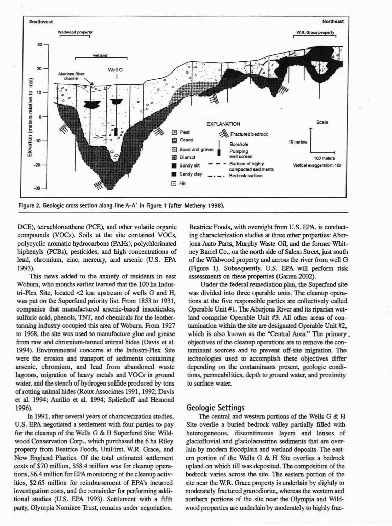
Figure 2. Geologic cross section along line A-A' in Figure 1 (after Metheny 1998).
DCE), tetrachloroethene (PCE), and other volatile organiccompounds (VOCs). Soils at the site contained VOCs,polycyclic aromatic hydrocarbons (pAHs), polychlorinatedbiphenyls (PCBs), pesticides, and high concentrations oflead, chromium, zinc, mercury, and arsenic (U.S. EPA1993).
1bis news added to the anxiety of residents in eastWoburn, who months earlier learned that the 100 ha Industri-Plex Site, located <2 km upstream of wells G and H,was put on the Superfund priority list. From 1853 to 1931,companies that manufactured arsenic-based insecticides,sulfuric acid, phenols, 'INf, and chemicals for the leathertanning industry occupied this area of Woburn. From 1927to 1968, the site was used to manufacture glue and greasefrom raw and chromium-tanned animal hides (Davis et al.1994). Environmental concerns at the Industri-Plex Sitewere the erosion and transport of sediments containingarsenic, chromium, and lead from abandoned wastelagoons, migration of heavy metals and VOCS in groundwater, and the stench of hydrogen sulfide produced by tonsof rotting animal hides (RouxAssociates 1991, 1992; Daviset al. 1994; Aurilio et al. 1994; Spliethoff and Hemond1996).
In 1991, after several years of characterization studies,U.S. EPA negotiated a settlement with four parties to payfor the cleanup of the Wells G & H Superfund Site: Wildwood Conservation Corp., which purchased the 6 ha Rileyproperty from Beatrice Foods, UniFirst, W.R Grace, andNew England Plastics. Of the total estimated settlementcosts of $70 million, $58.4 million was for cleanup operations, $6.4 million for EPA monitoring of the cleanup activities, $2.65 million for reimbursement of EPA's incurredinvestigation costs, and the remainder for performing additional studies (U.S. EPA 1993). Settlement with a fifthparty, Olympia Nominee Trust, remains under negotiation.
Beatrice Foods, with oversight from U.S. EPA, is conducting characterization studies at three other properties: Aberjona Auto Parts, Murphy Waste Oil, and the former Whitney Barrel Co., on the north side of Salem Street, just southof the Wildwood property and across the river from well G(Figure I). Subsequently, U.S. EPA will perform riskassessments on these properties (Garren 2002).
Under the federal remediation plan, the Superfund sitewas divided into three operable units. The cleanup operations at the five responsible parties are collectively calledOperable Unit #1. The Aheljona River and its riparian wetland comprise Operable Unit #3. All other areas of conlamination within the site are designated Operable Unit #2,which is also known as the "Central Area" The primary •objectives of the cleanup operations are to remove the contaminant sources and to prevent off-site migration. Thetechnologies used to aocomplish these objectives differdepending on the contaminants present, geologic conditions, permeabilities, depth to ground water, and proximityto surface water.
Geologic SettingsThe central and western portions of the Wells G & H
Site overlie a buried bedrock valley partially filled withheterogeneous, discontinuous layers and lenses ofglaciofluvial and glaciolacustrine sediments that are overlain by modem floodplain and wetland deposits. The eastern portion of the Wells G & H Site overlies a bedrockupland on which till was deposited_ The compOsition of thebedrock varies across the site. The eastern portion of thesite near the w.R. Grace property is underlain by slightly tomoderately fractured granodiorite, whereas the western andnorthern portions of the site near the Olympia and Wildwood properties are underlain by moderately to highly frac-

Figure 3. Design of the extraction well network at W.R. Graceand concentrations of TCE measured in late 1985 (after GenTrans Inc. 1995).
varied considerably across the 4 ha property. As sbown inFigure 3, the highest concentrations measured in 1985occur in two areas, one on the south side of the main building (Area 1) and another on the north side (Area 4). In theseareas, TCE concentrations exceeding 8000 ~gIL and 1,2DCE concentrations exceeding 12,000 ~gIL were found.Elsewhere on the property concentrations of TCE and 1,2DCE are lower, in the range of hundreds to several thousand micrograms per liter. Vmyl chloride (VC) also occursunder the W.R. Grace property. In 1985, VC concentrationstypically ranged from hundreds to several thousand micrograms per liter. WR. Grace estimates -380 L of TCE weredumped on the land surface, most in small aliquots outsidethe back doors at the north and south ends of the plant(Johns 2(00). Lesser concentrations of TCE were found inmonitoring wells drilled near a pit in the back of the property wbere six 210 L drums were buried. Both (cis) 1,2DCE and VC found in ground water at W.R. Grace occurfrom the dehalogenation of TCE.
The soils developed on the highly compacted glacialdeposits on the WR. Grace property are poorly drained.The property, which is -30 m higher than the wetland in theAbeIjona River valley, was used for agricultural productionprior to 1960 and contains two west-to-east agriculturaldrains that lowered the water table during wet periods. Thewater table is normally -4 m below land surface andground water flow across most of the property is to thewest-southwest toward the AbeIjona River valley. Slugtests indicate that the hydraulic conductivity of the highlycompacted materials is low and typically ranges from 0.03to 1.5 m1day (GeoTrans and ReTec 1994; GeoTrans 1995).
The remediation system recovers and treats contaminated ground water from the highly compacted materialsand shallow, fractured bedrock. Because of the low permeability of the glacial depositS, extraction wells had to beplaced.close together. The 22 extraction wells are located infour areas, including the two major hot spots and along thewestern and southern borders of the property to prevent offsite migration (Figure 3). These wells generalIy range from9 to 15 m deep. 1\venty extraction wells have 6 m screensthat straddle the interface between the highly compacted
--.-----
,,,.:::~
~3••• • __ -.. .--------------
,\7115,., .\ "1,820\1:-2,980
4. .10" AtN2% ,\.~ 2.520•
Contamination and Remediation:Operable Unit # 1
Some or all of the VOCs described previously occur inthe ground water at each of the five responsible parties.Cleanup of VOC-contami.ilated ground water, VOC-conlaminated soil, and mixed contaminated soils on the properties of four of the responsible parties is under way. Theremediation systems at UniFrrst and WR. Grace beganoperation in late 1992. Those at New England Plastics andWtldwood became operational early in 1998.
lured gabbrodiorite (Ecology and Environment 1982).Schist is observed in some core samples and probably represents foliation along shear zones within the gabbrodiorite(Ecology and Environment 1982).
The buried bedrock valley has the shape of a bowlelongated in a north-south direction. Bedrock is deepestunder the" center of the present valley at depths of 42 to45 m. The depth to bedrock decreases along the eastern andwestern margins of the area. Bedrock occurs at depths of 6to 20 m under the WR. Grace property and at depths of 9to 24 m under the 6 ha Wildwood property. At Olympia,bedrock occurs at a depth of -30 m. Outcrops of the granodiorite and the gabbrodiorite can be found within severalhundred meters east and west of the site.
Figure 2 is a southwest-northeast geologic cross section that extends from the Wtldwood property, across thewetland, through well G, to the WR. Grace property (alongline A-A' in Figure 1). TIris figure shows the shape of thebedrock surface and a simplified depiction of the sedimentsdeposited in the buried valley and on the bedrock upland. Adiscontinuous layer of highly compacted sediments, remnants from a Wisconsinan glacial advance (Chute 1959),occurs along the bottom and the margins of the bedrockvalley. Blow counts of split-spoon samples taken in thesematerials typically range from 50 to 120 per 15 em of penetration, whereas in the overlying loose materials depositedby a subsequent glacial retreat, blow counts typically rangefrom 20 to 50 per 15 em of penetration (Metheny 1998).
The lithologies of the loose materials and the highlycompacted materials vary laterally and vertically (Figure 2). The WR Grace property is underlain by highlycompacted sandy silt and silty sand with some gravellysand, which together range in thickness from 6 to 20 m.Under the UniFirst property, the highly compacted siltysand and diamict thicken rapidly to the west as the bedrocksurface becomes deeper. At the Wtldwood property,between 1.5 and 18 m of loose material overlie up to 12 mof higbly compacted, discontinuous layers of diamict, andsand and gravel, which cover the bedrock surface (Metheny1998). The loose materials are composed of discontinuouslenses of silty sand, sand, diamict, and sandy gravel that are1 to 6 m thick. Highly compacted sediments occur in a fewboreholes at New England Plastics, which is underlain by 2to 11 m of loose sand and gravel with some silt
W.R. Grace & Co.Characterization studies performed in 1985 showed
that concentrations of TeE and 1,2-DCE at WR. Grace
660 ES. Bair, MA Metheny GROUND WATER 40, no. 6: 657-668

Table 1Summary of Ground Water Pumpage and voe Removal at W.R. Grace'·2
VOCVolumeYearo( 'Ireated Volume VOCMass EquivalentSystem Ground Water Removed Removed RemovalOperation' (Liters Pumped) (kg) (liters) Efficiency'
1993 16,294,000 8.26 5.91 0.361994 10,567,000 4.72 3.37 0.321995 9,986,000 3.72 2.65 0.271996 12,922,000 2.27 1.63 0.131997 17,562,000 1.54 1.10 0.061998 16,266,000 3.73 2.65 0.161999 9,921,000 1.75 1.25 0.132000 12,160,000 1.65 1.17 0.102001 12,380,000 2.28 1.67 0.13
Totals 118,059,000 29.91 21.43
IHSJ GcoTrans Inc.. 2001 'Recorded from October I, 1992, to September 30. 2001'G""", 2002 ·Liters of VOC$: removed per million Iiten of wau:r pwnped
Figure 4. Recovered VOCS (bars) versus pumpage (solid line) atW.R. Gra"" from October 1992 to September 2001.
In 1992, the first year of operation, influent VOCs contained 44% TeE, 42% 1,2-DCE, 8% PeE, and minoramounts of VC, I,I-dichloroethene, and I,I,I-mchloroethane (l,I,I-TCA). The average yearly influentVOC concentration has declined from 507 IIgIL in the firstyear of operation to 205 IIgIL in the ninth year ofoperation.Influent pumped by the extraction wells to the trealmentsystem first passes through a bag filter. A solution of 50mgIL hydrogen peroxide then is injected into the contaminated water before it is exposed to two 5000-wan UVlamps, configured in series, which destroy the VOCS. TheIreated water is filtered before release to Snyder Creek, ashort distance to the east of the !realment building (Figure3). No carbon polishing is done because the primary contaminants, TCE and 1,2-DCE, are strongly affected by UVoxidation. Because the ground water contains minor concentrations ofdissolved iron and manganese, it is necessaryto mechanically scour the surface of the glass sheaths p,fOtecting the UV lamps to prevent buildup of iron and manganese precipitates that decrease the effective intensity ofthe UV ligbt The renovated water meets U.S. EPA Recordof Decision (ROD) cleanup levels for the site of <5 IIgILfor TCE and PCE, and <70 II gIL for 1,2-DCE (Metcalf &Eddy Inc. 1998). In the first nine years of system operation,30 kg ofVOCs were removed from more than I 18,059,000 Lof ground water (Table I and Figure 4).
In late 1997, U.S. EPA permitted WR. Grace to shutdown the six extraction wells in Area I, which together conttibuted -20% of the flow to the !realment system but only afew percent of the contaminant load. This is the reason forthe decrease in pumpage after the sixth year of operation(Table I). In 2000, W.R. Grace petitioned U.S. EPA toreplace the UV oxidation system with a GAC systembecause the concentration of influent VOCS became muchlower than in 1992, wben the original !realment system wasdesigned. The carbon system is equally effective at removingVOCs at the lowered concentrations and costs less to operateand maintain. U.S. EPA is evaluating this request and arequest to modify the sampling equipment and procedures.
6.0 16
5.0 16 !E"E 0.
!! '.0 14
~"-..U0 c::> 3.0 12 "'0 e!! CJ
" '6l;
10 ~" 2.0"Ir -'
c::
1.0 6~::l:
0.0 6
materials and bedrock. 'I\vo wells are screened solely in thehighly compacted materials. Recovery well R-22 is 10 mdeep, 2 m in diameter, and is pumped periodically to collectVOCs from the hot spot on the north side of the plant (HSIGooTrans Inc. 2(00). On average, the 22 extraction wellstogether produce -23 to 30 Vmin. A control unit in thewater-!realment building operates the p.oeumatic pumps inthe extraction wells (Figure 3). Deeper ground water flowin the fractured bedrock underlying the property is capturedby a deep bedrock extraction well on the UniFirst property(GeoTrans 1995). An agreement between WR. Grace andUniFirst covers the cost of treatment of deeper groundwater flow to the UniFirst well. An unidentified source ofVOCs exists just south of the WR. Grace property (GooTrans 1995).

~~."~~~~., ~~~ ~~' ~~~ ~",<i' 'l.r:P' 'l.<f'~
Figure 6. Recovtred VOCS (ba,,) vs. pumpage (solid line) atUniFirsl from October 1992 to September 2001.
N
A
..........TlOH............-• Exncdon.. UC-22
2,200 PCE co......... (ppb)1CW71D 31'88
Figu,. 5. Location of recovtrY well UC-22 at UniFirsl and concentrations of PeE measured in 1987-1988 (after GeaTrans Inc.and RETEC 1994).
The UV oxidation system cost $90,000. Constructionof the pump-and-treat system, including the prefabricatedbuilding, cost $1.3 million. Each 5000-watt UV lamp costs$1700 and must be replaced every three months. Electricitycosts about $2000 per month to operate the entire pumpflDd-treat system (Johns 1998).
120
100
E~ BO
-=-..00> 60'C~..>0u 40..0::
20
n
-----'~ \t1 ~: \.
~, ,\-~ IM \
, ~: "I \~ hi
~ !Rr--
~h-
~[r:
I!'! ~) p-'~
~., ,,~ ~'" .'
B6
74
UniFirst Cnrp.UniFirst Corp., known as Interstate Uniform Service
Corp. (IUS) prior to 1986, occupies a 1.2 ha site abuttingRoute 128 and Olympia Avenue (Figure I). The originalillS building was constructed in 1965 with additions in1966 and 1978. Historic aerial photographs show that theproperty was not used commercially prior to constructionof the original building, although debris piles and smallexcavations are evident, particularly during construction ofRoute 128 in 1954 and its widening in 1961-62. Aerial photographs from 1964 reveal a soil-stained area extendingfrom the northeastern comer of the illS property near thehighway on-ramp and off-ramp embankments, whereMassachusetts Department of Public Works records indicate construction debris was placed, to the south and westtoward Olympia Avenue (ENSR Consulting & Engineering1993). Between 1977 and 1982, illS maintained a190,000 L indoor storage tank at the east end of the building that was used to store PCB. In late 1979, a PCB spill of-380 L occurred inside the building and was cleaned up byemployees. 1be fill pipe for the indoor PCB tank waslocated at a nearby outside loading dock. 1be asphalt underthe fill pipe was scarred from PCE spilled during transferof the solvent The PCB tank was removed in late 1982 orearly 1983 (ENSR Consulting & Engineering 1993).UniFirst ceased operations on the property in 1989. Concentrations of PCB measured in monitoring wells in late1987 and early 1988 ranged from 2200 to 17,000 1Jg/L(Figure 5).
The thickness of the glacial materials varies across theUniFirst site. At the eastern end, bedrock is only a fewmeters below land surface and lithologic logs indicate thatmuch of the material above bedrock is engineered fill,whereas at the western end the glacial materials attain athickness of 22 m. The glacial deposits are generally composed of a layer ofIoose ablation till, which is underlain byhighly compacted materials that lie directly on bedrock.
662 E.5. Bair, MA Metheny GROUND WATER 40, no. 6: 657-668
Fractured granodiorite and gabbrodiorite underlie the property. Fractures in shallow excavations appear weatheredand bedrock becomes more competent with depth. Theunconsolidated deposits and fill beneath the eastern end ofthe property remain unsaturated throughout the year, Thewater table in the glacial deposits underlying the site variesfrom 3 to 4 m below land surface. The general direction ofshallow ground water flow in the glacial deposits is to thesouthwest toward the AbeIjona River (ENSR Consulting &Engineering 1993).
UniFirst and W.R Grace operate separate treatmentsystems, bnt operate an integrated ground water pumpingsystem because the extraction well at UniFirst capturesdeep flow in the fractured bedrock from the W.R Gracesite. At UniFirst, UC-22, a 58 m deep extraction well completed as an open borehole throug~ 53 m of fracturedbedrock, produces 130 to 170 Umin ofcontaminated watercontaining PCB, TeE, and minor amounts of other VOCS.During test pumping of UC-22, water levels declined inseveral of the bedrock monitoring wells at W.R. Grace.Subsequent testing showed that the contributing area ofUC-22 extends beyond the UniFtrst and WR Grace properties and UC-22 captures VOCs emanating from the WRGraCe property flowing in fractured bedrock (Harvard Project Services 2(00).
Over the nine years of pumping, PCB and TCE compose approximately 95% and 5%, respectively, of theVOCS in the influent water, with minor amounts of 1,1dichlorothene, 1,2-DCE, and l,l,I-TCA. Influent coDcentra~ons of PCB and TCE have declined from more than2500 and 130 1Jg/L, respectively, in the first year of operation, to less than 500 and 30 1Jg/L, respectively, in theeighth year (Harvard Project Services 2(00). Much of theTCE is likely from flow in the deeper bedrock at the WR.Grace site or from dehalogenation of PCE.
The water-treatment system at UniFirst is similar tothat at WR Grace, After filtering, hydrogen peroxide is

Table 2Summary of Ground Water Pumpage and VOC Removal at UniFirst'.2
VOCVolumeYear of Treated Volume VOCMass EquivalentSystem Ground Water Removed Removed RemovalOperation3 (liters pumped) (kg) (liters) Efficiency'
1993 84,339,000 159.26 110.76 1.311994 85,096,000 143.88 100.05 U81995 85,323,000 106.41 74.00 0.871996 85,626,000 82.15 57.12 0.671997 82,143,000 67.95 47.24 0.581998 79,115,000 58.97 41.00 0.521999 75,595,000 63.14 43.91 0.582000 75,860,000 49.67 34.56 0.462001 76,200,000 54.11 37.63 0.49
Totals 729,297,000 785.53 546.23
lHarvard Project Services 2£XX) )Recorded from October 1. 1992 to September 30. 200J'6=2002 "Liters of VOCS removed pet million liters of water pumped
Figure 7. Locations of treatment building, well G, and well 546;outline of raised gravel bed; and concentrations of TCE measuredat the Wildwood property in 1985 (after Remediation Technologies 1998d, GeoTrans Inc. 1995).
added to the influent water before it is exposed to a seriesof UV lamps. The six 10,OOO-watt UV lamps are constructed in two series of three lamps. The exposure time ofthe contaminated water in the UV chambers is -45 seconds.Afterward, the water is filtered and passed through two carbon adsorption units before it is released to a stonn sewer.The effluent meets U.S. EPA ROD criteria (Metcalf &Eddy Inc. 1998) for PCB, TCE, 1,2-DeE, and the otherVOCs (Harvard Project Services 2000). In the first nineyears of operation, nearly 729,300,000 L of ground waterwere pumped and 786 kg of VOCs were removed (Fig-
108 Well G ore 6 and Table 2). The total amounts of PCB and TCEremoved from ground water during this period are 748 kgand 36 kg, respectively (Harvard Project Services 2000;Garren 2002).
VOCs occur in the shallow unsaturated materials atUniFirst and are believed to be the result of upward vapormigration from contaminated ground water (ENSR Consulting & Engineering 1993). The most effective manner toremove these contaminants is a point ofdiscussion betweenUniFirst and U.S. EPA
Wildwood Conservation Corp.In 1983, Wildwood Conservation Corp. purchased the
6 ha property between the railroad tracks and the AberjonaRiver from the John J. RiJey Leather Co. The Wildwoodproperty borders Olympia Nominee Trust on the north andAbeIjona Auto Parts, Whitney Barrel Co., and MurpbyWaste Oil on the south (Figure I). The John J. RileyLeather Co. owned the property from 1908 until 1979,when it was sold along with the nearby tannery and itsproperty to Beatrice Foods Corp. Historic aerial photographs show that the properiy was accessible by a dirt roadextending from Whitney Barrel and Murphy Waste Oilnorthward to Olympia Avenue. The aerial photographs,reports, and trial testimony indicate the property was usedfor unauthorized storage of drums, tanks, and other materials and unauthorized dumping of debris, drums, and chemical wastes (Metcalf & Eddy Inc. 1998) were found on bothsides of the dirt road. A county sewer line and an old citysewer line transect the site parallel to the river. The entire 6ha property lies within the floodplain of the river (Figure7). The only structure on the property was an industrial well(S46 on Figures 1 and 7) built in 1958, which suppliedwater to the tannery until operations ceased in 1989 (ReTec1994).
In 1993,231,300 kg of debris, 45 drum carcasses, and895,400 kg of contaminated soil were removed from theWildwood property (U.S. EPA 1993). The soil was con-
50 __
EXPlANATlON
• Punphgwel
... Mooitoring well
1DB TeE concentration(ppb)n 1985
I• 0
•
IIIIIIIIIIIIII
I .Il~ .,1 V\leJI S46: )372 {11.oo}
~-
Fe; R>ir. MA Mpthpnv GROi INn WATFR 411 nn ~. ~~7-~~R ~~1

N
ASCALE
o 25 meters
Figure B. Design of the integrated air sparging, soil-vapor<Xlraclion, and pump-and-treat systtm at Wildwood Con..rvation Trust (aft., Rtmediation Trdlnologies 199Ba, 199Bb,'99Be).
taminated with TeE, 1,2-OCE, PCB, I,I,I-TCA, PARs,PCBs, chlordane, and DDT (Ebasco Services Inc. 1988).Six drums contained TCE (Block 1996). Concentrations>830,000 mglkg TCE were detected in the soil. Multilevelmonitoring wells were drilled on the property between1983 and 1985. The highest TCE concentrations in soil andground water were detected at the location of a formerdebris pile, referred to as Debris Pile E (Figure 7) duringthe federal trial, which is suspected to be a primary sourcearea (Ebasco Services Inc. 1988). TCE concentrationsmeasured in sballow monitoring wells near the dehris pilesin 1985 ranged from several hundred micrograms per literto more than 440,000 IlgIL (Figure 7) and concentrations of1,2-OCE, PCE, and other VOCs were in excess of U.S.EPA maximum contaminant levels. In 1985, TCE concentrations measured in bedrock monitoring wells near thedebris piles ranged <100 IlgIL to >2700 IlgIL. By 1995,after the debris piles and contaminated soil were removed,TCE concentrations in sballow monitoring wells decreasedto a maximum of )9,300 IlgIL, whereas TCE concentrations in bedrock monitoring wells increased to a maximumof 120,000' IlgIL. It appears that the contaminated soilremoved in 1993 was a primary TCE source contributing toshallow ground water contamination and that the high con-
664 E.S. Sair, MA Metheny GROUND WATER 40, nn. 6: 657-668
centrations of TCE in the shallow part of the ground waterflow system had moved downward into bedrock fracturesover time.
The Wildwood property is underlain hy 9 to 24 m ofglacial deposits in the buried bedrock valley. The sballowsediments consist of medium to fine sand with discontinuous deposits of sand and gravel. Sand and gravel beds predominate at depths of 7 to 15 m, or more in some locations.Slug tests in these deposits yield hydraulic conductivities of6 to 30 m1day (GeoTrans and RETEC 1994). These permeable materials are underlain by highly compacted glacialdeposits, which overlie fractured gabhrodiorite (Metheny1998). Ground water occurs at depths of <I m across mostof the property and flows toward the AbeIjona River(Myette et al. 1987).
Because of the large thickness and high permeabilityof the subsurface materials underlying the Wildwood property and its close proximity to the wetland and river, theremediation system is designed to remove most of the contaminants in ground water through air sparging and vaporextraction, rather than by extraction wells. The logic underlying this design is that air is easier and cheaper to movethan waler and there is simply too much available groundwaler and surface water at this location to pump and treatin an economical manner. The air sparging system consistsof 24 sbalJow (vertical) wells that aerate contaminated soilsand ground water (Figure 8). These wells are screened insand and gravel to depths up to 22 m. The vapor extractionsystem consists of 460 m of slotted plastic pipe (Figure 8),which is set in a raised gravel bed that is underlain by ageotextile fabric and overlain by a HOPE liner. The raisedbed is up to a meter thick and covers 1.2 ba. The HOPEliner is covered with a layer of sand and crushed stone toprevent erosion during flood events. Five deep groundwater extraction wells extend through the raised gravel bedinto bedrock to depths of 30 m (Figure 8). Together, thesewells produce -140 Umin. One of these wells produces <4Umin but with TCE concentrations in the milligrams perliter range (Block 1997), suggesting that TCE may occur asfree product beneath the Wildwood site.
In the nearby treatment building (Figure 7), contaminated ground water and condensate from the soil-vapor system pass through an air-stripping unit and two carbonadsorption tanks. The effiuent, which meets U.S. EPA RODcriteria (Metcalf & Eddy 1998), is released to a storm sewerthat discharges to the AbeIjona Riv<;!,. Soil vapor from thevacuum extraction system is combined with air from theair-stripping system and treated by catalytic oxidation. Thisintegrated system began operation in May 1998. Table 3lists the mass ofVOCs removed from the 'system during thefirst three years ofoperation. During this period, nearly 108million liters of ground water were pumped and treated.
Characterization of the Wildwood property cost $1million. Surface cleanup costs exceeded $1 million andconstruction costs including a pilot treatment system were$2 million (Block 1997).
Olympia Nominee TrustHemingway Transport has been a long-term tenant on
the Olympia Nominee Trust property on the south side of
Mooitorlng TCE PCE Total Xyl.....Well (pgIL) (pgIL) (pgIL)
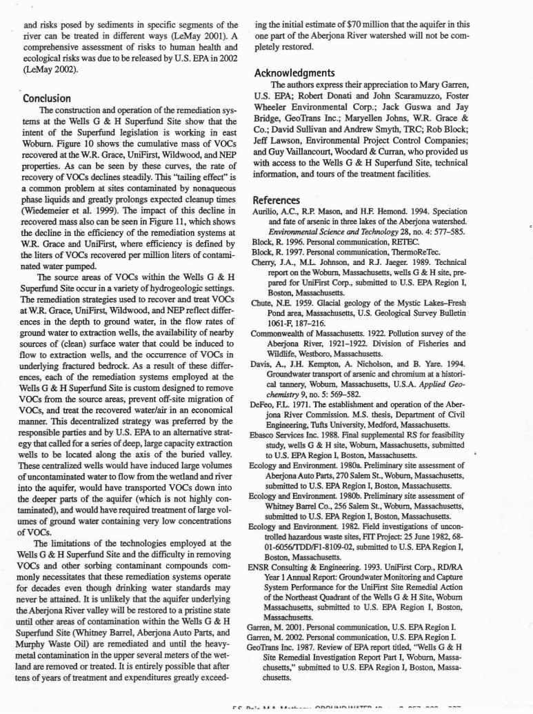
Figu", 9. Design of NEP ",m<diation system and measur<d concentrations ofllOCs in 1994 (after Woodanl a Curran 1997).
150
""",-""TlOH• Yapc:r exhd:ion wei
Ai' spwgng wei
.. Monitomg wei
------
5,4015 TotlII voc w ... ibatia,(ppb) Wl1994
o At.- wIh tcWI cI'DNIedV0C5 n soil aboW 10 ppbbetween 0 .-.:l eteeI bebw
-~~
NEP building
1412,0007,900
13
Table 4VOCs Measured in Monitoring Wells in 1987
at Olympia Nominee Trust'
SCALEO~--5_
'Sullivan (2002)
1W1ou0t.3
buildings and parking lots surround the property. Siteinvestigations and historic aerial photographs identified asource of VOCS at the former location of a storage trailerowned by Prospect Tool & Die Co., a tenant on the property from 1962 to 1989 (HMM Associates 1990). Investigations indicated contaminated soil and sediment extending to a depth of 4 m, slightly below the local water table(Figure 9).
The NEP property overlies permeable sand and graveldeposits that range in thickness from 2 to II m (Metheny1998). The hydraulic conductivity of the underlying sediments ranges between 0.6 to 18 m1day. The water tableoccurs at depths varying from 2 to 5 m below land surface.Ground water flow is generally to the south and southwest(Woodard & Curran 2000).
PCB is the primary contaminant Total VOCS measuring 5406 Jlg/L were detected in 1994 in a monitoring wellinstalled in the source area (Figure 9). Total VOCs in mODitoring wells within 90 m downgradient of the source areacommonly ranged from 10 to 200 Jlg/L in the glacial materials and from 20 to 270 Jlg/L in the bedrock (Woodard &Curran 2000).
After 230 m3 of contaminated soil were removed fromthe site, the source area was paved over with asphalt and asoil-vapor extraction system coupled with air-spargingwells was constructed (Figure 9). The system consists ofseven vertical 6 m deep air-sparging wells and six verticalvacuum extraction wells. In a small trailer, soil vapor andcondensate from the vapor-extraction system pass throughseparate carbon adsorption units. The system began operation in February 1998. In 15 months of operation, nearly 36kg ofVOCs were removed (Woodard & Curran 1999). Thesystem was turned off in 1999 because ROD cleanup levels
Table 3VOCs Removed at Wildwood Conservation Trust'
Yearo! VOCMass MassVOCs Total VOCSystem Removed-Air Removed-Water Mass RemovedOperatiOD (kg) (kg) (kg)
1999 334 33 3672000 247 7 2542001 238 7 245·
ToIal 819+ 47 866
IPenooaJ COlDlmDicariOQ, Mary Garren. u.s. EPA Regioo 1, 2001 mel 2002
Olympia Avenue. The Olympia property covers 8.5 ha andstraddles the Aberjona River (Figure I). A portion of theeastern area is used as a trucking terminal. The 3.2 ha onthe west side of the Aberjona River abut the WIldwoodproperty and are undeveloped hut accessible by the dirtroad paralleling the railroad tracks between OlympiaAvenue and Salem Street
The geology of the western portion of the Olympiaproperty is similar to that at WIldwood. The area overlies adeep part of the buried valley that contains 24 to 30 m ofpermeable sand and gravel deposits, which are underlain by6 to 9 m of highly compacted sediments (Metheny 1998).Ground water occurs at depths of 0 to 2 m and flows in aconverging pattern toward the river (Myette et al. 1987).
The Hemingway Transport Co. held permits for threeunderground storage tanks. In May 1983, the 24,000 Lgasoline storage tan.k. was found to contain water and wasremoved. In April 1985, U.S. EPA discovered 12 exposeddrums in various stages of corrosion in the southwesternportion of the property on the west floodplain of the Aberjona River (near the "0" in Figure I). Adjacent to thedrums was a small pile of caps from pesticide containers(U.S. EPA 1987). Aerial photographs show the presence ofdrums in this area in 1969.
The drums and underlying soil contained TCE, PCB,I,I-dichloroethane, I,I,I-TCA, toluenes, xylenes, PCBs,and chlordane (U.S. EPA 1986). In December 1986, fivemore drums were found buried in the same general area ofthe property (U.S. EPA 1987). Soil samples revealed significant concentrations of PCBs (31,000 Jlglkg), chlordane(51,000 Jlglkg), and TCE, PCB, 1,2-DCE, I,I,I-TCA,trichlorobenzene, and methyl naphthalene (Ebasco Services Inc. 1988).
No remediation systems are yet in operation atOlympia Nominee Trust. Negotiations are proceedingbetween the property owners and U.S. EPA. In the winterand spring of 2002, several more multilevel monitoringwells were drilled and sampled in the wetland downgradient from the location of the former drum piles. Concentrations of VOCS measured in 2002 in two sballow monitoring wells and a new test well on the west side of theOlympia property at the site of the 17 drums are listed inTable 4.
New England Plastics Co.The 1.6 ha NEP property is located west of Washing
ton Street, about 150 m east of well G (Figure I). Office
C:~ D_:.'. A •• _ __.. ,...,.,n' ·_

figu", 10. Cumulativt reeovtred mass of VOCs at the Wells G B: HSuperfund Site by responsible party.
in the unsaturated sediments were achieved. Some residualground water contaminatioo still exists but appears to bediminishing over time due to dispersion and natural attenuation (Woodard & Curran 2(00).
The intent of !be remediation system was to reduce theconcentration of contaminants in the unsaturated sedimentsto ROD cleanup levels and to reduce the concentration ofcontaminants in the source area ground water to the greatest extent possible. Ground water samples collected inAugust 2000 indicate that total VOCS in the source areahave declined to approximately 20 I'gIL. These samplesshowed that PeE exceeds U.S. EPA ROD criteria in onlytwo of five overburden wells and two of eight bedrockwells (Woodard & Curran 2(00). U.S. EPA permitted NEPto turn off the air-sparginglsoil-vapor extraction system in2001, depending on quarterly analysis of ground watersamples to determine wbether VOC concentrations remainlow.
Contamination and Remediation:Operable Units #2 and #3
The three properties on the oorth side of SalemStreet-Mwphy Waste Oil, Whitney Barrel, and AbeJjonaAuto Parts (Figure I}-are in Operable Unit #2 and underthe purview of U.S. EPA Region 1. Samples from eightshallow monitoring wells taken in 1993 show TCE concentrations of a few micrograms per liter in most wells,wbereas samples from seven deeper monitoring wells commonly show TCE concentrations up to several hundredmicrograms per liter. Low concentrations of PCE also werefound in most of the deeper monitoring wells (REI'EC1994). Remedial investigations and risk assessments areproceeding at each of these properties (Garren 2002).
Several studies document the presence of heavy metals(arsenic, chromium, and lead) in elevated concentrations inthe sediments underlying !be Industri-Plex Superfund Site,located a few kilometers upstream of the Wells G & HSuperfund Site, and in modern sediments deposited alongthe floodplain of the AbeIjona River and in the MysticLakes, located several kilometers downstream of the Wells
~
""1\\'\
'\
"'"r-..,. /'"' i'-.U iFirst
..........~
","R. rate
.......... ,/
figu", ". Efficiency of ",mediation systems at W.R. Grace andUnifirst during first nine years of operation.
1.50
MQ'1993 1991 1995 1996 1997 1998 1.999 .2CllO 2001
uS.Ea 1.25I!!~
G & H Superfund Site (Knox 1991; Auri1io et aI. 1994;Davis et aI. 1994; Spliethoff and Hemond 1996). Thesource of the heavy metals is a former chemical manufacturing plant on the Industri-Plex Superfund Site that produced arsenic-based pesticides, sulfuric acid, phenols,TNT, and other chemicals in the early 1900s (Tarr 1987).
Many other sources of contamination exist within theupper reaches of the AbeIjona River watershed upstream ofthe Wells G & H Superfund Site. These sources include tanneries, piggeries, a drum refurbishing company, and unregulated landfills among other industries (Tarr 1987). VOCshave been found in the East Drainage Ditch and LandfillCreek, two tributaties to the AbeJjona River that flowacross the Industri-Plex Site (Kim 1995).
The environmental impact on the Abeljona Riverwatershed of Woburn's once prolific leather-tanning andchemical manufacturing industries was first documentedby the Massachusetts Division of Fisheries and Wildlife in1919-1922, when it published 160 annotated photographsshowing animal carcasses, breached waSte lagoons,exposed piles of mineral ores and waste products, salinedrainages from tanneries, and tarry sediments lining thebeds_of tributary streams to the AbeJjona River (Commonwealth of Massachusetts 1922). Since !beD, several otherstudies have documented the impact of land usage andmanufacturing practices on the watershed (DeFeo 1971;Warrington 1973; Tarr 1987; Cherry et aI. 1989; Knox1991; Roux Associates 1991, 1992; Davis et aI. 1994; Spliethoff and Hemond 1996).
Cleanup ofOperable Unit #3 is also proceeding withinthe U.S. EPA Superfund framework Characterization andrisk assessment of !be portion of !be AbeIjona River andwetland in the Wells G & H Superfund Site is being managed by U.S. EPA Region I in a more holistic manner, combining it with similar tasks at the Industri-Plex SuperfundSite. Using this approach, the entire river is to be examined
3456789Year of Operation
2
V11ldw cd
7 .....-;v.------ riRrst
/ ./V
/ v/
7; NEP w.. G<oco
o
",
1000..E 800l"co0
~ 600~
00>
400."
f~8 200"'"
0
666 ES. Bair, M. Metheny GROUND WATER 40, no. 6: 657-668
and risks posed by sediments in specific segments of theriver can be treated in different ways (LeMay 200I). Acomprehensive assessment of risks to buman health andecological risks was due to be released by U.S. EPA in 2002(LeMay 2002).
ConclusionThe construction and operation of the remediation sys
tems at the Wells G & H Superfund Site show that theintent of the Superfund legislation is working in eastWoburn. Figure 10 shows the cumulative mass of VOCsrecovered at the w.R. Grace, UniFirst, WIldwood, and NEPproperties. As can be seen by these curves, the rate ofrecovery of VOCs declines steadily. 1bis "tailing effect" isa common problem at sites contaminated by nonaqueousphase liquids and greaIly prolongs expected cleanup times(Wiedemeier et al. 1999). The impact of this decline inrecovered mass also can be seen in Figure II, which showsthe decline in tJie efficiency of the remediation systems atWR. Grace and UniFirst, where efficiency is defined bythe liters of VOCS recovered per million liters of contaminated water pumped.
The source areas of VOCs within the Wells G & HSuperfund Site occur in a variety of hydrogeologic settings.The remediation strategies used to recover and treat VOCsat WR. Grace, UniFirst, WIldwood, and NEP reflect differences in the depth to ground water,· in the flow rates ofground water to extraction wells, the availability of nearbysources of (clean) surface water that could be induced toflow to extraction wells, and the occurrence of VOCS inundedying fractured bedrock. As a result of these differences, each of the remediation systems employed at theWells G & H Superfund Site is custom designed to removeVOCs from the source areas, prevent off-site migration ofVOCs, and treat the recovered water/air in an economicalmanner. 1bis decentralized strategy was preferred by theresponsible parties and by U.S. EPA to an alternative strategy that called for a series of deep, large capacity extractionwells to be located along the axis of the buried valley.These centralized wells would have induced large volumesofuncootaminated water to flow from the wetland and riverinto the aquifer, would have transported VOCs down intothe deeper parts of the aquifer (which is not highly contaminated), and would have required treatment oflarge volumes of ground water containing very low concentrationsofVOCs.
The limitations of the technologies employed at theWells G & H Superfund Site and the difficulty in removingVOCs and other sorbing contaminant compounds commonly necessitates that these remediation systems operatefor decades even though drinking water standards maynever be attained. It is unlikely that the aquifer underlyingthe Aberjona River valley will be restored to a pristine stateuntil other areas of contamination within the Wells G & HSuperfund Site (Whitney Barrel, Abeljona Auto Parts, andMurphy Waste Oil) are remediated and until the heavymetal contamination in the upper several meters of the wetland are removed or treated. It is entirely possible that aftertens of years of treatment and expenditures greatly exceed-
ing the initial estimate of $70 million that the aquifer in thisone part of the Abeljona River watershed will not be completely restored.
AcknowledgmentsThe authors express their appreciation to Mary Garren,
U.S. EPA; Robert Donati and John Scaramuzzo, FosterWheeler Environmental Corp.; Jack Guswa and JayBridge, GeoTrans Inc.; Maryellen Johns, WR. Grace &Co.; David Sullivan and Andrew Smyth, TRC; Rob Block;Jeff Lawson, Environmental Project Control Companies;and Guy Vaillancourt, Woodard & Curran, who provided uswith access to the Wells G & H Superfund Site, technicalinformation, and tours of the treatment facilities.
ReferencesAurilio, AC., RP. Mason, and H.F. Hemond. 1994. Speciation
and fate of arsenic in three lakes of the AbeIjona watersbed.Environmental Science and Technology 28, no. 4: 577-585.
Block, R. 1996. Personal communication, RETEC.Block, R 1997. Personal communication, ThermoReTec.Cherry, lA., ML Johnson, and RJ. Jaeger. 1989. Technical
report on the Woburn, Massacbusetts, wells G & H site, prepared for UniFlfSt Corp., submitted to U.S. EPA Region I,Boston, Massacbusetts.
Chute. N.E. 1959. Glacial geology of the Mystic Lakes-FresbPond area, Massacbusens, U.S. Geological Survey BulletinHJ6I-F, 187-216.
Commonwealth of Massacbusens. 1922. Pollutioo survey of theAbeIjona River, 1921-1922. Division of Fisheries andWlldlife, Westboro, Massacbusetts.
Davis, A, J.H. Kempton, A Nicbolson, and B. Yare. 1994.Groundwater transport of anenic and chromium at a historical taonery, Woburn, Massacbusetts, U.S.A. Applied Geochemistry 9, no. 5: 569-582.
DeFeo, F.L. 1971. The establisbment and operation of the Aherjona River Conunission. M.S. thesis, Department of CivilEngineering, Thfts University, Medford, Massachusens.
Ebasco Services loco 1988. Fmal supplemental RS for feasibilitystudy, wells G & H site, Woburn, Massacbusetts, subminedto U.S. EPA Region I, Boston, Massacbusetts.
Ecology and Environment 198Oa. Preliminary site assessmeot ofAbeIjona Auto Parts, 270 Salem St, Woburn, Massacbusens,submitted to U.S. EPA Region I, Boston, Massacbusens.
Ecology and Environment 1980b. Preliminary site assessment ofWhitney Barrel Co., 256 Salem St, Woburn, Massachusetts,submitted to U.S. EPA Region I, Boston, Massacbusens.
Ecology and Environment 1982. field investigations of uncontrolled hazardous waste sites, AT Project 25 June 1982, 6801-6056fIDDIFI-8109-02, submitted to U.S. EPA Region I,Boston, Massachusetts.
ENSR Consulting & Engineering. 1993. UniFirst Corp., RDIRAYear I Annual Report: Groundwater Monitoring and CaptureSystem Perfonnance for the Unifirst Site Remedial Actionof the Northeast Quadrant of the Wells G & H Site, WoburnMassacbusens, submitted to U.S. EPA Region I, Boston,Massachusetts.
Garren, M. 2001. Personal communication, U.S. EPA Region I.Garren, M. 2002. Personal communication, U.S. EPA Region I.GeoTraos Inc. 1987. Review of EPA report tilled, "Wells G & H
Site Remedial Investigation Report Part I, Woburn, Massacbusens," submitted to U.S. EPA Region I, Boston, Massachusetts.

GeoTrans Inc. 1995. W.R Grace Remedial Action Wells G & HSite, Woburn, Massachusetts, Annual Report for October I,I994-September 30, 1995, prepared for W. R Grace & Co.,Connecticut, suhmitted to U.S. EPA Region I, Boston, Massachusetts.
GeoTrans Inc. and ReTec. 1994. Wells G & H Site central arearemedial investigation phase IA Report Vol. I-rn, preparedfor Beatrice Corp., UniFm;t Corp., and W.R. Grace & Co.,Connecticut, submitted to U.S. EPA Region I, Boston, Massachusetts.
GHR. 1988. Site assessment report of the former Whitney BarrelCo. site, 256 Salem St., Woburn, Massachusetts.
Harr, Jonathan. 1995. A Civil Action. New York: Random House.Harvard Project Services. 2000. RDIRA Year 8 Annual Report for
the UniFmr Site, submitted to U.S. EPA Region I, Boston,Massachusetts.
HMM Associates. 1990. New England Plastics, Wells G & H sitehydrologic site investigation, February.
HSI GeoTrans Inc. 2000. W.R Grace Remedial Action, Wells G& H SUpeIfund Site, Woburn, Massachusetts, Annual ReportOctober I, 1999-September 30, 2000, prepared for W.R.Grace & Co., Connecticut, submitted to U.S. EPA Region I,Boston, Massachusetts.
Johns, M. 2000. Personal communication, W.R Grace & Co., Kim, H. 1995. Discharge of volatile organic compounds from a
contaminated aquifer and their fate in a stream. Ph.D. dissertation, Massachusetts Institute of Technology, Cambridge,Massachusetts.
Knox, M. 1991. The distribution and depositional history of metals in swface sediments of the AbeIjona River watershed.M.S. thesis, Department of Civil Engineering, MassachusettsInstitute of Technology.
leMay, J. 2001. Personal communication, U.S. EPA Region I.leMay, J. 2002. Personal communication, U.S. EPA Region I.Metcalf & Eddy Inc. 1998. Draft Field Operations Plan Remedial
DesignlRemedial Action {RDIRA) Oversight Support, WellsG & H Superfund Site, Woburn, Massachusetts, July 1998;prepared for U.S. Environmental Protection Agency, contractno. 68-W6-0042.
Metheny, M.A 1998. Numerical simulation of ground-water flowand advective transport at Woburn, Massachusetts, based ona sedimentological model of glacial and glaciofluvial deposition. M.S. thesis, Department of Geological Sciences, OhioState University.
Myette, C.F., lC. Olimpio, and D.G. Johnson. 1987. Area ofinfluence and zone of contribution to Superfund-site Wells Gand H, Woburn, Massachusetts. U.S. Geological SurveyWater-Resources Investigations Report 87-4100.
NUS Corp. 1986. Wells G & H Site Remedial InvestigationReport Part I, Woburn. Massachusetts, TOD No. FI-860707, U.S. EPA Site No. MAD980732168.
Remediation Technologies Inc. 1994. Draft Remedial Investigation, Southwest Properties, Wells G & H Superfund Site,Woburn, Massachusetts, prepared for Beatrice Co. Concord,Massachusetts.
Remediation Technologies .Inc. 1996. Attachment F, aquifer testreport, Wudwood Property, Wells G & H Superfund Site,Woburn. Massachusetts, Volume I. Technical report, April1996, prepared for Beatrice Co., by Remediation Technologies Inc., Concord, Massachusetts, and Hydroanalysis Inc.,Adon, Massachusetts.
Remediation Technologies Inc. 1998a 100% design drawings,Wildwood Property, Wells G & H Superfund Site, Woburn.Massachusetts. Drawing Dumber 54, soil vapor extractionlayout, prepared for Beatrice Co., by Remediation Technologies, Inc. Concord, Massachusetts.
668 E5. Bair, M. Metheny GROUND WATER 40, no. 6: 657-668
Remediation Technologies Inc. 1998b. 100% design drawings,Wudwood Property, Wells G & H Superfund Site, Woburn,Massachusetts. Drawing number S-3, air sparging, preparedfor Beatrice Co., by Remediation Technologies Inc. Concord, Massachusetts.
Remediation Technologies Inc. 199&. 100% design drawings,Wudwood Property, Wells G & H Superfund Site, Woburn,Massachusetts. Drawing number 5-5. groundwater extraction layout, prepared for Beatrice Co., by Remediation Technologies Inc. Concord, Massachusetts.
Remediation Technologies Inc. 1998d. 100% design drawings,Wudwood Property, Wells G & H Superfund Site, Woburn,Massachusetts. Drawing number S-lb, construction layoutand limits of clearing, prepared for Beatrice Co. Concord,Massachusetts.
Roux Associates. 1991. Remedial investigation: Ground-water!surface-water investigation plan, Phase I, prepared for U.S.EPA Region I, Boston, Massachusetts.
Roux Associates. 1992. Remedial investigation: Ground-water!surface-water investigation plan, Phase 2, prepared for U.S.EPA Region I, Boston, Massachusetts.
Spliethoff, HM., and H.F. Hemond, 1996. History of toxic metaldischarge to surface waters of the AheJjona watershed. Envi·ronmental Science and Technology 30, no. I: 121-128.
Sullivan, D. 2002. Personal communication, TRC.Tarr, JA. 1987. History of pollution in Woburn, Massachusetts,
report prepared for W.R. Grace & Co., included as AppendixB to GeoTrans.
ThermoReTec. 1999. Wells G & H Superfund Site, RDIRA forWudwood Property, letter from Michael Devir to Ms. MaryGarren, U.S. EPA Region I, Boston, Massachusetts.
Touchstone Pictures. 1998. A Civil Action, Screenplay by SteveZaiI1ian, dieeded by Steve ZaiI1ian.
U.S. Enviroumental Protection Agency. 1986. EnvironmentalNews, U.S. EPA Region I, Boston, Massachusetts, February.
U.S. Enviroumental Protection Agency. 1987. EnviroomentalNews, U.S. EPA Region I, Boston, Massachusetts, February.
U.S. Environmental Protection Agency. 1993. Oeanup begins atWells G & H, one year after landmarl< New England settJement: Superfund at Work-Hazardous Waste Oeanup EffortsNationwide, EPA 520-F-92·1ll5, WlOter.
Warrington, RA. 1973. Hydraulic survey of the Abetjona Riverand operation of the Abetjona River Commission. M.S. thesis, Department of Engineering, Thfts University, Medford,Massaebusetts. .
Wiedemeier, T.H., H.S. Rifai, CJ. Newell, and J.T. Wl1son. 1999.NaturolAttenunJion ofFuels and Chlorinoted SolvenlS in theSubsurface_ New York: John Wiley & Sons:
Woodard & Cumul. 1997. New England Plastics Corp., Woburn,Massachusetts, Source control remedial design, Project%032.04, soil vapor extraction and air sparge systems,100% Design, prepared for New England Plastics Corp., byWoodard & Curran, PorUand, Maine.
Woodard & Curran. 1999. New England Plastics Corp., RemedialAction Monuuy Report for November 1999. Letter to MaryGarren from Henri VmcenL
Woodard & Curran. 2000. Groundwater monitoring report, NewEngland Plastics Corp.,' Wells G & H Superfund Site,Woburn. Massachusetts, Odober 2000, prepared for .NewEngland Plastics Corp., by Woodard & Curran, Portland,Maine.