redefining tod
DESCRIPTION
Transit-Oriented District Design GuidelinesTRANSCRIPT
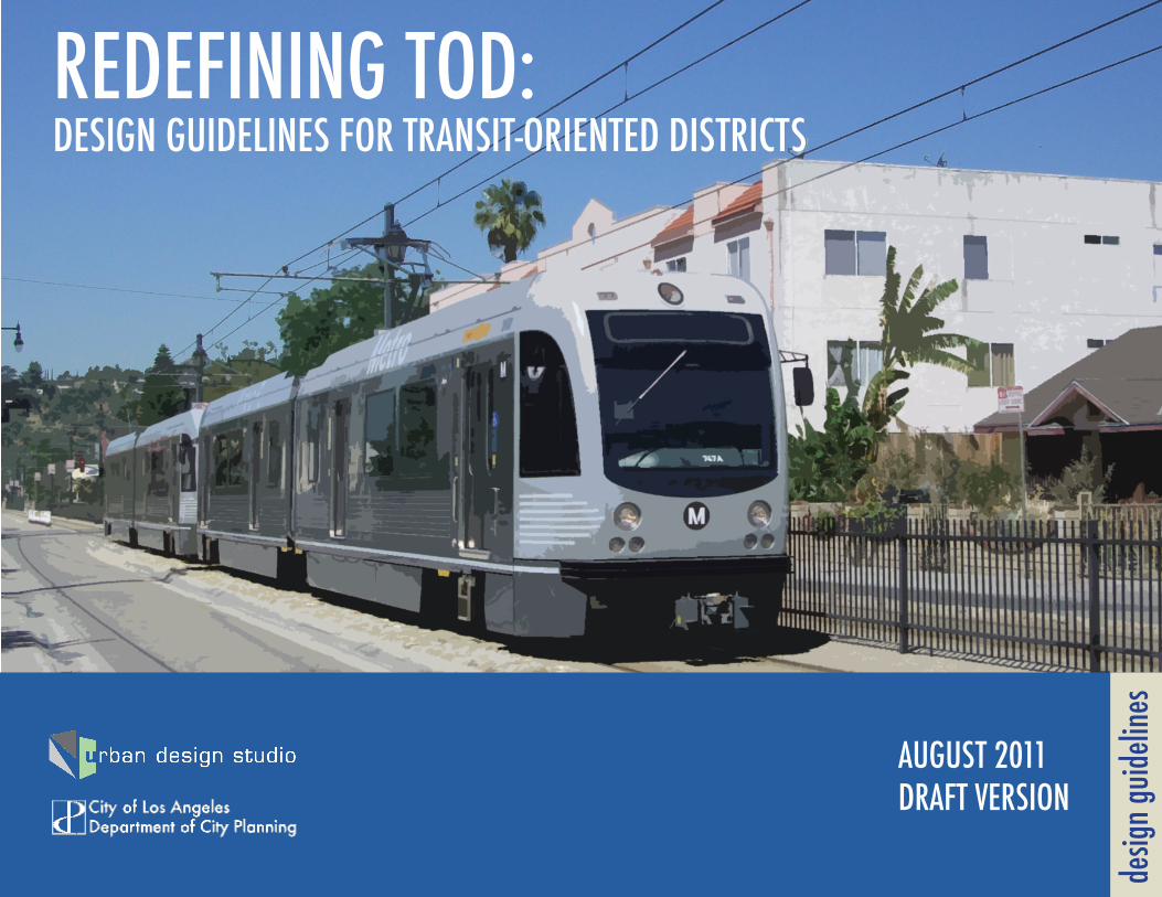
REDEFINING TOD: DESIGN GUIDELINES FOR TRANSIT-ORIENTED DISTRICTS
desig
n guid
eline
s
AUGUST 2011DRAFT VERSION
CONTENTS1. OVERVIEW
2. STREETCAR SUBURBS
3. TRANSIT VILLAGES
4. MIXED-USE COMMUNITIES
5. URBAN NEIGHBORHOODS
6. TRANSIT CAMPUS
7. URBAN CORRIDORS
8. URBAN REGIONAL CENTERS
9. DOWNTOWN
10. APPENDIX: MASTER LIST OF TOD DESIGN TREATMENTS
URBAN DESIGN STUDIO PROJECT TEAM
Simon Pastucha, Chief Urban DesignerJaymes Dunsmore, Urban Design InternCarter Rubin, Urban Design Intern
Partial funding for intern work was provided by the MIT Public Service Center through a
Paul and Priscilla Gray Internship Grant.
WHAT IS A TRANSIT-ORIENTED DISTRICT?
The area within a quarter-mile of a transit station offers unique opportunities and challenges. The development of a new station represents a substantial investment of public money and gives the public an invested interest in the successful development of the station area. The city should seek to enhance station areas as transit oriented districts. As the name suggests, a transit-oriented district is a neighborhood in which all elements of the public realm and private development are designed to facilitate subway, light-rail and bus ridership. Since all transit passengers become cyclists or pedestrians (even if only for the walk from the station to their car), special attention is paid to the enhancing their experience and safety.
1. OVERVIEW
DESIGNING TRANSIT-ORIENTED DISTRICTS
Expo/W
estern
Lincoln/Cypress
Chinatown
El Monte
Little Tokyo/Arts Dist
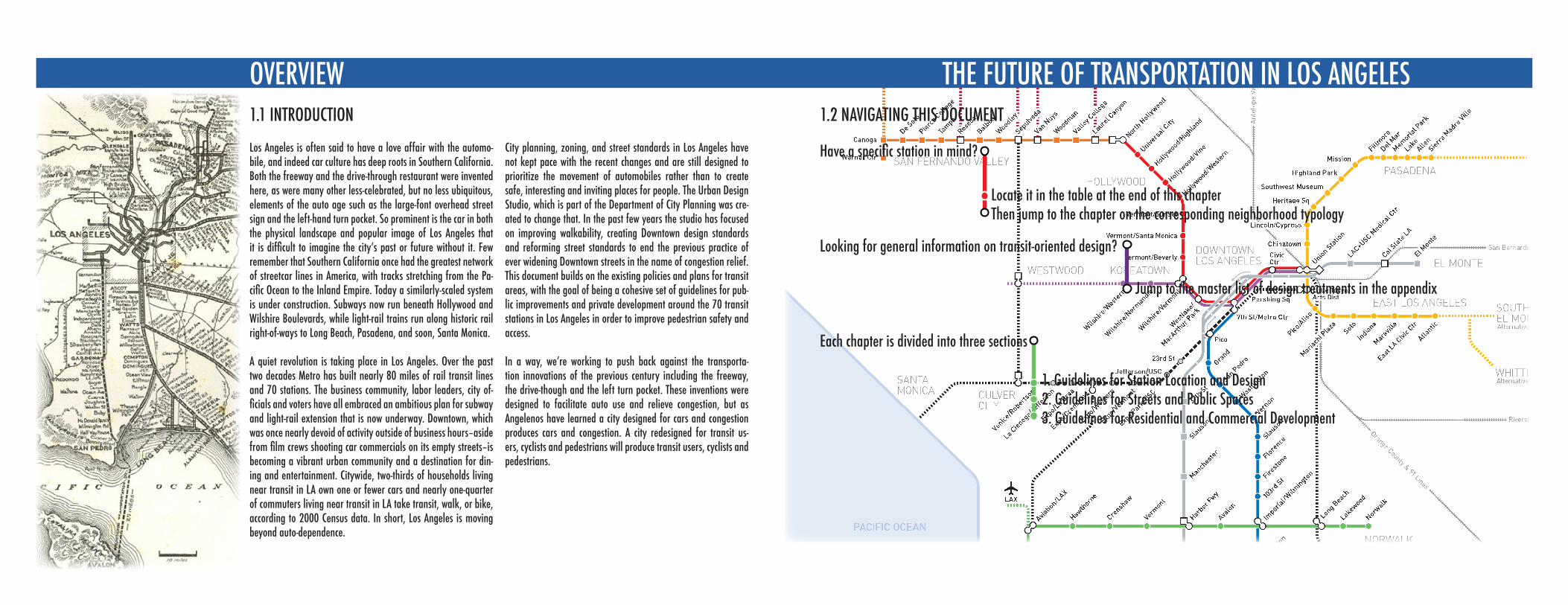
1.2 NAVIGATING THIS DOCUMENT
Have a specific station in mind?
Looking for general information on transit-oriented design?
Each chapter is divided into three sections
OVERVIEW THE FUTURE OF TRANSPORTATION IN LOS ANGELES
Los Angeles is often said to have a love affair with the automo-bile, and indeed car culture has deep roots in Southern California. Both the freeway and the drive-through restaurant were invented here, as were many other less-celebrated, but no less ubiquitous, elements of the auto age such as the large-font overhead street sign and the left-hand turn pocket. So prominent is the car in both the physical landscape and popular image of Los Angeles that it is difficult to imagine the city’s past or future without it. Few remember that Southern California once had the greatest network of streetcar lines in America, with tracks stretching from the Pa-cific Ocean to the Inland Empire. Today a similarly-scaled system is under construction. Subways now run beneath Hollywood and Wilshire Boulevards, while light-rail trains run along historic rail right-of-ways to Long Beach, Pasadena, and soon, Santa Monica.
A quiet revolution is taking place in Los Angeles. Over the past two decades Metro has built nearly 80 miles of rail transit lines and 70 stations. The business community, labor leaders, city of-ficials and voters have all embraced an ambitious plan for subway and light-rail extension that is now underway. Downtown, which was once nearly devoid of activity outside of business hours–aside from film crews shooting car commercials on its empty streets–is becoming a vibrant urban community and a destination for din-ing and entertainment. Citywide, two-thirds of households living near transit in LA own one or fewer cars and nearly one-quarter of commuters living near transit in LA take transit, walk, or bike, according to 2000 Census data. In short, Los Angeles is moving beyond auto-dependence.
City planning, zoning, and street standards in Los Angeles have not kept pace with the recent changes and are still designed to prioritize the movement of automobiles rather than to create safe, interesting and inviting places for people. The Urban Design Studio, which is part of the Department of City Planning was cre-ated to change that. In the past few years the studio has focused on improving walkability, creating Downtown design standards and reforming street standards to end the previous practice of ever widening Downtown streets in the name of congestion relief. This document builds on the existing policies and plans for transit areas, with the goal of being a cohesive set of guidelines for pub-lic improvements and private development around the 70 transit stations in Los Angeles in order to improve pedestrian safety and access.
In a way, we’re working to push back against the transporta-tion innovations of the previous century including the freeway, the drive-though and the left turn pocket. These inventions were designed to facilitate auto use and relieve congestion, but as Angelenos have learned a city designed for cars and congestion produces cars and congestion. A city redesigned for transit us-ers, cyclists and pedestrians will produce transit users, cyclists and pedestrians.
1.1 INTRODUCTION
Locate it in the table at the end of this chapterThen jump to the chapter on the corresponding neighborhood typology
Jump to the master list of design treatments in the appendix
1. Guidelines for Station Location and Design2. Guidelines for Streets and Public Spaces3. Guidelines for Residential and Commercial Development
OVERVIEW BENEFITS OF TRANSIT-ORIENTED DISTRICTS
As the City of Los Angeles continues to grow and as its residents housing needs change, concentrating housing development around transit hubs will serve a number civic goals.
1.3 WHY DEVELOP TRANSIT-ORIENTED DISTRICTS?
1. SUSTAINABILITY
Creating Transit-Oriented Districts (TODs) supports both environmental and economic sustainability. Transit-Oriented Districts more efficiently use land and energy than sprawling suburban communities, while providing enhanced mobility and access. Additionally, successful TODs reduce the number of car trips – and thus air pollution and greenhouse gas emissions – by locating housing within easy walking distance of one’s daily needs.
At the state level, Senate Bill 375 requires regions to plan for a more transit-oriented future in order to reduce vehicle-miles traveled (VMT) and auto emissions. Through Measure R, Metro’s Long Range Plan and careful TOD planning, the City of Los Angeles can actively support these goals.
Even if there were more room for the city of Los Angeles to expand its development footprint, simply put, sprawl is expensive. Transit-oriented development takes advantage of existing infrastructure, when done as an infill project. By locating development near existing transportation and utility systems, benefits municipalities because they don’t have to build entirely new lines out to new housing devel-opments – saving both upfront capital costs and long-term maintenance costs.
Finally, increasing density around transit stations – even modestly so – provides riders for the transit system. The additional fare revenues can support better service and further growth of transit in the region.
2. HOUSING AFFORDABILITY
Developing Transit-Oriented Districts allows cities to expand the stock of affordable housing by providing dwellings that lessen or eliminate the need for private vehicle ownership. These savings are conferred to individuals, but the community also reaps the benefits directly and indirectly.
As gas prices have risen substantially in the last decade, greater attention is being paid to the combined cost of hous-ing and transportation. The housing savings one might find by living farther from the city center in a car-oriented suburb can be wiped out by the increase costs of owning, operating and maintaining private autos.
According to the Center for Transit-Oriented Development, “The average household in the Los Angeles region spends 54 per-cent of its income on housing and transportation, well above the national average... Families living in walkable, location efficient neighborhoods can save up to $10,000 a yearon transportation costs in Los Angeles”
When individuals save money on transportation, they can spend and invest more in their family (i.e. education, health-care, entertainment) and community (i.e. supporting local businesses).
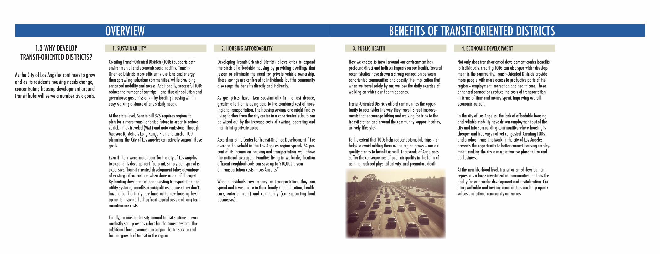
3. PUBLIC HEALTH
How we choose to travel around our environment has profound direct and indirect impacts on our health. Several recent studies have drawn a strong connection between car-oriented communities and obesity, the implication that when we travel solely by car, we lose the daily exercise of walking on which our health depends.
Transit-Oriented Districts afford communities the oppor-tunity to reconsider the way they travel. Street improve-ments that encourage biking and walking for trips to the transit station and around the community support healthy, actively lifestyles.
To the extent that TODs help reduce automobile trips – or helps to avoid adding them as the region grows – our air quality stands to benefit as well. Thousands of Angelenos suffer the consequences of poor air quality in the form of asthma, reduced physical activity, and premature death.
4. ECONOMIC DEVELOPMENT
Not only does transit-oriented development confer benefits to individuals, creating TODs can also spur wider develop-ment in the community. Transit-Oriented Districts provide more people with more access to productive parts of the region – employment, recreation and health care. These enhanced connections reduce the costs of transportation in terms of time and money spent, improving overall economic output.
In the city of Los Angeles, the lack of affordable housing and reliable mobility have driven employment out of the city and into surrounding communities where housing is cheaper and freeways not yet congested. Creating TODs and a robust transit network in the city of Los Angeles presents the opportunity to better connect housing employ-ment, making the city a more attractive place to live and do business.
At the neighborhood level, transit-oriented development represents a large investment in communities that has the ability foster broader development and revitalization. Cre-ating walkable and inviting communities can lift property values and attract community amenities.
OVERVIEW5. UNIVERSAL ACCESSABILITY
At their core, Transit-Oriented Districts are all about providing more housing within easy access to transit; for no group is this more important than those with physical limitations that limit their mobility. TODs can help address the lack of diversity of housing accommodations for those that are unable to get around easily and/or are unable to drive. The transit component provides convenient and affordable access to the region’s various social, economic and cultural destinations.
Additionally, TOD projects that mix housing with other land uses, like neighborhood stores and restaurants, make tak-ing car of ones daily needs much easier for residents with limited mobility.
6. SAFETY AND SECURITY
Making pedestrian- and bike-oriented street improvements in Transit-Oriented Districts has a track record of fostering safe streets for all road users. Traffic calming measures reduce collisions and accidents of all types, making the streets safer and more pleasant for pedestrians and cyclists – and thus supporting the public health benefits mentioned above in a virtuous cycle.
A 2008 study of 24 California cities published in New Urban News revealed that neighborhoods with high quality street connectivity, smaller block sizes, and more intersec-tions have significantly lower rates of fatalities.
Better lighting and a built environment that puts more “eyes on the street” can also enhance perceptions of safety and security.
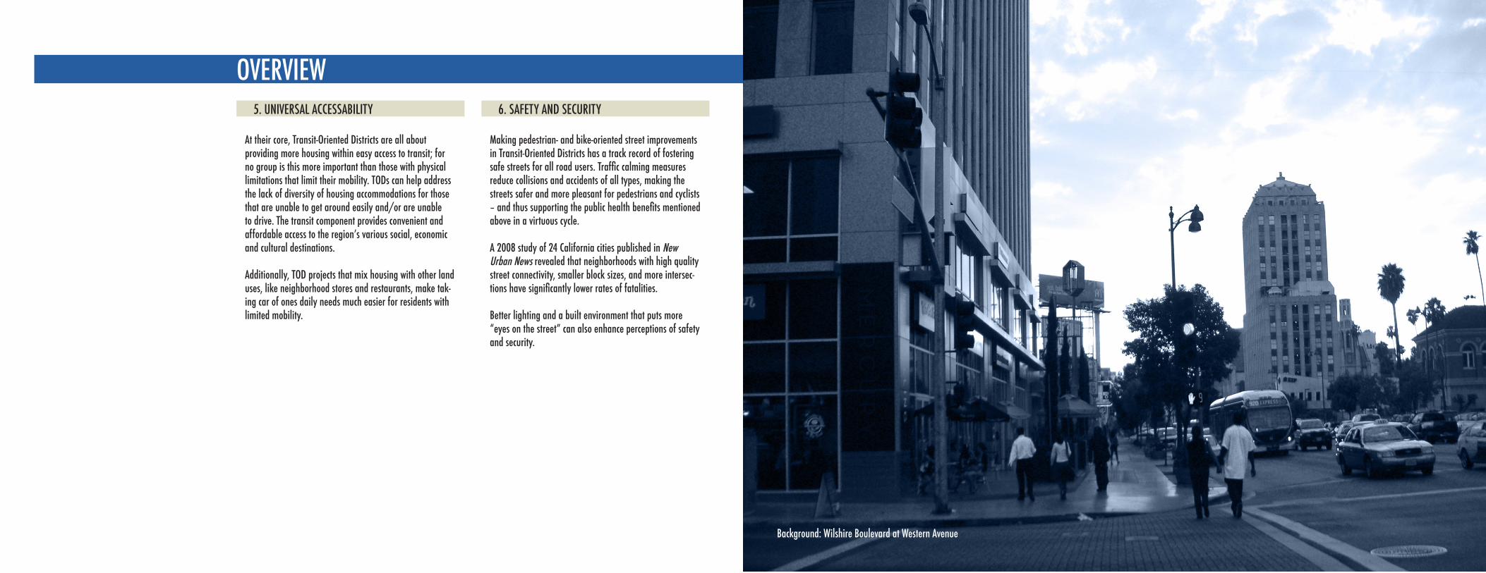
Background: Wilshire Boulevard at Western Avenue
OVERVIEW DESIGNING TRANSIT-ORIENTED DISTRICTS1.4 CONTEXT:
EXISTING PLANS AND POLICIESCHAPTER 3: LAND USE
“The Land Use policy encourages the retention of the • City’s stable residential neighborhoods and proposes incentives to encourage whatever growth that occurs to locate ... in proximity to transportation corridors and transit stations”
The Land Use policy calls for • “the establishment of pedestrian-oriented districts.”
“As a joint effort of the City of Los Angeles and Met-• ropolitan Transportation Authority, a policy has been adopted to foster the development of higher-density mixed-use projects within one-quarter mile of rail and major bus transit facilities. Adherence to this policy will significantly influence the form and character of devel-opment in the City. As additional rail transit routes are confirmed and funded (or unfunded), policy enables the revision of the plans to establish appropriate uses and densities in proximity to these facilities, in accor-dance with the Land Use/Transportation Policy.”
Policy 3.15.1 directs the Planning Department to “• Pre-pare detailed plans for land use and development of transit-oriented districts consistent with the provisions of the General Plan Framework Element and the Land Use/Transportation Policy.”
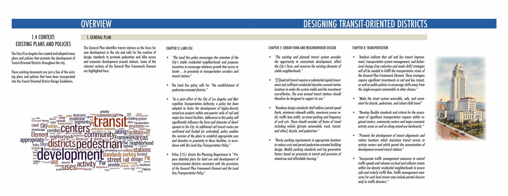
The City of Los Angeles has created and adopted many plans and policies that promote the development of Transit-Oriented Districts throughout the city.
These existing documents are just a few of the exist-ing plans and policies that have been incorporated into the Transit Oriented District Design Guidelines.
1. GENERAL PLAN
The General Plan identifies transit stations as the focus for new development in the city and calls for the creation of design standards to promote pedestrian and bike access and economic development around stations. Some of the relevant sections of the General Plan Framework Element are highlighted here.
CHAPTER 8: TRANSPORTATION
“Analysis indicate that rail and bus transit improve-• ment, transportation system management, and behav-ioral change (trip reduction and mode shift) strategies will all be needed to fulfill the transportation vision of the General Plan Framework Element. These strategies require significant investments in rail and bus transit, as well as public policies to encourage shifts away from the single-occupant automobile to other choices.”
“Make the street system accessible, safe, and conve-• nient for bicycle, pedestrian, and school child travel”
“Develop flexible standards and criteria for the assess-• ment of significant transportation impacts within re-gional centers, community centers and major economic activity areas as well as along mixed-use boulevards.”
“Promote the development of transit alignments and • station locations which maximize transit service to activity centers and which permit the concentration of development around transit stations”
“Incorporate traffic management measures to control • traffic speeds and volumes on local and collector streets within low density residential neighborhoods to assure safe and orderly traffic flow. Traffic management mea-sures for such local streets may include partial closures and/or traffic diverters.”
CHAPTER 5: URBAN FORM AND NEIGHBORHOOD DESIGN
“The existing and planned transit system provides • the opportunity to concentrate development, affect the City’s form, and conserve the existing character of stable neighborhoods.”
“[F]ixed rail transit requires a substantial capital invest-• ment and sufficient residential densities around station locations to make the system viable and the investment cost-effective. The area around transit stations should therefore be designed to support its use.”
“Roadway design standards shall address posted speed • limits, minimum sidewalk widths, maximum corner ra-dii, traffic lane width, on-street parking and frequency of curb cuts. These should consider all forms of travel including vehicle (private automobile, truck, transit, and other), bicycle, and pedestrian.”
“Revise parking requirements in appropriate locations • to reduce costs and permit pedestrian-oriented building design. Modify parking standards and trip generation factors based on proximity to transit and provision of mixed-use and affordable housing.”
OVERVIEW DESIGNING TRANSIT-ORIENTED DISTRICTS2. BICYCLE PLAN
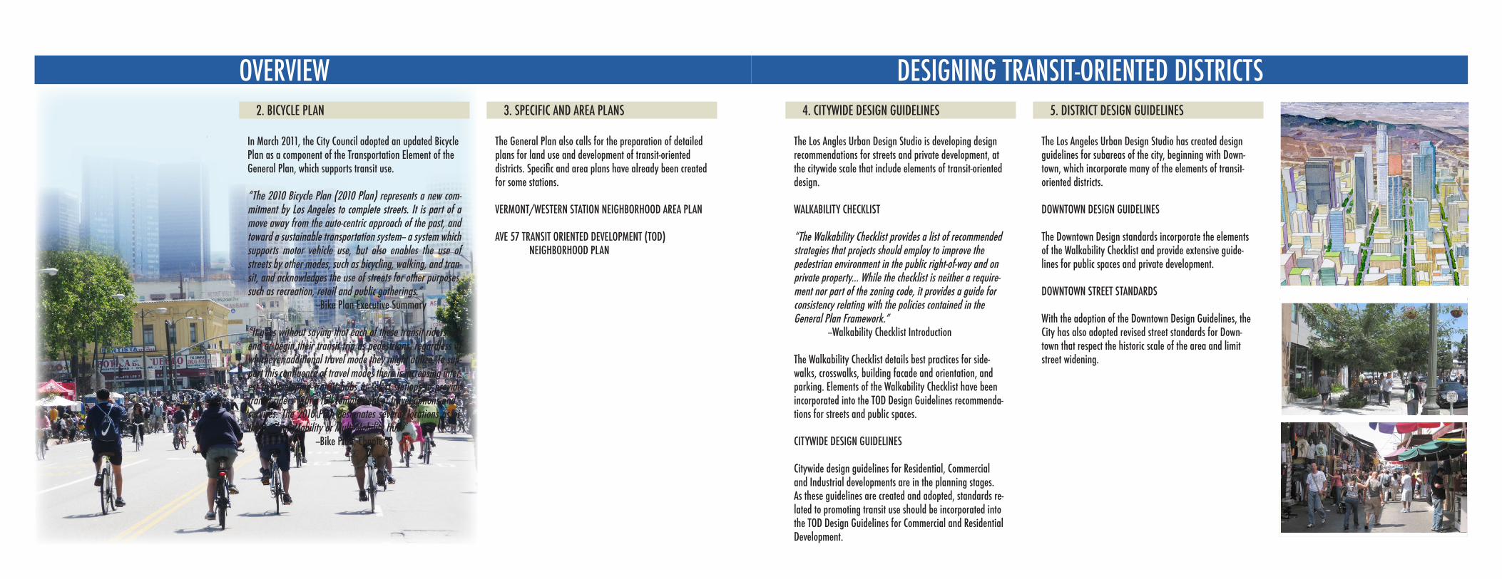
In March 2011, the City Council adopted an updated Bicycle Plan as a component of the Transportation Element of the General Plan, which supports transit use.
“The 2010 Bicycle Plan (2010 Plan) represents a new com-mitment by Los Angeles to complete streets. It is part of a move away from the auto-centric approach of the past, and toward a sustainable transportation system-- a system which supports motor vehicle use, but also enables the use of streets by other modes, such as bicycling, walking, and tran-sit, and acknowledges the use of streets for other purposes, such as recreation, retail and public gatherings.” --Bike Plan Executive Summary
“It goes without saying that each of these transit riders will end or begin their transit trip as pedestrians, regardless of whichever additional travel mode they might utilize. To sup-port this confluence of travel modes there is increasing inter-est in developing transit hubs at select stations to provide transit riders with a full complement of travel options andservices. The 2010 Plan designates several locations as ei-ther a Clean Mobility or Multi-Mobility Hub.” --Bike Plan, Chapter 3
3. SPECIFIC AND AREA PLANS
The General Plan also calls for the preparation of detailed plans for land use and development of transit-oriented districts. Specific and area plans have already been created for some stations.
VERMONT/WESTERN STATION NEIGHBORHOOD AREA PLAN
AVE 57 TRANSIT ORIENTED DEVELOPMENT (TOD) NEIGHBORHOOD PLAN
4. CITYWIDE DESIGN GUIDELINES
The Los Angles Urban Design Studio is developing design recommendations for streets and private development, at the citywide scale that include elements of transit-oriented design.
WALKABILITY CHECKLIST
“The Walkability Checklist provides a list of recommended strategies that projects should employ to improve the pedestrian environment in the public right-of-way and on private property... While the checklist is neither a require-ment nor part of the zoning code, it provides a guide for consistency relating with the policies contained in the General Plan Framework.” --Walkability Checklist Introduction
The Walkability Checklist details best practices for side-walks, crosswalks, building facade and orientation, and parking. Elements of the Walkability Checklist have been incorporated into the TOD Design Guidelines recommenda-tions for streets and public spaces.
CITYWIDE DESIGN GUIDELINES
Citywide design guidelines for Residential, Commercial and Industrial developments are in the planning stages. As these guidelines are created and adopted, standards re-lated to promoting transit use should be incorporated into the TOD Design Guidelines for Commercial and Residential Development.
5. DISTRICT DESIGN GUIDELINES
The Los Angeles Urban Design Studio has created design guidelines for subareas of the city, beginning with Down-town, which incorporate many of the elements of transit-oriented districts.
DOWNTOWN DESIGN GUIDELINES
The Downtown Design standards incorporate the elements of the Walkability Checklist and provide extensive guide-lines for public spaces and private development.
DOWNTOWN STREET STANDARDS
With the adoption of the Downtown Design Guidelines, the City has also adopted revised street standards for Down-town that respect the historic scale of the area and limit street widening.
D E S I G N G U I D EDOWNTOWNC I T Y O F L O S A N G E L E S
D E S I G N G U I D EDOWNTOWNC I T Y O F L O S A N G E L E S
OVERVIEW DESIGNING TRANSIT-ORIENTED DISTRICTS
Eliminate
AdvanceLocate
Demand
Off
ereq
uire
1 DEMAND a walkable city The answer to one question, more than any other, will tell us whether a project has it right: Does the proposal actively welcome its own users, its neighbors, its passersby? The planning history of Los Angeles exposes our failure to ana-lyze buildings in context. Smitten by the automobile, we trivialized our daily role as pedestrian, our need for inviting storefronts, broad sidewalks, plentiful benches, graceful lighting. We must prioritize the human scale of our built structures and street environments. We must insist that each new project visibly knit people together.
2 OFFER basic design standards Too many rules are a bane to growth and development. But too few rules, or misguided rules, can invite shoddy product and shabby boulevards. We must strike the right balance by announcing a handful of fundamental design requirements. Our goal should be to eliminate the sea of stucco boxes, blank walls, street-front parking lots, and other inhospi-table streetscapes.
3 REQUIRE density around transit We need more jobs and housing, for our current residents and for those whose arrival is imminent. At the same time, we must foster our fledgling rail system and its bus partner, to untangle our worsening traffic. The planning solution is elementary: congregate additional density at train and rapid bus stops, and discourage new density where we anticipate no mass transit relief valve.
uire
4 ELIMINATE department bottlenecks The volume of permit applications, our caseloads, and processing time have risen exponentially. Yes, these increases have occurred during years of hiring freezes and unaddressed attrition. But, this Mayor and City Council have pledged to strengthen our numbers. We must respond by ferreting out our systemic slowdowns. Our delayed responses abet inferior projects and kill quality development.
5 ADVANCE homes for every income We own a prized commodity: the power to increase the value of land by making its zoning more lucrative. The property owner need not be the exclusive benefi-ciary of our pen stroke. In this time of housing crisis, let’s unabashedly exploit this asset for the common good. Every upzoning should carry with it an obliga-tion to provide, preferably through on-site units but at least via monetary con-tribution, housing for the poor and middle class. We can all win.
6 LOCATE jobs near housing The time for segregating jobs from housing in Los Angeles has passed. The age of unrelenting sprawl has met its match in intolerable commute times. Fortunately, we have several stale business boulevards and districts that are ripe for reno-vation; in these traditionally commercial-only locations, we must include both jobs and housing in the new mix.
Every movement has its moment. Its beginning. Mayor Antonio Villaraigosa and Planning Director Gail Goldberg have challenged each of us to do more. It is our privilege to follow their lead. The time for inspired, principled land use plan-ning in Los Angeles is now.
© 2007 Los Angeles City Planning Commission Jane Ellison Usher, President; William Roschen, Vice President; Diego Cardoso; Regina M. Freer; Robin R. Hughes; Sabrina Kay; Father Spencer T. Kezios; Michael K. Woo.
Iden
tify
Neu
tral
ize
Landscape
Arr
est
Produce
Nurture
Narrow Giveeze
8 LANDSCAPE in abundance The Mayor has challenged us to plant a million trees. But most development proposals still only offer to meet the minimum requirements for landscaping; many do not even rise to that level. We must rewrite our project submission requirements and our landscaping mitigation mea-sures to show our seriousness and solidarity of purpose on adding shrubs, vines, and trees to create an urban forest.
9 ARREST visual blight Amidst the clutter of power lines, slapdash signage, and the demolition of our historic gems, it is difficult to find visual calm on our streets. The Planning Department has a key role to play in reducing the built intrusions into the lives of our residents. We must seek phased elimination of above-ground wires, controlled limitation of signage to appropriate districts, numbers, and sizes, and preservation of our historic resources.
10 NEUTRALIZE mansionization Neighborhoods zoned single family deserve our protec-tion. The most pervasive threat they face is the replacement of existing homes with residences whose bulk and mass is significantly larger than the street’s current character— sacrificing greenery, breath-ing room, light, and air. Let’s be the champions of a city-wide solution to prevent out-of-scale residences.
13 NARROW road widenings The most overused mitigation measure in the City is the requirement that the road adja-cent to a project be widened to appease the introduction of additional people. This rarely solves, and often invites, more passenger car congestion, and typically undermines our walkability goals. We must categorically reject nonsensical road widenings.
11 NURTURE planning leadership Professional planning advice has been supplanted in this City with politi-cally engineered compromise. Decades of this behav-ior have produced a reticent Planning Department that bends freely to both elected officials and fellow departments. We must alter this culture by standing strong for one thing at all times: advocacy of sound planning. Courageous and cogent planning must be rewarded and its practitioners promoted to positions of leadership.
14 GIVE project input early A hallmark of our passivity has been to offer our advice so late in the development process as to be irrelevant. We routinely hear “the plans have been finished for months” or “the cost of making that change would be prohibitive.” The Plan-ning Department must reorganize its case intake process and provide prelimi-nary guidance, or outright rejection of the case as incomplete, within sixty days after an application is filed.
12 IDENTIFY smart parking requirements Our long-standing love affair with the auto-mobile has led us to mandate acres of parking spaces and parking lots that often occupy prime street frontage. We must revisit our “one size fits all” suburban parking standards, and replace them with project and location-specific tools such as parking maximums, pooled parking, automated stacked parking, and other emerging techniques.
7 PRODUCE green buildings We are late to the party. The City’s codes must be overhauled to require, or at the very least incentivize, building materials, sys-tems, and methods that are health conscious and environmentally friendly. We planners should not wait for such new rules to hit the books. Let’s an-nounce today a menu of benefits that any developer who will commit to building a LEED certified project can expect in return from our department.
Des
ign:
Sus
sman
/P
rejz
a &
Com
pany
, In
c.
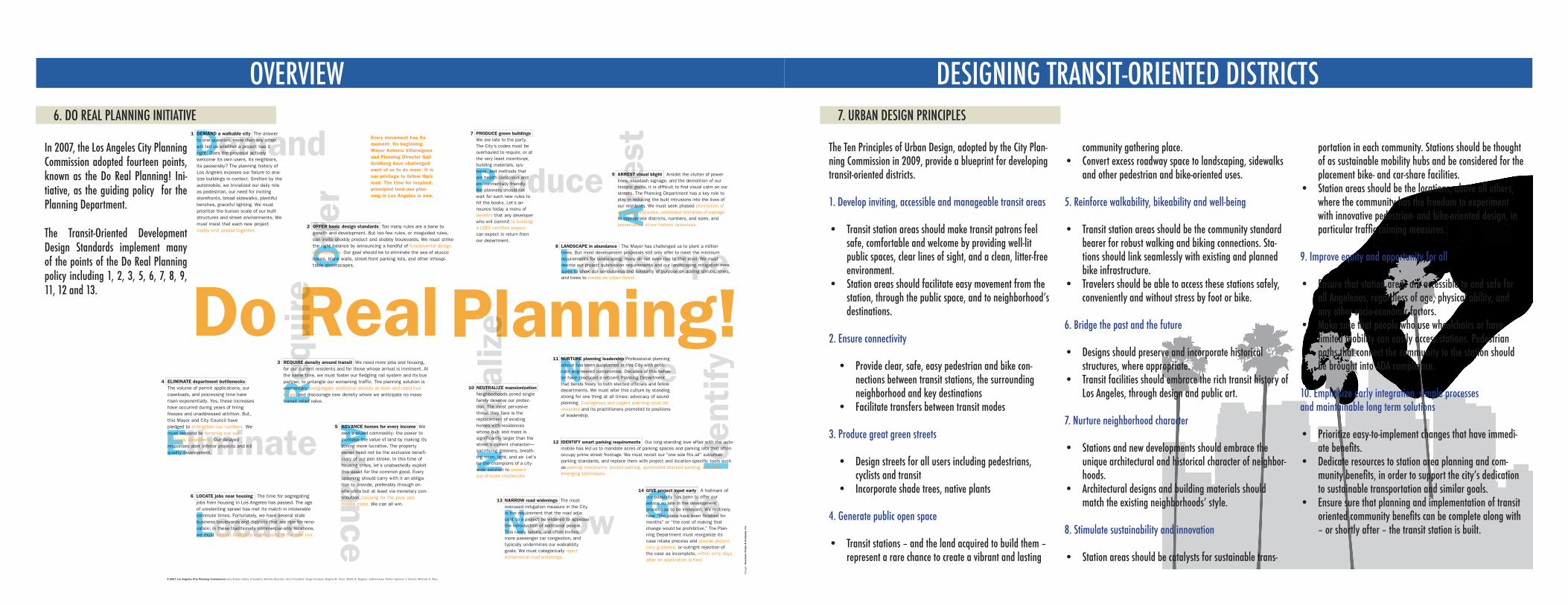
6. DO REAL PLANNING INITIATIVE
In 2007, the Los Angeles City Planning Commission adopted fourteen points, known as the Do Real Planning! Ini-tiative, as the guiding policy for the Planning Department.
The Transit-Oriented Development Design Standards implement many of the points of the Do Real Planning policy including 1, 2, 3, 5, 6, 7, 8, 9, 11, 12 and 13.
The Ten Principles of Urban Design, adopted by the City Plan-ning Commission in 2009, provide a blueprint for developing transit-oriented districts.
1. Develop inviting, accessible and manageable transit areas
Transit station areas should make transit patrons feel • safe, comfortable and welcome by providing well-lit public spaces, clear lines of sight, and a clean, litter-free environment.Station areas should facilitate easy movement from the • station, through the public space, and to neighborhood’s destinations.
2. Ensure connectivity
Provide clear, safe, easy pedestrian and bike con-• nections between transit stations, the surrounding neighborhood and key destinationsFacilitate transfers between transit modes•
3. Produce great green streets
Design streets for all users including pedestrians, • cyclists and transitIncorporate shade trees, native plants•
4. Generate public open space
Transit stations – and the land acquired to build them – • represent a rare chance to create a vibrant and lasting
community gathering place.Convert excess roadway space to landscaping, sidewalks • and other pedestrian and bike-oriented uses.
5. Reinforce walkability, bikeability and well-being
Transit station areas should be the community standard • bearer for robust walking and biking connections. Sta-tions should link seamlessly with existing and planned bike infrastructure.Travelers should be able to access these stations safely, • conveniently and without stress by foot or bike.
6. Bridge the past and the future
Designs should preserve and incorporate historical • structures, where appropriate.Transit facilities should embrace the rich transit history of • Los Angeles, through design and public art.
7. Nurture neighborhood character
Stations and new developments should embrace the • unique architectural and historical character of neighbor-hoods.Architectural designs and building materials should • match the existing neighborhoods’ style.
8. Stimulate sustainability and innovation
Station areas should be catalysts for sustainable trans-•
portation in each community. Stations should be thought of as sustainable mobility hubs and be considered for the placement bike- and car-share facilities. Station areas should be the locations, above all others, • where the community has the freedom to experiment with innovative pedestrian- and bike-oriented design, in particular traffic calming measures.
9. Improve equity and opportunity for all
Ensure that station areas are accessible to and safe for • all Angelenos, regardless of age, physical ability, and any other socio-economic factors.Make sure that people who use wheelchairs or have • limited mobility can easily access stations. Pedestrian paths that connect the community to the station should be brought into ADA compliance.
10. Emphasize early integration, simple processes and maintainable long term solutions
Prioritize easy-to-implement changes that have immedi-• ate benefits.Dedicate resources to station area planning and com-• munity benefits, in order to support the city’s dedication to sustainable transportation and similar goals.Ensure sure that planning and implementation of transit • oriented community benefits can be complete along with – or shortly after – the transit station is built.
7. URBAN DESIGN PRINCIPLES
OVERVIEW
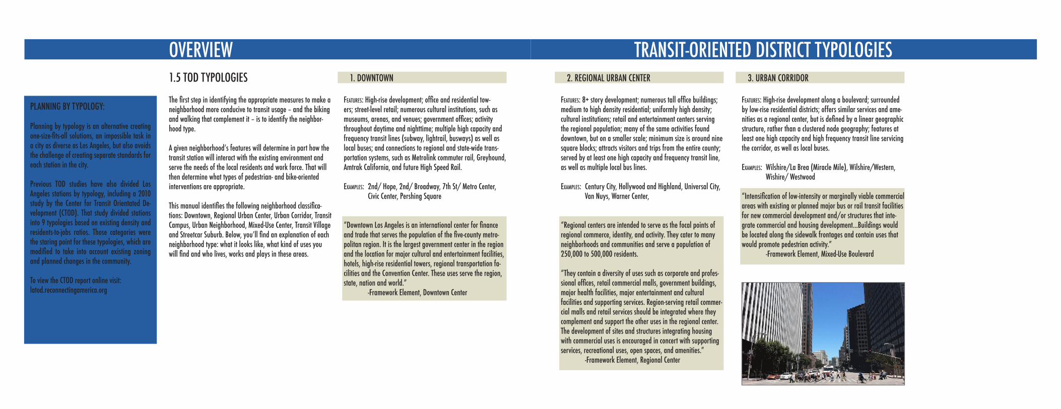
The first step in identifying the appropriate measures to make a neighborhood more conducive to transit usage – and the biking and walking that complement it – is to identify the neighbor-hood type.
A given neighborhood’s features will determine in part how the transit station will interact with the existing environment and serve the needs of the local residents and work force. That will then determine what types of pedestrian- and bike-oriented interventions are appropriate.
This manual identifies the following neighborhood classifica-tions: Downtown, Regional Urban Center, Urban Corridor, Transit Campus, Urban Neighborhood, Mixed-Use Center, Transit Village and Streetcar Suburb. Below, you’ll find an explanation of each neighborhood type: what it looks like, what kind of uses you will find and who lives, works and plays in these areas.
1.5 TOD TYPOLOGIES 1. DOWNTOWN
Features: High-rise development; office and residential tow-ers; street-level retail; numerous cultural institutions, such as museums, arenas, and venues; government offices; activity throughout daytime and nighttime; multiple high capacity and frequency transit lines (subway, lightrail, busways) as well as local buses; and connections to regional and state-wide trans-portation systems, such as Metrolink commuter rail, Greyhound, Amtrak California, and future High Speed Rail.
examples: 2nd/ Hope, 2nd/ Broadway, 7th St/ Metro Center, Civic Center, Pershing Square
“Downtown Los Angeles is an international center for finance and trade that serves the population of the five-county metro-politan region. It is the largest government center in the region and the location for major cultural and entertainment facilities, hotels, high-rise residential towers, regional transportation fa-cilities and the Convention Center. These uses serve the region, state, nation and world.” -Framework Element, Downtown Center
TRANSIT-ORIENTED DISTRICT TYPOLOGIES2. REGIONAL URBAN CENTER
Features: 8+ story development; numerous tall office buildings; medium to high density residential; uniformly high density; cultural institutions; retail and entertainment centers serving the regional population; many of the same activities found downtown, but on a smaller scale; minimum size is around nine square blocks; attracts visitors and trips from the entire county; served by at least one high capacity and frequency transit line, as well as multiple local bus lines.
examples: Century City, Hollywood and Highland, Universal City, Van Nuys, Warner Center,
“Regional centers are intended to serve as the focal points of regional commerce, identity, and activity. They cater to many neighborhoods and communities and serve a population of 250,000 to 500,000 residents.
“They contain a diversity of uses such as corporate and profes-sional offices, retail commercial malls, government buildings, major health facilities, major entertainment and cultural facilities and supporting services. Region-serving retail commer-cial malls and retail services should be integrated where they complement and support the other uses in the regional center. The development of sites and structures integrating housing with commercial uses is encouraged in concert with supporting services, recreational uses, open spaces, and amenities.” -Framework Element, Regional Center
3. URBAN CORRIDOR
Features: High-rise development along a boulevard; surrounded by low-rise residential districts; offers similar services and ame-nities as a regional center, but is defined by a linear geographic structure, rather than a clustered node geography; features at least one high capacity and high frequency transit line servicing the corridor, as well as local buses.
examples: Wilshire/La Brea (Miracle Mile), Wilshire/Western, Wishire/ Westwood
“Intensification of low-intensity or marginally viable commercial areas with existing or planned major bus or rail transit facilities for new commercial development and/or structures that inte-grate commercial and housing development...Buildings would be located along the sidewalk frontages and contain uses that would promote pedestrian activity.” -Framework Element, Mixed-Use Boulevard
PLANNING BY TYPOLOGY:
Planning by typology is an alternative creating one-size-fits-all solutions, an impossible task in a city as diverse as Los Angeles, but also avoids the challenge of creating separate standards for each station in the city.
Previous TOD studies have also divided Los Angeles stations by typology, including a 2010 study by the Center for Transit Orientated De-velopment (CTOD). That study divided stations into 9 typologies based on existing density and residents-to-jobs ratios. Those categories were the staring point for these typologies, which are modified to take into account existing zoning and planned changes in the community.
To view the CTOD report online visit:latod.reconnectingamerica.org
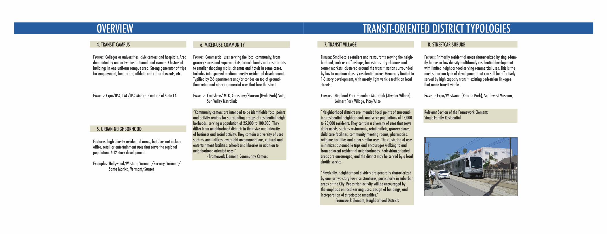
OVERVIEW4. TRANSIT CAMPUS
Features: Colleges or universities, civic centers and hospitals. Area dominated by one or two institutional land owners. Clusters of buildings in one uniform campus area. Strong generator of trips for employment, healthcare, athletic and cultural events, etc.
examples: Expo/USC, LAC/USC Medical Center, Cal State LA
5. URBAN NEIGHBORHOOD
Features: high-density residential areas, but does not include office, retail or entertainment uses that serve the regional population; 6-12 story development.
Examples: Hollywood/Western, Vermont/Bervery, Vermont/ Santa Monica, Vermont/Sunset
6. MIXED-USE COMMUNITY
Features: Commercial uses serving the local community, from grocery stores and supermarkets, branch banks and restaurants to smaller shopping malls, cinemas and hotels in some cases. Includes interspersed medium density residential development. Typified by 2-6 apartments and/or condos on top of ground-floor retail and other commercial uses that face the street.
Examples: Crenshaw/ MLK, Crenshaw/Slauson (Hyde Park) Soto, Sun Valley Metrolink
“Community centers are intended to be identifiable focal points and activity centers for surrounding groups of residential neigh-borhoods, serving a population of 25,000 to 100,000. They differ from neighborhood districts in their size and intensity of business and social activity. They contain a diversity of uses such as small offices, overnight accommodations, cultural and entertainment facilities, schools and libraries in addition to neighborhood-oriented uses.” - Framework Element, Community Centers
TRANSIT-ORIENTED DISTRICT TYPOLOGIES7. TRANSIT VILLAGE
Features: Small-scale retailers and restaurants serving the neigh-borhood, such as coffeeshops, bookstores, dry cleaners and corner markets, clustered around the transit station surrounded by low to medium density residential areas. Generally limited to 1-3 story development, with mostly light vehicle traffic on local streets.
examples: Highland Park, Glendale Metrolink (Atwater Village), Leimert Park Village, Pico/Aliso
“Neighborhood districts are intended focal points of surround-ing residential neighborhoods and serve populations of 15,000 to 25,000 residents. They contain a diversity of uses that serve daily needs, such as restaurants, retail outlets, grocery stores, child care facilities, community meeting rooms, pharmacies, religious facilities and other similar uses. The clustering of uses minimizes automobile trips and encourages walking to and from adjacent residential neighborhoods. Pedestrian-oriented areas are encouraged, and the district may be served by a local shuttle service.
“Physically, neighborhood districts are generally characterized by one- or two-story low-rise structures, particularly in suburban areas of the City. Pedestrian activity will be encouraged by the emphasis on local-serving uses, design of buildings, and incorporation of streetscape amenities.” -Framework Element, Neighborhood Districts
8. STREETCAR SUBURB
Features: Primarily residential areas characterized by single-fam-ily homes or low-density multifamily residential development with limited neighborhood-serving commercial uses. This is the most suburban type of development that can still be effectively served by high capacity transit; existing pedestrian linkages that make transit viable.
examples: Expo/Westwood (Rancho Park), Southwest Museum,
Relevant Section of the Framework Element: Single-Family Residential
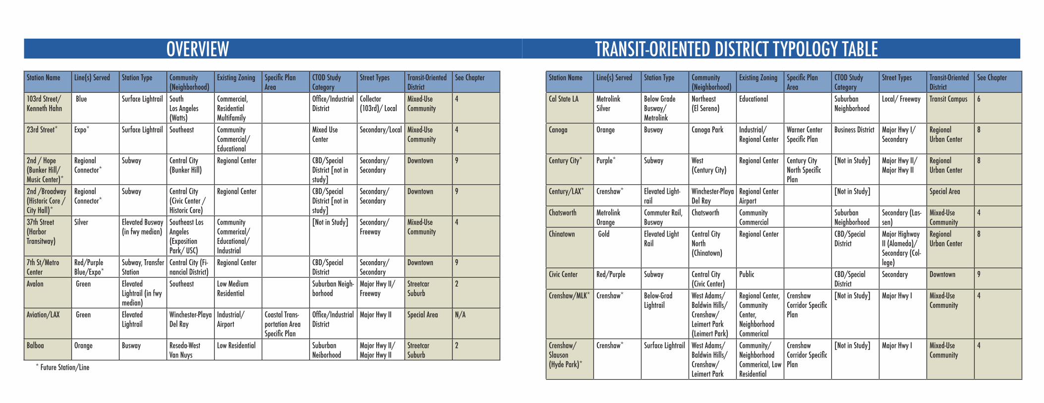
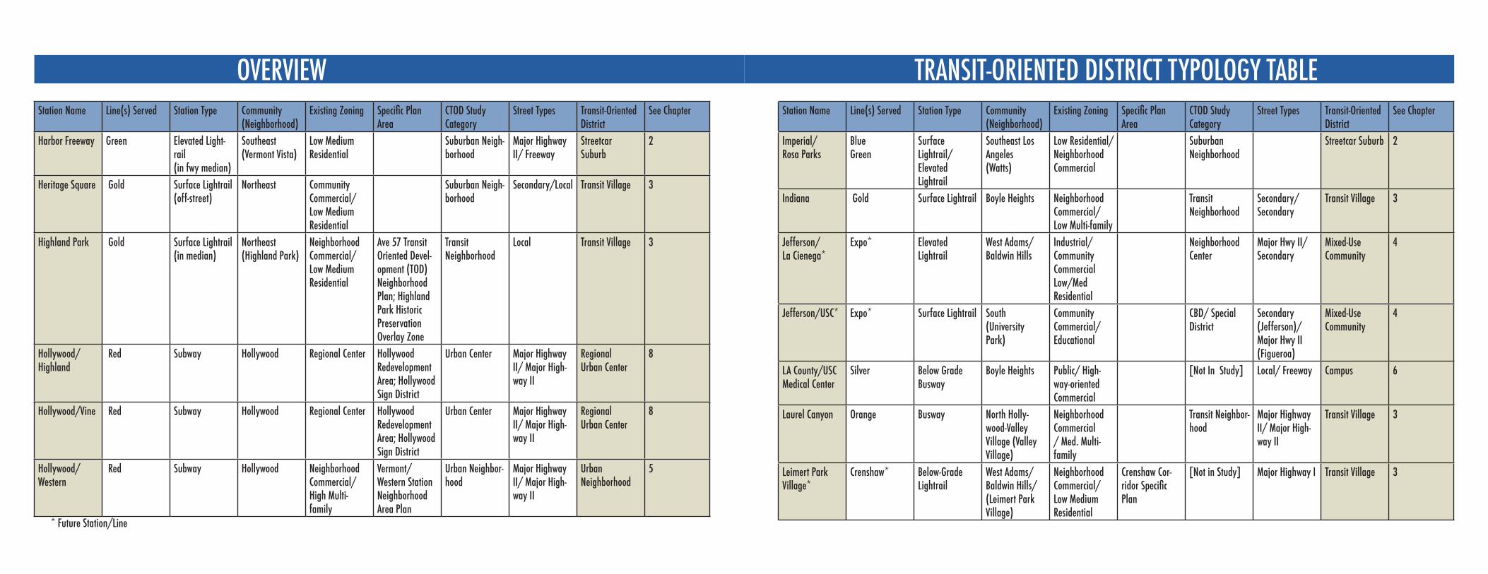
OVERVIEW TRANSIT-ORIENTED DISTRICT TYPOLOGY TABLE Station Name Line(s) Served Station Type Community
(Neighborhood)Existing Zoning Specific Plan
AreaCTOD Study Category
Street Types Transit-Oriented District
See Chapter
103rd Street/Kenneth Hahn
Blue Surface Lightrail South Los Angeles (Watts)
Commercial, Residential Multifamily
Office/Industrial District
Collector (103rd)/ Local
Mixed-Use Community
4
23rd Street* Expo* Surface Lightrail Southeast Community Commercial/ Educational
Mixed Use Center
Secondary/Local Mixed-Use Community
4
2nd / Hope (Bunker Hill/Music Center)*
Regional Connector*
Subway Central City (Bunker Hill)
Regional Center CBD/Special District [not in study]
Secondary/Secondary
Downtown 9
2nd /Broadway (Historic Core / City Hall)*
Regional Connector*
Subway Central City (Civic Center / Historic Core)
Regional Center CBD/Special District [not in study]
Secondary/Secondary
Downtown 9
37th Street (Harbor Transitway)
Silver Elevated Busway (in fwy median)
Southeast Los Angeles(Exposition Park/ USC)
Community Commerical/ Educational/ Industrial
[Not in Study] Secondary/Freeway
Mixed-Use Community
4
7th St/Metro Center
Red/PurpleBlue/Expo*
Subway, Transfer Station
Central City (Fi-nancial District)
Regional Center CBD/Special District
Secondary/Secondary
Downtown 9
Avalon Green Elevated Lightrail (in fwy median)
Southeast Low Medium Residential
Suburban Neigh-borhood
Major Hwy II/ Freeway
Streetcar Suburb
2
Aviation/LAX Green Elevated Lightrail
Winchester-Playa Del Ray
Industrial/ Airport
Coastal Trans-portation Area Specific Plan
Office/Industrial District
Major Hwy II Special Area N/A
Balboa Orange Busway Reseda-West Van Nuys
Low Residential Suburban Neiborhood
Major Hwy II/Major Hwy II
StreetcarSuburb
2
Station Name Line(s) Served Station Type Community (Neighborhood)
Existing Zoning Specific Plan Area
CTOD Study Category
Street Types Transit-Oriented District
See Chapter
Cal State LA Metrolink Silver
Below Grade Busway/Metrolink
Northeast (El Sereno)
Educational Suburban Neighborhood
Local/ Freeway Transit Campus 6
Canoga Orange Busway Canoga Park Industrial/Regional Center
Warner Center Specific Plan
Business District Major Hwy I/ Secondary
Regional Urban Center
8
Century City* Purple* Subway West (Century City)
Regional Center Century City North Specific Plan
[Not in Study] Major Hwy II/ Major Hwy II
Regional Urban Center
8
Century/LAX* Crenshaw* Elevated Light-rail
Winchester-Playa Del Ray
Regional Center Airport
[Not in Study] Special Area
Chatsworth Metrolink Orange
Commuter Rail, Busway
Chatsworth Community Commercial
Suburban Neighborhood
Secondary (Las-sen)
Mixed-Use Community
4
Chinatown Gold Elevated Light Rail
Central City North(Chinatown)
Regional Center CBD/Special District
Major Highway II (Alameda)/ Secondary (Col-lege)
Regional Urban Center
8
Civic Center Red/Purple Subway Central City (Civic Center)
Public CBD/Special District
Secondary Downtown 9
Crenshaw/MLK* Crenshaw* Below-Grad Lightrail
West Adams/Baldwin Hills/ Crenshaw/Leimert Park (Leimert Park)
Regional Center, Community Center, Neighborhood Commerical
Crenshaw Corridor Specific Plan
[Not in Study] Major Hwy I Mixed-Use Community
4
Crenshaw/ Slauson (Hyde Park)*
Crenshaw* Surface Lightrail West Adams/Baldwin Hills/ Crenshaw/ Leimert Park
Community/Neighborhood Commerical, Low Residential
Crenshaw Corridor Specific Plan
[Not in Study] Major Hwy I Mixed-UseCommunity
4
* Future Station/Line

OVERVIEW TRANSIT-ORIENTED DISTRICT TYPOLOGY TABLEStation Name Line(s) Served Station Type Community
(Neighborhood)Existing Zoning Specific Plan
AreaCTOD Study Category
Street Types Transit-Oriented District
See Chapter
Culver City* Expo* Elevated Lightrail
West Adams/Palms
Commerical/Med Residential
Mixed-UseCommunity
4
De Soto Orange Busway Woodland Hills Med/ Low Residential
Neighborhood Center
Major Hwy I/ Major Hwy II
Streetcar Suburb 2
Expo / Bundy* Expo* Elevated Lightrail
West (Sawtelle) Low Residential/ Industrial
West Los Angeles Transportation Improvement and Mitigation Specific Plan
[Not In Study] Secondary Mixed-Use Community
4
Expo / Sepulveda*
Expo* Surface Lightrail West (Rancho Park)
Medium Residential/ Industrial
West Los Angeles Transportation Improvement and Mitigation Specific Plan
[Not In Study] Major Hwy II (Sepulveda)/ Secondary
Mixed-Use Community
4
Expo / Western* Expo* Surface Lightrail South (Exposi-tion Park)
Neighborhood Commercial/ Low Medium Residential/ Educational (Jr High)
Transit Neighborhood
Major Hwy II (Western)/ Secondary
Transit Village 3
Expo Park / USC*
Expo* Surface Lightrail South (Exposi-tion Park)
Institutional/ Educational
Mixed Use Center
Secondary Transit Campus 6
Expo/ Crenshaw*
Expo*Crenshaw*
Surface Lightrail West Adams (Baldwin Hills/ Crenshaw)
Community Commercial/ Medium Residential
Crenshaw Corridor Specific Plan
Suburban Neigh-borhood
Major Hwy I (Crenshaw)/ Secondary
Mixed-Use Community
4
Station Name Line(s) Served Station Type Community (Neighborhood)
Existing Zoning Specific Plan Area
CTOD Study Category
Street Types Transit-Oriented District
See Chapter
Expo/ La Brea* Expo* Elevated Lightrail
West Adams/Baldwin Hills/ Crenshaw
Community Commercial/ Low-Medium Residential / Industrial
Transit Neighborhood
Major Hwy II/ Secondary
Transit Village 3
Expo/ Vermont* Expo* Surface Lightrail South (Exposition Park)
Community Commercial/ Institutional
Business District Major Hwy II (Vermont)/ Collector
Mixed-Use Community
4
Expo/ Westwood(Rancho Park)*
Expo* Surface Lightrail West (Rancho Park)
Low Residential West Los Angeles Transportation Improvement and Mitigation Specific Plan
[Not In Study] Secondary (Westwood)/ Collector
Streetcar Suburb 2
Farmdale* Expo* Surface Lightrail West Adams (Baldwin Hills/ Crenshaw)
Neighborhood Commercial/ Medium Resi-dential
[Not In Study] Secondary/ Local
Streetcar Suburb 2
Florence/West* Crenshaw* Surface Lightrail Station in Ingle-wood
[Not in Study] Streetcar Suburb 2
Glendale(Atwater Village)
Metrolink Metrolink Northeast (Atwater Village)
Low Residential CBD/ Special District
Local Transit Village 3
Grand Blue Surface Lightrail Southeast (Historic South Central)
Industrial, Educational
Business District Major Highway II (Washington/ Secondary (Grand)
Mixed-Use Community
4
* Future Station/Line
OVERVIEW TRANSIT-ORIENTED DISTRICT TYPOLOGY TABLEStation Name Line(s) Served Station Type Community
(Neighborhood)Existing Zoning Specific Plan
AreaCTOD Study Category
Street Types Transit-Oriented District
See Chapter
Imperial/Rosa Parks
BlueGreen
Surface Lightrail/Elevated Lightrail
Southeast Los Angeles(Watts)
Low Residential/Neighborhood Commercial
Suburban Neighborhood
Streetcar Suburb 2
Indiana Gold Surface Lightrail Boyle Heights Neighborhood Commercial/ Low Multi-family
Transit Neighborhood
Secondary/Secondary
Transit Village 3
Jefferson/La Cienega*
Expo* Elevated Lightrail
West Adams/Baldwin Hills
Industrial/Community CommercialLow/Med Residential
NeighborhoodCenter
Major Hwy II/Secondary
Mixed-Use Community
4
Jefferson/USC* Expo* Surface Lightrail South (University Park)
Community Commercial/ Educational
CBD/ Special District
Secondary (Jefferson)/ Major Hwy II (Figueroa)
Mixed-Use Community
4
LA County/USC Medical Center
Silver Below Grade Busway
Boyle Heights Public/ High-way-oriented Commercial
[Not In Study] Local/ Freeway Campus 6
Laurel Canyon Orange Busway North Holly-wood-Valley Village (Valley Village)
Neighborhood Commercial / Med. Multi-family
Transit Neighbor-hood
Major Highway II/ Major High-way II
Transit Village 3
Leimert Park Village*
Crenshaw* Below-Grade Lightrail
West Adams/Baldwin Hills/ (Leimert Park Village)
Neighborhood Commercial/ Low Medium Residential
Crenshaw Cor-ridor Specific Plan
[Not in Study] Major Highway I Transit Village 3
Station Name Line(s) Served Station Type Community (Neighborhood)
Existing Zoning Specific Plan Area
CTOD Study Category
Street Types Transit-Oriented District
See Chapter
Harbor Freeway Green Elevated Light-rail (in fwy median)
Southeast (Vermont Vista)
Low Medium Residential
Suburban Neigh-borhood
Major Highway II/ Freeway
Streetcar Suburb
2
Heritage Square Gold Surface Lightrail (off-street)
Northeast Community Commercial/ Low Medium Residential
Suburban Neigh-borhood
Secondary/Local Transit Village 3
Highland Park Gold Surface Lightrail (in median)
Northeast (Highland Park)
Neighborhood Commercial/ Low Medium Residential
Ave 57 Transit Oriented Devel-opment (TOD) Neighborhood Plan; Highland Park Historic Preservation Overlay Zone
Transit Neighborhood
Local Transit Village 3
Hollywood/Highland
Red Subway Hollywood Regional Center Hollywood Redevelopment Area; Hollywood Sign District
Urban Center Major Highway II/ Major High-way II
Regional Urban Center
8
Hollywood/Vine Red Subway Hollywood Regional Center Hollywood Redevelopment Area; Hollywood Sign District
Urban Center Major Highway II/ Major High-way II
Regional Urban Center
8
Hollywood/Western
Red Subway Hollywood Neighborhood Commercial/High Multi-family
Vermont/Western Station Neighborhood Area Plan
Urban Neighbor-hood
Major Highway II/ Major High-way II
Urban Neighborhood
5
* Future Station/Line
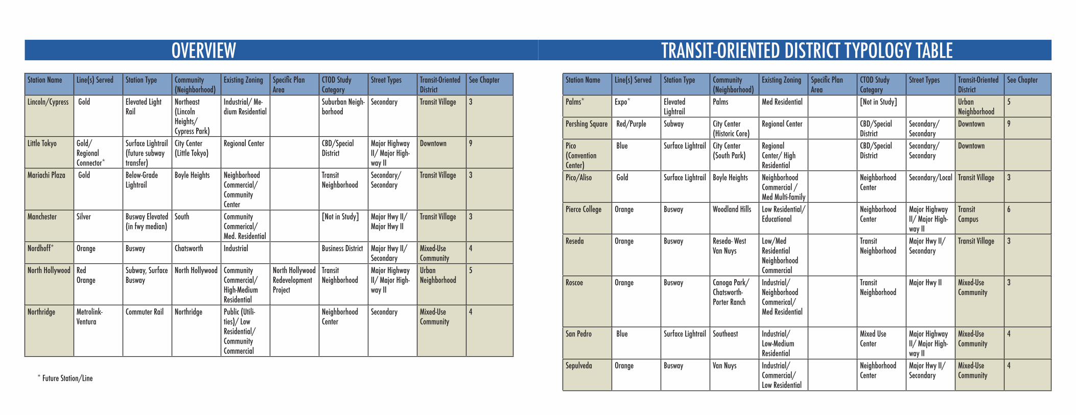
OVERVIEW TRANSIT-ORIENTED DISTRICT TYPOLOGY TABLEStation Name Line(s) Served Station Type Community
(Neighborhood)Existing Zoning Specific Plan
AreaCTOD Study Category
Street Types Transit-Oriented District
See Chapter
Lincoln/Cypress Gold Elevated Light Rail
Northeast (Lincoln Heights/ Cypress Park)
Industrial/ Me-dium Residential
Suburban Neigh-borhood
Secondary Transit Village 3
Little Tokyo Gold/Regional Connector*
Surface Lightrail (future subway transfer)
City Center (Little Tokyo)
Regional Center CBD/Special District
Major Highway II/ Major High-way II
Downtown 9
Mariachi Plaza Gold Below-GradeLightrail
Boyle Heights Neighborhood Commercial/ Community Center
Transit Neighborhood
Secondary/Secondary
Transit Village 3
Manchester Silver Busway Elevated(in fwy median)
South Community Commerical/ Med. Residential
[Not in Study] Major Hwy II/Major Hwy II
Transit Village 3
Nordhoff* Orange Busway Chatsworth Industrial Business District Major Hwy II/ Secondary
Mixed-UseCommunity
4
North Hollywood Red Orange
Subway, Surface Busway
North Hollywood CommunityCommercial/ High-Medium Residential
North Hollywood Redevelopment Project
Transit Neighborhood
Major Highway II/ Major High-way II
Urban Neighborhood
5
Northridge Metrolink-Ventura
Commuter Rail Northridge Public (Utili-ties)/ Low Residential/ Community Commercial
Neighborhood Center
Secondary Mixed-Use Community
4
Station Name Line(s) Served Station Type Community (Neighborhood)
Existing Zoning Specific Plan Area
CTOD Study Category
Street Types Transit-Oriented District
See Chapter
Palms* Expo* Elevated Lightrail
Palms Med Residential [Not in Study] Urban Neighborhood
5
Pershing Square Red/Purple Subway City Center (Historic Core)
Regional Center CBD/Special District
Secondary/Secondary
Downtown 9
Pico (Convention Center)
Blue Surface Lightrail City Center (South Park)
Regional Center/ High Residential
CBD/Special District
Secondary/Secondary
Downtown
Pico/Aliso Gold Surface Lightrail Boyle Heights Neighborhood Commercial /Med Multi-family
Neighborhood Center
Secondary/Local Transit Village 3
Pierce College Orange Busway Woodland Hills Low Residential/ Educational
Neighborhood Center
Major Highway II/ Major High-way II
TransitCampus
6
Reseda Orange Busway Reseda- WestVan Nuys
Low/Med ResidentialNeighborhoodCommercial
TransitNeighborhood
Major Hwy II/Secondary
Transit Village 3
Roscoe Orange Busway Canoga Park/Chatsworth-Porter Ranch
Industrial/Neighborhood Commerical/Med Residential
Transit Neighborhood
Major Hwy II Mixed-Use Community
3
San Pedro Blue Surface Lightrail Southeast Industrial/ Low-Medium Residential
Mixed Use Center
Major Highway II/ Major High-way II
Mixed-Use Community
4
Sepulveda Orange Busway Van Nuys Industrial/Commercial/ Low Residential
Neighborhood Center
Major Hwy II/Secondary
Mixed-UseCommunity
4* Future Station/Line
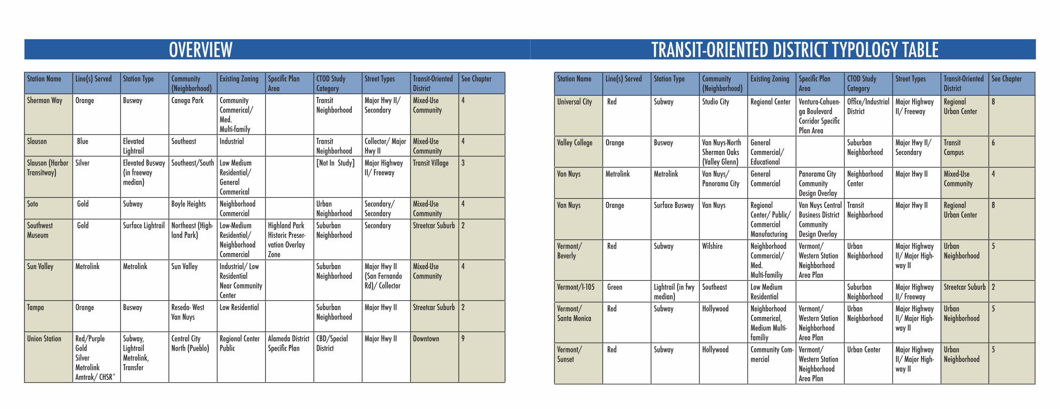
OVERVIEW TRANSIT-ORIENTED DISTRICT TYPOLOGY TABLEStation Name Line(s) Served Station Type Community
(Neighborhood)Existing Zoning Specific Plan
AreaCTOD Study Category
Street Types Transit-Oriented District
See Chapter
Sherman Way Orange Busway Canoga Park Community Commerical/Med. Multi-family
Transit Neighborhood
Major Hwy II/Secondary
Mixed-Use Community
4
Slauson Blue Elevated Lightrail
Southeast Industrial Transit Neighborhood
Collector/ Major Hwy II
Mixed-UseCommunity
4
Slauson (Harbor Transitway)
Silver Elevated Busway (in freeway median)
Southeast/South Low Medium Residential/General Commerical
[Not In Study] Major Highway II/ Freeway
Transit Village 3
Soto Gold Subway Boyle Heights Neighborhood Commercial
Urban Neighborhood
Secondary/Secondary
Mixed-UseCommunity
4
Southwest Museum
Gold Surface Lightrail Northeast (High-land Park)
Low-Medium Residential/ Neighborhood Commercial
Highland Park Historic Preser-vation Overlay Zone
Suburban Neighborhood
Secondary Streetcar Suburb 2
Sun Valley Metrolink Metrolink Sun Valley Industrial/ Low Residential Near Community Center
Suburban Neighborhood
Major Hwy II (San Fernando Rd)/ Collector
Mixed-Use Community
4
Tampa Orange Busway Reseda- WestVan Nuys
Low Residential SuburbanNeighborhood
Major Hwy II Streetcar Suburb 2
Union Station Red/PurpleGoldSilverMetrolinkAmtrak/ CHSR*
Subway, LightrailMetrolink, Transfer
Central City North (Pueblo)
Regional Center Public
Alameda District Specific Plan
CBD/Special District
Major Hwy II Downtown 9
Station Name Line(s) Served Station Type Community (Neighborhood)
Existing Zoning Specific Plan Area
CTOD Study Category
Street Types Transit-Oriented District
See Chapter
Universal City Red Subway Studio City Regional Center Ventura-Cahuen-ga Boulevard Corridor Specific Plan Area
Office/Industrial District
Major Highway II/ Freeway
Regional Urban Center
8
Valley College Orange Busway Van Nuys-North Sherman Oaks (Valley Glenn)
General Commercial/ Educational
Suburban Neighborhood
Major Hwy II/Secondary
TransitCampus
6
Van Nuys Metrolink Metrolink Van Nuys/ Panorama City
General Commercial
Panorama City Community Design Overlay
Neighborhood Center
Major Hwy II Mixed-Use Community
4
Van Nuys Orange Surface Busway Van Nuys Regional Center/ Public/ Commercial Manufacturing
Van Nuys Central Business District Community Design Overlay
Transit Neighborhood
Major Hwy II Regional Urban Center
8
Vermont/Beverly
Red Subway Wilshire Neighborhood Commercial/ Med.Multi-familiy
Vermont/Western Station Neighborhood Area Plan
Urban Neighborhood
Major Highway II/ Major High-way II
Urban Neighborhood
5
Vermont/I-105 Green Lightrail (in fwy median)
Southeast Low Medium Residential
Suburban Neighborhood
Major Highway II/ Freeway
Streetcar Suburb 2
Vermont/Santa Monica
Red Subway Hollywood Neighborhood Commerical, Medium Multi-familiy
Vermont/Western Station Neighborhood Area Plan
Urban Neighborhood
Major Highway II/ Major High-way II
Urban Neighborhood
5
Vermont/Sunset
Red Subway Hollywood Community Com-mercial
Vermont/Western Station Neighborhood Area Plan
Urban Center Major Highway II/ Major High-way II
Urban Neighborhood
5
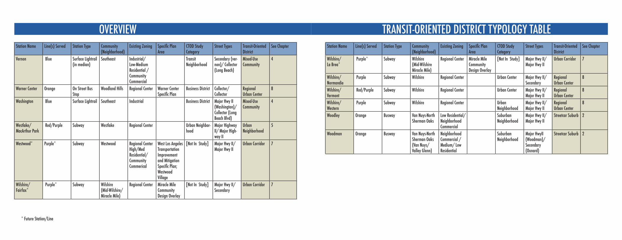
OVERVIEW TRANSIT-ORIENTED DISTRICT TYPOLOGY TABLEStation Name Line(s) Served Station Type Community
(Neighborhood)Existing Zoning Specific Plan
AreaCTOD Study Category
Street Types Transit-Oriented District
See Chapter
Vernon Blue Surface Lightrail (in median)
Southeast Industrial/ Low-Medium Residential / Community Commercial
Transit Neighborhood
Secondary (ver-non)/ Collector (Long Beach)
Mixed-UseCommunity
4
Warner Center Orange On Street Bus Stop
Woodland Hills Regional Center Warner Center Specific Plan
Business District Collector/Collector
Regional Urban Center
8
Washington Blue Surface Lightrail Southeast Industrial Business District Major Hwy II (Washington)/ Collector (Long Beach Blvd)
Mixed-Use Community
4
Westlake/MacArthur Park
Red/Purple Subway Westlake Regional Center Urban Neighbor-hood
Major Highway II/ Major High-way II
Urban Neighborhood
5
Westwood* Purple* Subway Westwood Regional Center High/Med Residential/ Community Commerical
West Los Angeles Transportation Improvement and Mitigation Specific Plan; Westwood Village
[Not In Study] Major Hwy II/ Major Hwy II
Urban Corridor 7
Wilshire/ Fairfax*
Purple* Subway Wilshire (Mid-Wilshire/ Miracle Mile)
Regional Center Miracle Mile Community Design Overlay
[Not In Study] Major Hwy II/ Secondary
Urban Corridor 7
* Future Station/Line
Station Name Line(s) Served Station Type Community (Neighborhood)
Existing Zoning Specific Plan Area
CTOD Study Category
Street Types Transit-Oriented District
See Chapter
Wilshire/ La Brea*
Purple* Subway Wilshire (Mid-WilshireMiracle Mile)
Regional Center Miracle Mile Community Design Overlay
[Not In Study] Major Hwy II/ Major Hwy II
Urban Corridor 7
Wilshire/ Normandie
Purple Subway Wilshire Regional Center Urban Center Major Hwy II/ Secondary
Regional Urban Center
8
Wilshire/ Vermont
Red/Purple Subway Wilshire Regional Center Urban Center Major Hwy II/ Major Hwy II
Regional Urban Center
8
Wilshire/Western
Purple Subway Wilshire Regional Center Urban Neighborhood
Major Hwy II/ Major Hwy II
Regional Urban Center
8
Woodley Orange Busway Van Nuys-North Sherman Oaks
Low Residential/NeighborhoodCommercial
Suburban Neighborhood
Major Hwy II/ Major Hwy II
Streetcar Suburb 2
Woodman Orange Busway Van Nuys-North Sherman Oaks (Van Nuys/ Valley Glenn)
Neighborhood Commercial /Medium/ Low Residential
Suburban Neighborhood
Major HwyII (Woodman)/ Secondary (Oxnard)
Streetcar Suburb 2
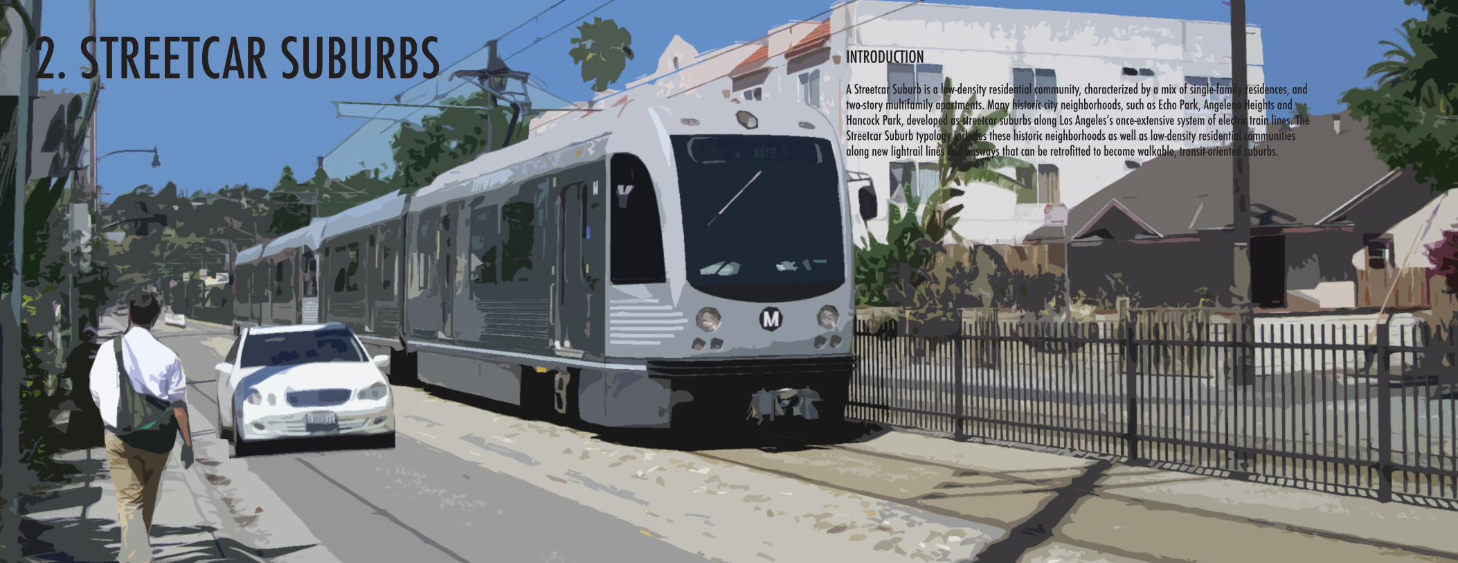
2. STREETCAR SUBURBS INTRODUCTION
A Streetcar Suburb is a low-density residential community, characterized by a mix of single-family residences, and two-story multifamily apartments. Many historic city neighborhoods, such as Echo Park, Angeleno Heights and Hancock Park, developed as streetcar suburbs along Los Angeles’s once-extensive system of electric train lines. The Streetcar Suburb typology includes these historic neighborhoods as well as low-density residential communities along new lightrail lines and busways that can be retrofitted to become walkable, transit-oriented suburbs.
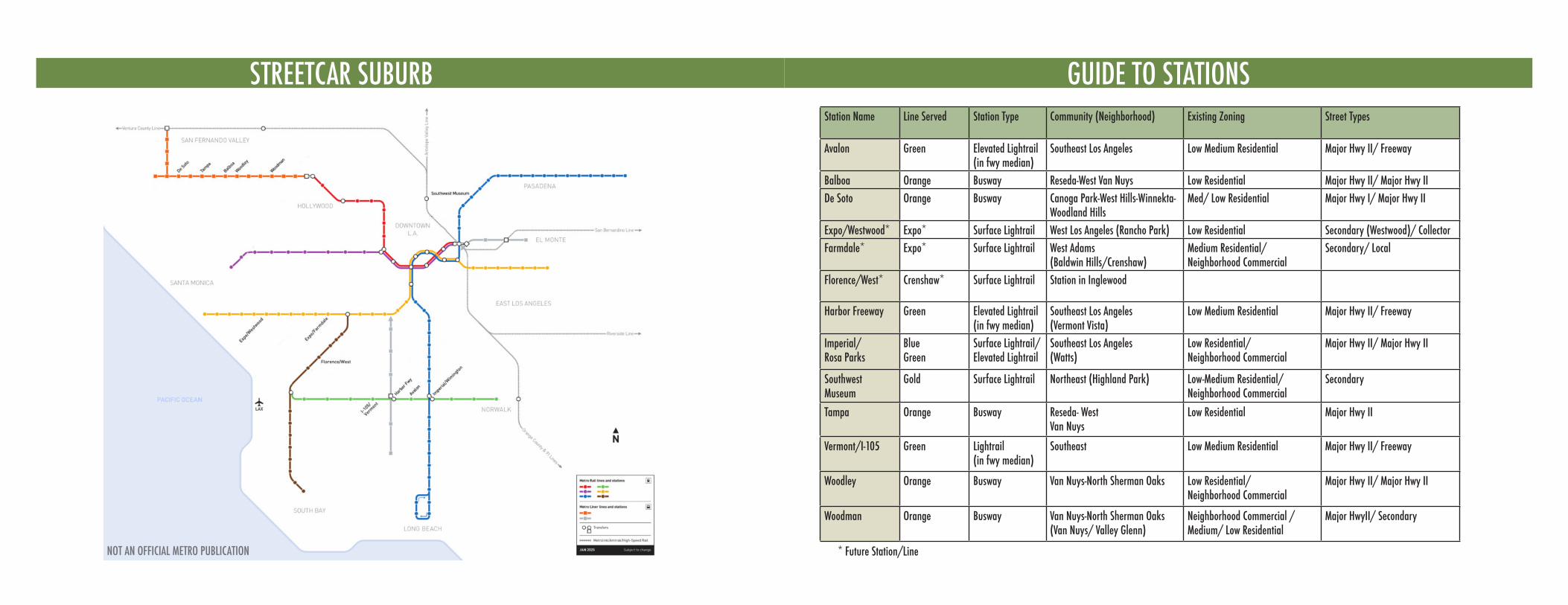
STREETCAR SUBURB GUIDE TO STATIONSStation Name Line Served Station Type Community (Neighborhood) Existing Zoning Street Types
Avalon Green Elevated Lightrail (in fwy median)
Southeast Los Angeles Low Medium Residential Major Hwy II/ Freeway
Balboa Orange Busway Reseda-West Van Nuys Low Residential Major Hwy II/ Major Hwy IIDe Soto Orange Busway Canoga Park-West Hills-Winnekta-
Woodland HillsMed/ Low Residential Major Hwy I/ Major Hwy II
Expo/Westwood* Expo* Surface Lightrail West Los Angeles (Rancho Park) Low Residential Secondary (Westwood)/ CollectorFarmdale* Expo* Surface Lightrail West Adams
(Baldwin Hills/Crenshaw)Medium Residential/Neighborhood Commercial
Secondary/ Local
Florence/West* Crenshaw* Surface Lightrail Station in Inglewood
Harbor Freeway Green Elevated Lightrail (in fwy median)
Southeast Los Angeles(Vermont Vista)
Low Medium Residential Major Hwy II/ Freeway
Imperial/Rosa Parks
BlueGreen
Surface Lightrail/Elevated Lightrail
Southeast Los Angeles(Watts)
Low Residential/Neighborhood Commercial
Major Hwy II/ Major Hwy II
Southwest Museum
Gold Surface Lightrail Northeast (Highland Park) Low-Medium Residential/ Neighborhood Commercial
Secondary
Tampa Orange Busway Reseda- WestVan Nuys
Low Residential Major Hwy II
Vermont/I-105 Green Lightrail (in fwy median)
Southeast Low Medium Residential Major Hwy II/ Freeway
Woodley Orange Busway Van Nuys-North Sherman Oaks Low Residential/Neighborhood Commercial
Major Hwy II/ Major Hwy II
Woodman Orange Busway Van Nuys-North Sherman Oaks (Van Nuys/ Valley Glenn)
Neighborhood Commercial /Medium/ Low Residential
Major HwyII/ Secondary
* Future Station/LineNOT AN OFFICIAL METRO PUBLICATION
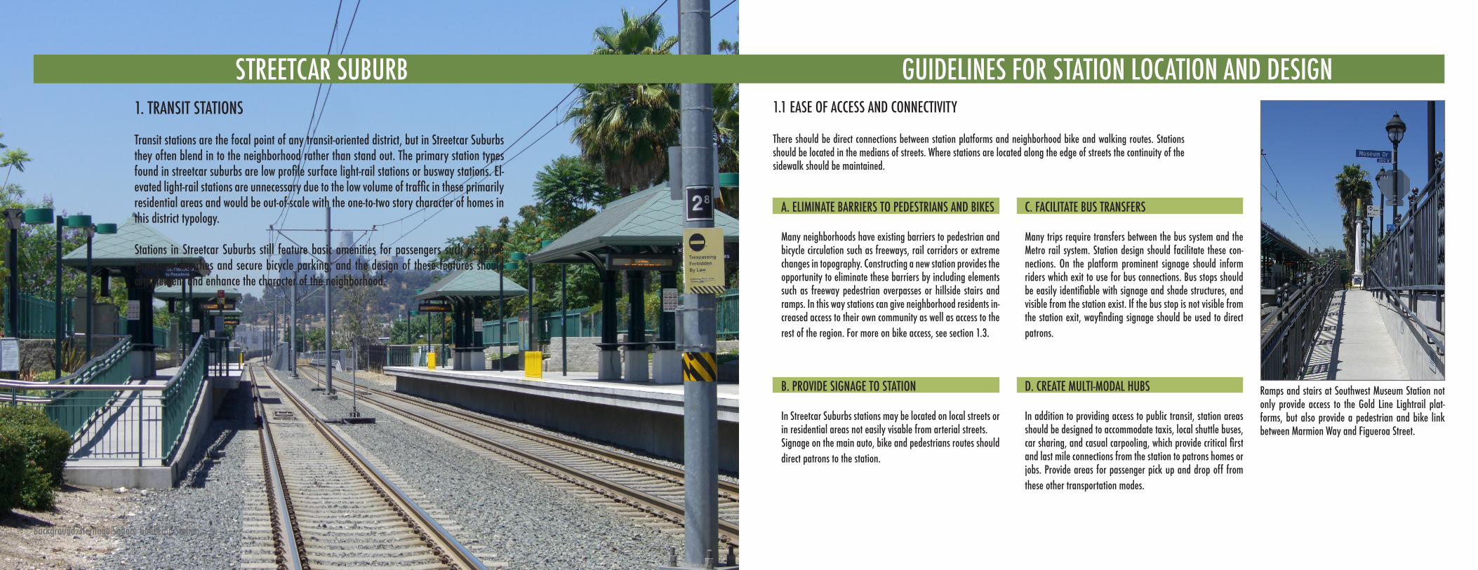
STREETCAR SUBURB GUIDELINES FOR STATION LOCATION AND DESIGN1. TRANSIT STATIONS
STREETCAR SUBURB
Transit stations are the focal point of any transit-oriented district, but in Streetcar Suburbs they often blend in to the neighborhood rather than stand out. The primary station types found in streetcar suburbs are low profile surface light-rail stations or busway stations. El-evated light-rail stations are unnecessary due to the low volume of traffic in these primarily residential areas and would be out-of-scale with the one-to-two story character of homes in this district typology.
Stations in Streetcar Suburbs still feature basic amenities for passengers such as shade structures, benches and secure bicycle parking, and the design of these features should complement and enhance the character of the neighborhood.
GUIDELINES FOR STATION LOCATION AND DESIGN1.1 EASE OF ACCESS AND CONNECTIVITY
Background: Heritage Square Gold Line Station
Ramps and stairs at Southwest Museum Station not only provide access to the Gold Line Lightrail plat-forms, but also provide a pedestrian and bike link between Marmion Way and Figueroa Street.
There should be direct connections between station platforms and neighborhood bike and walking routes. Stations should be located in the medians of streets. Where stations are located along the edge of streets the continuity of the sidewalk should be maintained.
A. ELIMINATE BARRIERS TO PEDESTRIANS AND BIKES
Many neighborhoods have existing barriers to pedestrian and bicycle circulation such as freeways, rail corridors or extreme changes in topography. Constructing a new station provides the opportunity to eliminate these barriers by including elements such as freeway pedestrian overpasses or hillside stairs and ramps. In this way stations can give neighborhood residents in-creased access to their own community as well as access to the rest of the region. For more on bike access, see section 1.3.
C. FACILITATE BUS TRANSFERS
Many trips require transfers between the bus system and the Metro rail system. Station design should facilitate these con-nections. On the platform prominent signage should inform riders which exit to use for bus connections. Bus stops should be easily identifiable with signage and shade structures, and visible from the station exist. If the bus stop is not visible from the station exit, wayfinding signage should be used to direct patrons.
B. PROVIDE SIGNAGE TO STATION
In Streetcar Suburbs stations may be located on local streets or in residential areas not easily visable from arterial streets. Signage on the main auto, bike and pedestrians routes should direct patrons to the station.
D. CREATE MULTI-MODAL HUBS
In addition to providing access to public transit, station areas should be designed to accommodate taxis, local shuttle buses, car sharing, and casual carpooling, which provide critical first and last mile connections from the station to patrons homes or jobs. Provide areas for passenger pick up and drop off from these other transportation modes.
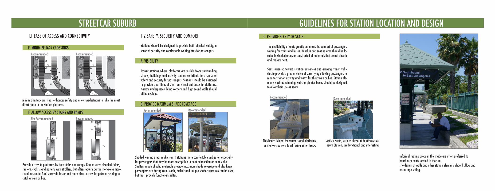
STREETCAR SUBURB GUIDELINES FOR STATION LOCATION AND DESIGN1.2 SAFETY, SECURITY AND COMFORT
Stations should be designed to provide both physical safety, a sense of security and comfortable waiting ares for passengers.
A. VISIBILITY
Transit stations where platforms are visible from surrounding streets, buildings and activity centers contribute to a sense of safety and security for passengers. Stations should be designed to provide clear lines-of-site from street entrances to platforms. Narrow underpasses, blind corners and high sound walls should all be avoided.
This bench is ideal for center island platforms, as it allows patrons to sit facing either track.
Artistic seats, such as these at Southwest Mu-seum Station, are functional and interesting.
C. PROVIDE PLENTY OF SEATS
Informal seating areas in the shade are often preferred to benches or seats located in the sun.The design of walls and other station elements should allow and encourage sitting.
Recommended Recommended
1.1 EASE OF ACCESS AND CONNECTIVITY
E. MINIMIZE TACK CROSSINGSRecommended Recommended
F. ALLOW ACCESS BY STAIRS AND RAMPSRecommended
Minimizing tack crossings enhances safety and allows pedestrians to take the most direct route to the station platform.
Not Recommended
Provide access to platforms by both stairs and ramps. Ramps serve disabled riders, seniors, cyclists and parents with strollers, but often require patrons to take a more circuitous route. Stairs provide faster and more direct access for patrons rushing to catch a train or bus.
B. PROVIDE MAXIMUM SHADE COVERAGERecommended
Shaded waiting areas make transit stations more comfortable and safer, especially for passengers that may be more susceptible to heat exhaustion or heat stoke. Shelters made of solid materials provide maximum shade coverage and also keep passengers dry during rain. Iconic, artistic and unique shade structures can be used, but must provide functional shelter.
The availability of seats greatly enhances the comfort of passengers waiting for trains and buses. Benches and seating ares should be lo-cated in shaded areas or constructed of materials that do not absorb and radiate heat.
Seats oriented towards station entrances and arriving transit vehi-cles to provide a greater sense of security by allowing passengers to monitor station activity and watch for their train or bus. Station ele-ments such as retaining walls or planter boxes should be designed to allow their use as seats.
Recommended
GUIDELINES FOR STATION LOCATION AND DESIGNSTREETCAR SUBURB
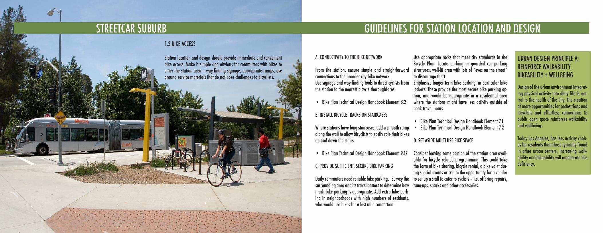
A. CONNECTIVITY TO THE BIKE NETWORK
From the station, ensure simple and straightforward connections to the broader city bike network. Use signage and way-finding tools to direct cyclists from the station to the nearest bicycle thoroughfares.
Bike Plan Technical Design Handbook Element 8.2•
B. INSTALL BICYCLE TRACKS ON STAIRCASES
Where stations have long staircases, add a smooth ramp along the wall to allow bicyclists to easily role their bikes up and down the stairs.
Bike Plan Technical Design Handbook Element 9.17•
C. PROVIDE SUFFICIENT, SECURE BIKE PARKING
Daily commuters need reliable bike parking. Survey the surrounding area and its travel patters to determine how much bike parking is appropriate. Add extra bike park-ing in neighborhoods with high numbers of residents, who would use bikes for a last-mile connection.
Use appropriate racks that meet city standards in the Bicycle Plan. Locate parking in guarded car parking structures, well-lit area with lots of “eyes on the street” to discourage theft.Emphasize longer term bike parking, in particular bike lockers. These provide the most secure bike parking op-tion, and would be appropriate in a residential area where the stations might have less activity outside of peak travel hours.
Bike Plan Technical Design Handbook Element 7.1• Bike Plan Technical Design Handbook Element 7.2•
D. SET ASIDE MULTI-USE BIKE SPACE
Consider leaving some portion of the station area avail-able for bicycle related programming. This could take the form of bike sharing, bicycle rental, a bike valet dur-ing special events or create the opportunity for a vendor to set up a stall to cater to cyclists – i.e. offering repairs, tune-ups, snacks and other accessories.
1.3 BIKE ACCESS
Station location and design should provide immediate and convenient bike access. Make it simple and obvious for commuters with bikes to enter the station area – way-finding signage, appropriate ramps, use ground service materials that do not pose challenges to bicyclists.
URBAN DESIGN PRINCIPLE V:REINFORCE WALKABILITY, BIKEABILITY + WELLBEING
Design of the urban environment integrat-ing physical activity into daily life is cen-tral to the health of the City. The creation of more opportunities for pedestrians and bicyclists and effortless connections to public open space reinforces walkability and wellbeing.
Today Los Angeles, has less activity choic-es for residents than those typically found in other urban centers. Increasing walk-ability and bikeability will ameliorate this deficiency.
GUIDELINES FOR STATION LOCATION AND DESIGN
STREETCAR SUBURB GUIDELINES FOR STATION LOCATION AND DESIGNSTREETCAR SUBURBSTREETCAR SUBURB
URBAN DESIGN PRINCIPLE VII:NURTURE NEIGHBORHOOD CHARACTER
One design approach does not fit all. Los Angeles is made up of a rich fabric of distinct neighborhoods. New projects can contribute to the character of a neighbor-hood rather than simply alter it. Each potential development or improvement needs to consider the context of its neigh-borhood or district.
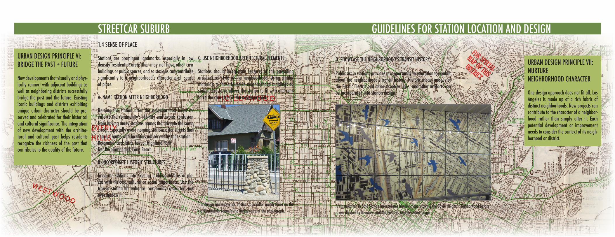
Stations are prominent landmarks, especially in low density residential areas that may not have other civic buildings or public spaces, and so stations can contribute significantly to a neighborhood’s character and sense of place.
A. NAME STATION AFTER NEIGHBORHOOD
Naming the station after the neighborhood helps re-enforce the community’s identity and avoids confusion from having many stations names that include the same street. Especially avoid naming stations after streets that share a name with localities not served by that station.Recommended: Little Tokyo, Highland ParkNot Recommended: Long Beach,
B. INCORPORATE HISTORIC STRUCTURES
Integrate stations into existing building edifices or pla-zas with historic, cultural or social importance. Use the transit station to enhance community character, not overshadow it.
C. USE NEIGHBORHOOD ARCHITECTURAL ELEMENTS
Stations should incorporate features of the prevailing architectural style of the neighborhood. Using similar materials to those found in neighborhood buildings on station structures allows the station to fit with and rein-force the character of the neighborhood.
1.4 SENSE OF PLACE
GUIDELINES FOR STATION LOCATION AND DESIGNSTREETCAR SUBURB
URBAN DESIGN PRINCIPLE VI:BRIDGE THE PAST + FUTURE
New developments that visually and phys-ically connect with adjacent buildings as well as neighboring districts successfully bridge the past and the future. Existing iconic buildings and districts exhibiting unique urban character should be pre-served and celebrated for their historical and cultural significance. The integration of new development with the architec-tural and cultural past helps residents recognize the richness of the past that contributes to the quality of the future.
Art installation in Soto Station incorporates historic maps showing the Boyle Heights neighborhood before it was divided by freeways and the East Los Angeles Interchange
Public art in stations provides an opportunity to education the public about the neighborhood’s transit history. Historic maps, images of the Pacific Electric and other streetcar lines, and other artifacts can be incorporated into station design.
D. SHOwCASE THE NEIGHBORHOOD’S TRANSIT HISTORy
The design and materials of this stone pillar match those on the craftsmanstyle home in the background of the photograph.
STREETCAR SUBURB
URBAN DESIGN PRINCIPLE III:PRODUCE GREAT, GREEN STREETS
Design streets to incorporate elements that reflect human scale, enhance neigh-borhood character, provide green infra-structure and balance needs for many modes of sustainable transit, including pedestrians, bicyclists, and automobiles and transit.
Our streets, which are more than conduits of movement, incorporate sustainable, green infrastructure to provide open space and easy access to the outdoors and celebrated Los Angeles climate.
Background: Westwood Blvd and Exposition Blvd, future light-rail station site
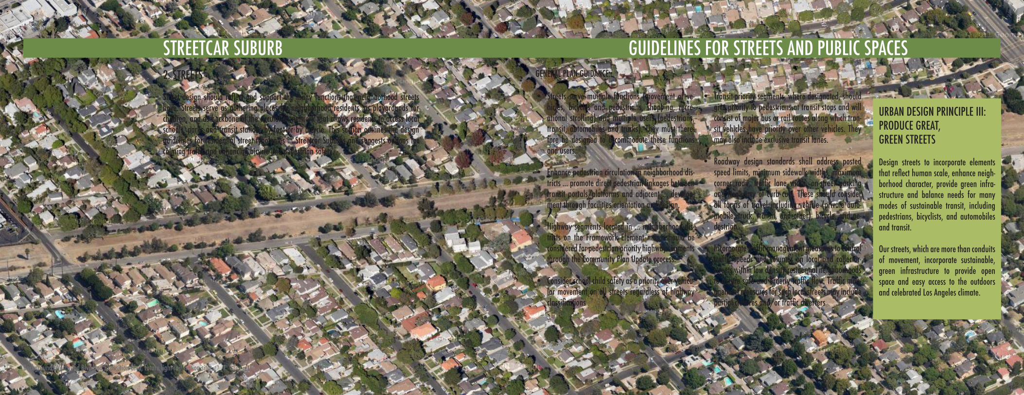
Streets serve multiple functions (movement of ve-• hicles, bicycles and pedestrians, shopping, recre-ational strolling) and multiple users (pedestrians, transit, automobiles and trucks). They must there-fore be designed to accommodate these functions and users.
Enhance pedestrian circulation in neighborhood dis-• tricts ... promote direct pedestrian linkages between transit portals/platforms and adjacent ... develop-ment through facilities orientation and design.
Highway segments located in ... neighborhood dis-• tricts on the Framework Element maps should be considered for pedestrian-priority highway segments through the Community Plan Update process.
Consider school child safety as a priority over vehicu-• lar movement on all streets regardless of highway classifications
Transit-priority segments, where designated, should • give priority to pedestrians at transit stops and will consist of major bus or rail routes along which tran-sit vehicles have priority over other vehicles. They may also include exclusive transit lanes.
Roadway design standards shall address posted • speed limits, minimum sidewalk widths, maximum corner radii, traffic lane width, on-street parking and frequency of curb cuts. These should consider all forms of travel including vehicle (private auto-mobile, truck, transit, and other), bicycle, and pe-destrian.
Incorporate traffic management measures to control • traffic speeds and volumes on local and collector-streets within low density residential neighborhoods to assure safe and orderly traffic flow. Traffic man-agement measures for such local streets may include partial closures and/or traffic diverters
Street design should reflect and support the many functions that neighborhood streets have. Streets serve as gathering places for neighborhood residents, as playgrounds for children, and as backbone of the circulation network that allows residents to access local schools, parks and transit stations by foot or by bicycle. This section outlines the design guidelines for residential street typologies in Streetcar Suburbs and suggests options for calming traffic and enhancing bicycle and pedestrian safety.
2. STREETS GENERAL PLAN GUIDANCE:
GUIDELINES FOR STREETS AND PUBLIC SPACES
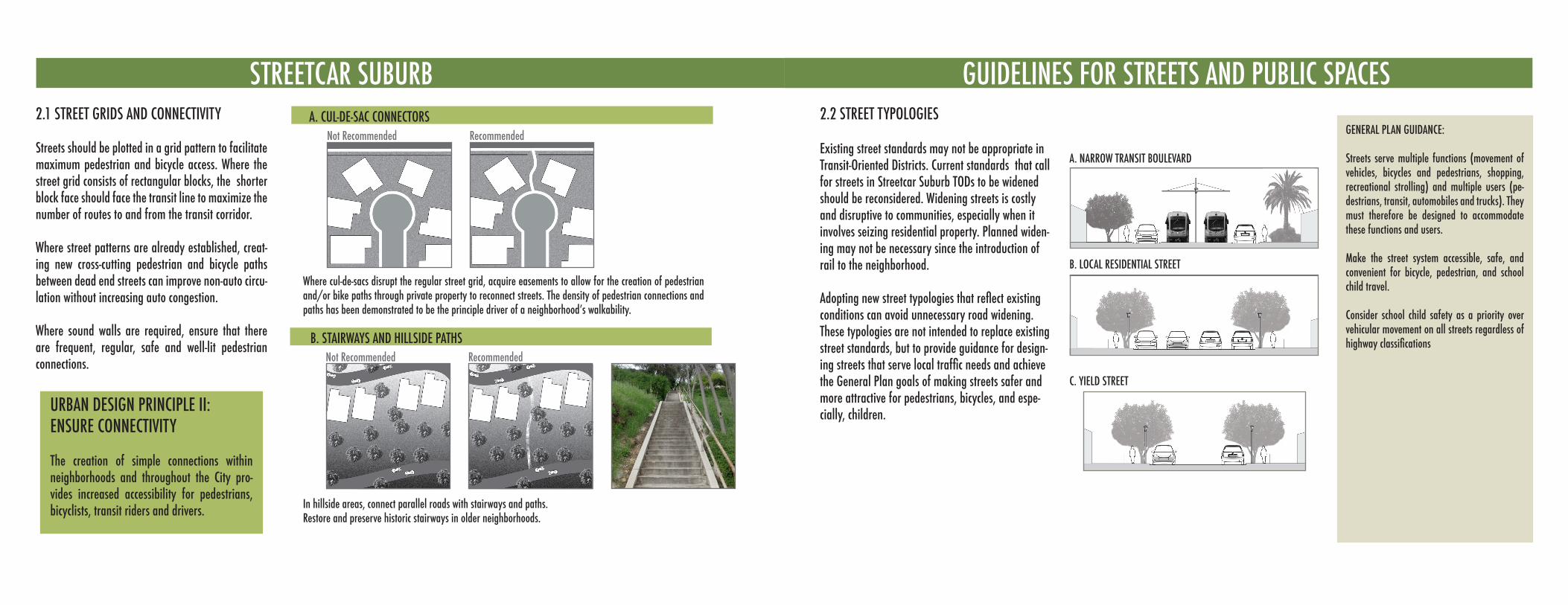
STREETCAR SUBURBA. CUL-DE-SAC CONNECTORS
B. STAIRWAYS AND HILLSIDE PATHS
Recommended
RecommendedNot Recommended
Not Recommended
URBAN DESIGN PRINCIPLE II:ENSURE CONNECTIVITY
The creation of simple connections within neighborhoods and throughout the City pro-vides increased accessibility for pedestrians, bicyclists, transit riders and drivers.
2.1 STREET GRIDS AND CONNECTIVITY
Streets should be plotted in a grid pattern to facilitate maximum pedestrian and bicycle access. Where the street grid consists of rectangular blocks, the shorter block face should face the transit line to maximize the number of routes to and from the transit corridor.
Where street patterns are already established, creat-ing new cross-cutting pedestrian and bicycle paths between dead end streets can improve non-auto circu-lation without increasing auto congestion.
Where sound walls are required, ensure that there are frequent, regular, safe and well-lit pedestrian connections.
Where cul-de-sacs disrupt the regular street grid, acquire easements to allow for the creation of pedestrian and/or bike paths through private property to reconnect streets. The density of pedestrian connections and paths has been demonstrated to be the principle driver of a neighborhood’s walkability.
2.2 STREET TYPOLOGIESGENERAL PLAN GUIDANCE:
Streets serve multiple functions (movement of vehicles, bicycles and pedestrians, shopping, recreational strolling) and multiple users (pe-destrians, transit, automobiles and trucks). They must therefore be designed to accommodate these functions and users.
Make the street system accessible, safe, and convenient for bicycle, pedestrian, and school child travel.
Consider school child safety as a priority over vehicular movement on all streets regardless of highway classifications
A. NARROW TRANSIT BOULEVARD
B. LOCAL RESIDENTIAL STREET
C. YIELD STREET
GUIDELINES FOR STREETS AND PUBLIC SPACES
Existing street standards may not be appropriate in Transit-Oriented Districts. Current standards that call for streets in Streetcar Suburb TODs to be widened should be reconsidered. Widening streets is costly and disruptive to communities, especially when it involves seizing residential property. Planned widen-ing may not be necessary since the introduction of rail to the neighborhood.
Adopting new street typologies that reflect existing conditions can avoid unnecessary road widening.These typologies are not intended to replace existing street standards, but to provide guidance for design-ing streets that serve local traffic needs and achieve the General Plan goals of making streets safer and more attractive for pedestrians, bicycles, and espe-cially, children.
In hillside areas, connect parallel roads with stairways and paths. Restore and preserve historic stairways in older neighborhoods.
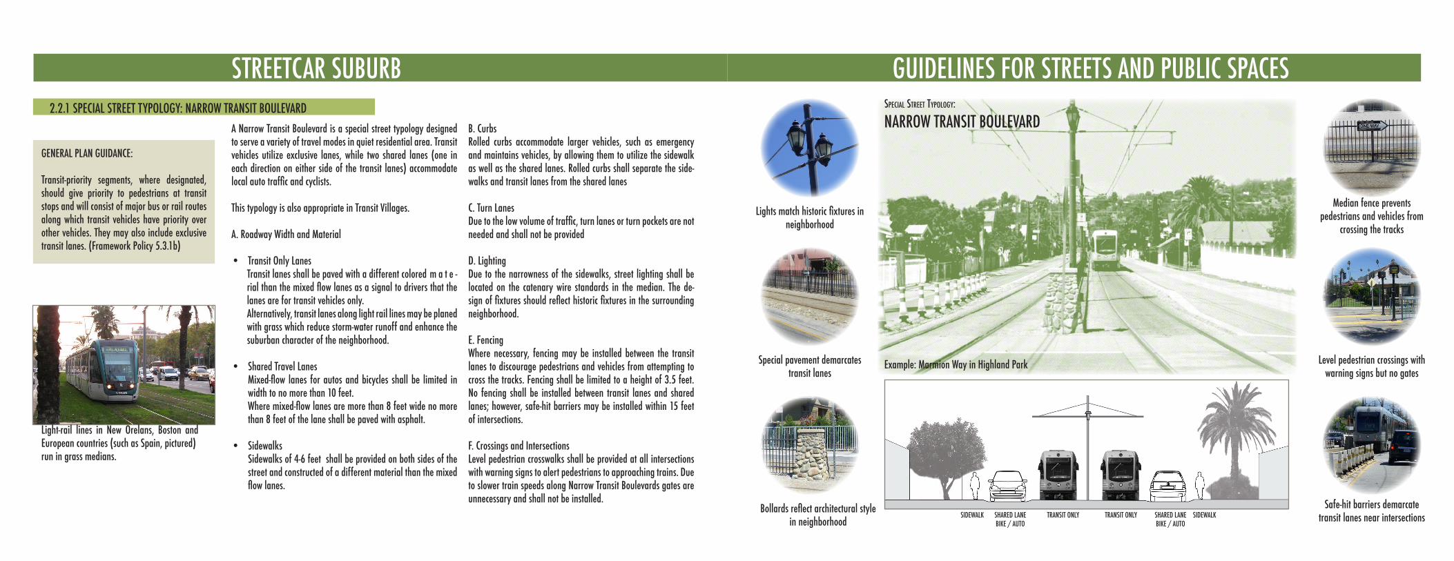
STREETCAR SUBURB
A Narrow Transit Boulevard is a special street typology designed to serve a variety of travel modes in quiet residential area. Transit vehicles utilize exclusive lanes, while two shared lanes (one in each direction on either side of the transit lanes) accommodate local auto traffic and cyclists.
This typology is also appropriate in Transit Villages.
A. Roadway Width and Material
Transit Only Lanes• Transit lanes shall be paved with a different colored m a t e -rial than the mixed flow lanes as a signal to drivers that the lanes are for transit vehicles only. Alternatively, transit lanes along light rail lines may be planed with grass which reduce storm-water runoff and enhance the suburban character of the neighborhood.
Shared Travel Lanes• Mixed-flow lanes for autos and bicycles shall be limited in width to no more than 10 feet. where mixed-flow lanes are more than 8 feet wide no more than 8 feet of the lane shall be paved with asphalt. Sidewalks• Sidewalks of 4-6 feet shall be provided on both sides of the street and constructed of a different material than the mixed flow lanes.
B. CurbsRolled curbs accommodate larger vehicles, such as emergency and maintains vehicles, by allowing them to utilize the sidewalk as well as the shared lanes. Rolled curbs shall separate the side-walks and transit lanes from the shared lanes
C. Turn LanesDue to the low volume of traffic, turn lanes or turn pockets are not needed and shall not be provided
D. LightingDue to the narrowness of the sidewalks, street lighting shall be located on the catenary wire standards in the median. The de-sign of fixtures should reflect historic fixtures in the surrounding neighborhood.
E. FencingWhere necessary, fencing may be installed between the transit lanes to discourage pedestrians and vehicles from attempting to cross the tracks. Fencing shall be limited to a height of 3.5 feet. No fencing shall be installed between transit lanes and shared lanes; however, safe-hit barriers may be installed within 15 feet of intersections.
F. Crossings and IntersectionsLevel pedestrian crosswalks shall be provided at all intersections with warning signs to alert pedestrians to approaching trains. Due to slower train speeds along Narrow Transit Boulevards gates are unnecessary and shall not be installed.
Light-rail lines in New Orelans, Boston and European countries (such as Spain, pictured) run in grass medians.
2.2.1 SPECIAL STREET TYPOLOGY: NARROW TRANSIT BOULEVARD
GENERAL PLAN GUIDANCE:
Transit-priority segments, where designated, should give priority to pedestrians at transit stops and will consist of major bus or rail routes along which transit vehicles have priority over other vehicles. They may also include exclusive transit lanes. (Framework Policy 5.3.1b)
GUIDELINES FOR STREETS AND PUBLIC SPACES
Level pedestrian crossings with warning signs but no gates
Lights match historic fixtures in neighborhood
Special pavement demarcates transit lanes
Bollards reflect architectural style in neighborhood
Median fence prevents pedestrians and vehicles from
crossing the tracks
speCial street typology:
NARROW TRANSIT BOULEVARD
Example: Marmion Way in Highland Park
SIDEWALK SIDEWALKSHARED LANEBIKE / AUTO
SHARED LANEBIKE / AUTO
TRANSIT ONLY TRANSIT ONLYSafe-hit barriers demarcate
transit lanes near intersections
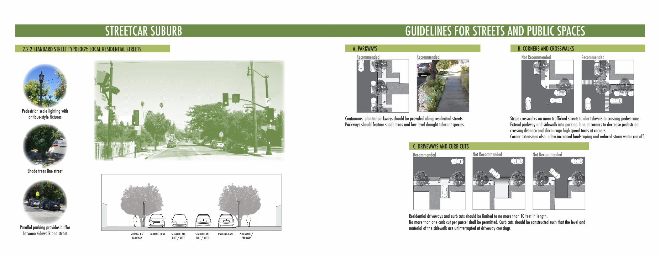
STREETCAR SUBURB2.2.2 STANDARD STREET TYPOLOGY: LOCAL RESIDENTIAL STREETS
Pedestrian scale lighting with antique-style fixtures
Shade trees line street
Parallel parking provides buffer between sidewalk and street SIDEWALK /
PARKWAYSHARED LANEBIKE / AUTO
SHARED LANEBIKE / AUTO
PARKING LANE PARKING LANESIDEWALK / PARKWAY
GUIDELINES FOR STREETS AND PUBLIC SPACESA. PARKWAYS
Recommended Recommended
Recommended Not Recommended Not Recommended
B. CORNERS AND CROSSWALKSRecommended
C. DRIVEWAYS AND CURB CUTS
Continuous, planted parkways should be provided along residential streets.Parkways should feature shade trees and low-level drought tolerant species.
Residential driveways and curb cuts should be limited to no more than 10 feet in length. No more than one curb cut per parcel shall be permitted. Curb cuts should be constructed such that the level and material of the sidewalk are uninterrupted at driveway crossings.
Not Recommended
Stripe crosswalks on more trafficked streets to alert drivers to crossing pedestrians. Extend parkway and sidewalk into parking lane at corners to decrease pedestrian crossing distance and discourage high-speed turns at corners. Corner extensions also allow increased landscaping and reduced storm-water run-off.
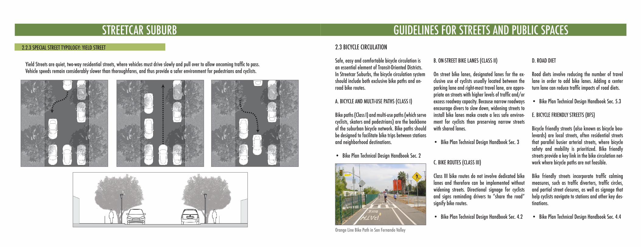
STREETCAR SUBURB2.2.3 SPECIAL STREET TYPOLOGY: YIELD STREET
yield Streets are quiet, two-way residential streets, where vehicles must drive slowly and pull over to allow oncoming traffic to pass. Vehicle speeds remain considerably slower than thoroughfares, and thus provide a safer environment for pedestrians and cyclists.
GUIDELINES FOR STREETS AND PUBLIC SPACES2.3 BICYCLE CIRCULATION
Safe, easy and comfortable bicycle circulation is an essential element of Transit-Oriented Districts. In Streetcar Suburbs, the bicycle circulation system should include both exclusive bike paths and on-road bike routes.
A. BICYCLE AND MULTI-USE PATHS (CLASS I)
Bike paths (Class I) and multi-use paths (which serve cyclists, skaters and pedestrians) are the backbone of the suburban bicycle network. Bike paths should be designed to facilitate bike trips between stations and neighborhood destinations.
Bike Plan Technical Design Handbook Sec. 2•
B. ON-STREET BIKE LANES (CLASS II)
On street bike lanes, designated lanes for the ex-clusive use of cyclists usually located between the parking lane and right-most travel lane, are appro-priate on streets with higher levels of traffic and/or excess roadway capacity. Because narrow roadways encourage divers to slow down, widening streets to install bike lanes make create a less safe environ-ment for cyclists than preserving narrow streets with shared lanes.
Bike Plan Technical Design Handbook Sec. 3•
C. BIKE ROUTES (CLASS III)
Class III bike routes do not involve dedicated bike lanes and therefore can be implemented without widening streets. Directional signage for cyclists and signs reminding drivers to “share the road” signify bike routes.
Bike Plan Technical Design Handbook Sec. 4.2•
D. ROAD DIET
Road diets involve reducing the number of travel lane in order to add bike lanes. Adding a center turn lane can reduce traffic impacts of road diets.
Bike Plan Technical Design Handbook Sec. 5.3•
E. BICYCLE FRIENDLY STREETS (BFS)
Bicycle friendly streets (also known as bicycle bou-levards) are local streets, often residential streets that parallel busier arterial streets, where bicycle safety and mobility is prioritized. Bike friendly streets provide a key link in the bike circulation net-work where bicycle paths are not feasible.
Bike friendly streets incorporate traffic calming measures, such as traffic diverters, traffic circles, and partial street closures, as well as signage that help cyclists navigate to stations and other key des-tinations.
Bike Plan Technical Design Handbook Sec. 4.4•
Orange Line Bike Path in San Fernando Valley
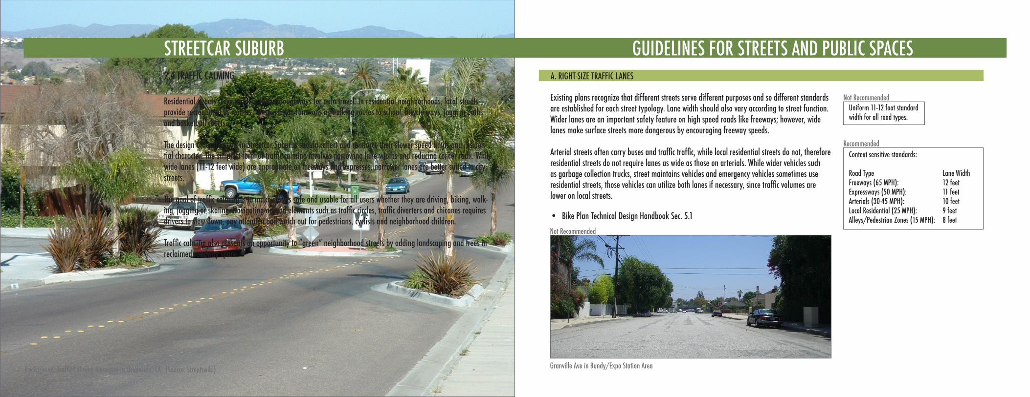
STREETCAR SUBURB2.4 TRAFFIC CALMING
Residential streets serve as more than throughways for auto travel. In residential neighborhoods, local streets provide recreational as well as transportation functions as walking routes to school, bicycle ways, jogging paths and basketball courts.
The design of local streets in Streetcar Suburbs should reflect and reinforce their slower speed limits and residen-tial character. The simplest form of traffic calming involves narrowing lane widths and reducing corner radii. while wide lanes (11-12 feet wide) are appropriate on freeways and expresses, narrower lanes are better suited to city streets.
The goal of traffic calming is to make streets safe and usable for all users whether they are driving, biking, walk-ing, jogging or skating. Navigating around elements such as traffic circles, traffic diverters and chicanes requires drivers to slow down, pay attention and watch out for pedestrians, cyclists and neighborhood children.
Traffic calming also presents an opportunity to “green” neighborhood streets by adding landscaping and trees in reclaimed roadway space.
STREETCAR SUBURB
Background: Traffic Calming Measures in Oceanside, CA (Source: Streetswiki)
GUIDELINES FOR STREETS AND PUBLIC SPACESA. RIGHT-SIZE TRAFFIC LANES
Not Recommended
Recommended
Existing plans recognize that different streets serve different purposes and so different standards are established for each street typology. Lane width should also vary according to street function. Wider lanes are an important safety feature on high speed roads like freeways; however, wide lanes make surface streets more dangerous by encouraging freeway speeds.
Arterial streets often carry buses and traffic traffic, while local residential streets do not, therefore residential streets do not require lanes as wide as those on arterials. While wider vehicles such as garbage collection trucks, street maintains vehicles and emergency vehicles sometimes use residential streets, those vehicles can utilize both lanes if necessary, since traffic volumes are lower on local streets.
Bike Plan Technical Design Handbook Sec. 5.1•
Uniform 11-12 foot standard width for all road types.
Context sensitive standards:
Road Type Lane Width Freeways (65 MPH): 12 feetExpressways (50 MPH): 11 feetArterials (30-45 MPH): 10 feetLocal Residential (25 MPH): 9 feetAlleys/Pedestrian Zones (15 MPH): 8 feet
Not Recommended
Granville Ave in Bundy/Expo Station Area
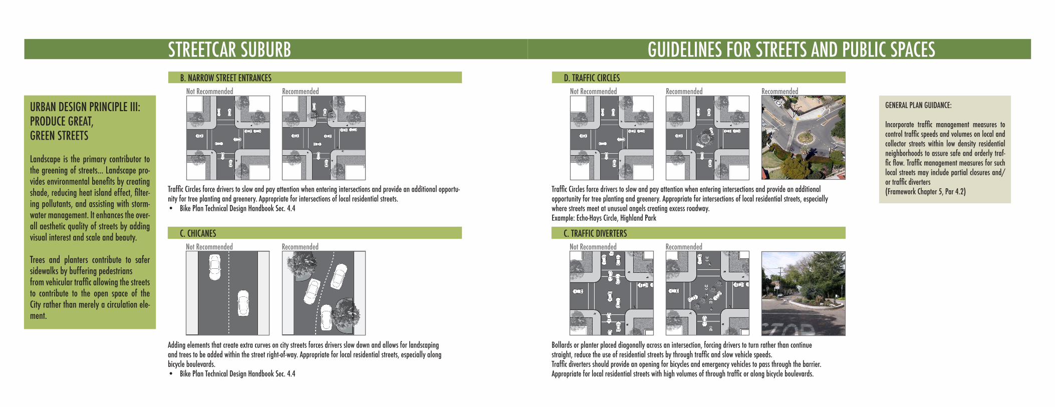
STREETCAR SUBURB
C. CHICANESNot Recommended Recommended
Adding elements that create extra curves on city streets forces drivers slow down and allows for landscaping and trees to be added within the street right-of-way. Appropriate for local residential streets, especially along bicycle boulevards.
Bike Plan Technical Design Handbook Sec. 4.4•
B. NARROW STREET ENTRANCESNot Recommended Recommended
Traffic Circles force drivers to slow and pay attention when entering intersections and provide an additional opportu-nity for tree planting and greenery. Appropriate for intersections of local residential streets.
Bike Plan Technical Design Handbook Sec. 4.4•
URBAN DESIGN PRINCIPLE III:PRODUCE GREAT,GREEN STREETS
Landscape is the primary contributor to the greening of streets... Landscape pro-vides environmental benefits by creating shade, reducing heat island effect, filter-ing pollutants, and assisting with storm-water management. It enhances the over-all aesthetic quality of streets by adding visual interest and scale and beauty.
Trees and planters contribute to safer sidewalks by buffering pedestriansfrom vehicular traffic allowing the streets to contribute to the open space of the City rather than merely a circulation ele-ment.
D. TRAFFIC CIRCLESNot Recommended Recommended
Traffic Circles force drivers to slow and pay attention when entering intersections and provide an additional opportunity for tree planting and greenery. Appropriate for intersections of local residential streets, especially where streets meet at unusual angels creating excess roadway. Example: Echo-Hays Circle, Highland Park
C. TRAFFIC DIVERTERSNot Recommended Recommended
Bollards or planter placed diagonally across an intersection, forcing drivers to turn rather than continue straight, reduce the use of residential streets by through traffic and slow vehicle speeds. Traffic diverters should provide an opening for bicycles and emergency vehicles to pass through the barrier.Appropriate for local residential streets with high volumes of through traffic or along bicycle boulevards.
GENERAL PLAN GUIDANCE:
Incorporate traffic management measures to control traffic speeds and volumes on local and collector streets within low density residential neighborhoods to assure safe and orderly traf-fic flow. Traffic management measures for such local streets may include partial closures and/or traffic diverters (Framework Chapter 5, Par 4.2)
GUIDELINES FOR STREETS AND PUBLIC SPACES
Recommended
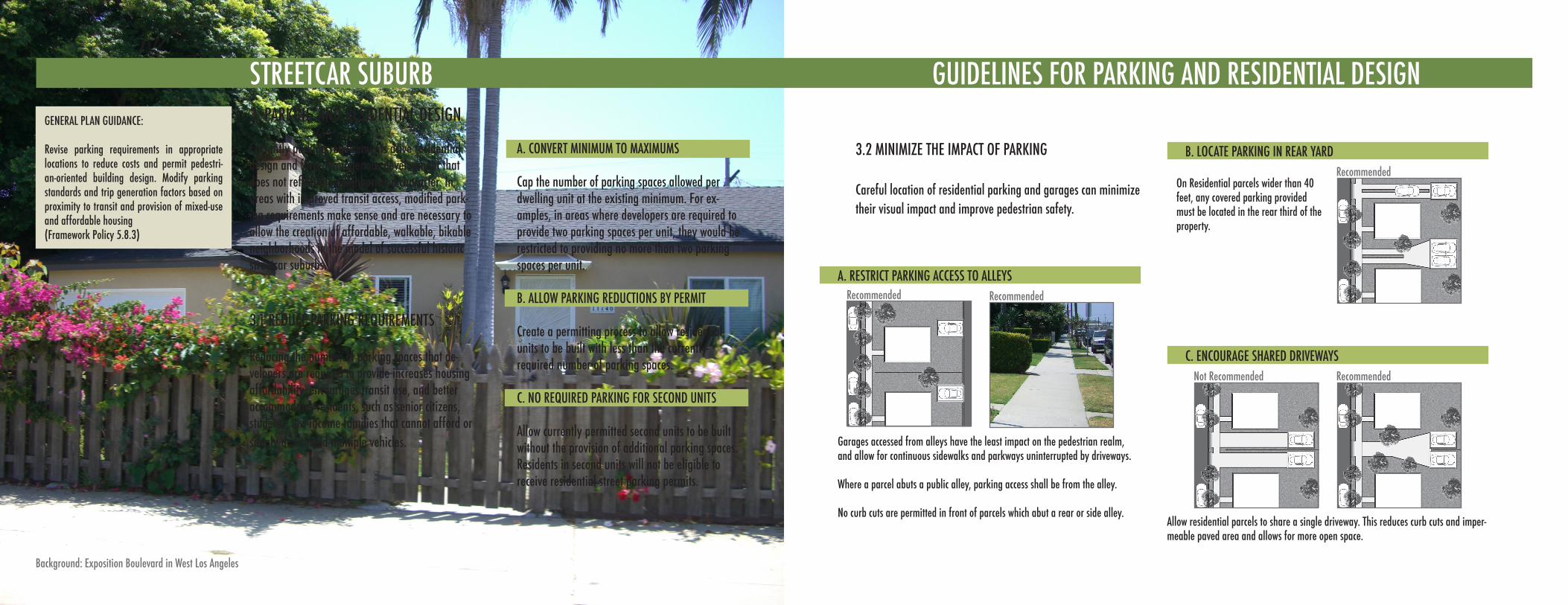
GENERAL PLAN GUIDANCE:
Revise parking requirements in appropriate locations to reduce costs and permit pedestri-an-oriented building design. Modify parking standards and trip generation factors based on proximity to transit and provision of mixed-use and affordable housing(Framework Policy 5.8.3)
STREETCAR SUBURB3. PARKING AND RESIDENTIAL DESIGN
3.1 REDUCE PARKING REQUIREMENTS
Reducing the number of parking spaces that de-velopers are required to provide increases housing affordability, encourages transit use, and better accommodates residents, such as senior citizens, students, low-income families that cannot afford or simply don’t need multiple vehicles.
A. CONVERT MINIMUM TO MAXIMUMS
Cap the number of parking spaces allowed per dwelling unit at the existing minimum. For ex-amples, in areas where developers are required to provide two parking spaces per unit, they would be restricted to providing no more than two parking spaces per unit.
B. ALLOW PARKING REDUCTIONS BY PERMIT
Create a permitting process to allow residential units to be built with less than the currently-required number of parking spaces.
C. NO REQUIRED PARKING FOR SECOND UNITS
Allow currently permitted second units to be built without the provision of additional parking spaces. Residents in second units will not be eligible to receive residential street parking permits.
Currently parking requirements drive residential design and force homogenous development that does not reflect the neighborhood character. In areas with improved transit access, modified park-ing requirements make sense and are necessary to allow the creation of affordable, walkable, bikable neighborhoods in the model of successful historic streetcar suburbs.
Background: Exposition Boulevard in West Los Angeles
GUIDELINES FOR PARKING AND RESIDENTIAL DESIGN
B. LOCATE PARKING IN REAR YARDRecommended
A. RESTRICT PARKING ACCESS TO ALLEYSRecommended
C. ENCOURAGE SHARED DRIVEWAYSRecommended
Garages accessed from alleys have the least impact on the pedestrian realm, and allow for continuous sidewalks and parkways uninterrupted by driveways.
Where a parcel abuts a public alley, parking access shall be from the alley.
No curb cuts are permitted in front of parcels which abut a rear or side alley.
Not Recommended
Allow residential parcels to share a single driveway. This reduces curb cuts and imper-meable paved area and allows for more open space.
On Residential parcels wider than 40 feet, any covered parking provided must be located in the rear third of the property.
3.2 MINIMIZE THE IMPACT OF PARKING
Careful location of residential parking and garages can minimize their visual impact and improve pedestrian safety.
Recommended
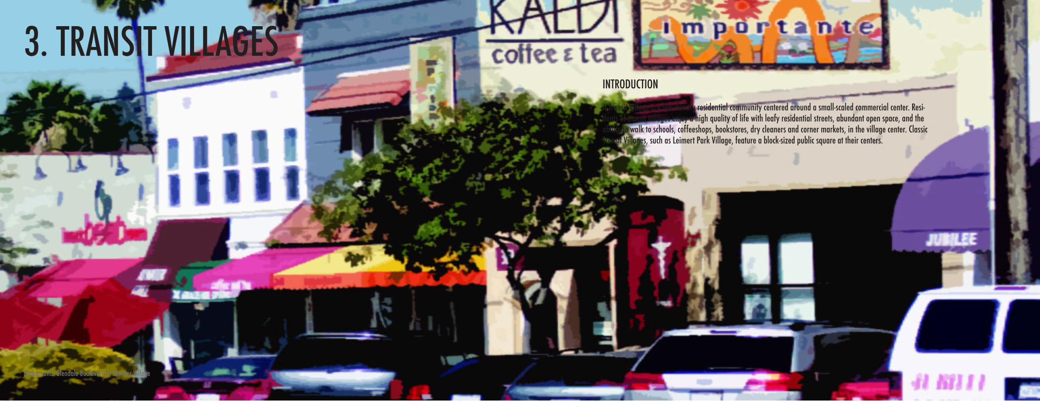
3. TRANSIT VILLAGES
Background: Glendale Boulevard in Atwater Village
INTRODUCTION
A Transit Village is a low-density residential community centered around a small-scaled commercial center. Resi-dents of transit villages enjoy a high quality of life with leafy residential streets, abundant open space, and the ability to walk to schools, coffeeshops, bookstores, dry cleaners and corner markets, in the village center. Classic Transit Villages, such as Leimert Park Village, feature a block-sized public square at their centers.
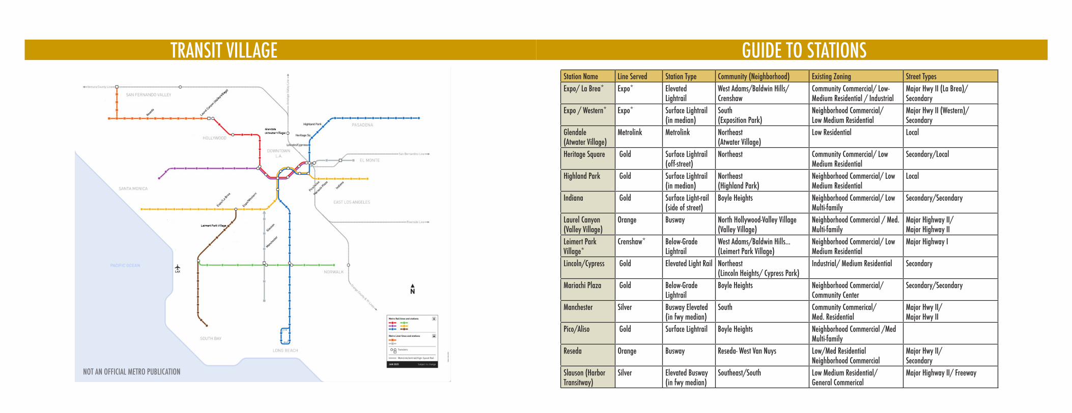
TRANSIT VILLAGE
NOT AN OFFICIAL METRO PUBLICATION
GUIDE TO STATIONSStation Name Line Served Station Type Community (Neighborhood) Existing Zoning Street TypesExpo/ La Brea* Expo* Elevated
LightrailWest Adams/Baldwin Hills/ Crenshaw
Community Commercial/ Low-Medium Residential / Industrial
Major Hwy II (La Brea)/ Secondary
Expo / Western* Expo* Surface Lightrail(in median)
South (Exposition Park)
Neighborhood Commercial/ Low Medium Residential
Major Hwy II (Western)/ Secondary
Glendale(Atwater Village)
Metrolink Metrolink Northeast (Atwater Village)
Low Residential Local
Heritage Square Gold Surface Lightrail (off-street)
Northeast Community Commercial/ Low Medium Residential
Secondary/Local
Highland Park Gold Surface Lightrail (in median)
Northeast (Highland Park)
Neighborhood Commercial/ Low Medium Residential
Local
Indiana Gold Surface Light-rail(side of street)
Boyle Heights Neighborhood Commercial/ Low Multi-family
Secondary/Secondary
Laurel Canyon(Valley Village)
Orange Busway North Hollywood-Valley Village (Valley Village)
Neighborhood Commercial / Med. Multi-family
Major Highway II/ Major Highway II
Leimert Park Village*
Crenshaw* Below-Grade Lightrail
West Adams/Baldwin Hills... (Leimert Park Village)
Neighborhood Commercial/ Low Medium Residential
Major Highway I
Lincoln/Cypress Gold Elevated Light Rail Northeast (Lincoln Heights/ Cypress Park)
Industrial/ Medium Residential Secondary
Mariachi Plaza Gold Below-GradeLightrail
Boyle Heights Neighborhood Commercial/ Community Center
Secondary/Secondary
Manchester Silver Busway Elevated(in fwy median)
South Community Commerical/ Med. Residential
Major Hwy II/Major Hwy II
Pico/Aliso Gold Surface Lightrail Boyle Heights Neighborhood Commercial /Med Multi-family
Reseda Orange Busway Reseda- West Van Nuys Low/Med ResidentialNeighborhood Commercial
Major Hwy II/Secondary
Slauson (Harbor Transitway)
Silver Elevated Busway (in fwy median)
Southeast/South Low Medium Residential/General Commerical
Major Highway II/ Freeway
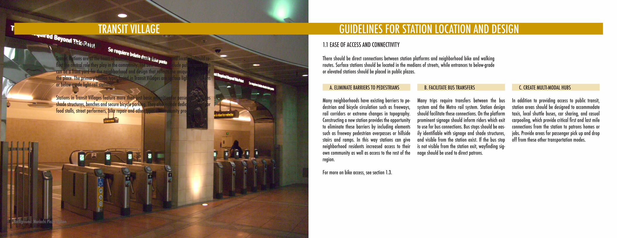
1. TRANSIT STATIONS
Transit stations are at the heart of Transit Villages and their design and location should re-flect the central role they play in the community. The best stations include public space that can be a front yard for the neighborhood and design that reflects the unique character of the place. The primary station types found in Transit Villages are surface light-rail stations or below-grade light-rail stations.
Stations in Transit Villages feature more than just basic amenities for passengers such as shade structures, benches and secure bicycle parking. They also include dedicated space for food stalls, street performers, bike repair and other types of community programming.
1.1 EASE OF ACCESS AND CONNECTIVITY
Background: Mariachi Plaza Station
There should be direct connections between station platforms and neighborhood bike and walking routes. Surface stations should be located in the medians of streets, while entrances to below-grade or elevated stations should be placed in public plazas.
Many neighborhoods have existing barriers to pe-destrian and bicycle circulation such as freeways, rail corridors or extreme changes in topography. Constructing a new station provides the opportunity to eliminate these barriers by including elements such as freeway pedestrian overpasses or hillside stairs and ramps. In this way stations can give neighborhood residents increased access to their own community as well as access to the rest of the region.
For more on bike access, see section 1.3.
Many trips require transfers between the bus system and the Metro rail system. Station design should facilitate these connections. On the platform prominent signage should inform riders which exit to use for bus connections. Bus stops should be eas-ily identifiable with signage and shade structures, and visible from the station exist. If the bus stop is not visible from the station exit, wayfinding sig-nage should be used to direct patrons.
In addition to providing access to public transit, station areas should be designed to accommodate taxis, local shuttle buses, car sharing, and casual carpooling, which provide critical first and last mile connections from the station to patrons homes or jobs. Provide areas for passenger pick up and drop off from these other transportation modes.
TRANSIT VILLAGE GUIDELINES FOR STATION LOCATION AND DESIGN
A. ELIMINATE BARRIERS TO PEDESTRIANS B. FACILITATE BUS TRANSFERS C. CREATE MULTI-MODAL HUBS

D. MINIMIZE TACK CROSSINGSRecommended Recommended
E. ALLOW ACCESS BY STAIRS AND RAMPSRecommended
Minimizing tack crossings enhances safety and allows pedestrians to take the most direct route to the station platform.
Not Recommended
Provide access to platforms by both stairs and ramps. Ramps serve disabled riders, seniors, cyclists and parents with strollers, but often require patrons to take a more circuitous route. Stairs provide faster and more direct access for patrons rushing to catch a train or bus.
Not Recommended
Design stations to with direct exits to streets. Pedestrians will seek out the shortest route, so make sure that the shortest route is the safest route.
F. ORIENT STATION EXITS TOWARDS MAJOR ATTRACTIONS AND LANDMARKS
Transit station exists should face local landmarks to help orient arriving passengers. Exits should also be oriented to facilitate easy pedestrian movement towards primary destinations. Where stations include public plazas, station entrances and exits should be oriented to guide pedestrian traffic through the public space to provide activity and “eyes on the street” in the park, which can deter crime and enhance perceived security.
TRANSIT VILLAGE GUIDELINES FOR STATION LOCATION AND DESIGN
Background: Soto Station
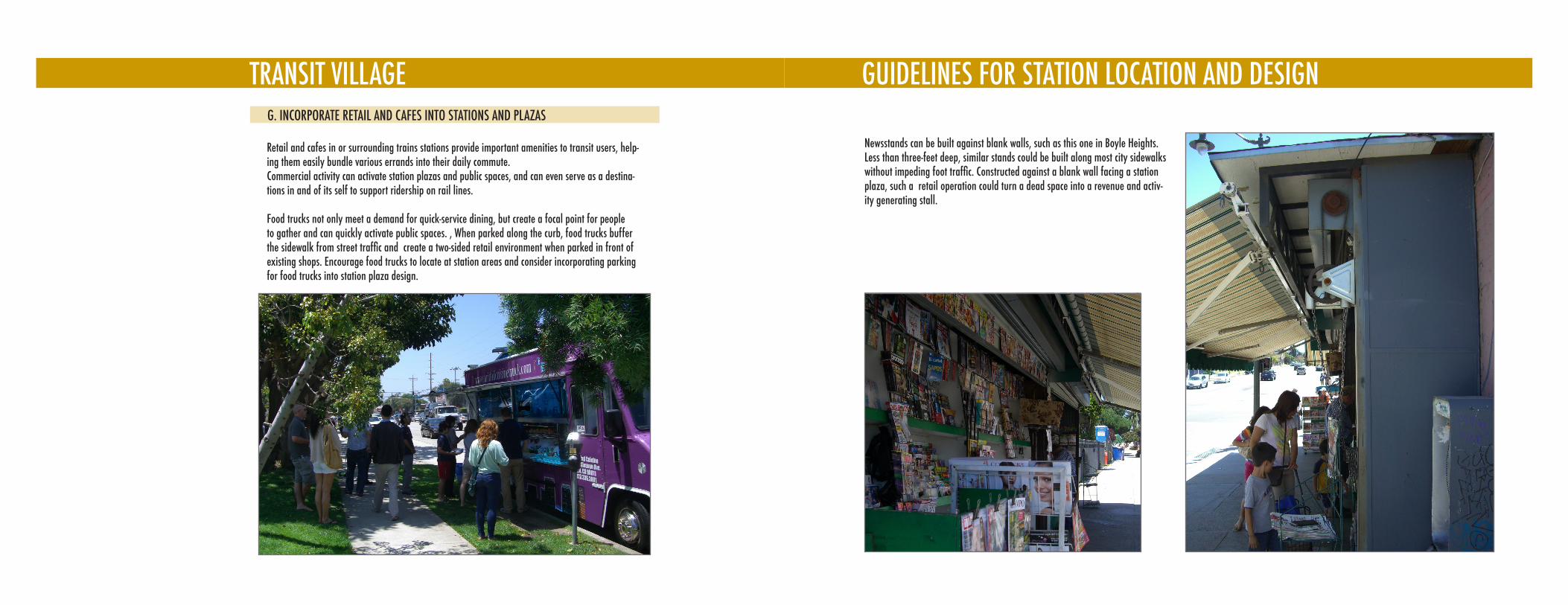
GUIDELINES FOR STATION LOCATION AND DESIGNTRANSIT VILLAGEG. INCORPORATE RETAIL AND CAFES INTO STATIONS AND PLAZAS
Retail and cafes in or surrounding trains stations provide important amenities to transit users, help-ing them easily bundle various errands into their daily commute. Commercial activity can activate station plazas and public spaces, and can even serve as a destina-tions in and of its self to support ridership on rail lines.
Food trucks not only meet a demand for quick-service dining, but create a focal point for people to gather and can quickly activate public spaces. , When parked along the curb, food trucks buffer the sidewalk from street traffic and create a two-sided retail environment when parked in front of existing shops. Encourage food trucks to locate at station areas and consider incorporating parking for food trucks into station plaza design.
Newsstands can be built against blank walls, such as this one in Boyle Heights. Less than three-feet deep, similar stands could be built along most city sidewalks without impeding foot traffic. Constructed against a blank wall facing a station plaza, such a retail operation could turn a dead space into a revenue and activ-ity generating stall.
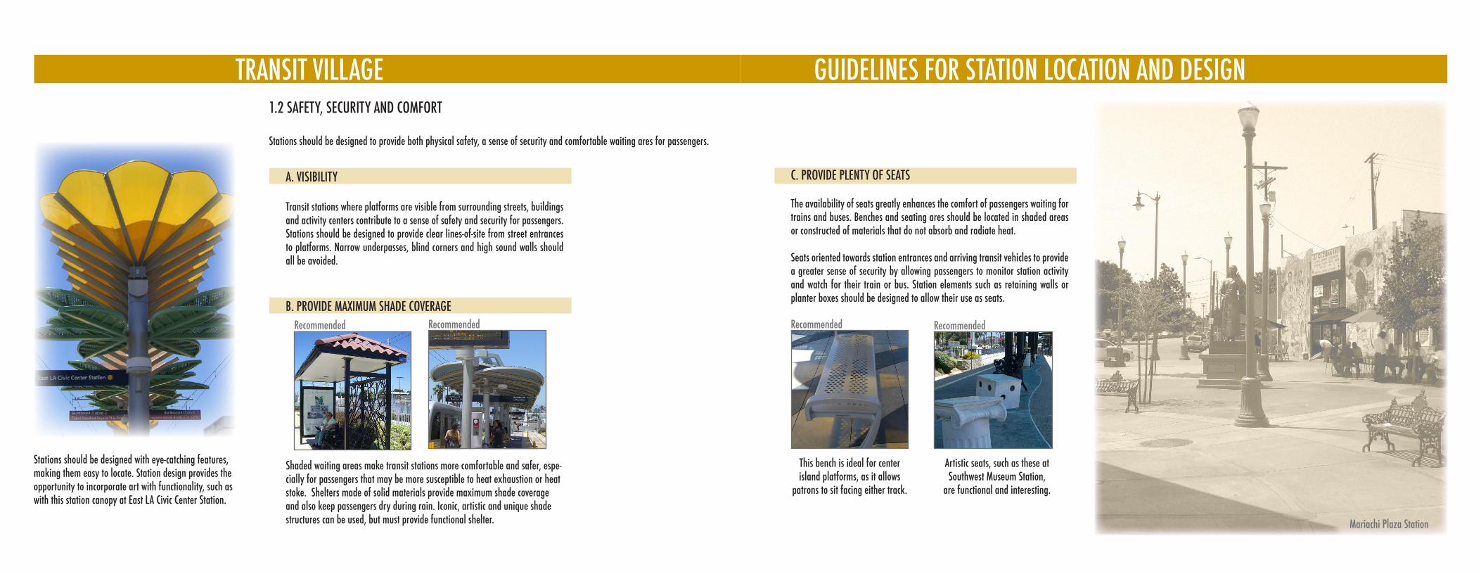
GUIDELINES FOR STATION LOCATION AND DESIGNTRANSIT VILLAGE1.2 SAFETY, SECURITY AND COMFORT
Stations should be designed to provide both physical safety, a sense of security and comfortable waiting ares for passengers.
This bench is ideal for center island platforms, as it allows
patrons to sit facing either track.
Artistic seats, such as these at Southwest Museum Station,
are functional and interesting.
C. PROVIDE PLENTY OF SEATS
Recommended Recommended
B. PROVIDE MAXIMUM SHADE COVERAGERecommended
Shaded waiting areas make transit stations more comfortable and safer, espe-cially for passengers that may be more susceptible to heat exhaustion or heat stoke. Shelters made of solid materials provide maximum shade coverage and also keep passengers dry during rain. Iconic, artistic and unique shade structures can be used, but must provide functional shelter.
The availability of seats greatly enhances the comfort of passengers waiting for trains and buses. Benches and seating ares should be located in shaded areas or constructed of materials that do not absorb and radiate heat.
Seats oriented towards station entrances and arriving transit vehicles to provide a greater sense of security by allowing passengers to monitor station activity and watch for their train or bus. Station elements such as retaining walls or planter boxes should be designed to allow their use as seats.
Recommended
A. VISIBILITY
Transit stations where platforms are visible from surrounding streets, buildings and activity centers contribute to a sense of safety and security for passengers. Stations should be designed to provide clear lines-of-site from street entrances to platforms. Narrow underpasses, blind corners and high sound walls should all be avoided.
Stations should be designed with eye-catching features, making them easy to locate. Station design provides the opportunity to incorporate art with functionality, such as with this station canopy at East LA Civic Center Station.
Mariachi Plaza Station
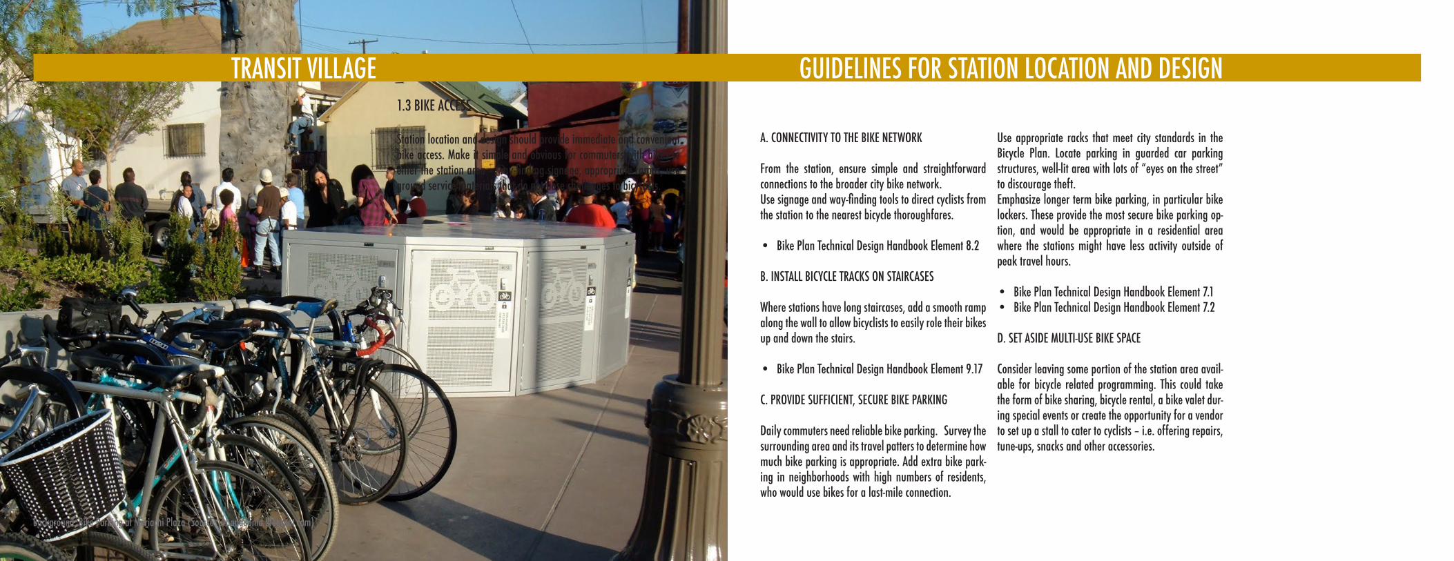
A. CONNECTIVITY TO THE BIKE NETWORK
From the station, ensure simple and straightforward connections to the broader city bike network. Use signage and way-finding tools to direct cyclists from the station to the nearest bicycle thoroughfares.
Bike Plan Technical Design Handbook Element 8.2•
B. INSTALL BICYCLE TRACKS ON STAIRCASES
Where stations have long staircases, add a smooth ramp along the wall to allow bicyclists to easily role their bikes up and down the stairs.
Bike Plan Technical Design Handbook Element 9.17•
C. PROVIDE SUFFICIENT, SECURE BIKE PARKING
Daily commuters need reliable bike parking. Survey the surrounding area and its travel patters to determine how much bike parking is appropriate. Add extra bike park-ing in neighborhoods with high numbers of residents, who would use bikes for a last-mile connection.
Use appropriate racks that meet city standards in the Bicycle Plan. Locate parking in guarded car parking structures, well-lit area with lots of “eyes on the street” to discourage theft.Emphasize longer term bike parking, in particular bike lockers. These provide the most secure bike parking op-tion, and would be appropriate in a residential area where the stations might have less activity outside of peak travel hours.
Bike Plan Technical Design Handbook Element 7.1• Bike Plan Technical Design Handbook Element 7.2•
D. SET ASIDE MULTI-USE BIKE SPACE
Consider leaving some portion of the station area avail-able for bicycle related programming. This could take the form of bike sharing, bicycle rental, a bike valet dur-ing special events or create the opportunity for a vendor to set up a stall to cater to cyclists – i.e. offering repairs, tune-ups, snacks and other accessories.
1.3 BIKE ACCESS
Station location and design should provide immediate and convenient bike access. Make it simple and obvious for commuters with bikes to enter the station area – way-finding signage, appropriate ramps, use ground service materials that do not pose challenges to bicyclists.
GUIDELINES FOR STATION LOCATION AND DESIGNTRANSIT VILLAGE
Background: Bike Parking at Mariachi Plaza (Source: urbanadonia.blogspot.com)
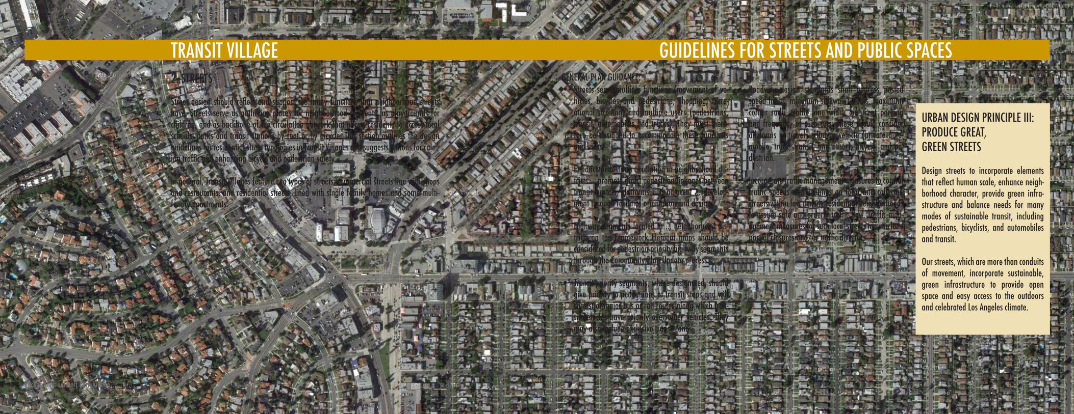
TRANSIT VILLAGE GUIDELINES FOR STATION LOCATION AND DESIGN
Street design should reflect and support the many functions that neighborhood streets have. Streets serve as gathering places for neighborhood residents, as playgrounds for children, and as backbone of the circulation network that allows residents to access local schools, parks and transit stations by foot or by bicycle. This section outlines the design guidelines for residential street typologies in Transit Villages and suggests options for calm-ing traffic and enhancing bicycle and pedestrian safety.
In general, Transit Villages feature two types of streets: commercial streets line with shops and restaurants, and residential streets, lined with single family homes and some multi-family apartments.
2. STREETS
TRANSIT VILLAGE
Background: Leimert Park Village
URBAN DESIGN PRINCIPLE III:PRODUCE GREAT, GREEN STREETS
Design streets to incorporate elements that reflect human scale, enhance neigh-borhood character, provide green infra-structure and balance needs for many modes of sustainable transit, including pedestrians, bicyclists, and automobiles and transit.
Our streets, which are more than conduits of movement, incorporate sustainable, green infrastructure to provide open space and easy access to the outdoors and celebrated Los Angeles climate.
GUIDELINES FOR STREETS AND PUBLIC SPACESGENERAL PLAN GUIDANCE:
Streets serve multiple functions (movement of ve-• hicles, bicycles and pedestrians, shopping, recre-ational strolling) and multiple users (pedestrians, transit, automobiles and trucks). They must there-fore be designed to accommodate these functions and users.
Enhance pedestrian circulation in neighborhood dis-• tricts ... promote direct pedestrian linkages between transit portals/platforms and adjacent ... develop-ment through facilities orientation and design.
Highway segments located in ... neighborhood dis-• tricts on the Framework Element maps should be considered for pedestrian-priority highway segments through the Community Plan Update process.
Transit-priority segments, where designated, should • give priority to pedestrians at transit stops and will consist of major bus or rail routes along which tran-sit vehicles have priority over other vehicles. They may also include exclusive transit lanes.
Roadway design standards shall address posted • speed limits, minimum sidewalk widths, maximum corner radii, traffic lane width, on-street parking and frequency of curb cuts. These should consider all forms of travel including vehicle (private auto-mobile, truck, transit, and other), bicycle, and pe-destrian.
Incorporate traffic management measures to control • traffic speeds and volumes on local and collector-streets within low density residential neighborhoods to assure safe and orderly traffic flow. Traffic man-agement measures for such local streets may include partial closures and/or traffic diverters
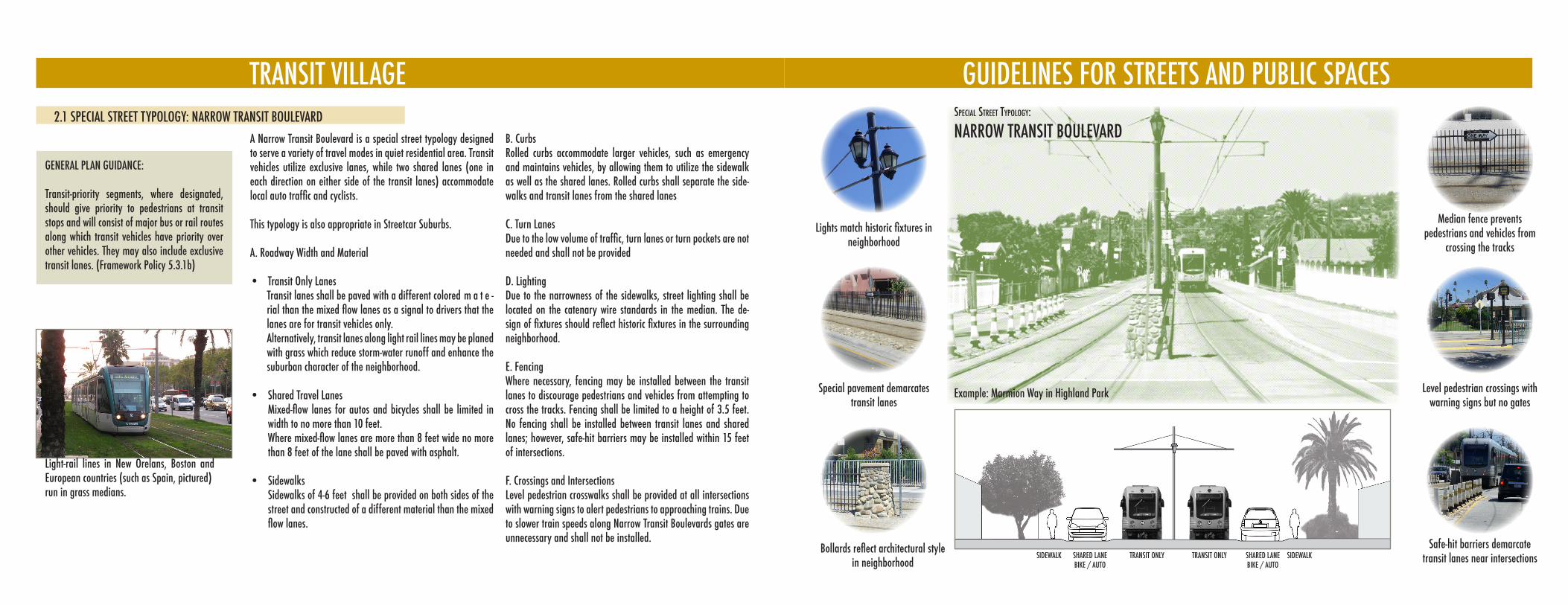
TRANSIT VILLAGE
A Narrow Transit Boulevard is a special street typology designed to serve a variety of travel modes in quiet residential area. Transit vehicles utilize exclusive lanes, while two shared lanes (one in each direction on either side of the transit lanes) accommodate local auto traffic and cyclists.
This typology is also appropriate in Streetcar Suburbs.
A. Roadway Width and Material
Transit Only Lanes• Transit lanes shall be paved with a different colored m a t e -rial than the mixed flow lanes as a signal to drivers that the lanes are for transit vehicles only. Alternatively, transit lanes along light rail lines may be planed with grass which reduce storm-water runoff and enhance the suburban character of the neighborhood.
Shared Travel Lanes• Mixed-flow lanes for autos and bicycles shall be limited in width to no more than 10 feet. where mixed-flow lanes are more than 8 feet wide no more than 8 feet of the lane shall be paved with asphalt. Sidewalks• Sidewalks of 4-6 feet shall be provided on both sides of the street and constructed of a different material than the mixed flow lanes.
B. CurbsRolled curbs accommodate larger vehicles, such as emergency and maintains vehicles, by allowing them to utilize the sidewalk as well as the shared lanes. Rolled curbs shall separate the side-walks and transit lanes from the shared lanes
C. Turn LanesDue to the low volume of traffic, turn lanes or turn pockets are not needed and shall not be provided
D. LightingDue to the narrowness of the sidewalks, street lighting shall be located on the catenary wire standards in the median. The de-sign of fixtures should reflect historic fixtures in the surrounding neighborhood.
E. FencingWhere necessary, fencing may be installed between the transit lanes to discourage pedestrians and vehicles from attempting to cross the tracks. Fencing shall be limited to a height of 3.5 feet. No fencing shall be installed between transit lanes and shared lanes; however, safe-hit barriers may be installed within 15 feet of intersections.
F. Crossings and IntersectionsLevel pedestrian crosswalks shall be provided at all intersections with warning signs to alert pedestrians to approaching trains. Due to slower train speeds along Narrow Transit Boulevards gates are unnecessary and shall not be installed.
Light-rail lines in New Orelans, Boston and European countries (such as Spain, pictured) run in grass medians.
2.1 SPECIAL STREET TYPOLOGY: NARROW TRANSIT BOULEVARD
GENERAL PLAN GUIDANCE:
Transit-priority segments, where designated, should give priority to pedestrians at transit stops and will consist of major bus or rail routes along which transit vehicles have priority over other vehicles. They may also include exclusive transit lanes. (Framework Policy 5.3.1b)
GUIDELINES FOR STREETS AND PUBLIC SPACES
Level pedestrian crossings with warning signs but no gates
Lights match historic fixtures in neighborhood
Special pavement demarcates transit lanes
Bollards reflect architectural style in neighborhood
Median fence prevents pedestrians and vehicles from
crossing the tracks
speCial street typology:
NARROW TRANSIT BOULEVARD
Example: Marmion Way in Highland Park
SIDEWALK SIDEWALKSHARED LANEBIKE / AUTO
SHARED LANEBIKE / AUTO
TRANSIT ONLY TRANSIT ONLYSafe-hit barriers demarcate
transit lanes near intersections
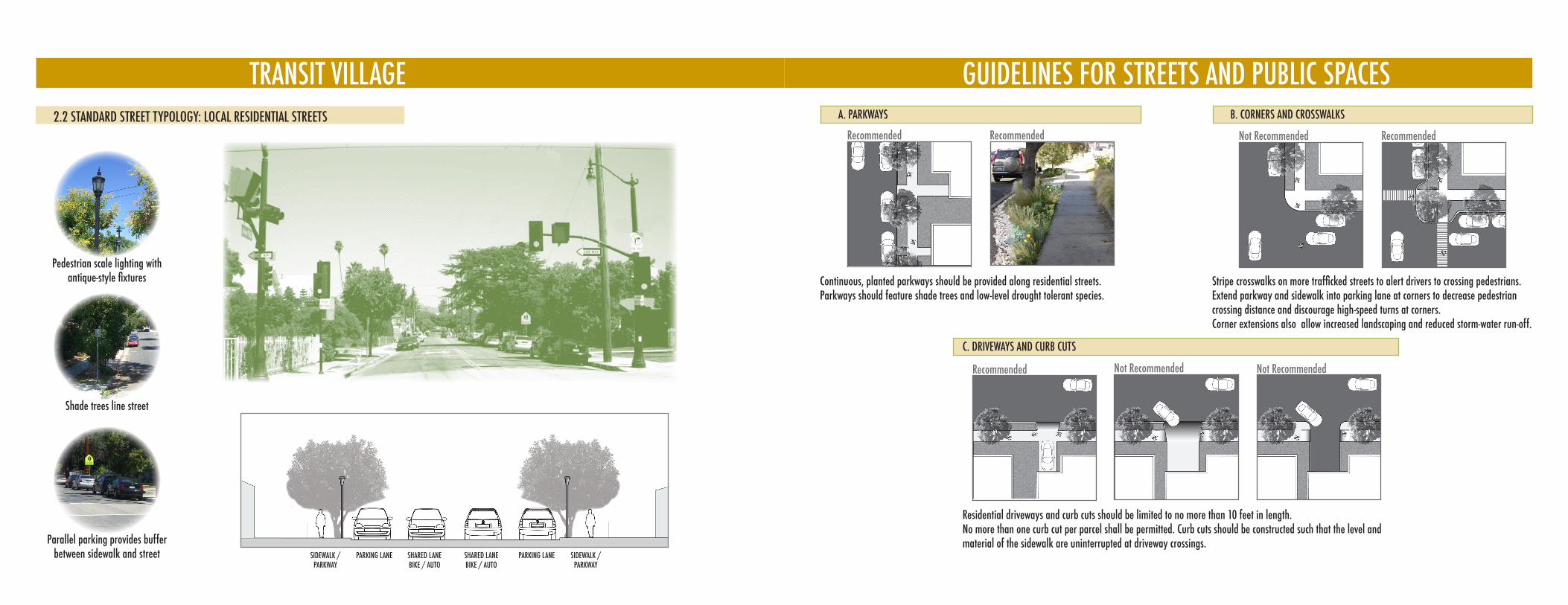
TRANSIT VILLAGE2.2 STANDARD STREET TYPOLOGY: LOCAL RESIDENTIAL STREETS
Pedestrian scale lighting with antique-style fixtures
Shade trees line street
Parallel parking provides buffer between sidewalk and street SIDEWALK /
PARKWAYSHARED LANEBIKE / AUTO
SHARED LANEBIKE / AUTO
PARKING LANE PARKING LANESIDEWALK / PARKWAY
GUIDELINES FOR STREETS AND PUBLIC SPACESA. PARKWAYS
Recommended Recommended
B. CORNERS AND CROSSWALKS
Recommended
C. DRIVEWAYS AND CURB CUTS
Continuous, planted parkways should be provided along residential streets.Parkways should feature shade trees and low-level drought tolerant species.
Not Recommended
Stripe crosswalks on more trafficked streets to alert drivers to crossing pedestrians. Extend parkway and sidewalk into parking lane at corners to decrease pedestrian crossing distance and discourage high-speed turns at corners. Corner extensions also allow increased landscaping and reduced storm-water run-off.
Recommended Not Recommended Not Recommended
Residential driveways and curb cuts should be limited to no more than 10 feet in length. No more than one curb cut per parcel shall be permitted. Curb cuts should be constructed such that the level and material of the sidewalk are uninterrupted at driveway crossings.
TRANSIT VILLAGE2.3 COMMERCIAL STREETS
Downtown Design Guide 6.15.0910
A. SIDEWALKS
The Downtown Street Standards establish required sidewalk widths for
all Downtown streets. On many streets, the required sidewalk width is
a combination of public right-of-way (dedication) and easement for
sidewalk purposes.
On segments of most north-south streets, an average easement for sidewalk
!"#!$%&%'(%'#&)"(#&*+',-&'./&#.0&'&.%&1&23'!#$/(*&%'4&5(6(7(38'(2'6"(7*(20'
design and at the same time provides space for sidewalk activity. A required
./&#.0&'&.%&1&23'1.8'#.20&'9#$1':;'3$'<'3(1&%'3-&'./&#.0&='!#$/(*&*'3-.3'3-&'
total area of the easement divided by the length of the property frontage equals
the required average.
Design sidewalks that are walkable and accommodate a variety of uses.
1. A building may project over the required sidewalk easement above a height
$9'>:;'.2*'6&7$?'.'*&!3-'$9'@;'3$'.AA$11$*.3&'%3#&&3'3#&&%+'B#$C&A3($2%='
which are permitted in the public ROW by the Municipal Code, such as
signs, canopies and awnings, are permitted over the required easement,
subject to the same approvals.
2. B#$/(*&'.'1(2(1"1'D;'A$23(2"$"%'!.3-'$9'3#./&7+
3. Provide an 18-24” wide access zone next to the curb, which includes the 6”
curb and 12” wide granite or brick edge band adjacent to the back of curb.
4. Outdoor dining may occur on any portion of the paved sidewalk provided a
1(2(1"1'D;'?(*&'A$23(2"$"%'!.3-'$9'3#./&7'(%'1.(23.(2&*+
OUTDOOR DINING, ETC. PATH OF TRAVEL
Example showing the parkway along the
curb, the clear path of travel and use of the
remaining sidewalk for outdoor dining.
PARKWAY
Example of building overhang that does not
interfere with street tree growth.
SIDEWALKS ANDSETBACKS03
Cafe tables, chairs, and merchandise displays along the street invite passers-by to patronize local businesses and create a more active streetscape.
A. COMMERCIAL SIDEWALKS
Encourage retailers and restaurants to adopt and utilize the sidewalk in front of their store, provided there is sufficient width to maintain a clear path of travel. The path of travel should be wide enough to allow two couples to comfortably pass or to allow pedestrians to walk four abreast. At a minimum, the path of travel must permit wheelchair access.
Allowing commercial use of the sidewalks increases pedestrian activity, spurs economic development by allowing businesses to expand their footprint, enhances safety by providing more “eyes on the street,” and can decrease costs to the city if merchants clean and maintain sidewalks in front of their establishments.
GUIDELINES FOR STREETS AND PUBLIC SPACES
Not Recommended Recommended
Downtown Design Guide 6.15.0910
A. SIDEWALKS
The Downtown Street Standards establish required sidewalk widths for
all Downtown streets. On many streets, the required sidewalk width is
a combination of public right-of-way (dedication) and easement for
sidewalk purposes.
On segments of most north-south streets, an average easement for sidewalk
!"#!$%&%'(%'#&)"(#&*+',-&'./&#.0&'&.%&1&23'!#$/(*&%'4&5(6(7(38'(2'6"(7*(20'
design and at the same time provides space for sidewalk activity. A required
./&#.0&'&.%&1&23'1.8'#.20&'9#$1':;'3$'<'3(1&%'3-&'./&#.0&='!#$/(*&*'3-.3'3-&'
total area of the easement divided by the length of the property frontage equals
the required average.
Design sidewalks that are walkable and accommodate a variety of uses.
1. A building may project over the required sidewalk easement above a height
$9'>:;'.2*'6&7$?'.'*&!3-'$9'@;'3$'.AA$11$*.3&'%3#&&3'3#&&%+'B#$C&A3($2%='
which are permitted in the public ROW by the Municipal Code, such as
signs, canopies and awnings, are permitted over the required easement,
subject to the same approvals.
2. B#$/(*&'.'1(2(1"1'D;'A$23(2"$"%'!.3-'$9'3#./&7+
3. Provide an 18-24” wide access zone next to the curb, which includes the 6”
curb and 12” wide granite or brick edge band adjacent to the back of curb.
4. Outdoor dining may occur on any portion of the paved sidewalk provided a
1(2(1"1'D;'?(*&'A$23(2"$"%'!.3-'$9'3#./&7'(%'1.(23.(2&*+
OUTDOOR DINING, ETC. PATH OF TRAVEL
Example showing the parkway along the
curb, the clear path of travel and use of the
remaining sidewalk for outdoor dining.
PARKWAY
Example of building overhang that does not
interfere with street tree growth.
SIDEWALKS ANDSETBACKS03
B. COMMERCIAL SIDEWALKS: PARKWAY AMENITIES
Street furniture, such as streetlights, benches, trash receptacles and planters can define and brand neighborhood shopping areas.
Street furniture placed in the parkway strip such as planters, mailboxes, news-racks and even trash cans serve pedestrians needs and create a buffer between the sidewalk path of travel and passing cars.
RECOMMENDED: Pedestiran-scale Streetlights Maps and pedestrian signageTreesTrash ReceptaclesNews racks
BenchesBus SheltersBike RacksMail Boxes
Streetlights should illuminate the sidewalk as well as the street. Smaller scale pedestrian lighting signals that an area is designed for walking while freeway-style cobra lights do not.
NOT RECOMMENDED:Above ground utility boxesFreeway-style streetlightsLarge signage for automobilists Overhead Freeway-style signs
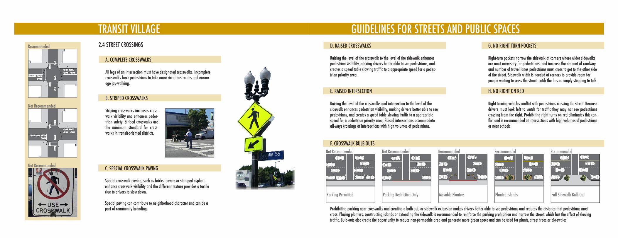
TRANSIT VILLAGE
Not Recommended
Not Recommended
Recommended 2.4 STREET CROSSINGS
A. COMPLETE CROSSWALKS
All legs of an intersection must have designated crosswalks. Incomplete crosswalks force pedestrians to take more circuitous routes and encour-age jay-walking.
B. STRIPED CROSSWALKS
Striping crosswalks increases cross-walk visibility and enhances pedes-trian safety. Striped crosswalks are the minimum standard for cross-walks in transit-oriented districts.
C. SPECIAL CROSSWALK PAVING
Special crosswalk paving, such as bricks, pavers or stamped asphalt, enhance crosswalk visibility and the different texture provides a tactile clue to drivers to slow down.
Special paving can contribute to neighborhood character and can be a part of community branding.
GUIDELINES FOR STREETS AND PUBLIC SPACES
Not Recommended RecommendedNot Recommended Recommended Recommended
F. CROSSWALK BULB-OUTS
Parking Permitted Parking Restriction Only Movable Planters Planted Islands Full Sidewalk Bulb-Out
D. RAISED CROSSWALKS
Raising the level of the crosswalk to the level of the sidewalk enhances pedestrian visibility, making drivers better able to see pedestrians, and creates a speed table slowing traffic to a appropriate speed for a pedes-trian priority area.
E. RAISED INTERSECTION
Raising the level of the crosswalks and intersection to the level of the sidewalk enhances pedestrian visibility, making drivers better able to see pedestrians, and creates a speed table slowing traffic to a appropriate speed for a pedestrian priority area. Raised intersections accommodate all-ways crossings at intersections with high volumes of pedestrians.
G. NO RIGHT TURN POCKETS
Right-turn pockets narrow the sidewalk at corners where wider sidewalks are most necessary for pedestrians, and increase the amount of roadway and number of travel lanes pedestrians must cross to get to the other side of the street. Sidewalk width is needed at corners to provide room for people waiting to cross the street, catch the bus or simply stopping to talk.
H. NO RIGHT ON RED
Right-turning vehicles conflict with pedestrians crossing the street. Because drivers must look left to watch for traffic they may not see pedestrians crossing from the right. Prohibiting right turns on red eliminates this con-flict and is recommended at intersections with high volumes of pedestrians or near schools.
Prohibiting parking near crosswalks and creating a bulb-out, or sidewalk extension makes drivers better able to see pedestrians and reduces the distance that pedestrians must cross. Placing planters, constructing islands or extending the sidewalk is recommended to reinforce the parking prohibition and narrow the street, which has the effect of slowing traffic. Bulb-outs also create the opportunity to reduce non-permeable area and generate more green space and can be used for plants, street trees or bio-swales.
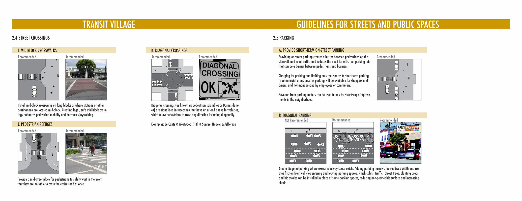
TRANSIT VILLAGE GUIDELINES FOR STREETS AND PUBLIC SPACES
Recommended Recommended
2.4 STREET CROSSINGS
I. MID-BLOCK CROSSWALKS
Install mid-block crosswalks on long blocks or where stations or other destinations are located mid-block. Creating legal, safe mid-block cross-ings enhances pedestrian mobility and decreases jaywalking.
J. PEDESTRIAN REFUGES
Recommended Recommended
K. DIAGONAL CROSSINGS
Diagonal crossings (as known as pedestrian scrambles or Barnes danc-es) are signalized intersections that have an all-red phase for vehicles, which allow pedestrians to cross any direction including diagonally.
Examples: Le Conte & Westwood, 11th & Santee, Hoover & Jefferson
Provide a mid-street place for pedestrians to safely wait in the event that they are not able to cross the entire road at once.
Recommended Recommended
A. PROVIDE SHORT-TERM ON-STREET PARKINGProviding on-street parking creates a buffer between pedestrians on the sidewalk and road traffic, and reduces the need for off-street parking lots that can be a barrier between pedestrians and business.
Charging for parking and limiting on-street spaces to short term parking in commercial areas ensures parking will be available for shoppers and diners, and not monopolized by employees or commuters.
Revenue from parking meters can be used to pay for streetscape improve-ments in the neighborhood.
Recommended
2.5 PARKING
B. DIAGONAL PARKINGRecommended
Create diagonal parking where excess roadway space exists. Adding parking narrows the roadway width and cre-ates friction from vehicles entering and leaving parking spaces, which calms traffic. Street trees, planting areas and bio swales can be installed in place of some parking spaces, reducing non-permeable surface and increasing shade.
Not Recommended Recommended
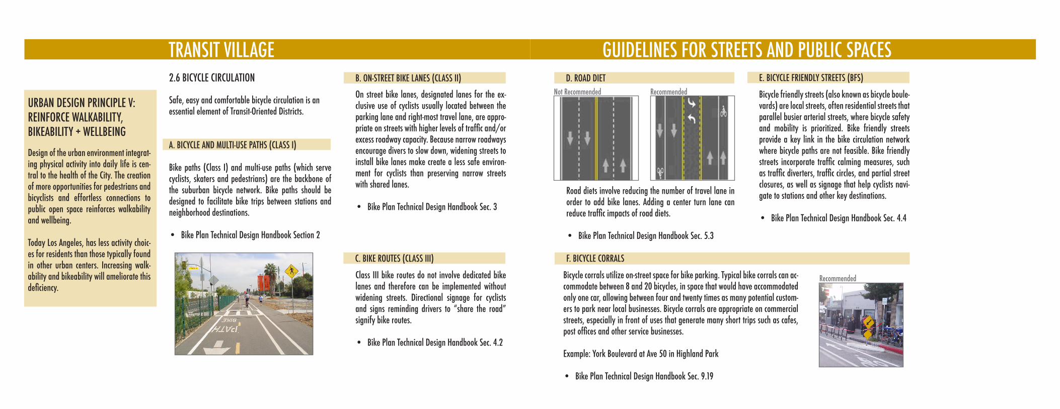
TRANSIT VILLAGE2.6 BICYCLE CIRCULATION
Safe, easy and comfortable bicycle circulation is an essential element of Transit-Oriented Districts.
A. BICYCLE AND MULTI-USE PATHS (CLASS I)
Bike paths (Class I) and multi-use paths (which serve cyclists, skaters and pedestrians) are the backbone of the suburban bicycle network. Bike paths should be designed to facilitate bike trips between stations and neighborhood destinations.
Bike Plan Technical Design Handbook Section 2•
On street bike lanes, designated lanes for the ex-clusive use of cyclists usually located between the parking lane and right-most travel lane, are appro-priate on streets with higher levels of traffic and/or excess roadway capacity. Because narrow roadways encourage divers to slow down, widening streets to install bike lanes make create a less safe environ-ment for cyclists than preserving narrow streets with shared lanes.
Bike Plan Technical Design Handbook Sec. 3•
URBAN DESIGN PRINCIPLE V:REINFORCE WALKABILITY, BIKEABILITY + WELLBEING
Design of the urban environment integrat-ing physical activity into daily life is cen-tral to the health of the City. The creation of more opportunities for pedestrians and bicyclists and effortless connections to public open space reinforces walkability and wellbeing.
Today Los Angeles, has less activity choic-es for residents than those typically found in other urban centers. Increasing walk-ability and bikeability will ameliorate this deficiency.
B. ON-STREET BIKE LANES (CLASS II)
Class III bike routes do not involve dedicated bike lanes and therefore can be implemented without widening streets. Directional signage for cyclists and signs reminding drivers to “share the road” signify bike routes.
Bike Plan Technical Design Handbook Sec. 4.2•
C. BIKE ROUTES (CLASS III)
GUIDELINES FOR STREETS AND PUBLIC SPACESD. ROAD DIET
Road diets involve reducing the number of travel lane in order to add bike lanes. Adding a center turn lane can reduce traffic impacts of road diets.
Bike Plan Technical Design Handbook Sec. 5.3•
Not Recommended Recommended Bicycle friendly streets (also known as bicycle boule-vards) are local streets, often residential streets that parallel busier arterial streets, where bicycle safety and mobility is prioritized. Bike friendly streets provide a key link in the bike circulation network where bicycle paths are not feasible. Bike friendly streets incorporate traffic calming measures, such as traffic diverters, traffic circles, and partial street closures, as well as signage that help cyclists navi-gate to stations and other key destinations.
Bike Plan Technical Design Handbook Sec. 4.4•
E. BICYCLE FRIENDLY STREETS (BFS)
Bicycle corrals utilize on-street space for bike parking. Typical bike corrals can ac-commodate between 8 and 20 bicycles, in space that would have accommodated only one car, allowing between four and twenty times as many potential custom-ers to park near local businesses. Bicycle corrals are appropriate on commercial streets, especially in front of uses that generate many short trips such as cafes, post offices and other service businesses.
Example: York Boulevard at Ave 50 in Highland Park
Bike Plan Technical Design Handbook Sec. 9.19•
F. BICYCLE CORRALS
Recommended