red soil chemistry and mineralogy reflect uniform weathering environments in fluvial sediments,...
TRANSCRIPT
SOILS, SEC 2 • GLOBAL CHANGE, ENVIRON RISK ASSESS, SUSTAINABLE LAND USE • RESEARCH ARTICLE
Red soil chemistry and mineralogy reflect uniform weatheringenvironments in fluvial sediments, Taiwan
Tsung Ming Tsao & Yue Ming Chen & Hwo Shuenn Sheu &
Shung Yao Zhuang & Ping Hua Shao & Hua Wen Chen &
Kai Shuan Shea & Ming Kuang Wang &
Yen Horng Shau & Kai Yin Chiang
Received: 7 April 2011 /Accepted: 22 February 2012 /Published online: 5 June 2012# Springer-Verlag 2012
AbstractPurpose Information on the physicochemical properties,mineral species and micromorphology of lateritic soils andgravel soil layers in paleo-environmental soil profile isseverely lacking. Red soil profile of the Taoyuan terracewas employed to demonstrate its different extents of lateriticweathering. The objectives of this study were to comparethe physicochemical properties of lateritic soils and gravelsoil layers and identify using conventional and synchrotronX-ray diffraction (XRD) analyses mineral species in nano-particles separated by automated ultrafiltration device(AUD) apparatus.Materials and methods Soil samples were collected frompaleo-environmental lateritic soils. Soil samples were exam-ined using elemental analysis, conventional and synchrotronXRD analyses, high gradient magnetic separation, separation
and collection of nanoparticles by AUD apparatus, and trans-mission electron microscopy (TEM).Results and discussion The soil pH, redness index, quanti-ties of free Al- and Fe-oxides (Ald and Fed), and clay contentof lateritic soils are higher than those of gravel soil layers.Illite, kaolinite, gibbsite, quartz, goethite, and hematite wereidentified in clay fractions and nanoparticles by convention-al and synchrotron XRD analyses. TEM images show pres-ence of hematite nanoparticles on the surface coating ofkaolinite nanoparticles and aggregated hematite nanopar-ticles overlapping the edge of a kaolinite flake in a sizerange of 4–7 nm. Synchrotron XRD techniques are morestraightforward and powerful than conventional XRD withrandom powder methods for identifying nanoparticles in redsoils, particularly for illite, kaolinite, goethite, and hematitenanoparticles. According to chemical compositions of clay
Responsible editor: Michael Kersten
T. M. TsaoThe Experimental Forest, National Taiwan University,No. 12, Section 1, Chienshan Road, Chushan,Nantou 55750, Taiwan
Y. M. ChenBiodiversity Research Center, Academia Sinica,128, Academia Road, Section 2, Nankang,Taipei 11529, Taiwan
H. S. SheuNatural Synchrotron Radiation Research Center,101 Hsinann Road, Hsinchu Science Park,Hsinchu 30076, Taiwan
S. Y. ZhuangState Key Laboratory of Soil and Sustainable Agriculture,Institute of Soil Science, Chinese Academy of Sciences,Nanjing 210008, People’s Republic of China
P. H. Shao :H. W. Chen :K. S. SheaCentral Geological Survey, Ministry of Economic Affairs, Taiwan,No. 2, Lane 109, Huaxin Street, Zhonghe,New Taipei City 235, Taiwan
M. K. Wang (*) :K. Y. ChiangDepartment of Agricultural Chemistry,National Taiwan University,No. 1, Section 4, Roosevelt Road,Taipei 10617, Taiwane-mail: [email protected]
Y. H. ShauDepartment of Marine Resource, National Sun Yat-Sen University,No. 70, Lienhai Road,Kaohsiung 425, Taiwan
J Soils Sediments (2012) 12:1054–1065DOI 10.1007/s11368-012-0495-z
fractions and red soil features in the Taoyuan terrace, thesered soils can be taken as lateritic red earths or red earths.Conclusions This work suggests that physicochemicalproperties, mineral species, and micromorphology of redsoil at all depths can shed light on the extent of paleo-environmental lateritic weathering.
Keywords Goethite . Hematite . Kaolinite . Laterite . Nano-particle . Red soil
1 Introduction
Red soils are most common soil types in the subtropical andtropical regions of the world that are low in fertility (Mohr etal. 1972; Sanchez 1976; Buol and Sanchez 1986; Eswaran etal. 1986; China Soil Survey Office 1987; IUSS WorkingGroup WRB 2006). Composed mainly of kaolinite, Al- andFe-oxides, quartz, and organic matter, red soils occur in soilmoisture regimes ranging from aridic to perudic and aquic.They are limited to low CEC and contain minerals with lowweatherability (Singh and Gilkes 1992a, b). Though theyoccur over many kinds of geologic bedrocks, red soils showevidence of ferruginous materials in which the soils wereformed (Soil Survey Staff 1999).
In northwestern Taiwan, red soils, known as laterites, occurextensively in the Taoyuan area and have been used for brickmaking. The lateritic terrace deposits are widely distributed inthe rolling hills as well as coastal and river terraces of north-western Taiwan (Wan and Chen 1988). Chen and Teng (1990)reported on the paleo-environments, focusing on the faciescharacteristics, paleo-current direction, and grain-size distri-bution of the Quaternary deposits of the Taoyuan terrace.Their work provided a comprehensive understanding of thedepositional system of the Taoyuan terrace. The Taoyuan fan-shaped delta, constituting the major portion of sedimentarydeposits, comprised more than 80 % of fluvial gravels inter-fingering with marine sands and muds (Shao et al. 2005,2010). Characterized by radial paleo-stream directions andthe fan-shaped pattern of facies associations and clast-sizevariations, the Taoyuan fan-shaped delta is believed to havebeen deposited by flood flows with the major stream flowingout of a paleo-lowland and highland located to the east of theterrace. Information on dating of the Quaternary deposits insoil profile on the Taoyuan terrace is severely lacking. It isbecause deposits (e.g., pollen grain, shell gravel, black carbon,and driftwood) in large quantities cannot be directly obtainedfrom the soil profile for age dating by potassium–argon andisotopic methods. In previous geological studies in theTaoyuan area, the degree of lateritization has been used asan index for terrace correlation (Chen and Liu 1991; Sung etal. 1997; Chuang et al. 2002). Pedologists and mineralogistsin Taiwan have been interested in the properties and genesis of
laterites (Chiu 1968; Chang 1971; Ho 1988; Wan and Chen1988; Lin et al. 2005). However, information on the physico-chemical properties, mineralogy, and micromorphology oflateritic soils and gravel soil layers in red pedons is necessaryfor further study.
The objectives of this study were to (i) compare thephysicochemical properties of paleo-environmental lateriticsoils and gravel soil layers; (ii) identify by synchrotron X-ray diffraction (XRD) analysis nanoparticle minerals in redsoils separated by an automated ultrafiltration device (AUD)apparatus (Tsao et al. 2009a, b, 2011); and (iii) discuss thebehavior of kaolinite and hematite particles in the red soils.
2 Materials and methods
2.1 Site descriptions and soil samplings
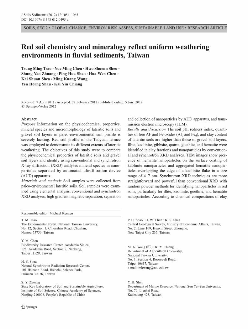
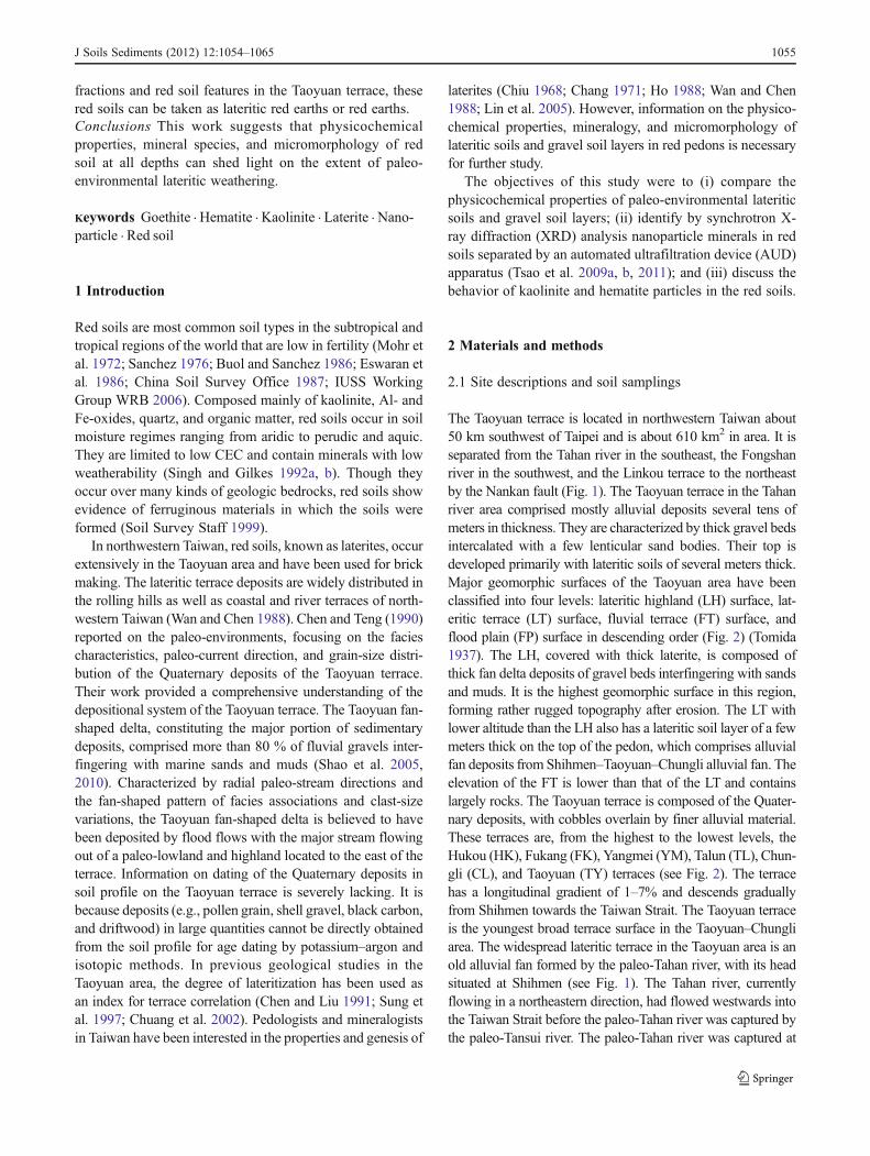
The Taoyuan terrace is located in northwestern Taiwan about50 km southwest of Taipei and is about 610 km2 in area. It isseparated from the Tahan river in the southeast, the Fongshanriver in the southwest, and the Linkou terrace to the northeastby the Nankan fault (Fig. 1). The Taoyuan terrace in the Tahanriver area comprised mostly alluvial deposits several tens ofmeters in thickness. They are characterized by thick gravel bedsintercalated with a few lenticular sand bodies. Their top isdeveloped primarily with lateritic soils of several meters thick.Major geomorphic surfaces of the Taoyuan area have beenclassified into four levels: lateritic highland (LH) surface, lat-eritic terrace (LT) surface, fluvial terrace (FT) surface, andflood plain (FP) surface in descending order (Fig. 2) (Tomida1937). The LH, covered with thick laterite, is composed ofthick fan delta deposits of gravel beds interfingering with sandsand muds. It is the highest geomorphic surface in this region,forming rather rugged topography after erosion. The LT withlower altitude than the LH also has a lateritic soil layer of a fewmeters thick on the top of the pedon, which comprises alluvialfan deposits from Shihmen–Taoyuan–Chungli alluvial fan. Theelevation of the FT is lower than that of the LT and containslargely rocks. The Taoyuan terrace is composed of the Quater-nary deposits, with cobbles overlain by finer alluvial material.These terraces are, from the highest to the lowest levels, theHukou (HK), Fukang (FK), Yangmei (YM), Talun (TL), Chun-gli (CL), and Taoyuan (TY) terraces (see Fig. 2). The terracehas a longitudinal gradient of 1–7% and descends graduallyfrom Shihmen towards the Taiwan Strait. The Taoyuan terraceis the youngest broad terrace surface in the Taoyuan–Chungliarea. The widespread lateritic terrace in the Taoyuan area is anold alluvial fan formed by the paleo-Tahan river, with its headsituated at Shihmen (see Fig. 1). The Tahan river, currentlyflowing in a northeastern direction, had flowed westwards intothe Taiwan Strait before the paleo-Tahan river was captured bythe paleo-Tansui river. The paleo-Tahan river was captured at
J Soils Sediments (2012) 12:1054–1065 1055
about 30 ka according to the depositional ages of some repre-sentative fluvial terraces along the lower Tahan river (Chen andLiu 1991). The commencing deposition ages of the main LT in
the lower Tahan river area were estimated to be earlier than47 ka; thus, the LT with a top lateritic soil layer was formedbetween 30 and 47 ka (Chen and Liu 1991). Furthermore, the
W E
S
N
121.00° 121.25° 121.75°121.50°
121.00° 121.25° 121.50° 121.75°
25.0
0 °25
.25°
25.0
0°25
.25°
Taoyuan terrace
Taipei basin
Linkouterrace
Shihmen Wulai
YangmingshanMountain
0 10 20Km
Eastern Chinese sea
Fig. 1 Location map of studyarea
Fig. 2 Location of sampling sites (TY-I, TY-II, TY-III, TY-IV, TY-V,and TY-VI) in the Taoyuan terrace. Terrace is a set of the youngestbroad terrace surfaces in the Taoyuan–Chungli area. Terrace surfaces:
HK Hukou Terrace, FK Fukang Terrace, YM Yangmei Terrace, LTalunTerrace, CL Chungli Terrace, TY Taoyuan Terrace. ★: outcrop of redsoils; ⊙: sampling location; ●: location of the Shihmen
1056 J Soils Sediments (2012) 12:1054–1065
average temperature in the study area is 23°C, and the meanannual rainfall over the past 5 years (2005–2009) is 1970 mm(Taiwan Civil Aeronautics Administration 2005–2009). Thesoil temperature and moisture regime of the study area areclassified as clay, alluvial, hyperthemic, and Typic Hapludox,respectively (Soil Survey Staff 2010).
Soil samples were collected from TY-I (24°57′13 N, 121°15′58E) in the TYarea, TY-II (24°54′31 N, 121°07′29E) in theFK area, TY-III (24°57′17 N, 121°10′26E) in the TL area, TY-IV (24°54′00 N, 121°10′27E) in the HK area, TY-V (24°48′38 N, 121°11′34E) in the HK area, and TY-VI (24°56′58 N,121°09′15E) in the YM area pedons (see Fig. 2). Soil sampleswere air dried, crushed, and ground to pass through a 2-mmsieve. Organic matter was removed by 30 % H2O2 and heatedon a hot plate. The soil sample (≥ 100 mg) was suspended indouble distilled water (DDW) (500 mL) and dispersed byultrasonification at 170 W and 60 kHz for 1 min by a NEY300 ultrasonic instrument (NEY, Barkmeyer Division,Yucaipa, CA). The suspension was then passed through a300-mesh sieve (50 μm) to remove the sand fraction(50 μm–2 mm) from the suspension of dispersed mineralparticles by wet sieving. Then, the silt (2000 nm–50 μm)and clay (< 2000 nm) fractions were collected by sedimenta-tion according to Stokes’ Law (Jackson 1979).
2.2 Analytical methods
2.2.1 Physical and chemical analyses
Soil pH was determined in 1:1 soil to water suspensions. Forthe conventional NH4-Na exchange method, the cation ex-change capacity (CEC) of soils was measured in leaching tubesusing soil samples (10 g) with celite as a filter aid. Sampleswere saturated with NH4
+ by washing with 90 mL of 1 MNH4OAc buffered at pH 7 (Rhoades 1982). Semi-quantitativeestimations of illite, kaolinite, quartz, vermiculite, and illite–vermiculite mixed layer goethite were performed according tothe methods used by Brindley (1980) and Pai et al. (1999).Aluminum and iron oxides were extracted with DCB solutions(Mehra and Jackson 1960) for free Al- and Fe-oxides (Ald andFed) and with 0.2 M NH4-oxalate solutions at pH 3 for X-raynoncrystalline Al- and Fe-oxides (Alo and Feo) (McKeague etal. 1971). The organic-bound Al- and Fe-oxides (Alp and Fep)were extracted by 0.1 M Na2P2O7 solutions (Loveland andDighy 1984). The extracted Fe and Al were determined byatomic absorption spectrometry (AAS, Hitachi, 180-30).
2.2.2 Elemental analysis
Twenty milligrams of dried sample was accurately weighedand added with 3 mL 30 % HCl (Merck, Darmstadt, Ger-many), 9 mL 65 % HNO3 (Merck), and 4 mL 48 % HF(Merck) to a CEM MARS-5 microwave digestive system
(Matthews, NC). The temperature was gradually raised to180°C in 10 min with digestion maintained for 15 min atthis temperature (US EPA 1996). Concentrations of Si, Al,Fe, Mn, Ca, Mg, K, Na, Ti, and Zr in solutions weredetermined by induced couple plasma (ICP-AES, PerkinElmer Optima 2000DV) (Bernas 1967).
2.2.3 XRD analysis
Mg-saturated clays were examined at 25°C before andafter glycerol solvation for identification of expandablesmectite. The K-saturated clays were X-rayed at 25°Cbefore and after heating at 110, 250, 350, 450, and 550°C for 2 h (Jackson 1979; Pai et al. 1999). Randompowder (fractions of size<2 mm) X-ray diffraction(XRD) of the oriented clays was performed using aRigaku Geigerflex with Ni-filtered CuKα radiation at35 kV and 15 mA scanned from 3° to 40°2θ at 0.02°2θ min−1.
2.2.4 High gradient magnetic separation (HGMS)
Clays were separated into magnetic and non-magnetic frac-tions (Schulze and Dixon 1979). Soil clay fractions werequantitatively separated without dithionite–citrate–bicarbon-ate (DCB) treatment. Clays were treated with ultrasonic dis-persion in pH 9.5 of Na2CO3 solution and then passed throughthe magnetic field of a strong electromagnet. The flow rate forwater was 0.05 Lmin−1. All clay suspensions were fractionat-ed at 0.9 T for separation of the non-iron-bearing minerals.After HGMS treatments, clay suspensions were flocculatedwith NaCl, and excess salts were removed by centrifugation,washed by DDW, and freeze-dried. Free-dried samples weresubjected to XRD analyses.
2.2.5 Separation and collection of soil nanoparticlesusing an AUD apparatus
The time required for separating particle-size fractions of 1–100 nm was calculated by the modified Stokes’ equation(Hiemenz 1986; Laidlaw and Steinmetz 2005; Tsao et al.2009a). The suspension (< 100-nm-size fraction) was centri-fuged at 6,840×g (9,000 rpm) for 15 min at 4°C using aHitachi CR21 refrigerated centrifuge, which had an R12A3rotor with polycarbonate tubes (250 mL×6) and settlingsample height of 10 cm within the centrifuge tube. Thecollected suspension (< 100-nm-size fraction) was filteredby the AUD apparatus (Tsao et al. 2009a, 2009b, 2011),with size fractions of 1–100 nm collected using the Sigmaultrafiltration disk membrane (NMWL: 1000 Da—equivalentto 1 nm in diameter).
J Soils Sediments (2012) 12:1054–1065 1057
2.2.6 TEM measurement
One drop of diluted suspension (< 100-nm-size fraction)was deposited on a Cu grid covered with a coated carbonfilm. The electron micrographs were operated at 200 kVwith a Jeol TEM-1230 instrument (JEOL Limited Company,Tokyo, Japan) for identifying soil nanoparticles.
2.2.7 Synchrotron XRD analysis
A hard X-ray beamline (BL01C) was used at NationalRadiation Research Center, Hsinchu, Taiwan (NSRRC).The photon energy for synchrotron XRD was 16 keV at aring energy of 1.5 GeV and electron current of 300 mA(Song et al. 2007; Tsao et al. 2011).
2.2.8 Micromorphological measurement
Kubiena boxes were utilized to collect undisturbed soilblocks for soil micromorphological studies. After beingair-dried, vertically oriented thin sections (7.8×6.8×3.0 cm) with slide thickness of 30 μm were prepared bySpectrum Petrographics (Oregon, USA). They were inves-tigated under a polarized microscope (Nikon Optiphot), andthe soil micromorphology was described (Brewer 1976;Bullock et al. 1985).
3 Results and discussion
3.1 Descriptions of lateritic soils
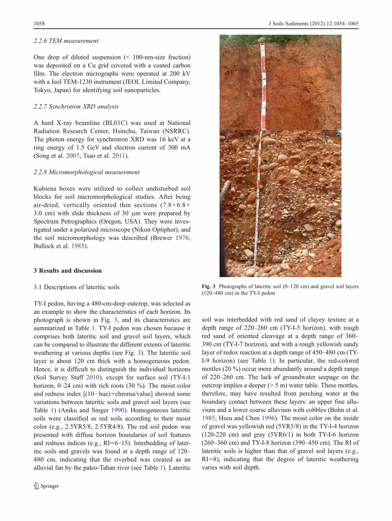
TY-I pedon, having a 480-cm-deep outcrop, was selected asan example to show the characteristics of each horizon. Itsphotograph is shown in Fig. 3, and its characteristics aresummarized in Table 1. TY-I pedon was chosen because itcomprises both lateritic soil and gravel soil layers, whichcan be compared to illustrate the different extents of lateriticweathering at various depths (see Fig. 3). The lateritic soillayer is about 120 cm thick with a homogeneous pedon.Hence, it is difficult to distinguish the individual horizons(Soil Survey Staff 2010), except for surface soil (TY-I-1horizon, 0–24 cm) with rich roots (30 %). The moist colorand redness index [(10−hue)×chroma/value] showed somevariations between lateritic soils and gravel soil layers (seeTable 1) (Aniku and Singer 1990). Homogeneous lateriticsoils were classified as red soils according to their moistcolor (e.g., 2.5YR5/8, 2.5YR4/8). The red soil pedon waspresented with diffuse horizon boundaries of soil featuresand redness indices (e.g., RI06–15). Interbedding of later-itic soils and gravels was found at a depth range of 120–480 cm, indicating that the riverbed was created as analluvial fan by the paleo-Tahan river (see Table 1). Lateritic
soil was interbedded with red sand of clayey texture at adepth range of 220–260 cm (TY-I-5 horizon), with roughred sand of oriented cleavage at a depth range of 360–390 cm (TY-I-7 horizon), and with a rough yellowish sandylayer of redox reaction at a depth range of 450–480 cm (TY-I-9 horizon) (see Table 1). In particular, the red-coloredmottles (20 %) occur more abundantly around a depth rangeof 220–260 cm. The lack of groundwater seepage on theoutcrop implies a deeper (> 5 m) water table. These mottles,therefore, may have resulted from perching water at theboundary contact between these layers: an upper fine allu-vium and a lower coarse alluvium with cobbles (Bohn et al.1985; Hseu and Chen 1996). The moist color on the insideof gravel was yellowish red (5YR5/8) in the TY-I-4 horizon(120-220 cm) and gray (5YR6/1) in both TY-I-6 horizon(260–360 cm) and TY-I-8 horizon (390–450 cm). The RI oflateritic soils is higher than that of gravel soil layers (e.g.,RI08), indicating that the degree of lateritic weatheringvaries with soil depth.
Fig. 3 Photographs of lateritic soil (0–120 cm) and gravel soil layers(120–480 cm) in the TY-I pedon
1058 J Soils Sediments (2012) 12:1054–1065
3.2 Soil physical and chemical properties
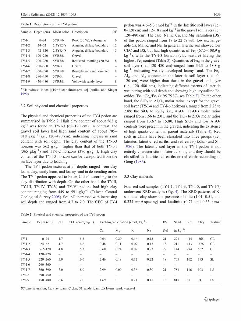
The physical and chemical properties of the TY-I pedon aresummarized in Table 2. High clay content of about 562 gkg−1 was found in TY-I-3 (62–120 cm). In contrast, thegravel soil layer had high sand content of about 705–818 gkg−1 (i.e., 120–480 cm), indicating increase in sandcontent with soil depth. The clay content of the TY-I-3horizon was 562 gkg−1 higher than that of both TY-I-1(365 gkg−1) and TY-I-2 horizons (376 gkg−1). High claycontent of the TY-I-3 horizon can be transported from thesurface layer due to leaching.
The TY-I pedon textures at all depths ranged from clayloam, clay, sandy loam, and loamy sand in descending order.The TY-I pedon appeared to be an Ultisol according to theclay distribution with depth. On the other hand, the TY-II,TY-III, TY-IV, TY-V, and TY-VI pedons had high claycontent ranging from 449 to 591 gkg−1 (Taiwan CentralGeological Survey 2005). Soil pH increased with increasingsoil depth and ranged from 4.7 to 7.0. The CEC of TY-I
pedon was 4.6–5.3 cmol kg−1 in the lateritic soil layer (i.e.,0–120 cm) and 12–18 cmol kg−1 in the gravel soil layer (i.e.,120–480 cm). The base (Na, K, Ca, and Mg) saturation (BS)of this pedon ranged from 18 to 22 % with low exchange-able Ca, Ma, K, and Na. In general, lateritic soil showed lowCEC and BS, but had high quantities of Fed (67.5–108.9 gkg−1), with the TY-I-3 horizon (clay texture) having thehighest Fed content (Table 3). Quantities of Fed in the gravelsoil layer (i.e., 120–480 cm) ranged from 34.3 to 48.8 gkg−1, indicating weakly developed loamy sand. The Feo,Ald, and Alo contents in the lateritic soil layer (i.e., 0–120 cm) were higher than those in the gravel soil layer(i.e., 120–480 cm), indicating different extents of lateriticweathering with soil depth and showing high crystalline Fe-oxides [Fed−Feo/Fed (> 95.75 %), see Table 3]. On the otherhand, the SiO2 to Al2O3 molar ratios, except for the gravelsoil layer (TY-I-4 and TY-I-6 horizons), ranged from 2.23 to2.89; the SiO2 to R2O3 (i.e., Al2O3+Fe2O3) molar ratiosranged from 1.66 to 2.01, and the TiO2 to ZrO2 molar ratiosranged from 13.67 to 15.80. High SiO2 and low Al2O3
contents were present in the gravels, indicating the existenceof high quartz content in parent materials (Table 4). Redsoils in China have been classified into three groups (i.e.,laterites, lateritic red earths, and red earths) (Zhao and Shi1986). The lateritic soil layer in the TY-I pedon is notentirely characteristic of lateritic soils, and they should beclassified as lateritic red earths or red earths according toGong (1986).
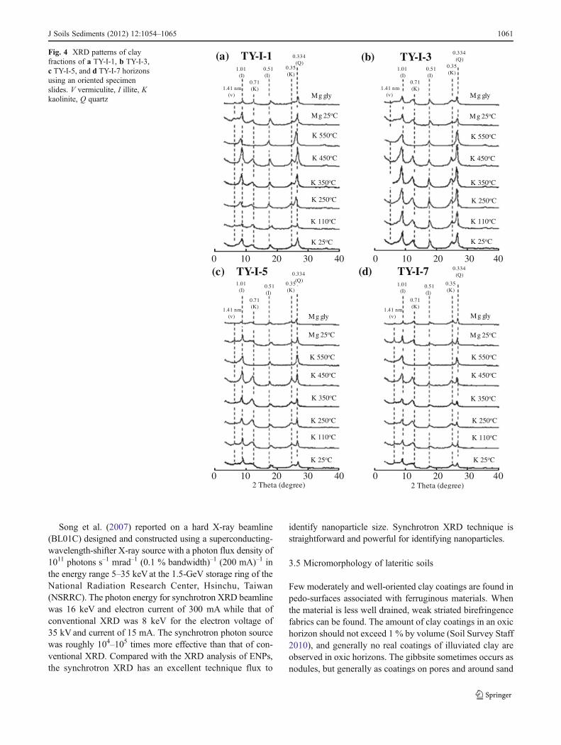
3.3 Clay minerals
Four red soil samples (TY-I-1, TY-I-3, TY-I-5, and TY-I-7)underwent XRD analysis (Fig. 4). The XRD patterns of K-saturated clay show the presence of illite (1.01, 0.51, and0.334 nmd-spacing) and kaolinite (0.71 and 0.35 nmd-
Table 1 Descriptions of the TY-I pedon
Sample Depth (cm) Moist color Description RIa
TY-I-1 0–24 5YR5/6 Root (30 %), subangular 6
TY-I-2 24–62 2.5YR5/8 Angular, diffuse boundary 12
TY-I-3 62–120 2.5YR4/8 Angular, diffuse boundary 15
TY-I-4 120–220 5YR5/8 Gravel –
TY-I-5 220–260 5YR5/8 Red sand, mottling (20 %) 8
TY-I-6 260–360 5YR6/1 Gravel –
TY-I-7 360–390 5YR5/8 Roughly red sand, oriented 8
TY-I-8 390–450 5YR6/1 Gravel –
TY-I-9 450–480 5YR5/8 Yellowish sandy layer 8
a RI: redness index [(10−hue)×chroma/value] (Aniku and Singer1990)
Table 2 Physical and chemical properties of the TY-I pedon
Sample Depth (cm) pH CEC (cmolc kg−1) Exchangeable cation (cmolc kg
−1) BS Sand Silt Clay Texture
Ca Mg K Na (%) (g kg−1)
TY-I-1 0–24 4.7 5.3 0.64 0.20 0.16 0.13 21 221 414 365 CL
TY-I-2 24–62 4.7 4.6 0.48 0.11 0.09 0.13 18 211 413 376 CL
TY-I-3 62–120 4.8 5.3 0.60 0.24 0.07 0.23 22 144 294 562 C
TY-I-4 120–220 – – – – – – – – – – –
TY-I-5 220–260 5.9 16.6 2.46 0.18 0.12 0.22 18 705 102 193 SL
TY-I-6 260–360 – – – – – – – – – – –
TY-I-7 360–390 7.0 18.0 2.99 0.09 0.36 0.30 21 781 116 103 LS
TYI-8 390–450 – – – – – – – – – – –
TYI-9 450–480 6.6 12.0 1.69 0.13 0.21 0.18 18 818 88 94 LS
BS base saturation, CL clay loam, C clay, SL sandy loam, LS loamy sand, – gravel
J Soils Sediments (2012) 12:1054–1065 1059
spacing). The XRD patterns of illite indicate that reflectionpeaks of 1.01 (001 of hkl), 0.51 (002), and 0.334 nm (003)remain in K-saturated clay heated at 110 and 550°C. TheXRD reflection peaks of 0.71 and 0.35 nm disappeared afterheating the K-saturated clays at 550°C, indicating that kao-linite was present in the TY-I-1 horizon (see Fig. 4a). XRDpatterns of the TY-I-1 horizon showed weak and broadpeaks at 1.41–1.01 nm with K-saturation. Although thevermiculite and illite-vermiculite mixed layers were charac-terized by XRD reflection peaks, weak reflection peaksrevealed the presence of trace amounts of vermiculite andan illite-vermiculite mixed layer in this TY-I-1 horizon.
Semi-quantitative analysis results of clay minerals aregiven in Table 5 to explain the amount differences of thevarious depth of TY-I pedon. The major clay minerals in thefour selected samples (TY-I-1, TY-I-3, TY-I-5, and TY-I-7horizons) were illite, kaolinite, and minor constituents of
vermiculite. There was also an illite–vermiculite mixed lay-er (see Table 5). The illite and kaolinite contents were highat all soil depths, indicating that kaolinite and illite clays are themajor constituents of this TY-I pedon (see Table 5). The XRDpatterns of clay minerals of TY-I-3, TY-I-5, and TY-I-7 hori-zons were similar to that of the TY-I-1 horizon.
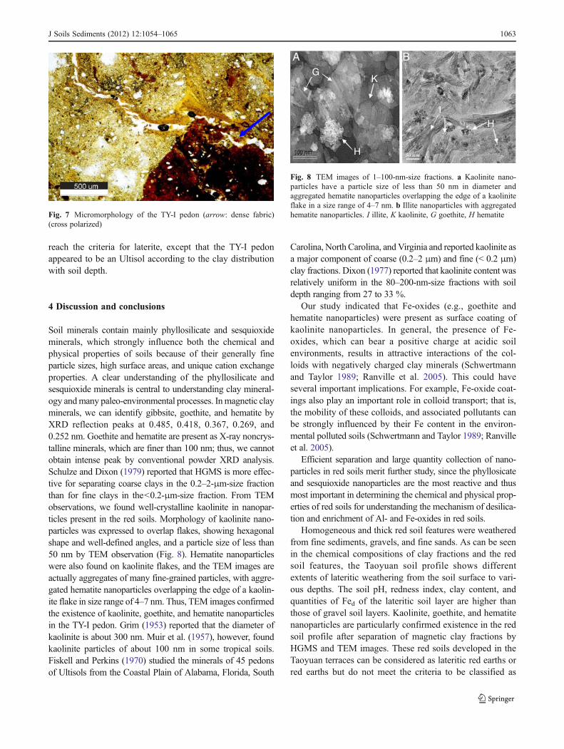
XRD of the magnetic clay fractions of four samples (TY-I-1, TY-I-3, TY-I-5, and TY-I-7 horizons) showed intenseXRD reflection peaks at 0.485 nm for gibbsite; 0.418 nm forgoethite; and 0.367, 0.269, and 0.252 nm for hematite(Fig. 5). Goethite and hematite are very common in redsoils; while ferrihydrite, lepidocrocite, and maghemite areless abundant. Torrent and Alferez (1983) reported thathematite content increased with increasing redness ratingin soils from European soil investigation, with redness ratingconverted from Munsell color by Torrent et al. (1980). Theseresults reveal that hematite existing in red soils plays animportant role in the lateritic pedogenesis.
3.4 Synchrotron XRD analysis
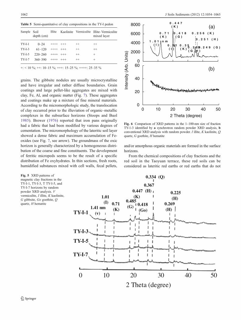
Results of synchrotron random powder XRD analysis showsimilar XRD patterns of all four samples (i.e., TY-I-1, TY-I-3, TY-I-5, and TY-I-7 horizons) in the 1–100-nm-size frac-tions; thus, sample TY-I-3 is taken to illustrate the synchro-tron XRD patterns. Figure 6a shows that illite, kaolinite,goethite, and hematite nanoparticles were particularly iden-tified in the 1–100-nm-size fractions by synchrotron high-resolution XRD patterns, but it is XRD noncrystalline mate-rials by conventional XRD analysis (see Fig. 6b). PowderXRD analysis is constrained by particle sizes and quantity inmineralogical constituents (Klug and Alexander 1974). It isworth noting that synchrotron XRD patterns which weredifferent from those analyzed by conventional XRD analy-sis provided unequivocal evidence of goethite and hematiteexistence in the 1–100-nm-size fractions.
Table 3 Extractable Fe and Al of the TY-I pedon
Sample Dithionitea Oxalateb Pyrophosphatec Fed�FeoFed
Ald Fed Alo Feo Alp Fep
(g kg−1) (%)
TY-I-1 15.3 67.5 1.1 1.9 2.8 3.5 97.23
TY-I-2 15.6 79.4 1.3 2.2 1.8 1.4 97.23
TY-I-3 12.9 108.9 1.1 2.0 0.8 1.0 98.21
TY-I-4 – – – – – – –
TY-I-5 6.8 43.8 1.1 1.9 0.8 0.1 95.73
TY-I-6 – – – – – – –
TY-I-7 7.2 48.8 0.6 1.6 0.6 0.1 96.73
TY-I-8 – – – – – – –
TY-I-9 6.0 34.3 0.5 1.2 0.6 0.1 96.38
a Sodium citrate–bicarbonate–dithionite extractable iron and aluminumbOxalate–oxalic acid (pH 3) extractable iron and aluminumc Sodium-pyrophosphate (pH 10) extractable iron and aluminum
Table 4 Chemical compositions of the TY-I pedon
Sample SiO2 Al2O3 Fe2O3 K2O Na2O CaO MgO TiO2 ZrO2SiO2Al2O3
SiO2R2O3
TiO2ZrO2
(%) Molar ratio
TY-I-1 49.94 34.46 12.98 0.77 0.20 0.26 0.94 0.40 0.04 2.46 1.98 15.50
TY-I-2 49.46 34.68 13.39 0.71 0.18 0.25 0.89 0.40 0.04 2.42 1.94 15.80
TY-I-3 48.78 33.33 15.68 0.50 0.17 0.24 0.86 0.39 0.04 2.48 1.91 15.53
TY-I-4 91.66 5.00 2.04 0.65 0.08 0.09 0.16 0.29 0.03 31.11 24.69 13.67
TY-I-5 45.08 34.30 17.55 1.07 0.46 0.41 0.67 0.42 0.05 2.23 1.68 15.21
TY-I-6 91.91 4.31 2.17 0.70 0.10 0.34 0.16 0.29 0.03 36.18 27.39 13.71
TY-I-7 43.47 29.82 23.05 1.12 0.40 0.71 0.96 0.42 0.05 2.47 1.66 15.73
TY-I-8 91.65 4.19 2.22 0.85 0.33 0.31 0.14 0.29 0.03 36.18 27.39 13.71
TY-I-9 48.20 28.28 19.42 1.71 0.40 0.38 1.18 0.38 0.04 2.89 2.01 14.59
1060 J Soils Sediments (2012) 12:1054–1065
Song et al. (2007) reported on a hard X-ray beamline(BL01C) designed and constructed using a superconducting-wavelength-shifter X-ray source with a photon flux density of1011 photons s–1 mrad–1 (0.1 % bandwidth)–1 (200 mA)–1 inthe energy range 5–35 keVat the 1.5-GeV storage ring of theNational Radiation Research Center, Hsinchu, Taiwan(NSRRC). The photon energy for synchrotron XRD beamlinewas 16 keV and electron current of 300 mA while that ofconventional XRD was 8 keV for the electron voltage of35 kV and current of 15 mA. The synchrotron photon sourcewas roughly 104–105 times more effective than that of con-ventional XRD. Compared with the XRD analysis of ENPs,the synchrotron XRD has an excellent technique flux to
identify nanoparticle size. Synchrotron XRD technique isstraightforward and powerful for identifying nanoparticles.
3.5 Micromorphology of lateritic soils
Few moderately and well-oriented clay coatings are found inpedo-surfaces associated with ferruginous materials. Whenthe material is less well drained, weak striated birefringencefabrics can be found. The amount of clay coatings in an oxichorizon should not exceed 1 % by volume (Soil Survey Staff2010), and generally no real coatings of illuviated clay areobserved in oxic horizons. The gibbsite sometimes occurs asnodules, but generally as coatings on pores and around sand
0 10 20 30 40 0 10 20 30 40
0 10 20 30 40 0 10 20 30 402 Theta (degree) 2 Theta (degree)
(a) TY-I-1
(c) TY-I-5 (d) TY-I-7
(b) TY-I-3
1.41 nm(v)
1.01(I)
0.71(K)
0.51(I)
0.35(K)
0.334(Q)
Mg gly
Mg 25oC Mg 25oC
Mg 25oC Mg 25oC
Mg gly
Mg gly Mg gly
K 550oC K 550oC
K 550oC K 550oC
K 450oC K 450oC
K 450oC K 450oC
K 350oC K 350oC
K 350oC K 350oC
K 250oC
K 250oC K 250oC
K 250oC
K 110oC K 110oC
K 110oC K 110oC
K 25oC K 25oC
K 25oCK 25oC
1.41 nm(v)
1.41 nm(v)
1.41 nm(v)
1.01(I)
1.01(I)
1.01(I)
0.71(K)
0.71(K)
0.51(I)
0.51(I)
0.51(I)
0.71(K)
0.35(K)
0.35(K)
0.35(K)
0.334(Q)
0.334(Q)
0.334(Q)
Fig. 4 XRD patterns of clayfractions of a TY-I-1, b TY-I-3,c TY-I-5, and d TY-I-7 horizonsusing an oriented specimenslides. V vermiculite, I illite, Kkaolinite, Q quartz
J Soils Sediments (2012) 12:1054–1065 1061
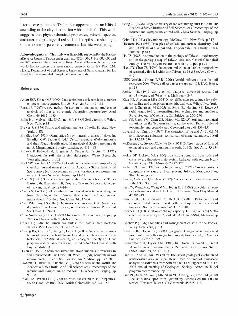
grains. The gibbsite nodules are usually microcrystallineand have irregular and rather diffuse boundaries. Graincoatings and large pellet-like aggregates are mixed withclay, Fe, Al, and organic matter (Fig. 7). These aggregatesand coatings make up a mixture of fine mineral materials.According to the micromorphologic study, the translocationof clay occurred prior to the illuviation of organic–metalliccomplexes in the subsurface horizons (Stoops and Buol1985). Brewer (1976) reported that iron pans originallyhad a fabric that had been modified by various degrees ofcementation. The micromorphology of the lateritic soil layershowed a dense fabric and maximum accumulation of Fe-oxides (see Fig. 7, see arrow). The groundmass of the oxichorizon is generally characterized by a homogeneous distri-bution of the coarse and fine constituents. The developmentof ferritic micropeds seems to be the result of a specificdistribution of Fe oxyhydrates. In thin sections, fresh roots,humidified substances mixed with cell walls, fecal pellets,
and/or amorphous organic materials are formed in the surfacehorizons.
From the chemical compositions of clay fractions and thered soil in the Taoyuan terrace, these red soils can beconsidered as lateritic red earths or red earths that do not
Table 5 Semi-quantitative of clay compositions in the TY-I pedon
Sample Soildepth (cm)
Illite Kaolinite Vermiculite Illite–Vermiculitemixed layer
TY-I-1 0–24 ++++ +++ ++ ++
TY-I-3 61–120 ++++ +++ ++ ++
TY-I-5 220–260 ++++ +++ ++ +
TY-I-7 360–390 ++++ +++ ++ +
+: < 10 %; ++: 10–15 %; +++: 15–25 %; ++++: 25–35 %
TY-I-7
TY-I-5
TY-I-3
TY-I-11.41 nm
(v)
1.01(I) 0.71
(K)
0.485(G)
0.447(K)
0.418(Go)
0.367(H)
0.334 (Q)
0.269(H)
0.225(H)
0 10 20 30 40 50
2 Theta (degree)
Fig. 5 XRD patterns ofmagnetic clay fractions in theTY-I-1, TY-I-3, T TY-I-5, andTY-I-7 horizons by randompowder XRD analysis. Vvermiculite, I illite, K kaolinite,G gibbsite, Go goethite, Qquartz, H hematite
0
2000
4000
6000
8000
0100 20 30 40 50
20
40
60
Inte
nsity
(A
rb. U
nits
)
2 Theta (degree)
1 . 0 1 n m( I )
0 . 7 1( K )
0 . 5 1( I )
0 . 4 4 7( K )
0 . 4 1 8( G )
0 . 2 6 9( G , H )
0 . 2 5 6 ( K )
0 . 2 5 1 ( H )
0 . 2 4 9 ( G )0 . 3 5( K )
(a)
(b)
Fig. 6 Comparison of XRD patterns in the 1–100-nm size of fractionTY-1-3 identified by a synchrotron random powder XRD analysis, bconventional XRD analysis with random powder. I illite, K kaolinite, Qquartz, G goethite, H hematite
1062 J Soils Sediments (2012) 12:1054–1065
reach the criteria for laterite, except that the TY-I pedonappeared to be an Ultisol according to the clay distributionwith soil depth.
4 Discussion and conclusions
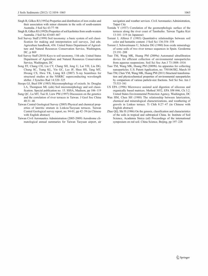
Soil minerals contain mainly phyllosilicate and sesquioxideminerals, which strongly influence both the chemical andphysical properties of soils because of their generally fineparticle sizes, high surface areas, and unique cation exchangeproperties. A clear understanding of the phyllosilicate andsesquioxide minerals is central to understanding clay mineral-ogy andmany paleo-environmental processes. Inmagnetic clayminerals, we can identify gibbsite, goethite, and hematite byXRD reflection peaks at 0.485, 0.418, 0.367, 0.269, and0.252 nm. Goethite and hematite are present as X-ray noncrys-talline minerals, which are finer than 100 nm; thus, we cannotobtain intense peak by conventional powder XRD analysis.Schulze and Dixon (1979) reported that HGMS is more effec-tive for separating coarse clays in the 0.2–2-μm-size fractionthan for fine clays in the<0.2-μm-size fraction. From TEMobservations, we found well-crystalline kaolinite in nanopar-ticles present in the red soils. Morphology of kaolinite nano-particles was expressed to overlap flakes, showing hexagonalshape and well-defined angles, and a particle size of less than50 nm by TEM observation (Fig. 8). Hematite nanoparticleswere also found on kaolinite flakes, and the TEM images areactually aggregates of many fine-grained particles, with aggre-gated hematite nanoparticles overlapping the edge of a kaolin-ite flake in size range of 4–7 nm. Thus, TEM images confirmedthe existence of kaolinite, goethite, and hematite nanoparticlesin the TY-I pedon. Grim (1953) reported that the diameter ofkaolinite is about 300 nm. Muir et al. (1957), however, foundkaolinite particles of about 100 nm in some tropical soils.Fiskell and Perkins (1970) studied the minerals of 45 pedonsof Ultisols from the Coastal Plain of Alabama, Florida, South
Carolina, North Carolina, andVirginia and reported kaolinite asa major component of coarse (0.2–2 μm) and fine (< 0.2 μm)clay fractions. Dixon (1977) reported that kaolinite content wasrelatively uniform in the 80–200-nm-size fractions with soildepth ranging from 27 to 33 %.
Our study indicated that Fe-oxides (e.g., goethite andhematite nanoparticles) were present as surface coating ofkaolinite nanoparticles. In general, the presence of Fe-oxides, which can bear a positive charge at acidic soilenvironments, results in attractive interactions of the col-loids with negatively charged clay minerals (Schwertmannand Taylor 1989; Ranville et al. 2005). This could haveseveral important implications. For example, Fe-oxide coat-ings also play an important role in colloid transport; that is,the mobility of these colloids, and associated pollutants canbe strongly influenced by their Fe content in the environ-mental polluted soils (Schwertmann and Taylor 1989; Ranvilleet al. 2005).
Efficient separation and large quantity collection of nano-particles in red soils merit further study, since the phyllosicateand sesquioxide nanoparticles are the most reactive and thusmost important in determining the chemical and physical prop-erties of red soils for understanding the mechanism of desilica-tion and enrichment of Al- and Fe-oxides in red soils.
Homogeneous and thick red soil features were weatheredfrom fine sediments, gravels, and fine sands. As can be seenin the chemical compositions of clay fractions and the redsoil features, the Taoyuan soil profile shows differentextents of lateritic weathering from the soil surface to vari-ous depths. The soil pH, redness index, clay content, andquantities of Fed of the lateritic soil layer are higher thanthose of gravel soil layers. Kaolinite, goethite, and hematitenanoparticles are particularly confirmed existence in the redsoil profile after separation of magnetic clay fractions byHGMS and TEM images. These red soils developed in theTaoyuan terraces can be considered as lateritic red earths orred earths but do not meet the criteria to be classified as
Fig. 7 Micromorphology of the TY-I pedon (arrow: dense fabric)(cross polarized)
H
K
I
G
H
A B
Fig. 8 TEM images of 1–100-nm-size fractions. a Kaolinite nano-particles have a particle size of less than 50 nm in diameter andaggregated hematite nanoparticles overlapping the edge of a kaoliniteflake in a size range of 4–7 nm. b Illite nanoparticles with aggregatedhematite nanoparticles. I illite, K kaolinite, G goethite, H hematite
J Soils Sediments (2012) 12:1054–1065 1063
laterite, except that the TY-I pedon appeared to be an Ultisolaccording to the clay distribution with soil depth. This worksuggests that physicochemical properties, mineral species,and micromorphology of red soil at all depths can shed lighton the extent of paleo-environmental lateritic weathering.
Acknowledgments This study was financially supported by the Nation-al Science Council, Taiwan under grant no. NSC-100-2313-B-002-007 andno. B02 project of the experimental forest, National Taiwan University. Wewould like to express our most sincere gratitude to the late Prof. P.M.Huang, Department of Soil Science, University of Saskatchewan, for hisvaluable advice provided throughout the entire study.
References
Aniku JRF, Singer MJ (1990) Pedogenic iron oxide trends in a marineterrace chronosequence. Soil Sci Soc Am J 54:147–152
Bernas B (1967) A new method for decomposition and comprehensiveanalysis of silicates by atomic absorption spectrometry. AnalChem 40:1682–1683
Bohn HL, McNeal BL, O’Connor GA (1985) Soil chemistry. Wiley,New York, p 341
Brewer R (1976) Fabric and mineral analysis of soils. Krieger, NewYork, p 482
Brindley GW (1980) Quantitative X-ray minerals analysis of clays. In:Brindley GW, Brown G (eds) Crystal structure of clay mineralsand their X-ray identification. Mineralogical Society monographno. 5. Mineralogical Society, London, pp 411–438
Bullock P, Fedoroff N, Jongerius A, Stoops G, Tursina T (1985)Handbook for soil thin section description. Waine Research,Wolverhampton, p 152
Buol SW, Sanchez PA (1986) Red soils in the Americas: morphology,classification and management. In: Academia Sinica Institute ofSoil Science (ed) Proceedings of the international symposium onred soil. China Science, Beijing, pp 14–43
Chang S (1971) Subsurface geologic study of the area from the TaipeiBasin to the Kuanyin shelf, Taoyuan, Taiwan. Petroleum Geologyof Taiwan, no. 9. pp 123–144
Chen YG, Liu TK (1991) Radiocarbon dates of river terraces along thelower Tahachi, northern Taiwan: their tectonic and geomorphicimplications. Proc Geol Soc China 34:337–347
Chen WF, Teng LS (1990) Depositional environment of Quaternarydeposits of the Linkou terrace, northwestern Taiwan. Proc GeolSoc China 33:39–63
China Soil Survey Office (1987) China soils. China Science, Beijing, p746. (in Chinese with English abstract)
Chiu HT (1968) The Hsinchuang fault in the Taoyuan area, northernTaiwan. Proc Geol Soc China 11:50–73
Chuang RY, Chen YG, Wang Y, Lee CT (2002) River terraces corre-lation of lower reach of Tahanchi and its implications on neo-tectonics. 2002 Annual meeting of Geological Society of China:program and expanded abstract, pp 347–349 (in Chinese withEnglish abstract)
Dixon JB (1977) Kaolin and serpentine group minerals in minerals insoil environments. In: Dixon JB, Weed SB (eds) Minerals in soilenvironments, 1st edn. Soil Sci Soc Am, Madison, pp 397–403
Eswaran H, Ikawa H, Kimble JM (1986) Oxisols of the world. In:Academia Sinica Institute of Soil Science (ed) Proceedings of theinternational symposium on red soil. China Science, Beijing, pp90–123
Fiskell JA, Perkins HF (1970) Selected coastal plain soil preperties.South Coop Ser Bull Univ Florida Gainesville 148:144–152
Gong ZT (1986) Biogeochemistry of red weathering crust in China. In:Academia Sinica Institute of Soil Science (ed) Proceedings of theinternational symposium on red soil. China Science, Beijing, pp124–158
Grim RE (1953) Clay mineralogy. McGraw-Hill, New York, p 317Hiemenz PC (1986) Principles of colloid and surface chemistry, 2nd
edn. Revised and expanded. Polytechnic University Press,Pomona, p 815
Ho CS (1988) An introduction to the geology of Taiwan—explanatorytext of the geologic map of Taiwan, 2nd edn. Central GeologicalSurvey, The Ministry of Economic Affairs, Taipei, p 192
Hseu ZY, Chen ZS (1996) Saturation, reduction, and redox morphologyof seasonally flooded Alfisols in Taiwan. Soil Sci Soc Am J 60:941–949
IUSS Working Group WRB (2006) World reference base for soilresources 2006. World soil resources reports no. 103. FAO, Rome,p 128
Jackson ML (1979) Soil chemical analysis—advanced course, 2ndedn. University of Wisconsin, Madison, p 246
Klug HP, Alexander LE (1974) X-ray diffraction procedures for poly-crystalline and amorphous materials, 2nd edn. Wiley, New York
Laidlaw I, Steinmetz M (2005) In: Scott DJ, Harding SE, Rowe AJ(eds) Analytical ultracentrifugation: techniques and methods.Royal Society of Chemistry, Cambridge, pp 270–290
Lin YS, Chen YG, Chen ZS, Hsieh ML (2005) Soil morphologicalvariations on the Taoyuan terrace, northwestern Taiwan: roles oftopography and groundwater. Geomorphology 69:138–151
Loveland PJ, Dighy P (1984) The extraction of Fe and Al by 0.1 Mpyrophosphate solutions: comparison of some techniques. J SoilSci 35:243–250
McKeague JA, Bryson JE, Miles JM (1971) Differentiation of form ofextractable iron and aluminum in soils. Soil Sci Soc Am J 35:33–38
Mehra OP, Jackson ML (1960) Iron oxides removed from soils andclays by a dithionite–citrate system buffered with sodium bicar-bonate. Clays Clay Minerals 7:317–327
Mohr ECJ, Baren FA, Van Schuylenborg J (1972) Tropical soils: acomprehensive study of their genesis, 3rd edn. Monton-Ichitor,The Hague, p 481
Muir A, Anderson B, Stephen I (1957) Characteristics of some Tanganyikasoils. J Soil Sci 8:1–8
Pai CW, Wang MK, Wang WM, Houng KH (1999) Smectites in iron-rich calcareous soil and black soils of Taiwan. Clays Clay Mineral47:389–398
Ranville JF, Chittleborough DJ, Beckett R (2005) Particle-size andelement distributions of soil colloids: Implication for colloidtransport. Soil Sci Soc Am J 69:1173–1184
Rhoades JD (1982) Cation exchange capacity. In: Page AL (ed) Meth-ods of soil analysis, part 2, 2nd edn. ASA and SSSA, Madison, pp149–157
Sanchez P (1976) Properties and management of soils in the tropics.Wiley, New York, p 618
Schulze DG, Dixon JB (1979) High gradient magnetic separation ofiron oxides and other magnetic minerals from soil clays. Soil SciSoc Am J 43:793–799
Schwertmann U, Taylor RM (1989) In: Dixon JB, Weed SB (eds)Minerals in soil environments, 2nd edn. Book Series No. 1.SSSA, Madison, pp 379–438
Shao PH, You SL, Su TW (2005) The lastest geological evolution ofsouthwestern area in Taipei Basin based on thermoluminesceneanalysis of sediments from Sanchiao fault drilling core SCF14-17.2005 annual meeting of Geological Society located in Taipeiprogram and extended, pp 182
Shao PH, Shea KS, Wang MK, Shau YH, Chiang KY, Tsao TM (2010)Red soils developed from Quaternary deposits on the Linkuoterrace, Northern Taiwan. Clay Minerals 45:315–326
1064 J Soils Sediments (2012) 12:1054–1065
Singh B, Gilkes RJ (1992a) Properties and distribution of iron oxides andtheir association with minor elements in the soils of south-easternAustralia. J Soil Sci 43:77–98
Singh B, Gilkes RJ (1992b) Properties of soil kaolinites from south-westernAustralia. J Soil Sci 43:645–667
Soil Survey Staff (1999) Soil taxonomy: a basic system of soil classi-fication for making and interpretation soil surveys, 2nd edn.Agriculture handbook, 436. United States Department of Agricul-ture and Natural Resources Conservation Service, Washington,DC, p 869
Soil Survey Staff (2010) Keys to soil taxonomy, 11th edn. United StatesDepartment of Agriculture and Natural Resources ConservationService, Washington, DC
Song FF, Chang CH, Liu CY, Chang SH, Jeng U, Lai YH, Liu DG,Chung SC, Tsang KL, Yin GC, Lee JF, Sheu HS, Tang MT,Hwang CS, Hwu YK, Liang KS (2007) X-ray beamlines forstructural studies at the NSRRC superconducting wavelengthshifter. J Synchro Rad 14:320–325
Stoops GJ, Buol SW (1985) Micromorphology of oxisols. In: DouglasLA, Thompson ML (eds) Soil micromorphology and soil classi-fication. Special publication no. 15. SSSA, Madison, pp 106–119
Sung QC, Lu MT, Tsai H, Liew PM (1997) Discussion on the geneticsand the correlation of river terraces in Taiwan. J Geol Soc China40:31–46
Taiwan Central Geological Survey (2005) Physical and chemical prop-erties of lateritic stratum in Linkou/Taoyuan terraces. TaiwanCentral Geological survey report, no. 94-01, pp 42–59 (in Chinesewith English abstract)
Taiwan Civil Aeronautics Administration (2005-2009) Aerodrome cli-matological annual summaries for Taiwan Taoyuan airport, air
navigation and weather services. Civil Aeronautics Administration,Taipei City
Tomida Y (1937) Correlation of the geomorphologic surface of theterraces along the river coast of Tanshuiho. Taiwan Tigaku Kizi13:101–119 (in Japanese)
Torrent J, Alferez F (1983) Quantitative relationships between soilcolor and hematite content. J Soil Sci 136:354–358
Torrent J, Schwertmann U, Schulze DG (1980) Iron oxide mineralogyof some soils of two river terrace sequences in Spain. Geoderma23:191–208
Tsao TM, Wang MK, Huang PM (2009a) Automated ultrafiltrationdevice for efficient collection of environmental nanoparticlesfrom aqueous suspensions. Soil Sci Soc Am J 73:1808–1816
Tsao TM, Wang MK, Huang PM (2009b) An apparatus for collectingnanoparticles. U.S. Patent Application, no. 7501063B2, March 10
Tsao TM, Chen YM, Wang MK, Huang PM (2011) Structural transforma-tion and physicochemical properties of environmental nanoparticlesby comparison of various particle-size fractions. Soil Sci Soc Am J75:533–541
US EPA (1996) Microwave assisted acid digestion of siliceous andorganically based matrices. Method 3052, EPA SW-846, Ch 3.2.United States Environmental Protection Agency, Washington, DC
Wan HM, Chen SH (1988) The relationship between laterization,chemical and mineralogical characterizations, and weathering ofgravels in Linkuo terrace. Ti Chih 8:27–47 (in Chinese withEnglish abstract)
Zhao QQ, Shi H (1986) On the genesis, classification and characteristicsof the soils in tropical and subtropical China. In: Institute of SoilScience, Academia Sinica (ed) Proceedings of the internationalsymposium on red soil. China Science, Beijing, pp 197–228
J Soils Sediments (2012) 12:1054–1065 1065