recent topobathymetric lidar surveys in various … · recent topobathymetric lidar surveys in...
TRANSCRIPT

Amar Nayegandhi, Dewberry
Recent Topobathymetric Lidar Surveys in various coastal, riverine, and lacustrine environments

• Airborne remote sensing technique used to measure the height of the surface on land and underlying streams, rivers, lakes, bays, and shallow coastal waters in moderately clear water column conditions.
• The depth range of bathy LiDAR systems is primarily limited by
• water clarity (turbidity) • bottom reflectivity • type of LiDAR system being used.
• Current bathy and topobathy LiDAR systems have depth performance of 1 to 3 times the Secchi depth.
Airborne topobathymetric LiDAR

• Complements acoustic (multi-beam sonar) technology
• Airborne topobathy LiDAR is of high value in filling the “0 to 10 m” depth gap in coastal and riverine areas
• Rapid survey of shallow water areas that are difficult, dangerous, or impossible to get using water borne methods
• Ability to rapidly assess riverine and estuary environments: channel cross sections, biological habitat, riparian conditions
Why topobathy LiDAR?
Image courtesy Watershed Sciences, Inc.

Seamless topobathy DEM

5 |
Bathymetric vs. Topobathymetric Lidar

• Traditional bathymetric systems• SHOALS / CHARTS (Optech)• LADS (Fugro LADS)• HawkEye III (AHAB)• CZMIL (Optech)
• Commercial topobathymetricsystems
• Riegl VQ-820G/880G• Optech Titan• Leica-AHAB Chiroptera• CZMIL (Optech)
Airborne LiDAR Bathymetric Systems
*Not an exhaustive list

Beaver Islands, Chiroptera II
Aucilla Bay, FL, VQ 880G
Kings BayCZMILChandeleurs
Chiroptera II
Everglades NP, Titan and Riegl VQ880G
FL KeysChiroptera II
• Dewberry selects/recommends topobathy sensor technology based on a “horses for courses” approach.
• Sensor selection is based on project requirements, intended application, cost, and client recommendation.
• Sensor agnostic / vendor neutral approach
• Work with sensor manufacturers, data acquisition partners, and client to acquire data.
• Dewberry will work with government agencies who own topobathy lidarsensors to help process data from these sensors.
• Will lease sensor/aircraft or subcontract as needed.
Dewberry’s Sensor Selection Criteria
Puerto Rico
Riegl Topo sensors;Riegl VQ820G/880G

Client Project Location Sensor Used Data Acquisition Application
SWFWMD Kings Bay / Three Sisters Springs, FL
Optech CZMIL April 2015 Florida Springs Initiative – protect and preserve natural springs
NOAA Office forCoastal Management
Beaver Islands Archipelago and South Manitou Island, Upper Lake Michigan
AHAB Chiroptera II November 2015, completed May 2016
Sea Level Rise
USGS & NOAA NGS Puerto RicoTopography and Topobathy
Riegl Q780iRiegl Q680iRiegl VQ820G
2014/15 (bathy)Jan – May 2016; Dec – Feb 2017 (topo) –96% complete
Mapping the entire island, including surrounding islands, for USGS 3DEP program.
NOAA NGS Puerto Rico Riegl VQ880G Winter 2015/16 NGS Shoreline Mapping Program
USGS / NPS Everglades NP Pilot Riegl VQ880G Optech Titan
April / May 2016 Pilot study to determine the most appropriate sensor technology to use for mapping the Everglades
Florida DEP, AucillaResearch Institute
Aucilla and EcofinaBay/River
Riegl VQ880G July 2016 Delineation of submerged river channels
USGS Chandeleur Islands, Gulf of Mexico
AHAB Chiroptera II June 2016 USGS Coastal Program research
USGS Northern FL Reef Tract AHAB Chiroptera II June 2016 USGS Coastal Program research
USGS & NOAA (and USACE)
West coast El Nino project
Topo sensor –helicopter based
April-May 2016 Impact of El Nino to beach and cliff erosion along the US west coast
NOAA NGS Martha’s Vineyard and Nantucket
AHAB Chrioptera II Oct – Nov 2017 NOAA’s shoreline mapping program
Recent Topobathy Projects by Dewberry
An Application for Topo-Bathymetric LiDAR on the Springs Coast of Florida
Alvan Karlin, Ph.D., CMS, GISPSouthwest Florida Water Management District
and
Amar Nayegandhi, CP, CMS, GISPDewberry

Introduction
Because soluble limestone of the upper Floridan Aquifer occur close to the surfaceand are not covered by confining sands, the northern portion of the SWFWMDhas developed into a karst landscape, characterized by sink holes, sinking streams,underground caverns, and springs,
The King’s Bay Springs (aka Crystal River Springs) group is the second largest springs system in Florida and composed of numerous springs distributed over a large area; the largest are: Black, Tarpon Hole, Idiots Delight, and Hunter’s Springs,
The King’s Bay Springs discharge approximately 567 MGD into King’s Bay, the headwaters of the Crystal River,
Groundwater discharging at the King’s Bay Springs may be fresh (primarily on the eastern side) or brackish (primarily on the western side), depending on tides and water levels in the Floridan aquifer,
Material, both organic and inorganic, tends to accumulate in the underwater Karst terrain.

King’s Bay, Citrus County, FL
Near Hunter’s Spring (Winter 2015)137 Manatees

King’s Bay Springs Complex, Citrus County, FL

Teledyne/OptechCoastal Zone Mapping and Imaging LiDAR
Images care of JALBTCX and Teledyne/Optech)

Why CZMIL Sensor for this study?
Deep + Shallow channels used to create bathymetric model
All Channels (Deep+Shallow)Shallow Channels onlyDeep Channel onlyAll Channels (Deep+Shallow)

Seamless Topobathymetric Digital Elevation Model(Hard Bottom)
CatfishSpring
Hunter’sSpring

Hunter’s Spring

Catfish Spring
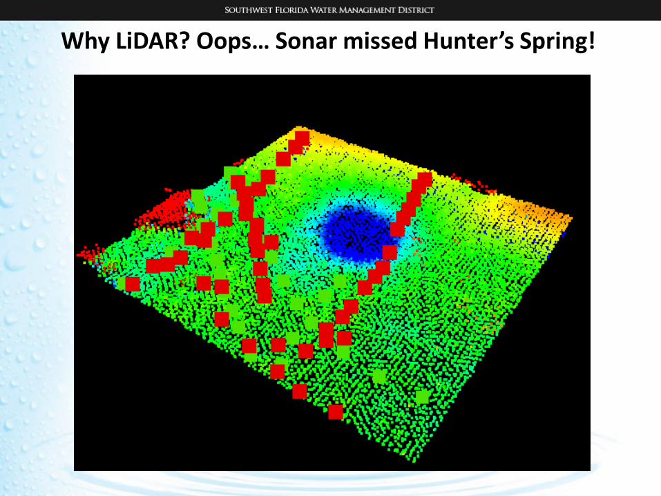
Why LiDAR? Oops… Sonar missed Hunter’s Spring!

National Park LiDAR Pilot 2016
Everglades National Park LiDAR Project

FL Everglades NP LiDAR Pilot 2016
USGS – NPS funding Partnership for lidar collection coveringEverglades National park.
USGS asked Dewberry to fly lidar for the project.
Dewberry proposed a Pilot Study.
• Lidar sensors vary in their ability to collect data over acombination of dry land, wetland and open water.
• Due to the unique nature of the Everglades landscape, wewanted to test lidar sensor technology prior to fullimplementation of lidar collection for a large area of EvergladesNP.
Elevation data resulting from lidar collection and processing will beused to support several scientific studies underway including astudy to model marl prairie habitat for the Cape Sable SeasideSparrow, an endangered non-migratory song bird residing solely inthe Everglades.
Cape Sable Seaside Sparrow

Everglades NP LiDAR Pilot 2016
Pilot Boundary
Coordination with NPS to determine a suitable footprint for the pilot project.• 33 Square Miles

Everglades NP LiDAR Pilot 2016
TWO INDEPENDENT LIDAR ACQUISITIONS WERE COMPLETED
Lidar acquired by NOAA NGS on May 5, 2016.
Riegl VQ-880-G lidar sensor
• Combined Topo-Bathymetric airborne laser scanning system
• Full waveform sensor• Narrow-beam green laser • Integrated infrared laser • Altitude = 400 m AGL

Everglades NP LiDAR Pilot 2016
TWO INDEPENDENT LIDAR ACQUISITIONS WERE COMPLETED
Lidar acquired June 15 -17, 2016.
Teledyne Optech Titan lidar sensor• Combined Topo-Bathymetric airborne laser
scanning system• Three independent channels – one for each
wavelength.• 532nm –visible (green)• 1064nm -NIR• 1550nm -IR
• Altitude 1: 400 m AGL• Altitude 2: 1000 m AGL

Pilot Acquisition and Analysis – Testing to Model Different Habitats
MAP LEGENDRED: Project Boundary
• Riegl and Titan LiDAR acquired at 400 m AGL
YELLOW: Titan high-altitude LiDAR acquired at 1000 m AGL
BLUE: Pilot project tile grid
ORANGE:
4 areas selected for detailed analysis based on the following land cover types:• Forested • Retention Pond (open water)• Slough• Tree Island

Shallow SloughSample DEMs produced from Riegl Green and IR data (top) and Titan Green and IR data (bottom) indicate the ability of the green wavelength data in the Riegl sensor to penetrate through the slough to produce submerged topography. The Titan Green data did not consistently penetrate through the water column to produce bottom returns.
Riegl Green and IR
Titan Green and IR

Shallow Slough – Profiles
Titan Green
Titan NIR
The Riegl green laser returns are consistently lower in areas that have water.
GREEN POINTS = Riegl Green YELLOW Points = Titan Green

The modelling capabilities of the two sensors did exhibit significant differences in the shallow wet areas within Sloughs and within, and adjacent to, the Tree Islands.
• The Riegl sensor was able to measure the shallow water depths (~50 cm – 1 m deep) more consistently than the Titan sensor.
• The Riegl sensor uses a short-pulse laser which enables improved depth performance in very shallow waters.
The ability to measure shallow water depths is a very important consideration for the Everglades National Park.
Pilot Project Conclusions

Pilot Project Report
Dewberry’s Pilot Project Report is available upon request.
The knowledge gained from the completion of the pilot project served to better scope the methodology to be used for the collection of LiDAR over a larger area of the Everglades National Park.

Everglades NP LiDAR Project
Pilot Project
Full Project 1211 sq. miles

Planned Flying Height• ~600 m AGL
Planned Density• IR wavelength = 6+ppsm• Green wavelength = 8+ppsm
ENP Lidar - Full Project Acquisition Plan
• Timing• Coordinate with NPS• Monitor real-time water level gages• Monitor ground conditions prior to
mobilization• Lidar Collection – March – May 2017

Beaver Islands Archipelago & South Manitou Island TopobathyLidar Survey

32 |
South Manitou Island
20 square miles
Beaver Islands Archipelago185 square miles
South Fox Island
2015

Northern Lake Michigan Topobathy Lidar
33 |
Beaver Islands Archipelago
South Manitou Island
Garden Island & Hog Island

34 |
Garden and Hog Islands
Garden Island
Hog Island

South Fox Island

36 |
South Manitou Island DEM
