readme document for a multi-sensor water vapor climate ... · updated for netcdf4 data products....
TRANSCRIPT
Goddard Earth Sciences Data and Information Services Center (GES DISC)
http://disc.gsfc.nasa.gov
NASA Goddard Space Flight Center
Code 610.2
Greenbelt, MD 20771 USA
README Document for
A Multi-Sensor Water Vapor Climate Data
Record Using Cloud Classification
Last Revised May 31, 2016
National Aeronautics and Space
Administration Goddard Earth Science Data
Information and Services Center (GES DISC)
2
Prepared By:
Gerald Manipon JPL
Name GES DISC
GSFC Code 610.2
Name
05/31/2016
Date
Reviewed By:
Reviewer Name GES DISC
GSFC Code 613.2
Date
Goddard Space Flight Center
Greenbelt, Maryland
3
Revision History
Revision Date Changes Author
2010-10-07 Added initial content. Gerald Manipon
2011-02-22 Updated for latest version of the data.
Gerald Manipon
2011-02-28 Added an explanation for the naming at the start of section 2.3, on current p. 14. Added the text and table in Sections 2.3.1 and 2.3.2.
Eric Fetzer
2011-03-01 Mapped data types to s4pa short/long names and collection versions. Clarified AMSU, AIRS, CloudSat footprints.
Gerald Manipon
2011-10-07 Updated for v3.1. Gerald Manipon
2012-03-19 Updated using the latest template. Updated for NetCDF4 data products.
Gerald Manipon
2013-06-20 Updated for v3.2 of NetCDF4 data products that now include quality flags. Updated all products with DOI metadata.
Gerald Manipon
2016-05-31 Updated for v4.0 of this software.
Gerald Manipon
4
Table of Contents
Contents
.................................................................................................................................................................. 1
1.0 Introduction ............................................................................................................................................ 6
1.1 Dataset/Mission Instrument Description............................................................................................ 6
1.2 Algorithm Background ........................................................................................................................ 8
1.3 Data Disclaimer ................................................................................................................................. 14
2.0 Data Organization ................................................................................................................................. 15
2.1 File Naming Convention .................................................................................................................... 15
2.2 File Format and Structure ................................................................................................................. 16
2.3 Key Science Data Fields ..................................................................................................................... 17
3.0 Data Contents ....................................................................................................................................... 26
3.1 Dimensions ........................................................................................................................................ 26
3.2 Global Attributes ............................................................................................................................... 27
3.3 Products/Parameters ........................................................................................................................ 28
5
4.0 Options for Reading the Data ............................................................................................................... 28
4.1 Command Line Utilities ..................................................................................................................... 28
The ncdump program can be found in bin directory of the HDF installation area. Consult your local
computer system administrator for the specifics. .................................................................................. 28
4.2 Tools/Programming .......................................................................................................................... 28
5.0 Data Services ......................................................................................................................................... 32
6.0 More Information ................................................................................................................................. 33
7.0 Acknowledgements ............................................................................................................................... 33
6
1.0 Introduction
This document provides basic information for using the WVCC (Water Vapor Cloud Climatology)
AIRS-CloudSat merged dataset.
The WVCC AIRS-CloudSat merged dataset consists of products generated for the focus on multi-
sensor water vapor climatology using cloud classification.
1.1 Dataset/Mission Instrument Description
The basic task is to bring together retrievals of water vapor and cloud properties from multiple
“A-train” instruments (AIRS & CloudSat), classify each “scene” (instrument look) using the cloud
information, and develop a merged, multi-sensor climatology of atmospheric water vapor as a
function of altitude, stratified by the cloud classes. This is a large science analysis project that
will require the use of the HySDS (Hybrid Cloud Science Data System) and SciFlo technologies to
discover and organize all of the datasets, move and cache datasets as required, find space/time
“matchups” between pairs of instruments, and scale up processing of years of satellite data to
produce the climate data records.
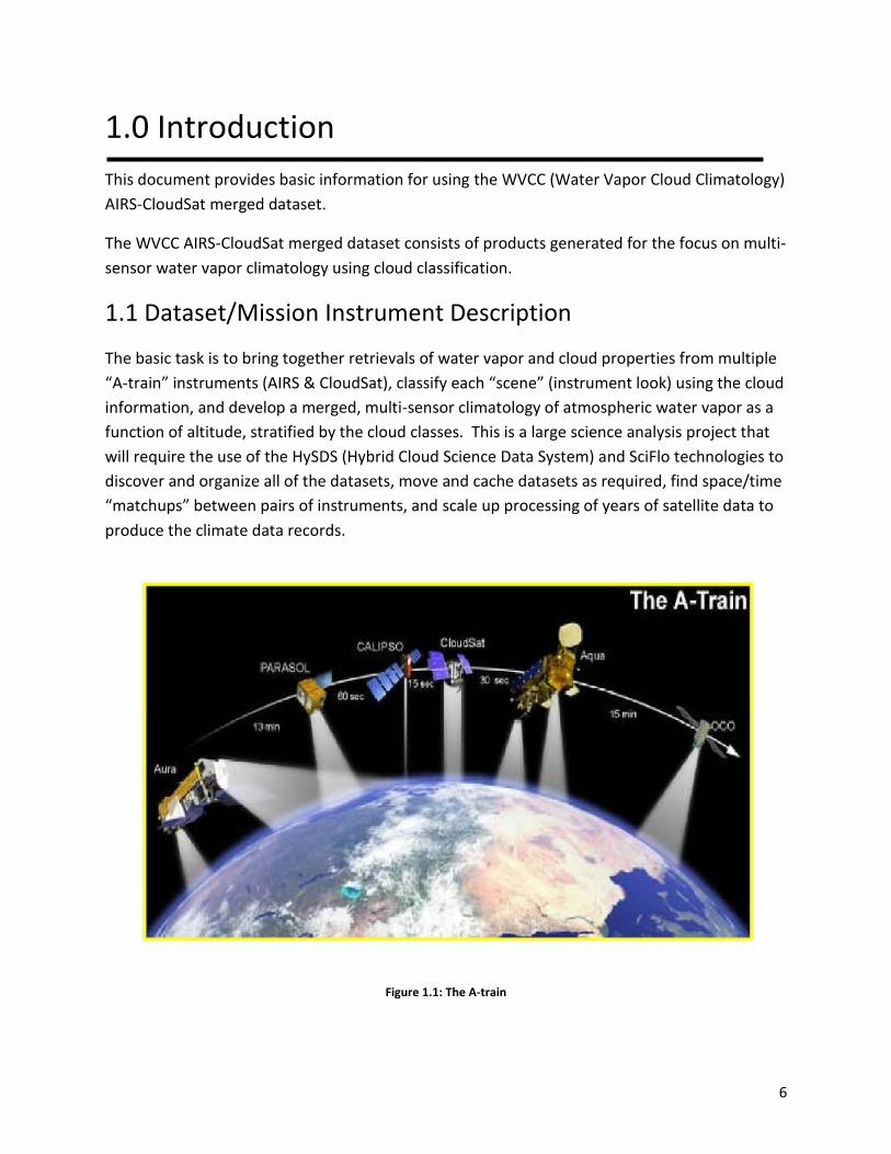
Figure 1.1: The A-train
7
1.1.1 AIRS & AMSU
AIRS is a continuously operating cross-track scanning sounder, consisting of a telescope that
feeds an echelle spectrometer. The AIRS infrared spectrometer acquires 2378 spectral samples
at resolutions, λ/Δλ, ranging from 1086 to 1570, in three bands: 3.74 m to 4.61 m, 6.20 m to
8.22 m, and 8.8 m to 15.4 m. The spatial footprint of the infrared channels is 1.1° in diameter,
which corresponds to about 15x15 km in the nadir.
AMSU-A is a 15-channel microwave temperature sounder implemented as two independently
operated modules. Module 1 (AMSU-A1) has 12 channels in the 50-58 GHz oxygen absorption
band which provide the primary temperature sounding capabilities and 1 channel at 89 GHz
which provides surface and moisture information. Module 2 (AMSU-A2) has 2 channels: one at
23.8 GHz and one at 31.4 GHz which provide surface and moisture information (total
precipitable water and cloud liquid water). Like AIRS, AMSU-A is a cross-track scanner. AMSU-
A scans three times as slowly as AIRS (once per 8 seconds), and its footprints are approximately
three times as large as those of AIRS (45 km at nadir). This results in three AIRS scans per
AMSU-A scans and nine AIRS footprints per AMSU-A footprint. Each AIRS/AMSU granule is six
minutes in length (240 per day), and contains 30x45 AMSU and 90x135 AIRS footprints
alongtrack x crosstrack.
1.1.2 CloudSat
The Cloud Profiling Radar (CPR) on CloudSat is a 94-GHz nadir-looking radar which measures the
power backscattered by clouds as a function of distance from the radar. The CloudSat data
footprint is approximately 1.7 km along-track by 1.3 km across-track. A granule is one orbit of
data beginning at the first profile on or after the equator on the descending node. There are
125 vertical bins, each one approximately 240 m thick. There are approximately 36,383 profiles
per granule.
1.1.3 SciFlo
SciFlo is a semantically-enabled ("smart") Grid Workflow system that ties together a peer-to-
peer network of computers into an efficient engine for distributed computation. The SciFlo
workflow engine enables scientists to do multi-instrument Earth Science by assembling
remotely-invokable Web Services (SOAP or http GET URLs), native executables, command-line
scripts, and Python codes into a distributed computing flow. SciFlo also deploys a variety of
Data Grid services to: query datasets in space and time, locate & retrieve on-line data granules,
and provide on-the-fly variable and spatial subsetting.
8
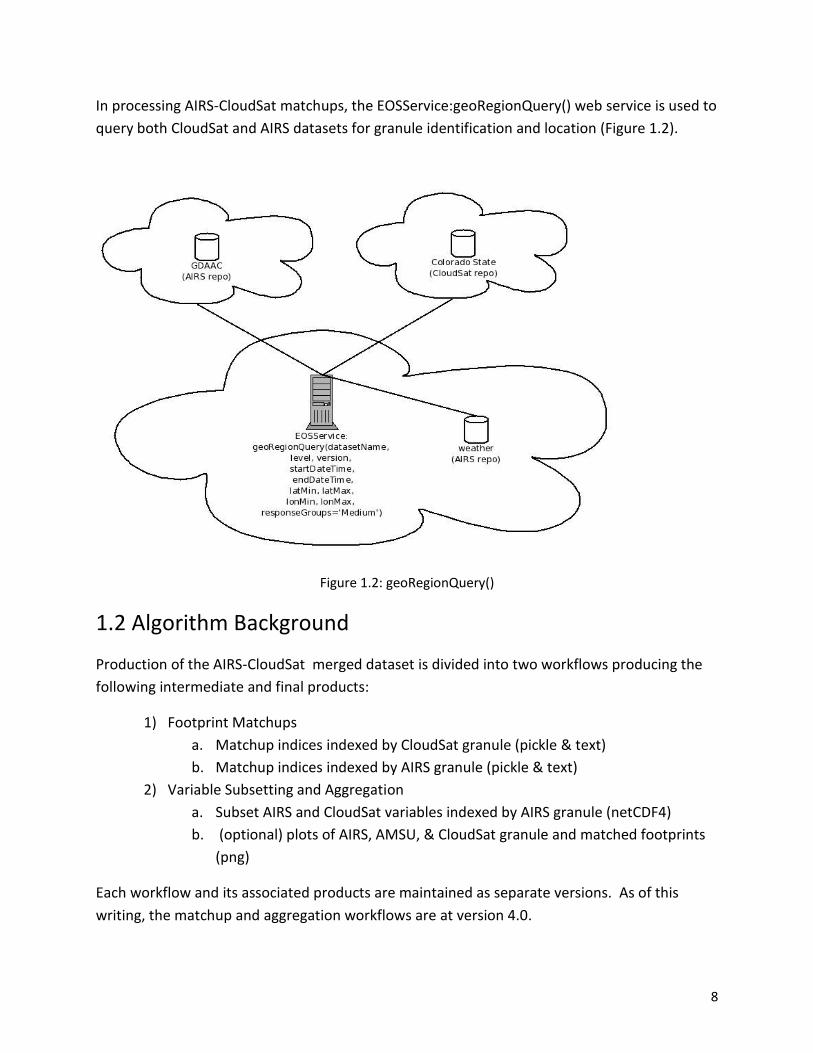
In processing AIRS-CloudSat matchups, the EOSService:geoRegionQuery() web service is used to
query both CloudSat and AIRS datasets for granule identification and location (Figure 1.2).
Figure 1.2: geoRegionQuery()
1.2 Algorithm Background
Production of the AIRS-CloudSat merged dataset is divided into two workflows producing the
following intermediate and final products:
1) Footprint Matchups
a. Matchup indices indexed by CloudSat granule (pickle & text)
b. Matchup indices indexed by AIRS granule (pickle & text)
2) Variable Subsetting and Aggregation
a. Subset AIRS and CloudSat variables indexed by AIRS granule (netCDF4)
b. (optional) plots of AIRS, AMSU, & CloudSat granule and matched footprints
(png)
Each workflow and its associated products are maintained as separate versions. As of this
writing, the matchup and aggregation workflows are at version 4.0.
9
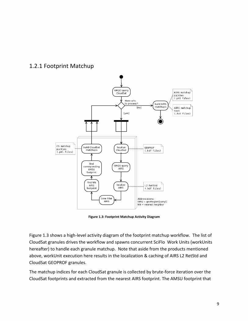
1.2.1 Footprint Matchup
Figure 1.3: Footprint Matchup Activity Diagram
Figure 1.3 shows a high-level activity diagram of the footprint matchup workflow. The list of
CloudSat granules drives the workflow and spawns concurrent SciFlo Work Units (workUnits
hereafter) to handle each granule matchup. Note that aside from the products mentioned
above, workUnit execution here results in the localization & caching of AIRS L2 RetStd and
CloudSat GEOPROF granules.
The matchup indices for each CloudSat granule is collected by brute-force iteration over the
CloudSat footprints and extracted from the nearest AIRS footprint. The AMSU footprint that
10
contains the matched AIRS footprint is also recorded. The following code snippet in Python
implements the nearest neighbor algorithm used in the matchup:
After the CloudSat-AIRS matchup indices are collected and pickled, the matchup index text files,
indexed by AIRS granules, are then generated.
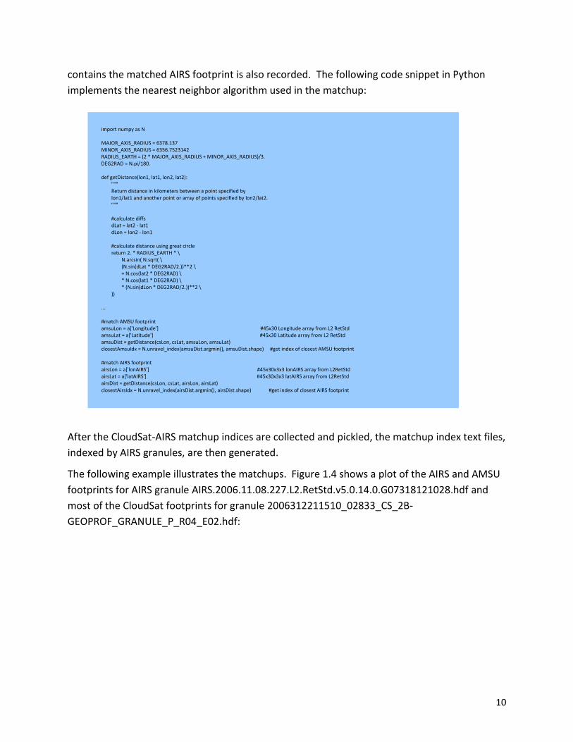
The following example illustrates the matchups. Figure 1.4 shows a plot of the AIRS and AMSU
footprints for AIRS granule AIRS.2006.11.08.227.L2.RetStd.v5.0.14.0.G07318121028.hdf and
most of the CloudSat footprints for granule 2006312211510_02833_CS_2B-
GEOPROF_GRANULE_P_R04_E02.hdf:
import numpy as N MAJOR_AXIS_RADIUS = 6378.137 MINOR_AXIS_RADIUS = 6356.7523142 RADIUS_EARTH = (2 * MAJOR_AXIS_RADIUS + MINOR_AXIS_RADIUS)/3. DEG2RAD = N.pi/180. def getDistance(lon1, lat1, lon2, lat2): """ Return distance in kilometers between a point specified by lon1/lat1 and another point or array of points specified by lon2/lat2. """ #calculate diffs dLat = lat2 - lat1 dLon = lon2 - lon1 #calculate distance using great circle return 2. * RADIUS_EARTH * \ N.arcsin( N.sqrt( \ (N.sin(dLat * DEG2RAD/2.))**2 \ + N.cos(lat2 * DEG2RAD) \ * N.cos(lat1 * DEG2RAD) \ * (N.sin(dLon * DEG2RAD/2.))**2 \ )) ... #match AMSU footprint amsuLon = a['Longitude'] #45x30 Longitude array from L2 RetStd amsuLat = a['Latitude'] #45x30 Latitude array from L2 RetStd amsuDist = getDistance(csLon, csLat, amsuLon, amsuLat) closestAmsuIdx = N.unravel_index(amsuDist.argmin(), amsuDist.shape) #get index of closest AMSU footprint #match AIRS footprint airsLon = a['lonAIRS'] #45x30x3x3 lonAIRS array from L2RetStd airsLat = a['latAIRS'] #45x30x3x3 latAIRS array from L2RetStd airsDist = getDistance(csLon, csLat, airsLon, airsLat) closestAirsIdx = N.unravel_index(airsDist.argmin(), airsDist.shape) #get index of closest AIRS footprint
11
Figure 1.4: Footprint Plot
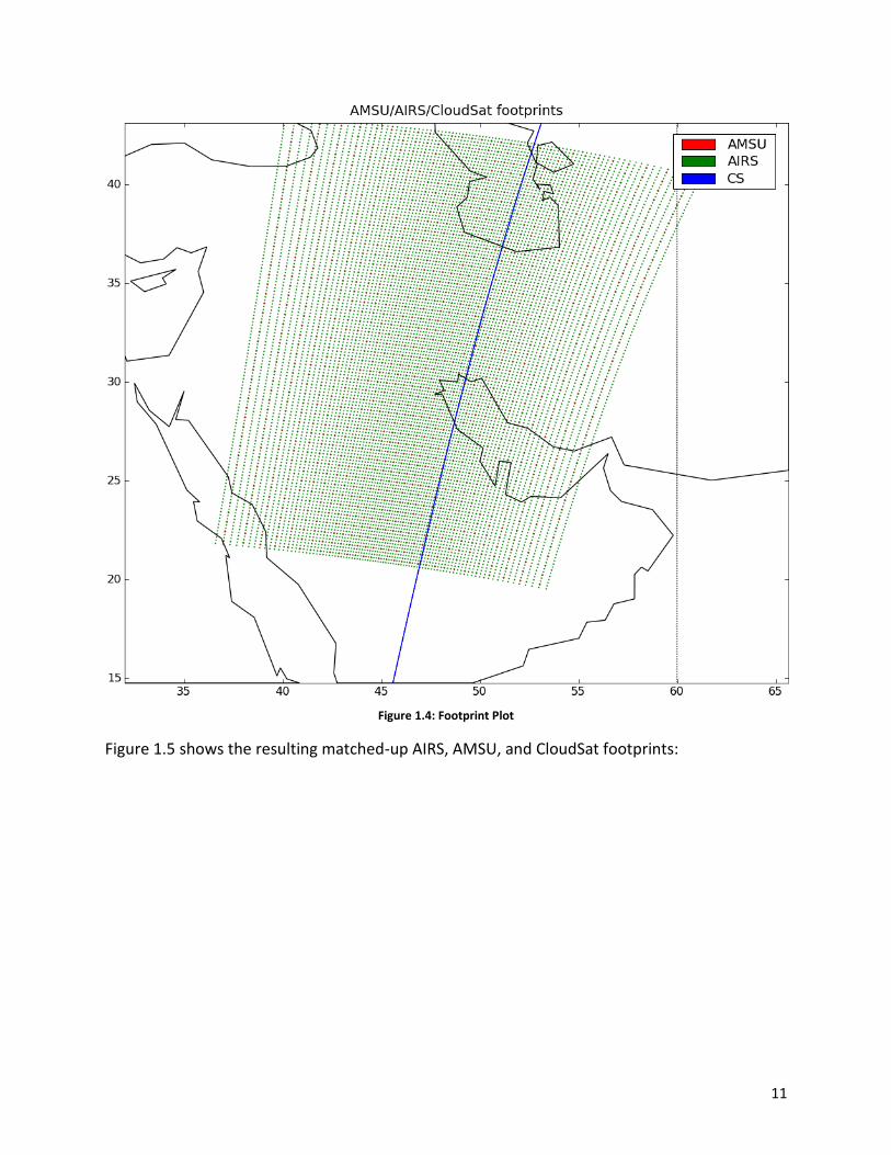
Figure 1.5 shows the resulting matched-up AIRS, AMSU, and CloudSat footprints:

12
Figure 1.5: Matched Footprints Plot
13
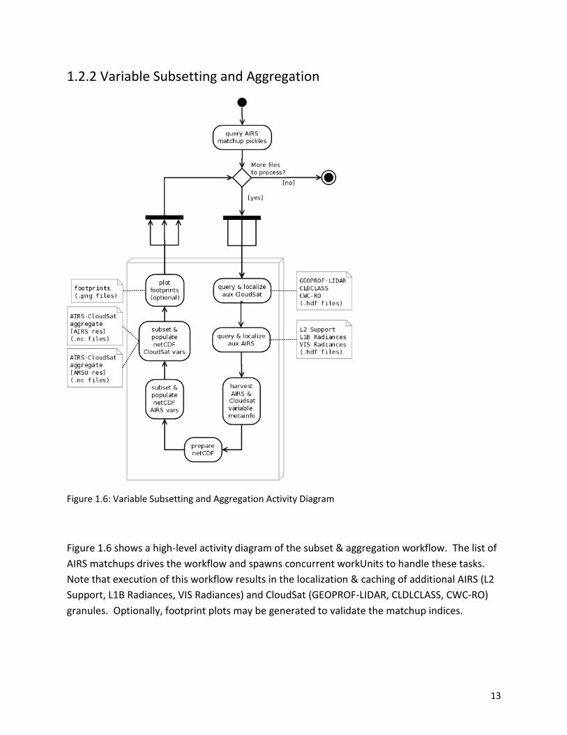
1.2.2 Variable Subsetting and Aggregation
Figure 1.6: Variable Subsetting and Aggregation Activity Diagram
Figure 1.6 shows a high-level activity diagram of the subset & aggregation workflow. The list of
AIRS matchups drives the workflow and spawns concurrent workUnits to handle these tasks.
Note that execution of this workflow results in the localization & caching of additional AIRS (L2
Support, L1B Radiances, VIS Radiances) and CloudSat (GEOPROF-LIDAR, CLDLCLASS, CWC-RO)
granules. Optionally, footprint plots may be generated to validate the matchup indices.
14
Which dataset (AIRS & CloudSat) product variables are included in the final merged product is
driven by an xml configuration file generated as a result of the WVCC variable voting application
(http://sciflo.jpl.nasa.gov/wsgi/wvc_varlister/).
1.3 Data Disclaimer
For any questions regarding this dataset, please contact Gerald Manipon at
For detailed information on the v6 AMSU/AIRS data, consult the documentation located at
http://disc.sci.gsfc.nasa.gov/AIRS/documentation.
For detailed information on the R04 CloudSat data, consult the documentation located at
http://www.cloudsat.cira.colostate.edu/dataHome.php.
For information on the directory structure and filename conventions used for the AIRS-CloudSat
matchups, consult the documentation located at
http://www.cloudsat.cira.colostate.edu/dataHome.php.
For information and access tools pertaining to NetCDF, consult the documentation at
http://www.unidata.ucar.edu/software/netcdf/.
For information on the Python programming language, consult the documentation at
http://www.python.org.

15
2.0 Data Organization
The data consists of:
1) the AIRS-CloudSat matchup index files in text and NetCDF4 formats
ShortName = AIRS_CPR_IND
LongName = AIRS-CloudSat cloud mask and radar reflectivities collocation
indexes
VersionID = 040
DOI = 10.5067/MEASURES/WVCC/DATA204
DOI_Authority = http://dx.doi.org/
2) the AIRS-CloudSat matched variables in AIRS and AMSU resolutions aggregated in
NetCDF4 files
ShortName = AIRS_CPR_MAT
LongName = AIRS-CloudSat cloud mask, radar reflectivities, and cloud
classification matchups
VersionID = 040
DOI = 10.5067/MEASURES/WVCC/DATA205
DOI_Authority = http://dx.doi.org/
All products are indexed by AIRS granules thus for each day there are 240 files per product.
2.1 File Naming Convention
2.1.1 AIRS_CPR_IND (Matchup Index Text and NetCDF4 Files)
index-airs.aqua_cloudsat-vm.m-yyyy.mm.dd.ggg.(txt|nc4)
Where:
o m.m = algorithm version identifier is made up of major version and minor version, respectively.
o yyyy = 4 digit year number [2006 - ].
o mm = 2 digit month number [01-12]
o dd = day of month [01-31]
o ggg = granule number [1-240]
Filename example: index-airs.aqua_cloudsat-v4.0-2006.06.15.167.txt, index-airs.aqua_cloudsat-
v4.0-2006.06.15.167.nc4
2.1.2 AIRS_CPR_MAT (Aggregate AIRS/AMSU/CloudSat NetCDF4 Files)
matched-airs.aqua_cloudsat-vm.m-yyyy.mm.dd.ggg_airs.nc4
16
Where:
o m.m = algorithm version identifier is made up of major version and minor version, respectively.
o yyyy = 4 digit year number [2006 - ].
o mm = 2 digit month number [01-12]
o dd = day of month [01-31]
o ggg = granule number [1-240]
Filename example: matched-airs.aqua_cloudsat-v4.0-2006.06.15.185_airs.nc4
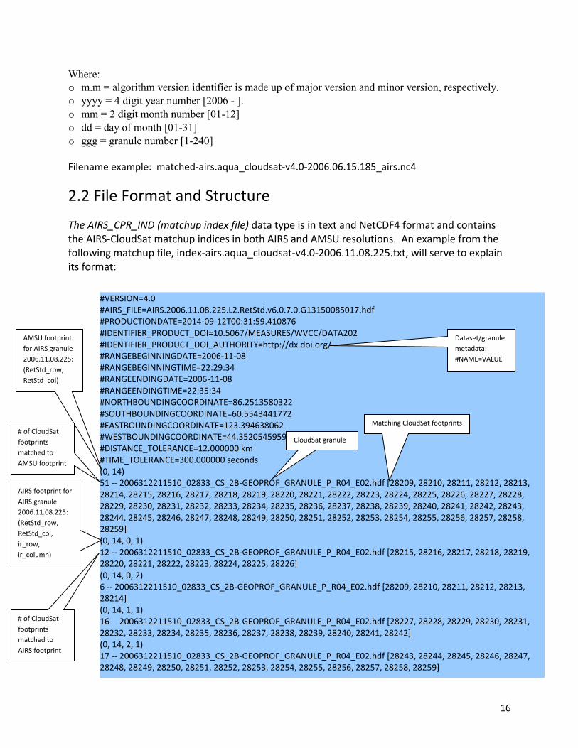
2.2 File Format and Structure
The AIRS_CPR_IND (matchup index file) data type is in text and NetCDF4 format and contains the AIRS-CloudSat matchup indices in both AIRS and AMSU resolutions. An example from the following matchup file, index-airs.aqua_cloudsat-v4.0-2006.11.08.225.txt, will serve to explain its format:
#VERSION=4.0 #AIRS_FILE=AIRS.2006.11.08.225.L2.RetStd.v6.0.7.0.G13150085017.hdf #PRODUCTIONDATE=2014-09-12T00:31:59.410876 #IDENTIFIER_PRODUCT_DOI=10.5067/MEASURES/WVCC/DATA202 #IDENTIFIER_PRODUCT_DOI_AUTHORITY=http://dx.doi.org/ #RANGEBEGINNINGDATE=2006-11-08 #RANGEBEGINNINGTIME=22:29:34 #RANGEENDINGDATE=2006-11-08 #RANGEENDINGTIME=22:35:34 #NORTHBOUNDINGCOORDINATE=86.2513580322 #SOUTHBOUNDINGCOORDINATE=60.5543441772 #EASTBOUNDINGCOORDINATE=123.394638062 #WESTBOUNDINGCOORDINATE=44.3520545959 #DISTANCE_TOLERANCE=12.000000 km #TIME_TOLERANCE=300.000000 seconds (0, 14) 51 -- 2006312211510_02833_CS_2B-GEOPROF_GRANULE_P_R04_E02.hdf [28209, 28210, 28211, 28212, 28213, 28214, 28215, 28216, 28217, 28218, 28219, 28220, 28221, 28222, 28223, 28224, 28225, 28226, 28227, 28228, 28229, 28230, 28231, 28232, 28233, 28234, 28235, 28236, 28237, 28238, 28239, 28240, 28241, 28242, 28243, 28244, 28245, 28246, 28247, 28248, 28249, 28250, 28251, 28252, 28253, 28254, 28255, 28256, 28257, 28258, 28259] (0, 14, 0, 1) 12 -- 2006312211510_02833_CS_2B-GEOPROF_GRANULE_P_R04_E02.hdf [28215, 28216, 28217, 28218, 28219, 28220, 28221, 28222, 28223, 28224, 28225, 28226] (0, 14, 0, 2) 6 -- 2006312211510_02833_CS_2B-GEOPROF_GRANULE_P_R04_E02.hdf [28209, 28210, 28211, 28212, 28213, 28214] (0, 14, 1, 1) 16 -- 2006312211510_02833_CS_2B-GEOPROF_GRANULE_P_R04_E02.hdf [28227, 28228, 28229, 28230, 28231, 28232, 28233, 28234, 28235, 28236, 28237, 28238, 28239, 28240, 28241, 28242] (0, 14, 2, 1) 17 -- 2006312211510_02833_CS_2B-GEOPROF_GRANULE_P_R04_E02.hdf [28243, 28244, 28245, 28246, 28247, 28248, 28249, 28250, 28251, 28252, 28253, 28254, 28255, 28256, 28257, 28258, 28259]
AMSU footprint
for AIRS granule
2006.11.08.225:
(RetStd_row,
RetStd_col)
# of CloudSat
footprints
matched to
AMSU footprint
CloudSat granule
Matching CloudSat footprints
AIRS footprint for
AIRS granule
2006.11.08.225:
(RetStd_row,
RetStd_col,
ir_row,
ir_column)
# of CloudSat
footprints
matched to
AIRS footprint
Dataset/granule
metadata:
#NAME=VALUE
17
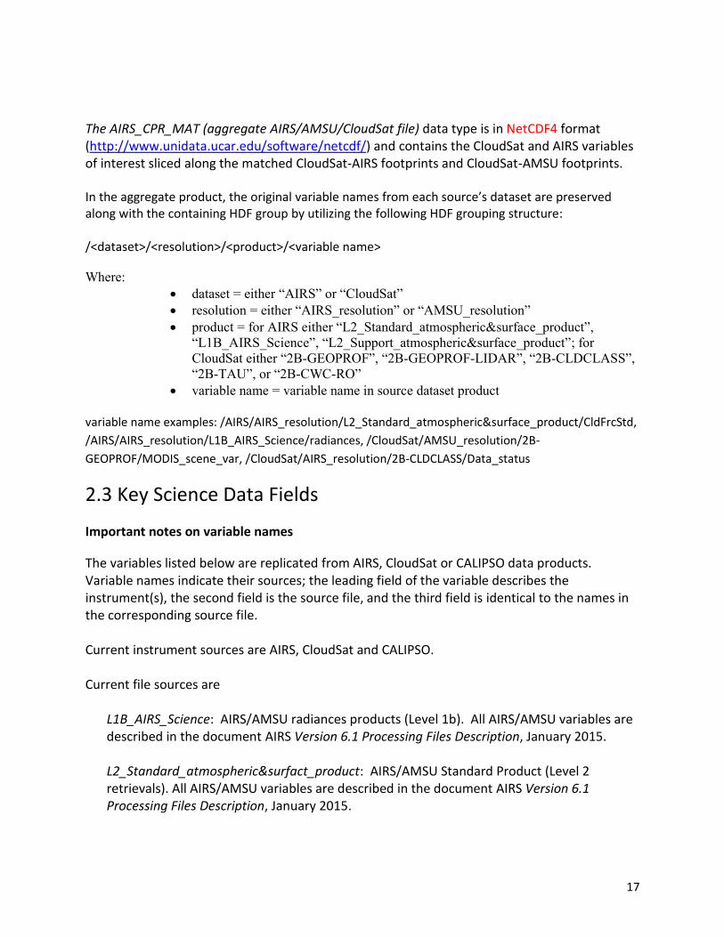
The AIRS_CPR_MAT (aggregate AIRS/AMSU/CloudSat file) data type is in NetCDF4 format (http://www.unidata.ucar.edu/software/netcdf/) and contains the CloudSat and AIRS variables of interest sliced along the matched CloudSat-AIRS footprints and CloudSat-AMSU footprints. In the aggregate product, the original variable names from each source’s dataset are preserved along with the containing HDF group by utilizing the following HDF grouping structure: /<dataset>/<resolution>/<product>/<variable name>
Where:
dataset = either “AIRS” or “CloudSat”
resolution = either “AIRS_resolution” or “AMSU_resolution”
product = for AIRS either “L2_Standard_atmospheric&surface_product”,
“L1B_AIRS_Science”, “L2_Support_atmospheric&surface_product”; for
CloudSat either “2B-GEOPROF”, “2B-GEOPROF-LIDAR”, “2B-CLDCLASS”,
“2B-TAU”, or “2B-CWC-RO”
variable name = variable name in source dataset product
variable name examples: /AIRS/AIRS_resolution/L2_Standard_atmospheric&surface_product/CldFrcStd,
/AIRS/AIRS_resolution/L1B_AIRS_Science/radiances, /CloudSat/AMSU_resolution/2B-
GEOPROF/MODIS_scene_var, /CloudSat/AIRS_resolution/2B-CLDCLASS/Data_status
2.3 Key Science Data Fields
Important notes on variable names
The variables listed below are replicated from AIRS, CloudSat or CALIPSO data products. Variable names indicate their sources; the leading field of the variable describes the instrument(s), the second field is the source file, and the third field is identical to the names in the corresponding source file. Current instrument sources are AIRS, CloudSat and CALIPSO. Current file sources are
L1B_AIRS_Science: AIRS/AMSU radiances products (Level 1b). All AIRS/AMSU variables are described in the document AIRS Version 6.1 Processing Files Description, January 2015. L2_Standard_atmospheric&surfact_product: AIRS/AMSU Standard Product (Level 2 retrievals). All AIRS/AMSU variables are described in the document AIRS Version 6.1 Processing Files Description, January 2015.

18
L2_Support_atmospheric&surface_product: AIRS/AMSU Support Products (L2). All AIRS/AMSU variables are described in the document AIRS Version 6.1 Processing Files Description, January 2015. 2B-GEOPROF: CloudSat radar geolocation information. See CloudSat Standard Data
Products Handbook, May 18, 2006.
2B-GEOPROF-LIDAR: CALIPSO lidar geolocation information. See CloudSat Standard Data Products Handbook, May 18, 2006. 2B-CLDCLASS: CloudSat cloud classes. See Level 2 Cloud Scenario Classification Product
Process Description and Interface Control Document, Version: 4.0, March 1, 2005.
Example: variable /AIRS/AIRS_resolution/L1B_AIRS_Science/Latitude
Source instruments: AIRS (designates the AIRS/AMSU instrument suite). AIRS or AMSU resolution: designates the AIRS/AMSU variable resolution. L2_Standard_atmospheric&surface_product: File source is AIRS/AMSU Standard Product (Level 2 retrievals). Latitude: latitudes of AIRS spectral within an AMSU FOV (dimensioned 3 X 3).
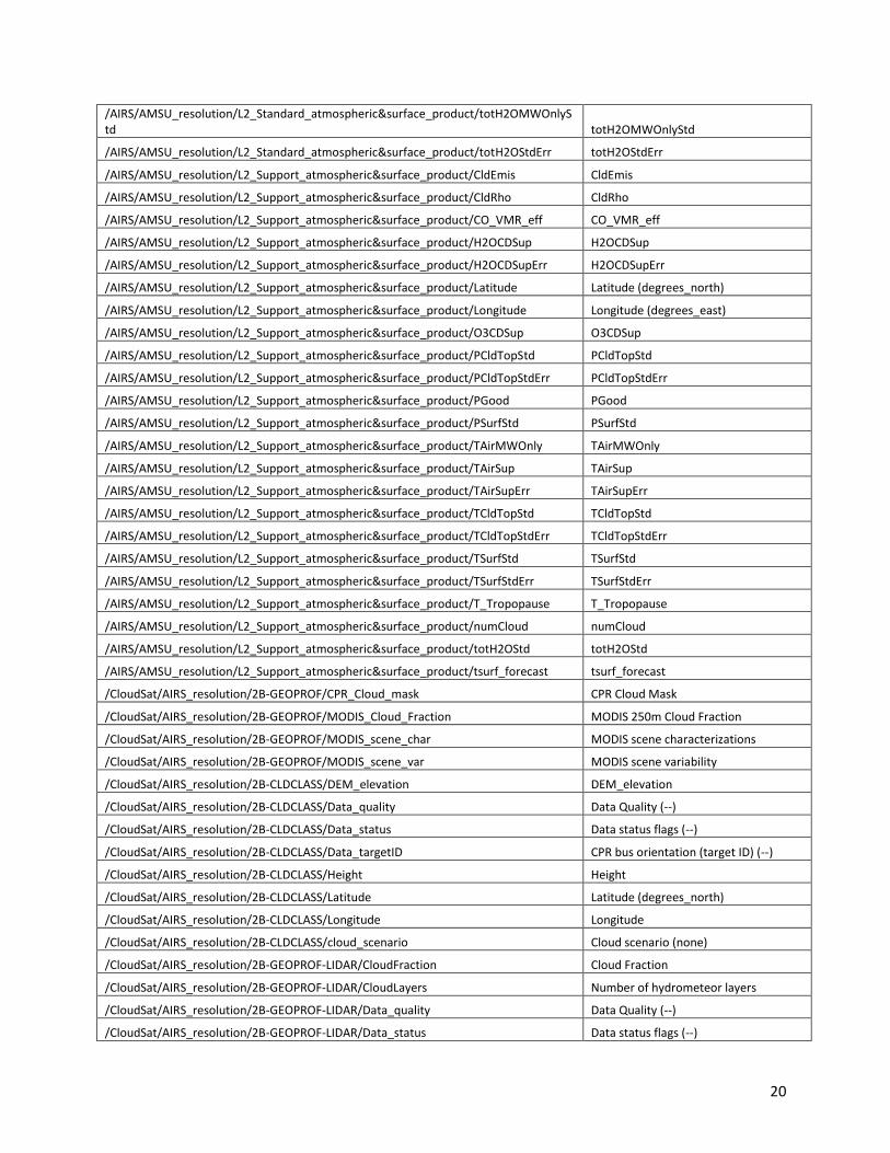
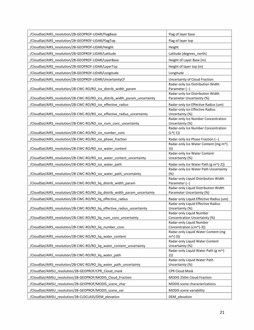
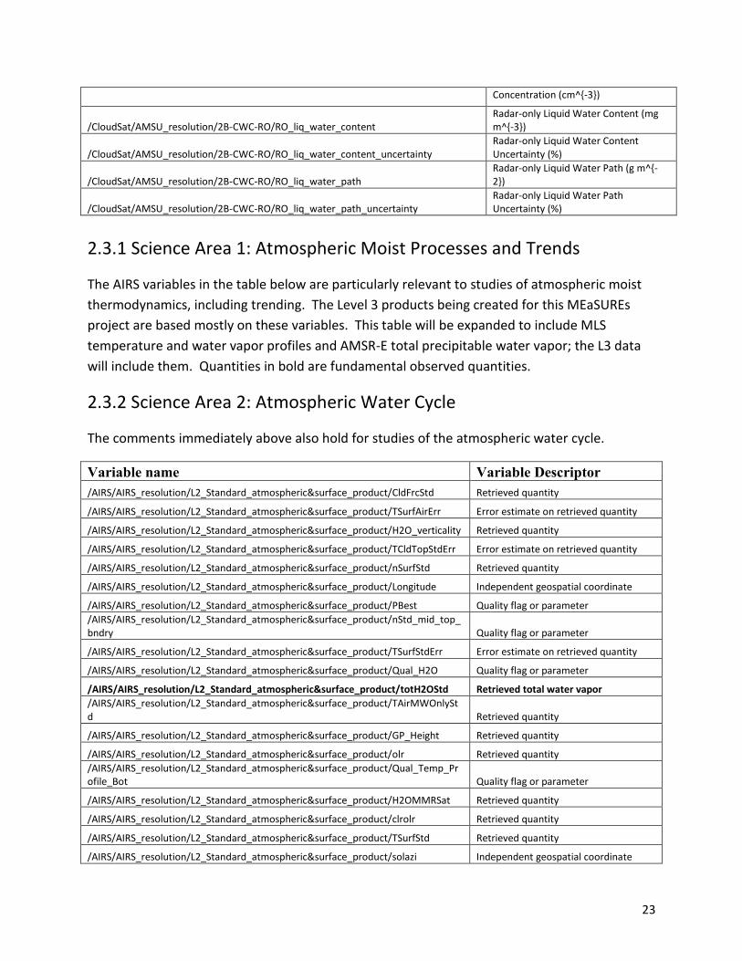
The following table lists the variables in the AIRS_CPR_MAT (aggregate AIRS/AMSU/CloudSat file) data type:
Variable name Long name (units)
/AIRS/spectral_freq spectral_freq
/AIRS/glintlat glintlat
/AIRS/glintlon glintlon
/AIRS/pressH2O pressH2O
/AIRS/pressStd pressStd
/AIRS/sat_lat sat_lat
/AIRS/sat_lon sat_lon
/AIRS/pressSupp pressSupp
/AIRS/AIRS_resolution/L2_Standard_atmospheric&surface_product/CldFrcStd
Comment: This is a retrieved quantity, but reported at the same locations as the AIRS spectra. All other AIRS/AMSU retrieved quantities are reported at the AMSU resolution (see next table).
/AIRS/AIRS_resolution/L2_Standard_atmospheric&surface_product/CldFrcStdErr CldFrcStdErr
/AIRS/AIRS_resolution/L2_Support_atmospheric&surface_product/pseudo_lapse_rate pseudo_lapse_rate
/AIRS/AIRS_resolution/L1B_AIRS_Science/Latitude Latitude
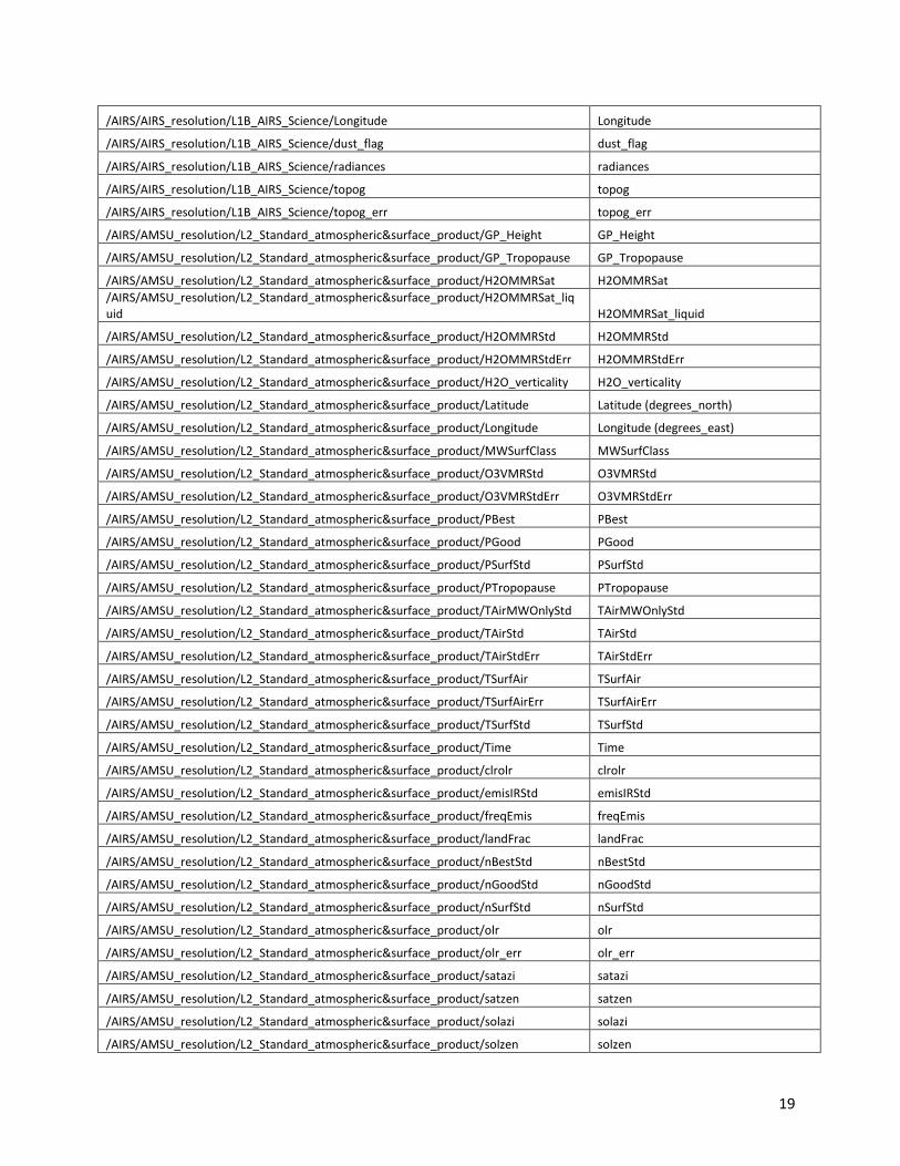
19
/AIRS/AIRS_resolution/L1B_AIRS_Science/Longitude Longitude
/AIRS/AIRS_resolution/L1B_AIRS_Science/dust_flag dust_flag
/AIRS/AIRS_resolution/L1B_AIRS_Science/radiances radiances
/AIRS/AIRS_resolution/L1B_AIRS_Science/topog topog
/AIRS/AIRS_resolution/L1B_AIRS_Science/topog_err topog_err
/AIRS/AMSU_resolution/L2_Standard_atmospheric&surface_product/GP_Height GP_Height
/AIRS/AMSU_resolution/L2_Standard_atmospheric&surface_product/GP_Tropopause GP_Tropopause
/AIRS/AMSU_resolution/L2_Standard_atmospheric&surface_product/H2OMMRSat H2OMMRSat
/AIRS/AMSU_resolution/L2_Standard_atmospheric&surface_product/H2OMMRSat_liquid H2OMMRSat_liquid
/AIRS/AMSU_resolution/L2_Standard_atmospheric&surface_product/H2OMMRStd H2OMMRStd
/AIRS/AMSU_resolution/L2_Standard_atmospheric&surface_product/H2OMMRStdErr H2OMMRStdErr
/AIRS/AMSU_resolution/L2_Standard_atmospheric&surface_product/H2O_verticality H2O_verticality
/AIRS/AMSU_resolution/L2_Standard_atmospheric&surface_product/Latitude Latitude (degrees_north)
/AIRS/AMSU_resolution/L2_Standard_atmospheric&surface_product/Longitude Longitude (degrees_east)
/AIRS/AMSU_resolution/L2_Standard_atmospheric&surface_product/MWSurfClass MWSurfClass
/AIRS/AMSU_resolution/L2_Standard_atmospheric&surface_product/O3VMRStd O3VMRStd
/AIRS/AMSU_resolution/L2_Standard_atmospheric&surface_product/O3VMRStdErr O3VMRStdErr
/AIRS/AMSU_resolution/L2_Standard_atmospheric&surface_product/PBest PBest
/AIRS/AMSU_resolution/L2_Standard_atmospheric&surface_product/PGood PGood
/AIRS/AMSU_resolution/L2_Standard_atmospheric&surface_product/PSurfStd PSurfStd
/AIRS/AMSU_resolution/L2_Standard_atmospheric&surface_product/PTropopause PTropopause
/AIRS/AMSU_resolution/L2_Standard_atmospheric&surface_product/TAirMWOnlyStd TAirMWOnlyStd
/AIRS/AMSU_resolution/L2_Standard_atmospheric&surface_product/TAirStd TAirStd
/AIRS/AMSU_resolution/L2_Standard_atmospheric&surface_product/TAirStdErr TAirStdErr
/AIRS/AMSU_resolution/L2_Standard_atmospheric&surface_product/TSurfAir TSurfAir
/AIRS/AMSU_resolution/L2_Standard_atmospheric&surface_product/TSurfAirErr TSurfAirErr
/AIRS/AMSU_resolution/L2_Standard_atmospheric&surface_product/TSurfStd TSurfStd
/AIRS/AMSU_resolution/L2_Standard_atmospheric&surface_product/Time Time
/AIRS/AMSU_resolution/L2_Standard_atmospheric&surface_product/clrolr clrolr
/AIRS/AMSU_resolution/L2_Standard_atmospheric&surface_product/emisIRStd emisIRStd
/AIRS/AMSU_resolution/L2_Standard_atmospheric&surface_product/freqEmis freqEmis
/AIRS/AMSU_resolution/L2_Standard_atmospheric&surface_product/landFrac landFrac
/AIRS/AMSU_resolution/L2_Standard_atmospheric&surface_product/nBestStd nBestStd
/AIRS/AMSU_resolution/L2_Standard_atmospheric&surface_product/nGoodStd nGoodStd
/AIRS/AMSU_resolution/L2_Standard_atmospheric&surface_product/nSurfStd nSurfStd
/AIRS/AMSU_resolution/L2_Standard_atmospheric&surface_product/olr olr
/AIRS/AMSU_resolution/L2_Standard_atmospheric&surface_product/olr_err olr_err
/AIRS/AMSU_resolution/L2_Standard_atmospheric&surface_product/satazi satazi
/AIRS/AMSU_resolution/L2_Standard_atmospheric&surface_product/satzen satzen
/AIRS/AMSU_resolution/L2_Standard_atmospheric&surface_product/solazi solazi
/AIRS/AMSU_resolution/L2_Standard_atmospheric&surface_product/solzen solzen
20
/AIRS/AMSU_resolution/L2_Standard_atmospheric&surface_product/totH2OMWOnlyStd totH2OMWOnlyStd
/AIRS/AMSU_resolution/L2_Standard_atmospheric&surface_product/totH2OStdErr totH2OStdErr
/AIRS/AMSU_resolution/L2_Support_atmospheric&surface_product/CldEmis CldEmis
/AIRS/AMSU_resolution/L2_Support_atmospheric&surface_product/CldRho CldRho
/AIRS/AMSU_resolution/L2_Support_atmospheric&surface_product/CO_VMR_eff CO_VMR_eff
/AIRS/AMSU_resolution/L2_Support_atmospheric&surface_product/H2OCDSup H2OCDSup
/AIRS/AMSU_resolution/L2_Support_atmospheric&surface_product/H2OCDSupErr H2OCDSupErr
/AIRS/AMSU_resolution/L2_Support_atmospheric&surface_product/Latitude Latitude (degrees_north)
/AIRS/AMSU_resolution/L2_Support_atmospheric&surface_product/Longitude Longitude (degrees_east)
/AIRS/AMSU_resolution/L2_Support_atmospheric&surface_product/O3CDSup O3CDSup
/AIRS/AMSU_resolution/L2_Support_atmospheric&surface_product/PCldTopStd PCldTopStd
/AIRS/AMSU_resolution/L2_Support_atmospheric&surface_product/PCldTopStdErr PCldTopStdErr
/AIRS/AMSU_resolution/L2_Support_atmospheric&surface_product/PGood PGood
/AIRS/AMSU_resolution/L2_Support_atmospheric&surface_product/PSurfStd PSurfStd
/AIRS/AMSU_resolution/L2_Support_atmospheric&surface_product/TAirMWOnly TAirMWOnly
/AIRS/AMSU_resolution/L2_Support_atmospheric&surface_product/TAirSup TAirSup
/AIRS/AMSU_resolution/L2_Support_atmospheric&surface_product/TAirSupErr TAirSupErr
/AIRS/AMSU_resolution/L2_Support_atmospheric&surface_product/TCldTopStd TCldTopStd
/AIRS/AMSU_resolution/L2_Support_atmospheric&surface_product/TCldTopStdErr TCldTopStdErr
/AIRS/AMSU_resolution/L2_Support_atmospheric&surface_product/TSurfStd TSurfStd
/AIRS/AMSU_resolution/L2_Support_atmospheric&surface_product/TSurfStdErr TSurfStdErr
/AIRS/AMSU_resolution/L2_Support_atmospheric&surface_product/T_Tropopause T_Tropopause
/AIRS/AMSU_resolution/L2_Support_atmospheric&surface_product/numCloud numCloud
/AIRS/AMSU_resolution/L2_Support_atmospheric&surface_product/totH2OStd totH2OStd
/AIRS/AMSU_resolution/L2_Support_atmospheric&surface_product/tsurf_forecast tsurf_forecast
/CloudSat/AIRS_resolution/2B-GEOPROF/CPR_Cloud_mask CPR Cloud Mask
/CloudSat/AIRS_resolution/2B-GEOPROF/MODIS_Cloud_Fraction MODIS 250m Cloud Fraction
/CloudSat/AIRS_resolution/2B-GEOPROF/MODIS_scene_char MODIS scene characterizations
/CloudSat/AIRS_resolution/2B-GEOPROF/MODIS_scene_var MODIS scene variability
/CloudSat/AIRS_resolution/2B-CLDCLASS/DEM_elevation DEM_elevation
/CloudSat/AIRS_resolution/2B-CLDCLASS/Data_quality Data Quality (--)
/CloudSat/AIRS_resolution/2B-CLDCLASS/Data_status Data status flags (--)
/CloudSat/AIRS_resolution/2B-CLDCLASS/Data_targetID CPR bus orientation (target ID) (--)
/CloudSat/AIRS_resolution/2B-CLDCLASS/Height Height
/CloudSat/AIRS_resolution/2B-CLDCLASS/Latitude Latitude (degrees_north)
/CloudSat/AIRS_resolution/2B-CLDCLASS/Longitude Longitude
/CloudSat/AIRS_resolution/2B-CLDCLASS/cloud_scenario Cloud scenario (none)
/CloudSat/AIRS_resolution/2B-GEOPROF-LIDAR/CloudFraction Cloud Fraction
/CloudSat/AIRS_resolution/2B-GEOPROF-LIDAR/CloudLayers Number of hydrometeor layers
/CloudSat/AIRS_resolution/2B-GEOPROF-LIDAR/Data_quality Data Quality (--)
/CloudSat/AIRS_resolution/2B-GEOPROF-LIDAR/Data_status Data status flags (--)
21
/CloudSat/AIRS_resolution/2B-GEOPROF-LIDAR/FlagBase Flag of layer base
/CloudSat/AIRS_resolution/2B-GEOPROF-LIDAR/FlagTop Flag of layer top
/CloudSat/AIRS_resolution/2B-GEOPROF-LIDAR/Height Height
/CloudSat/AIRS_resolution/2B-GEOPROF-LIDAR/Latitude Latitude (degrees_north)
/CloudSat/AIRS_resolution/2B-GEOPROF-LIDAR/LayerBase Height of Layer Base (m)
/CloudSat/AIRS_resolution/2B-GEOPROF-LIDAR/LayerTop Height of layer top (m)
/CloudSat/AIRS_resolution/2B-GEOPROF-LIDAR/Longitude Longitude
/CloudSat/AIRS_resolution/2B-GEOPROF-LIDAR/UncertaintyCF Uncertainty of Cloud Fraction
/CloudSat/AIRS_resolution/2B-CWC-RO/RO_ice_distrib_width_param Radar-only Ice Distribution Width Parameter (--)
/CloudSat/AIRS_resolution/2B-CWC-RO/RO_ice_distrib_width_param_uncertainty Radar-only Ice Distribution Width Parameter Uncertainty (%)
/CloudSat/AIRS_resolution/2B-CWC-RO/RO_ice_effective_radius Radar-only Ice Effective Radius (um)
/CloudSat/AIRS_resolution/2B-CWC-RO/RO_ice_effective_radius_uncertainty Radar-only Ice Effective Radius Uncertainty (%)
/CloudSat/AIRS_resolution/2B-CWC-RO/RO_ice_num_conc_uncertainty Radar-only Ice Number Concentration Uncertainty (%)
/CloudSat/AIRS_resolution/2B-CWC-RO/RO_ice_number_conc Radar-only Ice Number Concentration (L^{-1})
/CloudSat/AIRS_resolution/2B-CWC-RO/RO_ice_phase_fraction Radar-only Ice Phase Fraction (--)
/CloudSat/AIRS_resolution/2B-CWC-RO/RO_ice_water_content Radar-only Ice Water Content (mg m^{-3})
/CloudSat/AIRS_resolution/2B-CWC-RO/RO_ice_water_content_uncertainty Radar-only Ice Water Content Uncertainty (%)
/CloudSat/AIRS_resolution/2B-CWC-RO/RO_ice_water_path Radar-only Ice Water Path (g m^{-2})
/CloudSat/AIRS_resolution/2B-CWC-RO/RO_ice_water_path_uncertainty Radar-only Ice Water Path Uncertainty (%)
/CloudSat/AIRS_resolution/2B-CWC-RO/RO_liq_distrib_width_param Radar-only Liquid Distribution Width Parameter (--)
/CloudSat/AIRS_resolution/2B-CWC-RO/RO_liq_distrib_width_param_uncertainty Radar-only Liquid Distribution Width Parameter Uncertainty (%)
/CloudSat/AIRS_resolution/2B-CWC-RO/RO_liq_effective_radius Radar-only Liquid Effective Radius (um)
/CloudSat/AIRS_resolution/2B-CWC-RO/RO_liq_effective_radius_uncertainty Radar-only Liquid Effective Radius Uncertainty (%)
/CloudSat/AIRS_resolution/2B-CWC-RO/RO_liq_num_conc_uncertainty Radar-only Liquid Number Concentration Uncertainty (%)
/CloudSat/AIRS_resolution/2B-CWC-RO/RO_liq_number_conc Radar-only Liquid Number Concentration (cm^{-3})
/CloudSat/AIRS_resolution/2B-CWC-RO/RO_liq_water_content Radar-only Liquid Water Content (mg m^{-3})
/CloudSat/AIRS_resolution/2B-CWC-RO/RO_liq_water_content_uncertainty Radar-only Liquid Water Content Uncertainty (%)
/CloudSat/AIRS_resolution/2B-CWC-RO/RO_liq_water_path Radar-only Liquid Water Path (g m^{-2})
/CloudSat/AIRS_resolution/2B-CWC-RO/RO_liq_water_path_uncertainty Radar-only Liquid Water Path Uncertainty (%)
/CloudSat/AMSU_resolution/2B-GEOPROF/CPR_Cloud_mask CPR Cloud Mask
/CloudSat/AMSU_resolution/2B-GEOPROF/MODIS_Cloud_Fraction MODIS 250m Cloud Fraction
/CloudSat/AMSU_resolution/2B-GEOPROF/MODIS_scene_char MODIS scene characterizations
/CloudSat/AMSU_resolution/2B-GEOPROF/MODIS_scene_var MODIS scene variability
/CloudSat/AMSU_resolution/2B-CLDCLASS/DEM_elevation DEM_elevation
22
/CloudSat/AMSU_resolution/2B-CLDCLASS/Data_quality Data Quality (--)
/CloudSat/AMSU_resolution/2B-CLDCLASS/Data_status Data status flags (--)
/CloudSat/AMSU_resolution/2B-CLDCLASS/Data_targetID CPR bus orientation (target ID) (--)
/CloudSat/AMSU_resolution/2B-CLDCLASS/Height Height
/CloudSat/AMSU_resolution/2B-CLDCLASS/Latitude Latitude (degrees_north)
/CloudSat/AMSU_resolution/2B-CLDCLASS/Longitude Longitude
/CloudSat/AMSU_resolution/2B-CLDCLASS/cloud_scenario Cloud scenario (none)
/CloudSat/AMSU_resolution/2B-GEOPROF-LIDAR/CloudFraction Cloud Fraction
/CloudSat/AMSU_resolution/2B-GEOPROF-LIDAR/CloudLayers Number of hydrometeor layers
/CloudSat/AMSU_resolution/2B-GEOPROF-LIDAR/Data_quality Data Quality (--)
/CloudSat/AMSU_resolution/2B-GEOPROF-LIDAR/Data_status Data status flags (--)
/CloudSat/AMSU_resolution/2B-GEOPROF-LIDAR/FlagBase Flag of layer base
/CloudSat/AMSU_resolution/2B-GEOPROF-LIDAR/FlagTop Flag of layer top
/CloudSat/AMSU_resolution/2B-GEOPROF-LIDAR/Height Height
/CloudSat/AMSU_resolution/2B-GEOPROF-LIDAR/Latitude Latitude (degrees_north)
/CloudSat/AMSU_resolution/2B-GEOPROF-LIDAR/LayerBase Height of Layer Base (m)
/CloudSat/AMSU_resolution/2B-GEOPROF-LIDAR/LayerTop Height of layer top (m)
/CloudSat/AMSU_resolution/2B-GEOPROF-LIDAR/Longitude Longitude
/CloudSat/AMSU_resolution/2B-GEOPROF-LIDAR/UncertaintyCF Uncertainty of Cloud Fraction
/CloudSat/AMSU_resolution/2B-CWC-RO/RO_ice_distrib_width_param Radar-only Ice Distribution Width Parameter (--)
/CloudSat/AMSU_resolution/2B-CWC-RO/RO_ice_distrib_width_param_uncertainty Radar-only Ice Distribution Width Parameter Uncertainty (%)
/CloudSat/AMSU_resolution/2B-CWC-RO/RO_ice_effective_radius Radar-only Ice Effective Radius (um)
/CloudSat/AMSU_resolution/2B-CWC-RO/RO_ice_effective_radius_uncertainty Radar-only Ice Effective Radius Uncertainty (%)
/CloudSat/AMSU_resolution/2B-CWC-RO/RO_ice_num_conc_uncertainty Radar-only Ice Number Concentration Uncertainty (%)
/CloudSat/AMSU_resolution/2B-CWC-RO/RO_ice_number_conc Radar-only Ice Number Concentration (L^{-1})
/CloudSat/AMSU_resolution/2B-CWC-RO/RO_ice_phase_fraction Radar-only Ice Phase Fraction (--)
/CloudSat/AMSU_resolution/2B-CWC-RO/RO_ice_water_content Radar-only Ice Water Content (mg m^{-3})
/CloudSat/AMSU_resolution/2B-CWC-RO/RO_ice_water_content_uncertainty Radar-only Ice Water Content Uncertainty (%)
/CloudSat/AMSU_resolution/2B-CWC-RO/RO_ice_water_path Radar-only Ice Water Path (g m^{-2})
/CloudSat/AMSU_resolution/2B-CWC-RO/RO_ice_water_path_uncertainty Radar-only Ice Water Path Uncertainty (%)
/CloudSat/AMSU_resolution/2B-CWC-RO/RO_liq_distrib_width_param Radar-only Liquid Distribution Width Parameter (--)
/CloudSat/AMSU_resolution/2B-CWC-RO/RO_liq_distrib_width_param_uncertainty Radar-only Liquid Distribution Width Parameter Uncertainty (%)
/CloudSat/AMSU_resolution/2B-CWC-RO/RO_liq_effective_radius Radar-only Liquid Effective Radius (um)
/CloudSat/AMSU_resolution/2B-CWC-RO/RO_liq_effective_radius_uncertainty Radar-only Liquid Effective Radius Uncertainty (%)
/CloudSat/AMSU_resolution/2B-CWC-RO/RO_liq_num_conc_uncertainty Radar-only Liquid Number Concentration Uncertainty (%)
/CloudSat/AMSU_resolution/2B-CWC-RO/RO_liq_number_conc Radar-only Liquid Number
23
Concentration (cm^{-3})
/CloudSat/AMSU_resolution/2B-CWC-RO/RO_liq_water_content Radar-only Liquid Water Content (mg m^{-3})
/CloudSat/AMSU_resolution/2B-CWC-RO/RO_liq_water_content_uncertainty Radar-only Liquid Water Content Uncertainty (%)
/CloudSat/AMSU_resolution/2B-CWC-RO/RO_liq_water_path Radar-only Liquid Water Path (g m^{-2})
/CloudSat/AMSU_resolution/2B-CWC-RO/RO_liq_water_path_uncertainty Radar-only Liquid Water Path Uncertainty (%)
2.3.1 Science Area 1: Atmospheric Moist Processes and Trends
The AIRS variables in the table below are particularly relevant to studies of atmospheric moist
thermodynamics, including trending. The Level 3 products being created for this MEaSUREs
project are based mostly on these variables. This table will be expanded to include MLS
temperature and water vapor profiles and AMSR-E total precipitable water vapor; the L3 data
will include them. Quantities in bold are fundamental observed quantities.
2.3.2 Science Area 2: Atmospheric Water Cycle
The comments immediately above also hold for studies of the atmospheric water cycle.
Variable name Variable Descriptor
/AIRS/AIRS_resolution/L2_Standard_atmospheric&surface_product/CldFrcStd Retrieved quantity
/AIRS/AIRS_resolution/L2_Standard_atmospheric&surface_product/TSurfAirErr Error estimate on retrieved quantity
/AIRS/AIRS_resolution/L2_Standard_atmospheric&surface_product/H2O_verticality Retrieved quantity
/AIRS/AIRS_resolution/L2_Standard_atmospheric&surface_product/TCldTopStdErr Error estimate on retrieved quantity
/AIRS/AIRS_resolution/L2_Standard_atmospheric&surface_product/nSurfStd Retrieved quantity
/AIRS/AIRS_resolution/L2_Standard_atmospheric&surface_product/Longitude Independent geospatial coordinate
/AIRS/AIRS_resolution/L2_Standard_atmospheric&surface_product/PBest Quality flag or parameter
/AIRS/AIRS_resolution/L2_Standard_atmospheric&surface_product/nStd_mid_top_bndry Quality flag or parameter
/AIRS/AIRS_resolution/L2_Standard_atmospheric&surface_product/TSurfStdErr Error estimate on retrieved quantity
/AIRS/AIRS_resolution/L2_Standard_atmospheric&surface_product/Qual_H2O Quality flag or parameter
/AIRS/AIRS_resolution/L2_Standard_atmospheric&surface_product/totH2OStd Retrieved total water vapor
/AIRS/AIRS_resolution/L2_Standard_atmospheric&surface_product/TAirMWOnlyStd Retrieved quantity
/AIRS/AIRS_resolution/L2_Standard_atmospheric&surface_product/GP_Height Retrieved quantity
/AIRS/AIRS_resolution/L2_Standard_atmospheric&surface_product/olr Retrieved quantity
/AIRS/AIRS_resolution/L2_Standard_atmospheric&surface_product/Qual_Temp_Profile_Bot Quality flag or parameter
/AIRS/AIRS_resolution/L2_Standard_atmospheric&surface_product/H2OMMRSat Retrieved quantity
/AIRS/AIRS_resolution/L2_Standard_atmospheric&surface_product/clrolr Retrieved quantity
/AIRS/AIRS_resolution/L2_Standard_atmospheric&surface_product/TSurfStd Retrieved quantity
/AIRS/AIRS_resolution/L2_Standard_atmospheric&surface_product/solazi Independent geospatial coordinate
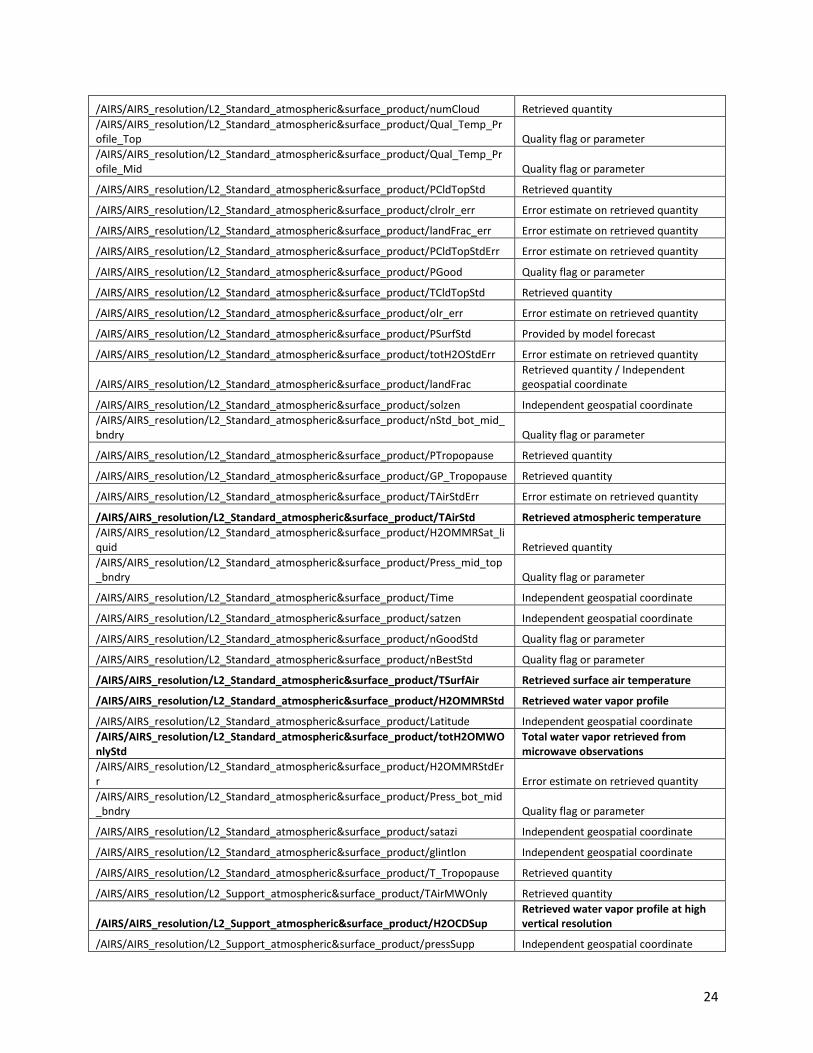
24
/AIRS/AIRS_resolution/L2_Standard_atmospheric&surface_product/numCloud Retrieved quantity
/AIRS/AIRS_resolution/L2_Standard_atmospheric&surface_product/Qual_Temp_Profile_Top Quality flag or parameter
/AIRS/AIRS_resolution/L2_Standard_atmospheric&surface_product/Qual_Temp_Profile_Mid Quality flag or parameter
/AIRS/AIRS_resolution/L2_Standard_atmospheric&surface_product/PCldTopStd Retrieved quantity
/AIRS/AIRS_resolution/L2_Standard_atmospheric&surface_product/clrolr_err Error estimate on retrieved quantity
/AIRS/AIRS_resolution/L2_Standard_atmospheric&surface_product/landFrac_err Error estimate on retrieved quantity
/AIRS/AIRS_resolution/L2_Standard_atmospheric&surface_product/PCldTopStdErr Error estimate on retrieved quantity
/AIRS/AIRS_resolution/L2_Standard_atmospheric&surface_product/PGood Quality flag or parameter
/AIRS/AIRS_resolution/L2_Standard_atmospheric&surface_product/TCldTopStd Retrieved quantity
/AIRS/AIRS_resolution/L2_Standard_atmospheric&surface_product/olr_err Error estimate on retrieved quantity
/AIRS/AIRS_resolution/L2_Standard_atmospheric&surface_product/PSurfStd Provided by model forecast
/AIRS/AIRS_resolution/L2_Standard_atmospheric&surface_product/totH2OStdErr Error estimate on retrieved quantity
/AIRS/AIRS_resolution/L2_Standard_atmospheric&surface_product/landFrac Retrieved quantity / Independent geospatial coordinate
/AIRS/AIRS_resolution/L2_Standard_atmospheric&surface_product/solzen Independent geospatial coordinate
/AIRS/AIRS_resolution/L2_Standard_atmospheric&surface_product/nStd_bot_mid_bndry Quality flag or parameter
/AIRS/AIRS_resolution/L2_Standard_atmospheric&surface_product/PTropopause Retrieved quantity
/AIRS/AIRS_resolution/L2_Standard_atmospheric&surface_product/GP_Tropopause Retrieved quantity
/AIRS/AIRS_resolution/L2_Standard_atmospheric&surface_product/TAirStdErr Error estimate on retrieved quantity
/AIRS/AIRS_resolution/L2_Standard_atmospheric&surface_product/TAirStd Retrieved atmospheric temperature
/AIRS/AIRS_resolution/L2_Standard_atmospheric&surface_product/H2OMMRSat_liquid Retrieved quantity
/AIRS/AIRS_resolution/L2_Standard_atmospheric&surface_product/Press_mid_top_bndry Quality flag or parameter
/AIRS/AIRS_resolution/L2_Standard_atmospheric&surface_product/Time Independent geospatial coordinate
/AIRS/AIRS_resolution/L2_Standard_atmospheric&surface_product/satzen Independent geospatial coordinate
/AIRS/AIRS_resolution/L2_Standard_atmospheric&surface_product/nGoodStd Quality flag or parameter
/AIRS/AIRS_resolution/L2_Standard_atmospheric&surface_product/nBestStd Quality flag or parameter
/AIRS/AIRS_resolution/L2_Standard_atmospheric&surface_product/TSurfAir Retrieved surface air temperature
/AIRS/AIRS_resolution/L2_Standard_atmospheric&surface_product/H2OMMRStd Retrieved water vapor profile
/AIRS/AIRS_resolution/L2_Standard_atmospheric&surface_product/Latitude Independent geospatial coordinate
/AIRS/AIRS_resolution/L2_Standard_atmospheric&surface_product/totH2OMWOnlyStd
Total water vapor retrieved from microwave observations
/AIRS/AIRS_resolution/L2_Standard_atmospheric&surface_product/H2OMMRStdErr Error estimate on retrieved quantity
/AIRS/AIRS_resolution/L2_Standard_atmospheric&surface_product/Press_bot_mid_bndry Quality flag or parameter
/AIRS/AIRS_resolution/L2_Standard_atmospheric&surface_product/satazi Independent geospatial coordinate
/AIRS/AIRS_resolution/L2_Standard_atmospheric&surface_product/glintlon Independent geospatial coordinate
/AIRS/AIRS_resolution/L2_Standard_atmospheric&surface_product/T_Tropopause Retrieved quantity
/AIRS/AIRS_resolution/L2_Support_atmospheric&surface_product/TAirMWOnly Retrieved quantity
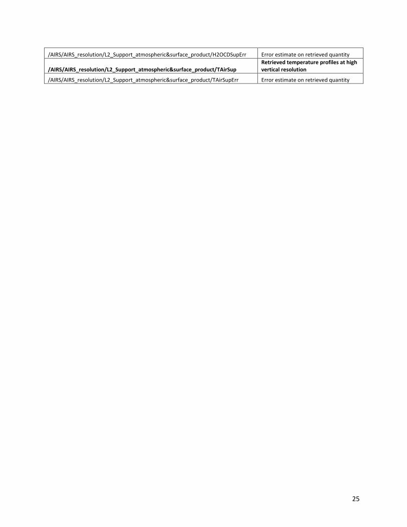
/AIRS/AIRS_resolution/L2_Support_atmospheric&surface_product/H2OCDSup Retrieved water vapor profile at high vertical resolution
/AIRS/AIRS_resolution/L2_Support_atmospheric&surface_product/pressSupp Independent geospatial coordinate
25
/AIRS/AIRS_resolution/L2_Support_atmospheric&surface_product/H2OCDSupErr Error estimate on retrieved quantity
/AIRS/AIRS_resolution/L2_Support_atmospheric&surface_product/TAirSup Retrieved temperature profiles at high vertical resolution
/AIRS/AIRS_resolution/L2_Support_atmospheric&surface_product/TAirSupErr Error estimate on retrieved quantity
26
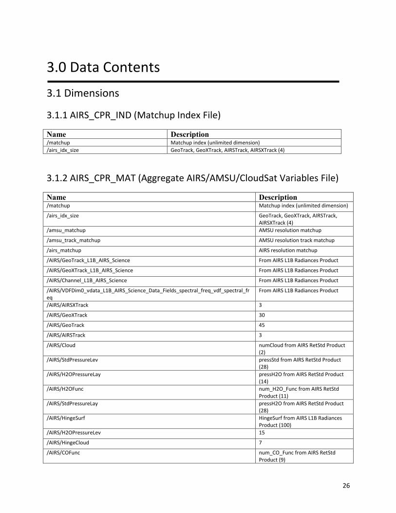
3.0 Data Contents
3.1 Dimensions
3.1.1 AIRS_CPR_IND (Matchup Index File)
Name Description /matchup Matchup index (unlimited dimension)
/airs_idx_size GeoTrack, GeoXTrack, AIRSTrack, AIRSXTrack (4)
3.1.2 AIRS_CPR_MAT (Aggregate AIRS/AMSU/CloudSat Variables File)
Name Description /matchup Matchup index (unlimited dimension)
/airs_idx_size GeoTrack, GeoXTrack, AIRSTrack, AIRSXTrack (4)
/amsu_matchup AMSU resolution matchup
/amsu_track_matchup AMSU resolution track matchup
/airs_matchup AIRS resolution matchup
/AIRS/GeoTrack_L1B_AIRS_Science From AIRS L1B Radiances Product
/AIRS/GeoXTrack_L1B_AIRS_Science From AIRS L1B Radiances Product
/AIRS/Channel_L1B_AIRS_Science From AIRS L1B Radiances Product
/AIRS/VDFDim0_vdata_L1B_AIRS_Science_Data_Fields_spectral_freq_vdf_spectral_freq
From AIRS L1B Radiances Product
/AIRS/AIRSXTrack 3
/AIRS/GeoXTrack 30
/AIRS/GeoTrack 45
/AIRS/AIRSTrack 3
/AIRS/Cloud numCloud from AIRS RetStd Product (2)
/AIRS/StdPressureLev pressStd from AIRS RetStd Product (28)
/AIRS/H2OPressureLay pressH2O from AIRS RetStd Product (14)
/AIRS/H2OFunc num_H2O_Func from AIRS RetStd Product (11)
/AIRS/StdPressureLay pressH2O from AIRS RetStd Product (28)
/AIRS/HingeSurf HingeSurf from AIRS L1B Radiances Product (100)
/AIRS/H2OPressureLev 15
/AIRS/HingeCloud 7
/AIRS/COFunc num_CO_Func from AIRS RetStd Product (9)
27
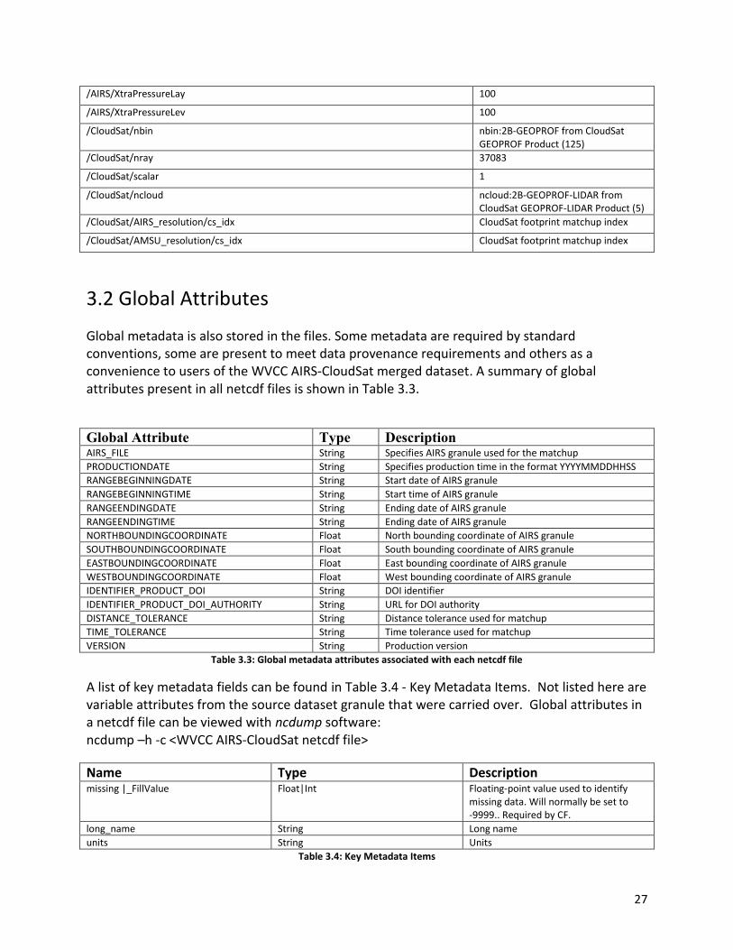
/AIRS/XtraPressureLay 100
/AIRS/XtraPressureLev 100
/CloudSat/nbin nbin:2B-GEOPROF from CloudSat GEOPROF Product (125)
/CloudSat/nray 37083
/CloudSat/scalar 1
/CloudSat/ncloud ncloud:2B-GEOPROF-LIDAR from CloudSat GEOPROF-LIDAR Product (5)
/CloudSat/AIRS_resolution/cs_idx CloudSat footprint matchup index
/CloudSat/AMSU_resolution/cs_idx CloudSat footprint matchup index
3.2 Global Attributes
Global metadata is also stored in the files. Some metadata are required by standard conventions, some are present to meet data provenance requirements and others as a convenience to users of the WVCC AIRS-CloudSat merged dataset. A summary of global attributes present in all netcdf files is shown in Table 3.3.
Global Attribute Type Description AIRS_FILE String Specifies AIRS granule used for the matchup
PRODUCTIONDATE String Specifies production time in the format YYYYMMDDHHSS
RANGEBEGINNINGDATE String Start date of AIRS granule
RANGEBEGINNINGTIME String Start time of AIRS granule
RANGEENDINGDATE String Ending date of AIRS granule
RANGEENDINGTIME String Ending date of AIRS granule
NORTHBOUNDINGCOORDINATE Float North bounding coordinate of AIRS granule
SOUTHBOUNDINGCOORDINATE Float South bounding coordinate of AIRS granule
EASTBOUNDINGCOORDINATE Float East bounding coordinate of AIRS granule
WESTBOUNDINGCOORDINATE Float West bounding coordinate of AIRS granule
IDENTIFIER_PRODUCT_DOI String DOI identifier
IDENTIFIER_PRODUCT_DOI_AUTHORITY String URL for DOI authority
DISTANCE_TOLERANCE String Distance tolerance used for matchup
TIME_TOLERANCE String Time tolerance used for matchup
VERSION String Production version
Table 3.3: Global metadata attributes associated with each netcdf file
A list of key metadata fields can be found in Table 3.4 - Key Metadata Items. Not listed here are variable attributes from the source dataset granule that were carried over. Global attributes in a netcdf file can be viewed with ncdump software: ncdump –h -c <WVCC AIRS-CloudSat netcdf file>
Name Type Description missing |_FillValue Float|Int Floating-point value used to identify
missing data. Will normally be set to -9999.. Required by CF.
long_name String Long name
units String Units
Table 3.4: Key Metadata Items

28
3.3 Products/Parameters
Refer to section 2.3 for product parameters.
4.0 Options for Reading the Data
4.1 Command Line Utilities
ncdump
The ncdump tool can be used as a simple browser for NetCDF data files, to display the dimension names
and sizes; variable names, types, and shapes; attribute names and values; and optionally, the values of
data for all variables or selected variables in a NetCDF file. The most common use of ncdump is with the
–h option, in which only the header information is displayed.
ncdump [-c|-h] [-v ...] [[-b|-f] [c|f]] [-l len] [-n name] [-d n[,n]] filename
Options/Arguments:
[-c] Coordinate variable data and header information
[-h] Header information only, no data
[-v var1[,...]] Data for variable(s) <var1>,... only data
[-f [c|f]] Full annotations for C or Fortran indices in data
[-l len] Line length maximum in data section (default 80)
[-n name] Name for netCDF (default derived from file name)
[-d n[,n]] Approximate floating-point values with less precision filename File name of input
netCDF file
Note: the ncdump tool will only display variables whose ranks are great than 1. In other words,
you will not see one dimensional vectors such as satheight using this tool.
The ncdump program can be found in bin directory of the HDF installation area. Consult your
local computer system administrator for the specifics.
4.2 Tools/Programming
Here we provide some python code snippets.

29
4.2.1 Read Variables
import os import netCDF4 def walktree(top): for k,v in top.variables.iteritems(): desc = "%s" % v.__dict__.get('long_name', '') if v.__dict__.get('units', None) is not None: desc += " (%s)" % v.__dict__.get('units', None) print("%s|%s" % (os.path.join(top.path, k), desc)) for k,g in top.groups.iteritems(): walktree(g) ncFile = 'matched-airs.aqua_cloudsat-v4.0-2006.08.26.061.nc4' f = netCDF4.Dataset(ncFile) # print all variables in the file walktree(f) # pull out some variables cloud_scen = f.groups['CloudSat'].groups['AIRS_resolution'].groups['2B-CLDCLASS'].variables['cloud_scenario'][:] heigth = f.groups['CloudSat'].groups['AIRS_resolution'].groups['2B-CLDCLASS'].variables['Height'][:] csLat = f.groups['CloudSat'].groups['AIRS_resolution'].groups['2B-CLDCLASS'].variables['Latitude'][:] radiances = f.groups['AIRS'].groups['AIRS_resolution'].groups['L1B_AIRS_Science'].variables['radiances'][:] f.close()
30
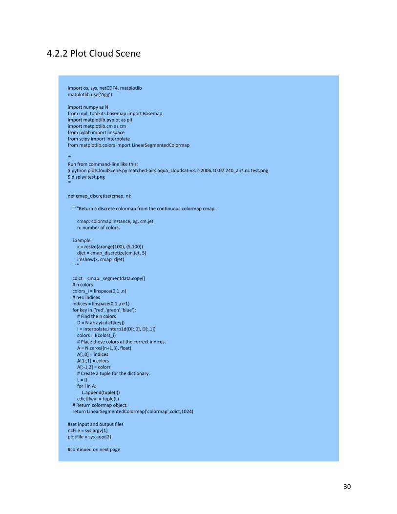
4.2.2 Plot Cloud Scene
import os, sys, netCDF4, matplotlib matplotlib.use(‘Agg’) import numpy as N from mpl_toolkits.basemap import Basemap import matplotlib.pyplot as plt import matplotlib.cm as cm from pylab import linspace from scipy import interpolate from matplotlib.colors import LinearSegmentedColormap ''' Run from command-line like this: $ python plotCloudScene.py matched-airs.aqua_cloudsat-v3.2-2006.10.07.240_airs.nc test.png $ display test.png ''' def cmap_discretize(cmap, n): """Return a discrete colormap from the continuous colormap cmap. cmap: colormap instance, eg. cm.jet. n: number of colors. Example x = resize(arange(100), (5,100)) djet = cmap_discretize(cm.jet, 5) imshow(x, cmap=djet) """ cdict = cmap._segmentdata.copy() # n colors colors_i = linspace(0,1.,n) # n+1 indices indices = linspace(0,1.,n+1) for key in ('red','green','blue'): # Find the n colors D = N.array(cdict[key]) I = interpolate.interp1d(D[:,0], D[:,1]) colors = I(colors_i) # Place these colors at the correct indices. A = N.zeros((n+1,3), float) A[:,0] = indices A[1:,1] = colors A[:-1,2] = colors # Create a tuple for the dictionary. L = [] for l in A: L.append(tuple(l)) cdict[key] = tuple(L) # Return colormap object. return LinearSegmentedColormap('colormap',cdict,1024) #set input and output files ncFile = sys.argv[1] plotFile = sys.argv[2] #continued on next page
31
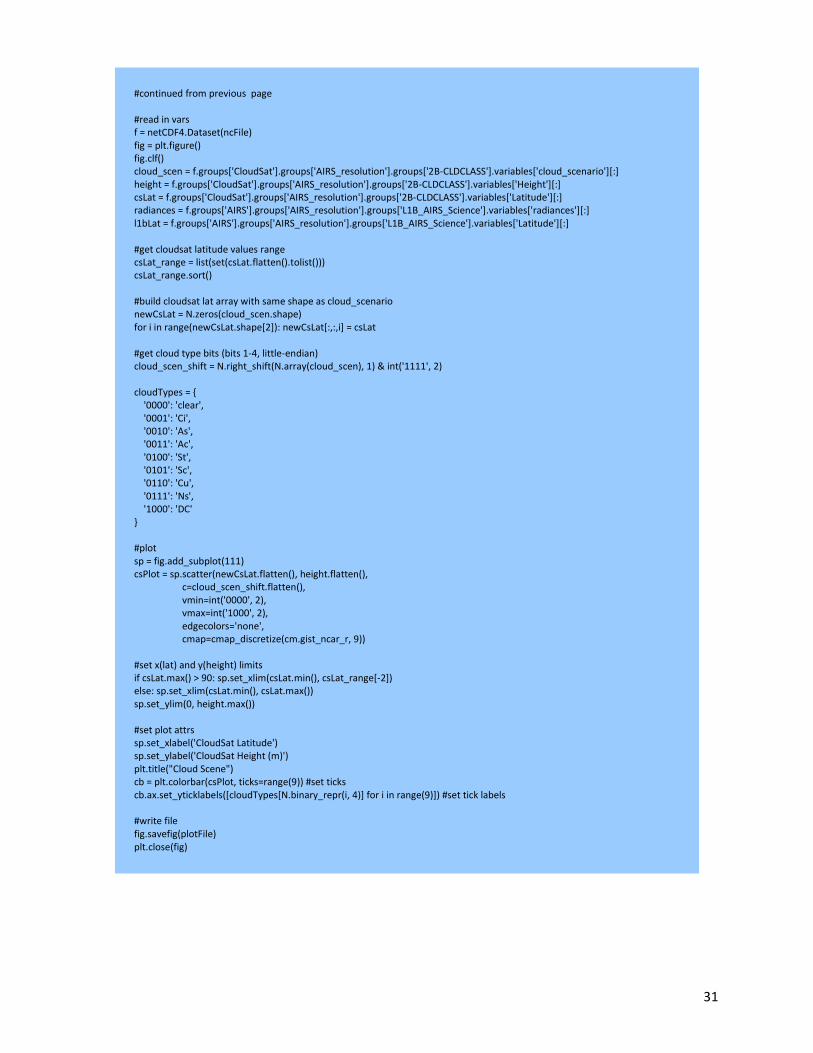
#continued from previous page #read in vars f = netCDF4.Dataset(ncFile) fig = plt.figure() fig.clf() cloud_scen = f.groups['CloudSat'].groups['AIRS_resolution'].groups['2B-CLDCLASS'].variables['cloud_scenario'][:] height = f.groups['CloudSat'].groups['AIRS_resolution'].groups['2B-CLDCLASS'].variables['Height'][:] csLat = f.groups['CloudSat'].groups['AIRS_resolution'].groups['2B-CLDCLASS'].variables['Latitude'][:] radiances = f.groups['AIRS'].groups['AIRS_resolution'].groups['L1B_AIRS_Science'].variables['radiances'][:] l1bLat = f.groups['AIRS'].groups['AIRS_resolution'].groups['L1B_AIRS_Science'].variables['Latitude'][:] #get cloudsat latitude values range csLat_range = list(set(csLat.flatten().tolist())) csLat_range.sort() #build cloudsat lat array with same shape as cloud_scenario newCsLat = N.zeros(cloud_scen.shape) for i in range(newCsLat.shape[2]): newCsLat[:,:,i] = csLat #get cloud type bits (bits 1-4, little-endian) cloud_scen_shift = N.right_shift(N.array(cloud_scen), 1) & int('1111', 2) cloudTypes = { '0000': 'clear', '0001': 'Ci', '0010': 'As', '0011': 'Ac', '0100': 'St', '0101': 'Sc', '0110': 'Cu', '0111': 'Ns', '1000': 'DC' } #plot sp = fig.add_subplot(111) csPlot = sp.scatter(newCsLat.flatten(), height.flatten(), c=cloud_scen_shift.flatten(), vmin=int('0000', 2), vmax=int('1000', 2), edgecolors='none', cmap=cmap_discretize(cm.gist_ncar_r, 9)) #set x(lat) and y(height) limits if csLat.max() > 90: sp.set_xlim(csLat.min(), csLat_range[-2]) else: sp.set_xlim(csLat.min(), csLat.max()) sp.set_ylim(0, height.max()) #set plot attrs sp.set_xlabel('CloudSat Latitude') sp.set_ylabel('CloudSat Height (m)') plt.title("Cloud Scene") cb = plt.colorbar(csPlot, ticks=range(9)) #set ticks cb.ax.set_yticklabels([cloudTypes[N.binary_repr(i, 4)] for i in range(9)]) #set tick labels #write file fig.savefig(plotFile) plt.close(fig)
32
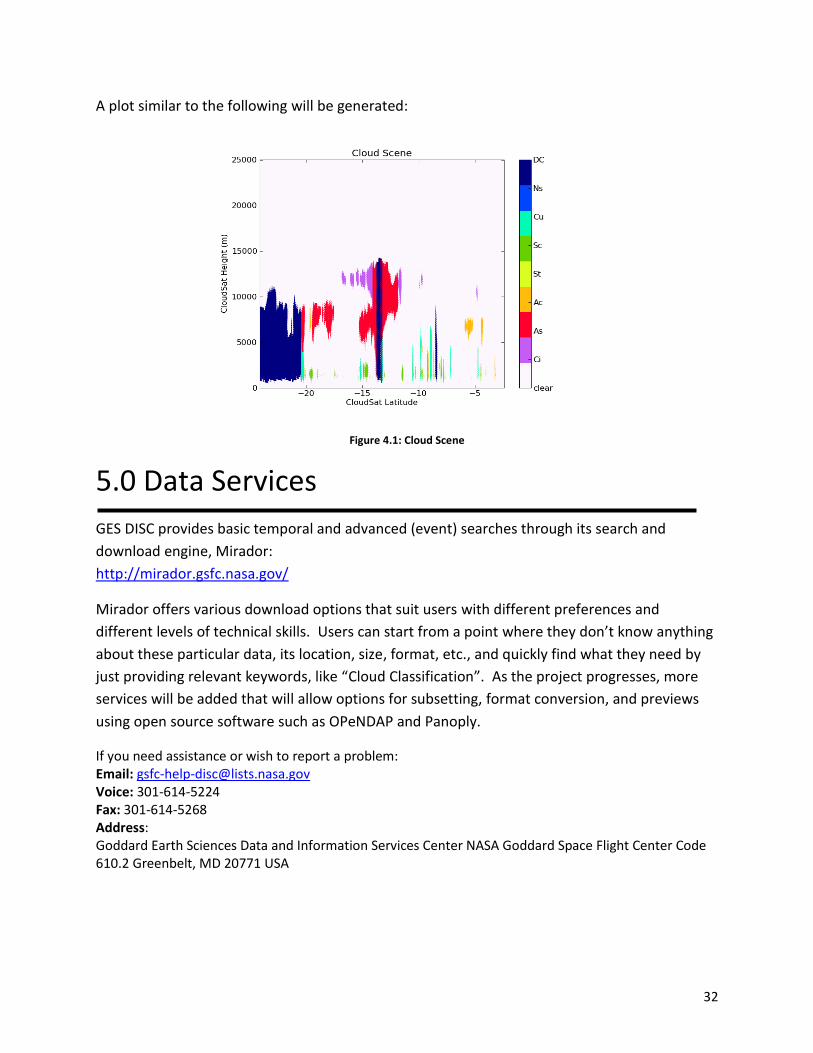
A plot similar to the following will be generated:
Figure 4.1: Cloud Scene
5.0 Data Services
GES DISC provides basic temporal and advanced (event) searches through its search and
download engine, Mirador:
http://mirador.gsfc.nasa.gov/
Mirador offers various download options that suit users with different preferences and
different levels of technical skills. Users can start from a point where they don’t know anything
about these particular data, its location, size, format, etc., and quickly find what they need by
just providing relevant keywords, like “Cloud Classification”. As the project progresses, more
services will be added that will allow options for subsetting, format conversion, and previews
using open source software such as OPeNDAP and Panoply.
If you need assistance or wish to report a problem: Email: [email protected] Voice: 301-614-5224 Fax: 301-614-5268 Address: Goddard Earth Sciences Data and Information Services Center NASA Goddard Space Flight Center Code 610.2 Greenbelt, MD 20771 USA
33
6.0 More Information
All WVCC data types are published to the Global Change Master Directory:
http://gcmd.nasa.gov
This is a centralized depository of climate data information that is catalogued by popular
keywords, which facilitate data discovery. Since the Directory is visited by a large number of
people working on a broad range of research topics, it is an excellent forum to popularize data
collections. It also serves as source of data type information for Mirador.
7.0 Acknowledgements
The creators for WVCC are:
Eric Fetzer, Brian Wilson, and Gerald Manipon.
References
AIRS Version 6.0 Processing Files Description: https://disc.gsfc.nasa.gov/information/documents?title=AIRS Documentation
CloudSat Standard Data Products Handbook, May 18, 2006:
http://www.cloudsat.cira.colostate.edu/dataHome.php
Level 2 Cloud Scenario Classification Product Process Description and Interface Control
Document, Version: 4.0, March 1, 2005.
NetCDF4: http://www.unidata.ucar.edu/software/netcdf/
For information on the Python programming language, consult the documentation:
http://www.python.org.