swelling potential on volcanic soil of brecia and … potential on volcanic soil of brecia and tuff...
TRANSCRIPT

Swelling Potential on Volcanic Soil of Brecia and Tuff
in Jatinangor Area, Sumedang, West Java, Indonesian
Aryas Prabaswara Widya WIDITA1, Nur KHAIRULAH
2, Raden Irvan SOPHIAN
3,
Dicky MUSLIM4
Faculty of Geological Engineering Padjadjaran University, Bandung-Sumedang Street km21,
45363, Sumedang City, West Java, Indonesian
2Email : [email protected]
Email : [email protected]
Email : [email protected]
Email : [email protected]
Abstract
This research was conducted in Jatinangor Subdistrict, Sumedang District, West Java
Province. Based on the geological mapping, the study area is included in the pyroclastic fall breccia
unit, the pyroclastic flow breccia unit, and the tuff unit. This research was conducted to find out the
swelling potential of soil from weathered volcanic rock based on the swelling index value from
undisturbed soil samples and analysis of clay mineral type from XRD analysis. Testing for swelling
index value of soil was conducted by free swell index test method with reference to Indian Standard
2720 Part40 (1977) on each undisturbed soil sample, so that the result of swelling index value of soil
in each sample will represent the swelling potential at each undisturbed sampling points. Based on the
swelling index value, the research area has a swelling index value between 3.45% - 22.88%. These
values based on the Indian Standart 2720 Part40 (1977) classification are included into the low to
medium swelling potential level. This value is supported by clay mineral type analysis on some soil
samples in the research area using XRD method.
Keywords: Jatinangor, XRD (X-Ray Difraction), swelling index, volcanic, clay mineral
The 2nd Join Conference of Utsunomiya University and Universitas Padjadjaran, Nov.24,2017
1
INTRODUCTION
Background
Jatinangor area has grown rapidly into educational areas, industrial estates, business
areas, government areas, and commercial areas. In this regard, the sector of infrastructure
development is increasing rapidly. The problem in developing the development on fine-
grained soil is the presence of expansive clay soil (Brotodiharjo, 1990). Where the Jatinangor
region is dominated by cohesive fine-grained soils, which may contain clay minerals with
great expansionary power that could affect the stability of the above ground infrastructure.
The expansionary power of the expansive soil itself depends on the type and quantity of
minerals, the ease of exchange of the ions or so-called cation exchange capacity and the
electrolyte content and the structure of the mineralized layer (Herina, 2005).
Purpose of Paper
The underlying thing to examine the potential of land swelling in Jatinangor itself is
because there are some infrastructures that fail so that endangers the users of the
infrastructure. After the observation, there were several points of location in Jatinangor that
suffered damage to infrastructure such as the UNPAD bridge located at the back gate which
is actually new because it has not been more than 5 years old but has experienced cracks. In
addition, the bridge UNPAD located next to the arboretum also experienced subsidence that
the campus was forced to close access to that direction.
LITERATUR REVIEW
Mechanism of swelling soil
Expansive clay of the soil, is one type of fine-grained colloidal soil, formed from
expansive minerals. Besides having general properties, it also has characteristic properties, ie
expansive mineral content has a high ion exchange capacity, resulting in expansive clay
having the potential for shrinkage, in case of an increase or decrease in water content. If there
is an increase in water content, the expansive soil will expand along with increased pore
water pressure and developmental pressures and if water content decreases, shrinkage will
occur. Depreciation that occurs, if the decrease in water content exceeds the shrinkage limit.
The expansive clay expanse of the soil depends on the type and quantity of minerals,
the ease of exchange of the ions or the cation exchange capacity and the electrolyte content
and the structure of the mineralized layer (Herina, 2005). Clay minerals that make up the
The 2nd Join Conference of Utsunomiya University and Universitas Padjadjaran, Nov.24,2017
2

expansive clays are generally montmorillonite, illite, and kaolinite. Of the three types of
minerals, montmorillonite has the greatest growth power (Grim, 1968), so its presence is
thought to be a major factor determining the expansive nature of the clay type. Knowing the
mineralogical content contained in the soil/rock can be used to estimate the expansive nature
of clay.
The process of swelling and shrinking is largely due to capillary events or changes in
water content in the soil. Soils contain much clay changes volume when water content
changes. The reduction of water content followed by an increase in effective stress causes the
volume of soil to shrink and otherwise the addition of moisture content causes expansion.
Geology characteristic on research area
Based on previous geological mapping results, the geology of the study area consists
of three rock units (Sandio et al, 2016), namely: Pyroclastic fall breccia, pyroclastic flow
breccia, and tuff unit.
1. Pyroclastic fall breccia unit
This unit is dominated by grain supported breccias, has a light brown color, angular
component shape, andesite frosted components that have a fresh gray color, dark gray
color, the grain size of porphyritic, hypocristalline, packed inequigranular, subhedral
crystal form, mesocratic mineral color index. Matrix in the form of fresh cream white tuff,
light brown color, angle grain shape, medium sorting, closed pack, tuff fine tuff-tuff grain.
2. Pyroclastic flow breccia unit
This unit is dominated by breccia matrix supported, has a fresh brown color, dark brown
color, angular shape components, open packing, frozen andesite igneous components that
have a fresh gray color, dark gray, porphyritic grains, hypocrystalline crystalline degrees,
inequigranular packs, subhedral crystal forms, mesocratic mineral color index. Matrix in
the form of fresh cream white tuff, light brown color, grain angle grain shape, medium
sorting, sealed pack, tuff fine tuff-tuff grain.
3. Tuff unit
This unit is dominated by tuff with fresh cream color, light brown color, fine grain size,
angle grain angle shape, medium sorting, hard hardness, closed pack, glass mineral. There
are quartz minerals, plagioclase, and pyroxene.
The 2nd Join Conference of Utsunomiya University and Universitas Padjadjaran, Nov.24,2017
3
METHODOLOGY
To get swelling index value is done by laboratory testing with free swell index test
method. A method of testing soil physical properties by observing the extent of soil
expansion within a colloid ie distilled water (distillation) and kerosene (kerosene) within 24
hours or more. The concept used in this test is where the soil soaked in distilled water will be
swelling, while soils soaked in kerosene will not develop due to their non-polar colloidal
nature (Anonymous, 1977). All stages of testing using standard Indian Standart 2720 Part40
(1977).
Furthermore, with the value of swelling index at some point of soil sampling,
zonation of the swelling index of land that will represent the potential of land swelling in the
research area. In addition, data from swelling index values at some sampling points will be
matched with XRD results to find out the type of clay minerals contained in the soil.
XRD analysis aims to determine the dominant clay mineral content in soil samples.
The analysis used from this result is by looking at the aspect of the d-spacing value at the top
of the major, the angle of 2θ, and the presence of the minor peak. The patterns are then
matched to the XRD result list table and other additional information in Chen (1977) and
analyzed based on the origin of their geometric precipitates.
RESULT AND DISCUSSION
Based on the description of soil in the field at the time of engineering geology
mapping and laboratory test results related to soil physical properties, the study area is
divided into three units of land according to the USCS soil classification system, namely:
clay high plasticity (CH), silt high plasticity (MH), and silt low plasticity (ML).
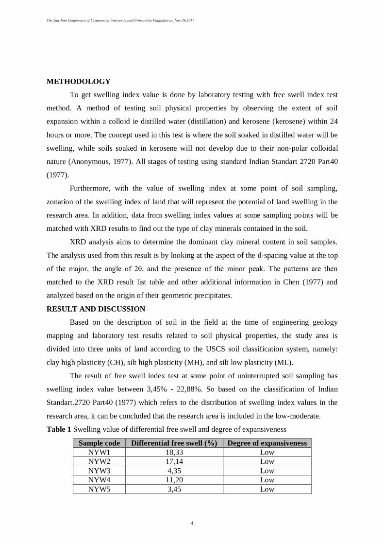
The result of free swell index test at some point of uninterrupted soil sampling has
swelling index value between 3,45% - 22,88%. So based on the classification of Indian
Standart.2720 Part40 (1977) which refers to the distribution of swelling index values in the
research area, it can be concluded that the research area is included in the low-moderate.
Table 1 Swelling value of differential free swell and degree of expansiveness
Sample code Differential free swell (%) Degree of expansiveness
NYW1 18,33 Low
NYW2 17,14 Low
NYW3 4,35 Low
NYW4 11,20 Low
NYW5 3,45 Low
The 2nd Join Conference of Utsunomiya University and Universitas Padjadjaran, Nov.24,2017
4

NYW6 7,50 Low
NYW7 4,35 Low
NYW8 22,88 Moderate
NYW10 21,74 Moderate
Based on the X-ray diffraction pattern of the five curves in each sample, it can be seen
the d-spacing value of each peak intensity value in the range 0º2θ to 20º2θ is as follows:
1. NYW1 sample has a d-spacing pattern of 7.321Å (12,079º2θ) and 4,467Å (19,857º2θ).
2. NYW2 sample has a d-spacing pattern of 7.226Å (12.237º2θ); 4,878Å (18,168º2θ); and
4,473Å (19,828º2θ).
3. NYW3 sample has a d-spacing pattern of 7.308Å (12,101º2θ) and 4,457Å (19,092º2θ).
4. NYW4 sample has a d-spacing pattern of 20.659Å (4,273º2θ); 7,304Å (12,107º2θ) and
4,456Å (19,905º2θ).
5. NYW5 sample has a d-spacing pattern of 7.331Å (12,062º2θ) and 4,460Å (19,889º2θ).
6. NYW6 sample has a d-spacing pattern of 7.275Å (12.155º2θ); 4,849Å (18,281º2θ) and
4,477Å (19,813º2θ).
Referring to Chen (1977), based on the d-spacing pattern and the 2θ angles on the
whole the sample was identified as a diffraction pattern in the kaolinite mineral gap.
However, in the NYW4 sample there is little difference in d-spacing pattern and 2 angles at
the initial peak, which is probably caused by the impurity material in the clay mineral body.
But after that, the next peak reading has followed the diffraction pattern of kaolinite minerals.
According to Nelson (2004), excellent kaolinite is formed from the rich aluminosilicate-
derived material produced by weathering in temperate temperatures such as in volcanic rock
or in areas with hydrothermal activity. This can be explained because the location of soil
sampling is present in pyroclastic flow breccia and tuff units.
Table 2 Type of clay minerals on each sample based on XRD analysis
Sample
code
Geology unit
(Sandio et all, 2016)
Swelling
potential
Type of clay
mineral
NYW1 Tuff Low Kaolinite
NYW2 Tuff Low Kaolinite
NYW3 Pyroclastic fall breccia Low Kaolinite
NYW4 Tuff Low Kaolinite
NYW5 Pyroclastic flow breccia Low Kaolinite
NYW6 Tuff Low Kaolinite
The 2nd Join Conference of Utsunomiya University and Universitas Padjadjaran, Nov.24,2017
5

CONCLUSION
The plasticity of the soil is caused by the interaction of water ions with the clay
mineralized surface, so that in the presence of high plasticity properties in the study area it
indicates a lot of clay minerals. Volcanic rocks rich in silica minerals (quartz, feldspar, mica),
when subjected to chemical weathering of the hydrolysis process will produce clay minerals.
This is what causes the soil result of weathered many clay minerals with different types
depending on the chemical content of rocks and processes that occur during the formation of
clay minerals.
Based on the free swell index test results, the research area has a swelling index of the
index value between 3.45% - 22.88%, which is classified into the category of low-medium to
expand potential. While based on XRD test for determination of clay minerals type found in
the research area, got a result in six samples spread in each zonation of the index value of
land swelling which shows that six samples dominated by kaolinite clay mineral type. This is
what causes the expansion rate of the research area based on swelling index value spread is
relatively low.
ACKNOWLEDGEMENT
First of all I would like to thank my counselor for completing this paper which is
Mr.Dicky Muslim, Mr.Raden Irvan Sophian, and Mr.Nur Khairulah who has given directions
to this paper can be solved.
I would also like to thank all people who have assisted me in completing this paper,
especially the great family of laboratory engineering geology Padjadjaran University. In the
making I always use the facilities in the laboratory so it makes it easier for me to get the
results of laboratory experiments. In addition, I would like thank to all parties that I can not
mention one by one in this paper.
REFERENCES
Anonymous. 1977. Determination of Differential Free Swell Index. India. Departement of
Civil Engineering, Cusrow Wadia Institute of Technology, Pune.
Brotodihardjo, A.P.P. 1990. Masalah Geoteknik di Sekitar Rencana Terowongan/Saluran
irigasi Karedok Kanan, DAS Cimanuk. IAGI XIX Annual scientific meeting, 11-13
December 1990, page.132-142.
The 2nd Join Conference of Utsunomiya University and Universitas Padjadjaran, Nov.24,2017
6

Chen, Pei-Yuan. 1977. Table of Key Lines in X-Ray Powder Diffraction Patterns of Minerals
in Clays and Associated Rock. Bloomingtoon, Indiana USA: Department of Natural
Resources, Geological Survey.
Grim, R.E. 1968. Clay Mineralogy. New York. McGraw-Hill Book Company, Inc.
Herina. 2005. Kajian Pemanfaatan Abu Sekam Padi Sebagai Bahan Stabilisasi Tanah Fondasi
Ekspansif Untuk Bangunan Sederhana. Kolokium & Open House 2005, Housing
Puslitbang, Litbang Institution Public Work Departement.
Muslim, D., Haerani, E., Sophian, I., Zakaria, Z., Khoirullah, N., Putra, Y.P. & Shibayama,
M. 2012. Engineering Geologic Mapping Around The Newly Built Higer Education
Complex in Jatinangor, West Java, Indonesia. The 2nd International Conference and
the 1st Joint Conference ICG 2015 page.169-173.
Nelson, Stepehen A. 2014. Weathering and Clay Minerals. Available online at
http://www.tulane.edu/~sanelson/eens211/weathering&clayminerals.html. (accessed
20 October 2017).
Sandio, V., Eka, Frini, G.G., Hardi, H. dan Neman. 2016. Geologi Daerah Jatinangor dan
Sekitarnya, Kabupaten Sumedang, Provinsi Jawa Barat. Jatinangor. Faculty of
Geology Engineering, Padjadjaran University.
Zakaria, Zufialdi. 2014. Aspek geoteknik di kawasan pendidikan jatinangor, sumedang,
jawa barat. National Conference of Geology Engineering Faculty, Bandung.
The 2nd Join Conference of Utsunomiya University and Universitas Padjadjaran, Nov.24,2017
7