state of the amazon: freshwater connectivity and ecosystem ... · terrestrial and aquatic...
TRANSCRIPT
State of the Amazon: Freshwater Connectivity and Ecosystem Health
2015
REPORTLIVINGAMAZON
State of the Amazon: Freshwater Connectivity and Ecosystem Health
W W F L I V I N G A M A Z O N I N I T I A T I V E
1st Edition
Brasilia, Brazil
April, 2015
SUGGESTED CITATION
Macedo, M. and L. Castello. 2015. State of the Amazon: Freshwater Connectivity and Ecosystem Health; edited by D. Oliveira, C. C. Maretti and S. Charity. Brasília, Brazil: WWF Living Amazon Initiative. 136pp.
PUBLICATION INFORMATIONState of the Amazon Series editors: Cláudio C. Maretti, Denise Oliveira and Sandra Charity.This publication State of the Amazon: Freshwater Connectivity and Ecosystem Health:Publication editors: Denise Oliveira, Cláudio C. Maretti, and Sandra Charity.Publication text editors: Sandra Charity and Denise Oliveira. Core Scientific Report (chapters 1-6): Written by Marcia Macedo and Leandro Castello; scientific assessment commissioned by WWF Living Amazon Initiative (LAI). Conclusions and Recommendations (chapter 7): Cláudio C. Maretti, Marcia Macedo, Leandro Castello, Sandra Charity, Denise Oliveira, André S. Dias, Tarsicio Granizo, Karen Lawrence
WWF Living Amazon Integrated Approaches for a More Sustainable Development in the Pan-AmazonCláudio C. Maretti; Sandra Charity; Denise Oliveira; Tarsicio Granizo; André S. Dias; and Karen Lawrence.
Maps: Paul Lefebvre/Woods Hole Research Center (WHRC); Valderli Piontekwoski/Amazon Environmental Research Institute (IPAM, Portuguese acronym); and Landscape Ecology Lab /WWF Brazil.
Photos: Adriano Gambarini; André Bärtschi; Brent Stirton/Getty Images; Denise Oliveira; Edison Caetano; Fernando Pelicice; Gleilson Miranda/Funai; Juvenal Pereira; Kevin Schafer/naturepl.com; María del Pilar Ramírez; Mark Sabaj Perez; Michel Roggo; Omar Rocha; Paulo Brando; Roger Leguen; Zig Koch.
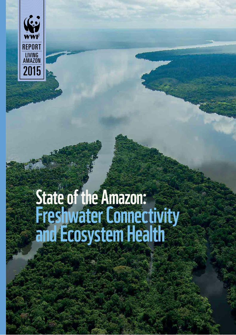
Front coverMouth of the Teles Pires and Juruena rivers forming the Tapajós River, on the borders of Mato Grosso, Amazonas and Pará states, Brazil. © Zig Koch / WWF-Living Amazon Initiative.
WWF is one of the world’s largest and most experienced independent conservation organizations, with over 5 million supporters and a global network active in more than 100 countries. WWF’s mission is to stop the degradation of the planet’s natural environment and to build a future in which humans live in harmony with nature, by conserving the world’s biological diversity, ensuring that the use of renewable natural resources is sustainable, and promoting the reduction of pollution and wasteful consumption.
WWF Living Amazon Initiative is one of nine Global Initiatives of the WWF Network. It has been developed since 2006 and implemented since 2008. Since 2013 it has had a focused approach, as an initiative dealing with regional or transboundary issues related to protected areas and indigenous territories, hydropower and deforestation, complementing the work done nationally and locally by the offices and organizations of the WWF Network working in the Amazon.
A WWF Living Amazon Initiative productionPublished in April 2015 by WWF – World Wide Fund For Nature(Formerly World Wildlife Fund - Gland, Switzerland). Any reproduction in full or in part must mention the title and credit the above-mentioned publisher as the copyright owner.
© Text 2015 WWF
All rights reserved.
ISBN 978-2-940529-19-3
For more information: [email protected] www.panda.org/amazon
APPs Areas of Permanent Preservation ABC Low-Carbon Agriculture ACTO Amazon Cooperation Treaty Organization ARPA Amazon Region Protected Areas Program BNDES Brazilian National Economic and Social Development BankC carbonCAF Latin American Development Bank CH4 methane CO2 carbon dioxide COSIPLAN The South American Infrastructure and Planning CouncilEIA Environmental Impact Assessment EIA-RIMA Environmental Impact Assessment and Report on Impacts to the EnvironmentET evapotranspiration Fonplata Plata Basin Development Fund GHG greenhouse gas Hg mercuryIBI Index of Biotic Integrity IDB Inter-American Development Bank IIRSA The Initiative for the Integration of the Regional Infrastructure of South America IPs indigenous peoples IRBM integrated river basin management ITs indigenous territories LAI Living Amazon Initiative MeHg methylmercury NPP net primary production PA protected areaPNMC National Climate Change Plan (Brazil)PPCDAm Action Plan for Prevention and Control of Deforestation in the Legal Amazon Q discharge RIMA Report on Impacts to the Environment SAMS South American Monsoon System THg total mercury TRMM Tropical Rainforest Monitoring Mission UNASUR Union of South American NationsWHRC Woods Hole Research CenterDS Changes in soil water storage
LIST OF ACRONYMSLIST OF ACRONYMS 4FOREWORD 8EXECUTIVE SUMMARY 101. INTRODUCTION 181.1. Amazon hydrological connectivity 201.2. Objectives 21
2. AMAZON FRESHWATER ECOSYSTEMS 262.1. Freshwater ecosystem types 272.2. Aquatic ecosystem services 30
3. DRIVERS OF HYDROLOGICAL ALTERATION 383.1. Dams 393.2. Land-cover change 423.3. Mineral extraction 453.4. Climate change 46
4. IMPACTS ON FRESHWATER ECOSYSTEMS 604.1. Disruption of physical processes 604.2. Disruption of biological processes 614.3. Disruption of ecosystem services 64
5. EXISTING POLICIES 685.1. Protected areas 685.2. Climate and land-use policy 705.3. Water resource management 715.4. Environmental licensing of dams 725.5. Gaps in existing policies 75
6. MANAGING FRESHWATER ECOSYSTEM CONNECTIVITY 966.1. Assessing vulnerability 976.3. Developing indicators of ecosystem integrity 996.4. Implementing management 102
7. CONCLUSIONS AND RECOMMENDATIONS 1067.1 Freshwater ecosystems and hydrological connectivity 1077.2 Ecosystem services and social impacts 1097.3 Managing ecological impacts 1107.4 Monitoring and evaluation 112
8. REFERENCES 1229. ACKNOWLEDGEMENTS 134
CONTENTS
State of the Amazon: Freshwater Connectivity and Ecosystem Health p. 4

TABLE OF EXTRA CONTENTSTHE AMAZON IS… 22
FISH TYPES 33
AMAZON FRESHWATER ECOSYSTEM TYPES 34
TOCANTINS RIVER BASIN AS THE FUTURE OF THE AMAZON? 48
DEFORESTATION SCENARIOS IN THE AREA OF INFLUENCE OF 50 THE TAPAJÓS HYDROPOWER COMPLEX
DEFORESTATION FRONTS AND TRENDS IN THE AMAZON 56
PROTECTED ECOLOGICAL REPRESENTATION IN THE AMAZON AND THE ‘AQUASCAPES’ 76
TAPAJÓS: INTEGRATED PLANNING FOR BIODIVERSITY CONSERVATION 78
BRAZILIAN ENERGY POLICY AND THE MANAGEMENT OF 92 AMAZON FRESHWATER ECOSYSTEMS
WWF LIVING AMAZON INTEGRATED APPROACHES FOR A MORE 114 SUSTAINABLE DEVELOPMENT IN THE PAN-AMAZON
© Denise O
liveira/WW
F-Living Amazon Initiative
Amazon forest, Madre de Dios, Peru.

FOREWORD WWF launched its Living Amazon Initiative, one of nine Global Initiatives of the WWF Network, in 2008. Since 2013 we have pursued a focused approach to dealing with
regional and transboundary issues related to protected areas and indigenous territories, hydropower, and deforestation, complementing the national and local work of the offices and organizations of the WWF Network.
As part of our approach, WWF Living Amazon Initiative developed the State of the Amazon report series, which describes the key conservation goals and issues of sustainable development on a Pan-Amazon scale and presents challenges and examples from both national and local perspectives.
In November 2014, we presented the first report, State of the Amazon: Ecological Representation, Protected Areas and Indigenous Territories, at the IUCN World Parks Congress in Australia.
WWF Living Amazon Initiative is pleased to present the newest report in the series, State of the Amazon: Freshwater Connectivity and Ecosystem Health, which provides a comprehensive assessment of the current state of Amazon freshwater ecosystems and highlights the importance of hydrological connectivity and land-water interactions in maintaining the ecological functions that support water, food and energy security.
Prominent researchers wrote the core scientific assessment, which they presented at a technical workshop to discuss the freshwater ecosystems in the Pan-Amazon. Organized by WWF Living Amazon Initiative, the workshop benefited from the collaboration of prestigious scientists from several research institutions (see complete list in Acknowledgements chapter).
Focused on topics from a draft scientific report, the two-day discussions and exchanges of information were important to our evaluation of the drivers of degradation; the public policies that influence them; and better Pan-Amazon planning, management and monitoring for maintenance of Amazon ecological stability. Other key themes of the discussions were the urgency of integrating biodiversity conservation and social issues into hydropower and infrastructure planning, and the policy elements needed to develop an integrated framework for Amazon freshwater ecosystem management.
The scientific assessment and discussions confirmed what we already knew: freshwater ecosystems are less protected, including in the Amazon, and, in some areas, under greater threat than are other resources. Most policies do not consider just how important freshwater ecosystem protection is, for reasons including lack of knowledge and adequate shared understanding. Freshwater ecosystems clearly show the impacts of climate change and the general lack of integrated approaches to their protection.
Based on these and other discussions, as well as nearly 10 years of WWF work on infrastructure and energy issues in the Pan-Amazon, we understand
the importance of hydropower, both as a concrete threat to the Amazon and the local communities, including indigenous peoples, and as a means of enabling development in the region. Charting the correct path requires evidence-based, respectful, sustainable, integrated approaches.
Therefore, in this State of the Amazon report, we include some contributions from the technical discussions as sidebar articles, including some presented for the first time here: a summary of Deforestation scenarios in the area of influence of the Tapajós Hydropower Complex, a study developed by WWF Living Amazon Initiative, WWF Brazil and the Amazon Environmental Research Institute (“IPAM” is the Portuguese acronym); and Tapajós: integrated planning for biodiversity conservation, which describes the conservation part of an integrated approach with energy authorities. Also included is a summary of the WWF Pan-Amazon view on the requirements for greener hydropower development.
The Amazon is under threat. We usually know it due to the importance of its forests and the immense volumes of deforestation each year. Brazil’s efforts to curb deforestation — and consequently reduce carbon emissions — are among the best in the world. Yet we tend to forget the Amazon rivers, which are also crucially important. Terrestrial and aquatic ecosystems are mutually dependent in terms of connectivity and therefore affect the region’s longer-term ecological stability. Scientific research proves that interdependence within the Amazon is crucial to stability in the region’s ecological functioning and that the Amazon is vital to both the continent and the world in terms of ecosystem services the region provides.
In addition to serving as a source of information and comprehensive understanding about the freshwater ecosystems in the Pan-Amazon, this State of the Amazon report presents real-life examples experienced in some river basins and describes the integrated approaches needed to achieve more sustainable development in the Pan-Amazon if we are to maintain its ecological integrity and ecosystems provision to local people, the countries and the world.
WWF’s main goals are to provide good information to enable stakeholders to develop the best possible solutions; and to promote a debate among stakeholders on the need for a regional, integrated Pan-Amazon approach to hydropower generation planning that will ensure the ecosystems’ integrity and avoid their fragmentation, maintain Amazon ecological services, and safeguard indigenous populations’ and local communities’ rights.
WWF Living Amazon Initiative believes that the Amazon has viable sustainable development prospects, but their fruition requires a productive dialogue among the involved actors. Hydropower is one of the main drivers of development and of risk and degradation. It is up to stakeholders to discuss, guide and design the future of the Amazon Region in a transparent way, based on open dialogues.
Please enjoy this report.
Cláudio C. MarettiWWF Living Amazon Initiative Leader
Foreword
State of the Amazon: Freshwater Connectivity and Ecosystem Health p. 9State of the Amazon: Freshwater Connectivity and Ecosystem Health p. 8
The Amazon Region contains both the largest block of contiguous tropical forest and the largest river system in the world, spanning 6.5 million km2 of forests in the
Amazon, Guiana Shield and Orinoco Basin and the 6.9 million km2 Amazon watershed. The Amazon River network is the lifeblood of the regional economy, providing the primary means of food and energy production, transportation, and other vital ecosystem services. At its mouth, the Amazon discharges about 6,700km3 yr-1 of freshwater into the Atlantic Ocean, about 20 per cent of global surface river flows. The Basin’s native forests and savannahs recycle 50-75 per cent of regional rainfall back to the atmosphere via evapotranspiration and help regulate the regional climate. These hydrological connections help maintain over 1 million km2 of freshwater ecosystems, which sustain a wealth of biological diversity and productive fisheries that are a vital source of protein and income for Amazonians. Amazon freshwater ecosystems are connected to the ocean, atmosphere and terrestrial ecosystems via the hydrological cycle. The amount and seasonality of rainfall in the region is controlled primarily by the South American Monsoon System and the trade winds, which regulate moisture transfer from the Atlantic Ocean to the Amazon Basin. The remaining rainfall drains terrestrial ecosystems via surface runoff, carrying with it organic and inorganic materials that shape freshwater ecosystem structure and fuel aquatic biological production processes. Additional interactions between freshwater and terrestrial ecosystems occur via the lateral exchange of organic and inorganic matter during seasonal floods, as water levels rise and flood adjacent riparian zones, and when overhanging vegetation drops fruits, leaves or insects into rivers and lakes. As river water flows downstream, it transports these terrestrial inputs, thereby connecting freshwater ecosystems longitudinally from the headwaters to the ocean. Forests and freshwater are mutually dependent, through the connections, for their ecosystem health. Together they are crucial to the climate stability.
Today the Amazon faces unprecedented development pressures. Dam construction, mining, oil and gas exploration and exploitation, new accesses and land-cover changes (Figure 1) are increasingly degrading Amazon freshwater ecosystems, disrupting the magnitude and timing of hydrological flows. Across the Amazon, 154 hydroelectric dams are currently in operation, 21 are under construction and ~277 are in the planning stages. If all go forward as planned, the Amazon network of power plants will have an installed capacity of ~95,000MW, and only three free-flowing tributaries will remain. At the same time, agriculture and ranching have expanded dramatically in the region, particularly in the Brazilian Amazon, and almost 20 per cent of the Biome has already been deforested. Mining (e.g. gold, bauxite, iron ore) and hydrocarbon extraction are also expanding rapidly, particularly in the Andes and Guianas. Energy-intensive aluminum and steel smelters often drive demand for new hydroelectric power in the region. The resulting dams are associated with myriad socio-environmental impacts such as deforestation, displacement of local populations and greenhouse gas emissions.
The cumulative effects of these hydrological alterations could irreversibly alter the hydrology, geomorphology and ecological integrity of Amazon freshwater ecosystems. Despite their regional and global importance, many of the Amazon Region’s freshwater ecosystems are not enough protected and have been largely ignored in the mainstream science and policy arenas. As a result, the data and management structures needed to conserve them are virtually non-existent. Amazon protected areas have been historically biased toward terrestrial conservation and are increasingly vulnerable to other uses (e.g. dams, mining, oil extraction) within their borders. In most Amazonian countries, environmental licensing processes lack transparency and are prone to corruption. Although some national water resource legislation exists, in general these laws fail to address the hydrological connectivity and integrity of freshwater ecosystems and are often fragmented in their goals. Even so, if fully implemented, some of these laws (e.g. Peru’s Forest and Fauna Law, Brazil’s Forest Code, and Colombia comprehensive framework for watershed management) facilitate coordinated landscape management that could benefit freshwater ecosystems.
The threats to the connectivity of Amazon freshwater ecosystems operate across multiple scales, as do efforts to curb their impacts and conserve freshwater resources. Conservation of these ecosystems requires a delicate balance between these opposing forces and a coordinated effort to overcome the barriers to Biome and Basin-scale conservation planning. Maintaining Amazon hydrologic connectivity and freshwater ecosystem function will require integrated management of terrestrial and freshwater ecosystems and, in many cases, international cooperation. A lack of consistent ecological and social data across the Amazon remains a critical barrier to such integrated management, making it impossible to quantify the true costs of development activities and hindering efforts to evaluate the potential impacts of proposed projects. Developing better baseline data, mechanisms for international coordination and an integrated management framework will be crucial to mitigate the impacts of human activities and maintain freshwater ecosystem connectivity and function for future generations.
Threats to the freshwater ecosystem health are not limited to hydropower, but this sector is a considerable part of the problem and could be part of the solutions. Some textboxes in this report present the potential worst scenario, as in the case of Tocantins, example of a potential positive path and at the same time considerable risks, in the case of Tapajós, both basins in Brazil.
EXECUTIVE SUMMARY
Executive Summary
MANY OF THE AMAZON BASIN’S FRESHWATER ECOSYSTEMS ARE UNPROTECTED AND HAVE BEEN LARGELY IGNORED IN THE MAINSTREAM SCIENCE AND POLICY ARENAS.
State of the Amazon: Freshwater Connectivity and Ecosystem Health p. 11State of the Amazon: Freshwater Connectivity and Ecosystem Health p. 10
RECOMMENDATIONS A key objective of WWF’s Living Amazon Initiative is to transform the way hydropower development is conducted in the Amazon by 2020. WWF is committed to developing constructive dialogues among civil society, industry, the finance sector and governments in order to enable sustainable hydropower programmes, should they be necessary, and associated territorial development plans.
In order to achieve this objective and reorient development in the Amazon Region toward a more sustainable path, new measures are necessary to mitigate threats to and alleviate pressures on the Amazon freshwater ecosystems.
Through its Living Amazon Initiative, WWF proposes a set of key recommendations to be adopted and implemented by decision makers in governments, the private and finance sectors, and the wider societies of the nine countries that share the Amazon Biome (Bolivia, Brazil, Colombia, Ecuador, Guyana, Peru, Suriname, Venezuela and French Guiana).
A summarized version of the recommendations (chapter 7) can be found below:
KEY RECOMMENDATIONS RELATED TO: FRESHWATER ECOSYSTEMS AND HYDROLOGICAL CONNECTIVITY• Adopt an integrated vision of Amazon sustainable development and
nature conservation.
• Develop an overarching regional policy framework for ecosystem conservation and watershed management.
• Incorporate the maintenance of ecological flows as a critical goal of decision-making related to land and water use, regional development, and environmental licensing.
• Designate new protected areas that increase ecological representation of freshwater ecosystems.
• Create or improve legal instruments for the designation of “protected rivers” as a special type of officially designated nature protected area.
• Mitigate the direct and indirect impacts of hydropower development projects.
• Promote greater international recognition of Amazon freshwater ecosystems.
• Sign and ratify the United Nations Watercourses Convention.
• Develop a regional strategic plan to maintain connectivity from the Andean highlands to the Amazon lowlands and from all headwaters to estuary.
ECOSYSTEM SERVICES AND SOCIAL IMPACTS• Consider the water, food and energy security of Amazon communities.
• Ensure informed, free and democratic participation of local communities, including indigenous peoples, in all decisions related to energy and infrastructure development.
• Monitor the effects of hydropower development on freshwater ecosystem function, subsistence activities and human well-being.
• Respect the rights of indigenous peoples and other traditional communities to their land, water and resources.
• Gather better scientific information on migratory fish strategies.
MANAGING ECOLOGICAL IMPACTS • Step up efforts to improve compliance with existing legislation on
ecosystem protection, with particular attention to freshwater ecosystems.
• Implement policies and voluntary standards aimed at achieving zero net ecosystem conversion and degradation (including deforestation, forest degradation and transformation of freshwater ecosystems) by 2020.
• Evaluate the cumulative ecological and social impact of dams and associated infrastructure on whole river basins as part of the viability and environmental impact assessments of infrastructure projects.
• Assess the potential ecological impacts of the full portfolio of proposed government projects, in terms of both hydrological alteration and forest loss.
• Address the drivers of ecosystem conversion and ecological degradation through multi-stakeholder dialogue, exchange of lessons learned and coordinated actions across political boundaries.
• Identify and address the ongoing deficiencies that undermine environmental licensing processes.
MONITORING AND EVALUATION• Support scientific institutions, strengthening their ability to generate and
disseminate reliable and consistent ecological, social and potential impact data for monitoring ecosystem health and social rights and sustainable development, including at the Amazon-wide level.
Executive Summary
State of the Amazon: Freshwater Connectivity and Ecosystem Health p. 13State of the Amazon: Freshwater Connectivity and Ecosystem Health p. 12
• Produce better ecological and social baseline data to evaluate the impacts of dams, other infrastructure and projects, and deforestation on Amazon connectivity.
• Develop meaningful, measurable ecological, social and economic indicators.
INTEGRATED APPROACHES WWF believes that integrated approaches (textbox page 114) are needed: to monitor Amazon freshwater ecosystems; plan the use and occupation of Amazon landscapes (terrestrial and freshwater); respect rights and promote social inclusion (especially of indigenous and other traditional communities); and to plan hydropower development in the Amazon.
1) An integrated approach to monitoring Amazon freshwater ecosystems can lead to improved conservation and sustainable use of these areas, as well as to the maintenance of hydrological connectivity in the region.
2) An integrated approach to planning the use and occupation of Amazon landscapes (both terrestrial and freshwater – or “aquascapes”) is key to the conservation and sustainable management of these areas.
3) Governments of the Amazon countries need to respect the individual and collective rights of indigenous peoples and other local or traditional communities to their lands, waters and natural resources through granting official recognition of their territories and ensuring access to the natural resources and ecosystems they depend on (both terrestrial and freshwater).
4) In order to make hydropower development in the Amazon Region more sustainable environmentally and socially, and based on its experience in recent years of engaging with hydropower development processes in the Pan-Amazon, WWF has developed proposals for an integrated approach to planning hydropower development in the Amazon.
Executive Summary
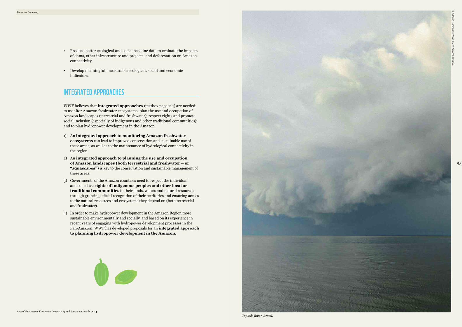
Tapajós River, Brazil.
© Adriano G
ambarini / W
WF-Living Am
azon Initiative
State of the Amazon: Freshwater Connectivity and Ecosystem Health p. 14
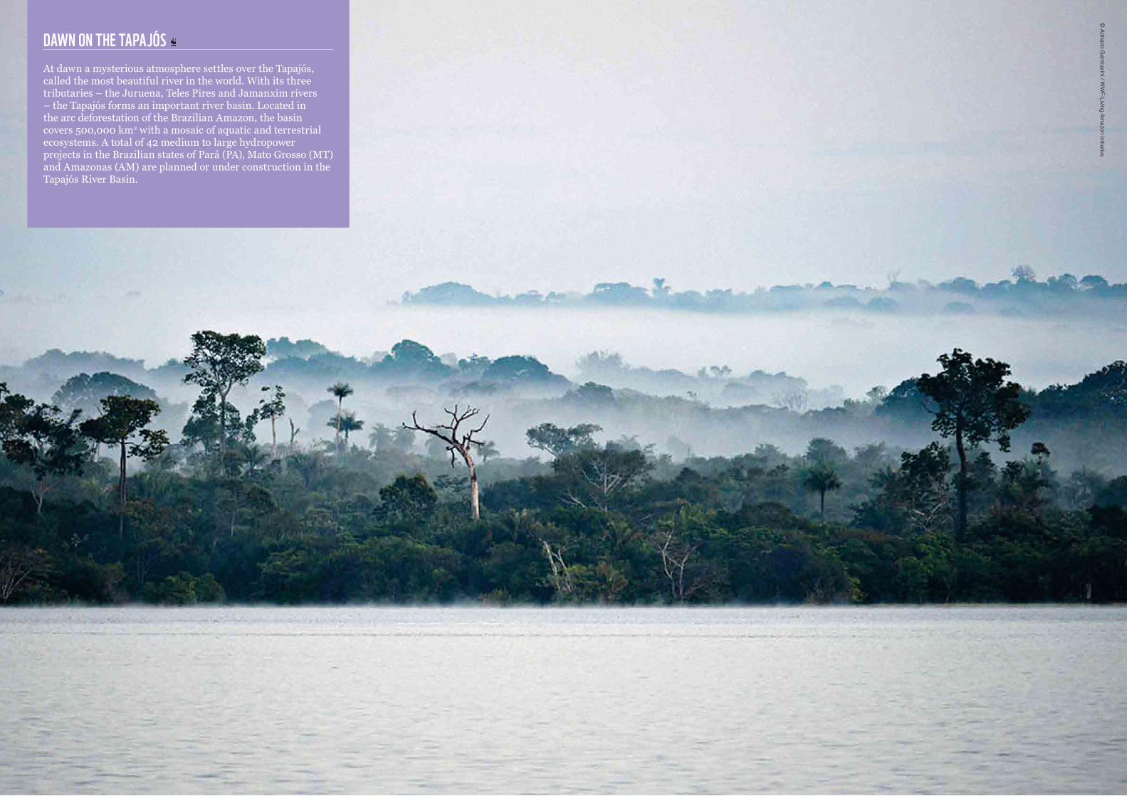
DAWN ON THE TAPAJÓS At dawn a mysterious atmosphere settles over the Tapajós, called the most beautiful river in the world. With its three tributaries – the Juruena, Teles Pires and Jamanxim rivers – the Tapajós forms an important river basin. Located in the arc deforestation of the Brazilian Amazon, the basin covers 500,000 km2 with a mosaic of aquatic and terrestrial ecosystems. A total of 42 medium to large hydropower projects in the Brazilian states of Pará (PA), Mato Grosso (MT) and Amazonas (AM) are planned or under construction in the Tapajós River Basin.
© Adriano G
ambarini / W
WF-Living Am
azon Initiative
The Amazon Region contains both the largest block of contiguous tropical forests and the largest river basin in the world. The Amazon Forest Biome spans an area of 6.5
million km2 and includes Amazonian forests and the contiguous forests of the Guiana Shield and Orinoco Basin.1 The Amazon River Basin, on the other hand, is the world’s largest river system, encompassing 6.9 million km2, 13 major tributaries and an extensive river network (Figure 1). Arising in the Peruvian Andes, the Amazon Basin drains moist tropical forests (Amazon) and savannahs (Cerrado), flowing nearly 7,000km before reaching Brazil’s Atlantic coast. At its mouth, the Amazon discharges approximately 6,700km3 yr-1 of freshwater into the Atlantic Ocean, representing 20 per cent of global surface river flows (Coe et al. 2008). The Basin’s native forests and savannahs return an estimated 9,600km3 y-1 of rainwater to the atmosphere via evapotranspiration2 (ET), helping regulate regional climate. This remarkable hydrological system supports well over one million km2 of freshwater ecosystems (Castello et al. 2013) and is home to some of the most diverse species assemblages on earth (Reis et al. 2003, Abell et al. 2008). Subsistence and commercial fisheries are estimated to yield nearly 425,000 tonnes of fish each year, providing a vital source of protein and income for Amazonians (Bayley 1998, Goulding et al. 2003, Junk et al. 2007). The river network is the lifeblood of the regional economy, providing the primary means of food and energy production, transportation, and other vital ecosystem services.
Despite their regional and global importance, today Amazon freshwater ecosystems face unprecedented development pressures. Deforestation, cattle ranching, agricultural expansion and infrastructure development are rapidly transforming the region’s rivers, with the potential to irreversibly alter their hydrology, geomorphology and ecological integrity. Although a considerable body of research exists on the mainstem Amazon River and its floodplains, studies are generally limited in scope, focusing on specific regions, species or drivers of change. The Basin’s other freshwater ecosystems have been largely ignored in the mainstream science and policy arenas. As a result, the data and management structures needed to conserve them are virtually non-existent (Junk and Piedade 2004). At the same time, economic activities and infrastructure development – particularly the construction of roads and hydroelectric dams – is proceeding at a scale and pace never before seen in the region. Studies investigating the impacts of these changes have also been limited in the scale and scope of analysis, highlighting an urgent need for a synthetic, basin-wide assessment of the causes and consequences of human development activities on Amazon freshwater ecosystems.
1 There are many different definitions of the “Amazon”. The most commonly used boundary encompasses the drainage area of the Amazon River Basin. In contrast, a legal/geopolitical definition of the Amazon Region includes all countries participating in the Amazon Cooperation Treaty. One of the most widely adopted concepts is that of the Amazon Biome, defined as the area covered predominantly by dense, moist tropical rainforest. This region includes a diversity of other vegetation types (including savannahs, floodplain forests, grasslands, swamps, bamboos and palm forests) and unique freshwater ecosystems. The Amazon Biome is the definition adopted by WWF and presented in this report (Maretti et al. 2014).
2 Estimates are based on the MODIS ET (MOD16) data product, available at http://www.ntsg.umt.edu/project/mod16.
INTRODUCTION
Introduction©
Denise Oliveira/W
WF-Living Am
azon Initiative
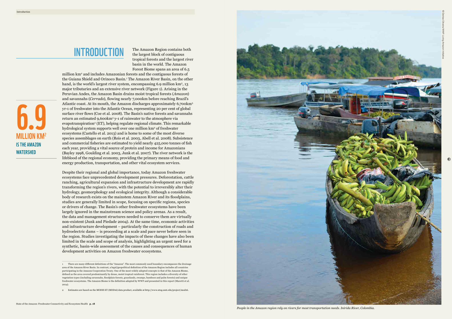
People in the Amazon region rely on rivers for most transportation needs. Inirida River, Colombia.
6.9
MILLION KM2 IS THE AMAZON WATERSHED
State of the Amazon: Freshwater Connectivity and Ecosystem Health p. 18
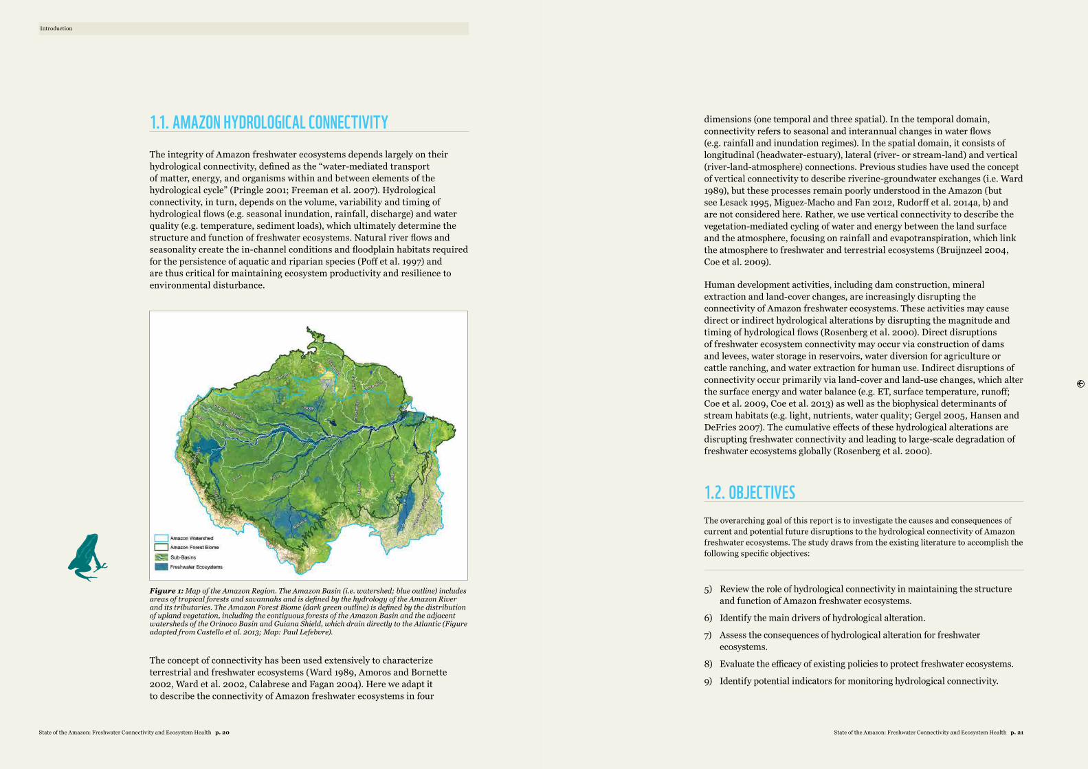
1.1. AMAZON HYDROLOGICAL CONNECTIVITY The integrity of Amazon freshwater ecosystems depends largely on their hydrological connectivity, defined as the “water-mediated transport of matter, energy, and organisms within and between elements of the hydrological cycle” (Pringle 2001; Freeman et al. 2007). Hydrological connectivity, in turn, depends on the volume, variability and timing of hydrological flows (e.g. seasonal inundation, rainfall, discharge) and water quality (e.g. temperature, sediment loads), which ultimately determine the structure and function of freshwater ecosystems. Natural river flows and seasonality create the in-channel conditions and floodplain habitats required for the persistence of aquatic and riparian species (Poff et al. 1997) and are thus critical for maintaining ecosystem productivity and resilience to environmental disturbance.
Figure 1: Map of the Amazon Region. The Amazon Basin (i.e. watershed; blue outline) includes areas of tropical forests and savannahs and is defined by the hydrology of the Amazon River and its tributaries. The Amazon Forest Biome (dark green outline) is defined by the distribution of upland vegetation, including the contiguous forests of the Amazon Basin and the adjacent watersheds of the Orinoco Basin and Guiana Shield, which drain directly to the Atlantic (Figure adapted from Castello et al. 2013; Map: Paul Lefebvre).
The concept of connectivity has been used extensively to characterize terrestrial and freshwater ecosystems (Ward 1989, Amoros and Bornette 2002, Ward et al. 2002, Calabrese and Fagan 2004). Here we adapt it to describe the connectivity of Amazon freshwater ecosystems in four
dimensions (one temporal and three spatial). In the temporal domain, connectivity refers to seasonal and interannual changes in water flows (e.g. rainfall and inundation regimes). In the spatial domain, it consists of longitudinal (headwater-estuary), lateral (river- or stream-land) and vertical (river-land-atmosphere) connections. Previous studies have used the concept of vertical connectivity to describe riverine-groundwater exchanges (i.e. Ward 1989), but these processes remain poorly understood in the Amazon (but see Lesack 1995, Miguez-Macho and Fan 2012, Rudorff et al. 2014a, b) and are not considered here. Rather, we use vertical connectivity to describe the vegetation-mediated cycling of water and energy between the land surface and the atmosphere, focusing on rainfall and evapotranspiration, which link the atmosphere to freshwater and terrestrial ecosystems (Bruijnzeel 2004, Coe et al. 2009).
Human development activities, including dam construction, mineral extraction and land-cover changes, are increasingly disrupting the connectivity of Amazon freshwater ecosystems. These activities may cause direct or indirect hydrological alterations by disrupting the magnitude and timing of hydrological flows (Rosenberg et al. 2000). Direct disruptions of freshwater ecosystem connectivity may occur via construction of dams and levees, water storage in reservoirs, water diversion for agriculture or cattle ranching, and water extraction for human use. Indirect disruptions of connectivity occur primarily via land-cover and land-use changes, which alter the surface energy and water balance (e.g. ET, surface temperature, runoff; Coe et al. 2009, Coe et al. 2013) as well as the biophysical determinants of stream habitats (e.g. light, nutrients, water quality; Gergel 2005, Hansen and DeFries 2007). The cumulative effects of these hydrological alterations are disrupting freshwater connectivity and leading to large-scale degradation of freshwater ecosystems globally (Rosenberg et al. 2000).
1.2. OBJECTIVES The overarching goal of this report is to investigate the causes and consequences of current and potential future disruptions to the hydrological connectivity of Amazon freshwater ecosystems. The study draws from the existing literature to accomplish the following specific objectives:
5) Review the role of hydrological connectivity in maintaining the structure and function of Amazon freshwater ecosystems.
6) Identify the main drivers of hydrological alteration.
7) Assess the consequences of hydrological alteration for freshwater ecosystems.
8) Evaluate the efficacy of existing policies to protect freshwater ecosystems.
9) Identify potential indicators for monitoring hydrological connectivity.
Introduction
State of the Amazon: Freshwater Connectivity and Ecosystem Health p. 21State of the Amazon: Freshwater Connectivity and Ecosystem Health p. 20
RICH. The Amazon’s vast river network includes 100,000km of rivers and streams and the largest remaining contiguous block of tropical rainforest on the planet. Its rivers contain the largest number of freshwater fish
species in the world, and its forests house at least 10 per cent of the world’s known biodiversity, including endemic and endangered flora and fauna.
BIG. The Amazon Forest Biome encompasses 6.5 million km2, spanning nine countries and a third of South America. The Amazon River is the longest in the world, flowing nearly 7000km from its source in the Peruvian Andes to Brazil’s Atlantic coast. At its mouth the Amazon is more than 300km wide and discharges about 200,000m3 per second of freshwater into the Atlantic, roughly 20 per cent of global surface river flows.
DYNAMIC. River levels in the Amazon floodplain vary by as much as 20m over the course of a single year. Strong variations in seasonal rainfall are responsible for the river’s dramatic ebb and flow, which helps maintain diverse habitats and immensely productive ecosystems.
CONNECTED. Hydrological connections link freshwater and terrestrial ecosystems to each other, to the ocean and to the atmosphere. The amount and seasonality of rainfall is controlled primarily by the South American Monsoon System and trade winds, which regulate moisture transfer to the Amazon Biome. These connections drive seasonal flooding regimes, support diverse freshwater ecosystems and play a key role in maintaining ecological function.
PROTECTED. A network of conservation areas and indigenous territories legally protects 56 per cent of the Amazon Biome. The region’s 390 protected areas conserve 167 million ha of the region’s forests (25 per cent of the biome), while 3,043 indigenous territories protect an additional 208 million ha (31 per cent of the biome).
VITAL. The Amazon provides vital ecosystem services such as water recycling, food production and carbon storage. Its rivers yield more than 400,000 tonnes of fish each year, supporting regional fisheries and local protein consumption. Its forests recycle 50-75 per cent of annual rainfall back to the atmosphere, helping regulate rainfall in key agricultural regions. The forests also store 100 billion tonnes of carbon, equivalent to 10 years of global fossil fuel emissions, and are key to the stability of the Earth system.
But the Amazon is also:
THREATENED. Roughly 20 per cent of the Amazon watershed (10-12 per cent of the biome) has already been deforested, and remaining forests face a variety of pressures, including agricultural expansion, energy development, mineral extraction and climate change. Protected areas are increasingly vulnerable to downgrading, downsizing and degazettement. Left unchecked, these threats could push Amazonian ecosystems beyond a tipping point, triggering a vicious feedback cycle of further fragmentation and degradation.
THE AMAZON IS:By Claudio Maretti et al.*
VULNERABLE. Despite relatively high levels of formal protection, Amazon biodiversity – and especially freshwater biodiversity – remains poorly protected. The protected area network does not adequately represent some of the region’s most sensitive freshwater ecosystems, notably the headwaters regions of the western Amazon and the central Amazon floodplains.
Protected areas are also vulnerable to threats arising outside their boundaries, including climate change, wildfires and loss of hydrological connectivity.
UNEXPLORED. Despite immense pressures on native flora and fauna, much of the Amazon’s biodiversity remains relatively unexplored. For example, just 2,500 Amazon fish species have been described to date, although estimates suggest the region may contain as many as 6,000-8,000 fish species. New species are being discovered every year, but many more may be lost before they are described.
REFERENCESBayley, P. B. 1998. Aquatic Biodiversity and Fisheries Management in the Amazon. United Nations and World
Bank, Rome.
D’Almeida, C., C. J. Vorosmarty, G. C. Hurtt, J. A. Marengo, S. L. Dingman and B. D. Keim. 2007. The effects of deforestation on the hydrological cycle in Amazonia: a review on scale and resolution. International Journal of Climatology 27:633-647.
Davidson, E. A., A. C. de Araujo, P. Artaxo, J. K. Balch, I. F. Brown, M. M. C. Bustamante, M. T. Coe, R. S. DeFries, M. Keller, M. Longo, J. W. Munger, W. Schroeder, B. S. Soares, C. M. Souza and S. C. Wofsy. 2012. The Amazon basin in transition. Nature 481:321-328.
Goulding, M., R. Barthem and E. J. G. Ferreira. 2003. The Smithsonian Atlas of the Amazon. Smithsonian Institution Press, Washington, DC.
Lathuillière, M. J., M. S. Johnson and S. D. Donner. 2012. Water use by terrestrial ecosystems: temporal variability in rainforest and agricultural contributions to evapotranspiration in Mato Grosso, Brazil. Environmental Research Letters 7:024024.
Malhi, Y., E. Pegoraro, A. D. Nobre, M. G. P. Pereira, J. Grace, A. D. Culf and R. Clement. 2002. Energy and water dynamics of a central Amazonian rain forest. Journal of Geophysical Research-Atmospheres 107.
Maretti, C.C., J.C. Riveros, R. Hofstede, D. Oliveira, S. Charity, T. Granizo, C. Alvarez, P. Valdujo and C. Thompson. 2014. State of the Amazon: Ecological Representation in Protected Areas and Indigenous Territories. WWF Living Amazon (Global) Initiative, Brasília and Quito.
Reis, R. E., S. O. Kullander and C. Ferraris, Jr. 2003. Check list of the freshwater fishes of South and Central America. EDIPUCRS, Porto Alegre.
Schaefer, S. A. 1998. Conflict and resolution: impact of new taxa on phylogenetic studies of the neotropical Cascudinhos (Siluroidei: Loricaridae). Pages 375-400 in L. R. Malabarba, R. E. Reis, R. P. Vari, Z. M. S. Lucena, and C. A. S. Lucena, editors. Phylogeny and Classification of Neotropical Fishes. EDIPUCRS, Porto Alegre.
The Amazon is:
* Maretti, C. C., J. C. Riveros, R. Hofstede, D. Oliveira, S. Charity, T. Granizo, C. Alvarez, P. Valdujo, and C. Thompson. 2014. State of the Amazon: Ecological representation in protected areas and indigenous territories, WWF Living Amazon (Global) Initiative, Brasília, Brazil.
© Funai / G
leilson Miranda
In the Amazon region, 60 indigenous groups still live in voluntary isolation.
State of the Amazon: Freshwater Connectivity and Ecosystem Health p. 23State of the Amazon: Freshwater Connectivity and Ecosystem Health p. 22
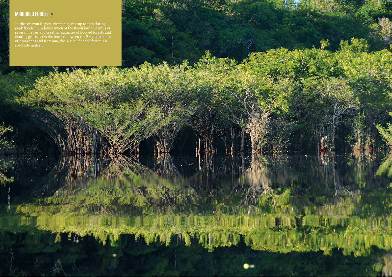
MIRRORED FOREST In the Amazon Region, rivers may rise up to 15m during peak floods, inundating much of the floodplain to depths of several metres and creating expanses of flooded forests and floating grasses. On the border between the Brazilian states of Amazonas and Roraima, the Xixuaú flooded forest is a spectacle in itself.
© W
WF-Brasil / Zig Koch
State of the Amazon: Freshwater Connectivity and Ecosystem Health p. 25State of the Amazon: Freshwater Connectivity and Ecosystem Health p. 24
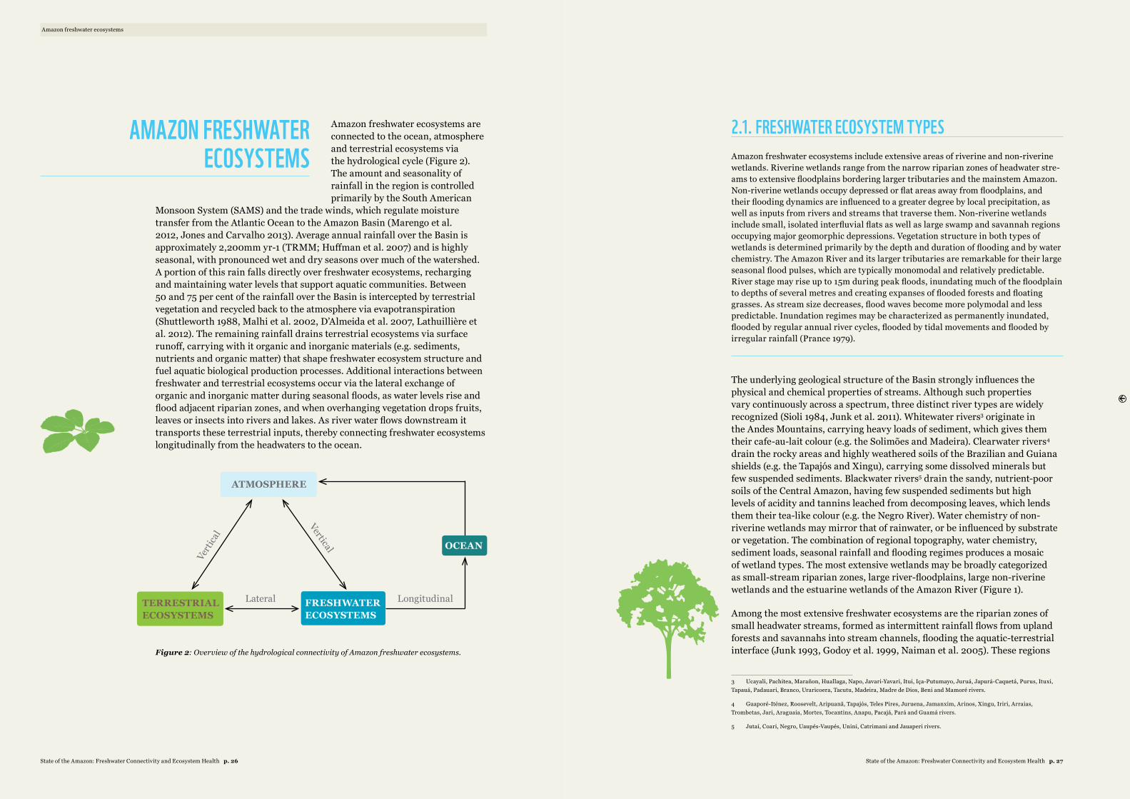
Amazon freshwater ecosystems are connected to the ocean, atmosphere and terrestrial ecosystems via the hydrological cycle (Figure 2). The amount and seasonality of rainfall in the region is controlled primarily by the South American
Monsoon System (SAMS) and the trade winds, which regulate moisture transfer from the Atlantic Ocean to the Amazon Basin (Marengo et al. 2012, Jones and Carvalho 2013). Average annual rainfall over the Basin is approximately 2,200mm yr-1 (TRMM; Huffman et al. 2007) and is highly seasonal, with pronounced wet and dry seasons over much of the watershed. A portion of this rain falls directly over freshwater ecosystems, recharging and maintaining water levels that support aquatic communities. Between 50 and 75 per cent of the rainfall over the Basin is intercepted by terrestrial vegetation and recycled back to the atmosphere via evapotranspiration (Shuttleworth 1988, Malhi et al. 2002, D’Almeida et al. 2007, Lathuillière et al. 2012). The remaining rainfall drains terrestrial ecosystems via surface runoff, carrying with it organic and inorganic materials (e.g. sediments, nutrients and organic matter) that shape freshwater ecosystem structure and fuel aquatic biological production processes. Additional interactions between freshwater and terrestrial ecosystems occur via the lateral exchange of organic and inorganic matter during seasonal floods, as water levels rise and flood adjacent riparian zones, and when overhanging vegetation drops fruits, leaves or insects into rivers and lakes. As river water flows downstream it transports these terrestrial inputs, thereby connecting freshwater ecosystems longitudinally from the headwaters to the ocean.
ATMOSPHERE
OCEAN
TERRESTRIALECOSYSTEMS
FRESHWATERECOSYSTEMS
Verti
cal
Vertical
LongitudinalLateral
Figure 2: Overview of the hydrological connectivity of Amazon freshwater ecosystems.
2.1. FRESHWATER ECOSYSTEM TYPES Amazon freshwater ecosystems include extensive areas of riverine and non-riverine wetlands. Riverine wetlands range from the narrow riparian zones of headwater stre-ams to extensive floodplains bordering larger tributaries and the mainstem Amazon. Non-riverine wetlands occupy depressed or flat areas away from floodplains, and their flooding dynamics are influenced to a greater degree by local precipitation, as well as inputs from rivers and streams that traverse them. Non-riverine wetlands include small, isolated interfluvial flats as well as large swamp and savannah regions occupying major geomorphic depressions. Vegetation structure in both types of wetlands is determined primarily by the depth and duration of flooding and by water chemistry. The Amazon River and its larger tributaries are remarkable for their large seasonal flood pulses, which are typically monomodal and relatively predictable. River stage may rise up to 15m during peak floods, inundating much of the floodplain to depths of several metres and creating expanses of flooded forests and floating grasses. As stream size decreases, flood waves become more polymodal and less predictable. Inundation regimes may be characterized as permanently inundated, flooded by regular annual river cycles, flooded by tidal movements and flooded by irregular rainfall (Prance 1979).
The underlying geological structure of the Basin strongly influences the physical and chemical properties of streams. Although such properties vary continuously across a spectrum, three distinct river types are widely recognized (Sioli 1984, Junk et al. 2011). Whitewater rivers3 originate in the Andes Mountains, carrying heavy loads of sediment, which gives them their cafe-au-lait colour (e.g. the Solimões and Madeira). Clearwater rivers4 drain the rocky areas and highly weathered soils of the Brazilian and Guiana shields (e.g. the Tapajós and Xingu), carrying some dissolved minerals but few suspended sediments. Blackwater rivers5 drain the sandy, nutrient-poor soils of the Central Amazon, having few suspended sediments but high levels of acidity and tannins leached from decomposing leaves, which lends them their tea-like colour (e.g. the Negro River). Water chemistry of non-riverine wetlands may mirror that of rainwater, or be influenced by substrate or vegetation. The combination of regional topography, water chemistry, sediment loads, seasonal rainfall and flooding regimes produces a mosaic of wetland types. The most extensive wetlands may be broadly categorized as small-stream riparian zones, large river-floodplains, large non-riverine wetlands and the estuarine wetlands of the Amazon River (Figure 1).
Among the most extensive freshwater ecosystems are the riparian zones of small headwater streams, formed as intermittent rainfall flows from upland forests and savannahs into stream channels, flooding the aquatic-terrestrial interface (Junk 1993, Godoy et al. 1999, Naiman et al. 2005). These regions
3 Ucayali, Pachitea, Marañon, Huallaga, Napo, Javari-Yavari, Itui, Iça-Putumayo, Juruá, Japurá-Caquetá, Purus, Ituxi, Tapauá, Padauari, Branco, Uraricoera, Tacutu, Madeira, Madre de Dios, Beni and Mamoré rivers.
4 Guaporé-Iténez, Roosevelt, Aripuanã, Tapajós, Teles Pires, Juruena, Jamanxim, Arinos, Xingu, Iriri, Arraias, Trombetas, Jari, Araguaia, Mortes, Tocantins, Anapu, Pacajá, Pará and Guamá rivers.
5 Jutaí, Coari, Negro, Uaupés-Vaupés, Unini, Catrimani and Jauaperi rivers.
Amazon freshwater ecosystems
AMAZON FRESHWATER ECOSYSTEMS
State of the Amazon: Freshwater Connectivity and Ecosystem Health p. 27State of the Amazon: Freshwater Connectivity and Ecosystem Health p. 26
are thought to be the principal zones of lateral interaction between terrestrial and freshwater ecosystems – exchanging water, nutrients, sediments and organic matter, and directly connecting upland landscapes to the rest of the stream network (McClain and Elsenbeer 2001, Biggs et al. 2004, Wipfli et al. 2007). Despite their small size, headwater streams are numerous and may account for as much as two-thirds of total stream length (Freeman et al. 2007). The riparian zones of these headwater streams have important ecological functions (Chaves et al. 2009, Lorion and Kennedy 2009, Ribeiro et al. 2012, Macedo et al. 2013) and may occupy a substantial portion of the Amazon Basin (Junk 1993), though precise area estimates of their total extent are lacking.
Seasonal rainfall produces “flood pulses” in the lower reaches of major tributaries, which connect river channels with their adjacent floodplains during part of the year (Figure 3). During annual floods, the heavy loads of organic and inorganic sediments in whitewater rivers create fertile floodplain deposits that support diverse forests and aquatic macrophyte communities. The annual rise and fall of river waters also induces lateral exchanges of organic and inorganic materials between river channels and floodplain ecosystems, promoting high rates of biological production. These seasonal variations in water level are the principal control on biogeochemical processes in river-floodplain ecosystems (Junk et al. 1989, Melack et al. 2009).
The Marañon-Ucayali region (Peru), Llanos de Moxos (Bolivia) and Bananal wetland (Brazil) occupy large structural depressions in which river networks traverse extensive areas of non-riverine wetlands. The Moxos and Bananal are primarily savannah wetlands with a mosaic of seasonally inundated grasslands, open woodlands, forested islands and lakes (Hamilton et al. 2002). The Marañon-Ucayali wetlands are primarily forested, with large expanses of palm swamps (aguajales) (Kalliola et al. 1991). In the Negro Basin, seasonal rainfall and a high water table in the flat, interfluvial regions cause swamps and flooded savannahs to form during the rainy season. These campina or campinarana wetlands are mosaics of shrub, palm, sedge and algal mat vegetation that are subject to relatively shallow flooding. In the savannah wetlands of the northern Roraima (Brazil) and Rupununi (Guyana) regions, streams, shallow lakes and ponds expand during the rainy season to flood extensive areas that are dominated by sedges and palms (Junk 1993). In the Amazon estuary, flooding in the central portions of Marajó Island is driven primarily by precipitation, while its margins are dominated by tidal cycles. The eastern portion of the island is covered by seasonally flooded grasslands, with small areas of scrub woodland, mangrove and forest, whereas the western part is occupied by tidally inundated forests, with patches of upland forest on higher ground (Smith 2002).
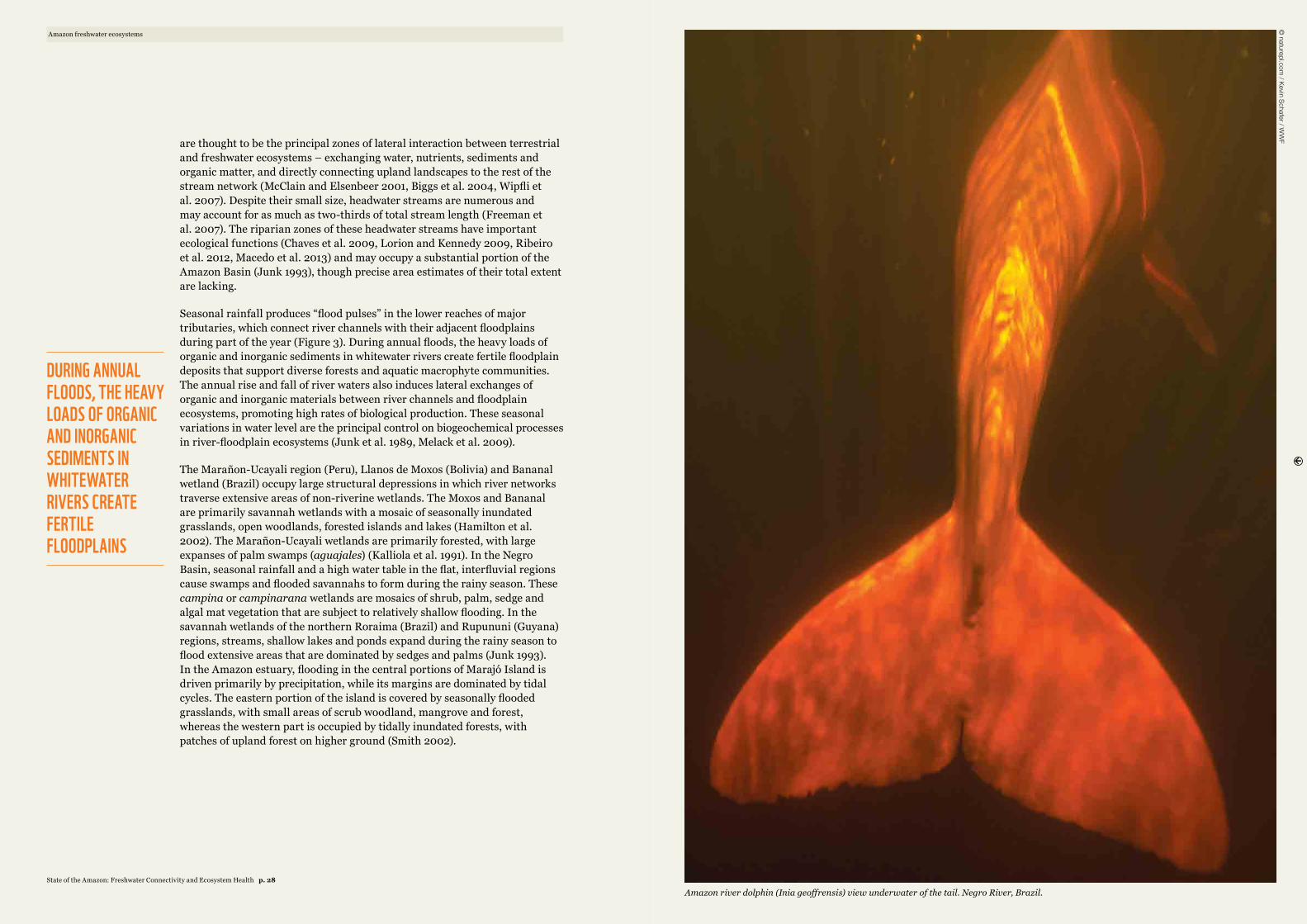
Amazon river dolphin (Inia geoffrensis) view underwater of the tail. Negro River, Brazil.
© naturepl.com
/ Kevin Schafer / WW
FAmazon freshwater ecosystems
DURING ANNUAL FLOODS, THE HEAVY LOADS OF ORGANIC AND INORGANIC SEDIMENTS IN WHITEWATER RIVERS CREATE FERTILE FLOODPLAINS
State of the Amazon: Freshwater Connectivity and Ecosystem Health p. 28
2.2. AQUATIC ECOSYSTEM SERVICES The biological productivity of Amazon freshwater ecosystems, and in particular of river-floodplains, has historically attracted people to settle near streams or rivers. Amazonians are so dependent on freshwater ecosystems in their daily lives that they are known as “water people” (Furtado et al. 1993). Although population settlement patterns in the Basin are changing, to this day much of the rural population obtains water for drinking and domestic use directly from streams and rivers; relies on rivers for most transportation needs; and harvests freshwater resources as a source of food and income (Junk et al. 2000). Amazon freshwater ecosystems thus contribute to human well-being in many important ways, including provision of key ecosystem services such as biodiversity maintenance, water quality and flow regulation, carbon cycling, and food (i.e. protein) and fibre production.
Amazon freshwater ecosystems sustain some of the most diverse plant and animal communities in the world. According to available estimates, the Amazon watershed contains between 6,000 and 8,000 fish species, of which only about 2,500 have been described to date (Schaefer 1998, Reis et al. 2003). About half of those fish species are thought to inhabit larger rivers and their floodplains, while the rest occupy headwater streams whose geographical isolation promotes endemism and speciation (Junk and Piedade 2004). The diversity of bird and tree species is similarly high, with an estimated 1,000 flood-tolerant tree species and over 1,000 bird species inhabiting the lowland forests of the Central Amazon, including river-floodplains and low-lying upland ecosystems (Junk et al. 1989, Stotz et al. 1996). Much of this diversity occurs longitudinally along streams, rivers and other freshwater ecosystems, creating ecological corridors with specific environmental conditions that determine species occurrence and mediate their movement throughout the landscape (Van Der Windt and Swart 2008).
Amazon terrestrial and freshwater ecosystems transport, filter and regulate flows of water and materials throughout the hydrological cycle. As rainwaters drain through terrestrial ecosystems, riparian zones filter the organic and inorganic materials they carry, thus regulating water quality and aquatic biological integrity in downstream water bodies (Alexander et al. 2000). Terrestrial inputs are transported downstream, deposited, and remobilized in river-floodplains until they are discharged into the ocean (Wipfli et al. 2007, McClain and Naiman 2008). During this transport, freshwater ecosystems regulate river flows, buffering flows during high discharge periods and maintaining them during low discharge periods. This flow regulation enables river navigation, promotes soil infiltration, recharges groundwater stores and helps maintain the ecological conditions needed to sustain aquatic biota.
River-floodplain exchanges of organic and inorganic matter produce ~1700Mg C km-2 yr-1 (megagrams of carbon per km2 per year), a rate of production five times higher than that of upland forests (Melack and Forsberg 2001, McClain and Naiman 2008). About 93 per cent of
this biological production occurs in levee forests and C46 macrophyte communities (e.g. Echinochloa polystachya; Piedade et al. 1991). Net primary production (NPP) along river-floodplains in a 1.77 million km2 region of the Central Amazon has been estimated at ~298Tg C yr-1 (teragrams of carbon per year), of which ~210Tg C yr-1 are outgassed as CO2 to the atmosphere and subsequently recycled as NPP (Melack et al. 2009).
Flood pulses also promote productivity by allowing fish to exploit resources in the floodplains that are unavailable in river channels (Lagler et al. 1971, Goulding 1980, Castello 2008). Neotropical fish have evolved strategies to feed directly on primary producers in the floodplains (e.g. phytoplankton, tree fruits, seeds and detritus). As a result, they comprise a large share of the heterotrophic life forms in Amazonian freshwater ecosystems (Forsberg et al. 1993, Melack and Forsberg 2001, Lewis et al. 2011). As rising river waters flood adjacent floodplains, fish and their young migrate laterally to feed on their abundant plant-based food resources and to avoid predators, thus increasing their rates of growth and survival, and ultimately their biomass (Welcomme 1985, de Mérona and Gascuel 1993, Gomes and Agostinho 1997). Conversely, declining water levels tend to decrease survival and reduce fish biomass by constraining fish populations to river channels and still-water (lentic) areas, where water quality is lower and fish are more vulnerable to fishing gear and predation (Lagler et al. 1971, Welcomme 1985, de Mérona and Gascuel 1993). Given that fish biomass gains during floods generally exceed losses during low water, ecosystems dominated by flood pulses are about 50 per cent more productive than those with stable water levels (Bayley 1995).
“Sedentary” fish species spend their entire life cycles in the river-floodplains (e.g. Arapaima spp. – pirarucu or paiche; Cichla spp. – tucunaré), moving laterally from river channels into adjacent floodplain forests during seasonal floods. Some fish groups complement the resource gains achieved by these lateral migrations with long-distance longitudinal migrations along river channels. For example, migratory tributary and floodplain species, including the barred sorubim (Pseudoplatystoma – surubim or doncella) and black prochilodus (Prochilodus nigricans – curimatá or bocachico), travel hundreds of kilometres along river channels, but their populations are generally constrained to single tributaries or connected to mainstem whitewater floodplains (Ribeiro and Petrere 1990; Barthem and Goulding 2007). In contrast, long-distance migratory catfish species such as the gilded catfish (Brachyplatystoma rousseauxii – dourada) can travel thousands of kilometres from the Amazon’s estuary, where they reside and grow at young ages, to its headwaters in the Andean foothills, where they spawn in adulthood. These migratory catfish are among the few known commercially valuable species that do not migrate laterally onto the floodplains (Barthem and Goulding 1997).
6 The terms C3 and C4 refer to the two primary pathways of photosynthesis and carbon fixation by plants. C3 plants rely exclusively on the Calvin cycle for carbon fixation (roughly 95% of all plants on earth). C4 plants (e.g. grasses, sugar cane, maize) have special adaptations that allow them to separate the initial carbon fixation step from the Calvin cycle. Although C4 plants require more energy, they are generally faster and more efficient at carbon fixation, particularly in tropical environments.
Amazon freshwater ecosystems
AMAZONIANS ARE SO DEPENDENT ON FRESHWATER ECOSYSTEMS IN THEIR DAILY LIVES THAT THEY ARE KNOWN AS “WATER PEOPLE”
State of the Amazon: Freshwater Connectivity and Ecosystem Health p. 31State of the Amazon: Freshwater Connectivity and Ecosystem Health p. 30
Many other species depend on rivers and floodplain resources, including turtles (Podocnemis spp.), caimans (e.g. Melanosuchus niger), otters (Pteronura brasiliensis) and dolphins (Inia geoffrensis, Inia boliviensis and Sotalia fluviatilis) – all of which have life cycles dependent on lateral migrations onto the floodplains. Although they generally do not migrate longitudinally over long (>100km) distances , these species do use the floodplains for feeding, nesting and other key aspects of their life cycles (Martin and da Silva 2004, Martin et al. 2004, Fachín-Terán et al. 2006, Da Silveira et al. 2010, Da Silveira et al. 2011).
Fish consumption in the Amazon is high. According to available estimates, the maximum sustainable production potential of inland fisheries in the Amazon watershed is 900,000 t yr-1 (Bayley and Petrere Jr. 1989), and roughly half that amount is harvested annually (Bayley 1998, Goulding et al. 2003). Information on fish yields is lacking for much of the Amazon Region, but in the Brazilian Amazon the inland fish harvest, together with estuarine, marine and aquaculture harvests, sustains average per capita fish consumption rates of 94kg yr-1 among riverine populations and 40kg yr-1 among urban populations – both relatively high compared with the global average of 16kg yr-1 (Isaacand Almeida 2011). Game animals associated with freshwater ecosystems also contribute to food security, including caiman (e.g. Melanosuchus niger) and turtle (Podocnemis spp.) species that are widely harvested for consumption (Da Silveira et al. 2011).
Many terrestrial animals inhabit freshwater ecosystems year-round or during the dry season to access water and feed on fruits, leaves and other animals (Naiman and Decamps 1997, Bodmer et al. 1999). Riparian forest areas serve as important migration corridors for wide-ranging terrestrial species such as jaguars (Panthera onca), tapirs (e.g. Tapirus terrestris) and peccaries (e.g. Tayassu pecari), particularly in human-dominated landscapes (Keuroghlian and Eaton 2008, Lees and Peres 2008). Some terrestrial and migratory bird species also use wetlands as seasonal feeding grounds when low water levels concentrate prey fish in lakes and channels (Petermann 1997). Amazonians know these game-wetland associations well and have long hunted along streams and rivers (Bodmer et al. 1999).
A number of other freshwater resources generate large-scale economic activities, including palm fruits such as açai (Euterpe oleracea) in the estuary and miriti (Mauritia flexuosa) in the Marañon-Ucayali sub-basin (Padoch 1988, Brondízio 2008), as well as timber species such as capirona (Calycophyllum spruceanum) and tropical cedar (Cedrela odorata) along river-floodplains (Pinedo-Vasquez et al. 2001). Economic studies in the Amazon and elsewhere indicate that resources produced by tropical freshwater ecosystems can contribute as much as two-thirds of rural household income (McGrath et al. 2008, Ewel 2009).
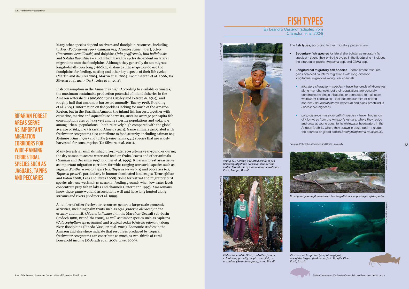
The fish types, according to their migratory patterns, are:
• Sedentary fish species (or lateral short-distance migratory fish species) – spend their entire life cycles in the floodplains – includes the pirarucu or paiche Arapaima spp. and Cichla spp.
• Longitudinal migratory fish species – complement resource gains achieved by lateral migrations with long-distance longitudinal migrations along river channels:
• Migratory characiform species – travel hundreds of kilometres along river channels, but their populations are generally constrained to single tributaries or connected to mainstem whitewater floodplains – includes the surubim or barred sorubim Pseudoplatystoma fasciatum and black prochilodus Prochilodus nigricans.
• Long-distance migratory catfish species – travel thousands of kilometres from the Amazon’s estuary, where they reside and grow at young ages, to its whitewater headwaters in the Andean foothills, where they spawn in adulthood – includes the dourada or gilded catfish Brachyplatystoma rousseauxii.
FISH TYPESBy Leandro Castello* (adapted from
Crampton et al. 2004)
*Virginia Polytechnic Institute and State University
© M
ichel Roggo / WW
F
Pirarucu or Arapaima (Arapaima gigas), one of the largest freshwater fish. Tapajós River, Pará, Brazil.
Young boy holding a Spotted sorubim fish(Pseudoplatystoma coruscans) under thewater. Mountains of Tumucumaque NationalPark, Amapa, Brazil.
Brachyplatystoma filamentosum is a long-distance migratory catfish species.
© Zig Koch / W
WF
© M
ark Sabaj Perez
Fisher Juvenal da Silva, and other fishers, exhibinting proudly the pirarucu fish, or arapaima (Arapaima gigas), Acre, Brazil.
© W
WF-Brazil / Edison C
aetano
RIPARIAN FOREST AREAS SERVE AS IMPORTANT MIGRATION CORRIDORS FOR WIDE-RANGING TERRESTRIAL SPECIES SUCH AS JAGUARS, TAPIRS AND PECCARIES
Amazon freshwater ecosystems
State of the Amazon: Freshwater Connectivity and Ecosystem Health p. 33State of the Amazon: Freshwater Connectivity and Ecosystem Health p. 32
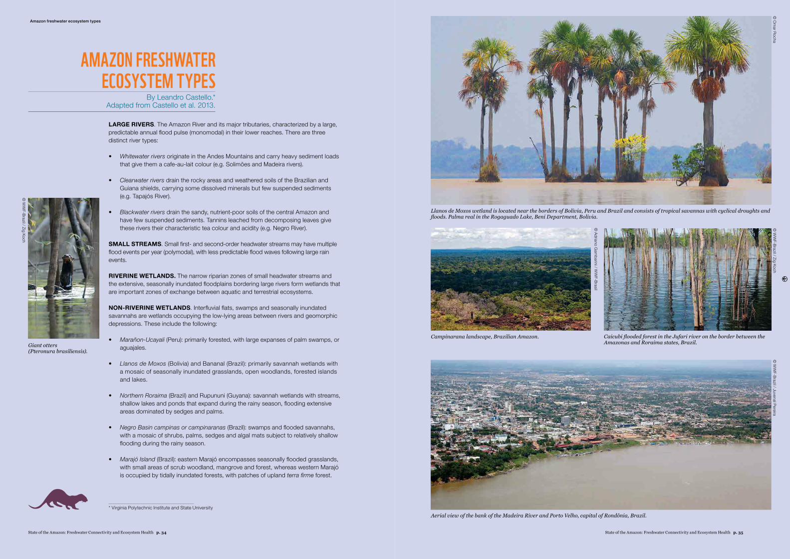
LARGE RIVERS. The Amazon River and its major tributaries, characterized by a large, predictable annual flood pulse (monomodal) in their lower reaches. There are three distinct river types:
• Whitewater rivers originate in the Andes Mountains and carry heavy sediment loads that give them a cafe-au-lait colour (e.g. Solimões and Madeira rivers).
• Clearwater rivers drain the rocky areas and weathered soils of the Brazilian and Guiana shields, carrying some dissolved minerals but few suspended sediments (e.g. Tapajós River).
• Blackwater rivers drain the sandy, nutrient-poor soils of the central Amazon and have few suspended sediments. Tannins leached from decomposing leaves give these rivers their characteristic tea colour and acidity (e.g. Negro River).
SMALL STREAMS. Small first- and second-order headwater streams may have multiple flood events per year (polymodal), with less predictable flood waves following large rain events.
RIVERINE WETLANDS. The narrow riparian zones of small headwater streams and the extensive, seasonally inundated floodplains bordering large rivers form wetlands that are important zones of exchange between aquatic and terrestrial ecosystems.
NON-RIVERINE WETLANDS. Interfluvial flats, swamps and seasonally inundated savannahs are wetlands occupying the low-lying areas between rivers and geomorphic depressions. These include the following:
• Marañon-Ucayali (Peru): primarily forested, with large expanses of palm swamps, or aguajales.
• Llanos de Moxos (Bolivia) and Bananal (Brazil): primarily savannah wetlands with a mosaic of seasonally inundated grasslands, open woodlands, forested islands and lakes.
• Northern Roraima (Brazil) and Rupununi (Guyana): savannah wetlands with streams, shallow lakes and ponds that expand during the rainy season, flooding extensive areas dominated by sedges and palms.
• Negro Basin campinas or campinaranas (Brazil): swamps and flooded savannahs, with a mosaic of shrubs, palms, sedges and algal mats subject to relatively shallow flooding during the rainy season.
• Marajó Island (Brazil): eastern Marajó encompasses seasonally flooded grasslands, with small areas of scrub woodland, mangrove and forest, whereas western Marajó is occupied by tidally inundated forests, with patches of upland terra firme forest.
AMAZON FRESHWATER ECOSYSTEM TYPES
By Leandro Castello.* Adapted from Castello et al. 2013.
Amazon freshwater ecosystem types
* Virginia Polytechnic Institute and State University
Llanos de Moxos wetland is located near the borders of Bolivia, Peru and Brazil and consists of tropical savannas with cyclical droughts and floods. Palma real in the Rogaguado Lake, Beni Department, Bolivia.
© O
mar Rocha
© Adriano G
ambarini / W
WF-Brasil
Campinarana landscape, Brazilian Amazon.
© W
WF-Brazil / Juvenal Pereira
© W
WF-Brazil / Zig Koch
Aerial view of the bank of the Madeira River and Porto Velho, capital of Rondônia, Brazil.
Giant otters (Pteronura brasiliensis).
Caicubi flooded forest in the Jufari river on the border between the Amazonas and Roraima states, Brazil.
© W
WF-Brazil / Zig Koch
State of the Amazon: Freshwater Connectivity and Ecosystem Health p. 35State of the Amazon: Freshwater Connectivity and Ecosystem Health p. 34
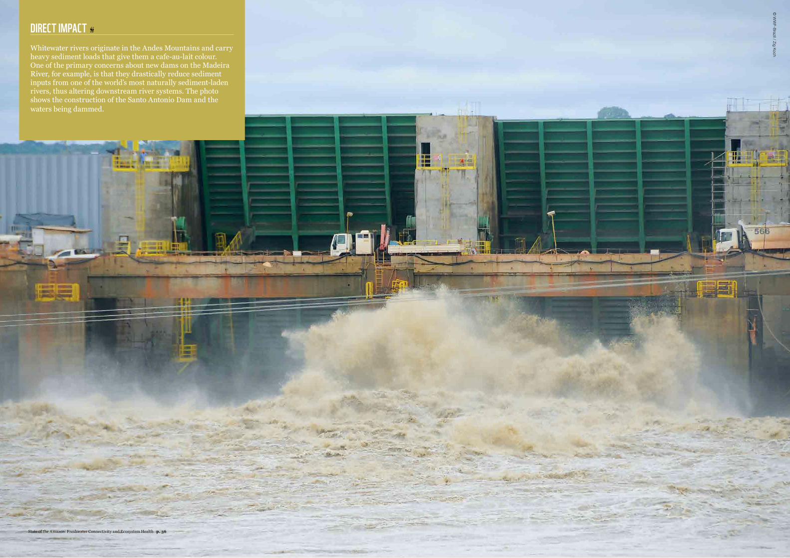
DIRECT IMPACT Whitewater rivers originate in the Andes Mountains and carry heavy sediment loads that give them a cafe-au-lait colour. One of the primary concerns about new dams on the Madeira River, for example, is that they drastically reduce sediment inputs from one of the world’s most naturally sediment-laden rivers, thus altering downstream river systems. The photo shows the construction of the Santo Antonio Dam and the waters being dammed.
© W
WF-Brazil / Zig Koch
State of the Amazon: Freshwater Connectivity and Ecosystem Health p. 36
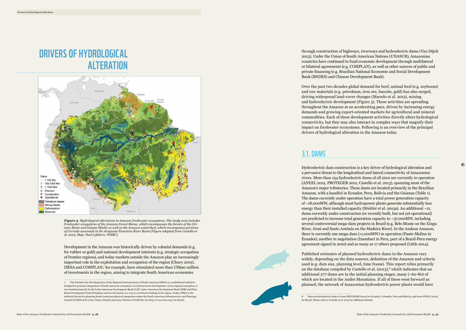
Figure 3: Hydrological alterations to Amazon freshwater ecosystems. The study area includes freshwater ecosystems of the Amazon Forest Biome, which encompasses the forests of the Ori-noco Basin and Guiana Shield, as well as the Amazon watershed, which encompasses portions of Cerrado savannah in the Araguaia-Tocantins River Basin (Figure adapted from Castello et al. 2013; Map: Paul Lefebvre, WHRC).
Development in the Amazon was historically driven by colonial demands (e.g. for rubber or gold) and national development interests (e.g. strategic occupation of frontier regions), and today markets outside the Amazon play an increasingly important role in the exploitation and occupation of the region (Cleary 2001). IIRSA and COSIPLAN,7 for example, have stimulated more than US$90 million of investments in the region, aiming to integrate South American economies
7 The Initiative for the Integration of the Regional Infrastructure of South America (IIRSA) is a multilateral initiative designed to promote integration of South American economies via infrastructure development. In its original conception, it was funded primarily by the Latin American Development Bank (CAF), Inter-American Development Bank (IDB) and Plata Basin Development Fund (Fonplata) and served mainly as a way to coordinate funding in the region. Today, IIRSA is the technical forum for planning South American physical integration under the South American Infrastructure and Planning Council (COSIPLAN) of the Union of South American Nations (UNASUR). See http://www.iirsa.org/ for details.
through construction of highways, riverways and hydroelectric dams (Van Dijick 2013). Under the Union of South American Nations (UNASUR), Amazonian countries have continued to fund economic development through multilateral or bilateral agreements (e.g. COSIPLAN), as well as other sources of public and private financing (e.g. Brazilian National Economic and Social Development Bank (BNDES) and Chinese Development Bank).
Over the past two decades global demand for beef, animal feed (e.g. soybeans) and raw materials (e.g. petroleum, iron ore, bauxite, gold) has also surged, driving widespread land-cover changes (Macedo et al. 2012), mining and hydroelectric development (Figure 3). These activities are spreading throughout the Amazon at an accelerating pace, driven by increasing energy demands and growing export-oriented markets for agricultural and mineral commodities. Each of these development activities directly alters hydrological connectivity, but they may also interact in complex ways that magnify their impact on freshwater ecosystems. Following is an overview of the principal drivers of hydrological alteration in the Amazon today.
3.1. DAMS Hydroelectric dam construction is a key driver of hydrological alteration and a pervasive threat to the longitudinal and lateral connectivity of Amazonian rivers. More than 154 hydroelectric dams of all sizes are currently in operation (ANEEL 2012, PROTEGER 2012, Castello et al. 2013), spanning most of the Amazon’s major tributaries. These dams are located primarily in the Brazilian Amazon, with a handful in Ecuador, Peru, Bolivia and the Guianas (Table 1). The dams currently under operation have a total power generation capacity of ~18,000MW, although most hydropower plants generate substantially less energy than their installed capacity (Stickler et al. 2013a). An additional ~21 dams currently under construction (or recently built, but not yet operational) are predicted to increase total generation capacity to ~37,000MW, including several controversial mega-dam projects in Brazil (e.g. Belo Monte on the Xingu River, Jiraú and Santo Antônio on the Madeira River). In the Andean Amazon, there is currently one mega-dam (>1,000MW) in operation (Paute-Molino in Ecuador), another in negotiation (Inambari in Peru, part of a Brazil-Peru energy agreement signed in 2010) and as many as 17 others proposed (Little 2014).
Published estimates of planned hydroelectric dams in the Amazon vary widely, depending on the data sources, definition of the Amazon and criteria used (e.g. dam size, planning level, time frame). This report relies primarily on the database compiled by Castello et al. (2013),8 which indicates that an additional 277 dams are in the initial planning stages, many (~60-80) of which are located in the Andes Mountains. If all of these went forward as planned, the network of Amazonian hydroelectric power plants would have
8 Data on hydroelectric dams is from PROTEGER (2012) for Ecuador, Colombia, Peru and Bolivia, and from ANEEL (2012) for Brazil. Please refer to Castello et al. 2013 for additional details.
Drivers of hydrological alteration
DRIVERS OF HYDROLOGICAL ALTERATION
State of the Amazon: Freshwater Connectivity and Ecosystem Health p. 39State of the Amazon: Freshwater Connectivity and Ecosystem Health p. 38
an installed capacity of ~95,000MW, and only three free-flowing Amazon tributaries would remain – two whitewater (Juruá and Iça-Putumayo) rivers and one clearwater (Trombetas) river. Other estimates report as many as 151 dams proposed in the Andes over the next 20 years (not all in advanced planning stages). If built, they would seriously disrupt longitudinal connectivity between Andean headwaters and lowland Amazon rivers and floodplains (Finer and Jenkins 2012, Little 2014). Regardless of the precise count, the hydrological impacts of large and medium dams are being exacerbated by the proliferation of small dams and impoundments (<2MW), which are increasingly common in the agricultural landscapes of the “arc of deforestation”. An estimated 10,000 small dams existed in the Upper Xingu Basin alone in 2007, averaging one per 7km of stream (Macedo et al. 2013). These small dams generally occur on private properties with a history of cattle ranching, having been installed to provide drinking water for cattle, generate electricity or facilitate road construction. Construction of small dams is unregulated despite their potentially large cumulative impact on small streams.
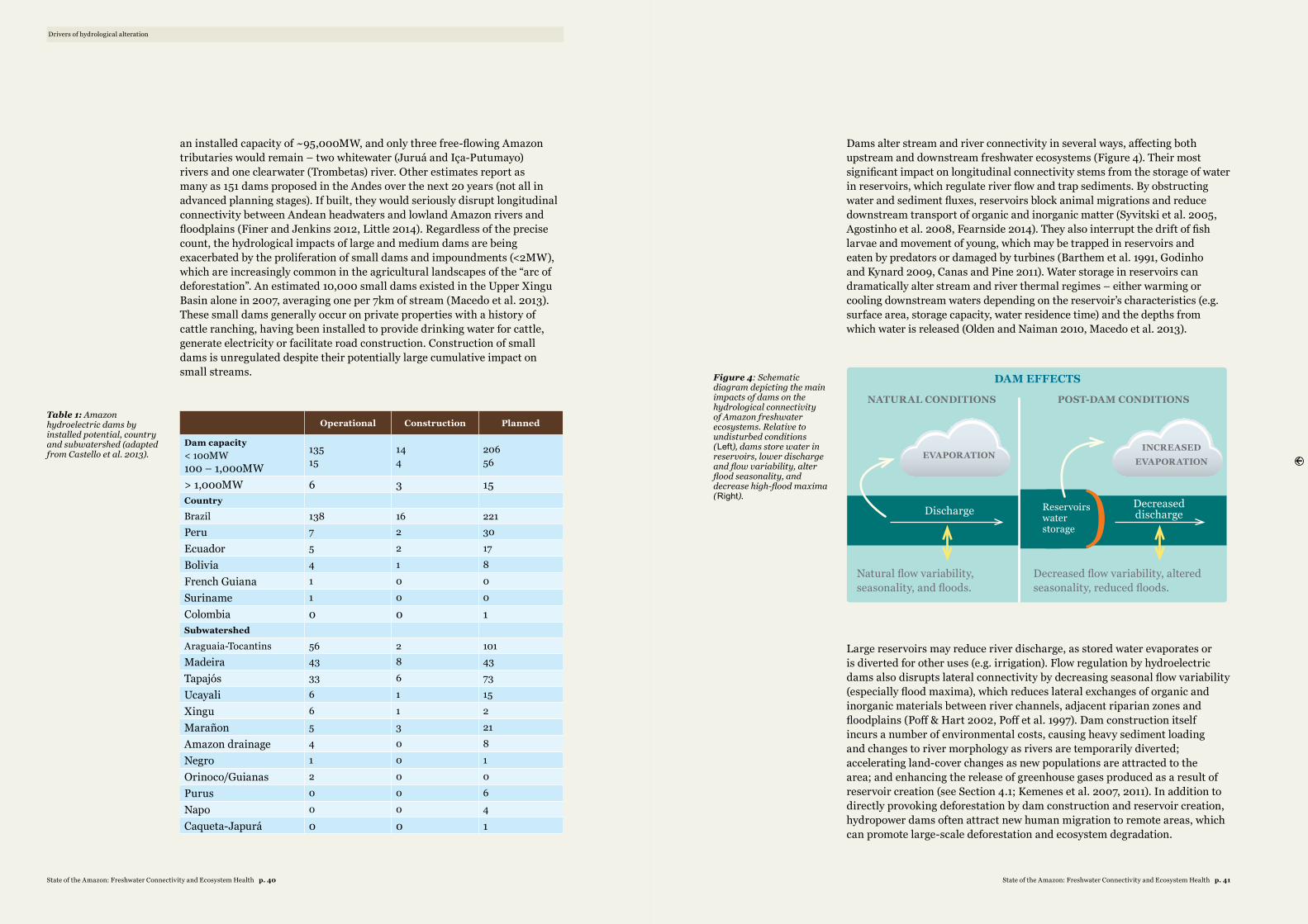
Operational Construction Planned
Dam capacity< 100MW100 – 1,000MW
13515
144
20656
> 1,000MW 6 3 15Country
Brazil 138 16 221Peru 7 2 30
Ecuador 5 2 17
Bolivia 4 1 8
French Guiana 1 0 0
Suriname 1 0 0
Colombia 0 0 1Subwatershed
Araguaia-Tocantins 56 2 101Madeira 43 8 43
Tapajós 33 6 73
Ucayali 6 1 15
Xingu 6 1 2
Marañon 5 3 21
Amazon drainage 4 0 8
Negro 1 0 1
Orinoco/Guianas 2 0 0
Purus 0 0 6
Napo 0 0 4
Caqueta-Japurá 0 0 1
Dams alter stream and river connectivity in several ways, affecting both upstream and downstream freshwater ecosystems (Figure 4). Their most significant impact on longitudinal connectivity stems from the storage of water in reservoirs, which regulate river flow and trap sediments. By obstructing water and sediment fluxes, reservoirs block animal migrations and reduce downstream transport of organic and inorganic matter (Syvitski et al. 2005, Agostinho et al. 2008, Fearnside 2014). They also interrupt the drift of fish larvae and movement of young, which may be trapped in reservoirs and eaten by predators or damaged by turbines (Barthem et al. 1991, Godinho and Kynard 2009, Canas and Pine 2011). Water storage in reservoirs can dramatically alter stream and river thermal regimes – either warming or cooling downstream waters depending on the reservoir’s characteristics (e.g. surface area, storage capacity, water residence time) and the depths from which water is released (Olden and Naiman 2010, Macedo et al. 2013).
DAM EFFECTS
NATURAL CONDITIONS POST-DAM CONDITIONS
)Natural flow variability, seasonality, and floods.
Decreased flow variability, altered seasonality, reduced floods.
Discharge Decreased discharge
EVAPORATIONINCREASED
EVAPORATION
Reservoirs water storage
Large reservoirs may reduce river discharge, as stored water evaporates or is diverted for other uses (e.g. irrigation). Flow regulation by hydroelectric dams also disrupts lateral connectivity by decreasing seasonal flow variability (especially flood maxima), which reduces lateral exchanges of organic and inorganic materials between river channels, adjacent riparian zones and floodplains (Poff & Hart 2002, Poff et al. 1997). Dam construction itself incurs a number of environmental costs, causing heavy sediment loading and changes to river morphology as rivers are temporarily diverted; accelerating land-cover changes as new populations are attracted to the area; and enhancing the release of greenhouse gases produced as a result of reservoir creation (see Section 4.1; Kemenes et al. 2007, 2011). In addition to directly provoking deforestation by dam construction and reservoir creation, hydropower dams often attract new human migration to remote areas, which can promote large-scale deforestation and ecosystem degradation.
Drivers of hydrological alteration
Table 1: Amazon hydroelectric dams by installed potential, country and subwatershed (adapted from Castello et al. 2013).
Figure 4: Schematic diagram depicting the main impacts of dams on the hydrological connectivity of Amazon freshwater ecosystems. Relative to undisturbed conditions (Left), dams store water in reservoirs, lower discharge and flow variability, alter flood seasonality, and decrease high-flood maxima (Right).
State of the Amazon: Freshwater Connectivity and Ecosystem Health p. 41State of the Amazon: Freshwater Connectivity and Ecosystem Health p. 40
3.2. LAND-COVER CHANGEDeforestation of native forests and savannahs for other land uses (i.e. land-cover change) can alter the connectivity of freshwater ecosystems in virtually every dimension. An estimated 1.4 million km2 (~20 per cent) of the Amazon Basin (defined as the watershed) has already been deforested, largely for the expansion of croplands and pasturelands (Hansen et al. 2013). These land-cover changes have occurred primarily along the southern and eastern flanks of the Basin, affecting the headwaters of the Araguaia-Tocantins, Xingu and Tapajós rivers. Since 2005, deforestation rates have decreased significantly, particularly in the Brazilian Amazon (Nepstad et al. 2009, Davidson et al. 2012, Macedo et al. 2012). However, growing international demand for beef, animal feed and raw materials fuels regional demand for energy and infrastructure, which in turn increases pressures on native ecosystems – especially in the Brazilian Cerrado, where legal protection is low (Soares-Filho et al. 2014) and in the Andean Amazon of Peru (Gutiérrez-Vélez et al. 2011), Bolivia and Ecuador.
LAND-COVER CHANGE EFFECTS
NATURAL CONDITIONS
LOCAL DEFORESTATION
Runoff
Discharge
Increased runoff
Increased discharge
Altered runoff (+/-)
Altered (+/-) discharge
REGIONAL DEFORESTATION
ET
Rainfall
Decreased ET Decreased
rainfall
Decreased ET Unchanged
rainfall
Figure 5: Schematic diagram depicting the main impacts of land-use change on the hydrologi-cal connectivity of Amazon freshwater ecosystems. Relative to undisturbed conditions (Left), lo-cal deforestation (Middle) generally decreases evapotranspiration (ET), increasing runoff and discharge but not rainfall. Deforestation at regional scales (Right) may decrease ET sufficiently to also decrease rainfall. Runoff and discharge may experience a net increase or decrease (+/-), depending on the balance between rainfall and ET (rainfall – ET = runoff).
Drivers of hydrological alteration
DEFORESTATION OF NATIVE FORESTS AND SAVANNAHS FOR OTHER LAND USES CAN ALTER THE CONNECTIVITY OF FRESHWATER ECOSYSTEMS IN VIRTUALLY EVERY DIMENSION
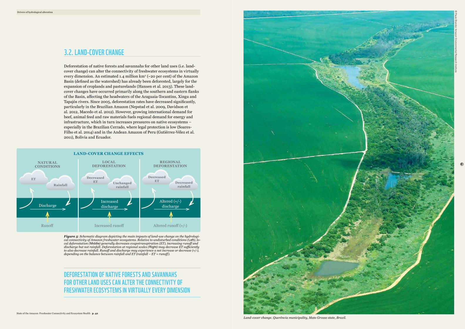
© Paulo Brando/ Am
azon Environmental Research Institute
Land-cover change. Querência municipality, Mato Grosso state, Brazil.State of the Amazon: Freshwater Connectivity and Ecosystem Health p. 42
Land-cover change alters hydrologic connectivity in several ways. Deforestation of upland and riparian forests disrupts vertical connectivity by altering the surface water balance and partitioning of rainfall into ET, discharge (Q) and soil moisture (Brauman et al. 2007, Wohl et al. 2012, Sterling et al. 2013). Independent of land cover, rainfall is equal to the sum of ET, Q and changes in soil water storage (DS). In general, crops and pasture grasses use less water than native forests and savannahs due to their lower height, less complex canopy, shallower rooting depth and lower leaf area index (Calder 1998, Giambelluca 2002). As a result, deforestation at local scales tends to decrease ET and increase Q relative to native vegetation (Sahin and Hall 1996, Andreassian 2004, Locatelli and Vignola 2009, Coe et al. 2011, Hayhoe et al. 2011). However, because forests recycle water back to the atmosphere via ET, they play a key role in maintaining regional rainfall (Costa and Foley 1997, Li et al. 2007, Spracklen et al. 2012). Evidence is mounting that deforestation over large spatial scales eventually reduces rainfall, alters rain seasonality (Butt et al. 2011) and decreases discharge (Figure 5; Bruijnzeel 2004, Stickler et al. 2013a), although the precise threshold is unknown.
Deforestation-induced changes to the water balance can impact both lateral and longitudinal connectivity of Amazon freshwater ecosystems. Field studies in the headwaters of the Xingu Basin (southeastern Amazon) have shown that total annual discharge in deforested watersheds is four times higher than that of forested watersheds (Hayhoe et al. 2011). On the other hand, modelling studies in the Xingu and southwestern Amazon indicate that large-scale land-cover changes may alter flow seasonality and decrease dry season discharge as a result of changes to the regional water balance (Lima et al. 2013, Stickler et al. 2013a). These changes may also lead to erratic stream flows, characterized by flashier storm flows, earlier annual floods (Bruijnzeel et al. 1990, Petts 1984) and changes in riverine morphology (e.g. incision, bed armouring and siltation). Large-scale deforestation of the Araguaia River Basin changed flow regimes so much that it increased bed load transport by 31 per cent (6.6Mt to 8.8Mt) from the 1960s to the 1990s, fundamentally changing the river’s geomorphology (Latrubesse et al. 2009).
Land-cover change in uplands and riparian zones increases erosion, surface runoff, and the delivery of sediments and pollutants to adjacent freshwaters. In tropical agricultural landscapes, these hydrological alterations are exacerbated by land management practices that compact soils, increase inputs of fertilizers and pesticides (Schiesari and Grillitsch 2011, Neill et al. 2013, Schiesari et al. 2013), and generally decrease water quality (Gergel et al. 2002, Allan 2004, Foley et al. 2005, Uriarte et al. 2011). Together, these hydrological alterations have substantial cumulative impacts on the quality and distribution of freshwater habitats in the stream network.
3.3. MINERAL EXTRACTIONLike hydroelectric dams, mineral extraction is an increasingly important driver of regional land-use change, with both direct and indirect impacts on the connectivity of Amazon freshwater ecosystems. In addition to leases for mineral extraction (Figure 4), small-scale artisanal mining activities occur throughout the Amazon and are not formally mapped. Gold mining has existed in the region for decades, but a 360 per cent increase in gold prices since 20009 has prompted a rapid resurgence that is impacting freshwater ecosystems throughout the Amazon, including Brazil (e.g. Tapajós Basin, Pará; Nevado et al. 2010, Marinho et al. 2014), Peru (Madre de Dios; Swenson et al. 2011, Gardner 2012, Asner et al. 2013), Guyana (Howard et al. 2011), Suriname (Ouboter et al. 2012), Colombia (De Miguel et al. 2014) and Venezuela (Santos-Frances et al. 2011). Artisanal gold miners in these regions extract gold by dredging sediments from the river bottom, using mercury (Hg) to amalgamate fine gold particles. These activities affect lateral and longitudinal connectivity by increasing sediment loads, altering the geomorphology of river channels and riparian areas, and polluting adjacent waterways with mercury, a toxin that persists in river sediments and may accumulate in fish depending on limnological conditions.
In addition to impairing water and habitat quality, mining and hydrocarbon extraction often impact hydrological connectivity indirectly by promoting the construction of new roads, dams and settlements in remote areas. The Carajás Mining Complex (Pará, Brazil), for example, is the world’s largest iron ore mine, with large stores of bauxite, copper, manganese and gold. In addition to the mine itself, since the late 1970s the Greater Carajás Project has attracted massive infrastructure investments leading to the construction of a railroad, roads and a large hydroelectric dam, the Tucuruí Dam. Tucuruí itself flooded 2,860km2 of forests and displaced more than 24,000 people, leading to significant further land-cover changes (WCD 2000).
Smelting of iron ore (to produce “pig iron” and eventually steel) and bauxite (to produce aluminium) is extremely energy-intensive. Roughly half of the energy consumed by aluminium smelters is derived from hydroelectric power (Switkes 2005, Fearnside 2006), and these energy demands have motivated the construction of many dams in the region. Where hydroelectric power and plantation forests are insufficient or too expensive to meet these demands, smelters create a significant regional market for charcoal, produced by burning native forests and savannahs (e.g. in Pará and Maranhão; Sonter et al. 2015).
Oil extraction is another key driver of land-cover change and infrastructure development, particularly in the Andean Amazon. Controversial projects such as the Camisea gas pipeline in Peru, oil leases in the Yasuní region of Ecuador, and oil and gas exploration in the Putumayo (Colombia), Madidi (Bolivia) and Amazonas (Brazil) regions are likely to become increasingly common as energy demands in the region grow (Finer et al. 2008). In some exceptional
9 World Gold Council (http://www.gold.org).
Drivers of hydrological alteration
LAND-COVER CHANGE IN UPLANDS AND RIPARIAN ZONES INCREASES EROSION, SURFACE RUNOFF, AND THE DELIVERY OF SEDIMENTS AND POLLUTANTS TO ADJACENT FRESHWATERS
State of the Amazon: Freshwater Connectivity and Ecosystem Health p. 45State of the Amazon: Freshwater Connectivity and Ecosystem Health p. 44
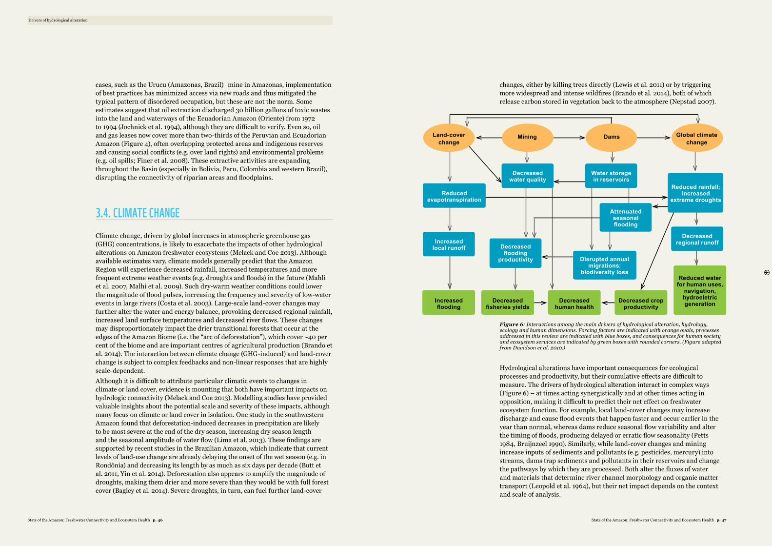
cases, such as the Urucu (Amazonas, Brazil) mine in Amazonas, implementation of best practices has minimized access via new roads and thus mitigated the typical pattern of disordered occupation, but these are not the norm. Some estimates suggest that oil extraction discharged 30 billion gallons of toxic wastes into the land and waterways of the Ecuadorian Amazon (Oriente) from 1972 to 1994 (Jochnick et al. 1994), although they are difficult to verify. Even so, oil and gas leases now cover more than two-thirds of the Peruvian and Ecuadorian Amazon (Figure 4), often overlapping protected areas and indigenous reserves and causing social conflicts (e.g. over land rights) and environmental problems (e.g. oil spills; Finer et al. 2008). These extractive activities are expanding throughout the Basin (especially in Bolivia, Peru, Colombia and western Brazil), disrupting the connectivity of riparian areas and floodplains.
3.4. CLIMATE CHANGEClimate change, driven by global increases in atmospheric greenhouse gas (GHG) concentrations, is likely to exacerbate the impacts of other hydrological alterations on Amazon freshwater ecosystems (Melack and Coe 2013). Although available estimates vary, climate models generally predict that the Amazon Region will experience decreased rainfall, increased temperatures and more frequent extreme weather events (e.g. droughts and floods) in the future (Mahli et al. 2007, Malhi et al. 2009). Such dry-warm weather conditions could lower the magnitude of flood pulses, increasing the frequency and severity of low-water events in large rivers (Costa et al. 2003). Large-scale land-cover changes may further alter the water and energy balance, provoking decreased regional rainfall, increased land surface temperatures and decreased river flows. These changes may disproportionately impact the drier transitional forests that occur at the edges of the Amazon Biome (i.e. the “arc of deforestation”), which cover ~40 per cent of the biome and are important centres of agricultural production (Brando et al. 2014). The interaction between climate change (GHG-induced) and land-cover change is subject to complex feedbacks and non-linear responses that are highly scale-dependent. Although it is difficult to attribute particular climatic events to changes in climate or land cover, evidence is mounting that both have important impacts on hydrologic connectivity (Melack and Coe 2013). Modelling studies have provided valuable insights about the potential scale and severity of these impacts, although many focus on climate or land cover in isolation. One study in the southwestern Amazon found that deforestation-induced decreases in precipitation are likely to be most severe at the end of the dry season, increasing dry season length and the seasonal amplitude of water flow (Lima et al. 2013). These findings are supported by recent studies in the Brazilian Amazon, which indicate that current levels of land-use change are already delaying the onset of the wet season (e.g. in Rondônia) and decreasing its length by as much as six days per decade (Butt et al. 2011, Yin et al. 2014). Deforestation also appears to amplify the magnitude of droughts, making them drier and more severe than they would be with full forest cover (Bagley et al. 2014). Severe droughts, in turn, can fuel further land-cover
changes, either by killing trees directly (Lewis et al. 2011) or by triggering more widespread and intense wildfires (Brando et al. 2014), both of which release carbon stored in vegetation back to the atmosphere (Nepstad 2007).
Increased flooding
Increased local runoff
Decreased fisheries yields
Decreased human health
Decreased crop productivity
Reduced water for human uses,
navigation, hydroeletric generation
Reduced evapotranspiration
freshwaterecosystems
Decreased flooding
productivity
Decreased water quality
freshwaterecosystems
Disrupted annual migrations;
biodiversity loss
Water storage in reservoirs
freshwaterecosystems
Decreased regional runoff
Reduced rainfall; increased
extreme droughts
freshwaterecosystems
Attenuated seasonal flooding
Land-cover change
Global climate change
DamsMining
Figure 6: Interactions among the main drivers of hydrological alteration, hydrology, ecology and human dimensions. Forcing factors are indicated with orange ovals, processes addressed in this review are indicated with blue boxes, and consequences for human society and ecosystem services are indicated by green boxes with rounded corners. (Figure adapted from Davidson et al. 2010.)
Hydrological alterations have important consequences for ecological processes and productivity, but their cumulative effects are difficult to measure. The drivers of hydrological alteration interact in complex ways (Figure 6) – at times acting synergistically and at other times acting in opposition, making it difficult to predict their net effect on freshwater ecosystem function. For example, local land-cover changes may increase discharge and cause flood events that happen faster and occur earlier in the year than normal, whereas dams reduce seasonal flow variability and alter the timing of floods, producing delayed or erratic flow seasonality (Petts 1984, Bruijnzeel 1990). Similarly, while land-cover changes and mining increase inputs of sediments and pollutants (e.g. pesticides, mercury) into streams, dams trap sediments and pollutants in their reservoirs and change the pathways by which they are processed. Both alter the fluxes of water and materials that determine river channel morphology and organic matter transport (Leopold et al. 1964), but their net impact depends on the context and scale of analysis.
Drivers of hydrological alteration
State of the Amazon: Freshwater Connectivity and Ecosystem Health p. 47State of the Amazon: Freshwater Connectivity and Ecosystem Health p. 46

State of the Amazon: Freshwater Connectivity and Ecosystem Health p. 49State of the Amazon: Freshwater Connectivity and Ecosystem Health p. 48
The Tocantins River is a major tributary of the Amazon that has experienced fast economic development fuelled by environmentally destructive practices that have caused widespread loss of biodiversity and ecosystem functions and services. Because development trends in the Tocantins are similar to those planned or occurring in other Amazonian basins today, this watershed
can be viewed as an example of what might happen to the Amazon. The Tocantins Basin is now extensively fragmented, with its main stem regulated by seven large dams, and its tributaries and streams blocked by hundreds of smaller dams.
As a result of this fragmentation, the fish fauna has changed substantially. Large migratory catfishes and characins (e.g. Prochilodus nigricans, Psectrogaster amazonica, Brycon goulding, Hydrolycus armatus, Oxydoras niger, Pseudoplatystoma fasciatum, Zungaro zungaro) have disappeared from many areas, primarily because impoundments have caused the loss of spawning sites, nursery areas and free-flowing reaches. Fishers have been forced to adapt to reservoir fish species, including sedentary species that generally have a lower market value. In addition, fish mortality events have become common downstream from large dams, further impacting fish populations. Hydropower companies operating the dams have implemented management strategies such as the construction of fish ladders, but such mitigation actions have largely failed.
In addition to the loss of fishery resources, impoundments have also changed the landscape. Many of the region’s sand beaches – an important part of local culture and the regional tourist economy – have been lost, while other areas have changed due to
overgrowth of aquatic macrophytes. Other activities are now further degrading the integrity of these freshwater ecosystems, including the development of cage aquaculture, which fosters social conflicts and further decreases water quality through eutrophication and species invasions. Agriculture has been another key driver of change, leading to the replacement of extensive areas of savannah ecosystems (Cerrado) with soybean and cattle ranching lands. The cumulative effects of intense river regulation, agriculture and urban development are having a profound effect on this watershed. The Tocantins Basin serves as a warning of what might come to pass elsewhere in the Amazon if better planning and policies are not developed.
TOCANTINS RIVER BASIN AS THE FUTURE OF THE AMAZON?
By Fernando Mayer Pelicice*
Tocantins River Basin as the Future of the Amazon?
Flooded trees after the formation of the Lajeado dam reservoir.
Fish ladder at the Lajeado dam was closed. Studies have proven that such mitigation actions have failed to preserve fish migration.
Overgrowth of aquatic macrophytes; Lajeado dam reservoir.Water level variation; Lajeado dam reservoir.
* Federal University of Tocantins, Brazil.
© Fernando Pelicice
© Fernando Pelicice
© Fernando Pelicice
© Fernando Pelicice
Tocantins River Basin
Schematic map without scale. Modified from Agostinho et al. (2009) by J. Rafael, Fábula Ilustrações
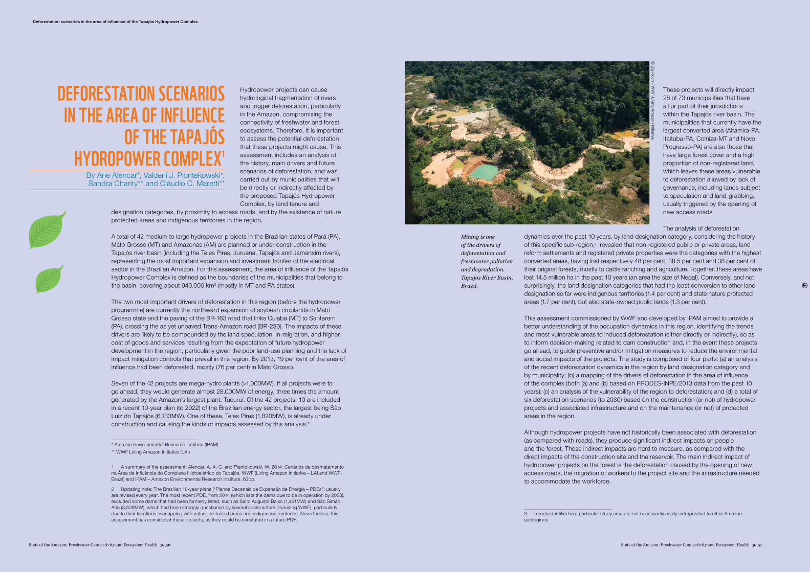
State of the Amazon: Freshwater Connectivity and Ecosystem Health p. 51State of the Amazon: Freshwater Connectivity and Ecosystem Health p. 50
Deforestation scenarios in the area of influence of the Tapajós Hydropower Complex
Hydropower projects can cause hydrological fragmentation of rivers and trigger deforestation, particularly in the Amazon, compromising the connectivity of freshwater and forest ecosystems. Therefore, it is important to assess the potential deforestation that these projects might cause. This assessment includes an analysis of the history, main drivers and future scenarios of deforestation, and was carried out by municipalities that will be directly or indirectly affected by the proposed Tapajós Hydropower Complex, by land tenure and
designation categories, by proximity to access roads, and by the existence of nature protected areas and indigenous territories in the region.
A total of 42 medium to large hydropower projects in the Brazilian states of Pará (PA), Mato Grosso (MT) and Amazonas (AM) are planned or under construction in the Tapajós river basin (including the Teles Pires, Juruena, Tapajós and Jamanxim rivers), representing the most important expansion and investment frontier of the electrical sector in the Brazilian Amazon. For this assessment, the area of influence of the Tapajós Hydropower Complex is defined as the boundaries of the municipalities that belong to the basin, covering about 940,000 km2 (mostly in MT and PA states).
The two most important drivers of deforestation in this region (before the hydropower programme) are currently the northward expansion of soybean croplands in Mato Grosso state and the paving of the BR-163 road that links Cuiaba (MT) to Santarem (PA), crossing the as yet unpaved Trans-Amazon road (BR-230). The impacts of these drivers are likely to be compounded by the land speculation, in-migration, and higher cost of goods and services resulting from the expectation of future hydropower development in the region, particularly given the poor land-use planning and the lack of impact mitigation controls that prevail in this region. By 2013, 19 per cent of the area of influence had been deforested, mostly (76 per cent) in Mato Grosso.
Seven of the 42 projects are mega-hydro plants (>1,000MW). If all projects were to go ahead, they would generate almost 28,000MW of energy, three times the amount generated by the Amazon’s largest plant, Tucuruí. Of the 42 projects, 10 are included in a recent 10-year plan (to 2022) of the Brazilian energy sector, the largest being São Luiz do Tapajós (6,133MW). One of these, Teles Pires (1,820MW), is already under construction and causing the kinds of impacts assessed by this analysis.2
* Amazon Environmental Research Institute (IPAM)** WWF Living Amazon Initiative (LAI)
1 A summary of the assessment: Alencar, A. A. C. and Pientokowski, W. 2014. Cenários de desmatamento na Área de Influência do Complexo Hidroelétrico do Tapajós. WWF (Living Amazon Initiative – LAI and WWF-Brazil) and IPAM – Amazon Environmental Research Institute. 63pp.
2 Updating note: The Brazilian 10-year plans (“Planos Decenais de Expansão de Energia – PDEs”) usually are revised every year. The most recent PDE, from 2014 (which lists the dams due to be in operation by 2023), excluded some dams that had been formerly listed, such as Salto Augusto Baixo (1,461MW) and São Simão Alto (3,509MW), which had been strongly questioned by several social actors (including WWF), particularly due to their locations overlapping with nature protected areas and indigenous territories. Nevertheless, this assessment has considered these projects, as they could be reinstated in a future PDE.
DEFORESTATION SCENARIOS IN THE AREA OF INFLUENCE
OF THE TAPAJÓS HYDROPOWER COMPLEX1
By Ane Alencar*, Valderli J. Piontekowski*, Sandra Charity** and Cláudio C. Maretti**
These projects will directly impact 28 of 73 municipalities that have all or part of their jurisdictions within the Tapajós river basin. The municipalities that currently have the largest converted area (Altamira-PA, Itaituba-PA, Colniza-MT and Novo Progresso-PA) are also those that have large forest cover and a high proportion of non-registered land, which leaves these areas vulnerable to deforestation allowed by lack of governance, including lands subject to speculation and land-grabbing, usually triggered by the opening of new access roads.
The analysis of deforestation dynamics over the past 10 years, by land designation category, considering the history of this specific sub-region,3 revealed that non-registered public or private areas, land reform settlements and registered private properties were the categories with the highest converted areas, having lost respectively 48 per cent, 38.5 per cent and 38 per cent of their original forests, mostly to cattle ranching and agriculture. Together, these areas have lost 14.5 million ha in the past 10 years (an area the size of Nepal). Conversely, and not surprisingly, the land designation categories that had the least conversion to other land designation so far were indigenous territories (1.4 per cent) and state nature protected areas (1.7 per cent), but also state-owned public lands (1.3 per cent).
This assessment commissioned by WWF and developed by IPAM aimed to provide a better understanding of the occupation dynamics in this region, identifying the trends and most vulnerable areas to induced deforestation (either directly or indirectly), so as to inform decision-making related to dam construction and, in the event these projects go ahead, to guide preventive and/or mitigation measures to reduce the environmental and social impacts of the projects. The study is composed of four parts: (a) an analysis of the recent deforestation dynamics in the region by land designation category and by municipality; (b) a mapping of the drivers of deforestation in the area of influence of the complex (both (a) and (b) based on PRODES-INPE/2013 data from the past 10 years); (c) an analysis of the vulnerability of the region to deforestation; and (d) a total of six deforestation scenarios (to 2030) based on the construction (or not) of hydropower projects and associated infrastructure and on the maintenance (or not) of protected areas in the region.
Although hydropower projects have not historically been associated with deforestation (as compared with roads), they produce significant indirect impacts on people and the forest. These indirect impacts are hard to measure, as compared with the direct impacts of the construction site and the reservoir. The main indirect impact of hydropower projects on the forest is the deforestation caused by the opening of new access roads, the migration of workers to the project site and the infrastructure needed to accommodate the workforce.
3 Trends identified in a particular study area are not necessarily easily extrapolated to other Amazon subregions.
© Zig Koch / W
WF-Living Am
azon Initiative
Mining is one of the drivers of deforestation and freshwater pollution and degradation. Tapajos River Basin, Brazil.
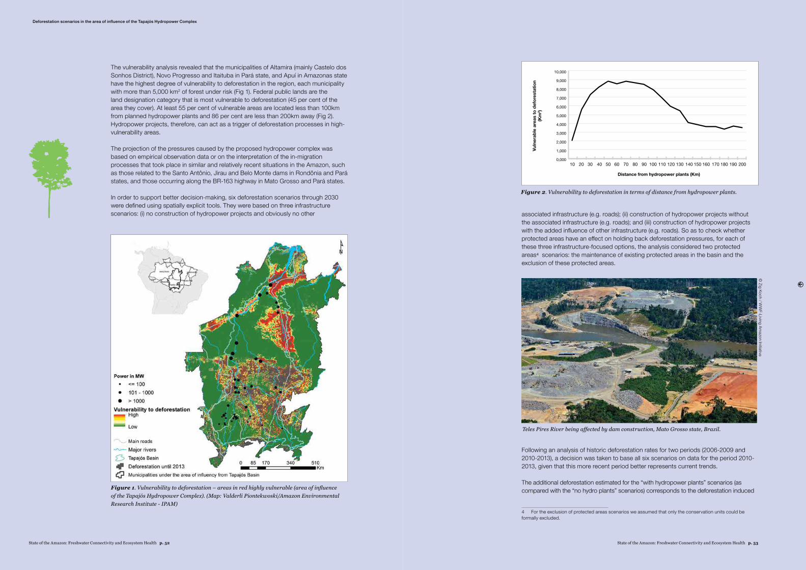
State of the Amazon: Freshwater Connectivity and Ecosystem Health p. 53State of the Amazon: Freshwater Connectivity and Ecosystem Health p. 52
The vulnerability analysis revealed that the municipalities of Altamira (mainly Castelo dos Sonhos District), Novo Progresso and Itaituba in Pará state, and Apuí in Amazonas state have the highest degree of vulnerability to deforestation in the region, each municipality with more than 5,000 km2 of forest under risk (Fig 1). Federal public lands are the land designation category that is most vulnerable to deforestation (45 per cent of the area they cover). At least 55 per cent of vulnerable areas are located less than 100km from planned hydropower plants and 86 per cent are less than 200km away (Fig 2). Hydropower projects, therefore, can act as a trigger of deforestation processes in high-vulnerability areas.
The projection of the pressures caused by the proposed hydropower complex was based on empirical observation data or on the interpretation of the in-migration processes that took place in similar and relatively recent situations in the Amazon, such as those related to the Santo Antônio, Jirau and Belo Monte dams in Rondônia and Pará states, and those occurring along the BR-163 highway in Mato Grosso and Pará states.
In order to support better decision-making, six deforestation scenarios through 2030 were defined using spatially explicit tools. They were based on three infrastructure scenarios: (i) no construction of hydropower projects and obviously no other associated infrastructure (e.g. roads); (ii) construction of hydropower projects without
the associated infrastructure (e.g. roads); and (iii) construction of hydropower projects with the added influence of other infrastructure (e.g. roads). So as to check whether protected areas have an effect on holding back deforestation pressures, for each of these three infrastructure-focused options, the analysis considered two protected areas4 scenarios: the maintenance of existing protected areas in the basin and the exclusion of these protected areas.
Following an analysis of historic deforestation rates for two periods (2006-2009 and 2010-2013), a decision was taken to base all six scenarios on data for the period 2010-2013, given that this more recent period better represents current trends.
The additional deforestation estimated for the “with hydropower plants” scenarios (as compared with the “no hydro plants” scenarios) corresponds to the deforestation induced
4 For the exclusion of protected areas scenarios we assumed that only the conservation units could be formally excluded.
Figure 1. Vulnerability to deforestation – areas in red highly vulnerable (area of influence of the Tapajós Hydropower Complex). (Map: Valderli Piontekwoski/Amazon Environmental Research Institute - IPAM)
Figure 2. Vulnerability to deforestation in terms of distance from hydropower plants.
0,000
1,000
2,000
3,000
4,000
5,000
6,000
7,000
8,000
9,000
10,000
10 20 30 40 50 60 70 80 90 100 110 120 130 140 150 160 170 180 190 200
Distance from hydropower plants (Km)
Vuln
erab
le a
reas
to d
efor
esta
tion
(Km
2 )
Deforestation scenarios in the area of influence of the Tapajós Hydropower Complex
© Zig Koch / W
WF-Living Am
azon Initiative
Teles Pires River being affected by dam construction, Mato Grosso state, Brazil.
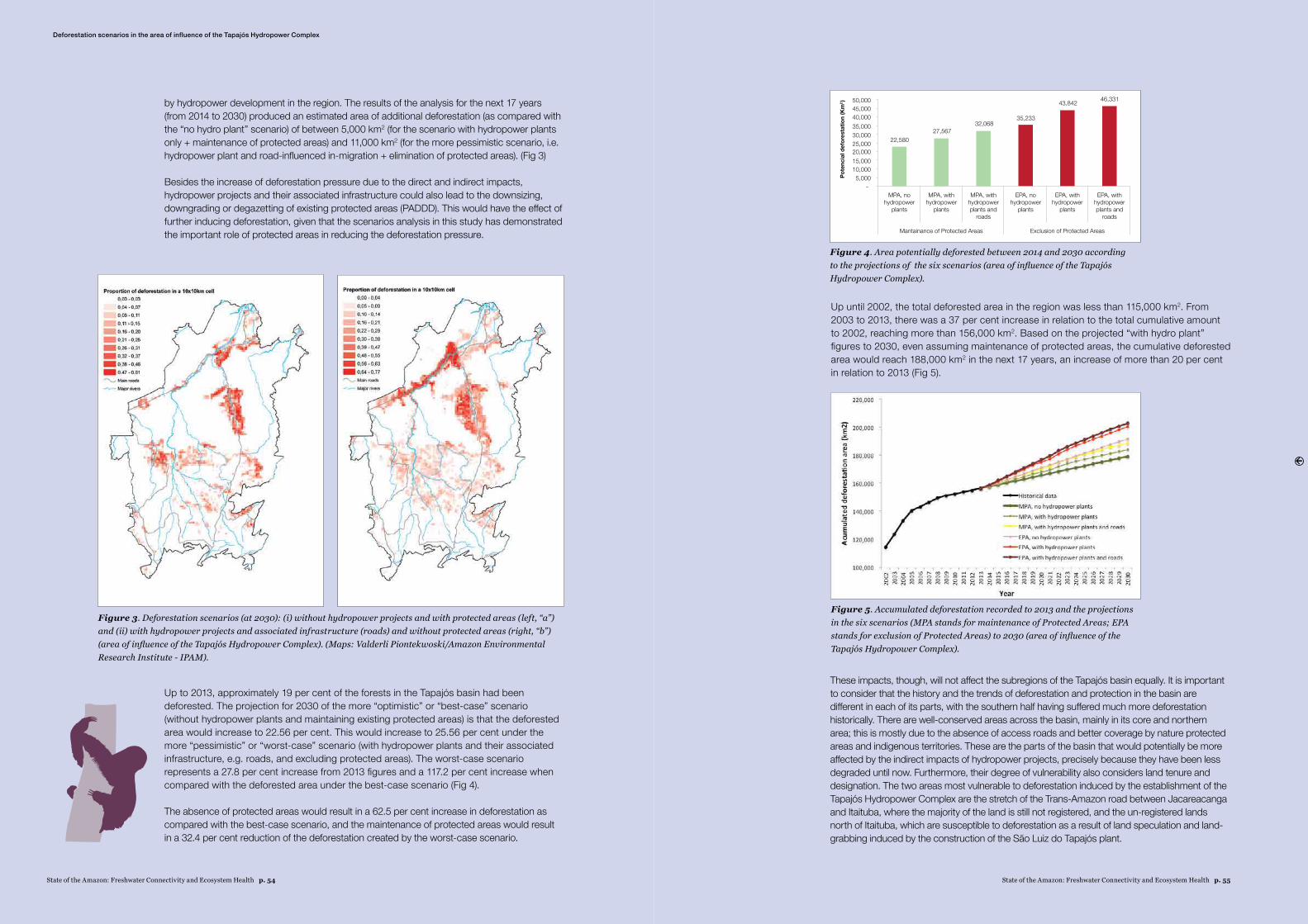
State of the Amazon: Freshwater Connectivity and Ecosystem Health p. 55State of the Amazon: Freshwater Connectivity and Ecosystem Health p. 54
by hydropower development in the region. The results of the analysis for the next 17 years (from 2014 to 2030) produced an estimated area of additional deforestation (as compared with the “no hydro plant” scenario) of between 5,000 km2 (for the scenario with hydropower plants only + maintenance of protected areas) and 11,000 km2 (for the more pessimistic scenario, i.e. hydropower plant and road-influenced in-migration + elimination of protected areas). (Fig 3)
Besides the increase of deforestation pressure due to the direct and indirect impacts, hydropower projects and their associated infrastructure could also lead to the downsizing, downgrading or degazetting of existing protected areas (PADDD). This would have the effect of further inducing deforestation, given that the scenarios analysis in this study has demonstrated the important role of protected areas in reducing the deforestation pressure.
Up until 2002, the total deforested area in the region was less than 115,000 km2. From 2003 to 2013, there was a 37 per cent increase in relation to the total cumulative amount to 2002, reaching more than 156,000 km2. Based on the projected “with hydro plant” figures to 2030, even assuming maintenance of protected areas, the cumulative deforested area would reach 188,000 km2 in the next 17 years, an increase of more than 20 per cent in relation to 2013 (Fig 5).
Figure 3. Deforestation scenarios (at 2030): (i) without hydropower projects and with protected areas (left, “a”) and (ii) with hydropower projects and associated infrastructure (roads) and without protected areas (right, “b”) (area of influence of the Tapajós Hydropower Complex). (Maps: Valderli Piontekwoski/Amazon Environmental Research Institute - IPAM).
Figure 4. Area potentially deforested between 2014 and 2030 according to the projections of the six scenarios (area of influence of the Tapajós Hydropower Complex).
Figure 5. Accumulated deforestation recorded to 2013 and the projections in the six scenarios (MPA stands for maintenance of Protected Areas; EPA stands for exclusion of Protected Areas) to 2030 (area of influence of the Tapajós Hydropower Complex).
Deforestation scenarios in the area of influence of the Tapajós Hydropower Complex
Up to 2013, approximately 19 per cent of the forests in the Tapajós basin had been deforested. The projection for 2030 of the more “optimistic” or “best-case” scenario (without hydropower plants and maintaining existing protected areas) is that the deforested area would increase to 22.56 per cent. This would increase to 25.56 per cent under the more “pessimistic” or “worst-case” scenario (with hydropower plants and their associated infrastructure, e.g. roads, and excluding protected areas). The worst-case scenario represents a 27.8 per cent increase from 2013 figures and a 117.2 per cent increase when compared with the deforested area under the best-case scenario (Fig 4).
The absence of protected areas would result in a 62.5 per cent increase in deforestation as compared with the best-case scenario, and the maintenance of protected areas would result in a 32.4 per cent reduction of the deforestation created by the worst-case scenario.
These impacts, though, will not affect the subregions of the Tapajós basin equally. It is important to consider that the history and the trends of deforestation and protection in the basin are different in each of its parts, with the southern half having suffered much more deforestation historically. There are well-conserved areas across the basin, mainly in its core and northern area; this is mostly due to the absence of access roads and better coverage by nature protected areas and indigenous territories. These are the parts of the basin that would potentially be more affected by the indirect impacts of hydropower projects, precisely because they have been less degraded until now. Furthermore, their degree of vulnerability also considers land tenure and designation. The two areas most vulnerable to deforestation induced by the establishment of the Tapajós Hydropower Complex are the stretch of the Trans-Amazon road between Jacareacanga and Itaituba, where the majority of the land is still not registered, and the un-registered lands north of Itaituba, which are susceptible to deforestation as a result of land speculation and land-grabbing induced by the construction of the São Luiz do Tapajós plant.
Pote
ncia
l def
ores
tatio
n (K
m2 )
22,580
50,00045,00040,00035,00030,00025,00020,00015,00010,000
5,000
27,56732,068
35,233
43,842 46,331
EPA, withhydropowerplants and
roads
MPA, withhydropowerplants and
roads
EPA, withhydropower
plants
MPA, withhydropower
plants
Mantainance of Protected Areas Exclusion of Protected Areas
EPA, nohydropower
plants
MPA, nohydropower
plants
State of the Amazon: Freshwater Connectivity and Ecosystem Health p. 57State of the Amazon: Freshwater Connectivity and Ecosystem Health p. 56
The Amazon is a complex natural region, hugely important in terms of the ecosystem services it provides and its ecological processes, biodiversity and cultural diversity. However, it is a region at a crossroads, whilst still relatively well protected, it is under increasing pressure of degradation. From 2001 to 2012, 177,000 km2 were deforested in the biome.1 Over this same period
there have been changes in the dynamics of deforestation across the Amazon Region. Despite an important overall reduction in the rate of deforestation in Brazilian Amazon since 2005, there are still parts of the region where deforestation and forest degradation continue at an alarming rate. These trends leave little room for long term optimism, with deforestation rates experiencing a significant increase in some countries and new roads being opened up in areas previously relatively undisturbed.
Amazon deforestation is shifting from Brazil toward the Andean Amazon countries. While in 2001 deforestation in Brazil still represented 81 per cent of total deforestation in the biome, by 2012 it had dropped to 44 per cent. On the other hand, there is a general trend of increased deforestation in the Andean Amazon countries, with Bolivia and Peru showing marked tendencies toward increased deforestation rates, and then followed by Colombia. This pattern is also mirrored in 25 active deforestation fronts in the Amazon (mostly in Brazil, Bolivia, Peru, Colombia and Ecuador). Another three more consolidated fronts were identified where further deforestation is limited these are largely located in the “arc of deforestation” in Brazil. Nevertheless, despite deforestation in the Brazilian Amazon declining significantly over the last decade – a globally important achievement – Brazil remains at the top of the list of deforesting countries. Furthermore, achieving further reductions in deforestation will be an immense challenge, likely requiring major revisions in several related policies.
However, the Amazon functions as a single ecological unit and has a complex system of interactions among its highly interdependent parts; destabilizing one part impacts on the others significantly. Combating deforestation in the region is not the task of isolated sectorial policies; nor is it the task of individual countries to tackle in isolation. It is essential to have integrated policies and an articulated action plan that seeks to value standing forests throughout the biome. Cross-border deforestation fronts, including the border between northwest Brazil and northeast Bolivia; the frontier between Peru and Colombia; and the triple frontier of Brazil, Peru and Bolivia, have been driven by various pressures that have entirely uncoordinated responses among the countries. Furthermore, many drivers are global. Impacts that appear to be localized are sometimes felt in other parts of the biome and often well beyond one country’s boundaries.
Although drivers of deforestation across the Amazon Region share many common characteristics, their relative importance and specific nature vary within and between countries. The direct drivers of deforestation are predominantly, extensive cattle ranching,
* WWF Living Amazon Initiative (LAI). Based on Dias et al., 2014, WWF “Saving forests at risk (Living Forests Report chapter 5, to be published), and Nobre, 2014.
1 The analysis uses forest cover data generated by Global Forest Change 2013, supported by the University of Maryland, College Park. Complementary data from PRODES (INPE 2013) was used for Brazil, and from literature reviews. The geographic scope of the analysis is the Amazon Biome, defined as the area covered predominantly by dense, moist tropical forest, with relatively small areas of savannahs, floodplain forests, grasslands, swamps, bamboos and palm forest.
land speculation and large-scale mechanized agriculture (mainly soybean and, in some regions, oil palm), complemented to a lesser extent by illicit crops and small-scale subsistence farming. The following factors may also have significant direct and indirect impacts on deforestation: oil and natural gas exploration; construction of roads and hydroelectric dams; mining; and other major infrastructure development projects. However more important than differentiating individual drivers, is understand the relationships between them and their perversely synergistic effects.
Access, particularly through road development, is the single most important underlying factor leading to deforestation and is related to most, if not all, other drivers. The strong correlation between the location of deforestation fronts and the presence of existing or planned roads suggests that isolated deforestation fronts will soon be connected along major infrastructure development routes. These fronts will then become axes of deforestation unless there is a drastic change in policy or a collapse in global commodity prices. Decades ago, the process of occupation of the Amazon was motivated by governments considering the region as an “empty” space to be developed and seeking to realize the region’s productive potential. Today, on another scale and with a different impact, this process is strongly connected with international markets and demands for agro-commodities, energy (oil and hydropower), minerals etc.
Gross estimates suggest that the Amazon could be approaching around 20 per cent deforestation with an additional 20 per cent due to forest degradation. Recent WWF projections suggest that 27 per cent of the Amazon Biome will be without trees by 2030 – 13 per cent from new deforestation – if the average deforestation rate of the past 10 years for each Amazon country is extrapolated into the future. This would result in 225,000 km2 of additional deforestation from 2010 to 2030. A more pessimistic view of the likely impact of planned dams and major new roads, combined with other pressures, doubles the amount of projected deforestation2. This could mean a total of 480,000 km2 deforested between 2010 and 2030, or 1 million km2 by 2050. Various other projections for the Brazilian Amazon range from 25 to 40 per cent for the total expected deforestation over the next five to thirty five years, with as much as 24 per cent of forests predicted to suffer the effects of degradation over similar time frames (Coca-Castro et al. 2013, Nepstad 2008, Soares-Filho et al. 2006).
2 This was calculated by extrapolating the worst annual deforestation rate for every country over the past 12 years and using this value to project deforestation to 2030 and 2050.
Deforestation Fronts and Trends in the Amazon
Fluvial transportation. Aguarico River, Ecuador.
DEFORESTATION FRONTS AND TRENDS IN THE AMAZON
By André S. Dias, Cláudio C. Maretti, Karen Lawrence et al.*
© Denise O
liveira / WW
F Living Amazon Initiative
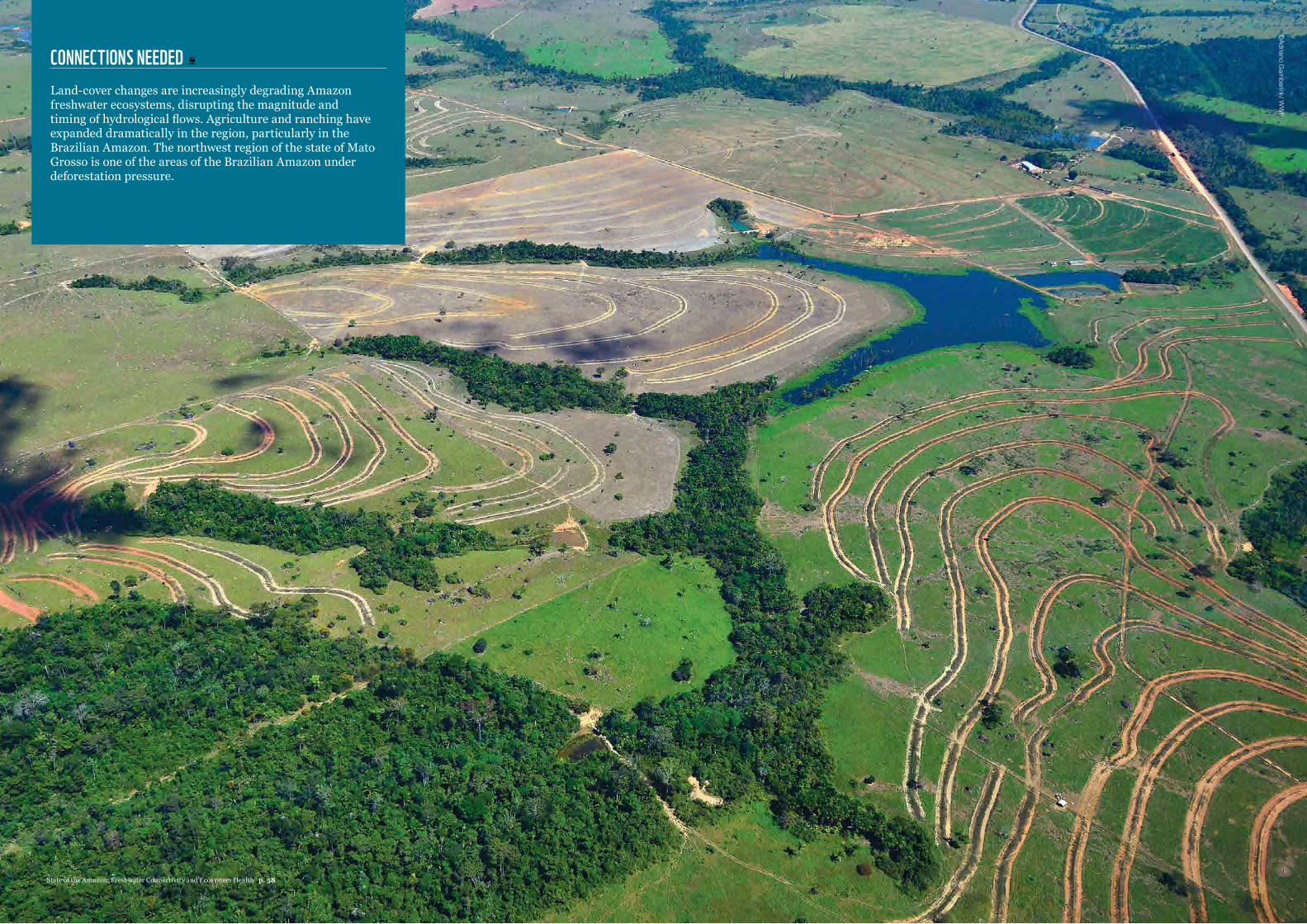
CONNECTIONS NEEDED Land-cover changes are increasingly degrading Amazon freshwater ecosystems, disrupting the magnitude and timing of hydrological flows. Agriculture and ranching have expanded dramatically in the region, particularly in the Brazilian Amazon. The northwest region of the state of Mato Grosso is one of the areas of the Brazilian Amazon under deforestation pressure.
©Adriano G
ambarini / W
WF
State of the Amazon: Freshwater Connectivity and Ecosystem Health p. 58
Globally, dams, mines and land-cover changes have already transformed freshwater ecosystems to the point that today they bear little resemblance to their pristine states and have a diminished capacity to provide ecosystem
services (Malmquist and Rundle 2002, Brauman et al. 2007). Disruptions to hydrological connectivity are changing the structure and function of Amazon freshwater ecosystems and reducing their resilience to disturbance (Wohl et al. 2012). These changes have a suite of consequences for the transport of organic and inorganic materials, biogeochemical cycling, freshwater community composition and productivity. Some hydrological disruptions may also trigger cascading impacts on ecological processes that rapidly impair ecosystem integrity. Following is an overview of the impacts of hydrological alterations on key physical and biological processes, as well as ecosystem services provided by Amazon freshwater ecosystems.
4.1. DISRUPTION OF PHYSICAL PROCESSESThe biogeochemistry of freshwater ecosystems is governed primarily by hydrology, terrestrial inputs of organic and inorganic matter, and nutrient availability. Biogeochemical cycling, in turn, is largely controlled by biota, temperature, light availability and water chemistry. All of these factors vary geographically throughout the Amazon, and changes to any of them can indirectly affect others. In temperate watersheds, conversion of forests to croplands has been associated with increased stream flow and nutrient loading, causing large-scale eutrophication (Carpenter et al. 1998, Schindler 2006). However, little is known about how similar changes affect tropical systems, where soils require different fertilization regimes and differ in their capacity to retain and cycle nutrients. In the headwaters of the Xingu Basin, for example, fertilizer use in soy croplands (primarily phosphorus and lime) has not affected stream nutrient concentrations due to the high binding capacity of regional soils (Neill et al. 2013). On the other hand, land-use practices in the same region have increased stream flow, degraded riparian forests and led to the creation of thousands of small reservoirs. Together, these land-use practices have warmed headwater streams in agricultural watersheds by 2-3 – C, compared with forested watersheds (Hayhoe et al. 2011, Macedo et al. 2013). Although agricultural expansion has a number of known implications for water quality, more research is needed to understand the cumulative effects of increases in stream flow, temperature and sediment transport on biogeochemical cycling over larger areas of the Amazon Basin.
The proliferation of reservoirs (both large and small) throughout the Amazon is another factor influencing water quality. The anoxic conditions commonly found in reservoirs are conducive to biological transformation (i.e. by microorganisms) of total mercury (THg) – some naturally occurring in Amazonian soils and rivers and some from anthropogenic sources – into
methylmercury (MeHg), which is a powerful endocrine-disruptor (Zhang and Wong 2007, Kasper et al. 2014). For example, MeHg levels in water, plankton and fish downstream of the Balbina Dam on the Uatumã River are higher when reservoir water is stratified, because stratification fosters the anoxic conditions required for methylation (Kasper et al. 2014). Mercury is just one of several micropollutants (including wastes associated with hydrocarbon extraction) that are produced or accumulated in reservoirs, dispersed downstream and magnified in food webs, making them particularly harmful to top predator species and human populations (Schwarzenbach et al. 2006, Ashe 2012, Marinho et al. 2014).
Sediment deposition in reservoirs traps organic carbon (C), lowering potential carbon dioxide (CO2) and methane (CH4) emissions that would normally occur from biological processing downstream (Smith et al. 2001). These same reservoirs often flood large forested areas, killing trees that produce large quantities of CH4 as they decay. As a result, tropical reservoirs are thought to have large concentrations of greenhouse gases (GHGs) in their deeper anoxic layers (Kemenes et al. 2007), although few reliable estimates exist of the rate at which they are emitted to the atmosphere. Estimates from the Balbina hydroelectric reservoir (Amazonas, Brazil) suggest annual emissions on the order of 3Tg C yr-1, equivalent to half of annual carbon emissions from burning fossil fuels in the Brazilian metropolis of São Paulo (Kemenes et al. 2007, 2011). It is unclear whether carbon storage in sediments compensates for the emissions from Amazonian reservoirs, but they are likely net producers of GHGs and thus contribute to global climate changes (St Louis et al. 2000, Fearnside 2004, Kemenes et al. 2007, 2011).
Hydrological alterations affect sediment transport and mobilization and river discharge, the driving forces defining river structure and geomorphology. But these effects are scale-dependent and context-specific. In the case of the Upper Xingu Basin, a fourfold increase in stream flow in agricultural watersheds had little effect on sediment loads or the morphology of small headwater streams. In the Araguaia River Basin, on the other hand, a 25 per cent increase in annual discharge due to cumulative land-cover changes increased bed loads and sedimentation rates so much that it completely restructured the river’s morphology (Latrubesse et al. 2009, Coe et al. 2011). In whitewater rivers, a reduction in sediment loads can be equally problematic. One of the primary concerns about new dams on the Madeira River, for example, is that they drastically reduce sediment inputs from one of the world’s most naturally sediment-laden rivers, thus altering downstream river systems (Fearnside 2013b).
4.2. DISRUPTION OF BIOLOGICAL PROCESSESBecause human settlements and development activities have historically focused in the riparian zones and floodplains of streams and rivers, they have disproportionately impacted floodplain forests relative to upland areas. Over
Impacts on freshwater ecosystems
IMPACTS ON FRESHWATER ECOSYSTEMS
ONE OF THE PRIMARY CONCERNS ABOUT NEW DAMS ON THE MADEIRA RIVER IS THAT THEY DRASTICALLY REDUCE SEDIMENT INPUTS FROM ONE OF THE WORLD’S MOST NATURALLY SEDIMENT-LADEN RIVERS
State of the Amazon: Freshwater Connectivity and Ecosystem Health p. 61State of the Amazon: Freshwater Connectivity and Ecosystem Health p. 60
50 per cent of the floodplain forests of the Lower Amazon Region had been deforested by 2008 (Renó et al. 2011), compared with ~20 per cent of upland forests in the Amazon. Deforestation of riparian areas reduces filtering of terrestrial organic and inorganic matter flowing from uplands into rivers and streams, lowering water quality and altering aquatic primary production (Williams et al. 1997, Neill et al. 2001). In whitewater rivers, floodplain deforestation reduces the abundance of C3 plant communities that sustain herbivore and detritivore animal populations, as well as C4 macrophyte communities that provide nursery habitat for many aquatic species and are key producers of organic carbon (Araujo-Lima et al. 1986, Forsberg et al. 1993). Riparian deforestation also removes structures that provide habitat for aquatic biota (e.g. large woody debris) and reduces shading of streams, often increasing water temperature and incident sunlight, which may directly affect species composition and metabolism (Bojsen and Barriga 2002, Sweeney et al. 2004, Macedo et al. 2013).
Seasonal flow variability plays a central role in structuring river-floodplain ecosystems, driving species selection and productivity. Disruption of natural flow dynamics can therefore affect evolutionary processes, restructure plant communities and alter other ecosystem processes. Floodplain forest trees have a number of adaptations to cope with the physiological stress caused by seasonal flooding (Haugaasen and Peres 2005). Reduced flood maxima can reduce selection for such flood-tolerant species and thus alter the composition of floodplain forests (Bayley 1995, Nilsson and Berggren 2000). Reducing lateral exchanges between river channels and floodplains also decreases nutrient recycling and associated biological productivity, including C3 and C4 plant productivity (Nilsson and Berggren 2000). Studies in a 1.77 million km2 quadrat of the Lower Amazon Basin indicate that floodplains produce ~300Tg C yr−1 and generally have higher NPP than upland forests (Melack et al. 2009). The dampening of flood pulses can thus significantly alter NPP and regional carbon budgets. It may also increase the frequency, severity and ecological impact of forest fires, since floodplain forests lack many traits associated with fire and drought resistance (Brando et al. 2012, Flores et al. 2012). For example, during drought (and hence low-flood) years in the 1990s, fires occurring in the blackwater floodplain forests of the Middle Rio Negro killed more than 90 per cent of trees, with little sign of regeneration even 10 years later (Flores et al. 2012).
As shown in river-floodplains globally (Jackson and Marmulla 2001) and the Tocantins Basin in particular (Ribeiro et al. 1995), dam-induced disruptions of lateral and longitudinal connectivity alter the migrations of fish and other river-floodplain fauna. Most dams in the Amazon are constructed in the middle or upper reaches of rivers, creating reservoirs that affect all fish with home ranges in the vicinity, as well as physical barriers that can obstruct the long-distance migrations of a few commercially important species (e.g. the gilded catfish, Brachyplatystoma rousseauxii). The effects of dams on hydrological flows impact lateral connectivity over an even larger area. Attenuation of seasonal floods in Amazon rivers disrupts lateral river-floodplain connectivity far downstream of dams, restricting access to floodplain food and habitat resources for fish and potentially disrupting
dispersal of fish eggs, larvae and young. Other animal groups (e.g. turtles, dolphins and otters, among others) may be similarly affected by alterations of seasonal flow variability, especially reduced high-flood maxima. In addition to restricting species movement, over the long term such hydrological alterations limit dispersal and recolonization after extreme events, thus increasing the likelihood of biological extinctions (Hess 1996, Fagan 2002).
Changes in water temperature and sediment dynamics (typically associated with damming and land-use change) may affect fundamental biological processes such as incubation and development time, sex determination, growth rates, and metabolism. This is particularly true for species groups that cannot regulate their body temperatures relative to their environment (i.e. strict ectotherms), including fish and river turtles. The nesting outcomes of turtle species such as the giant Amazon river turtle (Podocnemis expansa – tartaruga) and yellow-spotted side-neck turtle (Podocnemis unifilis – tracajá) have been directly linked to river dynamics and temperature and the grain size of sediments in the nesting area. Grain size is negatively correlated with hatching success of P. expansa, with nests located in finer-grained sand having a better chance of nesting success (Ferreira Júnior and Castro 2010). Likewise, changes in water temperature during incubation can affect the sex determination of turtle eggs and thus shift sex ratios over time (Lubiana and Ferreira Júnior 2009).
By replacing running waters (lotic habitats) with a lake-like environment (lentic habitats), the storage of water in reservoirs threatens specialist endemic species, favours generalist species and alters assemblage structure, leading to biotic homogenization and reducing biodiversity (Poff et al. 1997, Liermann et al. 2012). As a result, Amazonian reservoirs are often heavily vegetated with macrophytes and dominated by fish species adapted to lake conditions (Junk and Mello 1990, Gunkel et al. 2003). In the Araguaia-Tocantins River Basin, for example, construction of the Tucuruí Dam led to the dominance of predator species and increased the abundance and biomass of mud-eating (illiophagus) curimatá and jaraqui (Prochilodontidae) and plankton-eating (planktivorous) mapará (Hypophthalmus spp.) (Ribeiro et al. 1995). In a few cases, reservoirs can yield positive outcomes for particular species groups by creating additional habitat. For example, 25 years after its construction, the 4,500km2 Balbina Reservoir supports giant otter (Pteronura brasiliensis) populations twice as large as those before construction, but four times smaller than those predicted given the habitat available (Palmeirim et al. 2014), suggesting lower-quality habitat after dam construction.
CHANGES IN WATER TEMPERATURE AND SEDIMENT DYNAMICS (TYPICALLY ASSOCIATED WITH DAMMING AND LAND-USE CHANGE) MAY AFFECT FUNDAMENTAL BIOLOGICAL PROCESSES SUCH AS INCUBATION AND DEVELOPMENT TIME, SEX DETERMINATION, GROWTH RATES, AND METABOLISM
Impacts on freshwater ecosystems
MOST DAMS IN THE AMAZON ARE CONSTRUCTED IN THE MIDDLE OR UPPER REACHES OF RIVERS, CREATING RESERVOIRS THAT AFFECT ALL FISH WITH HOME RANGES IN THE VICINITY, AS WELL AS PHYSICAL BARRIERS THAT CAN OBSTRUCT THE LONG-DISTANCE MIGRATIONS OF A FEW COMMERCIALLY IMPORTANT SPECIES
State of the Amazon: Freshwater Connectivity and Ecosystem Health p. 63State of the Amazon: Freshwater Connectivity and Ecosystem Health p. 62
4.3. DISRUPTION OF ECOSYSTEM SERVICES Disruption of fish migrations affects the productivity of fish populations. In particular, dam-induced attenuation of seasonal floods restricts feeding and nursery opportunities in the riparian zones, thereby reducing fishery yields (Bayley 1995). Blockage of longitudinal migrations by dams has been a key driver of the dramatic declines observed in diadromous fish populations in North America (e.g. Atlantic salmon), as well as in the Araguaia-Tocantins Basin (Table 2; Ribeiro et al. 1995, Limburg and Waldman 2009). Such migratory disruptions are expected to reduce fish yields in subsistence and commercial fisheries, threatening regional income and food security.
Climate and land-cover changes are generally expected to reduce the reliability of rainfall and increase the severity of droughts and floods in the future (Mahli et al. 2007, 2009). Even in regions where total rainfall remains unchanged, changes in the timing of rain events will dramatically alter hydrological flows, with important consequences for Amazonian people and ecosystems. Such changes are likely to have negative impacts on crop productivity (Oliveira et al. 2013) and the potential for hydroelectric power generation (Stickler et al. 2013a), which could spur complex feedbacks on development. That is, decreases in the predictability of crop and energy production could increase demands for agricultural land and hydroelectric dams, or promote other types of climate change adaptation.
Region Fish community Fishery yields
Middle Araguaia-Tocantins
Increase in illiophagus and predator characinsLarge catfishes (Brachyplatystoma spp.) became rareFrugivorous and omnivorous species recovered
Yields increased in the TocantinsYields remained unchanged in the Araguaia
Reservoir
Species richness (217 species) did not changeDominance of the omnivore Parauchenipterus galeatus and decrease of illiophagus Curimata spp. During flooding phaseDominance of predator species and increased abundance and biomass of the illiophagus Prochilodontidae and planktivorous Hypophthalmus spp. after damming
300 per cent increase in yields after dammingPredator species dominate yields by 80 per cent
Lower Tocantins
Species richness (190 species) did not change10 abundant species drastically reducedPredominance of predator species right below the dam
Decrease of 70 per cent in yields soon after dammingRecovery of yields by 30 per cent by 1988 but still below pre-dam levels
Extreme weather events are also likely to become more commonplace in the future due to a combination of land-cover and climate changes. In the Amazon, severe regional droughts (e.g. 2005, 2010) have already caused river levels to drop to historic lows, disrupting river transport in parts of the Basin.
Abnormally high rainfall in other years (e.g. 2009, 2012) caused rapid flooding that was equally disruptive to regional economies and livelihoods, particularly in the western Amazon. More recently, in 2014 an estimated 68,000 people were displaced by massive floods in the Bolivian Amazon, the product of abnormally heavy rainfall and large-scale deforestation in the Peruvian and Bolivian Andes.10 At the other extreme, the 2014 drought in São Paulo, Brazil, dried up the Tietê waterway, which disrupted the transport of grains from southeastern Amazonia to the port of Santos (São Paulo, Brazil). Although occurring outside the Amazon Region, the São Paulo drought provides compelling evidence of the potential economic disruptions and regional teleconnections that may come into play under future climate changes.11
In addition to the ecological and economic impacts outlined above, the drivers of hydrological alteration have myriad human impacts. Mining and dam construction, in particular, often spur large-scale migrations that disrupt social processes, with consequences for local economies, rural livelihoods and human health. Among the most direct social costs of hydrological alteration by dams is the displacement of people residing in the areas flooded by their reservoirs. Globally, 40-80 million people have been forced from their land due to large dams (WCD 2000). Although the total number of dam-displaced people in Amazonia is unknown, a single hydroelectric project may displace tens of thousands of rural people, including indigenous groups (e.g. estimates exceed 35,000 for the Tucuruí Dam and 19,000 for the Belo Monte Dam).
Both dam construction and the discovery of new mineral stores may attract people to the region – often to remote rural areas, with precarious living conditions and a lack of basic social services. These rural population booms spur ancillary land-use changes and disordered land occupation, which can generate land tenure conflicts and perpetuate social inequality. People living in the vicinity of mines and dams face a number of health risks, including exposure to infectious diseases (e.g. malaria, schistosomiasis, dengue) and chemical exposure (e.g. mercury toxicity, respiratory illnesses, fluoride poisoning) associated with reservoirs and mineral extraction (Switkes 2005, Ashe 2012, Marinho et al. 2014). Further health issues may arise from poor water quality due to pollution and a lack of basic sanitation. Migrants may or may not be integrated into local economies and are often left unemployed once construction ends or mines are exhausted.
In light of the current evidence, a worst-case scenario emerges for some freshwater ecosystems in the Amazon Basin. Under changing climate, hydrological alterations in river basins with many dams and widespread land-cover changes may cause such serious disruptions to freshwater connectivity that they will greatly diminish biodiversity and ecosystem services. Degradation of small headwater streams and river-floodplains could cause major species losses, whereas disruptions to river-floodplain connectivity have the potential to decrease food production and carbon cycling.
10 http://www.ipsnews.net/2014/04/deforestation-andes-triggers-amazon-tsunami/
11 Folha de São Paulo (http://www.estadao.com.br/noticias/impresso,hidrovia-seca-e-transfere-carga-para-caminhoes,1135610,0.htm).
Impacts on freshwater ecosystems
Table 2. Fish communities and associated fishery yields in the Tocantins River Basin after construction of the Tucuruí Dam (adapted from Ribeiro et al. 1995).
State of the Amazon: Freshwater Connectivity and Ecosystem Health p. 65State of the Amazon: Freshwater Connectivity and Ecosystem Health p. 64
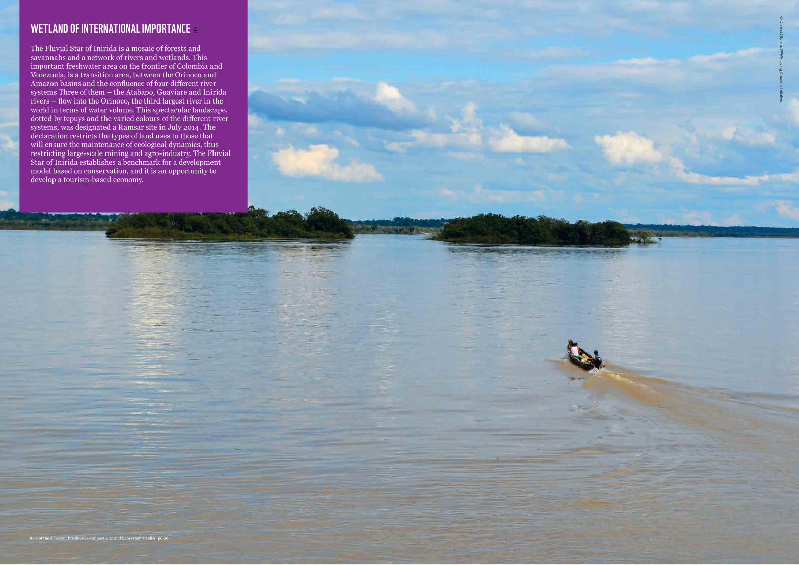
WETLAND OF INTERNATIONAL IMPORTANCE The Fluvial Star of Inirida is a mosaic of forests and savannahs and a network of rivers and wetlands. This important freshwater area on the frontier of Colombia and Venezuela, is a transition area, between the Orinoco and Amazon basins and the confluence of four different river systems Three of them – the Atabapo, Guaviare and Inirida rivers – flow into the Orinoco, the third largest river in the world in terms of water volume. This spectacular landscape, dotted by tepuys and the varied colours of the different river systems, was designated a Ramsar site in July 2014. The declaration restricts the types of land uses to those that will ensure the maintenance of ecological dynamics, thus restricting large-scale mining and agro-industry. The Fluvial Star of Inirida establishes a benchmark for a development model based on conservation, and it is an opportunity to develop a tourism-based economy.
© Denise O
liveira/WW
F-Living Amazon Initiative
State of the Amazon: Freshwater Connectivity and Ecosystem Health p. 66
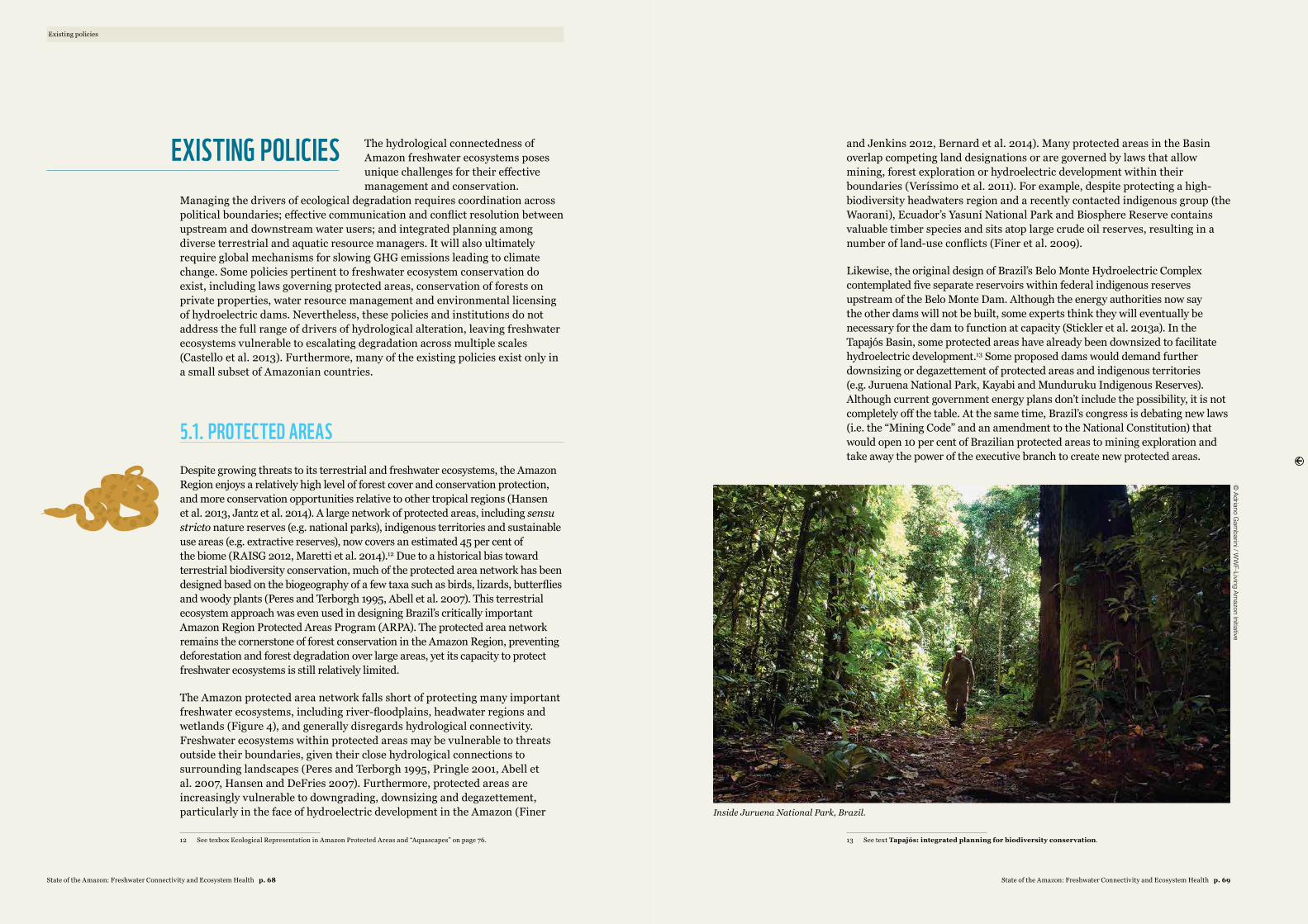
The hydrological connectedness of Amazon freshwater ecosystems poses unique challenges for their effective management and conservation.
Managing the drivers of ecological degradation requires coordination across political boundaries; effective communication and conflict resolution between upstream and downstream water users; and integrated planning among diverse terrestrial and aquatic resource managers. It will also ultimately require global mechanisms for slowing GHG emissions leading to climate change. Some policies pertinent to freshwater ecosystem conservation do exist, including laws governing protected areas, conservation of forests on private properties, water resource management and environmental licensing of hydroelectric dams. Nevertheless, these policies and institutions do not address the full range of drivers of hydrological alteration, leaving freshwater ecosystems vulnerable to escalating degradation across multiple scales (Castello et al. 2013). Furthermore, many of the existing policies exist only in a small subset of Amazonian countries.
5.1. PROTECTED AREASDespite growing threats to its terrestrial and freshwater ecosystems, the Amazon Region enjoys a relatively high level of forest cover and conservation protection, and more conservation opportunities relative to other tropical regions (Hansen et al. 2013, Jantz et al. 2014). A large network of protected areas, including sensu stricto nature reserves (e.g. national parks), indigenous territories and sustainable use areas (e.g. extractive reserves), now covers an estimated 45 per cent of the biome (RAISG 2012, Maretti et al. 2014).12 Due to a historical bias toward terrestrial biodiversity conservation, much of the protected area network has been designed based on the biogeography of a few taxa such as birds, lizards, butterflies and woody plants (Peres and Terborgh 1995, Abell et al. 2007). This terrestrial ecosystem approach was even used in designing Brazil’s critically important Amazon Region Protected Areas Program (ARPA). The protected area network remains the cornerstone of forest conservation in the Amazon Region, preventing deforestation and forest degradation over large areas, yet its capacity to protect freshwater ecosystems is still relatively limited.
The Amazon protected area network falls short of protecting many important freshwater ecosystems, including river-floodplains, headwater regions and wetlands (Figure 4), and generally disregards hydrological connectivity. Freshwater ecosystems within protected areas may be vulnerable to threats outside their boundaries, given their close hydrological connections to surrounding landscapes (Peres and Terborgh 1995, Pringle 2001, Abell et al. 2007, Hansen and DeFries 2007). Furthermore, protected areas are increasingly vulnerable to downgrading, downsizing and degazettement, particularly in the face of hydroelectric development in the Amazon (Finer
12 See texbox Ecological Representation in Amazon Protected Areas and “Aquascapes” on page 76.
and Jenkins 2012, Bernard et al. 2014). Many protected areas in the Basin overlap competing land designations or are governed by laws that allow mining, forest exploration or hydroelectric development within their boundaries (Veríssimo et al. 2011). For example, despite protecting a high-biodiversity headwaters region and a recently contacted indigenous group (the Waorani), Ecuador’s Yasuní National Park and Biosphere Reserve contains valuable timber species and sits atop large crude oil reserves, resulting in a number of land-use conflicts (Finer et al. 2009).
Likewise, the original design of Brazil’s Belo Monte Hydroelectric Complex contemplated five separate reservoirs within federal indigenous reserves upstream of the Belo Monte Dam. Although the energy authorities now say the other dams will not be built, some experts think they will eventually be necessary for the dam to function at capacity (Stickler et al. 2013a). In the Tapajós Basin, some protected areas have already been downsized to facilitate hydroelectric development.13 Some proposed dams would demand further downsizing or degazettement of protected areas and indigenous territories (e.g. Juruena National Park, Kayabi and Munduruku Indigenous Reserves). Although current government energy plans don’t include the possibility, it is not completely off the table. At the same time, Brazil’s congress is debating new laws (i.e. the “Mining Code” and an amendment to the National Constitution) that would open 10 per cent of Brazilian protected areas to mining exploration and take away the power of the executive branch to create new protected areas.
13 See text Tapajós: integrated planning for biodiversity conservation.
Existing policies
EXISTING POLICIES
© Adriano G
ambarini / W
WF-Living Am
azon Initiative
Inside Juruena National Park, Brazil.
State of the Amazon: Freshwater Connectivity and Ecosystem Health p. 69State of the Amazon: Freshwater Connectivity and Ecosystem Health p. 68
5.2. CLIMATE AND LAND-USE POLICYAlthough most Amazonian countries have laws regulating forest use and conservation on public lands (e.g. protected areas), few have laws that regulate forest cover on private properties. The Brazilian Forest Code and Peruvian Forest and Fauna Law are notable exceptions. Despite controversial revisions approved in 2012, the Brazilian Forest Code continues to be the central piece of legislation governing the conservation and use of forests on private properties, which contain over half of the country’s remaining native vegetation (Soares-Filho et al. 2014). The law requires landowners in the Amazon Biome to maintain forests on 80 per cent of their property (35 per cent in the Cerrado). It also designates riparian zones as Areas of Permanent Preservation (APPs), aiming to conserve riparian forests along rivers and lakes. Peru’s Forest and Fauna Law affords similar protection to riparian zones, mandating the conservation of a 50m buffer zone along rivers and lakes. By conserving riparian forest buffers, both laws protect freshwater ecosystems against the negative impacts of land-cover change (e.g. increased runoff, pollution and riparian habitat loss). To our knowledge, no equivalent laws exist in other Amazonian countries.
Despite the laws’ potential for maintaining hydrological connectivity, compliance with the Forest Code and Forest and Fauna laws has been notoriously low. Over 70 per cent of properties in the Upper Xingu River Basin (Mato Grosso, Brazil) were estimated to be out of compliance with Forest Code requirements in 2005 – partly because legal reserve requirements increased from 50 per cent to 80 per cent in 1996, pushing many compliant landowners into non-compliance overnight (Stickler et al. 2013b). In Peru, likewise, protected riparian buffers were found to be only about half the legally required width, on average (McClain and Cossio 2003). A major reason for such low levels of compliance with legislation has been poor monitoring and enforcement. Amazonian countries generally have limited human and financial resources for enforcement and management (Sagar 2000, Oliveira 2002, Veríssimo et al. 2011), particularly given the huge area of the Amazon to be surveyed and monitored. In many cases, what resources do exist have been devoted to curbing deforestation, which is perceived as a more immediate need than management of freshwater ecosystems (Castello et al. 2013). Such anti-deforestation measures indirectly benefit freshwater ecosystems, particularly when focused in riparian forests and headwater areas, but they are generally insufficient without complementary actions that directly address threats to freshwater ecosystems.
As deforestation rates in the Amazon skyrocketed in the early 2000s, Brazil became a laboratory for several innovative public and private policy initiatives, which together reduced Brazil’s deforestation to the lowest rates since monitoring began (Nepstad et al. 2009, IPEA et al. 2011, May et al. 2011, Dias et al. 2014). A large part of Brazil’s success in curbing deforestation is attributed to a comprehensive national “Action Plan for Prevention and
Control of Deforestation in the Legal Amazon” (PPCDAm – Plano de Ação para Prevenção e Controle do Desmatamento na Amazônia Legal), a cross-cutting initiative that integrated policies and programmes across several national ministries and sectors. The programme helped achieve major improvements in monitoring and enforcement at various levels, including targeted actions focused on municipalities and private properties owners who deforested illegally. At the same time, Brazil launched its National Climate Change Plan (PNMC) and implemented a Low-Carbon Agriculture (ABC) programme, which tied Brazil’s commitments to reduce carbon emissions to land use and created financial incentives (e.g. low-interest loans) and disincentives (e.g. restrictions on credit) aimed at reducing deforestation (IPEA et al. 2011, May et al. 2011). Expansion of protected areas and improvements in monitoring and enforcement of environmental laws were among the most important factors in reducing illegal deforestation (Jenkins and Joppa 2009, Soares-Filho et al. 2010), particularly in the southeastern Amazon (Nepstad et al. 2009, Macedo et al. 2012). These national efforts were aided by oscillations in related markets (commodities prices and exchange rates); non-profit campaigns to boycott products produced in illegally deforested areas; voluntary moratoria aimed at restricting market access for beef and soy produced on newly deforested lands; and restrictions on access to credit for illegal deforesters (Nepstad et al. 2014).
5.3. WATER RESOURCE MANAGEMENTMost Amazonian countries are implementing or revising legislation focused on water resource management, aiming to ensure the quality and quantity of water for human uses. These laws generally are based on the following principles of integrated water resources management: (i) water is a finite resource that has multiple uses; (ii) water is vulnerable to human activities; (iii) management must be implemented at the scale of catchments, or watersheds; and (iv) management must be decentralized and participatory (Setti 2004). Water management is usually implemented via a hierarchical institutional structure, consisting of a national water resource council and local water basin committees, agencies, civil organizations and communities – but these structures are poorly implemented in the Amazon today. Where laws exist, they generally focus on water itself (H2O) as the resource to be managed, rather than on freshwater ecosystems or their services – with the notable exception of Colombia, whose legislation is embedded in a more comprehensive framework.
Preserving water resources for human uses is important in the Amazon’s increasingly human-dominated landscapes, but existing legislation offers insufficient protection for freshwater ecosystems and fails to conserve ecosystem structure and function. Furthermore, because legislation is usually implemented within national boundaries, it often ignores the transboundary connectivity of freshwater ecosystems, thus contradicting the very principle of catchment-scale management. Even though water resource legislation
Existing policies
EXISTING LEGISLATION OFFERS INSUFFICIENT PROTECTION FOR FRESHWATER ECOSYSTEMS AND FAILS TO CONSERVE ECOSYSTEM STRUCTURE AND FUNCTION
State of the Amazon: Freshwater Connectivity and Ecosystem Health p. 71State of the Amazon: Freshwater Connectivity and Ecosystem Health p. 70
encompasses many large tributary basins of the Amazon (e.g. the Negro, Caqueta-Japurá, Napo, Juruá, Purus and Madeira; Figure 2), a lack of international coordination undermines its potential effectiveness across the whole Amazon watershed. Finally, existing legislation is far from being effectively implemented within national environmental management systems. The financial and human resources necessary for environmental management are limited in Amazonian countries and often used to address environmental issues that are perceived to be more pressing (e.g. deforestation).
Colombia is unique in having a comprehensive framework for watershed management that builds upon the principles of integrated water resource management described above, establishing that: (i) wetland, headwater and other sensitive freshwater ecosystems require special protection; (ii) the management, conservation and restoration of the structure and function of freshwater ecosystems transcends jurisdictional and administrative boundaries; (iii) it must prevent and control any form of degradation that threatens the integrity of aquatic ecosystems; (iv) it must consider and use all pertinent scientific and managerial information and approaches available; (v) human consumption of water must have priority over all other uses and must be considered at the time of making whole watershed decisions; and (vi) all costs and activities involved are the responsibility of the state. Although this whole watershed management framework is well suited to ensure the sustainable use and conservation of Amazonian freshwater ecosystems, its effective implementation is difficult due to the paucity of data on many Amazonian watersheds, large geographical areas involved and limited resources for implementation by Amazonian governments.
5.4. ENVIRONMENTAL LICENSING OF DAMSDecision-making processes related to the construction of hydroelectric dams vary considerably throughout the Amazon. Some countries have formal protocols guiding the development of hydroelectric projects, while others (e.g. Bolivia) lack them altogether. In the Brazilian and Peruvian Amazon, hydroelectric dam construction follows an environmental licensing process that aims to ensure that dams are economically viable and minimize environmental and social impacts (World Bank 2008, Balbín and La Rosa 2012). Although the licensing process is similar in both countries, we focus on Brazil’s process here because it has been better studied. The first step in the process is an inventory of the river basin, usually followed by a viability assessment of the proposed project, which should include a detailed Environmental Impact Assessment (EIA) and Report on Impacts to the Environment (RIMA) in its early stages, often referred to jointly as the EIA-RIMA. The EIA-RIMA study is usually led by the corporate entity (or agency) interested in bidding on the proposed project. Its aim is (or should be) to support a sound decision by evaluating all options, including dam location and type, management strategies, and the option of not building the dam. The process for approval of the EIA-RIMA includes public hearings in
the affected area and technical analyses by the appropriate agency. Together these may require changes to the documents, including development of a plan to minimize the environmental or social impacts identified. Once complete, the EIA-RIMA is either approved or denied by the appropriate agency. If approved, preliminary licenses are issued to enable firms to bid for construction contracts. Firms must then obtain an installation license to begin construction and subsequently an operating license to generate power.
On the surface the existing environmental licensing procedures appear fair, technically sound and capable of reconciling social, economic and environmental needs. However, several fundamental deficiencies in the process have allowed construction of many poorly designed hydroelectric dams in the Amazon. In general, project proposals are biased toward energy needs, often ignoring impacts on alternative uses of water, ecological flows and local populations. There is no inclusive, basin-level process for strategic assessment of project-level impacts (both positive and negative), evaluation of cumulative impacts or public debate of alternative options. Because initial proposals are almost exclusively focused on power generation potential, it is difficult for environmental and social agencies to give meaningful input before the projects gain political momentum. As a result, measures to mitigate social and environmental impacts are poorly designed and generally ineffective.
The need for electricity in the Amazon is undisputed, but the environmental licensing process has historically prioritized economic benefits and social interests (though often not those of local people) at the expense of freshwater ecosystems (La Rovere and Mendes 2000, Switkes 2002, 2007, Fearnside 2013a). These deficiencies undermine the capacity of Brazil’s environmental licensing process to balance the economic, social and environmental impacts typical of large infrastructure projects. Here, we review three of the main deficiencies in this process. First, the environmental licensing process is required only for hydroelectric dams larger than 10MW of installed energy production capacity, while those of equal or lesser capacity are exempt from any sort of rational, informed, public decision-making process. Over half (~90) of the operational dams in the Amazon Basin have an installed capacity of 10MW or less, compared with ~64 dams with a capacity greater than 10MW (Castello et al. 2013). Although the individual impacts of large dams may be greater than those of small dams, in some landscapes the cumulative effects of many small dams have the potential to surpass those of larger dams.
Second, the preparation of the EIA-RIMA documents is riddled with conflicts of interest. These documents are developed by consulting firms hired directly by the construction firms, giving those conducting the studies a monetary incentive to minimize negative findings. Construction firms often control the EIA-RIMA documents, creating a lack of transparency and potential for corruption of the results. The contracts specify that construction firms own all of the data and that the content of reports and publications is subject to their approval. Evidence of the partiality of EIA-RIMA studies abounds. Several studies have shown that EIA-RIMA documents are generally narrow
Existing policies
THE CUMULATIVE EFFECTS OF MANY SMALL DAMS HAVE THE POTENTIAL TO SURPASS THOSE OF LARGER DAMS
State of the Amazon: Freshwater Connectivity and Ecosystem Health p. 73State of the Amazon: Freshwater Connectivity and Ecosystem Health p. 72
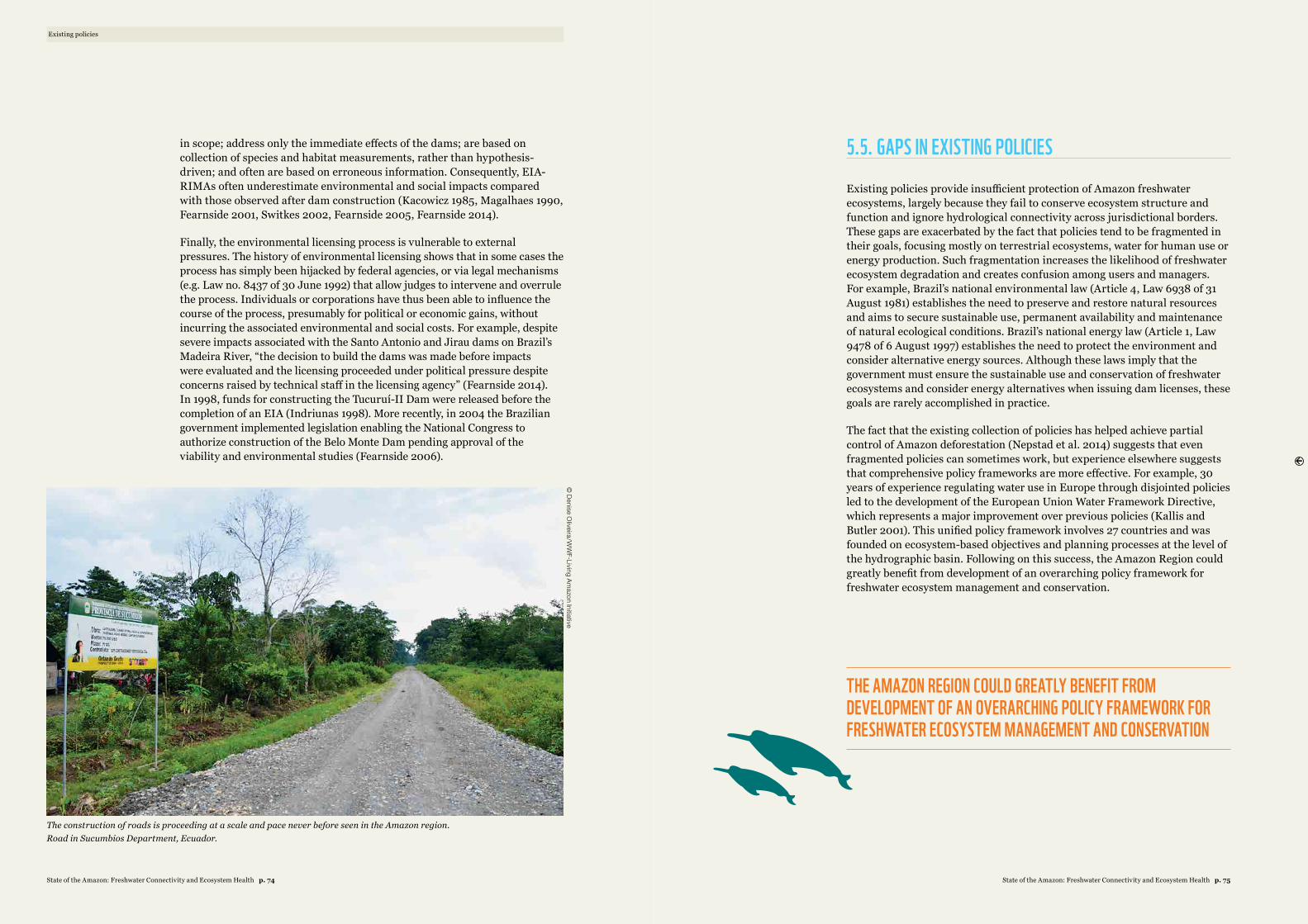
in scope; address only the immediate effects of the dams; are based on collection of species and habitat measurements, rather than hypothesis-driven; and often are based on erroneous information. Consequently, EIA-RIMAs often underestimate environmental and social impacts compared with those observed after dam construction (Kacowicz 1985, Magalhaes 1990, Fearnside 2001, Switkes 2002, Fearnside 2005, Fearnside 2014).
Finally, the environmental licensing process is vulnerable to external pressures. The history of environmental licensing shows that in some cases the process has simply been hijacked by federal agencies, or via legal mechanisms (e.g. Law no. 8437 of 30 June 1992) that allow judges to intervene and overrule the process. Individuals or corporations have thus been able to influence the course of the process, presumably for political or economic gains, without incurring the associated environmental and social costs. For example, despite severe impacts associated with the Santo Antonio and Jirau dams on Brazil’s Madeira River, “the decision to build the dams was made before impacts were evaluated and the licensing proceeded under political pressure despite concerns raised by technical staff in the licensing agency” (Fearnside 2014). In 1998, funds for constructing the Tucuruí-II Dam were released before the completion of an EIA (Indriunas 1998). More recently, in 2004 the Brazilian government implemented legislation enabling the National Congress to authorize construction of the Belo Monte Dam pending approval of the viability and environmental studies (Fearnside 2006).
Existing policies
5.5. GAPS IN EXISTING POLICIES
Existing policies provide insufficient protection of Amazon freshwater ecosystems, largely because they fail to conserve ecosystem structure and function and ignore hydrological connectivity across jurisdictional borders. These gaps are exacerbated by the fact that policies tend to be fragmented in their goals, focusing mostly on terrestrial ecosystems, water for human use or energy production. Such fragmentation increases the likelihood of freshwater ecosystem degradation and creates confusion among users and managers. For example, Brazil’s national environmental law (Article 4, Law 6938 of 31 August 1981) establishes the need to preserve and restore natural resources and aims to secure sustainable use, permanent availability and maintenance of natural ecological conditions. Brazil’s national energy law (Article 1, Law 9478 of 6 August 1997) establishes the need to protect the environment and consider alternative energy sources. Although these laws imply that the government must ensure the sustainable use and conservation of freshwater ecosystems and consider energy alternatives when issuing dam licenses, these goals are rarely accomplished in practice.
The fact that the existing collection of policies has helped achieve partial control of Amazon deforestation (Nepstad et al. 2014) suggests that even fragmented policies can sometimes work, but experience elsewhere suggests that comprehensive policy frameworks are more effective. For example, 30 years of experience regulating water use in Europe through disjointed policies led to the development of the European Union Water Framework Directive, which represents a major improvement over previous policies (Kallis and Butler 2001). This unified policy framework involves 27 countries and was founded on ecosystem-based objectives and planning processes at the level of the hydrographic basin. Following on this success, the Amazon Region could greatly benefit from development of an overarching policy framework for freshwater ecosystem management and conservation.
THE AMAZON REGION COULD GREATLY BENEFIT FROM DEVELOPMENT OF AN OVERARCHING POLICY FRAMEWORK FOR FRESHWATER ECOSYSTEM MANAGEMENT AND CONSERVATION
© Denise O
liveira/WW
F-Living Amazon Initiative
The construction of roads is proceeding at a scale and pace never before seen in the Amazon region. Road in Sucumbios Department, Ecuador.
State of the Amazon: Freshwater Connectivity and Ecosystem Health p. 75State of the Amazon: Freshwater Connectivity and Ecosystem Health p. 74
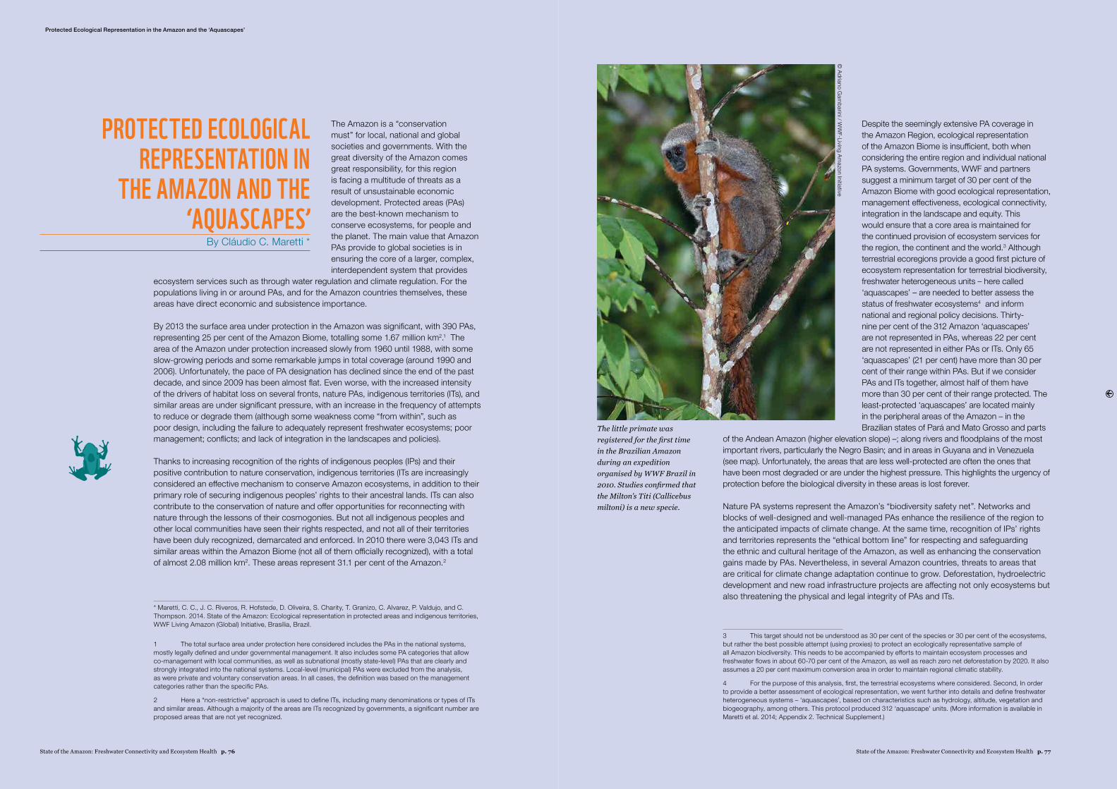
State of the Amazon: Freshwater Connectivity and Ecosystem Health p. 77State of the Amazon: Freshwater Connectivity and Ecosystem Health p. 76
The Amazon is a “conservation must” for local, national and global societies and governments. With the great diversity of the Amazon comes great responsibility, for this region is facing a multitude of threats as a result of unsustainable economic development. Protected areas (PAs) are the best-known mechanism to conserve ecosystems, for people and the planet. The main value that Amazon PAs provide to global societies is in ensuring the core of a larger, complex, interdependent system that provides
ecosystem services such as through water regulation and climate regulation. For the populations living in or around PAs, and for the Amazon countries themselves, these areas have direct economic and subsistence importance.
By 2013 the surface area under protection in the Amazon was significant, with 390 PAs, representing 25 per cent of the Amazon Biome, totalling some 1.67 million km2.1 The area of the Amazon under protection increased slowly from 1960 until 1988, with some slow-growing periods and some remarkable jumps in total coverage (around 1990 and 2006). Unfortunately, the pace of PA designation has declined since the end of the past decade, and since 2009 has been almost flat. Even worse, with the increased intensity of the drivers of habitat loss on several fronts, nature PAs, indigenous territories (ITs), and similar areas are under significant pressure, with an increase in the frequency of attempts to reduce or degrade them (although some weakness come “from within”, such as poor design, including the failure to adequately represent freshwater ecosystems; poor management; conflicts; and lack of integration in the landscapes and policies).
Thanks to increasing recognition of the rights of indigenous peoples (IPs) and their positive contribution to nature conservation, indigenous territories (ITs are increasingly considered an effective mechanism to conserve Amazon ecosystems, in addition to their primary role of securing indigenous peoples’ rights to their ancestral lands. ITs can also contribute to the conservation of nature and offer opportunities for reconnecting with nature through the lessons of their cosmogonies. But not all indigenous peoples and other local communities have seen their rights respected, and not all of their territories have been duly recognized, demarcated and enforced. In 2010 there were 3,043 ITs and similar areas within the Amazon Biome (not all of them officially recognized), with a total of almost 2.08 million km2. These areas represent 31.1 per cent of the Amazon.2
* Maretti, C. C., J. C. Riveros, R. Hofstede, D. Oliveira, S. Charity, T. Granizo, C. Alvarez, P. Valdujo, and C. Thompson. 2014. State of the Amazon: Ecological representation in protected areas and indigenous territories, WWF Living Amazon (Global) Initiative, Brasília, Brazil.
1 The total surface area under protection here considered includes the PAs in the national systems, mostly legally defined and under governmental management. It also includes some PA categories that allow co-management with local communities, as well as subnational (mostly state-level) PAs that are clearly and strongly integrated into the national systems. Local-level (municipal) PAs were excluded from the analysis, as were private and voluntary conservation areas. In all cases, the definition was based on the management categories rather than the specific PAs.
2 Here a “non-restrictive” approach is used to define ITs, including many denominations or types of ITs and similar areas. Although a majority of the areas are ITs recognized by governments, a significant number are proposed areas that are not yet recognized.
PROTECTED ECOLOGICAL REPRESENTATION IN
THE AMAZON AND THE ‘AQUASCAPES’
By Cláudio C. Maretti *
Despite the seemingly extensive PA coverage in the Amazon Region, ecological representation of the Amazon Biome is insufficient, both when considering the entire region and individual national PA systems. Governments, WWF and partners suggest a minimum target of 30 per cent of the Amazon Biome with good ecological representation, management effectiveness, ecological connectivity, integration in the landscape and equity. This would ensure that a core area is maintained for the continued provision of ecosystem services for the region, the continent and the world.3 Although terrestrial ecoregions provide a good first picture of ecosystem representation for terrestrial biodiversity, freshwater heterogeneous units – here called ‘aquascapes’ – are needed to better assess the status of freshwater ecosystems4 and inform national and regional policy decisions. Thirty-nine per cent of the 312 Amazon ‘aquascapes’ are not represented in PAs, whereas 22 per cent are not represented in either PAs or ITs. Only 65 ‘aquascapes’ (21 per cent) have more than 30 per cent of their range within PAs. But if we consider PAs and ITs together, almost half of them have more than 30 per cent of their range protected. The least-protected ‘aquascapes’ are located mainly in the peripheral areas of the Amazon – in the Brazilian states of Pará and Mato Grosso and parts
of the Andean Amazon (higher elevation slope) –; along rivers and floodplains of the most important rivers, particularly the Negro Basin; and in areas in Guyana and in Venezuela (see map). Unfortunately, the areas that are less well-protected are often the ones that have been most degraded or are under the highest pressure. This highlights the urgency of protection before the biological diversity in these areas is lost forever.
Nature PA systems represent the Amazon’s “biodiversity safety net”. Networks and blocks of well-designed and well-managed PAs enhance the resilience of the region to the anticipated impacts of climate change. At the same time, recognition of IPs’ rights and territories represents the “ethical bottom line” for respecting and safeguarding the ethnic and cultural heritage of the Amazon, as well as enhancing the conservation gains made by PAs. Nevertheless, in several Amazon countries, threats to areas that are critical for climate change adaptation continue to grow. Deforestation, hydroelectric development and new road infrastructure projects are affecting not only ecosystems but also threatening the physical and legal integrity of PAs and ITs.
3 This target should not be understood as 30 per cent of the species or 30 per cent of the ecosystems, but rather the best possible attempt (using proxies) to protect an ecologically representative sample of all Amazon biodiversity. This needs to be accompanied by efforts to maintain ecosystem processes and freshwater flows in about 60-70 per cent of the Amazon, as well as reach zero net deforestation by 2020. It also assumes a 20 per cent maximum conversion area in order to maintain regional climatic stability.
4 For the purpose of this analysis, first, the terrestrial ecosystems where considered. Second, In order to provide a better assessment of ecological representation, we went further into details and define freshwater heterogeneous systems – ‘aquascapes’, based on characteristics such as hydrology, altitude, vegetation and biogeography, among others. This protocol produced 312 ‘aquascape’ units. (More information is available in Maretti et al. 2014; Appendix 2. Technical Supplement.)
Protected Ecological Representation in the Amazon and the ‘Aquascapes’
The little primate was registered for the first time in the Brazilian Amazon during an expedition organised by WWF Brazil in 2010. Studies confirmed that the Milton’s Titi (Callicebus miltoni) is a new specie.
© Adriano G
ambarini / W
WF-Living Am
azon Initiative
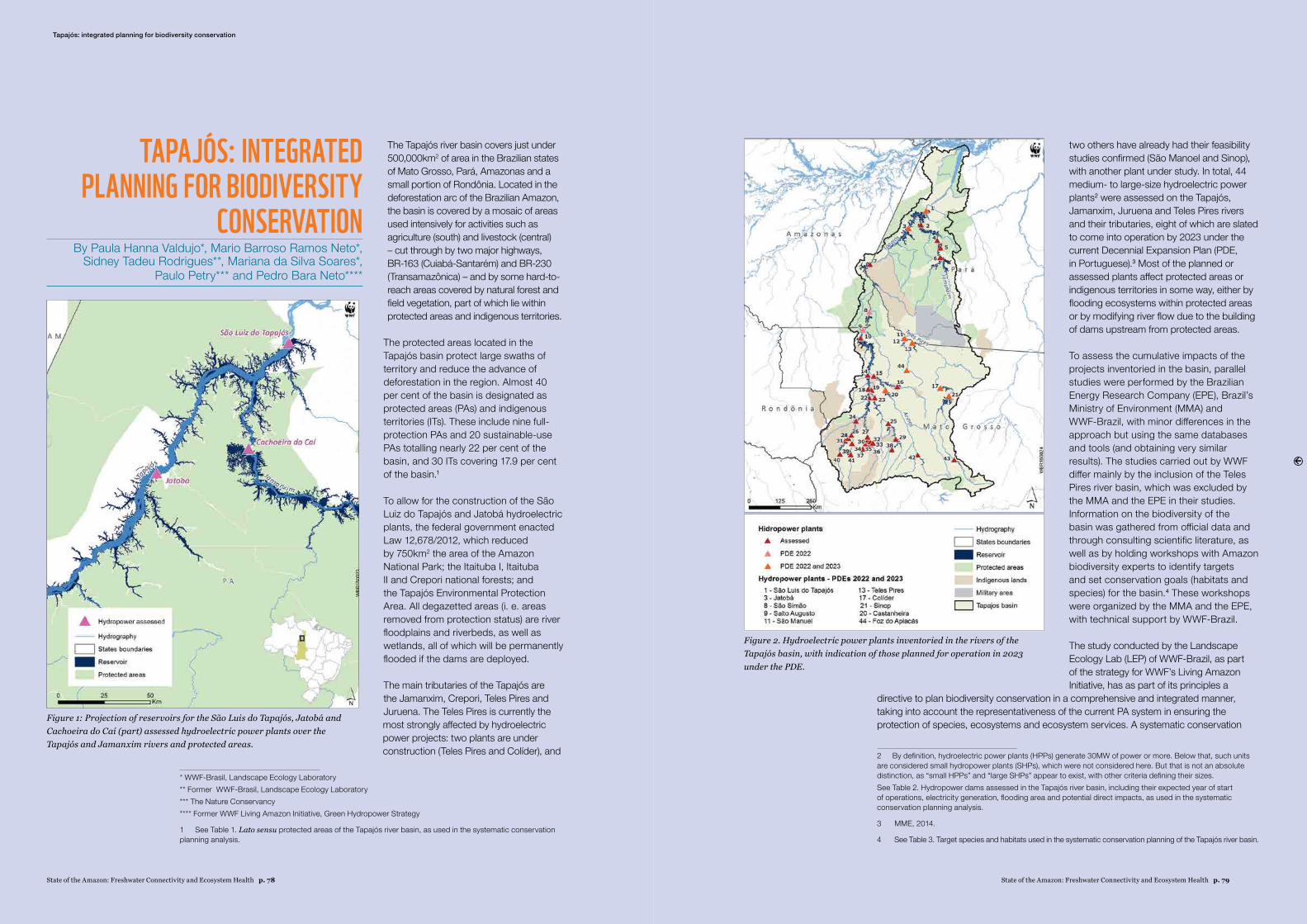
State of the Amazon: Freshwater Connectivity and Ecosystem Health p. 79State of the Amazon: Freshwater Connectivity and Ecosystem Health p. 78
The Tapajós river basin covers just under 500,000km2 of area in the Brazilian states of Mato Grosso, Pará, Amazonas and a small portion of Rondônia. Located in the deforestation arc of the Brazilian Amazon, the basin is covered by a mosaic of areas used intensively for activities such as agriculture (south) and livestock (central) – cut through by two major highways, BR-163 (Cuiabá-Santarém) and BR-230 (Transamazônica) – and by some hard-to-reach areas covered by natural forest and field vegetation, part of which lie within protected areas and indigenous territories.
The protected areas located in the Tapajós basin protect large swaths of territory and reduce the advance of deforestation in the region. Almost 40 per cent of the basin is designated as protected areas (PAs) and indigenous territories (ITs). These include nine full-protection PAs and 20 sustainable-use PAs totalling nearly 22 per cent of the basin, and 30 ITs covering 17.9 per cent of the basin.1
To allow for the construction of the São Luiz do Tapajós and Jatobá hydroelectric plants, the federal government enacted Law 12,678/2012, which reduced by 750km2 the area of the Amazon National Park; the Itaituba I, Itaituba II and Crepori national forests; and the Tapajós Environmental Protection Area. All degazetted areas (i. e. areas removed from protection status) are river floodplains and riverbeds, as well as wetlands, all of which will be permanently flooded if the dams are deployed.
The main tributaries of the Tapajós are the Jamanxim, Crepori, Teles Pires and Juruena. The Teles Pires is currently the most strongly affected by hydroelectric power projects: two plants are under construction (Teles Pires and Colíder), and
* WWF-Brasil, Landscape Ecology Laboratory** Former WWF-Brasil, Landscape Ecology Laboratory*** The Nature Conservancy**** Former WWF Living Amazon Initiative, Green Hydropower Strategy
1 See Table 1. Lato sensu protected areas of the Tapajós river basin, as used in the systematic conservation planning analysis.
TAPAJÓS: INTEGRATED PLANNING FOR BIODIVERSITY
CONSERVATIONBy Paula Hanna Valdujo*, Mario Barroso Ramos Neto*,
Sidney Tadeu Rodrigues**, Mariana da Silva Soares*, Paulo Petry*** and Pedro Bara Neto****
two others have already had their feasibility studies confirmed (São Manoel and Sinop), with another plant under study. In total, 44 medium- to large-size hydroelectric power plants2 were assessed on the Tapajós, Jamanxim, Juruena and Teles Pires rivers and their tributaries, eight of which are slated to come into operation by 2023 under the current Decennial Expansion Plan (PDE, in Portuguese).3 Most of the planned or assessed plants affect protected areas or indigenous territories in some way, either by flooding ecosystems within protected areas or by modifying river flow due to the building of dams upstream from protected areas.
To assess the cumulative impacts of the projects inventoried in the basin, parallel studies were performed by the Brazilian Energy Research Company (EPE), Brazil’s Ministry of Environment (MMA) and WWF-Brazil, with minor differences in the approach but using the same databases and tools (and obtaining very similar results). The studies carried out by WWF differ mainly by the inclusion of the Teles Pires river basin, which was excluded by the MMA and the EPE in their studies. Information on the biodiversity of the basin was gathered from official data and through consulting scientific literature, as well as by holding workshops with Amazon biodiversity experts to identify targets and set conservation goals (habitats and species) for the basin.4 These workshops were organized by the MMA and the EPE, with technical support by WWF-Brazil.
The study conducted by the Landscape Ecology Lab (LEP) of WWF-Brazil, as part of the strategy for WWF’s Living Amazon Initiative, has as part of its principles a
directive to plan biodiversity conservation in a comprehensive and integrated manner, taking into account the representativeness of the current PA system in ensuring the protection of species, ecosystems and ecosystem services. A systematic conservation
2 By definition, hydroelectric power plants (HPPs) generate 30MW of power or more. Below that, such units are considered small hydropower plants (SHPs), which were not considered here. But that is not an absolute distinction, as “small HPPs” and “large SHPs” appear to exist, with other criteria defining their sizes.See Table 2. Hydropower dams assessed in the Tapajós river basin, including their expected year of start of operations, electricity generation, flooding area and potential direct impacts, as used in the systematic conservation planning analysis.
3 MME, 2014.
4 See Table 3. Target species and habitats used in the systematic conservation planning of the Tapajós river basin.
Tapajós: integrated planning for biodiversity conservation
Figure 2. Hydroelectric power plants inventoried in the rivers of the Tapajós basin, with indication of those planned for operation in 2023 under the PDE.
Figure 1: Projection of reservoirs for the São Luis do Tapajós, Jatobá and Cachoeira do Caí (part) assessed hydroelectric power plants over the Tapajós and Jamanxim rivers and protected areas.
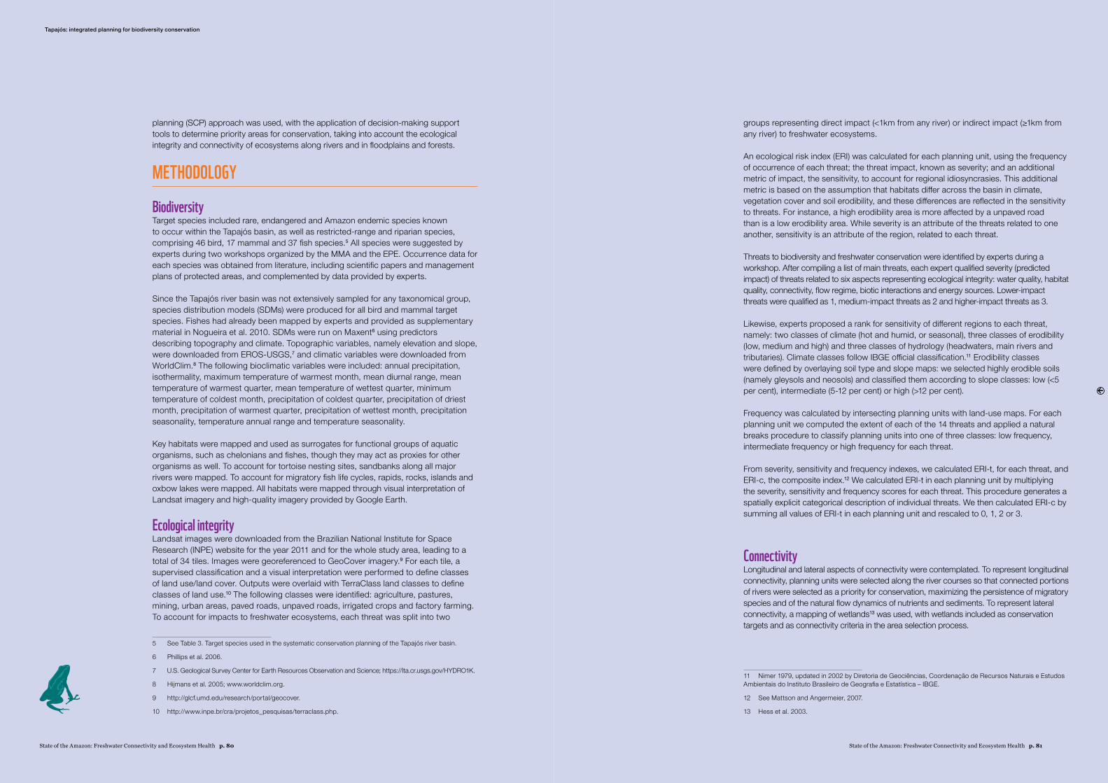
State of the Amazon: Freshwater Connectivity and Ecosystem Health p. 81State of the Amazon: Freshwater Connectivity and Ecosystem Health p. 80
planning (SCP) approach was used, with the application of decision-making support tools to determine priority areas for conservation, taking into account the ecological integrity and connectivity of ecosystems along rivers and in floodplains and forests.
METHODOLOGY
BiodiversityTarget species included rare, endangered and Amazon endemic species known to occur within the Tapajós basin, as well as restricted-range and riparian species, comprising 46 bird, 17 mammal and 37 fish species.5 All species were suggested by experts during two workshops organized by the MMA and the EPE. Occurrence data for each species was obtained from literature, including scientific papers and management plans of protected areas, and complemented by data provided by experts.
Since the Tapajós river basin was not extensively sampled for any taxonomical group, species distribution models (SDMs) were produced for all bird and mammal target species. Fishes had already been mapped by experts and provided as supplementary material in Nogueira et al. 2010. SDMs were run on Maxent6 using predictors describing topography and climate. Topographic variables, namely elevation and slope, were downloaded from EROS-USGS,7 and climatic variables were downloaded from WorldClim.8 The following bioclimatic variables were included: annual precipitation, isothermality, maximum temperature of warmest month, mean diurnal range, mean temperature of warmest quarter, mean temperature of wettest quarter, minimum temperature of coldest month, precipitation of coldest quarter, precipitation of driest month, precipitation of warmest quarter, precipitation of wettest month, precipitation seasonality, temperature annual range and temperature seasonality.
Key habitats were mapped and used as surrogates for functional groups of aquatic organisms, such as chelonians and fishes, though they may act as proxies for other organisms as well. To account for tortoise nesting sites, sandbanks along all major rivers were mapped. To account for migratory fish life cycles, rapids, rocks, islands and oxbow lakes were mapped. All habitats were mapped through visual interpretation of Landsat imagery and high-quality imagery provided by Google Earth.
Ecological integrityLandsat images were downloaded from the Brazilian National Institute for Space Research (INPE) website for the year 2011 and for the whole study area, leading to a total of 34 tiles. Images were georeferenced to GeoCover imagery.9 For each tile, a supervised classification and a visual interpretation were performed to define classes of land use/land cover. Outputs were overlaid with TerraClass land classes to define classes of land use.10 The following classes were identified: agriculture, pastures, mining, urban areas, paved roads, unpaved roads, irrigated crops and factory farming. To account for impacts to freshwater ecosystems, each threat was split into two
5 See Table 3. Target species used in the systematic conservation planning of the Tapajós river basin.
6 Phillips et al. 2006.
7 U.S. Geological Survey Center for Earth Resources Observation and Science; https://lta.cr.usgs.gov/HYDRO1K.
8 Hijmans et al. 2005; www.worldclim.org.
9 http://glcf.umd.edu/research/portal/geocover.
10 http://www.inpe.br/cra/projetos_pesquisas/terraclass.php.
groups representing direct impact (<1km from any river) or indirect impact (≥1km from any river) to freshwater ecosystems.
An ecological risk index (ERI) was calculated for each planning unit, using the frequency of occurrence of each threat; the threat impact, known as severity; and an additional metric of impact, the sensitivity, to account for regional idiosyncrasies. This additional metric is based on the assumption that habitats differ across the basin in climate, vegetation cover and soil erodibility, and these differences are reflected in the sensitivity to threats. For instance, a high erodibility area is more affected by a unpaved road than is a low erodibility area. While severity is an attribute of the threats related to one another, sensitivity is an attribute of the region, related to each threat.
Threats to biodiversity and freshwater conservation were identified by experts during a workshop. After compiling a list of main threats, each expert qualified severity (predicted impact) of threats related to six aspects representing ecological integrity: water quality, habitat quality, connectivity, flow regime, biotic interactions and energy sources. Lower-impact threats were qualified as 1, medium-impact threats as 2 and higher-impact threats as 3.
Likewise, experts proposed a rank for sensitivity of different regions to each threat, namely: two classes of climate (hot and humid, or seasonal), three classes of erodibility (low, medium and high) and three classes of hydrology (headwaters, main rivers and tributaries). Climate classes follow IBGE official classification.11 Erodibility classes were defined by overlaying soil type and slope maps: we selected highly erodible soils (namely gleysols and neosols) and classified them according to slope classes: low (<5 per cent), intermediate (5-12 per cent) or high (>12 per cent).
Frequency was calculated by intersecting planning units with land-use maps. For each planning unit we computed the extent of each of the 14 threats and applied a natural breaks procedure to classify planning units into one of three classes: low frequency, intermediate frequency or high frequency for each threat.
From severity, sensitivity and frequency indexes, we calculated ERI-t, for each threat, and ERI-c, the composite index.12 We calculated ERI-t in each planning unit by multiplying the severity, sensitivity and frequency scores for each threat. This procedure generates a spatially explicit categorical description of individual threats. We then calculated ERI-c by summing all values of ERI-t in each planning unit and rescaled to 0, 1, 2 or 3.
ConnectivityLongitudinal and lateral aspects of connectivity were contemplated. To represent longitudinal connectivity, planning units were selected along the river courses so that connected portions of rivers were selected as a priority for conservation, maximizing the persistence of migratory species and of the natural flow dynamics of nutrients and sediments. To represent lateral connectivity, a mapping of wetlands13 was used, with wetlands included as conservation targets and as connectivity criteria in the area selection process.
11 Nimer 1979, updated in 2002 by Diretoria de Geociências, Coordenacão de Recursos Naturais e Estudos Ambientais do Instituto Brasileiro de Geografia e Estatística – IBGE.
12 See Mattson and Angermeier, 2007.
13 Hess et al. 2003.
Tapajós: integrated planning for biodiversity conservation
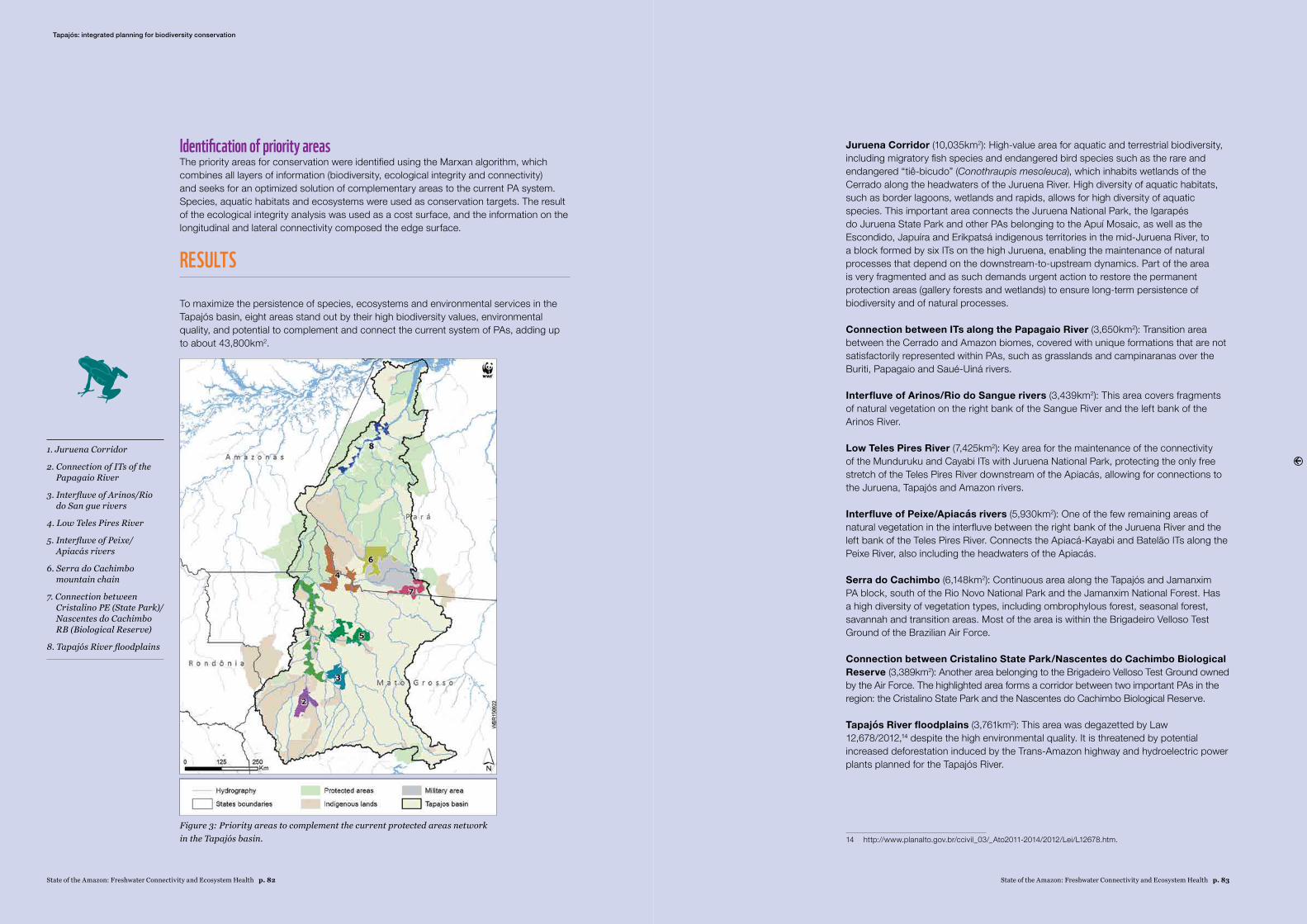
Identification of priority areasThe priority areas for conservation were identified using the Marxan algorithm, which combines all layers of information (biodiversity, ecological integrity and connectivity) and seeks for an optimized solution of complementary areas to the current PA system. Species, aquatic habitats and ecosystems were used as conservation targets. The result of the ecological integrity analysis was used as a cost surface, and the information on the longitudinal and lateral connectivity composed the edge surface.
RESULTS
To maximize the persistence of species, ecosystems and environmental services in the Tapajós basin, eight areas stand out by their high biodiversity values, environmental quality, and potential to complement and connect the current system of PAs, adding up to about 43,800km2.
Juruena Corridor (10,035km2): High-value area for aquatic and terrestrial biodiversity, including migratory fish species and endangered bird species such as the rare and endangered “tiê-bicudo” (Conothraupis mesoleuca), which inhabits wetlands of the Cerrado along the headwaters of the Juruena River. High diversity of aquatic habitats, such as border lagoons, wetlands and rapids, allows for high diversity of aquatic species. This important area connects the Juruena National Park, the Igarapés do Juruena State Park and other PAs belonging to the Apuí Mosaic, as well as the Escondido, Japuíra and Erikpatsá indigenous territories in the mid-Juruena River, to a block formed by six ITs on the high Juruena, enabling the maintenance of natural processes that depend on the downstream-to-upstream dynamics. Part of the area is very fragmented and as such demands urgent action to restore the permanent protection areas (gallery forests and wetlands) to ensure long-term persistence of biodiversity and of natural processes.
Connection between ITs along the Papagaio River (3,650km2): Transition area between the Cerrado and Amazon biomes, covered with unique formations that are not satisfactorily represented within PAs, such as grasslands and campinaranas over the Buriti, Papagaio and Saué-Uiná rivers.
Interfluve of Arinos/Rio do Sangue rivers (3,439km2): This area covers fragments of natural vegetation on the right bank of the Sangue River and the left bank of the Arinos River.
Low Teles Pires River (7,425km2): Key area for the maintenance of the connectivity of the Munduruku and Cayabi ITs with Juruena National Park, protecting the only free stretch of the Teles Pires River downstream of the Apiacás, allowing for connections to the Juruena, Tapajós and Amazon rivers.
Interfluve of Peixe/Apiacás rivers (5,930km2): One of the few remaining areas of natural vegetation in the interfluve between the right bank of the Juruena River and the left bank of the Teles Pires River. Connects the Apiacá-Kayabi and Batelão ITs along the Peixe River, also including the headwaters of the Apiacás.
Serra do Cachimbo (6,148km2): Continuous area along the Tapajós and Jamanxim PA block, south of the Rio Novo National Park and the Jamanxim National Forest. Has a high diversity of vegetation types, including ombrophylous forest, seasonal forest, savannah and transition areas. Most of the area is within the Brigadeiro Velloso Test Ground of the Brazilian Air Force.
Connection between Cristalino State Park/Nascentes do Cachimbo Biological Reserve (3,389km2): Another area belonging to the Brigadeiro Velloso Test Ground owned by the Air Force. The highlighted area forms a corridor between two important PAs in the region: the Cristalino State Park and the Nascentes do Cachimbo Biological Reserve.
Tapajós River floodplains (3,761km2): This area was degazetted by Law 12,678/2012,14 despite the high environmental quality. It is threatened by potential increased deforestation induced by the Trans-Amazon highway and hydroelectric power plants planned for the Tapajós River.
14 http://www.planalto.gov.br/ccivil_03/_Ato2011-2014/2012/Lei/L12678.htm.
1. Juruena Corridor
2. Connection of ITs of the Papagaio River
3. Interfluve of Arinos/Rio do San gue rivers
4. Low Teles Pires River
5. Interfluve of Peixe/Apiacás rivers
6. Serra do Cachimbo mountain chain
7. Connection between Cristalino PE (State Park)/Nascentes do Cachimbo RB (Biological Reserve)
8. Tapajós River floodplains
Figure 3: Priority areas to complement the current protected areas network in the Tapajós basin.
Tapajós: integrated planning for biodiversity conservation
State of the Amazon: Freshwater Connectivity and Ecosystem Health p. 83State of the Amazon: Freshwater Connectivity and Ecosystem Health p. 82
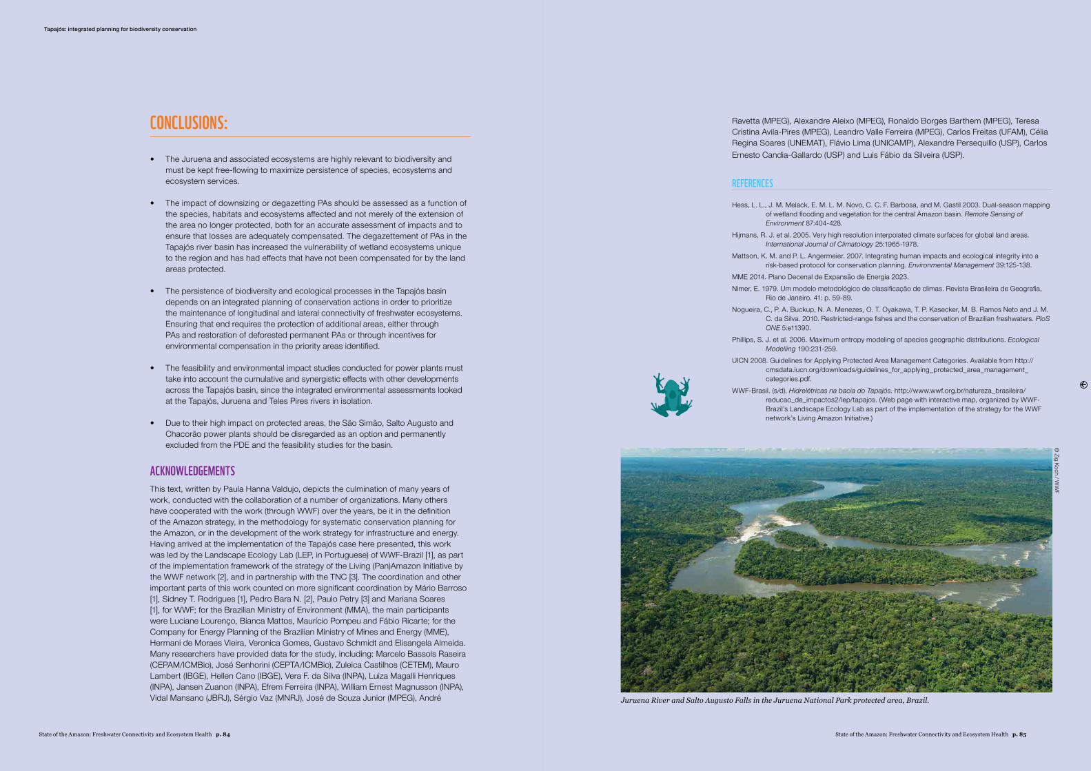
State of the Amazon: Freshwater Connectivity and Ecosystem Health p. 85
CONCLUSIONS:
• The Juruena and associated ecosystems are highly relevant to biodiversity and must be kept free-flowing to maximize persistence of species, ecosystems and ecosystem services.
• The impact of downsizing or degazetting PAs should be assessed as a function of the species, habitats and ecosystems affected and not merely of the extension of the area no longer protected, both for an accurate assessment of impacts and to ensure that losses are adequately compensated. The degazettement of PAs in the Tapajós river basin has increased the vulnerability of wetland ecosystems unique to the region and has had effects that have not been compensated for by the land areas protected.
• The persistence of biodiversity and ecological processes in the Tapajós basin depends on an integrated planning of conservation actions in order to prioritize the maintenance of longitudinal and lateral connectivity of freshwater ecosystems. Ensuring that end requires the protection of additional areas, either through PAs and restoration of deforested permanent PAs or through incentives for environmental compensation in the priority areas identified.
• The feasibility and environmental impact studies conducted for power plants must take into account the cumulative and synergistic effects with other developments across the Tapajós basin, since the integrated environmental assessments looked at the Tapajós, Juruena and Teles Pires rivers in isolation.
• Due to their high impact on protected areas, the São Simão, Salto Augusto and Chacorão power plants should be disregarded as an option and permanently excluded from the PDE and the feasibility studies for the basin.
ACKNOWLEDGEMENTS This text, written by Paula Hanna Valdujo, depicts the culmination of many years of work, conducted with the collaboration of a number of organizations. Many others have cooperated with the work (through WWF) over the years, be it in the definition of the Amazon strategy, in the methodology for systematic conservation planning for the Amazon, or in the development of the work strategy for infrastructure and energy. Having arrived at the implementation of the Tapajós case here presented, this work was led by the Landscape Ecology Lab (LEP, in Portuguese) of WWF-Brazil [1], as part of the implementation framework of the strategy of the Living (Pan)Amazon Initiative by the WWF network [2], and in partnership with the TNC [3]. The coordination and other important parts of this work counted on more significant coordination by Mário Barroso [1], Sidney T. Rodrigues [1], Pedro Bara N. [2], Paulo Petry [3] and Mariana Soares [1], for WWF; for the Brazilian Ministry of Environment (MMA), the main participants were Luciane Lourenco, Bianca Mattos, Maurício Pompeu and Fábio Ricarte; for the Company for Energy Planning of the Brazilian Ministry of Mines and Energy (MME), Hermani de Moraes Vieira, Veronica Gomes, Gustavo Schmidt and Elisangela Almeida. Many researchers have provided data for the study, including: Marcelo Bassols Raseira (CEPAM/ICMBio), José Senhorini (CEPTA/ICMBio), Zuleica Castilhos (CETEM), Mauro Lambert (IBGE), Hellen Cano (IBGE), Vera F. da Silva (INPA), Luiza Magalli Henriques (INPA), Jansen Zuanon (INPA), Efrem Ferreira (INPA), William Ernest Magnusson (INPA), Vidal Mansano (JBRJ), Sérgio Vaz (MNRJ), José de Souza Junior (MPEG), André
Ravetta (MPEG), Alexandre Aleixo (MPEG), Ronaldo Borges Barthem (MPEG), Teresa Cristina Avila-Pires (MPEG), Leandro Valle Ferreira (MPEG), Carlos Freitas (UFAM), Célia Regina Soares (UNEMAT), Flávio Lima (UNICAMP), Alexandre Persequillo (USP), Carlos Ernesto Candia-Gallardo (USP) and Luis Fábio da Silveira (USP).
REFERENCES
Hess, L. L., J. M. Melack, E. M. L. M. Novo, C. C. F. Barbosa, and M. Gastil 2003. Dual-season mapping of wetland flooding and vegetation for the central Amazon basin. Remote Sensing of Environment 87:404-428.
Hijmans, R. J. et al. 2005. Very high resolution interpolated climate surfaces for global land areas. International Journal of Climatology 25:1965-1978.
Mattson, K. M. and P. L. Angermeier. 2007. Integrating human impacts and ecological integrity into a risk-based protocol for conservation planning. Environmental Management 39:125-138.
MME 2014. Plano Decenal de Expansão de Energia 2023.Nimer, E. 1979. Um modelo metodológico de classificacão de climas. Revista Brasileira de Geografia,
Rio de Janeiro. 41: p. 59-89. Nogueira, C., P. A. Buckup, N. A. Menezes, O. T. Oyakawa, T. P. Kasecker, M. B. Ramos Neto and J. M.
C. da Silva. 2010. Restricted-range fishes and the conservation of Brazilian freshwaters. PloS ONE 5:e11390.
Phillips, S. J. et al. 2006. Maximum entropy modeling of species geographic distributions. Ecological Modelling 190:231-259.
UICN 2008. Guidelines for Applying Protected Area Management Categories. Available from http://cmsdata.iucn.org/downloads/guidelines_for_applying_protected_area_management_categories.pdf.
WWF-Brasil. (s/d). Hidrelétricas na bacia do Tapajós. http://www.wwf.org.br/natureza_brasileira/reducao_de_impactos2/lep/tapajos. (Web page with interactive map, organized by WWF-Brazil’s Landscape Ecology Lab as part of the implementation of the strategy for the WWF network’s Living Amazon Initiative.)
Tapajós: integrated planning for biodiversity conservation©
Zig Koch / WW
F
Juruena River and Salto Augusto Falls in the Juruena National Park protected area, Brazil.
State of the Amazon: Freshwater Connectivity and Ecosystem Health p. 84
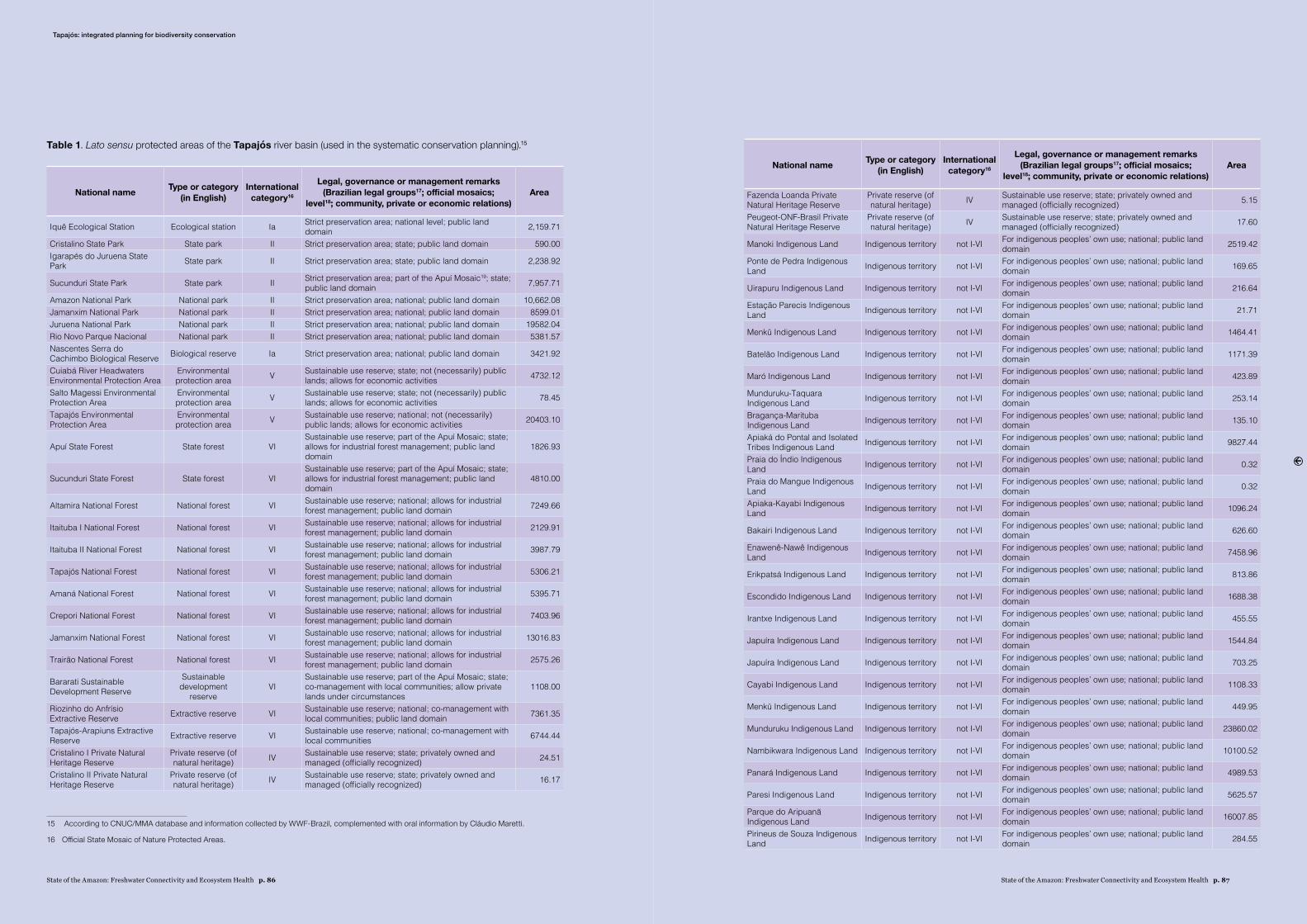
State of the Amazon: Freshwater Connectivity and Ecosystem Health p. 87State of the Amazon: Freshwater Connectivity and Ecosystem Health p. 86
Table 1. Lato sensu protected areas of the Tapajós river basin (used in the systematic conservation planning).15
National name Type or category (in English)
International category16
Legal, governance or management remarks (Brazilian legal groups17; official mosaics;
level18; community, private or economic relations)Area
Iquê Ecological Station Ecological station Ia Strict preservation area; national level; public land domain 2,159.71
Cristalino State Park State park II Strict preservation area; state; public land domain 590.00Igarapés do Juruena State Park State park II Strict preservation area; state; public land domain 2,238.92
Sucunduri State Park State park II Strict preservation area; part of the Apuí Mosaic19; state; public land domain 7,957.71
Amazon National Park National park II Strict preservation area; national; public land domain 10,662.08Jamanxim National Park National park II Strict preservation area; national; public land domain 8599.01Juruena National Park National park II Strict preservation area; national; public land domain 19582.04Rio Novo Parque Nacional National park II Strict preservation area; national; public land domain 5381.57Nascentes Serra do Cachimbo Biological Reserve Biological reserve Ia Strict preservation area; national; public land domain 3421.92
Cuiabá River Headwaters Environmental Protection Area
Environmental protection area V Sustainable use reserve; state; not (necessarily) public
lands; allows for economic activities 4732.12
Salto Magessi Environmental Protection Area
Environmental protection area V Sustainable use reserve; state; not (necessarily) public
lands; allows for economic activities 78.45
Tapajós Environmental Protection Area
Environmental protection area V Sustainable use reserve; national; not (necessarily)
public lands; allows for economic activities 20403.10
Apuí State Forest State forest VISustainable use reserve; part of the Apuí Mosaic; state; allows for industrial forest management; public land domain
1826.93
Sucunduri State Forest State forest VISustainable use reserve; part of the Apuí Mosaic; state; allows for industrial forest management; public land domain
4810.00
Altamira National Forest National forest VI Sustainable use reserve; national; allows for industrial forest management; public land domain 7249.66
Itaituba I National Forest National forest VI Sustainable use reserve; national; allows for industrial forest management; public land domain 2129.91
Itaituba II National Forest National forest VI Sustainable use reserve; national; allows for industrial forest management; public land domain 3987.79
Tapajós National Forest National forest VI Sustainable use reserve; national; allows for industrial forest management; public land domain 5306.21
Amaná National Forest National forest VI Sustainable use reserve; national; allows for industrial forest management; public land domain 5395.71
Crepori National Forest National forest VI Sustainable use reserve; national; allows for industrial forest management; public land domain 7403.96
Jamanxim National Forest National forest VI Sustainable use reserve; national; allows for industrial forest management; public land domain 13016.83
Trairão National Forest National forest VI Sustainable use reserve; national; allows for industrial forest management; public land domain 2575.26
Bararati Sustainable Development Reserve
Sustainable development
reserveVI
Sustainable use reserve; part of the Apuí Mosaic; state; co-management with local communities; allow private lands under circumstances
1108.00
Riozinho do Anfrísio Extractive Reserve Extractive reserve VI Sustainable use reserve; national; co-management with
local communities; public land domain 7361.35
Tapajós-Arapiuns Extractive Reserve Extractive reserve VI Sustainable use reserve; national; co-management with
local communities 6744.44
Cristalino I Private Natural Heritage Reserve
Private reserve (of natural heritage) IV Sustainable use reserve; state; privately owned and
managed (officially recognized) 24.51
Cristalino II Private Natural Heritage Reserve
Private reserve (of natural heritage) IV Sustainable use reserve; state; privately owned and
managed (officially recognized) 16.17
15 According to CNUC/MMA database and information collected by WWF-Brazil, complemented with oral information by Cláudio Maretti.
16 Official State Mosaic of Nature Protected Areas.
National name Type or category (in English)
International category16
Legal, governance or management remarks (Brazilian legal groups17; official mosaics;
level18; community, private or economic relations)Area
Fazenda Loanda Private Natural Heritage Reserve
Private reserve (of natural heritage) IV Sustainable use reserve; state; privately owned and
managed (officially recognized) 5.15
Peugeot-ONF-Brasil Private Natural Heritage Reserve
Private reserve (of natural heritage) IV Sustainable use reserve; state; privately owned and
managed (officially recognized) 17.60
Manoki Indigenous Land Indigenous territory not I-VI For indigenous peoples’ own use; national; public land domain 2519.42
Ponte de Pedra Indigenous Land Indigenous territory not I-VI For indigenous peoples’ own use; national; public land
domain 169.65
Uirapuru Indigenous Land Indigenous territory not I-VI For indigenous peoples’ own use; national; public land domain 216.64
Estação Parecis Indigenous Land Indigenous territory not I-VI For indigenous peoples’ own use; national; public land
domain 21.71
Menkü Indigenous Land Indigenous territory not I-VI For indigenous peoples’ own use; national; public land domain 1464.41
Batelão Indigenous Land Indigenous territory not I-VI For indigenous peoples’ own use; national; public land domain 1171.39
Maró Indigenous Land Indigenous territory not I-VI For indigenous peoples’ own use; national; public land domain 423.89
Munduruku-Taquara Indigenous Land Indigenous territory not I-VI For indigenous peoples’ own use; national; public land
domain 253.14
Bragança-Marituba Indigenous Land Indigenous territory not I-VI For indigenous peoples’ own use; national; public land
domain 135.10
Apiaká do Pontal and Isolated Tribes Indigenous Land Indigenous territory not I-VI For indigenous peoples’ own use; national; public land
domain 9827.44
Praia do Índio Indigenous Land Indigenous territory not I-VI For indigenous peoples’ own use; national; public land
domain 0.32
Praia do Mangue Indigenous Land Indigenous territory not I-VI For indigenous peoples’ own use; national; public land
domain 0.32
Apiaka-Kayabi Indigenous Land Indigenous territory not I-VI For indigenous peoples’ own use; national; public land
domain 1096.24
Bakairi Indigenous Land Indigenous territory not I-VI For indigenous peoples’ own use; national; public land domain 626.60
Enawenê-Nawê Indigenous Land Indigenous territory not I-VI For indigenous peoples’ own use; national; public land
domain 7458.96
Erikpatsá Indigenous Land Indigenous territory not I-VI For indigenous peoples’ own use; national; public land domain 813.86
Escondido Indigenous Land Indigenous territory not I-VI For indigenous peoples’ own use; national; public land domain 1688.38
Irantxe Indigenous Land Indigenous territory not I-VI For indigenous peoples’ own use; national; public land domain 455.55
Japuíra Indigenous Land Indigenous territory not I-VI For indigenous peoples’ own use; national; public land domain 1544.84
Japuíra Indigenous Land Indigenous territory not I-VI For indigenous peoples’ own use; national; public land domain 703.25
Cayabi Indigenous Land Indigenous territory not I-VI For indigenous peoples’ own use; national; public land domain 1108.33
Menkü Indigenous Land Indigenous territory not I-VI For indigenous peoples’ own use; national; public land domain 449.95
Munduruku Indigenous Land Indigenous territory not I-VI For indigenous peoples’ own use; national; public land domain 23860.02
Nambikwara Indigenous Land Indigenous territory not I-VI For indigenous peoples’ own use; national; public land domain 10100.52
Panará Indigenous Land Indigenous territory not I-VI For indigenous peoples’ own use; national; public land domain 4989.53
Paresi Indigenous Land Indigenous territory not I-VI For indigenous peoples’ own use; national; public land domain 5625.57
Parque do Aripuanã Indigenous Land Indigenous territory not I-VI For indigenous peoples’ own use; national; public land
domain 16007.85
Pirineus de Souza Indigenous Land Indigenous territory not I-VI For indigenous peoples’ own use; national; public land
domain 284.55
Tapajós: integrated planning for biodiversity conservation
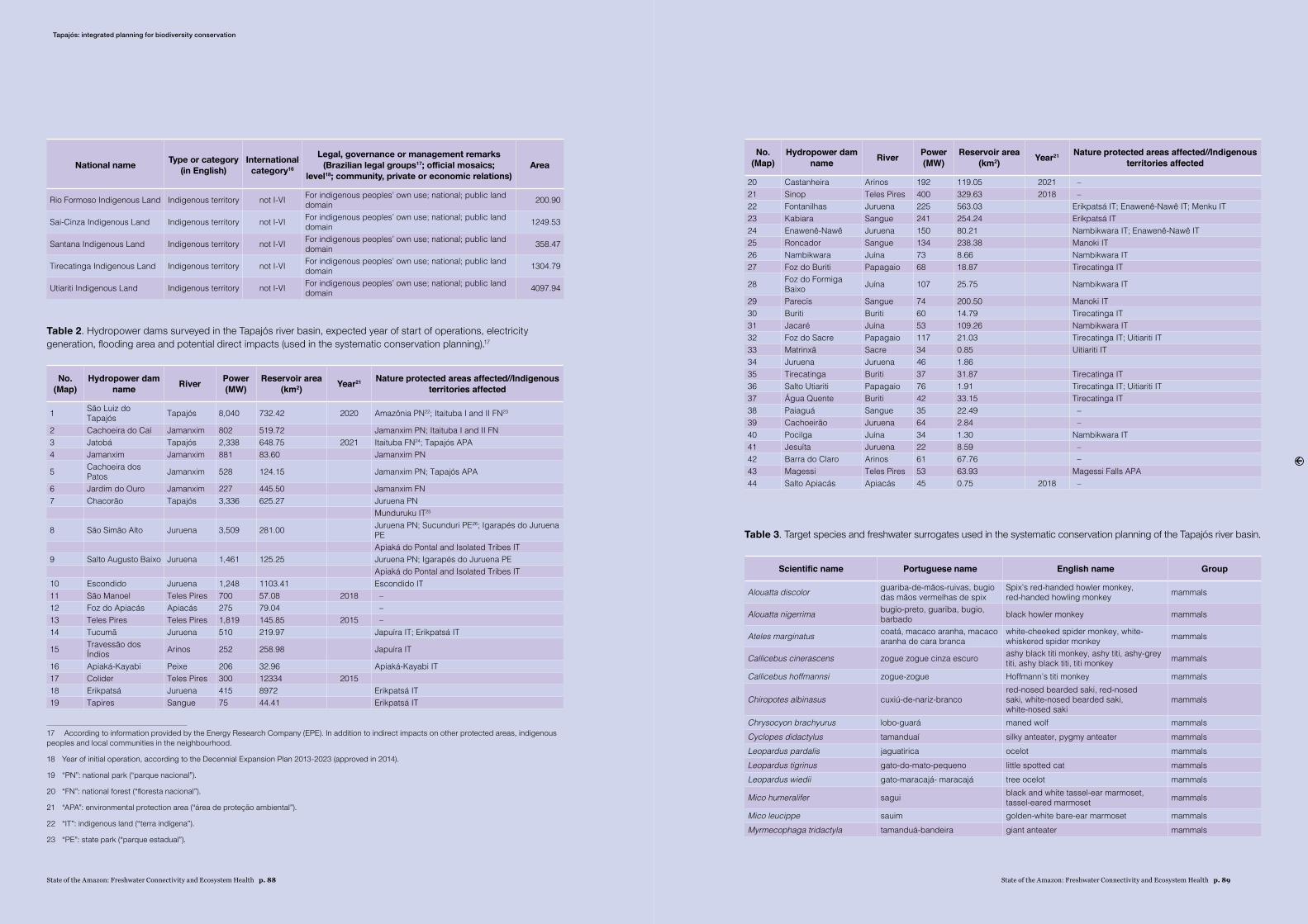
State of the Amazon: Freshwater Connectivity and Ecosystem Health p. 89State of the Amazon: Freshwater Connectivity and Ecosystem Health p. 88
National name Type or category (in English)
International category16
Legal, governance or management remarks (Brazilian legal groups17; official mosaics;
level18; community, private or economic relations)Area
Rio Formoso Indigenous Land Indigenous territory not I-VI For indigenous peoples’ own use; national; public land domain 200.90
Sai-Cinza Indigenous Land Indigenous territory not I-VI For indigenous peoples’ own use; national; public land domain 1249.53
Santana Indigenous Land Indigenous territory not I-VI For indigenous peoples’ own use; national; public land domain 358.47
Tirecatinga Indigenous Land Indigenous territory not I-VI For indigenous peoples’ own use; national; public land domain 1304.79
Utiariti Indigenous Land Indigenous territory not I-VI For indigenous peoples’ own use; national; public land domain 4097.94
Table 2. Hydropower dams surveyed in the Tapajós river basin, expected year of start of operations, electricity generation, flooding area and potential direct impacts (used in the systematic conservation planning).17
No. (Map)
Hydropower dam name River Power
(MW)Reservoir area
(km2) Year21 Nature protected areas affected//Indigenous territories affected
1 São Luiz do Tapajós Tapajós 8,040 732.42 2020 Amazônia PN22; Itaituba I and II FN23
2 Cachoeira do Caí Jamanxim 802 519.72 Jamanxim PN; Itaituba I and II FN3 Jatobá Tapajós 2,338 648.75 2021 Itaituba FN24; Tapajós APA4 Jamanxim Jamanxim 881 83.60 Jamanxim PN
5 Cachoeira dos Patos Jamanxim 528 124.15 Jamanxim PN; Tapajós APA
6 Jardim do Ouro Jamanxim 227 445.50 Jamanxim FN7 Chacorão Tapajós 3,336 625.27 Juruena PN
Munduruku IT25
8 São Simão Alto Juruena 3,509 281.00 Juruena PN; Sucunduri PE26; Igarapés do Juruena PEApiaká do Pontal and Isolated Tribes IT
9 Salto Augusto Baixo Juruena 1,461 125.25 Juruena PN; Igarapés do Juruena PEApiaká do Pontal and Isolated Tribes IT
10 Escondido Juruena 1,248 1103.41 Escondido IT11 São Manoel Teles Pires 700 57.08 2018 – 12 Foz do Apiacás Apiacás 275 79.04 – 13 Teles Pires Teles Pires 1,819 145.85 2015 – 14 Tucumã Juruena 510 219.97 Japuíra IT; Erikpatsá IT
15 Travessão dos Índios Arinos 252 258.98 Japuíra IT
16 Apiaká-Kayabi Peixe 206 32.96 Apiaká-Kayabi IT17 Colider Teles Pires 300 12334 201518 Erikpatsá Juruena 415 8972 Erikpatsá IT19 Tapires Sangue 75 44.41 Erikpatsá IT
17 According to information provided by the Energy Research Company (EPE). In addition to indirect impacts on other protected areas, indigenous peoples and local communities in the neighbourhood.
18 Year of initial operation, according to the Decennial Expansion Plan 2013-2023 (approved in 2014).
19 “PN”: national park (“parque nacional”).
20 “FN”: national forest (“floresta nacional”).
21 “APA”: environmental protection area (“área de protecão ambiental”).
22 “IT”: indigenous land (“terra indígena”).
23 “PE”: state park (“parque estadual”).
No. (Map)
Hydropower dam name River Power
(MW)Reservoir area
(km2) Year21 Nature protected areas affected//Indigenous territories affected
20 Castanheira Arinos 192 119.05 2021 – 21 Sinop Teles Pires 400 329.63 2018 – 22 Fontanilhas Juruena 225 563.03 Erikpatsá IT; Enawenê-Nawê IT; Menku IT23 Kabiara Sangue 241 254.24 Erikpatsá IT24 Enawenê-Nawê Juruena 150 80.21 Nambikwara IT; Enawenê-Nawê IT25 Roncador Sangue 134 238.38 Manoki IT26 Nambikwara Juína 73 8.66 Nambikwara IT27 Foz do Buriti Papagaio 68 18.87 Tirecatinga IT
28 Foz do Formiga Baixo Juína 107 25.75 Nambikwara IT
29 Parecis Sangue 74 200.50 Manoki IT30 Buriti Buriti 60 14.79 Tirecatinga IT31 Jacaré Juína 53 109.26 Nambikwara IT32 Foz do Sacre Papagaio 117 21.03 Tirecatinga IT; Uitiariti IT33 Matrinxã Sacre 34 0.85 Uitiariti IT34 Juruena Juruena 46 1.8635 Tirecatinga Buriti 37 31.87 Tirecatinga IT36 Salto Utiariti Papagaio 76 1.91 Tirecatinga IT; Uitiariti IT37 Água Quente Buriti 42 33.15 Tirecatinga IT38 Paiaguá Sangue 35 22.49 – 39 Cachoeirão Juruena 64 2.84 – 40 Pocilga Juína 34 1.30 Nambikwara IT41 Jesuíta Juruena 22 8.59 – 42 Barra do Claro Arinos 61 67.76 – 43 Magessi Teles Pires 53 63.93 Magessi Falls APA44 Salto Apiacás Apiacás 45 0.75 2018 –
Table 3. Target species and freshwater surrogates used in the systematic conservation planning of the Tapajós river basin.
Scientific name Portuguese name English name Group
Alouatta discolor guariba-de-mãos-ruivas, bugio das mãos vermelhas de spix
Spix’s red-handed howler monkey, red-handed howling monkey mammals
Alouatta nigerrima bugio-preto, guariba, bugio, barbado black howler monkey mammals
Ateles marginatus coatá, macaco aranha, macaco aranha de cara branca
white-cheeked spider monkey, white-whiskered spider monkey mammals
Callicebus cinerascens zogue zogue cinza escuro ashy black titi monkey, ashy titi, ashy-grey titi, ashy black titi, titi monkey mammals
Callicebus hoffmannsi zogue-zogue Hoffmann’s titi monkey mammals
Chiropotes albinasus cuxiú-de-nariz-brancored-nosed bearded saki, red-nosed saki, white-nosed bearded saki, white-nosed saki
mammals
Chrysocyon brachyurus lobo-guará maned wolf mammalsCyclopes didactylus tamanduaí silky anteater, pygmy anteater mammalsLeopardus pardalis jaguatirica ocelot mammalsLeopardus tigrinus gato-do-mato-pequeno little spotted cat mammalsLeopardus wiedii gato-maracajá- maracajá tree ocelot mammals
Mico humeralifer sagui black and white tassel-ear marmoset, tassel-eared marmoset mammals
Mico leucippe sauim golden-white bare-ear marmoset mammalsMyrmecophaga tridactyla tamanduá-bandeira giant anteater mammals
Tapajós: integrated planning for biodiversity conservation
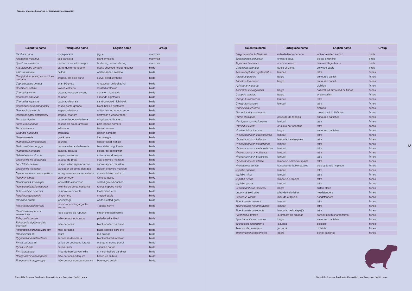
State of the Amazon: Freshwater Connectivity and Ecosystem Health p. 91State of the Amazon: Freshwater Connectivity and Ecosystem Health p. 90
Scientific name Portuguese name English name Group
Panthera onca onça-pintada jaguar mammalsPriodontes maximus tatu-canastra giant armadillo mammalsSpeothos venaticus cachorro-do-mato-vinagre bush dog, savannah dog mammalsAnabazenops dorsalis barranqueiro-de-topete dusky-cheeked foliage-gleaner birdsAtticora fasciata peitoril white-banded swallow birdsCampylorhamphus procurvoides probatus arapaçu-de-bico-curvo curve-billed scythebill birds
Cephalopterus ornatus anambé-preto Amazonian umbrellabird birdsChamaeza nobilis tovaca-estriada striated antthrush birdsChordeiles minor bacurau-norte-americano common nighthawk birdsChordeiles nacunda corucão nacunda nighthawk birdsChordeiles rupestris bacurau-da-praia sand-coloured nighthawk birdsConopophaga melanogaster chupa-dente-grande black-bellied gnateater birdsDendrocincla merula arapaçu-da-taoca white-chinned woodcreeper birdsDendrocolaptes hoffmannsi arapaçu-marrom Hoffmann’s woodcreeper birdsFurnarius figulus casaca-de-couro-da-lama wing-banded hornero birdsFurnarius leucopus casaca-de-couro-amarelo pale-legged hornero birdsFurnarius minor joãozinho lesser hornero birdsGuaruba guarouba ararajuba golden parakeet birdsHarpia harpyja gavião real harpy eagle birdsHydropsalis climacocerca acurana ladder-tailed nightjar birdsHydropsalis leucopyga bacurau-de-cauda-barrada band-tailed nighthawk birdsHydropsalis torquata bacurau-tesoura scissor-tailed nightjar birdsHylexetastes uniformis arapaçu-uniforme uniform woodcreeper birdsLepidothrix iris eucephala cabeça-de-prata opal-crowned manakin birdsLepidothrix nattereri uirapuru-de-chapeu-branco snow-capped manakin birdsLepidothrix vilasboasi dançador-de-coroa-dourada golden-crowned manakin birdsMyrmeciza hemimelana pallens formigueiro-de-cauda-castanha chestnut-tailed antbird birdsNeochen jubata pato-corredor Orinoco goose birdsNeomorphus squamiger jacu-estalo-escamoso scaled ground-cuckoo birdsNonnula ruficapilla nattereri freirinha-de-coroa-castanha rufous-capped nunlet birdsOdontorchilus cinereus cambaxirra-cinzenta tooth-billed wren birdsMorphnus guianensis uiraçu-falso crested eagle birdsPenelope pileata jacupiranga white-crested guan birds
Phaethornis aethopygus rabo-branco-de-garganta-escura Tapajós hermit birds
Phaethornis rupurumii amazonicus rabo-branco-de-rupununi streak-throated hermit birds
Phlegopsis borbae mãe-de-taoca-dourada pale-faced antbird birdsPhlegopsis nigromaculata bowmani mãe-de-taoca black-spotted bare-eye birds
Phlegopsis nigromaculata spn mãe-de-taoca black-spotted bare-eye birdsPhoenicircus sp saurá red cotinga birdsPygochelidon melanoleuca andorinha-de-coleira black-collared swallow birdsPyrilia barrabandi curica-de-bochecha-laranja orange-cheeked parrot birdsPyrilia vulturina curica-urubu vulturine parrot birdsPyrrhura perlata tiriba-de-barriga-vermelha crimson-bellied parakeet birdsRhegmatorhina berlepschi mãe-de-taoca-arlequim harlequin antbird birdsRhegmatorhina gymnops mãe-de-taoca-de-cara-branca bare-eyed antbird birds
Scientific name Portuguese name English name Group
Rhegmatorhina hoffmannsi mãe-de-taoca-papuda white-breasted antbird birdsSakesphorus luctuosus choca-d’água glossy antshrike birdsTigrisoma fasciatum socó-boi-escuro fasciated tiger-heron birdsUrubitinga coronata águia-cinzenta crowned eagle birdsAcestrocephalus nigrifasciatus lambari tetra fishesAncistrus parecis bagre armoured catfish fishesAncistrus tombador bagre armoured catfish fishesApistogramma arua cichlids fishesAspidoras microgalaeus bagre callichthyid armoured catfishes fishesCetopsis sandrae bagre whale catfish fishesCreagrutus cracentis lambari tetra fishesCreagrutus ignotus lambari tetra fishesCrenicichla urosema cichlids fishesGymnotus diamantinensis naked-back knifefishes fishesHarttia dissidens cascudo-do-tapajós armoured catfishes fishesHemigrammus skolioplatus lambari tetra fishesHemiodus sterni cruzeiro-do-tocantins tetra fishesHopliancistrus tricornis bagre armoured catfishes fishesHyphessobrycon cachimbensis lambari tetra fishesHyphessobrycon heliacus lambari-do-teles-pires tetra fishesHyphessobrycon hexastichos lambari tetra fishesHyphessobrycon melanostichos lambari tetra fishesHyphessobrycon notidanos lambari tetra fishesHyphessobrycon scutulatus lambari tetra fishesHyphessobrycon vilmae lambari-do-alto-do-tapajós tetra fishesHypostomus soniae cascudo-do-baixo-tapajós blue eyed red fin pleco fishesJupiaba apenina lambari tetra fishesJupiaba minor lambari tetra fishesJupiaba pirana lambari-do-tapajós tetra fishesJupiaba yarina lambari tetra fishesLeporacanthicus joselimai bagre sultan pleco fishesLeporinus sextriatus piau-de-seis-listras headstanders fishesLeporinus vanzoi piau-do-araguaia headstanders fishesMoenkhausia newtoni lambari tetra fishesMoenkhausia nigromarginata lambari tetra fishesMoenkhausia phaeonota lambari-do-alto-tapajós tetra fishesProchilodus britskii curimbata-do-apiacás flannel-mouth characiforms fishesSpectracanthicus murinus bagre armoured catfishes fishesTeleocichla prionogenys jacundá cichlids fishesTeleocichla proselytus jacundá cichlids fishesTrichomycterus hasemanis bagre pencil catfishes fishes
Tapajós: integrated planning for biodiversity conservation
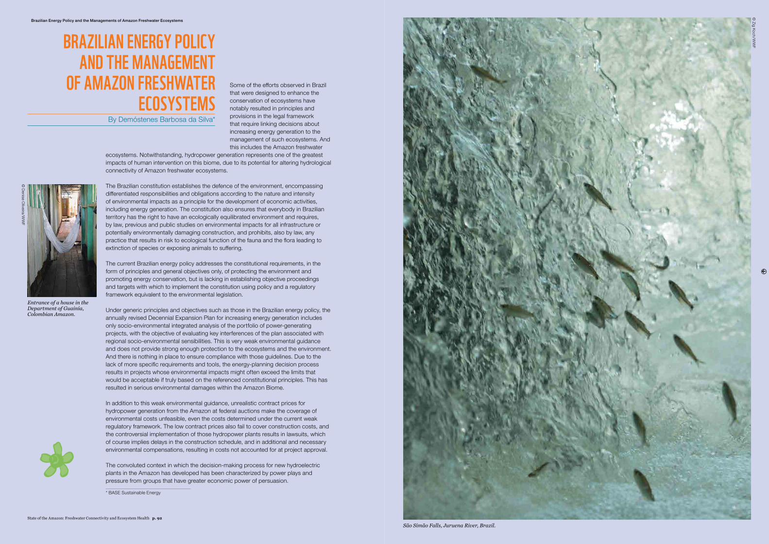
Some of the efforts observed in Brazil that were designed to enhance the conservation of ecosystems have notably resulted in principles and provisions in the legal framework that require linking decisions about increasing energy generation to the management of such ecosystems. And this includes the Amazon freshwater
ecosystems. Notwithstanding, hydropower generation represents one of the greatest impacts of human intervention on this biome, due to its potential for altering hydrological connectivity of Amazon freshwater ecosystems.
The Brazilian constitution establishes the defence of the environment, encompassing differentiated responsibilities and obligations according to the nature and intensity of environmental impacts as a principle for the development of economic activities, including energy generation. The constitution also ensures that everybody in Brazilian territory has the right to have an ecologically equilibrated environment and requires, by law, previous and public studies on environmental impacts for all infrastructure or potentially environmentally damaging construction, and prohibits, also by law, any practice that results in risk to ecological function of the fauna and the flora leading to extinction of species or exposing animals to suffering.
The current Brazilian energy policy addresses the constitutional requirements, in the form of principles and general objectives only, of protecting the environment and promoting energy conservation, but is lacking in establishing objective proceedings and targets with which to implement the constitution using policy and a regulatory framework equivalent to the environmental legislation.
Under generic principles and objectives such as those in the Brazilian energy policy, the annually revised Decennial Expansion Plan for increasing energy generation includes only socio-environmental integrated analysis of the portfolio of power-generating projects, with the objective of evaluating key interferences of the plan associated with regional socio-environmental sensibilities. This is very weak environmental guidance and does not provide strong enough protection to the ecosystems and the environment. And there is nothing in place to ensure compliance with those guidelines. Due to the lack of more specific requirements and tools, the energy-planning decision process results in projects whose environmental impacts might often exceed the limits that would be acceptable if truly based on the referenced constitutional principles. This has resulted in serious environmental damages within the Amazon Biome.
In addition to this weak environmental guidance, unrealistic contract prices for hydropower generation from the Amazon at federal auctions make the coverage of environmental costs unfeasible, even the costs determined under the current weak regulatory framework. The low contract prices also fail to cover construction costs, and the controversial implementation of those hydropower plants results in lawsuits, which of course implies delays in the construction schedule, and in additional and necessary environmental compensations, resulting in costs not accounted for at project approval.
The convoluted context in which the decision-making process for new hydroelectric plants in the Amazon has developed has been characterized by power plays and pressure from groups that have greater economic power of persuasion.
BRAZILIAN ENERGY POLICY AND THE MANAGEMENT
OF AMAZON FRESHWATER ECOSYSTEMS
By Demóstenes Barbosa da Silva*
* BASE Sustainable Energy
© Zig Koch/W
WF
© Denise O
liveira/WW
F
São Simão Falls, Juruena River, Brazil.
Entrance of a house in the Department of Guainía, Colombian Amazon.
Brazilian Energy Policy and the Managements of Amazon Freshwater Ecosystems
State of the Amazon: Freshwater Connectivity and Ecosystem Health p. 92
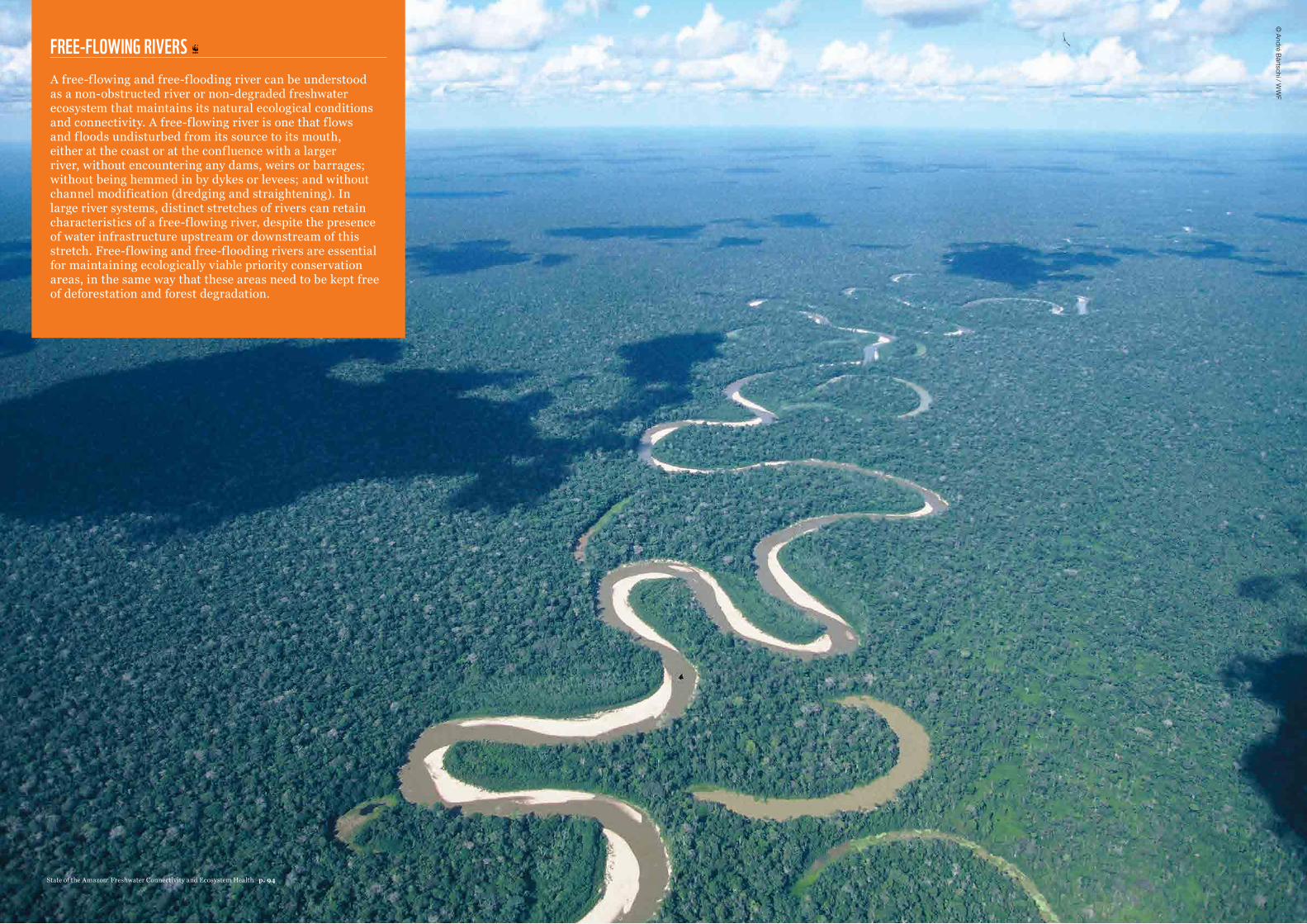
FREE-FLOWING RIVERS A free-flowing and free-flooding river can be understood as a non-obstructed river or non-degraded freshwater ecosystem that maintains its natural ecological conditions and connectivity. A free-flowing river is one that flows and floods undisturbed from its source to its mouth, either at the coast or at the confluence with a larger river, without encountering any dams, weirs or barrages; without being hemmed in by dykes or levees; and without channel modification (dredging and straightening). In large river systems, distinct stretches of rivers can retain characteristics of a free-flowing river, despite the presence of water infrastructure upstream or downstream of this stretch. Free-flowing and free-flooding rivers are essential for maintaining ecologically viable priority conservation areas, in the same way that these areas need to be kept free of deforestation and forest degradation.
© André Bärtschi / W
WF
State of the Amazon: Freshwater Connectivity and Ecosystem Health p. 94
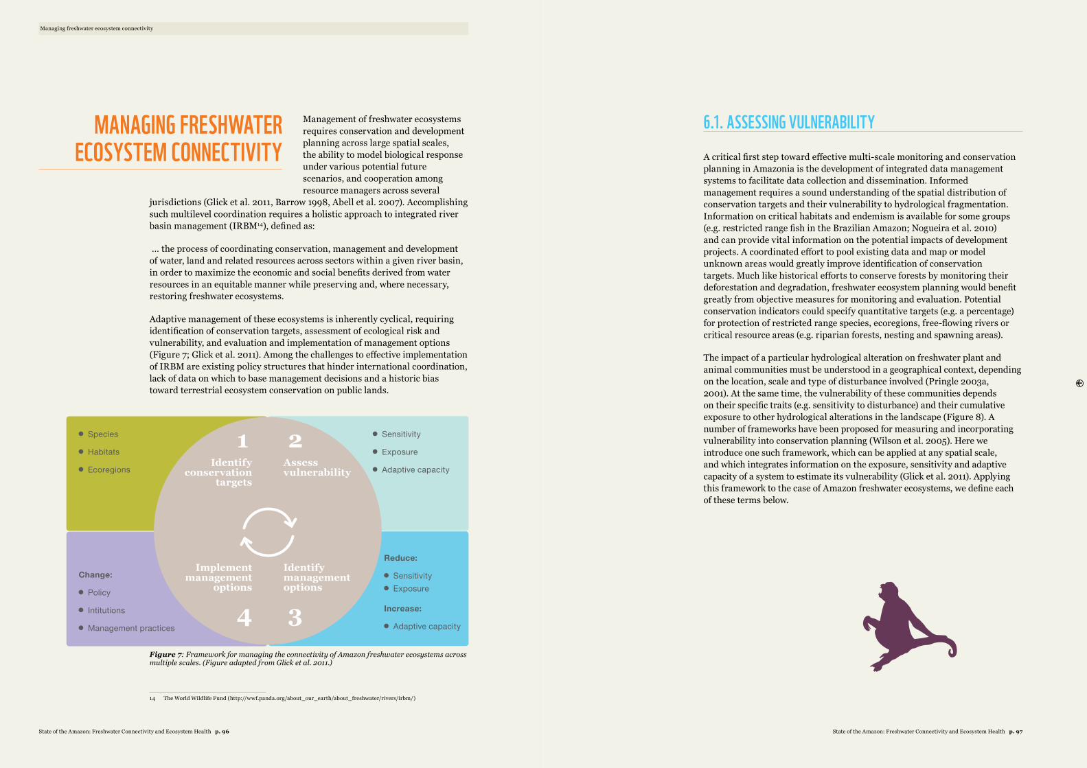
Management of freshwater ecosystems requires conservation and development planning across large spatial scales, the ability to model biological response under various potential future scenarios, and cooperation among resource managers across several
jurisdictions (Glick et al. 2011, Barrow 1998, Abell et al. 2007). Accomplishing such multilevel coordination requires a holistic approach to integrated river basin management (IRBM14), defined as:
… the process of coordinating conservation, management and development of water, land and related resources across sectors within a given river basin, in order to maximize the economic and social benefits derived from water resources in an equitable manner while preserving and, where necessary, restoring freshwater ecosystems.
Adaptive management of these ecosystems is inherently cyclical, requiring identification of conservation targets, assessment of ecological risk and vulnerability, and evaluation and implementation of management options (Figure 7; Glick et al. 2011). Among the challenges to effective implementation of IRBM are existing policy structures that hinder international coordination, lack of data on which to base management decisions and a historic bias toward terrestrial ecosystem conservation on public lands.
1 2
4 3
Identify conservation
targets
Implement management
options
Assess vulnerability
Identify management options
n Species
n Habitats
n Ecoregions
Change:
n Policy
n Intitutions
n Management practices
n Sensitivity
n Exposure
n Adaptive capacity
Reduce:
n Sensitivityn Exposure
Increase:
n Adaptive capacity
Figure 7: Framework for managing the connectivity of Amazon freshwater ecosystems across multiple scales. (Figure adapted from Glick et al. 2011.)
14 The World Wildlife Fund (http://wwf.panda.org/about_our_earth/about_freshwater/rivers/irbm/)
6.1. ASSESSING VULNERABILITY
A critical first step toward effective multi-scale monitoring and conservation planning in Amazonia is the development of integrated data management systems to facilitate data collection and dissemination. Informed management requires a sound understanding of the spatial distribution of conservation targets and their vulnerability to hydrological fragmentation. Information on critical habitats and endemism is available for some groups (e.g. restricted range fish in the Brazilian Amazon; Nogueira et al. 2010) and can provide vital information on the potential impacts of development projects. A coordinated effort to pool existing data and map or model unknown areas would greatly improve identification of conservation targets. Much like historical efforts to conserve forests by monitoring their deforestation and degradation, freshwater ecosystem planning would benefit greatly from objective measures for monitoring and evaluation. Potential conservation indicators could specify quantitative targets (e.g. a percentage) for protection of restricted range species, ecoregions, free-flowing rivers or critical resource areas (e.g. riparian forests, nesting and spawning areas).
The impact of a particular hydrological alteration on freshwater plant and animal communities must be understood in a geographical context, depending on the location, scale and type of disturbance involved (Pringle 2003a, 2001). At the same time, the vulnerability of these communities depends on their specific traits (e.g. sensitivity to disturbance) and their cumulative exposure to other hydrological alterations in the landscape (Figure 8). A number of frameworks have been proposed for measuring and incorporating vulnerability into conservation planning (Wilson et al. 2005). Here we introduce one such framework, which can be applied at any spatial scale, and which integrates information on the exposure, sensitivity and adaptive capacity of a system to estimate its vulnerability (Glick et al. 2011). Applying this framework to the case of Amazon freshwater ecosystems, we define each of these terms below.
Managing freshwater ecosystem connectivity
MANAGING FRESHWATER ECOSYSTEM CONNECTIVITY
State of the Amazon: Freshwater Connectivity and Ecosystem Health p. 97State of the Amazon: Freshwater Connectivity and Ecosystem Health p. 96
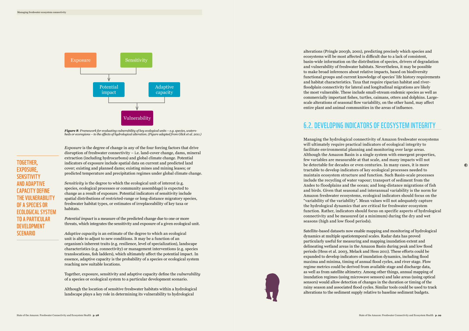
Potential impact
Vulnerability
Exposure Sensitivity
Adaptive capacity
Figure 8: Framework for evaluating vulnerability of key ecological units – e.g. species, waters-heds or ecoregions – to the effects of hydrological alteration. (Figure adapted from Glick et al. 2011.)
Exposure is the degree of change in any of the four forcing factors that drive disruption of freshwater connectivity – i.e. land-cover change, dams, mineral extraction (including hydrocarbons) and global climate change. Potential indicators of exposure include spatial data on current and predicted land cover; existing and planned dams; existing mines and mining leases; or predicted temperature and precipitation regimes under global climate change.
Sensitivity is the degree to which the ecological unit of interest (e.g. species, ecological processes or community assemblage) is expected to change as a result of exposure. Potential indicators of sensitivity include spatial distributions of restricted-range or long-distance migratory species, freshwater habitat types, or estimates of irreplaceability of key taxa or habitats.
Potential impact is a measure of the predicted change due to one or more threats, which integrates the sensitivity and exposure of a given ecological unit.
Adaptive capacity is an estimate of the degree to which an ecological unit is able to adjust to new conditions. It may be a function of an organism’s inherent traits (e.g. resilience, level of specialization), landscape characteristics (e.g. connectivity) or management interventions (e.g. species translocations, fish ladders), which ultimately affect the potential impact. In essence, adaptive capacity is the probability of a species or ecological system reaching new suitable locations.
Together, exposure, sensitivity and adaptive capacity define the vulnerability of a species or ecological system to a particular development scenario.
Although the location of sensitive freshwater habitats within a hydrological landscape plays a key role in determining its vulnerability to hydrological
alterations (Pringle 2003b, 2001), predicting precisely which species and ecosystems will be most affected is difficult due to a lack of consistent, basin-wide information on the distribution of species, drivers of degradation and vulnerability of freshwater habitats. Nevertheless, it may be possible to make broad inferences about relative impacts, based on biodiversity functional groups and current knowledge of species’ life history requirements and habitat characteristics. Taxa that require riparian habitat and river-floodplain connectivity for lateral and longitudinal migrations are likely the most vulnerable. These include small-stream endemic species as well as commercially important fishes, turtles, caimans, otters and dolphins. Large-scale alterations of seasonal flow variability, on the other hand, may affect entire plant and animal communities in the areas of influence.
6.2. DEVELOPING INDICATORS OF ECOSYSTEM INTEGRITY Managing the hydrological connectivity of Amazon freshwater ecosystems will ultimately require practical indicators of ecological integrity to facilitate environmental planning and monitoring over large areas. Although the Amazon Basin is a single system with emergent properties, few variables are measurable at that scale, and many impacts will not be detectable for decades or even centuries. In many cases, it is more tractable to develop indicators of key ecological processes needed to maintain ecosystem structure and function. Such Basin-scale processes include the recycling of water vapour; transport of sediment from the Andes to f loodplains and the ocean; and long-distance migrations of fish and birds. Given that seasonal and interannual variability is the norm for Amazon freshwater ecosystems, ecological indicators should focus on the “variability of the variability”. Mean values will not adequately capture the hydrological dynamics that are critical for freshwater ecosystem function. Rather, indicators should focus on specific aspects of hydrological connectivity and be measured (at a minimum) during the dry and wet seasons (high and low flood periods).
Satellite-based datasets now enable mapping and monitoring of hydrological dynamics at multiple spatiotemporal scales. Radar data has proved particularly useful for measuring and mapping inundation extent and delineating wetland areas in the Amazon Basin during peak and low flood periods (Hess et al. 2003, Melack and Hess 2011). These efforts could be expanded to develop indicators of inundation dynamics, including flood maxima and minima, timing of annual flood cycles, and river stage. Flow regime metrics could be derived from available stage and discharge data, as well as from satellite altimetry. Among other things, annual mapping of inundation regimes (using microwave sensors) and lake areas (using optical sensors) would allow detection of changes in the duration or timing of the rainy season and associated flood cycles. Similar tools could be used to track alterations to the sediment supply relative to baseline sediment budgets.
Managing freshwater ecosystem connectivity
TOGETHER, EXPOSURE, SENSITIVITY AND ADAPTIVE CAPACITY DEFINE THE VULNERABILITY OF A SPECIES OR ECOLOGICAL SYSTEM TO A PARTICULAR DEVELOPMENT SCENARIO
State of the Amazon: Freshwater Connectivity and Ecosystem Health p. 99State of the Amazon: Freshwater Connectivity and Ecosystem Health p. 98
Another approach to establishing objective measures of biological integrity is to use the Index of Biotic Integrity (IBI; Karr et al. 1986, Karr 1991) as an indicator of ecosystem health. The IBI was originally proposed as a method to evaluate the integrity of impacted streams relative to pristine ones. It integrates physical measures of integrity (e.g. connectivity, water quality, discharge) and biotic measures (e.g. species abundance, richness, composition) for a whole-stream assessment of ecosystem health. The advantage of this method is that it is standardized, enabling comparison across sites and detection of change over time. This allows managers to quantify freshwater ecosystem degradation and set objective conservation targets. Endemic species distributions and critical habitats can be mapped in greater detail at the small watershed scale, enabling more informed decision-making about what can and should be conserved. On the other hand, these metrics are labour-intensive and require data that is rarely available over larger spatial extents.
MAPPING INDICATORS OF EXPOSURE Spatial modelling – using available remote sensing and environmental data to develop proxies for freshwater ecosystem integrity – holds promise for freshwater conservation planning over large areas, particularly in data-poor regions (Lehner et al. 2006, Hamilton et al. 2007, Thieme et al. 2007, Abell et al. 2008, Nel et al. 2009). Simply mapping the entirety of threats to hydrological connectivity can provide insights into the cumulative degradation (or exposure) of a given watershed or conservation target. Today remote sensing enables tracking of forest removal, degradation and regeneration over large areas in near-real time. Combining these techniques with spatial modelling can provide vital information on the extent of deforestation associated with mining and dams (for example), enabling development of quantitative metrics of connectivity. Examples might include the number of small and large dams per stream kilometre; percentage of river reaches likely to be polluted; and number of small or large reservoirs per unit area (ratio of lentic to lotic areas). Such metrics could be used in isolation or coupled with information about particular species (e.g. migratory catfish) to evaluate potential impact.
Land-use maps, coupled with environmental modelling, can provide useful proxies of ecological impacts that are difficult to monitor directly. For example, agricultural land uses may affect freshwater ecosystems indirectly via nonpoint source pollutants (e.g. herbicides, pesticides, fertilizers) and cause associated changes to stream water quality, discharge, temperature and sediment regimes. Mining and hydrocarbon extraction are likewise associated with pollutants such as mercury, arsenic, cyanide and other toxic heavy metals that can persist in the environment over long periods. The consequences of these land uses (e.g. agriculture, mining) for freshwater ecosystems may be amplified or mitigated by other landscape characteristics such as roads, dams, riparian forest buffers, or fires. Many of these factors are mapped regularly for terrestrial conservation and could be readily incorporated into metrics of freshwater connectivity (such as the Dendritic Connectivity Index; Cote et al. 2009).
BASIN-SCALE CONSERVATION PLANNINGIndicators of exposure and sensitivity may be effectively combined into indicators of potential impact or vulnerability. Due to data limitations, such indices are most readily applied at relatively small spatiotemporal scales. Mesoscale basins (e.g. level 2-4, ~102 to 105 km2) are generally considered a suitable scale of analysis for most large infrastructure projects. Although the same indicators can be applied at different scales, vulnerability varies as a function of several factors, including scale, water type (white/black/clear water) and geomorphic setting (slope, valley shape). These factors are particularly relevant in Andean basins, which have a high degree of endemism, geomorphic variability and threat. The degree to which hydrologic connectivity is disrupted in a given basin depends on the relative prevalence of dams and land-cover changes. Information on the current and potential future spatial distributions of these drivers can therefore provide an objective indicator of relative threats to these basins.
The Araguaia-Tocantins River Basin has been substantially altered by both land-cover change and dam construction. Over half of the watershed has been deforested, leading to a 25 per cent increase in annual discharge, changes in geomorphology and anticipation of the annual flood pulse peak by one month (Coe et al. 2009). At the same time, this watershed contains over one-third of the existing and planned dams in the entire Amazon Basin, indicating that it is the most degraded sub-basin of the Amazon by those two measures (Figure 4). The hydrology of the Ucayali River Basin, on the other hand, is more threatened by future dams than by land-cover changes, given its relatively low levels of deforestation compared with the large number of planned dams (Figure 4). Even so, the fate of Amazon sub-basins is not wholly independent, given that large-scale deforestation in one river basin may affect climate in other basins via land-atmosphere interactions (Figure 7). To date, only one study that we know of provides a preliminary assessment of the ecological integrity of an Amazonian river basin (Ribeiro et al. 1995), making it difficult to infer the status of individual sub-basins.
An alternative and cost-effective approach for evaluating the integrity of river basins is the development of indices based on multispecies fishery yields, which integrate many aquatic and terrestrial biological production processes (Bayley 1995). The scale and species composition of multispecies fishery yields can indicate ecosystem integrity in much the same way as the widely used index of biotic integrity (Karr 1981, 1991). Observed changes in multispecies fishery yields after construction of the Tucuruí Dam on the Araguaia-Tocantins River mirrored those observed in degraded streams elsewhere, showing similar patterns in species composition, abundance and biomass (Table 2; Angermeier and Karr 1986, Lammert and Allan 1999). Although data for fishery yields is limited for much of the Amazon (Bayley and Petrere Jr. 1989, Crampton et al. 2004, Castello et al. 2011, 2013), existing evidence suggests that the Araguaia-Tocantins ranks as its most degraded sub-basin. This inference is supported by the fact that both the extent of deforestation and the density of dams in this basin are higher than in any other.
Managing freshwater ecosystem connectivity
THE ARAGUAIA-TOCANTINS RIVER BASIN HAS BEEN SUBSTANTIALLY ALTERED BY BOTH LAND-COVER CHANGE AND DAM CONSTRUCTION
State of the Amazon: Freshwater Connectivity and Ecosystem Health p. 101State of the Amazon: Freshwater Connectivity and Ecosystem Health p. 100
6.4. IMPLEMENTING MANAGEMENT
The forces driving the threats to the connectivity of Amazon freshwater ecosystems operate across multiple scales, as do numerous efforts to curb their impacts and conserve freshwater resources (e.g. World Commission on Dams, Convention on Biological Diversity, Ramsar Convention on Wetlands). Successful conservation of these ecosystems will require a delicate balance between these opposing forces and a coordinated effort to overcome the many barriers to maintaining their ecological integrity and connectivity.
INTERNATIONAL COORDINATIONMaintaining Amazon hydrologic connectivity and freshwater ecosystem function requires integrated management of terrestrial and freshwater ecosystems and, in many cases, international cooperation. As such, there is a critical need for strategic Basin-scale evaluation of the impact of infrastructure projects, agricultural expansion and mining on hydrological connectivity. Evaluating the potential impact of Andean dams is a particularly pressing example, given the many planned dams in the region, their potential to obstruct connections between Andean headwaters and the lowland Amazon, and the possibility of international conflicts surrounding water rights. Understanding the indirect impacts of national efforts to reduce deforestation on cross-border deforestation is another key area for international collaboration and coordination. The Amazon Cooperation Treaty Organization (ACTO) stands out as the only existing institution with the geographic focus needed to achieve such coordination. Charged with implementing the Amazon Cooperation Treaty, ACTO represents eight member Amazonian countries that have “pledged to promote the harmonious development of the Amazon territories, through the preservation and rational use of natural resources”. Perhaps even more relevant is the UN Watercourses Convention, which went into force in August 2014 and offers a flexible global legal framework for the use, management and protection of international watercourses.
BETTER BASELINE DATAThe lack of consistent environmental information across the Amazon Region remains a crucial barrier to integrated management of freshwater ecosystem connectivity. Although dams and deforestation have long been considered threats to freshwater ecosystems, these activities have expanded rapidly in the Amazon – largely in the absence of the baseline ecological and social data needed to evaluate their impacts. This lack of information makes it impossible to quantify the true costs of these activities and hinders efforts to objectively evaluate the potential impacts of proposed projects. Given the absence of detailed ecological information and the increasing pace of threats to freshwater ecosystems, developing new methods for large-scale conservation
planning and prioritization seems both necessary and prudent for managing Amazon connectivity (Abell et al. 2007, Thieme et al. 2007, Abell et al. 2008, Nel et al. 2009). Full cost accounting of the impacts of human activities on freshwater ecosystems will require further efforts to integrate data on species distributions, multispecies fishery yields, water quality and other indicators of environmental health. The lack of objective, publicly available information stands out as a key deficiency of the EIA-RIMA and other environmental licensing processes. Taking steps to make these processes more open, transparent and free of conflicts of interest would go a long way toward curbing corruption in environmental licensing.
INTEGRATED MANAGEMENTAlthough existing legislation does not directly address the hydrological connectivity and integrity of freshwater ecosystems, current laws do provide opportunities for coordinated management of landscapes that could benefit freshwater ecosystems. For example, if fully implemented and enforced, the Brazilian Forest Code and Peruvian Forest and Fauna laws would facilitate coordination at the landscape scale and mitigate many of the potential impacts of agricultural development on freshwater ecosystems. Barriers to securing this outcome include unclear land tenure, limited capacity for enforcement, corruption within government agencies and inefficient collection of fines. Advances in satellite-based monitoring and enforcement, as well as nascent policies and financial incentives to encourage environmental stewardship, may help reconcile management goals on public and private lands. Ultimately, effective conservation of freshwater ecosystems will require integrated management of terrestrial and freshwater ecosystems within a single framework. Regardless of the mechanism, such integrated management will be crucial to mitigate the impacts of human activities and maintain freshwater ecosystem connectivity and function for future generations.
Managing freshwater ecosystem connectivity
THE LACK OF CONSISTENT ENVIRONMENTAL INFORMATION ACROSS THE AMAZON REGION REMAINS A CRUCIAL BARRIER TO INTEGRATED MANAGEMENT OF FRESHWATER ECOSYSTEM CONNECTIVITY
State of the Amazon: Freshwater Connectivity and Ecosystem Health p. 103State of the Amazon: Freshwater Connectivity and Ecosystem Health p. 102
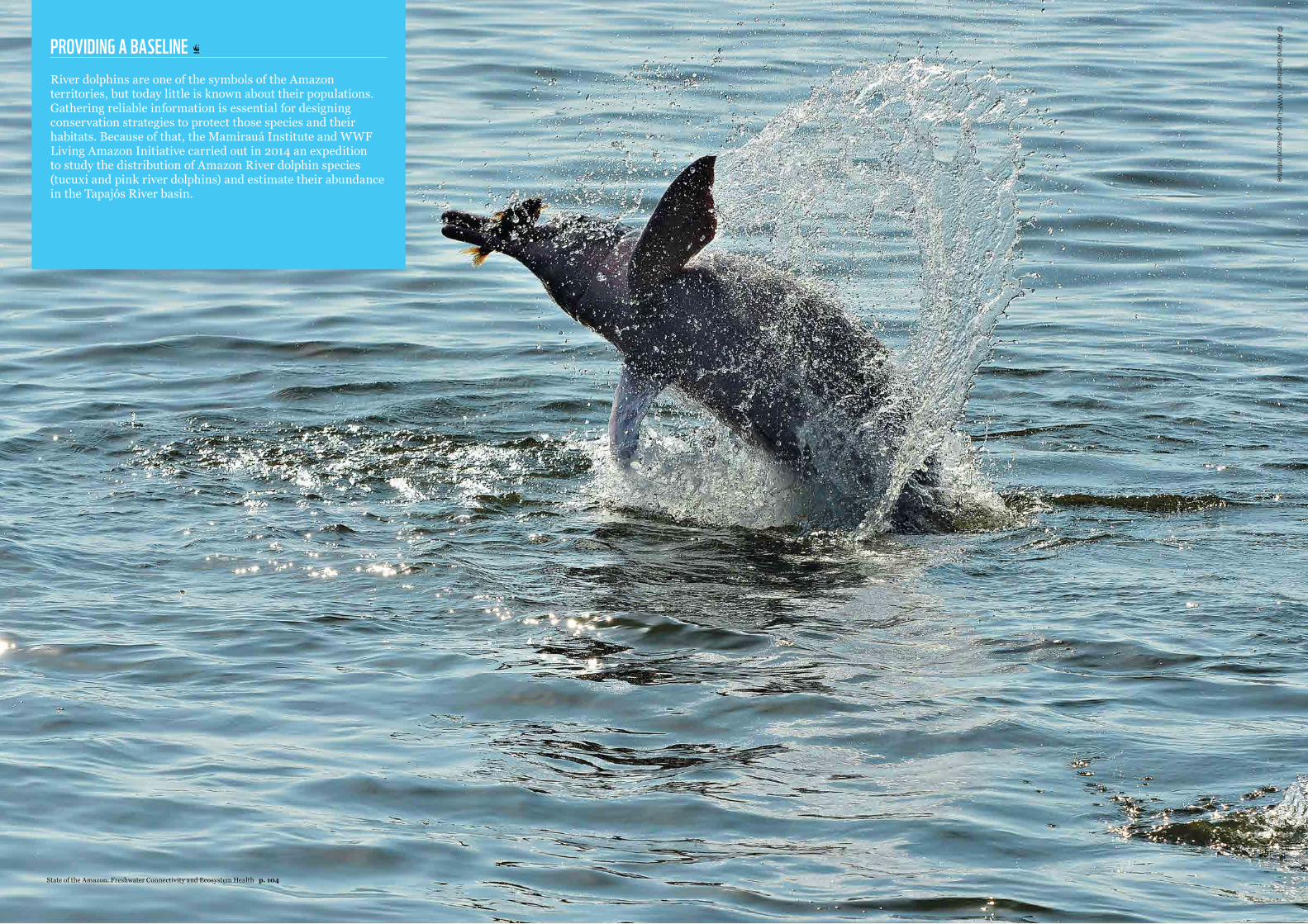
PROVIDING A BASELINE River dolphins are one of the symbols of the Amazon territories, but today little is known about their populations. Gathering reliable information is essential for designing conservation strategies to protect those species and their habitats. Because of that, the Mamirauá Institute and WWF Living Amazon Initiative carried out in 2014 an expedition to study the distribution of Amazon River dolphin species (tucuxi and pink river dolphins) and estimate their abundance in the Tapajós River basin.
© Adriano G
ambarini / W
WF-Living Am
azon Initiative
State of the Amazon: Freshwater Connectivity and Ecosystem Health p. 104
Conclusions and Recommendations
CONCLUSIONS AND RECOMMENDATIONS1
By Cláudio C. Maretti*, Sandra Charity*, Marcia Macedo**, Denise Oliveira*,
Leandro Castello***, Tarsicio Granizo*, André S. Dias* and
Karen Lawrence*
This report provides a comprehensive assessment of the current state of Amazon freshwater ecosystems. It highlights the importance of hydrological connectivity and land-water interactions in maintaining the ecological functions that support water, food and energy security. It also evaluates the drivers of degradation and the public policies that influence them, stressing the importance of Pan-Amazon planning for maintaining Amazon stability. The report makes a
clear case for management at the level of meso-scale sub-basins, through decision support systems, that integrates biodiversity and social issues into the hydropower and infrastructure planning, systematic tracking of ecological indicators and allowing real space for negotiations with the transparent participation of stakeholders, while recognizing the need to work under Pan-Amazon macro-scale guidance. It also presents the possible importance of working at the local scale, particularly for monitoring biological indicators and more deeply engaging local communities. Finally, the report outlines the key policy elements needed to develop an integrated framework for Amazon freshwater ecosystem management, particularly considering the impacts of hydropower projects.
Within this framework, a key objective of WWF’s Living Amazon Initiative is to transform the way hydropower development is conducted in the Amazon by 2020. WWF is committed to developing constructive dialogues among civil society, industry, the finance sector and governments in order to enable sustainable hydropower programmes, should they be necessary, and associated territorial development plans. Integrated approaches (land and water use, hydropower planning, etc.), such as the decision support methodologies and system proposed by WWF – including WWF’s Hydrological Information System for Amazon River Assessments (HIS-ARA) – and specific project assessments such as the Hydropower Sustainability Assessment Protocol (HSAP), are important tools for achieving this goal.1
In order to achieve this objective and reorient development in the Amazon Region toward a more sustainable path, new measures are necessary to mitigate threats to and alleviate pressures on the Amazon freshwater ecosystems. Through its Living Amazon Initiative, WWF proposes a set of
* WWF Living Amazon Initiative (LAI) ** Woods Hole Research Center
*** Virginia Polytechnic Institute and State University
1 Organized by WWF’s Living Amazon Initiative (LAI) based on the scientific assessment and complementary information (e.g. boxes) included in chapters 1-6 and drawing on WWF’s contribution to date (LAI, country offices and global programmes) to improving freshwater ecosystems conservation, provision of ecosystem services from the Amazon, and hydropower planning and development in the region (within WWF’s vision for the Amazon), as well as drawing on WWF’s global position on hydropower dams. These recommendations also draw on Castello et al. (2013), WWF (LAI) (2009, 2010, 2012, 2013), WWF (FP) (2014), Nobre (2014), Finer and Jenkins (2012), Little (2014), Maretti et al. (2014), Dias et al. (2014), Maretti (2014), Pacha (2014), WCD (2000), Maretti et al. (2015 – in press) and WWF-Brazil. 2015 (in press): Tapajós: Integrated Planning for Biodiversity Conservation
key recommendations to be adopted and implemented by decision makers in governments, the private and finance sectors, and the wider societies of the nine countries that share the Amazon Biome (Bolivia, Brazil, Colombia, Ecuador, Guyana, Peru, Suriname, Venezuela and French Guiana). Here we outline key recommendations in light of the main conclusions of this report.
7.1. FRESHWATER ECOSYSTEMS AND HYDROLOGICAL CONNECTIVITY The Amazon functions as a single ecological unit with complex interactions and feedbacks among its highly interdependent parts. Amazon freshwater ecosystems sustain some of the most diverse plant and animal communities in the world. Much of this biological diversity occurs longitudinally and laterally along streams and rivers, creating natural ecological corridors with specific environmental conditions that determine species occurrence and mediate their movement throughout the landscape. Maintaining the integrity of Amazon freshwater ecosystems thus depends on managing their hydrological connectivity, including the volume, variability and timing of hydrological flows that ultimately determine freshwater ecosystem structure and function.
One of the most critical hydrological connections occurs at the transition from the eastern Andean slope to the Amazonian lowlands. The Andes Mountains supply the vast majority of the sediments, nutrients and organic matter found in the main-stem Amazon, fuelling floodplain ecosystems that are among the most productive on Earth. The Amazon River has been intimately linked to the Andes Mountains for over 10 million years, and major breaks in that connectivity could bring severe and unpredictable impacts. Protected areas (PAs) sensu lato are the best-known mechanism for conserving these interconnected ecosystems, but the existing PA system is not sufficient, for it often disregards hydrological connectivity by not adequately considering important freshwater ecosystems such as river floodplains, headwaters and wetlands.
Key recommendations
• Adopt an integrated vision of Amazon sustainable development and nature conservation. Governments and the finance and private sectors should incorporate freshwater ecosystem management into development plans and economic policies and voluntary standards at regional, national and subnational levels. Amazon forests and freshwater ecosystems must be an integral part of country adaptation strategies to ensure future water, food and energy security.
• Develop an overarching regional policy framework for ecosystem conservation and watershed management. Amazon countries need to regularly evaluate the cumulative impacts of infrastructure projects, agricultural expansion and mining. Implementation of this framework might include a strengthened mandate
State of the Amazon: Freshwater Connectivity and Ecosystem Health p. 107State of the Amazon: Freshwater Connectivity and Ecosystem Health p. 106
for ACTO, the only international organization with an Amazon-wide remit, and engagement with UNASUR and COSIPLAN, which are responsible for planning regional energy and transportation integration.
• Incorporate the maintenance of ecological flows as a critical goal of decision-making related to land and water use, regional development, and environmental licensing. In doing so, governments and project developers will help safeguard the health of freshwater ecosystems and ensure the stability of the whole Amazon freshwater-terrestrial system.
• Designate new PAs that increase ecological representation of freshwater ecosystems. In doing so, Amazon countries will help preserve hydrological connectivity and freshwater ecosystem function.
• Create or improve legal instruments for the designation of “protected rivers” as a special type of officially designated nature protected area. Amazon governments should target rivers within their national territories, as well as transboundary rivers (through bilateral or trilateral agreements), in order to secure cross-boundary connectivity.
• Mitigate the direct and indirect impacts of hydropower development projects. Energy planners and hydropower project developers should avoid projects that impact existing protected areas and indigenous territories. In cases where impacts are unavoidable (after following due consultation processes), suitable offsetting and compensation mechanisms should be implemented to mitigate predicted impacts on freshwater ecosystems based on the specific biodiversity and ecosystem services provision.
• Promote greater international recognition of Amazon freshwater ecosystems. National governments should highlight the globally important role of Amazon freshwater ecosystems in providing environmental services by requesting their recognition under international conventions such as the Ramsar Convention on Wetlands of International Importance (Ramsar Sites) and the World Heritage Convention (World Heritage Sites).
• Sign and ratify the United Nations Watercourses Convention. This convention offers Amazon country governments a flexible global legal framework for the use, management and protection of international watercourses.
• Develop a regional strategic plan to maintain connectivity from the Andean highlands to the Amazon lowlands and from all headwaters to estuary. Amazon governments need to work collaboratively to identify key river reaches that need to remain free-flowing to safeguard the Amazon’s hydrological system. This will require aggregating, interpreting and mapping existing ecological information, or in areas with limited information using ecological modelling to inform these processes.
7.2. ECOSYSTEM SERVICES AND SOCIAL IMPACTS Amazon freshwater ecosystems contribute to human well-being by providing key ecosystem services. Economic studies in the Amazon and elsewhere indicate that resources produced by tropical freshwater ecosystems can contribute as much as two-thirds of rural household income in these regions. Rivers are thus essential for the livelihoods of Amazonian peoples, including indigenous peoples, fishing communities and rubber tappers. Freshwater connectivity is particularly critical for fisheries and regional food security, since many economically and ecologically important fish species depend on lateral or longitudinal migrations for parts of their life cycles. Long-distance migratory catfish, for example, travel thousands of kilometres from the Amazon’s estuary to the headwaters of white-water rivers, where they spawn in the Andean foothills.
Given a lack of capacity for systematic monitoring and management of hydrological alterations, Amazon freshwater ecosystems are vulnerable to escalating degradation. The rapid growth of Amazon regional economies has generated growing demands for electricity, agricultural products and mineral extraction. This has stimulated ambitious government programmes to build hydroelectric dams and other infrastructure in the Amazon and attracted substantial national and foreign investment to the region. While there is limited understanding of the ecological consequences of these initiatives, some of their social impacts are well documented. The most directly impacted communities are those forcibly relocated to other lands due to flooding by hydroelectric reservoirs; a single hydroelectric project may displace tens of thousands of rural people, including indigenous groups. At the same time, dam construction and the discovery of new mineral stores may attract people to the region, causing rural population booms that spur further deforestation, generate land tenure conflicts and perpetuate social inequality.
Despite this local crucial importance, it is necessary to recognize that the ecosystem services provided by the Amazon go far beyond the direct food supply and the subsistence of local communities, including climate regulation and climate change mitigation and adaptation, fundamental to the economy and social life of the Amazon countries, the South American continent and even the whole world, far beyond the Amazon limits.
Key recommendations
• Consider the water, food and energy security of Amazon communities. Governments should consider local and regional needs when planning for hydropower and other infrastructure development.
• Ensure informed, free and democratic participation of local communities in all decisions related to energy and infrastructure development. Technical analyses of infrastructure development projects must incorporate the social dimension, enabling local communities to participate in the process, evaluate results and identify key threats and potential solutions.
Conclusions and Recommendations
ECONOMIC STUDIES IN THE AMAZON AND ELSEWHERE INDICATE THAT RESOURCES PRODUCED BY TROPICAL FRESHWATER ECOSYSTEMS CAN CONTRIBUTE AS MUCH AS TWO-THIRDS OF RURAL HOUSEHOLD INCOME IN THESE REGIONS
State of the Amazon: Freshwater Connectivity and Ecosystem Health p. 109State of the Amazon: Freshwater Connectivity and Ecosystem Health p. 108
• Monitor the effects of hydropower development on freshwater ecosystem function, subsistence activities and human well-being. Governments and developers should consider not only biodiversity and ecosystems but also the services they provide and their cultural and social importance for local communities, including indigenous peoples.
• Respect the rights of indigenous peoples and other traditional communities to their land, water and resources. Governments and developers have a legal and ethical responsibility to safeguard traditional ways of life, knowledge and the Amazon’s rich cultural heritage.
• Gather better scientific information on migratory fish strategies. This will provide a more robust assessment of the potential impacts of infrastructure development on commercially valuable species of fish.
7.3. MANAGING ECOLOGICAL IMPACTS The hydrological connectivity of Amazon freshwater ecosystems poses unique challenges for their effective management and conservation. Existing legislation offers insufficient protection, often not adequately considering transboundary connectivity and failing to account for the full range of drivers of hydrological alteration. There is thus a critical need for strategic, basin-scale evaluation of the cumulative impact of energy and infrastructure projects, agricultural expansion, and mining on freshwater ecosystems. The impacts of large hydroelectric dams, for example, are normally evaluated on a project-by-project basis and with consideration given only to the most direct impacts. Their cumulative impacts are in fact much larger, particularly when considering the access roads and other infrastructure associated, and such impacts may be even further exacerbated by the proliferation of small farm dams, regional land-use changes and human-induced climate change. Evaluating the potential impact of Andean-Amazon dams is particularly pressing, given the many planned dams, their potential to impair connectivity between Andean headwaters and the Amazon lowlands, and the possibility of international conflicts surrounding water rights.
Despite effective coordination among Amazon countries over protected areas, there is still very limited engagement in developing a broader, higher-level integrated regional vision for the Amazon, which should include further policy and legal aspects of river protection. Project planning and licensing processes tend to focus more on economic and political interests, without accounting enough for associated environmental and social costs. There is thus an urgent need for legal and policy instruments capable of evaluating the social and environmental impacts at larger geographical scales and in longer time frames. WWF has developed one such tool, a Living Amazon decision support system (also called HIS-ARA) that enables integration of ecological information to obtain a regional vision of terrestrial and aquatic ecosystem conservation. This needs to be completed with the social elements. The Strategic Environmental Assessment (SEA) has emerged within financial
institutions as another instrument with the potential to integrate results into broader regional planning and serve as an input for understanding long-term impacts and projecting future development needs. Despite these advances, the Amazon Region would greatly benefit from development of an overarching policy framework for freshwater ecosystem management and conservation.
Key recommendations
• Step up efforts to improve compliance with existing legislation on ecosystem protection, with particular attention to freshwater ecosystems. To accomplish this, governments and project developers should strengthen monitoring and enforcement, while creating financial incentives (or disincentives) aimed at reducing deforestation and freshwater ecosystem degradation.
• Implement policies and voluntary standards aimed at achieving zero net ecosystem conversion and degradation (including deforestation, forest degradation and transformation of freshwater ecosystems) by 2020. Given the intimate connections between Amazon terrestrial and freshwater ecosystems, national governments must have the political resolve to make and sustain long-term changes through national programmes to control ecosystem conversion and degradation, cross-sector policies, and international agreements. The private and financial sectors should likewise take steps to curb deforestation in support of a shared regional vision for the Amazon.
• Evaluate the cumulative ecological and social impact of dams and associated infrastructure on whole river basins as part of the viability and environmental impact assessments of infrastructure projects. This includes the full range of impacts associated with building and operating hydropower plants, including road construction, land-cover changes and other planned development projects in the same river basins (e.g. hidrovias).
• Assess the potential ecological impacts of the full portfolio of proposed government projects, in terms of both hydrological alteration and forest loss. Given the absence of detailed ecological information and the increasing pace of threats to freshwater ecosystems, it is important for governments to develop methods for large-scale systematic conservation planning and prioritization. Examples include the WWF Living Amazon decision support system (also called HIS-ARA) and integrated approaches for hydropower planning.
• Address the drivers of ecosystem conversion and ecological degradation through multi-stakeholder dialogue, exchange of lessons learned and coordinated action across political boundaries. Terrestrial and aquatic resource managers, as well as public and private finance agencies, should strive for effective communication, integrated planning and conflict resolution between upstream and downstream water users.
Conclusions and Recommendations
State of the Amazon: Freshwater Connectivity and Ecosystem Health p. 111State of the Amazon: Freshwater Connectivity and Ecosystem Health p. 110
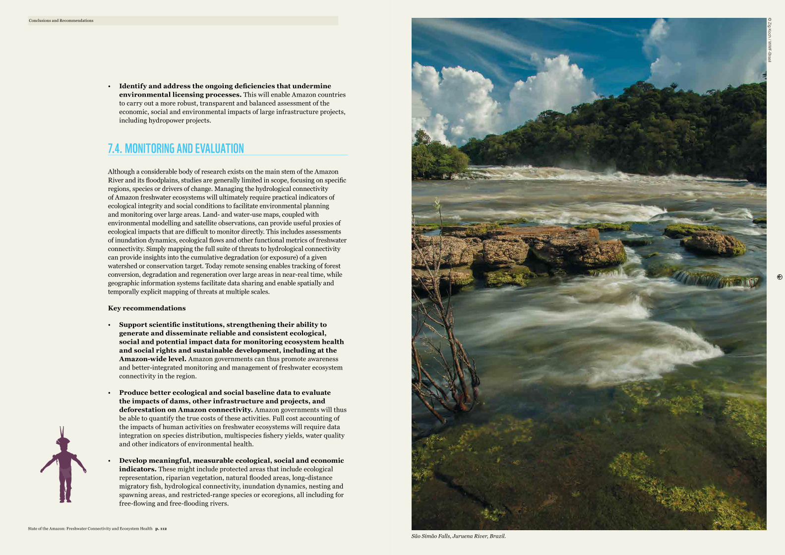
• Identify and address the ongoing deficiencies that undermine environmental licensing processes. This will enable Amazon countries to carry out a more robust, transparent and balanced assessment of the economic, social and environmental impacts of large infrastructure projects, including hydropower projects.
7.4. MONITORING AND EVALUATION Although a considerable body of research exists on the main stem of the Amazon River and its floodplains, studies are generally limited in scope, focusing on specific regions, species or drivers of change. Managing the hydrological connectivity of Amazon freshwater ecosystems will ultimately require practical indicators of ecological integrity and social conditions to facilitate environmental planning and monitoring over large areas. Land- and water-use maps, coupled with environmental modelling and satellite observations, can provide useful proxies of ecological impacts that are difficult to monitor directly. This includes assessments of inundation dynamics, ecological flows and other functional metrics of freshwater connectivity. Simply mapping the full suite of threats to hydrological connectivity can provide insights into the cumulative degradation (or exposure) of a given watershed or conservation target. Today remote sensing enables tracking of forest conversion, degradation and regeneration over large areas in near-real time, while geographic information systems facilitate data sharing and enable spatially and temporally explicit mapping of threats at multiple scales.
Key recommendations
• Support scientific institutions, strengthening their ability to generate and disseminate reliable and consistent ecological, social and potential impact data for monitoring ecosystem health and social rights and sustainable development, including at the Amazon-wide level. Amazon governments can thus promote awareness and better-integrated monitoring and management of freshwater ecosystem connectivity in the region.
• Produce better ecological and social baseline data to evaluate the impacts of dams, other infrastructure and projects, and deforestation on Amazon connectivity. Amazon governments will thus be able to quantify the true costs of these activities. Full cost accounting of the impacts of human activities on freshwater ecosystems will require data integration on species distribution, multispecies fishery yields, water quality and other indicators of environmental health.
• Develop meaningful, measurable ecological, social and economic indicators. These might include protected areas that include ecological representation, riparian vegetation, natural flooded areas, long-distance migratory fish, hydrological connectivity, inundation dynamics, nesting and spawning areas, and restricted-range species or ecoregions, all including for free-flowing and free-flooding rivers.
São Simão Falls, Juruena River, Brazil.
Conclusions and Recommendations©
Zig Koch / WW
F-Brasil
State of the Amazon: Freshwater Connectivity and Ecosystem Health p. 112
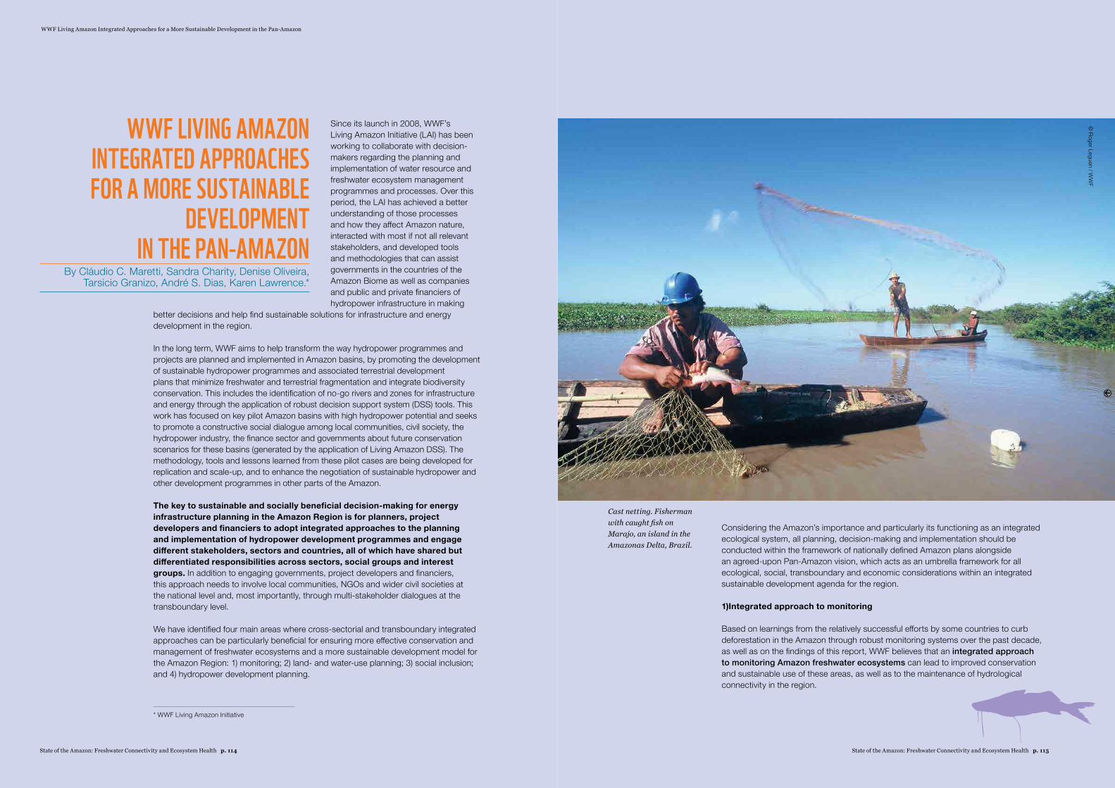
WWF Living Amazon Integrated Approaches for a More Sustainable Development in the Pan-Amazon
WWF LIVING AMAZON INTEGRATED APPROACHES FOR A MORE SUSTAINABLE
DEVELOPMENT IN THE PAN-AMAZON
By Cláudio C. Maretti, Sandra Charity, Denise Oliveira, Tarsicio Granizo, André S. Dias, Karen Lawrence.*
Since its launch in 2008, WWF’s Living Amazon Initiative (LAI) has been working to collaborate with decision-makers regarding the planning and implementation of water resource and freshwater ecosystem management programmes and processes. Over this period, the LAI has achieved a better understanding of those processes and how they affect Amazon nature, interacted with most if not all relevant stakeholders, and developed tools and methodologies that can assist governments in the countries of the Amazon Biome as well as companies and public and private financiers of hydropower infrastructure in making
better decisions and help find sustainable solutions for infrastructure and energy development in the region.
In the long term, WWF aims to help transform the way hydropower programmes and projects are planned and implemented in Amazon basins, by promoting the development of sustainable hydropower programmes and associated terrestrial development plans that minimize freshwater and terrestrial fragmentation and integrate biodiversity conservation. This includes the identification of no-go rivers and zones for infrastructure and energy through the application of robust decision support system (DSS) tools. This work has focused on key pilot Amazon basins with high hydropower potential and seeks to promote a constructive social dialogue among local communities, civil society, the hydropower industry, the finance sector and governments about future conservation scenarios for these basins (generated by the application of Living Amazon DSS). The methodology, tools and lessons learned from these pilot cases are being developed for replication and scale-up, and to enhance the negotiation of sustainable hydropower and other development programmes in other parts of the Amazon.
The key to sustainable and socially beneficial decision-making for energy infrastructure planning in the Amazon Region is for planners, project developers and financiers to adopt integrated approaches to the planning and implementation of hydropower development programmes and engage different stakeholders, sectors and countries, all of which have shared but differentiated responsibilities across sectors, social groups and interest groups. In addition to engaging governments, project developers and financiers, this approach needs to involve local communities, NGOs and wider civil societies at the national level and, most importantly, through multi-stakeholder dialogues at the transboundary level.
We have identified four main areas where cross-sectorial and transboundary integrated approaches can be particularly beneficial for ensuring more effective conservation and management of freshwater ecosystems and a more sustainable development model for the Amazon Region: 1) monitoring; 2) land- and water-use planning; 3) social inclusion; and 4) hydropower development planning.
Considering the Amazon’s importance and particularly its functioning as an integrated ecological system, all planning, decision-making and implementation should be conducted within the framework of nationally defined Amazon plans alongside an agreed-upon Pan-Amazon vision, which acts as an umbrella framework for all ecological, social, transboundary and economic considerations within an integrated sustainable development agenda for the region.
1) Integrated approach to monitoring
Based on learnings from the relatively successful efforts by some countries to curb deforestation in the Amazon through robust monitoring systems over the past decade, as well as on the findings of this report, WWF believes that an integrated approach to monitoring Amazon freshwater ecosystems can lead to improved conservation and sustainable use of these areas, as well as to the maintenance of hydrological connectivity in the region.
* WWF Living Amazon Initiative
© Roger Leguen / W
WF
Cast netting. Fisherman with caught fish on Marajo, an island in the Amazonas Delta, Brazil.
State of the Amazon: Freshwater Connectivity and Ecosystem Health p. 115State of the Amazon: Freshwater Connectivity and Ecosystem Health p. 114
Planners and managers need to:
a. Develop indicators and indexes for Amazon freshwater connectivity and the health of its rivers and basins, tracking variables such as conversion of riparian vegetation, flood pulses and flooding areas, social and cultural needs, fish in the food supply of Amazon people, and compliance with legislation and policies, among others.
b. Use monitoring, communication of results and awareness-raising to create enabling conditions to propose and develop national, subnational and transboundary integrated policies to prevent new conversion of freshwater ecosystems and promote their sustainable use and conservation. Use monitoring, including in a participatory way, as a key part of always improving adaptive management for the programmes associated with those policies.
c. Focus monitoring on the meso scale (sub-basins or parts of sub-basins), which is generally considered a suitable scale of analysis for most large infrastructure projects. This is also an appropriate level to promote a more direct interaction between relevant social actors, including governments, through their engagement in a broad social dialogue on planned hydropower programmes and solutions for freshwater conservation.
d. At the same time, keep sight of the macro scale (the Amazon Basin and larger biome, including the Amazon Caribbean river basins of the Guianas), aiming to maintain at least some larger free-flowing rivers so as to ensure that the Amazon continues to function as a single hydrological system.
2) Integrated approach to land- and water-use planning
Building on the learnings from conventional land-use planning processes commonly used in several Amazon countries, as well as on the findings of this report, WWF believes that an integrated approach to planning the use and occupation of Amazon landscapes (both terrestrial and freshwater) is key to the conservation and sustainable management of these areas. Planners and managers need to take the following elements into account:
a. Conventional land-use planning approaches need to be adapted and applied to freshwater ecosystems, including the development of a clear set of rules and regulations that take into account the characteristics of these areas.
b. Integrate existing protected areas (mostly IUCN categories I and II) into land-use and water-use planning, aiming to conserve a representative sample of biodiversity and to safeguard natural processes and ecosystem services.
c. Also integrate lands and freshwater ecosystems managed or co-managed by traditional communities and indigenous peoples into land-use plans in areas designated as sustainable use reserves (mostly IUCN category VI).
d. The degazettement, downsizing or downgrading of protected areas (PADDD) and indigenous territories resulting from poorly planned land use (and water use) needs to be avoided at all costs. These areas represent the “safety net” for maintaining the biodiversity, the critical terrestrial and freshwater ecosystems, and the essential environmental services they provide and can help secure hydrological connectivity in the Amazon.
e. Promote sustainable commercial management of forest and fisheries resources that do not compromise forest cover or integrity of freshwater ecosystems or the ecosystem services they provide.
f. Businesses and governments of all sectors operating in the Amazon Region, in particular those engaged in unsustainable economic activities such as ranching, plantations, hydropower and other water-related infrastructure, mining, oil and gas exploration, and transportation (particularly roads) must shift their objectives toward achieving “net positive impact”. This concept is increasingly being adopted by companies in the global productive sector; these companies redefine their corporate goals to go beyond productivity and profit, incorporating the need to achieve clear social and environmental benefits as part of their overall mission.
g. Integrated approaches to land- and water-use planning need to take into account wider regional and global conservation and development goals as well as national and subnational conservation and sustainable development objectives.
h. Government authorities and companies engaged in planning and implementing land- and water-use strategies (in particular hydropower infrastructure) need to strictly adhere to the widely accepted and internationally adopted “mitigation hierarchy” for infrastructure development projects (avoid, minimize, restore, offset), where offsetting is viewed as a “last resort” (after all reasonable measures have been taken first to avoid or minimize the impact of a development project and then restore biodiversity on-site).
3) Integrated approach to social inclusion (especially of indigenous and other traditional communities)
Governments of the Amazon countries need to respect the individual and collective rights of indigenous peoples and other local or traditional communities to their lands, waters and natural resources through granting official recognition of their territories and ensuring access to the natural resources and ecosystems they depend on (both terrestrial and freshwater). The processes required to recognize indigenous territories (ITs) and formalize land- and water-use rights of local or traditional communities would benefit from an integrated approach involving all relevant government departments (indigenous affairs, agriculture, justice, home office) and wider stakeholders (farmers, the oil and gas sector, mining companies, banks, etc.). Such an approach should be based on the following principles:
a. Respect and apply the rights of indigenous peoples and other traditional communities to give or withhold their prior informed consent to projects and activities that affect their traditional way of life, cultural diversity and beliefs, lands, rivers, and associated natural resources. Special attention should be given to indigenous peoples in voluntary isolation in order to respect and ensure their decision and right to live as they decide. Give full recognition to community conserved areas (CCAs).
b. Support indigenous peoples and other traditional communities in improving the management of their territories, developing sustainable economic activities (non-timber forest products, fisheries, forest management) and establishing effective links with local, national, regional and global markets, and publicize the important role of ITs and CCAs for nature conservation, local economies and ecosystem integrity (ecosystem services, biodiversity, carbon storage, hydrological connectivity, etc.).
WWF Living Amazon Integrated Approaches for a More Sustainable Development in the Pan-Amazon
State of the Amazon: Freshwater Connectivity and Ecosystem Health p. 117State of the Amazon: Freshwater Connectivity and Ecosystem Health p. 116

4) Integrated approach to hydropower development planning
In order to make hydropower development in the Amazon Region more sustainable environmentally and socially, and based on its experience in recent years of engaging with hydropower development processes in the Pan-Amazon, WWF has developed proposals for an integrated approach to planning hydropower development in the Amazon. The recommended approach is premised on the need to question the hydropower expansion plans of several Amazon countries, making a case for a stronger focus on energy efficiency (in the generation, transport and consumption of electricity) and greater diversification and decentralization of energy sources (solar, wind and biomass; urban and rural generation; avoiding fossil fuels and nuclear). In addition, the energy needs of the Amazon Region have to be assessed in terms of the most appropriate and sustainable alternatives for the region (small-scale locally provided energy, as opposed to large-scale exported energy). This would require a fundamental shift in government thinking and business practice through cross-sectorial dialogue, integration and political will.
If a compelling argument is made in favour of the construction of more dams in the Amazon, the following principles would need to be incorporated into planning their expansion in the region:
a. Infrastructure and energy development must fulfil the social needs of people living in the region itself and benefit local economies, contributing to the sustainable development of the area or sub-region itself (and not simply satisfy the needs of industry and urban development in far-flung regions or nations).
b. Integrate the conservation of biodiversity and maintenance of ecosystem services within infrastructure and energy planning processes and promote the integration of the energy sector with the conservation of the region (safeguarding ecological representation, ecological flows, forest-river interaction, etc.) through the use of systematic conservation planning (SCP) approaches and DSS tools for identifying ecosystem-based solutions.
c. Ensure that the planning, assessment, consultation and decision-making processes relating to the energy and infrastructure needs in the region are conducted at the basin level given the critical importance of assessing the cumulative impacts of multiple hydropower projects in the basin, and avoid project-by-project planning.
d. Hydropower planning decisions must not be made based on electricity generation potential alone. The inventory stage of any hydropower planning process needs to go beyond simply defining energy generation potential of alternative dam sites, and should give early consideration to the maintenance of ecological flows in the river basin and to the potential multiple uses of water and reservoirs.
e. Conduct Amazon Basin-wide integrated assessments of the cumulative environmental and social impacts of whole portfolios of projects (i.e. access roads, hydro-ways and mining projects, and hydropower) on the main stem of the Amazon River, its tributaries and their tributaries. Transboundary integrated assessments will require bilateral or trilateral cooperative agreements between countries.
f. Conduct assessments that consider not only the direct impacts of hydropower projects, but also their indirect impacts, such as: the indirect impacts of dam construction on deforestation resulting from the establishment of construction sites for workers, which later become permanent settlements; access roads; and provoke in-migration.
g. Engage all affected stakeholders early on in the planning process, in particular indigenous peoples and other traditional communities, discussing site options and other alternatives through open, broad-ranging democratic debates rooted in the principle of free, prior and informed consent.
h. Advocate for strict adherence of the hydropower sector to the “mitigation hierarchy” for infrastructure development projects (avoid, mitigate, restore, offset), and influence companies to carry out “net positive impact” forecasting – where the positive impacts of mitigation actions are expected to outweigh the negative impacts of the project.
i. The environmental licensing stage of hydropower planning should address the means for avoiding and reducing the environmental damage caused by the project, and the resulting mitigation measures need to be defined prior to investments being made and initial project implementation.
WWF Living Amazon Integrated Approaches for a More Sustainable Development in the Pan-Amazon
© Brent Stirton / G
etty Images
Aerial shot of a winding river, Amazon rainforest, Loreto region, Peru.
State of the Amazon: Freshwater Connectivity and Ecosystem Health p. 119State of the Amazon: Freshwater Connectivity and Ecosystem Health p. 118
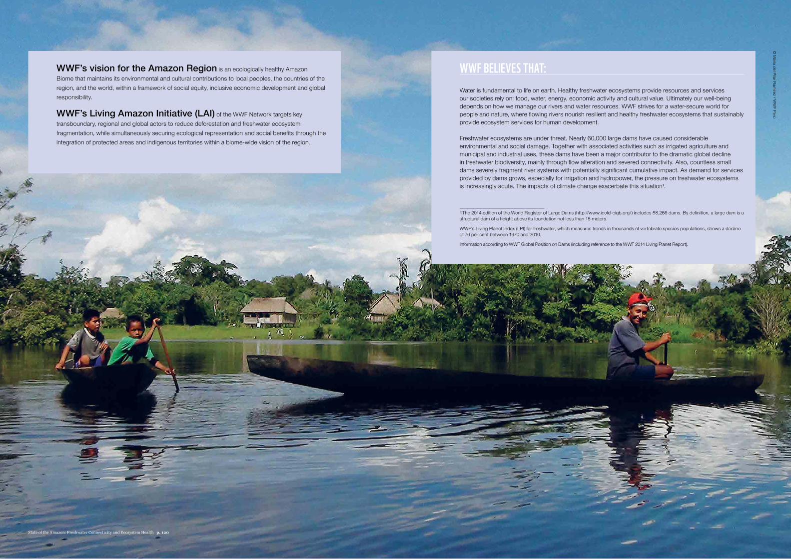
WWF BELIEVES THAT: Water is fundamental to life on earth. Healthy freshwater ecosystems provide resources and services our societies rely on: food, water, energy, economic activity and cultural value. Ultimately our well-being depends on how we manage our rivers and water resources. WWF strives for a water-secure world for people and nature, where flowing rivers nourish resilient and healthy freshwater ecosystems that sustainably provide ecosystem services for human development.
Freshwater ecosystems are under threat. Nearly 60,000 large dams have caused considerable environmental and social damage. Together with associated activities such as irrigated agriculture and municipal and industrial uses, these dams have been a major contributor to the dramatic global decline in freshwater biodiversity, mainly through flow alteration and severed connectivity. Also, countless small dams severely fragment river systems with potentially significant cumulative impact. As demand for services provided by dams grows, especially for irrigation and hydropower, the pressure on freshwater ecosystems is increasingly acute. The impacts of climate change exacerbate this situation1.
1 The 2014 edition of the World Register of Large Dams (http://www.icold-cigb.org/) includes 58,266 dams. By definition, a large dam is a structural dam of a height above its foundation not less than 15 meters.
WWF’s Living Planet Index (LPI) for freshwater, which measures trends in thousands of vertebrate species populations, shows a decline of 76 per cent between 1970 and 2010.
Information according to WWF Global Position on Dams (including reference to the WWF 2014 Living Planet Report).
WWF’s vision for the Amazon Region is an ecologically healthy Amazon Biome that maintains its environmental and cultural contributions to local peoples, the countries of the region, and the world, within a framework of social equity, inclusive economic development and global responsibility.
WWF’s Living Amazon Initiative (LAI) of the WWF Network targets key transboundary, regional and global actors to reduce deforestation and freshwater ecosystem fragmentation, while simultaneously securing ecological representation and social benefits through the integration of protected areas and indigenous territories within a biome-wide vision of the region.
© M
aría del Pilar Ramírez / W
WF Perú
State of the Amazon: Freshwater Connectivity and Ecosystem Health p. 120
Abell, R., J. D. Allan, and B. Lehner. 2007. Unlocking the potential of protected areas for freshwaters. Biological Conservation 134:48-63.Abell, R., M. L. Thieme, C. Revenga, M. Bryer, M. Kottelat, N. Bogutskaya, B. Coad, N. Mandrak, S. C. Balderas, W. Bussing, M. L. J. Stiassny, P. Skelton, G. R. Allen, P. Unmack, A. Naseka, R. Ng, N. Sindorf, J. Robertson, E. Armijo, J. V. Higgins, T. J. Heibel, E. Wikramanayake, D. Olson, H. L. Lopez, R. E. Reis, J. G. Lundberg, M. H. S. Perez, and P. Petry. 2008. Freshwater ecoregions of the world: A new map of biogeographic units for freshwater biodiversity conservation. Bioscience 58:403-414.Agostinho, A. A., F. M. Pelicice, and L. C. Gomes. 2008. Dams and the fish fauna of the Neotropical region: impacts and management related to diversity and fisheries. Brazilian Journal of Biology 68:1119-1132.Alexander, R. B., R. A. Smith, and G. E. Schwarz. 2000. Effect of stream channel size on the delivery of nitrogen to the Gulf of Mexico. Nature 403:758-761.Allan, J. D. 2004. Landscapes and riverscapes: The influence of land use on stream ecosystems. Annual Review of Ecology Evolution and Systematics 35:257-284.Amoros, C. and G. Bornette. 2002. Connectivity and biocomplexity in waterbodies of riverine floodplains. Freshwater Biology 47:761-776.Andreassian, V. 2004. Waters and forests: from historical controversy to scientific debate. Journal of Hydrology 291:1-27.[ANEEL] Agência Nacional de Energia Elétrica. 2012. (1 May 2012; www.aneel.gov.br).Angermeier, P. L. and J. R. Karr. 1986. Applying an index of biotic integrity based on stream-fish communities: Considerations in sampling and interpretation. North American Journal of Fisheries Management 6:418-429.Araujo-Lima, C. A. R. M., B. R. Forsberg, R. Victoria, and L. Martinelli. 1986. Energy-sources for detrivorous fishes in the Amazon. Science 234:1256-1258.Ashe, K. 2012. Elevated mercury concentrations in humans of Madre de Dios, Peru. PLoS ONE 7:e33305.Asner, G. P., W. Llactayp, R. Tupayachi, and E. R. Luna. 2013. Elevated rates of gold mining in the Amazon revealed through high-resolution monitoring. Proc Natl Acad Sci U S A 110:18454-18459.Bagley, J. E., A. R. Desai, K. J. Harding, and P. K. Snyder. 2014. Drought and deforestation: Has land cover change influenced recent precipitationextremes in the Amazon? Journal of Climate 27:345-361.Balbín, C. and V. La Rosa. 2012. Hidroeléctricas y conflictos sociales: Recomendaciones para una mejor gestión ambiental. Friedrich Ebert Stiftung, Lima.Barthem, R. and M. Goulding. 1997. The catfish connection: ecology, migration and conservation of Amazon predators. Columbia University Press, New York.Barthem, R. B., M. C. L. Ribeiro, and M. Petrere. 1991. Life strategies of some long-distance migratory catfish in relation to hydroelectric dams in the Amazon Basin. Biological Conservation 55:339-345.Bayley, P. B. 1995. Understanding large river-floodplain ecosystems: Significant economic advantages and increased biodiversity and stability would result from restoration of impaired systems. Bioscience 45:153-158.Bayley, P. B. 1998. Aquatic Biodiversity and Fisheries Management in the Amazon. United Nations and World Bank, Rome.Bayley, P. B. and M. Petrere Jr. 1989. Amazon fisheries: assessment methods, current status and management options. Pages 385-398 in D. P. Dodge, editor. Proceedings of the international large river symposium. Canadian Special Publication of Fisheries and Aquatic Sciences.Bernard, E., L. A. Penna, and E. Araujo. 2014. Downgrading, Downsizing, Degazettement, and Reclassification of Protected Areas in Brazil. Conserv Biol.
Biggs, T. W., T. Dunne, and L. A. Martinelli. 2004. Natural controls and human impacts on stream nutrient concentrations in a deforested region of the Brazilian Amazon Basin. Biogeochemistry 68:227-257.Bodmer, R., P. Puertas, J. Garcia, D. Dias, and C. Reyes. 1999. Game animals, palms, and people of the flooded forests: Management considerations for the Pacaya-Samiria National Reserve, Peru. Pages 203-232 in P. C., A. MA., P.-V. M., and H. A., editors. Várzea: diversity, development, and conservation of Amazonia’s whitewater floodplains. New York Botanical Garden Press, New York.Bojsen, B. H. and R. Barriga. 2002. Effects of deforestation on fish community structure in Ecuadorian Amazon streams. Freshwater Biology 47:2246-2260.Brando, P. M., J. K. Balch, D. C. Nepstad, D. C. Morton, F. E. Putz, M. T. Coe, D. Silverio, M. N. Macedo, E. A. Davidson, C. C. Nobrega, A. Alencar, and B. S. Soares-Filho. 2014. Abrupt increases in Amazonian tree mortality due to drought-fire interactions. Proc Natl Acad Sci U S A.Brando, P. M., D. C. Nepstad, J. K. Balch, B. Bolker, M. C. Christman, M. Coe, and F. E. Putz. 2012. Fire-induced tree mortality in a neotropical forest: the roles of bark traits, tree size, wood density and fire behavior. Global Change Biology 18:630-641.Brauman, K. A., G. C. Daily, T. K. e. Duarte, and H. A. Mooney. 2007. The nature and value of ecosystem services: An overview highlighting hydrologic services. Annual Review of Environment and Resources 32:67-98.Brondízio, E. 2008. The Amazonian caboclo and the Acaí palm: forest farmers in the global market. New York Botanical Garden Press, New York.Bruijnzeel, L. A. 1990. Hydrology of moist tropical forests and effects of conversion: a state of knowledge review. Faculty of Earth Sciences, Free University Amsterdam, The Netherlands.Bruijnzeel, L. A. 2004. Hydrological functions of tropical forests: not seeing the soil for the trees? Agriculture Ecosystems & Environment 104:185-228.Butt, N., P. A. de Oliveira, and M. H. Costa. 2011. Evidence that deforestation affects the onset of the rainy season in Rondonia, Brazil. Journal of Geophysical Research-Atmospheres 116.Calabrese, J. M. and W. F. Fagan. 2004. A comparison-shopper’s guide to connectivity metrics. Frontiers in Ecology and the Environment 2:529-536.Calder, I. R. 1998. Water use by forests, limits and controls. Tree Physiology 18:625-631.Canas, C. M. and W. E. Pine. 2011. Documentation of the temporal and spatial patterns of Pimelodidae catfish spawning and larvae dispersion in the Madre de Dios (Peru): Insights for conservation in the Andean-Amazon headwaters. River Research and Applications 27:602-611.Carpenter, S. R., N. F. Caraco, D. L. Correll, R. W. Howarth, A. N. Sharpley, and V. H. Smith. 1998. Nonpoint pollution of surface waters with phosphorus and nitrogen. Ecological Applications 8:559-568.Castello, L. 2008. Lateral migration of Arapaima gigas in floodplains of the Amazon. Ecology of Freshwater Fish 17:38-46.Castello, L., D. G. McGrath, and P. S. A. Beck. 2011. Resource sustainability in small-scale fisheries in the Lower Amazon floodplains. Fisheries Research 110:356-364.Castello, L., D. G. McGrath, L. L. Hess, M. T. Coe, P. A. Lefebvre, P. Petry, M. N. Macedo, V. F. Renó, and C. C. Arantes. 2013. The vulnerability of Amazon freshwater ecosystems. Conservation Letters:n/a-n/a.Chaves, J., C. Neill, S. Germer, S. G. Neto, A. V. Krusche, A. C. Bonilla, and H. Elsenbeer. 2009. Nitrogen transformations in flowpaths leading from soils to streams in Amazon forest and pasture. Ecosystems 12:961-972.Cleary, D. 2001. Towards an environmental history of the Amazon: from prehistory to the nineteenth century. Latin American Research Review:65-96.Coe, M. T., M. H. Costa, and E. A. Howard. 2008. Simulating the surface waters of the Amazon River basin: impacts of new river geomorphic and flow parameterizations RID A-5695-2009. Hydrological Processes 22:2542-2553.
REFERENCES
References
State of the Amazon: Freshwater Connectivity and Ecosystem Health p. 123State of the Amazon: Freshwater Connectivity and Ecosystem Health p. 122
Coe, M. T., M. H. Costa, and B. S. Soares-Filho. 2009. The influence of historical and potential future deforestation on the stream flow of the Amazon River – Land surface processes and atmospheric feedbacks. Journal of Hydrology 369:165-174.Coe, M. T., E. M. Latrubesse, M. E. Ferreira, and M. L. Amsler. 2011. The effects of deforestation and climate variability on the streamflow of the Araguaia River, Brazil. Biogeochemistry 105:119-131.Coe, M. T., T. R. Marthews, M. H. Costa, D. R. Galbraith, N. L. Greenglass, H. M. Imbuzeiro, N. M. Levine, Y. Malhi, P. R. Moorcroft, M. N. Muza, T. L. Powell, S. R. Saleska, L. A. Solorzano, and J. Wang. 2013. Deforestation and climate feedbacks threaten the ecological integrity of south–southeastern Amazonia. Philosophical Transactions of the Royal Society B: Biological Sciences 368.Costa, M. H., A. Botta, and J. A. Cardille. 2003. Effects of large-scale changes in land cover on the discharge of the Tocantins River, Southeastern Amazonia. Journal of Hydrology 283:206-217.Costa, M. H. and J. A. Foley. 1997. Water balance of the Amazon Basin: Dependence on vegetation cover and canopy conductance. Journal of Geophysical Research-Atmospheres 102:23973-23989.Cote, D., D. Kehler, C. Bourne, and Y. Wiersma. 2009. A new measure of longitudinal connectivity for stream networks. Landscape Ecology 24:101-113.Crampton, W. G. R., L. Castello, and J. P. Viana. 2004. Fisheries in the Amazon várzea: historical trends, current status, and factors affecting sustainability. Pages 76-95 in K. Silvius, R. Bodmer, and J. M. V. Fragoso, editors. People in nature: wildlife conservation in South and Central America. Columbia University Press, New York.D’Almeida, C., C. J. Vorosmarty, G. C. Hurtt, J. A. Marengo, S. L. Dingman, and B. D. Keim. 2007. The effects of deforestation on the hydrological cycle in Amazonia: a review on scale and resolution. International Journal of Climatology 27:633-647.Da Silveira, R., J. V. Amaral, W. E. Magnussson, and J. B. Thorbjarnarson. 2011. Melanosuchus Niger (black caiman): long distance movement. Herpetological Review 4.Da Silveira, R., E. E. Ramalho, J. B. Thorbjarnarson, and W. E. Magnusson. 2010. Depredation by jaguars on caimans and importance of reptiles in the diet of jaguar. Journal of Herpetology 44:418-424.Davidson, E. A., A. C. de Araujo, P. Artaxo, J. K. Balch, I. F. Brown, M. M. C. Bustamante, M. T. Coe, R. S. DeFries, M. Keller, M. Longo, J. W. Munger, W. Schroeder, B. S. Soares, C. M. Souza, and S. C. Wofsy. 2012. The Amazon basin in transition. Nature 481:321-328.de Mérona, B. and D. Gascuel. 1993. The effects of flood regime and fishing effort on the overall abundance of an exploited fish community in the Amazon floodplain. Aquatic Living Resources 6:97-108.De Miguel, E., D. Clavijo, M. F. Ortega, and A. Gomez. 2014. Probabilistic meta-analysis of risk from the exposure to Hg in artisanal gold mining communities in Colombia. Chemosphere 108:183-189.Dias, A. S., J. Johnson, L. H. Gomez, G. Accacio, C. C. Maretti, K. Lawrence, S. Charity, and D. Oliveira. 2014. Deforestation fronts in the Amazon Region: Current situation and future trends, a preliminary summary. La COP 20: Perspectivas desde el Sur WWF Living Amazon Initiative, Universidad Ruiz de Montoya, Lima, Perú.Ewel, K. C. 2009. Appreciating tropical coastal wetlands from a landscape perspective. 8:26-26.Fachín-Terán, A., R. C. Vogt, and J. B. Thorbjarnarson. 2006. Seasonal movements of Podocnemis sextuberculata (Testudines: Podocnemididae) in the Mamirauá sustainable development reserve, Amazonas, Brazil. Chelonian Conservation and Biology 5:18-24.Fagan, W. F. 2002. Connectivity, fragmentation, and extinction risk in dendritic metapopulations. Ecology 83:3243-3249.Fearnside, P. 2013a. The evolving context of Brazil’s environmental policies in Amazonia. Novos Cadernos NAEA 16:9-25.Fearnside, P. 2013b. Viewpoint – Decision making on Amazon dams: Politics trumps uncertainty in the Madeira River sediments controversy. Water Alternatives 6:313-325.
Fearnside, P. M. 2001. Environmental impacts of Brazil’s Tucurui Dam: Unlearned lessons for hydroelectric development in Amazonia. Environmental Management 27:377-396.Fearnside, P. M. 2004. Greenhouse gas emissions from hydroelectric dams: Controversies provide a springboard for rethinking a supposedly ‘clean’ energy source – An editorial comment. Climatic Change 66:1-8.Fearnside, P. M. 2005. Brazil’s Samuel Dam: Lessons for hydroelectric development policy and the environment in Amazonia. Environmental Management 35:1-19.Fearnside, P. M. 2006. Dams in the Amazon: Belo Monte and Brazil’s hydroelectric development of the Xingu River basin. Environmental Management 38:16-27.Fearnside, P. M. 2014. Viewpoint – Brazil’s Madeira River dams: A setback for environmental policy in Amazonian development. Water Alternatives 7:1-15.Ferreira Júnior, P. and P. Castro. 2010. Nesting ecology of Podocnemis expansa (Schweigger, 1812) and Podocnemis unifilis (Troschel, 1848) (Testudines, Podocnemididae) in the Javaés River, Brazil. Brazilian Journal of Biology 70:85-94.Finer, M. and C. N. Jenkins. 2012. Proliferation of hydroelectric dams in the Andean Amazon and implications for Andes-Amazon connectivity. PLoS ONE 7:e35126.Finer, M., C. N. Jenkins, S. L. Pimm, B. Keane, and C. Ross. 2008. Oil and gas projects in the Western Amazon: threats to wilderness, biodiversity, and indigenous peoples. PLoS ONE 3:e2932.Finer, M., V. Vijay, F. Ponce, C. N. Jenkins, and T. R. Kahn. 2009. Ecuador’s Yasuni Biosphere Reserve: a brief modern history and conservation challenges. Environmental Research Letters 4.Flores, B. M., M.-T. F. Piedade, and B. W. Nelson. 2012. Fire disturbance in Amazonian blackwater floodplain forests. Plant Ecology & Diversity:1-9.Foley, J. A., R. DeFries, G. P. Asner, C. Barford, G. Bonan, S. R. Carpenter, F. S. Chapin, M. T. Coe, G. C. Daily, H. K. Gibbs, J. H. Helkowski, T. Holloway, E. A. Howard, C. J. Kucharik, C. Monfreda, J. A. Patz, I. C. Prentice, N. Ramankutty, and P. K. Snyder. 2005. Global consequences of land use. Science 309:570-574.Forsberg, B. R., C. A. R. M. Araujo-Lima, L. A. Martinelli, R. I. Victoria, and J. A. Bonassi. 1993. Autotrophic carbon-sources for fish of the Central Amazon. Ecology 74:643-652.Freeman, M. C., C. M. Pringle, and C. R. Jackson. 2007. Hydrologic connectivity and the contribution of stream headwaters to ecological integrity at regional scales. Journal of the American Water Resources Association 43:5-14.Furtado, L. G., W. Leitão, and A. F. Melo, editors. 1993. Povos das águas, realidade e perspectivas na Amazônia. Ministério de Ciência e Tecnologia, Conselho Nacional de Pesquisa, Museu Paraense Emilio Goeldi, Belém, Brazil.Gardner, E. 2012. Peru battles the golden curse of Madre de Dios. Nature 486.Gergel, S. E. 2005. Spatial and non-spatial factors: When do they affect landscape indicators of watershed loading? Landscape Ecology 20:177-189.Gergel, S. E., M. G. Turner, J. R. Miller, J. M. Melack, and E. H. Stanley. 2002. Landscape indicators of human impacts to riverine systems. Aquatic Sciences 64:118-128.Giambelluca, T. W. 2002. Hydrology of altered tropical forest. Hydrological Processes 16:1665-1669.Godinho, A. L. and B. Kynard. 2009. Migratory fishes of Brazil: Life history and fish passage needs. River Research and Applications 25:702-712.Godoy, J. R., G. Petts, and J. Salo. 1999. Riparian flooded forests of the Orinoco and Amazon basins: a comparative review. Biodiversity and Conservation 8:551-586.Gomes, L. C. and A. A. Agostinho. 1997. Influence of the flooding regime on the nutritional state and juvenile recruitment of the curimba, Prochilodus scrofa, Steindachner, in upper Parana River, Brazil. Fisheries Management and Ecology 4:263-274.Goulding, M. 1980. The fishes and the forest: explorations in Amazonian natural history. University of California Press, Los Angeles, CA.
References
State of the Amazon: Freshwater Connectivity and Ecosystem Health p. 125State of the Amazon: Freshwater Connectivity and Ecosystem Health p. 124
Goulding, M., R. Barthem, and E. J. G. Ferreira. 2003. The Smithsonian atlas of the Amazon. Smithsonian Institution Press, Washington, DC.Gunkel, G., U. Lange, D. Walde, and J. W. C. Rosa. 2003. The environmental and operational costs of Curuá-Una, a reservoir in the Amazon region of Pará, Brazil. Lakes & Reservoir: Research & Management 8:201-216.Gutiérrez-Vélez, V. H., R. DeFries, M. Pinedo-Vásquez, M. Uriarte, C. Padoch, W. Baethgen, K. Fernandes, and Y. Lim. 2011. High-yield oil palm expansion spares land at the expense of forests in the Peruvian Amazon. Environmental Research Letters 6:044029.Hamilton, S. K., J. Kellndorfer, B. Lehner, and M. Tobler. 2007. Remote sensing of floodplain geomorphology as a surrogate for biodiversity in a tropical river system (Madre de Dios, Peru). Geomorphology 89:23-38.Hamilton, S. K., S. J. Sippel, and J. M. Melack. 2002. Comparison of inundation patterns among major South American floodplains. Journal of Geophysical Research: Atmospheres 107:LBA 5-1-LBA 5-14.Hansen, A. J. and R. DeFries. 2007. Ecological mechanisms linking protected areas to surrounding lands. Ecological Applications 17:974-988.Hansen, M. C., P. V. Potapov, R. Moore, M. Hancher, S. A. Turubanova, A. Tyukavina, D. Thau, S. V. Stehman, S. J. Goetz, T. R. Loveland, A. Kommareddy, K. Egorov, L. Chini, C. O. Justice, and J. G. R. Townsend. 2013. High-resolution global maps of 21st-century forest cover change. Science 342:850-853.Haugaasen, T. and C. A. Peres. 2005. Tree phenology in adjacent Amazonian flooded and unflooded forests. Biotropica 37:620-630.Hayhoe, S. J., C. Neill, S. Porder, R. McHorney, P. Lefebvre, M. T. Coe, H. Elsenbeer, and A. V. Krusche. 2011. Conversion to soy on the Amazonian agricultural frontier increases streamflow without affecting stormflow dynamics. Global Change Biology 17:1821-1833.Hess, G. R. 1996. Linking extinction to connectivity and habitat destruction in metapopulation models. The American Naturalist 148:226-236.Hess, L. L., J. M. Melack, E. M. L. M. Novo, C. C. F. Barbosa, and M. Gastil. 2003. Dual-season mapping of wetland inundation and vegetation for the central Amazon basin. Remote Sensing of Environment 87:404-428.Howard, J., M. A. Trotz, K. Thomas, E. Omisca, H. T. Chiu, T. Halfhide, F. Akiwumi, R. Michael, and A. L. Stuart. 2011. Total mercury loadings in sediment from gold mining and conservation areas in Guyana. Environmental Monitoring and Assessment 179:555-573.Huffman, G. J., R. F. Adler, D. T. Bolvin, G. Gu, E. J. Nelkin, K. P. Bowman, Y. Hong, E. F. Stocker, and D. B. Wolff. 2007. The TRMM multi-satellite precipitation analysis: quasi-global, multi-year, combined-sensor precipitation estimates at fine scale. J. Hydrometeor. 8:38-55.Indriunas, L. 1998. FHC inaugura obras em viagem ao Pará. Folha de São Paulo, São Paulo.IPEA, CEPAL, and GIZ. 2011. Avaliação do Plano de Ação para Prevenção e Controle do Desmatamento na Amazônia Legal (PPCDAm) 2007-2010. Instituto de Pesquisa Econômica Aplicada, Comissão Econômica para a América Latina e Caribe, and Deutsche Gesellschaft für Internationale Zusammenarbeit, Brasília, Brazil.Isaac, V. and M. Almeida. 2011. El consumo de pescado en la Amazonian brasileña. FAO, Roma.Jackson, D. C. and G. Marmulla. 2001. The influence of dams on river fisheries. Pages 166-144 in G. Marmulla, editor. Dams, fish and fisheries: opportunities, challenges and conflict resolution. Food & Agriculture Org., Rome.Jantz, P., S. J. Goetz, and N. Laporte. 2014. Carbon stock corridors to mitigate climate change and promote biodiversity in the tropics. Nature Climate Change 4:138-142.Jenkins, C. N. and L. Joppa. 2009. Expansion of the global terrestrial protected area system. Biological Conservation 142:2166-2174.Jochnick, C., R. Norman, and S. Zaidi. 1994. Rights violations in the Ecuadorian Amazon: the human consequences of oil development. Health Human Rights 1:82-100.
Jones, C. and L. M. V. Carvalho. 2013. Climate change in the South American Monsoon System: Present climate and CMIP5 projections. Journal of Climate 26:6660-6678.Junk, W. J. 1993. Wetlands of tropical South America. Pages 679-739 in D. Whigham and D. H. Dykyjová, editors. Wetlands of the World: Inventory, ecology, and management. Kluwer Academic Publishers, Boston.Junk, W. J., P. B. Bayley, and R. E. Sparks. 1989. The flood pulse concept in river-floodplain systems. Canadian Special Publication of Fisheries and Aquatic Sciences 106:110-127.Junk, W. J. and J. A. S. N. d. Mello. 1990. Impactos ecológicos das represas hidrelétricas na bacia amazônica brasileira. Estudos Avançados 4:126-143.Junk, W. J., M. G. Mota Soares, and P. B. Bayley. 2007. Freshwater fishes of the Amazon River basin: their biodiversity, fisheries, and habitats. Aquatic Ecosystem Health & Management 10:153-173.Junk, W. J., J. J. Ohly, M. T. F. Piedade, and M. G. M. Soares. 2000. The Central Amazon floodplain: Actual use and options for a sustainable management. Backhuys Publishers.Junk, W. J. and M. T. F. Piedade. 2004. Status of knowledge, ongoing research, and research needs in Amazonian wetlands. Wetlands Ecology and Management 12:597-609.Junk, W. J., M. T. F. Piedade, J. Schöngart, M. Cohn-Haft, J. M. Adeney, and F. Wittmann. 2011. A classification of major naturally-occurring Amazonian lowland wetlands. Wetlands 31:623-640.Kacowicz, Z. 1985. Covenio ELETRONORTE/CNPQ/INPA. Relatorio do projeto: Estudo de ecologia e controle ambiental nas regiões do reservatório UHE de Balbina e Samuel: Comentário., Conselho Nacional de Desenvolvimento Cientiífico e Tecnológico (CNPq), Brasilia.Kalliola, R., M. Puhakka, J. Salo, H. Tuomisto, and K. Ruokolainen. 1991. The dynamics, distribution and classification of swamp vegetation in Peruvian Amazonia. Annales Botanici Fennici 28:225-239.Kallis, G. and D. Butler. 2001. The EU water framework directive: measures and implications. Water Policy 3:125-142.Karr, J. R. 1981. Assessment of biotic integrity using fish communities. Fisheries 6.6:21-27.Karr, J. R. 1991. Biological Integrity: A Long-Neglected Aspect of Water Resource Management. Ecological Applications 1:66-84.Karr, J. R., K. D. Fausch, P. L. Angermeier, P. R. Yant, and I. J. Schlosser. 1986. Assessing biological integrity in running waters: A method and its rationale. Illinois National Historical Survey.Kasper, D., B. R. Forsberg, J. H. F. Amaral, R. P. Leitao, S. S. Py-Daniel, W. R. Bastos, and O. Malm. 2014. Reservoir stratification affects methylmercury levels in river water, plankton, and fish downstream from Balbina hydroelectric dam, Amazonas, Brazil. Environmental Science & Technology 48:1032-1040.Kemenes, A., B. R. Forsberg, and J. M. Melack. 2007. Methane release below a tropical hydroelectric dam. Geophysical Research Letters 34.Kemenes, A., B. R. Forsberg, and J. M. Melack. 2011. CO2 emissions from a tropical hydroelectric reservoir (Balbina, Brazil). Journal of Geophysical Research-Biogeosciences 116.Keuroghlian, A. and D. P. Eaton. 2008. Importance of rare habitats and riparian zones in a tropical forest fragment: preferential use by Tayassu pecari, a wide-ranging frugivore. Journal of Zoology 275:283-293.La Rovere, E. L. and F. E. Mendes. 2000. TucuruÌ Hydropower Complex, Brazil, A WCD case study prepared as an input to the World Commission on Dams. World Commission on Dams, Cape Town.Lagler, K. F., J. F. Kapetski, and D. J. Stewart. 1971. The fisheries of the Kafue River Flats, Zambia, in relation to the Kafue Gorge Dam. Central Fisheries Research Institute, Chilanga (Zambia).
References
State of the Amazon: Freshwater Connectivity and Ecosystem Health p. 127State of the Amazon: Freshwater Connectivity and Ecosystem Health p. 126
Lammert, M. and J. D. Allan. 1999. Assessing biotic integrity of streams: Effects of scale in measuring the influence of land use/cover and habitat structure on fish and macroinvertebrates. Environmental Management 23:257-270.Lathuillière, M. J., M. S. Johnson, and S. D. Donner. 2012. Water use by terrestrial ecosystems: temporal variability in rainforest and agricultural contributions to evapotranspiration in Mato Grosso, Brazil. Environmental Research Letters 7:024024.Latrubesse, E. M., M. L. Amsler, R. P. de Morais, and S. Aquino. 2009. The geomorphologic response of a large pristine alluvial river to tremendous deforestation in the South American tropics: The case of the Araguaia River. Geomorphology 113:239-252.Lees, A. C. and C. A. Peres. 2008. Conservation value of remnant riparian forest corridors of varying quality for Amazonian birds and mammals. Conservation Biology 22:439-449.Lehner, B., K. Verdin, and A. Jarvis. 2006. HydroSHEDS Technical Documentation. World Wildlife Fund US, Washington, DC. Available at http://hydrosheds.cr.usgs.gov.Leopold, L. B., M. G. Wolman, and J. P. Miller. 1964. Fluvial processes in geomorphology. W. H. Freeman & Sons, San Francisco.Lesack, L. F. W. 1995. Seepage exchange in an Amazon floodplain lake. Limnology and Oceanography 40:598-609.Lewis, S. L., P. M. Brando, O. L. Phillips, G. M. van der Heijden, and D. Nepstad. 2011. The 2010 Amazon drought. Science 331:554.Li, K. Y., M. T. Coe, N. Ramankutty, and R. De Jong. 2007. Modeling the hydrological impact of land-use change in West Africa. Journal of Hydrology 337:258-268.Liermann, C. R., C. Nilsson, J. Robertson, and R. Y. Ng. 2012. Implications of dam obstruction for global freshwater fish diversity. Bioscience 62:539-548.Lima, L. S., M. T. Coe, B. S. Soares Filho, S. V. Cuadra, L. C. P. Dias, M. H. Costa, L. S. Lima, and H. O. Rodrigues. 2013. Feedbacks between deforestation, climate, and hydrology in the Southwestern Amazon: implications for the provision of ecosystem services. Landscape Ecology 29:261-274.Limburg, K. E. and J. R. Waldman. 2009. Dramatic declines in North Atlantic diadromous fishes. Bioscience 59:955-965.Little, P. 2014. Mega-Development Projects in Amazonia; A geopolitical and socioenvironmental primer. Red Jurídica Amazónica (RAMA) Articulación Regional Amazónica (ARA) Derecho Ambiente y Recursos Naturales (DAR), Lima, Perú.Locatelli, B. and R. Vignola. 2009. Managing watershed services of tropical forests and plantations: Can meta-analyses help? Forest Ecology and Management 258:1864-1870.Lorion, C. M. and B. P. Kennedy. 2009. Relationships between deforestation, riparian forest buffers and benthic macroinvertebrates in neotropical headwater streams. Freshwater Biology 54:165-180.Lubiana, A. and P. D. Ferreira Júnior. 2009. Pivotal temperature and sexual dimorphism of Podocnemis expansa hatchlings (Testudines: Podocnemididae) from Bananal Island, Brazil. Zoologia (Curitiba) 26:527-533.Macedo, M., R. DeFries, D. Morton, C. Stickler, G. Galford, and Y. Shimabukuro. 2012. Decoupling of deforestation and soy production in the southern Amazon during the late 2000s. PNAS 109:1341-1346.Macedo, M. N., M. T. Coe, R. DeFries, M. Uriarte, P. M. Brando, C. Neill, and W. S. Walker. 2013. Land-use-driven stream warming in southeastern Amazonia. Philos Trans R Soc Lond B Biol Sci 368:20120153.Magalhaes, S. B. 1990. Tucuruí: A relocation policy in context. Pages 105-114 in L. A. O. Santos and L. M. M. Andrade, editors. Hydroelectric dams on Brazil’s Xingu River and Indigenous peoples. Cultural Survival, Cambridge, Massachusetts.Mahli, Y., J. T. Roberts, R. A. Betts, T. J. Killeen, W. Li, and C. A. Nobre. 2007. Climate change, deforestation, and the fate of the Amazon. Science 319:169-172.Malhi, Y., L. E. Aragão, D. Galbraith, C. Huntingford, R. Fisher, P. Zelazowski, P. Meir, and P. Others. 2009. Exploring the likelihood and mechanism of a climate-change-
induced dieback of the Amazon rainforest. Pages 20610-20615 in National Academy of Sciences.Malhi, Y., E. Pegoraro, A. D. Nobre, M. G. P. Pereira, J. Grace, A. D. Culf, and R. Clement. 2002. Energy and water dynamics of a central Amazonian rain forest. Journal of Geophysical Research-Atmospheres 107.Malmquist, B. and S. Rundle. 2002. Threats to the running water ecosystems of the world. Environmental Conservation 29:134-153.Marengo, J. A., B. Liebmann, A. M. Grimm, V. Misra, P. L. S. Dias, I. F. A. Cavalcanti, L. M. V. Carvalho, E. H. Berbery, T. Ambrizzi, C. S. Vera, A. C. Saulo, J. Nogues-Paegle, E. Zipser, A. Seth, and L. M. Alves. 2012. Recent developments on the South American monsoon system. International Journal of Climatology 32:1-21.Maretti, C. C., J. C. Riveros, R. Hofstede, D. Oliveira, S. Charity, T. Granizo, C. Alvarez, P. Vialdujo, and C. Thompson. 2014. State of the Amazon: Ecological representation in protected areas and indigenous territories., WWF Living Amazon (Global) Initiative, Brasília, Brazil; Quito, Ecuador.Marinho, J. S., M. O. Lima, E. C. d. O. Santos, I. M. de Jesus, M. d. C. N. Pinheiro, C. N. Alves, and R. C. S. Muller. 2014. Mercury speciation in hair of children in three communities of the Amazon, Brazil. BioMed Research International 2014:1-9.Martin, A. R. and V. M. E. da Silva. 2004. River dolphins and flooded forest: seasonal habitat use and sexual segregation of botos (Inia geoffrensis) in an extreme cetacean environment. Journal of Zoology 263:295-305.Martin, A. R., V. M. F. Da Silva, and D. L. Salmon. 2004. Riverine habitat preferences of botos (Inia geoffrensis) and tucuxis (Sotalia fluviatilis) in the central Amazon. Marine Mammal Science 20:189-200.May, P. H., B. Millikan, and M. F. Gebara. 2011. The context of REDD+ in Brazil: Drivers, agents and institutions. CIFOR, Bogor, Indonesia.McClain, M. E. and R. E. Cossio. 2003. The use of riparian environments in the rural Peruvian Amazon. Environmental Conservation 30:242-248.McClain, M. E. and H. Elsenbeer. 2001. Terrestrial Inputs to Amazon Streams and Internal Biogeochemical Processing in M. E. McClain, R. L. Victoria, and J. E. Richey, editors. The Biogeochemistry of the Amazon Basin. Oxford University Press.McClain, M. E. and R. J. Naiman. 2008. Andean influences on the biogeochemistry and ecology of the Amazon River. Bioscience 58:325-338.McGrath, D. G., A. Cardoso, O. T. Almeida, and J. Pezzuti. 2008. Constructing a policy and institutional framework for an ecosystem-based approach to managing the Lower Amazon floodplain. Environment, Development and Sustainability 10:677-695.Melack, J. M. and M. T. Coe. 2013. Climate change and the floodplain lakes of the Amazon Basin. Pages 295-310 in C. R. Goldman, M. Kumagai, and R. Robarts, editors. Amazonia and Global Change. John Wiley and Sons.Melack, J. M. and B. R. Forsberg. 2001. Biogechemistry of Amazon Floodplain Lakes and Associated Wetlands. Pages 235-274 in M. E. McClain, R. L. Victoria, and J. E. Richey, editors. The Biogeochemistry of the Amazon Basin. Oxford University Press, New York.Melack, J. M. and L. L. Hess. 2011. Remote Sensing of the Distribution and Extent of Wetlands in the Amazon Basin Amazonian Floodplain Forests. Pages 43-59 in W. J. Junk, M. T. F. Piedade, F. Wittmann, J. Schöngart, and P. Parolin, editors. Springer Netherlands.Melack, J. M., E. M. L. M. Novo, B. R. Forsberg, M. T. F. Piedade, and L. Maurice. 2009. Floodplain ecosystem processes. Pages 525-541 in M. Keller, M. G. J. Bustamante, and P. S. Dias, editors. Amazonia and Global Change. American Geophysical Union, Washington, DC.Miguez-Macho, G. and Y. Fan. 2012. The role of groundwater in the Amazon water cycle: 1. Influence on seasonal streamflow, flooding and wetlands. Journal of Geophysical Research-Atmospheres 117.Naiman, R. J. and H. Decamps. 1997. The ecology of interfaces: Riparian zones. Annual Review of Ecology and Systematics 28:621-658.
References
State of the Amazon: Freshwater Connectivity and Ecosystem Health p. 129State of the Amazon: Freshwater Connectivity and Ecosystem Health p. 128
Naiman, R. J., H. Decamps, and M. E. McClain. 2005. Riparia – Ecology, Conservation and Management of Streamside Communities. Elsevier Academic Press, London.Neill, C., M. T. Coe, S. H. Riskin, A. V. Krusche, H. Elsenbeer, M. N. Macedo, R. McHorney, P. Lefebvre, E. A. Davidson, R. Scheffler, A. M. Figueira, S. Porder, and L. A. Deegan. 2013. Watershed responses to Amazon soya bean cropland expansion and intensification. Philosophical Transactions of the Royal Society B: Biological Sciences 368.Neill, C., L. A. Deegan, S. M. Thomas, and C. C. Cerri. 2001. Deforestation for pasture alters nitrogen and phosphorus in small Amazonian streams. Ecological Applications 11:1817-1828.Nel, J. L., D. J. Roux, R. Abell, P. J. Ashton, R. M. Cowling, J. V. Higgins, M. Thieme, and J. H. Viers. 2009. Progress and challenges in freshwater conservation planning. Aquatic Conservation-Marine and Freshwater Ecosystems 19:474-485.Nepstad, D., D. McGrath, C. Stickler, A. Alencar, A. Azevedo, B. Swette, T. Bezerra, M. DiGiano, J. Shimada, R. Seroa da Motta, E. Armijo, L. Castello, P. Brando, M. C. Hansen, M. McGrath-Horn, O. Carvalho, and L. Hess. 2014. Slowing Amazon deforestation through public policy and interventions in beef and soy supply chains. Science 344:1118-1123.Nepstad, D., B. Soares-Filho, F. Merry, A. Lima, P. Moutinho, J. B. M. Carter, A. Cattaneo, H. Rodrigues, S. Schwartzman, D. McGrath, C. M. Stickler, R. Lubowski, P. Piris-Cabezas, S. Rivero, A. Alencar, O. Almeida, and O. Stella. 2009. The end of deforestation in the Brazilian Amazon. Science 326:1350-1351.Nepstad, D. C. 2007. The Amazon’s Vicious Cycles: Drought and Fire in the Greenhouse: Ecological and Climatic Tipping Points of the World’s Largest Tropical Rainforest, and Practical Preventive Measures. WWF.Nevado, J. J. B., R. C. R. Martin-Doimeadios, F. J. G. Bernardo, M. J. Moreno, A. M. Herculano, J. L. M. do Nascimento, and M. E. Crespo-Lopez. 2010. Mercury in the Tapajos River basin, Brazilian Amazon: A review. Environment International 36:593-608.Nilsson, C. and K. Berggren. 2000. Aterations of riparian ecosystems caused by river regulation. Bioscience 50:783-792.Nogueira, C., P. A. Buckup, N. A. Menezes, O. T. Oyakawa, T. P. Kasecker, M. B. Ramos Neto, and J. M. da Silva. 2010. Restricted-range fishes and the conservation of Brazilian freshwaters. PLoS ONE 5:e11390.Olden, J. D. and R. J. Naiman. 2010. Incorporating thermal regimes into environmental flows assessments: modifying dam operations to restore freshwater ecosystem integrity. Freshwater Biology 55:86-107.Oliveira, J. A. P. 2002. Implementing environmental policies in developing countries through decentralization: the case of protected areas in Bahia, Brazil. World Development 30:1713-1736.Oliveira, L. J. C., M. H. Costa, B. S. Soares-Filho, and M. T. Coe. 2013. Large-scale expansion of agriculture in Amazonia may be a no-win scenario. Environmental Research Letters 8:024021.Ouboter, P. E., G. A. Landburg, J. H. Quik, J. H. Mol, and F. van der Lugt. 2012. Mercury levels in pristine and gold mining impacted aquatic ecosystems of Suriname, South America. Ambio 41:873-882.Padoch, C. 1988. Aguaje (Mauritia flexuosa Lf) in the economy of Iquitos, Peru. Advances in Economic Botany 6:214-224.Palmeirim, A. F., C. A. Peres, and F. C. W. Rosas. 2014. Giant otter population responses to habitat expansion and degradation induced by a mega hydroelectric dam. Biological Conservation 174:30-38.Peres, C. A. and J. W. Terborgh. 1995. Amazonian nature-reserves – an analysis of the defensibility status of existing conservation units and design criteria for the future. Conservation Biology 9:34-46.Petermann, P. 1997. The birds. Pages 419-454 in W. J. Junk, editor. The Central Amazon Floodplain: Ecology of a Pulsing System. Springer Verlag, Berlin.
Petts, G. E. 1984. Impounded rivers: perspectives for ecological management. John Wiley.Piedade, M. T. F., W. J. Junk, and S. P. Long. 1991. The productivity of the C4 grass Echinochloa-Polystachya on the Amazon floodplain. Ecology 72:1456-1463.Pinedo-Vasquez, M., J. B. Pasqualle, D. C. Torres, and K. Coffey. 2001. A tradition of change: the dynamic relationship between biodiversity and society in sector Muyuy, Peru. Environmental Science and Policy 5:43-53.Poff, N. L., J. D. Allan, M. B. Bain, J. R. Karr, K. L. Prestegaard, B. D. Richter, R. E. Sparks, and J. C. Stromberg. 1997. The natural flow regime: A paradigm for river restoration and conservation. Bioscience 47:769-784.Prance. 1979. Notes on the vegetation of Amazonia III. The terminology of Amazonian forest types subject to inundation. Brittonia 31:26-38.Pringle, C. 2003a. The need for a more predictive understanding of hydrologic connectivity. Aquatic Conservation-Marine and Freshwater Ecosystems 13:467-471.Pringle, C. 2003b. What is hydrologic connectivity and why is it ecologically important? Hydrological Processes 17:2685-2689.Pringle, C. M. 2001. Hydrologic connectivity and the management of biological reserves: A global perspective. Ecological Applications 11:981-998.[PROTEGER] Fundación PROTEGER, International Rivers, ECOA. Dams in Amazonia. 2012. (1 May 2012; www.dams-info.org).RAISG. 2012. Amazon Protected Areas and Indigenous Territories. Red Amazónica de Información Socioambiental Georeferenciada.Reis, R. E., S. O. Kullander, and C. Ferraris, Jr. 2003. Check list of the freshwater fishes of South and Central America. EDIPUCRS, Porto Alegre.Renó, V. F., E. M. L. M. Novo, C. Suemitsu, C. D. Rennó, and T. S. F. Silva. 2011. Assessment of deforestation in the Lower Amazon floodplain using historical Landsat MSS/TM imagery. Remote Sensing of Environment.Ribeiro, J. W., A. P. Lima, and W. E. Magnusson. 2012. The effect of riparian zones on species diversity of frogs in Amazonian forests. Copeia:375-381.Ribeiro, M., M. Petrere, and A. A. Juras. 1995. Ecological integrity and fisheries ecology of the Araguaia-Tocantins River Basin, Brazil. Regulated Rivers-Research & Management 11:325-350.Rosenberg, D. M., P. McCully, and C. M. Pringle. 2000. Global-scale environmental effects of hydrological alterations: Introduction. Bioscience 50:746-751.Rudorff, C. M., J. M. Melack, and P. D. Bates. 2014a. Flooding dynamics on the lower Amazon floodplain: 1. Hydraulic controls on water elevation, inundation extent, and river-floodplain discharge. Water Resources Research 50:619-634.Rudorff, C. M., J. M. Melack, and P. D. Bates. 2014b. Flooding dynamics on the lower Amazon floodplain: 2. Seasonal and interannual hydrological variability. Water Resources Research 50:635-649.Sagar, A. D. 2000. Capacity development for the environment: A view for the south, a view for the north. Annual Review of Energy and the Environment 25:377-439.Sahin, V. and M. J. Hall. 1996. The effects of afforestation and deforestation on water yields. Journal of Hydrology 178:293-309.Santos-Frances, F., A. Garcia-Sanchez, P. Alonso-Rojo, F. Contreras, and M. Adams. 2011. Distribution and mobility of mercury in soils of a gold mining region, Cuyuni river basin, Venezuela. Journal of Environmental Management 92:1268-1276.Schaefer, S. A. 1998. Conflict and resolution: impact of new taxa on phylogenetic studies of the neotropical Cascudinhos (Siluroidei: Loricaridae). Pages 375-400 in L. R. Malabarba, R. E. Reis, R. P. Vari, Z. M. S. Lucena, and C. A. S. Lucena, editors. Phylogeny and Classification of Neotropical Fishes. EDIPUCRS, Porto Alegre.Schiesari, L. and B. Grillitsch. 2011. Pesticides meet megadiversity in the expansion of biofuel crops. Frontiers in Ecology and the Environment 9:215-221.Schiesari, L., A. Waichman, T. Brock, C. Adams, and B. Grillitsch. 2013. Pesticide use and biodiversity conservation in the Amazonian agricultural frontier. Philosophical Transactions of the Royal Society B-Biological Sciences 368.
References
State of the Amazon: Freshwater Connectivity and Ecosystem Health p. 131State of the Amazon: Freshwater Connectivity and Ecosystem Health p. 130
Schindler, D. W. 2006. Recent advances in the understanding and management of eutrophication. Limnology and Oceanography 51:356-363.Schwarzenbach, R. P., B. I. Escher, K. Fenner, T. B. Hofstetter, C. A. Johnson, U. von Gunten, and B. Wehrli. 2006. The challenge of micropollutants in aquatic systems. Science 313:1072-1077.Setti, A. A. 2004. Legislation and institutional systems for water resources management in Brazil and their relevance to the Amazon. Pages 167-202 in L. E. Aragón and M. Clüsener-Godt, editors. UNESCO.Shuttleworth, W. J. 1988. Evaporation from Amazonian forests. Philos Trans R Soc Lond B Biol Sci 233:321-346.Sioli, H. 1984. The Amazon and its main affluents: Hydrography, morphology of the river courses, and river types. Pages 127-166 in H. Sioli, editor. The Amazon: Limnology and landscape ecology of a mighty tropical river and its basin. Dr W. Junk Publishers, Dordretch.Smith, N. J. H. 2002. Amazon Sweet Sea: Land, Life, and Water at the River’s Mouth. University of Texas Press.Smith, S. V., W. H. Renwick, R. W. Buddemeier, and C. J. Crossland. 2001. Budgets of soil erosion and deposition for sediments and sedimentary organic carbon across the conterminous United States. Global Biogeochemical Cycles 15:697-707.Soares-Filho, B., P. Moutinho, D. Nepstad, A. Anderson, H. Rodrigues, R. Garcia, L. Dietzsch, F. Merry, M. Bowman, L. Hissa, R. Silvestrini, and C. Maretti. 2010. Role of Brazilian Amazon protected areas in climate change mitigation. Proc Natl Acad Sci U S A 107:10821-10826.Soares-Filho, B., R. Rajão, M. Macedo, A. Carneiro, W. Costa, M. Coe, H. Rodrigues, and A. Alencar. 2014. Cracking Brazil’s Forest Code. Science 344.Sonter, L. J., D. J. Barrett, C. J. Moran, and B. S. Soares-Filho. 2015. Carbon emissions due to deforestation for the production of charcoal used in Brazil’s steel industry. Nature Clim. Change advance online publication.Spracklen, D. V., S. R. Arnold, and C. M. Taylor. 2012. Observations of increased tropical rainfall preceded by air passage over forests. Nature 489:282-U127.St Louis, V. L., C. A. Kelly, E. Duchemin, J. W. M. Rudd, and D. M. Rosenberg. 2000. Reservoir surfaces as sources of greenhouse gases to the atmosphere: A global estimate. Bioscience 50:766-775.Sterling, S. M., A. Ducharne, and J. Polcher. 2013. The impact of global land-cover change on the terrestrial water cycle. Nature Clim. Change 3:385-390.Stickler, C. M., M. T. Coe, M. H. Costa, D. C. Nepstad, D. G. McGrath, L. C. P. Dias, H. O. Rodrigues, and B. S. Soares-Filho. 2013a. Dependence of hydropower energy generation on forests in the Amazon Basin at local and regional scales. Pages 9601-9606 in National Academy of Sciences.Stickler, C. M., D. C. Nepstad, A. A. Azevedo, and D. G. McGrath. 2013b. Defending public interests in private lands: compliance, costs and potential environmental consequences of the Brazilian Forest Code in Mato Grosso. Philos Trans R Soc Lond B Biol Sci 368:20120160.Stotz, D. F., J. W. Fitzpatrick, T. E. Parker, III, and D. K. Moskovits. 1996. Neotropical birds. University of Chicago Press, Chicago.Sweeney, B. W., T. L. Bott, J. K. Jackson, L. A. Kaplan, J. D. Newbold, L. J. Standley, W. C. Hession, and R. J. Horwitz. 2004. Riparian deforestation, stream narrowing, and loss of stream ecosystem services. Proc Natl Acad Sci U S A 101:14132-14137.Swenson, J. J., C. E. Carter, J.-C. Domec, and C. I. Delgado. 2011. Gold mining in the Peruvian Amazon: global prices, deforestation, and mercury imports. PLoS ONE 6:e18875.Switkes, G. 2002. Brazilian government pushes ahead with plans for huge dams in Amazon. World Rivers Review 17:12-13.Switkes, G. 2005. Foiling the Aluminum Industry: A toolkit for communities, consumers, and workers. International Rivers Network, Berkeley, CA.Switkes, G. 2007. Madeira dams in Amazon get go-ahead. World Rivers Review 22:12-13.
Syvitski, J. P. M., C. J. Vörösmarty, A. J. Kettner, and P. Green. 2005. Impact of humans on the flux of terrestrial sediment to the global coastal ocean. Science 308:376-380.Thieme, M., B. Lehner, R. Abell, S. K. Hamilton, J. Kellndorfer, G. Powell, and J. C. Riveros. 2007. Freshwater conservation planning in data-poor areas: An example from a remote Amazonian basin (Madre de Dios River, Peru and Bolivia). Biological Conservation 135:484-501.Uriarte, M., C. B. Yackulic, Y. Lim, and J. A. Arce-Nazario. 2011. Influence of land use on water quality in a tropical landscape: a multi-scale analysis. Landscape Ecology 26:1151-1164.Van Der Windt, H. J. and J. A. A. Swart. 2008. Ecological corridors, connecting science and politics: The case of the Green River in the Netherlands. Journal of Applied Ecology 45:124-132.Van Dijick, P. 2013. The impact of the IIRSA road infrastructure programme in Amazonia. Routledge, New York, NY.Veríssimo, A., A. Rolla, A. P. C. Souto Maior, A. Monteiro, B. Brito, C. Souza Jr., C. C. Augusto, D. Cardoso, D. Conrado, E. Araújo, F. Ricardo, J. Ribeiro, L. M. de Lima, M. B. Ribeiro, M. Vedoveto, M. Mesquita, P. G. Barreto, R. Salomão, and S. d. M. Futada. 2011. Áreas Protegidas na Amazônia Brasileira: Avanços e Desafios. IMAZON/ISA, Brasil.Ward, J. V. 1989. The 4-dimensional nature of lotic ecosystems. Journal of the North American Benthological Society 8:2-8.Ward, J. V., K. Tockner, D. B. Arscott, and C. Claret. 2002. Riverine landscape diversity. Freshwater Biology 47:517-539.WCD. 2000. Dams and Development: A New Framework for Decision-Making. Earthscan, London.Welcomme, R. L. 1985. River fisheries. FAO, Rome.Williams, M. R., T. R. Fisher, and J. M. Melack. 1997. Solute dynamics in soil water and groundwater in a central Amazon catchment undergoing deforestation. Biogeochemistry 38:303-335.Wipfli, M. S., J. S. Richardson, and R. J. Naiman. 2007. Ecological linkages between headwaters and downstream ecosystems: Transport of organic matter, invertebrates, and wood down headwater channels. Journal of the American Water Resources Association 43:72-85.Wohl, E., A. Barros, N. Brunsell, N. A. Chappell, M. Coe, T. Giambelluca, S. Goldsmith, R. Harmon, J. M. H. Hendrickx, J. Juvik, J. McDonnell, and F. Ogden. 2012. The hydrology of the humid tropics. Nature Clim. Change 2:655-662.World Bank. 2008. Summary report. Vol. 1 of Environmental licensing for hydroelectric projects in Brazil: A contribution to the debate. The World Bank, Washington, DC.Yin, L., R. Fu, Y.-F. Zhang, P. A. Arias, D. N. Fernando, W. Li, K. Fernandes, and A. R. Bowerman. 2014. What controls the interannual variation of the wet season onsets over the Amazon? Journal of Geophysical Research: Atmospheres 119:2314-2328.Zhang, L. and M. H. Wong. 2007. Environmental mercury contamination in China: Sources and impacts. Environment International 33:108-121.Coca-Castro, A., Reymondin, L., Bellfield, H., and G. Hyman. 2013. Land Use Status and Trends in Amazonia. Report for Global Canopy Programme and International Center for Tropical Agriculture as part of the Amazonia Security Agenda project. Quotes Laurence 2001 at 100 million ha and 25 per cent on the Brazilian Legal Amazon.Nepstad, D. C., C. M. Stickler, B. Soares-Filho, and F. Merry. 2008. Interactions among Amazon land use, forests and climate: prospects for a near-term forest tipping point, Philosophical Transactions of the Royal Society Biological Sciences 363(1498): 1737-1746.Soares-Filho B. S., D. C. Nepstad, L. Curran et al. 2006. Modelling conservation in the Amazon basin. Nature 440: 520-523.
References
State of the Amazon: Freshwater Connectivity and Ecosystem Health p. 133State of the Amazon: Freshwater Connectivity and Ecosystem Health p. 132
This report benefited greatly from comments and constructive feedback from numerous colleagues. In particular, we acknowledge the important contributions of the organizers and participants of the “WWF Living Amazon Initiative Technical Workshop on Freshwater Ecosystem Fragmentation”, held 26-28 May 2014 in Brasília, Brazil. The workshop brought together a diverse panel of experts (listed below) on Amazon freshwater ecosystems, energy and conservation policy to comment on an earlier draft of the report. We are deeply grateful to all of the participants for their time and energy, lively debates, and rich discussion about the future of Amazon freshwater ecosystems. Your feedback was invaluable; any oversights or omissions in the final version of the report are solely the responsibility of the authors.
A special thanks to Michelle Thieme, Wolfgang Junk, Cláudio Maretti, John Melack, Laura Hess, Michael Coe, Fernando Trujillo, Fernando Mayer Pelicice, José Saulo Usma, Cecilia Alvarez Vega and Demóstenes Barbosa da Silva for providing detailed written feedback or key references. Thanks also to Patrick Jantz and Carol Franco for advice on vulnerability assessments, as well as Fernando Mayer Pelicice and Paula Hanna Valdujo for contributing case studies on the Tocantins and Tapajós river basins, respectively. Finally, a heartfelt thanks to Denise Oliveira and José Maria de Freitas Fernandes for their expert support with logistics and communications throughout the workshop and report preparation.
Workshop ParticipantsAndré Silva Dias – WWF Living Amazon (Global) Initiative
Cecilia Alvarez Vega – WWF-Peru
Claudia Veliz – WWF-Peru
Cláudio C. Maretti – WWF Living Amazon (Global) Initiative
Damian Fleming – WWF-UK
Demóstenes B. da Silva – Base Energia Sustentável
Denise Oliveira – WWF Living Amazon (Global) Initiative
Fernando Pelicice – Federal University of Tocantins
Fernando Trujillo – Omacha Foundation
James Bilce – Mapsmut
Jean-François Timmers – WWF-Brazil
John Melack – University of California at Santa Barbara
José Saulo Usma – WWF-Colombia
Karen Lawrence – WWF-UK
Laura Hess – University of California at Santa Barbara
Luiz Felipe Guanaes Rego – Interdisciplinary Center for the Environment/Catholic University of Rio de Janeiro
Mario Barroso – WWF-Brazil
Michael Goulding – Wildlife Conservation Society
Michael T. Coe – The Woods Hole Research Center
Miriam Marmontel – Mamirauá Sustainable Development Institute
Paula Hanna Valdujo – WWF-Brazil
Acknowledgements
ACKNOWLEDGEMENTSFrom Marcia Macedo and Leandro Castello
State of the Amazon: Freshwater Connectivity and Ecosystem Health p. 134
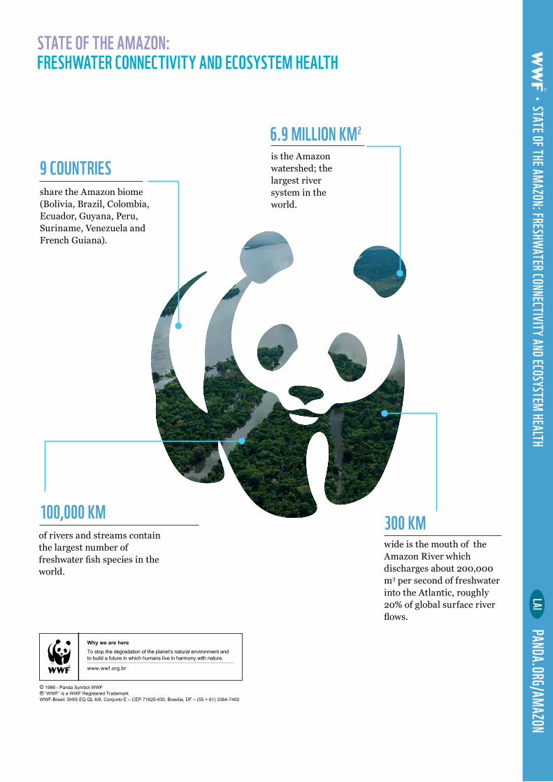
6.9 MILLION KM2
9 COUNTRIES
100,000 KM 300 KM
is the Amazon watershed; the largest river system in the world.
share the Amazon biome (Bolivia, Brazil, Colombia, Ecuador, Guyana, Peru, Suriname, Venezuela and French Guiana).
of rivers and streams contain the largest number of freshwater fish species in the world.
wide is the mouth of the Amazon River which discharges about 200,000 m3 per second of freshwater into the Atlantic, roughly 20% of global surface river flows.
STATE OF THE AMAZON: FRESHWATER CONNECTIVITY AND ECOSYSTEM HEALTH
LAIPANDA.ORG/AMAZON
STATE OF THE AMAZON: FRESHWATER CONNECTIVITY AND ECOSYSTEM HEALTH
Why we are here
www.wwf.org.br
To stop the degradation of the planet’s natural environment andto build a future in which humans live in harmony with nature.
© 1986 - Panda Symbol WWF ® “WWF” is a WWF Registered TrademarkWWF-Brasil: SHIS EQ QL 6/8, Conjunto E – CEP 71620-430, Brasília, DF – (55 + 61) 3364-7400