places of interest - kincardine, ontario township driving... · of interest/historical sites that...
TRANSCRIPT

Bruce Township’sPLACES OF INTEREST
DRIVING TOUR

Second Edition 2016
Produced by Heritage Kincardine

Savor the unique features of our Driving Tour emphasizing the points of
interest and the historical sites of Bruce Township. Over the course of history
many places have been transformed due to natural causes and humans. Points
of interest/historical sites that have no structure or viewable object are listed at
the end of each defined section (NW, SW, SE, NW) and marked alphabetically
on the map for that particular area. The remaining stops with visible points of
interest are marked numerically on the map.
The original survey of Bruce Township was started by Alex Wilkinson in 1847,
continued by Allan Park Brough and C. Millar until completion in 1852.
In 1854 the lands were opened and Bruce Township was founded in 1856.
Central administration was located in Underwood until the amalgamation of
the Township of Bruce as a part of the Municipality of Kincardine in 1999. The
original administration building is now a garden centre. A satellite office for
the Municipality remains at the Township of Bruce Community Centre.
The first settlers to the area were mainly from the British Isles bringing with
them their customs and skills to establish a new life in these untamed lands.
They cleared lands, built homes and communities while overcoming many
hardships leaving their footprint in Bruce Township. The shores of Lake Huron
provided many natural harbours, refuge for ships, transportation for settlers into
the area and shipping for their tanbark, grain, lumber, lime, and produce.
Fishing along our shoreline has always been a part of Bruce Township's
commerce as well as recreation.
The main industries over the years have been agriculture, lumber, ports
although they did not flourish, brickyards, Bruce Telecom, Bruce Nuclear site,
windmills and tourism.
An endeavor such as this would not be possible without the assistance and
dedication of many individuals. We wish to extend considerable recognition to
the Township of Bruce Historical Society, Bruce Telecom, the Bruce Nuclear
site and the Municipality of Kincardine for their research work, photos and
support necessary in developing this driving tour.
Introduction

Books of Interest regarding the History of the Township of Bruce:
The following books are good resources on the history of the Township
of Bruce. Other books and relevant materials may be found at the
Bruce County Museum, Southampton.
Bruce Township Tales and Trails, Bruce Township Historical Society,
1984.
Bruce Township Laneways and Landmarks, Township of Bruce
Historical Society, 2008.
Bruce Township More Families and Farms, Township of Bruce
Historical Society, 1998.
Glammis; Then and Now, Glamis Historical Researchers, 2014.
Books Referenced
Northwest Quadrant
QUADRANT MAP ........................................................................... 1
1 Brucedale Conservation Area................................................. 2
2 Job Carr Stone House ............................................................ 3
3 School Section No. 12........................................................... 3
4 Wesley United Church .......................................................... 4
5 Underwood Cheese & Butter Factory..................................... 4
6 Stone House .......................................................................... 5
7 Baie du Dore (Port Bruce & Malta)......................................... 5
8 Port Bruce Cemetery.............................................................. 7
9 School Section No. 6 ............................................................. 7
10 Bruce Community Pasture ..................................................... 8
11 School Section No. 7 ............................................................. 8
12 Township of Bruce Community Centre .................................. 9
13 Underwood United Church ................................................... 9
14 Old Township Hall ................................................................ 10
15 Bruce Township Central Public School .................................. 10
A Maas Sawmill ........................................................................ 11
B Orange Lodge........................................................................ 11
C Jack’s Ranch or Baie du Dore Resort ...................................... 12
D Underwood Methodist Church .............................................. 12
Index

Southwest Quadrant
QUADRANT MAP ........................................................................... 13
16 Bruce Energy Centre .............................................................. 14
17 Douglas Point & Bruce Nuclear Power Development ............ 15
18 Bruce Power Information Centre............................................ 17
19 Inverhuron Provincial Park .................................................... 17
20 Inverhuron Cemetery............................................................. 18
21 McIntyre Park ........................................................................ 18
22 The Inverhuron Beach ........................................................... 19
23 Inverhuron Pavilion ............................................................... 19
24 Lime Kiln............................................................................... 20
25 Sinclairs Corners.................................................................... 21
26 School Section No. 11 at Sinclairs Corners ............................ 21
27 Bruce Telecom ...................................................................... 22
E Boss Gray’s Castle ................................................................. 23
F School Section No. 1 ............................................................. 23
Index

Southeast Quadrant
QUADRANT MAP ........................................................................... 24
28 Glammis Presbyterian Church & Plaque ................................ 25
29 Glammis Baptist Church & Plaque......................................... 25
30 Township of Greenock Plaque in Glammis............................ 26
31 Union School Section No. 16, Glammis School..................... 26
32 Bottomless Bog aka Mud Lake or Christopher’s Lake ............. 27
33 Glammis Bog......................................................................... 28
34 Large Barn Sideroad 20.......................................................... 29
35 School Section No. 5 ............................................................. 29
36 Wind Turbines & Ripley Switchyard ...................................... 30
37 Shiloh United Brethren Church.............................................. 30
38 Willow Creek Cemetery ........................................................ 31
39 RKM Wood Products Ltd. ...................................................... 31
G Union School Section No. 3 (Eskdale).................................... 32
H Former Eskdale Post Offices................................................... 32
I Union School Section No. 4 .................................................. 33
J Former A.E. Greer Store & Glammis Ceramics ....................... 34
K Former Hutton Transport ....................................................... 35
L Former Glammis Methodist (United) Church ......................... 36
M MacLean Cemetery................................................................ 36
N Evangelical United Brethren Church ...................................... 37
Index

Northeast Quadrant
QUADRANT MAP ........................................................................... 38
40 School Section No. 10........................................................... 39
41 School Section No. 9 ............................................................. 39
42 Wind Turbines & Transformer Station.................................... 40
43 Lovat Cemetery ..................................................................... 40
44 Original Log Home and Lovat Bed & Breakfast ...................... 41
45 Lovat Brick & Tile Yard.......................................................... 41
46 Octagonal House................................................................... 42
47 Log Home at Lot 35 Conc. 10................................................ 42
48 Union School Section No. 15 ................................................ 43
49 School Section No. 14........................................................... 43
50 Cluny Plaque......................................................................... 44
51 School Section No. 13........................................................... 44
52 North Bruce Presbyterian Church & Queen Hill Manse ......... 45
53 Queen Hill Cemetery ............................................................ 45
54 Bruce County Rail Trail.......................................................... 46
O Centre Bruce Church in Gresham .......................................... 47
P Gresham................................................................................ 47
Q North Bruce Baptist Church ................................................... 48
R Smith Farm Cemetery ............................................................ 48
Did You Know That?........................................................................ 49
Walk of Memories, Tiverton............................................................. 52
Index

UNDERWOOD
NORTH BRUCECONC. 14
CONC. 12/13
CONC. 10/11
CONC. 8/9
CONC. 6/7
Northwest Quadrant Map
1Northwest Quadrant

137 Sprucedale Drive, (Con.10-12, Lake-Range lots 57-58), about 1 km south of Con. 12. Take Concession 12 to the end and turn south on Sprucedale Drive. GPS: 44.3795°N, 81.5228°W
Brucedale, Saugeen Conservation (formerly the Saugeen Valley Conservation Authority) manages a camp ground which opened in 1955. It includes tent and trailer sites, a sandy beach, picnic area and walking trails.
Brucedale Conservation Area
Northwest Quadrant
2Northwest Quadrant
Jennifer Hoover

3
1558 Con. 12, (Lot H Con. 13), 500 m east of Bruce Rd. 33. GPS 44.3682°N, 81.4795°W
This stone house was built in 1885 by Alexander Brunton, a Scottish stone mason for Job Carr who came to Canada from England. His neighbours recalled his “English Country” garden with its quince, walnut, flowering shrubs, holly, and many familiar and strange plants. Dave and Sue Glass purchased the property in 2005. Sue’s business, Lost Gardens, offers accommodation and weekend retreats.
Job Carr Stone House
1461 Con. 12, (Lot J Con. 12), 2 km west of Hwy 21.GPS 44.3638°N, 81.4689°W
The first school was a frame building erected in 1857 and located across the road on Con. 13. In 1875, a new brick school was built at the present location. All grades were taught by one teacher. When Bruce Central Public School opened in Underwood (1965) this building was sold for use as a private residence.
School Section No. 12
Northwest Quadrant

4
4253 Highway 21 (Pt Lot 5 Con. 12) Con. 12 at Hwy 21.GPS 44.3548°N, 81.4469°W
Wesley Methodist church was erected in 1876 on land purchased from Robert Stephenson. In 1909 the building was bricked and renovated. In 1925, the congregation joined the United Church as part of the union between the Methodists and Presbyterians. Other changes: an addition in 1927; stained glass windows in 1958, interior redecoration (1982). The church celebrated its centennial Sept. 5, 1976.
Wesley United Church
3972 Hwy 21 (Lot 6 Con. 10) about 2.7 km north of Underwood.GPS 44.3329°N, 81.4638°W
In 1875, a cooperative cheese factory was built on Lot 4 Con. 6 near Underwood and later moved to Lot 6 Con. 10, the site of the present motel on Highway 21. At one time the cheese factory sold cheese for 10-12 cents a lb. Butter was added to their product line at a later time. The cheese factory closed in 1934. The wagon in the picture made a weekly trip to collect cream from all the participating farms.
Underwood Cheese & Butter Factory
Northwest Quadrant

1605 Con. 10 (Lot G Con. 10), about 500 m east of Bruce Rd. 33.GPS 44.3544°N, 81.4976°W
This stone house was built in 1884 by Thomas Mather and stone mason Sandy Brunton for the Blakely family. The walls are 18 inches thick making them nice and cool in summer but difficult to heat in winter. Previous owners, the Thomas family, did their best to bring the interior back to the original, adorning it with many antiques. Catharine Crawford and John Thompson purchased the home in 2005 and built an addition that compliments the stone work.
Stone House
5
GPS: 44.3342°N, 81.5508°W
The plaque is located 6 km west of Underwood at the intersection of Con. 6 and the Tie Road. It pays tribute to two communities a little farther west along Con. 6: Port Bruce and Malta.
Baie du Dore
Northwest Quadrant

Port BruceLakeside end of Con. 6.GPS: 44.3353°N, 81.5555°W
From the plaque, go west about 400 m to the Lake, taking the left fork when the dirt road splits. Port Bruce was on the North and South side of this concession occupying Lake Range lots 30 to 33 and lots A and B of Con. 6.This village was surveyed on the shore of Baie du Dore for George Butchart in 1856. Butchart and his wife started a hotel in 1861. Margaret Turner kept a Tavern. John Lindsay ran a sawmill. The population grew to 150. Port Bruce disappeared after the disastrous fire of 1862.
MaltaMalta was located about 600 m north of Port Bruce at GPS: 44.3389°N, 81.5522°W
From the plaque, go west about 400 m to the Lake, taking the right fork, McFarland Road. Follow it north and follow around to the lake. Malta was situated on Lake Range Lots 34 to 39 which, in later years, became known as Jack's Ranch and Holiday Acres. This village was surveyed for Captain Alexander Murray McGregor. A Post Office was opened in 1855. John and Gregor McGregor built the first sawmill here. The 1861 census shows many tradesmen and businesses. There was a respectable wharf which shipped lumber, hemlock bark, lime, cedar posts, grain (warehouse held 10,000 bushels), fish, and local cord-wood for the many wood burning steam ships. The population grew to 125. Malta like Port Bruce prospered until 1862 when both were levelled by a swamp fire. Most settlers moved inland.
Baie du Dore
6Northwest Quadrant

Pt Lots D & E Con. 7, about 4.5 km west of Hwy 21 on Con. 6.GPS 44.3265°N, 81.5324°W
The cemetery on the crest of the hill dates back to the 1850s. The first death recorded on a monument here was that of John Stewart, aged 29, who died February 14, 1854. This 5-acre cemetery is still in use today.
Port Bruce Cemetery
7
201 Sideroad E/F (pt. Lot E Con. 6) at SW corner 4 km west of Hwy 21.GPS 44.3245°N, 81.5286°W
The early log school built on the southwest corner of Lot C Con. 7 about 1856 served the students of Baie du Dore, then called Port Bruce and Malta. A new brick school was built about 200 m east of that log building in 1876. The school closed in 1964, and was occupied as a residence until destroyed by fire in 1982.
School Section No. 6
Northwest Quadrant

1514 Con. 7 (Lots F to J, Con. 7 and Lots E to J, Con. 8), 3 km west of Hwy 21. GPS 44.3194°N, 81.5149°W
Agricultural Rehabilitation and Development Administration (ARDA) purchased 1400 acres of land between 1966 and 1970. This land was in a run down condition and covered with thorn trees. A Federal-Provincial project, ARDA rehabilitated the land and allowed local farmers to pasture up to 20 cattle on consignment with a formula for costs to cover vet bills, staff costs, and land maintenance. Since the initial purchase, these fees cover rehabilitation and maintenance costs. A local committee, appointed by Bruce County Council, administered the program. Saugeen Valley Conservation Authority, with the assistance of ARDA personnel, undertook a stream rehabilitation project on the ARDA property on Concession 8 in 1991. To control erosion and prevent cattle access to the stream on ARDA property, 150,000 trees donated by Ontario Hydro plus 7,500 from SVCA were planted. Eleven students planted trees on slopes too steep for machinery. Since 2004, the Bruce Community Pasture has been owned by the Association of Community Pastures.
Bruce Community Pasture
8
1264 Con. 6 about 300 m west of Underwood.GPS: 44.3083°N, 81.4876°W
The original log school built in 1860 was about 2 km west of this location. In 1876, a brick school was built here, with a second room added in 1883 to accommodate enrolment of 120 pupils.Closed in 1965, the building has now disappeared. The Township of Bruce Historical Society placed the plaque in 2000.
School Section No. 7
Northwest Quadrant

9
1240 Con. 6 west of Underwood.GPS 44.3076°N, 81.4855 °W
May 1974 marked the final meeting of council in the old Township Hall on Highway 21. From June of that year, councillors conducted municipal business in the Conference Room of the newly built Township of Bruce Community Centre. An expansion to the Clerk's office was added in 1978 to the west side of the original building.After The Township of Bruce became part of the Municipality of Kincardine, this building became a Satellite Municipal Administration Centre.The Community Centre is extensively used for business meetings, fund-raising dinners, and by entertainment groups. Its vault houses a great deal of early Bruce history, compiled by the very active Township of Bruce Historical Society.
Township of Bruce Community Centre
3630 Highway 21, southeast part of Underwood.GPS 44.3057°N, 81.4847°W
In 1925 the newly organized United Church in Underwood decided to use the former Presbyterian Church building. The Methodist congregation from across the road then came to this church. The active unit of United Church Women continues the tradition of serving community meals as fundraisers. Many of the gatherings at the Underwood Community Centre are catered by the UCW.
Underwood United Church
Northwest Quadrant

3664 Highway 21 at northeast corner of Underwood. GPS 44.3086°N, 81.4826°W
This, the original township hall, was erected in 1870. Many improvements were made over the years including a concrete vault for the township papers and records in 1915. Besides being Bruce Township’s administrative centre, it was used by the agricultural society and other community groups such as lodges, political parties, church organizations, businesses, and the Bruce Municipal Telephone System held meetings or social functions here. In 1974, after meeting here for over 100 years, Council moved to a new community centre built on the west side of Underwood. In 1976, Rudy and Mimi Langhans bought the building and opened “The Chapel” gift and fashion shop. In 2013, Pam’s Flowers took over the building.
Old Township Hall
10
3713 Highway 21 just north of Underwood. GPS 44.3128°N, 81.4792°W
In 1963, construction started on a public school for all of Bruce Township. In 1965, all 243 students from the section schools moved to the new building. The school was a busy place for 37 years until 2002 when it closed due to declining enrolment and budget cuts. Students are now bussed to Kincardine, Port Elgin, or Paisley schools. The building was purchased by Tennyson’s Technical Services, formerly located in “downtown” Underwood.
Bruce Township Central Public School
Northwest Quadrant

11
Lot E Con. 12 about 150m west of Bruce Road 33 on south side of road- only a private trail remains.GPS 44.3758°N, 81.4981°W
Charles Maas's sawmill was operating in this location in 1895. In 1897, the original mill burned down and a new mill was erected. The mill ran night and day, making lumber for the many houses and barns being built at the time.
Maas SawmillA
921 Sideroad J/1, (Pt Lot J Con. 11) 2 km west of Hwy 21 on Con. 10, NW corner of the intersection.GPS 44.3479°N, 81.4814°W
The Underwood Loyal Orange Lodge No. 1122 was formed in 1871. The hall built at this corner in 1876 was used for Lodge meetings, dances, receptions, card parties and box socials. After the Lodge disbanded in 1984, the building was used for occasional meetings. The structure burned in 2012.
Orange LodgeB
Northwest Quadrant

Half way between Con. 6 and Con. 8 along the B/C Sideroad.GPS: 44.339°N 81.5355°W.
From the Baie du Dore plaque take Concession 6 east for 1 km. Turn left/north on B/C side road for one kilometre to GPS location.Around 1950 a resort at Baie du Dore was built on 250 acres by Jack McCall. It was first called “Jack's Ranch” and later “Baie du Dore Resort.” It consisted of log cabins as well as two motel-style buildings and a main lodge with dining room and lounge. The GPS coordinates above give the location of the main gate for the resort. The land beyond the gate location is owned by Ontario Power Generation and access is denied.
Jack’s Ranch or Baie du Dore ResortC
12
3617 Highway 21 at southwest corner of Underwood.GPS 44.3050°N, 81.4851°W
The brick church measuring 28 ft by 40 ft was built here in 1876. The ministry at Underwood was part of a three-point charge including Tiverton and Wesley. It closed in 1925 when Church Union resulted in this congregation joining that of the Presbyterian Church across the road in the newly named United Church. The building was purchased by members of the Howe family who used it in a trucking and transport business ca. 1969. The tornado of 1977 destroyed the building.
Underwood Methodist ChurchD
Northwest Quadrant

13
Southwest Quadrant Map
Southwest Quadrant
F
E
TIVERTONINVERHURON
UNDERWOOD
CONC. 8/9
CONC. 6/7
CONC. 4/5
CONC. 2/3
CONC. 1

14Southwest Quadrant
148 Farrell Drive, 5 km west of Hwy 21 on County Road 20. It is across from the Bruce Power Information Centre.GPS: 44.3112°N, 81.5484°W
The Bruce Energy Centre (BEC) is an industrial and agricultural development planned to take advantage of a nearby resource, steam energy from Bruce Nuclear Power Development. This proposal was made in the early 1970s. An experimental greenhouse project demonstrated one use of the steam energy. Other enterprises that have operated at the BEC include an alfalfa dehydration and cubing plant, a plastic film extrusion plant, an 8-acre greenhouse which is being converted to growing medical marijuana, a commercial alcohol plant and a brewery. The BEC covers 600 acres of Bruce Township between the second and fourth of concessions, just east of BNPD.
Bruce Energy Centre
Southwest Quadrant

15Southwest Quadrant
Lake Range Lot 18 inside a 2,300 acre fenced-in area. GPS: 44.3264°N, 81.6004°W
Douglas Point Nuclear Generating Station is not accessible to the general public, but can be seen and studied from the Bruce Power Information Centre. From there, tours of the site operate during summer months.
The first full-scale nuclear power plant was built at Douglas Point. Construction started in 1960, with the first electricity produced in 1967. This plant operated for 16 years until shut down in 1984. Bruce A Generating Station began construction in 1969 and produced its first power in 1977. Construction of Bruce B started at this time. From 1984 to 1987, each year marked the start-up of one of Bruce B's Units.
Douglas Point Nuclear Generating Station and historical plaque.
Douglas Point & Bruce Nuclear Power Development

In the mid-1990s units at Bruce A were laid up. On May 12, 2001, Bruce Power assumed operation of the site, eventually restarting all 4 Bruce A reactors.
The Bruce Power site, as it appeared in the late 1970s, was one of the largest construction projects in Canada. The towers in the middle of the photo represent the Bruce Heavy Water Plants. Heavy water was produced here for 25 years until 1997 when the plants were retired and all towers removed.
The Bruce Power site, as it appears today, is the largest operating nuclear power facility in the world.
16Southwest Quadrant
17Southwest Quadrant
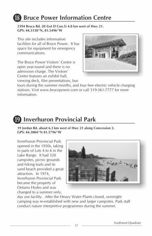
3394 Bruce Rd. 20 (Lot D Con.5) 4.8 km west of Hwy 21.GPS: 44.3138°N, 81.5496°W
This site includes information facilities for all of Bruce Power. It has space for equipment for emergency communications.
The Bruce Power Visitors' Centre is open year-round and there is no admission charge. The Visitors' Centre features an exhibit hall, viewing deck, film presentations, bus tours during the summer months, and four free electric vehicle charging stations. Visit www.brucepower.com or call 519-361-7777 for more information.
Bruce Power Information Centre
19 Jordan Rd. about 6.3 km west of Hwy 21 along Concession 2.GPS: 44.3004°N 81.5796°W
Inverhuron Provincial Park opened in the 1950s, taking in parts of Lots 4 to 6 in the Lake Range. It had 320 campsites, picnic grounds and hiking trails and its sand beach provided a great attraction. In 1974, Inverhuron Provincial Park became the property of Ontario Hydro and was changed to a summer only, day use facility. After the Heavy Water Plants closed, overnight camping was re-established with new and larger campsites. Park staff conduct nature interpretive programmes during the summer.
Inverhuron Provincial Park

This cemetery is situated within Inverhuron Park, 19 Jordan Rd. about 6.3 km west of Hwy 21 along Concession 2. Follow the signage to get to the park. The sign for the cemetery is 550 m from the park entrance. If you get to the park gate house, you have gone too far.GPS: 44.2982°N, 81.5845°W
The earliest burials are recorded in the 1850s. The grounds were fenced in the 1950s as few markers remained. This cemetery became part of the Provincial Park in 1956.
Inverhuron Cemetery
Across the road from 3215 Bruce Rd. 15, .4 km west of Tiverton.GPS: 44.2870°N, 81.5912°W
John McIntyre bequeathed to his heirs two cottages with a large open area in the front used for many years as a playground. He wished the area to be always available to the children. This land was also used for a Sunday evening church service during the summer. The McIntyre heirs donated the park land to the Township.
McIntyre Park
18Southwest Quadrant

Leave your car at McIntyre Park and walk west to the Lake Huron shore where you will come onto the sand beach.GPS: 44.2872°N 81.5919°W
This beach was always popular with the people of the area, who picnicked and tented here. In 1908 a Gilchrist family from Tiverton built a small cottage on the lake front. This started a trend that led to a row of summer cottages along the shore. Our beautiful, sandy beach still draws many people to enjoy all its wonderful qualities, whether picnicking, fishing, tenting, swimming or just having “fun in the sun.”
The Inverhuron Beach
From McIntyre Park, drive east to Victoria St., north to John St. The former pavilion is a few metres northeast of that corner at GPS: 44.2884°N 81.5883°W
Built in 1930, the Inverhuron Pavilion was originally called the Casa Nova Gardens, and it was a “very hopping place” to go in its day. In the later years, dances were held Friday nights accompanied by Roy MacKenzie's orchestra. In the 1960s the pavilion was converted to apartments.
Inverhuron Pavilion
19Southwest Quadrant

Take county road 15 west of Tiverton for 5 kilometres to Lake Street south. Go about half a kilometre and watch for signage on the East (left) side of the street.GPS: 44.2830°N, 81.5954°W
This old kiln in the garden was operated for over half a century and was in use until 1929 and closed in 1930. The limestone was gathered from the beach and the kiln was originally fired by driftwood. The limestone was burned for three days and nights, under constant watch, and then cooled to form lime which was sold by the bushel and used in many of the nearby foundations. In 1931, Mrs. Ida Perry and Miss Helen Oliver started the Lime Kiln Lodge by opening a small grocery store and tea room. Over the years the business was expanded providing the base for the beginning of the tourism industry in Inverhuron.Many families spent their vacation at the Lime Kiln Resort. Meals were provided in the dining room and cabins provided accommodation. Eventually, the cabins were converted to rental cottages.
Lime Kilns
20Southwest Quadrant

1409 Con.2 (Lot 1 Con.2) 2 km north of Tiverton at SE corner. GPS: 44.2836°N, 81.5307°W
This plaque was erected in 1989 to remember the first inland settlement in the Township of Bruce, the man it was named after as well as businesses and other buildings erected there. The Potashery was located at the old Presbyterian Church near the dip in the road on the way to Tiverton. There was little market for lumber in the earliest days so the trees were burnt. The ash was collected from the burns and sold for 2 cents a bushel. The Presbyterian Church building was bought when the church moved to Tiverton and used for the manufacture of pearl ash for making china.
Sinclairs Corners
121 Sideroad J/1(Lot J Con.3) 2.2 km north of Tiverton about 250 meters North of Con. 2. GPS: 44.2850°N, 81.5297°W
The first school was built in 1876. It was a red frame structure. Daniel Stonehouse cleaned the school and lit the fires for 3 cents a day. In 1904 it was moved to the present location and placed on a concrete foundation and was bricked over in1912.
School Section No. 11 at Sinclairs Corners
21Southwest Quadrant

3145 Hwy 21, 3 km North of Tiverton on Hwy 21.GPS 44.2678°N, 81.5145°W
This local telephone system started in Underwood at the Henry Dent house near 3636 Hwy 21. GPS 44.3059°N, 81.4845°W
Only three months after an initial meeting the decision to proceed with establishing a municipal telephone system was made on May 17, 1910. In Underwood the first telephones were in the Presbyterian Manse and two in Richardson's hardware Store. One for business and one for community messages. The exchange was put in Richardson's in December 1911; when the store burned, the switchboard was moved to Brown and McCall's general store. This location did not suit and was moved to the George Hood home. In 1916 it was moved to the Old Post Office and managed by Henry Dent for 31 years.
From 1947 the exchange was located in the McArthur house, 3638 Hwy 21, directly north and beside the Dent building. Mae McArthur became the manager and operator. The exchange remained there until 1965 when it was moved to Tiverton. In 1983, the system connected 13,469 telephones in surrounding townships and in Kincardine, Paisley and Port-Elgin.In 1993 the Bruce Municipal Telephone System opened its new administration centre at Lot 5 Con. 1 Bruce Township. The property had been acquired in the 1970s as the commissioners planned for expansion and updating. All managers and employees are now in one centralized work location, bringing clerical and technical functions under the same roof with the new name “Bruce Telecom.”
Bruce Telecom
22Southwest Quadrant

F
EAbout 400 m east of 1718 Con. 2 (Lot D Con. 2). GPS: 44.2948°N, 81.5593°W
Take Bruce Township Concession 2 west from Highway 21 for about 5 kilometres to GPS location. If you look south into the field you will see one lone power pole at the general location of Boss Gray's Castle.
“Lakeview”, the home of the William Gray family, was typical of the homes successful Victorian gentlemen built in the prosperous eighteen-sixties and seventies. Known locally as “Gray's Castle” it was far grander than any home in the area. Its construction began about 1871 and lasted three years. It was built with local limestone and the walls were eighteen inches thick. There were many fireplaces, oak floors, a mahogany staircase and imported marble in many areas of the home. It was destroyed by fire January 25, 1960.
Boss Gray’s Castle
Just north of the end of Victoria St., Inverhuron.GPS: 44.2902°N, -81.5873°W
Take Bruce Rd 15 West from Tiverton to Victoria Street in Inverhuron and turn right or north, past the Inverhuron Pavilion, where Victoria Street turns left and becomes Cayley Street. Take the dirt trail on the corner and walk about 30 metres north. This is the corner of the school yard. Look for the concrete pillar and some of the bricks from the wall or foundation of the school.
A log school was built in1862 on Victoria Street, then replaced by a brick school built in 1875 just a few feet north. The school closed in 1953. A motion is on the record that the school be opened for a social or anything else approved by the ladies. There is no record of this being done. The building was torn down after 1964.
School Section No. 1
23Southwest Quadrant

Q
R
F
E
G II-1
J
KL
M
N
0
P
CLUNY
GRESHAMLOVAT
WILLOW CREEK
ESKDALE
TIVERTONINVERHURON
GLAMMIS
UNDERWOOD
NORTH BRUCE
QUEEN HILLCONC. 14
CONC. 12/13
CONC. 10/11
CONC. 8/9
CONC. 6/7
CONC. 4/5
CONC. 2/3
CONC. 1
Bruce Township’s Places of Interest
DRIVING TOUR

24Southeast Quadrant
Southeast Quadrant Map
G II-1
J
KL
M
N
GRESHAMLOVAT
WILLOW CREEK
ESKDALE
GLAMMIS
CONC. 8/9
CONC. 6/7
CONC. 4/5
CONC. 2/3
CONC. 1

1403 Bruce Road 15 at the west end of Glammis.GPS: 44.2073°N, 81.3930°W
In 1858 a log church was built on Lot 35 Con.12 in Kincardine Township in the village of Glamis, as it was then spelled. It was known as the Greenock Church. In 1896 the present church was built. In 2008 St. Paul's
thcelebrated its 150 anniversary. The plaque was placed on the church property by Kincardine Township Historical Society.
Glammis Presbyterian Church & Plaque
25Southeast Quadrant
Southeast Quadrant
1372 Bruce Road 15 in Glammis (Lot 35 Con.1), GPS: 44.2059°N, 81.3892°W
Part of Lot 35 Concession 12 of Kincardine Township was the location of the original chapel. The plaque was placed there by the Kincardine Township Historical Society. By 1884 the membership increased and a building 40 ft x 80 ft erected on the north side of the road. Renovations have enlarged the vestry, divided classroom space, and added a kitchen and bathroom.
Glammis Baptist Church & Plaque

Intersection of Bruce Road 1 and Bruce Road 15 in Glammis. GPS: 44.2056°N, 81.3884°W
Glammis is a hamlet located on the boundaries of the former townships of Kincardine, Bruce, and Greenock. This plaque was erected in 1998 by the Township of Greenock in memory of early settlers.
Township of Greenock Plaque in Glammis
26Southeast Quadrant
3047 Bruce Road 1. 300 ft. north of Glammis. GPS: 44.2070°N, 81.3873ºW
The school was built in 1899 by R.Y. McFadyen. The first teacher was John Rowan. The attendance of 52 included three sets of twins. In 1938, when SS #4 was closed, the pupils were transported to SS #16. In 1939 the students went to Stratford to see King George VI and Queen Elizabeth. The last trustee meeting was held in December 1964. The students were then bussed to Bruce Township Central Public School in Underwood.
Union School Section No. 16, Glammis School

27Southeast Quadrant
Lot 35 Conn. 2 on Bruce County Road 1about 2 km north of Glammis.GPS: 44.2201°N, 81.3773°W
This bottomless lake is very muddy, thus it got its name “The Mud Lake”. It is sometimes also referred to as “Christopher's Lake” for the landowner in early years, Christopher McCrae.An elderly lady in Glammis always said if the Baptist Church were put in it, it would soon disappear. The Bruce County road crew found out how deep it was when they tried to straighten the road to go through the lake in the 1990s. They put in many loads of gravel before they gave up. Thus the curve remains in the road.
Bottomless Bog aka Mud Lake or Christopher’s Lake

Between Con.2 and Bruce Rd 20, east of Sideroad 30 (Lot 32 Con.3).There are two vantage points: From the ridge on sideroad 30 at GPS: 44.2379°N, 81.3929°W (not in winter) or from Con.2 at GPS: 44.2272°N, 81.3897°W
Glammis Bog is a stretch of trees and swampy land. It is considered to be possibly the most significant acid bog in Owen Sound MNR District. Ten locally significant species occur in this area: bog clubmoss (Lycopodium inundatum), a sedge (Scirpus hudsonianus), stemless lady's slipper (Cypripedium acaule), white-fringed orchid (Habenaria blephariglottis), bog willow (Salix pedicellaris), spatulate-leaved sundew (Drosera intermediz), mountain holly (Nemopanthus mucronata), bog rosemary (Andromeda glaucophylla), pale bog laurel (Kalmia polifolia), and velvet-leaf blueberry (Vaccinium mytrilloides). South of the bog, birds include Pied-billed Grebe, bitterns, and herons. Bordering the bog are stands of red maple and white cedar.
It is not good to venture too far onto this property as it is quite marshy in places. Some deer hunters are brave enough to venture into it in hunting season.
Glammis Bog
28Southeast Quadrant

1339 Sideroad 20 (Lot 20 Con.2) 1.7 km north of Bruce Road 15 on Sideroad 20, 6 km east of Hwy 21.GPS: 44.2454°N, 81.4441°W
One of the largest barns in Bruce County, was built by Joe Wrightson for Bill Gilchrist, Sr. in 1904. It measures 60 feet wide and 120 feet long. Many of the beams are 60 feet long and one foot square. Malcolm Brown bought the farm in 1920. His grandson, Howard Brown, started a herd of Holsteins in 1953, built a milk house, and later added modern milking equipment. Malcolm's great-grandson, Jim Brown, and his wife, Laurie, bought the farm in 1982 and continued to farm extensively after making many improvements to this barn
Large Barn Sideroad 20
29Southeast Quadrant
808 Con.2 (Lot 15 Con.3) 4 km east of Hwy 21.GPS: 44.2569°N, 81.4642°W
In 1874 the Crown Deed for an acre of land on Lot 15, Con. 3 was obtained and a frame school erected. In 1906 a brick school was built on the same property by John Haug, mason, and Mr. Bolander, carpenter. Proceeds of a play in 1924-25 bought an organ and a Victrola (early record player). When low enrolment caused its closure in 1950, students were transferred to SS No. 3, then in 1965 to Bruce Township Central Public School in Underwood. The building is still standing but remains vacant.
School Section No. 5

30Southeast Quadrant
2228 Bruce Road 20 (Lot 22 Con.5), 5.2 km west of Bruce Rd. 1. GPS: 44.2608°N, 81.4210°W
Built in 1902, it was framed by the master framer Joe Wrightson, Jr., replacing an older church which closed its doors in 1889. Five years later, in 1907, it was named Willow Creek United Brethren Church. The name “Shiloh” was adopted in 1923.In 1931 the church was removed from the rolls, but reopened in 1934. Renovations, including raising the building to add a basement, were carried out in 1948 and 1968. It is still active, now known as the Shiloh Community Church.
Shiloh United Brethren Church
Sideroad 10 half way between Con. 2 and Con.4. GPS: 44.2733°N, 81.4803°W
This switchyard connects the Ripley Wind Power Project to the 230 kilovolt power lines running from the Bruce Nuclear site to major centres of Ontario. The Ripley project consists of 38 wind turbines, each with a rated capacity of 2,000 kilowatts. The project was fully operational in 2007 and it is estimated the wind farm will generate over 216,000 megawatt-hours per year.Also see the Underwood Project description for the Bruce Township wind turbines #42.
Wind Turbines and Ripley Switchyard

31Southeast Quadrant
2228 Bruce Road 20 (Lot 23 Con.5), 5.2 km west of Bruce Rd. 1. GPS: 44.2608°N, 81.4210°W
In the 1860's the area was known as Willow Creek, giving its name to this cemetery. Several burials took place in the Wrightson family plot in those years. Since the cemetery is beside Shiloh United Brethren Church it continued to be used by families of that congregation. There have been few burials in recent years. In 1979 it was conveyed to the Township of Bruce for its care and maintenance.
Willow Creek Cemetery
1895 Bruce Road 20 (Lot 31 Con.4) 2 km west of Bruce Rd. 1.GPS: 44.2461°N, 81.3846°W
RKM Wood Products, built in 1973, was owned and operated by three brothers, Ron, Keith, and Mervin Hodgins, thus the name. The workforce began with twelve people and soon expanded to fifty. The raw material, purchased from private landowners, provided lumber for industrial purposes. In later years they made wood flooring, in another building. Unfortunately the main operations and equipment burned and was never rebuilt.
RKM Wood Products Ltd.

2176 Bruce Road 15 (Lot 15 Con.1), 4 km east of Hwy 21. GPS: 44.2409°N, 81.4773°W
Eskdale School was located on the southeast corner of Lot 11, Con.1 in 1854. In 1873 it was replaced by a frame building on Lot 15, Con.1. It was later bricked and in 1900 a stone foundation was put under it. In 1907 the blackboards were installed. In 1934 music teachers visited the schools: Charles Fotheringham followed by Mary MacArthur, then Everett Lane. After January 8, 1965, pupils were bussed to Bruce Township Central Public School in Underwood. The building was sold to Neil and Jean MacLeod. It remains a residence, and kept up-to-date by owners.
Union School Section No. 3 (Eskdale)
32Southeast Quadrant
G
Eskdale was a Boundary line Post Office and provided mail to both Kincardine and Bruce Township.Eskdale Post Office opened July 1, 1875 in the home of H.P. Chapman at the first location above. It then moved to Lot 20, Con.12 Kincardine Twp., then Lot 21, Con.1 Bruce Twp.; in 1889 to Lot 12, Con.12 Kincardine Twp. The location of the Post Office moved to various homes according to politics. From June 1897 it was located at Lot 19, Con.1, then in 1908 to Lot 21, Con.1. The Post Office closed in 1913. Mail then was delivered from Tiverton Post Office to the Boundary, as part of RR # 1, Tiverton.
Former Eskdale Post OfficesHHH - 2114 Bruce Road 15 (Lot 17 Con.1), 5.2 km east of Hwy 21.
GPS: 44.2381°N, 81.4706°W

Road closed in winter. Both plaques are on Sideroad 30, 2 km west of Glammis, just north of Bruce Rd. 15. The Township of Bruce Historical Society placed both plaques to commemorate its history.East side of Sideroad 30, about 300 m north of Bruce Rd. 15. GPS: 44.2179°N, 81.4070°W
2- West side of the same sideroad about 600 m farther north. GPS: 44.2226°N, 81.4037°W
The first log school, built in the early 1850's had 48 students in 1891. It burned down and another one was built across the road a little farther north where the second plaque is located.Jack Rowan was the first teacher at the new school. Before the Glammis school was built, this school drew students from both Kincardine and Bruce townships from the Greenock
thboundary to the 25 sideroad. Attendance declined in 1938 and the school was closed. The building was sold to Frank Zister of Chepstow for $25.00. It was removed and the land returned to farm use.
Union School Section No. 4
33Southeast Quadrant
II
I-1
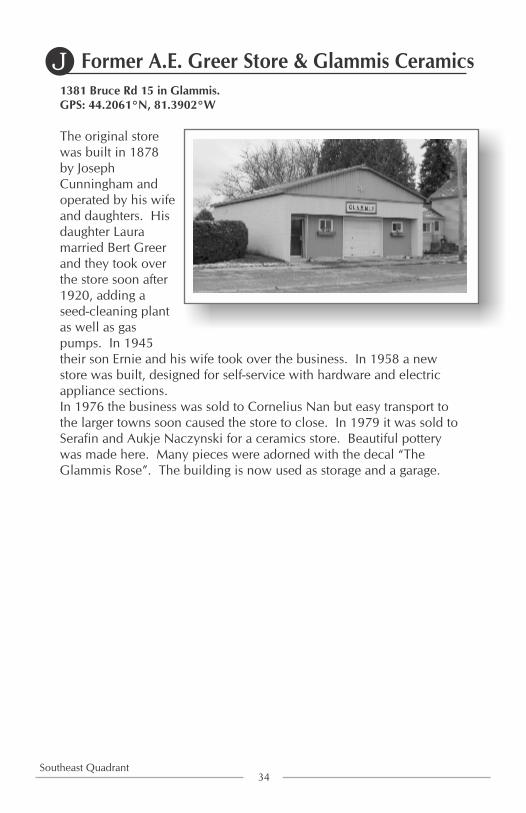
1381 Bruce Rd 15 in Glammis.GPS: 44.2061°N, 81.3902°W
The original store was built in 1878 by Joseph Cunningham and operated by his wife and daughters. His daughter Laura married Bert Greer and they took over the store soon after 1920, adding a seed-cleaning plant as well as gas pumps. In 1945 their son Ernie and his wife took over the business. In 1958 a new store was built, designed for self-service with hardware and electric appliance sections.In 1976 the business was sold to Cornelius Nan but easy transport to the larger towns soon caused the store to close. In 1979 it was sold to Serafin and Aukje Naczynski for a ceramics store. Beautiful pottery was made here. Many pieces were adorned with the decal “The Glammis Rose”. The building is now used as storage and a garage.
Former A.E. Greer Store & Glammis Ceramics
34Southeast Quadrant
J

35Southeast Quadrant
Just west of 1374 Bruce Road 15 in Glammis. GPS: 44.2062°N, 81.3898°W
Hutton Transport was established in Glammis in 1945 by Lloyd Hutton and his wife, Margaret Jean. At that time it employed sixteen persons and served the areas of Mildmay, Tara, Chesley, Port Elgin, Southampton, Kincardine, and Lucknow. Its main business was hauling livestock, feed, and fertilizer. It had a license to haul calves from western provinces to Ontario. In 1957, it hauled 200 hives of bees from Camrose, Alberta. It expanded to Lloyd Hutton Transport Ltd. and moved to Paisley in 1984. Lloyd Hutton died in June 1987. His grandson Greg now operates the business in Paisley.
Former Hutton TransportK
Hutton Transport in Glammis about 1977

1352 Bruce Road 15 in Glammis.GPS: 44.2050°N, 81.3871°W
The Methodist Church opened its doors in 1889 as part of the Eden Grove circuit together with Cargill and Purdy. Richard H. Harrison was on the building committee. Early members included Attons, Cunninghams, Kennedys, Kirktowns, and Pattersons. In 1925 the congregation voted to join the United Church and continued until the church closed in 1948. Alex MacLennan bought the building and converted it to a garage in 1949. It was later run as a Texaco gas station and later again as “Joe's Garage”. Owned by James Alexander since 1988, it is used to service trucks.
Former Glammis Methodist (United) Church
36Southeast Quadrant
L
Lot 31, Con.2 about 1.8 km west of Bruce Rd 1.GPS: 44.2298°N, 81.3962°WCo-ordinates taken at start of driveway.
The cemetery got its name from the owners of the farm. A deadly plague hit the family in the early years when no medical treatment was known. Many family members died and were buried on their own land. A large stone marks the plots. Visitors are permitted to walk to the tombstone along the path.
MacLean CemeteryM

Lot 16 Con.5 just east of Sideroad 15 on Bruce Rd. 20, 4 km east of Hwy 21.GPS: 44.2727°N, 81.4507°W
This church was built in 1873,. It was 26 feet by 40 feet on a stone foundation. From 1886 until 1930 immigrants, mainly from Germany, arrived to increase the settlement and congregation. In 1968 the Evangelical United Brethren Church joined the United Church of Canada. Most families then joined Shiloh Community Church farther east on the same road. The Evangelical United Brethren building was then dismantled.
In 1996, this plaque was placed by the Township of Bruce Historical Society to honour the location of that church.
Evangelical United Brethren Church
37Southeast Quadrant
N

38Northeast Quadrant
Northeast Quadrant Map
Q
R
0
P
CLUNY
GRESHAMLOVAT
WILLOW CREEK
UNDERWOOD
QUEEN HILLCONC. 14
CONC. 12/13
CONC. 10/11
CONC. 8/9
CONC. 6/7
CONC. 4/5

205 Con. 6 (Lot 31Con. 6) 10 km east of Hwy 21. GPS: 44.2622°N ,81.3718°W
The first school, made of logs, was built on the land of the first early settler in the area. Later, in 1875, a red brick school was built. In 1915, a replacement school was erected a little east of the original site. In 1965, Bruce Central Public School opened in Underwood and this building was sold for use as a private residence.
School Section No. 10
Northeast Quadrant
615 Con. 6 (Lot 21 Con. 6) about 6 km east of Hwy 21. GPS: 44.2806°N, 81.4167°W
A log school, built before 1860, was replaced by a frame building in 1861. In 1893, a new school was erected on the same site. In 1965, Bruce Central Public School opened in Underwood and this building was sold for use as a private residence.
School Section No. 9
39Northeast Quadrant

1098 Con. 6 (Lot 9 Con. 7), about 2 km east of Underwood.GPS: 44.3008°N ,81.4692°W
Wind turbines and a transformer station, erected in 2008, came online March 2009. Owned by Enbridge Wind Farms, the operation consists of 110 Vesta V82 wind turbines in Bruce Township. Each turbine has a capacity of 1,650 kilowatts. The substation completes the connection to Hydro One circuits that feed Ontario. These turbines generate enough power for approximately 60,000 homes. The large number of blinking red lights at night have named the Underwood area the “red light district”.
Wind Turbines and Transformer Station
40Northeast Quadrant
Across the road from 38 Con. 8 (Lot 35 Con. 8) about 300 m west of Lovat. GPS: 44.2708°N ,81.3411°W
The plans for this cemetery were first laid out in October 1859. The earliest stone is dated June 11, 1854. It has been in continuous use since 1859. The memorial gates were erected in 1944.
Lovat Cemetery

38 Con. 8 (Lot 35 Con. 9) about 300 m west of Lovat.GPS: 44.2706°N ,81.3402°W
The log house was built approximately 1914. In 1970, the house was severed from the farm land. An addition expanded the house in 1992. In 1993, the Dalmans opened Lovat Bed and Breakfast in conjunction with the International Plowing Match in Walkerton. In the summer, people come here for a quiet stay or to visit the area beaches. In the winter, snowmobilers enjoy using the Grey-Bruce Snowmobile Trails.
Original Log Home and Lovat Bed & Breakfast
41Northeast Quadrant
Plaque is in Lovat, 32 metres from County Rd 1. GPS: 44.2675°N ,81.3350°W
Robert Mawhinney, a brickmaker, acquired seventeen acres of land at the settlement of Lovat in 1889. Here, he erected buildings and a tile kiln and manufactured brick and tile. These buildings burned in 1920 but were rebuilt in 1921. Only a plaque remains at this site.
Lovat Brick & Tile Yard

173 Con. 10 (Lot 32 Con. 10) GPS: 44.2917°N ,81.3407°WA similar home by Alex Thornburn is on Lot 31 Con. 11, about 0.4 km east of this one.
Built in 1903 by Alex Thornburn, this home was originally frame construction veneered with cement blocks made on the premises in 1908. The back kitchen and a verandah were added later. Owned and occupied in 2015 by great-grandson John Thornburn and his wife, Lisa who have significantly renovated the home.
Octagonal House
42Northeast Quadrant
201 Bruce-Greenock Boundary South (Lot 35 Con. 10) about 2 km north of Lovat.GPS: 44.2841°N, 81.3247°W
Log home initially erected 1860 and added to in 1995. This is one of the few log homes still in use in the township.
Log Home at Lot 35 Conc. 10
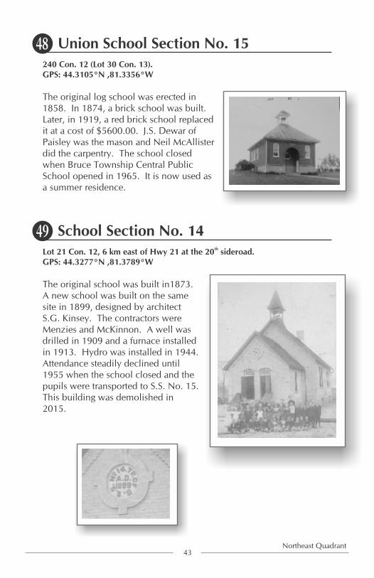
240 Con. 12 (Lot 30 Con. 13). GPS: 44.3105°N ,81.3356°W
The original log school was erected in 1858. In 1874, a brick school was built. Later, in 1919, a red brick school replaced it at a cost of $5600.00. J.S. Dewar of Paisley was the mason and Neil McAllister did the carpentry. The school closed when Bruce Township Central Public School opened in 1965. It is now used as a summer residence.
Union School Section No. 15
43Northeast Quadrant
thLot 21 Con. 12, 6 km east of Hwy 21 at the 20 sideroad. GPS: 44.3277°N ,81.3789°W
The original school was built in1873. A new school was built on the same site in 1899, designed by architect S.G. Kinsey. The contractors were Menzies and McKinnon. A well was drilled in 1909 and a furnace installed in 1913. Hydro was installed in 1944. Attendance steadily declined until 1955 when the school closed and the pupils were transported to S.S. No. 15. This building was demolished in 2015.
School Section No. 14

Just east of 867 Con. 12 (Lot 15 Con. 12) 4 km east of Hwy 21. GPS: 44.3372°N ,81.4025°W
Between the years of 1880 and 1912 a settlement at these crossroads was known as Cluny. At Lot 16 Con. 13 on the SW corner of the farm, a blacksmith shop was established in 1880. Across the sideroad, on the NW corner of Lot 16 Con.12 a general store operated for a number of years. In the home at Lot 15 Con. 12 the post office operated from 1907 to 1915. On Lot 15 Con.13 Cluny Ridge Farms was established.
Cluny Plaque
44Northeast Quadrant
1046 Con. 12 (Lot 11 Con. 13) 5 km east of Hwy 21. GPS: 44.3453°N ,81.4231°W
The original log school, built in 1862, was bricked over in 1916. In March of 1940, fire gutted the schoolhouse and it was replaced on the north side of the road at Lot 11, Con. 13, by a brick building. In 1968, the property was sold and is now The Brucedale Community Centre. It is currently used for 4H meetings, card parties and family reunions.
School Section No. 13

1179 Bruce-Saugeen Town Line (Con. 14 Lot 15), about 5 km east of North Bruce.GPS: 44.3539°N, 81.3908°W
Part lot 15, Con. 14 was donated in 1855 by Duncan McKinnon as a site for a church and a manse. The church was built of logs in that year, then it was replaced by a frame structure in 1866. On October 18, 1959, the building was destroyed by fire.Erected between 1870 and 1875, the manse has been renovated and is currently being lived in.
North Bruce Presbyterian Church & Queen Hill Manse
45Northeast Quadrant
Con. 14 Lot 18, 5.7 km east of North Bruce, just east of1093 Bruce-Saugeen Town Line. GPS: 44.3482°N, 81.3769°W
Queen Hill was a small community along the Bruce-Saugeen Townline. Important buildings included North Bruce Presbyterian Church and its associated manse, both about half a km west of this spot at fire number 1179. In Queen Hill's one-acre cemetery, the earliest marker is dated Feb 1, 1855. The Township of Bruce assumed ownership and care in 1959. The site is still occasionally used for burials.
Queen Hill Cemetery

Bruce Greenock Townline west of Paisley. GPS: 44.3061°N, 81.3039W
Bruce County Rail Trail is approximately 80 km long and follows the former Grand Trunk Railway line. It runs from Port Elgin to the Bruce-Huron line and also south from Port Elgin to near Kincardine. Where the trail crosses the boundary road between Bruce and Greenock townships, it is signed and gated, but allows non-automotive traffic. Toward the southeast, it leads to Paisley where it crosses two rivers on high trestle bridges. Toward the northwest, it travels through Bruce and then Saugeen Township on its way to Port Elgin. It can be used by hikers, bikers, skiers, snowshoers, and ATV's (for the Bruce Twp. section).
Bruce County Rail Trail
46Northeast Quadrant

Lot 21 Con. 8, 6 km east of Hwy 21.GPS: 44.2958°N ,81.4047°W
In 1862, services were held in the area farmhouses. In 1870, a log church was erected at Lot 20, Con.8. Later, in 1875, a brick building was built at Lot 21. The church closed May 23, 1965 and the building was later dismantled. Only a plaque remains at the site.
Centre Bruce Church in Gresham0
47
Post office at Lot 23 Con. 9, 6.5 km east of Hwy 21. GPS: 44.2908°N ,81.3911°W
The Gresham Post Office first opened in 1867, at Lot 23, Con.9. It was later moved to Lot 24, Con. 9, then to Lot 23, Con. 8. Finally, it was moved to Lot 22 Con. 8. until rural mail delivery from Paisley began in 1913. Currently, this site is a grass farm.
GreshamP
Northeast Quadrant

2199 Sideroad 15, Con. 10, Lot 15GPS: 44.3203°N ,81.4150°W
The building was constructed in 1877 but was closed and dismantled in 1966 due to the decline of membership.
North Bruce Baptist ChurchQ
48
Lot 24 Con. 14, just west of 779 Bruce-Saugeen Townline. GPS: 44.3369°N ,81.3494°W
Lots 24 and 25 were owned by the Buie family in the early years and a family burial plot was located here. Very little information is available, although it is believed that about thirteen people were buried in this spot. Only two markers remain, showing Buie (died in 1874) and Smith names. Four children of the Smith family were buried in October, 1875.
Smith Farm CemeteryR
Northeast Quadrant

Ÿ At one time the Township of Bruce consisted of a number of hamlets
and villages such as, Cluny, Gresham, Sinclair Corners, Baie du Dore,
Port Bruce, Malta, Inverhuron, Lovat, Eskdale, Queen Hill, Glammis,
North Bruce, Tiverton, Underwood, and Willow Creek.
Ÿ “The Glamis Maple Leaf” was a Glamis newspaper published June 11,
1900 by Frank Howard Leslie. Only one edition was published. One
of the articles offered an explanation of “Glamis” vs. “Glammis”
Ÿ Glammis has been given a controversial designation of “a ghost town.”
Ÿ The first Bruce County Ploughing match was held in Glammis in 1886.
Ÿ After the decision was made in June 1959 by Gordon Churchill,
Minister of Trade and Commerce to proceed with the building of a
power plant at Douglas Point, Atomic Energy of Canada and Ontario
Hydro acquired land in the Douglas Point area to begin the project.
Ÿ The first electricity from Douglas Point started feeding the Ontario
Hydro Grid on January 7, 1967 and was officially commissioned
September 26, 1968.
Ÿ Douglas Point was the first full scale nuclear power plant and second
CANDU pressurized heavy water reactor. Its success was a major
milestone marking Canada's entry into the global nuclear power
scene.
Ÿ The original reactor was shut down in 1984. The present reactors each
produce approximately four times the capacity of the original reactor.
Ÿ Today Bruce Power's facility can generate enough electricity to supply
30% of Ontario needs.
Did you know that?
49

Ÿ Inverhuron Provincial Park is owned by Ontario Power Generation
and leased to the Ontario Ministry of Natural Resources. The former
park campground was phased out in 1976 because of safety concerns
related to the manufacturing of heavy water. Since heavy water is no
longer produced, the park campground was allowed to re-open.
Ÿ Bruce Telecom (formerly Bruce Municipal Telephone System)
beginnings started from a meeting called February 19, 1910 to address
the need of telephones. The Bruce Municipal Telephone System
service began December 1911.
Ÿ The first telephone directory in 1912 was 3” x 6”, included 199 names
from Tiverton and Underwood. Telephone Central was located in
Underwood and their hours were listed in the directory as 7am -10 pm
Week days, 9:30 am – 11:00 am and 2:00 pm – 3:00 pm on Sundays.
Ÿ The motel between Conc. 10 and 12 on Highway 21 (Lot 6, Conc. 10),
originally called the Town and Country Motel was built in 1952 on the
property of the Underwood Cheese and Butter Factory.
Ÿ In 1935 Highway 21 was assumed from the County of Bruce and
designated a King's Highway.
Ÿ Underwood's School Fair originated ca. 1914-1915 and ran until
1947.
Ÿ Inverhuron was at the height of prosperity as a major shipping centre in
the 1870's but April 13, 1882 the pier and warehouses were destroyed
by fire. Relocation and closed businesses resulted and after the second
fire in 1887 which destroyed the remaining buildings the area was
financially and physically finished.
Ÿ Tourism started in the Inverhuron area with the growing use of
automobiles. A few cottages started to be built by locals and after the
lime kiln closed in the late 1920's the Lime Kiln Lodge was established
as a popular place to spend a vacation.
50

Ÿ Ontario's first commercial windfarm consisting of five windmills was
established in the township of Bruce.
Ÿ In the 1980's Amish families from the Milverton area began purchasing
farms and establishing their businesses adding a new uniqueness to the
area.
Ÿ Memorable Winter Storms February 1937 – long time before able to
move around, Winter 1947 – record breaker as more snow “dumped”
on Bruce Township than ever before.
Ÿ Tornadoes - Good Friday March 21, 1913 - S.S. # 7, Underwood Area.
March 19, 1921 - barn roofs mainly 2nd and 4th concession of Bruce,
automobile roof lifted off as being driven along 6th concession.
October 8, 1977 - the Todd Farm and Campbell Farm on 2nd Conc.
and along 21 Underwood to North Bruce.
Ÿ Heavy rain caused a sudden flood at the Underwood intersection on
May 17, 1960. The only casualty was a bull.
51

Please visit the beautiful free standing display on the History of the Village of Tiverton
at the "Walk of Memories".
Parking and access located at theTiverton Library on King Street.
52

We hope you have enjoyed this tour of Bruce Township.
If you have any personal anecdotes or photos that addto the value of this tour, please contact:
Jennifer LawrieDeputy Clerk of the Municipality of Kincardine
519-396-3468
