phase 1 environmental site assessment for the state
TRANSCRIPT
PHASE 1 ENVIRONMENTAL SITE ASSESSMENT
FOR THE STATE ROUTE 94 / MAXFIELD ROAD INTERSECTION
STATE ROUTE 94 IMPROVEMENT PROJECT
June 5, 2014
Prepared for:
California Department of Transportation District 11
4050 Taylor Street San Diego, CA 92110
Prepared by:
G. O. Graening, PhD, MSE (Registered Environmental Assessor 1, License #08060)
Natural Investigations Company
6124 Shadow Lane, Citrus Heights, CA 95621 (916) 452-5442
SR-94 / MAXFIELD ROAD INTERSECTION PHASE 1 ESA
Natural Investigations Co. Page 2
TABLE OF CONTENTS SUMMARY ....................................................................................................................................................................... 3 1. INTRODUCTION ..................................................................................................................................................... 4
1.1. PURPOSE ......................................................................................................................................................................... 4 1.2. DETAILED SCOPE OF SERVICES ................................................................................................................................... 5 1.3. SIGNIFICANT ASSUMPTIONS, LIMITATIONS, AND EXCEPTIONS ............................................................................... 5 1.4. SPECIAL TERMS AND CONDITIONS .............................................................................................................................. 7 1.5. INFORMATION RELIANCE ............................................................................................................................................... 7
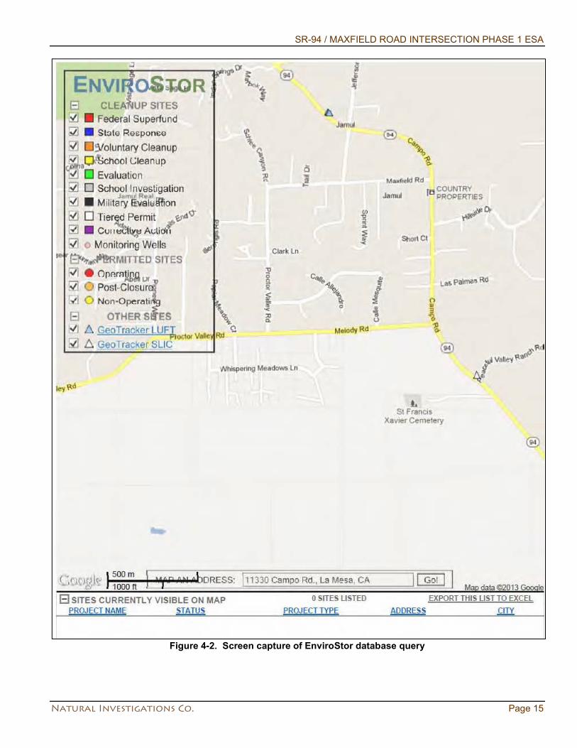
2. SITE DESCRIPTION ............................................................................................................................................... 7 2.1. LOCATION AND LEGAL DESCRIPTION .......................................................................................................................... 7 2.2. SITE AND VICINITY GENERAL CHARACTERISTICS ..................................................................................................... 9 2.3. CURRENT USE OF THE PROPERTY AND IMPROVEMENTS ........................................................................................ 9 2.4. CURRENT USES OF ADJOINING PROPERTIES ............................................................................................................ 9
3. USER-PROVIDED INFORMATION ......................................................................................................................... 9 3.1. USER’S RESPONSIBILITIES ............................................................................................................................................ 9 3.2. REQUESTED DOCUMENTS AND INFORMATION ........................................................................................................ 10 3.3. TITLE RECORDS ............................................................................................................................................................ 10 3.4. ENVIRONMENTAL LIENS OR ACTIVITY AND USE LIMITATIONS ............................................................................... 11 3.5. SPECIALIZED KNOWLEDGE OR ACTUAL KNOWLEDGE............................................................................................ 11 3.6. VALUATION REDUCTION FOR ENVIRONMENTAL ISSUES ........................................................................................ 11 3.7. OWNER, PROPERTY MANAGER, AND OCCUPANT INFORMATION .......................................................................... 11 3.8. REASON FOR PERFORMING PHASE I ESA ................................................................................................................. 11
4. RECORDS REVIEW .............................................................................................................................................. 11 4.1. STANDARD ENVIRONMENTAL RECORD SOURCES .................................................................................................. 11 4.2. ADDITIONAL ENVIRONMENTAL RECORD SOURCES ................................................................................................ 14 4.3. PHYSICAL SETTING SOURCES .................................................................................................................................... 18 4.4. HISTORICAL USE INFORMATION ON THE PROPERTY .............................................................................................. 20 4.5. HISTORICAL USE INFORMATION ON ADJOINING PROPERTIES .............................................................................. 20
5. SITE RECONNAISSANCE .................................................................................................................................... 20 5.1. METHODOLOGY AND LIMITING CONDITIONS ............................................................................................................ 20 5.2. EXTERIOR OBSERVATIONS ......................................................................................................................................... 21 5.3. LIMITATIONS .................................................................................................................................................................. 22
6. INTERVIEWS ......................................................................................................................................................... 22 7. FINDINGS .............................................................................................................................................................. 22
7.1. RATIONALE FOR DETERMINATION OF SIGNIFICANT FINDINGS .............................................................................. 22 7.2. DE MINIMIS ENVIRONMENTAL CONDITIONS .............................................................................................................. 23 7.3. HISTORICAL RECOGNIZED ENVIRONMENTAL CONDITIONS ................................................................................... 23 7.4. KNOWN OR SUSPECT RECOGNIZED ENVIRONMENTAL CONDITIONS ................................................................... 23
8. OPINION AND RECOMMENDATION ................................................................................................................... 23 8.1. IMPACT OF ENVIRONMENTAL CONDITIONS ON PROPERTY ................................................................................... 23 8.2. ADDITIONAL INVESTIGATION ....................................................................................................................................... 23
9. CONCLUSIONS ..................................................................................................................................................... 25 9.1. DATA FAILURE OR OTHER DATA GAPS ...................................................................................................................... 25
10. DEVIATIONS ..................................................................................................................................................... 25 11. ADDITIONAL SERVICES .................................................................................................................................. 25 12. REFERENCES .................................................................................................................................................. 27 13. SIGNATURE OF ENVIRONMENTAL PROFESSIONAL .................................................................................. 28 14. QUALIFICATIONS OF ENVIRONMENTAL PROFESSIONAL ......................................................................... 28 15. APPENDICES .................................................................................................................................................... 29
SR-94 / MAXFIELD ROAD INTERSECTION PHASE 1 ESA
Natural Investigations Co. Page 3
SUMMARY This report presents the findings of a Phase I Environmental Site Assessment (ESA) for the Study Area, which is a State Route 94 / Maxfield Road intersection improvement project area in unincorporated San Diego County, California, at approximately 14047 Maxfield Rd. and 13987 Campo Rd., Jamul. Natural Investigations Company has performed this Phase I ESA in conformance with the scope and limitations of the American Society for Testing and Materials (ASTM) Practice E 1527-13 and in accordance with the prevailing standard of care for completing such assessments in California at this time. Exceptions to, or deletions from, this practice are described in Section 10 of this report. The subject Study Area consists of a traffic intersection. SR-94 is two-lane conventional highway with a two-way left turn lane. Maxfield Road is a two-lane road with a westbound right turn “sneaker” lane at this intersection. The setting is suburban, and is characterized by a variety of land uses, steep topography, and an adjacent drainage channel. Surrounding land uses consist of commercial (esp. farm & feed supply), a post office, fenced pasture, and residences (estates and smaller subdivisions). No environmental liens or value reductions were found in association with the Property. No indication of heavy industrial uses was detected from title review. The Property was not listed in any of the environmental databases queried. A review of physical setting sources and historical use information (topographic maps, aerial photography, fire insurance maps, city directories, and building permits) did not detect any indications of possible recognized environmental conditions within the Study Area. Site reconnaissance was performed on May 15, 2013; no indications of possible recognized environmental conditions were noted on the Property. On May 15, 2013, the environmental assessor met with Caltrans staff: no indications of possible recognized environmental conditions were uncovered. There were a few minor data failures with the physical setting and historical information sources. However, a combination of other data sources was available such that no significant data gap existed, and the historical research objectives were achieved. There were no data gaps that significantly affected our ability to identify recognized environmental conditions associated with the property. Except for the limitations and exceptions discussed in Section 2.4, this Phase I ESA complies with the ASTM Standard 1527-13. No additional services beyond the scope of the ASTM Standard 1527-13 were conducted as part of this assessment. No de minimis conditions were found in connection with the Property pursuant to the ASTM Practice E 1527-13. The Study Area is located in a suburban area and is developed as traffic intersection with no known industrial history and no known historical usage of hazardous materials or petroleum products. It is Natural Investigations Company’s opinion that there are no historical or current recognized environmental conditions in connection with the Study Area pursuant to the ASTM Practice E 1527-13. Records review, database searches, or interviews failed to identify any environmental conditions in connection with the Study Area. Therefore, no further site investigation is recommended by Natural Investigations Co. Although the ASTM standard practice for Phase I ESA’s considers lead paint an out-of-scope subject, California Department of Transportation (Caltrans) requested a discussion of the potential hazard of lead in construction/demolition materials for this project. Historical lead emissions from automobiles are a recognized source of contamination in soils along heavily-used roadways (i.e., aerially deposited lead or ADL). Thus, surface and near-surface soils along such roadways have the potential to contain elevated concentrations of lead. Implementation of the project may require the excavation and export of soils from the project area; soil within, and adjacent to, the Caltrans rights-of-way usually contain ADL. According to Caltrans’ requirements, prior to construction ADL levels must be determined in order to handle the soil appropriately. Caltrans has a variance with the DTSC that
SR-94 / MAXFIELD ROAD INTERSECTION PHASE 1 ESA
Natural Investigations Co. Page 4
will allow the Department to keep soil with hazardous levels of ADL within the right-of-way depending on the level of contamination that is found. Yellow traffic paint used prior to 1999 contained high concentrations of lead. Implementation of the project may require the removal of traffic stripe paint from the underlying asphalt concrete by grinding or sand blasting, which would create a paint waste stream. All traffic striping and traffic marking paints contain lead, but it is not known whether it is at hazardous levels or not. According to Caltrans’ requirements, this paint waste must be sampled and analyzed prior to disposal. Disposal of removed traffic stripe paint materials is also dependent on the method utilized to remove these materials (i.e. focused stripe removal vs. pavement grinding). According to Caltrans’ requirements, no soil shall be disturbed or exported from the State right-of-way project area before an ADL study is completed. No paint striping shall be removed before a lead compliance plan is implemented. Cal/OSHA and Caltrans require a lead compliance plan when lead is known to be present. The potential presence of elevated lead concentrations requires sampling and analytical testing of any exported soil and any traffic paint materials to determine appropriate health and safety procedures and proper management and disposal practices. A project-specific Lead Compliance Plan will be required and must be prepared by a Certified Industrial Hygienist and properly implemented by the contractor. As specified in this plan, lead-containing materials must be sampled and analyzed prior to disposal. A dust control plan and health and safety plan should also be prepared and implemented to minimize worker exposure to lead and any other hazardous materials. One common hazard should also be noted: the Study Area contains dense, dry vegetation that may fuel wildfire, and the region is located within an area of moderate to high level of fire hazard. This summary should only be read in conjunction with the full text of the report. The scope of work, significant assumptions, limitations, and exceptions should be understood prior to reading the site-specific information, findings, opinions, and conclusions. Except for any limitations and exceptions discussed in Section 2.4, this Phase I ESA complies with the ASTM Standard 1527-13. No additional services beyond the scope of the ASTM Standard 1527-13 were conducted as part of this assessment.
1. INTRODUCTION
1.1. PURPOSE The ASTM (2013) defines the purpose of the Phase I ESA as quoted:
"The purpose of this practice is to define good commercial and customary practice in the United States of America for conducting an environmental site assessment of a parcel of commercial real estate with respect to the range of contaminants within the scope of Comprehensive Environmental Response, Compensation and Liability Act (CERCLA)(42 U.S.C. §9601) and petroleum products. As such, this practice is intended to permit a user to satisfy one of the requirements to qualify for the innocent landowner, contiguous property owner, or bona fide prospective purchaser limitations on CERCLA liability (hereinafter, the ‘landowner liability protections,’ or ‘LLPs’): that is, the practice that constitutes ‘all appropriate inquiry into the previous ownership and uses of the property consistent with good commercial or customary practice' as defined at 42 USC § 9601(35)(B)." (page 1, ASTM, 2013).
In 2002, the Small Business Liability Relief and Brownfields Revitalization Act was passed, and it directed the United States Environmental Protection Agency (USEPA) to promulgate a rule defining due diligence for compliance with the Comprehensive Environmental Response, Compensation and Liability Act (CERCLA). This rule, which is generally referred to as All Appropriate Inquiry (AAI), was adopted in 2002; it states that ASTM E1527-13 complies with the USEPA requirements for AAI. In some cases the ASTM 1527-13 is more stringent than AAI.
SR-94 / MAXFIELD ROAD INTERSECTION PHASE 1 ESA
Natural Investigations Co. Page 5
1.2. DETAILED SCOPE OF SERVICES The ASTM (2013) describes the general scope of services in the following excerpts:
"A Phase I Environmental Site Assessment shall have four components: records review; site reconnaissance; interviews; and report." (page 12, ASTM, 2013). "In defining a standard of good commercial and customary practice for conducting an environmental site assessment of a parcel of a property, the goal of the processes established by this practice is to identify recognized environmental conditions. The term recognized environmental conditions means the presence or likely presence of any hazardous substances or petroleum products on a property under conditions that indicate an existing release, a past release, or a material threat of a release of any hazardous substances or petroleum products into structures on the property or into the ground, ground water, or surface water of the property. The term includes hazardous substances or petroleum products even under conditions in compliance with laws. The term is not intended to include de minimis conditions that generally do not present a threat to public health or the environment and that generally would not be the subject of an enforcement action if brought to the attention of appropriate governmental agencies." (page 1, ASTM, 2013). "The scope of this practice includes research and reporting requirements that support the user's ability to qualify for the LLPs. As such, sufficient documentation of all sources, records, and resources utilized in conducting the inquiry required by this practice must be provided in the written report." (page 2, ASTM, 2013).
The scope of services was limited to a qualitative evaluation of environmental conditions of the Study Area. The specific scope of services performed for this Phase I ESA included the following tasks: • Records research, including review of title records (title report provided by user), historical aerial
photography, topographic maps, fire insurance maps and municipal and county case files, where available
• Requisition and analysis of an environmental database query report from a reputable research company
• Site reconnaissance, including photographic documentation • Interviews, where possible, with previous and current property owners and tenants • Interaction with applicable municipal and state agency personnel to review available environmental
records and permits • Preparation and submittal of a Phase I ESA report summarizing the results of the records research, site
reconnaissance, and interviews, the rendering of a professional opinion on any recognized environmental conditions and impacts upon the property, and the inclusion of all reference material.
The scope of services does not include other services that are not described in this report. Section 1.3 details significant assumptions, limitations, and exceptions to the performance of this Phase I ESA.
1.3. SIGNIFICANT ASSUMPTIONS, LIMITATIONS, AND EXCEPTIONS ASTM Standard Practice E 1527-13 cites many assumptions, limitations, and exceptions in the performance of a Phase I ESA. Some of the most important are quoted in the following excerpts:
"This practice does not address whether requirements in addition to appropriate inquiry have been met in order to qualify for the LLPs (for example, the duties specified in 42 U.S.C. § 9607(b)(3)(a) and (b)." (page 1, ASTM, 2013). "This practice does not address requirements of any state of local laws or of any federal laws other than the all appropriate inquiry provisions of the LLPs. Users are cautioned that federal, state, and local laws may impose environmental assessment obligations that are beyond the scope of this practice. Users should also be aware that there are likely to be other legal obligations with regard
SR-94 / MAXFIELD ROAD INTERSECTION PHASE 1 ESA
Natural Investigations Co. Page 6
to hazardous substances or petroleum products discovered on property that are not addressed in this practice and that may pose risks of civil and/or criminal sanctions for non-compliance." (pages 1-2, ASTM, 2013). "No environmental site assessment can wholly eliminate uncertainty regarding the potential for recognized environmental conditions in connection with a property. Performance of this practice is intended to reduce, but not eliminate, uncertainty regarding the potential for recognized environmental conditions in connection with a property, and this practice recognizes reasonable limits of time and cost." (page 9, ASTM, 2013). “Appropriate inquiry does not mean an exhaustive assessment of a clean property. There is a point at which the cost of information obtained or the time required to gather it outweighs the usefulness of the information and, in fact, may be a material detriment to the orderly completion of transactions. One of the purposes of this practice is to identify a balance between the competing goals of limiting the costs and time demands inherent in performing an environmental site assessment and the reduction of uncertainty about unknown conditions resulting from additional information.” (page 9, ASTM, 2013). “Not every property will warrant the same level of assessment. Consistent with good commercial or customary practice, the appropriate level of environmental site assessment will be guided by the type of property subject to assessment, the expertise and risk tolerance of the user, and the information developed in the course of the inquiry” (page 10, ASTM, 2013). "This practice does not include any testing or sampling of materials (for example, soil, water, air, building materials." (page 12, ASTM, 2013). "There may be environmental issues or conditions at a property that parties may wish to assess in connection with commercial real estate that are outside of the scope of this practice (the non-scope considerations). As noted by the legal analysis in Appendix X1 of this practice, some substances may be present on the property in quantities and under conditions that may lead to contamination of the property or of nearby properties but are not included in CERCLA's definition of hazardous substances (42 U.S.C. § 9601(14)) or do not otherwise present potential CERCLA liability. In any case, they are beyond the scope of this practice." (page 21, ASTM, 2013). "Whether or not a user elects to inquire into non-scope considerations in connection with this practice or any other environmental site assessment, no assessment of such non-scope considerations is required for appropriate inquiry as defined by this practice." (page 21, ASTM, 2013). "There may be standards of protocols for assessment of potential hazards and conditions associated with non-scope conditions developed by governmental entities, professional organizations, or other private entities." (page 21, ASTM, 2013). "Following are several non-scope considerations that persons may want to assess in connection with commercial real estate. No implication is intended as to the relative importance of inquiry into such non-scope considerations, and this list of non-scope considerations is not intended to be all-inclusive: asbestos-containing materials; radon; lead-based paint; lead in drinking water; wetlands; regulatory compliance; cultural and historical resources; industrial hygiene; health and safety; ecological resources; endangered species; indoor air quality; biological agents; and mold." (page 22, ASTM, 2013).

SR-94 / MAXFIELD ROAD INTERSECTION PHASE 1 ESA
Natural Investigations Co. Page 7
Natural Investigations Company, as an independent and impartial contractor, has completed this Phase I ESA in accordance with ASTM guidelines and in accordance with the prevailing standard of care for completing such assessments in California at this time. Natural Investigations Company shall not be subject to any express or implied warranties whatsoever. Phase I ESAs are non-comprehensive by nature and are unlikely to identify all environmental problems or eliminate all risk. This report is a qualitative assessment. Although risk can never be eliminated, more detailed and extensive investigations yield more information, which may help the User understand and better manage risks associated with the property. No warranty, either expressed or implied, is made. Land use, Site conditions, and other factors will change over time. This report should not be relied upon after 180 days from the date of issuance, unless additional services are performed as defined in ASTM E 1527-13 - Section 4.7. The property owner is solely responsible for notifying all governmental agencies, and the public at large, of the existence, release, treatment, or disposal of, any hazardous substance or petroleum product occurring on the Site, either before, during, or after Natural Investigation Company’s services. Natural Investigation Company assumes no responsibility or liability whatsoever for any claim, loss of property value, damage, or injury which results from pre-existing materials being encountered or being present on the Site, or from the discovery of such hazardous substances or petroleum products. This report and other instruments or service are prepared and made available for the sole use of the User and their agents. The contents may not be used or relied upon by any other persons without the express written consent and authorization of the User.
1.4. SPECIAL TERMS AND CONDITIONS There are no special terms or contractual conditions for this assessment.
1.5. INFORMATION RELIANCE Information reliance is defined by ASTM as:
"An environmental professional is not required to verify independently the information provided but may rely on information provided unless he or she has actual knowledge that certain information is incorrect or unless it is obvious that certain information is incorrect based on other information obtained in the Phase I Environmental Site Assessment or otherwise actually known to the environmental professional." (page 12, ASTM, 2013).
This report is for the sole benefit and exclusive use of the User in accordance with the contract under which these services have been provided. It is possible that information exists beyond the scope of this assessment. Additional information, which was not found or available to Natural Investigations Company at the time of report preparation, may result in a modification of the conclusions and recommendations presented herein. Any reliance on this report by third parties shall be at their own risk.
2. SITE DESCRIPTION
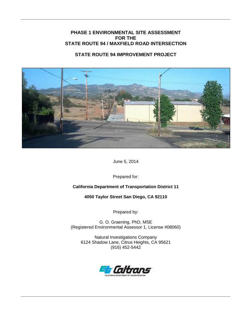
2.1. LOCATION AND LEGAL DESCRIPTION The subject property of this Phase I ESA is a traffic improvement Study Area at the intersection of State Route 94 and Maxfield Road in unincorporated San Diego County, California (Figure 2-1). Although Study Area parcels do not have specific addresses, the intersection is at approximately 14047 Maxfield Rd. and 13987 Campo Rd., Jamul.
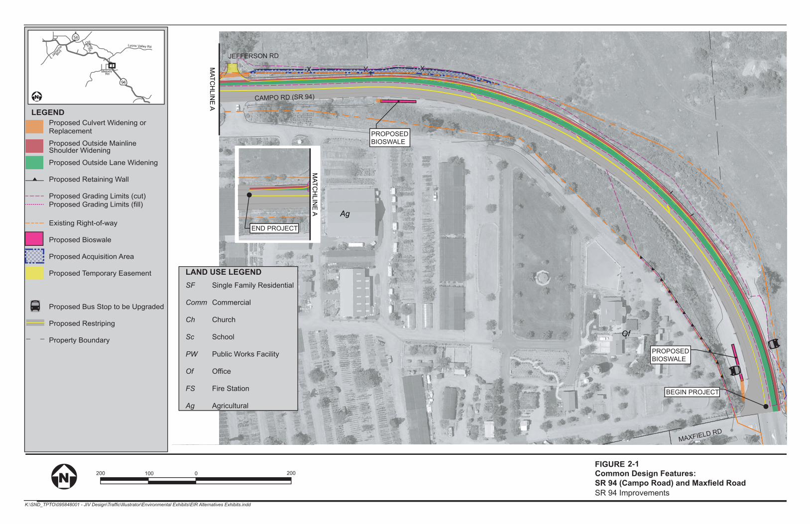
CAMPO RD (SR 94)
MAXFIELD RD
JEFFERSON RD
Of
Ag
R-58
PROPOSEDBIOSWALE
PROPOSEDBIOSWALE
MATC
HLIN
E A
MATC
HLIN
E A
END PROJECT
BEGIN PROJECT
FIGURE
SR 94 Improvements
200 100 0 200 2-1Common Design Features:
Proposed Culvert Widening or Replacement
Proposed Outside Mainline Shoulder Widening
Proposed Outside Lane Widening
Proposed Retaining Wall
Proposed Grading Limits (cut)Proposed Grading Limits (fill)
Existing Right-of-way
Proposed Bioswale
Proposed Acquisition Area
Proposed Temporary Easement
Proposed Bus Stop to be Upgraded
Proposed Restriping
Property Boundary
LEGEND
94CALIFORNIA
54CALIFORNIA
Jamac
haBlvd
MelodyRd
Steele
Cyn Rd
Lyons Valley Rd
Single Family Residential
Commercial
Church
School
Public Works Facility
Office
Fire Station
Agricultural
LAND USE LEGENDSF
Comm
Ch
Sc
PW
Of
FS
Ag
SR-94 / MAXFIELD ROAD INTERSECTION PHASE 1 ESA
Natural Investigations Co. Page 9
2.2. SITE AND VICINITY GENERAL CHARACTERISTICS The Study Area is located in mixed commercial / rural residential setting in an unincorporated part of the County and is characterized by a variety of land uses and sloping topography.
2.3. CURRENT USE OF THE PROPERTY AND IMPROVEMENTS SR-94 is two-lane conventional highway with a two-way left turn lane. Maxfield Road is a two-lane road with a westbound right turn “sneaker” lane at this intersection.
2.4. CURRENT USES OF ADJOINING PROPERTIES Land uses consist of commercial (esp. farm & feed supply), a post office, fenced pasture, and residences (estates and smaller subdivisions).
3. USER-PROVIDED INFORMATION The “User” is defined as the party seeking to use Practice E 1527 to complete an environmental site assessment of the property. A user may include, without limitation, a potential purchaser of property, a potential tenant of property, an owner of property, a lender, or a property manager. In the case of this assessment, the User is the project proponent, Jamul Indian Village, its consultants, such as Environmental Data Systems Inc., and the lead CEQA agency, Caltrans.
3.1. USER’S RESPONSIBILITIES User’s responsibilities are defined by the ASTM E 1527-13 standard, and include the following, as quoted:
“Any environmental liens or activity and use limitations so identified shall be reported to the environmental professional conducting a Phase I Environmental Site Assessment. Unless added by a change in the scope of work to be performed by the environmental professional, this practice does not impose on the environmental professional the responsibility to undertake a review of recorded land title records and judicial records for environmental liens or activity and use limitations.” (p. 11, ASTM, 2013) “If the user is aware of any specialized knowledge or experience that is material to recognized environmental conditions in connection with the property, it is the user’s responsibility to communicate any information based on such specialized knowledge or experience to the environmental professional.” (p. 11, ASTM, 2013) “The user should try to identify an explanation for a lower price which does not reasonable reflect fair market value if the property were not contaminated, and make a written record of such explanation.” (p. 11, ASTM, 2013) “If the user is aware of any commonly known or reasonably ascertainable information within the local community about the property that is material to recognized environmental conditions in connection with the property, it is the user’s responsibility to communicate such information to the environmental professional.” (p. 11, ASTM, 2013) “Either the user shall make known to the environmental professional the reason why the user wants to have the Phase I Environmental Site Assessment performed or, if the user does not identify the purpose of the Phase I Environmental Site Assessment, the environmental professional shall assume the purpose is to qualify for an LLP to CERCLA liability and state this in the report.” (page 11, ASTM, 2013).
SR-94 / MAXFIELD ROAD INTERSECTION PHASE 1 ESA
Natural Investigations Co. Page 10
In order to exert an LLP, the User must satisfy a number of statutory requirements that are generally referred to as Continuing Obligations, which are outside the Scope of Services of the Phase I ESA. Examples of Continuing Obligations include providing legally required notices stopping continuing releases and complying with land use restrictions. Failure to comply with these and other statutory post-acquisition requirements will jeopardize liability protection. It is the responsibility of the User to comply with the Continuing Obligations requirements of ASTM E1527-13 and All Appropriate Inquiry.
3.2. REQUESTED DOCUMENTS AND INFORMATION The following documents and information were requested of Caltrans on May 16, 2013: • Previous environmental site assessments or environmental compliance audit reports • Environmental permits or hazardous waste generator notices/reports • Registrations for aboveground or underground storage tanks • Location of septic systems, oil wells, or water wells • Registrations for underground injection systems • Material Safety Data Sheets; Community Right to Know Plans or Safety, Preparedness and prevention
Plans; Spill Protection, Countermeasures and Control Plans • Hazardous Material Business Plans • Geotechnical studies or hydrological studies • Notices or other correspondence from any government agency relating to past or current violations of
environmental laws with respect to the Property or relating to environmental liens encumbering the Property.
• Risk assessments • Recorded Activity Use Limitations • Proceedings regarding hazardous substances and petroleum products including any pending,
threatened or past: litigation; administrative proceedings; or notices from any governmental entity regarding possible violations of environmental laws or other possible liability related to hazardous substances or petroleum products.
No documents specific to the Study Area were provided in response to Natural Investigations’ information request. Documents were either not available or they did not exist / did not apply to the Study Area.
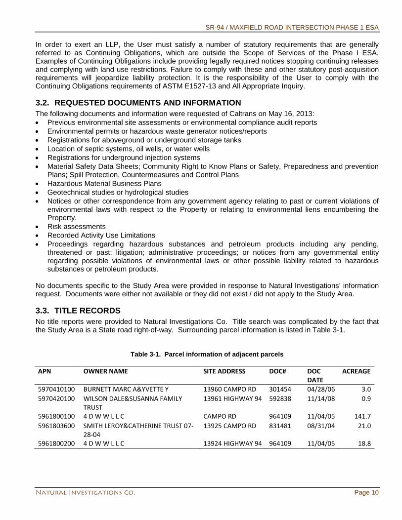
3.3. TITLE RECORDS No title reports were provided to Natural Investigations Co. Title search was complicated by the fact that the Study Area is a State road right-of-way. Surrounding parcel information is listed in Table 3-1.
Table 3-1. Parcel information of adjacent parcels APN OWNER NAME SITE ADDRESS DOC# DOC
DATE ACREAGE
5970410100 BURNETT MARC A&YVETTE Y 13960 CAMPO RD 301454 04/28/06 3.0 5970420100 WILSON DALE&SUSANNA FAMILY
TRUST 13961 HIGHWAY 94 592838 11/14/08 0.9
5961800100 4 D W W L L C CAMPO RD 964109 11/04/05 141.7 5961803600 SMITH LEROY&CATHERINE TRUST 07-
28-04 13925 CAMPO RD 831481 08/31/04 21.0
5961800200 4 D W W L L C 13924 HIGHWAY 94 964109 11/04/05 18.8
SR-94 / MAXFIELD ROAD INTERSECTION PHASE 1 ESA
Natural Investigations Co. Page 11
No indication of heavy industrial uses was detected from title review. No environmental liens were identified from this title review, but the search was not exhaustive.
3.4. ENVIRONMENTAL LIENS OR ACTIVITY AND USE LIMITATIONS An environmental lien is a charge, security, or encumbrance upon the title to a property to secure the payment of a cost, damage, debt, obligation, or duty arising out of response actions, cleanup, or other remediation of hazardous substances or petroleum products upon the property. No environmental liens or activity and use limitations were made aware to Natural Investigations Company. No evidence of environmental liens was identified during the interview process, title review, or records review.
3.5. SPECIALIZED KNOWLEDGE OR ACTUAL KNOWLEDGE No specialized knowledge or actual knowledge that is material to recognized environmental conditions in connection with the Study Area was provided by the User to Natural Investigations Company.
3.6. VALUATION REDUCTION FOR ENVIRONMENTAL ISSUES No valuation reductions for environmental issues were made aware to Natural Investigations Company. No valuation reductions were identified during the interview process or by the title review.
3.7. OWNER, PROPERTY MANAGER, AND OCCUPANT INFORMATION The owner of the Study Area parcels is Caltrans or County of San Diego.
3.8. REASON FOR PERFORMING PHASE I ESA Natural Investigations Company performed this Phase I ESA at the request of Environmental Data Systems, Inc. This assessment was performed in support of the requirements of the California Environmental Quality Act as it applies to the proposed intersection improvement project and the accompanying Environmental Impact Report. Specifically, this Phase I ESA is intended to be used to evaluate the hazards and hazardous materials setting in the project area, determine potential impacts of hazards and hazardous materials upon the Project, and identify potential mitigation measures to reduce negative impacts of hazardous materials to a less-than-significant level.
4. RECORDS REVIEW The purpose of the records review is to obtain and review records that will help identify recognized environmental conditions in connection with the property.
4.1. STANDARD ENVIRONMENTAL RECORD SOURCES As part of this assessment, Natural Investigations Company retained the services of Environmental Data Resources, Incorporated (EDR), which queries and maintains comprehensive environmental databases and historical information, including proprietary databases, aerial photography, topographic maps, Sanborn Maps, and city directories. EDR‘s Phase I ESA standard package - “Radius Map with GeoCheck” was ordered and performed on April 18, 2013. In this report, EDR presents the results of searches of all reasonably ascertainable environmental databases (federal, state, local, and private) for records of potential environmental impacts of the Property and vicinity. EDR performed these database searches within the prescribed radii of ASTM Practice E 1527-13 (ASTM, 2013). The databases queried by EDR included the following:
Federal ASTM Standard and Supplemental – National Priority List (NPL); proposed NPL; Comprehensive Environmental Response, Compensation, and Liability Information System (CERCLIS); CERCLIS No Further Remedial Action Planned; Corrective Action Report; Resource Conservation and Recovery Act (RCRA) Information; RCRA Large Quantity Generator; Emergency Response Notification System; Superfund Consent Decrees; Records of Decision; NPL Deletions, Hazardous Materials Information Reporting System; Material Licensing Tracking System; Mines Master Index File; Federal Superfund Liens; PCB Activity Database System; Department of Defense Sites; Indian Reservations; Uranium
SR-94 / MAXFIELD ROAD INTERSECTION PHASE 1 ESA
Natural Investigations Co. Page 12
Mill Tailings Sites; Engineering Controls Sites List; Open Dump Inventory; Formerly Used Defense Sites; RCRA Administrative Action Tracking System; Toxic Chemical Release Inventory System; Toxic Substances Control Act (TSCA); Section 7 Tracking Systems; Federal Insecticide, Fungicide, and Rodenticide Act / TSCA; US Brownfields; US Institutional Control Sites; Voluntary Clean-up Program Properties; State ASTM Standard and Supplemental – Proposition 65 Records; Toxic Pits Cleanup Act Sites; Bond Expenditure Plan; List of Underground Storage Tank (UST) Facilities; Voluntary Cleanup Program Facilities; Leaking UST on Indian Land; UST on Indian Land; Waste Discharge System; Deed Restriction Listing; Properties Needing Further Evaluation; No Further Action Determination; Well Investigation Program Case List; Emissions Inventory Data; School Property Evaluation Program; Former Manufactured Gas Sites.
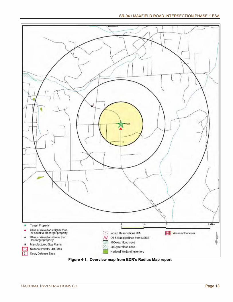
The complete EDR Radius Map report is provided in Appendix 15.1. Results are summarized in EDR’s overview map (Figure 4-1). The Study Area was not listed in any of the databases queried by EDR. In the vicinity of the Study Area the following sites were listed, as summarized in EDR’s Executive Summary: • Mapped element 1 – _13795 Camp Road. Rancho Jamul Autocare. From EDR US Hist Auto Stat
database. Auto care station. • Mapped element 2 – 13886 Campo Road, Raul Rodriguez. From: HIST CORTESE, SWRCY, LUST,
AST, SWEEPS UST, San Diego Co. HMMD, EMI, San Diego Co databases. 5 USTs. 4000 and 2000 gallon gasoline, 3000 gallon diesel all removed July 1992. 550 gallon gasoline removed December 1992. 50 Gallon waste oil removed September 1995. All USTs were disposed of with Pacific Steel. Three monitoring wells were installed post tank removal. The case was closed after determining the plume was not migrating on 10/8/1998.
It should be noted that the computerized geocoding technology used in the database search is based on available census data and is only accurate to ±300 feet. The EDR report indicates that poor or inadequate address information was provided for various properties that are potentially located in the vicinity of the Study Area; therefore, these sites could not be readily mapped by EDR. Because the location of these sites with respect to the Study Area could not be determined, the evaluation of the unmappable sites is limited in terms of determining the potential impact on the Study Area. Although the list of the unmappable sites was reviewed for adjacent or nearby properties observed during the site reconnaissance, locating each of the unmapped sites identified by EDR is not considered practicable.
SR-94 / MAXFIELD ROAD INTERSECTION PHASE 1 ESA
Natural Investigations Co. Page 13
Figure 4-1. Overview map from EDR's Radius Map report
SR-94 / MAXFIELD ROAD INTERSECTION PHASE 1 ESA
Natural Investigations Co. Page 14
4.2. ADDITIONAL ENVIRONMENTAL RECORD SOURCES
4.2.1.State of California Department of Toxic Substances Control Records
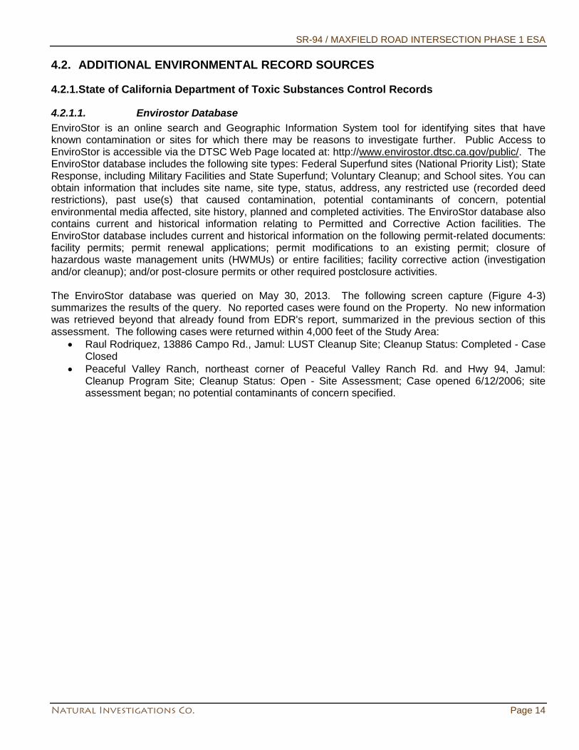
4.2.1.1. Envirostor Database EnviroStor is an online search and Geographic Information System tool for identifying sites that have known contamination or sites for which there may be reasons to investigate further. Public Access to EnviroStor is accessible via the DTSC Web Page located at: http://www.envirostor.dtsc.ca.gov/public/. The EnviroStor database includes the following site types: Federal Superfund sites (National Priority List); State Response, including Military Facilities and State Superfund; Voluntary Cleanup; and School sites. You can obtain information that includes site name, site type, status, address, any restricted use (recorded deed restrictions), past use(s) that caused contamination, potential contaminants of concern, potential environmental media affected, site history, planned and completed activities. The EnviroStor database also contains current and historical information relating to Permitted and Corrective Action facilities. The EnviroStor database includes current and historical information on the following permit-related documents: facility permits; permit renewal applications; permit modifications to an existing permit; closure of hazardous waste management units (HWMUs) or entire facilities; facility corrective action (investigation and/or cleanup); and/or post-closure permits or other required postclosure activities. The EnviroStor database was queried on May 30, 2013. The following screen capture (Figure 4-3) summarizes the results of the query. No reported cases were found on the Property. No new information was retrieved beyond that already found from EDR's report, summarized in the previous section of this assessment. The following cases were returned within 4,000 feet of the Study Area:
• Raul Rodriquez, 13886 Campo Rd., Jamul: LUST Cleanup Site; Cleanup Status: Completed - Case Closed
• Peaceful Valley Ranch, northeast corner of Peaceful Valley Ranch Rd. and Hwy 94, Jamul: Cleanup Program Site; Cleanup Status: Open - Site Assessment; Case opened 6/12/2006; site assessment began; no potential contaminants of concern specified.
SR-94 / MAXFIELD ROAD INTERSECTION PHASE 1 ESA
Natural Investigations Co. Page 15
Figure 4-2. Screen capture of EnviroStor database query
SR-94 / MAXFIELD ROAD INTERSECTION PHASE 1 ESA
Natural Investigations Co. Page 16
4.2.2.California State Water Resources Control Board / Regional Board Records
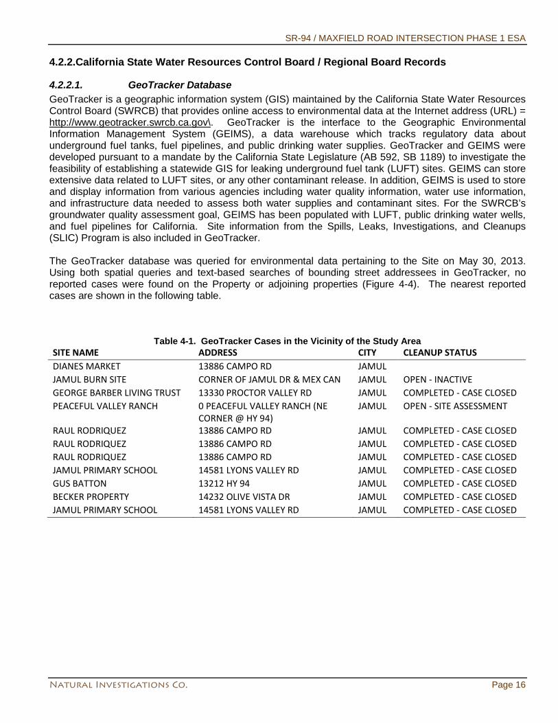
4.2.2.1. GeoTracker Database GeoTracker is a geographic information system (GIS) maintained by the California State Water Resources Control Board (SWRCB) that provides online access to environmental data at the Internet address (URL) = http://www.geotracker.swrcb.ca.gov\. GeoTracker is the interface to the Geographic Environmental Information Management System (GEIMS), a data warehouse which tracks regulatory data about underground fuel tanks, fuel pipelines, and public drinking water supplies. GeoTracker and GEIMS were developed pursuant to a mandate by the California State Legislature (AB 592, SB 1189) to investigate the feasibility of establishing a statewide GIS for leaking underground fuel tank (LUFT) sites. GEIMS can store extensive data related to LUFT sites, or any other contaminant release. In addition, GEIMS is used to store and display information from various agencies including water quality information, water use information, and infrastructure data needed to assess both water supplies and contaminant sites. For the SWRCB’s groundwater quality assessment goal, GEIMS has been populated with LUFT, public drinking water wells, and fuel pipelines for California. Site information from the Spills, Leaks, Investigations, and Cleanups (SLIC) Program is also included in GeoTracker. The GeoTracker database was queried for environmental data pertaining to the Site on May 30, 2013. Using both spatial queries and text-based searches of bounding street addressees in GeoTracker, no reported cases were found on the Property or adjoining properties (Figure 4-4). The nearest reported cases are shown in the following table.
Table 4-1. GeoTracker Cases in the Vicinity of the Study Area SITE NAME ADDRESS CITY CLEANUP STATUS DIANES MARKET 13886 CAMPO RD JAMUL JAMUL BURN SITE CORNER OF JAMUL DR & MEX CAN JAMUL OPEN - INACTIVE GEORGE BARBER LIVING TRUST 13330 PROCTOR VALLEY RD JAMUL COMPLETED - CASE CLOSED PEACEFUL VALLEY RANCH 0 PEACEFUL VALLEY RANCH (NE
CORNER @ HY 94) JAMUL OPEN - SITE ASSESSMENT
RAUL RODRIQUEZ 13886 CAMPO RD JAMUL COMPLETED - CASE CLOSED RAUL RODRIQUEZ 13886 CAMPO RD JAMUL COMPLETED - CASE CLOSED RAUL RODRIQUEZ 13886 CAMPO RD JAMUL COMPLETED - CASE CLOSED JAMUL PRIMARY SCHOOL 14581 LYONS VALLEY RD JAMUL COMPLETED - CASE CLOSED GUS BATTON 13212 HY 94 JAMUL COMPLETED - CASE CLOSED BECKER PROPERTY 14232 OLIVE VISTA DR JAMUL COMPLETED - CASE CLOSED JAMUL PRIMARY SCHOOL 14581 LYONS VALLEY RD JAMUL COMPLETED - CASE CLOSED
SR-94 / MAXFIELD ROAD INTERSECTION PHASE 1 ESA
Natural Investigations Co. Page 17
Figure 4-3. Spatial results of GeoTracker query
4.2.3.County / CUPA Records SearchThe Unified Program (http://www.calepa.ca.gov/CUPA/) consolidates, coordinates, and makes consistent the administrative requirements, permits, inspections, and enforcement activities of six environmental and emergency response programs. Cal/EPA and other state agencies set the standards for their programs while local governments implement the standards—these local implementing agencies are called Certified Unified Program Agencies (CUPA).
No pertinent cases were found.
SR-94 / MAXFIELD ROAD INTERSECTION PHASE 1 ESA
Natural Investigations Co. Page 18
4.3. PHYSICAL SETTING SOURCES
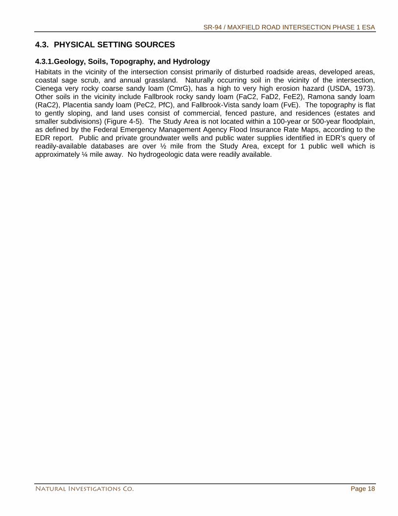
4.3.1.Geology, Soils, Topography, and Hydrology Habitats in the vicinity of the intersection consist primarily of disturbed roadside areas, developed areas, coastal sage scrub, and annual grassland. Naturally occurring soil in the vicinity of the intersection, Cienega very rocky coarse sandy loam (CmrG), has a high to very high erosion hazard (USDA, 1973). Other soils in the vicinity include Fallbrook rocky sandy loam (FaC2, FaD2, FeE2), Ramona sandy loam (RaC2), Placentia sandy loam (PeC2, PfC), and Fallbrook-Vista sandy loam (FvE). The topography is flat to gently sloping, and land uses consist of commercial, fenced pasture, and residences (estates and smaller subdivisions) (Figure 4-5). The Study Area is not located within a 100-year or 500-year floodplain, as defined by the Federal Emergency Management Agency Flood Insurance Rate Maps, according to the EDR report. Public and private groundwater wells and public water supplies identified in EDR’s query of readily-available databases are over ½ mile from the Study Area, except for 1 public well which is approximately ¼ mile away. No hydrogeologic data were readily available.
SR-94 / MAXFIELD ROAD INTERSECTION PHASE 1 ESA
Natural Investigations Co. Page 19
Figure 4-4. EDR’s Physical Setting Map
SR-94 / MAXFIELD ROAD INTERSECTION PHASE 1 ESA
Natural Investigations Co. Page 20
4.4. HISTORICAL USE INFORMATION ON THE PROPERTY The objective of consulting historical sources is to develop a history of the previous uses of the property and surrounding area, in order to help identify the likelihood of past uses having led to recognized environmental conditions in connection with the property.
4.4.1.Topographic Map Analysis Historical and current topographic maps of the Study Area were analyzed to determine any of the following: topography and inferred surface water and ground water flow direction; current and historical land use; and current and historical structures, utilities, and roads. All available USGS topographic quadrangle maps were obtained and analyzed. The resolution of these maps was so coarse that only general land uses could be inferred. No visual clues as to any possible recognized environmental conditions were found.
4.4.2.Aerial Photography Analysis Historical aerial photographs of the Study Area were analyzed to determine the any of the following: current and historical land use; any current and historical structures, utilities, and roads; and any current or historical drum storage, above ground tanks, garbage dumps or landfills, or pits, ponds, or lagoons. The resolution of these maps was so coarse that only general land uses could be inferred.
4.4.3.Fire Insurance (Sanborn Company) Maps Fire insurance maps are historical city and building layout maps produced for private fire insurance companies (primarily by the former Sanborn Company). These historical city maps can indicate the presence of structures on, or uses of, properties at specified dates. EDR now owns the Sanborn Company, and provides any available fire insurance maps for the target address. EDR’s Sanborn report indicated that there was no coverage of the Study Area by Sanborn maps.
4.5. HISTORICAL USE INFORMATION ON ADJOINING PROPERTIES No relevant information was found. Other historical use information on adjoining properties is summarized in other sections of this report.
5. SITE RECONNAISSANCE The objective of the site reconnaissance is to obtain information indicating the likelihood of identifying recognized environmental conditions in connection with the property.
5.1. METHODOLOGY AND LIMITING CONDITIONS The site visit is limited to visual and/or physical observation of the exterior and interior of the Property and its improvements, the past and current uses of the Property and adjoining properties, and the condition of the Property. The site visit evaluated the Property and adjoining properties for potential hazardous materials/waste and petroleum product use, storage, disposal, or accidental release, including the following: presence of tank and drum storage; mechanical or electrical equipment likely to contain liquids; evidence of soil or pavement staining or stressed vegetation; ponds, pits, lagoons, or sumps; suspicious odors; fill and depressions; or any other condition indicative of potential contamination. The site visit did not evaluate the presence of asbestos-containing materials, radon, lead-based paint, mold, indoor air quality, or structural defects, or other non-scope items. On May 15, 2013, Dr. G. O. Graening performed a Site reconnaissance of the Study Area. All accessible portions of the Study Area were observed by a pedestrian survey; adjoining properties were observed by a combination of pedestrian survey and windshield (automobile) survey.
SR-94 / MAXFIELD ROAD INTERSECTION PHASE 1 ESA
Natural Investigations Co. Page 21
5.2. EXTERIOR OBSERVATIONS The Study Area and its improvements are generally well kept and litter free. The following text discusses focus areas of the site reconnaissance.
5.2.1.Stained Soil / Distressed Vegetation / Odors No stained soil, distressed vegetation, or unusual odors was noted during the site reconnaissance.
5.2.2.Roads Roads surrounding the Study Area are all paved with asphalt or concrete, and show no suspicious staining.
5.2.3.Wells / Potable Water Supply Water mains are located under major streets and parking lots.
5.2.4.Sewage Disposal System Sewage is transported and treated by municipal utility.
5.2.5.Storage Tanks, Containers, or Drums No storage tanks or drum storage was noted on the Study Area or adjoining properties during the site reconnaissance. It is beyond the scope of this assessment to open any container.
5.2.6.Hazardous Substances and Petroleum Products No hazardous substances or petroleum product usage or storage was noted within the Study Area or adjoining properties during the site reconnaissance.
5.2.7.Electrical or Mechanical Equipment Likely to Contain Fluids Polychlorinated biphenyls, or PCBs, were commonly used historically in electrical equipment such as transformers, fluorescent lamp ballasts, and capacitors. According to United States EPA regulation 40 CFR, Part 761, there are three categories for classifying such equipment: <50 ppm of PCBs is considered “Non-PCB”; between 50 and 500 ppm is considered “PCB-Contaminated”; and >500 ppm is considered “PCB-Containing”. Pursuant to 15 U.S.C. 2605(e)(2)(A), the manufacture, process, or distribution in commerce or use of any polychlorinated biphenyl in any manner other than in a totally enclosed manner was prohibited after January 1, 1977. No PCB-containing equipment (electric or hydraulic) was observed during the site reconnaissance. Pole-mounted transformers were observed in the vicinity, but appear to be modern and non-leaking. Electrical service is provided by SDG&E.
5.2.8.Pits / Ponds / Lagoons No pits, ponds, or lagoons were observed during the site reconnaissance.
5.2.9.Storm Water / Pools of Liquid The County maintains and operates a municipal stormwater sewer system within the Study Area. Stormwater drop inlets and manhole vaults were observed at various locations.
5.2.10. Solid Waste Municipal solid waste and recyclables generated on the Study Area and adjoining properties are collected in cans and hauled by the County. Privately-contracted “roll-off” dumpsters were noted in alleys and behind buildings.
SR-94 / MAXFIELD ROAD INTERSECTION PHASE 1 ESA
Natural Investigations Co. Page 22
5.3. LIMITATIONS There were no limitations that affected the conclusions of this assessment.
6. INTERVIEWS The ASTM explains that, "The objective of interviews is to obtain information indicating the likelihood of identifying recognized environmental conditions in connection with the property" (page 16, ASTM, 2013). The following text summarizes interviews performed and questionnaires answered. On May 15, 2013, Dr. Graening met with Caltrans staff. Caltrans staff did not disclose any environmental conditions or provide any documentation of the Study Area.
7. FINDINGS The Study Area is located in a suburban area and is developed as a traffic intersection with no known industrial history and no known historical usage of hazardous materials or petroleum products.
7.1. RATIONALE FOR DETERMINATION OF SIGNIFICANT FINDINGS Offsite properties identified in the vicinity of the Property were evaluated to determine if they are likely to have adversely affected the Property. The criteria used to evaluate whether an offsite property pose potential environmental concerns to the Property include: • Distance from the Property: Offsite properties within one-quarter mile of the Property were evaluated.
The one-quarter-mile radius was used because it is unlikely a hazardous material released to the subsurface will migrate laterally within the soil for a significant distance, although in some cases, a hazardous material can migrate in groundwater in a generally downgradient direction for distances greater than one-quarter mile.
• Expected depth and direction of groundwater and surface water flow: The identification of a site as potentially upgradient or downgradient is based on the expected direction of groundwater flow determined by site-specific measurement, where available, or inferred from the regional topography.
• The presence of documented contaminant releases at the identified sites. • The media that the documented contaminant releases affected (i.e., soil and/or groundwater). For the
evaluation of potential environmental contamination in the Property, offsite properties with releases to soil only are assumed to pose no significant impact on the Property, as the contaminants are unlikely to migrate towards the Property.
Based on the review and evaluation of information available in the environmental databases and regulatory agency files, no adverse environmental effect is expected because the identified vicinity sites are in assumed down-gradient or cross-gradient locations, have obtained case closure, were contained at the ground surface, or releases to the subsurface affected soil only, in which case the contaminants are unlikely to migrate towards the Property in groundwater. In addition, offsite properties located further than one-quarter mile from the study are not expected to adversely affect the Property conditions, as it is unlikely a hazardous material released to the subsurface will migrate laterally within the soil for a significant distance, although a hazardous material can migrate in groundwater in a generally downgradient direction. It should be noted that Leaking Underground Storage Tank and DTSC EnviroStor sites closed by the RWQCB or local agencies prior to April 1, 2008, would not necessarily have been closed based on a risk assessment that considered volatile organic compounds and the vapor intrusion pathway. Assembly Bill 422, which now requires such a risk assessment, did not take effect until January 1, 2008. Evaluation of the vapor intrusion pathway is not included in the scope of this hazardous materials/wastes study.
SR-94 / MAXFIELD ROAD INTERSECTION PHASE 1 ESA
Natural Investigations Co. Page 23
7.2. DE MINIMIS ENVIRONMENTAL CONDITIONS De minimis environmental conditions are conditions that are not believed to present a material risk of harm to public health or the environment and that generally would not be the subject of an enforcement action if brought to the attention of appropriate governmental agencies (ASTM, 2013). No minimal, or de minimis, environmental condition(s) exists pursuant to the ASTM standard.
7.3. HISTORICAL RECOGNIZED ENVIRONMENTAL CONDITIONS ASTM (2013) defines a historical recognized condition as
“...an environmental condition which in the past would have been considered a recognized environmental condition, but which may or may not be considered a recognized environmental condition currently. The final decision rests with the environmental professional and will be influenced by the current impact of the historical recognized environmental condition on the property. If a past release of any hazardous substances or petroleum products has occurred in connection with the property and has been remediated, with such remediation accepted by the responsible regulatory agency (for example, as evidenced by the issuance of a no further action letter or equivalent), this condition shall be considered an historical recognized environmental condition.” (p. 5, ASTM 2013)
No historical recognized environmental conditions were found in connection with the Study Area pursuant to the ASTM Practice E 1527-13.
7.4. KNOWN OR SUSPECT RECOGNIZED ENVIRONMENTAL CONDITIONS No recognized environmental conditions were found in connection with the Study Area pursuant to the ASTM Practice E 1527-13.
8. OPINION AND RECOMMENDATION
8.1. IMPACT OF ENVIRONMENTAL CONDITIONS ON PROPERTY It is Natural Investigations Co.’s opinion that there are no current recognized environmental conditions, in connection with the Study Area pursuant to the ASTM Practice E 1527-13. Records review, site reconnaissance, and interviews failed to identify any current environmental conditions in connection with the Study Area.
8.2. ADDITIONAL INVESTIGATION It is Natural Investigations Co.’s opinion that there are no historical or current recognized environmental conditions in connection with the Study Area pursuant to the ASTM Practice E 1527-13. Records review, database searches, or interviews failed to identify any environmental conditions in connection with the Study Area. Therefore, no further site investigation is recommended by Natural Investigations Co.
8.2.1.Potential Hazard of Lead in Construction/Demolition Materials Although the ASTM standard practice for Phase I ESA’s considers lead paint an out-of-scope subject (ASTM, 2013), California Department of Transportation (Caltrans) requested a discussion of the potential hazard of lead in construction/demolition materials for this project.
8.2.1.1. Potential Lead Soil Impacts “Earth Material Containing Lead” Leaded gasoline was used as a vehicle fuel in the USA from the 1920s through the 1980s. Although lead is no longer used in gasoline formulations, historical lead emissions from automobiles are a recognized source of contamination in soils along heavily-used roadways (i.e., aerially deposited lead or ADL). Thus, surface and near-surface soils along such roadways have the potential to contain elevated concentrations
SR-94 / MAXFIELD ROAD INTERSECTION PHASE 1 ESA
Natural Investigations Co. Page 24
of lead. Ongoing testing by Caltrans throughout California has indicated that ADL exists along major freeway routes. At sites where soil has not been disturbed, the ADL is generally limited to the upper 2 feet of soil within unpaved shoulder and median areas. Implementation of the project may require the excavation and export of soils from the project area; soil within, and adjacent to, the Caltrans rights-of-way usually contain ADL. It is not known whether the level of lead at the project area is at a hazardous level. According to Caltrans’ requirements, prior to construction ADL levels must be determined in order to handle the soil appropriately. Caltrans has a variance with the DTSC that will allow the Department to keep soil with hazardous levels of ADL within the right-of-way depending on the level of contamination that is found.
8.2.1.2. Potential Lead-based Traffic Stripe Paint Impacts Current Caltrans paint specifications require paints to have lead concentrations less than 20 mg/kg. Old non-yellow paints (e.g., white, blue, black, etc.) had higher concentrations of lead, but not high enough for removed paint to be classified as a hazardous waste. Residue from the removal of these paints is a non-hazardous waste. Yellow traffic paint used prior to 1999 contained high concentrations of lead. Application of yellow thermoplastic material containing high concentrations of lead was phased out during 2004 to 2006. The lead concentrations in these paints and thermoplastics are high enough to make these materials hazardous wastes when they are removed. Implementation of the project may require the removal of traffic stripe paint from the underlying asphalt concrete by grinding or sand blasting, which would create a paint waste stream. All traffic striping and traffic marking paints contain lead, but it is not known whether it is at hazardous levels or not. According to Caltrans’ requirements, this paint waste must be sampled and analyzed prior to disposal. Disposal of removed traffic stripe paint materials is also dependent on the method utilized to remove these materials (i.e. focused stripe removal vs. pavement grinding).
8.2.1.3. Recommended Mitigation According to Caltrans’ requirements, no soil shall be disturbed or exported from the State right-of-way project area before an ADL study is completed. No paint striping shall be removed before a lead compliance plan is implemented. Cal/OSHA and Caltrans require a lead compliance plan when lead is known to be present. The potential presence of elevated lead concentrations requires sampling and analytical testing of any exported soil and any traffic paint materials to determine appropriate health and safety procedures and proper management and disposal practices. A project-specific Lead Compliance Plan will be required and must be prepared by a Certified Industrial Hygienist and properly implemented by the contractor. The requirements for the lead compliance plan can be found in the Caltrans Standard Specifications in Section 7-1.02K(6)(j)(ii) and CCR Title 8, Section 1532.1. Note that just one lead compliance plan that addresses all types of lead exposures on the project is to be prepared. As specified in this plan, lead-containing materials must be sampled and analyzed prior to disposal. If the analytical results show that lead levels are below the regulated hazardous level the materials may be disposed with other construction and demolition debris. If the analytical results show that lead levels are above the regulated hazardous level, the waste must be transported under manifest to a Class I landfill appropriately permitted to receive the material. The project-specific Lead Compliance Plan is intended, among other things, to minimize worker exposure to lead. The plan should include protocols for environmental and personnel monitoring, requirements for the use of personal protective equipment, and other health and safety protocols and procedures for the handling of lead-containing materials. A dust control plan and health and safety plan should also be prepared and implemented to minimize worker exposure to lead and any other hazardous materials.

SR-94 / MAXFIELD ROAD INTERSECTION PHASE 1 ESA
Natural Investigations Co. Page 25
8.2.2. Other Potential Hazards One common hazards should also be noted: the Study Area contains dense, dry vegetation that may fuel wildfire, and the region is located within an area of moderate to high level of fire hazard.
9. CONCLUSIONS Natural Investigations Company has performed a Phase I ESA in conformance with the scope and limitations of ASTM Practice E 1527-13 of the Study Area (a SR-94 / Maxfield Road intersection improvement project area in unincorporated San Diego County, California, at approximately 14047 Maxfield Rd. and 13987 Campo Rd., Jamul). Any exceptions to, or deletions from, this practice are described in Section 10 of this report. This assessment has revealed no evidence of recognized environmental conditions in connection with Study Area.
9.1. DATA FAILURE OR OTHER DATA GAPS ASTM (2013) defines data failure as the failure to achieve the historical research objectives even after reviewing the standard historical sources that are reasonably ascertainable and likely to be useful. Data failure is one type of data gap. ASTM (2013) defines a data gap as a lack, of or inability to obtain, information required by this practice despite good faith efforts by the environmental professional to gather such information. Data gaps may result from incompleteness in any of the activities required by this practice, including, but not limited to site reconnaissance (for example, an inability to conduct the site visit), and interviews (for example, an inability to interview the key site manager, regulatory officials, etc.) The available historical USGS quadrangle maps and aerial photography were too coarse in resolution to discern any specific land uses or structures on the Property or adjacent properties, and Sanborn fire insurance maps did not cover the Property. These constitute data failures. However, a combination of other historical data sources was available such that no significant data gap existed, and the historical research objectives were achieved.
10. DEVIATIONS There were no deletions or deviations from the standard practice.
11. ADDITIONAL SERVICES No additional services beyond the scope of the ASTM Standard 1527-13 were conducted as part of this assessment. There may be environmental issues or conditions at a property that parties may wish to assess in connection with commercial real estate that are outside the scope of this practice. No implication is intended as to the relative importance of inquiry into such non-scope considerations, and this list of non-scope considerations is not intended to be all-inclusive: asbestos-containing building materials, radon, lead-based paint, lead in drinking water, wetlands, regulatory compliance, cultural and historic resources, industrial hygiene, health and safety, ecological resources, endangered species, indoor air quality, biological agents, and mold. Phase I ESAs are non-comprehensive by nature and are unlikely to identify all environmental problems or eliminate all risk. Natural Investigations Company offers a range of investigative and consulting services to suit the needs of our clients, including more quantitative investigations. Although risk can never be eliminated, more detailed and extensive investigations yield more information, which may help the User understand and better manage risks associated with their property. Since such detailed services involve greater expense and time, we ask that our clients participate in the identification of the level of service that will provide them with what they consider to be an acceptable level of risk. Please contact the signatory of this report if you would like to discuss the issue of risk further. Land use, site conditions, and other factors
SR-94 / MAXFIELD ROAD INTERSECTION PHASE 1 ESA
Natural Investigations Co. Page 26
will change over time. This report should not be relied upon after 180 days from the date of issuance, unless additional services are performed as defined in Section 4.7 of ASTM E 1527-13.

SR-94 / MAXFIELD ROAD INTERSECTION PHASE 1 ESA
Natural Investigations Co. Page 27
12. REFERENCES American Society for Testing and Materials. 2013. Standard Practice for Environmental Site Assessments: Phase I Environmental Site Assessment Process. Designation E 1527-13. West Conshohocken, Pennsylvania. 35 pp. Department of Toxic Substances Control. 2013. EnviroStor Database Website, http://www.envirostor.dtsc.ca.gov/public/. State Water Resources Control Board. 2013. GeoTracker Database Website, http://geotracker.swrcb.ca.gov/. USEPA. 2002. OSWER Draft Guidance for Evaluating the Vapor Intrusion to Indoor Air Pathway from Groundwater and Soils (Subsurface Vapor Intrusion Guidance). EPA530-D-02-004. Office of Solid Waste and Emergency Response. 178 pp. Available on the Internet at: http://www.epa.gov/epawaste/hazard/correctiveaction/eis/vapor.htm. USEPA. 2013. Envirofacts Data Warehouse Multisystem Query Website, http://www.epa.gov/enviro/html/multisystem.html. USEPA. 2013. The Enforcement and Compliance History Online (ECHO) database maintained by the USEPA, http://www.epa-echo.gov/echo/.
SR-94 / MAXFIELD ROAD INTERSECTION PHASE 1 ESA
Natural Investigations Co. Page 28
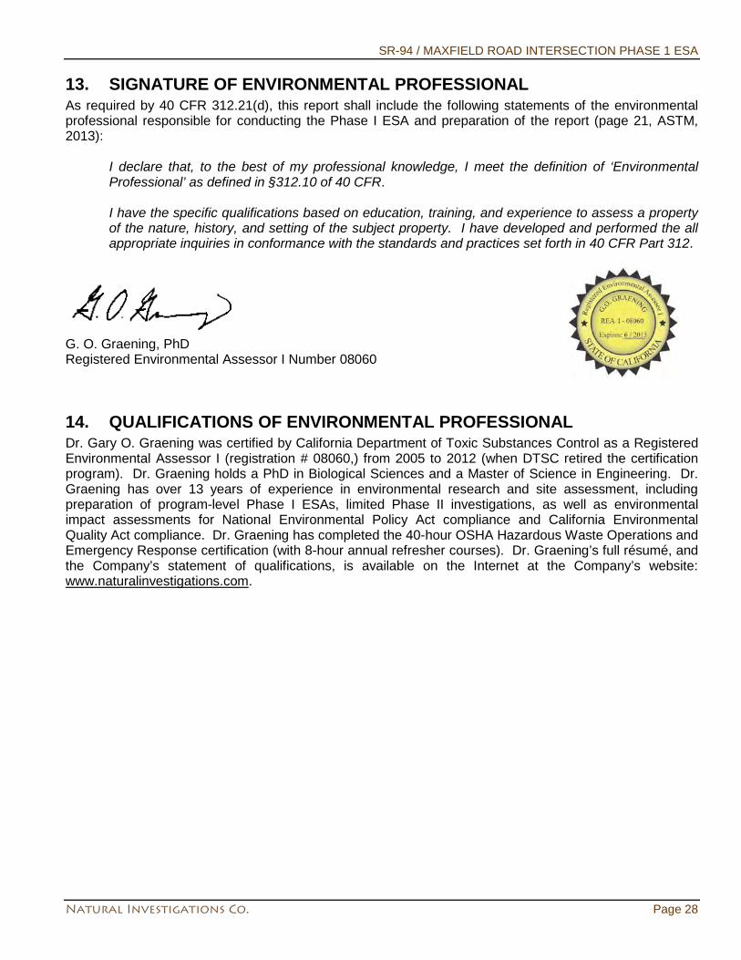
13. SIGNATURE OF ENVIRONMENTAL PROFESSIONAL As required by 40 CFR 312.21(d), this report shall include the following statements of the environmental professional responsible for conducting the Phase I ESA and preparation of the report (page 21, ASTM, 2013):
I declare that, to the best of my professional knowledge, I meet the definition of ‘Environmental Professional’ as defined in §312.10 of 40 CFR. I have the specific qualifications based on education, training, and experience to assess a property of the nature, history, and setting of the subject property. I have developed and performed the all appropriate inquiries in conformance with the standards and practices set forth in 40 CFR Part 312.
G. O. Graening, PhD Registered Environmental Assessor I Number 08060
14. QUALIFICATIONS OF ENVIRONMENTAL PROFESSIONAL Dr. Gary O. Graening was certified by California Department of Toxic Substances Control as a Registered Environmental Assessor I (registration # 08060,) from 2005 to 2012 (when DTSC retired the certification program). Dr. Graening holds a PhD in Biological Sciences and a Master of Science in Engineering. Dr. Graening has over 13 years of experience in environmental research and site assessment, including preparation of program-level Phase I ESAs, limited Phase II investigations, as well as environmental impact assessments for National Environmental Policy Act compliance and California Environmental Quality Act compliance. Dr. Graening has completed the 40-hour OSHA Hazardous Waste Operations and Emergency Response certification (with 8-hour annual refresher courses). Dr. Graening’s full résumé, and the Company’s statement of qualifications, is available on the Internet at the Company’s website: www.naturalinvestigations.com.
SR-94 / MAXFIELD ROAD INTERSECTION PHASE 1 ESA
Natural Investigations Co. Page 29
15. APPENDICES All appendices are presented as electronic files on the attached compact disc.
SR-94 / MAXFIELD ROAD INTERSECTION PHASE 1 ESA
Natural Investigations Co. Appendix Coverpage A
EDR Radius Map Report
FORM-NULL-PVC
tropeR paM suidaR yrammuS RDE
440 Wheelers Farms RoadMilford, CT 06461Toll Free: 800.352.0050www.edrnet.com
SR94 & Maxfield Road IntersectionState Route 94 / Maxfield RoadJamul, CA 91935
Inquiry Number: 3580184.1sApril 18, 2013
SECTION PAGE
Executive Summary ES1
Overview Map 2
Detail Map 3
Map Findings Summary 4
Map Findings 8
Orphan Summary 25
Government Records Searched/Data Currency Tracking GR-1
GEOCHECK ADDENDUM
Physical Setting Source Addendum A-1
Physical Setting Source Summary A-2
Physical Setting SSURGO Soil Map A-5
Physical Setting Source Map A-14
Physical Setting Source Map Findings A-16
Physical Setting Source Records Searched A-19
TC3580184.1s Page 1
Thank you for your business.Please contact EDR at 1-800-352-0050
with any questions or comments.
Disclaimer - Copyright and Trademark Notice
This Report contains certain information obtained from a variety of public and other sources reasonably available to Environmental DataResources, Inc. It cannot be concluded from this Report that coverage information for the target and surrounding properties does not exist fromother sources. NO WARRANTY EXPRESSED OR IMPLIED, IS MADE WHATSOEVER IN CONNECTION WITH THIS REPORT. ENVIRONMENTALDATA RESOURCES, INC. SPECIFICALLY DISCLAIMS THE MAKING OF ANY SUCH WARRANTIES, INCLUDING WITHOUT LIMITATION,MERCHANTABILITY OR FITNESS FOR A PARTICULAR USE OR PURPOSE. ALL RISK IS ASSUMED BY THE USER. IN NO EVENT SHALLENVIRONMENTAL DATA RESOURCES, INC. BE LIABLE TO ANYONE, WHETHER ARISING OUT OF ERRORS OR OMISSIONS, NEGLIGENCE,ACCIDENT OR ANY OTHER CAUSE, FOR ANY LOSS OF DAMAGE, INCLUDING, WITHOUT LIMITATION, SPECIAL, INCIDENTAL,CONSEQUENTIAL, OR EXEMPLARY DAMAGES. ANY LIABILITY ON THE PART OF ENVIRONMENTAL DATA RESOURCES, INC. IS STRICTLYLIMITED TO A REFUND OF THE AMOUNT PAID FOR THIS REPORT. Purchaser accepts this Report "AS IS". Any analyses, estimates, ratings,environmental risk levels or risk codes provided in this Report are provided for illustrative purposes only, and are not intended to provide, norshould they be interpreted as providing any facts regarding, or prediction or forecast of, any environmental risk for any property. Only a Phase IEnvironmental Site Assessment performed by an environmental professional can provide information regarding the environmental risk for anyproperty. Additionally, the information provided in this Report is not to be construed as legal advice.
Copyright 2013 by Environmental Data Resources, Inc. All rights reserved. Reproduction in any media or format, in wholeor in part, of any report or map of Environmental Data Resources, Inc., or its affiliates, is prohibited without prior written permission.
EDR and its logos (including Sanborn and Sanborn Map) are trademarks of Environmental Data Resources, Inc. or its affiliates. All othertrademarks used herein are the property of their respective owners.
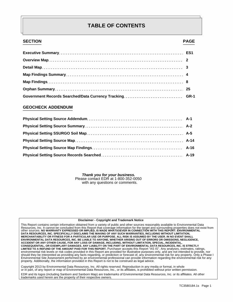
TABLE OF CONTENTS
EXECUTIVE SUMMARY
TC3580184.1s EXECUTIVE SUMMARY 1
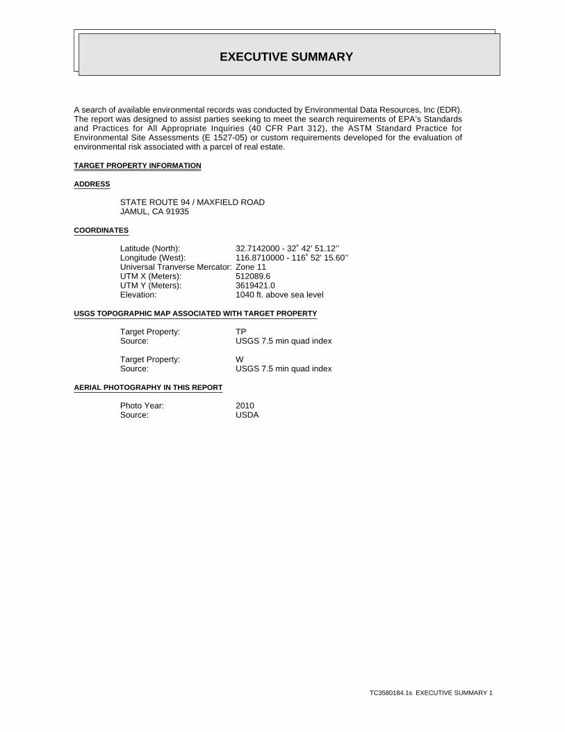
A search of available environmental records was conducted by Environmental Data Resources, Inc (EDR).The report was designed to assist parties seeking to meet the search requirements of EPA’s Standardsand Practices for All Appropriate Inquiries (40 CFR Part 312), the ASTM Standard Practice forEnvironmental Site Assessments (E 1527-05) or custom requirements developed for the evaluation ofenvironmental risk associated with a parcel of real estate.
TARGET PROPERTY INFORMATION
ADDRESS
STATE ROUTE 94 / MAXFIELD ROADJAMUL, CA 91935
COORDINATES
32.7142000 - 32˚ 42’ 51.12’’Latitude (North): 116.8710000 - 116˚ 52’ 15.60’’Longitude (West): Zone 11Universal Tranverse Mercator: 512089.6UTM X (Meters): 3619421.0UTM Y (Meters): 1040 ft. above sea levelElevation:
USGS TOPOGRAPHIC MAP ASSOCIATED WITH TARGET PROPERTY
TP Target Property:USGS 7.5 min quad indexSource:
W Target Property:USGS 7.5 min quad indexSource:
AERIAL PHOTOGRAPHY IN THIS REPORT
2010Photo Year:USDASource:

3580184.1s Page 2
2 RAUL RODRIQUEZ 13886 CAMPO RD HIST CORTESE, SWRCY, LUST, AST, SWEEPS UST, San... Lower 2021, WNW
1 13975 CAMPO RD EDR US Hist Auto Stat Higher 272, South
MAPPED SITES SUMMARY
Target Property Address:STATE ROUTE 94 / MAXFIELD ROADJAMUL, CA 91935
Click on Map ID to see full detail.
MAP RELATIVE DIST (ft.)ID DATABASE ACRONYMS ELEVATION DIRECTIONSITE NAME ADDRESS
EXECUTIVE SUMMARY
TC3580184.1s EXECUTIVE SUMMARY 3
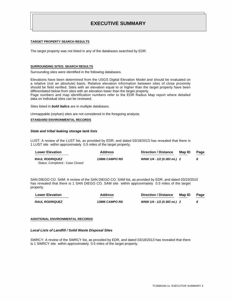
TARGET PROPERTY SEARCH RESULTS
The target property was not listed in any of the databases searched by EDR.
SURROUNDING SITES: SEARCH RESULTS
Surrounding sites were identified in the following databases.
Elevations have been determined from the USGS Digital Elevation Model and should be evaluated ona relative (not an absolute) basis. Relative elevation information between sites of close proximityshould be field verified. Sites with an elevation equal to or higher than the target property have beendifferentiated below from sites with an elevation lower than the target property.Page numbers and map identification numbers refer to the EDR Radius Map report where detaileddata on individual sites can be reviewed.
Sites listed in bold italics are in multiple databases.
Unmappable (orphan) sites are not considered in the foregoing analysis.
STANDARD ENVIRONMENTAL RECORDS
State and tribal leaking storage tank lists
LUST: A review of the LUST list, as provided by EDR, and dated 03/18/2013 has revealed that there is1 LUST site within approximately 0.5 miles of the target property.
PageMap IDDirection / Distance Address Lower Elevation ____________________ ________ ___________________ _____ _____
RAUL RODRIQUEZ 13886 CAMPO RD WNW 1/4 - 1/2 (0.383 mi.) 2 8Status: Completed - Case Closed
SAN DIEGO CO. SAM: A review of the SAN DIEGO CO. SAM list, as provided by EDR, and dated 03/23/2010has revealed that there is 1 SAN DIEGO CO. SAM site within approximately 0.5 miles of the targetproperty.
PageMap IDDirection / Distance Address Lower Elevation ____________________ ________ ___________________ _____ _____
RAUL RODRIQUEZ 13886 CAMPO RD WNW 1/4 - 1/2 (0.383 mi.) 2 8
ADDITIONAL ENVIRONMENTAL RECORDS
Local Lists of Landfill / Solid Waste Disposal Sites
SWRCY: A review of the SWRCY list, as provided by EDR, and dated 03/18/2013 has revealed that thereis 1 SWRCY site within approximately 0.5 miles of the target property.
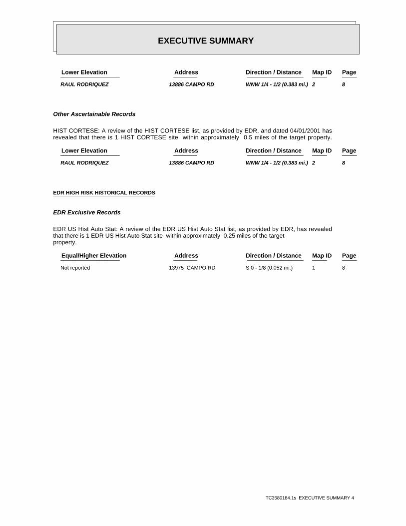
EXECUTIVE SUMMARY
TC3580184.1s EXECUTIVE SUMMARY 4
PageMap IDDirection / Distance Address Lower Elevation ____________________ ________ ___________________ _____ _____
RAUL RODRIQUEZ 13886 CAMPO RD WNW 1/4 - 1/2 (0.383 mi.) 2 8
Other Ascertainable Records
HIST CORTESE: A review of the HIST CORTESE list, as provided by EDR, and dated 04/01/2001 hasrevealed that there is 1 HIST CORTESE site within approximately 0.5 miles of the target property.
PageMap IDDirection / Distance Address Lower Elevation ____________________ ________ ___________________ _____ _____
RAUL RODRIQUEZ 13886 CAMPO RD WNW 1/4 - 1/2 (0.383 mi.) 2 8
EDR HIGH RISK HISTORICAL RECORDS
EDR Exclusive Records
EDR US Hist Auto Stat: A review of the EDR US Hist Auto Stat list, as provided by EDR, has revealedthat there is 1 EDR US Hist Auto Stat site within approximately 0.25 miles of the targetproperty.
PageMap IDDirection / Distance Address Equal/Higher Elevation ____________________ ________ ___________________ _____ _____
Not reported 13975 CAMPO RD S 0 - 1/8 (0.052 mi.) 1 8

ED
R Inc.
ED
R Inc.
ED
R Inc.
ED
R Inc.
ED
R Inc.
ED
R Inc.
ED
R Inc.
ED
R Inc.
ED
R Inc.
ED
R Inc.
ED
R Inc.
ED
R Inc.
ED
R Inc.
ED
R Inc.
ED
R Inc.
ED
R Inc.
ED
R Inc.
ED
R Inc.
ED
R Inc.
ED
R Inc.
ED
R Inc.
ED
R Inc.
ED
R Inc.
ED
R Inc.
ED
R Inc.
ED
R Inc.
ED
R Inc.
ED
R Inc.
ED
R Inc.
ED
R Inc.
ED
R Inc.
ED
R Inc.
ED
R Inc.
ED
R Inc.
ED
R Inc.
ED
R Inc.
ED
R Inc.
ED
R Inc.
ED
R Inc.
ED
R Inc.
ORPHAN SUMMARY
City EDR ID Site Name Site Address Zip Database(s)
Count: 33 records.
JAMUL S108407201 RANCHO MIGUEL ESTATES JAMACHA RD/STEELE CY 91935 SAN DIEGO CO. SAMJAMUL S105155612 JAMUL BURNSITE JAMUL DR SWF/LFJAMUL S106916126 RANCHO MIGUEL ESTATES NONE JAMACHA RD & STEELE CY 91935 SLICJAMUL S106928537 LAS MONTANAS GOLF COURSE VISTA RANCHO MIGUEL RD 91935 SWEEPS USTJAMUL S109521465 PEACEFUL VALLEY RANCH ZERO PEACEFUL VALLEY RNCH & H 91935 SLICSAN DIEGO COUNTY A100345749 FLEET TRAINING CENTER (TENANT ON NAVAL STATION) ASTSAN DIEGO COUNTY A100346114 SHORE INTERMEDIATE MAINTENANCE (TENANT) ASTSAN DIEGO COUNTY M300002614 AZTEC PERLITE CO INC AZTEC ESCONDIDO PLANT US MINESSAN DIEGO COUNTY M300003197 MUHT-HEI, INC. CAMPO MATERIALS PIT US MINESSAN DIEGO COUNTY M300003189 VULCAN MATERIALS CO. CARROLL CANYON (#026) US MINESSAN DIEGO COUNTY M300002765 WESTERN SALT CO CHULA VISTA PLANT US MINESSAN DIEGO COUNTY M300002489 WESTERN SALT CO CHULA VISTA PLANT US MINESSAN DIEGO COUNTY M300002124 REED OPERATION ELIZABETH R MINE US MINESSAN DIEGO COUNTY M300003196 ENNISS ENTERPRISES, INC. ENNISS LAKESIDE PLANT US MINESSAN DIEGO COUNTY M300002616 HARBORLITE CORP HARBORLITE ESCONDIDO PLANT US MINESSAN DIEGO COUNTY M300003188 C. W. MCGRATH, INC. HILLSDALE GRANITE PIT US MINESSAN DIEGO COUNTY M300002123 PALA INTERNATIONAL HIMALAYA MINE US MINESSAN DIEGO COUNTY M300002119 HIGH DESSERT GEMS AND MINERALS HIMALAYA MINE CALIF US MINESSAN DIEGO COUNTY S112265074 LOOP ROAD CG 4530 INTERSECTION OF ALTA ROAD AND ENFSAN DIEGO COUNTY M300003199 CW MCGRATH LAKESIDE SAND PIT US MINESSAN DIEGO COUNTY M300006415 SUPERIOR READY MIX CONCRETE CO. MINE #1 US MINESSAN DIEGO COUNTY M300003190 VULCAN MATERIALS CO. MISSION VALLEY (#022) US MINESSAN DIEGO COUNTY M300003187 SUPERIOR READY MIX CONCRETE CO. MISSION GORGE PLANT US MINESSAN DIEGO COUNTY M300001892 NATIONAL QUARRIES LLC NATIONAL QUARRIES US MINESSAN DIEGO COUNTY M300003193 NELSON & SLOAN CO. OTAY PIT & MILL US MINESSAN DIEGO COUNTY M300002121 JIM MEANS PACKRAT MINES US MINESSAN DIEGO COUNTY M300003191 VULCAN MATERIALS CO. PALA (#023) US MINESSAN DIEGO COUNTY M300003184 SIM J. HARRIS PALA SAND PLANT US MINESSAN DIEGO COUNTY M300003186 RCP BLOCK & BRICK, INC. RCP SAND PLANT US MINESSAN DIEGO COUNTY M300003198 SUPERIOR ROCK PRODUCTS, INC. SAND & GRAVEL OPERATIONS US MINESSAN DIEGO COUNTY M300003195 VULCAN MATERIALS CO. SLOAN CANYON SAND CO. (#027) US MINESSAN DIEGO COUNTY M300002122 MILLENNIUM INC STEWART LITHIA MINE US MINESSAN DIEGO COUNTY M300002125 SOUTHERN CA GEM INDUSTRIES TOURMALINE QUEEN MINE US MINES
TC3580184.1s Page 25

EDR Inc.EDR Inc.EDR Inc.EDR Inc.EDR Inc.EDR Inc.EDR Inc.EDR Inc.EDR Inc.EDR Inc.EDR Inc.EDR Inc.EDR Inc.EDR Inc.EDR Inc.EDR Inc.EDR Inc.EDR Inc.EDR Inc.EDR Inc.EDR Inc.EDR Inc.EDR Inc.EDR Inc.EDR Inc.EDR Inc.EDR Inc.EDR Inc.EDR Inc.EDR Inc.EDR Inc.EDR Inc.EDR Inc.EDR Inc.EDR Inc.EDR Inc.EDR Inc.EDR Inc.EDR Inc.EDR Inc.
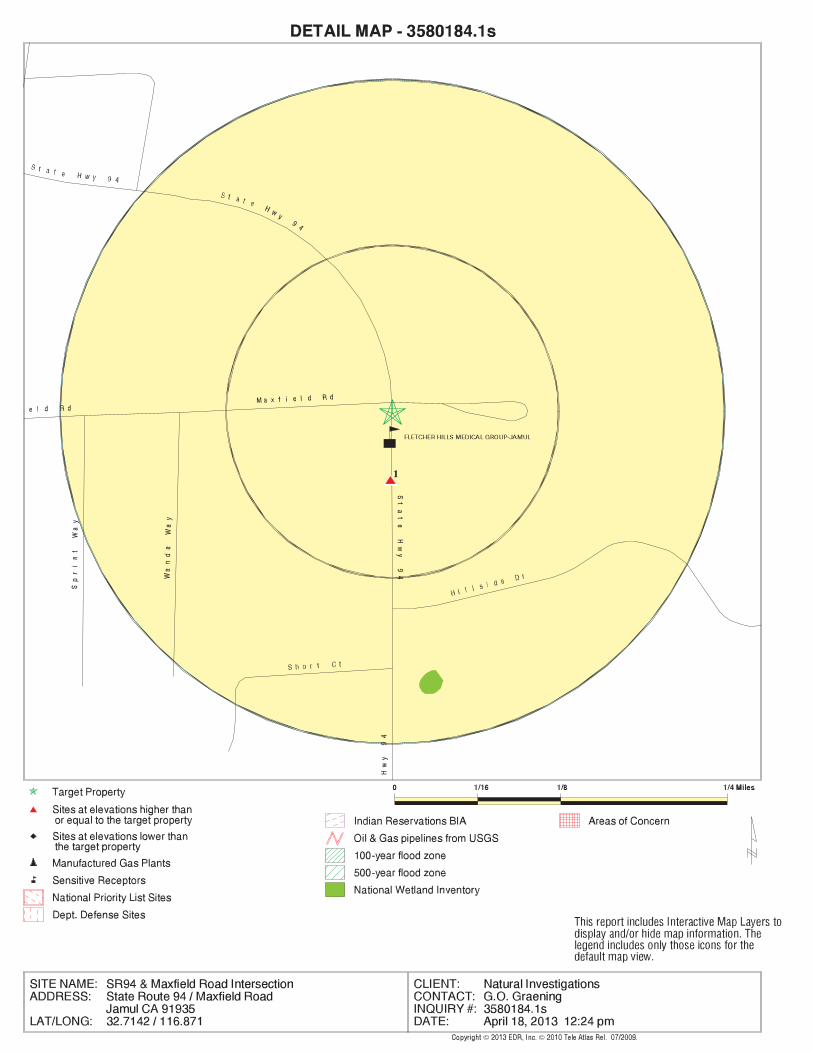
EDR Inc.EDR Inc.EDR Inc.EDR Inc.EDR Inc.EDR Inc.EDR Inc.EDR Inc.EDR Inc.EDR Inc.EDR Inc.EDR Inc.EDR Inc.EDR Inc.EDR Inc.EDR Inc.EDR Inc.EDR Inc.EDR Inc.EDR Inc.EDR Inc.EDR Inc.EDR Inc.EDR Inc.EDR Inc.EDR Inc.EDR Inc.EDR Inc.EDR Inc.EDR Inc.EDR Inc.EDR Inc.EDR Inc.EDR Inc.EDR Inc.EDR Inc.EDR Inc.EDR Inc.EDR Inc.EDR Inc.

EDR Inc.EDR Inc.EDR Inc.EDR Inc.EDR Inc.EDR Inc.EDR Inc.EDR Inc.EDR Inc.EDR Inc.EDR Inc.EDR Inc.EDR Inc.EDR Inc.EDR Inc.EDR Inc.EDR Inc.EDR Inc.EDR Inc.EDR Inc.EDR Inc.EDR Inc.EDR Inc.EDR Inc.EDR Inc.EDR Inc.EDR Inc.EDR Inc.EDR Inc.EDR Inc.EDR Inc.EDR Inc.EDR Inc.EDR Inc.EDR Inc.EDR Inc.EDR Inc.EDR Inc.EDR Inc.EDR Inc.
MAP FINDINGS SUMMARY
SearchTargetDistance Total
Database Property(Miles) < 1/8 1/8 - 1/4 1/4 - 1/2 1/2 - 1 > 1 Plotted
STANDARD ENVIRONMENTAL RECORDS
Federal NPL site list
0 NR 0 0 0 0 1.000NPL 0 NR 0 0 0 0 1.000Proposed NPL 0 NR NR NR NR NR TPNPL LIENS
Federal Delisted NPL site list
0 NR 0 0 0 0 1.000Delisted NPL
Federal CERCLIS list
0 NR NR 0 0 0 0.500CERCLIS 0 NR NR 0 0 0 0.500FEDERAL FACILITY
Federal CERCLIS NFRAP site List
0 NR NR 0 0 0 0.500CERC-NFRAP
Federal RCRA CORRACTS facilities list
0 NR 0 0 0 0 1.000CORRACTS
Federal RCRA non-CORRACTS TSD facilities list
0 NR NR 0 0 0 0.500RCRA-TSDF
Federal RCRA generators list
0 NR NR NR 0 0 0.250RCRA-LQG 0 NR NR NR 0 0 0.250RCRA-SQG 0 NR NR NR 0 0 0.250RCRA-CESQG
Federal institutional controls /engineering controls registries
0 NR NR 0 0 0 0.500US ENG CONTROLS 0 NR NR 0 0 0 0.500US INST CONTROL 0 NR NR 0 0 0 0.500LUCIS
Federal ERNS list
0 NR NR NR NR NR TPERNS
State- and tribal - equivalent NPL
0 NR 0 0 0 0 1.000RESPONSE
State- and tribal - equivalent CERCLIS
0 NR 0 0 0 0 1.000ENVIROSTOR
State and tribal landfill and/orsolid waste disposal site lists
0 NR NR 0 0 0 0.500SWF/LF
State and tribal leaking storage tank lists
1 NR NR 1 0 0 0.500LUST
TC3580184.1s Page 4

MAP FINDINGS SUMMARY
SearchTargetDistance Total
Database Property(Miles) < 1/8 1/8 - 1/4 1/4 - 1/2 1/2 - 1 > 1 Plotted
0 NR NR 0 0 0 0.500SLIC 1 NR NR 1 0 0 0.500SAN DIEGO CO. SAM 0 NR NR 0 0 0 0.500INDIAN LUST
State and tribal registered storage tank lists
0 NR NR NR 0 0 0.250UST 0 NR NR NR 0 0 0.250AST 0 NR NR NR 0 0 0.250INDIAN UST 0 NR NR NR 0 0 0.250FEMA UST
State and tribal voluntary cleanup sites
0 NR NR 0 0 0 0.500VCP 0 NR NR 0 0 0 0.500INDIAN VCP
ADDITIONAL ENVIRONMENTAL RECORDS
Local Brownfield lists
0 NR NR 0 0 0 0.500US BROWNFIELDS
Local Lists of Landfill / SolidWaste Disposal Sites
0 NR NR 0 0 0 0.500ODI 0 NR NR 0 0 0 0.500DEBRIS REGION 9 0 NR NR 0 0 0 0.500WMUDS/SWAT 1 NR NR 1 0 0 0.500SWRCY 0 NR NR NR NR NR TPHAULERS 0 NR NR 0 0 0 0.500INDIAN ODI
Local Lists of Hazardous waste /Contaminated Sites
0 NR NR NR NR NR TPUS CDL 0 NR 0 0 0 0 1.000HIST Cal-Sites 0 NR NR NR 0 0 0.250SCH 0 NR 0 0 0 0 1.000Toxic Pits 0 NR NR NR NR NR TPCDL 0 NR NR NR NR NR TPSan Diego Co. HMMD 0 NR NR NR NR NR TPUS HIST CDL
Local Lists of Registered Storage Tanks
0 NR NR NR 0 0 0.250CA FID UST 0 NR NR NR 0 0 0.250HIST UST 0 NR NR NR 0 0 0.250SWEEPS UST
Local Land Records
0 NR NR NR NR NR TPLIENS 2 0 NR NR NR NR NR TPLIENS 0 NR NR 0 0 0 0.500DEED
Records of Emergency Release Reports
0 NR NR NR NR NR TPHMIRS
TC3580184.1s Page 5
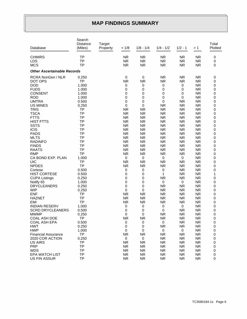
MAP FINDINGS SUMMARY
SearchTargetDistance Total
Database Property(Miles) < 1/8 1/8 - 1/4 1/4 - 1/2 1/2 - 1 > 1 Plotted
0 NR NR NR NR NR TPCHMIRS 0 NR NR NR NR NR TPLDS 0 NR NR NR NR NR TPMCS
Other Ascertainable Records
0 NR NR NR 0 0 0.250RCRA NonGen / NLR 0 NR NR NR NR NR TPDOT OPS 0 NR 0 0 0 0 1.000DOD 0 NR 0 0 0 0 1.000FUDS 0 NR 0 0 0 0 1.000CONSENT 0 NR 0 0 0 0 1.000ROD 0 NR NR 0 0 0 0.500UMTRA 0 NR NR NR 0 0 0.250US MINES 0 NR NR NR NR NR TPTRIS 0 NR NR NR NR NR TPTSCA 0 NR NR NR NR NR TPFTTS 0 NR NR NR NR NR TPHIST FTTS 0 NR NR NR NR NR TPSSTS 0 NR NR NR NR NR TPICIS 0 NR NR NR NR NR TPPADS 0 NR NR NR NR NR TPMLTS 0 NR NR NR NR NR TPRADINFO 0 NR NR NR NR NR TPFINDS 0 NR NR NR NR NR TPRAATS 0 NR NR NR NR NR TPRMP 0 NR 0 0 0 0 1.000CA BOND EXP. PLAN 0 NR NR NR NR NR TPUIC 0 NR NR NR NR NR TPNPDES 0 NR NR 0 0 0 0.500Cortese 1 NR NR 1 0 0 0.500HIST CORTESE 0 NR NR NR 0 0 0.250CUPA Listings 0 NR 0 0 0 0 1.000Notify 65 0 NR NR NR 0 0 0.250DRYCLEANERS 0 NR NR NR 0 0 0.250WIP 0 NR NR NR NR NR TPENF 0 NR NR NR NR NR TPHAZNET 0 NR NR NR NR NR TPEMI 0 NR 0 0 0 0 1.000INDIAN RESERV 0 NR NR 0 0 0 0.500SCRD DRYCLEANERS 0 NR NR NR 0 0 0.250MWMP 0 NR NR NR NR NR TPCOAL ASH DOE 0 NR NR 0 0 0 0.500COAL ASH EPA 0 NR NR NR 0 0 0.250HWT 0 NR 0 0 0 0 1.000HWP 0 NR NR NR NR NR TPFinancial Assurance 0 NR NR NR 0 0 0.2502020 COR ACTION 0 NR NR NR NR NR TPUS AIRS 0 NR NR NR NR NR TPPRP 0 NR NR NR NR NR TPWDS 0 NR NR NR NR NR TPEPA WATCH LIST 0 NR NR NR NR NR TPUS FIN ASSUR
TC3580184.1s Page 6
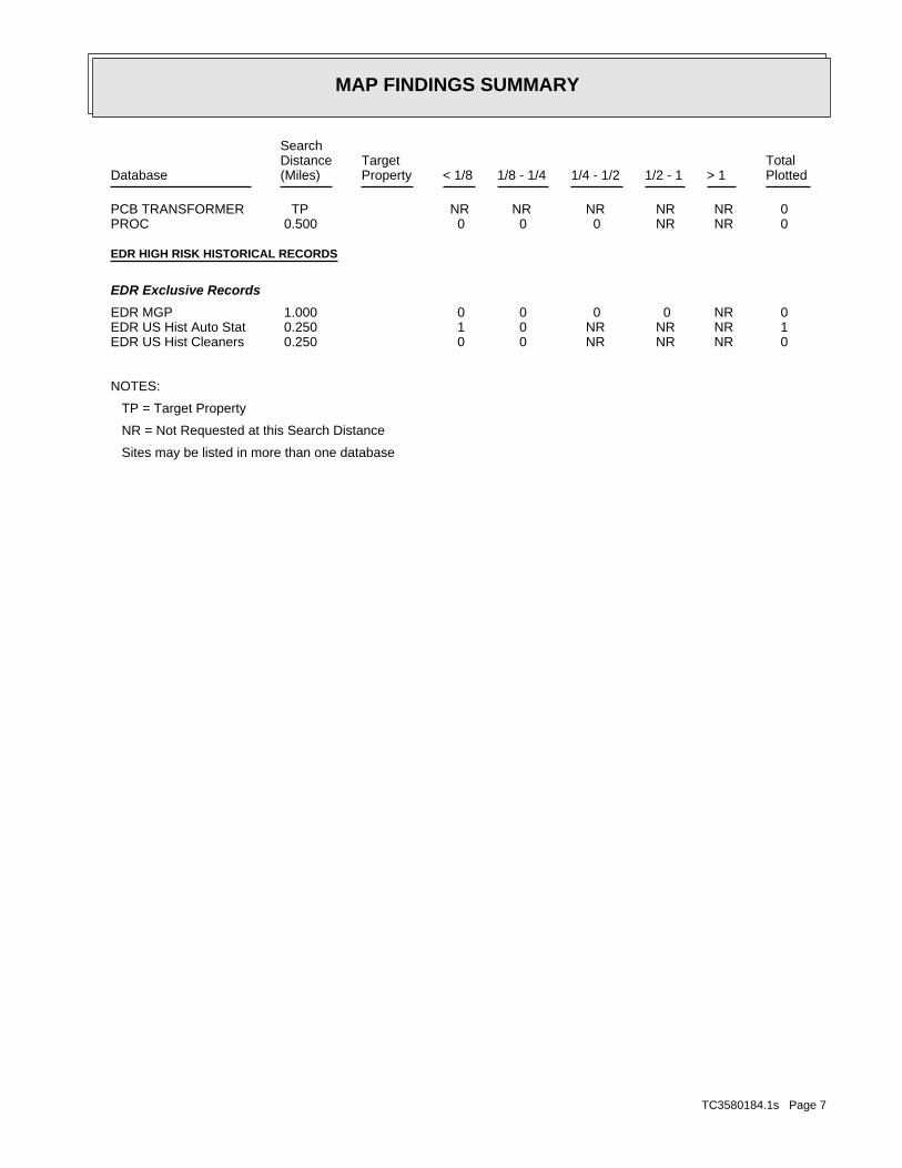
MAP FINDINGS SUMMARY
SearchTargetDistance Total
Database Property(Miles) < 1/8 1/8 - 1/4 1/4 - 1/2 1/2 - 1 > 1 Plotted
0 NR NR NR NR NR TPPCB TRANSFORMER 0 NR NR 0 0 0 0.500PROC
EDR HIGH RISK HISTORICAL RECORDS
EDR Exclusive Records
0 NR 0 0 0 0 1.000EDR MGP 1 NR NR NR 0 1 0.250EDR US Hist Auto Stat 0 NR NR NR 0 0 0.250EDR US Hist Cleaners
NOTES:
TP = Target Property
NR = Not Requested at this Search Distance
Sites may be listed in more than one database
TC3580184.1s Page 7
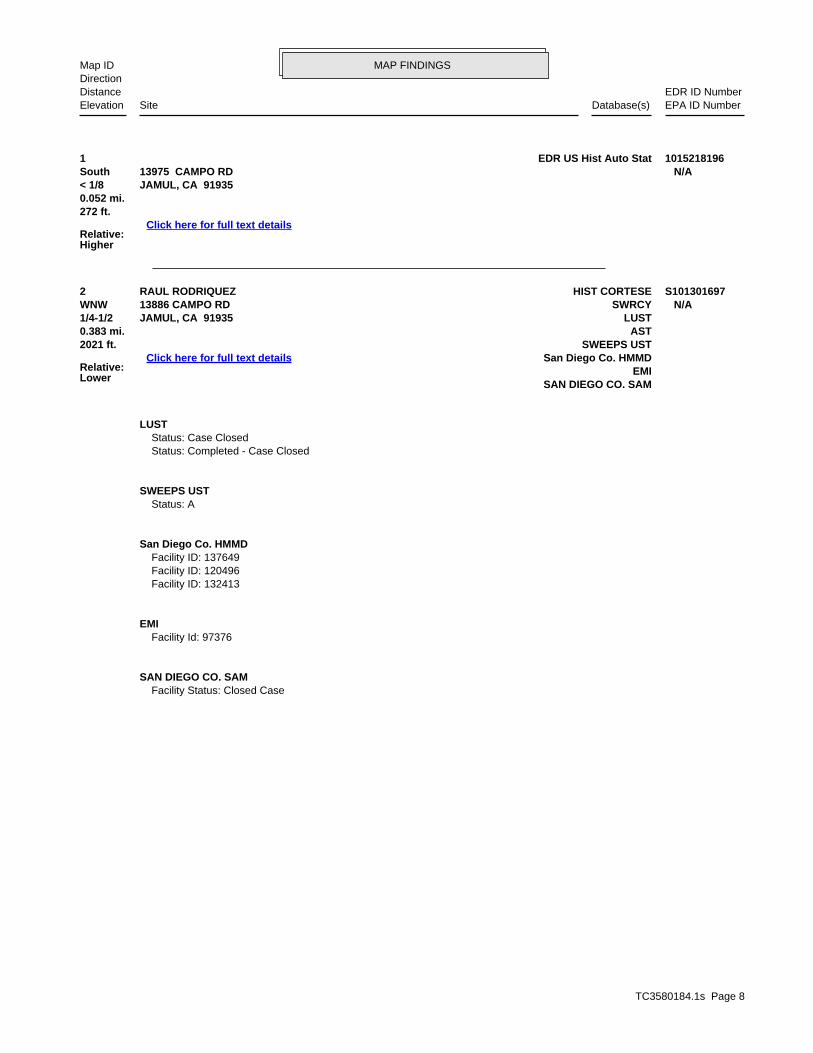
TC3580184.1s Page 8
2 HIST CORTESERAUL RODRIQUEZ S101301697WNW SWRCY13886 CAMPO RD N/A1/4-1/2 LUSTJAMUL, CA 91935
Relative:Lower
Click here for full text details
0.383 mi. AST2021 ft. SWEEPS UST
San Diego Co. HMMDEMI
SAN DIEGO CO. SAM
LUST Status: Case Closed Status: Completed - Case Closed
SWEEPS UST Status: A
San Diego Co. HMMD Facility ID: 137649 Facility ID: 120496 Facility ID: 132413
EMI Facility Id: 97376
SAN DIEGO CO. SAM Facility Status: Closed Case
1 EDR US Hist Auto Stat 1015218196South 13975 CAMPO RD N/A< 1/8 JAMUL, CA 91935
Relative:Higher
Click here for full text details
0.052 mi.272 ft.
MAP FINDINGSMap IDDirection
EDR ID NumberDistanceEPA ID NumberDatabase(s)SiteElevation

ED
R Inc.
ED
R Inc.
ED
R Inc.
ED
R Inc.
ED
R Inc.
ED
R Inc.
ED
R Inc.
ED
R Inc.
ED
R Inc.
ED
R Inc.
ED
R Inc.
ED
R Inc.
ED
R Inc.
ED
R Inc.
ED
R Inc.
ED
R Inc.
ED
R Inc.
ED
R Inc.
ED
R Inc.
ED
R Inc.
ED
R Inc.
ED
R Inc.
ED
R Inc.
ED
R Inc.
ED
R Inc.
ED
R Inc.
ED
R Inc.
ED
R Inc.
ED
R Inc.
ED
R Inc.
ED
R Inc.
ED
R Inc.
ED
R Inc.
ED
R Inc.
ED
R Inc.
ED
R Inc.
ED
R Inc.
ED
R Inc.
ED
R Inc.
ED
R Inc.
ED
R Inc.
ED
R Inc.
ED
R Inc.
ED
R Inc.
ED
R Inc.
ED
R Inc.
ED
R Inc.
ED
R Inc.
ED
R Inc.
ED
R Inc.
ED
R Inc.
ED
R Inc.
ED
R Inc.
ED
R Inc.
ED
R Inc.
ED
R Inc.
ED
R Inc.
ED
R Inc.
ED
R Inc.
ED
R Inc.
ED
R Inc.
ED
R Inc.
ED
R Inc.
ED
R Inc.
ED
R Inc.
ED
R Inc.
ED
R Inc.
ED
R Inc.
ED
R Inc.
ED
R Inc.
ED
R Inc.
ED
R Inc.
ED
R Inc.
ED
R Inc.
ED
R Inc.
ED
R Inc.
ED
R Inc.
ED
R Inc.
ED
R Inc.
ED
R Inc.
CA AST Aboveground Petroleum Storage Tank Facilities State Water Resources Control Board 08/01/2009 09/10/2009 10/01/2009CA CA BOND EXP. PLAN Bond Expenditure Plan Department of Health Services 01/01/1989 07/27/1994 08/02/1994CA CA FID UST Facility Inventory Database California Environmental Protection Agency 10/31/1994 09/05/1995 09/29/1995CA CDL Clandestine Drug Labs Department of Toxic Substances Control 06/30/2012 09/12/2012 10/03/2012CA CHMIRS California Hazardous Material Incident Report System Office of Emergency Services 12/06/2012 01/29/2013 03/19/2013CA CORTESE "Cortese" Hazardous Waste & Substances Sites List CAL EPA/Office of Emergency Information 01/02/2013 01/03/2013 02/22/2013CA DEED Deed Restriction Listing Department of Toxic Substances Control 03/11/2013 03/12/2013 03/25/2013CA DRYCLEANERS Cleaner Facilities Department of Toxic Substance Control 12/11/2012 12/12/2012 01/04/2013CA EMI Emissions Inventory Data California Air Resources Board 12/31/2008 09/29/2010 10/18/2010CA ENF Enforcement Action Listing State Water Resoruces Control Board 01/08/2013 01/29/2013 03/19/2013CA ENVIROSTOR EnviroStor Database Department of Toxic Substances Control 03/13/2013 03/14/2013 03/27/2013CA Financial Assurance 1 Financial Assurance Information Listing Department of Toxic Substances Control 03/01/2007 06/01/2007 06/29/2007CA Financial Assurance 2 Financial Assurance Information Listing California Integrated Waste Management Board 02/19/2013 02/20/2013 03/20/2013CA HAULERS Registered Waste Tire Haulers Listing Integrated Waste Management Board 03/13/2013 03/14/2013 03/27/2013CA HAZNET Facility and Manifest Data California Environmental Protection Agency 12/31/2011 06/22/2012 07/06/2012CA HIST CAL-SITES Calsites Database Department of Toxic Substance Control 08/08/2005 08/03/2006 08/24/2006CA HIST CORTESE Hazardous Waste & Substance Site List Department of Toxic Substances Control 04/01/2001 01/22/2009 04/08/2009CA HIST UST Hazardous Substance Storage Container Database State Water Resources Control Board 10/15/1990 01/25/1991 02/12/1991CA HWP EnviroStor Permitted Facilities Listing Department of Toxic Substances Control 02/25/2013 02/26/2013 03/25/2013CA HWT Registered Hazardous Waste Transporter Database Department of Toxic Substances Control 01/15/2013 01/15/2013 02/22/2013CA LDS Land Disposal Sites Listing State Water Qualilty Control Board 03/18/2013 03/19/2013 03/27/2013CA LIENS Environmental Liens Listing Department of Toxic Substances Control 03/15/2013 03/15/2013 03/27/2013CA LUST Geotracker’s Leaking Underground Fuel Tank Report State Water Resources Control Board 03/18/2013 03/19/2013 03/27/2013CA LUST REG 1 Active Toxic Site Investigation California Regional Water Quality Control Boa 02/01/2001 02/28/2001 03/29/2001CA LUST REG 2 Fuel Leak List California Regional Water Quality Control Boa 09/30/2004 10/20/2004 11/19/2004CA LUST REG 3 Leaking Underground Storage Tank Database California Regional Water Quality Control Boa 05/19/2003 05/19/2003 06/02/2003CA LUST REG 4 Underground Storage Tank Leak List California Regional Water Quality Control Boa 09/07/2004 09/07/2004 10/12/2004CA LUST REG 5 Leaking Underground Storage Tank Database California Regional Water Quality Control Boa 07/01/2008 07/22/2008 07/31/2008CA LUST REG 6L Leaking Underground Storage Tank Case Listing California Regional Water Quality Control Boa 09/09/2003 09/10/2003 10/07/2003CA LUST REG 6V Leaking Underground Storage Tank Case Listing California Regional Water Quality Control Boa 06/07/2005 06/07/2005 06/29/2005CA LUST REG 7 Leaking Underground Storage Tank Case Listing California Regional Water Quality Control Boa 02/26/2004 02/26/2004 03/24/2004CA LUST REG 8 Leaking Underground Storage Tanks California Regional Water Quality Control Boa 02/14/2005 02/15/2005 03/28/2005CA LUST REG 9 Leaking Underground Storage Tank Report California Regional Water Quality Control Boa 03/01/2001 04/23/2001 05/21/2001CA MCS Military Cleanup Sites Listing State Water Resources Control Board 03/18/2013 03/19/2013 03/27/2013CA MWMP Medical Waste Management Program Listing Department of Public Health 03/06/2013 03/12/2013 03/25/2013CA NOTIFY 65 Proposition 65 Records State Water Resources Control Board 10/21/1993 11/01/1993 11/19/1993CA NPDES NPDES Permits Listing State Water Resources Control Board 02/18/2013 02/18/2013 03/20/2013CA PROC Certified Processors Database Department of Conservation 03/18/2013 03/19/2013 03/27/2013CA RESPONSE State Response Sites Department of Toxic Substances Control 03/13/2013 03/14/2013 03/27/2013CA SCH School Property Evaluation Program Department of Toxic Substances Control 03/13/2013 03/14/2013 03/27/2013CA SLIC Statewide SLIC Cases State Water Resources Control Board 03/18/2013 03/19/2013 03/27/2013CA SLIC REG 1 Active Toxic Site Investigations California Regional Water Quality Control Boa 04/03/2003 04/07/2003 04/25/2003CA SLIC REG 2 Spills, Leaks, Investigation & Cleanup Cost Recovery Listing Regional Water Quality Control Board San Fran 09/30/2004 10/20/2004 11/19/2004CA SLIC REG 3 Spills, Leaks, Investigation & Cleanup Cost Recovery Listing California Regional Water Quality Control Boa 05/18/2006 05/18/2006 06/15/2006CA SLIC REG 4 Spills, Leaks, Investigation & Cleanup Cost Recovery Listing Region Water Quality Control Board Los Angele 11/17/2004 11/18/2004 01/04/2005CA SLIC REG 5 Spills, Leaks, Investigation & Cleanup Cost Recovery Listing Regional Water Quality Control Board Central 04/01/2005 04/05/2005 04/21/2005CA SLIC REG 6L SLIC Sites California Regional Water Quality Control Boa 09/07/2004 09/07/2004 10/12/2004
TC3580184.1s Page GR-1
GOVERNMENT RECORDS SEARCHED / DATA CURRENCY TRACKING
St Acronym Full Name Government Agency Gov Date Arvl. Date Active Date

CA SLIC REG 6V Spills, Leaks, Investigation & Cleanup Cost Recovery Listing Regional Water Quality Control Board, Victorv 05/24/2005 05/25/2005 06/16/2005CA SLIC REG 7 SLIC List California Regional Quality Control Board, Co 11/24/2004 11/29/2004 01/04/2005CA SLIC REG 8 Spills, Leaks, Investigation & Cleanup Cost Recovery Listing California Region Water Quality Control Board 04/03/2008 04/03/2008 04/14/2008CA SLIC REG 9 Spills, Leaks, Investigation & Cleanup Cost Recovery Listing California Regional Water Quality Control Boa 09/10/2007 09/11/2007 09/28/2007CA SWEEPS UST SWEEPS UST Listing State Water Resources Control Board 06/01/1994 07/07/2005 08/11/2005CA SWF/LF (SWIS) Solid Waste Information System Department of Resources Recycling and Recover 02/18/2013 02/18/2013 03/20/2013CA SWRCY Recycler Database Department of Conservation 03/18/2013 03/19/2013 03/27/2013CA TOXIC PITS Toxic Pits Cleanup Act Sites State Water Resources Control Board 07/01/1995 08/30/1995 09/26/1995CA UIC UIC Listing Deaprtment of Conservation 03/05/2013 03/19/2013 03/27/2013CA UST Active UST Facilities SWRCB 03/18/2013 03/19/2013 04/18/2013CA UST MENDOCINO Mendocino County UST Database Department of Public Health 09/23/2009 09/23/2009 10/01/2009CA VCP Voluntary Cleanup Program Properties Department of Toxic Substances Control 03/13/2013 03/14/2013 03/27/2013CA WDS Waste Discharge System State Water Resources Control Board 06/19/2007 06/20/2007 06/29/2007CA WIP Well Investigation Program Case List Los Angeles Water Quality Control Board 07/03/2009 07/21/2009 08/03/2009CA WMUDS/SWAT Waste Management Unit Database State Water Resources Control Board 04/01/2000 04/10/2000 05/10/2000US 2020 COR ACTION 2020 Corrective Action Program List Environmental Protection Agency 11/11/2011 05/18/2012 05/25/2012US BRS Biennial Reporting System EPA/NTIS 12/31/2009 03/01/2011 05/02/2011US CERCLIS Comprehensive Environmental Response, Compensation, and Liab EPA 02/04/2013 03/01/2013 03/13/2013US CERCLIS-NFRAP CERCLIS No Further Remedial Action Planned EPA 02/05/2013 03/01/2013 03/13/2013US COAL ASH DOE Sleam-Electric Plan Operation Data Department of Energy 12/31/2005 08/07/2009 10/22/2009US COAL ASH EPA Coal Combustion Residues Surface Impoundments List Environmental Protection Agency 08/17/2010 01/03/2011 03/21/2011US CONSENT Superfund (CERCLA) Consent Decrees Department of Justice, Consent Decree Library 12/31/2011 01/15/2013 03/13/2013US CORRACTS Corrective Action Report EPA 02/12/2013 02/21/2013 02/27/2013US DEBRIS REGION 9 Torres Martinez Reservation Illegal Dump Site Locations EPA, Region 9 01/12/2009 05/07/2009 09/21/2009US DELISTED NPL National Priority List Deletions EPA 02/01/2013 03/01/2013 03/13/2013US DOD Department of Defense Sites USGS 12/31/2005 11/10/2006 01/11/2007US DOT OPS Incident and Accident Data Department of Transporation, Office of Pipeli 07/31/2012 08/07/2012 09/18/2012US EDR MGP EDR Proprietary Manufactured Gas Plants EDR, Inc.US EDR US Hist Auto Stat EDR Exclusive Historic Gas Stations EDR, Inc.US EDR US Hist Auto Stat EDR Proprietary Historic Gas Stations - ColeUS EDR US Hist Cleaners EDR Proprietary Historic Dry Cleaners - ColeUS EDR US Hist Cleaners EDR Exclusive Historic Dry Cleaners EDR, Inc.US EPA WATCH LIST EPA WATCH LIST Environmental Protection Agency 07/31/2012 08/13/2012 09/18/2012US ERNS Emergency Response Notification System National Response Center, United States Coast 12/31/2012 01/17/2013 02/15/2013US FEDERAL FACILITY Federal Facility Site Information listing Environmental Protection Agency 07/31/2012 10/09/2012 12/20/2012US FEDLAND Federal and Indian Lands U.S. Geological Survey 12/31/2005 02/06/2006 01/11/2007US FEMA UST Underground Storage Tank Listing FEMA 01/01/2010 02/16/2010 04/12/2010US FINDS Facility Index System/Facility Registry System EPA 10/23/2011 12/13/2011 03/01/2012US FTTS FIFRA/ TSCA Tracking System - FIFRA (Federal Insecticide, Fu EPA/Office of Prevention, Pesticides and Toxi 04/09/2009 04/16/2009 05/11/2009US FTTS INSP FIFRA/ TSCA Tracking System - FIFRA (Federal Insecticide, Fu EPA 04/09/2009 04/16/2009 05/11/2009US FUDS Formerly Used Defense Sites U.S. Army Corps of Engineers 12/31/2011 02/26/2013 03/13/2013US HIST FTTS FIFRA/TSCA Tracking System Administrative Case Listing Environmental Protection Agency 10/19/2006 03/01/2007 04/10/2007US HIST FTTS INSP FIFRA/TSCA Tracking System Inspection & Enforcement Case Lis Environmental Protection Agency 10/19/2006 03/01/2007 04/10/2007US HMIRS Hazardous Materials Information Reporting System U.S. Department of Transportation 12/31/2012 01/03/2013 02/27/2013US ICIS Integrated Compliance Information System Environmental Protection Agency 07/20/2011 11/10/2011 01/10/2012US INDIAN LUST R1 Leaking Underground Storage Tanks on Indian Land EPA Region 1 09/28/2012 11/01/2012 04/12/2013US INDIAN LUST R10 Leaking Underground Storage Tanks on Indian Land EPA Region 10 02/05/2013 02/06/2013 04/12/2013
TC3580184.1s Page GR-2
GOVERNMENT RECORDS SEARCHED / DATA CURRENCY TRACKING
St Acronym Full Name Government Agency Gov Date Arvl. Date Active Date
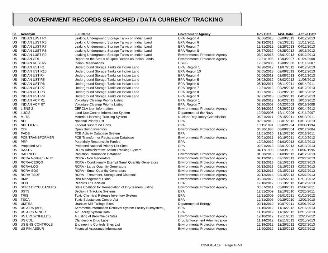
US INDIAN LUST R4 Leaking Underground Storage Tanks on Indian Land EPA Region 4 02/06/2013 02/08/2013 04/12/2013US INDIAN LUST R6 Leaking Underground Storage Tanks on Indian Land EPA Region 6 09/12/2011 09/13/2011 11/11/2011US INDIAN LUST R7 Leaking Underground Storage Tanks on Indian Land EPA Region 7 12/31/2012 02/28/2013 04/12/2013US INDIAN LUST R8 Leaking Underground Storage Tanks on Indian Land EPA Region 8 08/27/2012 08/28/2012 10/16/2012US INDIAN LUST R9 Leaking Underground Storage Tanks on Indian Land Environmental Protection Agency 03/01/2013 03/01/2013 04/12/2013US INDIAN ODI Report on the Status of Open Dumps on Indian Lands Environmental Protection Agency 12/31/1998 12/03/2007 01/24/2008US INDIAN RESERV Indian Reservations USGS 12/31/2005 12/08/2006 01/11/2007US INDIAN UST R1 Underground Storage Tanks on Indian Land EPA, Region 1 09/28/2012 11/07/2012 04/12/2013US INDIAN UST R10 Underground Storage Tanks on Indian Land EPA Region 10 02/05/2013 02/06/2013 04/12/2013US INDIAN UST R4 Underground Storage Tanks on Indian Land EPA Region 4 02/06/2013 02/08/2013 04/12/2013US INDIAN UST R5 Underground Storage Tanks on Indian Land EPA Region 5 08/02/2012 08/03/2012 11/05/2012US INDIAN UST R6 Underground Storage Tanks on Indian Land EPA Region 6 05/10/2011 05/11/2011 06/14/2011US INDIAN UST R7 Underground Storage Tanks on Indian Land EPA Region 7 12/31/2012 02/28/2013 04/12/2013US INDIAN UST R8 Underground Storage Tanks on Indian Land EPA Region 8 08/27/2012 08/28/2012 10/16/2012US INDIAN UST R9 Underground Storage Tanks on Indian Land EPA Region 9 02/21/2013 02/26/2013 04/12/2013US INDIAN VCP R1 Voluntary Cleanup Priority Listing EPA, Region 1 09/28/2012 10/02/2012 10/16/2012US INDIAN VCP R7 Voluntary Cleanup Priority Lisitng EPA, Region 7 03/20/2008 04/22/2008 05/19/2008US LIENS 2 CERCLA Lien Information Environmental Protection Agency 02/16/2012 03/26/2012 06/14/2012US LUCIS Land Use Control Information System Department of the Navy 12/09/2005 12/11/2006 01/11/2007US MLTS Material Licensing Tracking System Nuclear Regulatory Commission 06/21/2011 07/15/2011 09/13/2011US NPL National Priority List EPA 02/01/2013 03/01/2013 03/13/2013US NPL LIENS Federal Superfund Liens EPA 10/15/1991 02/02/1994 03/30/1994US ODI Open Dump Inventory Environmental Protection Agency 06/30/1985 08/09/2004 09/17/2004US PADS PCB Activity Database System EPA 11/01/2010 11/10/2010 02/16/2011US PCB TRANSFORMER PCB Transformer Registration Database Environmental Protection Agency 02/01/2011 10/19/2011 01/10/2012US PRP Potentially Responsible Parties EPA 12/02/2012 01/03/2013 03/13/2013US Proposed NPL Proposed National Priority List Sites EPA 02/01/2013 03/01/2013 03/13/2013US RAATS RCRA Administrative Action Tracking System EPA 04/17/1995 07/03/1995 08/07/1995US RADINFO Radiation Information Database Environmental Protection Agency 01/08/2013 01/09/2013 04/12/2013US RCRA NonGen / NLR RCRA - Non Generators Environmental Protection Agency 02/12/2013 02/15/2013 02/27/2013US RCRA-CESQG RCRA - Conditionally Exempt Small Quantity Generators Environmental Protection Agency 02/12/2013 02/15/2013 02/27/2013US RCRA-LQG RCRA - Large Quantity Generators Environmental Protection Agency 02/12/2013 02/15/2013 02/27/2013US RCRA-SQG RCRA - Small Quantity Generators Environmental Protection Agency 02/12/2013 02/15/2013 02/27/2013US RCRA-TSDF RCRA - Treatment, Storage and Disposal Environmental Protection Agency 02/12/2013 02/15/2013 02/27/2013US RMP Risk Management Plans Environmental Protection Agency 05/08/2012 05/25/2012 07/10/2012US ROD Records Of Decision EPA 12/18/2012 03/13/2013 04/12/2013US SCRD DRYCLEANERS State Coalition for Remediation of Drycleaners Listing Environmental Protection Agency 03/07/2011 03/09/2011 05/02/2011US SSTS Section 7 Tracking Systems EPA 12/31/2009 12/10/2010 02/25/2011US TRIS Toxic Chemical Release Inventory System EPA 12/31/2009 09/01/2011 01/10/2012US TSCA Toxic Substances Control Act EPA 12/31/2006 09/29/2010 12/02/2010US UMTRA Uranium Mill Tailings Sites Department of Energy 09/14/2010 10/07/2011 03/01/2012US US AIRS (AFS) Aerometric Information Retrieval System Facility Subsystem ( EPA 11/15/2012 11/16/2012 02/15/2013US US AIRS MINOR Air Facility System Data EPA 11/15/2012 11/16/2012 02/15/2013US US BROWNFIELDS A Listing of Brownfields Sites Environmental Protection Agency 12/10/2012 12/11/2012 12/20/2012US US CDL Clandestine Drug Labs Drug Enforcement Administration 11/14/2012 12/11/2012 02/15/2013US US ENG CONTROLS Engineering Controls Sites List Environmental Protection Agency 12/19/2012 12/26/2012 02/27/2013US US FIN ASSUR Financial Assurance Information Environmental Protection Agency 11/20/2012 11/30/2012 02/27/2013
TC3580184.1s Page GR-3
GOVERNMENT RECORDS SEARCHED / DATA CURRENCY TRACKING
St Acronym Full Name Government Agency Gov Date Arvl. Date Active Date
US US HIST CDL National Clandestine Laboratory Register Drug Enforcement Administration 09/01/2007 11/19/2008 03/30/2009US US INST CONTROL Sites with Institutional Controls Environmental Protection Agency 12/19/2012 12/26/2012 02/27/2013US US MINES Mines Master Index File Department of Labor, Mine Safety and Health A 08/18/2011 09/08/2011 09/29/2011
CT CT MANIFEST Hazardous Waste Manifest Data Department of Energy & Environmental Protecti 02/18/2013 02/18/2013 03/21/2013NJ NJ MANIFEST Manifest Information Department of Environmental Protection 12/31/2011 07/19/2012 08/28/2012NY NY MANIFEST Facility and Manifest Data Department of Environmental Conservation 02/01/2013 02/07/2013 03/15/2013PA PA MANIFEST Manifest Information Department of Environmental Protection 12/31/2011 07/23/2012 09/18/2012RI RI MANIFEST Manifest information Department of Environmental Management 12/31/2011 06/22/2012 07/31/2012WI WI MANIFEST Manifest Information Department of Natural Resources 12/31/2011 07/19/2012 09/27/2012
US Oil/Gas Pipelines GeoData Digital Line Graphs from 1:100,000-Scale Maps USGSUS Electric Power Lines Electric Power Transmission Line Data Rextag Strategies Corp.
US AHA Hospitals Sensitive Receptor: AHA Hospitals American Hospital Association, Inc.US Medical Centers Sensitive Receptor: Medical Centers Centers for Medicare & Medicaid ServicesUS Nursing Homes Sensitive Receptor: Nursing Homes National Institutes of HealthUS Public Schools Sensitive Receptor: Public Schools National Center for Education StatisticsUS Private Schools Sensitive Receptor: Private Schools National Center for Education StatisticsCA Daycare Centers Sensitive Receptor: Licensed Facilities Department of Social Services
US Flood Zones 100-year and 500-year flood zones Emergency Management Agency (FEMA)US NWI National Wetlands Inventory U.S. Fish and Wildlife ServiceUS USGS 7.5’ Topographic Map Scanned Digital USGS 7.5’ Topographic Map (DRG) USGS
STREET AND ADDRESS INFORMATION
© 2010 Tele Atlas North America, Inc. All rights reserved. This material is proprietary and the subject of copyright protectionand other intellectual property rights owned by or licensed to Tele Atlas North America, Inc. The use of this material is subjectto the terms of a license agreement. You will be held liable for any unauthorized copying or disclosure of this material.
TC3580184.1s Page GR−4
GOVERNMENT RECORDS SEARCHED / DATA CURRENCY TRACKING
St Acronym Full Name Government Agency Gov Date Arvl. Date Active Date
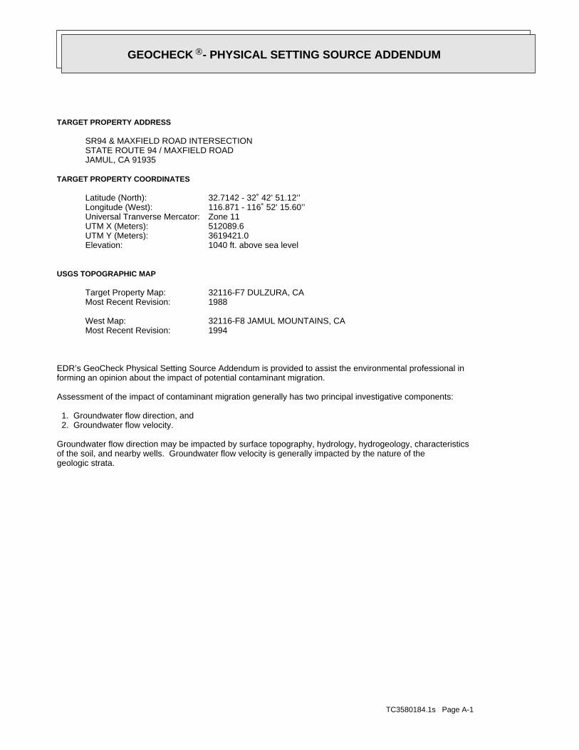
TC3580184.1s Page A-1
geologic strata.of the soil, and nearby wells. Groundwater flow velocity is generally impacted by the nature of theGroundwater flow direction may be impacted by surface topography, hydrology, hydrogeology, characteristics
2. Groundwater flow velocity. 1. Groundwater flow direction, and
Assessment of the impact of contaminant migration generally has two principal investigative components:
forming an opinion about the impact of potential contaminant migration.EDR’s GeoCheck Physical Setting Source Addendum is provided to assist the environmental professional in
1994Most Recent Revision:32116-F8 JAMUL MOUNTAINS, CAWest Map:
1988Most Recent Revision:32116-F7 DULZURA, CATarget Property Map:
USGS TOPOGRAPHIC MAP
1040 ft. above sea levelElevation:3619421.0UTM Y (Meters): 512089.6UTM X (Meters): Zone 11Universal Tranverse Mercator: 116.871 - 116˚ 52’ 15.60’’Longitude (West): 32.7142 - 32˚ 42’ 51.12’’Latitude (North):
TARGET PROPERTY COORDINATES
JAMUL, CA 91935STATE ROUTE 94 / MAXFIELD ROADSR94 & MAXFIELD ROAD INTERSECTION
TARGET PROPERTY ADDRESS
®GEOCHECK - PHYSICAL SETTING SOURCE ADDENDUM®
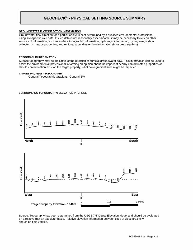
TC3580184.1s Page A-2
should be field verified.on a relative (not an absolute) basis. Relative elevation information between sites of close proximitySource: Topography has been determined from the USGS 7.5’ Digital Elevation Model and should be evaluated
SURROUNDING TOPOGRAPHY: ELEVATION PROFILES
Ele
vatio
n (f
t)E
leva
tion
(ft)
TP
TP0 1/2 1 Miles
✩Target Property Elevation: 1040 ft.
North South
West East
910
881
894
920
929
979
1010
1005
1044
1040
1078
1052
1034
1034
1008
1002
10239909441029 954
975
1001
1041
1037
1049
1048
1072
1040
1068
1085
1041
1011 930
951
1223
1215
1244
General SWGeneral Topographic Gradient:TARGET PROPERTY TOPOGRAPHY
should contamination exist on the target property, what downgradient sites might be impacted.assist the environmental professional in forming an opinion about the impact of nearby contaminated properties or,Surface topography may be indicative of the direction of surficial groundwater flow. This information can be used toTOPOGRAPHIC INFORMATION
collected on nearby properties, and regional groundwater flow information (from deep aquifers).sources of information, such as surface topographic information, hydrologic information, hydrogeologic datausing site-specific well data. If such data is not reasonably ascertainable, it may be necessary to rely on otherGroundwater flow direction for a particular site is best determined by a qualified environmental professionalGROUNDWATER FLOW DIRECTION INFORMATION
®GEOCHECK - PHYSICAL SETTING SOURCE SUMMARY®

TC3580184.1s Page A-3
Not Reported
GENERAL DIRECTIONLOCATIONGROUNDWATER FLOWFROM TPMAP ID
hydrogeologically, and the depth to water table.authorities at select sites and has extracted the date of the report, groundwater flow direction as determinedflow at specific points. EDR has reviewed reports submitted by environmental professionals to regulatoryEDR has developed the AQUIFLOW Information System to provide data on the general direction of groundwater
AQUIFLOW®
Search Radius: 1.000 Mile.
Not found Status:1.25 miles Search Radius:
Site-Specific Hydrogeological Data*:
* ©1996 Site−specific hydrogeological data gathered by CERCLIS Alerts, Inc., Bainbridge Island, WA. All rights reserved. All of the information and opinions presented are those of the cited EPA report(s), which were completed undera Comprehensive Environmental Response Compensation and Liability Information System (CERCLIS) investigation.
contamination exist on the target property, what downgradient sites might be impacted.environmental professional in forming an opinion about the impact of nearby contaminated properties or, shouldof groundwater flow direction in the immediate area. Such hydrogeologic information can be used to assist theHydrogeologic information obtained by installation of wells on a specific site can often be an indicatorHYDROGEOLOGIC INFORMATION
YES - refer to the Overview Map and Detail MapDULZURA
NATIONAL WETLAND INVENTORYNWI ElectronicData CoverageNWI Quad at Target Property
Not ReportedAdditional Panels in search area:
06073C - FEMA DFIRM Flood dataFlood Plain Panel at Target Property:
YES - refer to the Overview Map and Detail MapSAN DIEGO, CA
FEMA FLOOD ZONEFEMA FloodElectronic DataTarget Property County
and bodies of water).Refer to the Physical Setting Source Map following this summary for hydrologic information (major waterways
contamination exist on the target property, what downgradient sites might be impacted.the environmental professional in forming an opinion about the impact of nearby contaminated properties or, shouldSurface water can act as a hydrologic barrier to groundwater flow. Such hydrologic information can be used to assistHYDROLOGIC INFORMATION
®GEOCHECK - PHYSICAL SETTING SOURCE SUMMARY®

TC3580184.1s Page A-4
Map, USGS Digital Data Series DDS - 11 (1994).of the Conterminous U.S. at 1:2,500,000 Scale - a digital representation of the 1974 P.B. King and H.M. BeikmanGeologic Age and Rock Stratigraphic Unit Source: P.G. Schruben, R.E. Arndt and W.J. Bawiec, Geology
ROCK STRATIGRAPHIC UNIT GEOLOGIC AGE IDENTIFICATION
Plutonic and Intrusive RocksCategory:MesozoicEra:CretaceousSystem:Cretaceous granitic rocksSeries:KgCode: (decoded above as Era, System & Series)
at which contaminant migration may be occurring.Geologic information can be used by the environmental professional in forming an opinion about the relative speedGEOLOGIC INFORMATION IN GENERAL AREA OF TARGET PROPERTY
move more quickly through sandy-gravelly types of soils than silty-clayey types of soils.characteristics data collected on nearby properties and regional soil information. In general, contaminant plumesto rely on other sources of information, including geologic age identification, rock stratigraphic unit and soilusing site specific geologic and soil strata data. If such data are not reasonably ascertainable, it may be necessaryGroundwater flow velocity information for a particular site is best determined by a qualified environmental professionalGROUNDWATER FLOW VELOCITY INFORMATION
®GEOCHECK - PHYSICAL SETTING SOURCE SUMMARY®

EDR Inc.EDR Inc.EDR Inc.EDR Inc.EDR Inc.EDR Inc.EDR Inc.EDR Inc.EDR Inc.EDR Inc.EDR Inc.EDR Inc.EDR Inc.EDR Inc.EDR Inc.EDR Inc.EDR Inc.EDR Inc.EDR Inc.EDR Inc.EDR Inc.EDR Inc.EDR Inc.EDR Inc.EDR Inc.EDR Inc.EDR Inc.EDR Inc.EDR Inc.EDR Inc.EDR Inc.EDR Inc.EDR Inc.EDR Inc.EDR Inc.EDR Inc.EDR Inc.EDR Inc.EDR Inc.EDR Inc.
67
1
2
5
6
2
5
8
34
32
8
72
0 1/16 1/8 1/4 Miles

TC3580184.1s Page A-6
Min: 6.6Max: 7.3
Min: 1.4Max: 4
Clayey sand.Sands with fines,SOILS, Sands,COARSE-GRAINED
Soils.200), Siltypassing No.than 35 pct.Materials (moreSilt-Claysandy clay loam74 inches59 inches 3
Min: 6.6Max: 7.3
Min: 1.4Max: 4
Clayey sand.Sands with fines,SOILS, Sands,COARSE-GRAINED
Soils.200), Siltypassing No.than 35 pct.Materials (moreSilt-Claysandy clay loam59 inches 9 inches 2
Min: 6.6Max: 7.3
Min: 1.4Max: 4
Clayey sand.Sands with fines,SOILS, Sands,COARSE-GRAINED
Soils.200), Siltypassing No.than 35 pct.Materials (moreSilt-Claysandy loam 9 inches 0 inches 1
Soil Layer Information
Boundary Classification Saturatedhydraulicconductivitymicro m/sec
Layer Upper Lower Soil Texture Class AASHTO Group Unified Soil Soil Reaction(pH)
> 0 inchesDepth to Watertable Min:
> 0 inchesDepth to Bedrock Min:
ModerateCorrosion Potential - Uncoated Steel:
Hydric Status: Not hydric
Well drainedSoil Drainage Class:
textures.moderately well and well drained soils with moderately coarseClass B - Moderate infiltration rates. Deep and moderately deep,Hydrologic Group:
sandy loamSoil Surface Texture:
RAMONASoil Component Name:
Soil Map ID: 1
in a landscape. The following information is based on Soil Conservation Service SSURGO data.for privately owned lands in the United States. A soil map in a soil survey is a representation of soil patternsSurvey (NCSS) and is responsible for collecting, storing, maintaining and distributing soil survey informationThe U.S. Department of Agriculture’s (USDA) Soil Conservation Service (SCS) leads the National Cooperative Soil
DOMINANT SOIL COMPOSITION IN GENERAL AREA OF TARGET PROPERTY
®GEOCHECK - PHYSICAL SETTING SOURCE SUMMARY®

TC3580184.1s Page A-7
Max: Min: Min: Max: Not reported
Soils.200), Siltypassing No.than 35 pct.Materials (moreSilt-Clay
bedrockweathered51 inches46 inches 5
Max: Min: Min: Max: Not reported
Soils.200), Siltypassing No.than 35 pct.Materials (moreSilt-Clayloam46 inches27 inches 4
Max: Min: Min: Max: Not reported
Soils.200), Siltypassing No.than 35 pct.Materials (moreSilt-Claysandy clay loam27 inches11 inches 3
Max: Min: Min: Max: Not reported
Soils.200), Siltypassing No.than 35 pct.Materials (moreSilt-Clayloam11 inches 5 inches 2
Max: Min: Min: Max: Not reported
Soils.200), Siltypassing No.than 35 pct.Materials (moreSilt-Claysandy loam 5 inches 0 inches 1
Soil Layer Information
Boundary Classification Saturatedhydraulicconductivitymicro m/sec
Layer Upper Lower Soil Texture Class AASHTO Group Unified Soil Soil Reaction(pH)
> 0 inchesDepth to Watertable Min:
> 0 inchesDepth to Bedrock Min:
ModerateCorrosion Potential - Uncoated Steel:
Hydric Status: Not hydric
Well drainedSoil Drainage Class:
textures.moderately well and well drained soils with moderately coarseClass B - Moderate infiltration rates. Deep and moderately deep,Hydrologic Group:
sandy loamSoil Surface Texture:
FALLBROOKSoil Component Name:
Soil Map ID: 2
®GEOCHECK - PHYSICAL SETTING SOURCE SUMMARY®

TC3580184.1s Page A-8
Max: Min: Min: Max: Not reported
Soils.200), Siltypassing No.than 35 pct.Materials (moreSilt-Clay
bedrockweathered31 inches27 inches 4
Max: Min: Min: Max: Not reported
Soils.200), Siltypassing No.than 35 pct.Materials (moreSilt-Claysandy loam27 inches24 inches 3
Max: Min: Min: Max: Not reported
Soils.200), Siltypassing No.than 35 pct.Materials (moreSilt-Claysandy clay loam24 inches 1 inches 2
Max: Min: Min: Max: Not reported
Soils.200), Siltypassing No.than 35 pct.Materials (moreSilt-Claysandy loam 1 inches 0 inches 1
Soil Layer Information
Boundary Classification Saturatedhydraulicconductivitymicro m/sec
Layer Upper Lower Soil Texture Class AASHTO Group Unified Soil Soil Reaction(pH)
> 0 inchesDepth to Watertable Min:
> 0 inchesDepth to Bedrock Min:
ModerateCorrosion Potential - Uncoated Steel:
Hydric Status: Not hydric
Well drainedSoil Drainage Class:
movement of water, or soils with moderately fine or fine textures.Class C - Slow infiltration rates. Soils with layers impeding downwardHydrologic Group:
sandy loamSoil Surface Texture:
FALLBROOKSoil Component Name:
Soil Map ID: 3
®GEOCHECK - PHYSICAL SETTING SOURCE SUMMARY®
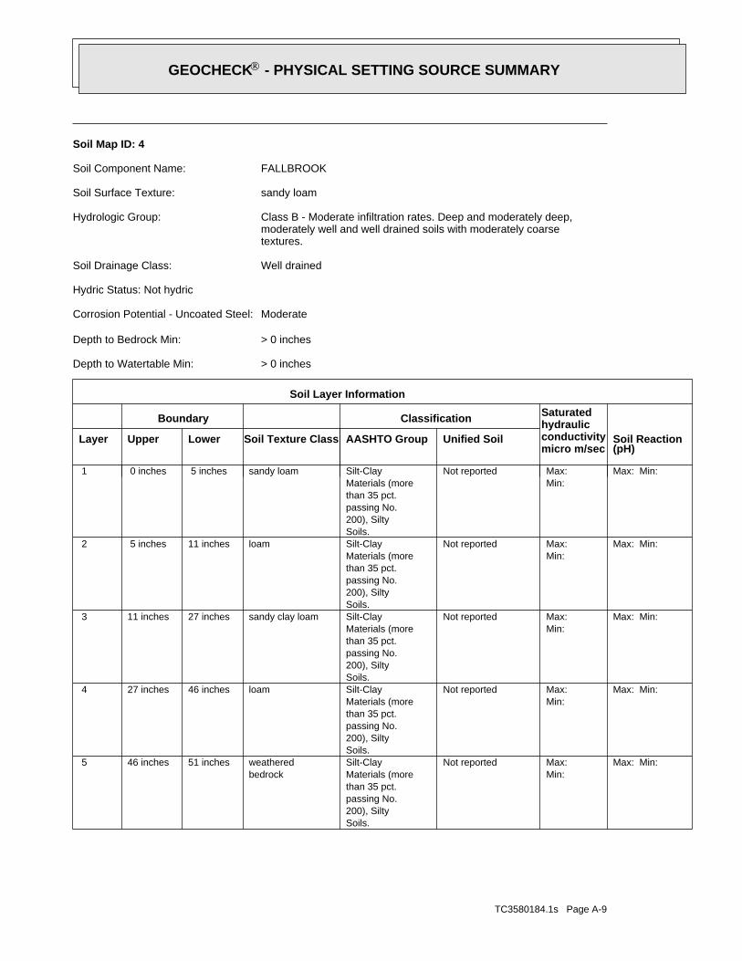
TC3580184.1s Page A-9
Max: Min: Min: Max: Not reported
Soils.200), Siltypassing No.than 35 pct.Materials (moreSilt-Clay
bedrockweathered51 inches46 inches 5
Max: Min: Min: Max: Not reported
Soils.200), Siltypassing No.than 35 pct.Materials (moreSilt-Clayloam46 inches27 inches 4
Max: Min: Min: Max: Not reported
Soils.200), Siltypassing No.than 35 pct.Materials (moreSilt-Claysandy clay loam27 inches11 inches 3
Max: Min: Min: Max: Not reported
Soils.200), Siltypassing No.than 35 pct.Materials (moreSilt-Clayloam11 inches 5 inches 2
Max: Min: Min: Max: Not reported
Soils.200), Siltypassing No.than 35 pct.Materials (moreSilt-Claysandy loam 5 inches 0 inches 1
Soil Layer Information
Boundary Classification Saturatedhydraulicconductivitymicro m/sec
Layer Upper Lower Soil Texture Class AASHTO Group Unified Soil Soil Reaction(pH)
> 0 inchesDepth to Watertable Min:
> 0 inchesDepth to Bedrock Min:
ModerateCorrosion Potential - Uncoated Steel:
Hydric Status: Not hydric
Well drainedSoil Drainage Class:
textures.moderately well and well drained soils with moderately coarseClass B - Moderate infiltration rates. Deep and moderately deep,Hydrologic Group:
sandy loamSoil Surface Texture:
FALLBROOKSoil Component Name:
Soil Map ID: 4
®GEOCHECK - PHYSICAL SETTING SOURCE SUMMARY®
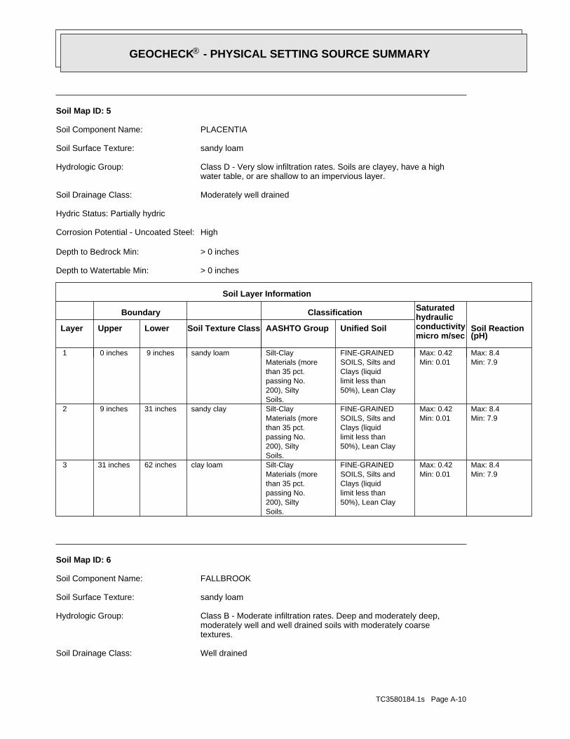
TC3580184.1s Page A-10
Well drainedSoil Drainage Class:
textures.moderately well and well drained soils with moderately coarseClass B - Moderate infiltration rates. Deep and moderately deep,Hydrologic Group:
sandy loamSoil Surface Texture:
FALLBROOKSoil Component Name:
Soil Map ID: 6
Min: 7.9Max: 8.4
Min: 0.01Max: 0.42
50%), Lean Claylimit less thanClays (liquidSOILS, Silts andFINE-GRAINED
Soils.200), Siltypassing No.than 35 pct.Materials (moreSilt-Clayclay loam62 inches31 inches 3
Min: 7.9Max: 8.4
Min: 0.01Max: 0.42
50%), Lean Claylimit less thanClays (liquidSOILS, Silts andFINE-GRAINED
Soils.200), Siltypassing No.than 35 pct.Materials (moreSilt-Claysandy clay31 inches 9 inches 2
Min: 7.9Max: 8.4
Min: 0.01Max: 0.42
50%), Lean Claylimit less thanClays (liquidSOILS, Silts andFINE-GRAINED
Soils.200), Siltypassing No.than 35 pct.Materials (moreSilt-Claysandy loam 9 inches 0 inches 1
Soil Layer Information
Boundary Classification Saturatedhydraulicconductivitymicro m/sec
Layer Upper Lower Soil Texture Class AASHTO Group Unified Soil Soil Reaction(pH)
> 0 inchesDepth to Watertable Min:
> 0 inchesDepth to Bedrock Min:
HighCorrosion Potential - Uncoated Steel:
Hydric Status: Partially hydric
Moderately well drainedSoil Drainage Class:
water table, or are shallow to an impervious layer.Class D - Very slow infiltration rates. Soils are clayey, have a highHydrologic Group:
sandy loamSoil Surface Texture:
PLACENTIASoil Component Name:
Soil Map ID: 5
®GEOCHECK - PHYSICAL SETTING SOURCE SUMMARY®
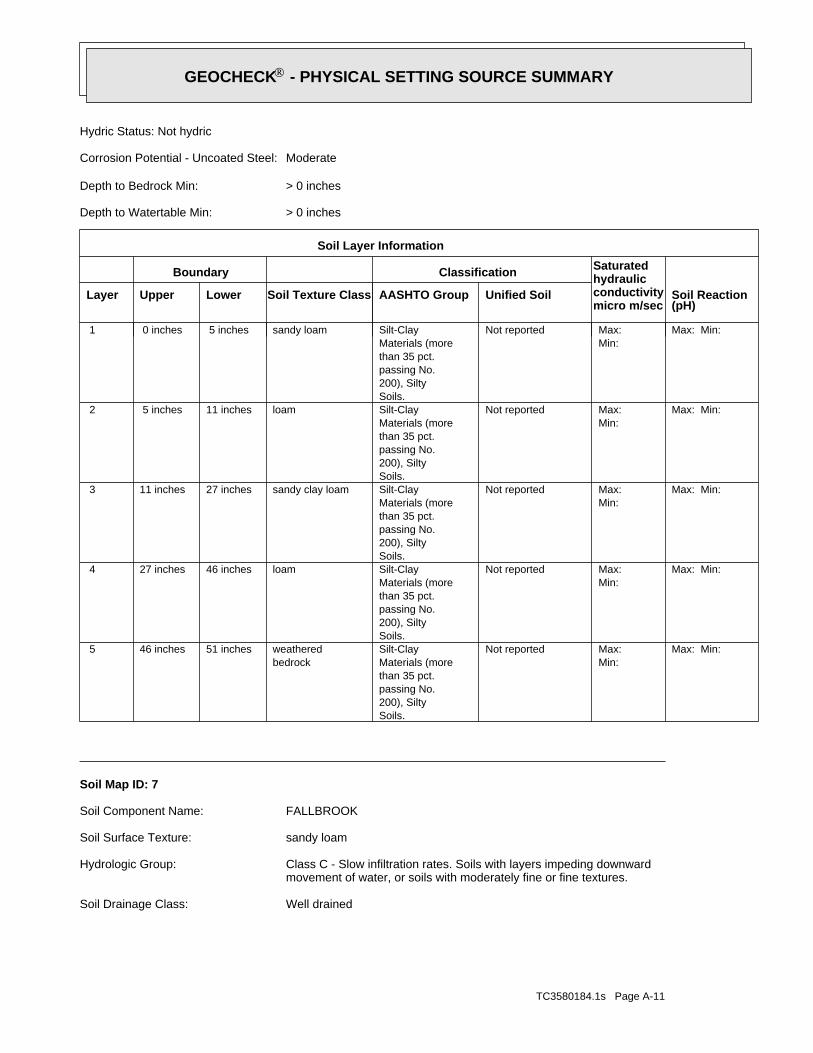
TC3580184.1s Page A-11
Well drainedSoil Drainage Class:
movement of water, or soils with moderately fine or fine textures.Class C - Slow infiltration rates. Soils with layers impeding downwardHydrologic Group:
sandy loamSoil Surface Texture:
FALLBROOKSoil Component Name:
Soil Map ID: 7
Max: Min: Min: Max: Not reported
Soils.200), Siltypassing No.than 35 pct.Materials (moreSilt-Clay
bedrockweathered51 inches46 inches 5
Max: Min: Min: Max: Not reported
Soils.200), Siltypassing No.than 35 pct.Materials (moreSilt-Clayloam46 inches27 inches 4
Max: Min: Min: Max: Not reported
Soils.200), Siltypassing No.than 35 pct.Materials (moreSilt-Claysandy clay loam27 inches11 inches 3
Max: Min: Min: Max: Not reported
Soils.200), Siltypassing No.than 35 pct.Materials (moreSilt-Clayloam11 inches 5 inches 2
Max: Min: Min: Max: Not reported
Soils.200), Siltypassing No.than 35 pct.Materials (moreSilt-Claysandy loam 5 inches 0 inches 1
Soil Layer Information
Boundary Classification Saturatedhydraulicconductivitymicro m/sec
Layer Upper Lower Soil Texture Class AASHTO Group Unified Soil Soil Reaction(pH)
> 0 inchesDepth to Watertable Min:
> 0 inchesDepth to Bedrock Min:
ModerateCorrosion Potential - Uncoated Steel:
Hydric Status: Not hydric
®GEOCHECK - PHYSICAL SETTING SOURCE SUMMARY®
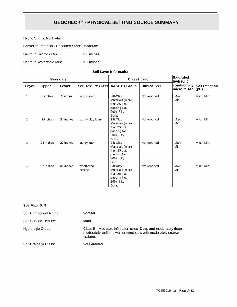
TC3580184.1s Page A-12
Well drainedSoil Drainage Class:
textures.moderately well and well drained soils with moderately coarseClass B - Moderate infiltration rates. Deep and moderately deep,Hydrologic Group:
loamSoil Surface Texture:
WYMANSoil Component Name:
Soil Map ID: 8
Max: Min: Min: Max: Not reported
Soils.200), Siltypassing No.than 35 pct.Materials (moreSilt-Clay
bedrockweathered31 inches27 inches 4
Max: Min: Min: Max: Not reported
Soils.200), Siltypassing No.than 35 pct.Materials (moreSilt-Claysandy loam27 inches24 inches 3
Max: Min: Min: Max: Not reported
Soils.200), Siltypassing No.than 35 pct.Materials (moreSilt-Claysandy clay loam24 inches 3 inches 2
Max: Min: Min: Max: Not reported
Soils.200), Siltypassing No.than 35 pct.Materials (moreSilt-Claysandy loam 3 inches 0 inches 1
Soil Layer Information
Boundary Classification Saturatedhydraulicconductivitymicro m/sec
Layer Upper Lower Soil Texture Class AASHTO Group Unified Soil Soil Reaction(pH)
> 0 inchesDepth to Watertable Min:
> 0 inchesDepth to Bedrock Min:
ModerateCorrosion Potential - Uncoated Steel:
Hydric Status: Not hydric
®GEOCHECK - PHYSICAL SETTING SOURCE SUMMARY®
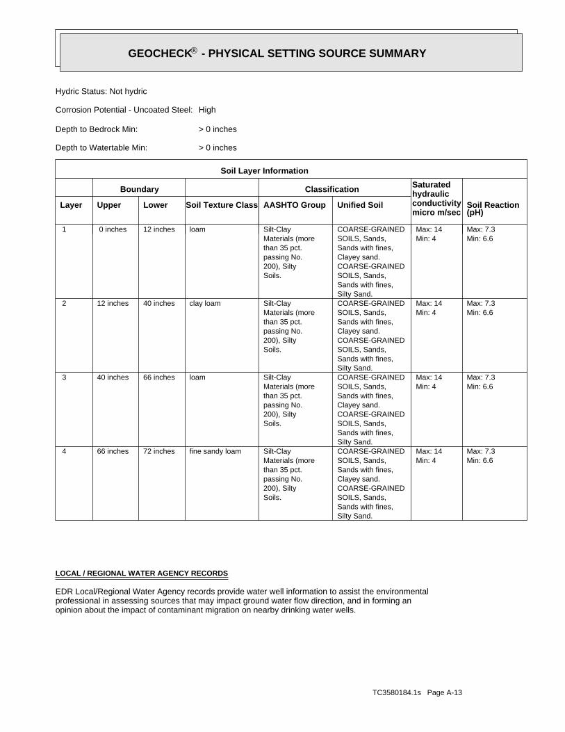
TC3580184.1s Page A-13
opinion about the impact of contaminant migration on nearby drinking water wells.professional in assessing sources that may impact ground water flow direction, and in forming anEDR Local/Regional Water Agency records provide water well information to assist the environmental
LOCAL / REGIONAL WATER AGENCY RECORDS
Min: 6.6Max: 7.3
Min: 4Max: 14
Silty Sand.Sands with fines,SOILS, Sands,COARSE-GRAINEDClayey sand.Sands with fines,SOILS, Sands,COARSE-GRAINED
Soils.200), Siltypassing No.than 35 pct.Materials (moreSilt-Clayfine sandy loam72 inches66 inches 4
Min: 6.6Max: 7.3
Min: 4Max: 14
Silty Sand.Sands with fines,SOILS, Sands,COARSE-GRAINEDClayey sand.Sands with fines,SOILS, Sands,COARSE-GRAINED
Soils.200), Siltypassing No.than 35 pct.Materials (moreSilt-Clayloam66 inches40 inches 3
Min: 6.6Max: 7.3
Min: 4Max: 14
Silty Sand.Sands with fines,SOILS, Sands,COARSE-GRAINEDClayey sand.Sands with fines,SOILS, Sands,COARSE-GRAINED
Soils.200), Siltypassing No.than 35 pct.Materials (moreSilt-Clayclay loam40 inches12 inches 2
Min: 6.6Max: 7.3
Min: 4Max: 14
Silty Sand.Sands with fines,SOILS, Sands,COARSE-GRAINEDClayey sand.Sands with fines,SOILS, Sands,COARSE-GRAINED
Soils.200), Siltypassing No.than 35 pct.Materials (moreSilt-Clayloam12 inches 0 inches 1
Soil Layer Information
Boundary Classification Saturatedhydraulicconductivitymicro m/sec
Layer Upper Lower Soil Texture Class AASHTO Group Unified Soil Soil Reaction(pH)
> 0 inchesDepth to Watertable Min:
> 0 inchesDepth to Bedrock Min:
HighCorrosion Potential - Uncoated Steel:
Hydric Status: Not hydric
®GEOCHECK - PHYSICAL SETTING SOURCE SUMMARY®
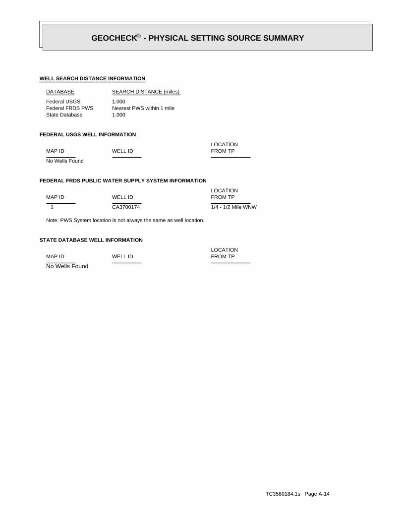
TC3580184.1s Page A-14
No Wells Found
STATE DATABASE WELL INFORMATION
LOCATIONFROM TPWELL IDMAP ID
Note: PWS System location is not always the same as well location.
1/4 - 1/2 Mile WNWCA3700174 1
FEDERAL FRDS PUBLIC WATER SUPPLY SYSTEM INFORMATION
LOCATIONFROM TPWELL IDMAP ID
No Wells Found
FEDERAL USGS WELL INFORMATION
LOCATIONFROM TPWELL IDMAP ID
1.000State DatabaseNearest PWS within 1 mileFederal FRDS PWS1.000Federal USGS
WELL SEARCH DISTANCE INFORMATION
SEARCH DISTANCE (miles)DATABASE
®GEOCHECK - PHYSICAL SETTING SOURCE SUMMARY®

EDR Inc.EDR Inc.EDR Inc.EDR Inc.EDR Inc.EDR Inc.EDR Inc.EDR Inc.EDR Inc.EDR Inc.EDR Inc.EDR Inc.EDR Inc.EDR Inc.EDR Inc.EDR Inc.EDR Inc.EDR Inc.EDR Inc.EDR Inc.EDR Inc.EDR Inc.EDR Inc.EDR Inc.EDR Inc.EDR Inc.EDR Inc.EDR Inc.EDR Inc.EDR Inc.EDR Inc.EDR Inc.EDR Inc.EDR Inc.EDR Inc.EDR Inc.EDR Inc.EDR Inc.EDR Inc.EDR Inc.
12 00
1200
1200
1000
1200
800
1000
1000
1 0 0 0
1000
1000
1200
1200
1200
0
1 3 0 0
1100
1 100
1100
1 100
9
0 0900
1 3
1100
700
900
900
900
900
1100
1100
00
CA
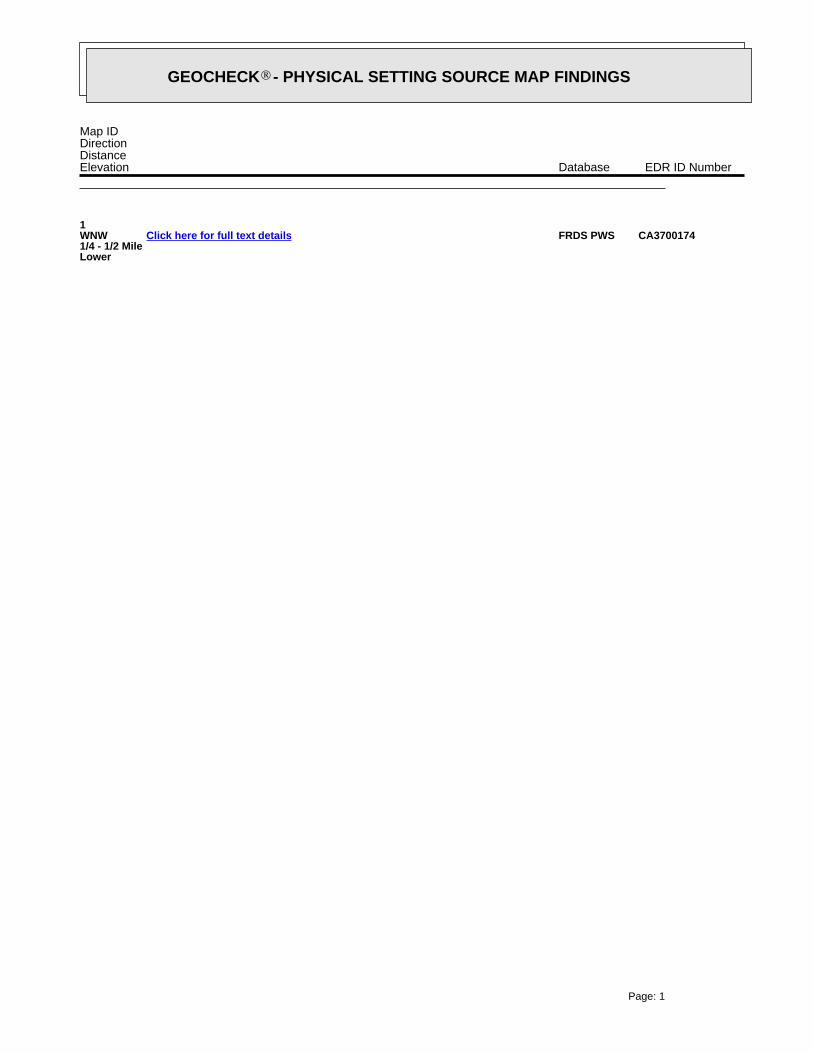
EDR Inc.EDR Inc.EDR Inc.EDR Inc.EDR Inc.EDR Inc.EDR Inc.EDR Inc.EDR Inc.EDR Inc.EDR Inc.EDR Inc.EDR Inc.EDR Inc.EDR Inc.EDR Inc.EDR Inc.EDR Inc.EDR Inc.EDR Inc.EDR Inc.EDR Inc.EDR Inc.EDR Inc.EDR Inc.EDR Inc.EDR Inc.EDR Inc.EDR Inc.EDR Inc.EDR Inc.EDR Inc.EDR Inc.EDR Inc.EDR Inc.EDR Inc.EDR Inc.EDR Inc.EDR Inc.EDR Inc.
GEOCHECK - PHYSICAL SETTING SOURCE MAP FINDINGS®
Map IDDirectionDistanceElevation EDR ID NumberDatabase
1WNW1/4 - 1/2 MileLower
CA3700174FRDS PWSClick here for full text details
Page: 1

Not ReportedNot ReportedNot ReportedNot ReportedBasement0%0%100%0.400 pCi/LLiving Area - 2nd Floor0%0%100%0.677 pCi/LLiving Area - 1st Floor
% >20 pCi/L% 4-20 pCi/L% <4 pCi/LAverage ActivityArea
Number of sites tested: 30
Federal Area Radon Information for SAN DIEGO COUNTY, CA
: Zone 3 indoor average level < 2 pCi/L. : Zone 2 indoor average level >= 2 pCi/L and <= 4 pCi/L. Note: Zone 1 indoor average level > 4 pCi/L.
Federal EPA Radon Zone for SAN DIEGO County: 3
0691935
______________________> 4 pCi/LNum TestsZipcode
Radon Test Results
State Database: CA Radon
AREA RADON INFORMATION
®GEOCHECK - PHYSICAL SETTING SOURCE MAP FINDINGSRADON
®
TC3580184.1s Page 2
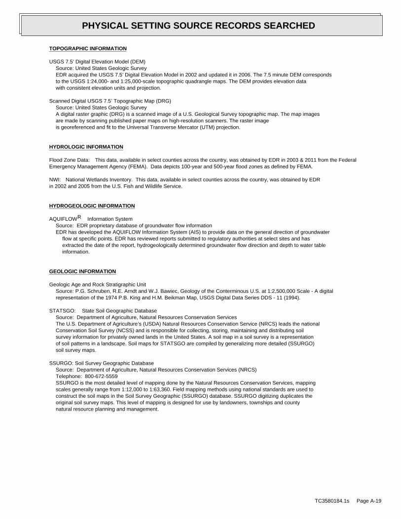
EDR Inc.EDR Inc.EDR Inc.EDR Inc.EDR Inc.EDR Inc.EDR Inc.EDR Inc.EDR Inc.EDR Inc.EDR Inc.EDR Inc.EDR Inc.EDR Inc.EDR Inc.EDR Inc.EDR Inc.EDR Inc.EDR Inc.EDR Inc.EDR Inc.EDR Inc.EDR Inc.EDR Inc.EDR Inc.EDR Inc.EDR Inc.EDR Inc.EDR Inc.EDR Inc.EDR Inc.EDR Inc.EDR Inc.EDR Inc.EDR Inc.EDR Inc.EDR Inc.EDR Inc.EDR Inc.EDR Inc.
TOPOGRAPHIC INFORMATION
USGS 7.5’ Digital Elevation Model (DEM)Source: United States Geologic SurveyEDR acquired the USGS 7.5’ Digital Elevation Model in 2002 and updated it in 2006. The 7.5 minute DEM correspondsto the USGS 1:24,000- and 1:25,000-scale topographic quadrangle maps. The DEM provides elevation datawith consistent elevation units and projection.
Scanned Digital USGS 7.5’ Topographic Map (DRG)Source: United States Geologic SurveyA digital raster graphic (DRG) is a scanned image of a U.S. Geological Survey topographic map. The map imagesare made by scanning published paper maps on high-resolution scanners. The raster imageis georeferenced and fit to the Universal Transverse Mercator (UTM) projection.
HYDROLOGIC INFORMATION
Flood Zone Data: This data, available in select counties across the country, was obtained by EDR in 2003 & 2011 from the FederalEmergency Management Agency (FEMA). Data depicts 100-year and 500-year flood zones as defined by FEMA.
NWI: National Wetlands Inventory. This data, available in select counties across the country, was obtained by EDRin 2002 and 2005 from the U.S. Fish and Wildlife Service.
HYDROGEOLOGIC INFORMATION
AQUIFLOW Information SystemR
Source: EDR proprietary database of groundwater flow informationEDR has developed the AQUIFLOW Information System (AIS) to provide data on the general direction of groundwater
flow at specific points. EDR has reviewed reports submitted to regulatory authorities at select sites and hasextracted the date of the report, hydrogeologically determined groundwater flow direction and depth to water tableinformation.
GEOLOGIC INFORMATION
Geologic Age and Rock Stratigraphic UnitSource: P.G. Schruben, R.E. Arndt and W.J. Bawiec, Geology of the Conterminous U.S. at 1:2,500,000 Scale - A digitalrepresentation of the 1974 P.B. King and H.M. Beikman Map, USGS Digital Data Series DDS - 11 (1994).
STATSGO: State Soil Geographic DatabaseSource: Department of Agriculture, Natural Resources Conservation ServicesThe U.S. Department of Agriculture’s (USDA) Natural Resources Conservation Service (NRCS) leads the nationalConservation Soil Survey (NCSS) and is responsible for collecting, storing, maintaining and distributing soilsurvey information for privately owned lands in the United States. A soil map in a soil survey is a representationof soil patterns in a landscape. Soil maps for STATSGO are compiled by generalizing more detailed (SSURGO)soil survey maps.
SSURGO: Soil Survey Geographic DatabaseSource: Department of Agriculture, Natural Resources Conservation Services (NRCS)Telephone: 800-672-5559SSURGO is the most detailed level of mapping done by the Natural Resources Conservation Services, mappingscales generally range from 1:12,000 to 1:63,360. Field mapping methods using national standards are used toconstruct the soil maps in the Soil Survey Geographic (SSURGO) database. SSURGO digitizing duplicates theoriginal soil survey maps. This level of mapping is designed for use by landowners, townships and countynatural resource planning and management.
TC3580184.1s Page A-19
PHYSICAL SETTING SOURCE RECORDS SEARCHED

LOCAL / REGIONAL WATER AGENCY RECORDS
FEDERAL WATER WELLS
PWS: Public Water SystemsSource: EPA/Office of Drinking WaterTelephone: 202-564-3750Public Water System data from the Federal Reporting Data System. A PWS is any water system which provides water to at
least 25 people for at least 60 days annually. PWSs provide water from wells, rivers and other sources.
PWS ENF: Public Water Systems Violation and Enforcement DataSource: EPA/Office of Drinking WaterTelephone: 202-564-3750Violation and Enforcement data for Public Water Systems from the Safe Drinking Water Information System (SDWIS) after
August 1995. Prior to August 1995, the data came from the Federal Reporting Data System (FRDS).
USGS Water Wells: USGS National Water Inventory System (NWIS)This database contains descriptive information on sites where the USGS collects or has collected data on surfacewater and/or groundwater. The groundwater data includes information on wells, springs, and other sources of groundwater.
STATE RECORDS
Water Well DatabaseSource: Department of Water ResourcesTelephone: 916-651-9648
California Drinking Water Quality DatabaseSource: Department of Health ServicesTelephone: 916-324-2319The database includes all drinking water compliance and special studies monitoring for the state of California
since 1984. It consists of over 3,200,000 individual analyses along with well and water system information.
OTHER STATE DATABASE INFORMATION
California Oil and Gas Well LocationsSource: Department of ConservationTelephone: 916-323-1779Oil and Gas well locations in the state.
RADON
State Database: CA RadonSource: Department of Health ServicesTelephone: 916-324-2208Radon Database for California
Area Radon InformationSource: USGSTelephone: 703-356-4020The National Radon Database has been developed by the U.S. Environmental Protection Agency(USEPA) and is a compilation of the EPA/State Residential Radon Survey and the National Residential Radon Survey.The study covers the years 1986 - 1992. Where necessary data has been supplemented by information collected atprivate sources such as universities and research institutions.
EPA Radon ZonesSource: EPATelephone: 703-356-4020Sections 307 & 309 of IRAA directed EPA to list and identify areas of U.S. with the potential for elevated indoorradon levels.
TC3580184.1s Page A-20
PHYSICAL SETTING SOURCE RECORDS SEARCHED
OTHER
Airport Landing Facilities: Private and public use landing facilitiesSource: Federal Aviation Administration, 800-457-6656
Epicenters: World earthquake epicenters, Richter 5 or greaterSource: Department of Commerce, National Oceanic and Atmospheric Administration
California Earthquake Fault Lines: The fault lines displayed on EDR’s Topographic map are digitized quaternary fault lines,prepared in 1975 by the United State Geological Survey. Additional information (also from 1975) regarding activity at specific faultlines comes from California’s Preliminary Fault Activity Map prepared by the California Division of Mines and Geology.
STREET AND ADDRESS INFORMATION
© 2010 Tele Atlas North America, Inc. All rights reserved. This material is proprietary and the subject of copyright protectionand other intellectual property rights owned by or licensed to Tele Atlas North America, Inc. The use of this material is subjectto the terms of a license agreement. You will be held liable for any unauthorized copying or disclosure of this material.
TC3580184.1s Page A-21
PHYSICAL SETTING SOURCE RECORDS SEARCHED