performance based navigation pbn nas · 4 pbn nas navigation strategy - 2016 draft v1.6 the federal...
TRANSCRIPT
DRAFT1.6
PERFORMANCE BASED NAVIGATION
PBN NASNAVIGATION STRATEGY


June 2016
Ten years ago, the FAA and aviation stakeholders embarked on a path to modernize navigation in the National Airspace System (NAS). As part of this activity, the FAA and aviation stakeholders developed and published a report called “Roadmap for Performance-Based Navigation (PBN).” Since the Roadmap’s publication, together we have established and flown thousands of Area Navigation (RNAV) and Required Navigation Performance (RNP) procedures throughout the NAS, resulting in safety, access, capacity, efficiency, and environmental benefits. We have learned a great deal over the last 10 years, and we also recognize that as the NAS continues to evolve, so too must our navigation strategy.
Therefore, I am pleased to present the PBN NAS Navigation Strategy 2016. It builds on the progress of the past decade and refocuses our priorities and milestones to transition to a truly PBN-centric NAS, that is, a NAS where PBN is used as the basis for daily operations. It charts a course that will allow the public and private sectors to advance the NAS collaboratively and constructively for the benefit of all aviation stakeholders, including aircraft operators, the traveling public, as well as new entrants such as unmanned aircraft systems and commercial space vehicles.
This report describes a pathway to this vision, linking together many interdependent elements necessary to deliver PBN, and includes commitments that will:
• Leverage evolving aircraft capabilities;
• Enable new operations;
• Enhance decision support tools; and
• Reduce dependence on legacy navigational infrastructure.
This report is divided into near-, mid- and far-term objectives over the next 15 years. In the near-term, we will focus on increasing the utilization of RNAV and RNP procedures that are in place and develop new criteria, policies and standards to allow for more advanced applications of PBN. In the mid-term, we will build on newly available PBN operations to increase access, efficiency and resiliency across the system. New PBN operations and procedures will provide the predictability and repeatability necessary to facilitate the transition to the Next Generation Air Transportation System (NextGen), including integration of Data Communications (Data Comm) and improvements to traffic flow management. Finally, the far-term strategies to 2030 and beyond focus on shifting to time- and speed-based air traffic management to increase system predictability.
This report is the product of collaboration between the FAA and aviation stakeholders, and has benefited greatly from the input of the NextGen Advisory Committee and the Performance Based Operations Aviation Rulemaking Committee. A successful transition to a PBN-centric NAS will require a sustained, long-term focus on collaboration across aircraft operators, manufacturers, airport operators and the communities that surround airports. Balancing the interests of these groups will be a challenge, but there is much common ground, and we must take on these challenges if we are to advance the system to the benefit of all aviation stakeholders. The PBN NAS Navigation Strategy will be a living document, and it will be revisited every two years to confirm that the priorities it contains continue to address the navigation needs of an evolving world.
Thank you for your continued support and active participation in ensuring that the most complex airspace in the world remains unsurpassed.
From the Administrator
Michael P. Huerta
www.faa.gov 3
Table of Contents457799
1112141719232425272932333435
IntroductionBackgroundToday’s Navigation
Building on PBN AccomplishmentsEvolving NAS OperationsIncreasing Use of PBN ProceduresAirport and Community Outreach
Navigation Strategy OverviewNavigation Service GroupsPBN Evolution2016–2020 Timeframe2021–2025 Timeframe2026–2030 TimeframeResiliencyMinimum PBN Capabilities
Related EffortsAppendix A: Summary of FAA Goals and Commitments by Vision Area Appendix B: Navigation Service Group DefinitionsAbbreviations, Acronyms and InitialismsReferences
4 PBN NAS Navigation Strategy - 2016 DRAFT v1.6
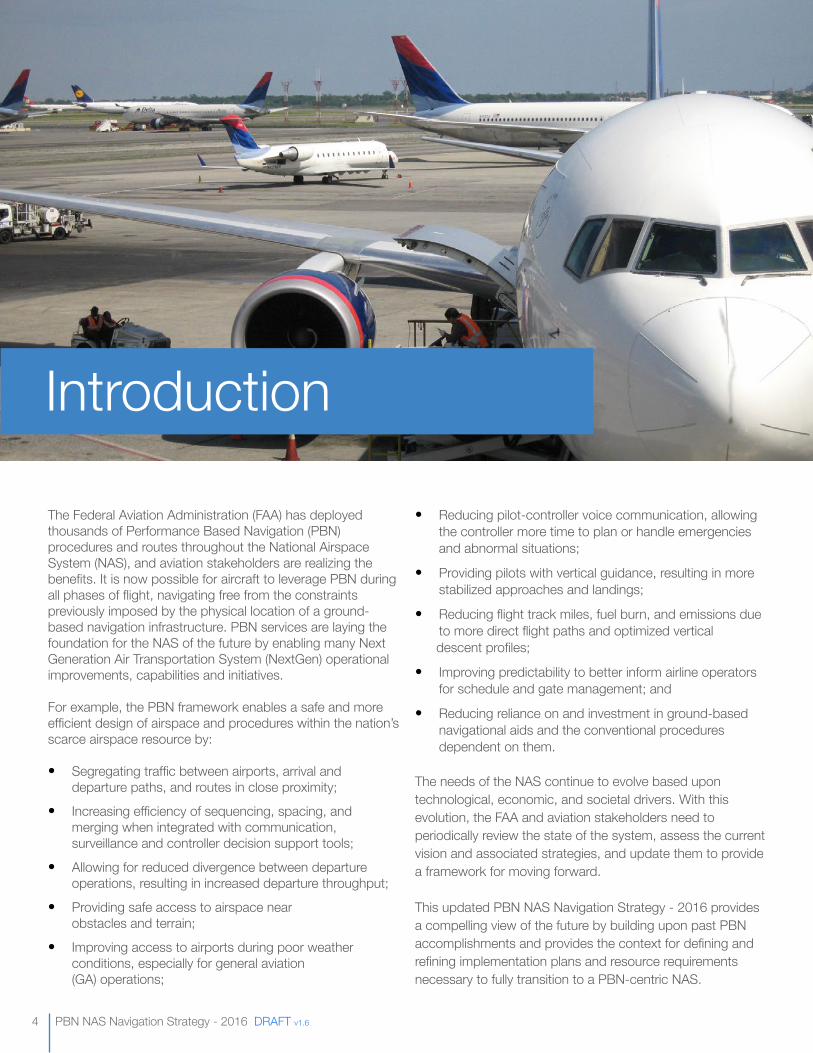
The Federal Aviation Administration (FAA) has deployed thousands of Performance Based Navigation (PBN) procedures and routes throughout the National Airspace System (NAS), and aviation stakeholders are realizing the benefits. It is now possible for aircraft to leverage PBN during all phases of flight, navigating free from the constraints previously imposed by the physical location of a ground-based navigation infrastructure. PBN services are laying the foundation for the NAS of the future by enabling many Next Generation Air Transportation System (NextGen) operational improvements, capabilities and initiatives.
For example, the PBN framework enables a safe and more efficient design of airspace and procedures within the nation’s scarce airspace resource by:
• Segregating traffic between airports, arrival and departure paths, and routes in close proximity;
• Increasing efficiency of sequencing, spacing, and merging when integrated with communication, surveillance and controller decision support tools;
• Allowing for reduced divergence between departure operations, resulting in increased departure throughput;
• Providing safe access to airspace near obstacles and terrain;
• Improving access to airports during poor weather conditions, especially for general aviation (GA) operations;
Introduction
• Reducing pilot-controller voice communication, allowing the controller more time to plan or handle emergencies and abnormal situations;
• Providing pilots with vertical guidance, resulting in more stabilized approaches and landings;
• Reducing flight track miles, fuel burn, and emissions due to more direct flight paths and optimized vertical descent profiles;
• Improving predictability to better inform airline operators for schedule and gate management; and
• Reducing reliance on and investment in ground-based navigational aids and the conventional procedures dependent on them.
The needs of the NAS continue to evolve based upon technological, economic, and societal drivers. With this evolution, the FAA and aviation stakeholders need to periodically review the state of the system, assess the current vision and associated strategies, and update them to provide a framework for moving forward.
This updated PBN NAS Navigation Strategy - 2016 provides a compelling view of the future by building upon past PBN accomplishments and provides the context for defining and refining implementation plans and resource requirements necessary to fully transition to a PBN-centric NAS.
www.faa.gov 5
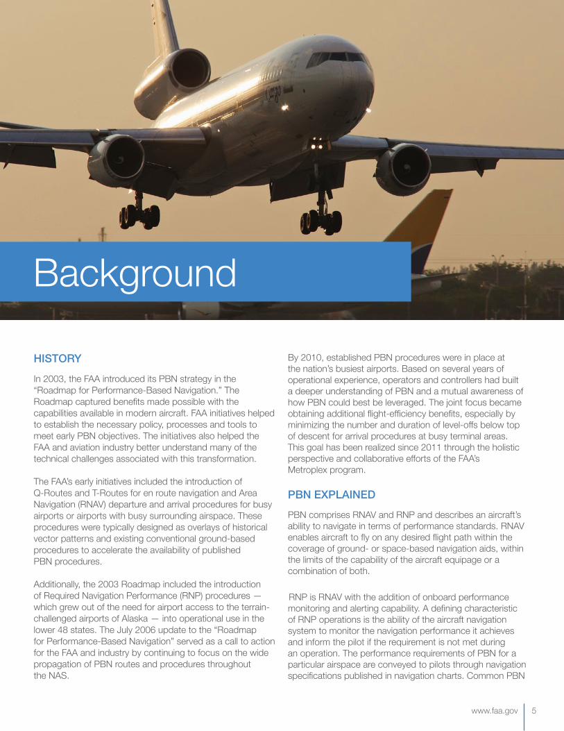
HISTORYIn 2003, the FAA introduced its PBN strategy in the “Roadmap for Performance-Based Navigation.” The Roadmap captured benefits made possible with the capabilities available in modern aircraft. FAA initiatives helped to establish the necessary policy, processes and tools to meet early PBN objectives. The initiatives also helped the FAA and aviation industry better understand many of the technical challenges associated with this transformation.
The FAA’s early initiatives included the introduction of Q-Routes and T-Routes for en route navigation and Area Navigation (RNAV) departure and arrival procedures for busy airports or airports with busy surrounding airspace. These procedures were typically designed as overlays of historical vector patterns and existing conventional ground-based procedures to accelerate the availability of published PBN procedures.
Additionally, the 2003 Roadmap included the introduction of Required Navigation Performance (RNP) procedures — which grew out of the need for airport access to the terrain-challenged airports of Alaska — into operational use in the lower 48 states. The July 2006 update to the “Roadmap for Performance-Based Navigation” served as a call to action for the FAA and industry by continuing to focus on the wide propagation of PBN routes and procedures throughout the NAS.
Background
By 2010, established PBN procedures were in place at the nation’s busiest airports. Based on several years of operational experience, operators and controllers had built a deeper understanding of PBN and a mutual awareness of how PBN could best be leveraged. The joint focus became obtaining additional flight-efficiency benefits, especially by minimizing the number and duration of level-offs below top of descent for arrival procedures at busy terminal areas. This goal has been realized since 2011 through the holistic perspective and collaborative efforts of the FAA’s Metroplex program.
PBN EXPLAINEDPBN comprises RNAV and RNP and describes an aircraft’s ability to navigate in terms of performance standards. RNAV enables aircraft to fly on any desired flight path within the coverage of ground- or space-based navigation aids, within the limits of the capability of the aircraft equipage or a combination of both.
RNP is RNAV with the addition of onboard performance monitoring and alerting capability. A defining characteristic of RNP operations is the ability of the aircraft navigation system to monitor the navigation performance it achieves and inform the pilot if the requirement is not met during an operation. The performance requirements of PBN for a particular airspace are conveyed to pilots through navigation specifications published in navigation charts. Common PBN
6 PBN NAS Navigation Strategy - 2016 DRAFT v1.6
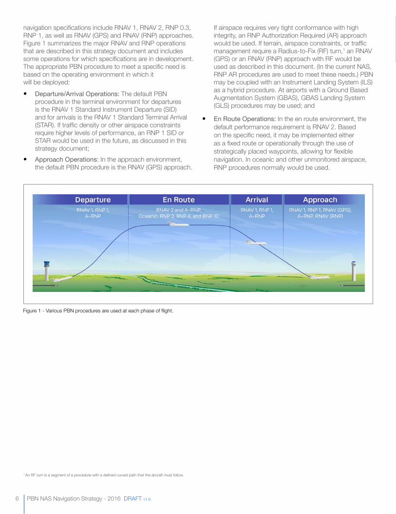
navigation specifications include RNAV 1, RNAV 2, RNP 0.3, RNP 1, as well as RNAV (GPS) and RNAV (RNP) approaches. Figure 1 summarizes the major RNAV and RNP operations that are described in this strategy document and includes some operations for which specifications are in development. The appropriate PBN procedure to meet a specific need is based on the operating environment in which it will be deployed:
• Departure/ArrivalOperations: The default PBN procedure in the terminal environment for departures is the RNAV 1 Standard Instrument Departure (SID) and for arrivals is the RNAV 1 Standard Terminal Arrival (STAR). If traffic density or other airspace constraints require higher levels of performance, an RNP 1 SID or STAR would be used in the future, as discussed in this strategy document;
• ApproachOperations: In the approach environment, the default PBN procedure is the RNAV (GPS) approach.
1 An RF turn is a segment of a procedure with a defined curved path that the aircraft must follow.
If airspace requires very tight conformance with high integrity, an RNP Authorization Required (AR) approach would be used. If terrain, airspace constraints, or traffic management require a Radius-to-Fix (RF) turn,1 an RNAV (GPS) or an RNAV (RNP) approach with RF would be used as described in this document. (In the current NAS, RNP AR procedures are used to meet these needs.) PBN may be coupled with an Instrument Landing System (ILS) as a hybrid procedure. At airports with a Ground Based Augmentation System (GBAS), GBAS Landing System (GLS) procedures may be used; and
• EnRouteOperations: In the en route environment, the default performance requirement is RNAV 2. Based on the specific need, it may be implemented either as a fixed route or operationally through the use of strategically placed waypoints, allowing for flexible navigation. In oceanic and other unmonitored airspace, RNP procedures normally would be used.
Figure 1 - Various PBN procedures are used at each phase of flight.
www.faa.gov 7
This document discusses how the FAA and industry are building upon the significant progress made in the development and implementation of PBN over the past 12 years. It was developed with consideration for changes in the structure and operation of the NAS, the availability of technologies and avionics and the relationship of PBN initiatives to other NextGen modernization efforts.
BUILDING ON PBN ACCOMPLISHMENTS
Many of the capabilities described in the 2006 PBN Roadmap for the 2006–2015 timeframe are now operationally available across the NAS.
PROCEDUREIMPLEMENTATION
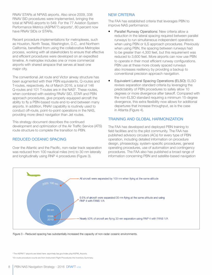
A total of 2,684 airports in the FAA’s National Plan of Integrated Airport Systems (NPIAS) in the NAS have at least one published standard Instrument Approach Procedure (IAP).2 Of these airports, 95 percent have at least one PBN IAP and 25 percent have only PBN IAPs with no conventional IAP.3 From 2009-2016, the number of published RNAV approaches increased from 3,659 to 5,795. Over the same period, published RNP approaches increased threefold, from 125 to 391.
Since 2009, an additional 264 RNAV STAR (Figure 2) procedures were implemented, resulting in a total of 355
2 Terminal procedure counts from digital Terminal Procedures Publication, using December 2008 and March 2016 data.3 ICAO has established a global goal to implement “approach procedures with vertical guidance (APV) (baro-VNAV and/or augmented Global Navigation Satellite System [GNSS]) for all instrument runway ends, either as the primary approach or as a backup for precision approaches by 2016.” See “Navigation Strategy Overview” section for FAA commitments related to this ICAO goal.
Today’s Navigation
Figure 2 – Red are RNAV SID/STARs. Blue are Q-Routes and T-Routes
8 PBN NAS Navigation Strategy - 2016 DRAFT v1.6
RNAV STARs at NPIAS airports. Also since 2009, 338 RNAV SID procedures were implemented, bringing the total at NPIAS airports to 549. For the 77 Aviation System Performance Metrics (ASPM77) airports4, 80 percent now have RNAV SIDs or STARs.
Recent procedure implementations for metroplexes, such as Houston, North Texas, Washington, D.C., and Northern California, benefited from using the collaborative Metroplex process, working with all stakeholders to ensure that effective and efficient procedures were developed on an expedited timeline. A metroplex includes one or more commercial airports with shared airspace that serves at least one major city.
The conventional Jet route and Victor airway structure has been augmented with their PBN equivalents, Q-routes and T-routes, respectively. As of March 2016, a total of 146 Q-routes and 101 T-routes are in the NAS5. These routes, when combined with existing RNAV SID, STAR and PBN approach procedures, give properly equipped aircraft the ability to fly a PBN-based route end-to-end between many airports. In addition, RNAV capability is routinely used to conduct off-route, point-to-point operations in the NAS, providing more direct navigation than Jet routes.
This strategy document describes the continued development and optimization of the Air Traffic Service (ATS) route structure to complete the transition to PBN.
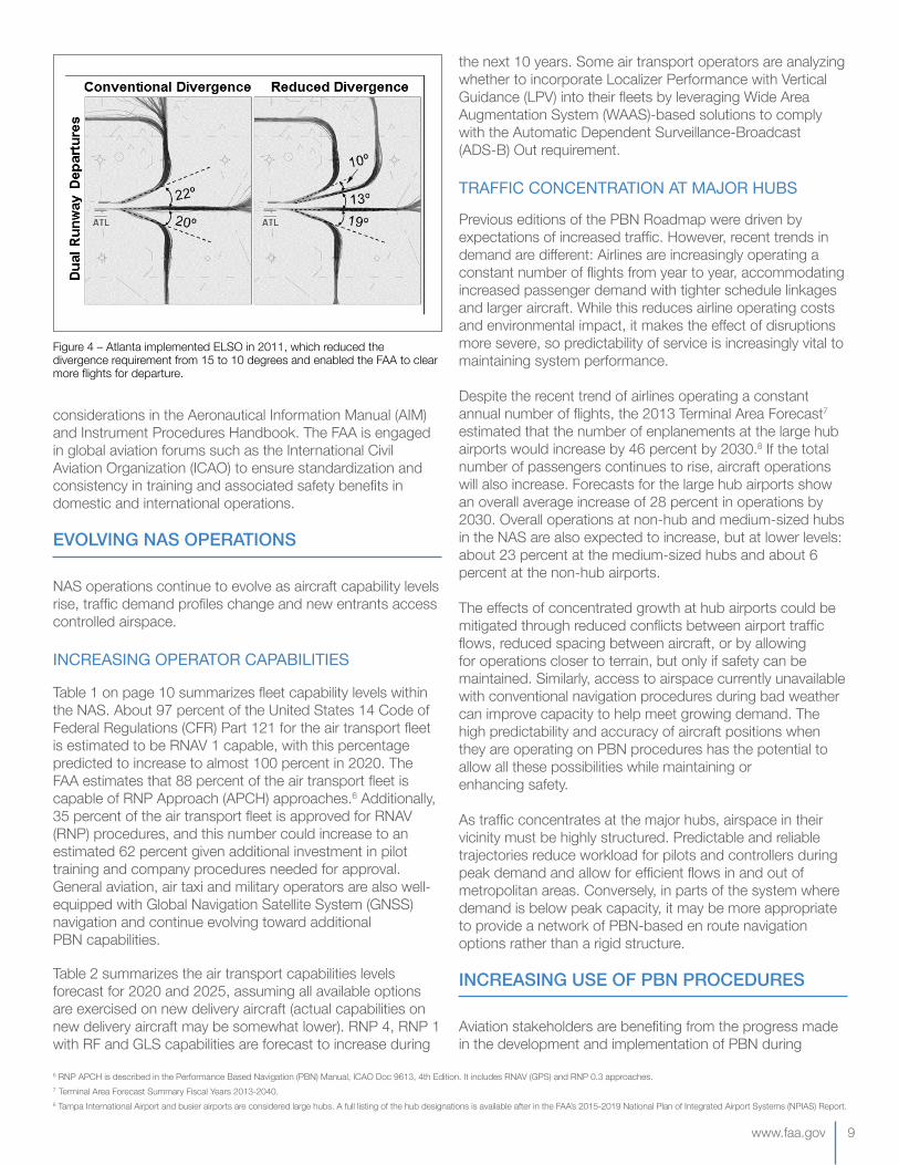
REDUCEDOCEANICSPACING
Over the Atlantic and the Pacific, non-radar track separation was reduced from 100 nautical miles (nm) to 30 nm laterally and longitudinally using RNP 4 procedures (Figure 3).
NEWCRITERIAThe FAA has established criteria that leverages PBN to improve NAS performance:
• ParallelRunwayOperations:New criteria allow a reduction in the lateral spacing required between parallel runways to run simultaneous independent operations when using PBN or ILS approach procedures. Previously when using PBN, the spacing between runways had to be greater than 4,300 feet, but this requirement was reduced to 3,600 feet. More airports can now use PBN to operate in their most efficient runway configurations. PBN use at these more closely spaced runways also increases resiliency by providing a backup to conventional precision approach navigation.
• EquivalentLateralSpacingOperations(ELSO): ELSO revises separation standard criteria by leveraging the predictability of PBN procedures to safely allow 10 degrees or more divergence after takeoff. Compared with the non-ELSO standard requiring a minimum 15-degree divergence, this extra flexibility now allows for additional departures that increase throughput, as is the case in Atlanta (Figure 4).
TRAININGANDGLOBALHARMONIZATION
The FAA has developed and deployed PBN training to field facilities and to the pilot community. The FAA has published advisory circulars (ACs) for every type of PBN operation, including detailed information on procedure design, phraseology, system-specific procedures, general operating procedures, use of automation and contingency procedures. The FAA also has published a broad range of information concerning PBN and satellite-based navigation
Figure 3 – Reduced spacing has substantially increased the capacity of non-radar oceanic environments.
4 The ASPM77 airports are listed here: aspmhelp.faa.gov/index.php/ASPM_Airports.5 En route procedure counts are from Instrument Flight Procedures the Inventory Summary.
www.faa.gov 9
considerations in the Aeronautical Information Manual (AIM) and Instrument Procedures Handbook. The FAA is engaged in global aviation forums such as the International Civil Aviation Organization (ICAO) to ensure standardization and consistency in training and associated safety benefits in domestic and international operations.
EVOLVING NAS OPERATIONS
NAS operations continue to evolve as aircraft capability levels rise, traffic demand profiles change and new entrants access controlled airspace.
INCREASINGOPERATORCAPABILITIES
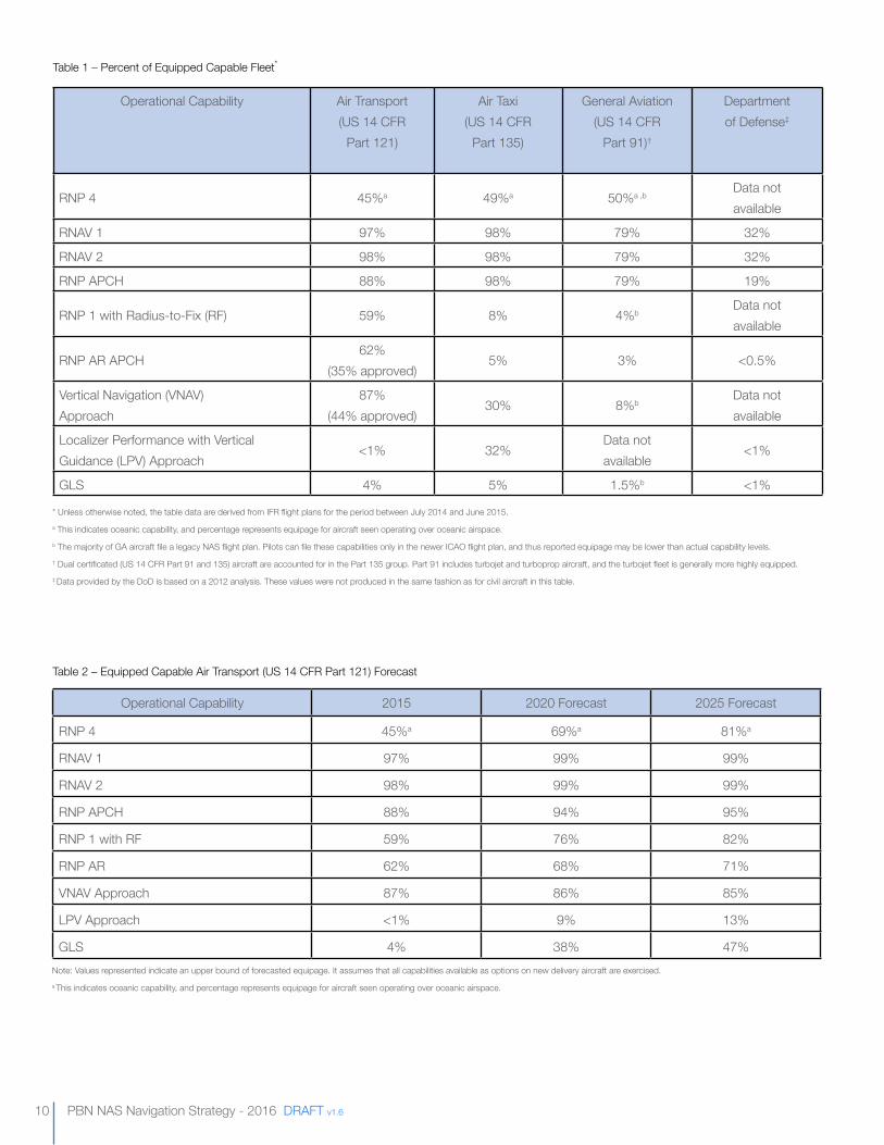
Table 1 on page 10 summarizes fleet capability levels within the NAS. About 97 percent of the United States 14 Code of Federal Regulations (CFR) Part 121 for the air transport fleet is estimated to be RNAV 1 capable, with this percentage predicted to increase to almost 100 percent in 2020. The FAA estimates that 88 percent of the air transport fleet is capable of RNP Approach (APCH) approaches.6 Additionally, 35 percent of the air transport fleet is approved for RNAV (RNP) procedures, and this number could increase to an estimated 62 percent given additional investment in pilot training and company procedures needed for approval. General aviation, air taxi and military operators are also well- equipped with Global Navigation Satellite System (GNSS) navigation and continue evolving toward additional PBN capabilities.
Table 2 summarizes the air transport capabilities levels forecast for 2020 and 2025, assuming all available options are exercised on new delivery aircraft (actual capabilities on new delivery aircraft may be somewhat lower). RNP 4, RNP 1 with RF and GLS capabilities are forecast to increase during
the next 10 years. Some air transport operators are analyzing whether to incorporate Localizer Performance with Vertical Guidance (LPV) into their fleets by leveraging Wide Area Augmentation System (WAAS)-based solutions to comply with the Automatic Dependent Surveillance-Broadcast (ADS-B) Out requirement.
TRAFFICCONCENTRATIONATMAJORHUBS
Previous editions of the PBN Roadmap were driven by expectations of increased traffic. However, recent trends in demand are different: Airlines are increasingly operating a constant number of flights from year to year, accommodating increased passenger demand with tighter schedule linkages and larger aircraft. While this reduces airline operating costs and environmental impact, it makes the effect of disruptions more severe, so predictability of service is increasingly vital to maintaining system performance.
Despite the recent trend of airlines operating a constant annual number of flights, the 2013 Terminal Area Forecast7 estimated that the number of enplanements at the large hub airports would increase by 46 percent by 2030.8 If the total number of passengers continues to rise, aircraft operations will also increase. Forecasts for the large hub airports show an overall average increase of 28 percent in operations by 2030. Overall operations at non-hub and medium-sized hubs in the NAS are also expected to increase, but at lower levels: about 23 percent at the medium-sized hubs and about 6 percent at the non-hub airports.
The effects of concentrated growth at hub airports could be mitigated through reduced conflicts between airport traffic flows, reduced spacing between aircraft, or by allowing for operations closer to terrain, but only if safety can be maintained. Similarly, access to airspace currently unavailable with conventional navigation procedures during bad weather can improve capacity to help meet growing demand. The high predictability and accuracy of aircraft positions when they are operating on PBN procedures has the potential to allow all these possibilities while maintaining or enhancing safety.
As traffic concentrates at the major hubs, airspace in their vicinity must be highly structured. Predictable and reliable trajectories reduce workload for pilots and controllers during peak demand and allow for efficient flows in and out of metropolitan areas. Conversely, in parts of the system where demand is below peak capacity, it may be more appropriate to provide a network of PBN-based en route navigation options rather than a rigid structure.
INCREASING USE Of PBN PROCEDURES
Aviation stakeholders are benefiting from the progress made in the development and implementation of PBN during
6 RNP APCH is described in the Performance Based Navigation (PBN) Manual, ICAO Doc 9613, 4th Edition. It includes RNAV (GPS) and RNP 0.3 approaches. 7 Terminal Area Forecast Summary Fiscal Years 2013-2040.8 Tampa International Airport and busier airports are considered large hubs. A full listing of the hub designations is available after in the FAA’s 2015-2019 National Plan of Integrated Airport Systems (NPIAS) Report.
Figure 4 – Atlanta implemented ELSO in 2011, which reduced the divergence requirement from 15 to 10 degrees and enabled the FAA to clear more flights for departure.
10 PBN NAS Navigation Strategy - 2016 DRAFT v1.6
Operational Capability Air Transport(US 14 CFR
Part 121)
Air Taxi(US 14 CFR
Part 135)
General Aviation(US 14 CFR
Part 91)†
Department of Defense‡
RNP 4 45%a 49%a 50%a ,bData not available
RNAV 1 97% 98% 79% 32%
RNAV 2 98% 98% 79% 32%
RNP APCH 88% 98% 79% 19%
RNP 1 with Radius-to-Fix (RF) 59% 8% 4%bData not available
RNP AR APCH62%
(35% approved)5% 3% <0.5%
Vertical Navigation (VNAV) Approach
87% (44% approved)
30% 8%b Data not available
Localizer Performance with Vertical Guidance (LPV) Approach
<1% 32%Data not available
<1%
GLS 4% 5% 1.5%b <1%
Table 1 – Percent of Equipped Capable Fleet*
* Unless otherwise noted, the table data are derived from IFR flight plans for the period between July 2014 and June 2015. a This indicates oceanic capability, and percentage represents equipage for aircraft seen operating over oceanic airspace.b The majority of GA aircraft file a legacy NAS flight plan. Pilots can file these capabilities only in the newer ICAO flight plan, and thus reported equipage may be lower than actual capability levels. † Dual certificated (US 14 CFR Part 91 and 135) aircraft are accounted for in the Part 135 group. Part 91 includes turbojet and turboprop aircraft, and the turbojet fleet is generally more highly equipped.‡ Data provided by the DoD is based on a 2012 analysis. These values were not produced in the same fashion as for civil aircraft in this table.
Operational Capability 2015 2020 Forecast 2025 Forecast
RNP 4 45%a 69%a 81%a
RNAV 1 97% 99% 99%
RNAV 2 98% 99% 99%
RNP APCH 88% 94% 95%
RNP 1 with RF 59% 76% 82%
RNP AR 62% 68% 71%
VNAV Approach 87% 86% 85%
LPV Approach <1% 9% 13%
GLS 4% 38% 47%
Table 2 – Equipped Capable Air Transport (US 14 CFR Part 121) Forecast
Note: Values represented indicate an upper bound of forecasted equipage. It assumes that all capabilities available as options on new delivery aircraft are exercised. a This indicates oceanic capability, and percentage represents equipage for aircraft seen operating over oceanic airspace.
www.faa.gov 11
the last 15 years. However, in some locations, air traffic control (ATC) and operators are not using the available PBN procedures as often as was expected when the procedures were originally proposed. Increasing PBN procedure utilization is an important component in the transition to a PBN-centric NAS that:• Provides benefits to NAS stakeholders by taking
advantage of investments in advanced navigation capabilities;
• Improves systemwide efficiency by increasing the homogeneity of NAS operations; and
• Supports pathways to future traffic management capabilities.
Lessons learned from early PBN implementations reveal several important factors to maximize procedure utilization:
• Balancetheobjectivesofoperationalstakeholders:Collaboration between users and service providers is key to the development, implementation and proper use of PBN procedures and provides substantive benefits. Continued participation by facility personnel in all aspects of PBN development and deployment is necessary. Collaboration with the ATC workforce is essential to success, but represents a challenge when critically staffed facilities or unavailable funding result in reduced participation in key design, development, training and implementation activities. To support the NAS described in this strategy document, a sustained focus on addressing facility staffing and work group funding requirements is required. Likewise, operator resources for participation in key design, development, training and implementation activities are also becoming harder to schedule against these activities;
• IntegrateappropriateATCdecisionsupporttools:Consistent use of PBN procedures during periods of high traffic demand is necessary to maintain the operator efficiency that PBN affords. Ensuring consistent use requires that controllers have access to and training on appropriate decision support tools and automation;
• ConductcomprehensiveATCandpilottraining:While training materials are available that describe PBN procedures, comprehensive training on effectively using PBN for ATC and pilots could help increase procedure utilization and operational efficiency;
• Reducethetimetodevelop,implementandamendprocedures: Streamlining PBN procedure development, deployment and amendment, along with the reduction of conventional procedures, will expedite the transition to a PBN-centric NAS and increase the FAA’s ability to provide procedures that leverage new capabilities and meet emerging needs in a timely manner;
• Leveragecapabilitiestomodelandsimulateairframeandavionicsvariations: Variations in onboard avionics, such as the Flight Management System (FMS), can cause aircraft to fly the same procedure in different ways
while still meeting minimum performance specifications. Procedure designers may account for these variations in ways that reduce efficiency and benefits. For complex implementations, modeling and simulation can inform design decisions. However, in the longer term, a uniform application of FMS performance standards will be the most effective mechanism to reduce flight trajectory variability; and
• Modifycriteriaandpoliciestomakeadvancedconceptsandservicesoperationallyavailable: PBN is the foundation for numerous advanced navigation concepts and services that will increase safety, efficiency, access and capacity. Leveraging these concepts and providing these services as part of normal operations require proposing, analyzing and implementing relevant criteria and policies while concurrently scrutinizing, modifying and removing outdated policies as necessary.
While the FAA is currently pursuing several efforts to align these objectives, this strategy document also represents the aspiration of the FAA and stakeholders to continue to address these challenges in innovative and collaborative ways.
AIRPORT AND COMMUNITY OUTREACH
Successfully moving to a PBN-centric NAS requires balancing the objectives of all stakeholders, including airport operators and the surrounding communities. Recent PBN implementation efforts illustrate the importance of airport and community involvement to ensure that community concerns are adequately addressed and that projects progress on schedule.
The FAA is incorporating industry recommendations contained in the NextGen Advisory Committee’s 2014 Blueprint for Success to Implementing Performance Based Navigation relative to community outreach and airport involvement.
Increasing public awareness of the changes that PBN procedures bring to individual communities, regions and the nation as a whole is a shared responsibility across all stakeholders. Continued success will require the early, active and sustained outreach by the FAA to airport operators and the surrounding communities in PBN procedure design and implementation processes. Airport operators understand the local interests, sensitivities and expectations of the communities they serve, having built relationships over many decades. Their insights can help the FAA proactively address community concerns regarding PBN procedures during the design process and engage local communities more effectively during outreach efforts.
This strategy document represents the aspiration of the FAA and stakeholders to continue to emphasize these factors to increase PBN use.
12 PBN NAS Navigation Strategy - 2016 DRAFT v1.6
The continued evolution to a PBN-centric NAS requires deploying and supporting the use of appropriate PBN procedures to enhance safety, efficiency, access and capacity. This document is the result of collaborative FAA and industry efforts during the past 15 years and outlines commitments and achievements needed to complete the transition to a PBN-centric NAS in the following focus areas:
• Operating with PBN throughout the NAS, using the right procedure to meet the need;
• Using navigation structure where beneficial and flexibility where possible;
• Shifting to time- and speed-based air traffic management;
• Delivering and using resilient navigation services;• Modernizing the FAA navigation service delivery to
reduce delivery time;• Enabling lower visibility access; and• Innovating and continuously improving.
Each of these focus areas has associated strategy elements, which are explained in further detail below.
RIGHTPROCEDURES
To implement PBN with the right procedure to meet a specific need requires that all stakeholders share a clear understanding of the national strategy, the purpose and benefits of a selected procedure and the operating
environment in which it will be deployed. The type of procedure deployed will safely and efficiently address the operational needs.
Success requires that procedures be used as intended. The FAA is committed to encouraging an increased harmonization in fleet navigation capability, as well as developing, fostering and maintaining an environment in which ATC can consistently assign flights to the new procedures and aircraft can consistently fly the procedures as intended. This will require advances in decision support tools, ATC and pilot training programs and involvement of aircraft and avionics manufacturers.
ROUTESTRUCTURE
In complex airspace, route structure provides a mechanism for controllers to manage the safe and efficient separation of aircraft. In less complex airspace or in conditions where a degree of adaptability is necessary to minimize operational disruptions, PBN can be used to provide flexible routing options that balance user preferences with maintaining system-level efficiencies. This document describes a PBN structure concept that uses route structure where beneficial and PBN-based flexibility elsewhere.
TIMEANDSPEED-BASEDMANAGEMENT
Schedule predictability is a key priority for air carriers, air transport operators and the general aviation community. PBN arrival, departure and approach procedures will provide
Navigation Strategy Overview
www.faa.gov 13
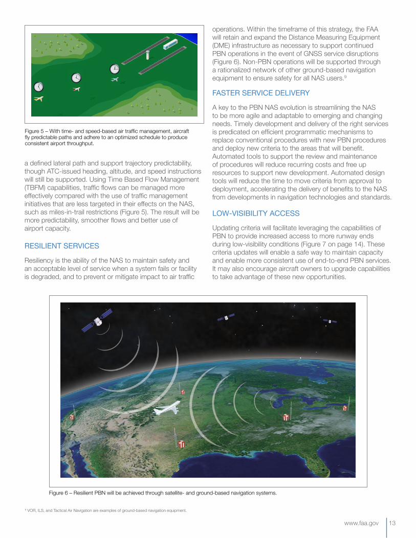
a defined lateral path and support trajectory predictability, though ATC-issued heading, altitude, and speed instructions will still be supported. Using Time Based Flow Management (TBFM) capabilities, traffic flows can be managed more effectively compared with the use of traffic management initiatives that are less targeted in their effects on the NAS, such as miles-in-trail restrictions (Figure 5). The result will be more predictability, smoother flows and better use of airport capacity.
RESILIENTSERVICES
Resiliency is the ability of the NAS to maintain safety and an acceptable level of service when a system fails or facility is degraded, and to prevent or mitigate impact to air traffic
operations. Within the timeframe of this strategy, the FAA will retain and expand the Distance Measuring Equipment (DME) infrastructure as necessary to support continued PBN operations in the event of GNSS service disruptions (Figure 6). Non-PBN operations will be supported through a rationalized network of other ground-based navigation equipment to ensure safety for all NAS users.9
FASTERSERVICEDELIVERY
A key to the PBN NAS evolution is streamlining the NAS to be more agile and adaptable to emerging and changing needs. Timely development and delivery of the right services is predicated on efficient programmatic mechanisms to replace conventional procedures with new PBN procedures and deploy new criteria to the areas that will benefit. Automated tools to support the review and maintenance of procedures will reduce recurring costs and free up resources to support new development. Automated design tools will reduce the time to move criteria from approval to deployment, accelerating the delivery of benefits to the NAS from developments in navigation technologies and standards.
LOW-VISIBILITYACCESS
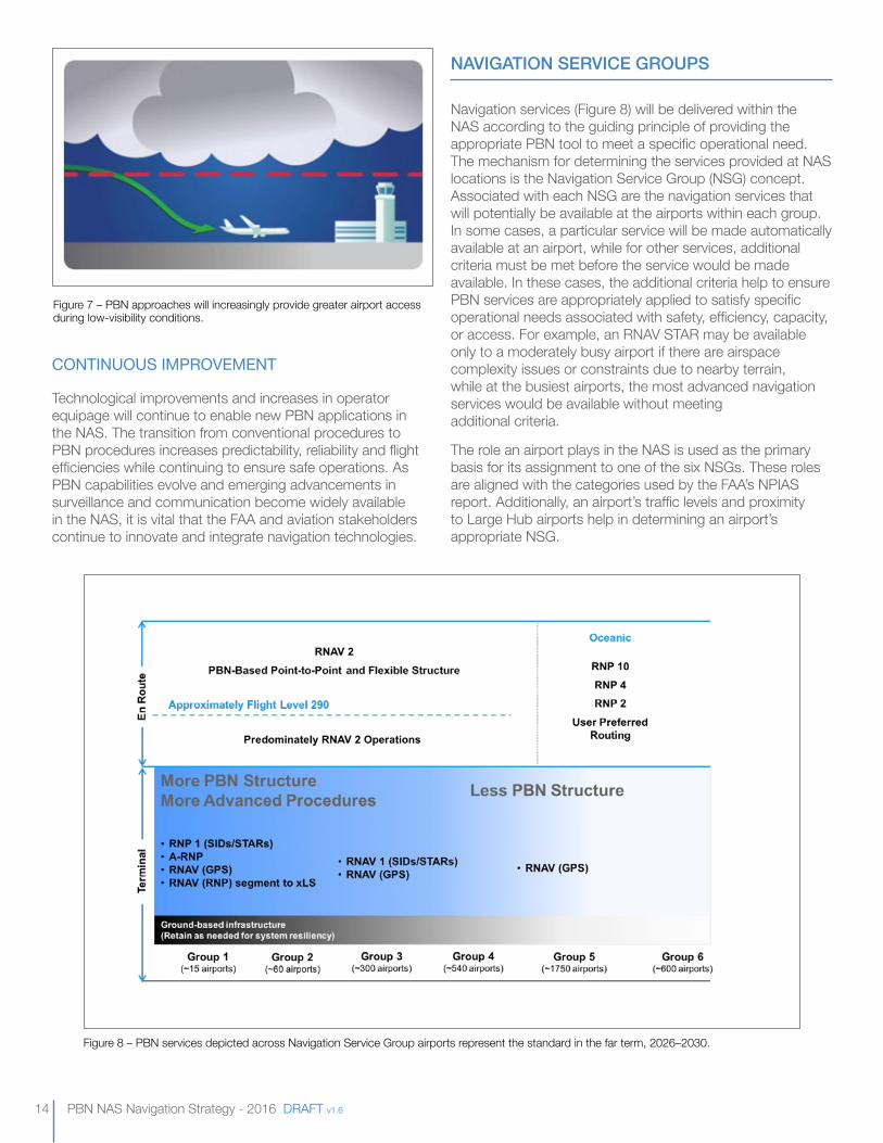
Updating criteria will facilitate leveraging the capabilities of PBN to provide increased access to more runway ends during low-visibility conditions (Figure 7 on page 14). These criteria updates will enable a safe way to maintain capacity and enable more consistent use of end-to-end PBN services. It may also encourage aircraft owners to upgrade capabilities to take advantage of these new opportunities.
Figure 5 – With time- and speed-based air traffic management, aircraft fly predictable paths and adhere to an optimized schedule to produce consistent airport throughput.
9 VOR, ILS, and Tactical Air Navigation are examples of ground-based navigation equipment.
Figure 6 – Resilient PBN will be achieved through satellite- and ground-based navigation systems.
14 PBN NAS Navigation Strategy - 2016 DRAFT v1.6
CONTINUOUSIMPROVEMENT
Technological improvements and increases in operator equipage will continue to enable new PBN applications in the NAS. The transition from conventional procedures to PBN procedures increases predictability, reliability and flight efficiencies while continuing to ensure safe operations. As PBN capabilities evolve and emerging advancements in surveillance and communication become widely available in the NAS, it is vital that the FAA and aviation stakeholders continue to innovate and integrate navigation technologies.
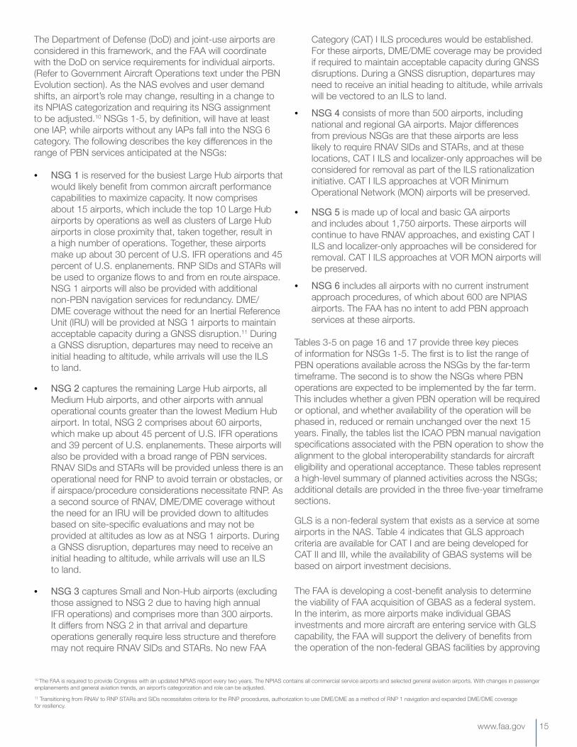
NAVIGATION SERVICE GROUPS
Navigation services (Figure 8) will be delivered within the NAS according to the guiding principle of providing the appropriate PBN tool to meet a specific operational need. The mechanism for determining the services provided at NAS locations is the Navigation Service Group (NSG) concept. Associated with each NSG are the navigation services that will potentially be available at the airports within each group. In some cases, a particular service will be made automatically available at an airport, while for other services, additional criteria must be met before the service would be made available. In these cases, the additional criteria help to ensure PBN services are appropriately applied to satisfy specific operational needs associated with safety, efficiency, capacity, or access. For example, an RNAV STAR may be available only to a moderately busy airport if there are airspace complexity issues or constraints due to nearby terrain, while at the busiest airports, the most advanced navigation services would be available without meeting additional criteria.
The role an airport plays in the NAS is used as the primary basis for its assignment to one of the six NSGs. These roles are aligned with the categories used by the FAA’s NPIAS report. Additionally, an airport’s traffic levels and proximity to Large Hub airports help in determining an airport’s appropriate NSG.
Figure 7 – PBN approaches will increasingly provide greater airport access during low-visibility conditions.
Figure 8 – PBN services depicted across Navigation Service Group airports represent the standard in the far term, 2026–2030.
www.faa.gov 15
10 The FAA is required to provide Congress with an updated NPIAS report every two years. The NPIAS contains all commercial service airports and selected general aviation airports. With changes in passenger enplanements and general aviation trends, an airport’s categorization and role can be adjusted.11 Transitioning from RNAV to RNP STARs and SIDs necessitates criteria for the RNP procedures, authorization to use DME/DME as a method of RNP 1 navigation and expanded DME/DME coverage for resiliency.
The Department of Defense (DoD) and joint-use airports are considered in this framework, and the FAA will coordinate with the DoD on service requirements for individual airports. (Refer to Government Aircraft Operations text under the PBN Evolution section). As the NAS evolves and user demand shifts, an airport’s role may change, resulting in a change to its NPIAS categorization and requiring its NSG assignment to be adjusted.10 NSGs 1-5, by definition, will have at least one IAP, while airports without any IAPs fall into the NSG 6 category. The following describes the key differences in the range of PBN services anticipated at the NSGs:
• NSG1 is reserved for the busiest Large Hub airports that would likely benefit from common aircraft performance capabilities to maximize capacity. It now comprises about 15 airports, which include the top 10 Large Hub airports by operations as well as clusters of Large Hub airports in close proximity that, taken together, result in a high number of operations. Together, these airports make up about 30 percent of U.S. IFR operations and 45 percent of U.S. enplanements. RNP SIDs and STARs will be used to organize flows to and from en route airspace. NSG 1 airports will also be provided with additional non-PBN navigation services for redundancy. DME/DME coverage without the need for an Inertial Reference Unit (IRU) will be provided at NSG 1 airports to maintain acceptable capacity during a GNSS disruption.11 During a GNSS disruption, departures may need to receive an initial heading to altitude, while arrivals will use the ILS to land.
• NSG2 captures the remaining Large Hub airports, all Medium Hub airports, and other airports with annual operational counts greater than the lowest Medium Hub airport. In total, NSG 2 comprises about 60 airports, which make up about 45 percent of U.S. IFR operations and 39 percent of U.S. enplanements. These airports will also be provided with a broad range of PBN services. RNAV SIDs and STARs will be provided unless there is an operational need for RNP to avoid terrain or obstacles, or if airspace/procedure considerations necessitate RNP. As a second source of RNAV, DME/DME coverage without the need for an IRU will be provided down to altitudes based on site-specific evaluations and may not be provided at altitudes as low as at NSG 1 airports. During a GNSS disruption, departures may need to receive an initial heading to altitude, while arrivals will use an ILS to land.
• NSG3captures Small and Non-Hub airports (excluding those assigned to NSG 2 due to having high annual IFR operations) and comprises more than 300 airports. It differs from NSG 2 in that arrival and departure operations generally require less structure and therefore may not require RNAV SIDs and STARs. No new FAA
Category (CAT) I ILS procedures would be established. For these airports, DME/DME coverage may be provided if required to maintain acceptable capacity during GNSS disruptions. During a GNSS disruption, departures may need to receive an initial heading to altitude, while arrivals will be vectored to an ILS to land.
• NSG4 consists of more than 500 airports, including national and regional GA airports. Major differences from previous NSGs are that these airports are less likely to require RNAV SIDs and STARs, and at these locations, CAT I ILS and localizer-only approaches will be considered for removal as part of the ILS rationalization initiative. CAT I ILS approaches at VOR Minimum Operational Network (MON) airports will be preserved.
• NSG5 is made up of local and basic GA airports and includes about 1,750 airports. These airports will continue to have RNAV approaches, and existing CAT I ILS and localizer-only approaches will be considered for removal. CAT I ILS approaches at VOR MON airports will be preserved.
• NSG6 includes all airports with no current instrument approach procedures, of which about 600 are NPIAS airports. The FAA has no intent to add PBN approach services at these airports.
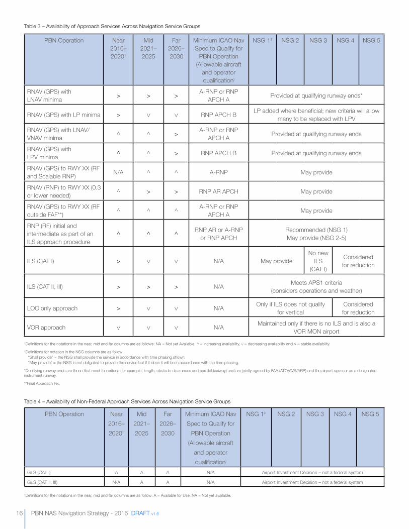
Tables 3-5 on page 16 and 17 provide three key pieces of information for NSGs 1-5. The first is to list the range of PBN operations available across the NSGs by the far-term timeframe. The second is to show the NSGs where PBN operations are expected to be implemented by the far term. This includes whether a given PBN operation will be required or optional, and whether availability of the operation will be phased in, reduced or remain unchanged over the next 15 years. Finally, the tables list the ICAO PBN manual navigation specifications associated with the PBN operation to show the alignment to the global interoperability standards for aircraft eligibility and operational acceptance. These tables represent a high-level summary of planned activities across the NSGs; additional details are provided in the three five-year timeframe sections.
GLS is a non-federal system that exists as a service at some airports in the NAS. Table 4 indicates that GLS approach criteria are available for CAT I and are being developed for CAT II and III, while the availability of GBAS systems will be based on airport investment decisions.
The FAA is developing a cost-benefit analysis to determine the viability of FAA acquisition of GBAS as a federal system. In the interim, as more airports make individual GBAS investments and more aircraft are entering service with GLS capability, the FAA will support the delivery of benefits from the operation of the non-federal GBAS facilities by approving
16 PBN NAS Navigation Strategy - 2016 DRAFT v1.6
PBN Operation Near2016–2020†
Mid2021–2025
Far2026–2030
Minimum ICAO Nav Spec to Qualify for
PBN Operation (Allowable aircraft
and operator qualification)
NSG 1‡ NSG 2 NSG 3 NSG 4 NSG 5
RNAV (GPS) with LNAV minima > > > A-RNP or RNP
APCH A Provided at qualifying runway ends*
RNAV (GPS) with LP minima > RNP APCH B LP added where beneficial; new criteria will allow many to be replaced with LPV
RNAV (GPS) with LNAV/VNAV minima ^ ^ > A-RNP or RNP
APCH A Provided at qualifying runway ends
RNAV (GPS) with LPV minima ^ ^ > RNP APCH B Provided at qualifying runway ends
RNAV (GPS) to RWY XX (RF and Scalable RNP) N/A ^ ^ A-RNP May provide
RNAV (RNP) to RWY XX (0.3 or lower needed) ^ > > RNP AR APCH May provide
RNAV (GPS) to RWY XX (RF outside FAF**) ^ ^ ^ A-RNP or RNP
APCH A May provide
RNP (RF) initial and intermediate as part of an ILS approach procedure
^ ^ ^ RNP AR or A-RNP or RNP APCH
Recommended (NSG 1) May provide (NSG 2-5)
ILS (CAT I) > N/A May provideNo new
ILS (CAT I)
Considered for reduction
ILS (CAT II, III) > > > N/A Meets APS1 criteria(considers operations and weather)
LOC only approach > N/A Only if ILS does not qualify for vertical
Considered for reduction
VOR approach N/A Maintained only if there is no ILS and is also a VOR MON airport
Table 3 – Availability of Approach Services Across Navigation Service Groups
†Definitions for the notations in the near, mid and far columns are as follows: NA = Not yet Available, ^ = increasing availability, = decreasing availability and > = stable availability.‡Definitions for notation in the NSG columns are as follow:
“Shall provide” = the NSG shall provide the service in accordance with time phasing shown.“May provide” = the NSG is not obligated to provide the service but if it does it will be in accordance with the time phasing.
*Qualifying runway ends are those that meet the criteria (for example, length, obstacle clearances and parallel taxiway) and are jointly agreed by FAA (ATO/AVS/ARP) and the airport sponsor as a designated instrument runway.
**Final Approach Fix.
PBN Operation Near2016–2020†
Mid2021–2025
Far2026–2030
Minimum ICAO Nav Spec to Qualify for
PBN Operation (Allowable aircraft
and operator qualification)
NSG 1‡ NSG 2 NSG 3 NSG 4 NSG 5
GLS (CAT I) A A A N/A Airport Investment Decision – not a federal system
GLS (CAT II, III) N/A A A N/A Airport Investment Decision – not a federal system
Table 4 – Availability of Non-Federal Approach Services Across Navigation Service Groups
†Definitions for the notations in the near, mid and far columns are as follow: A = Available for Use, NA = Not yet available.
www.faa.gov 17
new facilities, developing and publishing GLS approach procedures, training controllers and providing flight inspection services. The FAA is also supporting the development and approval of CAT II/III GLS capability, which is expected to be available late in the near term. Until the FAA’s investment decision is made, GLS services will be available only where funded, provided and installed by an airport operator or other qualified non-federal navigation system sponsor and approved through the FAA’s non-federal system program.
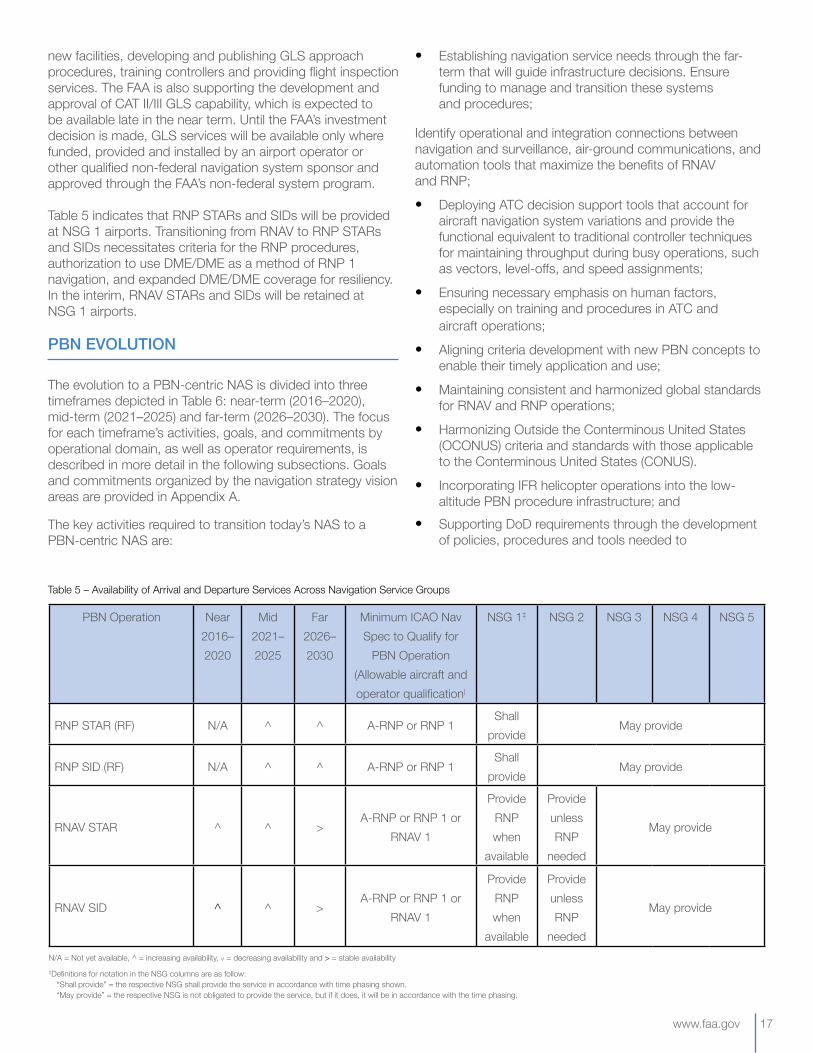
Table 5 indicates that RNP STARs and SIDs will be provided at NSG 1 airports. Transitioning from RNAV to RNP STARs and SIDs necessitates criteria for the RNP procedures, authorization to use DME/DME as a method of RNP 1 navigation, and expanded DME/DME coverage for resiliency. In the interim, RNAV STARs and SIDs will be retained at NSG 1 airports.
PBN EVOLUTION
The evolution to a PBN-centric NAS is divided into three timeframes depicted in Table 6: near-term (2016–2020), mid-term (2021–2025) and far-term (2026–2030). The focus for each timeframe’s activities, goals, and commitments by operational domain, as well as operator requirements, is described in more detail in the following subsections. Goals and commitments organized by the navigation strategy vision areas are provided in Appendix A.
The key activities required to transition today’s NAS to a PBN-centric NAS are:
• Establishing navigation service needs through the far-term that will guide infrastructure decisions. Ensure funding to manage and transition these systems and procedures;
Identify operational and integration connections between navigation and surveillance, air-ground communications, and automation tools that maximize the benefits of RNAV and RNP;
• Deploying ATC decision support tools that account for aircraft navigation system variations and provide the functional equivalent to traditional controller techniques for maintaining throughput during busy operations, such as vectors, level-offs, and speed assignments;
• Ensuring necessary emphasis on human factors, especially on training and procedures in ATC and aircraft operations;
• Aligning criteria development with new PBN concepts to enable their timely application and use;
• Maintaining consistent and harmonized global standards for RNAV and RNP operations;
• Harmonizing Outside the Conterminous United States (OCONUS) criteria and standards with those applicable to the Conterminous United States (CONUS).
• Incorporating IFR helicopter operations into the low-altitude PBN procedure infrastructure; and
• Supporting DoD requirements through the development of policies, procedures and tools needed to
N/A = Not yet available, ^ = increasing availability, = decreasing availability and > = stable availability‡Definitions for notation in the NSG columns are as follow:
“Shall provide” = the respective NSG shall provide the service in accordance with time phasing shown.“May provide” = the respective NSG is not obligated to provide the service, but if it does, it will be in accordance with the time phasing.
PBN Operation Near2016–2020
Mid2021–2025
Far2026–2030
Minimum ICAO Nav Spec to Qualify for
PBN Operation (Allowable aircraft and operator qualification)
NSG 1‡ NSG 2 NSG 3 NSG 4 NSG 5
RNP STAR (RF) N/A ^ ^ A-RNP or RNP 1Shall
provideMay provide
RNP SID (RF) N/A ^ ^ A-RNP or RNP 1Shall
provideMay provide
RNAV STAR ^ ^ >A-RNP or RNP 1 or
RNAV 1
Provide RNP when
available
Provide unless RNP
needed
May provide
RNAV SID ^ ^ >A-RNP or RNP 1 or
RNAV 1
Provide RNP when
available
Provide unless RNP
needed
May provide
Table 5 – Availability of Arrival and Departure Services Across Navigation Service Groups
18 PBN NAS Navigation Strategy - 2016 DRAFT v1.6
accommodate the unique missions and capabilities of military aircraft operating in the NAS.
HELICOPTEROPERATIONS
Heliports and helicopter operations fill important roles in the United States. As the NAS transitions to PBN, it will become increasing important to consider the integration of helicopter operations. The focus area will be de-conflicting low altitude airspace shared among multiple aircraft types through the publication of helicopter IFR routing and PBN approaches to heliports. While this strategy document does not extensively discuss heliports and helicopters, the FAA continues to
develop the PBN strategy in this area, with details to be included in subsequent versions of the document.
GOVERNMENTAIRCRAFTOPERATIONS
Moving to a PBN-based navigation system for the NAS will provide significant opportunities for improved safety, as well as operational and flight efficiencies for civil and military operators. This evolution requires a continued advancement of aircraft and avionics to meet current and future airspace performance requirements. The FAA is committed to working with the DoD and other governmental bodies to ensure that they are able to fulfill their roles in providing for national
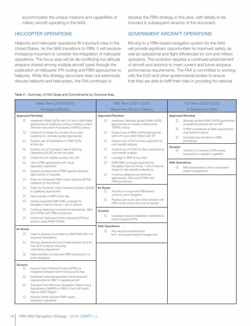
Table 6 – Summary of FAA Goals and Commitments by Outcome Area
Near Term (2016–2020) Increase Utilization
Mid Term (2021–2025) Streamline Service Delivery
Far Term (2026–2030) A Streamlined NAS
Approach/Terminal
¨ Implement RNAV (GPS) with LPV and LNAV/VNAV approaches at qualifying runways meeting current Terminal Instrument Procedures (TERPS) criteria
¨ Criteria to increase the number of runways qualifying for vertically guided approaches
¨ Expand use of Established on RNP (EoR) at first site
¨ Expand use of Equivalent Lateral Spacing Operations (ELSO) at first two sites
¨ Criteria for low visibility access with LPV ¨ Use of PBN approaches with visual
separation standards ¨ Expand development of PBN special helicopter
approaches to hospitals ¨ Policy for Enhanced Flight Vision Systems (EFVS)
operation to touchdown ¨ Policy for Synthetic Vision Guidance System (SVGS)
to qualifying approaches ¨ Demonstrate A-RNP at first site ¨ Initiate expanded DME/DME coverage for
Navigation Service Group 1 and 2 airports ¨ Continue replacing conventional approaches, SIDs
and STARs with PBN procedures ¨ Implement Optimized Profile Descents (OPD) at
airports using RNAV STARs
Approach/Terminal
¨ Implement Vertically guided RNAV (GPS) approaches at runways meeting new TERPS criteria
¨ Expand use of RNAV (GPS) approaches (with LPV and LNAV/VNAV) with RF
¨ Expand use of EoR at sites supported by cost-benefit analysis
¨ Expand use of ELSO at sites supported by cost-benefit analysis
¨ Leverage A-RNP at key sites ¨ DME/DME coverage expanded for
Navigation Service Group 1 and 2 airports based on site-specific evaluations
¨ Continue replacing conventional approaches, SIDs and STARs with PBN procedures
Approach/Terminal
¨ Vertically guided RNAV (GPS) approaches at qualifying airports with an IAP
¨ A-RNP procedures at sites supported by cost-benefit analysis
¨ Complete the transition to PBN procedures
Oceanic ¨ Transition to dynamic UPRs where
supported by operator capability
NAS Operations
¨ NAS transitioned to time- and speed-based management
En Route ¨ Transition to improved PBN-based
point-to-point navigation ¨ Replace Jet routes and Victor airways with
PBN routes where structure is needed
Oceanic
¨ Leverage reduced separation standards to further expand UPRs
NAS Operations
¨ Key airports transitioned to time- and speed-based management
En Route
¨ Class A airspace is covered by DME/DME (IRU not required) redundancy
¨ Shorten development and implementation time for new ATS routes by removing rulemaking requirement
¨ Initial transition to improved PBN-based point-to-point navigation
Oceanic ¨ Expand User Preferred Routes (UPRs) for
navigation between North America and Asia ¨ Implement reduced separation climb/descend
requirements for RNP 4 capable aircraft ¨ Transition from Minimum Navigation Performance
Specification (MNPS) to PBN in the ICAO North Atlantic (NAT) Region
¨ Analyze further reduced RNP-based separation standards
www.faa.gov 19
defense, search and rescue, transport and other missions critical to U.S. interests.
2016–2020 TIMEfRAME
In the near term, efforts will continue to focus on ensuring that the NAS infrastructure provides the appropriate navigation services at airports and throughout NAS. At larger airports, the focus will be on increasing use of existing PBN procedures, continuing implementation at major metroplex sites, optimizing the procedures that are already in place, and ensuring resilient navigation infrastructure is available in the event of GNSS service disruptions. At smaller airports, the focus will be on providing additional safety by implementing PBN approaches with vertical guidance, which is LPV and Lateral Navigation/Vertical Navigation (LNAV/VNAV) lines of minima to every qualified runway end.12
KEYNEAR-TERMFOCUS
Throughout the near term, the FAA will focus on increasing the use of PBN procedures, particularly RNAV STARsThis will require providing ATC with decision support tools that support the use of PBN procedures and account for aircraft performance variability. It will also require training the controller workforce as appropriate on state-of-the-art PBN procedures, TBFM capabilities, and best practices.
Operator and pilot training will also play a key role in ensuring that the most efficient procedures available are used routinely and safely. In the near term, the FAA is committed to:
• Emphasizing pilot training and accountability in proper use of phraseology during PBN operations;
• Developing Airmen Certification Standards that consolidate Practical Test Standards with pilot knowledge requirements and risk management strategies. (Updates to material regarding PBN and satellite-based navigation operations are included as part of this effort);
• Developing guidance to address vulnerabilities in the pilot’s management of path automation based on recommendations provided by the Air Carrier Training Aviation Rulemaking Committee (ACT ARC) Flight Deck Automation Working Group; and
• Continuing to update ACs, the AIM, and other guidance materials related to PBN operations as warranted. These updates will continue throughout the near term and beyond.
The entire aviation community contributes to increasing the use of PBN procedures. Harmonizing and updating aircraft avionics to take advantage of PBN procedures will reduce ATC complexity, allowing equipped users to derive benefits more often.
As new traffic management and avionics capabilities become available and are integrated into the fabric of the NAS, the system as a whole will become more efficient, and individual users will see benefits, including increased predictability and more opportunities to fly efficient trajectories.
APPROACH
In the approach phase of flight, near-term initiatives will focus on increasing safety and improving throughput during low-visibility conditions. Commitments include:
• Continuing replacement of current conventional approach procedures with PBN procedures. Replacement of these procedures will reduce costs and training requirements;
• Implementing RNAV (GPS) approaches with LPV and LNAV/VNAV lines of minima at runways that qualify according to the current Terminal Instrument Procedures (TERPS) criteria. Providing vertical guidance increases safety by supporting a stabilized approach. These approach procedures will be developed to support participation by aircraft in as many approach categories (categories A, B, C and D) as possible. Furthermore, revision to the TERPS criteria will increase the number of runways that qualify for an LPV approach;
• Revising criteria allowing LPV approaches to Special Authorization CAT I/1800 Runway Visual Range (RVR) minima and for CAT II minima. This will expand access during low visibility to aircraft with WAAS capabilities;
• Developing and implementing an operational capability that leverages the predictability and repeatability of PBN instrument approach procedures and the efficiency of visual separation standards. This will be achieved through updating standards, phraseology and training, and will not require new IAPs. This combination is expected to result in enhanced safety and efficiency during visual conditions without the added complexity of multiple approach procedures;
• Implementing Established on RNP (EoR) operations and routine use at a key site by the end of the near term. EoR enables controllers to clear aircraft on an RNP approach while on the downwind to the airport without the need to use the standard 1,000 feet of vertical or 3 nm lateral separation when the aircraft turns to align with the runway centerline (Figure 9 on page 20). This change to separation standards allows aircraft to turn to align to the runway much closer to the field, reducing track miles, fuel burn and noise. EoR provides safety, reliability and efficiency benefits in the NAS while improving customer service and minimizing delays en route and on the ground. The FAA recently completed a safety study using EoR with Track-to-Fix (TF) legs rather than RF legs, paving the way to significantly increase the number of aircraft eligible to participate in EoR;
12 Qualified runway ends are those that meet the criteria (e.g., length, obstacle clearances and parallel taxiway) and are jointly agreed on by the FAA (ATO/AVS/ARP) and the airport sponsor as a designated instrument runway. Most, but not all, airports in the NPIAS will have an IAP to at least a single runway end for reliable, safe access.
20 PBN NAS Navigation Strategy - 2016 DRAFT v1.6
• Developing PBN special helicopter approaches where needed to ensure safe arrival to hospitals for emergency medical service operations. Where hospitals are located near major metropolitan areas and airports, it may be challenging to develop these procedures due to the constraints of nearby airport IAPs. As with other procedure projects, these will rely on early engagement with all affected stakeholders;
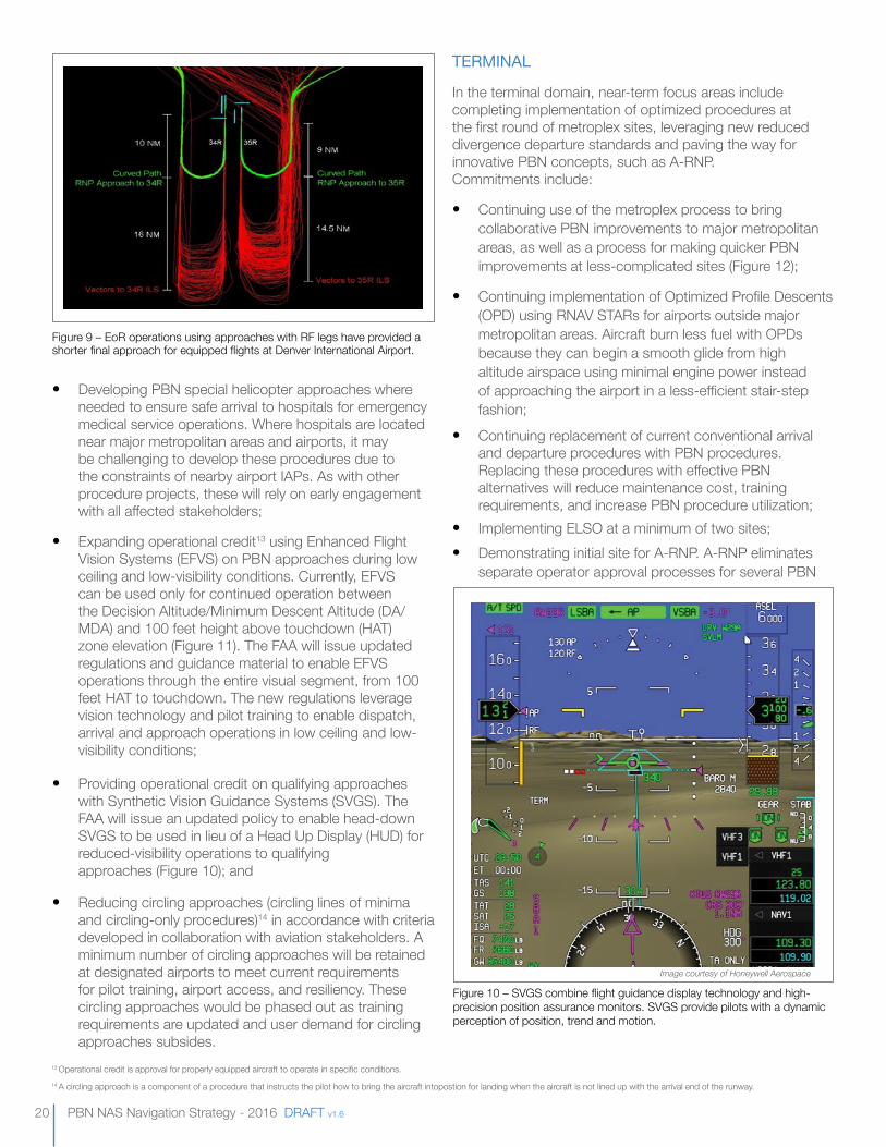
• Expanding operational credit13 using Enhanced Flight Vision Systems (EFVS) on PBN approaches during low ceiling and low-visibility conditions. Currently, EFVS can be used only for continued operation between the Decision Altitude/Minimum Descent Altitude (DA/MDA) and 100 feet height above touchdown (HAT) zone elevation (Figure 11). The FAA will issue updated regulations and guidance material to enable EFVS operations through the entire visual segment, from 100 feet HAT to touchdown. The new regulations leverage vision technology and pilot training to enable dispatch, arrival and approach operations in low ceiling and low-visibility conditions;
• Providing operational credit on qualifying approaches with Synthetic Vision Guidance Systems (SVGS). The FAA will issue an updated policy to enable head-down SVGS to be used in lieu of a Head Up Display (HUD) for reduced-visibility operations to qualifying approaches (Figure 10); and
• Reducing circling approaches (circling lines of minima and circling-only procedures)14 in accordance with criteria developed in collaboration with aviation stakeholders. A minimum number of circling approaches will be retained at designated airports to meet current requirements for pilot training, airport access, and resiliency. These circling approaches would be phased out as training requirements are updated and user demand for circling approaches subsides.
TERMINAL
In the terminal domain, near-term focus areas include completing implementation of optimized procedures at the first round of metroplex sites, leveraging new reduced divergence departure standards and paving the way for innovative PBN concepts, such as A-RNP. Commitments include:
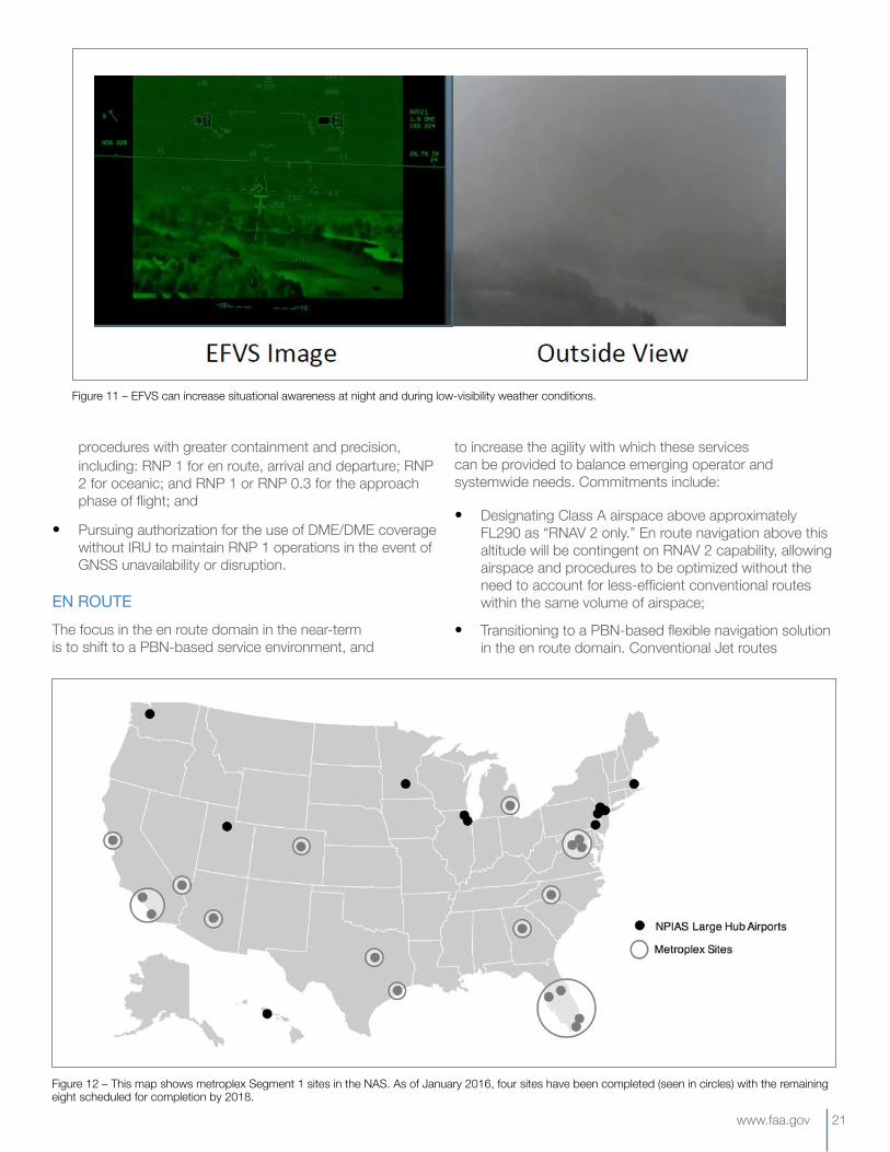
• Continuing use of the metroplex process to bring collaborative PBN improvements to major metropolitan areas, as well as a process for making quicker PBN improvements at less-complicated sites (Figure 12);
• Continuing implementation of Optimized Profile Descents (OPD) using RNAV STARs for airports outside major metropolitan areas. Aircraft burn less fuel with OPDs because they can begin a smooth glide from high altitude airspace using minimal engine power instead of approaching the airport in a less-efficient stair-step fashion;
• Continuing replacement of current conventional arrival and departure procedures with PBN procedures. Replacing these procedures with effective PBN alternatives will reduce maintenance cost, training requirements, and increase PBN procedure utilization;
• Implementing ELSO at a minimum of two sites; • Demonstrating initial site for A-RNP. A-RNP eliminates
separate operator approval processes for several PBN
Figure 9 – EoR operations using approaches with RF legs have provided a shorter final approach for equipped flights at Denver International Airport.
13 Operational credit is approval for properly equipped aircraft to operate in specific conditions.14 A circling approach is a component of a procedure that instructs the pilot how to bring the aircraft intopostion for landing when the aircraft is not lined up with the arrival end of the runway.
Figure 10 – SVGS combine flight guidance display technology and high-precision position assurance monitors. SVGS provide pilots with a dynamic perception of position, trend and motion.
Image courtesy of Honeywell Aerospace
www.faa.gov 21
procedures with greater containment and precision, including: RNP 1 for en route, arrival and departure; RNP 2 for oceanic; and RNP 1 or RNP 0.3 for the approach phase of flight; and
• Pursuing authorization for the use of DME/DME coverage without IRU to maintain RNP 1 operations in the event of GNSS unavailability or disruption.
ENROUTEThe focus in the en route domain in the near-term is to shift to a PBN-based service environment, and
to increase the agility with which these services can be provided to balance emerging operator and systemwide needs. Commitments include:
• Designating Class A airspace above approximately FL290 as “RNAV 2 only.” En route navigation above this altitude will be contingent on RNAV 2 capability, allowing airspace and procedures to be optimized without the need to account for less-efficient conventional routes within the same volume of airspace;
• Transitioning to a PBN-based flexible navigation solution in the en route domain. Conventional Jet routes
Figure 11 – EFVS can increase situational awareness at night and during low-visibility weather conditions.
Figure 12 – This map shows metroplex Segment 1 sites in the NAS. As of January 2016, four sites have been completed (seen in circles) with the remaining eight scheduled for completion by 2018.
22 PBN NAS Navigation Strategy - 2016 DRAFT v1.6
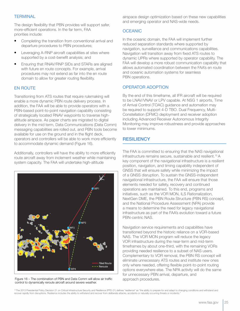
(Figure 13) and many Victor airways will begin to be removed and replaced with a PBN route structure where needed. Elsewhere, PBN-based point-to-point navigation will be used. The RNAV waypoints within the Navigation Reference System (NRS) grid that are currently being used or are expected to have future utility will be retained and renamed to be more usable. The rest may be removed to simplify en route navigation charts and conserve FMS memory capacity; and
• Updating policy to remove the notice of proposed rulemaking requirement for ATS routes in the en route domain. Removing this requirement will reduce the time it takes to develop and implement new ATS routes. As always, the FAA will conduct an appropriate environmental review for any new procedures.
OCEANIC
In the near-term, the oceanic domain will expand the PBN-based service environment and complete implementation of optimized services. Commitments include:
• Continuing use of PBN-based reduced separation standards predicated on RNP 10 and RNP 4;
• Expanding the use of User Preferred Routes (UPRs) as the primary means of navigation for flights operating between North America and Asia;
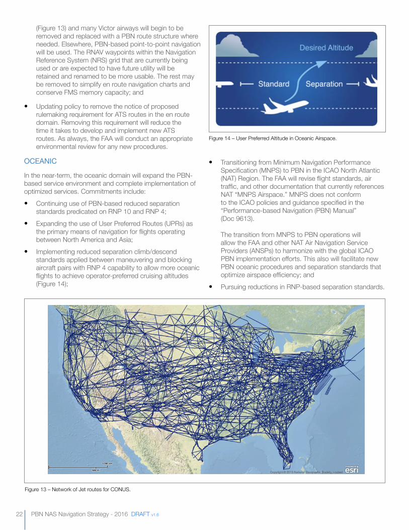
• Implementing reduced separation climb/descend standards applied between maneuvering and blocking aircraft pairs with RNP 4 capability to allow more oceanic flights to achieve operator-preferred cruising altitudes (Figure 14);
• Transitioning from Minimum Navigation Performance Specification (MNPS) to PBN in the ICAO North Atlantic (NAT) Region. The FAA will revise flight standards, air traffic, and other documentation that currently references NAT “MNPS Airspace.” MNPS does not conform to the ICAO policies and guidance specified in the “Performance-based Navigation (PBN) Manual” (Doc 9613). The transition from MNPS to PBN operations will allow the FAA and other NAT Air Navigation Service Providers (ANSPs) to harmonize with the global ICAO PBN implementation efforts. This also will facilitate new PBN oceanic procedures and separation standards that optimize airspace efficiency; and
• Pursuing reductions in RNP-based separation standards.
Figure 13 – Network of Jet routes for CONUS.
Figure 14 – User Preferred Altitude in Oceanic Airspace.
www.faa.gov 23
OPERATORADOPTION
In the near term, navigation in Class A airspace above approximately FL290 will require RNAV 2 capability, which is currently supported by GNSS and DME/DME with IRU. The FAA will expand DME infrastructure to allow RNAV operations to continue in Class A airspace in the event of GNSS disruption without requiring IRU, allowing more aircraft to participate. The PBN resiliency strategy is discussed further in the Resiliency section on page 25, and operator performance goals are described in the Minimum PBN Capabilities section on page 27.
2021–2025 TIMEfRAME
In the mid term, navigation within the NAS will become increasingly PBN-centric, more resilient against GNSS service disruptions, and be supported by agile processes and tools for deploying and maintaining PBN procedures. Implementation of criteria and plans developed in the near term will begin to significantly shape the operation of the NAS, and the rationalization of ground-based navigation infrastructure will reduce the number of VOR facilities and, to a lesser extent, the number of Category I ILSs.
KEYMID-TERMFOCUS
The focus of the mid-term timeframe will be to expedite the delivery, use and subsequent maintenance of PBN services. Commitments include:
• Developing procedure-design tools and processes that accelerate the ability to move from criteria to implemented procedures. This is accomplished by syncing criteria, data and design automation software;
• Completing the transition to digital delivery of chart data. This continued modernization of how procedure information is delivered to operators will improve coordination and reduce the time required to introduce procedure changes to the NAS. Collaboration with DoD will ensure a chart delivery option that accommodates the capabilities of military aircraft operating in the NAS;
• Completing development of an automated tool for periodic review of procedures, which will reduce the resource requirements to maintain procedures; and
• Facilitating aircraft qualification and operator approvals for A-RNP, applicable to oceanic, en route, terminal and approach PBN operations.
APPROACH
In the mid term, the FAA will continue to enhance safety, access and efficiency by expanding vertically guided approaches to newly qualifying runway ends and building upon near-term safety studies and criteria changes to provide
advanced navigation capabilities that more operators are equipped to fly. Commitments include:
• Building upon TERPS criteria revised in the near-term by providing vertically-guided RNAV (GPS) approaches at qualifying runways meeting new TERPS criteria;
• Expanding the use of RNAV (GPS) approaches with RF legs. Based on the current limitations of many aircraft operating across the NAS, use of TF legs will exist as needed to support the migration to RF legs. Over the next 15 years, the strategy requires the transition from TF to RF, rendering TF legs the exception and RF legs the norm at NSG 1 and 2 airports. Approaches with RF legs are preferred at NSG 1 and 2 airports as these provide higher track predictability and better support for time and speed-based traffic management than TF legs. Based on operator equipage rates, the use of TF legs may provide for higher procedure utilization and result in a more beneficial operation in the short term. RNAV (RNP) approaches will be retained where necessary;
• Continuing the application of EoR operations at sites supported by cost-benefit analysis; and
• Continuing to replace current conventional approach procedures with PBN procedures.
TERMINAL
In the terminal environment, the FAA will begin leveraging A-RNP at key sites that have constraints, such as terrain or proximity to busy, complex traffic flows. The FAA will increasingly leverage reduced separation standards, such as ELSO, at sites supported by cost-benefit analysis. The FAA also will continue to replace conventional arrival and departure procedures with PBN procedures.
ENROUTE
In the en route environment, the FAA will focus on continuing efforts initiated in the near-term to provide additional PBN ATS routes and point-to-point navigation where operationally beneficial, and to remove most conventional ATS routes. Commitments include:
• Replacing conventional Jet routes with Q-routes (or non-rulemaking equivalent) where route structure continues to be needed and with a PBN-based point-to-point navigation solution elsewhere;
• Implementing T-routes (or non-rulemaking equivalent) where beneficial, typically to provide access for GA aircraft to transition through or around Class B or Class C airspace; and
• Eliminating Victor airways, except where needed in mountainous regions and areas without radar coverage as operationally required.
24 PBN NAS Navigation Strategy - 2016 DRAFT v1.6
OCEANIC
In the oceanic environment, the FAA will continue to pursue further reductions in RNP-based separation standards. These reductions are dependent on advances in surveillance and communication capabilities. The FAA will also leverage reduced separation standards to expand the implementation of UPRs.
OPERATORADOPTION
The mid-term commitments include changes to methods of IFR navigation throughout the NAS. Early in the mid term, all IFR aircraft are expected to meet RNAV 2 and RNAV 1 performance requirements supported by GNSS. By the end of the mid-term, all IFR aircraft are expected to have RNAV (GPS) approach capability (with LNAV at a minimum). Aircraft without the following capabilities may not be able to efficiently access NSG 1 airports:
• RNAV (GPS) approach with LNAV/VNAV or LPV;• RNP 1;• DME navigation; and• RF.
2026–2030 TIMEfRAME
By 2030, PBN procedures and flexible routing will be the standard method of navigation throughout the NAS during normal operating conditions. The number of VORs and ILSs in the NAS will be reduced as a result of rationalization, and VORs that remain in the MON will be re-evaluated within the new system context.
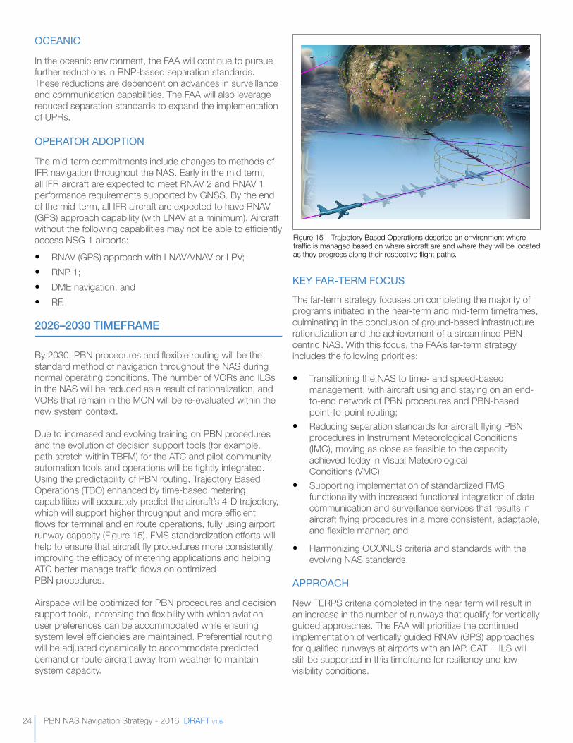
Due to increased and evolving training on PBN procedures and the evolution of decision support tools (for example, path stretch within TBFM) for the ATC and pilot community, automation tools and operations will be tightly integrated. Using the predictability of PBN routing, Trajectory Based Operations (TBO) enhanced by time-based metering capabilities will accurately predict the aircraft’s 4-D trajectory, which will support higher throughput and more efficient flows for terminal and en route operations, fully using airport runway capacity (Figure 15). FMS standardization efforts will help to ensure that aircraft fly procedures more consistently, improving the efficacy of metering applications and helping ATC better manage traffic flows on optimized PBN procedures.
Airspace will be optimized for PBN procedures and decision support tools, increasing the flexibility with which aviation user preferences can be accommodated while ensuring system level efficiencies are maintained. Preferential routing will be adjusted dynamically to accommodate predicted demand or route aircraft away from weather to maintain system capacity.
KEYFAR-TERMFOCUS
The far-term strategy focuses on completing the majority of programs initiated in the near-term and mid-term timeframes, culminating in the conclusion of ground-based infrastructure rationalization and the achievement of a streamlined PBN-centric NAS. With this focus, the FAA’s far-term strategy includes the following priorities:
• Transitioning the NAS to time- and speed-based management, with aircraft using and staying on an end-to-end network of PBN procedures and PBN-based point-to-point routing;
• Reducing separation standards for aircraft flying PBN procedures in Instrument Meteorological Conditions (IMC), moving as close as feasible to the capacity achieved today in Visual Meteorological Conditions (VMC);
• Supporting implementation of standardized FMS functionality with increased functional integration of data communication and surveillance services that results in aircraft flying procedures in a more consistent, adaptable, and flexible manner; and
• Harmonizing OCONUS criteria and standards with the evolving NAS standards.
APPROACH
New TERPS criteria completed in the near term will result in an increase in the number of runways that qualify for vertically guided approaches. The FAA will prioritize the continued implementation of vertically guided RNAV (GPS) approaches for qualified runways at airports with an IAP. CAT III ILS will still be supported in this timeframe for resiliency and low-visibility conditions.
Figure 15 – Trajectory Based Operations describe an environment where traffic is managed based on where aircraft are and where they will be located as they progress along their respective flight paths.
www.faa.gov 25
TERMINAL
The design flexibility that PBN provides will support safer, more-efficient operations. In the far term, FAA priorities include:• Completing the transition from conventional arrival and
departure procedures to PBN procedures;
• Leveraging A-RNP aircraft capabilities at sites where supported by a cost-benefit analysis; and
• Ensuring that RNAV/RNP SIDs and STARs are aligned with future en route concepts. For example, arrival procedures may not extend as far into the en route domain to allow for greater routing flexibility.
ENROUTE
Transitioning from ATS routes that require rulemaking will enable a more dynamic PBN route delivery process. In addition, the FAA will be able to provide operators with a PBN-based point-to-point navigation capability consisting of strategically located RNAV waypoints to traverse high-altitude airspace. As paper charts are migrated to digital delivery in the mid term, Data Communications (Data Comm) messaging capabilities are rolled out, and PBN tools become available for use on the ground and in the flight deck, operators and controllers will be able to work more efficiently to accommodate dynamic demand (Figure 16).
Additionally, controllers will have the ability to more efficiently route aircraft away from inclement weather while maintaining system capacity. The FAA will undertake high-altitude
airspace design optimization based on these new capabilities and emerging operator and NAS-wide needs.
OCEANIC
In the oceanic domain, the FAA will implement further reduced separation standards where supported by navigation, surveillance and communications capabilities. Navigation will transition away from fixed ATS routes to dynamic UPRs where supported by operator capability. The FAA will develop a more robust communication capability that allows automated coordination between the FAA’s en route and oceanic automation systems for seamless PBN operations.
OPERATORADOPTION
By the end of this timeframe, all IFR aircraft will be required to be LNAV/VNAV or LPV capable. At NSG 1 airports, Time of Arrival Control (TOAC) guidance and automation may be required to support 4-D TBO. Dual Frequency, Multi-Constellation (DFMC) deployment and receiver adoption including Advanced Receiver Autonomous Integrity Monitoring may improve robustness and provide approaches to lower minimums.
RESILIENCY
The FAA is committed to ensuring that the NAS navigational infrastructure remains secure, sustainable and resilient.15 A key component of the navigational infrastructure is a resilient position, navigation, and timing capability independent of GNSS that will ensure safety while minimizing the impact of a GNSS disruption. To sustain the GNSS-independent navigational infrastructure, the FAA will ensure that those elements needed for safety, recovery and continued operations are maintained. To this end, programs and initiatives, such as the VOR MON, ILS Rationalization, NextGen DME, the PBN Route Structure (PBN RS) concept, and the National Procedure Assessment (NPA) provide a means to determine the need for legacy navigational infrastructure as part of the FAA’s evolution toward a future PBN-centric NAS.
Navigation service requirements and capabilities have transitioned beyond the historic reliance on a VOR-based NAS. The VOR MON program will reduce the legacy VOR infrastructure during the near-term and mid-term timeframes by about one-third, with the remaining VORs providing needed resilience to a subset of NAS users. Complementary to VOR removal, the PBN RS concept will eliminate unnecessary ATS routes and institute new ones only where needed, offering flexible point-to-point routing options everywhere else. The NPA activity will do the same for unnecessary PBN arrival, departure, and approach procedures.
15 The 2013 Presidential Policy Decision 21 on Critical Infrastructure Security and Resilience (PPD-21) defines “resilience” as “the ability to prepare for and adapt to changing conditions and withstand and recover rapidly from disruptions. Resilience includes the ability to withstand and recover from deliberate attacks, accidents or naturally occurring threats or incidents.”
Figure 16 – The combination of PBN and Data Comm will allow air traffic control to dynamically reroute aircraft around severe weather.
26 PBN NAS Navigation Strategy - 2016 DRAFT v1.6
The NextGen DME program will expand DME coverage in the en route and terminal domains to provide a resilient complementary system to support PBN operations in the event of a GNSS disruption without the need for an IRU. As PBN operations are expanded, the ground-based infrastructure including facilities and conventional instrument flight procedures will be reduced. The FAA has established teams to work across lines of business to rationalize the legacy ground-based infrastructure to ensure the necessary safety backup capability will always be maintained.
NEARTERM
By the end of the near term, the NAS will remain resilient with PBN services throughout Class A airspace provided by phasing in DME RNAV coverage down to 18,000 feet above mean sea level (MSL). The exception is areas in the Western Mountainous Region, where terrain severely limits line-of-sight coverage at altitudes below 24,000 feet MSL. DME coverage will exist without the need for an IRU, though operators without IRU may need to confirm critical DMEs are not out of service in the terminal area. Class A airspace will require DME/DME positioning for operators needing to access the airspace during a GNSS service disruption.16
Operators equipped with only a single FMS, and thus only a single DME/DME navigation source, will be allowed to use VOR (non-RNAV) or Tactical Air Navigation as an authorized second form of navigation to continue to dispatch during the disruption.
Once the PBN infrastructure is complete in particular locations or regions, the option will exist for the decommissioning of procedures and ground infrastructure, over time, where they are not required for system resiliency. As a result:
• No additional Non-Direction Beacon (NDB) approaches will be published, and NDB approaches used for training by the DoD or other private entities will not be included in the NAS;
• As part of the VOR MON, a program designed to change the purpose of VORs from providing a route structure to being a resilient method of navigation for non-DME/DME aircraft during a GNSS disruption, the discontinuance of approximately 70 of the current VOR stations will be completed by the end of the near term;
• The need to retain current ILSs at each individual location and runway will be assessed by the FAA’s ongoing ILS rationalization effort. Rationalization activities will be confined to CAT I ILSs at NSG 4 and 5 airports; and
• Increasing situational awareness of GNSS disruption events and the ability to quickly communicate information to the affected parties is an essential capability needed throughout the NAS to ensure effective and timely use of resilient infrastructure. In the near term, the
FAA will define requirements for a Satellite Operations Coordination Concept (SOCC) position at the FAA’s Air Traffic Control System Command Center to manage real-time information on the NAS navigation status.
MIDTERM
By the end of the mid term, the resilience of the NAS will be increased further with the following FAA commitments:
• DME/DME coverage, providing RNAV 1 navigation, will be extended down to NSG 1 and 2 airports to facilitate a conventional approach, as required (for example, 1,500 feet height above airport). This coverage will require the installation of additional DME facilities. Note that for departures, DME/DME may not provide needed coverage to support all PBN departures due to the aircraft computer processing delay that exists after receiving DME ground transponder signals. To maintain acceptable departure operations during a GNSS disruption, local facilities will have to develop contingency plans. DME/DME equipment will be required for those operators needing to access the airspace during a GNSS service disruption; and
• The SOCC will begin operations in the mid term, providing the real-time, system-level view of NAS navigation resiliency and coordinating mitigation to service disruptions.
The provision of DME/DME RNAV coverage in Class A airspace in the near-term and at the selected airports during the mid term will constitute a resilient position and navigation service for the NAS. The FAA will continue to evaluate alternatives for position and navigation as technologies and capabilities advance.
Improvements in navigation resiliency will allow for continued reduction of aging ground infrastructure and associated approach procedures. Thus:
• All NDB approaches will be discontinued in CONUS;
• ILS rationalization will continue at NSG 4 and 5 airports; and
• About 200 more current VOR facilities will be discontinued.
FARTERM
In the far term, the FAA will focus on the completion of legacy infrastructure divestment, making PBN the standard method of navigation. Conventional navigation will exist to ensure the resiliency of non-DME/DME operations, low-visibility approaches and DoD requirements. The FAA will be able to complete programs to recapitalize and divest from additional ground-based infrastructure. Priorities for the 2026–2030 timeframe include:
16 The FAA recognizes the capabilities of specific public aircraft fleets and potential effects these have on the operation within the en route domain. Refer to Government Aircraft text within Navigation Strategy Overview section.
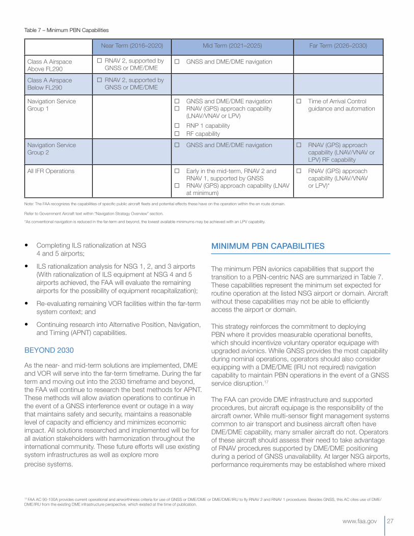
www.faa.gov 27
• Completing ILS rationalization at NSG 4 and 5 airports;
• ILS rationalization analysis for NSG 1, 2, and 3 airports (With rationalization of ILS equipment at NSG 4 and 5 airports achieved, the FAA will evaluate the remaining airports for the possibility of equipment recapitalization);
• Re-evaluating remaining VOR facilities within the far-term system context; and
• Continuing research into Alternative Position, Navigation, and Timing (APNT) capabilities.
BEYOND2030
As the near- and mid-term solutions are implemented, DME and VOR will serve into the far-term timeframe. During the far term and moving out into the 2030 timeframe and beyond, the FAA will continue to research the best methods for APNT. These methods will allow aviation operations to continue in the event of a GNSS interference event or outage in a way that maintains safety and security, maintains a reasonable level of capacity and efficiency and minimizes economic impact. All solutions researched and implemented will be for all aviation stakeholders with harmonization throughout the international community. These future efforts will use existing system infrastructures as well as explore more precise systems.
MINIMUM PBN CAPABILITIES
The minimum PBN avionics capabilities that support the transition to a PBN-centric NAS are summarized in Table 7. These capabilities represent the minimum set expected for routine operation at the listed NSG airport or domain. Aircraft without these capabilities may not be able to efficiently access the airport or domain.
This strategy reinforces the commitment to deploying PBN where it provides measurable operational benefits, which should incentivize voluntary operator equipage with upgraded avionics. While GNSS provides the most capability during nominal operations, operators should also consider equipping with a DME/DME (IRU not required) navigation capability to maintain PBN operations in the event of a GNSS service disruption.17
The FAA can provide DME infrastructure and supported procedures, but aircraft equipage is the responsibility of the aircraft owner. While multi-sensor flight management systems common to air transport and business aircraft often have DME/DME capability, many smaller aircraft do not. Operators of these aircraft should assess their need to take advantage of RNAV procedures supported by DME/DME positioning during a period of GNSS unavailability. At larger NSG airports, performance requirements may be established where mixed
Note: The FAA recognizes the capabilities of specific public aircraft fleets and potential effects these have on the operation within the en route domain.
Refer to Government Aircraft text within “Navigation Strategy Overview” section.
*As conventional navigation is reduced in the far-term and beyond, the lowest available minimums may be achieved with an LPV capability.
Table 7 – Minimum PBN Capabilities
Near Term (2016–2020) Mid Term (2021–2025) Far Term (2026–2030)
Class A Airspace Above FL290
¨ GNSS and DME/DME navigation
Class A Airspace Below FL290
Navigation Service Group 1
¨ GNSS and DME/DME navigation ¨ RNAV (GPS) approach capability
(LNAV/VNAV or LPV) ¨ RNP 1 capability ¨ RF capability
¨ Time of Arrival Control guidance and automation
Navigation Service Group 2
¨ GNSS and DME/DME navigation ¨ RNAV (GPS) approach capability (LNAV/VNAV or LPV) RF capability
All IFR Operations ¨ Early in the mid-term, RNAV 2 and RNAV 1, supported by GNSS
¨ RNAV (GPS) approach capability (LNAV at minimum)
¨ RNAV (GPS) approach capability (LNAV/VNAV or LPV)*
¨ RNAV 2, supported by GNSS or DME/DME
¨ RNAV 2, supported by GNSS or DME/DME
17 FAA AC 90-100A provides current operational and airworthiness criteria for use of GNSS or DME/DME or DME/DME/IRU to fly RNAV 2 and RNAV 1 procedures. Besides GNSS, this AC cites use of DME/DME/IRU from the existing DME infrastructure perspective, which existed at the time of publication.

28 PBN NAS Navigation Strategy - 2016 DRAFT v1.6
equipage cannot be supported, though rulemaking could be avoided with sufficient voluntary aircraft equipage.
For this strategy, it is expected that future industry development of avionics capabilities will be more standardized and consistent with the criteria of the RNP system and equipment standards produced by the RTCA’s Standards of Navigation Performance committee (Special Committee 227).
The result will be aircraft and avionics performance for PBN and instrument operations with greater reliability,
repeatability and predictability in their lateral, vertical and time-based performance. Additionally, these avionics will be highly integrated with highly integrated with Data Comm and surveillance technologies to enable more advanced operations, including dynamic RNP and interval management in the far-term.
This complex functional and operational integration will necessitate improved FAA/industry processes for oversight and coordination to ensure the desired outcomes are achieved across the communications, navigation, surveillance and air traffic management domains.
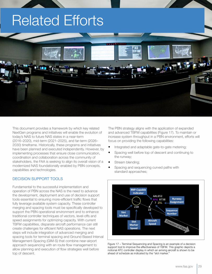
www.faa.gov 29
This document provides a framework by which key related NextGen programs and initiatives will enable the evolution of today’s NAS to future NAS states in a near-term (2016–2020), mid-term (2021–2025), and far-term (2026–2030) timeframe. Historically, these programs and initiatives have been planned and executed independently. However, by implementing processes that ensure close communication, coordination and collaboration across the community of stakeholders, the FAA is seeking to align its overall vision of a modernized NAS foundationally enabled by PBN concepts, capabilities and technologies.
DECISIONSUPPORTTOOLS
Fundamental to the successful implementation and operation of PBN across the NAS is the need to advance the development, deployment and use of decision support tools essential to ensuring more-efficient traffic flows that fully leverage available system capacity. These controller merging and spacing tools must be specifically developed to support the PBN operational environment and to enhance traditional controller techniques of vectors, level-offs and speed assignments for optimizing capacity. With current TBFM capabilities, disparate aircraft performance can still create challenges for efficient NAS operations. The next steps will include integration of advanced merging and spacing tools for terminal spacing and Ground Based Interval Management-Spacing (GIM-S) that combine near-airport approach sequencing with en route flow management to allow planning and execution of flow strategies well before top of descent.
The PBN strategy aligns with the application of expanded and advanced TBFM capabilities (Figure 17). To maintain or increase system throughput in a PBN environment, efforts will focus on providing the following capabilities:
• Integrated and adaptable gate-to-gate metering;• Spacing well before top of descent and continuing to
the runway;• Stream blending;• Spacing and sequencing curved paths with
standard approaches;
Figure 17 – Terminal Sequencing and Spacing is an example of a decision support tool to improve the effectiveness of TBFM. This graphic depicts a notional ATC controller display in which an arriving aircraft is shown to be ahead of schedule as indicated by the “slot marker.”
Related Efforts
30 PBN NAS Navigation Strategy - 2016 DRAFT v1.6
• Adaptability to airport specific route configurations and abnormal routing scenarios (such as route closure and weather avoidance);
• Integration of winds aloft data with trajectory modeling;
• Surface flow functionality; and
• Functionality across multiple facility platforms and aircraft equipage.
In addition to TBFM, enhancements to the En Route Automation Modernization (ERAM) and the Standard Terminal Automation Replacement System (STARS) will be necessary to maximize effective use of PBN procedures. By increasing the information available to controllers, these capabilities should allow aircraft to remain on the efficient PBN procedures more often.
These capabilities will lay the foundation for successful PBN initiatives. The FAA is committed to funding, testing, and implementing these tools in the NAS as soon as possible, recognizing that implementation may need to be staged to reflect unique operational needs at individual airports and ATC facilities.
SURVEILLANCE
ADS-B capability is enabled through the use of precision position, navigation, and timing services provided by GPS and WAAS. With the ADS-B Out equipage mandate for most controlled airspace set to take effect in 2020, operators can also achieve the benefits of operating in a PBN-centric NAS when incorporating a GPS/WAAS system into their FMS or navigation system.
COMMUNICATIONS
Currently, nearly all communication between the flight deck and controllers is done via audio radio channels. This has served pilots and controllers well for many years. However, with the growing number of flights expected to fly PBN procedures, changes in the way pilots and controllers communicate are needed to support an improved and more robust information exchange without impacting either pilot or controller workload.
The Data Comm program will provide data communications services between pilots and air traffic controllers, as well as enhanced air traffic control information to airline operations centers (Figure 18). Data Comm will provide
ERAM is the new FAA computer system used to control high altitude air traffic.
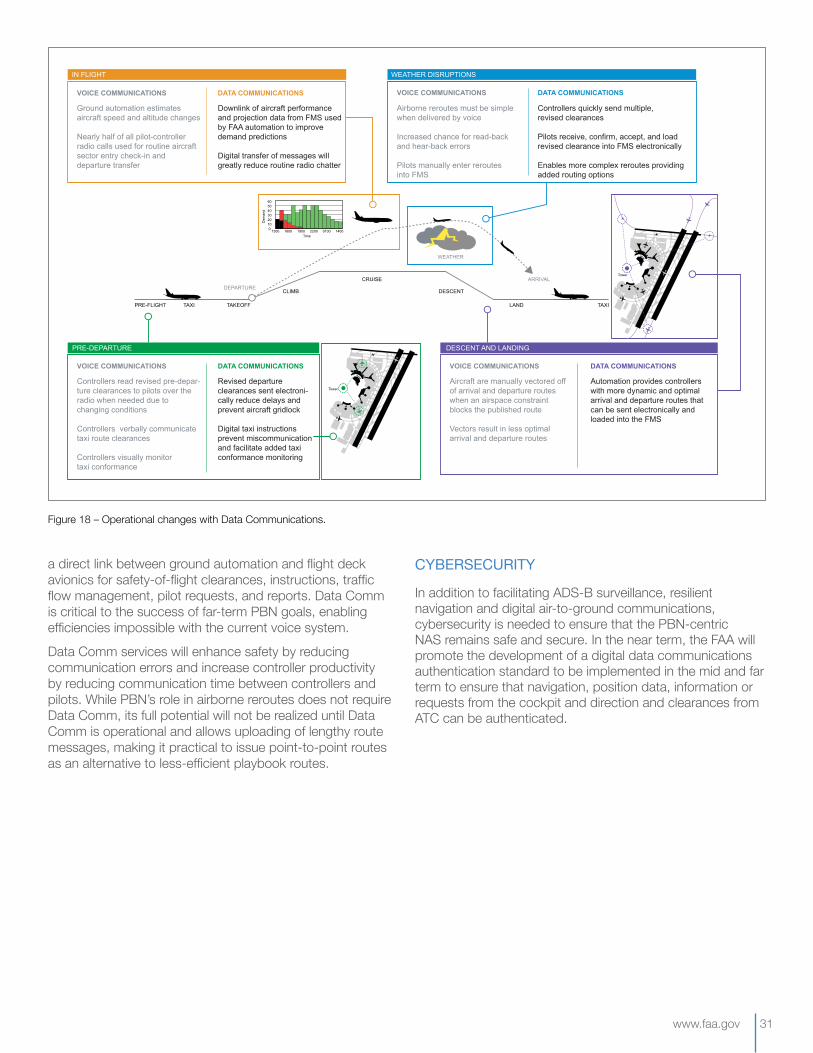
www.faa.gov 31
a direct link between ground automation and flight deck avionics for safety-of-flight clearances, instructions, traffic flow management, pilot requests, and reports. Data Comm is critical to the success of far-term PBN goals, enabling efficiencies impossible with the current voice system.
Data Comm services will enhance safety by reducing communication errors and increase controller productivity by reducing communication time between controllers and pilots. While PBN’s role in airborne reroutes does not require Data Comm, its full potential will not be realized until Data Comm is operational and allows uploading of lengthy route messages, making it practical to issue point-to-point routes as an alternative to less-efficient playbook routes.
CYBERSECURITY
In addition to facilitating ADS-B surveillance, resilient navigation and digital air-to-ground communications, cybersecurity is needed to ensure that the PBN-centric NAS remains safe and secure. In the near term, the FAA will promote the development of a digital data communications authentication standard to be implemented in the mid and far term to ensure that navigation, position data, information or requests from the cockpit and direction and clearances from ATC can be authenticated.
Figure 18 – Operational changes with Data Communications.
IN FLIGHT
PRE-FLIGHT TAXI TAKEOFF
CLIMB
CRUISE
DESCENT
LAND TAXI
WEATHER
WEATHER DISRUPTIONS
Ground automation estimates aircraft speed and altitude changes
Nearly half of all pilot-controller radio calls used for routine aircraft sector entry check-in and departure transfer
VOICE COMMUNICATIONS DATA COMMUNICATIONS
Downlink of aircraft performance and projection data from FMS used by FAA automation to improve demand predictions
Digital transfer of messages will greatly reduce routine radio chatter
Airborne reroutes must be simple when delivered by voice
Increased chance for read-back and hear-back errors
Pilots manually enter reroutesinto FMS
VOICE COMMUNICATIONS DATA COMMUNICATIONS
Controllers quickly send multiple, revised clearances
Pilots receive, confirm, accept, and load revised clearance into FMS electronically
Enables more complex reroutes providing added routing options
Controllers read revised pre-depar-ture clearances to pilots over the radio when needed due to changing conditions
Controllers verbally communicate taxi route clearances
Controllers visually monitor taxi conformance
VOICE COMMUNICATIONS DATA COMMUNICATIONS
Revised departure clearances sent electroni-cally reduce delays and prevent aircraft gridlock
Digital taxi instructions prevent miscommunication and facilitate added taxi conformance monitoring
Aircraft are manually vectored off of arrival and departure routes when an airspace constraint blocks the published route
Vectors result in less optimal arrival and departure routes
VOICE COMMUNICATIONS DATA COMMUNICATIONS
Automation provides controllers with more dynamic and optimal arrival and departure routes that can be sent electronically and loaded into the FMS
DESCENT AND LANDINGPRE-DEPARTURE
1300 1600 1900 2200 0100 14000
102030405060
Dem
and
Time
Tower
Tower
DEPARTUREARRIVAL
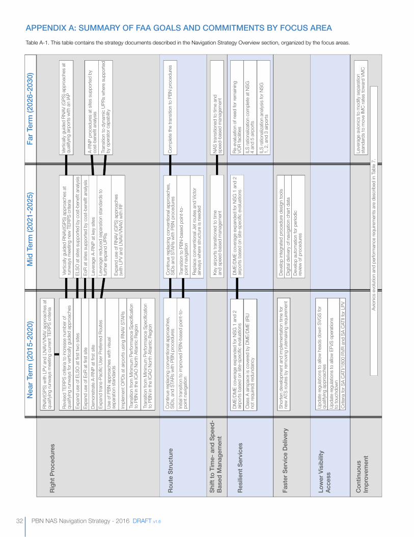
32 PBN NAS Navigation Strategy - 2016 DRAFT v1.6
APPENDIX A: SUMMARY Of fAA GOALS AND COMMITMENTS BY fOCUS AREATable A-1. This table contains the strategy documents described in the Navigation Strategy Overview section, organized by the focus areas.
Righ
t Pro
cedu
res
Rout
e St
ruct
ure
Resi
lient
Ser
vice
s
fast
er S
ervi
ce D
eliv
ery
Low
er V
isib
ility
Ac
cess
Con
tinuo
us
Impr
ovem
ent
Shift
to T
ime-
and
Spe
ed-
Base
d M
anag
emen
t
Nea
r Ter
m (2
015-
2020
)M
id T
erm
(202
1-20
25)
far T
erm
(202
6-20
30)
RNAV
(GPS
) with
LPV
and
LNA
V/VN
AV a
ppro
ache
s at
qu
alify
ing
runw
ays
mee
ting
curre
nt T
ERPS
crit
eria
Revis
ed T
ERPS
crit
eria
to in
crea
se n
umbe
r of
quali
fyin
g ru
nway
s fo
r ver
ticall
y gu
ided
app
roac
hes
Expa
nd u
se o
f ELS
O a
t firs
t tw
o sit
esEx
pand
use
of E
oR a
t firs
t site
Dem
onst
rate
A-R
NP a
t firs
t site
Expa
nd tr
ans-
Pacifi
c Us
er P
refe
rred
Rout
esUs
e of
PBN
app
roac
hes
with
visu
al se
para
tion
stan
dard
s
Impl
emen
t OPD
s at
airp
orts
usin
g RN
AV S
TARs
Tran
sitio
n fro
m M
inim
um P
erfo
rman
ce S
pecifi
catio
n to
PBN
in th
e IC
AO N
orth
Atla
ntic
Regi
on
Tran
sitio
n fro
m M
inim
um P
erfo
rman
ce S
pecifi
catio
n to
PBN
in th
e IC
AO N
orth
Atla
ntic
Regi
on
Cont
inue
repl
acin
g co
nven
tiona
l app
roac
hes,
SI
Ds, a
nd S
TARs
with
PBN
pro
cedu
res
Initia
l tra
nsitio
n to
impr
oved
PBN
-bas
ed p
oint
-to-
poin
t nav
igat
ion
DME/
DME
cove
rage
exp
ande
d fo
r NSG
1 a
nd 2
air
ports
bas
ed o
n sit
e-sp
ecific
eva
luat
ions
Clas
s A
airsp
ace
is co
vere
d by
DM
E/DM
E (IR
U no
t req
uire
d) re
dund
ancy
Shor
ten
deve
lopm
ent a
nd im
plem
enta
tion
time
for
new
ATS
rout
es b
y re
mov
ing
rulem
akin
g re
quire
men
t
Upda
te re
gulat
ions
to a
llow
hea
ds d
own
SVG
S fo
r qu
alify
ing
appr
oach
esUp
date
regu
latio
ns to
allo
w E
FVS
oper
atio
ns
to to
uchd
own
Crite
ria fo
r SA
CATI
/180
0 RV
R an
d SA
CAT
II fo
r LPV Avio
nics
evo
lutio
n an
d pe
rform
ance
requ
irem
ents
are
des
crib
ed in
Tab
le 7.
Verti
cally
gui
ded
RNAV
(GPS
) app
roac
hes
at
runw
ays
mee
ting
new
TER
PS c
riter
iaEL
SO a
t site
s su
ppor
ted
by c
ost-b
enefi
t ana
lysis
EoR
at s
ites
supp
orte
d by
cos
t-ben
efit a
nalys
isLe
vera
ge A
-RNP
at k
ey s
ites
Leve
rage
redu
ced
sepa
ratio
n st
anda
rds
to
furth
er e
xpan
d UP
Rs
Expa
nd u
se o
f RNA
V (G
PS) a
ppro
ache
s (w
ith L
PV a
nd L
NAV/
VNAV
) with
RF
Cont
inue
repl
acin
g co
nven
tiona
l app
roac
hes,
SI
Ds a
nd S
TARs
with
PBN
pro
cedu
res
Tran
sitio
n to
PBN
-bas
ed p
oint
-to-
poin
t nav
igat
ion
Repl
ace
conv
entio
nal J
et ro
utes
and
Vict
or
airw
ays
whe
re s
truct
ure
is ne
eded
Key
airpo
rts tr
ansit
ione
d to
tim
e an
d sp
eed-
base
d m
anag
emen
t
DME/
DME
cove
rage
exp
ande
d fo
r NSG
1 a
nd 2
air
ports
bas
ed o
n sit
e-sp
ecific
eva
luat
ions
Deve
lop
inte
grat
ed p
roce
dure
des
ign
tool
sDi
gita
l deli
very
of n
avig
atio
n ch
art d
ata
Deve
lop
auto
mat
ion
for p
erio
dic
revie
w o
f pro
cedu
res
Verti
cally
gui
ded
RNAV
(GPS
) app
roac
hes
at
quali
fyin
g air
ports
with
an
IAP
A-RN
P pr
oced
ures
at s
ites
supp
orte
d by
co
st-b
enefi
t ana
lysis
Tran
sitio
n to
dyn
amic
UPRs
whe
re s
uppo
rted
by o
pera
tor c
apab
ility
Com
plet
e th
e tra
nsitio
n to
PBN
pro
cedu
res
NAS
trans
itione
d to
tim
e an
d sp
eed-
base
d m
anag
emen
t
Re-e
valu
atio
n of
nee
d fo
r rem
ainin
g VO
R fa
cilitie
sIL
S ra
tiona
lizat
ion
com
plet
e at
NSG
4
and
5 air
ports
ILS
ratio
naliz
atio
n an
alysis
for N
SG
1, 2
, and
3 a
irpor
ts
Leve
rage
avio
nics
to m
odify
sep
arat
ion
stan
dard
s to
mov
e IM
C ra
tes
tow
ard
VMC
www.faa.gov 33
APPENDIX B: NAVIGATION SERVICE GROUP DEfINITIONS
The National Service Group (NSG) concept is a mechanism for determining the services provided at NAS locations. The criteria used to distinguish each NSG are meant to provide logical, general groupings of airports based on their roles in the NAS.
Airports are subject to variability among NSGs because an airport’s role in the NAS may evolve over time. Due to annual variation, an airport would need to satisfy the criteria for several consecutive years in order to move into a new group. The groupings are primarily based on the 2015-2019 National Plan of Integrated Airport Systems (NPIAS), and also factor in the airport’s traffic levels and its proximity to NPIAS Large Hub airports.18 The FAA updates the NPIAS every two years, and the most recent report was released in September 2014.
The following definitions describe the criteria that an airport must satisfy for each NSG:
• NSG1 comprises the 10 busiest Large Hub airports by annual itinerant IFR operations. Among airports outside of the top 10, NSG 1 also includes those considered to be “neighboring” Large Hub airports. This definition includes airports that are part of a grouping of three or more Large Hub airports all located within 100 nm of one
another. This list includes Baltimore, Newark, New York John F. Kennedy, New York LaGuardia, Philadelphia, Washington Dulles and Washington Reagan.
• NSG2 comprises all Medium Hub airports as well as the remaining Large Hub airports not included in NSG 1. Additionally, NSG 2 includes all airports with an annual itinerant IFR operational count greater than that of the lowest Medium Hub airport and also not in Group 1.
• NSG3comprises the Small and Non-Hub airports, excluding those in Group 2 due to high annual IFR operational counts.
• NSG4 comprises the National and Regional airports, excluding those in Group 2 due to high annual IFR operational counts.
• NSG5 comprises airports not meeting the conditions of Groups 1-4 but have an instrument approach procedure.19 These airports are primarily Local and Basic airports.
• NSG6 comprises airports not meeting the conditions of Group 1-4 and do not have an instrument approach procedure. These airports are primarily Local and Basic airports.
18 Airports designations use the definitions in the 2015-2019 NPIAS document. These include: Large Hub, Medium Hub, Small Hub, and Non-Hub in the primary category; and National, Regional, Local, and Basic airports in the non-primary category.
19 The FAA’s digital-Terminal Procedures Publication was used as the basis for determining whether an airport has an instrument approach procedure.
34 PBN NAS Navigation Strategy - 2016 DRAFT v1.6
ABBREVIATIONS, ACRONYMS, AND INITIALISMS
ACACTADS-BAIMANSPAPCHAPNTARARCA-RNPASPMATCATSCATCFRCONUSDAData CommDMEDoDDFMCEFVSELSOEoRFAAFAFFMSGAGBASGIM-SGLSGNSSGPSHATHUDIAPICAOIFRILSIMC
Advisory CircularAir Carrier TrainingAutomatic Dependent Surveillance–BroadcastAeronautics Information ManualAir Navigation Service ProviderApproachAlternate Positioning, Navigation, and TimingAuthorization RequiredAviation Rulemaking CommitteeAdvanced-Required Navigation PerformanceAviation System Performance MetricsAir Traffic ControlAir Traffic ServiceCategoryCode of Federal RegulationsConterminous United StatesDecision AltitudeData CommunicationsDistance Measuring Equipment Department of DefenseDual Frequency, Multi-ConstellationEnhanced Flight Vision SystemsEquivalent Lateral Spacing OperationsEstablished on RNPFederal Aviation AdministrationFinal Approach FixFlight Management SystemGeneral AviationGround Based Augmentation SystemGround Based Interval Management–SpacingGBAS Landing SystemGlobal Navigation Satellite SystemGlobal Positioning SystemHeight Above TouchdownHead Up DisplayInstrument Approach ProcedureInternational Civil Aviation OrganizationInstrument Flight RulesInstrument Landing SystemInstrument Meteorological Conditions
Inertial Reference UnitLateral NavigationLocalizerLocalizer Performance with Vertical GuidanceMinimum Decision AltitudeMinimum Navigation Performance SpecificationsMinimum Operational NetworkMean Sea LevelNational Airspace SystemNorth AtlanticNon-Direction BeaconNext Generation Air Transportation SystemNautical MilesNational Procedure AssessmentNational Plan of Integrated Airport SystemsNavigation Reference SystemNavigation Service GroupOutside Conterminous United StatesOptimized Profile DescentPerformance Based NavigationRadius-to-FixArea NavigationRequired Navigation PerformanceRoute StructureRadio Technical Commission for AviationRunway Visual RangeStandard Instrument DepartureSatellite Operations Coordination ConceptStandard Arrival RouteSynthetic Vision Guidance SystemTactical Air NavigationTime Based Flow ManagementTrajectory Based OperationsTerminal Instrument ProceduresTrack-to-FixUser Preferred RoutesVisual Meteorological ConditionsVertical NavigationVery High Frequency Omni-Directional RangeWide Area Augmentation System
IRULNAVLOCLPVMDAMNPSMONMSLNASNATNDBNextGennmNPANPIASNRSNSGOCONUSOPDPBNRFRNAVRNPRSRTCARVRSIDSOCCSTARSVGSTACANTBFMTBOTERPSTFUPRsVMCVNAVVORWAAS
www.faa.gov 35
REfERENCESFederalAviationAdministration,“AdvisoryCircular90-100A.U.S.TerminalandEnRouteAreaNavigationOperations,”2015
FederalAviationAdministration,“AdvisoryCircular90-105A.ApprovalGuidanceforRNPOperationsandBarometricVerticalNavigationintheU.S.NationalAirspaceSystem,”2016
FederalAviationAdministration,Congressionalreport,“NationalPlanofIntegratedAirportSystems(NPIAS)Report,”2014
FederalAviationAdministration,“AeronauticalInformationManual.OfficialGuidetoBasicFlightInformationandATCProcedures,”2014
FederalAviationAdministration,“InstrumentProceduresHandbook,”FAA-H-8083-16A,2015
FederalAviationAdministration,“RoadmapforPerformance-BasedNavigation.EvolutionforAreaNavigation(RNAV)andRequiredNavigationPerformance(RNP)Capabilities2006-2025,”Version2,2006
InternationalCivilAviationOrganization,“Performance-basedNavigation(PBN)Manual,”Doc9613AN/937,FourthEdition,2013
RTCA,“BlueprintforSuccesstoImplementingPerformanceBasedNavigation,”DocumentNumberAPBN-1,2014
RTCA,“SC-227StandardsofNavigationPerformance,”Availableonline:www.rtca.org/content.asp?pl=108&sl=78&contentid=78
TheWhiteHouseOfficeofthePressSecretary,“PresidentialPolicyDirective21–CriticalInfrastructureSecurityandResilience,”February12,2013.Availableonline:www.whitehouse.gov/the-press-office/2013/02/12/presidential-policy-directive-critical-infrastructure-security-and-resil
FederalAviationAdministration,“Pilot/ControllerGlossary,”June25,2015,www.faa.gov/Air_traffic/Publications/
FederalAviationAdministration,“InstrumentProceduresHandbook,”FAA-H-8083-16A,2015.

PERFORMANCE-BASED NAVIGATION
PBN2016
800 Independence Avenue, SWWashington, DC 20591