march 2014 - sustainability.vic.gov.au/media/resources/documents/contact... · contents...
TRANSCRIPT
March 2014
Contents
Introduction 4
Regions by RWMG and councils 5
SV contacts for regions (March 2014) 7
Acronyms 9
Barwon South West 11 Regional features 12 Key facts 13 Demography 13 Political context 14 Regional context 14 Regional priorities 15 Economic profile 16 Industry profile by subregion 16 Funded sustainability project examples 17 SWOT analysis 18
Gippsland 19 Regional features 20 Key facts 21 Demography 21 Political context 22 Regional context 22 Regional priorities 23 Economic profile 23 Industry profile 24 Key Points 25 Funded sustainability project examples 26 SWOT analysis 27
Grampians 28 Regional features 29 Key facts 31 Demography 31 Political context 32 Regional context 33 Regional priorities 33 Economic profile 34 Funded sustainability project examples 35 SWOT analysis 36
Hume 37 Regional features 38 Key facts 39 Demography 40 Political context 40 Regional priorities 41 Economic profile 42 Funded sustainability project examples 43 SWOT analysis 44
Loddon Mallee 46 Regional features 47 Key facts 48 Demography 49 Political context 49 Regional context 50 Regional priorities 50 Economic profile 51 Funded sustainability project examples 51 SWOT analysis 53
Further reading 54
Sustainability Victoria
Level 28, Urban Workshop
50 Lonsdale Street Melbourne 3000
T 1300 363 744
sustainability.vic.gov.au
© Sustainability Victoria 2014
Printed on 100% recycled paper
Disclaimer
Information in this document is current as at February 2014. While all professional care has been
taken in preparing this document, Sustainability Victoria accepts no liability for loss or damages
incurred as a result of reliance placed upon its content.
Introduction
This document provides a snapshot of the five Sustainability Victoria (SV) regions across the state -
Barwon South West, Gippsland, Grampians, Hume and Loddon Mallee. It is not an exhaustive
compilation of regional information, but instead focuses on information that is considered relevant to
SV’s priority outcomes in integrated waste management and resource efficiency.
It has been produced by SV’s Strategic Coordinators based in the regions. Information has been
drawn from plans and strategies, including regional strategic plans and growth plans, and other
documents, as well as discussions with key regional personnel.
This document aims to assist SV staff to understand regional conditions so that SV and our
stakeholders (e.g. Regional Waste Management Groups) can
• Work more effectively across the portfolio
• Design and develop relevant programs and projects
• Prepare their business plans.
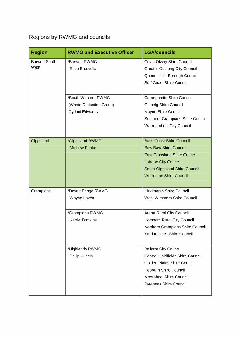
Regions by RWMG and councils
Region RWMG and Executive Officer LGA/councils
Barwon South
West
*Barwon RWMG
Enzo Bruscella
Colac Otway Shire Council
Greater Geelong City Council
Queenscliffe Borough Council
Surf Coast Shire Council
*South Western RWMG
(Waste Reduction Group)
Cydoni Edwards
Corangamite Shire Council
Glenelg Shire Council
Moyne Shire Council
Southern Grampians Shire Council
Warrnambool City Council
Gippsland *Gippsland RWMG
Mathew Peake
Bass Coast Shire Council
Baw Baw Shire Council
East Gippsland Shire Council
Latrobe City Council
South Gippsland Shire Council
Wellington Shire Council
Grampians *Desert Fringe RWMG
Wayne Lovett
Hindmarsh Shire Council
West Wimmera Shire Council
*Grampians RWMG
Kerrie Tomkins
Ararat Rural City Council
Horsham Rural City Council
Northern Grampians Shire Council
Yarriambiack Shire Council
*Highlands RWMG
Philip Clingin
Ballarat City Council
Central Goldfields Shire Council
Golden Plains Shire Council
Hepburn Shire Council
Moorabool Shire Council
Pyrenees Shire Council
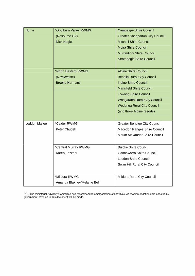
Hume *Goulburn Valley RWMG
(Resource GV)
Nick Nagle
Campaspe Shire Council
Greater Shepparton City Council
Mitchell Shire Council
Moira Shire Council
Murrindindi Shire Council
Strathbogie Shire Council
*North Eastern RWMG
(NevRwaste)
Brooke Hermans
Alpine Shire Council
Benalla Rural City Council
Indigo Shire Council
Mansfield Shire Council
Towong Shire Council
Wangaratta Rural City Council
Wodonga Rural City Council
(and three Alpine resorts)
Loddon Mallee *Calder RWMG
Peter Chudek
Greater Bendigo City Council
Macedon Ranges Shire Council
Mount Alexander Shire Council
*Central Murray RWMG
Karen Fazzani
Buloke Shire Council
Gannawarra Shire Council
Loddon Shire Council
Swan Hill Rural City Council
*Mildura RWMG
Amanda Blakney/Melanie Bell
Mildura Rural City Council
*NB. The ministerial Advisory Committee has recommended amalgamation of RWMG’s. As recommendations are enacted by government, revision to this document will be made.
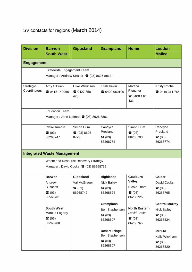
SV contacts for regions (March 2014)
Division Barwon
South West
Gippsland Grampians Hume Loddon-
Mallee
Engagement
Statewide Engagement Team
Manager : Andrew Straker (03) 8626 8813
Strategic
Coordinators
Amy O’Brien
0418 149068
Luke Wilkinson
0427 850
478
Trish Kevin
0409 060109
Martina
Rienzner
0408 110
431
Kristy Roche
0419 311 765
Education Team
Manager : Jane Liefman (03) 8626 8861
Claire Ruedin
(03)
86268747
Simon Hum
(03) 8626
8793
Candyce
Presland
(03)
86268774
Simon Hum
(03)
86268793
Candyce
Presland
(03)
86268774
Integrated Waste Management
Waste and Resource Recovery Strategy
Manager : David Cocks (03) 86268765
Barwon
Andrew
Buzacott
(03)
86566701
South West
Marcus Fogarty
(03)
86268788
Gippsland
Val McGregor
(03)
86268742
Highlands
Nick Bailey
(03)
86268824
Grampians
Ben Stephenson
(03)
86268807
Desert Fringe
Ben Stephenson
(03)
86268807
Goulburn
Valley
Nicola Thom
(03)
86268726
North Eastern
David Cocks
(03)
86268765
Calder
David Cocks
(03)
86268765
Central Murray
Nick Bailey
(03)
86268824
Mildura
Kelly Wickham
(03)
86268820
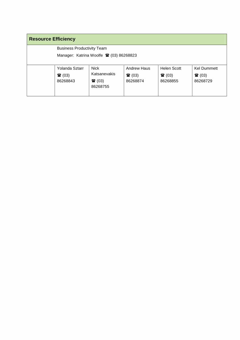
Resource Efficiency
Business Productivity Team
Manager: Katrina Woolfe (03) 86268823
Yolanda Sztarr
(03)
86268843
Nick
Katsanevakis
(03)
86268755
Andrew Haus
(03)
86268874
Helen Scott
(03)
86268855
Kel Dummett
(03)
86268729
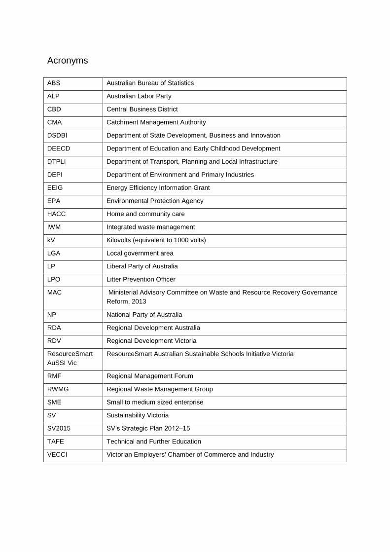
Acronyms
ABS Australian Bureau of Statistics
ALP Australian Labor Party
CBD Central Business District
CMA Catchment Management Authority
DSDBI Department of State Development, Business and Innovation
DEECD Department of Education and Early Childhood Development
DTPLI Department of Transport, Planning and Local Infrastructure
DEPI Department of Environment and Primary Industries
EEIG Energy Efficiency Information Grant
EPA Environmental Protection Agency
HACC Home and community care
IWM Integrated waste management
kV Kilovolts (equivalent to 1000 volts)
LGA Local government area
LP Liberal Party of Australia
LPO Litter Prevention Officer
MAC Ministerial Advisory Committee on Waste and Resource Recovery Governance
Reform, 2013
NP National Party of Australia
RDA Regional Development Australia
RDV Regional Development Victoria
ResourceSmart
AuSSI Vic
ResourceSmart Australian Sustainable Schools Initiative Victoria
RMF Regional Management Forum
RWMG Regional Waste Management Group
SME Small to medium sized enterprise
SV Sustainability Victoria
SV2015 SV’s Strategic Plan 2012–15
TAFE Technical and Further Education
VECCI Victorian Employers' Chamber of Commerce and Industry
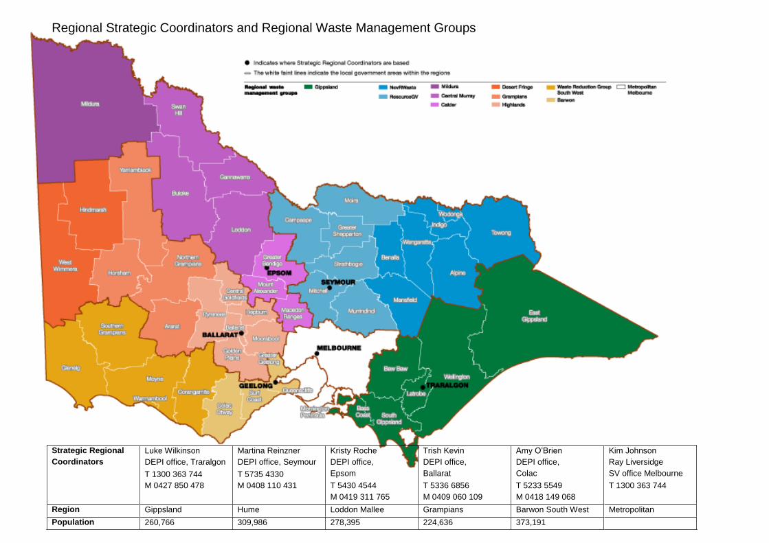
Regional Strategic Coordinators and Regional Waste Management Groups
Strategic Regional
Coordinators
Luke Wilkinson
DEPI office, Traralgon
T 1300 363 744
M 0427 850 478
Martina Reinzner
DEPI office, Seymour
T 5735 4330
M 0408 110 431
Kristy Roche
DEPI office,
Epsom
T 5430 4544
M 0419 311 765
Trish Kevin
DEPI office,
Ballarat
T 5336 6856
M 0409 060 109
Amy O’Brien
DEPI office,
Colac
T 5233 5549
M 0418 149 068
Kim Johnson
Ray Liversidge
SV office Melbourne
T 1300 363 744
Region Gippsland Hume Loddon Mallee Grampians Barwon South West Metropolitan
Population 260,766 309,986 278,395 224,636 373,191
1 1 | Regional Profiles – Barwon South West
Barwon South West
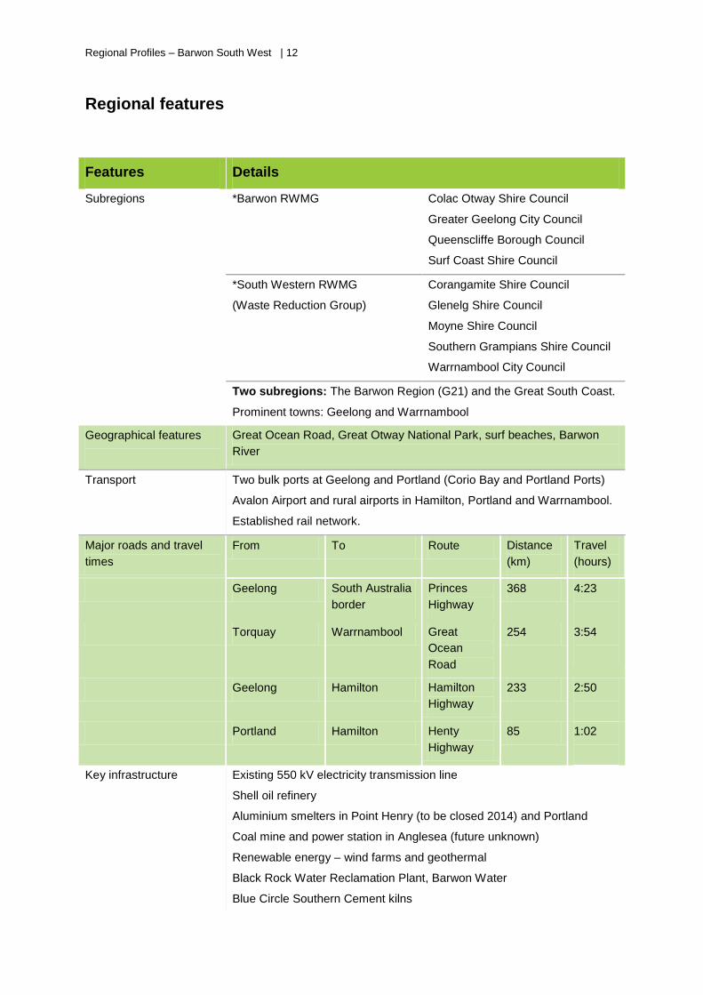
Regional Profiles – Barwon South West | 12
Regional features
Features Details
Subregions *Barwon RWMG
Colac Otway Shire Council
Greater Geelong City Council
Queenscliffe Borough Council
Surf Coast Shire Council
*South Western RWMG
(Waste Reduction Group)
Corangamite Shire Council
Glenelg Shire Council
Moyne Shire Council
Southern Grampians Shire Council
Warrnambool City Council
Two subregions: The Barwon Region (G21) and the Great South Coast.
Prominent towns: Geelong and Warrnambool
Geographical features
Great Ocean Road, Great Otway National Park, surf beaches, Barwon
River
Transport
Two bulk ports at Geelong and Portland (Corio Bay and Portland Ports)
Avalon Airport and rural airports in Hamilton, Portland and Warrnambool.
Established rail network.
Major roads and travel
times
From To Route Distance
(km)
Travel
(hours)
Geelong South Australia
border
Princes
Highway
368 4:23
Torquay Warrnambool Great
Ocean
Road
254 3:54
Geelong Hamilton Hamilton
Highway
233 2:50
Portland Hamilton Henty
Highway
85 1:02
Key infrastructure
Existing 550 kV electricity transmission line
Shell oil refinery
Aluminium smelters in Point Henry (to be closed 2014) and Portland
Coal mine and power station in Anglesea (future unknown)
Renewable energy – wind farms and geothermal
Black Rock Water Reclamation Plant, Barwon Water
Blue Circle Southern Cement kilns

1 3 | Regional Profiles – Barwon South West
Gas fields in the Otway basin
Ports- Corio and Portland
Mineral sand processing at Hamilton
Meat processing at Warrnambool, Geelong and Colac
Licensed landfills – Naroghid, Portland, Hamilton, Anglesea, Drysdale,
and inert landfills at Killarney, Alvie and Fyansford
*NB. The ministerial Advisory Committee has recommended amalgamation of RWMG’s. As recommendations are enacted by government, revision to this document will be made.
Key facts
• Barwon South West has 800 km of coastline which is 40% of Victoria’s coast.
• The region has nine LGAs under two subregions.
• The regional centre, Geelong, is Victoria’s largest regional city.
• The Gunditjmara people have native title land in the far south west.
• The region enjoys booming health, social services and education sectors.
• Barwon South West is Australia’s largest milk production area and is home to 20% of the national
plantation timber industry.
• Other industries include aluminium production, food processing and automotive manufacturing.
Emerging industries include new energy, food security and biotechnology.
• The region has good transport links with two seaports with road and rail freight connections and
Avalon Airport.
Demography
Population: 350,000 (approx.)
G21 region Great South Coast region
Municipal centres Population Municipal centres Population
Geelong CBD,
City of Greater Geelong
223,047
Camperdown,
Corangamite Shire
17,469
Queenscliff,
Borough of Queenscliffe
3,306
Port Fairy,
Moyne Shire
16,906
Torquay,
Surf Coast Shire
26,873
Warrnambool CBD,
Warrnambool City Council
34,193
Colac,
Colac Otway Shire
22,108
Hamilton,
Southern Grampians Shire
17,411
Bannockburn,
Golden Plains Shire2
19,014
Portland,
Glenelg Shire
21,236
42 Golden Plains Shire is included as part of the G21 group for strategic planning purposes, but is part of the Highlands RWMG
for waste management purposes
Regional Profiles – Barwon South West | 14
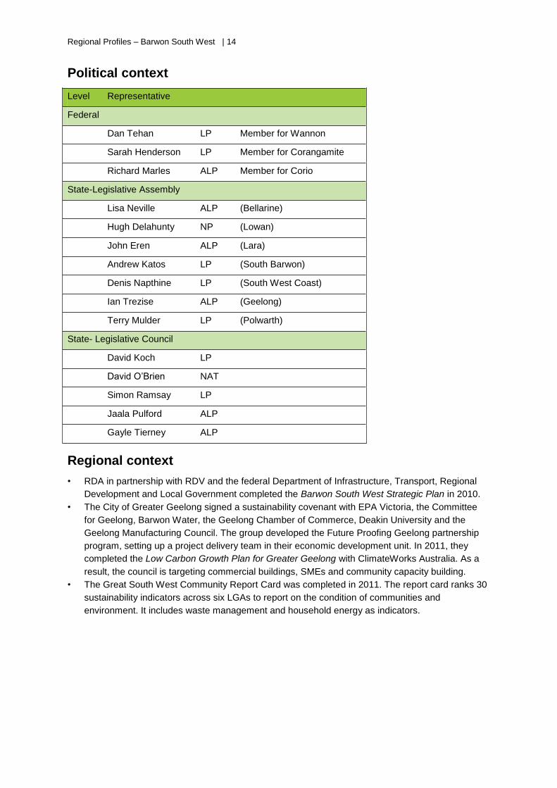
Political context
Level Representative
Federal
Dan Tehan LP Member for Wannon
Sarah Henderson LP Member for Corangamite
Richard Marles ALP Member for Corio
State-Legislative Assembly
Lisa Neville ALP (Bellarine)
Hugh Delahunty NP (Lowan)
John Eren ALP (Lara)
Andrew Katos LP (South Barwon)
Denis Napthine LP (South West Coast)
Ian Trezise ALP (Geelong)
Terry Mulder LP (Polwarth)
State- Legislative Council
David Koch LP
David O’Brien NAT
Simon Ramsay LP
Jaala Pulford ALP
Gayle Tierney ALP
Regional context
• RDA in partnership with RDV and the federal Department of Infrastructure, Transport, Regional
Development and Local Government completed the Barwon South West Strategic Plan in 2010.
• The City of Greater Geelong signed a sustainability covenant with EPA Victoria, the Committee
for Geelong, Barwon Water, the Geelong Chamber of Commerce, Deakin University and the
Geelong Manufacturing Council. The group developed the Future Proofing Geelong partnership
program, setting up a project delivery team in their economic development unit. In 2011, they
completed the Low Carbon Growth Plan for Greater Geelong with ClimateWorks Australia. As a
result, the council is targeting commercial buildings, SMEs and community capacity building.
• The Great South West Community Report Card was completed in 2011. The report card ranks 30
sustainability indicators across six LGAs to report on the condition of communities and
environment. It includes waste management and household energy as indicators.
1 5 | Regional Profiles – Barwon South West
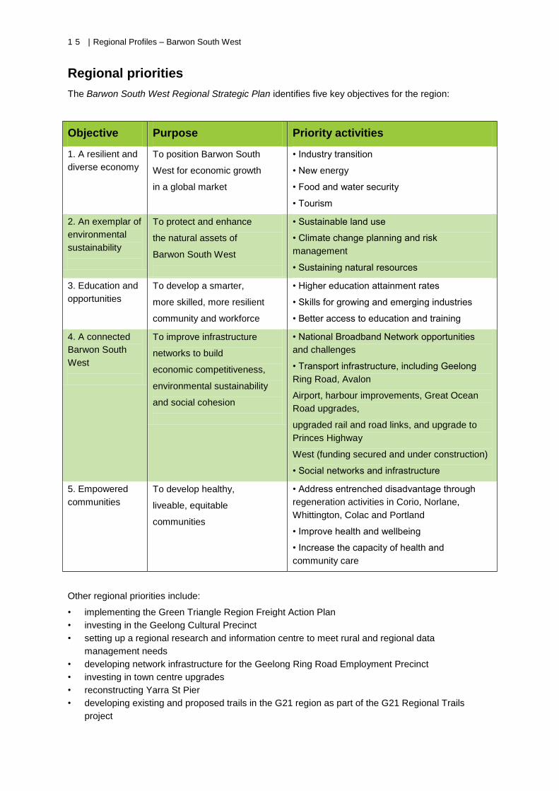
Regional priorities
The Barwon South West Regional Strategic Plan identifies five key objectives for the region:
Objective Purpose Priority activities
1. A resilient and
diverse economy
To position Barwon South
West for economic growth
in a global market
• Industry transition
• New energy
• Food and water security
• Tourism
2. An exemplar of
environmental
sustainability
To protect and enhance
the natural assets of
Barwon South West
• Sustainable land use
• Climate change planning and risk
management
• Sustaining natural resources
3. Education and
opportunities
To develop a smarter,
more skilled, more resilient
community and workforce
• Higher education attainment rates
• Skills for growing and emerging industries
• Better access to education and training
4. A connected
Barwon South
West
To improve infrastructure
networks to build
economic competitiveness,
environmental sustainability
and social cohesion
• National Broadband Network opportunities
and challenges
• Transport infrastructure, including Geelong
Ring Road, Avalon
Airport, harbour improvements, Great Ocean
Road upgrades,
upgraded rail and road links, and upgrade to
Princes Highway
West (funding secured and under construction)
• Social networks and infrastructure
5. Empowered
communities
To develop healthy,
liveable, equitable
communities
• Address entrenched disadvantage through
regeneration activities in Corio, Norlane,
Whittington, Colac and Portland
• Improve health and wellbeing
• Increase the capacity of health and
community care
Other regional priorities include:
• implementing the Green Triangle Region Freight Action Plan
• investing in the Geelong Cultural Precinct
• setting up a regional research and information centre to meet rural and regional data
management needs
• developing network infrastructure for the Geelong Ring Road Employment Precinct
• investing in town centre upgrades
• reconstructing Yarra St Pier
• developing existing and proposed trails in the G21 region as part of the G21 Regional Trails
project
Regional Profiles – Barwon South West | 16
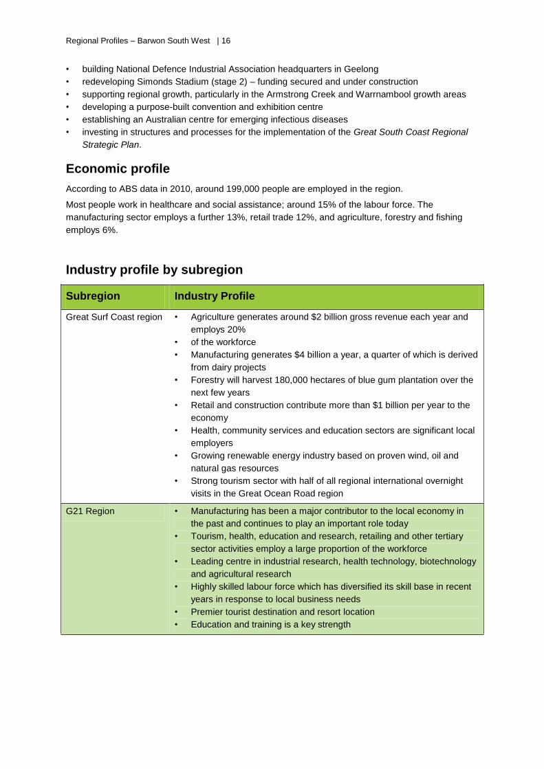
• building National Defence Industrial Association headquarters in Geelong
• redeveloping Simonds Stadium (stage 2) – funding secured and under construction
• supporting regional growth, particularly in the Armstrong Creek and Warrnambool growth areas
• developing a purpose-built convention and exhibition centre
• establishing an Australian centre for emerging infectious diseases
• investing in structures and processes for the implementation of the Great South Coast Regional
Strategic Plan.
Economic profile
According to ABS data in 2010, around 199,000 people are employed in the region.
Most people work in healthcare and social assistance; around 15% of the labour force. The
manufacturing sector employs a further 13%, retail trade 12%, and agriculture, forestry and fishing
employs 6%.
Industry profile by subregion
Subregion Industry Profile
Great Surf Coast region • Agriculture generates around $2 billion gross revenue each year and
employs 20%
• of the workforce
• Manufacturing generates $4 billion a year, a quarter of which is derived
from dairy projects
• Forestry will harvest 180,000 hectares of blue gum plantation over the
next few years
• Retail and construction contribute more than $1 billion per year to the
economy
• Health, community services and education sectors are significant local
employers
• Growing renewable energy industry based on proven wind, oil and
natural gas resources
• Strong tourism sector with half of all regional international overnight
visits in the Great Ocean Road region
G21 Region • Manufacturing has been a major contributor to the local economy in
the past and continues to play an important role today
• Tourism, health, education and research, retailing and other tertiary
sector activities employ a large proportion of the workforce
• Leading centre in industrial research, health technology, biotechnology
and agricultural research
• Highly skilled labour force which has diversified its skill base in recent
years in response to local business needs
• Premier tourist destination and resort location
• Education and training is a key strength
1 7 | Regional Profiles – Barwon South West
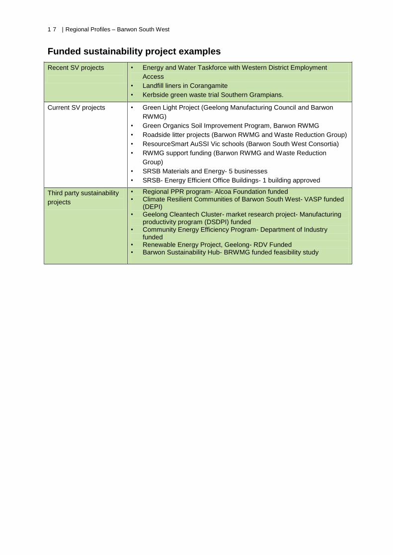
Funded sustainability project examples
Recent SV projects
• Energy and Water Taskforce with Western District Employment
Access
• Landfill liners in Corangamite
• Kerbside green waste trial Southern Grampians.
Current SV projects
• Green Light Project (Geelong Manufacturing Council and Barwon
RWMG)
• Green Organics Soil Improvement Program, Barwon RWMG
• Roadside litter projects (Barwon RWMG and Waste Reduction Group)
• ResourceSmart AuSSI Vic schools (Barwon South West Consortia)
• RWMG support funding (Barwon RWMG and Waste Reduction
Group)
• SRSB Materials and Energy- 5 businesses
• SRSB- Energy Efficient Office Buildings- 1 building approved
Third party sustainability
projects
• Regional PPR program- Alcoa Foundation funded • Climate Resilient Communities of Barwon South West- VASP funded
(DEPI) • Geelong Cleantech Cluster- market research project- Manufacturing
productivity program (DSDPI) funded • Community Energy Efficiency Program- Department of Industry
funded • Renewable Energy Project, Geelong- RDV Funded • Barwon Sustainability Hub- BRWMG funded feasibility study
Regional Profiles – Barwon South West | 18
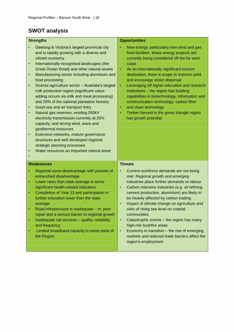
SWOT analysis
Strengths
• Geelong is Victoria’s largest provincial city
and is rapidly growing with a diverse and
vibrant economy
• Internationally recognised landscapes (the
Great Ocean Road) and other natural assets
• Manufacturing sector including aluminium and
food processing
• Diverse agriculture sector – Australia’s largest
milk production region (significant value-
adding occurs via milk and meat processing)
and 20% of the national plantation forestry
• Good sea and air transport links
• Natural gas reserves, existing 550kV
electricity transmission currently at 25%
capacity, and strong wind, wave and
geothermal resources
• Extensive networks, mature governance
structures and well developed regional
strategic planning processes
• Water resources an important natural asset
•
Opportunities
• New energy, particularly new wind and gas
fired facilities. Wave energy projects are
currently being considered off the far west
coast
• As an internationally significant tourism
destination, there is scope to improve yield
and encourage visitor dispersal
• Leveraging off higher education and research
institutions – the region has building
capabilities in biotechnology, information and
communication technology, carbon fibre
• and clean technology
• Timber harvest in the green triangle region
has growth potential
Weaknesses
• Regional socio-disadvantage with pockets of
entrenched disadvantage
• Lower rates than state average in some
significant health-related indicators
• Completion of Year 12 and participation in
further education lower than the state
average
• Road infrastructure is inadequate – in poor
repair and a serious barrier to regional growth
• Inadequate rail services – quality, reliability
and frequency
• Limited broadband capacity in some parts of
the Region
Threats
• Current workforce demands are not being
met. Regional growth and emerging
industries place further demands on labour
• Carbon intensive industries (e.g. oil refining,
cement production, aluminium) are likely to
be heavily affected by carbon trading
• Impact of climate change on agriculture and
risks of rising sea level on coastal
communities
• Catastrophic events – the region has many
high-risk bushfire areas
• Economy in transition – the rise of emerging
markets and reduced trade barriers affect the
region’s employment
Regional Profiles – Gippsland | 19
Gippsland
Regional Profiles – Gippsland | 20
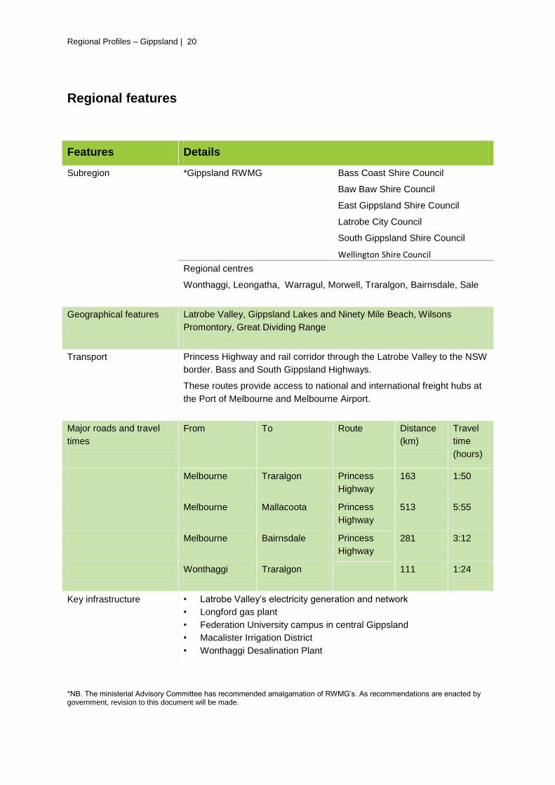
Regional features
Features Details
Subregion *Gippsland RWMG Bass Coast Shire Council
Baw Baw Shire Council
East Gippsland Shire Council
Latrobe City Council
South Gippsland Shire Council
Wellington Shire Council
Regional centres
Wonthaggi, Leongatha, Warragul, Morwell, Traralgon, Bairnsdale, Sale
Geographical features
Latrobe Valley, Gippsland Lakes and Ninety Mile Beach, Wilsons
Promontory, Great Dividing Range
Transport
Princess Highway and rail corridor through the Latrobe Valley to the NSW
border. Bass and South Gippsland Highways.
These routes provide access to national and international freight hubs at
the Port of Melbourne and Melbourne Airport.
Major roads and travel
times
From To Route Distance
(km)
Travel
time
(hours)
Melbourne Traralgon Princess
Highway
163 1:50
Melbourne Mallacoota Princess
Highway
513 5:55
Melbourne Bairnsdale Princess
Highway
281 3:12
Wonthaggi Traralgon 111 1:24
Key infrastructure
• Latrobe Valley’s electricity generation and network
• Longford gas plant
• Federation University campus in central Gippsland
• Macalister Irrigation District
• Wonthaggi Desalination Plant
*NB. The ministerial Advisory Committee has recommended amalgamation of RWMG’s. As recommendations are enacted by government, revision to this document will be made.
Regional Profiles – Gippsland | 21
Key facts
Natural Assets
• The Latrobe Valley provides over 80% of Victoria’s electricity, with large reserves of brown coal
and over 90% of Victoria’s natural gas.
• Nearly half of Australia’s oil comes from the Bass Strait fields.
• The 4.6 million Ha of Gippsland’s land mass is made up of 73% forest and 27% other uses,
predominately rural and urban use.
• The region is home to one of Australia’s strongest dairy industries due to rich soil and dependable
rainfall.
• The region supplies 60% of Melbourne’s water. The Wonthaggi Desalination Plant was completed
in December 2012 and the region includes the Macalister Irrigation District, which provides water
security for farmers in irrigated diary and horticulture sectors.
• Public Native Forestry harvestable in the region occupies 9% of the region’s land mass, and
makes up to 45% of wood production. Plantation Forestry occupies 2% of the region and delivers
54%of regions wood production. Wellington LGA has 52% of the region’s plantations, Latrobe
LGA has 26% and Baw Baw South Gippsland and East Gippsland have fewer than 10% each.
Industry
• Associated dairy food processing has a significant presence with clusters associated with West
and South Gippsland.
• The Eastern half of the region is home to several Australian food brands (e.g. Patties Foods and
Vegco) and Victoria’s largest fishing port is at Lakes Entrance, where offshore and inshore fishing
vessels are protected by a safe harbour.
• There is extensive energy generation and distribution infrastructure in the region’s central
corridor, primarily supplying electricity and gas to Melbourne and beyond. There are gas and
electricity links from the region to Tasmania and NSW.
• A large proportion of Gippsland is not supplied with domestic reticulated natural gas, and the
electricity distribution network has minimal additional capacity available for both lower voltage and
high voltage industry.
• A new ExxonMobil Gas Conditioning Plan began construction in December 2013. The facility is
expected to be operational in 2016 at Longford which will be the biggest on the eastern sea
board.
Demography
Population: 269,790 (approx.)
• Gippsland has one of the highest dispersed populations with over 100,000 residents (40% of the
regional population) located in towns of less than 1000 people.
• Gippsland males have the lowest life expectancy when compared with any other region in
Victoria; 53% of the population are overweight or obese and 49% are smokers.
Population growth is projected to increase to 306,600 by 2026. Between 2010 and 2022, the
population of Bass Coast is expected to grow by 32.5% and the population of Baw Baw by 29.5%.
Plan Melbourne’s strategy to 2050 identified Wonthaggi and Drouin/Warragul as new population and
employment towns for growth as a strategy for managing growth in Melbourne’s peri-urban regions.
Regional Profiles – Gippsland | 22
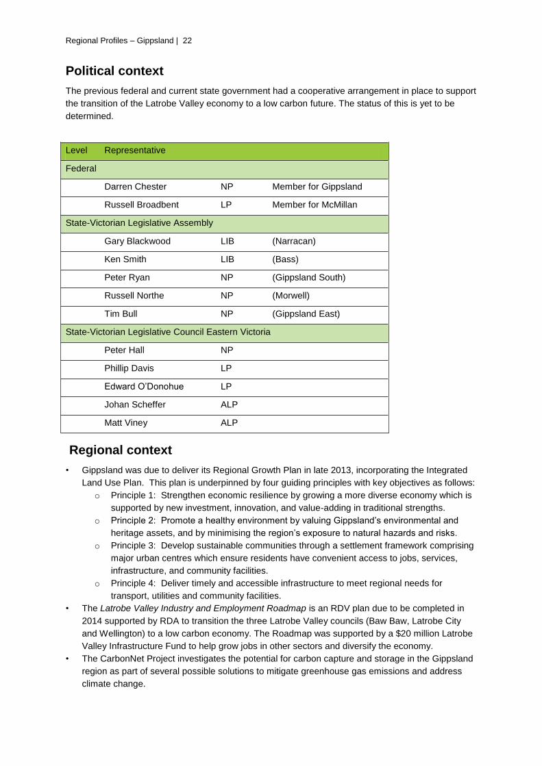
Political context
The previous federal and current state government had a cooperative arrangement in place to support
the transition of the Latrobe Valley economy to a low carbon future. The status of this is yet to be
determined.
Level Representative
Federal
Darren Chester NP Member for Gippsland
Russell Broadbent LP Member for McMillan
State-Victorian Legislative Assembly
Gary Blackwood LIB (Narracan)
Ken Smith LIB (Bass)
Peter Ryan NP (Gippsland South)
Russell Northe NP (Morwell)
Tim Bull NP (Gippsland East)
State-Victorian Legislative Council Eastern Victoria
Peter Hall NP
Phillip Davis LP
Edward O’Donohue LP
Johan Scheffer ALP
Matt Viney ALP
Regional context
• Gippsland was due to deliver its Regional Growth Plan in late 2013, incorporating the Integrated
Land Use Plan. This plan is underpinned by four guiding principles with key objectives as follows:
o Principle 1: Strengthen economic resilience by growing a more diverse economy which is
supported by new investment, innovation, and value-adding in traditional strengths.
o Principle 2: Promote a healthy environment by valuing Gippsland’s environmental and
heritage assets, and by minimising the region’s exposure to natural hazards and risks.
o Principle 3: Develop sustainable communities through a settlement framework comprising
major urban centres which ensure residents have convenient access to jobs, services,
infrastructure, and community facilities.
o Principle 4: Deliver timely and accessible infrastructure to meet regional needs for
transport, utilities and community facilities.
• The Latrobe Valley Industry and Employment Roadmap is an RDV plan due to be completed in
2014 supported by RDA to transition the three Latrobe Valley councils (Baw Baw, Latrobe City
and Wellington) to a low carbon economy. The Roadmap was supported by a $20 million Latrobe
Valley Infrastructure Fund to help grow jobs in other sectors and diversify the economy.
• The CarbonNet Project investigates the potential for carbon capture and storage in the Gippsland
region as part of several possible solutions to mitigate greenhouse gas emissions and address
climate change.
Regional Profiles – Gippsland | 23
• The new Coastal Settlements of the Future program will focus initially on Lakes Entrance and Port
Welshpool; helping these communities mitigate risk, protect vital infrastructure, and adapt to
climate change.
• RDV funded ClimateWorks Australia to develop the Low Carbon Growth Plan for Gippsland in
2011. The plan identifies activities to save businesses and households $100 million per year
across the region through improved energy efficiency, increased land productivity and cleaner
distributed energy.
• Fuelled for Growth: Investing in Victoria’s biofuels and bioenergy industries (2012) stated that
Gippsland has potential biomass resources mostly related to forestry and livestock. This has
stimulated international interest in future investment and development.
Regional priorities
The Gippsland Regional Strategic Plan in 2010 identified ten key focus areas:
• Gippsland Low Carbon Economy Transition Plan:
• Post-secondary education
• Gippsland’s gateways: build the region’s exports
• Centre for Sustainable Industries: develop a local presence with Monash (now Federation)
University to carry out research and development on technology and practices that support
sustainable resource use of brown coal and water to strengthen the resilience of the regional
economy
• Gippsland Lakes Sustainable Development Framework
• Health and wellbeing outcomes
• Gippsland Integrated Land Use Plan: direction and priorities to address population growth across
the region including changes to land use and infrastructure development
• Gippsland’s water
• Broadband connectivity
• Tourism infrastructure.
Gippsland is now taking a new approach with four strategy groups established to support the 2010
Gippsland Regional Plan, with members from RMF, RDA, the Committee for Gippsland and the
Gippsland Local Government Network. The groups focus on the following themes that incorporate the
ten priorities:
• economic development
• health and wellbeing
• environment and natural resources management
• low carbon transition.
These strategic groups are collating priority projects and proposals to approach government and
industry for support, as multi-themed projects can attract greater regional support. It resulted in
Gippsland’s peak advocacy group, One Gippsland, identifying four priorities for the region in June
2013 that it took to Canberra for Federal support. This included;
• The full duplication of the Princes Highway between Traralgon and Sale;
• Funding to complete phase one of the Macalister Irrigation District (MID) modernisation program,
• The Latrobe Regional Hospital stage 2a redevelopment;
• East Sale as the preferred destination for Defence project 5428;
• Construction of the East West Link and North East Link road projects
Regional Profiles – Gippsland | 24
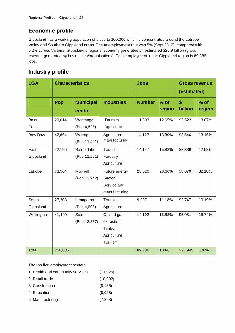
Economic profile
Gippsland has a working population of close to 100,000 which is concentrated around the Latrobe
Valley and Southern Gippsland areas. The unemployment rate was 5% (Sept 2012), compared with
5.2% across Victoria. Gippsland’s regional economy generates an estimated $26.9 billion (gross
revenue generated by businesses/organisations). Total employment in the Gippsland region is 89,386
jobs.
Industry profile
LGA Characteristics Jobs
Gross revenue
(estimated)
Pop Municipal
centre
Industries Number % of
region
$
billion
% of
region
Bass
Coast
29,614 Wonthaggi
(Pop 6,528)
Tourism
Agriculture
11,303 12.65% $3,522 13.07%
Baw Baw 42,864 Warragul
(Pop 11,491)
Agriculture
Manufacturing
14,127 15.80% $3,546 13.16%
East
Gippsland
42,196 Bairnsdale
(Pop 11,271)
Tourism
Forestry
Agriculture
14,147 15.83% $3,389 12.58%
Latrobe 73,564 Morwell
(Pop 13,942)
Future energy
Sector
Service and
manufacturing
25,620 28.66% $8,670 32.18%
South
Gippsland
27,208 Leongatha
(Pop 4,505)
Tourism
Agriculture
9,997 11.18% $2,747 10.19%
Wellington 41,440 Sale
(Pop 13,337)
Oil and gas
extraction
Timber
Agriculture
Tourism
14,192 15.88% $5,051 18.74%
Total 256,886 89,386 100% $26,945 100%
The top five employment sectors
1. Health and community services (11,926)
2. Retail trade (10,902)
3. Construction (8,136)
4. Education (8,035)
5. Manufacturing (7,823)
Regional Profiles – Gippsland | 25
The top five industry sectors
1. Manufacturing
2. Construction
3. Mining
4. Property services
5. Utility services
Key Points
• Food related activity in the Gippsland region generates more than $2 billion in exports, more than
14,000 jobs and is responsible for more than $1.3 billion in expenditure on goods and services
within the region. The Gippsland Food Plan was to be delivered in 2013 to direct the future
development/positioning of the Gippsland food system as a state and national food bowl.
• The 2013/14 State budget allocated $14million to the Macalister Irrigation Districts modernisation
project. This is home to significant diary and horticulture assets
• The 2013/14 state budget allocated $110million over 4 years to further investigate the
development and expansion of the Hastings Port as a major container port.
• The central western part of Gippsland is strongly linked to the mining and utilities industries.
• The largest proportion of land mass in Victoria granted to coal seam gas exploration is located in
Gippsland. The State Government currently has a moratorium on extraction.
• East Gippsland has attracted investment around agriculture, timber production, horticulture,
manufacturing, tourism, retail and service, commercial fishing and other marine industries. The
region is home to several Australian food brands and Victoria’s largest fishing port at Lakes
Entrance.
• Gippsland has a thriving dairy industry with more than 2,500 licensed dairy farms. The main
production areas are in the west and south of the region, including 11 processing plants and two
research institutes at Maffra and Ellinbank. Dairy dominates Gippsland exports with $762 million.
The Gippsland dairy industry is bigger than NSW, South Australia and Tasmania combined.
There is a number of dairy processing plants with in increasing focus on export markets, operate
in the Gippsland. These include Murray Goulburn Co-operative, Burra Foods, United Dairy Power,
Parmalat and National Foods. VIPLUS has recently invested in reopening diary processing at
Toora.
Regional Profiles – Gippsland | 26
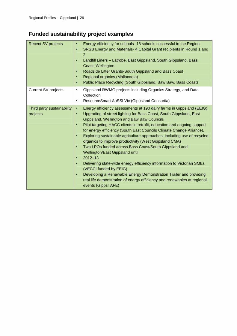
Funded sustainability project examples
Recent SV projects
• Energy efficiency for schools- 18 schools successful in the Region
• SRSB Energy and Materials- 4 Capital Grant recipients in Round 1 and
2
• Landfill Liners – Latrobe, East Gippsland, South Gippsland, Bass
Coast, Wellington
• Roadside Litter Grants-South Gippsland and Bass Coast
• Regional organics (Mallacoota)
• Public Place Recycling (South Gippsland, Baw Baw, Bass Coast)
Current SV projects
• Gippsland RWMG projects including Organics Strategy, and Data
Collection
• ResourceSmart AuSSI Vic (Gippsland Consortia)
Third party sustainability
projects
• Energy efficiency assessments at 190 dairy farms in Gippsland (EEIG)
• Upgrading of street lighting for Bass Coast, South Gippsland, East
Gippsland, Wellington and Baw Baw Councils
• Pilot targeting HACC clients in retrofit, education and ongoing support
for energy efficiency (South East Councils Climate Change Alliance).
• Exploring sustainable agriculture approaches, including use of recycled
organics to improve productivity (West Gippsland CMA)
• Two LPOs funded across Bass Coast/South Gippsland and
Wellington/East Gippsland until
• 2012–13
• Delivering state-wide energy efficiency information to Victorian SMEs
(VECCI funded by EEIG)
• Developing a Renewable Energy Demonstration Trailer and providing
real life demonstration of energy efficiency and renewables at regional
events (GippsTAFE)

Regional Profiles – Gippsland | 27
SWOT analysis
Strengths
• Proximity and access to Melbourne
• Established transport infrastructure (road
and rail, energy)
• Diverse economic drivers
• Number of regional networks and bodies
already exist (waste, economic, tourism,
agriculture, local government)
• Abundance of natural resource assets
• Employment and training opportunities
• Significant organic waste processing
infrastructure
• Energy generation and distribution
infrastructure
Opportunities
• Reducing costs and increasing inward
investment through the Low Carbon Growth
Plan for Gippsland
• Identifying additional regional projects and
starting discussions between stakeholders for
the Gippsland Regional Growth Plan (GRP)
• Looking for support and funding from other
levels of government for GRP projects, for
example, developing the Gippsland logistics
precinct and upgrading priority tourism roads
• Strong interest from government and industry
in using cost effective moisture removal
technologies from brown coal and exporting
this internationally
• Potentially large local markets for recovered
and processed organic waste in land use
• Significant external commercial interest in
food processing and biomass
• Improving the function, capacity and amenity
of the region’s commercial centres
Weaknesses
• Uncertainty as to what the focus of state and
federal governments relating to Latrobe
Valley transition to low carbon economy will
be.
• Significant areas socio-economic
disadvantage limits participation in the local
economy.
• Perception that the region only reliance is on
fossil fuel sector limits acknowledging the
diversity of the regional economy
Threats
• Ageing population and net migration of young
people
• Large geography and dispersed population
• Impacts of climate change and associated
policies on key industries (farming, forestry
and mining). Buildings and infrastructure may
be at risk from flooding and storm surges
along the coast and from bushfires inland
• Energy sector facing significant challenges
due to global shift to a low carbon economy
• Transition to low carbon economy stagnates
due to policy uncertainty
Regional Profiles – Grampians | 28
Grampians
Regional Profiles – Grampians |29
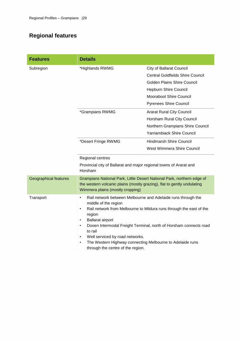
Regional features
Features Details
Subregion *Highlands RWMG
City of Ballarat Council
Central Goldfields Shire Council
Golden Plains Shire Council
Hepburn Shire Council
Moorabool Shire Council
Pyrenees Shire Council
*Grampians RWMG Ararat Rural City Council
Horsham Rural City Council
Northern Grampians Shire Council
Yarriambiack Shire Council
*Desert Fringe RWMG Hindmarsh Shire Council
West Wimmera Shire Council
Regional centres
Provincial city of Ballarat and major regional towns of Ararat and
Horsham
Geographical features
Grampians National Park, Little Desert National Park, northern edge of
the western volcanic plains (mostly grazing), flat to gently undulating
Wimmera plains (mostly cropping)
Transport
• Rail network between Melbourne and Adelaide runs through the
middle of the region
• Rail network from Melbourne to Mildura runs through the east of the
region
• Ballarat airport
• Dooen Intermodal Freight Terminal, north of Horsham connects road
to rail
• Well serviced by road networks.
• The Western Highway connecting Melbourne to Adelaide runs
through the centre of the region.
Regional Profiles – Grampians | 30
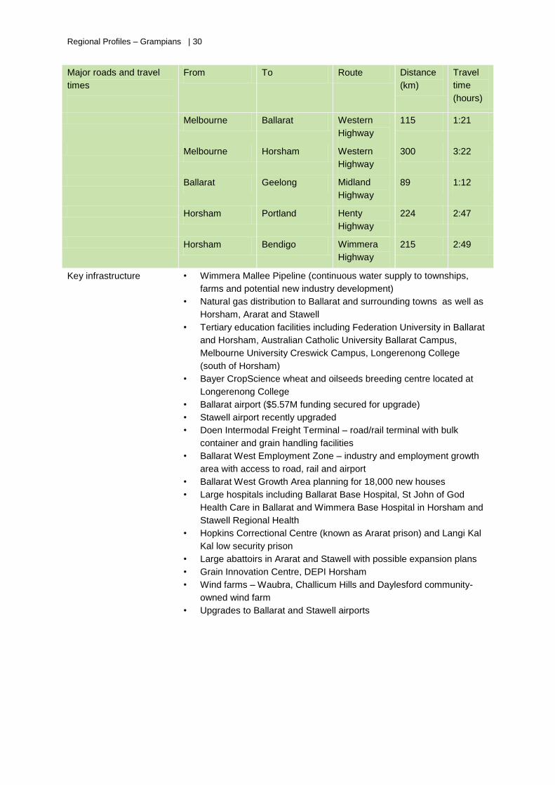
Major roads and travel
times
From To Route Distance
(km)
Travel
time
(hours)
Melbourne Ballarat Western
Highway
115 1:21
Melbourne Horsham Western
Highway
300 3:22
Ballarat Geelong Midland
Highway
89 1:12
Horsham Portland Henty
Highway
224 2:47
Horsham Bendigo Wimmera
Highway
215 2:49
Key infrastructure
• Wimmera Mallee Pipeline (continuous water supply to townships,
farms and potential new industry development)
• Natural gas distribution to Ballarat and surrounding towns as well as
Horsham, Ararat and Stawell
• Tertiary education facilities including Federation University in Ballarat
and Horsham, Australian Catholic University Ballarat Campus,
Melbourne University Creswick Campus, Longerenong College
(south of Horsham)
• Bayer CropScience wheat and oilseeds breeding centre located at
Longerenong College
• Ballarat airport ($5.57M funding secured for upgrade)
• Stawell airport recently upgraded
• Doen Intermodal Freight Terminal – road/rail terminal with bulk
container and grain handling facilities
• Ballarat West Employment Zone – industry and employment growth
area with access to road, rail and airport
• Ballarat West Growth Area planning for 18,000 new houses
• Large hospitals including Ballarat Base Hospital, St John of God
Health Care in Ballarat and Wimmera Base Hospital in Horsham and
Stawell Regional Health
• Hopkins Correctional Centre (known as Ararat prison) and Langi Kal
Kal low security prison
• Large abattoirs in Ararat and Stawell with possible expansion plans
• Grain Innovation Centre, DEPI Horsham
• Wind farms – Waubra, Challicum Hills and Daylesford community-
owned wind farm
• Upgrades to Ballarat and Stawell airports
Regional Profiles – Grampians |31
Key facts
The Grampians region for planning purposes is divided into two sub regions – Central Highlands
Region in the south east and Wimmera Southern Mallee Region in the north west.
• Ballarat is the fastest growing regional centre and third largest urban area in the state.
• Horsham is twice the size of any other centre in the north west of the region and has grown at the
expense of smaller towns.
• The Grampians region has a recognised higher education and training system network.
• It has the strongest concentration of IT and computing services and capacity in regional Victoria.
• The region has the major concentration of Australia’s gold mining heritage.
• Registered Aboriginal parties in the region include Barengi Gadjin Land Council Aboriginal
Corporation, Dja Dja Wurung Clans Aboriginal Corporation, Matang Pty Ltd and Wathaurung
Aboriginal Cooperative.
Demography
Population growth will be concentrated in Melbourne’s peri-urban fringe, principally the shires of
Moorabool, Golden Plains and Hepburn as well as in Ballarat West Growth Area of Ballarat City
Council.
The median weekly income and the number of people participating in higher education is lower than
the state average.
Relatively high levels of disadvantage, particularly in towns in Ballarat, Pyrenees, Hindmarsh and
Yarriambiack shires.
Low rents in smaller towns can create pockets of disadvantage.
Wimmera Southern Mallee has the oldest population in Victoria. Projected population growth is low
due to young people leaving for education and employment, leaving a large proportion of retirees (and
school aged children).
Includes very small pockets of new arrivals to Australia e.g. the Karen people in Nhill, many of whom
work at Luvaduck - duck producer and manufacturer.
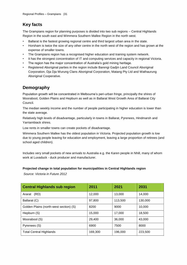
Projected change in total population for municipalities in Central Highlands region
Source: Victoria in Future 2012
Central Highlands sub region 2011 2021 2031
Ararat (RD) 12,000 13,000 14,000
Ballarat (C) 97,800 113,500 130,000
Golden Plains (north-west section) (S) 8200 9000 10,000
Hepburn (S) 15,000 17,000 18,500
Moorabool (S) 29,400 36,000 43,000
Pyrenees (S) 6900 7500 8000
Total Central Highlands 169,300 196,000 223,500
Regional Profiles – Grampians | 32
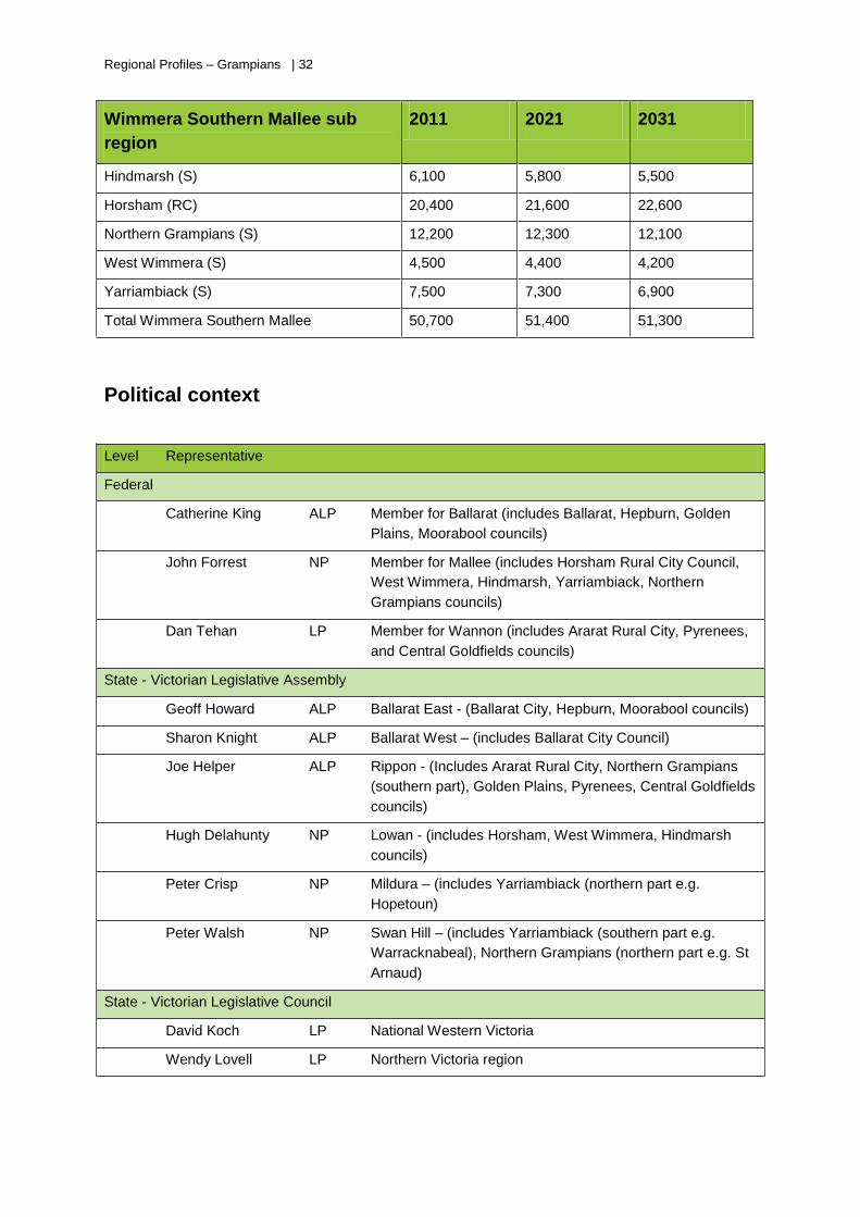
Wimmera Southern Mallee sub
region
2011 2021 2031
Hindmarsh (S) 6,100 5,800 5,500
Horsham (RC) 20,400 21,600 22,600
Northern Grampians (S) 12,200 12,300 12,100
West Wimmera (S) 4,500 4,400 4,200
Yarriambiack (S) 7,500 7,300 6,900
Total Wimmera Southern Mallee 50,700 51,400 51,300
Political context
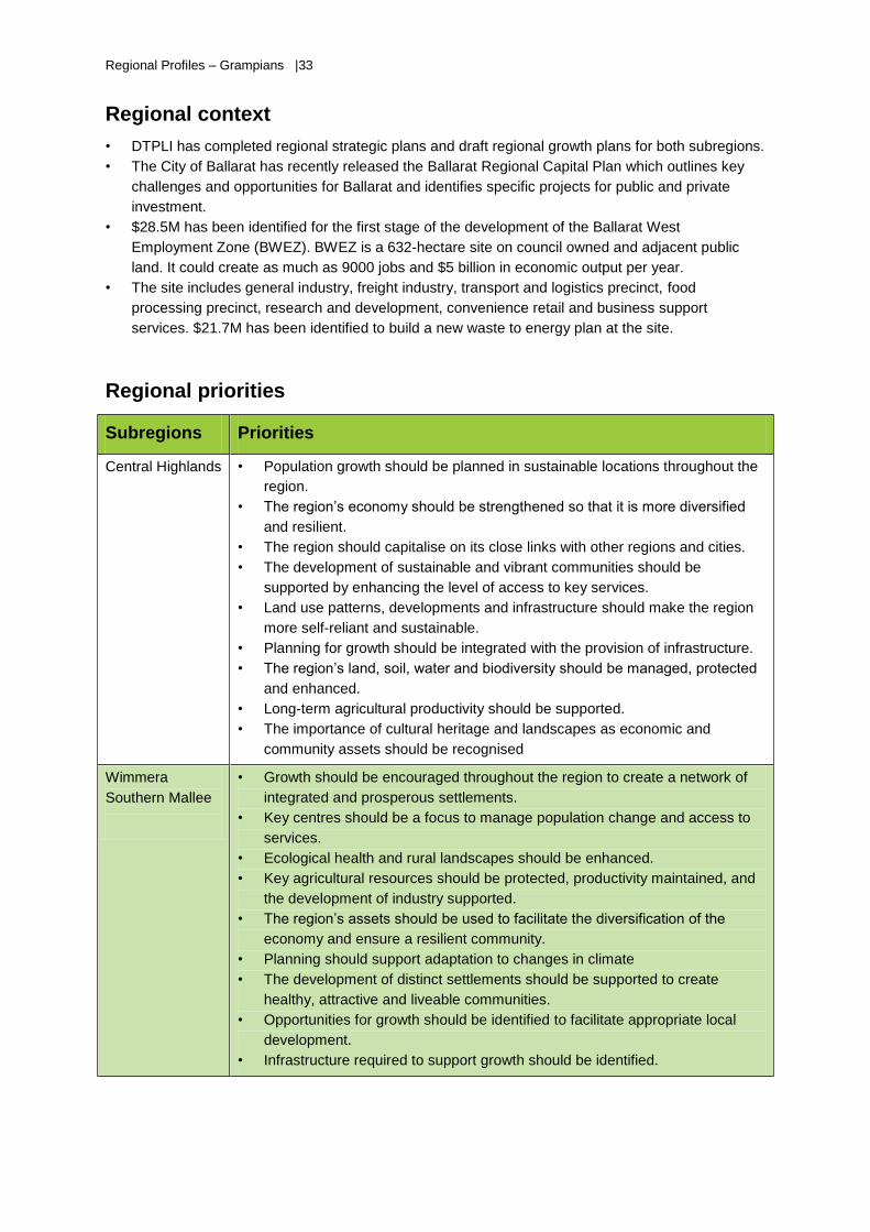
Level Representative
Federal
Catherine King ALP Member for Ballarat (includes Ballarat, Hepburn, Golden
Plains, Moorabool councils)
John Forrest NP Member for Mallee (includes Horsham Rural City Council,
West Wimmera, Hindmarsh, Yarriambiack, Northern
Grampians councils)
Dan Tehan LP Member for Wannon (includes Ararat Rural City, Pyrenees,
and Central Goldfields councils)
State - Victorian Legislative Assembly
Geoff Howard ALP Ballarat East - (Ballarat City, Hepburn, Moorabool councils)
Sharon Knight ALP Ballarat West – (includes Ballarat City Council)
Joe Helper ALP Rippon - (Includes Ararat Rural City, Northern Grampians
(southern part), Golden Plains, Pyrenees, Central Goldfields
councils)
Hugh Delahunty NP Lowan - (includes Horsham, West Wimmera, Hindmarsh
councils)
Peter Crisp NP Mildura – (includes Yarriambiack (northern part e.g.
Hopetoun)
Peter Walsh NP Swan Hill – (includes Yarriambiack (southern part e.g.
Warracknabeal), Northern Grampians (northern part e.g. St
Arnaud)
State - Victorian Legislative Council
David Koch LP National Western Victoria
Wendy Lovell LP Northern Victoria region
Regional Profiles – Grampians |33
Regional context
• DTPLI has completed regional strategic plans and draft regional growth plans for both subregions.
• The City of Ballarat has recently released the Ballarat Regional Capital Plan which outlines key
challenges and opportunities for Ballarat and identifies specific projects for public and private
investment.
• $28.5M has been identified for the first stage of the development of the Ballarat West
Employment Zone (BWEZ). BWEZ is a 632-hectare site on council owned and adjacent public
land. It could create as much as 9000 jobs and $5 billion in economic output per year.
• The site includes general industry, freight industry, transport and logistics precinct, food
processing precinct, research and development, convenience retail and business support
services. $21.7M has been identified to build a new waste to energy plan at the site.
Regional priorities
Subregions Priorities
Central Highlands
• Population growth should be planned in sustainable locations throughout the
region.
• The region’s economy should be strengthened so that it is more diversified
and resilient.
• The region should capitalise on its close links with other regions and cities.
• The development of sustainable and vibrant communities should be
supported by enhancing the level of access to key services.
• Land use patterns, developments and infrastructure should make the region
more self-reliant and sustainable.
• Planning for growth should be integrated with the provision of infrastructure.
• The region’s land, soil, water and biodiversity should be managed, protected
and enhanced.
• Long-term agricultural productivity should be supported.
• The importance of cultural heritage and landscapes as economic and
community assets should be recognised
Wimmera
Southern Mallee
• Growth should be encouraged throughout the region to create a network of
integrated and prosperous settlements.
• Key centres should be a focus to manage population change and access to
services.
• Ecological health and rural landscapes should be enhanced.
• Key agricultural resources should be protected, productivity maintained, and
the development of industry supported.
• The region’s assets should be used to facilitate the diversification of the
economy and ensure a resilient community.
• Planning should support adaptation to changes in climate
• The development of distinct settlements should be supported to create
healthy, attractive and liveable communities.
• Opportunities for growth should be identified to facilitate appropriate local
development.
• Infrastructure required to support growth should be identified.
Central High
Regional Profiles – Grampians | 34
Economic profile
Central Highlands
Economic activities include agriculture, manufacturing, government administration, education and
health services, tourism, gold mining, viticulture and forestry. Ballarat City also has strong retail trade,
construction, property and business services. Government services are the major employer in major
regional centres.
Traditional economic strengths such as agriculture/agribusiness, mining and manufacturing will
remain important. However high growth sectors in the future include healthcare and social assistance,
professional, scientific and technical services, accommodation, food services and tourism. Potential
future growth industries include ICT and business process services and research and development,
high value added food processing and gold, copper and mineral sands mining.
Wimmera Southern Mallee
Agriculture is the dominant economic driver and employer in the region. This is predominantly broad
acre cropping of cereals (produces 70% of Victoria’s grain), pulses and oil seeds, with livestock
grazing towards the south of the sub region.
Other key economic activities include healthcare, manufacturing (dominated by food processing,
including meat), retail and construction. Nature based tourism, freight transport and mineral sands
mining are also important.
Regional Profiles – Grampians |35
Funded sustainability project examples
Recent SV projects
• Smart Living Centre, Ballarat
• Upgrading waste sorting facilities at KKC Property Pty Ltd,
Ballarat
Current SV projects
• In vessel composting trial FABCOM at Maryborough - Highlands
RWMG
• Upgrade of transfer stations and education resources - Desert
Fringe RWMG area
• Infrastructure upgrade at transfer stations, trial of small in vessel
composting units, trial of food scraps collection and educational
resources – Grampians RWMG
• ResourceSmart AuSSI Vic schools – Grampians regional
implementation.
• Detox your Home – existing site in Ballarat and new sites at
Ararat and Horsham
• Smarter Resources, Smarter Businesses program – In 2013,
capital funding to Haymes Paint and Blue Pyrenees Winery,
resource assessment to Creswick Supermarket and Taltarni
Winery. A further 5 businesses are recommended for capital
funding in 2014
Third party sustainability
projects
• Building resilience in farming communities and agribusiness –
West Wimmera, Yariambiack and Horsham Rural City Council
• Resilient community assets – Central Goldfields shire, partnering
with 5 neighbouring shires in the Loddon Mallee region
• Supporting change and adaptation in the Northern Grampians
Shire
• Adapting to climate change – Hepburn, Golden Plains,
Moorabool and Pyrenees Shires
• Bioenergy pilot project at Beaufort Hospital
AusIndustry grants
• Ballarat Concrete Products replacing their boiler with generators
• McCain Foods, Ballarat boiler upgrades
• Mars Australia, Ballarat equipment upgrade and insulation
• Sonac Australia Maryborough plant capital upgrades
Other
• Lighting the Region – replacement of street lights in Hindmarsh,
West Wimmera, Ararat and Horsham councils (along with 12
other councils across Victoria)
• Solar cooling demonstration at Stockland Wendouree Shopping
Centre (funded by Australian renewable Energy Agency)
• Northern Grampians Shire beverage recycling (Coca cola and
KABV grant)
Regional Profiles – Grampians | 36
SWOT analysis
Strengths
• City of Ballarat Council provides leadership in
strategic planning and actively encourages
innovation in future economic development in
the city, which benefits the surrounding
region
• Well-developed agriculture and
manufacturing industries and growing new
industries of viticulture and tourism
• Straddles major road and rail networks.
Opportunities
• Wimmera Mallee pipeline provides
opportunity for new intensive agricultural
activities
• Generating energy locally from renewable
sources, including bioenergy
• Low population densities in the north west
provide opportunity for industries with offsite
impacts
• Some parts of the region have reputation and
commitment to sustainability e.g. Hepburn
Shire
Weaknesses
• Two-speed economy with growth in the
Central Highlands sub region and potential
decline in the Wimmera Southern Mallee
• Wimmera Southern Mallee sub region has an
ageing population, low population densities
and large travel distances between
settlements.
• Varied access to broadband and internet
services
• Agriculture e.g. cropping and grazing reliant
on fuel transport to southern port
• Not enough people willing to work in the jobs
available in the more remoter parts of the
region
• Reliant on road transport for moving high
value products from north to port in the south
• Pockets of disadvantage throughout the
region
• Pressures include adapting to predicted
climate change which is likely to include
rising temperatures, declining rainfall and the
potential for greater incidents of drought,
flood and fire
Threats
• Dispersed settlements and poor public
transport in north west means populations
are vulnerable to rising fuel prices
• Climate change is predicted to adversely
impact the region, particularly in the north
west where economy relies on agriculture
• Ageing infrastructure
• Lack of cooperation across industry sectors
37 | Regional Profiles – Hume
Hume
Regional Profiles – Hume | 38
Regional features
Features Details
Subregion * Goulburn Valley RWMG -
ResourceGV
Campaspe Shire Council
Greater Shepparton City Council
Mitchell Shire Council
Moira Shire Council
Murrindindi Shire Council
Strathbogie Shire Council
*+ North Eastern RWMG -
NevRwaste
Alpine Shire Council
Benalla Rural City Council
Indigo Shire Council
Mansfield Shire Council
Towong Shire Council
Wangaratta Rural City Council
Wodonga City Council
Alpine Resorts (Falls Creek, Mt Hotham
and Mt Buller Mt Sterling)*
+Resorts are included as they have
waste management responsibilities and
are members of NevRwaste)
These can be further subdivided to create the following four regions:
• Central Hume: Wangaratta, Benalla, Alpine, Mansfield
• Goulburn Valley: Greater Shepparton, Moira, Strathbogie and
Campaspe**
• Upper Hume: Wodonga, Indigo and Towong
• Lower Hume: Mitchell (including Seymour) and Murrindindi (including
Beveridge and Wallan)
** Under some planning frameworks Campaspe is part of the Loddon
Mallee rather than the Hume region
Geographical features
• Goulburn, Broken, Murray, Ovens, King and Kiewa river systems
• Large areas of environmental value including National Parks
• Alpine National Park and resorts including Falls Creek, Mt Hotham,
Mt Buller Mt Sterling and Lake Mountain
Transport
The region is linked to the rest of Victoria, and Australia, through the
Hume and Goulburn Valley transport corridors (rail and road). Most
prominent example is the road to/from Sydney across the NSW border.
Significant freight and logistics hubs in Barnawartha (Upper Hume) and
Mooroopna (Goulburn Valley)
Rail service and infrastructure requires investment.
39 | Regional Profiles – Hume
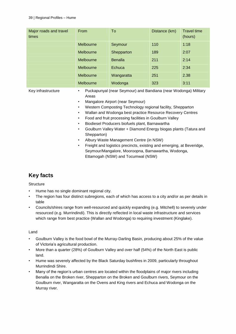
Major roads and travel
times
From To Distance (km) Travel time
(hours)
Melbourne Seymour 110 1:18
Melbourne Shepparton 189 2:07
Melbourne Benalla 211 2:14
Melbourne Echuca 225 2:34
Melbourne Wangaratta 251 2.38
Melbourne Wodonga 323 3:11
Key infrastructure
• Puckapunyal (near Seymour) and Bandiana (near Wodonga) Military
Areas
• Mangalore Airport (near Seymour)
• Western Composting Technology regional facility, Shepparton
• Wallan and Wodonga best practice Resource Recovery Centres
• Food and fruit processing facilities in Goulburn Valley
• Biodiesel Producers biofuels plant, Barnawartha
• Goulburn Valley Water + Diamond Energy biogas plants (Tatura and
Shepparton)
• Albury Waste Management Centre (in NSW)
• Freight and logistics precincts, existing and emerging, at Beveridge,
Seymour/Mangalore, Mooroopna, Barnawartha, Wodonga,
Ettamogah (NSW) and Tocumwal (NSW)
Key facts
Structure
• Hume has no single dominant regional city.
• The region has four distinct subregions, each of which has access to a city and/or as per details in
table
• Councils/shires range from well-resourced and quickly expanding (e.g. Mitchell) to severely under
resourced (e.g. Murrindindi). This is directly reflected in local waste infrastructure and services
which range from best practice (Wallan and Wodonga) to requiring investment (Kinglake).
Land
• Goulburn Valley is the food bowl of the Murray-Darling Basin, producing about 25% of the value
of Victoria’s agricultural production.
• More than a quarter (28%) of Goulburn Valley and over half (54%) of the North East is public
land.
• Hume was severely affected by the Black Saturday bushfires in 2009, particularly throughout
Murrindindi Shire.
• Many of the region’s urban centres are located within the floodplains of major rivers including
Benalla on the Broken river, Shepparton on the Broken and Goulburn rivers, Seymour on the
Goulburn river, Wangaratta on the Ovens and King rivers and Echuca and Wodonga on the
Murray river.
Regional Profiles – Hume | 40
Demography
Population: 310,000 (two-thirds in Goulburn Valley).
• Population growth is a slightly lower than the Victorian average.
• High amenity areas experience a significant influx of Melburnians seeking a rural lifestyle
(weekenders and commuters).
• High proportion of part time residents in areas of natural beauty (e.g. 50% of rate payers in
Mansfield Shire are part time residents, similar in Alpine Shire)
• Structural ageing as farmers get older, young people migrate to cities and retirees migrate to the
region. Most significant in Strathbogie followed by Towong, Alpine and Benalla shires.
• Shepparton-Mooroopna has the largest Indigenous population in provincial Victoria
• Further cultural diversity resulting from past and recent settlement of migrants, including large
Arabic speaking communities in Shepparton and Moira
• Relatively low levels of social disadvantage. Of 270 relatively disadvantaged towns in regional
Victoria only 40 are in the Hume region (and none in the top 24). However, disadvantaged towns
include al l of the region’s centres – Shepparton and nearby Mooroopna, Wodonga, Wangaratta,
Benalla and Seymour.
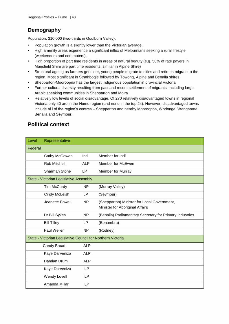
Political context
Level Representative
Federal
Cathy McGowan Ind Member for Indi
Rob Mitchell ALP Member for McEwen
Sharman Stone LP Member for Murray
State - Victorian Legislative Assembly
Tim McCurdy NP (Murray Valley)
Cindy McLeish LP (Seymour)
Jeanette Powell NP (Shepparton) Minister for Local Government,
Minister for Aboriginal Affairs
Dr Bill Sykes NP (Benalla) Parliamentary Secretary for Primary Industries
Bill Tilley LP (Benambra)
Paul Weller NP (Rodney)
State - Victorian Legislative Council for Northern Victoria
Candy Broad ALP
Kaye Darveniza ALP
Damian Drum ALP
Kaye Darveniza LP
Wendy Lovell LP
Amanda Millar LP
41 | Regional Profiles – Hume
Regional priorities
The June 2013 Draft Hume Regional Growth Plan provides a regional approach to land use planning
and identifies opportunities for growth and change over the next 30 years.
Principles under the plan include:
• Ensure land use planning decisions adopt a triple bottom line approach and are based on the best
available land capability data
• Support rural towns by providing access to key community infrastructure that can respond to
changing needs over time
• Ensure future development makes a positive contribution to sustainability and embraces good
urban design
• Support innovative and flexible service delivery models and improve access to facilities and
services
• Support the expansion and diversification of the region’s economy
• Capitalise on national transport links and tourist routes
• Support industrial growth through value adding
• Provide for efficient and effective transport movements within the region and to Melbourne and
other key urban centres outside of the region.
The growth plan is guided by The Hume Strategy for Sustainable Communities 2010-2020. Directions
under the strategy include
• harnessing renewable energy sources, reducing greenhouse gas emissions and pursuing
innovative waste management approaches
• adapting and diversifying agriculture in an environment of change
• facilitating research and innovation in tourism, manufacturing and industry to encourage new and
evolving business
• developing energy infrastructure that builds on existing competitive advantages
• developing a proficient land transportation system
• maximising use of existing infrastructure and services and facilitating strategic investment in
future infrastructure and services
• ensuring efficient use of land use planning resources in the region.
NB: These documents have been guided by 12 local councils excluding Shire of Campaspe which is reflected in the Loddon Mallee Regional Growth Plan.
High
Regional Profiles – Hume | 42
Economic profile
The economy is based on access to water and productive land, the national freight corridor and
significant areas of natural beauty. Related key industries are agriculture/primary production,
manufacturing (primarily food and beverage) and tourism (including ski resorts).
Manufacturing and agriculture are the most significant economic sectors, contributing over 30%
($3.1b) to the region’s gross value added and providing 75% of the region’s exports.
Significant and growing employment sectors include retail, construction, health care, education and
accommodation/food services.
Significant and declining employment sectors include manufacturing and agriculture.
Transition/emerging opportunities include intensive agriculture (broiler farms, piggeries, feedlots,
horticulture) and agricultural clusters, greenhouses, forestry, renewable energy generation including
bioenergy and conservation activities.
Opportunities also exist in the waste sector for localised waste management solutions (including
composting, recycling and reuse), specifically around towns with industries processing food and fibre
and near clusters of intensive animal raising industries.
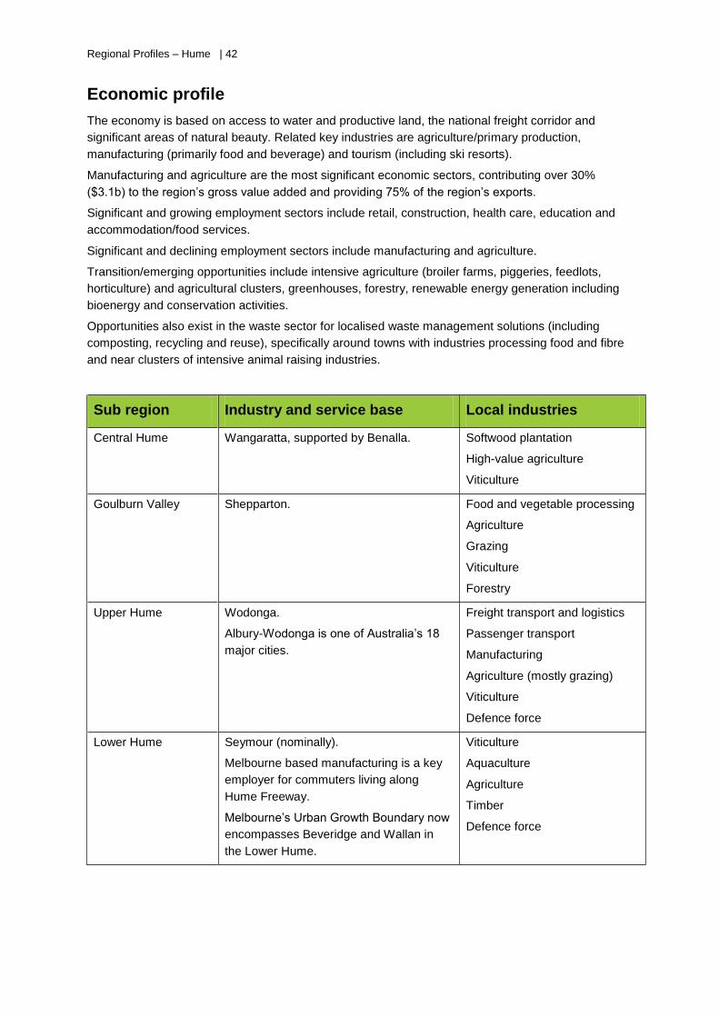
Sub region Industry and service base Local industries
Central Hume Wangaratta, supported by Benalla. Softwood plantation
High-value agriculture
Viticulture
Goulburn Valley Shepparton. Food and vegetable processing
Agriculture
Grazing
Viticulture
Forestry
Upper Hume Wodonga.
Albury-Wodonga is one of Australia’s 18
major cities.
Freight transport and logistics
Passenger transport
Manufacturing
Agriculture (mostly grazing)
Viticulture
Defence force
Lower Hume Seymour (nominally).
Melbourne based manufacturing is a key
employer for commuters living along
Hume Freeway.
Melbourne’s Urban Growth Boundary now
encompasses Beveridge and Wallan in
the Lower Hume.
Viticulture
Aquaculture
Agriculture
Timber
Defence force
43 | Regional Profiles – Hume
Funded sustainability project examples
Recent SV projects
• Alpine Living Bin project
• Fluoro Collect – Driving Investment for New Recycling fund
• Sustainable organics management in Goulburn Valley
• Inaugural SV@ your doorstep (Alpine Shire)
Current SV projects
25 projects at a total contract value of $2.7m funded by SV since July
2012, including:
• Green and food waste collection in the Goulburn Valley
• Tallangatta Eco Education and Integrated Services Hub (co-
funded by DEECD and Living Libraries)
• Education and engagement campaign for Wodonga and Indigo
• Away from Home behaviour study, North East.
Third party sustainability
projects
Seven Hume projects under Victorian Adaption and Sustainability
Partnership Program, including:
• Virtual Renewable Power Stations, feasibility study into
decentralised electricity generation and distribution infrastructure
(Moira Shire partnering with Swan Hill Rural City)
• Climate smart agricultural development, long term data to inform
agricultural industry transformation (partnership of six Goulburn
Broken councils)
• Climate change resilience and adaptation.
Over 15 Hume projects under Australian Government’s Clean
Technology Fund, including:
• Energy efficient evaporator technology for Kagome Foods,
Australia’s largest tomato processor, based in Echuca
• Tri-gen plant for Wodonga Rendering (abattoir)
• Consolidation from Port Melbourne to Shepparton for chemical
manufacturer Pental Ltd
• Energy efficient cooling technology for Victorian Alps Wine
Company, based in Myrtleford.
Four Hume projects under Australian Government’s Local
Government Energy Efficiency Program, for solar and/or heat pump
hot water systems at Alpine, Indigo, Mitchell and Strathbogie Shires.
$2.9m from Australian Government for ‘Watts Working Better’ street
lighting project (total value $4.6m). Lead by Shepparton Council with
Campaspe, Benalla, Moira, Strathbogie, Mansfield, Mitchell,
Murrindindi and Wangaratta as partners. Managed by Goulburn
Broken Greenhouse Alliance.
Regional Profiles – Hume | 44
SWOT analysis
Strengths
• Multi-centred and somewhat diversified
economy with strong interregional linkages
• Opportunities for business development due
to geographical location of Hume between
Melbourne and Sydney
• Strong agricultural base and established role
in food production
• Good collaboration between most
councils/shires
• History of shared resource use and
collaborative procurement for waste services
• Towns/regions with good transport links and
existing infrastructure can accommodate
growth e.g. Seymour
• Consortium approach to ResourceSmart
AuSSI Vic taps into a strong local network in
the Hume region.
Opportunities
• Multi-centred structure and strong transport
links are a good fit for a ‘hub and spokes’
waste management model
• Hume can be an early adopter of Getting Full
Value, based on functional regional waste
groups and active local support for MAC
recommendations
• Significant changes earmarked to transport
networks (e.g. the GV Link project)
• Towns/regions with slowing economies can
provide infrastructure and population for
emerging industries
• Waste industry can provide training and
employment opportunities for displaced,
semi-skilled or unskilled workers
• Integrating resource awareness into planning
and new infrastructure where councils are
actively reinventing and restructuring the
local economic mix
• Albury/Wodonga and other border towns
provide opportunities for interstate knowledge
and resource share as well as joint
infrastructure projects
• Some areas are willing to invest in emerging
waste management technologies and may
find it easier to maintain buffer distances.
Weaknesses
• No sizable regional city and no ‘natural
centre’ for the region. This affects funding
support which is often based on population
size and city-based models and makes it
difficult to invest in centralised infrastructure
• Distorted ‘waste market’ from lower landfill
fees in NSW-Albury and two councils
(Wodonga and Indigo) that do not pay landfill
levy
• Community education difficult in high tourism
areas with transient populations and areas
with part-time populations
• Slowing economies and employment
opportunities in previous ‘agricultural centre’
towns
• Limited access to technologies that city-
based agencies may take for granted e.g.
internet access
• Limited access to commuter rail services
restricts population growth and has caused
Threats
• Changing weather patterns and increases in
droughts, floods, bushfires and other extreme
weather events can be a higher priority than
resource efficiency for local organisations,
businesses and householders
• Income from agriculture is volatile, subject to
climate change impacts (see above, plus
reduction in water, seasonal changes, and
increase in frost), direction of the Murray-
Darling Basin plan and global and local
economic conditions.
• Downturn in manufacturing has lead and will
lead to successive rationalisation
• Ongoing and significant regional issues
include water security, ageing infrastructure,
information and communication technology
demand and supply, and barriers to
establishing renewable energy supplies
• Pressure for urban and rural residential
development can present a threat to
45 | Regional Profiles – Hume
high dependence on private cars
• Small councils with relatively limited
resources, e.g. they don’t employ waste
education officers.
environmental assets but also provides
opportunities for tourism and other economic
diversification. Balancing these pressures,
along with natural hazards and potentially
prohibitive infrastructure cost, is a key
challenge for regional and local planning.
Regional Profiles – Loddon Mallee | 46
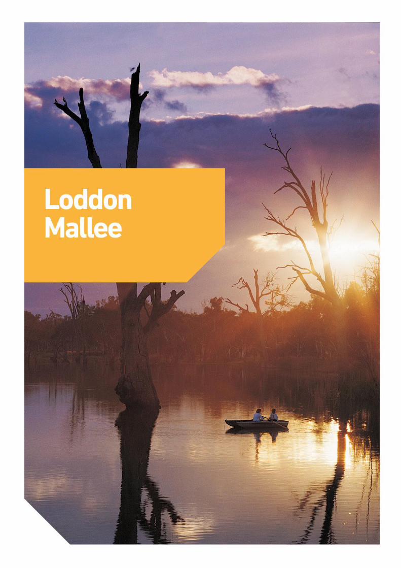
Loddon Mallee
Regional Profiles – Loddon Mallee | 4 7
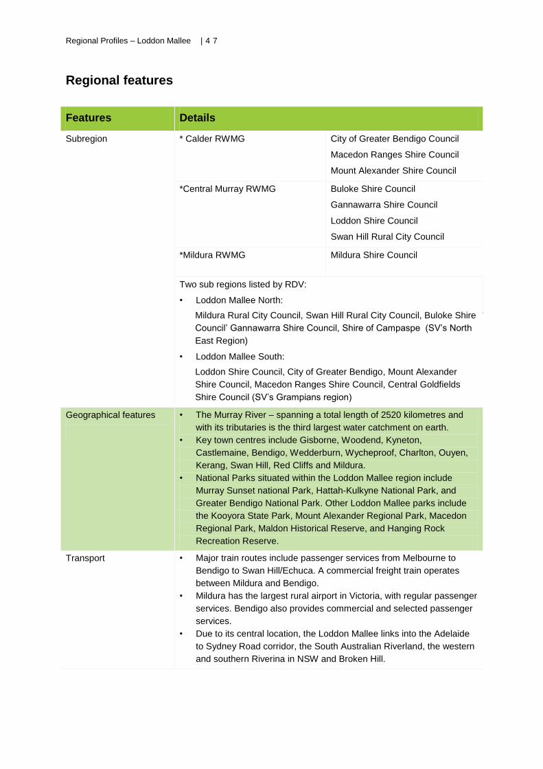
Regional features
Features Details
Subregion * Calder RWMG
City of Greater Bendigo Council
Macedon Ranges Shire Council
Mount Alexander Shire Council
*Central Murray RWMG
Buloke Shire Council
Gannawarra Shire Council
Loddon Shire Council
Swan Hill Rural City Council
*Mildura RWMG
Mildura Shire Council
Two sub regions listed by RDV:
• Loddon Mallee North:
Mildura Rural City Council, Swan Hill Rural City Council, Buloke Shire
Council’ Gannawarra Shire Council, Shire of Campaspe (SV’s North
East Region)
• Loddon Mallee South:
Loddon Shire Council, City of Greater Bendigo, Mount Alexander
Shire Council, Macedon Ranges Shire Council, Central Goldfields
Shire Council (SV’s Grampians region)
Geographical features
• The Murray River – spanning a total length of 2520 kilometres and
with its tributaries is the third largest water catchment on earth.
• Key town centres include Gisborne, Woodend, Kyneton,
Castlemaine, Bendigo, Wedderburn, Wycheproof, Charlton, Ouyen,
Kerang, Swan Hill, Red Cliffs and Mildura.
• National Parks situated within the Loddon Mallee region include
Murray Sunset national Park, Hattah-Kulkyne National Park, and
Greater Bendigo National Park. Other Loddon Mallee parks include
the Kooyora State Park, Mount Alexander Regional Park, Macedon
Regional Park, Maldon Historical Reserve, and Hanging Rock
Recreation Reserve.
Transport
• Major train routes include passenger services from Melbourne to
Bendigo to Swan Hill/Echuca. A commercial freight train operates
between Mildura and Bendigo.
• Mildura has the largest rural airport in Victoria, with regular passenger
services. Bendigo also provides commercial and selected passenger
services.
• Due to its central location, the Loddon Mallee links into the Adelaide
to Sydney Road corridor, the South Australian Riverland, the western
and southern Riverina in NSW and Broken Hill.
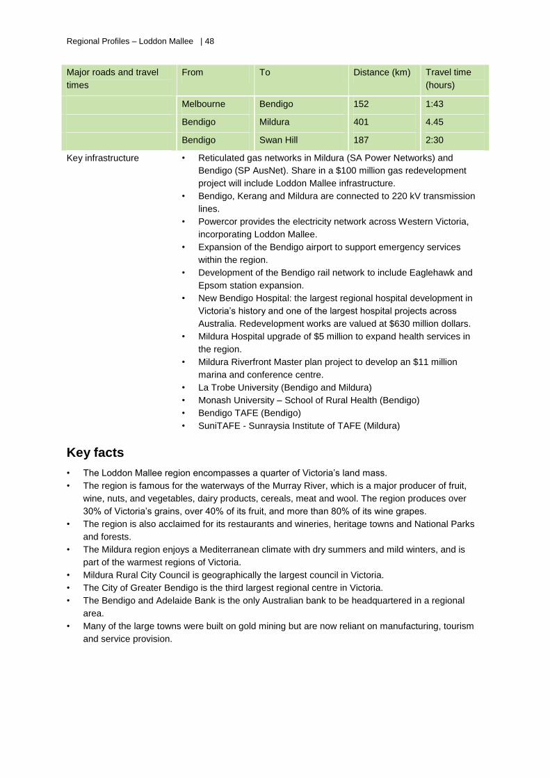
Regional Profiles – Loddon Mallee | 48
Major roads and travel
times
From To Distance (km) Travel time
(hours)
Melbourne Bendigo 152 1:43
Bendigo Mildura 401 4.45
Bendigo Swan Hill 187 2:30
Key infrastructure
• Reticulated gas networks in Mildura (SA Power Networks) and
Bendigo (SP AusNet). Share in a $100 million gas redevelopment
project will include Loddon Mallee infrastructure.
• Bendigo, Kerang and Mildura are connected to 220 kV transmission
lines.
• Powercor provides the electricity network across Western Victoria,
incorporating Loddon Mallee.
• Expansion of the Bendigo airport to support emergency services
within the region.
• Development of the Bendigo rail network to include Eaglehawk and
Epsom station expansion.
• New Bendigo Hospital: the largest regional hospital development in
Victoria’s history and one of the largest hospital projects across
Australia. Redevelopment works are valued at $630 million dollars.
• Mildura Hospital upgrade of $5 million to expand health services in
the region.
• Mildura Riverfront Master plan project to develop an $11 million
marina and conference centre.
• La Trobe University (Bendigo and Mildura)
• Monash University – School of Rural Health (Bendigo)
• Bendigo TAFE (Bendigo)
• SuniTAFE - Sunraysia Institute of TAFE (Mildura)
Key facts
• The Loddon Mallee region encompasses a quarter of Victoria’s land mass.
• The region is famous for the waterways of the Murray River, which is a major producer of fruit,
wine, nuts, and vegetables, dairy products, cereals, meat and wool. The region produces over
30% of Victoria’s grains, over 40% of its fruit, and more than 80% of its wine grapes.
• The region is also acclaimed for its restaurants and wineries, heritage towns and National Parks
and forests.
• The Mildura region enjoys a Mediterranean climate with dry summers and mild winters, and is
part of the warmest regions of Victoria.
• Mildura Rural City Council is geographically the largest council in Victoria.
• The City of Greater Bendigo is the third largest regional centre in Victoria.
• The Bendigo and Adelaide Bank is the only Australian bank to be headquartered in a regional
area.
• Many of the large towns were built on gold mining but are now reliant on manufacturing, tourism
and service provision.
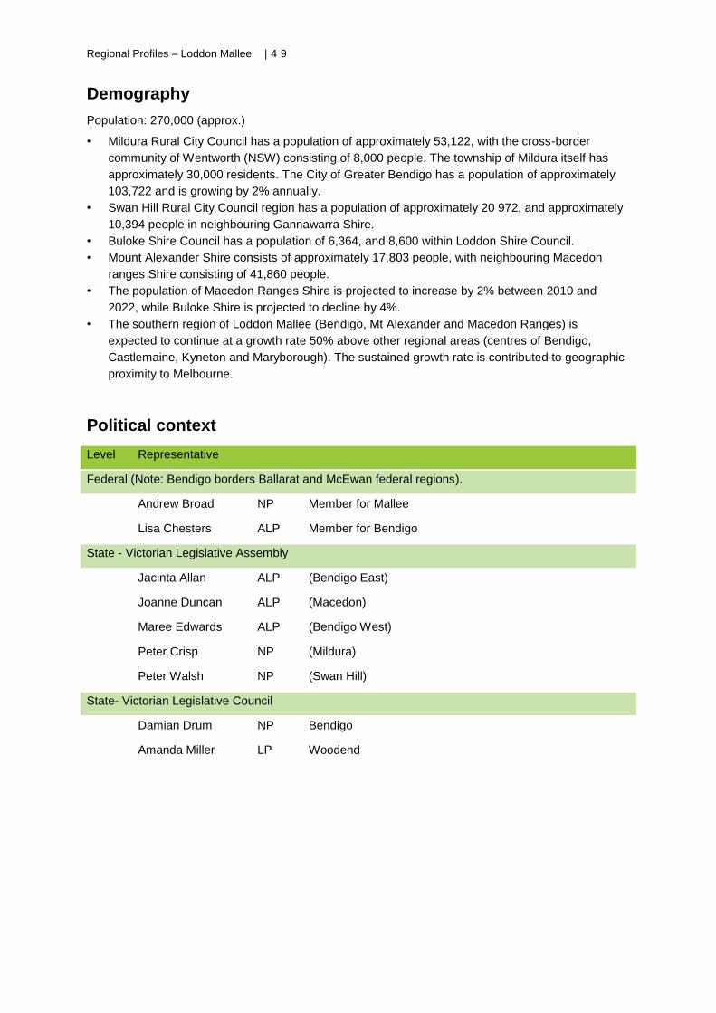
Regional Profiles – Loddon Mallee | 4 9
Demography
Population: 270,000 (approx.)
• Mildura Rural City Council has a population of approximately 53,122, with the cross-border
community of Wentworth (NSW) consisting of 8,000 people. The township of Mildura itself has
approximately 30,000 residents. The City of Greater Bendigo has a population of approximately
103,722 and is growing by 2% annually.
• Swan Hill Rural City Council region has a population of approximately 20 972, and approximately
10,394 people in neighbouring Gannawarra Shire.
• Buloke Shire Council has a population of 6,364, and 8,600 within Loddon Shire Council.
• Mount Alexander Shire consists of approximately 17,803 people, with neighbouring Macedon
ranges Shire consisting of 41,860 people.
• The population of Macedon Ranges Shire is projected to increase by 2% between 2010 and
2022, while Buloke Shire is projected to decline by 4%.
• The southern region of Loddon Mallee (Bendigo, Mt Alexander and Macedon Ranges) is
expected to continue at a growth rate 50% above other regional areas (centres of Bendigo,
Castlemaine, Kyneton and Maryborough). The sustained growth rate is contributed to geographic
proximity to Melbourne.
Political context
Level Representative
Federal (Note: Bendigo borders Ballarat and McEwan federal regions).
Andrew Broad NP Member for Mallee
Lisa Chesters ALP Member for Bendigo
State - Victorian Legislative Assembly
Jacinta Allan ALP (Bendigo East)
Joanne Duncan ALP (Macedon)
Maree Edwards ALP (Bendigo West)
Peter Crisp NP (Mildura)
Peter Walsh NP (Swan Hill)
State- Victorian Legislative Council
Damian Drum NP Bendigo
Amanda Miller LP Woodend
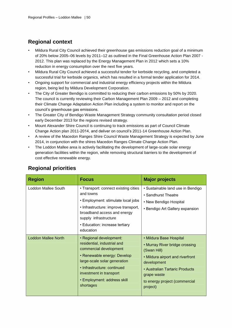
Regional Profiles – Loddon Mallee | 50
Regional context
• Mildura Rural City Council achieved their greenhouse gas emissions reduction goal of a minimum
of 20% below 2005–06 levels by 2011–12 as outlined in the Final Greenhouse Action Plan 2007 -
2012. This plan was replaced by the Energy Management Plan in 2012 which sets a 10%
reduction in energy consumption over the next five years.
• Mildura Rural City Council achieved a successful tender for kerbside recycling, and completed a
successful trial for kerbside organics, which has resulted in a formal tender application for 2014.
• Ongoing support for commercial and industrial energy efficiency projects within the Mildura
region, being led by Mildura Development Corporation.
• The City of Greater Bendigo is committed to reducing their carbon emissions by 50% by 2020.
The council is currently reviewing their Carbon Management Plan 2009 – 2012 and completing
their Climate Change Adaptation Action Plan including a system to monitor and report on the
council’s greenhouse gas emissions.
• The Greater City of Bendigo Waste Management Strategy community consultation period closed
early December 2013 for the regions revised strategy.
• Mount Alexander Shire Council is continuing to track emissions as part of Council Climate
Change Action plan 2011-2014, and deliver on council’s 2011-14 Greenhouse Action Plan.
• A review of the Macedon Ranges Shire Council Waste Management Strategy is expected by June
2014, in conjunction with the shires Macedon Ranges Climate Change Action Plan.
• The Loddon Mallee area is actively facilitating the development of large-scale solar energy
generation facilities within the region, while removing structural barriers to the development of
cost effective renewable energy.
Regional priorities
Region Focus Major projects
Loddon Mallee South • Transport: connect existing cities
and towns
• Employment: stimulate local jobs
• Infrastructure: improve transport,
broadband access and energy
supply infrastructure
• Education: increase tertiary
education
• Sustainable land use in Bendigo
• Sandhurst Theatre
• New Bendigo Hospital
• Bendigo Art Gallery expansion
Loddon Mallee North • Regional development:
residential, industrial and
commercial development
• Renewable energy: Develop
large-scale solar generation
• Infrastructure: continued
investment in transport
• Employment: address skill
shortages
• Mildura Base Hospital
• Murray River bridge crossing
(Swan Hill)
• Mildura airport and riverfront
development
• Australian Tartaric Products
grape waste
to energy project (commercial
project)
Regional Profiles – Loddon Mallee | 5 1
High
Economic profile
• The total financial value of Loddon Mallee to Victoria’s economy through its varying industry
sectors is valued at approximately $21 billion.
• The Loddon Mallee region gains its main income from tourism, viticulture, horticulture, cropping,
cattle wool markets, equine industries, and manufacturing.
• The region is classed as one of the main food producing areas in Victoria ranging from irrigation
supported horticulture, dry land horticulture, dry land cropping, and dry land grazing.
• Additional key drivers for the region includes healthcare and social assistance programs,
transport and warehousing services, arts and recreation, and professional services.
• The Bendigo Bank is the only Australian bank to be headquartered in a regional area and
provides great economic and social support to the region.
• There is strong support for renewable energy markets and opportunities, including large and small
scale solar.
• The service sector (especially health and education) and related industries are growing. Other
strong
• economies include information technology and professional and business services.
• New economic opportunities include renewable energy, particularly large-scale solar projects;
mineral sands; and nature-based and Indigenous tourism.
Funded sustainability project examples
Recent SV projects
• Regional Victoria Community Solar Hubs program: Bendigo and Mildura
• Central Victoria Solar City - Data Monitoring and Reporting for the
Central Victorian Solar Cities Program. Delivered by Sustainable
Regional Australia
• Smart Energy Zones: Central Victoria Solar City (Community solar parks
in Bendigo and Ballarat)
• Calder Highway Illegal Dumping and Litter Investigation Squad
• Mildura Education Centre (Eco Living project – Learning from a Landfill
project) officially opened in June and Final Report due August.
• RED Group - Recycling Plus Education = the Difference. Delivered by
RED Group Holding, engaging Victorian schools. Working with RWMGs.
Current SV projects
• Transition support to improve rural landfill infrastructure program, Mt
Alexander Shire Council, Castlemaine landfill
• Organics trial, Veolia Environmental Services, Lake Boga -Swan Hill
• Mildura Eco Living Centre, Mildura Rural City Council
• Wycheproof Community Resource Centre, winner of the Keep Australia
Beautiful Victoria, Community Government Partnership Award, Keep
Australia Beautiful Victoria Tidy
Towns -Sustainable Communities Awards 2012.
• Smarter Resources Smarter Business Energy and Materials Grants.
• Wycheproof, Keep Australia Beautiful Victoria Tidy Town of the Year
2012.
• Mildura projects include sharps and medical waste, education kit
upgrades, kerbside organics trial and tenders, polystyrene compactor,
Regional Profiles – Loddon Mallee | 52
home recycling eco bin, dog pouches, food waste avoidance and
Kerbside Pride for business, and attendance at the Mildura Sustainability
Living Festival 2013.
• Central Murray RWMG projects include Kerbside Pride organics and
education, increased awareness of recycling and waste diversion (get it
sorted, Kerbside Pride), Reduce Litter Grant, landfill and transfer station
assessment.
• Calder RWMG projects include organics management strategy, green
organics on farm management trial and Get it Right on Bin Night
campaign.
Third party
sustainability projects
• Resilient Community Assets Project, a joint grant project between Mount
Alexander, Macedon Ranges, Buloke, Loddon and Gannawarra Shire
Councils under the Victorian Adaptation and Sustainability Partnership.
The $240, 000 will address climate adaptation policies and programs in
the region and collaboration between the councils.
• Australian Tartaric Products in Colignan (Mildura region) received $1.7
million grant from Clean Tech Investment Program and $1.8 million from
RDV for a $7.5m bioenergy plant
• Grays Bakery in Kerang received $100,000 through the Victorian
Business Flood Recovery Fund to install new energy efficient ovens,
lighting and double-glazed windows.
• Central Victorian Greenhouse Alliance received funding from the EEIG
program to offer road show seminars, partly funded business energy
assessments and award programs to SMEs in central Victoria
• The Victorian Government funds natural gas supply with a share of $100
million to extend natural gas across regional Victoria and encourage
greater investment in the regions
• City of Greater Bendigo Council received $380,000 from the
Commonwealth Government through the Community Energy Efficiency
Program to increase energy efficiency in seven of its highest energy
using facilities
Regional Profiles – Loddon Mallee | 5 3
SWOT analysis
Strengths
• Diverse agricultural region
• Diverse economic drivers
• Employment and training opportunities
• Close proximity to Melbourne (Southern
Loddon Mallee)
• Mildura and Bendigo airports
• Good infrastructure in regional centres
• Sustained growing population in majority of
council regions (especially southern Loddon
Mallee)
• State-of-the-art education facilities throughout
the region
• An abundance of sunshine (north of the
Dividing Range) and historic context for
tourism
Opportunities
• Exploitation of solar resources remains an
opportunity for the region.
• Further development of horticulture and
efficient farming practices.
Weaknesses
• Low population density in North Loddon
Mallee, with high growth in the southern
council regions.
• Travel distances from regions north of
Bendigo are prohibitive.
• Lack of broadband connection restrictive
• Skill shortages and mismatch or trained
workers for jobs available, therefore
excessive commuting from Bendigo, Mount
Alexander and Macedon Ranges regions to
Melbourne for employment.
Threats
• Maintaining infrastructure
• Ageing populations throughout Loddon
Mallee, particularly more isolated rural
farming zones to the north of Bendigo.
• Economy is vulnerable to unfavourable
exchange rates, and current uncertainty in
horticultural based industries.
• Skills and /or job shortages
Regional Profiles – Loddon Mallee | 54
Further reading
This section provides a list of organisations providing regional development information in Victoria.
All web addresses are correct as at June 2013.
ClimateWorks Australia
ClimateWorks Australia publishes a number of plans related to lowering emissions, including the low
carbon growth plans for Geelong and Gippsland.
www.climateworksaustralia.org/publications.html
Council websites
Most councils publish economic reports and statistics on their websites. A full list of councils with
websites is available on the Department of Transport, Planning and Local Infrastructure website.
http://www.dpcd.vic.gov.au/localgovernment/find-your-local-council
Department of State Development, Business and Innovation (DSDBI)
DSDBI has published an Industry Atlas of Victoria (2011).
www.dsdbi.vic.gov.au/research-reports/industry-atlas-of-victoria
Regional Development Victoria (RDV)
RDV provides regional development summaries on the five regions and publishes regional and
subregional growth plans and strategic plans.
www.rdv.vic.gov.au/victorian-regions.
Fuelled for Growth: The 2012 Ernst and Young report on bioenergy (Fuelled for Growth: Investing in
Victoria’s biofuels and bioenergy industries) is available for download at
www.rdv.vic.gov.au/business-and-industry-programs/biofuels-and-bioenergy.
Department of Transport, Planning and Local Infrastructure (DTPLI)
DTPLI publishes regional and subregional growth plans and strategic plans for Victorian regions.
http://www.dpcd.vic.gov.au/planning/projects-and-programs/regionalgrowthplans/
Profile.id
Profile.id uses the 2011 Census to provide comprehensive, online, socio-demographic profiles
of local government areas.
www.home.id.com.au/id-community/local-govt-products/profileid.
RWMG websites
The RWMGs publish business plans and annual reports on their websites. For a full list of RWMGs
and their websites, see contact details listed on the SV website: www.sustainability.vic.gov.au.