protecting the sky - rohde & schwarz€¦ · 1 protecting the sky ... mounted display while...
TRANSCRIPT
Pro
tect
ing
the
Sky
Whi
tepa
per
Sig
nal A
naly
sis
8GE
P
10.2
015
- V
02.0
0
Protecting the Sky Signal Monitoring of Radio
Controlled Civilian Unmanned
Aerial Vehicles and Possible
Countermeasures
Whitepaper
Whitepaper
This whitepaper provides insights into the use, specifications, and impact of Radio Controlled (RC) Unmanned Aerial
Vehicles (commonly referred to as “drones”). UAVs intended for recreational use are increasingly being used for other
(sometimes hostile) purposes. These include: observing/disturbing public events, spying in protected areas, smuggling
contraband into prisons, endangering/threatening commercial air traffic, and entering restricted airspace. A technical
approach for countering the threats posed by such drones is described, and includes: monitoring the spectrum for
relevant signals, identification of frequency-agile RC signals, direction finding, and possible defensive countermeasures.
V01.01 V02.00 Rohde & Schwarz Protecting the Sky 2
Table of Contents
1 Protecting the Sky .................................................................. 3
1.1 The Highlights .............................................................................................. 3
2 Civilian (Commercial) Drones Overview ............................... 5
2.1 Introduction .................................................................................................. 5
2.2 Categories of Civilian (Commercial) Drones ............................................. 5
2.3 Specifications ............................................................................................... 6
3 Conceptual Solution for Monitoring and Countermeasures7
3.1 Key Features ................................................................................................. 7
3.2 Conceptual Approach .................................................................................. 8
4 FHSS Drones ........................................................................... 9
4.1 Detection, Recognition and Analysis ......................................................... 9
4.2 Direction Finding ........................................................................................ 10
4.3 Jamming ...................................................................................................... 11
5 WLAN Drones ........................................................................ 12
5.1 Detection, Recognition and Direction Finding ........................................ 12
6 Summary................................................................................ 13
7 Reference............................................................................... 13
V01.01 V02.00 Rohde & Schwarz Protecting the Sky 3
1 Protecting the Sky
1.1 The Highlights
The use of Radio Controlled (RC) Unmanned Aerial Vehicles (UAVs) for civilian and commercial purposes
has been growing steadily for the past decade. As early as 2011, research indicated that approximately
50,000 drones were in use by amateurs, worldwide. In the USA, some researchers claim that up to 30,000
civilian and commercial drones could be flying in the skies over US cities within the next decade. Experts
estimate that, during this time frame, cumulative global spending on aerial drones will reach $98 billion
and around 12% of this will be for commercial purposes. These Unmanned Aircraft (UA) systems are an
advancing technology with a proven record for providing beneficial “eye in the sky” services, but which
also raise serious concerns with regard to privacy and safety.
This paper provides an overview of the different types of UAV and their communications behavior. A
conceptual solution for both monitoring and countermeasures is also presented.
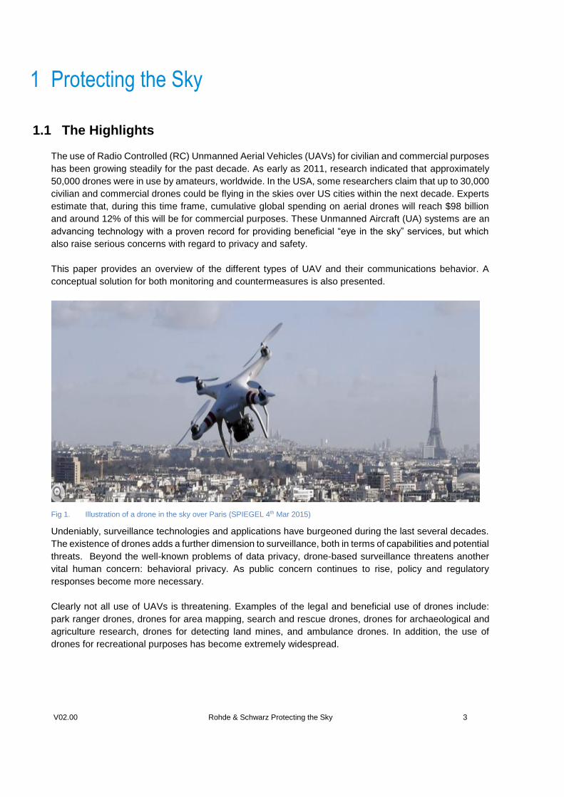
Fig 1. Illustration of a drone in the sky over Paris (SPIEGEL 4th Mar 2015)
Undeniably, surveillance technologies and applications have burgeoned during the last several decades.
The existence of drones adds a further dimension to surveillance, both in terms of capabilities and potential
threats. Beyond the well-known problems of data privacy, drone-based surveillance threatens another
vital human concern: behavioral privacy. As public concern continues to rise, policy and regulatory
responses become more necessary.
Clearly not all use of UAVs is threatening. Examples of the legal and beneficial use of drones include:
park ranger drones, drones for area mapping, search and rescue drones, drones for archaeological and
agriculture research, drones for detecting land mines, and ambulance drones. In addition, the use of
drones for recreational purposes has become extremely widespread.
V01.01 V02.00 Rohde & Schwarz Protecting the Sky 4
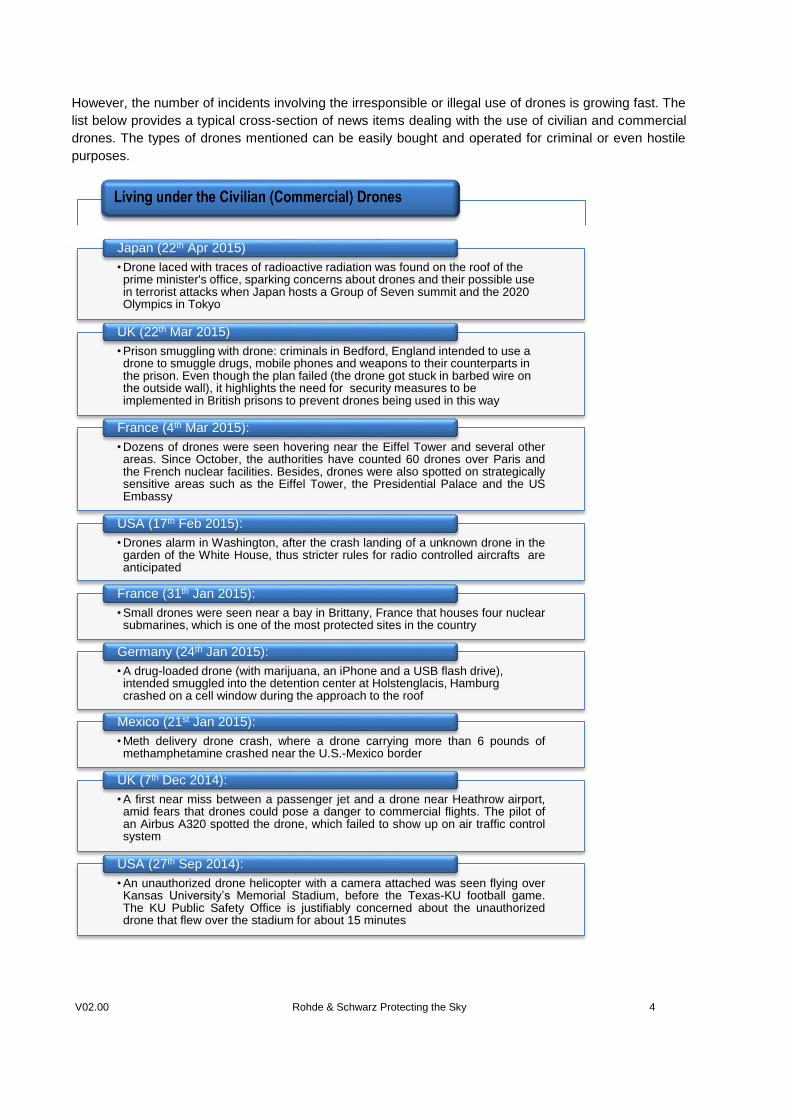
However, the number of incidents involving the irresponsible or illegal use of drones is growing fast. The
list below provides a typical cross-section of news items dealing with the use of civilian and commercial
drones. The types of drones mentioned can be easily bought and operated for criminal or even hostile
purposes.
• Drone laced with traces of radioactive radiation was found on the roof of the prime minister's office, sparking concerns about drones and their possible use in terrorist attacks when Japan hosts a Group of Seven summit and the 2020 Olympics in Tokyo
Japan (22th Apr 2015)
• Prison smuggling with drone: criminals in Bedford, England intended to use a drone to smuggle drugs, mobile phones and weapons to their counterparts in the prison. Even though the plan failed (the drone got stuck in barbed wire on the outside wall), it highlights the need for security measures to be implemented in British prisons to prevent drones being used in this way
UK (22th Mar 2015)
• Dozens of drones were seen hovering near the Eiffel Tower and several otherareas. Since October, the authorities have counted 60 drones over Paris andthe French nuclear facilities. Besides, drones were also spotted on strategicallysensitive areas such as the Eiffel Tower, the Presidential Palace and the USEmbassy
France (4th Mar 2015):
• Drones alarm in Washington, after the crash landing of a unknown drone in thegarden of the White House, thus stricter rules for radio controlled aircrafts areanticipated
USA (17th Feb 2015):
• Small drones were seen near a bay in Brittany, France that houses four nuclearsubmarines, which is one of the most protected sites in the country
France (31th Jan 2015):
• A drug-loaded drone (with marijuana, an iPhone and a USB flash drive), intended smuggled into the detention center at Holstenglacis, Hamburg crashed on a cell window during the approach to the roof
Germany (24th Jan 2015):
• Meth delivery drone crash, where a drone carrying more than 6 pounds ofmethamphetamine crashed near the U.S.-Mexico border
Mexico (21st Jan 2015):
• A first near miss between a passenger jet and a drone near Heathrow airport,amid fears that drones could pose a danger to commercial flights. The pilot ofan Airbus A320 spotted the drone, which failed to show up on air traffic controlsystem
UK (7th Dec 2014):
• An unauthorized drone helicopter with a camera attached was seen flying overKansas University’s Memorial Stadium, before the Texas-KU football game.The KU Public Safety Office is justifiably concerned about the unauthorizeddrone that flew over the stadium for about 15 minutes
USA (27th Sep 2014):
V01.01 V02.00 Rohde & Schwarz Protecting the Sky 5
2 Civilian (Commercial) Drones Overview
2.1 Introduction
As the name suggests, Unmanned Aerial Vehicles (UAVs) are aircraft without a human pilot on board.
The flight is controlled remotely by a pilot on the ground or by means of an onboard navigation system
flying a predefined route. UAVs typically fall into one of six functional categories: Civilian and Commercial,
Target and Decoy, Reconnaissance, Combat, Logistics, and Research and Development.
Our focus here is aimed on radio controlled civilian (commercial) drones, where the UAVs specifically
designed for civil and commercial applications. The trend for the use of UAV technology in civilian and
commercial uses is expanding rapidly with increased development of automated object detection
approaches and the lowing of cost. The increasing amount of affordable civilian drones capable of carrying
payloads of some 100g up to a few kg leads to an emerging threat for critical infrastructures, VIPs and
public events. Threats may involve simple disturbances (privacies), spying or even incur severe harms
(terror attacks). Facing with the challenges and difficulties of intercepting radio controlled drones as well
as their operators, many authorities have been striving to achieve a solution in drones monitoring and
countermeasures.
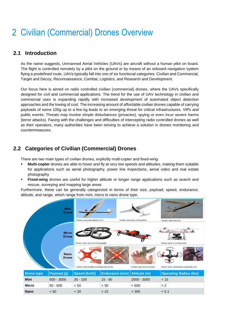
2.2 Categories of Civilian (Commercial) Drones
There are two main types of civilian drones, explicitly multi-copter and fixed-wing.
Multi-copter drones are able to hover and fly at very low speeds and altitudes, making them suitable
for applications such as aerial photography, power line inspections, aerial video and real estate
photography
Fixed-wing drones are useful for higher altitude or longer range applications such as search and
rescue, surveying and mapping large areas
Furthermore, these can be generally categorized in terms of their size, payload, speed, endurance,
altitude, and range, which range from mini, micro to nano drone type.
Drone type Payload (g) Speed (km/h) Endurance (min) Altitude (m) Operating Radius (km)
Mini 600 - 3000 30 - 100 15 - 90 2000 - 3000 < 15
Micro 50 - 600 < 50 < 30 < 600 < 2
Nano < 50 < 20 < 10 < 300 < 0.1
*mini drone is corresponding to fixed-wing aircraft UAV with weight around 5-6kg
V01.01 V02.00 Rohde & Schwarz Protecting the Sky 6
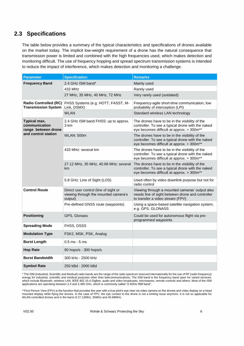
2.3 Specifications
The table below provides a summary of the typical characteristics and specifications of drones available
on the market today. The implicit low-weight requirement of a drone has the natural consequence that
transmission power is limited and combined with the high frequencies used, which makes detection and
monitoring difficult. The use of frequency hopping and spread spectrum transmission systems is intended
to reduce the impact of interference, which makes detection and monitoring a challenge.
* The ISM (Industrial, Scientific and Medical) radio bands are the range of the radio spectrum reserved internationally for the use of RF (radio frequency) energy for industrial, scientific and medical purposes other than telecommunications. The ISM band is the frequency band open for varied services, which include Bluetooth, wireless LAN, IEEE 802.15.4-ZigBee, audio and video broadcasts, microwaves, remote controls and others. Most of the ISM applications are operating between 2.4 and 2.485 GHz, which is commonly called “2.4GHz ISM band”. **First Person View (FPV) is the function that provides the user with a true pilot’s eye view via video camera on the drones and video display on a head mounted display while flying the drones. In the case of FPV, the eye contact to the drone is not a limiting issue anymore. It is not so applicable for WLAN controlled drones and in the band of 27.12MHz, 35MHz and 40.68MHz.
Parameter Specification Remarks
Frequency Band 2.4 GHz ISM band* Mainly used
433 MHz Rarely used
27 MHz, 35 MHz, 40 MHz, 72 MHz
Very rarely used (outdated)
Radio Controlled (RC) Transmission System
FHSS Systems (e.g. HOTT, FASST, M-Link, DSMX)
Frequency-agile short-time communication, low probability of interception (LPI)
WLAN
Standard wireless LAN technology
Typical max. communication range between drone and control station
2.4 GHz ISM band FHSS: up to approx. 3 km
The drones have to be in the visibility of the controller. To see a typical drone with the naked eye becomes difficult at approx. > 300m**
WLAN: 500m The drones have to be in the visibility of the controller. To see a typical drone with the naked eye becomes difficult at approx. > 300m**
433 MHz: several km The drones have to be in the visibility of the controller. To see a typical drone with the naked eye becomes difficult at approx. > 300m**
27.12 MHz, 35 MHz, 40.68 MHz: several km
The drones have to be in the visibility of the controller. To see a typical drone with the naked eye becomes difficult at approx. > 300m**
5.8 GHz: Line of Sight (LOS) Used often by video downlink purpose but not for radio control
Control Route Direct user control (line of sight or viewing through the mounted camera’s output)
Viewing through a mounted cameras’ output also needs line of sight between drone and controller to transfer a video stream (FPV)
Pre-defined GNSS route (waypoints)
Using a space-based satellite navigation system, e.g. GPS, GLONASS
Positioning GPS, Glonass Could be used for autonomous flight via pre-programmed waypoints
Spreading Mode FHSS, DSSS
Modulation Type FSK2, MSK, PSK, Analog
Burst Length 0.5 ms - 5 ms
Hop Rate 90 hops/s - 300 hops/s
Burst Bandwidth 300 kHz - 2500 kHz
Symbol Rate 250 kBd - 2000 kBd
V01.01 V02.00 Rohde & Schwarz Protecting the Sky 7
3 Conceptual Solution for Monitoring and Countermeasures The main challenge in the field of radio controlled drone monitoring and countermeasure is response time.
It is essential to detect, identify, locate and counter the targeted signals, in the shortest possible time. With
long standing experience in the field of radiomonitoring and radiolocation, Rohde & Schwarz is able to
offer an optimized solution ensuring that the radio controlled drone activity is optimally monitored and
surveilled. The section illustrates the conceptual solution for radio controlled drone monitoring and
countermeasures.
3.1 Key Features
The key features of the targeted R&S solution are:
Fast response: detection, identification, directing finding and jamming of threats in less than 20s,
including the decision time by the operator. Capable of identifying the radio control emission of the
drone immediately after switching on (even before take-off)
Frequency range: covers all the relevant frequencies used by modern drones 433 MHz, 2.4 GHz,
and 5.8 GHz
Automatic workflow: online detection of frequency-agile short-time signals, hop analysis,
classification of hop parameters (i.e. hop duration, hop rate, modulation and other parameters)
Excellent time resolution: min burst duration = 500 µs
Wideband hopper detection: max hopper bandwidth = 2.5 MHz
Wideband direction finding: max realtime bandwidth = 80 MHz
Advanced DF: multi-element direction finding antennas with superior DF accuracy, sensitivity and
immunity to reflections
Effective jamming: advanced exciter for jamming purpose, only the radio controlled drone signal
should be jammed and other legal signals in the same band should not be affected
Automatic IQ recording: IQ recording for detailed analysis of the recorded complex signal scenarios
by technical signal analysis software to explore new types of drones. Concurrently, it also conserves
as the assurance of evidence
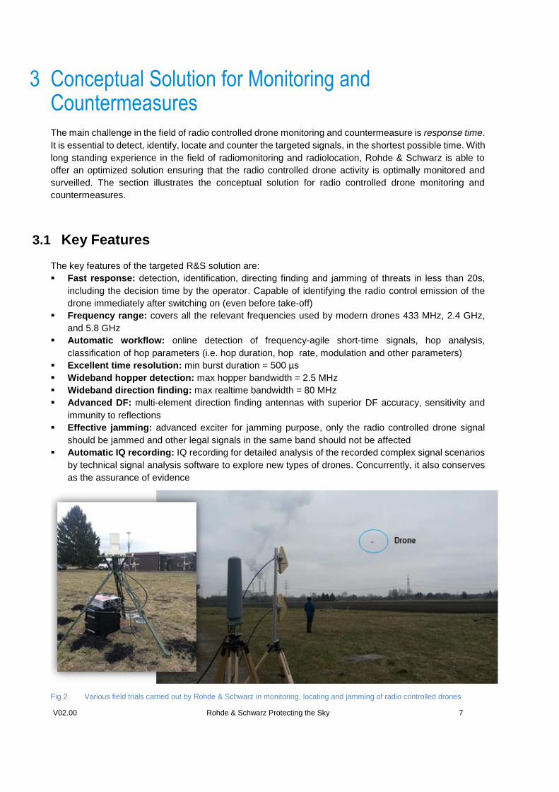
Fig 2. Various field trials carried out by Rohde & Schwarz in monitoring, locating and jamming of radio controlled drones
V01.01 V02.00 Rohde & Schwarz Protecting the Sky 8
3.2 Conceptual Approach
Action Benefit Remarks
Signal monitoring over a
wide area to detect the
appearance of radio
controlled drones. Its aims
are to improve situational
awareness and to detect the
radio control signals of
interest as early as possible
- Achieve immediate detection
of the drone’s RC once it
switches on (even before
take-off)
- Achieve an overview of all
the active RC or WLAN
controlled drones in the area
covered by the monitoring
stations
- Obtain the parameters and
classification of the active
radio controlled drones
- Drones that are flying autonomously (via
GNSS) may or may not have a simultaneous RC-
link. If such RC-link is established, surveillance
and monitoring on the RC signal can be achieved.
Otherwise, the drone is controlled by pre-defined
waypoints that dependent on satellite based GPS
(vulnerable to GPS jamming). Detection of this
kind of drones can be achieved by having an
additional strategy (i.e. radar, optical, acoustic)
Direction finding and
locating of radio controlled
drone through one or more
direction finding station(s) in
order to geo-locate the
corresponding radio controls
of interest
- Achieve the approx. direction
from where the drone is
approaching
- Achieve the exact position of
the person that is controlling
the drone
- It is possible while the RC signal and/or
downlink is active
- For WLAN controlled drones, the radiolocation
performance depends on the number and signal
level of the other WLAN transmitters in the vicinity
of the DF station(s)
Jamming is triggered if the
radio controlled drone has to
be stopped
- The hostile mission is
prevented and the drone will
no longer be under the control
of the remote operator
- Almost all drones have a
selectable fail-safe-procedure
in case they lose their control
signal. They will
a) immediately slowly
descend to the ground
b) return to home position
(requires that the drone
can receive GPS)
- The GPS signal can also be
jammed. Normally the GPS-
controlled drone will stay
where it is or descend down
- In all cases, jamming the drone can lead to a
non-predictable behavior of the drone and thus
can even lead to a crash of the drone
- The home position will normally be the position
the drone came from but can also be set to any
other pre-programmed position (rare case)
- Jamming the connection of autonomous flying
drone will typically lead to its “fail-safe” mode (e.g.
return to home, landing). It is also possible that
the drone will continue the pre-programmed path
after the transmitter is switched off.
- Jamming GPS will influence all other GPS-
devices in the area
- For WLAN drone, it is possible to generate a link
interruption or take over the control. It is a
preferred/ recommended solution because the
drone remains under control
Detailed analysis of the
recorded (new types of)
FHSS drone control signals
- Extend the library of known
drone types for the monitoring
and jamming process
Detailed analysis of the
recorded (new types of)
WLAN drone control signals
- Analysis of the IP data
stream
V01.01 V02.00 Rohde & Schwarz Protecting the Sky 9
4 FHSS Drones
4.1 Detection, Recognition and Analysis
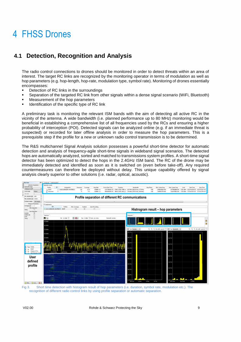
The radio control connections to drones should be monitored in order to detect threats within an area of interest. The target RC links are recognized by the monitoring operator in terms of modulation as well as hop parameters (e.g. hop-length, hop-rate, modulation type, symbol rate). Monitoring of drones essentially encompasses: Detection of RC links in the surroundings Separation of the targeted RC link from other signals within a dense signal scenario (WiFi, Bluetooth) Measurement of the hop parameters Identification of the specific type of RC link A preliminary task is monitoring the relevant ISM bands with the aim of detecting all active RC in the vicinity of the antenna. A wide bandwidth (i.e. planned performance up to 80 MHz) monitoring would be beneficial in establishing a comprehensive list of all frequencies used by the RCs and ensuring a higher probability of interception (POI). Detected signals can be analyzed online (e.g. if an immediate threat is suspected) or recorded for later offline analysis in order to measure the hop parameters. This is a prerequisite step if the profile for a new or unknown radio control transmission is to be determined. The R&S multichannel Signal Analysis solution possesses a powerful short-time detector for automatic detection and analysis of frequency-agile short-time signals in wideband signal scenarios. The detected hops are automatically analyzed, sorted and matched to transmissions system profiles. A short-time signal detector has been optimized to detect the hops in the 2.4GHz ISM band. The RC of the drone may be immediately detected and identified as soon as it is switched on (even before take-off). Any required countermeasures can therefore be deployed without delay. This unique capability offered by signal analysis clearly superior to other solutions (i.e. radar, optical, acoustic).
Fig 3. Short time detection with histogram result of hop parameters (i.e. duration, symbol rate, modulation etc.). The
recognition of different radio control links by using profile separation or automatic separation.
Profile separation of different RC communications
User defined profile
Histrogram result – hop parameters
V01.01 V02.00 Rohde & Schwarz Protecting the Sky 10
The detected hops are further analyzed to determine the relevant technical parameters (e.g. duration, bandwidth, level, modulation, symbol rate) of each individual hop. This enables the classification of the short-time emissions. By displaying the results in statistical histograms, the operator receives a full overview of all detectable RC links in a wideband signal scenario. Profile separation enables online separation and recognition of both known and unknown RC transmitters. The separator filters and sorts the hops according to their measured technical parameters, such as duration, modulation type and modulation parameters. The user can define profiles of RC transmission systems with their relevant technical parameters. For each cluster of hops, the separator will automatically compare and match the user defined profiles which fit to the hop parameters. With the profile trigger functionality, automatic processing workflows can be generated based on user defined rules. Once a target RC has been identified, automatic alarming can be triggered and the operator will be instantly notified about the existence of the targeted RC and is therefore forewarned of imminent drone activity within the area of interest. For analysis of unknown/new drone communication signals, it is necessary to use our detailed technical analysis specialized for frequency-agile transmissions. It provides time/frequency domain signal analysis, timing analysis and modulation analysis for determining technical parameters. New profiles for the separation/recognition and the countermeasures processes can be defined from the measured parameters.
4.2 Direction Finding
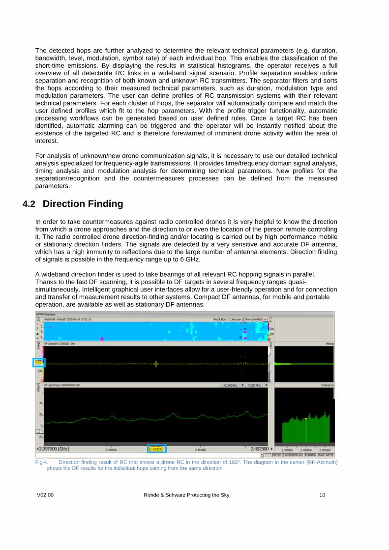
In order to take countermeasures against radio controlled drones it is very helpful to know the direction from which a drone approaches and the direction to or even the location of the person remote controlling it. The radio controlled drone direction-finding and/or locating is carried out by high performance mobile or stationary direction finders. The signals are detected by a very sensitive and accurate DF antenna, which has a high immunity to reflections due to the large number of antenna elements. Direction finding of signals is possible in the frequency range up to 6 GHz. A wideband direction finder is used to take bearings of all relevant RC hopping signals in parallel. Thanks to the fast DF scanning, it is possible to DF targets in several frequency ranges quasi-simultaneously. Intelligent graphical user interfaces allow for a user-friendly operation and for connection and transfer of measurement results to other systems. Compact DF antennas, for mobile and portable operation, are available as well as stationary DF antennas.
Fig 4. Direction finding result of RC that shows a drone RC in the direction of 183°. The diagram in the center (RF-Azimuth)
shows the DF results for the individual hops coming from the same direction
V01.01 V02.00 Rohde & Schwarz Protecting the Sky 11
4.3 Jamming
Effective jamming of the RC link may have various consequences – e.g. forcing it to the ground, reprograming it to a fix position, causing its controlled landing or eventually leading to the activation of a return-to-home mode. The key purpose of jamming is to create interruption or at least strong interference of the targeted RC link in order to disable the opponent’s communications and disrupt any further hostile actions. The highly effective R&S follower jammer needs much lower power than required by a wideband jammer (e.g. a non-responsive barrage jammer). With this low power approach, jamming is possible from about 2/3 distance to the remote control under line-of-site conditions.
1/3 2/3
i.e. 300m i.e. 600m
Fig 5. Successful jamming of RC link
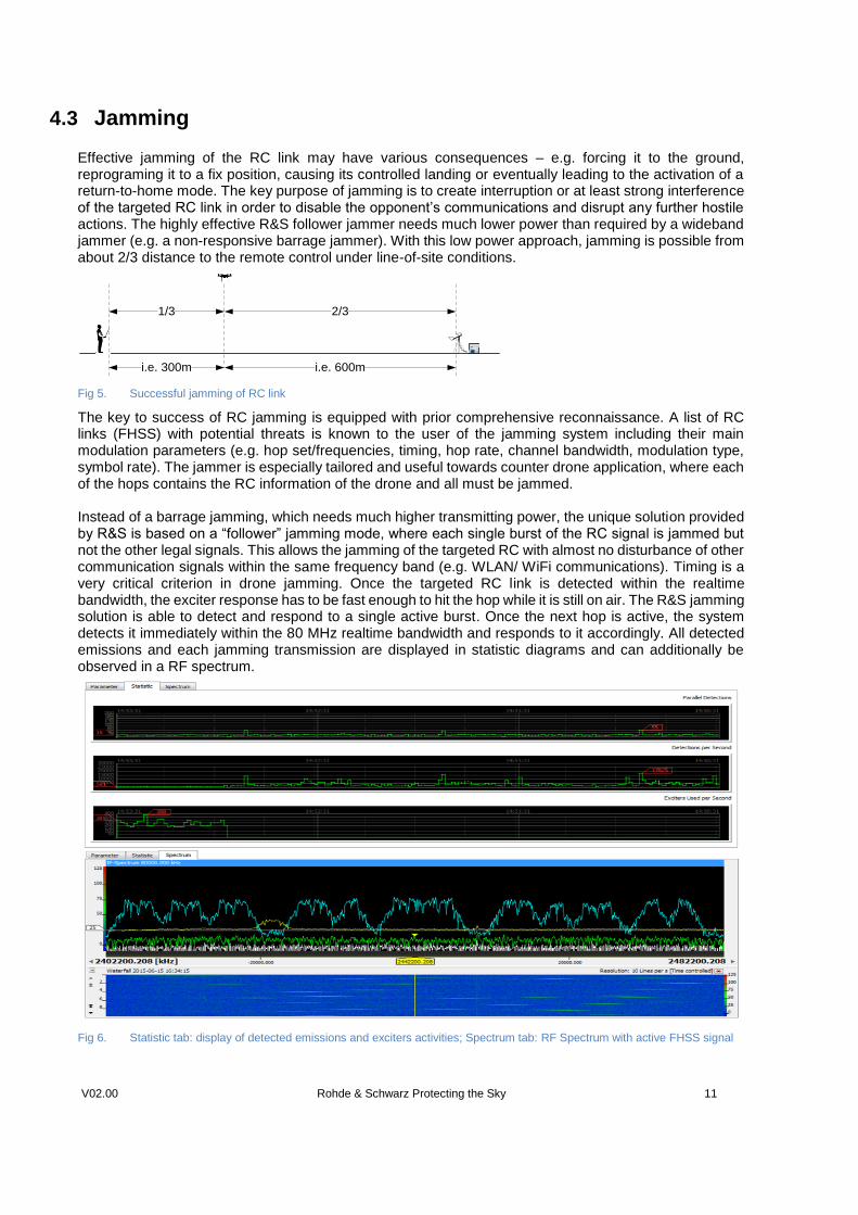
The key to success of RC jamming is equipped with prior comprehensive reconnaissance. A list of RC links (FHSS) with potential threats is known to the user of the jamming system including their main modulation parameters (e.g. hop set/frequencies, timing, hop rate, channel bandwidth, modulation type, symbol rate). The jammer is especially tailored and useful towards counter drone application, where each of the hops contains the RC information of the drone and all must be jammed. Instead of a barrage jamming, which needs much higher transmitting power, the unique solution provided by R&S is based on a “follower” jamming mode, where each single burst of the RC signal is jammed but not the other legal signals. This allows the jamming of the targeted RC with almost no disturbance of other communication signals within the same frequency band (e.g. WLAN/ WiFi communications). Timing is a very critical criterion in drone jamming. Once the targeted RC link is detected within the realtime bandwidth, the exciter response has to be fast enough to hit the hop while it is still on air. The R&S jamming solution is able to detect and respond to a single active burst. Once the next hop is active, the system detects it immediately within the 80 MHz realtime bandwidth and responds to it accordingly. All detected emissions and each jamming transmission are displayed in statistic diagrams and can additionally be observed in a RF spectrum.
Fig 6. Statistic tab: display of detected emissions and exciters activities; Spectrum tab: RF Spectrum with active FHSS signal
V01.01 V02.00 Rohde & Schwarz Protecting the Sky 12
5 WLAN Drones
5.1 Detection, Recognition and Direction Finding
Some drones are controlled via a WLAN connection. In this case, the radio control cannot be detected by analyzing the physical layer. It is necessary to analyze the WLAN protocol itself. Reading out the SSID of a given WLAN connection is in many cases sufficient to distinguish a remote control from any other WLAN connection. Solutions are available to track the azimuth of the drone (typically by combining a certain number of directional WLAN antennas and perform a so called “amplitude based direction finding”). Access points with fast movements may be a good hint for a drone, even if its SSID doesn’t allow a clear identification. After a WLAN radio control link had been identified, two further options are available: a) The first option is to interrupt the WLAN link that will force the drone to enter into its “fail-safe” mode.
This may result in a “shut down” of the rotors. b) The second option is to broadcast RC commands on the identified WLAN (the drone being the “access
point”) and to take over the control of the drone. It is necessary to know the type of drone in order to pre-program the command set necessary for this take-over procedure.
V01.01 V02.00 Rohde & Schwarz Protecting the Sky 13
6 Summary With the rapidly increasing popularity in the use of civilian and commercial drones, there is an urgent need
for monitoring and countermeasures solution. Our aim is to provide an all-in-one solution for coping with
the increasing challenges and requirements in the field of radio controlled drone monitoring. The strategic
solution range from detection, recognition, analysis, direction finding to counter measuring of drones in a
very effective and efficient approach. The above mentioned solution, the WLAN drone monitoring is under
intensive investigation. For further information and about the availability, please contact the Rohde &
Schwarz local representatives.
7 Reference [1] The drones military (2015) Available at: http://www.theguardian.com/world/drones (Accessed at 27th April 2015)
[2] Drones (2015) Available at: http://gizmodo.com/tag/drones (Accessed at 27th April 2015)
[3] Drones, pros-and-cons (2015) Available at: https://flipboard.com/@gitten4/ drones%3Apros-and-cons-
7sumklfdz (Accessed at 27th April 2015)
[4] Krueger, K (2015) 'World Cup of drones' offers $1m for innovative uses of unmanned aircraft. Available at:
http://www.theguardian.com/world/2015/ feb/06/world-cup-of-drones-dubai-unmanned-aircraft (Accessed at 27th
April 2015)
[5] Holenwinski, S. and Liz, L. (2012) ‘The civilains impacts of the drones’, Center for civilians in conflict, 83, pp. 1-
18. (Accessed at 27th April 2015)
[6] Drone threats (2014) Available at: http://loganbanner.com/news/opinion/ 150094270/Drones:-Pro-and-Con
(Accessed at 27th April 2015)
[7] Tests, Vergleiche, Technik of Drones (2015) Available at: http://www.drohnen.de/ (Accessed at 27th April 2015)
[8] Humphreys, T (2015) Research Team Demonstrates First Successful GPS Spoofing of UAV. Available at:
http://www.ae.utexas.edu/news/features/todd-humphreys-research-team-demonstrates-first-successful-gps-
spoofing-of-uav (Accessed at 27th April 2015)
[9] Wikipedia Unmanned aerial vehicle (2015) Available at: http://en.wikipedia.org/wiki/ Unmanned_aerial_vehicle
(Accessed at 27th April 2015)
[10] Wikipedia List of unmanned aerial vehicle (2015) Available at: http://en.wikipedia.
org/wiki/List_of_unmanned_aerial_vehicles (Accessed at 27th April 2015)
[11] UT Austin Researchers Successfully Spoof an $80 million Yacht at Sea (2013) Available at:
http://news.utexas.edu/2013/07/29/ut-austin-researchers-successfully-spoof-an-80-million-yacht-at-sea
(Accessed at 27th April 2015)
About Rohde & Schwarz The Rohde & Schwarz electronics group is a leading supplier of solutions in the fields of test and measurement, broadcast and media, secure communications, cyber security, and radiomonitoring and radiolocation. Founded more than 80 years ago, this independent global company has an extensive sales network and is present in more than 70 countries. The company is headquartered in Munich, Germany.
Regional contact
Europe, Africa, Middle East +49 89 4129 12345 [email protected] North America 1 888 TEST RSA (1 888 837 87 72) [email protected] Latin America +1 410 910 79 88 [email protected] Asia Pacific +65 65 13 04 88 [email protected]
China +86 800 810 82 28 |+86 400 650 58 96 [email protected] Sustainable product design
ı Environmental compatibility and eco-footprint
ı Energy efficiency and low emissions
ı Longevity and optimized total cost of ownership
This white paper and the supplied programs may only be used subject to the conditions of use set forth in the download area of the Rohde & Schwarz website. R&S® is a registered trademark of Rohde & Schwarz GmbH & Co. KG;
Trade names are trademarks of the owners.
Rohde & Schwarz GmbH & Co. KG
Mühldorfstraße 15 | D - 81671 München
Phone + 49 89 4129 - 0 | Fax + 49 89 4129 – 13777
www.rohde-schwarz.com
PA
D-T
-M: 3
573
.738
0.02
/02.
04
/EN
/