proposal to modify the hydrographic surveys in the north sea … · 2013-02-21 · shom/hom/rec...
TRANSCRIPT
SHOM/HOM/REC ___________
PROPOSAL TO MODIFY THE
HYDROGRAPHIC SURVEYS IN THE NORTH SEA NAVIGATION CHANNEL

EVOLUTION OF SAND DUNES PROJECT
Proposal to adapt the hydrographic surveys in the North Sea navigation channel
V 1.0 31/08/2009
2
Revisions
Revision N° Author Date Observations
V 1.0 T. Garlan SHOM/HOM/REC 31/08/2009 Creation of document
References
Reference Author Date Observations
1 T. Garlan SHOM/DO/HOM/REC
V2.0 dated 14/05/2009
Definition of indicators characterising dunes that are dangerous for navigation - Task 2.1.1 - Milestone 10
2 RMS
N°06-1055 IB N°06-1056 IA N°06-1057 IA
06/10/2006
Software for calculating morphological parameters of dunes from MBES bathymetric data
3
T. Garlan EPSHOM/CMO/REC
V 1.0 dated 30/01/2007
Update of list of dangerous dunes in the North Sea - Task 2.2.2 - Milestone 15
4 CréoCéan 104245_RA2 20/06/2006
Determination of dangerous dunes in the North Sea by modelling - Task 2.2.1 – Milestone 14
5
T. Garlan EPSHOM/CH/GG
18/07/1996 Strategy for monitoring the changes in sand dunes in the Pas de Calais and in the North Sea. Form N°814 EPSHOM/CH/GG/NP
6
T Garlan EPSHOM/CMO/REC
14/10/2008 Composition of the DUNES GIS
7
T Garlan EPSHOM/CMO/REC
23/12/2008
Chart showing recurrence of hydrographic surveys conducted on the dunes and analysis of the match between knowledge and the evolution of the seabed
This document is published and updated by:
SHOM/DO/HOM/REC 13 rue du Chatellier CS 92803 29228 Brest Cedex 2
EVOLUTION OF SAND DUNES PROJECT
Proposal to adapt the hydrographic surveys in the North Sea navigation channel
V 1.0 31/08/2009
3
CONTENTS
1. PURPOSE OF THE DOCUMENT............................................................................................. 4
1.1. PURPOSE.................................................................................................................................... 4 1.2. USING THE DOCUMENT ............................................................................................................. 4
2. VOCABULARY AND ABBREVIATIONS................................................................................ 5
3. POSITION OF THIS TASK IN THE EVOLUTION OF SAND DUNE S PE......................... 6
3.1. GENERAL FRAMEWORK ............................................................................................................ 6 3.2. MEETING THE REQUIREMENTS ................................................................................................ 6 3.3. POSITION OF THIS DOCUMENT IN THE EVOLUTION OF SAND DUNES PE............................... 6
4. PARAMETERS FOR THE DESCRIPTION AND CLASSIFICATION O F DUNES........... 7
4.1. GENERAL POINTS REGARDING DUNES ..................................................................................... 7 4.2. THE METHOD USED TO CHARACTERISE DUNES ....................................................................... 7
5. CLASSIFICATION OF NORTH SEA DUNES ...................................................................... 12
5.1. METHOD FOR EXTRACTION OF PARAMETERS AND SUMMARY OF DUNES ........................... 13 5.1.1. Extraction of parameters 13 5.1.2. Summary of data 15
5.2. DEGREE OF DANGER REPRESENTED BY THE DUNES ............................................................. 16 5.3. DIRECTION AND DISPLACEMENT OF THE DUNES ................................................................... 17
6. CONCLUSION ........................................................................................................................... 21
EVOLUTION OF SAND DUNES PROJECT
Proposal to adapt the hydrographic surveys in the North Sea navigation channel
V 1.0 31/08/2009
4
1. PURPOSE OF THE DOCUMENT
1.1. Purpose
The present document is based on the analysis of hydrographic surveys conducted in the navigation channel of the North Sea. Its purpose is to determine the dangerous dunes according to indicators for the degree of danger established as part of the Dunes project (cf. Ref 1) and to define a new protocol for hydrographic survey for zones that are evolving. This document defines the dunes that are dangerous for navigation in the French part of the North Sea navigation channel. It will be updated when the MBES surveys undertaken during the decennial survey have been completed and fully analysed using the software for calculating sand dune parameters (cf. Ref 2).
1.2. Using the document
This document is intended for directing strategy, planning and for external relations, in preparation for the next meeting of the North Sea Hydrographic Commission

EVOLUTION OF SAND DUNES PROJECT
Proposal to adapt the hydrographic surveys in the North Sea navigation channel
V 1.0 31/08/2009
5
2. VOCABULARY AND ABBREVIATIONS
Bank Morphological structure, whose crest is virtually parallel to the current, composed of non-cohesive sediments unlimited in height.
Submarine Dune Periodic morphological structure, whose crest is virtually perpendicular to the current, composed of non-cohesive sediments and characterised by a height between that of the viscous flow sub-layer and 22 metres.
Mega ripple Secondary periodic morphological structure, frequently superimposed on banks or dunes, transverse to the current, composed of non-cohesive sediments with a height between 0.1 and 1.0 metres.
Sediment Assembly formed from the combining of fairly coarse, detrital or biogenic particles, having been transported by several means of transport.
MBES Multibeam echo sounder

EVOLUTION OF SAND DUNES PROJECT
Proposal to adapt the hydrographic surveys in the North Sea navigation channel
V 1.0 31/08/2009
6
3. POSITION OF THIS TASK IN THE EVOLUTION OF SAND DUNE S PE
3.1. General framework
The objective of macrotask 2 of the Evolution of sand dunes project was to create a system of national monitoring, listing all sandy structures (dunes and banks), for the long-term management of the continental shelf. The task objective aims to characterise the magnitude of dune mobility and to name the dangerous dunes necessitating special surveillance. It must make it possible to define the sectors involved in this process and to qualify the dunes that are dangerous for navigation.
Within this macrotask, task 2.2.2 has enabled a list to be established of dunes that are dangerous for navigation in the North Sea channel (cf. Ref 3). The present report continues this analysis by taking account of the decennial surveys analysed on 01/06/2009, and established the findings regarding movements of dunes and regarding the degree of danger to navigation. At the end of this analysis a new procedure for surveying the North Sea navigation channel is proposed.
3.2. Meeting the requirements
The present document responds to the requirements: � to understand the displacements of dunes in the North Sea navigation channel � to define protocols for surveys in the evolving zones � to take account of these dynamics in products intended for navigators and Defence.
3.3. Position of this document in the Evolution of sand dunes PE
The present document is one of the «Evolution of sand dunes» end of project reports.

EVOLUTION OF SAND DUNES PROJECT
Proposal to adapt the hydrographic surveys in the North Sea navigation channel
V 1.0 31/08/2009
7
4. PARAMETERS FOR THE DESCRIPTION AND CLASSIFICATION OF DUNES
4.1. General points regarding dunes
The parameters described above were defined using theses on the dunes and their modelling conducted for SHOM by Le Bot (2001) and Idier (2002). The results presented at three workshops on dune dynamics, jointly organised by SHOM with the universities of Lille (Trentesaux and Garlan, 2000), Twente (Hulsher, Garlan and Idier, 2004) and Leeds and Urbana Champaign (Parsons, Garlan and Best, 2008) have added to the state of knowledge on the properties of dunes.
The dynamics of sand dunes is a domain which affects several applications such as the extraction of aggregates, laying and surveillance of cables and pipe-lines, burying of mines and wrecks, oilfield surveying and, clearly, maintaining safety of navigable channels. In addition, dunes are now one of the environments classified as Natura 2000 (Habitat 1110-2 medium sand dunes) and a protected marine area is proposed for the French section of the North Sea. All of these applications require knowledge of the shape, volume, and dynamics of the dunes. In order to obtain this knowledge, as part of the Evolution of sand dunes project, a summary of the dunes has been generated whose complexity has been reduced to a restricted number of descriptive data, enabling the dunes to be put into the GIS and to study their development.
4.2. The method used to characterise dunes
All of the characteristic parameters of the dunes were first calculated using the ParamDunes software (cf. ref 2). This processing was performed for each of the hydrographic surveys conducted before 2007 (cf. appendix). Next, all of the data obtained were incorporated into a GIS (cf. ref 6).
Finally, the processing below was performed using the Arcview software:
� digitising the last known position of each of the crests,
� for each dune, entering a series of data consisting of: parameters that are useful for the present application (cf. next paragraph), the date of the hydrographic surveys, the average rate of movement of the dune, the history of the dune (variability of the high point, of the height of the dune, of its rate of movement, and of its direction)
Among the parameters playing a part in the dynamics of the dunes, only those that are characterised in terms of the danger they present were taken into account:
� the line of the crest that serves to calculate displacement, � the depth at the summit of the dune, � the maximum height of the dune, which may influence the rate of displacement, � the theoretical base of the dune in line with its summit, � the sinuosity of the dune; since according to some authors this is correlated with the
rate of movement of the dunes, � the symmetry factor, since according to one author this is also correlated with the rate
of movement of the dunes,
� the mean annual rate of movement between different surveys.

EVOLUTION OF SAND DUNES PROJECT
Proposal to adapt the hydrographic surveys in the North Sea navigation channel
V 1.0 31/08/2009
8
In summary, the principal representative elements are the crest, height, depth and rate of movement.
� Crest: the crests make it possible to visualise the dunes and their organisation. One objective is to have a summary that displays all of the dunes as a function of the date of their survey in order to generate a map of the knowledge quality. The crest displays the last known position for each dune (cf. figure 1). The major portion of the dune crests come from a single survey, but some dunes may be taken from the fusion of segments from different hydrographic surveys.
Successive surveys
(exhaustive and isolated profiles)
Last known position of the line of dune crests
Figure 1: Integration of the various surveys into the Dune GIS and summary. Crete = Crest
EVOLUTION OF SAND DUNES PROJECT
Proposal to adapt the hydrographic surveys in the North Sea navigation channel
V 1.0 31/08/2009
9
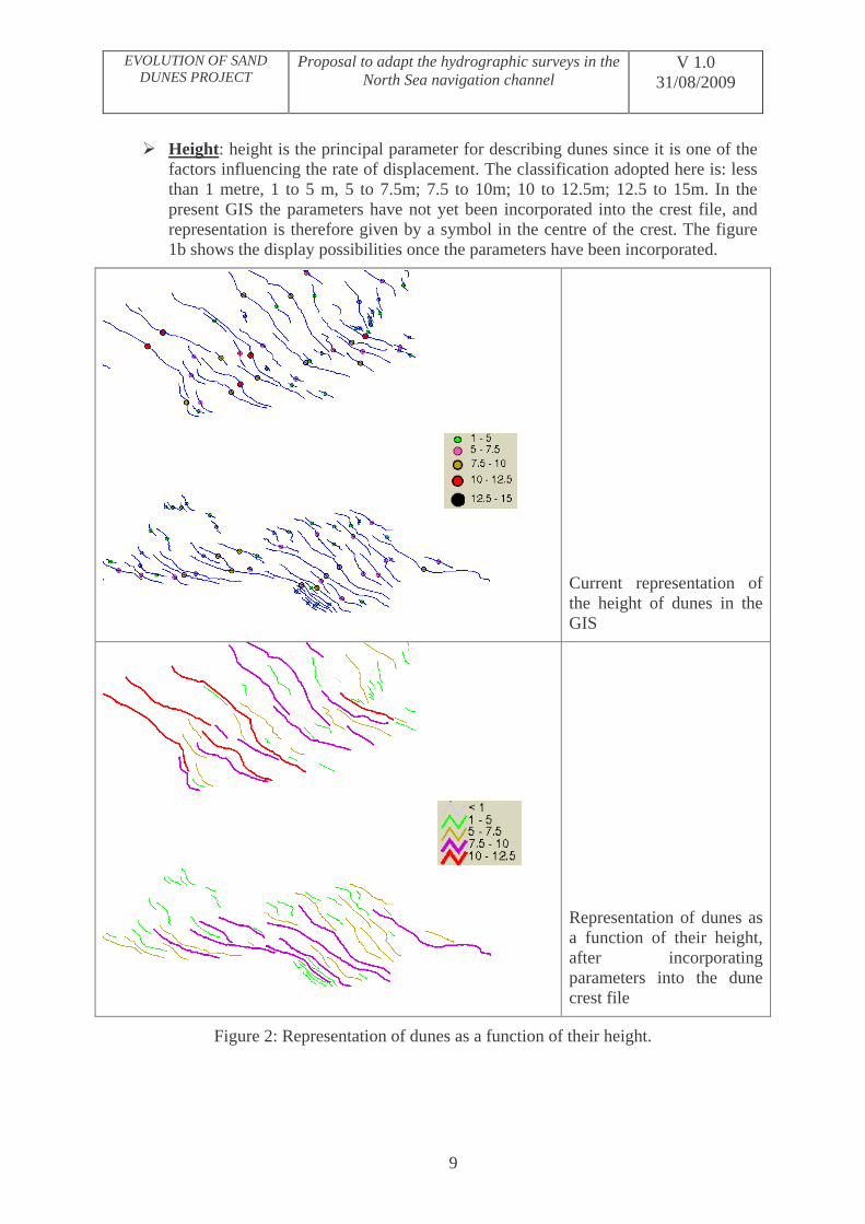
� Height: height is the principal parameter for describing dunes since it is one of the factors influencing the rate of displacement. The classification adopted here is: less than 1 metre, 1 to 5 m, 5 to 7.5m; 7.5 to 10m; 10 to 12.5m; 12.5 to 15m. In the present GIS the parameters have not yet been incorporated into the crest file, and representation is therefore given by a symbol in the centre of the crest. The figure 1b shows the display possibilities once the parameters have been incorporated.
Current representation of the height of dunes in the GIS
Representation of dunes as a function of their height, after incorporating parameters into the dune crest file
Figure 2: Representation of dunes as a function of their height.
EVOLUTION OF SAND DUNES PROJECT
Proposal to adapt the hydrographic surveys in the North Sea navigation channel
V 1.0 31/08/2009
10
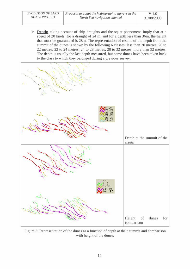
� Depth: taking account of ship draughts and the squat phenomena imply that at a speed of 20 knots, for a draught of 24 m, and for a depth less than 36m, the height that must be guaranteed is 28m. The representation of results of the depth from the summit of the dunes is shown by the following 6 classes: less than 20 metres; 20 to 22 metres; 22 to 24 metres; 24 to 28 metres; 28 to 32 metres; more than 32 metres. The depth is usually the last depth measured, but some dunes have been taken back to the class to which they belonged during a previous survey.
Depth at the summit of the crests
Height of dunes for comparison
Figure 3: Representation of the dunes as a function of depth at their summit and comparison with height of the dunes.

EVOLUTION OF SAND DUNES PROJECT
Proposal to adapt the hydrographic surveys in the North Sea navigation channel
V 1.0 31/08/2009
11
Figure 3 clearly reveals that even for a restricted region the height of the dunes is not necessarily correlated with depth; to the north-west of figure 3, a dune of 11 metres has its summit at a depth of 26 metres and is therefore not very dangerous, in spite of its considerable height.
� Rate of movement: when a dune has been the subject of several surveys, the rate of movement is calculated for each period separating the surveys. The mean rate of movement is obtained from the distance run between the two surveys that are most widely spaced apart. It should be noted that in virtually all cases the rate of movement between the last two surveys is faster than the rates of movement between earlier surveys, and hence than the mean rate of movement. This type of analysis has been performed on the dunes to the south of the navigation channel where there are numerous measurements since the crest monitoring profiles have been produced in this region over recent years for research purposes. In other sectors rate of movement measurements have usually been made at the overlap areas between the decennial surveys. This study will be continued by incorporating old data acquired using a single beam echo sounder.
Vitesse Moyenne des Dunes (m/an)
Figure 4: Representation of the dunes as a function of their rate of movement and direction of displacement.
Vitesse Moyenne des Dunes (m/an) = Mean rate of movement of the dunes (:Myr)
EVOLUTION OF SAND DUNES PROJECT
Proposal to adapt the hydrographic surveys in the North Sea navigation channel
V 1.0 31/08/2009
12
5. CLASSIFICATION OF NORTH SEA DUNES
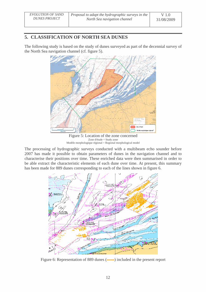
The following study is based on the study of dunes surveyed as part of the decennial survey of the North Sea navigation channel (cf. figure 5).
Figure 5: Location of the zone concerned
Zone d'étude = Study zone Modèle morphologique régional = Regional morphological model
The processing of hydrographic surveys conducted with a multibeam echo sounder before 2007 has made it possible to obtain parameters of dunes in the navigation channel and to characterise their positions over time. These enriched data were then summarised in order to be able extract the characteristic elements of each dune over time. At present, this summary has been made for 889 dunes corresponding to each of the lines shown in figure 6.
Figure 6: Representation of 889 dunes (��) included in the present report

EVOLUTION OF SAND DUNES PROJECT
Proposal to adapt the hydrographic surveys in the North Sea navigation channel
V 1.0 31/08/2009
13
5.1. Method for extraction of parameters and summary of dunes
5.1.1. Extraction of parameters
For monitoring the dunes it is necessary to extract the characteristic parameters of these sedimentary structures. With the aid of these parameters it is then possible to compare hydrographic surveys with each other and to monitor the evolution and displacement of the dunes. This comparison of several recurrent surveys has become more difficult since the arrival of the area charts offered by multibeam echo sounders (MBES), on the one hand because each survey generates gigabytes of data and on the other hand because comparisons of several surveys, through statistical computation or by subtraction of DTM, do not give quantitative results of sufficient quality.
The software developed for the Evolution of dunes project was applied to all surveys conducted before 2007. The files obtained were displayed using the Arcview software that made it possible to set out the various positions of each dune over time and for each one of them all of the characteristic parameters of the dunes (cf. ref 1). The calculation software whose functional diagram is shown in figure 7 is described in reference 2. Application of these data has made it possible to define an initial list of dunes to be studied on a regular basis (cf. Ref 3).
Figure 7: Functional diagram of the ParamDunes software (SHOM-RMS)

EVOLUTION OF SAND DUNES PROJECT
Proposal to adapt the hydrographic surveys in the North Sea navigation channel
V 1.0 31/08/2009
14
Load data Choose scale
number Choose mesh
resolution for DTM Define
processing parameters Select study
zone
Form starting lattice
Calculate and update the ripple coefficients
Calculate DTM at full scale and ½ scale
Calculate error between DTM and lattice at full scale
Calculation of DTM to finest resolution
Add error and inverse conversion
Calculate DTM
Smooth over n scales to obtain DTM at different resolutions
LPE algorithms Search for
ridges and crest lines Pruning method in multi-resolution analysis
Define a base (very low scale)
Define scale of dunes sought
Calculate position of foot of dune
Calculate position of crests
Search for ruptures in slopes
Construct dunes Extract
topological info
Process data
Characterise dune parameters
Display DTM / soundings adopted
Display dunes and their morphological characteristics
Display results
Display the parameters of a dune
Save initial result
Save results Save final result in required format
Zoom Select a dune
for display of its parameters
Modify certain morphological parameters of the dune and refresh
Restart processing on another zone of the terrain
Software
Interact
Display a cross-section of resultant terrain

EVOLUTION OF SAND DUNES PROJECT
Proposal to adapt the hydrographic surveys in the North Sea navigation channel
V 1.0 31/08/2009
15
5.1.2. Summary of data
At the end of processing the surveys with the ParamDunes software, we have files containing: � the metadata of the survey and processing carried out � for each survey, all of the dunes described by their parameters.
These data are incorporated into a GIS in order to be able to display the position of the dunes, their extent (contour and crest), and also the characteristics of the dunes according to various parameters. The large quantity of dune parameters and the existence of the history of each dune render these data too numerous to be easy to read. A second summary is therefore necessary in order to ensure that for each dune we have only those criteria that are relevant for the degree of danger.
The following three files have therefore been created, in shape format, from the many files output by ParamDunes:
� a point type file: showing the centre of the dune to which is assigned a series of parameters;
� a vector file presenting the direction and mean rate of displacement of the dunes;
� a line file showing the extent of the dunes.
In due course, these three files will contain all of the descriptions of the dunes that exist in the navigation channel and on the French continental shelf.
a. Point file
This file has the following parameters: - Height of the dune: latest height (mm.mm), maximum height and minimum height
over all of the surveys, and the difference between the extreme heights; - Depth of the area surrounding the dune (mm.mm); - High point of the dune: latest high point (mm.mm), minimum high point and
maximum high point over all of the surveys, and the difference between the extremes;
- Symmetry parameters: latest value of sinuosity and latest symmetry index; - Rate of movement: displacement (m/yr) between latest survey and the previous one,
maximum rate of movement between two surveys and mean rate of movement between first and last survey.
- Date of surveys included in the summary; - Directions of displacements in degrees (from 0 to 360° clockwise).
The point corresponds to the centre of the line of the crest of the last known position of the dune.
The parameters correspond to the latest survey that covered the dune completely. If part of the dune is absent large variations in the symmetry parameters and heights have too great an effect on results to be usable.
For calculations of rate of movement all surveys are included, that is even those that have not covered the dune completely.

EVOLUTION OF SAND DUNES PROJECT
Proposal to adapt the hydrographic surveys in the North Sea navigation channel
V 1.0 31/08/2009
16
b. Vector file
The dune is depicted by a vector oriented in the direction of the resultant displacement. The file contains the value of the mean rate of displacement of each dune that has been surveyed several times.
c. Line file
In this file, the dune is depicted by a line representing the last position of the dune. In general, this is the position obtained from the last survey but when a dune has been hydrographically surveyed several times the dune is reconstituted. In this case, fairly frequently in the fields of dunes covered by several decennial surveys, shifting associated with the displacement of the dune between surveys may appear. This file contains: the number of the dune (taken from the point file) and the principal parameters of the dune: height, depth of summit, mean annual rate of movement, date of last survey.
5.2. Degree of danger represented by the dunes
The present report is based on analysis of the surveys listed in Appendix 1. These represent 65 days of data acquisition at sea (excluding ports of call and transits). The data used are validated data the volume of which is less than the initial data, but even so sometimes reaches 379 359 801 depth values. One of the objectives of the processing performed is to reduce these millions of data items to a few parameters enabling the knowledge to be summarised so that decisions can be taken.
The degree of danger is defined by the following criteria:
� in all cases, all dunes in the navigation channel whose summit reaches a depth of less than 20 metres are classified as very dangerous;
� in the case of dunes having a displacement of 5 to 25 metres/yr (rate of movement calculated over a period of more than a year), representing a maximum deviation of one centimetre on a 1/50,000 scale chart in 20 years, dunes of 20 to 28 metres are classified as dangerous;
� in the case of dunes having a displacement greater than 25 metres/yr, dunes with a depth of between 20 and 24 are classified as very dangerous.
The degree of danger calculated using the criteria: bottom friction, asymmetry and sinuosity is still very much a research area but should make it possible to limit the number of dunes classified as dangerous.
The last criterion is the age of the survey. The measurements seem to show acceleration in the rate of displacement of the dunes. This might be a result of climatic changes and more especially the decennial increase in the number of storms. Changes are therefore possible in the medium term and it is necessary to continue studying the evolution of dunes in the channel.
These criteria were applied to 889 dunes and gave the following results:
� Depth less than 20 metres: 36 dunes (4% of the dunes studied) are classified as very dangerous since their summit is less than 20 metres;
� depth of summit between 20 and 28 metres: this class comprises 340 dunes to which we add 5 dunes whose summit is deeper but which have been less than 28m at least once in the recent past;

EVOLUTION OF SAND DUNES PROJECT
Proposal to adapt the hydrographic surveys in the North Sea navigation channel
V 1.0 31/08/2009
17
o among these, 29 dunes are classified as very dangerous (3.5%) since their summit is at a depth of less than 24 m and they are found in sectors where the measured rates of displacement are greater than 25m/yr;
o among the remaining dunes, 90 have a depth of less than 24 metres (10% of the total) and 227 have a depth between 24 and 28 metres (25.5%). All of these dunes are classified as dangerous.
� Among the 889 dunes studied, 508 dunes (57%) have a summit at a greater depth than 28 metres and therefore present no danger to navigation.
5.3. Direction and displacement of the dunes
Analysis of the displacements of the dunes makes it possible to understand the process of dune dynamics. It appears that dunes frequently go in opposite directions in the same region. The dynamics are therefore confined within a constrained system (cf. Figures 4, 9 and 10). The dunes should be surveyed per sedimentary cell. The sedimentary cells are defined as sectors containing dunes going into the same direction.
?
m/an = m/yr
Figure 9: Rate of movement and direction of displacement of dunes in the north of the channel

EVOLUTION OF SAND DUNES PROJECT
Proposal to adapt the hydrographic surveys in the North Sea navigation channel
V 1.0 31/08/2009
18
Shown in the west section of figure 9, (corresponding to the eastern end of the Sandettie bank), there is a limit separating two zones of opposite displacements. The maximum rates of movement are observed in this sector whereas the rest of the field of dunes presents relative stability. These places with greatest dynamics must be studied especially and the limits of the sedimentary cells must be clarified for the whole of the navigation channel. Rates of movement of 5 to 10 metres/yr in the major portion of this sector will over 20 years result in the displacement of the dunes being less than the distance between two dunes. The overlapping of the dunes and the overall organisation of sedimentary movements mean that the system is not changing a great deal and that repeating the survey of the whole channel does not appear worthwhile. It would seem preferable to carry out accurate and complete surveys frequently on a few selected dunes in various parts of the channel.
?
Profondeur du sommet
Vecteur de déplacement (m/an)
Figure 10 Rate of movement and direction of displacement of dunes in the south of the channel
Profondeur du sommet = Depth of summit Vecteur de déplacement = Displacement vector
m/an = m/yr
Figure 10 shows the last known position of the dunes superimposed on the marine chart. The depth of the summit of the dunes is shown by the colour of the crest and the colour of the vectors shows the rate of displacement. It appears that a single dune in this sector has a rate of movement greater than 20 m/yr but that this dune has a depth of more than 32 metres. In a sector like this where the depth of the dunes is greater than 24 metres and the rates of movement are fairly low it is advantageous to survey one dune in order to monitor the
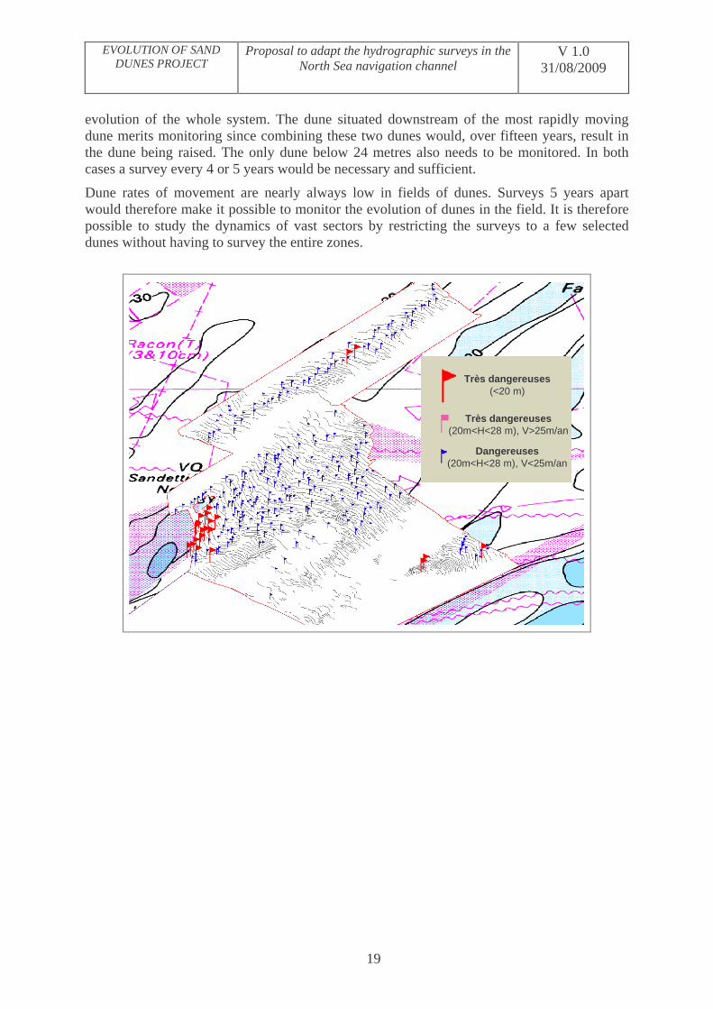
EVOLUTION OF SAND DUNES PROJECT
Proposal to adapt the hydrographic surveys in the North Sea navigation channel
V 1.0 31/08/2009
19
evolution of the whole system. The dune situated downstream of the most rapidly moving dune merits monitoring since combining these two dunes would, over fifteen years, result in the dune being raised. The only dune below 24 metres also needs to be monitored. In both cases a survey every 4 or 5 years would be necessary and sufficient.
Dune rates of movement are nearly always low in fields of dunes. Surveys 5 years apart would therefore make it possible to monitor the evolution of dunes in the field. It is therefore possible to study the dynamics of vast sectors by restricting the surveys to a few selected dunes without having to survey the entire zones.
Très dangereuses(<20 m)
Très dangereuses(20m<H<28 m), V>25m/an
Dangereuses(20m<H<28 m), V<25m/an
EVOLUTION OF SAND DUNES PROJECT
Proposal to adapt the hydrographic surveys in the North Sea navigation channel
V 1.0 31/08/2009
20
Très dangereuses(<20 m)
Très dangereuses(20m<H<28 m), V>25m/an
Dangereuses(20m<H<28 m), V<25m/an
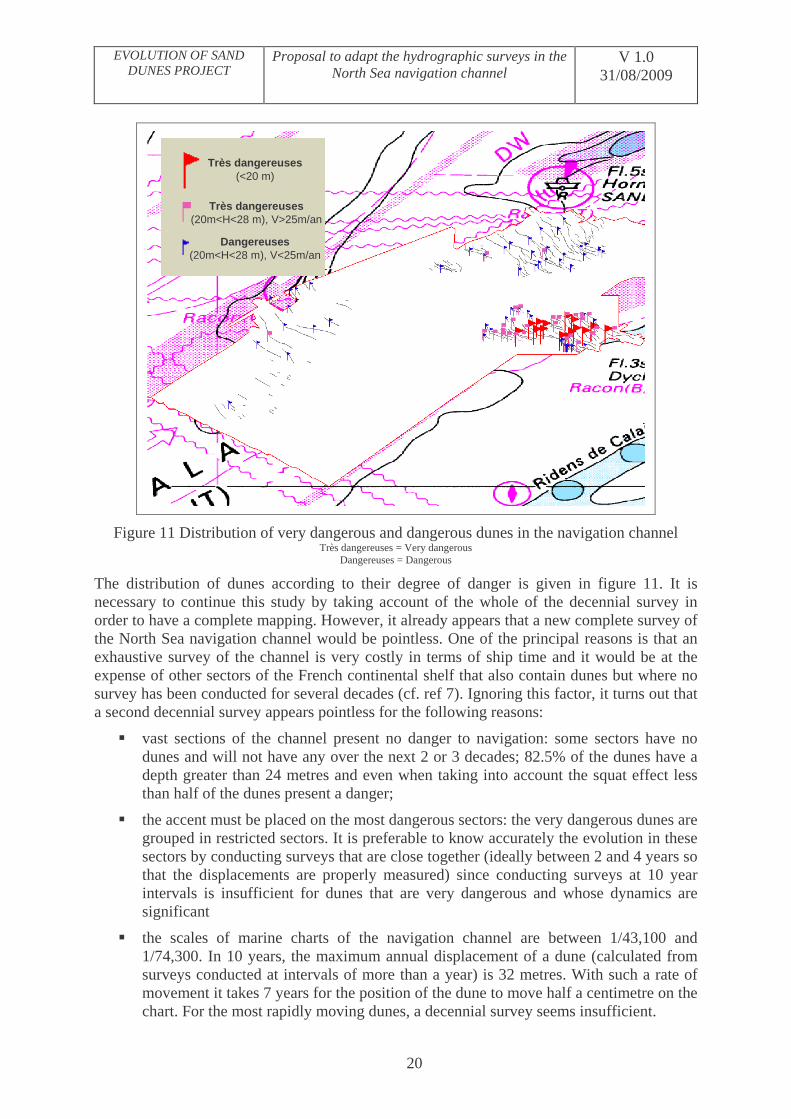
Figure 11 Distribution of very dangerous and dangerous dunes in the navigation channel Très dangereuses = Very dangerous
Dangereuses = Dangerous
The distribution of dunes according to their degree of danger is given in figure 11. It is necessary to continue this study by taking account of the whole of the decennial survey in order to have a complete mapping. However, it already appears that a new complete survey of the North Sea navigation channel would be pointless. One of the principal reasons is that an exhaustive survey of the channel is very costly in terms of ship time and it would be at the expense of other sectors of the French continental shelf that also contain dunes but where no survey has been conducted for several decades (cf. ref 7). Ignoring this factor, it turns out that a second decennial survey appears pointless for the following reasons:
� vast sections of the channel present no danger to navigation: some sectors have no dunes and will not have any over the next 2 or 3 decades; 82.5% of the dunes have a depth greater than 24 metres and even when taking into account the squat effect less than half of the dunes present a danger;
� the accent must be placed on the most dangerous sectors: the very dangerous dunes are grouped in restricted sectors. It is preferable to know accurately the evolution in these sectors by conducting surveys that are close together (ideally between 2 and 4 years so that the displacements are properly measured) since conducting surveys at 10 year intervals is insufficient for dunes that are very dangerous and whose dynamics are significant
� the scales of marine charts of the navigation channel are between 1/43,100 and 1/74,300. In 10 years, the maximum annual displacement of a dune (calculated from surveys conducted at intervals of more than a year) is 32 metres. With such a rate of movement it takes 7 years for the position of the dune to move half a centimetre on the chart. For the most rapidly moving dunes, a decennial survey seems insufficient.

EVOLUTION OF SAND DUNES PROJECT
Proposal to adapt the hydrographic surveys in the North Sea navigation channel
V 1.0 31/08/2009
21
6. CONCLUSION
These results reveal the need to modify survey methods. The decennial survey is the necessary and indispensable basis but repeating it does not seem sensible and it is excessively costly for the expected results.
Sectors with very dangerous or dangerous dunes must be subjected to regular monitoring in order to guarantee the safety of navigation. It seems more appropriate to survey some of these very dangerous or dangerous dunes selected from the decennial survey over the whole of the channel under French responsibility. These dunes must be explored regularly in order to monitor the various sedimentary cells (zones with uniform direction of displacement) and to guard against variations in the dynamics that shows trends that appear linked to climate change.
Some analyses will be continued in order to select dunes in each of the sectors of the North Sea navigation channel. A hydrographic survey must be conducted on each one consisting of a few profiles covering the whole of the dune. These surveys should be conducted every two years on two series of dunes evenly distributed over the whole of the channel (each series being surveyed every four years). According to the results obtained after 8 years, these surveys will be clarified, with possible redefinition of the dunes to be surveyed and the abandonment or not of one of the two series of dunes.
ISC T Garlan
Head of the Evolution of sand dunes project

Appendix 1: Evolving zones in the Pas de Calais - MHA surveys included in this report
Survey Zone Specific report Date of survey Duration of survey in days
Number of soundings
S200201500 MPC South B 06 dated
08/01/2002 2000-05-30 to 2000-05-31 1 3008166
S200202600 Survey of zone G 10 dated
09/01/2002 2000-10-19 to 2000-10-23 5 98001327
S200203800 Annual inspection of isolated dunes D, F and G
128 dated 24/05/2002
2001-03-04 to 2001-03-14 2001-06-27 to 2001-06-28 7 37865257
MHA200216 Survey of Zone E 174 dated
03/07/2002 2001-03-06 to 2001-03-14 5 73439447
MHA200315 Annual inspection of Zone F
241 dated 29/10/2003 2003-10-08 to 2003-10-09 2 182117
S200400800 Decennial survey of zone PdC 1
283 dated 08/12/2003 2002-06-15 to 2002-06-21 7 56016320
S200401900 Decennial survey of zone PdC 3
20 dated 13/01/2004 2003-10-09 to 2003-11-11 6 2838899
S200404600 Annual inspection of zones Fa, Fc, Fi, D, Gne
311 dated 01/12/2004 2004-09-15 to 2004-09-16 2 16247532
S200502900 Decennial survey of zone PdC 4
133 dated 11/04/2005
2004-09-13 to 2004-09-21 2004-11-15 to 2004-11-23 12 37663423
S200508100 Annual inspection of evolving zones in Pas de Calais F, D, Gne
366 dated 31/08/2005 2005-09-28 to 2005-10-04 7 5430532
S200600300 Decennial survey of 367 dated 2005-10-03 to 2005-10-15 9 44368445

EVOLUTION OF SAND DUNES PROJECT
Proposal to adapt the hydrographic surveys in the North Sea navigation channel
V 1.0 31/08/2009
23
zone PdC 5 24/10/2005
S200607700 Annual inspection of evolving zones in Pas de Calais F, D, Gne
311 dated 14/11/2006
2006-09-23 to 2006-09-24 2 4298336