project prioritization and costs - sccrtcsccrtc.org/wp...+project+prioritization+and+costs.pdf ·...
TRANSCRIPT
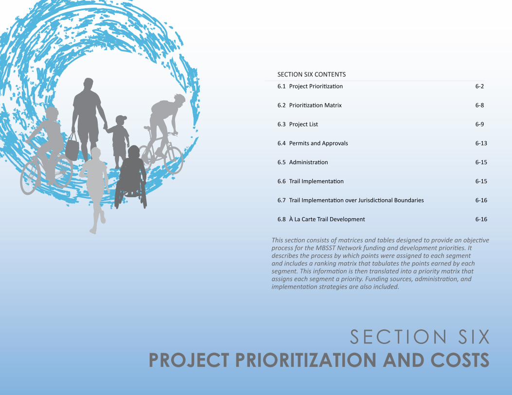
S E C T I O N S I X PROJECT PRIORITIZATION AND COSTS
SECTION SIX CONTENTS
6.1 ProjectPrioritization 6-2
6.2 PrioritizationMatrix 6-8
6.3 ProjectList 6-9
6.4 PermitsandApprovals 6-13
6.5 Administration 6-15
6.6 TrailImplementation 6-15
6.7 TrailImplementationoverJurisdictionalBoundaries 6-16
6.8 ÀLaCarteTrailDevelopment 6-16
This section consists of matrices and tables designed to provide an objective process for the MBSST Network funding and development priorities. It describes the process by which points were assigned to each segment and includes a ranking matrix that tabulates the points earned by each segment. This information is then translated into a priority matrix that assigns each segment a priority. Funding sources, administration, and implementation strategies are also included.

6 - 2 | MON T E R E Y B AY S A N C T U A R Y S C E N I C T R A I L N E TWO R K M A S T E R P L A N - F I N A L
6.1 PROJECT PRIORITIZATIONThefollowinginformationandtablesareprovidedtoaidtheSantaCruzCountyRegionalTransportationCommission(RTC)indeterminingwhetherornotaprojectisreadyforfurtherdevelopmentandimplementation.ThegoalofTables6.1through6.9istoobjectivelyprioritizetheorderinwhichtheMontereyBaySanctuaryScenicTrailNetwork(MBSSTNetwork)segmentscouldbedeveloped.Actualimplementationmaybedifferentduetonewfundingopportunitiesorrestrictions,communitypriorities,regionaltransportationplangoals,andneedsforgapclosureswithinthetrailsystemitselfwhichmaychangeovertime.Prioritizationmayalsobeimpactedbyimplementingentities’interestsinbringingtheprojecttofruition.However,theRTCintendstousethisprioritizationmechanismasageneralguidelinebywhichtofundandimplementeachsegment.Tables6.2through6.9evaluateaseriesofcriteriadevelopedtoprioritizesegmentsbasedonapointsystem.Thesegmentsthatreceivethemostpointsareonesthatservealargenumberofactivitycenters,haveminimalphysicalconstraints,andfillinMBSSTNetworkgaps.Theseprioritizationcategoriesinclude:
1. ProximitytoActivityCenters-5pointspossible2. PopulationDensity-5pointspossible3. CoastalAccessConnectivity-5pointspossible4. TrailSegmentCost-5pointspossible5. TrailSegmentLength-5pointspossible6. MinimalorNoBridgeCrossings-5pointspossible7. LimitedRight-Of-WayConstraints-5pointspossible8. GapClosures(andconnectionstoexistingandplannednon-motorizedfacilities)-5pointspossible9. PublicInput-5pointspossible
ThesetablesworkinconcertwithTable6.10whichappliestheprioritizationcategoriestoeachsegment.Thereareatotalofforty-five(45)possiblepointsbasedonthenine(9)categoriesabove.
Actual implementation may be different
due to new funding opportunities or
restrictions, community priorities, regional
transportation plan goals, and needs for
gap closures within the trail system itself which
may change over time.

P R O J E C T P R I O R I T I Z A T I O N A N D C O S T S | 6 - 3
6.1.1 EVALUATION CRITERIA AND METHODOLOGY
PROXIMITY TO ACTIVITY CENTERS - 5 POINTS POSSIBLEThiscategoryrepresentsthenumberoflocalandregionalactivitycenterswithin1/4-mile,1/2-mile,and1-mileoftheproposedtrailalignment.Activitycentersincludedestinationssuchaseducationalfacilities,employmentandretail/commercialcenters,parks,beaches,andtouristattractions.
Theactivitycenterswerecountedpertrailsegmentandassignedacorrespondingpointtotal.Theywerealsoassignedadistancemultiplierbasedonthedistancesmentionedabove,ascenterslocatedclosertotheproposedtrailalignmenthaveahighervaluetotrailusers.
TheresultingActivityCenterTypePerSegmentmatrixisshowninTable3.1.ThemethodologyforincludingtheactivitycenterdatainTable6.1below.
TABLE 6.1 - Proximity to Activity Centers Methodology and Points
SegmentDistance From Trail Multiplier Number of
Activity Centers Points1/4 mile 1/2 mile 1 mile
PerSegment 1.5 1 0.5
0-10 1
10.5-20 2
20.5-30 3
30.5-40 4
40.5-50 5

6 - 4 | MON T E R E Y B AY S A N C T U A R Y S C E N I C T R A I L N E TWO R K M A S T E R P L A N - F I N A L
POPULATION DENSITY - 5 POINTS POSSIBLEThiscategoryrepresentsatrailsegment’sutilityasitrelatestonumbersofpotentiallocalizedusers.TheanalysisisbasedonCensus2010Blockpopulationdatapolygonswithinorintersectinga1/2-milebufferregionforeachsegment.Thepotentialbenefiteachtrailsegmentprovides,asitrelatestopopulationdensity,isreflectedinthefollowingpointscale:
TABLE 6.2 - Population Density Methodology
Description Points
Segmentareapopulationgreaterthan20,000 5
Segmentareapopulationof15,001to20,000 4
Segmentareapopulationof10,001to15,000 3
Segmentareapopulationof5,001to10,000 2
Segmentareapopulationof0to5,000 1
COASTAL ACCESS CONNECTIVITY - 5 POINTS POSSIBLETheCoastalRailTrailcomprisesmostoftheproposedtrailalignment.ItispartofthelargerMBSSTNetworkthroughSantaCruzCountyanditsconnectivitytocoastalaccessandlocalbeachesisvitallyimportant.Thiscategoryassignshighervaluewherethereismoreconnectivitytothesecoastalresourcesandbreaksdownasfollows:
TABLE 6.3 - Coastal Access Connectivity Methodology
Description Points
Trailrunsadjacenttobeach/shoreline/coastalbluffs 5
Trailhasthree(3)ormoredirectcoastalconnections 3
Trailhasone(1)ortwo(2)directcoastalconnections 1
Traildoesnotdirectlyconnecttoacoastalaccesspoint 0

P R O J E C T P R I O R I T I Z A T I O N A N D C O S T S | 6 - 5
TRAIL SEGMENT COST - 5 POINTS POSSIBLEThecostofatrailsegmentprojectdirectlyinfluencestheabilitytoimplementitandhowlimitedfundingshouldbeprioritized.Eachprojectwasratedonascaleof1to5pointsforestimatedcostofimplementationasshowninTable6.4below.
TABLE 6.4 - Trail Segment Cost Methodology
Estimated Segment Cost Points
$0-$1,000,000 5
$1,000,000-$2,500,000 4
$2,500,000-$5,000,000 3
$5,000,000-$7,500,000 2
$7,500,000+ 1
SEGMENT LENGTH - 5 POINTS POSSIBLETrailsegmentlengthrepresentsthephysicalamountoftrailthatwillbeavailableforpublicuseperprojectsegment.LongertrailsegmentsreceiveahigherpointtotalandtheassignedvaluesarerepresentedinTable6.5below.
TABLE 6.5 - Trail Segment Length Methodology
Segment Length in Miles Points
0.00-1.00Miles 1
1.01-2.00Miles 2
2.01-3.00Miles 3
3.01-4.00Miles 4
4.01-5.00+Miles 5
6 - 6 | MON T E R E Y B AY S A N C T U A R Y S C E N I C T R A I L N E TWO R K M A S T E R P L A N - F I N A L
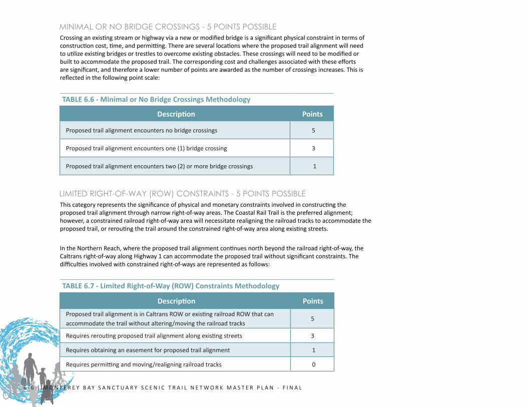
MINIMAL OR NO BRIDGE CROSSINGS - 5 POINTS POSSIBLECrossinganexistingstreamorhighwayviaanewormodifiedbridgeisasignificantphysicalconstraintintermsofconstructioncost,time,andpermitting.Thereareseverallocationswheretheproposedtrailalignmentwillneedtoutilizeexistingbridgesortrestlestoovercomeexistingobstacles.Thesecrossingswillneedtobemodifiedorbuilttoaccommodatetheproposedtrail.Thecorrespondingcostandchallengesassociatedwiththeseeffortsaresignificant,andthereforealowernumberofpointsareawardedasthenumberofcrossingsincreases.Thisisreflectedinthefollowingpointscale:
TABLE 6.6 - Minimal or No Bridge Crossings Methodology
Description Points
Proposedtrailalignmentencountersnobridgecrossings 5
Proposedtrailalignmentencountersone(1)bridgecrossing 3
Proposedtrailalignmentencounterstwo(2)ormorebridgecrossings 1
LIMITED RIGHT-OF-WAY (ROW) CONSTRAINTS - 5 POINTS POSSIBLEThiscategoryrepresentsthesignificanceofphysicalandmonetaryconstraintsinvolvedinconstructingtheproposedtrailalignmentthroughnarrowright-of-wayareas.TheCoastalRailTrailisthepreferredalignment;however,aconstrainedrailroadright-of-wayareawillnecessitaterealigningtherailroadtrackstoaccommodatetheproposedtrail,orreroutingthetrailaroundtheconstrainedright-of-wayareaalongexistingstreets.
IntheNorthernReach,wheretheproposedtrailalignmentcontinuesnorthbeyondtherailroadright-of-way,theCaltransright-of-wayalongHighway1canaccommodatetheproposedtrailwithoutsignificantconstraints.Thedifficultiesinvolvedwithconstrainedright-of-waysarerepresentedasfollows:
TABLE 6.7 - Limited Right-of-Way (ROW) Constraints Methodology
Description PointsProposedtrailalignmentisinCaltransROWorexistingrailroadROWthatcanaccommodatethetrailwithoutaltering/movingtherailroadtracks
5
Requiresreroutingproposedtrailalignmentalongexistingstreets 3
Requiresobtaininganeasementforproposedtrailalignment 1
Requirespermittingandmoving/realigningrailroadtracks 0
P R O J E C T P R I O R I T I Z A T I O N A N D C O S T S | 6 - 7
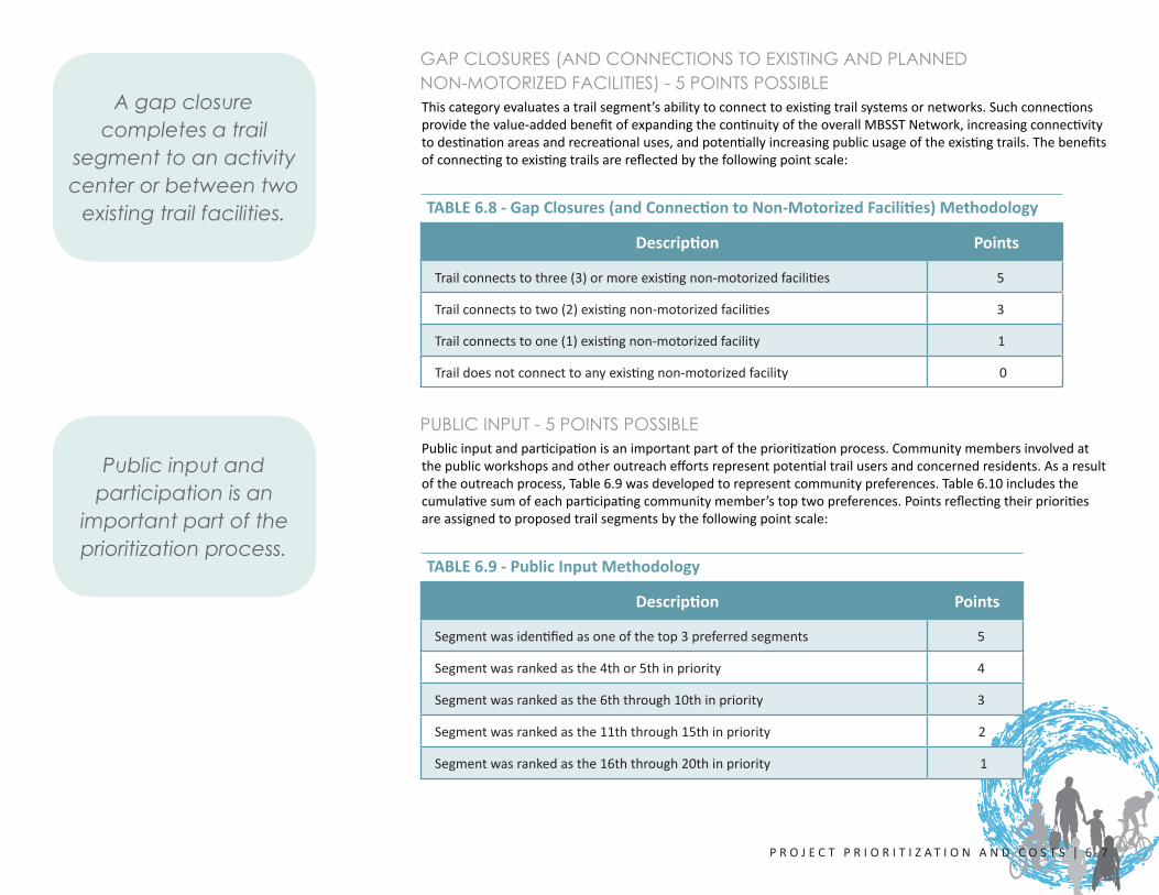
GAP CLOSURES (AND CONNECTIONS TO EXISTING AND PLANNED NON-MOTORIZED FACILITIES) - 5 POINTS POSSIBLEThiscategoryevaluatesatrailsegment’sabilitytoconnecttoexistingtrailsystemsornetworks.Suchconnectionsprovidethevalue-addedbenefitofexpandingthecontinuityoftheoverallMBSSTNetwork,increasingconnectivitytodestinationareasandrecreationaluses,andpotentiallyincreasingpublicusageoftheexistingtrails.Thebenefitsofconnectingtoexistingtrailsarereflectedbythefollowingpointscale:
TABLE 6.8 - Gap Closures (and Connection to Non-Motorized Facilities) Methodology
Description Points
Trailconnectstothree(3)ormoreexistingnon-motorizedfacilities 5
Trailconnectstotwo(2)existingnon-motorizedfacilities 3
Trailconnectstoone(1)existingnon-motorizedfacility 1
Traildoesnotconnecttoanyexistingnon-motorizedfacility 0
PUBLIC INPUT - 5 POINTS POSSIBLEPublicinputandparticipationisanimportantpartoftheprioritizationprocess.Communitymembersinvolvedatthepublicworkshopsandotheroutreacheffortsrepresentpotentialtrailusersandconcernedresidents.Asaresultoftheoutreachprocess,Table6.9wasdevelopedtorepresentcommunitypreferences.Table6.10includesthecumulativesumofeachparticipatingcommunitymember’stoptwopreferences.Pointsreflectingtheirprioritiesareassignedtoproposedtrailsegmentsbythefollowingpointscale:
TABLE 6.9 - Public Input Methodology
Description Points
Segmentwasidentifiedasoneofthetop3preferredsegments 5
Segmentwasrankedasthe4thor5thinpriority 4
Segmentwasrankedasthe6ththrough10thinpriority 3
Segmentwasrankedasthe11ththrough15thinpriority 2
Segmentwasrankedasthe16ththrough20thinpriority 1
A gap closure completes a trail
segment to an activity center or between two
existing trail facilities.
Public input and participation is an
important part of the prioritization process.

6 - 8 | MON T E R E Y B AY S A N C T U A R Y S C E N I C T R A I L N E TWO R K M A S T E R P L A N - F I N A L
TABLE 6.10 - Project Prioritization Matrix
TABLE 6.11 - Segment Priority Ranking
6.2 PRIORITIZATION MATRIX6.2.1 PROJECT PRIORITIZATION
Table6.10showsthescoringguideforeachtrailsegmentbasedontabulatingtheapplicablepointsfromTables6.1to6.9.Eachsegmentcanearnapossible45points.Segmentswiththehighestpointtotalswithintheirreachareconsideredtobethemostlikelytobefundedintheearlystagesoftraildevelopment.AdetailedanalysisoftheprojectprioritylistisdescribedinSection6.3.
1 2 3 4 5 6 7 8 9 10 11 12 13 14 15 16 17 18 19 20SEGMENT LENGTH (IN MILES)* 1.06 4.77 1.11 3.64 10.55 1.49 3.10 0.77 1.73 1.50 3.20 1.14 0.85 1.17 1.37 2.66 4.00 4.01 0.47 0.74SEGMENT COST (IN MILLIONS) 0.11$ 0.31$ 2.55$ 2.69$ 15.01$ 3.11$ 11.22$ 10.31$ 11.91$ 9.71$ 8.87$ 10.83$ 3.31$ 2.08$ 4.74$ 3.61$ 19.96$ 3.01$ 0.38$ 3.01$
Activity Centers 2 2 1 1 1 3 4 5 5 5 1 2 1 2 2 2 1 1 2 1Population Density 1 1 1 1 1 1 5 3 4 5 5 3 2 2 1 1 1 3 3 2Coastal Access Connectivity 5 3 3 1 5 3 3 5 3 1 5 1 1 1 3 1 0 0 0 0Segment Cost 5 5 3 3 1 3 1 1 1 1 1 1 3 4 3 3 1 3 5 3Segment Length 2 5 2 4 5 2 4 1 2 2 4 2 1 2 2 3 4 5 1 1Minimal or No Bridge Crossings 5 5 3 5 5 5 3 3 1 3 1 1 3 5 1 5 1 5 5 3Limited ROW Constraints 0 0 1 3 5 5 5 3 5 0 1 1 3 3 3 3 3 3 1 3Gap Closures 3 1 0 0 5 5 5 5 5 3 5 3 1 1 3 1 0 3 5 5Public Input 1 2 1 3 5 1 3 4 5 4 5 3 2 2 2 1 3 3 1 2Total Points (out of 45) 24 24 15 21 33 28 33 30 31 24 28 17 17 22 20 20 14 26 23 20Note: *Segment Length refers to total combined length of Coastal Rail Trail and Coastal Trail alignments.
TRAIL ALIGNMENT SEGMENT
PROJECT PRIORITIZATION MATRIXCATEGORY
(WITH POINT TOTALS)
6.2.2 SEGMENT PRIORITY RANKING
Table6.11utilizesdatafromthePrioritizationMatrixandranksthesegmentsbyoveralltrailandalsobyreach.Thisdataprovidescountywideandregionalguidanceastowhichsegmentsmaydevelopaheadofothersbasedonthepriorityanalysis.
1st 2nd 3rd 4th 5th 6th 7th 8th 9th 10th 11th 12th 13th 14th 15th 16th 17th 18th 19th 20th
Trail Segment 7 5 9 8 6 11 18 10 1 2 19 14 4 20 16 15 13 12 3 17Total Points 33 33 31 30 28 28 26 24 24 24 23 22 21 20 20 20 17 17 15 14% of Total Possible Points (45) 73% 73% 69% 67% 62% 62% 58% 53% 53% 53% 51% 49% 47% 44% 44% 44% 38% 38% 33% 31%
1st 2nd 3rd 4th 5th 1st 2nd 3rd 4th 5th 6th 7th 8th 9th 1st 2nd 3rd 4th 5th 6th
Trail Segment 5 1 2 4 3 7 9 8 6 11 10 14 13 12 18 19 20 16 15 17Total Points 33 24 24 21 15 33 31 30 28 28 24 22 17 17 26 23 20 20 20 14% of Total Possible Points (45) 73% 53% 53% 47% 33% 73% 69% 67% 62% 62% 53% 49% 38% 38% 58% 51% 44% 44% 44% 31%
SEGMENT COST (IN MILLIONS) 15.01$ 0.11$ 0.31$ 2.69$ 2.55$ 11.22$ 11.91$ 10.31$ 8.87$ 3.11$ 9.71$ 2.08$ 3.31$ 10.83$ 3.01$ 0.38$ 3.01$ 3.61$ 4.74$ 19.96$
SEGMENT PRIORITY RANKING
ITEMPRIORITY RANKING*: OVERALL TRAIL
ITEMPRIORITY RANKING*: BY REACH
NORTHERN REACH CENTRAL REACH WATSONVILLE REACH
Note: *If two or more segments accumulate the same number of points, the segment with the least associated cost is given a higher priority.
$20,657,456 71,354,320 34,712,304

P R O J E C T P R I O R I T I Z A T I O N A N D C O S T S | 6 - 9
6.3 PROJECT LIST6.3.1 NORTHERN REACH PROJECTS
TheNorthernReachincludesSegments1-5.Table6.12prioritizesthesegmentsbythenumberofpointstheyreceived.Thesegmentsthatreceivedthemostnumberofpointsareconsideredthemostfeasibleforimplementingwithinashorttimeframe.ThisincludesSegments5,1,and2asthetopthreesegments.
ThesesegmentsprovidegapclosurestoexistingMBSSTsegments,provideaccesstonumerousactivitycenters,connecttothecoastaledgeandbeaches,andprovideconnectivitytootherexistinglocalandregionalbikewayandpedestrianfacilities.Segment5isparticularlyinagoodpositionforimplementationasitfallswithintherailroadright-of-waycorridorwithminimalprivatelandinterferenceorsignificantenvironmentalimpacts.Segments4and3mayrequireabitmoreleadtimetoresolvephysicaldesignconstraints,ROWconflicts,complexcoastalconnections,andotherbudgetarychallenges.However,thesesegmentsservetoclosethegapintheoveralltrailnetwork,whichwillhelpelevatetheirimportanceforfunding.
TABLE 6.12 - Northern Reach Projects
Points Segment Length Cost Document Reference Page
33 5-DavenportandWilderRanch 10.55miles $15,006,784 4-25to4-34
24 1-WaddellBluffs 1.06miles $107,120 4-5to4-8
24 2-GreyhoundRock/CalPolyBluffs 4.77miles $308,032 4-9to4-14
214-DavenportLanding/EndofRailroadTracks
3.64miles $2,685,424 4-21to4-24
153-UpperCoastDairiesatScottCreek
1.11miles $2,550,096 4-15to4-20
TOTALS 21.13 miles $20,657,456

6 - 1 0 | MON T E R E Y B AY S A N C T U A R Y S C E N I C T R A I L N E TWO R K M A S T E R P L A N - F I N A L
6.3.2 CENTRAL REACH PROJECTS
TheCentralReachincludesSegments6-14.Table6.13prioritizesthesegmentsbythenumberofpointstheyreceived.Thesegmentsthatreceivedthemostnumberofpointsareconsideredthemostfeasibleforimplementingwithinashorttimeframe.ThisincludesSegments7,9,and8asthetopthreesegments.
ThesesegmentsprovidegapclosurestoexistingMBSSTsegments,provideaccesstonumerousactivitycenters,connecttothecoastaledgeandbeaches,andprovideconnectivitytootherexistinglocalandregionalbikewayandpedestrianfacilities.ThesesegmentsarelocatedinsomeofthemostdenselypopulatedareasoftheMBSSTNetworkandprovideidealstart/endpointsfromresidentialneighborhoods.Someofthesegmentsthatreceivedalowernumberofpointsdidsoduetoinfluencessuchas:highcostofconstruction,difficultornumerousrailcrossings,narrowright-of-way,minimalaccesstogreaterpopulation,andotherlimitingfactors.However,thesesegmentsservetoclosethegapintheoveralltrailnetwork,whichwillhelpelevatetheirimportanceforfunding.
TABLE 6.13 - Central Reach Projects
Points Segment Length CostDocument Reference
Page33 7-CoastalSantaCruz 3.10miles $11,218,016 4-39to4-44
31 9-TwinLakes 1.73miles $11,914,384 4-51to4-56
308-SantaCruzBeachBoardwalk
0.77miles $10,314,240 4-45to4-50
286-WilderRanchTrailhead/ShafferRoad
1.49miles $3,114,224 4-35to4-38
28 11-Capitola-SeaCliff 3.20miles $8,868,336 4-61to4-66
24 10-LiveOak/JadeStPark 1.50miles $9,707,440 4-57to4-60
22 14-Seascape 1.17miles $2,079,872 4-79to4-82
1713-RioDelMar-HiddenBeach
0.85miles $3,306,112 4-73to4-78
17 12-AptosVillage 1.14miles $10,831,696 4-67to4-72
TOTALS 14.95 miles $71,354,320

P R O J E C T P R I O R I T I Z A T I O N A N D C O S T S | 6 - 1 1
6.3.3 WATSONVILLE REACH PROJECTS
TheWatsonvilleReachincludesSegments15-20.Table6.14prioritizesthesegmentsbythenumberofpointstheyreceived.Thesegmentsthatreceivedthemostnumberofpointsareconsideredthemostfeasibleforimplementingwithinashorttimeframe.ThisincludesSegments18,19,and20asthetopthreesegments.
ThesesegmentsprovidegapclosurestoexistingMBSSTsegments,provideaccesstonumerousactivitycenters,andprovideconnectivitytootherexistinglocalandregionalbikewayandpedestrianfacilities.ThesesegmentsarelocatedinsomeofthemostdenselypopulatedareasoftheWatsonvilleReachandprovideidealstart/endpointsfromresidentialneighborhoodsandthecityofWatsonville.Segments16and15mayrequireabitmoreleadtimetoresolvingphysicaldesignconstraints,ROWconflicts,bridgedesignandconstruction,andotherbudgetarychallenges.However,thesesegmentsservetoclosethegapintheoveralltrailnetwork,whichwillhelpelevatetheirimportanceforfunding.
TABLE 6.14 - Watsonville Reach Projects
Points Segment Length Cost Document Reference Page
2618-WatsonvilleSloughOpenSpaceTrails
4.01miles $3,010,720 4-99to4-104
2319-WalkerStreet,CityofWatsonville
0.47miles $381,280 4-105to4-108
20 20-PajaroRiver 0.74miles $3,009,136 4-109to4-112
20 16-EllicottSlough 2.66miles $3,613,600 4-89to4-92
20 15-ManresaStateBeach 1.37miles $4,735,680 4-83to4-88
14 17-HarkinsSlough 4.0miles $19,961,888 4-93to4-98
TOTALS 13.25 miles $34,712,304
6 - 1 2 | MON T E R E Y B AY S A N C T U A R Y S C E N I C T R A I L N E TWO R K M A S T E R P L A N - F I N A L
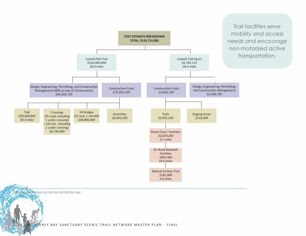
Figure 6.1 Summary of cost by trail facility type
Trail facilities serve mobility and access
needs and encourage non-motorized active
transportation. CoastalRailTrail
$120,960,96830.3 miles
ConstructionCosts$75,601,230
Design,Engineering,Permitting,andConstructionManagement(60%ontopofConstruction)
$45,360,739
CoastalTrailSpurs$5,762,11218.4 miles
ConstructionCosts$3,601,320
Design,Engineering,Permitting,andConstructionManagement
$2,160,792
Amenities$6,005,390
PavedClassIFacilities$2,629,260
3.1 miles
On-RoadNetworkFacilities$681,06010.6 miles
StagingAreas$110,000
Trails$3,491,320
NaturalSurfaceTrail$181,0004.8 miles
24Bridges(23new,1retrofit)
$28,800,000
Crossings(76road,including1undercrossing)+(20rail,including1undercrossing)
$6,795,000
Trail$34,000,840
30.3 miles
COST ESTIMATE BREAKDOWNTOTAL: $126,724,080

P R O J E C T P R I O R I T I Z A T I O N A N D C O S T S | 6 - 1 3
6.4 PERMITS AND APPROVALSTypicallyeachsegmentorcombinationofsegmentsthatispursuedasaprojectwillinvolveobtainingseveralpermitsandagreements.Thissectionsummarizesthetypesofpermitsandthebasicprocessforeach.
COASTAL DEVELOPMENT PERMIT - LOCAL GOVERNMENT OR COASTAL COMMISSIONNearlyanykindofimprovement,evensigns,requiresaCoastalDevelopmentPermit(CDP).Signsandotherrudimentaryimprovementscanbeapprovedadministratively,buttheprojectscontainedintheMasterPlanaresignificantandwillrequireafullpermitandhearing.
WhileSantaCruzCountywillhandlethemajorityofCDPapplications,itisanticipatedthatCDPswillalsoberequiredfortheCitiesofSantaCruz,Capitola,andWatsonville.In“originaljurisdiction”wetlandareas,CDPapplicationswillbesubmitteddirectlytotheCoastalCommissionitself.TheseareasincludethemouthoftheSanLorenzoRiver,theWoodsLagoon(Harbor)area,SoquelCreekLagooninCapitola,andsixotherlocations.TheCoastalCommissionwillalsohearappealsofalocallyapprovedCDP.ThelegalstandardofreviewforthedelegatedjurisdictionareasincludestherespectiveLocalCoastalProgram(LCP)foreachofthelocalgovernments,inadditiontothepublicaccessandrecreationpoliciescontainedinChapter3oftheCaliforniaCoastalAct.
ThestandardofreviewforCDPsistheCoastalCommission-certifiedLCP,includingtheLCP’sLandUsePlanandimplementingordinances.CertainactionscontemplatedinthisMasterPlanwerenotanticipatedatthetimeoforiginalLCPcertification,e.g.,dualuseoftherailcorridor.TheseinstancesmaytriggertheneedforLCPamendmentbeforetheCDPapplicationcanbeconsidered.
ForqualifyingPublicWorksprojects,theCaliforniaCoastalActalsoprovidesanalternativedevelopmentreviewprocessthatdoesnotentailalocallyissuedCDP.ThisprocessrequirespriorCoastalCommissionapprovalofaPublicWorksPlan(PWP).AtWilderRanchStatePark,forexample,projectsidentifiedintheapprovedPWPdonotneedseparateapprovalasCDPs.Althoughonlyrarelyutilized,thePWPprocessisanavailableoptionforfuturestatepark,localparkagency,utilityagency,Caltrans,andlocalandregionaltransportationagencyprojectsthataresubjecttotheCaliforniaCoastalAct.
TheCoastalZoneManagementAct(CZMA),enactedin1972,isthecorrespondingfederallegislation.InaccordancewiththeCZMA,theCaliforniaCoastalActandthevariousLocalCoastalProgramscomprisethefederallydesignatedCaliforniaCoastalManagementProgram(CCMP).InadditiontoitsprimarydevelopmentreviewresponsibilitiesundertheCaliforniaCoastalAct,anongoingrolefortheCoastalCommissionistoreviewfederalagencyactionsforconsistencywiththeCCMP.
Appealsofcountyandcityactions,originaljurisdictionCDPs,requestsforapprovalofPWPs,LongRangeDevelopmentPlans(applicabletoUniversityofCalifornia,SantaCruzlands),federalconsistencymatters,andanysubmittedLCPamendmentrequestsareheardbytheCoastalCommissionatitsregularlyscheduledmeetings.
PERMIT AND APPROVAL TYPES
A. ApprovalbytheCaliforniaPublicUtilitiesCommissionRailCrossingEngineeringSection;
B. Localjurisdictionadoption(includingSantaCruzCounty,MontereyCounty[forSegment20]andcitiesofSantaCruz,Capitola,andWatsonville);
C. CoastalDevelopmentPermit(s)fromSantaCruzCountyorCaliforniaCoastalCommission;
D. Section404Permit(s)fromtheU.S.ArmyCorpsofEngineers;
E. Section1600Permit(s)fromtheCaliforniaDepartmentofFishandGameWildlife;
F. Section401WaterQualityCertificationfromtheRegionalWaterQualityControlBoard;
G. ApprovalbytheU.S.FishandWildlifeService;
H. ApprovalbytheCaliforniaPublicUtilitiesCommissionRailCrossingEngineeringSection;
I. CaltransEncroachmentPermit(s)and/orApprovalbyFederalRailroadAdministration.
J. MarineMammalProtectionActIncidentalHarassmentAuthorizationPermit

6 - 1 4 | MON T E R E Y B AY S A N C T U A R Y S C E N I C T R A I L N E TWO R K M A S T E R P L A N - F I N A L
U.S. ARMY CORPS OF ENGINEERS (USACE) PERMITASection404PermitapplicationtotheUSACEforplacementoffill,includingconsultationwiththeU.S.FishandWildlifeService,mayberequiredtosatisfytherequirementsofSection404(b)(1)oftheCleanWaterAct(CWA).
AJurisdictionalDelineationReport,orwetlanddelineation,ispartofthetechnicalstudiesrequiredinanylocationwherethereispotentialforwetlandstooccur.ThismapsandobtainsUSACEconcurrenceonjurisdictional“WatersoftheU.S.,”includingwetlands(ifpresent),and/or“WatersoftheState.”
STREAMBED ALTERATION AGREEMENT - CALIFORNIA DEPARTMENT OF FISH AND WILDLIFE (CDFW)ASection1602LakeorStreambedNotification/ApplicationforaStreambedAlterationAgreementwillneedtobesubmittedtoCDFWforanyworkthatmayimpactastreamorrelatedriparianhabitat.
CALTRANS ENCROACHMENT PERMIT - CALTRANS OR SANTA CRUZ COUNTYWheretheprojectinvolvesworkorpermanentimprovementswithinthestatehighwayright-of-wayorcountyroadright-of-way,anencroachmentpermitfromCaltransorthecountywillberequired.Thistypicallyrequiresamaintenanceagreementwitheitherapublicagencyoranon-profitorganizationtoensurethattheMBSSTNetworkfacilitiesinthehighwayright-of-waywillbeadequatelymaintained.
RAIL CROSSING - CALIFORNIA PUBLIC UTILITIES COMMISSION (CPUC)CPUCstaffensurethatrailcrossingsaresafelydesigned,constructed,andmaintained,andCPUCauthorizationisrequiredpriortoconstructinganewrailcrossingormodifyinganexistingrailcrossing.Commissionauthorizationmayberequestedbyfilingaformalapplicationwithtypicalrequeststaking45daysto12monthsforapproval.Thereare101CPUCcrossingsalongCoastalRailTrail.
SECTION 401 WATER QUALITY CERTIFICATION - REGIONAL WATER QUALITY CONTROL BOARD (RWQCB)ManyMBSSTNetworkprojectswillberequiredtoprepareaRWQCBCWASection401WaterQualityCertification(WQC)notification/applicationtothelocalRWQCB,whichmayincludeaStormWaterPollutionPreventionPlan(SWPPP).TheissuanceoftheWQCisnecessarypriortotheissuanceofanUSACECWASection404(b)(1)permit.
NATIONAL OCEANIC AND ATMOSPHERIC ADMINISTRATION (NOAA)Whenfederalfundsareusedfortrailimplementation,theNOAAmaybeinvolvedwithreviewingandcommentingonenvironmentaldocumentationforprojectseffectingmarinemammals.ThismayleadtoprojectmitigationsandpossiblyrequireaMarineMammalProtectionActIncidentalHarassmentAuthorization(MMPAIHA)permit.
As owner of the Coastal Rail Trail
corridor, the RTC will continue to provide regional policy and
oversight for the MBSST Network.
P R O J E C T P R I O R I T I Z A T I O N A N D C O S T S | 6 - 1 5
6.5 ADMINISTRATIONAdministrationoftheCoastalRailTrailwillinvolveboththeRTCandtheimplementingentities.TheRTCwillremainthepropertyowner,willcontinuetoprovideregionalpolicyoversightfortrailswithintherailright-of-waycorridor,andwillcoordinatewiththerailoperator.Forsegmentsorfacilitiesonlocalroadsorotherpublicrights-of-ways,theappropriateimplementingentitywillmaintainoversightand/orresponsibility.RTCstaffwillprovideaforumforpublicinputthroughoutthetraildevelopmentprocess,augmentingpublicinputinthelocalplanninganddesignprocess.
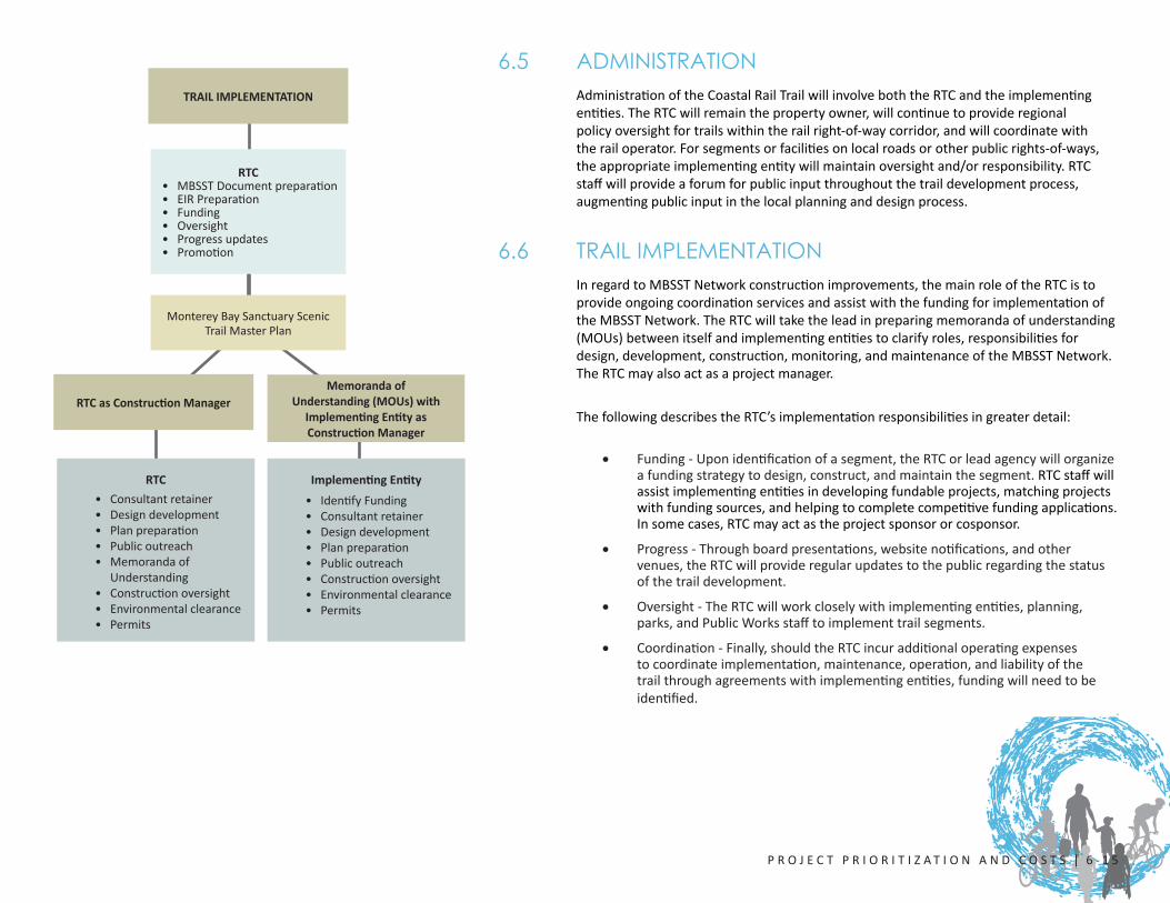
6.6 TRAIL IMPLEMENTATIONInregardtoMBSSTNetworkconstructionimprovements,themainroleoftheRTCistoprovideongoingcoordinationservicesandassistwiththefundingforimplementationoftheMBSSTNetwork.TheRTCwilltaketheleadinpreparingmemorandaofunderstanding(MOUs)betweenitselfandimplementingentitiestoclarifyroles,responsibilitiesfordesign,development,construction,monitoring,andmaintenanceoftheMBSSTNetwork.TheRTCmayalsoactasaprojectmanager.
ThefollowingdescribestheRTC’simplementationresponsibilitiesingreaterdetail:
• Funding-Uponidentificationofasegment,theRTCorleadagencywillorganizeafundingstrategytodesign,construct,andmaintainthesegment.RTCstaffwillassistimplementingentitiesindevelopingfundableprojects,matchingprojectswithfundingsources,andhelpingtocompletecompetitivefundingapplications.Insomecases,RTCmayactastheprojectsponsororcosponsor.
• Progress-Throughboardpresentations,websitenotifications,andothervenues,theRTCwillprovideregularupdatestothepublicregardingthestatusofthetraildevelopment.
• Oversight-TheRTCwillworkcloselywithimplementingentities,planning,parks,andPublicWorksstafftoimplementtrailsegments.
• Coordination-Finally,shouldtheRTCincuradditionaloperatingexpensestocoordinateimplementation,maintenance,operation,andliabilityofthetrailthroughagreementswithimplementingentities,fundingwillneedtobeidentified.
RTC• MBSSTDocumentpreparation• EIRPreparation• Funding• Oversight• Progressupdates• Promotion
Memoranda of Understanding (MOUs) with
Implementing Entity as Construction Manager
MontereyBaySanctuaryScenicTrailMasterPlan
Implementing Entity
• IdentifyFunding• Consultantretainer• Designdevelopment• Planpreparation• Publicoutreach• Constructionoversight• Environmentalclearance• Permits
RTC• Consultantretainer• Designdevelopment• Planpreparation• Publicoutreach• Memorandaof
Understanding• Constructionoversight• Environmentalclearance• Permits
RTC as Construction Manager
TRAIL IMPLEMENTATION
6 - 1 6 | MON T E R E Y B AY S A N C T U A R Y S C E N I C T R A I L N E TWO R K M A S T E R P L A N - F I N A L
Thefollowingdescribesimplementingentities’responsibilitiesingreaterdetail:
• Oncethesegmentasbeenidentifiedandfunded,theRTCand/orimplementingentitiesmayemployin-housestafforretainaqualifiedbicycleandpedestriantrailplanningconsultanttodesignthetrailconstructiondocuments.AfterreviewbytheRTC’sadvisorycommitteesandimplementingentities,boardsandcommittees,theRTCwillreviewandapproveofalltraildesignssubmittedbytheimplementingentities.TheRTCBicycleCommitteewillreviewdesignandengineeringplansattheconceptualanddetailedlevels.
• Inconjunctionwithimplementingentitiesand/ortrailplanningconsultant,aseriesofworkshopsshouldbeconductedtointroducetheprojecttothepublicandtoidentifyanynewinformationnotincludedinthisMasterPlan.
• Implementingentitieswillberesponsibleforoverseeinganynecessaryenvironmentalclearance.Theimplementingentitieswillobtainthenecessaryplanning,environmental,anddevelopmentpermits.
• TheRTCmayoverseeprojectconstruction.Thismaybedoneinconsultationwiththeimplementingentityand/ortrailplanningorconstructionmanagementconsultant.
6.7 TRAIL IMPLEMENTATION OVER JURISDICTIONAL BOUNDARIESThe20trailalignmentsegmentsincorporatelogicalstartandendpointsbasedonphysicaland/orgeographicalfeatures.Insomeinstances,itwasnecessarytoextendasegmentacrossjurisdictionalboundariestothenextsignificantphysicalfeature.TheRTCowns31milesoftheapproximately32-mile-longSantaCruzBranchRailroadcorridorright-of-wayandwillworkcloselywiththeCityofSantaCruz,SantaCruzCounty,CityofCapitola,CityofWatsonville,andStateParkswheretrailsegmentscrossjurisdictionalboundariesorwhenthesegmentislocatedsolelywithintheirjurisdiction.
6.8 À LA CARTE TRAIL DEVELOPMENT (PARTIAL SEGMENT)Duetocostsorotherconsiderations,itmaynotalwaysbepossibletodevelopanentiresegmentatonce.Inaddition,thescopeofgrantfundingmaylimitthetypesofimprovementsthatmaybefunded.Itispossiblethatonlyaportionofatrailsegment,facility,oramenitymaybefunded/constructedatonetime.Forexample,itispossiblethatjusttheCoastalRailTrailportionofasegmentmaybefundedwhiletheon-streetimprovementsmaynotorviseversa.Remainingfacilitiesmaybeimprovedatalaterdate.
An implementing entity is defined as a city,
county, RTC, state park, or other body.
The RTC owns 31 miles of the approximately
32-mile-long Santa Cruz Branch Railroad corridor right-of-way, allowing the RTC to act as the primary developer of the Coastal Rail Trail.