programmatic environmental assessment high speed … · programmatic environmental assessment high...
TRANSCRIPT

Programmatic Environmental Assessment High Speed Test Track (HSTT) Operations
Holloman Air Force Base, New Mexico
September 2007
Points of Contact for more information: Mr. Timothy C. Wolfe, 846 TS/TGTP
(505)679-2386 [email protected]
Mr. Andrew Gomolak, 49 CES/CEVA Ms. Jeanne Dye 49 CES/CEVN
Telephone: (505) 572-3931 Fax: (505) 572-5080
e-mail: [email protected] [email protected]
Report Documentation Page Form ApprovedOMB No. 0704-0188
Public reporting burden for the collection of information is estimated to average 1 hour per response, including the time for reviewing instructions, searching existing data sources, gathering andmaintaining the data needed, and completing and reviewing the collection of information. Send comments regarding this burden estimate or any other aspect of this collection of information,including suggestions for reducing this burden, to Washington Headquarters Services, Directorate for Information Operations and Reports, 1215 Jefferson Davis Highway, Suite 1204, ArlingtonVA 22202-4302. Respondents should be aware that notwithstanding any other provision of law, no person shall be subject to a penalty for failing to comply with a collection of information if itdoes not display a currently valid OMB control number.
1. REPORT DATE OCT 2008 2. REPORT TYPE
3. DATES COVERED 00-00-2008 to 00-00-2008
4. TITLE AND SUBTITLE Programmatic Environmental Assessment High Speed Test Track(HSTT) Operations Holloman Air Force Base, New Mexico
5a. CONTRACT NUMBER
5b. GRANT NUMBER
5c. PROGRAM ELEMENT NUMBER
6. AUTHOR(S) 5d. PROJECT NUMBER
5e. TASK NUMBER
5f. WORK UNIT NUMBER
7. PERFORMING ORGANIZATION NAME(S) AND ADDRESS(ES) 49th Civil Engineer Squadron (49 CES/CEAO),550 TabosaAvenue,Holloman AFB,NM,88330
8. PERFORMING ORGANIZATIONREPORT NUMBER
9. SPONSORING/MONITORING AGENCY NAME(S) AND ADDRESS(ES) 10. SPONSOR/MONITOR’S ACRONYM(S)
11. SPONSOR/MONITOR’S REPORT NUMBER(S)
12. DISTRIBUTION/AVAILABILITY STATEMENT Approved for public release; distribution unlimited
13. SUPPLEMENTARY NOTES
14. ABSTRACT The High Speed Test Track (HSTT) at Holloman Air Force Base (HAFB) is the longest, most preciselyaligned, and best instrumented facility of its kind in the world. It is an important element of theDepartment of Defense Major Range and Test Facility Base (MRTFB), which conducts developmental andoperational test and evaluation activities in support of DoDD 5000.1 and DoDI 5000.2 for weapons systemsacquisition programs. The HSTT is also available for test and evaluation activities required by State orFederal agencies, allied foreign nations, educational research organizations, and commercial entities. The846th Test Squadron (846 TS) operates the HSTT. The 846 TS is part of the 46th Test Group (46 TG),which is a tenant activity at HAFB. This Programmatic Environmental Assessment (PEA) evaluates allground-based test and operational activities conducted at the HSTT, except for the Magnetic LevitationSled Track Operations, which is covered under a separate EA. Through the analysis of test and operationalactivities and environmental, safety, and health issues associated with those requirements activities thatmeet 46 TG and 846 TS requirements while protecting and enhancing environmental, safety, and healthconsiderations (management actions and best management practices) are identified. The results of theProgrammatic Environmental Assessment will be incorporated into the HAFB Integrated NaturalResources Management Plan (INRMP) as revised (2007), and will be used for managing the naturalresources and natural infrastructure in association with operation of the HSTT. Activities that areconsistent with the analysis in this PEA can be categorically excluded without further NationalEnvironmental Policy Act (NEPA) evaluation.
15. SUBJECT TERMS

16. SECURITY CLASSIFICATION OF: 17. LIMITATION OF ABSTRACT Same as
Report (SAR)
18. NUMBEROF PAGES
85
19a. NAME OFRESPONSIBLE PERSON
a. REPORT unclassified
b. ABSTRACT unclassified
c. THIS PAGE unclassified
Standard Form 298 (Rev. 8-98) Prescribed by ANSI Std Z39-18
FINDING OF NO SIGNIFICANT IMPACT Programmatic Environmental Assessment
High Speed Test Track Operations
HOLLOMAN AIR FORCE BASE, NEW MEXICO
1. Need for Ac~ion and Proposed Action
1.1. Need for Action
The High Speed Test Track (HSTI) at Holloman Air Force Base (HAFB) is the longest, most precisely aligned, and best instrumented facility of its kind in the world. It is part of the Department of Defense (DoD) Major Range and Test Facility Base (MRTFB), DoDD 3200.11, and exists for the management and operation of track-related DoD developmental and operational test and evaluation activities in support of DoDD 5000.1 for weapons systems acquisition programs. The HSTI is also available for test and evaluation activities required by other Federal agencies, foreign nations, educational research organizations, and commercial entities. The 846th Test Squadron (846 TS) operates the HSTT. The 846 TS is part of the 46th Test Group (46 TG), which is a tenant activity at HAFB.
This Programmatic Environmental Assessment (PEA) evaluates all ground-based test and operational activities conducted at the HSTI, except for the Magnetic Levitation Sled Track Operations, which is covered under a separate environmental assessment. Through the analysis of test and operational activities and environmental, safety, and health issues associated with those requirements, activities that meet 46 TG and 846 TS requirements while protecting and enhancing environmental, safety, and health considerations (management actions and best management practices) are identified. The results of the PEA and the Finding of No Significant Impact (FONSI) will be incorporated into the Holloman AFB Integrated Natural Resources Management Plan (INRMP) and will be used for managing the natural resources associated with operation of the HSTT. Activities that are consistent with the analysis in this PEA can be categorically excluded without further National Environmental Policy Act (NEPA) evaluation, subject to analysis based on AF Form 813.
1.2. Summary of the Proposed Action
Because of the increasing complexity and rising costs incurred in the development of weapons and flight systems, flight simulation using high-speed rocket sleds is a widely used ground test method for reducing technological risk, safety hazards, and exorbitant costs involved in proceeding from laboratory-type tests immediately to actual flight tests. Track testing fills the gap in ground testing by providing the missing link between laboratory-type tests and simulations and full-scale flight tests. Track tests allow new weapons systems program managers to rigorously define and repeat specific test environments and performance, to recover the test specimen after test completion for evaluation, and to eliminate crew safety hazards while avoiding delays and high costs inherent in testing flight-rated experimental weapons system hardware.
1

The HSTI is located in the Tularosa Basin in southeastern New Mexico, approximately 15 miles west of the city of Alamogordo. It extends along the eastern edge of the gypsum (white sand) dunefields in a near north-south direction over a total length of 50,788 feet. The HSTI is located along the far northwestern edge of HAFB. 1.3. Scope of Decisions
This PEA, prepared pursuant to NEPA, evaluates environmental, safety and health effects associated only with ground-based test and operational activities of the HSTI at HAFB, as currently implemented and with proposed changes. It evaluates effects of the current program as currently implemented (no action alternative), and identifies and evaluates the effects of the program as foreseen to meet HSTI client requirements now and in the future, and to ensure sustainability of HSTI operations through environmental protection.
The analysis of the tests using specific simulants at each test site, including the HSTI, is included in the Programmatic Environmental Assessment for the Theater Missile Defense Lethality Program, U.S. Army Space and Strategic Defense Command, Huntsville AL, August 1993 (FONSI signed 27 July 93). The U.S. Army examined additional simulants not evaluated in their PEA, but narrowed the appropriate simulants to those evaluated in the PEA. No other simulants are expected to be used for HSTI tests. Therefore, no additional analysis regarding simulants is included in this PEA.
This PEA also does not include analysis and decisions for the Magnetic Levitation System which has been evaluated in Environmental Assessment- Magnetic Levitation System Installation and Operation at Holloman High Speed Test Track1 Holloman AFB1
New Mexico, (FONSI signed 26 Jan 96).
This PEA has no termination date. It provides the basis for natural resources management integrated into the long-term operation of the HSTI at HAFB as long as:
• The testing is conducted in a similar manner as actions described in Chapter 2, including the management actions and best management practices described for each resource in Chapter 4 of the PEA, and
• The actual impacts associated with operations remain within the range of impacts identified in Chapter 4 of the PEA for the proposed action.
All of the proposed facilities described in Section 2.2 would be either additions to existing buildings located in the developed administrative area at the south end of the HSTI, to the Track itself, or new buildings within the developed area. Although additional impacts are not expected for these proposed facilities, each facility would undergo scrutiny through AF Form 332 and AF Form 813, and the appropriate NEPA documentation prepared, as details are not available at this time. Therefore, the impacts of these proposed facilities are not included within the environmental impact analyses in this chapter.
HSTI operations and test requirements proposed in the future will be evaluated by 49 CES/CEV against the descriptions of the existing tests and operations described in Sections 2.1 and 2.2, the best management practices and management actions and processes outlined for each issue in Sections 4.1 through 4.14, and environmental impacts predicted in Chapter 4 of this PEA. If the proposed actions are consistent with
2

the test descriptions, best management practices & actions & predicted impacts and have no extraordinary circumstances, then the actions can be categorically excluded under Categorical Exclusion A2.3.11 (AFI 32-7061) as documented on AF Form 813:
"Actions similar to other actions which have been determined to have an insignificant impact in a similar setting as established in an EIS or EA resulting in a FONSI. The EPF must document application of this CA TEX on AF Form 813, specifically identifying the previous Air Force approved environmental document which provides the basis for this determination."
If any future proposed tests or track operations have issues or extraordinary circumstances which are not evaluated in this PEA, the proposed tests or operations cannot be categorically excluded under Categorical Exclusion A2.3.11. These proposed activities, as well as any new information or circumstances having environmental relevance, such as additional species listed under the Endangered Species Act, shall be evaluated in a supplement to this PEA (40 CFR 1502.9), unless the proposed action can be categorically excluded in its own right (based on the AF Form 332 and site-specific evaluation). Any supplement for a particular activity or changed circumstance will not affect the analysis of any other activity evaluated in this PEA.
2. Alternatives Considered in this PEA The alternatives considered in this Programmatic Environmental Assessment are:
• No Action Alternative. The No Action Alternative (Section 2.1 of the PEA) includes all current tests and operations of the HSTT that might cause adverse environmental impacts at HAFB. This includes over 14 types of tests conducted using combinations of different facilities at the HSTT site. Many of these types of tests use large quantities of water and involve extremely high speeds and explosions. Some of these tests create sonic booms. Two static tests requiring compliance with the Clean Air Act have also been conducted.
• Proposed Action. The 46 TG proposes to continue the operations of the HSTT as described under Section 2.2 of the PEA. However, operations would be modified with proposed new facilities and additional best management practices and management actions as standard operating procedures identified in Sections 4.1 through 4.14. Static tests using large rocket motors having substantial air emissions could result in HAFB becoming a "major source" under the Clean Air Act and are not included in this PEA. The proposed action incorporates the description of current operations and tests as described in Section 2.1 and describes additional proposed activities, best management practices and management actions to protect the environment. Additional modifications to existing facilities are i:dentified. All best management practices and management actions were developed using the interdisciplinary approach involving cooperation and concurrence of 13 HSTT personnel (846 TS, 46 TG, and support contractors) and 13 resource managers and community planners from HAFB (Section 5 of the PEA). No other alternatives were necessary for this lEA, consistent with Section 1 02(2)(E) of NEPA.
3
3. Decisions
3.1. Selection of Alternative
Pursuant to 40 CFR 1508.9(a)(2), environmental assessments may be used for evaluating and selecting alternatives.
Based on the information and analyses provided by this PEA, I select the Proposed Action: Current Operations of the HSTT as modified with best management practices and management actions to protect the environment as described in Section 2.2, and described and evaluated in Sections 4.1 through 4.14 of the PEA.
I select this alternative because this alternative and its associated best management practices and management actions were developed using a systematic, comprehensive, and interdisciplinary approach. The management actions identified in Sections 4.1 through 4.14 of the PEA will be effective in long-term management and protection of the natural resources at the HSTT, while supporting present and future HSTT mission and sustainability. This alternative is consistent with NEPA, the HAFB INRMP, and Air Force policy. The best management practices and management actions will be immediately available for implementation upon approval of this FONSI and incorporated into the INRMP.
3.2. FONSI Analysis
The FONSI provides the rationale for why the actions described and evaluated in this PEA are not "major federal actions" having significant impac1s, pursuant to the National Environmental Policy Act (NEPA; 40 CFR 1508.18 and 40 CFR 1508.27), and, therefore, why an Environmental Impact Statement (EIS) is not being prepared.
The evaluation of lack of impact significance documented here is based on the criteria identified at 40 CFR 1508.27.
3.2.1. Impacts on Health and Safety
The PEA identified best management practices and management actions that best manage chemicals for noxious plant and overall weed control, consistent with the INRMP, and protect HSTT personnel from rattlesnakes using non-lethal actions. The HSTT is currently operated using tested safety policies and management actions. Acce~s to the HSTT, as part of the DoD MRTFB, is restricted to authorized personnel only.
No significant adverse impacts on health or safety are therefore foreseen.
3.2.2. Unique Geographic Characteristics, Degree of Environmental Controversy, and Degree of Highly Uncertain Effects or Unique or Unknown Risks
All unique areas and special habitats at the HSTT were evaluated for potential adverse impacts on erosive soils, sensitive plants and animals and their habitat, wetlands, historical and archaeological sites, and other unique characteristics. Management actions in Chapter 4 of the PEA implement specific protections for these unique areas and resources consistent with necessary operations of the HSTT and the INRMP. As
4
described in detail in Chapter 4, no significant adverse impacts to unique areas are foreseen.
All best management practices and management actions identified in Chapter 4 of the PEA have proven effective for their intended uses. A high degree of confidence is placed in the resultant analyses documented in Chapter 4. No environmental controversy or unique or unknown risks are therefore foreseen.
3.2.3. Setting a Precedent for Future Actions
No action within this analysis would set a precedent for future actions that themselves have the potential for significant environmental impacts, 1individually or cumulatively. All best management practices and management actions identified in Chapter 4 of the PEA were identified using the systematic interdisciplinary approach (HAFB and HSTI personnel working together) and are consistent with operation and mission of the HSTT, with the INRMP, and Air Force policy.
3.2.4. Potential for Adverse Cumulative Environmental Impacts
No actions are foreseen to set a precedent for future actions which would themselves have the potential for causing significant environmental impacts, either individually or cumulatively. The environmental analyses in Chapter 4 of the best management practices and the management actions described in Chapter 4 of the PEA indicate that no significant adverse cumulative impacts would be caused by implementation of the proposed action. Overall, water use at the HSTT is consistent with the annual water use on HAFB, and is substantially less than that used by other base facilities, such as the golf course and Military Family Housing. Control of noxious weeds at the HSTT is consistent with that identified in the INRMP base-wide, and would protect native vegetation and reduce the use of herbicides and pesticides.
3.2.5. Potential to Adversely Affect Historic or Archaeological Resources, or Threatened or Endangered Species and Critical Habitat
Based on the analysis in Chapter 4, no adverse impacts would occur to any historic or archaeological resources with the implementation of identified best management practices and management actions. No threatened or endangered species would be adversely impacted. Identified best management practices and management actions would protect the White Sands Pupfish, burrowing owls, and sensitive vegetation communities. None of these species are protected under the Endangered Species Act.
3.2.6. Potential to Violate federal, State, or Local Environmental Law
The subject matter experts carefully considered the requirements of the laws and Executive Orders identified in Section 1.5 of the PEA, and ensured that the best management practices and management actions complied with the requirements. Please see Section 4 of this FONSI for compliance with the General Conformity Rule pursuant to the Clean Air Act Amendments of 1990.
5
4. General Conformity Rule Determination Pursuant to the Clean Air Act Amendments of 1990
Due to the attainment status of HAFB with regard to criteria air pollutants, a formal Air Conformity Determination is not required. Pursuant to Title Ill of the Clean Air Act, proposed static tests of rocket motors will be evaluated on a case-by-case basis, as each test is different and cannot be evaluated in this PEA, to determine the potential for exceedance of Federal and State air quality standards and appropriate actions pursuant to Federal and State law taken prior to testing. Any test that would have an adverse effect on air quality regulated by Federal and New Mexico Regulations would not be approved by 49 CES/CEV or would have to undergo the permitting process for air quality required by the State of New Mexico.
5. FONSI Conclusion
Based on this PEA conducted in accordance with the requirements of NEPA, its implementing regulations at 40 CFR 1500-1508, and AFI 32-7061, I conclude that the environmental effects associated with implementing the proposed action for long-term management and operation of the HSTT are not significant effects. Implementation of the proposed action and associated best management practices and management actions would improve the quality and management of natural resources at the HSTT, consistent with mission and the HAFB INRMP, and meet Federal law and requirements and Air Force policy. These actions would also contribute to long-term sustainability of HSTT operations. Therefore an EIS will not be prepared.
JMREvt H{t~~G~i= Colonel, USAF Commander
6
~\ ~~Q~ Date

ii

iii
Programmatic Environmental Assessment High Speed Test Track (HSTT) Operations
Holloman Air Force Base, New Mexico
September 2007
Points of Contact for more information: Mr. Timothy C. Wolfe, 846 TS/TGTP
(505)679-2386 [email protected]
Mr. Andrew Gomolak Ms. Jeanne Dye
49 CES/CEV 550 Tabosa Avenue
HAFB, New Mexico 88330 Telephone: (505) 572-3931 Fax: (505) 572-5080
e-mail: [email protected] [email protected]
ABSTRACT: The High Speed Test Track (HSTT) at Holloman Air Force Base (HAFB) is the longest, most precisely aligned, and best instrumented facility of its kind in the world. It is an important element of the Department of Defense Major Range and Test Facility Base (MRTFB), which conducts developmental and operational test and evaluation activities in support of DoDD 5000.1 and DoDI 5000.2 for weapons systems acquisition programs. The HSTT is also available for test and evaluation activities required by State or Federal agencies, allied foreign nations, educational research organizations, and commercial entities. The 846th Test Squadron (846 TS) operates the HSTT. The 846 TS is part of the 46th Test Group (46 TG), which is a tenant activity at HAFB.
This Programmatic Environmental Assessment (PEA) evaluates all ground-based test and operational activities conducted at the HSTT, except for the Magnetic Levitation Sled Track Operations, which is covered under a separate EA. Through the analysis of test and operational activities and environmental, safety, and health issues associated with those requirements, activities that meet 46 TG and 846 TS requirements while protecting and enhancing environmental, safety, and health considerations (management actions and best management practices) are identified. The results of the Programmatic Environmental Assessment will be incorporated into the HAFB Integrated Natural Resources Management Plan (INRMP) as revised (2007), and will be used for managing the natural resources and natural infrastructure in association with operation of the HSTT. Activities that are consistent with the analysis in this PEA can be categorically excluded without further National Environmental Policy Act (NEPA) evaluation.

Table of Contents 1. Purpose and Need ...................................................................................................... 1
1.1 Introduction .................................................................................................................. 1 1.2 Need for Action and Planning Requirements ............................................................ 2 1.3 Summary of the Proposed Action ............................................................................... 3 1.4 Scope of the Analysis and Decisions to be Made ....................................................... 5 1.5 Laws, Regulations, and Agency Instructions Applying to Operation of the High Speed Test Track on HAFB ...................................................................................................... 7
2. Alternatives including the Proposed Action ............................................................ 10 2.1 Current Tests and Operations Facilities of the High Speed Test Track on HAFB (No Action Alternative) ........................................................................................................... 10 2.2 Description of Proposed Modifications to the Current Operations of the HSTT (Proposed Action) .................................................................................................................... 32
3. Affected Environment .............................................................................................. 34 3.1 Location, Natural Setting, and Surface and Ground Water Characteristics ....... 34 3.2 Floral and Faunal Communities on Main Base, Including Noxious Plants .......... 35 3.3 Installation Restoration Program ............................................................................. 36 3.4 Historic and Archaeological Resources .................................................................... 36 3.5 Air Quality .................................................................................................................. 37 3.6 Restrictive Land Use Zones ....................................................................................... 37
4. Environmental Consequences ................................................................................. 38 4.1 Soil Erosion, Protection of Microbiotic Crusts, and Road Management .............. 38 4.2 Protection of Wetlands .............................................................................................. 42 4.3 Conservation of HAFB Potable Water ..................................................................... 45 4.4 Storm Water Management and Contamination ...................................................... 47 4.5 White Sands Pupfish .................................................................................................. 50 4.6 Western Burrowing Owls .......................................................................................... 53 4.7 BASH (Test Sled-Wildlife Collisions) and Oryx Management .............................. 58 4.8 Pest and Bat Management ......................................................................................... 60 4.9 Management of Cultural, Archaeological, and Historic Resources ...................... 62 4.10 Landscaping, Grounds Maintenance, and Noxious/Exotic Plant Management ... 64 4.11 Management of Encroaching Sand Dunes ............................................................... 65 4.12 Management of Air Emissions during Static Tests (Stationary Sources) ............. 66 4.13 Management of Outdoor Storage Areas and Used Communication Wire ........... 67 4.14 Issues Not Considered in Detail with Rationale ...................................................... 68
ii
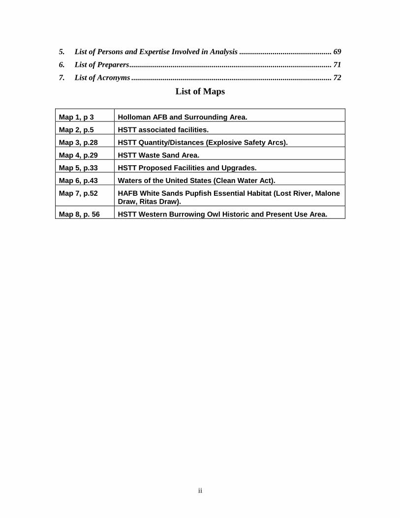
5. List of Persons and Expertise Involved in Analysis ............................................... 69
6. List of Preparers ....................................................................................................... 71
7. List of Acronyms ...................................................................................................... 72
List of Maps
Map 1, p 3 Holloman AFB and Surrounding Area.
Map 2, p.5 HSTT associated facilities.
Map 3, p.28 HSTT Quantity/Distances (Explosive Safety Arcs).
Map 4, p.29 HSTT Waste Sand Area.
Map 5, p.33 HSTT Proposed Facilities and Upgrades.
Map 6, p.43 Waters of the United States (Clean Water Act).
Map 7, p.52 HAFB White Sands Pupfish Essential Habitat (Lost River, Malone Draw, Ritas Draw).
Map 8, p. 56 HSTT Western Burrowing Owl Historic and Present Use Area.

Purpose and Need
1
Programmatic Environmental Assessment High Speed Test Track (HSTT) Operations
Holloman Air Force Base, New Mexico
1. Purpose and Need
1.1 Introduction Holloman Air Force Base (HAFB; Map 1) is required to implement environmental planning and documentation pursuant to the National Environmental Policy Act (NEPA) and in accordance with Department of Defense Directive (DODD) 4700.4, Air Force Policy Directive 32-70, AFI 32-7061, and AFI 32-7064.
This programmatic environmental assessment (PEA) provides a process for the evaluation of all of the ground-based tests and support operational activities conducted by the 846th Test Squadron (846 TS), 46th Test Group (46 TG) at the High Speed Test Track (HSTT) for contracted domestic and international clients. The HSTT is a tenant activity on HAFB, under Air Force Materiel Command (AFMC) at Wright-Patterson AFB and the Air Armament Center (AAC) at Eglin AFB in Florida (fig. 1). This PEA provides the basis for the management of natural resources and natural infrastructure integrated into the operation of the HSTT at HAFB, using NEPA for the comprehensive planning effort, that:
• Meets the mission needs of HAFB as the host unit and 846 TS and 46 TG as the tenant unit;
• Identifies and corrects environmental, safety, and health concerns associated with past operation of the HSTT;
• Evaluates proposed tests and proposed new facilities, and incorporates environmental, safety, and health requirements as standard operating procedures
• Provides for long-term use of the HSTT by retaining and protecting necessary environmental components; and
• Is consistent with and meets the standards, guidelines, and other recommendations described in HAFB Integrated Natural Resources Management Plan (INRMP), Integrated Cultural Resources Management Plan, Base Comprehensive Plan, and other documents supplementing the INRMP.

Purpose and Need
2
Figure 1. Organizational Chart for the High Speed Test Track, HAFB, New Mexico
Air Force Materiel Command Wright-Patterson AFB, Ohio
Air Armament Center
46th Test Wing Eglin AFB, Florida
46th Test Group
HAFB, New Mexico
846th Test Squadron HAFB, New Mexico
1.2 Need for Action and Planning Requirements Because of the increasing complexity and rising costs incurred in the development of weapons and flight systems, flight simulation using high speed rocket sleds is a widely used ground test method for reducing technological risk, safety hazards, and exorbitant costs involved in proceeding from laboratory-type tests immediately to actual flight tests. Track testing fills the gap in ground testing by providing the missing link between laboratory-type simulations and full-scale flight tests. Track tests allow new weapons systems Program Managers to rigorously define and repeat specific test environments and performance, to recover the test specimen for evaluation after test completion, and eliminate crew safety hazards, while avoiding the delays and high costs inherent in flight-rating experimental weapons system hardware.
The goal of this planning effort is to develop opportunities for conducting tests at the HSTT for clients so that test objectives are met completely and all support activities are conducted efficiently and safely, while protecting human health and the quality of the environment.

Purpose and Need
3
Map 1. Holloman AFB and Surrounding Area.
1.3 Summary of the Proposed Action The HSTT at HAFB is the longest, most precisely aligned, and best instrumented facility of its kind in the world. It exists to provide management and operation of track-related DoD developmental and operational test and evaluation activities in support of DoDD 5000.1 and DODI 5002 (12 May 2003) for weapons systems acquisition programs. The HSTT is also available for test and evaluation activities required by cooperators, State and Federal agencies, foreign nations, educational research organizations, and commercial entities. . The HSTT is located in the Tularosa Basin in southeastern New Mexico, approximately 15 miles west of the city of Alamogordo and located at the far northwestern edge of HAFB (Map 1). It extends along the eastern edge of white sand (gypsum) dunefields in a near north-south direction over a total length of 50,788 feet. In addition to the track itself, primary associated facilities include (Map 2):
• A trackside rain simulation facility for rain erosion testing; • Ballistic Rainfield, where Hay Draw crosses the Track, a separate rain simulation
area for gun-fired projectiles; • An ejection test area for testing release of aircraft weapons, and ejection seats and
crew escape systems; • An impact test site for inert and live payloads; • Four permanent blockhouses for controlling tests and a fifth blockhouse for operating
the rain system; • A Track Data Center (TDC) building and a mobile track data center that can be
located anywhere as needed for a particular test for operating ground-based telemetry

Purpose and Need
4
and other activities; • Storage and maintenance buildings for servicing, installation, and maintenance of
solid rocket engines; • Project work area and office space; • A Horizontal Test Stand (HTS) for testing rocket motors; • Fabrication and Repair Shop for making and modifying sleds, installing special
hardware, and hardware prototype fabrication; • Antenna Relay Control (ARC) Building for mission control, data relay, and mission
staging; • A prototype Magnetic Levitation Facility (MAGLEV) consisting of a 1,600 foot
guideway; • Concrete Target Fabrication and Storage area to the east of the track at the north end.
In addition, a 20,000 pound Explosive Ordnance Disposal (EOD) range (permitted under the Resource Conservation and Recovery Act (RCRA)), under the jurisdiction of 49 CES/CED and administered by 49 CES/CEV, is located at the northern end of the HSTT. This site exists for disposal of explosive wastes at HAFB (AFMAN 91-201, 18 Oct 01). At this site, the HSTT has the 49 CES/CED dispose of live explosives and energetic materials and evaluate munitions post-test for damage. The types of tests conducted at the HSTT include: tests of life support systems; testing of the effects that environmental parameters have on materials, components, and systems; tests of guidance systems; track launch applications; and special applications. HSTT managers are flexible in order to meet clients’ special requirements when appropriate and possible. Current operations of the HSTT are described in more detail under the “No Action” alternative in Section 2.1.

Purpose and Need
5
Map 2. HSTT associated facilities.
1.4 Scope of the Analysis and Decisions to be Made
1.4.1 Scope of Analysis This Programmatic Environmental Assessment (PEA) prepared pursuant to NEPA evaluates environmental, safety, and health effects associated only with ground-based test and operational activities of the HSTT at HAFB, as currently implemented and with proposed changes. It evaluates effects of the current program as implemented (no action alternative), identifies and evaluates the effects of the program as foreseen to meet HSTT client requirements now and in the future to ensure sustainability of the Test Track through Natural Infrastructure Management and natural resources protection.
This PEA does not include analyses and decisions for the Magnetic Levitation System (MAGLEV), which has been evaluated in Environmental Assessment – Magnetic Levitation System Installation and Operation at Holloman High Speed Test Track, HAFB, New Mexico, Finding of No Significant Impact (FONSI) signed 26 Jan 96. Pertinent information is incorporated by reference into this EA. The prototype magnetic levitation system is currently under effectiveness testing and will be fully operational by 2011. At that time, proposed tests will undergo appropriate analysis and documentation pursuant to NEPA.
The analysis of the tests on specific simulants and explosives at the HSTT is included in the Programmatic Environmental Assessment for the Theater Missile Defense Lethality Program, U.S. Army Space and Strategic Defense Command, Huntsville AL, August 1993 (FONSI signed

Purpose and Need
6
27 July 93). No other explosives are expected to be used for HSTT Theater Missile Defense Lethality tests; and simulants even though evaluated in the U. S. Army Programmatic EA, are not commonly used in tests at the HSTT. Therefore, no additional analysis is included in this PEA.
This PEA has no termination date. It provides the basis for Natural Infrastructure Management and natural resources protection integrated into the long-term operation of the HSTT at HAFB as long as:
• The testing is conducted in a similar manner as the actions described in Chapter 2 with the management actions and best management practices described for each resource in Chapter 4, and
• The actual impacts associated with operations remain within the range of impacts identified in Chapter 4 for the Proposed Action.
All of the proposed facilities described in Section 2.2 would be additions or modifications to existing buildings located in the developed administrative area south of the Test Track; to the Track itself; or to new buildings within the developed administrative area. Each facility would undergo scrutiny through the required Civil Engineering project review AF Form 332 and the appropriate AF Form 813 and the appropriate NEPA documentation in a timely fashion. Therefore, the impacts of these new facilities are not included within the environmental impact analyses in Chapter 4.
HSTT operations and test requirements proposed in the future will be evaluated by 49th Civil Engineering Squadron Environmental Flight (49 CES/CEV) against the descriptions of the existing tests and operations described in Sections 2.1 and 2.2, the best management practices and management actions and processes outlined for each issue in Chapter 4, and environmental impacts predicted in Chapter 4 of this PEA. If the proposed test actions are consistent with the test descriptions, best management practices and management actions, and predicted impacts, and have no extraordinary circumstances as defined in 32 Code of Federal Regulations (CFR) 989 appendix B Section A2.2 (AFI 21-7061), then the actions can be approved under Categorical Exclusion A2.11:
“Actions similar to other actions which have been determined to have an insignificant impact in a similar setting as established in an EIS or EA resulting in a FONSI. The EPF must document application of this CATEX on AF Form 813, specifically identifying the previous Air Force approved environmental document which provides the basis for this determination.”
All proposed actions identified in Section 2.2 will require AF Form 332 coordination, and possibly an AF Form 813 to determine appropriate NEPA compliance prior to implementation.
If any future proposed tests or track operations have issues or extraordinary circumstances or impacts which have not been evaluated in this PEA, the proposed tests or operations cannot be conducted under Categorical Exclusion A2.11. These proposed activities, as well as any new information or circumstances having environmental relevance, such as additional species listed under the Endangered Species Act, shall be evaluated in a supplement to this PEA (40 CFR 1502.9), unless the proposed action can be categorically excluded in its own right (based on the AF Form 332, AF Form 813, and site-specific evaluation). Any supplement for a particular activity or changed circumstance will not affect the analysis of any other activity evaluated in this PEA.
Purpose and Need
7
1.4.2 Decisions to be Made The 846 TS, 46 TG, is a tenant activity on HAFB. The HAFB Wing Commander (49 FW/CC) is responsible, as the commander of the Host Activity, for all decisions with the potential to adversely affect the quality of the environment regarding the activities of its tenant activities. The 49 CES/CEV collaborated with 846 TS 46 TG to conduct the analysis and prepare this NEPA document for use by 49 FW/CC to ensure that the 846 TS requirements are met, compliance with NEPA is fulfilled, and that the decision package is complete.
The decisions to be made by 49 FW/CC are:
1. Might the tests and operations program at the HSTT, a tenant activity at HAFB, as currently operated and reasonably foreseen in the future have significant impacts needing analysis and public disclosure and comment using Environmental Impact Statement (EIS) procedures or would a Finding of No Significant Impact be appropriate?
2. Should 846 TS, 46 TG, continue its tests and operations as currently implemented (no action alternative) on HAFB or modify its tests and operations to improve environmental protection (best management practices and management actions as standard operating procedures)?
3. If the 49 FW/CC decides, in cooperation with 46 TG, 846 TS, to change its current implementation of high speed ground-based track testing and operations in support of client requirements, the following decisions need to be made:
• What management actions and best management practices for protection and/or enhancement of the natural infrastructure should be implemented as standard operating procedures?
• What monitoring would be conducted, and who would be responsible?
This PEA provides analysis for the current program (no action alternative) and planned and reasonably foreseeable ground-based track testing and operations of the HSTT at HAFB. As such, it is both a site-specific and programmatic Environmental Assessment.
1.4.3 Integration with HAFB INRMP This analysis and resultant best management practices and management actions are coordinated with and will be incorporated into the revised HAFB Integrated Natural Resources Management Plan (INRMP) prepared pursuant to the Sikes Act as Amended (2006) and the ICRMP prepared pursuant to the National Historic Preservation Act (NHPA). The best management practices and management actions identified in this PEA, as documented and committed to in the FONSI, will be integrated into the INRMP.
1.5 Laws, Regulations, and Agency Instructions Applying to Operation of the High Speed Test Track on HAFB The following laws, regulations, agency instructions, and cooperative agreements apply to the operations of the HSTT on HAFB, in addition to NEPA:
• National Historic Preservation Act of 1968, as amended • Archaeological Resources Protection Act of 1979 • Clean Water Act of 1977, as amended • Endangered Species Act
Purpose and Need
8
• Fish and Wildlife Conservation Act • Sikes Act Improvement Act as amended 1997 • Resource Conservation and Recovery Act (RCRA) • Migratory Bird Treaty Act (MBTA) • Federal Insecticide, Fungicide, and Rodenticide Act (FIFRA) • Noxious Weed Regulations (7 CFR Part 360) • Federal Noxious Weed Act • Toxic Substances Control Act (TSCA) • Safe Drinking Water Act (SDWA) • 20 New Mexico Administrative Code (NMAC) 6.2, Ground and Surface Water
Protection • 20 NMAC 7.1, Drinking Water • 20 NMAC 7.3, Liquid Waste Disposal • 20 NMAC 9.1, Solid Waste Disposal • NM Harmful Plant Act 76-6A-AA • NM Noxious Weed Act 76-6-1 through 76-7-22 • NM Harmful Weed Act 76-6-23 through 76-7-30 • DoDI 5000.2: Operation of Defense Acquisition System (12 May 2003) • HAFB Land Use Plan • HAFB Storm Water Pollution Prevention Plan (January 2001) • HAFB Integrated Natural Resources Management Plan (October 2002 as revised
2007) • HAFB Integrated Cultural Resources Management Plan as revised 2006 • DoDI 4715.3 Environmental Conservation Program • DoDD 4700.4 Natural Resources Management Program • DoDD 4000.19 Interservice Support Agreements[ • Interservice Support Agreement (ISSA), the agreement under which the 46 TG
operates as a tenant activity on HAFB • AFI 25-201 Support Agreements Procedures • AFI 32-7061 (32 CFR 989) Environmental Impact Analysis Process (EIAP) • AFI 32-7064 Integrated Resources Management • AFI 32-706 Cultural Resources Management • Secretary of the Air Force Order 780.1 Wetlands • E.O. 11988 Floodplain Management (May 24, 1977) • E.O. 11990 Protection of Wetlands (May 24, 1977) • E.O. 12898 Federal Actions to Address Environmental Justice in Minority and Low-
Income Populations (February 11, 1994) • E.O. 13112 Invasive Species (February 3, 1999) • White House Memo on Environmentally and Economically Beneficial Landscaping
Practices (June 29, 1995)

Purpose and Need
9
• Cooperative Agreement for Protection and Maintenance of White Sands Pupfish (July 21, 1995)
• Memorandum of Understanding Between Otero County, Various Federal, State, and Local Agencies for the Coordinated Management of Noxious Plants on Public and Private Lands in Otero County, New Mexico (July 30, 1998)
• National Pollutant Discharge System Storm Water Multi-Sector General Permit for Industrial Activities, Federal Register 65:64745-64880, 30 October 2000

Alternatives: Operation of the HSTT
10
2. Alternatives including the Proposed Action This Chapter complies with NEPA (40 CFR 1502.14 and 1508.9(b)) for describing alternatives and identifying environmental issues and associated management actions and best management practices for operation of the HSTT by the 846 TS, 46 TG on HAFB. This chapter includes:
Detailed description of the HSTT, and descriptions of tests and operations as currently implemented (no action alternative, Section 2.1);
Detailed description of proposed modifications to tests and operations and descriptions of new facilities (proposed action, Section 2.2);
Section 2.1 summarizes the current tests and operation program at the HSTT (no action alternative), including descriptions of the pertinent affected environment. Additional information regarding the Affected Environment for HAFB in general is located in Chapter 3. Section 2.2 describes the proposed modifications to current tests and operations and proposed new facilities.
2.1 Current Tests and Operations Facilities of the High Speed Test Track on HAFB (No Action Alternative) This section discusses the aspects of HSTT activities, existing facilities, tests conducted, and general operations and maintenance which have the potential to impact the natural infrastructure of HAFB, to support decision making by 49 FW/CC (Section 1.4.2). For information on technical information associated with tests and operation, see the booklet prepared by the 6585th Test Group, Test Track Division (now the 46 TG, 846 TS), Holloman Air Force Base entitled, “The High Speed Test Track: Facilities and Capabilities,” April 1989. All descriptions presented here were obtained from this booklet and from 46 TG and 846 TS personnel (Chapter 5).
2.1.1 Purpose of the High Speed Test Track The HSTT, operated by the 846 TS, 46 TG as a tenant activity on HAFB, is the longest, most precisely aligned, and best instrumented operational rocket sled test facility in the world. Its function is to simulate selected portions of flight trajectories under accurately programmed, closely controlled, and rigorously monitored conditions.
The HSTT was first constructed during the Cold War and has been continually maintained and upgraded to meet DoD needs for Research Development Test and Evaluation and Operational Test and Evaluation (ODT&E, RDT&E) under highly precise and rigorously controlled conditions.
The HSTT exists primarily to provide test and evaluation information for DoD decision makers and to support test and evaluation needs of DoD research programs and weapons system development programs. Other government agencies (Federal, state, and local) and allied foreign governments and defense contractors may also use the HSTT. Customers of the HSTT include the U.S. Air Force, U.S. Army, U.S. Navy, Department of Energy, Department of Transportation, Federal Aviation Administration, other government agencies and their contractors, and, periodically, foreign governments, as directed by DoD.
Tests are conducted on a regular basis year-round, with the tempo dependent on the complexity of tests and client needs. Tempo of tests can vary from 1 to 17 tests per day, one to three times per week. Some of these tests are simple, and others are complex and large scale requiring substantial preparation. In track testing, payloads are moved rapidly along a straight-line path by means of rocket-powered sleds operating on a set of heavy-duty crane rail tracks. The sleds are propelled by multi-stage solid fuel rocket motors, with sleds capable of reaching speeds of over 9,400 feet/second (this speed was reached in 2003 during a land-speed record-setting test). Occasionally, a low-speed prime mover, basically a semi-tractor, running on diesel fuel, with rubber tires and guide wheels, can tow sleds where higher speed is not a

Alternatives: Operation of the HSTT
11
requirement. Also, a multipurpose rail-mounted utility cart using a diesel engine is used for maintenance purposes.
The following types of test capabilities provided by the Test Track fill the gap in the spectrum of aerospace ground testing by providing the missing link between laboratory-type investigations and full-scale flight tests:
• Full-scale testing of dynamic events which do not lend themselves to simulation by other ground test approaches, such as dynamic evaluation and qualification of aircraft crew escape systems, full-scale impact tests, ejection and release testing of weapons systems, and simulation of missile launch trajectories.
• Performance regimes for which other ground test techniques cannot fulfill the essential flight conditions and environmental constraints, such as extended supersonic flight through rain and dust clouds, simulation of the final phase of high ballistic coefficient reentry, and high Mach number flight at low altitudes.
• Efficient, safe, and cost-effective ground-based tests that provide an alternative to expensive flight and ground-based static tests.
Track testing provides the capability to rigorously define and repeat specific environments and performance envelopes, recover the specimen after the test, eliminating crew safety hazards while avoiding costs and delays inherent in flight rating of experimental hardware. It also provides comprehensive digital and photo-optical video, and electronic data through on-board telemetry onboard or fixed instrumentation. Instrumentation test capabilities include debugging, developmental shakedown, and performance and demonstration under field conditions that provide maximum degree of confidence that the tested items will perform under their specified flight requirements, combat conditions, and environmental constraints without failure or need for subsequent retrofits.
The Test Track provides customers with an independent, unbiased analysis and evaluation of test results, emphasizing sled and test item performance, validity and accuracy of test data, quality of environmental simulations, and overall suitability and credibility of selected test approaches.
For technology development and for systems test requirements prior to actual flight tests, track testing offers the following advantages:
• The test item trajectory can be tailored for optimum data collection by arranging test events to occur exactly at predetermined points of the flight path, under conditions that allow comprehensive event photographic coverage.
• Airflow field visualization (evaluating the air flow and shockwave interactions) for test objects can be obtained using focused schlieren photographic techniques.
• Test conditions can be repeated accurately from test to test within closely controlled tolerances.
• The test items can generally be recovered for post-test inspection, evaluation, and possible reuse.
• Short operational turn-around times are achieved, allowing a sequence of consecutive tests consistent with usually tight developmental schedules.
• Track tests can be conducted at a fraction of the cost involved in full-scale flight tests.
• Safety of personnel involved in testing is substantially higher than in full flight tests.
Alternatives: Operation of the HSTT
12
2.1.2 Location of HSTT Facility The HSTT and HAFB are located in the Tularosa Basin in southeastern New Mexico, approximately 15 miles west of the city of Alamogordo. It extends along the eastern edge of the gypsum (white sands) dunefields in the northwestern portion of HAFB in a near north-south direction, for a total length of 50,788 feet (Map 2).
The nearby White Sands Missile Range (WSMR) provides an uninhabited area of more than 50 miles to the north and west of the Track. The White Sands National Monument (WSNM) to the south and southwest provides additional, generally uninhabited areas. The area beyond the northern end of the Track is an unobstructed, uninhabited, highly instrumented free-flight test range 50 miles long under the jurisdiction of White Sands Missile Range, with permitted use by the HSTT for test purposes. The three communities to the east of the Test Track (Alamogordo, La Luz, and Tularosa) are eight or more miles from the Track; Albuquerque, NM is 180 miles to the north and El Paso, Texas, is approximately 95 miles to the southwest. This remote location of the Track makes it ideally suited for the types of tests conducted at the Track and minimizes any safety or health risks caused by rocket exhaust, shock waves and sonic booms and high-explosive detonations, in live munitions or airblast test effects.
2.1.3 Description of Natural Environment of the HSTT The HSTT is located on desert land used for military purposes and is similar to the Cantonment area on HAFB in development and ground disturbance. Its western boundary is an ecotone of the gypsum duneland system and alluvial flats shrublands. Topography within this long and narrow area is relatively flat, ranging in elevation from 4,055 feet to 4,134 feet.
Soils at the HSTT have high gypsum content, are highly erodible, and tend to be compacted in high activity areas associated with the Test Track. In areas with low activity, soils, vegetation, and protective microbiotic soil crusts (cryptogams) are undisturbed.
Most of the drainages that enter the Base from the east eventually lead to the Test Track. Drainages flowing to or near the Track are Lost River to the south, Reagan Draw, Hay Draw, Sheep Camp Draw, Guilez Draw, and Allen Draw. The Test Track lies perpendicular to the east-west draws and in the cases of Hay, Guilez, and Allen Draws blocks the natural flows of these systems. These draws historically flowed into and stopped at the dunefields west of the Test Track. Hay Draw and most of Sheep Camp Draw, and the eastern portions of Guilez and Reagan Draws appear to be relict features and do not exhibit indicators of historic surface water flow. However, these areas provide a source of groundwater recharge during heavy rains and also create a flood hazard for 100-year or greater floods. The HSTT also has several unique depressional designated wetlands within blowouts or borrow pits, and several natural wetlands.
The plant community of the Test Track area is dominated by fourwing saltbush/gyp dropseed shrubland, with approximately 15% gyp dropseed grassland. Fourwing saltbush, the most common type of shrub, occupies swales and basin bottom flats of the mildly undulating surfaces, often between mounds hardened by gypsic crusts dominated by gyp dropseed and/or hairy caldenia. Fourwing saltbush/alkali sacaton shrubland and alkali sacaton grassland are within the upland regions bounded on the south by Sheep Camp Draw and the north by Guilez Draw.
Areas adjacent to the Test Track are directly impacted by tests. Placement of test instruments parallel to the track and materials ejected from the track can impact any location along and at the end of the Test Track. The areas receiving the greatest impact and use from tests are: at the northern end of the track where many tests end with explosives or high speed energy impact; and in the highly developed southern end near the north bank of the Lost River playa and the area between track stations 7,000 feet and 10,000 feet in the southern portion of the track. These impacts result from personnel traffic and equipment movement before, in preparation for and after a test.
Alternatives: Operation of the HSTT
13
2.1.4 Description of High Speed Test Track Facilities The track at the HSTT is 50,788 feet long. The geological history of the Tularosa Basin indicates that it is one of the most stable regions in the United States, unaffected by earthquakes and tremors, and is well-suited for retaining a high degree of linear straightness. The track itself is similar to extremely straight and smooth railroad tracks, with a trough for water in between the rails that can be dammed off at intervals for holding braking water. Sleds can be run either on one track or both tracks, depending on test requirements. Camera Pad Road runs parallel to the Track to the east for access to the various areas of the Track and for setting up instrumentation.
Support and test facilities at the HSTT include (Map 2):
• Trackside Rain Simulation Facility: The rain system produces the test environment for impacts of rain erosion on materials carried on monorail sleds above the west rail The Rainfield is 6,000 feet long along the track. ECHO Blockhouse is located under the Track midway in the rainfield area and is the control center for the rain simulation operations.
• Ballistic Rainfield: This site is a separate 2,000 foot rain simulation area perpendicular to the track for testing projectiles fired by guns. This site uses ECHO Blockhouse for operating and controlling the rain system and an earthen berm at the west end to stop and retain test projectiles. When this berm is used again for testing, it will be cleaned and rebuilt to meet test requirements as needed.
• Ejection Test Site: This test site on the track is used for testing crew escape systems and ejection and release of aircraft weapon systems, by sleds traveling either north or south.
• Blast Test Site: This 5-acre asphalted and 18-acre stabilized soil site tests blast effects on moving sleds. Up to three separate 12,000 pound charges have been detonated sequentially in the past. This facility has not been used in a long time, but remains a viable test facility.
• Prototype Magnetic Levitation Guideway (MAGLEV): Complementing the existing Test Track, the prototype 2,300 foot long MAGLEV track provides a low vibration environment for payloads on rocket-propelled sleds for high altitude flight simulation tests at speeds up to Mach 10. It is intended to be integrated into a full system to provide a Hypersonic Ground Test Facility at HAFB.
• Four Additional Blockhouses (ALPHA, BRAVO, COCO, and DOG) and Mobile Launch Vehicles: The ALPHA blockhouse located along the Track provides the capability for launching sleds from the south end of the track and is eligible for listing on the National Register of Historic Places. BRAVO is used for storage and as a sled launch facility; COCO is also used as a sled launch facility and used as a personnel break room; DOG is used as a sled launch facility. Sleds can also be launched from any location along the Track using mobile launch control vehicles.
• Track Data Center (TDC): This hardened, air-conditioned, and dust-free telemetry ground station, located 2,000 feet east of the track, has line-of-sight reception from test sleds at all points on the track and is a focal point for track control and safety operations.
• Tula Peak: A staging area for a mobile telemetry ground station and programming centers is located in the parking area on the top of Tula Peak, 6,000 feet east of the northern end of the track (the building on Tula Peak is not used for Test Track activities). This upper parking area also provides a good vantage point for remote cameras operations, and a lower parking area provides a suitable area for spectators.
• Propulsion, Storage, Maintenance and Office Buildings: These buildings provide centers for installation, maintenance, and storage of solid-fuel rocket motors, munitions, warheads,
Alternatives: Operation of the HSTT
14
and other equipment and storage items. Buildings 1180, 1181, 1183, 1179, 1174, 1170, 1166, 1176, 1173, and 1605 (Dearborn), located at the southern end of the Track, provide office space and project working areas. Building 1605 is also used to store plastic sheeting, sandbags, tools, and field equipment.
• Horizontal Test Stand (HTS): The HTS, located east of the track, tests rocket motors and jet engines, capable of a total thrust rating of 1.0 million pounds. A 400,000 gallon water supply tank originally for dissipating static test motor heat is now used as supply and storage for track rainfield or water braking use. This facility is equipped with a large concrete lined pool for cooling rocket blasts. This pool is no longer used because it leaks, and is fenced because it can also trap oryx. The rail survey crew uses the control bunker as an administrative area.
• The Antenna Relay Center (ARC) Building 1625: The ARC, located east of the north end of the Test Track, is used to control missions at the north end of the Track. It is a storage area for helium which is piped to the track for tests requiring low atmospheric density. The ARC is a focal point for Track control and safety operations for tests conducted at the north end.
• Fabrication and Repair Shop Buildings 1173 and 1178 and associated buildings: These buildings located near the south end of the track are used for fabricating special sleds, modifying existing sleds, installing special hardware, and making prototypes to meet client test requirements. The facilities include a machine shop, a welding shop, carpenter and wood shop, metal heat treatment shop, bead blast shop, paint shop, non-destructive inspection shop, and a sheet metal shop.
• Bullpen: Located in the administrative area, this area provides parking for government vehicles, generators and aerospace ground equipment (AGE). Light maintenance is conducted here.
• North End Concrete Target Fabrication and Storage Area: This bladed and leveled earthen area at the north end of the Track (between the track and Camera Pad Road) is used for fabricating concrete targets, currently up to 20 ft x 20 ft x 5 ft (formed, cast, cured and temporarily stockpiled until needed and transported to the end of the track using a 200-ton mobile gantry crane). Damaged targets are returned to the area and stockpiled until testing is completed, then they are turned into rubble by a contractor; the rebar is recycled and the rubble is transported to waste disposal sites or recycled.
• Expended Rocket Storage Facility: Next to Building 1177 is a fenced and hardened holding area for storing expended solid fuel rocket motors pending disposal through Defense Reutilization Marketing Organization (DRMO).
• Fuel Storage Area: Motor Gasoline and diesel fuel is stored and dispensed behind the carpenter shop next to Building 1166.
• Liquid Nitrogen Facility: Building 1157 provides facilities for converting liquid nitrogen to gaseous nitrogen.
• Buildings 923 and 924: These buildings, located west of Bear Base, are used to tear down and build-up customer explosive items for tests. These are being replaced by proposed buildings 1153 and 1154 west of the southern portion of the track.
• Live Munitions Storage/Operations Buildings 1151 and 1152: Live munitions are stored in Building 1151 prior to use in tests. Munitions buildup activities take place in Bldg 1152.
• Munitions Operating Buildings 1168 and 1169: Live munitions are prepared, configured, and mounted for tests in this building.
Alternatives: Operation of the HSTT
15
• Sled Launch Administrative Building (1189): This 60 ft x 80 ft building is located between Buildings 1173 and 1176 in the administrative area south of the Test Track near the boneyard and provides administrative offices facilities for Sled Launch personnel.
• Sheet Metal Storage Building (Building 1186): This 50 ft x 100 ft storage building is located south of Building 1178 and stores raw sheet metal indoors to protect it from theft and degradation.
• Additional Storage Buildings: Building 1184, approximately 50 feet by 100 feet in size, is used to store metal and welding gas (oxygen and acetylene), tools and equipment, and Track-associated hardware and tools, respectively. Building 1604 is also used to fabricate special purpose field equipment.
• Instrumentation and Vehicle Parking Mounds and Borrow Pits. Three of these pits and berms are located along the eastern side of the track east of Camera Pad Road are used for placing instruments and parking vehicles as necessary. They are also occasionally used by 4th Space Control Squadron Communication and Data Relay training.
2.1.5 Description of Sled Operations The vehicles operating on the track are called “sleds” because they ride the rails on steel shoes (“slippers”) that slide over the rails. Depending on test needs, the sleds can be of various sizes and configurations. Except when the test involves destructive explosions or high speed impacts, the sled and test equipment are recovered for post-run inspection, evaluation, and reuse. When the test involves destructive explosions or high speed impact, resultant debris are collected for inspection and test result data.
The sleds are currently propelled by solid fuel rocket motors and possibly jet engines in the future, often in multi-stage operation. Solid fuel rocket motors and jet engines are used to meet test requirements for high acceleration levels along the limited length of the Test Track. Liquid propellant rockets have not been used since 1982 at the Track.
In most cases, costs are reduced by using rocket motors that have been phased out or surplused for other reasons. Modern commercial rocket motors are used only when extremely high performance requirements exceed the capabilities of surplus motors. From 1963 through 1993, an average of 902 rocket motors were used annually. However, from 1993 through 1999, an average of 190 motors were used annually. In 2005, 227 motors were fired.
Sled operation can involve activities such as carrying explosives, testing ejection seats, shooting lasers, dispensing flares, dispersing bomblets and submunitions, carrying cameras, and ejecting data acquisition systems.
After engine burnout at high speed, the sled is decelerated by its own air drag, which may be augmented by deployable or fixed aerodynamic drag brakes. Deceleration at lower speeds is accomplished by either letting the sled coast to a stop or using water braking by transferring momentum from the sled to water. For some tests, rather than putting the braking water between the rails in dammed sections, it is located in railside water channels or in plastic “sausage” bags on top of the rails. Methanol may be used as antifreeze in braking water when needed. Drag straps and arresting straps can also be used to brake sleds at low speeds. Piles of dirt, concrete, scrap wood, sand and styrofoam can be used along the track and in impact area at the northern end of the track for stopping sleds. Retropropulsion, or firing engines in reverse, is also used infrequently. All debris are collected after use.
For dual rail sleds, the braking water is provided in the water trough between the rails. Masonite partitions can be placed anywhere along the trough to provide braking at specific locations for tests. The braking force is controlled by adjusting the water height by using the masonite dams in the trough. The
Alternatives: Operation of the HSTT
16
most water used for a single test for dual rail sleds, assuming water is in the track trough for 2,000 linear feet at a depth of 16 inches is 44,500 gallons (5,956 cubic feet). For monorail sleds, braking water is sometimes made more resistant by mixing with a gelling agent and is positioned either on top of one rail or next to the rail in expendable plastic tubes, or in trays. The most congealed water used for a single test was 233.5 gallons (31.2 cubic feet); the most water used in plastic bags for a single test was 4,556 gallons (609 cubic feet). The most water used for narrow gauge tests, assuming 2,000 feet with 7.5 inch depth is 9,349 gallons (1,250 cubic feet). Methanol may be used as antifreeze in braking water for winter tests.
Water used at the HSTT is provided from the HAFB potable water system piped from the Boles Wells Water System Annex or from Bonito Lake through the City of Alamogordo. Water is supplied to the HSTT from a ten-inch line running on the west side of the Track for the full length of the Track. It supplies water anywhere along the Track as needed for water braking. It also supplies water to the 400,000 gallon water tank at the Horizontal Test Stand and is piped to the 20,000 gallon water tank located next to Blockhouse ECHO. This water is also used for watering the impact area at the north end of the Test Track for dust abatement, and other operational uses. When a test is completed, braking water which has not evaporated or been splashed out of the rails is drained to the south end of the Track to a collection ditch and into the Lost River playa through the storm water system, or to the north end of the Track, where it either infiltrates the soil and/or evaporates. Water from Ballistic Rainfield tests evaporates and/or infiltrate the soil.
2.1.6 Descriptions of Data Collection Instrumentation and Processes Conducted at the HSTT
The HSTT is a very versatile track facility, where new and unprecedented applications and tests can be developed and implemented in an efficient, timely, and cost-effective way. The 846 TS maintains an aggressive in-house development program aimed at providing advanced capabilities needed to satisfy more demanding test requirements for existing or foreseen systems. This applies to all areas of track operation, including advanced sled and propulsion hardware, data collection capabilities, techniques for environmental simulation, and methods to increase operational efficiency and cost effectiveness.
Data collection for sledborne tests frequently uses radio telemetry and onboard instrumentation. Data can be received from multiple receiving stations, such as the TDC, or the mobile telemetry van, which can be located at any location appropriate for data collection. Cameras and other instruments can be set up anywhere along the Test Track, at its ancillary facilities on mobile vehicles or on the ground. Three large dirt mounds have been constructed east of the Track for placing cameras and instrumentation during tests.
Electricity is supplied to the Track complex and the Horizontal Test Stand (HTS) by an extended underground cable complex of balanced and coaxial lines located in conduits. The Track also has microwave installations that link the TDC, ALPHA Blockhouse, and Tula Peak. Blockhouses ALPHA, BRAVO, COCO, and DOG are equipped with power supplies, control panels, and recording and communication equipment for launching sleds.
The Track also has mobile launch control vehicles that provide the same capabilities as the blockhouses. These can launch sleds and fire rockets from almost any location along the east and west sides of the Track.
Photo-optical instrumentation is the primary means of data collection for all tests involving dynamic flight events, such as ejection, release, impact, and body separation. Test item trajectories can be calculated to occur at precisely predetermined points in time and space, allowing comprehensive coverage by ground-fixed cameras within the best possible field of view and under optimum lighting conditions for each camera. Cinetheodolite-type metric cameras and/or laser tracking equipment are used for aircraft flight trajectories exceeding 500 feet above ground level.

Alternatives: Operation of the HSTT
17
A total of 79 permanent optical instrumentation sites are located along Camera Pad Road, a line that parallels the Track, approximately 1,040 feet east of centerline. Each camera position relates a sled and test item position to precisely surveyed target poles, five to seven of which are within the field of view of each camera station. Each permanent camera site is equipped with commercial power connected with a central control station, permitting remote operation of all metric cameras. Mobile stations for metric cameras can be located at various optical sites, using mobile power generators. Mobile cameras on flatbed trailers can be set up anywhere along the Track, sometimes in concrete bunkers moved into place by mobile cranes or from existing roads and earthen camera mounds. Cameras are often set up near the roads in the desert, mostly within 50 feet of the Track.
Trackside motion picture coverage is available to provide close-up magnified observations of programmed events such as ignition, flame pattern, operation of onboard test items, ejections, and impacts. Image Motion Compensation photography, which synchronizes film motion with sled motion to make the sled appear stationary in each photo, is used in rain and particle erosion tests and other high velocity tests. Focused schlieren photography can also provide clear pictures of shock wave patterns around sleds at supersonic speeds. Small, rugged, onboard cameras can record functioning of crew escape systems, separation of ejected weapons from the launcher, and deployment of parachutes. Aerial photography can be obtained using helicopters. Infrared photography, flash X-ray photography and documentary photography using both still and motion pictures are also used.
Data collection at the north end of the Track can involve evaluating size and velocities of impact debris using ground based radar and cameras. The dispersion of biological simulants can also be evaluated by putting collector containers in holes dug into the ground (up to 150 have been installed in the past) at the target area at the north end. Small radio-controlled drones can be used to collect airborne samples of biological and chemical simulants.
Debris created by explosive or impact tests is sought out and recovered by 5 to up to 30 individuals walking systematically in a predetermined grid to a maximum of about 600 meters on each side of the Track extending as far as 3 miles north of the north end of the Track. ATVs may also be used for debris collection. The impact area beyond 1,000 feet north of the Test Track is located on land under the jurisdiction of the White Sands Missile Range (WSMR) and used for HSTT operations by agreement. Impact sites on WSMR are surveyed for natural and cultural resources by 49 CES/CEV. Recovery efforts that involve trucks or heavy equipment and excavation are monitored by 49 CES/CEV. Typically, debris is flagged and collected by personnel in small mechanized vehicles, and the site catalogued using Global Positioning System (GPS) equipment. Any debris created by a failed test at any point along the Track is collected by personnel on foot and in small mechanized vehicles at the point of the mishap.
2.1.7 Descriptions of Tests Conducted at the HSTT The types of tests conducted at the HSTT are described in detail in this section. Any use of aircraft during testing, including all flights less than 500 feet in altitude, would be conducted within the airspace extending five miles from each side of the Test Track and must be coordinated with the local airfield, White Sands Missile Range, and/or White Sands National Monument.
All tests that use water are identified in the description and summarized in Table 1 at the end of Section 2.1.7.
2.1.7.1 Hypersonic Aerodynamic Testing These tests involve realistic simulation of the flow of air and shock waves encountered at speeds faster than the speed of sound (high Mach number tests) at low altitudes, with realistic model sizes and test times above the millisecond range under controlled conditions. The intent is to move the sled at as high speeds as possible, stop the sled, then recover it, using the entire length of the track. “High Mach number tests” involve sled runs intended to achieve or sustain a specified Mach number at low altitudes and the
Alternatives: Operation of the HSTT
18
effects directly related to it. Models are mounted on sleds and retrieved intact at the end of the test. The existing C-rail (narrow gauge) girder and track was extended for 5,000 feet farther to the south of the existing 15,200-foot track in 2000-2001. That extended the existing C-rail to 20,200 feet and upgraded the existing system to provide capability for conducting the Hypersonic Aerodynamic testing. Tests requiring extremely high speeds (greater than Mach 6) that are currently conducted on the regular track can be conducted on this extended track if desired.
The air and shock wave flows are recorded by ground-fixed optical instrumentation using focused schlieren photography cameras. Some tests are conducted in a helium atmosphere to reduce friction and allow greater speeds. Helium is piped from the ARC building for a particular test, and the helium is released to the air after test completion.
Sonic booms are heard and may rattle windows can often be heard under typical atmospheric conditions as far away as Tularosa and Alamogordo. Approximately four tests generating sonic booms are conducted per year. These tests are often conducted at night when the winds are minimal and the risks of birdstrikes are lower.
No water is used for these tests.
2.1.7.2 Crew Escape Systems Ejection seat, extraction seat, and crew module escape system tests include developmental, qualification, and compatibility tests. Tests are conducted using specially-designed sleds that closely simulate the aerodynamics of aircraft; crew members are simulated using anthropomorphic dummies. Tests are conducted from zero airspeed up to 600 knots equivalent air speed.
On-board telemetry, cameras, laser trackers, and tape recordings, and fixed and mobile ground tracking cameras are used to collect data on escape system function, separation of the seat or module from the sled, and separation of the dummy from the seat or module, linear acceleration and human tolerance, angular velocity, blast, and trajectory of the escape system. Cameras may be located from 15 feet from the centerline of the Track up to 3,000 feet from centerline at any location along the Track and on the earthen camera mounds. Modules, dummies, and any resultant debris are retrieved.
Approximately 14 tests are conducted per year. On average, five of these tests use 44,550 gallons (5,956 ft3) for each test, for a total of 222,750 gallons/year (29,779 ft3). When a test is completed, the water which has not evaporated or been splashed out of the rails is drained to the south end of the Track to a collection area and into the Lost River playa through the storm water system, or to the north end of the Track, where it evaporates.
Approximately seven of these 14 tests may cause sonic booms.
2.1.7.3 Rain Erosion Testing Rain erosion testing is conducted to study the erosive effects of extended supersonic or hypersonic flight through rain clouds on material samples and components of weapons and aerospace systems. The Track is capable of simulating a wide range of combinations of specific rain environments and flight conditions along a 6,000-foot section of track which is equipped with a parallel trackside sprinkler to produce simulated rain environments with specified rain rates and droplet size distribution. The spray heads are located over the west rail for use with monorail sleds.
The sledborne test items (warheads, radar covers, inlet diffusers, material samples, etc.) are mounted high and forward on the sleds so as to be unaffected by sled-induced flow-interference or reflected shock waves. Data are collected by extensive photographic coverage of the sledborne test specimen while traversing the rain environment, and by evaluation of the recovered test specimen. Most of the cameras used for data collection are located on roads east and west of the Track approximately 20 feet to 30 feet from the Track centerline. A few may be located off road in the desert.
Alternatives: Operation of the HSTT
19
The water for rainfield test operation is stored in the 20,000 gallon water tank located near ECHO blockhouse. This tank is supplied by the 400,000 gallon tank at the Horizontal Test Stand (see Table 1.). The maximum quantity of water for a single test would be about 250,000 gallons (33,400 ft3), including calibration checks and the test itself. When a test is completed, the water which has not evaporated or been splashed out of the rails is drained to the south end of the Track to a collection area then into the Lost River playa through the storm water system, or to the north end of the Track, where it infiltrates or evaporates.
Depending on test requirements, rain erosion tests have been conducted at speeds up to Mach 6. On average, fewer than one test, lasting a few seconds, is conducted per year. This type of test had not been conducted for years, yet in 2005, 12 such tests were conducted and from 2 to 8 are foreseen in the next few years. Each test creates a sonic boom.
2.1.7.4 Ballistic Rain Testing The Ballistic Rainfield in Hay Draw is a specialized facility for firing munitions, ranging from 105 mm rounds to projectiles from field weapons, through simulated rain environments for developmental test and evaluation activities and for qualification of artillery fuzes. The munitions are fired to the west and projectiles are stopped by a target bunker. This site can be used without interfering with preparation of other Track tests. However, this type of test has not been conducted for 20 years. Ten to twelve test sessions were conducted between 20 and 40 years ago, during the Vietnam War, with each session composed of firing 3 to 4 rounds.
Data are collected using photo-optical instrumentation set up parallel and 300 feet south of the Field on either dirt roads or tripods. All shell casings are collected and recycled after each test.
This type of test is less in demand with recent military action occurring in more xeric conditions. A maximum of 190,000 gallons (25,401 ft3) of water are used per test, delivered by the same water system for the rain erosion testing (Section 2.1.7.4). The water infiltrates into gravel on site during the test. A shock wave is created by this test.
2.1.7.5 Dust and Particle Erosion Testing These tests evaluate a wide range of erosion problems that occur during weapons and flight systems operation due to the effects of hail, water drop, dust, and/or particle impacts at supersonic speeds. Particle impact tests at speeds up to Mach 6 are conducted on a routine basis. Speeds may be increased using helium atmosphere (Section 2.1.7.1).
Data are collected by photo-optical instrumentation from ground-fixed cameras and by recovery of the test specimen, similar to that described in Section 2.1.7.4.
The impact of individual particles on models at supersonic and hypersonic flow and heating conditions is studied by suspending the particles on very fine nets for interception by the sled. The impact of individual water drops is studied by coordinating the sled trajectory with the water drops falling by gravity. The individual water droplets are produced by a drop generator. When a test is completed, the water which has not evaporated or been splashed out of the rails is drained to the south end of the Track and into the Lost River playa through the storm water system, or to the north end of the Track, where it evaporates or infiltrates.
The impact of ice crystals and particles is studied by freezing water droplets in molds onto threads within containers placed over the track. The containers are refrigerated and have doors that open just before the sled arrives.
Depending on customer requirements, tests may be conducted in an atmosphere of helium, carbon dioxide, or a vacuum. All such tests generate a sonic boom. Less than one of these tests is conducted per

Alternatives: Operation of the HSTT
20
year – the last one was conducted 15 to 20 years ago, with each test using about 100 gallons of water (13 ft3).
2.1.7.6 Impact Testing Dependent upon test objectives, high velocity impact tests are generally conducted at the north end of the track, with the payloads varying from less than one pound to 7,000 pounds in weight. High velocity tests involve sled runs conducted at specified impact speeds between the test item and target. Typically, the payload is carried by the sled to impact a stationary object. Occasionally, the payload is stationary with the target mounted on the sled. The existing C-rail (narrow gauge) girder and track was extended for 5,000 feet farther to the south of the existing 15,200-foot track in 2000-2001. That extended the existing C-rail to 20,200 feet, and upgraded the existing system to provide capability for conducting hypersonic impact testing. Tests requiring extremely high speeds (greater than Mach 6) that are currently conducted on the regular Track can be conducted on this extended track if desired.
Tests conducted for the Theater Missile Defense Lethality Program (6a in Table 1) to date have varied from a 6,800 pound high explosive submunitions and biological simulants being impacted at 330 feet per second to a 42 pound payload being impacted at 8,978 feet per second, Defense against warheads is accomplished by intercepting theater missiles and delivering enough energy at impact to “kill” a warhead before it can deliver its payload to its designated target. The results of testing activities determine the kill mechanism types and magnitudes required for destroying ballistic, cruise, and air-to-surface theater missiles armed with conventional, chemical, biological, and nuclear warheads.
Tests use explosive materials, including aluminum, PBX 9404 (a common, sensitive, high-explosive material consisting of 94% cyclotetramethylene tetranitramine (HMX), 3% nitrocellulose (NC), and 3% 2-chloroethanol phosphate (CEF)), and Composition B (a common high explosive composed of 60% cyclonite (RDX) and 40% TNT). RDX is one of the most powerful high explosives in use, with more shattering power than TNT).
Tests can also use non-explosive materials, such as silica phenolic (a fibrous silica fabric bonded with epoxy that can be machined into variously shaped and sized components), steel, lexan, and Lucite plastic.
Generally, three impact tests are conducted per year, and each test would use 2,561 gallons (342 ft3) of water, for a total of 7,683 gallons (1,027 ft3) of water per year.
The analysis of the tests on specific simulants at each test site, including the HSTT, is included in the Programmatic Environmental Assessment for the Theater Missile Defense Lethality Program, U.S. Army Space and Strategic Defense Command, Huntsville AL, August 1993 (FONSI signed 27 July 93). No other explosives and simulants are expected to be used for HSTT tests. Therefore, no additional analysis is included in this PEA.
The Deep Penetrating Warhead Tests (6b in Table 1) involve up to 8 targets, each as large as 300,000 pounds, constructed of materials ranging from water to armor plate and concrete. The northern portion of the track is curved downward so that the pusher sled impacts dirt berms and the rocket motors go into dirt trenches at the end of the Track rather than the target. This type of test has the warhead penetrate stacks of heavy concrete targets. The bomb can either penetrate, stay in the concrete or go completely through the stacks of concrete. Each type of test requires a different protocol for recovery and cleanup.
For specific test objectives, a 10,000-foot artificial atmosphere of helium in a sealed plastic tunnel can be installed to reduce aerodynamic heating and drag just prior to high velocity impact (Section 2.1.7.1).
After the test, debris from the payload, target, or both are collected by 5 to 30 test personnel walking up to three miles north of the impact site and approximately 600 meters to either side of the centerline of the track. ATVs may also be used for debris searches. Data are also collected by photo-optical and electronic methods, including X-ray photography, using cameras located trackside or as far away as Tula

Alternatives: Operation of the HSTT
21
Peak. Cameras along the track are protected from blast debris and shockwaves by movable concrete bunkers.
Approximately 12 of this type of tests are conducted per year, with each test creating a sonic boom. Six to eight of these tests using the narrow gauge rails use approximately 2,561 gallons (341 ft3) of water for braking, for a total of 20,488 gallons (2,732 ft3) per year. The remainder of the tests do not use water.
2.1.7.7 Dispenser System Testing These tests involve determining launch patterns by launching rocket-powered weapons, dissemination of bomblets or flechette (needle bombs), and dissemination of powder-like stimulant substances from moving sleds. These tests also include cross-wind firings of aircraft weapons and missiles and testing of weapons delivery platforms. Aircraft weapons can be launched vertically from the moving sleds as well as by firing missiles from the sled-borne launchers at preselected sites. The Air Launch Sled can carry 900 pounds of externally-mounted pods, and can launch them at velocities of up to 1,700 feet per second. The adjacent White Sands Missile Range beyond the north end of the Track provides an unobstructed, uninhabited, highly instrumented free-flight test range of 50 nautical miles. Dispense speeds of up to Mach 3.0 with payload weight of up to 1,000 pounds have been tested. Both dual-rail and monorail sleds are used.
Carbon dioxide may be used as artificial atmosphere within a plastic tunnel. The shredded plastic is recycled following test completion.
Data are collected with photo-optical instrumentation and by collecting and sampling dispersed articles. Cameras are located as needed along the east and west sides of the Track at some distance so as to avoid damage from debris. Search for debris is conducted on foot.
On average, less than one test is conducted per year, with each test creating a sonic boom. Each test may use water braking and, when used, the test requires approximately 44,550 gallons (5,456 ft3) of water. When a test is completed, the water which has not evaporated or been splashed out of the rails is drained to the south end of the Track and into the Lost River Playa through the storm water system, or to the north end of the Track, where it evaporates or infiltrates.
2.1.7.8 Guidance Testing Track testing of weapons guidance systems closely simulates the typical acceleration profile of an actual missile flight. It allows recovery of the payload, practically unlimited onboard data acquisition equipment, and a highly accurate reference instrumentation system. Guidance sled runs can be deliberately tailored to promote, for example, the growth of specified errors to allow the most comprehensive evaluation and correction of errors and design deficiencies. Missiles sled-tested include the Titan II, Minuteman, Saturn, NATO’s Penguin, Peacekeeper, Small Missile, and Trident.
Track testing also evaluates the ability of the terminal weapons guidance system, such as for the SM-2 and Lance systems, to lock onto a real or simulated target in an environment that approximates an actual missile launch, as well as evaluating subsystems and weapons components such as gyroscopes, computers, avionics systems and flight control systems. The electro-optic seeker can be either laser-based or infrared, and the systems use Global Positioning Systems (GPS).
These tests require minimal camera coverage, and cameras are located appropriate to the test. Less than one test is conducted per year (none in the last 3 years), with each test creating a sonic boom. Each test uses approximately 44,550 gallons (5,956 ft3) of water. When a test is completed, the water which has not evaporated or been splashed out of the rails is drained to the south end of the Track and into the Lost River playa through the storm water system, or to the north end of the Track, where it evaporates or infiltrates.
Alternatives: Operation of the HSTT
22
2.1.7.9 High-Gravity Testing High-gravity testing involves subjecting payloads to specified closely controlled and monitored levels of linear acceleration and/or deceleration. While acceleration is limited by the availability and expense of suitable rocket motors, deceleration is achieved with controlled water braking. Methanol is added to the water during freezing conditions; the methanol evaporates rapidly. Producing extremely high-gravity conditions for a few milliseconds is accomplished with a controlled collision between a test item on a stationary sled and a hammer sled traveling up to 300 feet per second.
These tests are conducted near the northern end of the Track. Cameras are placed in concrete bunkers in locations appropriate to the test location.
Less than one test is conducted per year, with each test using 44,550 gallons (5,956 ft3) of water. Each test would create a sonic boom.
2.1.7.10 Aerodynamic Testing These tests substitute for and augment wind tunnel studies when test items are larger than available wind tunnels, when wind tunnels cannot meet test requirements, or when tests would be impaired by uncertainties associated with wall effects and noise. Aerodynamic tests are accomplished with monorail sleds designed to counteract aerodynamic lift loads, minimize shock strength, avoid interacting shock waves, and prevent ram air from entering the slipper-rail gap. Sled runs provide a simultaneous occurrence of specific Mach number-related flow and heating conditions within a set of specific environmental conditions. High speeds are created in artificial atmospheres using helium or semi-vacuum conditions.
Typical tests include pressure distribution on full-scale wing sections and aerodynamic buffeting studies on scale models. Data are collected by focused Schlieren photography and photo-optic instruments on the test sleds and located at least 30 to 50 feet from the track in test-appropriate locations.
Approximately 6 tests per year have been conducted in the past, but few tests in the last several years. Each test uses 2,561 gallons (342 ft)3 of water and would create a sonic boom.
2.1.7.11 Aeropropulsion Testing Aeropropulsion testing in a supersonic low-altitude setting was developed to test air-augmented propulsion concepts on components, subsystems, and complete propulsion units under ground-level conditions at speeds of Mach 3. The track is well-suited for duplicating supersonic flight in dense air at low altitude and for providing realistic conditions for full-scale free-jet testing under various angles of attack. These tests evaluate the air inlets of engines for component compatibility, inlet performance, and internal aerodynamics in a completely assembled engine. A proposed Evacuated Atmosphere Test Tunnel (Section 2.2) would improve future capability to provide a realistic simulation alternative to actual jet flight for testing.
Data are collected by onboard telemetry, and camera instrumentation is located approximately 30 to 50 feet from the Track at test-appropriate locations.
Only a couple of tests have been conducted, and each test has created a sonic boom. These tests do not require water for braking or other uses.
2.1.7.12 Aerodynamic Decelerators Aerodynamic decelerators, such as parachutes and ballutes (small parachutes) are routinely tested on the Track at speeds up to 3,000 feet per second (approximately Mach 2.7). Data collection is mostly through onboard and ground-based metric cameras located approximately 1,000 feet from the centerline of the Track.
Alternatives: Operation of the HSTT
23
Less than one test is conducted per year, and each test creates a sonic boom. No water is used for this test.
2.1.7.13 Explosive Blast Testing Blast tests simulate an explosive blast interception on full-scale re-entry vehicles and on components of aircraft, missiles, and aerospace systems during supersonic or hypersonic flight. Most blast tests are conducted in a designated blast area. Some tests are conducted in the impact area and the EOD range at the north end of the Track.
Blast tests on the Track involve two different kinds of missions: captive tests and free-flight tests.
Captive tests involve exposing a sledborne test item “side on” to the environment generated by detonation of explosive charges, and subsequently recovering the sled and test item for evaluation. Captive blast tests of 30-pound payload items at speeds of Mach 3 through blast waves generated by charges of up to 4,000 pounds of TNT have been conducted without damage to the facilities. Large full-scale payloads, including a cruise missile, have been tested in environments created by charges of up to 10,000 pounds TNT equivalent at distances of several hundred feet from the intercept point. For shock-on-shock interaction studies, vehicles have been operated at speeds of Mach 5 through blast waves having up to 12 pounds per square inch free-field overpressure at the intercept point.
Data are collected using focused schlieren photography at the test site, with 60 to 1,000 foot offset, and with still cameras mounted on-board the sled and alongside the Track.
Free-flight tests involve the test item separating from the sled in free flight prior to being subjected to the blast environment at the north end of the Track. Recovery of the test item is not attempted. Tests have been conducted with 350-pound test items traveling 5,000 feet per second and free-field overpressures up to 5 pounds per square inch.
Test items can also be subjected to the blast within gas bags or polyethylene tubes filled with high density gas such as R-134 after separation from the sled.
Most tests cause sonic booms due to extremely high speeds. Test Track personnel conduct a computer simulation based on atmospheric conditions to determine if damage could occur in Alamogordo and Tularosa; if so, the test is not conducted until atmospheric conditions are more favorable.
Less than one test is conducted per year, with each test using 44,550 gallons (5,956 ft3) of water.
2.1.7.14 Launch into a Free Flight Trajectory These tests involve simulated aircraft launch of experimental missiles, including missile propulsion and missile guidance and homing systems. Aircraft weapons can be launched vertically from the moving sleds as well as by firing missiles from the sledborne launchers at preselected velocities. The Air Launch Sled can carry 900 pounds of externally mounted pods launched at velocities of up to 1,700 feet per second. The adjacent White Sands Missile Range beyond the north end of the Track provides an unobstructed, uninhabited, highly instrumented free-flight test range of 50 nautical miles.
Test data of the launch and separation dynamics is collected using photo-optical cameras and onboard instrumentation, including laser ranger tracking cameras.
Less than one test is conducted per year, and each test creates a sonic boom. Sleds would be braked by natural or physical deceleration, using no water.
2.1.7.15 Static Tests on Horizontal Test Stand (HTS) Static propulsion tests involving primarily rockets and jet engines are occasionally conducted at the HTS located adjacent to the Track to the east. The HTS is rated for a nominal maximum thrust of 1,000,000
Alternatives: Operation of the HSTT
24
pounds. The structure includes facilities for engine-mounting, a thrust absorption area, and monitoring and sensing instrumentation. Data collection instrumentation includes strip-chart recorders, oscillographs, and telemetry.
The HTS is primarily used to test performance degradation on surplus rockets used for tests, but it can be used by clients for meeting other test objectives for tests such as those involving electronic countermeasures and missile warning systems.
The HTS was equipped with a water deluge system and large concrete holding pool to cool the test stand, dissipate rocket heat, and capture spilled fuel from liquid-fueled rocket motors. The Track no longer uses liquid-fueled rocket motors, and the deluge system has been dismantled. The deluge system and the pool were last used in the 1980s. Before the deluge system and the pool can be used again, a Notice of Intent to discharge to the land surface must be submitted to the state of New Mexico (20 NMAC 6.2). The 400,000 gallon water storage tank at the HTS was initially used to supply water to the deluge system. The tank is no longer used for the deluge system, but it is used to feed water to the 20,000 gallon water storage tank at the ECHO Blockhouse.
2.1.7.16 Prototype Magnetic Levitation Guideway (MAGLEV) The 2,300-foot prototype Magnetic Levitation system is the first phase of the Hypersonic Ground Test Facility at HAFB. The upgrade to the existing Test Track uses strong magnetic fields to allow a rocket-propelled sled to “float” in its guideway to create a low vibration environment at speeds up to Mach 10. Tests requiring low-vibration environments, such as delicate electronic systems and/or simulated high-altitude flights at extremely high speeds can be conducted on the ground at lower risk and lower cost. When fully operational, the system could also have capability for electromagnetic propulsion and braking. The prototype is currently under testing and the system will not be fully operational until 2011, depending on funding. Tests using the operational system will be identified at that time and will require appropriate environmental analyses and documentation if not consistent with the tests described in Section 2.1.7 of this PEA. No water is needed for tests conducted on the MAGLEV. Sonic booms will be possible as speeds are increased on the MAGLEV guideway.
2.1.7.17 Flare/Chaff Countermeasures Tests These tests involve evaluating the effectiveness of aircraft/missile radar and infrared countermeasures systems again various threats. The countermeasure test components can include chaff, flares, lasers, and other electronic systems, aircraft, missiles, and helicopters. The countermeasures tests typically involve a helicopter or other aircraft flying over a predetermined marked drop zone, or sled-mounted missiles, anywhere along the Track. However, countermeasure materials can also be dispersed from moving sleds as well. Any tests involving flares incorporate fire prevention into the test plan.
Cameras are placed over a wide area to track the dispersal of the chaff, and trajectory of the flares, sleds, and aircraft.
Approximately 7 tests are conducted per year, or 15 every other year, with ten of those tests creating sonic booms. Sleds are braked using either coast down or physical methods, requiring no water use.
2.1.7.18 Miscellaneous Tests A wide variety of other tests have been conducted on the Track at extremely low tempos, with some tests only conducted once, such as:
• testing of miss-distance indicators,
• structural response and flutter behavior of plastic fins,
• the use of explosive bolts for cutting wires,

Alternatives: Operation of the HSTT
25
• operational characteristics of undercooled rocket engines under dynamic conditions,
• structural behavior of large undercooled cryogenic tanks under acceleration and associated vibrations, and
• “soft catching” artillery shells by firing the shells at a low relative velocity into a sled for evaluating the effectiveness of the shell fuzing mechanism.
Different types of radars are used approximately six times per year as part of tests. Prior to use, an announcement is made over the test track radio system after receiving approval from 49th Medical Group Biomedical Engineering to ensure that all personnel are evacuated from the radiation hazard zone of the particular radar. Calibrations of radar can take 2 to 3 hours; tests using radar can take up to 10 minutes.
Approximately four miscellaneous tests are conducted per year, with half of those typically creating a sonic boom. Two tests also typically use approximately 44,550 gallons (5,956 ft3) of water for braking, for a total of 89,100 gallons (11,912 ft3) per year. When a test is completed, the water which has not evaporated or been splashed out of the rails is drained to the south end of the Track and into the Lost River playa through the storm water system, or to the north end of the Track, where it evaporates or infiltrates.
2.1.7.19 Static Tests of Rocket Motors Static propulsion tests involving primarily solid-fuel rocket motors and potentially jet engines are occasionally conducted on or adjacent to the Track rails or at the Horizontal Test Stand (HTS) located adjacent to the Track to the east. The test involves statically firing a specific rocket motor to evaluate its performance. Each firing emits toxic air emissions and hazardous air pollutant emissions (Clean Air Act). To date, only one static test has been conducted although several other rocket tests have been proposed and ultimately cancelled due to funding and/or air emission concerns. Each test is evaluated for air quality concerns on a case-by-case basis.
The HTS is rated for a nominal maximum thrust of 1,000,000 pounds. The structure includes facilities for motor-mounting, a thrust absorption area, and monitoring and sensing instrumentation. Data collection instrumentation includes data acquisition systems and telemetry. These types of tests are occasionally performed on or near the Track when the HTS cannot meet the customer’s needs. For example, a test was performed on the Track instead of the HTS because the concrete berms that surround three sides of the HTS make line-of-sight observations impossible. Another customer test involved statically firing representative shoulder-launched weapon rocket motors some 1,000 feet east and west of the Track to simulate potential false alarm sources to spoof the electronic countermeasures system being tested.
Rocket motors that could be fired statically in the next 10 years include: • Stinger 12 every 4 years • Super Roadrunner 1 every 10 years • Nike 3 every 5 years • Pupfish (MLRS) 3 every 10 years • Super Terrier 3 every 5 years • Roadrunner 1 every 10 years • HVAR 3 every 5 years • Zuni 3 every 5 years

Alternatives: Operation of the HSTT
26
Table 1. Volume of Water Used for High Speed Test Track Tests Name of Test PEA
Section Number
of Tests/Yr
Volume Water (gallons per
test/ ft3 per test)
Volume Water (gallons per
year/ Ft3 per year)
Hypersonic Aerodynamic Testing 2.1.7.1 4 0 0 Crew Escape Systems 2.1.7.2 14 (5 with
water) 44,550/5,956 222,750/29,779
Rain Erosion Testing 2.1.7.31 <1 190,000/25,401 <190,000/<25,401 Ballistic Rain Testing 2.1.7.41 <1 190,000/25,401 <190,000/<25.401 Dust and Particle Erosion Testing 2.1.7.51 <1 100/13 <100/<13 Impact Testing: Missile Defense Lethality Program
2.1.7.6a 3 2,561/342 7,683/1,027
Impact Testing: Deep Penetrating Warhead
2.1.1.6b 12 (8 with water)
2,561/342 20,488/2,732
Dispenser System Testing 2.1.7.7 <1 44,550/5,956 44,550/5,956 Guidance Testing 2.1.7.8 1 44,550/5,956 44,550/5,956 High-Gravity Testing 2.1.7.9 <1 44,550/5,956 <44,550/5,956 Aerodynamic Testing 2.1.7.10 6 2,561/342 15,366/2,054 Aeropropulsion Testing 2.1.7.111 <1 0 0 Aerodynamic Decelerators 2.1.7.12 <1 0 0 Explosive Blast Testing 2.1.7.13 <1 44,550/5,956 <44,550/5,956 Launch into a Free Flight Trajectory 2.1.7.14 <1 0 0 Static Tests on Horizontal Test Stand (HTS)
2.1.7.15 0 0 0
Magnetic Levitation 2.1.7.16 0 0 0 Countermeasures Testing 2.1.7.17 7 0 0 Miscellaneous Tests 2.1.7.18 4 (2 with
water) 44,550/5,956 89,100/11,912
2.2.1.1 Probable Total Volume Used for Tests/Year2 655,083/87,577 2.2.1.2 Maximum Total Volume Used for Tests/Year3 905,804/122,145 1 These tests have not been conducted for many years, but it is possible that they may be requested by clients in the future as military needs change 2 Volume without water from tests identified in footnote 1. 3 Volume assuming one test per year from tests identified in footnote 1 and one test per year for those tests conducted less than once per year.

Alternatives: Operation of the HSTT
27
2.1.8 Description of Munitions Used at HSTT and Associated Explosive Arcs
2.1.8.1 Munitions Live munitions are used for impact and explosive blast tests. 49 CES/CED is responsible for disposing of waste munitions for all munitions users at HAFB, including the 46 TG, in the 20,000 pound Explosive Ordnance Disposal site (EOD) at the north end of the Track, based on the existing permit. With the exception of the asbestos in used NIKE booster rocket motors, there is no indication of hazardous materials that would preclude local disposal of 46 TG munitions at the 20,000 pound EOD range.
The NIKE booster rocket casing linings contain asbestos. In the past, the NIKE casings were sold to recyclers; the casings are now sent to DRMO, which ships them to a RCRA-permitted treatment/storage/disposal facility. Other rocket motor casings do not have asbestos and are recycled by DRMO. All live rocket motors that have malfunctioned are disposed of by 49 CES/CED at the 20,000 pound EOD site.
No radioactive source materials or nuclear munitions are permitted for use at the HSTT. Obtaining a license for use of such materials requires a 5-year lead time.
2.1.8.2 Quantity Distances (Explosive Arcs) The Test Track has the following explosive safety arcs (Quantity Distance; Q/D) in place (Map 3):
• The Quantity Distance arc for the 11,900 pound net explosive weight (NEW) EOD disposal range at the north end of the Track is 7,489 feet radius from the center, within which unrelated facilities, personnel and resources are prohibited during active tests and demolition actions.
• The Quantity Distance for the HSTT impact area currently sited for 3,525 pounds (NEW) is 4,992 feet from centerline, within which unrelated facilities, personnel, and resources are prohibited during active tests.
• The Quantity Distance arc for the Horizontal Test Stand (HST) cited for 30,000 pounds (NEW) is 1,250 feet.
• The Quantity Distance arc for the remaining length of the HSTT is 1,250 feet from centerline, within which unrelated facilities, personnel, and resources are prohibited during active tests.
• The Quantity Distance for the explosive storage Building 1151 toward the south end of the HSTT, sited for 120,000 pounds (NEW) is 2,064 feet.
• The Quantity Distance arc for the explosive operating Building 1152 toward the south end of the HSTT, sited for 30,000 pounds (NEW) is 1,250 feet.
• The Quantity Distance arc for the explosive storage Building 1177 for 15,000 pounds (NEW) is 1,250 feet.
• The Quantity Distance for the Explosive Operating Location Building 1169 sited for 8,000 pounds (NEW) is 1,250 feet.
• The Quantity Distance for the Explosive Operating Location Building 1168 sited for 5,618 pounds (NEW) is 1,250 feet.
• The Quantity Distance for the Explosive Storage Location Building 1640 sited for 1,000 pounds (NEW) is 1,250 feet.
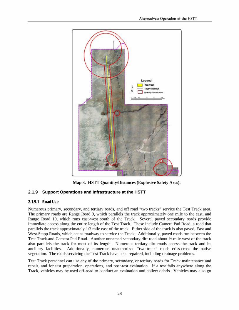
Alternatives: Operation of the HSTT
28
Map 3. HSTT Quantity/Distances (Explosive Safety Arcs).
2.1.9 Support Operations and Infrastructure at the HSTT
2.1.9.1 Road Use Numerous primary, secondary, and tertiary roads, and off road “two tracks” service the Test Track area. The primary roads are Range Road 9, which parallels the track approximately one mile to the east, and Range Road 10, which runs east-west south of the Track. Several paved secondary roads provide immediate access along the entire length of the Test Track. These include Camera Pad Road, a road that parallels the track approximately 1/3 mile east of the track. Either side of the track is also paved, East and West Stapp Roads, which act as roadway to service the Track. Additionally, paved roads run between the Test Track and Camera Pad Road. Another unnamed secondary dirt road about ½ mile west of the track also parallels the track for most of its length. Numerous tertiary dirt roads access the track and its ancillary facilities. Additionally, numerous unauthorized “two-track” roads criss-cross the native vegetation. The roads servicing the Test Track have been repaired, including drainage problems.
Test Track personnel can use any of the primary, secondary, or tertiary roads for Track maintenance and repair, and for test preparation, operations, and post-test evaluation. If a test fails anywhere along the Track, vehicles may be used off-road to conduct an evaluation and collect debris. Vehicles may also go
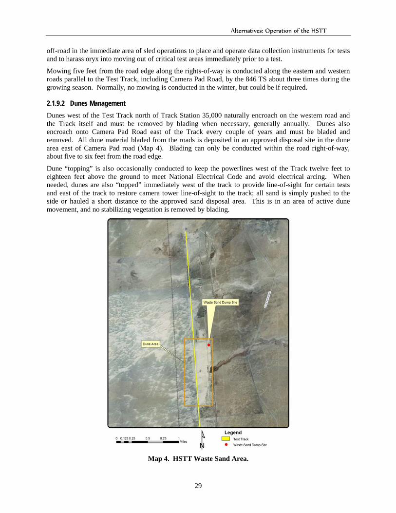
Alternatives: Operation of the HSTT
29
off-road in the immediate area of sled operations to place and operate data collection instruments for tests and to harass oryx into moving out of critical test areas immediately prior to a test.
Mowing five feet from the road edge along the rights-of-way is conducted along the eastern and western roads parallel to the Test Track, including Camera Pad Road, by the 846 TS about three times during the growing season. Normally, no mowing is conducted in the winter, but could be if required.
2.1.9.2 Dunes Management Dunes west of the Test Track north of Track Station 35,000 naturally encroach on the western road and the Track itself and must be removed by blading when necessary, generally annually. Dunes also encroach onto Camera Pad Road east of the Track every couple of years and must be bladed and removed. All dune material bladed from the roads is deposited in an approved disposal site in the dune area east of Camera Pad road (Map 4). Blading can only be conducted within the road right-of-way, about five to six feet from the road edge.
Dune “topping” is also occasionally conducted to keep the powerlines west of the Track twelve feet to eighteen feet above the ground to meet National Electrical Code and avoid electrical arcing. When needed, dunes are also “topped” immediately west of the track to provide line-of-sight for certain tests and east of the track to restore camera tower line-of-sight to the track; all sand is simply pushed to the side or hauled a short distance to the approved sand disposal area. This is in an area of active dune movement, and no stabilizing vegetation is removed by blading.
Map 4. HSTT Waste Sand Area.
Alternatives: Operation of the HSTT
30
2.1.9.3 Track Alignment and Repair The Track must be constantly realigned and repaired to ensure that it meets the precise needs of test activities. Realignment involves welders, air compressors, solvents and lubrication, paints, primers, and paint thinners. All materials are approved by the HAFB HAZMART prior to being obtained. A new rail-mounted diesel-powered multi-purpose utility cart uses high-pressure water blast to clean the rails of paint and rust, and to repaint the rails as needed for exceptionally high-speed tests. Depending on the number of exceptionally high speed rail tests, the rails would be stripped and repainted no more than twice per year, and have not needed stripping and repainting for the last two years.
2.1.9.4 Storm Water Management and Spill Plan A revised Storm Water Management Plan for HAFB was approved in January 2001. Storm water drainage along the Test Track, with the exception of the south end of the Track (which flows toward the Lost River Playa), flows by sheet flow to the adjacent desert. The isolated wetlands, no longer under the authority of the U.S. Army Corps of Engineers as “waters of the US”, are located at least 250 feet from the Track. A storm water basin is located adjacent to the south end of the Track and storm water from this area flows through a culvert to the Lost River. Runoff is permanently routed to the existing storm drain at the south end of the track for flow to the Lost River Playa.
Test Track support industrial buildings include, but are not limited to, buildings 1173, 1176, 1178, 1178A, and 1185. Activities conducted in these buildings include the fabrication and maintenance of sleds and test components (Buildings 1173 and 1178), rain simulation (Building 1176), painting (Building 1178A), and metal fabrication, heat treating, and bead blasting (Building 1185).
Two above-ground storage tanks which contain diesel fuel and gasoline, with capacities of 1,000 gallons and 2,100 gallons respectively, are located in a concrete-paved and bermed area east of Building 1180. There are two in-ground oil quench tanks used in the Heat Treatment process located in Building 1185, one holding 1,000 gallons and the other holding 700 gallons. Above-ground storage tanks at Building 1166 contain 1,034 gallons of Motor Gasoline, and 2,037 gallons of diesel fuel. A tank and trailer at the north end hold 250 gallons of diesel fuel.
Bulk outside metal storage is located west of Bldg 1185. Outside sled storage is located west of Building 1173.
The Test Track itself is not regulated under the Multi-Sector General Permit for Storm Water Discharges from Industrial activities because the tests do not meet the definition of “industrial activities” under the Clean Water Act. However, Track-related activities in the support buildings at the southern end of the Test Track do meet the definition of “industrial activities.”
49 CES/CEV has installed an automated water quality sampling system at Outfall 08, which is the main runoff diversion for the South end of the Test Track to collect runoff from test activities and precipitation events. Only two samples have been collected during the six years since installing the sampler (November 2000 and July 2001). Collected samples were analyzed for parameters required by the state of New Mexico for the 1995 Multi-Sector General Permit for Storm Water Discharges from Industrial Activities for Sector P (Motor Freight Transportation Facilities) and Sector S (Air Transportation Facilities). These parameters are Total Suspended Solids, Ammonia Nitrogen, Total Kjeldahl Nitrogen, Nitrate + Nitrate Nitrogen, Chemical Oxygen Demand, and Oil and Grease. This demonstrates that large discharges or runoff events from the Track to the Lost River are currently uncommon because of generally low precipitation levels and rarity of water-using tests. However, 49 CES/CEV does have concerns about the sensitivity of the sampling system to small runoff events. The sampling system was upgraded in 2002 to attempt to capture samples from smaller runoff events.
The only Multi-Sector General Permit Benchmark exceeded in the two samples collected was for Nitrate + Nitrate Nitrogen. Each sample had 2.0 mg/L and 4.78 Mg/L Nitrate + Nitrate Nitrogen, respectively,
Alternatives: Operation of the HSTT
31
well over the benchmark value of 0.68 mg/L. However, this value is well below the Safe Drinking Water Act Maximum Contaminant Level (MCL) of 10 mg/L, therefore meeting Federal standards for safe drinking water. It should be noted that data obtained from the USGS National Atmospheric Deposition Program indicates that ambient Nitrate + Nitrate Nitrogen was approximately 1.2 mg/L during 2000, also well above the benchmark value. Discussions with U.S. EPA storm water program personnel indicate that Nitrate + Nitrate Nitrogen levels below the Safe Drinking Water Act MCL are generally not of concern.
2.1.9.5 Hazardous Waste Management and Solid Waste Management All debris and material is cleaned up after each test and disposed of according to regulation. The HSTT, as a tenant activity on HAFB, controls its own initial accumulation points compliant with the Resource Conservation and Recovery Act (RCRA), but uses the Main Base’s 90-day accumulation point under HAFB’s Part B permit. Solid waste is included in the HAFB solid waste contract and is also sent to DRMO for reuse/recycling as appropriate.
A new 41,600 square foot facility for storing expended NIKE rocket motor casings is located adjacent to Building 1177 and is fenced and hardened with recycled asphalt. DRMO currently arranges for all NIKE rocket motor casings containing asbestos to be disposed of at a RCRA-approved treatment, storage, and disposal facility.
2.1.9.6 Underground Pipelines and Wires, and Cables Four-inch diameter underground pipelines are installed to transport helium from the ARC Building 1625 feet to the Track. In the future, hydrogen may be used for low atmospheric density high speed tests.
Permanent communications wire is buried in conduit five feet underground to transmit data to TDC which has been recently replaced. Overhead electrical lines from the La Luz substation located in the Tula Peak area run along the west side of the Track. Temporary communications wire is often run on the ground surface between test instruments and track facilities. All communication wire set aboveground is cleaned up after completion of every test, especially in the impact area at the north end of the Track. This is especially important along Camera Pad Road where the wire could get caught in grounds maintenance mowers.
Approximately three miles of fiber optic cable in conduit have been installed in trenches from the north end of the track south along the edge of Camera Pad Road and along the east Track road to access the ARC buildings for communication and test instrumentation in “real time.”
2.1.9.7 Personnel The HSTT is under constant maintenance and repair to ensure that tests can be completed successfully. Personnel needed for this maintenance include welders, sand blasters to remove old paint from rails, painters, concrete fabricators, surveyors using laser instrumentation, and heavy equipment operators, such as crane and bulldozer operators. Most activity, except for placing cameras during some tests, is conducted along the Track itself, on the roads and road rights-of-way, and at existing buildings or facilities.
2.1.9.8 BASH Management Occasionally, BASH hazards are a caused by small birds and coyotes, especially where Hay Draw crosses the Track. Small species of birds, primarily doves, often roost on the rails during the day. Currently, a small monorail sled (the birdchaser sled) is run on the opposite rail a few seconds prior to the test launch to dislodge birds. Eight to ten portable orchard cannons, fueled by propane are also fired at random intervals shortly before the test to scare birds and other animals away from the track. Some tests require
Alternatives: Operation of the HSTT
32
the still air conditions occurring at night. When possible, tests are conducted at night when birds are not in the vicinity of the Test Track. BASH events are only recorded if tests are affected.
Small herds of oryx, a non-native species of large antelope, also routinely move throughout the area, especially north and east of the Test Track. Prior to a test, trucks and personnel on foot chase any oryx out of the area between the east side of the Track and Camera Pad Road. Occasionally, sirens are used. The oryx are relatively unafraid of people, sometimes making it difficult to move them. 46 TG asks 49 CES/CEV to request a population reduction hunt by New Mexico Department of Game and Fish when Test Track personnel become concerned that oryx might begin interfering with tests. These population reduction hunts are generally conducted between November and March, although oryx determined to be a hazard can be removed by NMDGF personnel at any time of the year.
2.1.9.9 Heliport Helicopters occasionally use the heliport located in the developed area at the south end of the track to transport distinguished visitors on tour of the Track or administrative or support trades test personnel to check the status of live munitions in the north end impact area after tests.
2.2 Description of Proposed Modifications to the Current Operations of the HSTT (Proposed Action)
46 TG proposes to continue the operations of the HSTT as described under Section 2.1. However, operations would be modified with proposed new facilities, and additional best management practices and management actions as standard operating procedures identified in Chapter 4. Section 2.2 of this PEA incorporates the description of current operations and tests as described in Section 2.1 and describes additional proposed activities and facilities.
2.2.1 Description of Additional Facilities and Upgrades The following facilities and upgrades have been proposed to enhance the capabilities of the HSTT, but they have not yet been funded (Map 5).
• Additional Manufacturing Space Either Added to or In Place of Building 1178: Construct additional floor space for conducting simultaneous sheet metal manufacturing operations and consolidating the fabrication shop operations within less crowded and, therefore, safer conditions. This is proposed as a MILCON project. Machine Shop operations may also be consolidated from buildings 1173 and 1625 into this proposed action, which may make both Buildings 1178 and 1173 obsolete.
• Sled Storage Building: Construct warehouse storage facility behind the headquarters building (Building 1179) and near Building 1178 in the developed area to protect certain complex sleds from deterioration and corrosion caused by exposure to elements when not in use.
• Munitions Operations and Storage Facilities: Buildings 1148 and 1149 would be similar to Munitions Storage Buildings 1151 and 1152, and would be located north of Buildings 1151/1152, outside the Explosive Arc for Building 1151
• Evacuated Atmosphere Test Capability: Approximately 10,000 to 20,000 feet of the existing track would be covered with a large steel tube (most likely removable) in which all the air would be evacuated in order to simulate high altitude conditions for flight simulation tests.
• Additional Impact Zone: This 1000 foot radius impact zone cited for 4,000 pounds (NEW) would be located at the north end of the Test Track and would double the clear zone for the existing impact zone. The inner 500-foot radius would be scraped, the outer 500-foot ring would be mowed. Approval for this proposal is waiting for Headquarters approval.
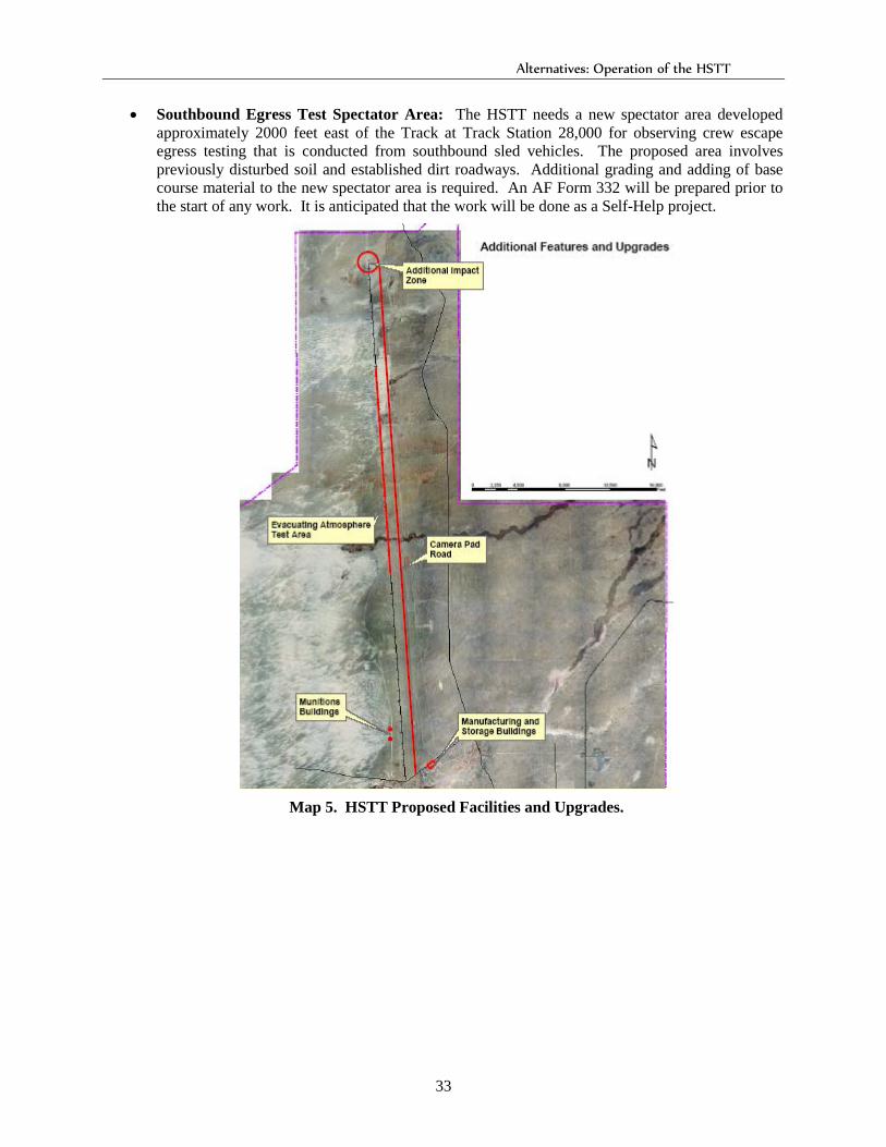
Alternatives: Operation of the HSTT
33
• Southbound Egress Test Spectator Area: The HSTT needs a new spectator area developed approximately 2000 feet east of the Track at Track Station 28,000 for observing crew escape egress testing that is conducted from southbound sled vehicles. The proposed area involves previously disturbed soil and established dirt roadways. Additional grading and adding of base course material to the new spectator area is required. An AF Form 332 will be prepared prior to the start of any work. It is anticipated that the work will be done as a Self-Help project.
Map 5. HSTT Proposed Facilities and Upgrades.
Affected Environment
34
3. Affected Environment This chapter is composed of a general description of HAFB as it relates to operations of the HSTT, summarized from the Integrated Natural Resources Management Plan, 2000, available for review at 49 CES/CEVN, 505-475-3931. The descriptions of the affected environment of the HSTT are incorporated analytically into the description of the “No Action” alternative (Section 2.1), the description of the proposed action (Section 2.2) and the descriptions of the issues (Chapter 4). This approach is intended to make the information more useful and therefore the entire document more readily understood and analytic rather than encyclopedic (40 CFR 1502.10 and 40 CFR 1500.4(b)).
3.1 Location, Natural Setting, and Surface and Ground Water Characteristics Holloman Air Force Base consists of 59,639 acres within Otero County, in southeastern New Mexico. Within its contiguous boundaries (Main Base) are 52,073 acres (Map 2).
Southeast of the contiguous portion of the base, the USAF has jurisdiction or property interests in 2,694 acres called the Boles Wells Water System Annex (BWWSA, which includes the Boles, Douglas, San Andres, Frenchy, and Escondido Wellfields), and sub-surface interests to protect and develop the underground water supply on 4,187 acres of public land withdrawn under Public Land Orders 3434 and 4667. Land surface management for these public lands lies with the Bureau of Land Management. The total acreage of the BWWSA is about 12,000 acres.
The Main Base is located on the floor of the Tularosa Basin approximately 8 miles west of Alamogordo, NM; the Wellfields Annex runs from approximately 6 to 15 miles south of Alamogordo, adjacent to the western foothills (bajada) of the Sacramento Mountains.
Geographically, Holloman Air Force Base is located near the southern end of the Tularosa Basin, which is characterized by desert plains bounded by the Sacramento Mountains on the east, the San Andres Mountains on the west, and the Oscura Mountains and Chupadera Mesa on the north. No streams or rivers exit the closed Tularosa Basin. Most of the annual 8 inches of precipitation on the Main Base falls from convectional thunderstorms during the summer monsoon season, July through September. Winters are usually dry.
The major land forms of the Main Base consist of the gypsum sand dunes on the western boundary of the base, and flat, dry, gently sloping alluvial desert plains over the remainder. The plains are dissected from east to west by at least six major intermittent streams (arroyos) with broad drainage bottoms that typically terminate at the dunefield on the western margin of the base. Lost River continues onto the White Sands National Monument. Dillard Draw terminates in a series of playa lakes located north and south of US Highway 70 at the southwestern corner of the base. Small permanent and ephemeral lakes and ponds are scattered across the basin floor and several relict dry Pleistocene lakebeds are located in and around the base. The most prominent of these is a lakebed lying just southwest of the Main Base that has been divided by a dam, forming Lake Holloman, which contains water throughout the year, and Stinky Playa, which intermittently holds water. The water source for the Lake Holloman Wetland Complex (Map 6) is treated sewage effluent from the base’s wastewater treatment facility. Enhanced wetlands (up to 170 acres), were developed between Lagoon G and Lake Holloman. The Lake Holloman wetlands complex is maintained for storage of wastewater effluent and supports a biologically diverse bird community, especially shorebirds.
Groundwater under the Main Base, which may occur at a depth as shallow as three feet below the surface at some points, is too saline for consumption, is not considered legally potable, and is not legally protected.
Several drainages within the Main Base are 100-year floodplain zones. These areas are associated with the presence of the poorly drained Mead soils, which are alluvial floodplain soils. These soils are present
Affected Environment
35
within Dillard Draw, Lagoon G, Allen, Malone and Ritas and Allen Draws, and Lost River drainages. The flood-prone areas associated with Allen, Malone and Ritas Draws, and Lost River, are within the more remote, less densely developed sections of the base.
3.2 Floral and Faunal Communities on Main Base, Including Noxious Plants Vegetative communities at Holloman Air Force Base, located within the northernmost portion of the Chihuahuan Desert Province, favor drought-resistant plant species. The lakes, lagoons, playas and wetland habitats support a greater biodiversity than that of the surrounding areas. The largely undeveloped, generally pristine, and comparatively unique areas under the jurisdiction of the National Park Service (White Sands National Monument), the US Army (White Sands Missile Range and Fort Bliss Military Reservation), the USDA Forest Service (Lincoln National Forest), and the Bureau of Land Management, combined with the largely open and undeveloped Air Force Base, provide a large expanse of intermixed habitats that include rare and undisturbed vegetative communities and associated rare wildlife and plant species.
Human use has been restricted over much of the Basin since World War II, creating a large area that is in better ecological condition than most of the remainder of New Mexico. However, use is increasing in both quantity and extent, indicating a need for more protection. Vegetation on the Main Base is predominantly Chihuahuan Desert Scrub with small areas of grassland and riparian habitats. The flats and gently undulating hills are generally covered by low, sparse bunchgrass-shrub communities. As one moves easterly from the dunes, the vegetative communities are made up of more shrubs and fewer grasses. Plant communities in and around springs, lakes, small ponds, and wet portions of arroyos are sparse and salt-tolerant. The Main Base supports a substantial population of paperspine fishhook cactus (Pediocactus papyracanthas), a federal species of concern. It was removed from the New Mexico list of endangered species because it was considered to be sufficiently abundant on DoD lands in the state and adequately protected under current military uses of the land.
The Test Track area on HAFB supports important habitat for various rare and sensitive animals, as well as more common mammals such as coyote (Canis latrans), badgers (Taxidea taxus), and desert cottontails (Sylvilagus auduboni), and blacktailed jackrabbits (Lepus californicus). Mule deer (Odocoileus hemionus) regularly occur in Carter and Malone Draws. Sensitive or protected land- and water-associated species that could be impacted by Test Track operations include western burrowing owls (Athene cunicularia hypugaea), Texas horned lizard (Phrynosoma cornutum), found mostly in sandy and gravely areas; and White Sands pupfish (Cyprinodon tularosa), found in the Lost River drainage and Malone Draw.
Four species of introduced noxious plants have been exceptionally problematic in the Tularosa Basin and on Main Base: African rue, Russian thistle, Russian knapweed, and saltcedar. Current estimates indicate over 2,800 acres of HAFB, including approximately 700 acres of disturbed roadsides, are overrun by noxious plants.
High densities of African rue have been found along all road right-of-ways across the main base, including at the HSTT. African rue is beginning to spread into undisturbed areas. It displaces native vegetation due to its aggressive root system and does not provide habitat for any native animals or insects.
Saltcedar grows in dense bands along riparian areas and draws, including in Hay Draw. Its deep aggressive root system and high transpiration rate allows saltcedar to out-compete native riparian plants and often contributes to localized water table drops. In marginal ephemeral streams, it may actually dry up the stream. Saltcedar can also increase soil salinity due to high water use.
Affected Environment
36
3.3 Installation Restoration Program HAFB began the Installation Restoration Program in 1983 when the base originally identified 43 sites. The number of sites by 1994 totaled sixty. One hundred thirteen Solid Waste Management Units (SWMUs) under the Resource Conservation and Recovery Act (RCRA) have been identified by the IRP program. These sites cover a combined area exceeding 500 acres of the installation, mostly within the industrial airfield of the main, west and north areas of the developed portion of the base.
The extent of cleanup in remediation and corrective actions depends on ultimate use of the site, with less cleanup necessary for industrial sites, and more cleanup necessary for residential or other high human uses; most IRP sites are within industrial or commercial zones. Only 25 sites have groundwater contamination; the remaining sites are soil contamination sites. Most sites with soil contamination may be reused after remediation and corrective actions are completed.
IRP Site SS39 east of the southern end of the Test Track is the SWMU near track activities. It was a missile fuel spill area and has been officially closed. The groundwater at the site is being monitored every two years for ten years for specific contaminants.
3.4 Historic and Archaeological Resources HAFB has sites representing all cultural periods in the Tularosa Basin. Resources representing Paleo-Indian (some as old as 8000 B.C.), the Archaic, Jornada branch of the Mogollon, Apache, historic Hispanic/Anglo, and military periods are present. The dimensions of known prehistoric sites are generally small but representative of the larger subsistence societies that inhabited the basin.
Inventory surveys for cultural resources have been completed on all base-administered lands, both the Main Base and Water Well Field Annex. Of the 363 sites recorded, over 150 prehistoric and historic sites are potentially eligible for listing on the National Register of Historic Places.
Most prehistoric sites are located near drainages in the northern part of the base, especially along Carter and Malone Draws (permanent water), often in sandy soils near creosotebush. The eastern fringe of the sand dunes west of the Test Track (where the chemical characteristics of the gypsum preserve hearth sites) has hearth site complexes in the dunes area which are unique natural plaster casts containing complete hearth contents. These range in size from one to three meters in diameter and range in age from 4,000 to approximately 600 years ago. In the basin area away from the dunefield, artifact scatters are ubiquitous, representing food processing and camp sites, and other residential and economic activities from all periods.
Although little is known about early historic-period activities on HAFB, historic ranching probably commenced following the settlement of nearby Tularosa in 1862. By the late 1940s, two ranches along Malone Draw and numerous wells and stock tanks are indicated on topographic maps, including Edgington Well just east of the Holloman boundary, and McNatt and Danley Ranches, currently within the base boundary. Ranching in and near the Main Base involved relatively small subsistence ranching operations with a few range cattle, some personal-use livestock, and lasted 20 to 30 years. These ranches were discontinued in the 1940s when the military acquired the land.
Since its beginning in 1941 as the Alamogordo Army Air Field and the Alamogordo Bombing and Gunnery Range, HAFB has experienced tremendous growth on the Main Base. The buildings vary from structures built during World War II to buildings currently under construction. The buildings constructed in WWII were typically wood-framed pitched-roof structures with paned windows. During the Korean War, 1950s and 60s (the Cold War period), many of the buildings were constructed of cinder block, especially housing, dorms, dining facilities and some office buildings. Buildings older than 50 years old can be considered eligible for the National Register (greater than 50 years old); newer buildings can also be considered if they exhibit exceptional historic value.

Affected Environment
37
3.5 Air Quality HAFB and the surrounding area are currently in compliance with the New Mexico State Implementation Plan (SIP) and its requirements for National Ambient Air Quality Standards (NAAQS, Clean Air Act) for all “Criteria Air Pollutants” (carbon monoxide, lead, nitrogen oxides, PM-10 particulate matter, sulfur oxides, and volatile organic compounds). This places HAFB within an “Attainment Area,” requiring no detailed analysis for new projects.
Air emissions at the base occur due to training exercises, aircraft refueling and maintenance, rocket firing activities, jet engine testing, fuel storing and distribution, aerospace ground equipment operations, corrosion control activities, emissions from aircraft and motor vehicle operations, boilers, emergency generators, and grounds maintenance equipment.
3.6 Restrictive Land Use Zones Explosive arc boundaries are determined by the Quantity Distance from areas in which explosives are stored and/or used. Larger distances are required for larger quantities and/or more highly explosive materials. At HAFB, explosive arcs are mainly concentrated in the flightline area, around the Munitions Storage Area and EOD Range, and at the EOD Disposal Site at the north end of the Test Track as well as around the Track. Planned human activity, such as office buildings, training areas, and public use areas are not allowed within permanent explosive arcs, unless the use is organic to the mission actually storing the explosives.

Environmental Consequences
38
4. Environmental Consequences This chapter:
• Describes the environmental issues associated with current and proposed operations of the HSTT
• Lists the best management practices and management actions that would become standard operating procedures with implementation of the proposed action. These management actions and best management practices will be incorporated into the HAFB current Integrated Natural Resources Management Plan (INRMP) upon approval of any FONSI for this PEA, and into the Revised INRMP upon approval of the INRMP and its associated PEA in 2007.
• Evaluates the associated impacts under the current Test Track operations (the no action alternative, Section 2.1) as compared to the current operations as modified by best management practices and management actions (the action alternative, Sections 2.2) and Chapter 4.
All of the proposed facilities described in Section 2.2 would be either additions to existing buildings located in the developed administrative area south of the Test Track or to the Track itself, or new buildings within the developed area. Although additional impacts are not expected for these proposed facilities, each facility would undergo scrutiny through AF Form 332 and AF Form 813, and the appropriate NEPA documentation prepared, as details are not available at this time. Therefore, the impacts of these proposed facilities are not included within the environmental impact analyses in this chapter.
4.1 Soil Erosion, Protection of Microbiotic Crusts, and Road Management
4.1.1 Issue Background All soils on base are easily eroded by wind and water because of the low level of organic matter integrated into the soils. The soils in the vicinity of the Test Track are more erodible because of very low soil organic matter production associated with low plant production.
HAFB has completed a long-term research project to determine sustainable disturbance levels for military activities on gypsic soils, based on the resistance of critical ecosystem functions to specific types of disturbances, including vehicle traffic, foot traffic, and horse traffic. Plots were established at three sites across the base, with each site having varying levels of gypsum content in the soil. One of the plots, called the dune margin (DM) plot is located directly west of the HSTT and has nearly 100% gypsum soil. The vegetation community at the DM study site is dominated by fourwing saltbush/gyp dropseed grass. This vegetation/soil type has a high surface density of microbiotic crusts (cryptogams).
In general, microbiotic crusts are living organisms composed of communities of free-living and lichen-associated algae, cyanobacteria, lichen, moss, fungi, and/or liverworts. Microbiotic crusts on HAFB are generally composed of lichen, algae, and cyanobacteria. These crusts provide stability to soils through consolidation of the soil surface layer, which reduces erosion and increases the availability of soil nutrients and moisture to plants. The crusts also fix nitrogen in the soil, which is important for plant growth.
Environmental Consequences
39
Data have been collected and analyzed for 1-year and 4-year post-disturbance events and 1-year post-disturbance after a double-disturbance event. The following are highlights of the results for the DM site:
Lichen cover was reduced by at least 40% 1 year after disturbance by vehicle, foot, and horse traffic (Herrick and Belnap, 2002, Sustainable Disturbance Levels for Military Training on Gypsic Soils (Phase II)).
Within four years post-disturbance, over 70% of the lichen cover that had been lost from the initial disturbance had recovered. This apparent recovery in cover, however, was offset by the lack of recovery in the ecosystem function of the microbiotic community. The study showed that nitrogen fixation potential was reduced to near zero after 1 year post-disturbance, and had a slow recovery rate thereafter. The implication is that retention of lichen cover is not necessarily correlated with the status of all the functions it performs in the microbiotic crust.
The sustainability or health of rangeland ecosystems can be described in terms of three attributes: soil and site stability, hydrologic function, and biotic integrity. These three attributes are key to maintaining the natural infrastructure capacity of HAFB ecosystems to support land management and military activities on the installation. The results of the study regarding these three attributes include:
Soil and Site Stability. The DM site appears to be relatively resistant to water erosion, probably due to high microbiotic crust cover. The lichen cover showed a relatively quick recovery of soil stability within 1 year post-disturbance. The DM site is inherently susceptible to wind erosion. Wind erosion was significantly increased at this site by all three disturbance treatments. Loss of vegetative cover ensured that soil movement remained high.
Hydrologic Function. The greatest threat to hydrologic function is vehicle traffic. Two passes of a small/lightweight jeep weighing approximately 4,000 pounds having a tire pressure of 15 psi on dry soil reduced water infiltration rates by 50%. Even after 4 years post-disturbance, infiltration rates were still 40% below that of control levels. Under more typical conditions with more vehicle passes, higher tire pressures and occasionally moist soils, the effects would be expected to be even greater and more persistent. Based on this study, vehicle traffic has a long-term, significant effect on soil structure throughout the Test Track area. Proposed rainfall simulation studies during the final phase of this project should allow us to determine whether these changes will increase runoff and reduce water availability for plant growth from reduced infiltration. The final phase will also quantify the effects of vehicle traffic on wet soils. Early indications are that vehicle traffic on moist soils is even more detrimental.
Biotic Integrity. The significant and persistent reduction in shrub cover at the DM site, particularly in response to vehicle traffic, has important implications for biotic integrity. It is correlated with reduction in foliage height diversity which provides habitat for a number of different wildlife species. The relatively slow recovery of nitrogen fixation suggests a loss of the integrity of the microbiotic crust community despite relatively rapid recovery of the crust cover.
In conclusion, the DM site had the least disturbance to start with, was the most sensitive to disturbance, and the slowest to recover of all three sites. Several factors combine to make this site particularly sensitive to all types of disturbance. The first factor is the inherently low vegetative cover and dominance of low-stature saltbush, which appears to be particularly susceptible to breakage, and recovers slowly at this site. The second factor is that the gypsic soils at this site have very low strength and are highly susceptible to compaction. Of the
Environmental Consequences
40
three types of disturbance, off-road vehicle traffic is the greatest threat to ecosystem function and stability.
4.1.2 Issue Statements Test Track-related vehicles that drive off established roads disturb the highly erodible soils and damage or destroy the microbiotic crust communities. Repeated walking on exposed soils, whether for debris collection or for placing instrumentation, including beyond the northern end of the Test Track on land within the jurisdiction of the WSMR, create similar circumstances, but the magnitude and persistence of the impacts are generally much less, unless heavy equipment is used or excavation is conducted. Any use of vehicles or other high intensity activity off of established roads and activity areas will damage the primary indicators of ecosystem health: soil and site stability, hydrological function, and biotic integrity. Long-term impacts include increased soil erosion, loss of vegetative cover, loss of water infiltration which leads to reduced ability of native vegetation to recover, and accelerating the spread of noxious and invasive plants. Additionally, blowing dust interferes with tests and test support activities such as photography.
Range Roads 9 and 10 are the main roads accessing the HSTT. Range Road 10 also accesses the White Sands Missile Range. Access to the HSTT and WSMR by people not associated with either installation must be controlled during tests and for security reasons, and to ensure that unauthorized off-road vehicle use does not occur.
4.1.3 Management Actions and Best Management Practices
• When traveling off of established roads for mission-essential activities only (including debris searches), trucks, off-road vehicles, and other vehicles will travel at low speeds (no greater than 10 mph). At low speeds, disturbance of biological soils crusts and soil erosion may be reduced. Vehicles will also use the same track in and out whenever possible.
• When soils are moist, off-road vehicle use will be conducted only for absolutely mission-essential operations. Otherwise, off-road vehicle use will be postponed until soils are dry.
• Test Track personnel, contractors, researchers, and other users shall minimize foot, vehicle, and heavy equipment travel around the track (including for debris searches on HAFB and north of the track on WSMR land) off existing (established) roads, except when mission-essential. All monitoring instrumentation and mobile launch vehicles shall be placed either on authorized roads or within 75 feet of authorized roads, unless it is mission-essential for off-road activity. Non-mission-essential traveling off-road under other circumstances, taking short cuts, and using unauthorized “two track” roads are not allowed.
• 49 CES/CEV and Test Track personnel coordinated authorized transportation routes using existing roads in the Test Track area to create the minimal roadage necessary for meeting Test Track mission. These roads include paved, gravel, and dirt roads. On some dirt roads, it may be desirable to reduce dust and protect vegetation by hardening dirt roads with recycled paving products. The only road planned for surfacing to date accesses two new proposed munitions storage buildings (Buildings 1148 and 1149). In these instances, the 46 TG will request authorization to hard-surface specific roads through 49 CES via the AF Form 332 process. Any existing dirt roads that may become necessary to surface will also be requested through 49 CES and undergo appropriate analysis.
Environmental Consequences
41
• Any proposed ground-disturbing activities and off-road vehicle use must be coordinated via an AF Form 332 to identify and avoid impacts to archaeological, historical, and sensitive natural resources.
• Any activities that would result in destruction of microbiotic soil crusts and/or loss of native vegetation should be minimized, specifically the development of new roads across previously undisturbed native vegetation. Revegetation or reseeding of disturbed areas should occur as soon after the disturbance as possible. The most appropriate seeding season is typically late June through mid-July to coincide with the start of the summer monsoon season. However, any seed mixtures will include a mix of cool and warm season plants, so that seeding may be done in the fall and winter as well as the spring and summer, as long as the seeds are incorporated into the soil. Supplemental watering may be required for the reestablishment of native vegetation. The 49 CES/CEVN will provide recommendations on specific seed mixes and other soil stabilization requirements as needed.
• In the Lost River drainage, activities must be conducted at least 100 feet away from the edge of the drainage to maintain compliance with the Interagency Cooperative Agreement for the Protection and Management of White Sands Pupfish (2006).
4.1.4 Environmental Impact Analysis
4.1.4.1 Impacts of the Current Program (No Action Alternative) Test Track-related vehicles drive off established roads alongside and at the northern end of the Test Track to set up test instruments, drive off oryx that are potentially threatening test implementation, and collect test debris. Microbiotic crusts protecting the soils surface are damaged, making the soils particularly vulnerable to wind erosion. Repeated walking in areas of undisturbed soils to set up instrumentation and collect debris also breaks up the biological soil crusts, although the impacts are less intense or persistent than those caused by vehicle traffic. Currently, systematic control of off-road vehicle and foot traffic is not exercised, and soil erosion, soil compaction, loss of biotic integrity, and the ability to restore these impacted sites is a concern.
4.1.4.2 Impacts of the Proposed Program Implementing policies that control mission-essential and prohibit non-mission-essential off-road vehicle and foot traffic, and revegetate disturbed sites immediately after disturbance would minimize damage and destruction of cryptogamic crusts, protecting the soil surface. Most test-related activities, such as instrument placement, would occur within 75 feet of roads. However, driving slowly (5 mph) beyond that distance and minimizing the number of new tracks by using the same track in and out would also minimize damage to vegetation and cryptogamic crusts. Any mission-related activities within 100 feet of the edge of drainages, such as Hay Draw, would be implemented according to the best management practices cooperatively developed by Test Track personnel and 49 CES/CEV. Otherwise, these sensitive areas would be avoided.
The potential for soil erosion would be substantially reduced with implementation of the best management practices and management actions outlined in Section 4.1.3. Therefore, the natural infrastructure sustainability of the Test Track area for long-term test use would be increased and essentially no significant adverse impacts would occur to ecosystem function and viability.
Environmental Consequences
42
4.2 Protection of Wetlands
4.2.1 Issue Background Drainages flowing across or near the Test Track are Lost River, Hay Draw, Guilez Draw, Reagan Draw, Allen Draw, and Sheep Camp Draw. The Test Track also has several unique depressional wetlands within blowouts or borrow pits and natural low areas (Table 2 and Map 6). The Test Track lies perpendicular to the east-west draws and in some cases, particularly within Hay Draw, Guilez and Allen Draws, alters the natural surface flows of these systems. Allen Draw, Hay Draw, most of Sheep Camp Draw, and the eastern portions of Guilez and Reagan Draws appear to be relict features and do not exhibit indicators of above-ground water flow. In 1996, Reagan, Allen, and Guilez Draws were delineated by the U.S. Army Corps of Engineers as “waters of the US” under the Clean Water Act (Delineations of Jurisdictional Waters of the United States and Wetlands on Holloman Air Force Base, New Mexico, Sep 96; Map 6). On January 9, 2001, The U.S. Supreme Court issued a decision in Solid Waste Agency of Northern Cook County (SWANCC) v. United States (531 U.S., 2001) finding that the Migratory Bird Rule may no longer be used as the basis of identifying jurisdictional wetlands under the Clean Water Act. The US Army Corps of Engineers (USACE) has not yet issued formal interpretation and guidance for management of isolated wetlands pursuant to this case. Because the Tularosa Basin is internally drained with no surface water connection to the ocean, all waters in the basin are to some degree “isolated.” As a practical matter, the USACE Albuquerque El Paso Regulatory Office is no longer asserting jurisdiction for small isolated wetlands in borrow pits, blowouts, and natural depressions such as those along the Test Track. This office is still asserting jurisdiction over streams that pass across Indian reservation boundaries as interstate waters, because Indian reservations are considered equivalent to states under the Clean Water Act. Since some headwater tributaries of the Lost River begin in the Mescalero Indian Reservation, the Lost River is considered to be a jurisdictional “Water of the U.S.” Isolated wetlands remain protected under Executive Order 11990, “Protection of Wetlands” and Air Force policy in AFI 32-7064.
The Lost River drainage is designated Essential Pupfish Habitat per the 2006 interagency White Sands Pupfish Cooperative Agreement.

Environmental Consequences
43
Map 6. Waters of the United States (Clean Water Act).
Table 2. Isolated Wetlands near the HSTT Delineated by the U.S. Army Corps of Engineers in 1994.
Plot No.
Location Area (ac)
Description
52 Blowout/borrow pit 100 ft. east of Track
0.39 12” to saturated soil with prevalent oxidized root channels in upper 12 inches.
53 Blowout/borrow pit east of Track and south of 52
0.45 Fed by groundwater with thick salt crust; water marks with sediment deposits.
57 Blowout/borrow pit west of Track and northwest of 53
0.50 12” to saturated soil with salt crust, saturation in upper 12 inches and sediment deposits.
58 Blowout/borrow pit west of Track and north of 57
0.44 Saturated almost to surface in upper 12 inches, with salt layer.
59 Permanently flooded excavated pool north of 53
0.44 Surface water in a 5’ diameter pond 6.6’ deep (probably excavated originally for mission purposes). This is called Camera Pad Pond and currently supports fish.
60 Vegetated flat east of Camera Pad Road
0.55 Water marks in depressional area
Environmental Consequences
44
62 3 seeps dominated by common reed west of 59
0.02 3 seeps on side of south bank of Guilez Draw with water marks, sediment deposits, and depth to saturated soil 18”.
64, 65
Vegetated flat east of Track north of 60
2.55 64: 1.5” to saturated soils, with water marks and sediment deposits, and heavy shorebird use. 65: In Reagan Draw; Soil saturated, with water marks, sediment deposits, and thick salt crust. Heavy shorebird use.
66 Vegetated flat west of Track and north of 64, 65
0.53 ½” to saturated soil, with water marks and sediment deposits and evidence of flooding. Recent signs of shorebird use.
Larger draws that are currently dry are remnants of free-running draws relict from geologic periods with more moisture. Streams may also have dried up from lower water tables caused by water diversion for municipal and agricultural purposes near La Luz, Alamogordo and Tularosa. The Lost River drainage has less agriculture than the Tularosa Creek drainage, which is where most of the agriculture in the Tularosa Basin occurs. Agriculture still uses approximately 50% of the water in the Tularosa Basin. However, these draws do provide a source of basin groundwater recharge during heavy rains. Additionally, seeps near the Test Track and Guilez and Reagan Draws still support native wetland vegetation.
Lost River Playa, which is frequently flooded, and receives flow from Lost River downstream from Ritas and Malone Draws, is located just to the south of the southern end of the HSTT. The playa fills with water after heavy rainfall, which may occur several times a year, especially during summer thunderstorms. This flooded condition typically remains for several days, with water depths of 12 inches or less. Lost River flows into the gypsum dunes to the west on the White Sands National Monument, where water flow infiltrates to groundwater.
4.2.2 Issue Statement Construction activities may either fill or change the hydrology of the remaining wetlands delineated by the U.S. Army Corps of Engineers as “waters of the US” under the Clean Water Act. All wetlands are protected by E.O. 11990, “Protection of Wetlands” and Air Force policy (AFI 32-7064). No construction activities are currently proposed for any of the wetland areas.
4.2.3 Best Management Practices and Management Actions
• Construction and military activities within and adjacent to wetlands should be avoided to the extent possible. However, all activities which would impact wetlands must be coordinated with 49 CES/CEV and appropriate protective management actions developed and implemented. Establish Best Management Practices (BMPs) to avoid construction or military activities within wetlands and floodplains adjacent to the wetlands. Any construction or activities proposed for wetlands or floodplains must be documented on an AF Form 332 with a site plan and an AF Form 813 for environmental evaluation. Any action proposed within identified jurisdictional wetlands must be coordinated with 49 CES/CEV regarding 401/404 permits under the Clean Water Act. Air Force policy (AFI 32-7064) requires avoiding wetlands and floodplains where practicable, consistent with the Executive Orders. Jurisdictional wetlands should be re-evaluated by 2008 to determine the status of isolated wetlands per current US Army Corps of Engineers and US Environmental Protection Agency policy.

Environmental Consequences
45
• Heavy equipment shall not be used in wetlands, including for clearing sand from below the powerlines on the west side of the Track, unless there is no practicable alternative, consistent with all applicable Executive Orders and Air Force policy (AFI 32-7064).
4.2.4 Environmental Impact Analysis
4.2.4.1 Impacts of the Current Program (No Action Alternative) Currently, no actions are taken that affect key wetlands, such as Camera Pad pond. However, some vehicle tracks are seen in some of the drier depressions. These apparently were made when the depressions were dry or slightly wet, not damaging the vegetation. This off-road activity compacts the soil, which increases soil erosion and reduces re-establishment of vegetation.
4.2.4.2 Impacts of the Proposed Action Ensuring systematic coordination with 49 CES/CEVN, including preparation of AF Form 332 and AF Form 813 and compliance with E.O. 11990 and 11988, regarding any mission-essential Test Track activities that could impact wetlands would minimize adverse impacts to wetlands in the Test Track area and essentially no adverse impacts would occur to wetland ecosystem function and viability.
4.3 Conservation of HAFB Potable Water
4.3.1 Issue Background HAFB owns 15 wells in the Boles Wells Water System Annex (BWWSA) and shares interest in the City of Alamogordo Bonito Lake water rights to provide the potable and non-potable water needs for all base activities. The HSTT tests requiring water for braking or water erosion evaluation use water from the general HAFB potable water budget. The water tanks at the Test Track can store 400,000 gallons at the Horizontal Test Stand and 20,000 gallons next to Blockhouse ECHO, for a total of 420,000 gallons at one time. A “worst case” for total water volume used for braking a single dual rail sled test for commonly conducted tests is 44,550 gallons (5,956 ft3), including the Crew Escape Systems (section 2.1.7.2),Dispenser System Testing (section 2.1.7.7), Guidance Testing (section 2.1.7.8), High-Gravity Testing (section 2.1.7.9), Explosive Blast Testing (section 2.1.7.13) and other miscellaneous tests (section 2.1.7.18). With five Crew Escape Tests conducted with water each year, this test uses substantially more water per year than any other test. Rain Erosion and Ballistic Rain Testing (sections 2.1.7.3 and 2.1.7.4) each use approximately 190,000 gallons (25,401 ft3) per test, although these tests are rarely if ever conducted (Table 1).
For monorail sled tests, the “worst case” is 2,561 gallons (342 cubic feet). Assuming that the maximum number of tests are conducted in a single year, including all tests that are conducted less than once per year, a “worst case” volume of water used per year would be 905,804 gallons (122,145 ft3 per year) (see Table 1, Section 2.1.7). However, the more realistic volume, not including the high-volume but seldom conducted Rain Erosion and Ballistic Rain Tests is 655,083 gallons per year (122,145 ft3).
4.3.2 Issue Statement Assuming a worst case for water use of 905,804 gallons (122,145 ft3) per year (including one test each of Rain Erosion Testing and Ballistic Rain Testing), tests using water at the Test Track may use a substantial proportion of the water budget for the entire base. Over the past five years, the annual HAFB water budget is 90 million gallons. Therefore, 905,804 gallons used by the HSTT over a year is not an excessive withdrawal from the water budget (approximately 1% of the total
Environmental Consequences
46
water budget). The average daily water budget for the base is 2 million gallons; the use of 44,550 gallons for a single test in a single day, however, is a substantial portion of the average daily water budget (2.2% of the average daily water budget). Only the HAFB golf course has a higher daily usage on HAFB, at an estimated 377,000 gallons of water three times per week for the fairways and an estimated 100,000 gallons per day on the off days, for a conservative estimate of 1 million gallons per week, or approximately 52 million gallons of water per year (6,952,400 ft3 per year, or 58% of the HAFB annual water budget). Therefore, the amount of potable water used annually at the Test Track is not a major concern for HAFB.
However, leaks in the 50-year-old water main serving the Test Track are likely wasting water as well as possibly undermining the Test Track. Leaks will be repaired when identified and funding will be sought to replace that main.
4.3.3 Best Management Practices and Management Actions
• Test Track and 846 TS personnel will adhere to all water conservation measures adopted by the 49 FW during times of drought conditions. The measure that pertains to all Test Track/Test Group facilities includes restrictive watering schedules for watering landscaping. Only in extreme emergency situations (for example, lack of potable water for human consumption) could track operations requiring potable water be affected. Any water conservation measures will be forwarded to the Environmental Coordinator(s) for the Test Track/Test Group for proper internal distribution and implementation.
• Locate and repair any leaks in the water main running parallel to the Test Track as leaks in the system are suspected and/or identified to eliminate wasted water and to protect the Test Track from being undermined.
4.3.4 Environmental Impact Analysis
4.3.4.1 Impacts of the Current Program (No Action Alternative) Worst case annual water use at the Test Track (905,804 gallons/year), compared to the total annual HAFB water budget (90 million gallons/year) is not excessive or of concern. However, use of 44,500 gallons of water for a single test, compared to the average daily use of approximately 2 million gallons/day (2% of daily use), may be a substantial contribution to daily use, especially under drought conditions. Golf course annual water use is approximately 58% of the total HAFB annual water budget, which illustrates that the HSTT water use for tests is not a major concern in the HAFB water use budget. The concern is the continuing loss of water from the leaky water system running along the track, rather than the amount used during tests.
4.3.4.2 Impacts of the Proposed Program The Test Track personnel would adhere to any drought measures required by the base during severe droughts, in relation to measures taken by other organizations as well, including the golf course and residential areas. Based on client needs for specific tests, tests may take precedence for water use. Repairing old and leaking water systems along the track may save additional water, which could be important particularly during drought conditions, while also eliminating the erosion under the track itself. However, essentially no adverse impacts would occur to ecosystem function and viability.
Environmental Consequences
47
4.4 Storm Water Management and Contamination
4.4.1 Issue Background The administrative and support facilities at the south end of the HSTT are included in the revised HAFB Storm Water Pollution Prevention Plan (January 2001) developed in compliance with the Clean Water Act. Any discharge of water to the land surface requires a one-page Notice of Intent to discharge (NOI) to land surface prior to the actual discharge that identifies the project, water quantity to be discharged, and what pollutants might be in the water (20 NMAC 6.2). The remainder of the Track area does not meet the definition of an industrial area under the Clean Water Act and is therefore not covered by the storm water permit.
Ammonium perchlorate, an oxidizer used for many years in solid rocket fuel, has been detected in very low concentrations, with low frequency, in the Lost River drainage which flows into White Sands National Monument in the vicinity of the Test Track. Perchlorate is not regulated by EPA or the State of New Mexico, but is being studied to determine if it should be regulated. The source(s) of the perchlorate at HAFB is not known, but is suspected to be from wide use and storage of solid rocket fuel and solid rocket fuel-containing rockets or missiles in the immediate areas of the Test Track and/or at the historic Missile Test Stand Area and about a half mile east of the Track administrative area. Perchlorate is a thyroid inhibitor, and the U.S. Air Force, including HAFB, is currently participating in tests in eleven areas throughout the west to determine if the chemical should be regulated under the Clean Water Act (Interim Final Scientific and Technical Report for Perchlorate Biotransport Investigation: A Study of Perchlorate Occurrence in Selected Ecosystems, AFIERA, June 2001).
Perchlorate has potentially been used in nineteen sites associated with the Test Track:
• EOD disposal area one-half mile north of Track;
• Debris field one mile east and west of the Track and one-quarter mile north of the Track;
• Test impact area at the north end of the Track;
• COCO Blockhouse (liquid and solid sled launch facility) east of the Track;
• BRAVO Blockhouse (solid propellant sled launch facility) west of the Track;
• Horizontal Test Stand east of the Track;
• Open Blast Area west of the Track;
• DOG Blockhouse (solid propellant sled launch facility);
• ALPHA Blockhouse (liquid and solid sled launch facility);
• Former expended rocket storage area ¼ mile south and west of the Track;
• Live rocket motor and igniter storage area Building 1151 west of the Track;
• Built-up live sled holding area Building 1177 west of the Track;
• Live rocket motor maintenance facility Building 1169 west of the Track;
• Live igniter holding facility Building 1640 west of the Track;
• Live sled build-up and stripping facility Building 1168 southwest of the Track;
• Ballistic Rainfield explosive fuze testing facility west of the Track;
Environmental Consequences
48
• Facility for build-up of customer explosive items Building 924 5 miles south of the Track;
• Alternative live rocket motor stripping facility Building 1194 5 miles east of the Track;
• Ejection seat and egress system build-up facility Building 1170 east of the Track.
Several sampling efforts have been conducted on HAFB. In 1998, the National Park Service (White Sands National Monument) and the U.S. Geologic Survey sampled storm water runoff within the Lost River channel west of the playa, and detected perchlorate in surface waters entering the Monument. The surface water could have originated anywhere within the Lost River/Malone Draw/La Luz Creek watershed, but it likely originated from the Test Track area on HAFB. These sample results have not been confirmed, and subsequent samples taken from likely source areas on base have not shown high levels of perchlorate. Since that original sampling, the Air Force has conducted three sampling efforts:
1. Sampling in September 1999 from IRP groundwater monitoring wells located east of the southern end of the Test Track (IRP site #39) used modified EPA Method 300.0 sampling protocol. Low levels of perchlorate were detected. In what was thought to be a well upgradient from the suspected source of the Test Track, an historic missile launching area located east of the industrial area at the south end of the HSTT may also have been a perchlorate source. Perchlorate was not detected in two downstream samples of the Lost River surface water.
2. Modified EPA Method 300.0 was also used to analyze solid rocket fuel residue from NIKE rocket motors in February 2000. No perchlorate was detected, and QA/QC was performed. Test Track personnel later indicated that the solid rocket fuel in NIKE motors does not contain perchlorate.
3. In October 2000, the Air Force Institute for Environment, Safety, and Occupational Health Risk (AFIERA) at Brooks AFB, TX, conducted sampling at HAFB (as well as five other sites across the United States with known sources of perchlorate) in support of the EPA’s Interagency Perchlorate Steering Committee. Various media were sampled at six different sites near the Test Track and along the Lost River, including sediment, soil, terrestrial vegetation and animals, and fish from the Lost River. EPA Method 314.0 was used at HAFB, which better controls analytical interference caused by high total dissolved solids, typical of conditions at HAFB. Perchlorate was not found at a high frequency at HAFB, which precluded the ability to describe locations as containing relatively higher or lower perchlorate levels. Perchlorate was, however, present at detectable levels in terrestrial vegetation, but absent in all other biological media, suggesting that terrestrial vegetation may be especially prone to absorbing perchlorate from the environment. Perchlorate was not detected above laboratory levels in fish, aquatic vegetation, pore water, surface water, terrestrial reptile, terrestrial bird, or terrestrial mammal samples collected at HAFB (Interim Final Scientific and Technical Report for Perchlorate Biotransport Investigation: A Study of Perchlorate Occurrence in Selected Ecosystems, AFIERA, June 2001).
4. In summary, extremely low levels of perchlorate were detected in terrestrial vegetation at some sampling locations at the Test Track by AFIERA. Also, HAFB had the lowest frequency of occurrence and lowest concentration of perchlorate of the six installations sampled.
Environmental Consequences
49
Since perchlorate is not a regulated contaminant, no funds are available to HAFB specifically for perchlorate sampling or cleanup, as funds to investigate perchlorate are currently provided only to Air Force-wide organizations.
The HAFB Storm Water Pollution Prevention Management Plan provides best management practices for storm water management, including requiring standard administrative procedures involving good housekeeping practices, effective material, equipment and waste management practices, preventive maintenance, spill prevention and response, visual inspections, personnel training, and appropriate documentation and recordkeeping. Standard operating procedures include on-site sediment and soil erosion control and management of storm water runoff. All exposed metal, which is stored outside, is stored above-ground on pallets, wood blocks, or racks as required by the plan. The primary areas currently in use are the sled storage yard, the Expanded Rocket Storage Facility next to Building 1177, and the metals storage yard near Building 1173.
4.4.2 Issue Statement Water discharged from the braking system in the regulated south end of the Test Track tends to flow southerly toward and into the Lost River playa, and the water discharged from other areas along the track and the rainfields area is discharged onto the ground, where it either infiltrates the soil or evaporates. This water may contain chemical pollutants from tests. However, storm water sampling conducted in 2000 and 2001 found no harmful levels of chemical pollutants. In addition, HAFB had the lowest level of perchlorate levels of the six installations sampled.
4.4.3 Best Management Practices and Management Actions
• HAFB and 46 TG will continue to cooperate with the Interagency Perchlorate Steering Committee sampling efforts, and will implement appropriate recommendations made for HAFB.
• Unless monitoring indicates otherwise, water discharged after tests will not require treatment before discharge.
4.4.4 Environmental Impact Analysis
4.4.4.1 Impacts of the Current Program (No Action Alternative) HAFB is implementing the HAFB Storm Water Management Plan, including those best management practices and administrative procedures required for the south end of the Test Track. The Plan does not cover water released after tests north of the administrative areas, nor water used for dust abatement activities. Most of this water either percolates into the soil or evaporates, and some runs off over the soil surface. This water is not known to be contaminated. Extremely low levels of perchlorate were detected in terrestrial vegetation at some sampling locations at the Test Track by AFIERA for the EPA Interagency Steering Committee. However, HAFB had the lowest frequency of occurrence and lowest concentration of perchlorate of the six installations sampled. Additionally, previous water sampling indicated no harmful levels of pollutants.
4.4.4.2 Impacts of the Proposed Program As stated above, HAFB continues to implement the 2001 Storm Water Management Plan to minimize the introduction of contaminants into the surface and groundwater system, which drains into pupfish habitat in the Lost River drainage. Previous sampling found water quality to be acceptable. Insufficient information is available regarding potential contamination of White Sands pupfish habitat with perchlorate to raise concern with the White Sands Pupfish Interagency

Environmental Consequences
50
Working Group. Therefore, essentially no adverse impacts would occur to ecosystem function and viability.
4.5 White Sands Pupfish
4.5.1 Issue Background The White Sands pupfish (Cyprinodon tularosa) is endemic to the Tularosa Basin. The species was introduced from Salt Creek on WSMR into the Lost River Playa and its sources in Malone and Ritas Draws (Map 7). This fish inhabits clear, shallow, strongly alkaline pools and streams with fine mud-silt and sand bottoms. When abundant rainfall causes water flow, many small pools are created for the pupfish along the length of the Lost River drainage system. During periods of drought, pools below the confluence of Malone and Ritas Draws, pools below the Range Road 9-Lost River crossing, and the two pools at the terminus of Lost River are known to support pupfish. Currently, the White Sands Pupfish Conservation Team considers the HAFB pupfish population to be stable. On HAFB, the Lost River population is distributed in three stream segments:
• the Malone-Ritas Draw segment above Range Road 9,
• the entrenched segment between Range Road 9 and the Lost River Playa, and
• the dunes segment downstream from the playa causeway. Prior to 1978, the causeway crossing Lost River was breached by Test Track personnel, inadvertently introducing pupfish into White Sands National Monument.
The White Sands pupfish is classified by the state of New Mexico as threatened, which means that the species’ prospects of survival or recruitment in the state are likely to be in jeopardy within the near future. Its management is under the jurisdiction of the New Mexico Department of Game and Fish. The US Fish and Wildlife Service has categorized it as a species of concern (formerly a Federal Category 2 species). It has no legal protection under the Endangered Species Act, but it could be listed under the Act if the species fails to be managed properly under the Cooperative Agreement (2006) approved by the New Mexico Department of Game and Fish, U.S. Fish and Wildlife Service, HAFB, White Sands Missile Range, and White Sands National Monument. All locations with pupfish are managed under the 2006 Cooperative Agreement, including the RATSCAT area.
Under the 2006 Cooperative Agreement, HAFB has agreed to and continues to:
• Continue participation on the White Sands Pupfish Conservation Team to review activities that might affect the pupfish or its habitat, make recommendations and provide advice and information to the Team, and meet at least annually to discuss pertinent concerns.
• Provide logistical and financial resources necessary to carry out the responsibilities identified in the Cooperative Agreement, to at least, subject to the availability of funds, provide personnel and equipment to semi-annually monitor habitats and populations of pupfish and exchange manpower, equipment, and funds to carry out other activities under the Agreement.
• Protect, manage, and enhance habitats of White Sands pupfish within Essential Habitat and Limited Use Areas on HAFB, in coordination with signatory agencies.
• Restrict all non-emergency activities, including vehicular traffic, within Essential Habitat with the exception of use of existing improved and unimproved roads, and for management, conservation or research of natural and cultural resources (to include but
Environmental Consequences
51
not be limited to pupfish monitoring, research, and conservation activities). Any such restricted non-emergency activities can only occur with consultation with the responsible WHMR, HAFB, or WSNM official consulted.
• In the case of emergency activities that may affect habitats of White Sands pupfish, such as chemical spills, debris recovery from military activities, or carrion removal, notify and confer with NMDGF and USFWS, as appropriate. Implement, review, and update as necessary, incident response programs for accidental chemical spills, impacts from airborne debris, vehicle accidents, etc. and coordinate the resolution of any unforeseen perturbation to the White Sands pupfish or its habitats with signatory agencies immediately upon detection or advisement of such event(s).
All unauthorized off-road vehicle use has been eliminated from the Lost River and Ritas and Malone Draws to eliminate sediment sources due to erosion.

Environmental Consequences
52
Map 7. HAFB White Sands Pupfish Essential Habitat located in Lost River, Malone Draw,
Ritas Draw marked in tan.
4.5.2 Issue Statement Test Track runoff water, as well as storm water runoff from the HSTT industrial area enters Essential Habitat for the White Sands pupfish in the Lost River drainage and may possibly contribute to soil erosion, although sedimentation within Essential Pupfish Habitat is not known to be a problem, especially with the elimination of unauthorized off-road vehicle use. Sampling of storm water runoff from the Test Track area into the Lost River drainage was conducted in 2000 and 2001. No biological or chemical contaminants were found to be at harmful levels at that time and only visual monitoring has been conducted since.
4.5.3 Best Management Practices and Management Actions
• No man-caused water removal from Camera Pad Pond, into which pupfish from the experimental population have been relocated, will be allowed.
Environmental Consequences
53
4.5.4 Environmental Impact Analysis
4.5.4.1 Impacts of the Current Program (No Action Alternative) Currently, no contamination of White Sands pupfish habitat in the Lost River drainage is known based on previous storm water runoff sampling. Since unauthorized off-road vehicle use has been prohibited in the Lost River drainage and Ritas and Malone Draws, sediment levels have been reduced, having no impact on White Sands pupfish.
4.5.4.2 Impacts of the Proposed Action HAFB continues to implement the 2001 Storm Water Management Plan to minimize the introduction of contaminants into surface and groundwater system. These actions also minimize the potential for any adverse impacts to White Sands pupfish in the Lost River drainage including near the Test Track. Insufficient information is available regarding potential contamination of pupfish habitat in the Lost River drainage by perchlorate; however, of the six installations sampled, HAFB had the lowest frequency of occurrence and lowest mean concentration of perchlorate. No other water contamination problems are known. HAFB continues to cooperate with the White Sands Pupfish Interagency Team for managing and protecting the White Sands pupfish. Therefore, essentially no adverse impacts would occur to ecosystem function and viability.
4.6 Western Burrowing Owls
4.6.1 Issue Background In much of their range, burrowing owls (Athene cunicularia hypugaea) are considered threatened by human alteration of their habitat. Although most burrowing owl populations in New Mexico are viable, these populations are considered a high conservation priority because of range-wide population decreases throughout the western United States. Burrowing owls are a Federal species of concern under the Endangered Species Act and the species is considered a sensitive species on HAFB. The species is also protected under the Migratory Bird Treaty Act. New Mexico is ranked as the second most important over-wintering area in the western United States.
Burrowing Owls typically use burrows constructed by other animals such as badger, fox, ground squirrels, and prairie dogs. At HAFB, burrowing owls primarily use badger and fox burrows located in relatively arid gyp dropseed/alkali sacaton grassland habitat, as prairie dogs are not present. The burrows are typically surrounded by bare ground and short vegetation, which offer excellent horizontal visibility, with elevated perches nearby.
On HAFB, highest densities of burrowing owls occur near the HSTT, especially within the ejection area on both sides of the track between blockhouses BRAVO and DOG (Map 8), with some scattered burrows near the airfield. Surveys conducted during the spring and summer of 1996-1997 reported a minimum of 42 fledglings from 32 nests. However, since that time, a survey conducted between 2000 and 2002 by Hawks Aloft, Inc. for HAFB, found that burrowing owl populations on HAFB have declined by 89% (Borgmann, K., G. Garber, and C. Finley. 2003. Status of burrowing owls (Athene cunicularia hypugaea) on Holloman Air Force Base 2000-2002. Hawks aloft, Inc., Albuquerque, NM. 61 pp.).
To attempt to reverse this trend, thirty-nine artificial burrows were constructed in the vicinity of the HSTT – nine were installed along Camera Pad Road, 24 along the track itself, and 6 at the northwest end of the Track (Map 8). The burrows were installed in clusters of three to mimic a natural burrow system that would be used by a pair of owls and newly-fledged young. This program serves two objectives: 1) Constructed burrows were located further away from heavily
Environmental Consequences
54
used roads and the Test Track to reduce adverse impacts from human activity and track tests, and 2) The artificial burrows will provide permanent burrows where natural burrows are lacking.
During the 2000 breeding season, only two nest burrows were occupied, and two young were produced from one of the burrows. In 2001, only one burrow, located adjacent to Camera Pad Road, was occupied, and four young were produced. In 2002, three pairs of burrowing owls were observed near the airfield using both natural and artificial nests and fledged five young. Also in 2002, a pair near the Test Track fledged four young using both natural and artificial nest burrows. Between 2000 and 2002, a total of 20 young were fledged. Additionally, one single owl was present near the airfield for most of the breeding season. Based on the 2000-2002 surveys compared to the 1996-1997 surveys, the average number of young produced per pair increased from less than 1 in 1996 to 3 in 2002. Additionally, the success rate per year increased from 38% in 1996 to 100% in 2001 and 2002. However, the number of active nests declined by 81% since the 1996 surveys and the number of fledglings decreased by 52%. It appears that the decline in burrowing owls on HAFB may be due to a reduction in burrowing mammals such as badgers and a subsequent decline in suitable burrows. Also, 42% of the natural burrows were damaged or unsuitable in 2000. Over 40% of the artificial burrows were used by other mammals, and additional artificial burrows may be needed. Other factors possibly contributing to burrowing owl decline on HAFB could be habitat fragmentation, habitat destruction, drought, predation, and reduced prey (although abundant mammal prey was observed during the surveys). During the survey period, Test Track missions did not result in any new roads or other activities that fragmented any habitat in the area.
No burrowing owls were found on base during 2003 and 2004. In 2005, one pair returned to the Test Track area and fledged 5 young and a solitary male was observed. In 2006, a total of 11 adult burrowing owl pairs nested on the Main Base, with 10 pair monitored (one pair nested in a restricted access area of the airfield and could not be monitored). Six pairs were documented in the Test Track area and 4 pairs were observed in the ditch on the east side of the Test Track area outside the boundary fence. Of the 10 monitored pairs, 5 pairs successfully fledged 13 young, resulting in an average of 2.6 chicks per breeding pair for the population that did breed or 1.18 per pair of the total number of pairs documented ((Mershon, M. and V. Bailey. 2006. Population dynamics of breeding burrowing owls on Holloman Air Force Base: Interim summary report. Envirological Services, Inc., Albuquerque, NM. 24 pp.; Table 3).
In 2006, breeding was not successful or observed at 6 of the original 11 nests: two burrows were abandoned for unknown reasons, a third had signs of predation and an adult flushed from the burrow when approached, and a fourth pair may have shifted to another burrow for breeding. In June 2006, 3 pairs of owls were observed in the ditch east of Camera Pad Road outside the boundary fence; however, by July two of the three pairs had left the area. Late in July, another pair was found in the ditch south of the original location, but had disappeared by August. Only 1 pair of the pairs in the ditch successfully reproduced (Mershon and Bailey 2006; Table 3).
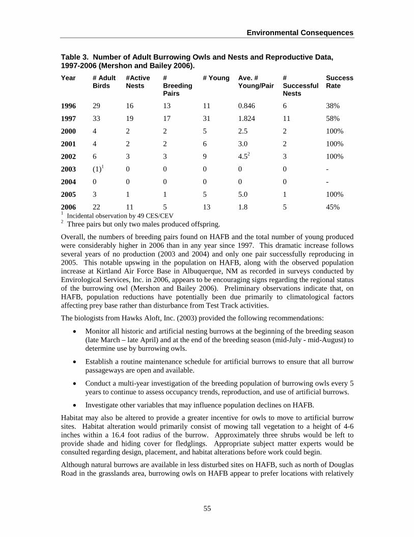
Environmental Consequences
55
Table 3. Number of Adult Burrowing Owls and Nests and Reproductive Data, 1997-2006 (Mershon and Bailey 2006). Year # Adult
Birds #Active Nests
# Breeding Pairs
# Young Ave. # Young/Pair
# Successful Nests
Success Rate
1996 29 16 13 11 0.846 6 38%
1997 33 19 17 31 1.824 11 58%
2000 4 2 2 5 2.5 2 100%
2001 4 2 2 6 3.0 2 100%
2002 6 3 3 9 4.52 3 100%
2003 (1)1 0 0 0 0 0 -
2004 0 0 0 0 0 0 -
2005 3 1 1 5 5.0 1 100%
2006 22 11 5 13 1.8 5 45% 1 Incidental observation by 49 CES/CEV 2 Three pairs but only two males produced offspring.
Overall, the numbers of breeding pairs found on HAFB and the total number of young produced were considerably higher in 2006 than in any year since 1997. This dramatic increase follows several years of no production (2003 and 2004) and only one pair successfully reproducing in 2005. This notable upswing in the population on HAFB, along with the observed population increase at Kirtland Air Force Base in Albuquerque, NM as recorded in surveys conducted by Envirological Services, Inc. in 2006, appears to be encouraging signs regarding the regional status of the burrowing owl (Mershon and Bailey 2006). Preliminary observations indicate that, on HAFB, population reductions have potentially been due primarily to climatological factors affecting prey base rather than disturbance from Test Track activities.
The biologists from Hawks Aloft, Inc. (2003) provided the following recommendations:
• Monitor all historic and artificial nesting burrows at the beginning of the breeding season (late March – late April) and at the end of the breeding season (mid-July - mid-August) to determine use by burrowing owls.
• Establish a routine maintenance schedule for artificial burrows to ensure that all burrow passageways are open and available.
• Conduct a multi-year investigation of the breeding population of burrowing owls every 5 years to continue to assess occupancy trends, reproduction, and use of artificial burrows.
• Investigate other variables that may influence population declines on HAFB.
Habitat may also be altered to provide a greater incentive for owls to move to artificial burrow sites. Habitat alteration would primarily consist of mowing tall vegetation to a height of 4-6 inches within a 16.4 foot radius of the burrow. Approximately three shrubs would be left to provide shade and hiding cover for fledglings. Appropriate subject matter experts would be consulted regarding design, placement, and habitat alterations before work could begin.
Although natural burrows are available in less disturbed sites on HAFB, such as north of Douglas Road in the grasslands area, burrowing owls on HAFB appear to prefer locations with relatively
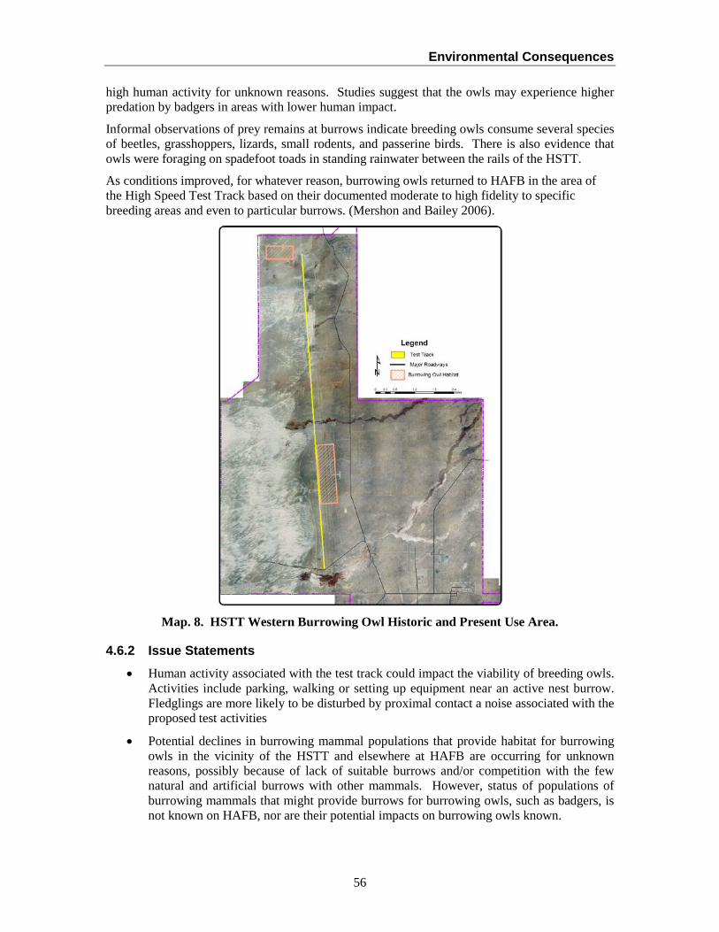
Environmental Consequences
56
high human activity for unknown reasons. Studies suggest that the owls may experience higher predation by badgers in areas with lower human impact.
Informal observations of prey remains at burrows indicate breeding owls consume several species of beetles, grasshoppers, lizards, small rodents, and passerine birds. There is also evidence that owls were foraging on spadefoot toads in standing rainwater between the rails of the HSTT.
As conditions improved, for whatever reason, burrowing owls returned to HAFB in the area of the High Speed Test Track based on their documented moderate to high fidelity to specific breeding areas and even to particular burrows. (Mershon and Bailey 2006).
Map. 8. HSTT Western Burrowing Owl Historic and Present Use Area.
4.6.2 Issue Statements • Human activity associated with the test track could impact the viability of breeding owls.
Activities include parking, walking or setting up equipment near an active nest burrow. Fledglings are more likely to be disturbed by proximal contact a noise associated with the proposed test activities
• Potential declines in burrowing mammal populations that provide habitat for burrowing owls in the vicinity of the HSTT and elsewhere at HAFB are occurring for unknown reasons, possibly because of lack of suitable burrows and/or competition with the few natural and artificial burrows with other mammals. However, status of populations of burrowing mammals that might provide burrows for burrowing owls, such as badgers, is not known on HAFB, nor are their potential impacts on burrowing owls known.
Environmental Consequences
57
4.6.3 Best Management Practices and Management Actions • Artificial burrows, set back from the road in the right-of-way, have been created and
maintained annually between November and March along DeZonia Road, Vandergrift Road, Taxiway Alpha, along the Test Track and on Camera Pad Road for burrowing owls. Even though burrowing owls are present in substantially lower numbers on HAFB than in 2000, the population increased in 2006 and the artificial burrows will continue to be maintained.
• 49 CES/CEVN will continue to survey all areas of known burrowing owl burrows linked to mission activities at the airfield and the artificial burrows for activity every year during the breeding season (mid-March through mid-July), and breeding/fledging success every three years, if burrowing owls are found. Signs marking artificial burrows will be maintained.
• Any permits needed from the U.S. Fish and Wildlife Service or New Mexico Department of Game and Fish to cover “incidental take, relocation, or banding” will be the responsibility of 49 CES/CEVN and/or any designated contractor.
• 49 CES/CEVN will continue to incorporate educational materials regarding burrowing owl management into natural resources brochures, cards, and handouts.
• Research should continue to focus on monitoring western burrowing owl populations and protecting their nesting and wintering burrows from disturbance. Four principal research and monitoring directions discussed in Mehlhop et al. (1998) include:
o Population trend and breeding success
o Predator impact
o Owl diet and foraging efficiency
o Effect of human activity on owl reproductive success
o Owl activity and seasonal patterns
4.6.4 Environmental Impact Analysis
4.6.4.1 Impacts of the Current Program (No Action Alternative) Burrowing owls are located in areas of high Test Track activity, including in areas used by Test Track technicians on foot and in vehicles to set up test instrumentation. It is unclear why populations are declining on HAFB, including near the Test Track, but Test Track activities do not appear to contribute to such declines. Continuing monitoring past and current nesting sites and maintaining selected artificial burrow sites will continue burrowing owl sustainability on HAFB.
4.6.4.2 Impacts of the Proposed Program Surveys conducted to determine burrowing owl and burrowing mammal population trends and implementing a system of reporting burrowing owl activity have identified trends with burrowing owl populations on HAFB and within the Test Track area. Trapping burrowing mammals that provide burrows for burrowing owls is prohibited on HAFB. Increasing communication between Test Track personnel/management and 49 CES/CEVN substantially improves identification and response to burrowing owl management concerns as they arise. Prohibiting the use of pesticides and herbicides, including phosphene gas, in burrowing owl nesting and foraging areas during the

Environmental Consequences
58
breeding season protects owl prey. Therefore, essentially no adverse impacts would occur to burrowing owl ecosystem function and viability.
4.7 BASH (Test Sled-Wildlife Collisions) and Oryx Management
4.7.1 Issue Background The oryx is an African antelope brought from the Kalahari Desert and introduced onto White Sands Missile Range as a game animal between 1969 and 1973. Oryx are highly adapted to desert life: they eat desert grasses, yucca, buffalo gourds, mesquite bean pods, and tumbleweeds, can tolerate extremely high temperatures, and can obtain most water necessary for survival from the plants that they eat. Resident animals on HAFB number between 24 and 36 animals. Additionally, another 80 to 100 animals regularly move through the Test Track area. Reproduction averages a little over one calf per cow per year, which indicates a healthy growing population on HAFB.
Oryx access to the base from White Sands National Monument is controlled through an existing fence near the western boundary. The fence was specifically designed by the National Park Service to prevent oryx from gaining access to the Monument. HAFB granted an easement to the White Sands National Monument to extend their oryx control fence across Lost River basin in the spring of 1995. This fence also effectively controls vehicle access into the sand dunes area southwest of the Test Track.
Oryx tend to concentrate in the northern shrublands area and the “Ballistic Rainfields” where Hay Draw crosses the Test Track (Map 2). Oryx wandering near the Track are considered a hazard to operation and are chased off by personnel in trucks and on foot prior to tests. Periodic population reduction hunts managed by the NMDGF have been conducted on WSMR since 1974, with no hunting fees charged to date by HAFB. Approximately 30-35 oryx were removed during the population reduction hunts conducted in 2004 and 2005. Generally, 12 to 20 oryx are harvested during each population reduction hunt. However, a single animal may occasionally be removed in emergency situations. When oryx begin interfering with tests at the Test Track, Test Track personnel cooperating with 49 CES/CEVN, work with New Mexico Department of Game and Fish to conduct a depredation hunt.
Occasionally, water contained for test sled braking held in the concrete trough between the track rails attracts wildlife. Also, water accumulation in the trough after a rain event can remain up to 24 hours. This available water is valuable to wildlife.
The wooded habitat in the Ballistic Rainfield in Hay Draw attracts oryx and deer, as well as smaller mammals such as coyotes and foxes, which also potentially create BASH problems with test vehicles, although no problems generally occur. Test Track personnel do not keep a log of strikes except as part of data collection for tests, since strikes are seldom a problem because tests are often conducted at night when animals are not as active in Test Track area. In addition, orchard cannons and a “bird-chaser” sled are used to harass animals away from the track during daytime tests. Any oryx in the area that might interfere with tests are chased away prior to the test.
HQ AFSC/SEFW (USAF BASH Team) conducted a site visit in September 2001 to assess the BASH problems and issues at the Test Track. Recommended management practices included recording presence of animals on or near the track and strikes and identifying potential problem areas. At this time, management practices and oryx population reduction hunts have effectively reduced strikes below mission concern and fencing oryx from the track is not needed.
Environmental Consequences
59
4.7.2 Issue Statement Oryx, birds and mammals are hazards to sleds. It is estimated that, on the average, one bird is struck per 100 test shots. The test sled has also struck coyotes. Whenever possible, tests are conducted at night when birds are roosting away from the track. A collision can break components and derail sleds at high speeds. Time and resources must be spent to chase wildlife away from and off the track prior to tests, especially tests conducted during the day. The riparian vegetation community in Hay Draw creates suitable habitat for many wildlife species, including oryx, which can interfere with tests. The project treating saltcedar wildlife habitat in Hay Draw, initiated in September 2006, may assist in minimizing risk of strikes.
4.7.3 Best Management Practices and Management Actions: • 49 CES/CEVN, Test Track personnel, and New Mexico Game and Fish Department
continue to coordinate to develop threshold levels for requesting oryx population reduction hunts. When these levels or conditions are reached, 49 CES/CEVN and Test Track personnel will coordinate hunts with NMDGF and hunter access will be coordinated with 49 SFS.
• The Test Group representative on the BASH Working Group will work with 49 FW/SEF to modify existing forms to accommodate reporting BASH incidents at the HSTT, and to develop procedures for submitting feather and fur remains for identification. Forms would include information such as date, time, species, problem, or damage caused.
• Use of noisemakers for harassing birds away from the Track prior to tests should follow approved guidelines and Test Track personnel will be trained in the operation of such equipment.
4.7.4 Environmental Impact Analysis
4.7.4.1 Impacts of the Current Program (No Action Alternative) The small monorail sled is run on the opposite rail a few seconds prior to a test to dislodge birds and scare small mammals away. Using portable orchard cannons and conducting tests at night whenever possible also minimize BASH concerns. Oryx, which are relatively unafraid of people on HAFB, observed grazing in the vicinity of the Test Track prior to a test are harassed away from the track using trucks and on foot. This harassment is sometimes difficult, requires substantial manpower and time, and could contribute to soil erosion by damaging cryptogamic crusts (see Section 4.1). As oryx become a consistent problem, 46 TG, in cooperation with 49 CES/CEVN requests a population reduction hunt. The vegetation at Hay Draw also attracts birds, small mammals and oryx to the Test Track area.
Currently, BASH incidents are not systematically recorded as such, although Test Group personnel are represented on the HAFB BASH working group.
4.7.4.2 Impacts of the Proposed Action Keeping records of BASH events, including time of day, species, and location, will assist in focusing BASH efforts in effective ways. Ensuring that Test Track personnel are trained in the use of harassment methods will minimize unnecessary adverse impacts to wildlife individuals and populations at the Track. Controlling saltcedar could minimize wildlife access to the Track, minimizing BASH concerns in that area. In general, the standard operating procedures used by Test Track personnel to avoid BASH problems are effective.
Environmental Consequences
60
4.8 Pest and Bat Management
4.8.1 Issue Background 49 CES/CEOUE removes offending animals, such as but not limited to coyotes, bats, and snakes, from areas on HAFB, including the HSTT, only when absolutely necessary and when requested by mission personnel. No current predator control programs are implemented at HAFB; if coyotes become a problem, either 49 CES/CEOUE live trap offending animals, or USDA APHIS Wildlife Services or New Mexico Department of Game and Fish would be consulted for corrective measures.
49 CES/CEOUE personnel live-trap animals (predominantly snakes and skunks) when requested and release them in isolated release sites on the base.
Rattlesnakes, which are especially common near the Test Track during the fall prior to hibernation, are captured by Environmental Controls personnel when requested and released alive in isolated areas on base in suitable habitat. No animals are marked before release to determine if they return. Security Police (49 SFS) can also shoot or trap stray animals when requested by Environmental Controls, especially if the animal has bitten a person. Generally, however, 49 SFS calls animal control personnel in Alamogordo to assist capture and detain problem animals.
Bat foraging sites and maternity colonies are located within the Test Track area. The small pond at the mouth of Guilez Draw (Camera Pad Pond) is a known foraging site for the pallid bat (Antrozous pallidus) and hoary bat (Lasiurus cinereus). Townsend’s big-eared bats (Plecotus townsendii) were also mist-netted over Camera Pad Pond in June, 1999. West of the Test Track, pallid and other bat species occupy Building 1162. Roosting colonies of Brasilian free-tail bats (Tadarida brasiliensis) also occur in Building 1174, which is a large hanger-like building. Brasilian free-tail bats and pallid bats roost in the fascia of Building 1183; the primary concern there is guano in the air intake.
Building 1169 at the Test Track has historically had a large maternity colony of pallid bats in an unused area of the warehouse, which created large volumes of bat guano. Bats are also commonly found in other buildings at the Test Track, especially blockhouses BRAVO, COCO, and DOG. These blockhouse colonies are not causing any concerns.
The major threats to bats on HAFB are pesticides and disturbance within buildings during hibernation and gestation and nursing of young, two sensitive periods during the bat life cycle. Direct and indirect exposure to pesticides, such as when bats consume insects containing pesticides, can lead to mortality. Entering buildings occupied by gestating, nursing, or hibernating bats can create enough noise disturbance to arouse the animals, causing them to expend critical energy reserves.
4.8.2 Issue Statements
• Rattlesnakes can be commonly found in areas of the Test Track with high personnel activity, creating a potential hazard. Consequences of collecting reptiles such as rattlesnakes, turtles, and tortoises may involve prosecution by state or Federal agencies, a general loss of biodiversity, disrupting the biological balance by increasing rodent populations, increasing the potential for hanta virus, and causing adverse publicity and loss of integrity for HAFB.
• Bats roost in Blockhouses BRAVO and DOG. The largest known maternity colony of pallid bats on base is located in Building 1169. Although not currently a problem, it is possible that at some future times bats could interfere with mission. These buildings also
Environmental Consequences
61
provide high quality habitat for high densities of bats on base, and Test Track operations could adversely affect the quality of bat habitat and viability of bat populations.
4.8.3 Management Actions and Best Management Practices • 49 CES/CEOUE will be called for assistance in capturing live snakes for relocation.
Snakes may not be otherwise captured, traded, sold or otherwise removed from base. 49 CES/CEOUE is equipped to handle any snake considered a nuisance or threat. Personnel operating in areas where snake encounters regularly occur shall wear protective apparel such as high top boots, snake chaps, or leggings and shall not kill or harm snakes.
• 49 CES/CEOUE and 49 CES/CEVN will ensure an annual joint briefing with appropriate speakers to Test Track personnel who regularly encounter snakes. Briefings will cover such topics as basic snake ecology, snake avoidance and handling techniques, and treatment of snakebite.
• Test Track personnel will call 49 CES/CEOUE to live-trap and relocate any problem animals (foxes, badgers, etc). Entomology personnel will also coordinate these activities with 49 CES/CEVN. Educational materials and/or briefing will be provided to discourage 846 TS personnel from feeding wild animals.
• Currently, bats using Building 1169 are not creating a nuisance or concern. However, if bats become a pest management problem in Building 1169 or any other building in the future at the track, 49 CES/CEVN will evaluate the relative quality of the maternity colony in Building 1169 against any other known maternity colonies on base, and develop an appropriate management response. Currently, no other major maternity colonies are known, thus elevating the importance of the colony in Building 1169. Units requesting bat exclusion devices or control measures must submit an AF Form 332 requesting assistance and consult with 49 CES/CEVN.
• If bats are interfering with mission, bats will be excluded using appropriate means developed in coordination with 49 CES/CEVN to avoid damaging historic characteristics of the blockhouses, and bat houses installed in an appropriate nearby location.
• If bat guano in Building 1169 or any other facility needs to be cleaned up or disturbed, clean-up procedures as outlined in the INRMP and/or HAFB Pest Management Plan will be followed.
• Before demolishing or modifying a structure at the Test Track, a bat survey should be conducted in the early evening or at night both inside and outside the building (some locations have bats living behind circuit breaker boxes). If bats are present, 49 CES/CEOUE and 49 CES/CEVN through AF Form 332 will ensure that bats are not present. If bats are present, 49 CES/CEVN will determine species and the best removal technique.
4.8.4 Environmental Impact Analysis
4.8.4.1 Impact of the Current Program (No Action Alternative) Unauthorized collecting and killing of rattlesnakes and other reptiles at the Test Track unnecessarily could decrease populations, which can cause increases in rodent populations, decreases in biodiversity, and adverse publicity for HAFB. Currently, no formal program is in place to protect these species or Test Track personnel who might be exposed to rattlesnakes. No formal program is in place to collect information and to manage and protect bats using Test Track buildings.
Environmental Consequences
62
4.8.4.2 Impacts of the Proposed Program Prohibiting unauthorized collecting or killing of wildlife, coordinating with HAFB Entomology (49 CES/CEOUE) to manage problem wildlife, and requiring Test Track personnel to wear protective clothing in areas with rattlesnakes would more effectively protect personnel and those species. Coordination among the Natural Resources Staff, Entomology, Test Track, and the Archaeologist to survey, develop management strategies, and control/relocate problem bats in Test Track buildings would ensure that bats are not unnecessarily harassed or habitat disturbed or destroyed. Therefore, essentially no adverse impacts would occur to bat populations.
4.9 Management of Cultural, Archaeological, and Historic Resources
4.9.1 Issue Background HAFB has sites representing all cultural periods in the Tularosa Basin. Resources representing Paleo-Indian (some as old as 8000 B.C.), Archaic, the Jornada branch of the Mogollon, Apache, and historic European/American and military periods are present. The dimensions of known prehistoric sites are generally small but representative of the larger subsistence societies that inhabited the Basin.
Large inventory surveys for cultural resources on HAFB have been completed. The Test Track area has 36 inventoried sites, most of which have undergone complete data recovery and will not be adversely affected by HSTT activities.
The eastern fringes of the sand dunes (where the chemical characteristics of the gypsum preserve hearth sites) have a high concentration of archaeological sites. The site complexes in the dunes area are unique, consisting of natural plaster casts containing hearth contents ranging in size from one to 2 meters in size and ranging in age from 4,000 years ago to approximately 600 years ago.
The Test Track itself is a historical resource in that it was constructed during the Cold War. The Test Track is potentially eligible for listing on the National Register of Historic Places and as a National Engineering Landmark because of its distinguishing characteristics, including the unique ALPHA control room. All the blockhouses were constructed during the 1950s, and are therefore eligible for the National Register because of its distinguishing characteristics and historic events that have occurred at the HSTT.
Archaeological excavations and surveys have been conducted between Camera Pad Road and the Track, in the Impact Zone off the north end of the track, and in the dunes west of the HSTT.
4.9.2 Issue Statements • Archaeological sites can be damaged by the use of heavy equipment in areas with sites
and by illegal collecting of artifacts.
• Special consideration should be given to all existing military structures, buildings, and objects constructed prior to 1989 that may be important in military history until such time that their significance can be adequately evaluated and their eligibility for the National Register can be determined. HAFB’s special and diverse military history should be recognized, documented, and preserved as a legacy of the US Air Force (HAFB Historic Preservation Plan, pg. 26-27).
4.9.3 Management Actions and Best Management Practices
• Archaeological sites are both numerous and very sensitive in the Dunelands/Test Track and will be managed in the following ways:
Environmental Consequences
63
• All vehicular use shall stay on existing roads as designated within the highly disturbed areas within 75 feet of the track, except for mission-essential actions such as debris searches and for placing cameras as necessary.
• Any digging shall have AF Form 103 (digging permit) coordination.
• All researchers conducting activities in the dune area will be briefed not to dislocate, damage, or remove any artifacts, historical, or archaeological (felony violation of Archaeological Resources Protection Act).
• Blading around the Test Track will be conducted as described in Section 2.2.12, based on an AF Form 332, to protect vegetation and archeological resources.
• Within 5 years, all archaeological sites from which data recovery has occurred will be reviewed to determine if any other significant data have become apparent.
• The distinguishing historical characteristics of Blockhouse ALPHA shall be maintained, including the control room and tunnel, to retain the integrity of the site for the National Register of Historic Places.
• Debris searches for test objects and detritus in the debris field at the north end of the HSTT and north of the HAFB/WSMR boundary are normally conducted on foot or light all-terrain vehicles which cause minimal surface disturbance and may traverse undeveloped or undisturbed areas. Heavier vehicles should be limited to established two-tracks or roads, or to areas cleared by environmental staff. The exception to this is short, single trip (out and back) travel by one tractor-tired front loader away from the existing roads to carry test objects back to the road. When heavy equipment such as backhoes, graders, trucks one ton and over or similar vehicles, is used to disturb, grade, or excavate any area in search of test objects, 49 CES/CEV or WSMR IMSW-WSM-PW-E-ES shall be consulted prior to the action. 49 CES/CEV may be required to be present to record pre-existing conditions, look for and protect sensitive biological or archaeological items and to prepare a brief report on their findings.
4.9.4 Environmental Impact Analysis
4.9.4.1 Impacts of the Current Program (No Action Alternative) Digging, blading sand dunes, and off-road vehicular use could inadvertently damage archaeological sites. Blockhouse ALPHA has distinguishing historical characteristics which are currently protected because the building is used in such as way as to protect those characteristics.
4.9.4.2 Impacts of the Proposed Program Implementing best management practices and management actions requiring Test Track activities to stay on roads or within 75 feet of roads (areas already heavily disturbed) to minimize soil erosion and protect burrowing owl habitat (Sections 4.1.3 and 4.6.3) would also protect any unidentified archaeological sites from damage caused by vehicles. Blading of sand dunes as described in Section 2.2.12 would not affect any archaeological sites. Any change in use of Blockhouse ALPHA would be coordinated with 49 CES/CEV to avoid damaging the distinguishing historical characteristics, so as to retain potential eligibility for the National Register of Historic Places.
Environmental Consequences
64
4.10 Landscaping, Grounds Maintenance, and Noxious/Exotic Plant Management
4.10.1 Issue Background The grounds contract provides for herbicide use and mowing in the industrial facilities south of the Test Track. In 1997, all roadways, taxiways, and runways were treated.
All landscaping in the Test Track area should follow landscaping guidelines in the approved INRMP (2007), and will avoid using non-native plants and non-drought-resistant plants.
4.10.2 Issue Statements • After soil disturbance, lack of vegetation or restoration efforts increases the rapid spread
of invasive plants and increases water and wind erosion. Invasive plants are very difficult to eradicate once established.
• Wide rights-of-way that are regularly mowed increase the area potentially suitable for invasion by noxious plants, and increase the potential of spread of invasive plants into previously undisturbed natural areas. The species of current concern in the vicinity of the Test Track are African rue, Malta starthistle, and Russian thistle. All of these species are difficult to control once established.
4.10.3 Best Management Practices and Management Actions In addition to those noxious plant management actions identified in the HAFB Integrated Natural Resources Management Plan and Noxious and Invasive Species Management Plan, the following actions specific to management of the HSTT will be followed:
• The cost of revegetation and restoration, and noxious plant management for ground disturbing activities needs to be estimated for projects in the initial planning stages, and incorporated into project funding requests. Funding for both considerations should be multi-year in nature to ensure success for the project and for invasive plant management on HAFB.
• Restoration/revegetation shall be conducted after ground-disturbing activity that results in the removal of existing native or nonnative vegetation. These types of activities are typically installation or repair of cable line or pipeline and construction projects. Without implementation of revegetation practices, nonnative invasive plants, especially African rue, will likely infest newly disturbed areas. Use HAFB-generated compost mixtures with intermix seeding appropriate for the area as identified by 49 CES/CEVN, partially disked into the ground, then watered using a watering truck.
4.10.4 Environmental Impact Analysis
4.10.4.1 Impacts of the Current Program (No Action Alternative) The current grounds contract has measures incorporated to minimize the spread of invasive plants. The HAFB Integrated Natural Resources Management Plan also has specific activities for management and control of invasive/exotic plants, such as African rue and saltcedar.

Environmental Consequences
65
4.10.4.2 Impacts of the Proposed Program Systematic and consistent implementation of the grounds management actions required by the contract and the noxious/exotic plant control measures required by the HAFB INRMP at the Test Track would minimize spread of invasive/exotic plants.
4.11 Management of Encroaching Sand Dunes
4.11.1 Issue Background The gypsum sand dunes east and west of the northern end of the Test Track are dynamic, pushed by the winds toward the northeast. Some of the dunes cross the Track and Camera Pad (Map 4).
4.11.2 Issue Statements • Blading the edges of the dunes along the Test Track could remove vegetation that
stabilizes the dynamic edge and could adversely affect the functioning of the interface of the dunes, riparian ecosystems, and the Track.
• Blading the dunes along the Test Track could damage archaeological resources that have not been previously exposed on the surface.
4.11.3 Management Actions and Best Management Practices
• Blading away from the Test Track will not be allowed, except for Camera Pad Road, powerline clearances, and sand buildup removal areas. Any blading for sand removal will be no more extensive than the existing right-of-way and must be preceded by an AF Form 332. Sand will continue to be deposited in the approved dune disposal area east of Camera Pad Road.
• Vegetated areas on the eastern edge of the dunefields should not be disturbed unless approved by 49 CES/CEV on AF Form 332. Vegetation stabilizes the dunes, minimizing movement.
4.11.4 Environmental Impact Analysis
4.11.4.1 Impacts of the Current Program (No Action Alternative) Currently, dune sand is bladed in areas where sand encroaches on the Test Track and adjacent roads, and the waste sand is deposited in an approved sand disposal area east of Camera Pad Road.
4.11.4.2 Impacts of the Proposed Program 49 CES/CEV (Natural and Cultural Resources Managers) will be consulted and an AF Form 332 prepared for any sand blading operation to ensure that vegetated areas that are stabilizing dunes are protected, and unnecessary blading is not conducted. This would also help protect archaeological resources and minimize dune movement.
Environmental Consequences
66
4.12 Management of Air Emissions during Static Tests (Stationary Sources)
4.12.1 Issue Background Proposed static rocket motor tests are considered part of the HAFB stationary source total and are subject to the Federal Clean Air Act and Federal and New Mexico air quality regulations. Depending upon the proposed testing activity, the emissions of criteria pollutants, hazardous air pollutants and toxic air pollutants exceed the permitting threshold requiring a construction permit prior to starting this activity. Required permitting includes modeling to demonstrate that the proposed new stationary source does not exceed any New Mexico or National Ambient Air Quality Standards. Compliance with these standards must be reviewed to prevent degradation of air quality as a result of the proposed static rocket motor tests. The static rocket motor tests may also need to be added to the HAFB operating permit if the number and types of tests cause it to be a significant contributor to air emissions from the stationary source. As a program-level EA, insufficient information is available at this phase to determine the exact impact of additional static test activities on the current air quality status. Due to the wide variation in air emissions from static tests, each test program will have to be evaluated on a case-by-case basis to determine its impact on air quality.
HAFB, located in Otero County, a portion of New Mexico Air Quality Control Region 153, is classified as “in attainment” for air pollutants with primary and secondary National Ambient Air Quality Standards (EPA 40CFR 81.332). Primary standards are established to protect public health from adverse impacts of air pollution. Secondary standards are established to protect the public welfare from adverse impacts of air pollution.
4.12.2 Issue Statement Unlike the tests that occur when the rocket is moving under its own power, static rocket tests represent the following issues from an impact on air quality:
• Static tests would contribute emissions to the overall facility stationary source total and could contribute sufficient emissions of hazardous air pollutants to cause the base to become a major source under Title III of the Clean Air Act. Change to "major source" status would have substantial impacts on HAFB’s operations and could ultimately limit the ability of the base to incorporate new missions.
• Static tests will require a construction permit under Title 20 of the New Mexico Administrative Code 2.72 for criteria pollutants and toxic air pollutants.
• Static tests will require inclusion in the HAFB operating permit for criteria pollutants and hazardous air pollutants.
4.12.3 Management Actions and Best Management Practices • 49 CES/CEVC will be consulted prior to any static test program using AF Form 813 to
determine if any construction permit is required prior to conducting specific static tests.
• 49 CES/CEVC will work with Test Track operators to determine if any proposed static tests should be included in the HAFB Clean Air Act operating permit.
• Test Track operators will provide to 49 CES/CEVC information necessary to determine the amount and types of air pollutants emitted from static test operations.
Environmental Consequences
67
4.12.4 Environmental Impact Analysis
4.12.4.1 Impacts of the Current Program (No Action Alternative) To date, only one static test has been conducted as part of operations, although two other rockets (up to six tests) were proposed and ultimately cancelled. Each test was evaluated on a case-by-case basis based on review of AF Form 813s submitted by 846 TS, and criteria pollutants, toxic air pollutants and hazardous air pollutant emissions would not be approved if the test would have an adverse impact on air quality. The existing review process has denied proposed static tests that would require Clean Air Act permits or would have an adverse impact on HAFB compliance with air quality rules. Additional tests are proposed over the next 10 years, some of which would have larger rockets than that fired (Section 2.1.7.19). These larger rockets would have higher levels of air emissions, both of which would increase total emission levels and will require both construction permits and inclusion in the HAFB operating permit. The impact of these new larger static tests and static tests as part of routine operations will have to be modeled and evaluated to demonstrate that the expanded static test facilities do not result in exceedance of New Mexico or National Ambient Air Quality Standards or exceedance of New Mexico Screening levels for toxic air pollutants. The proposed action could impact air quality in the vicinity of the test operations and, in some cases, short-term impacts of an individual test could be substantial. Because of the wide and varied nature of proposed static tests, it is not possible to quantitatively assess the air quality impacts without identification of specific test rockets and test conditions on a case-by-case basis. Each proposed future test will be evaluated on a case-by-case basis. Any test that would have an adverse effect on air quality regulated by Federal and New Mexico Regulations would not be approved by 49 CES/CEV or would have to undergo the permitting process for air quality required by the State of New Mexico.
4.12.4.2 Impacts of the Proposed Program As the additional tests are already identified and under planning, there would be no change from current and future operations of the Test Track under the proposed action.
4.13 Management of Outdoor Storage Areas and Used Communication Wire
4.13.1 Issue Background Several outside areas around the Track are used for target preparation and temporary storage of new and recyclable materials, such as the Dearborn site, and the concrete target preparation and storage area at the north end of the Track. The North End is primarily used to store concrete and rebar debris until it can be "rubble-ized" and the rebar reclaimed. The concrete rubble has been hauled to the HAFB concrete recycling area west of the BEAR Base compound and the rebar is recycled. Currently the debris is being hauled to solid waste disposal sites off HAFB. All materials are stored appropriately and cleaned up after use in a timely manner.
Communications wire is often placed on the ground surface as part of tests. HSTT personnel are very diligent is picking up all used communications wire after test completion.
4.13.2 Issue Statements
• Outside storage of materials and use of communications wire may cause unsightly and unsafe conditions. Unintended expansion of such areas ("creep") may result in damage to natural and cultural resources.

Environmental Consequences
68
4.13.3 Management Actions and Best Management Practices • All temporary storage areas shall be identified and the perimeter delineated on the
ground. All materials shall be stored within the perimeter of such authorized sites. Any materials that may degrade when exposed to the elements shall be stored within appropriate shelter and on elevated pads when appropriate.
• All degrading materials and unsightly litter shall be cleaned up and disposed of appropriately.
• All new communications wire not necessary for a current test shall continue to be cleaned up immediately upon completion of the test. All existing unused communications wire or cable shall be cleaned up and disposed of appropriately.
4.13.4 Environmental Impact Analysis
4.13.4.1 Impacts of the Current Program (No Action Alternative) The perimeters of storage areas are not delineated, and tend to get larger as materials are dumped in convenient locations within the area, causing unnecessary soil erosion and compaction. Some of the unused materials, such as plastic, degrade in the elements, creating unsightly litter and damaged materials. Communication wire left on the ground after tests creates unsightly litter, can interfere with tests and equipment, and can injure and kill wildlife.
4.13.4.2 Impacts of the Proposed Program Reinforcing existing policy requiring cleaning up the storage sites; delineating authorized storage areas; requiring that all materials be stored within the delineated area; and protecting stored materials from the elements appropriately would minimize soil erosion and compaction and maintain a clean, orderly site with minimal material damage. Cleaning up communication wire after test completion would also keep the test areas safe and would protect wildlife.
4.14 Issues Not Considered in Detail with Rationale
4.14.1 Impacts to Residents in Tularosa and Alamogordo from Sonic Booms Many of the tests use hypersonic sled speeds, which create sonic booms at ground level. The sound is propagated from the sled at speeds above supersonic, and radiates to the east and west at ground level. Booms can be heard in Alamogordo, La Luz, and/or Tularosa under certain atmospheric conditions, but not to the point at which the booms cause damage or irritate residents.
List of Participants
69
5. List of Persons and Expertise Involved in Analysis Expertise Contribution
Office Symbol POC Name(s)/e-mail
Phone
Chief Project Management Flight
846 TS/TGTP Mr. Tim Wolfe [email protected] 679-2386
Test Manager 846 TS/TGTP Mr. John Leslie [email protected] 679-2482
Weapons Safety 46 TG/SEW MSgt Ted Larson [email protected] 679-2086
Operations and Maintenance Flight Chief
846 TS/TGTO Mr. Jeff Whiteside [email protected] 679-2161
Environmental Coordinator Fabrication Shop
846 TS/TGTOH Mr. John Morris [email protected] 679-2166
Environmental Manager
46 TG/XPX Mr. Artis Allen [email protected] 572-1380
Track Photo-Optics
NewTec Ms. Heather Weaver [email protected] 679-2945
Track Photo-Optics
NewTec Mr. Dennis Baca [email protected] 679-2945
Hazardous Material Management
49 CES/CEV Ms. Geraldine Arellano [email protected] 572-3931
Explosive Ordnance Disposal
49 CES/CED Capt Kristy Youngpeter [email protected] 572-5141
Technical Director
846 TS/CA Mr. Dave Minto [email protected] 679-2133
NEPA/EIAP 49 CES/CEVA Mr. Andrew JR Gomolak [email protected] 572-3931
Natural Resources
49 CES/CEVN Jeanne L. Dye [email protected] 572-3931
Soils 49 CES/CEVN Jeanne L. Dye [email protected] 572-3931
Geomorphology, Historic and Cultural Resources
49 CES/CEVN Mr. Andrew JR Gomolak [email protected] 572-3931
Floodplains 49 CES/CEV Dr. Fred Fisher Fred.fisher@ holloman.af.mil 572-3931
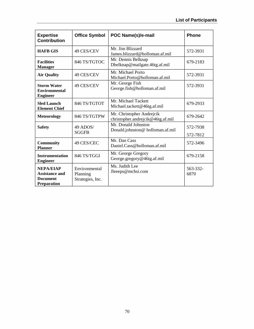
List of Participants
70
Expertise Contribution
Office Symbol POC Name(s)/e-mail
Phone
HAFB GIS 49 CES/CEV Mr. Jim Blizzard [email protected] 572-3931
Facilities Manager
846 TS/TGTOC Mr. Dennis Belknap [email protected] 679-2183
Air Quality 49 CES/CEV Mr. Michael Porto [email protected] 572-3931
Storm Water Environmental Engineer
49 CES/CEV Mr. George Fish [email protected] 572-3931
Sled Launch Element Chief
846 TS/TGTOT Mr. Michael Tackett [email protected] 679-2933
Meteorology 846 TS/TGTPW Mr. Christopher Andrejcik [email protected] 679-2642
Safety 49 ADOS/ SGGFB
Mr. Donald Johnston Donald.johnston@ holloman.af.mil 572-7938
572-7812
Community Planner
49 CES/CEC Mr. Dan Cass [email protected] 572-3496
Instrumentation Engineer
846 TS/TGGI Mr. George Gregory [email protected] 679-2158
NEPA/EIAP Assistance and Document Preparation
Environmental Planning Strategies, Inc.
Ms. Judith Lee [email protected] 563-332-
6870

List of Preparers
71
6. List of Preparers
Mr.Andrew “J.R.” Gomolak Ms. Judith Lee
49 CES/CEV Environmental Planning Strategies, Inc.
550 Tabosa Avenue 17405 246th Avenue
Holloman Air Force Base, NM 88330 Pleasant Valley, IA 52767
[email protected] [email protected]
Ms. Jeanne Dye Mr. Timothy Wolfe
49 CES/CEVN Chief Project Management Flight
550 Tabosa Avenue 846th Test Squadron/TGTP
HAFB, NM 88330 1521 Test Track Road
[email protected] HAFB, New Mexico 88330

72
7. List of Acronyms For complete lists of Office Codes and associated Squadron/Unit names, please see Chapter 5 of this Programmatic Environmental Assessment (PEA). ACC Air Combat Command
AFB Air Force Base
AFI Air Force Instruction
AFJMAN Air Force Joint Manual
AFMAN Air Force Manual
CERCLA Comprehensive Environmental Response, Compensation, and Liability Act
49 CES/CEV Civil Engineering Flight Natural Resources
49 CES/CEOUE Civil Engineering Entomology
CFR Code of Federal Regulations
DoD Department of Defense
EA Environmental Assessment
EIS Environmental Impact Statement
EOD Explosive Ordnance Disposal
FONPA Finding of No Practicable Alternative
FONSI Finding of No Significant Impact
HAFB Holloman Air Force Base
HSTT High Speed Test Track
HTS Horizontal Test Stand
IRP Installation Restoration Program
NCOIC Non-Commissioned Officer in Charge
NEPA National Environmental Policy Act
NEW Net Explosive Weight
NMAC New Mexico Administrative Code
PEA Programmatic Environmental Assessment
POC Point of contact
RCRA Resources Conservation and Recovery Act
RRR Rapid Runway Repair (Prime Beef area)
Q/D Quantity Distance (explosive arc)
SDWA Safe Drinking Water Act
TSCA Toxic Substances Control Act
WSNM White Sands National Monument
WSMR White Sands Missile Range

73