preliminary environmental information report: appendix … · 2016-04-11 · silvertown tunnel...
TRANSCRIPT
Preliminary Environmental Information Report: Appendix 9.C
Stage 1 Habitat Regulation Assessment (HRA) Report
Silvertown Tunnel Preliminary Environmental Information Report
Appendix 9.C: Stage 1 Habitat Regulation Assessment (HRA) Report
Page 2 of 33
THIS PAGE IS LEFT INTENTIONALLY BLANK
Silvertown Tunnel Preliminary Environmental Information Report
Appendix 9.C: Stage 1 Habitat Regulation Assessment (HRA) Screening Report
Page 3 of 33
Contents
SUMMARY ................................................................................................................. 7
1. INTRODUCTION ....................................................................................... 9
1.1 Overview ....................................................................................................... 9
1.2 The Scheme overview ................................................................................... 9
1.3 Need for the Scheme .................................................................................... 9
1.4 Aims of the document ................................................................................. 10
2. THE SCHEME DESIGN ........................................................................... 11
3. BACKGROUND TO HABITAT REGULATIONS ASSESSMENT ............. 13
3.1 Natura 2000 site creation ............................................................................ 13
3.2 Natura 2000 site protection ......................................................................... 14
4. HABITATS REGULATIONS ASSESSMENT METHOD ........................... 17
4.1 Overview ..................................................................................................... 17
4.2 Stage 1: Screening ...................................................................................... 17
4.3 Stage 2: Appropriate Assessment ............................................................... 17
4.4 Stage 3: Assessment of alternative solutions .............................................. 20
4.5 Stage 4: Assessment where no alternative solutions exist and where adverse impacts remain ........................................................................................ 20
4.6 Relevant legislation and guidance ............................................................... 20
5. NATURA 2000 SITES POTENTIALLY WITHIN THE ZONE OF INFLUENCE ............................................................................................ 23
5.1 Overview ..................................................................................................... 23
5.2 Approach to assessment ............................................................................. 23
5.3 Other “Areas” included for screening: functional habitat ............................. 23
6. BASELINE RESULTS .............................................................................. 25
6.1 Sites scoped out .......................................................................................... 25
Silvertown Tunnel Preliminary Environmental Information Report
Appendix 9.C: Stage 1 Habitat Regulation Assessment (HRA) Report
Page 4 of 33
6.2 Sites scoped in for further assessment ....................................................... 26
6.3 The Lee Valley SPA and Ramsar (and SSSI) ............................................. 27
6.4 The Thames Estuary and Marshes SPA and Ramsar ................................. 27
6.5 The Epping Forest SAC .............................................................................. 27
7. ASSESSMENT OF POTENTIAL EFFECTS ............................................ 29
7.1 Effects scoped in for consideration ............................................................. 29
7.2 Air quality .................................................................................................... 29
7.3 Water regime and quality ............................................................................ 31
7.4 Functional habitat loss/damage and/or disturbance .................................... 31
8. CONCLUSIONS....................................................................................... 33
Silvertown Tunnel Preliminary Environmental Information Report
Appendix 9.C: Stage 1 Habitat Regulation Assessment (HRA) Screening Report
Page 5 of 33
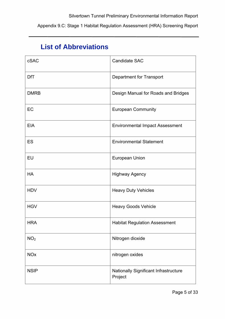
List of Abbreviations
cSAC Candidate SAC
DfT Department for Transport
DMRB Design Manual for Roads and Bridges
EC European Community
EIA Environmental Impact Assessment
ES Environmental Statement
EU European Union
HA Highway Agency
HDV Heavy Duty Vehicles
HGV Heavy Goods Vehicle
HRA Habitat Regulation Assessment
NO2 Nitrogen dioxide
NOx nitrogen oxides
NSIP Nationally Significant Infrastructure Project
Silvertown Tunnel Preliminary Environmental Information Report
Appendix 9.C: Stage 1 Habitat Regulation Assessment (HRA) Report
Page 6 of 33
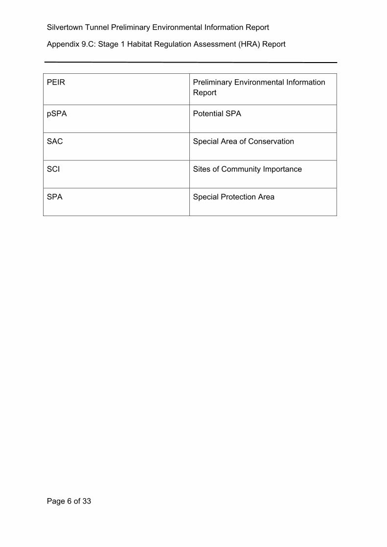
PEIR Preliminary Environmental Information Report
pSPA Potential SPA
SAC Special Area of Conservation
SCI Sites of Community Importance
SPA Special Protection Area
Silvertown Tunnel Preliminary Environmental Information Report
Appendix 9.C: Stage 1 Habitat Regulation Assessment (HRA) Screening Report
Page 7 of 33
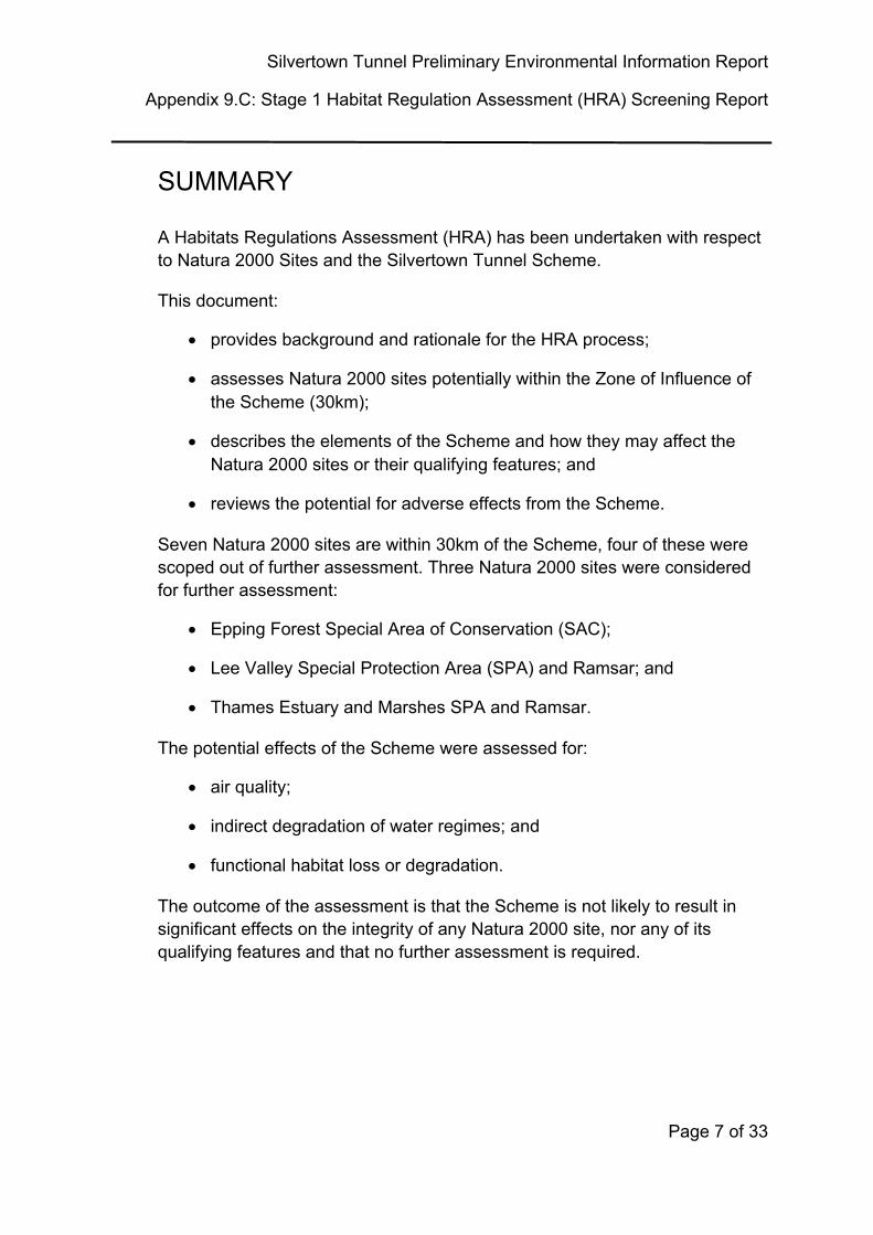
SUMMARY
A Habitats Regulations Assessment (HRA) has been undertaken with respect to Natura 2000 Sites and the Silvertown Tunnel Scheme.
This document:
provides background and rationale for the HRA process;
assesses Natura 2000 sites potentially within the Zone of Influence of the Scheme (30km);
describes the elements of the Scheme and how they may affect the Natura 2000 sites or their qualifying features; and
reviews the potential for adverse effects from the Scheme.
Seven Natura 2000 sites are within 30km of the Scheme, four of these were scoped out of further assessment. Three Natura 2000 sites were considered for further assessment:
Epping Forest Special Area of Conservation (SAC);
Lee Valley Special Protection Area (SPA) and Ramsar; and
Thames Estuary and Marshes SPA and Ramsar.
The potential effects of the Scheme were assessed for:
air quality;
indirect degradation of water regimes; and
functional habitat loss or degradation.
The outcome of the assessment is that the Scheme is not likely to result in significant effects on the integrity of any Natura 2000 site, nor any of its qualifying features and that no further assessment is required.
Silvertown Tunnel Preliminary Environmental Information Report
Appendix 9.C: Stage 1 Habitat Regulation Assessment (HRA) Report
Page 8 of 33
THIS PAGE IS LEFT INTENTIONALLY BLANK
Silvertown Tunnel Preliminary Environmental Information Report
Appendix 9.C: Stage 1 Habitat Regulation Assessment (HRA) Screening Report
Page 9 of 33
1. INTRODUCTION
1.1 Overview
1.1.1 This is a Stage 1 Habitat Regulation Assessment (HRA) Report for the proposed Silvertown Tunnel. The Scheme is a Nationally Significant Infrastructure Project (NSIP) creating a new highway below the River Thames connecting Silvertown to the north and Greenwich to the south. As part of this, an Environmental Impact Assessment (EIA), presented in an Environmental Statement (ES) is currently being undertaken to ensure the development has no detrimental effect on the environment, including ecology. In tandem with the production of an EIA, a HRA is required to implement the Habitats Directive which requires confirmation that the development will not have an effect on the integrity of any Natura 2000 sites or on any of their qualifying features, either directly or indirectly. This document comprises that HRA.
1.2 The Scheme overview
1.2.1 The Scheme – known as the Silvertown Tunnel, described in Volume 1, Chapter 4 – Scheme Description of the PEIR, would comprise a new dual two-lane connection between the A102 Blackwall Tunnel Approach on Greenwich Peninsula and the Tidal Basin roundabout junction on the A1020 Lower Lea Crossing/A1011 Silvertown Way by means of twin tunnel bores under the River Thames.
1.3 Need for the Scheme
1.3.1 The Silvertown Tunnel Scheme is proposed in response to the three transport problems which exist at the Blackwall Tunnel:
congestion,
frequent closures and
a lack of resilience (owing to the lack of alternative local crossings).
1.3.2 These issues lead to adverse effects on the economy and local environment. In the context of continued significant growth, these problems can only get worse, and in turn their secondary effects will increase. Failing to address these problems could hamper the sustainable and optimal growth of London and the UK.
Silvertown Tunnel Preliminary Environmental Information Report
Appendix 9.C: Stage 1 Habitat Regulation Assessment (HRA) Report
Page 10 of 33
1.4 Aims of the document
1.4.1 This document aims to:
outline the legal requirements and guidance for undertaking an HRA, including the potential option stages;
describe the baseline features of the Natura 2000 sites and assess how the development site may be used by their qualifying features;
describe the development proposals;
assess the potential adverse effects of the development as identified in consultation with Natural England (NE);
review relevant literature for the SPA bird species to assess the likelihood (or otherwise) of adverse effects from the proposed development;
outline additional mitigation recommendations (as required); and
confirm the result of the HRA in accordance with NE’s advice.
Silvertown Tunnel Preliminary Environmental Information Report
Appendix 9.C: Stage 1 Habitat Regulation Assessment (HRA) Screening Report
Page 11 of 33
2. THE SCHEME DESIGN
2.1.1 The scheme – known as the Silvertown Tunnel – would comprise a new dual two-lane connection between the A102 Blackwall Tunnel Approach on Greenwich Peninsula (London Borough of Greenwich) and the Tidal Basin roundabout junction on the A1020 Lower Lea Crossing/Silvertown Way (London Borough of Newham) by means of twin tunnel bores under the River Thames and associated approach roads. The Silvertown Tunnel would be approximately 1.4km long and would be able to accommodate large vehicles including double-deck buses.
2.1.2 On the north side, the tunnel approach road connects to the Tidal Basin Roundabout, which would be altered to create a new signal-controlled roundabout linking the Silvertown Way, Dock Road and the Lower Lea Crossing. Dock Road would be realigned to accommodate the new tunnel and approach road. On the south side, the A102 would be widened to create new slip-road links to the Silvertown Tunnel. A new flyover would be built to take southbound traffic exiting the Blackwall Tunnel over the northbound approach to the Silvertown Tunnel. The Boord Street footbridge over the A102 would be replaced with a pedestrian and cycle bridge.
2.1.3 New portal buildings would be located close to each portal to house the plant and equipment necessary to operate the tunnel, including ventilation equipment.
2.1.4 The introduction of free-flow user charging on both the Blackwall and Silvertown Tunnels would play a fundamental part in managing traffic demand and support the financing of the construction and operation of the Silvertown Tunnel. The design of the tunnel would include a dedicated bus/coach and Heavy Goods Vehicle (HGV) lane, which would provide opportunities for TfL to provide additional cross-river bus routes.
2.1.5 Main construction works would likely commence in 2018 and would last approximately four years with the new tunnel opening in 2022/23. A Tunnel Boring Machine (TBM) would be used to bore the main tunnel sections under the river with shorter sections of cut and cover tunnel at either end linking to the portals. The proposal is to erect and launch the TBM from a specially constructed chambers at Silvertown and Greenwich Peninsula where the bored and cut and cover sections connect. The main site construction compound would be located at Silvertown to utilise Thames Wharf to facilitate the removal of spoil and delivery of materials by river. A secondary site
Silvertown Tunnel Preliminary Environmental Information Report
Appendix 9.C: Stage 1 Habitat Regulation Assessment (HRA) Report
Page 12 of 33
compound would be located adjacent to the alignment of the proposed cut and cover tunnel on the Greenwich peninsula.
2.1.6 Further details of the Scheme design are provided in the Preliminary Environmental Information Report (PEIR)1.
1 Volume 1, Chapter 4 – Scheme Description of the PEIR
Silvertown Tunnel Preliminary Environmental Information Report
Appendix 9.C: Stage 1 Habitat Regulation Assessment (HRA) Screening Report
Page 13 of 33
3. BACKGROUND TO HABITAT REGULATIONS ASSESSMENT
3.1.1 This section describes the background behind Natura designations and the legislation surrounding its protection and therefore the rationale for this assessment. This also includes references to guidance followed.
3.1 Natura 2000 site creation
3.1.2 In May 1992 Member States belonging to the European Union (EU) adopted legislation designed to protect the most seriously threatened habitats and species across Europe. This legislation is referred to as the Habitats Directive and complements the Birds Directive (adopted in 1979). At the heart of both these Directives is the creation of a network of sites called Natura 2000. Natura 2000 is a network of areas designated to conserve natural habitats and species that are rare, endangered, vulnerable or endemic within the EU.
3.1.3 The Birds Directive requires the establishment of SPAs for birds classified under Directive 2009/147/EC on the Conservation of Wild Birds (the codified version of Directive 79/409/EEC as amended2) for rare, vulnerable and regularly-occurring migratory bird species and internationally important wetlands.
3.1.4 The Habitats Directive (Council Directive 92/43/EEC on the conservation of natural habitats and of wild fauna and flora)3, similarly requires SACs to be designated for other species, and for habitats.
3.1.5 Together, SPAs and SACs make up the Natura 2000 series. All EU Member States contribute to the network of sites in a Europe-wide partnership from the Canaries to Crete and from Sicily to Finnish Lapland.
3.1.6 SPAs are classified under the Birds Directive to help protect and manage areas which are important for rare and vulnerable birds because they use them for breeding, feeding, wintering or migration.
2 Conservation of Wild Birds (the codified version of Directive 79/409/EEC as amended
3 Council Directive 92/43/EEC on the conservation of natural habitats and of wild fauna and flora
Silvertown Tunnel Preliminary Environmental Information Report
Appendix 9.C: Stage 1 Habitat Regulation Assessment (HRA) Report
Page 14 of 33
3.2 Natura 2000 site protection
3.2.1 Under Article 6 of the European Community (EC) Habitats Directive an assessment is required where a plan or project may give rise to significant effects upon a Natura 2000 site or sites (also known as ‘European Sites’).
3.2.2 In addition, it is a matter of law that candidate SACs (cSACs) and Sites of Community Importance (SCI) are considered in this process; furthermore, it is Government policy that sites designated under the 1971 Ramsar Convention for their internationally important wetlands (Ramsar sites) and potential SPAs (pSPAs) are also considered.
3.2.3 Paragraph 3, Article 6 of the Habitats Directive states that:
‘Any plan or project not directly connected with or necessary to the management of the site but likely to have a significant effect thereon, either individually or in combination with other plans or projects, shall be subject to appropriate assessment of its implications for the site in view of the site’s conservation objectives. In the light of the conclusions of the assessment of the implications for the site and subject to paragraph 4 (see below), the competent national authority shall agree to the plan or project only having ascertained that it will not adversely affect the integrity of the site concerned and, if appropriate, after having obtained the opinion of the general public.’
3.2.4 Paragraph 4, Article 6 of the Habitats Directive states that:
‘If, in spite of a negative assessment of the implications for the site and in the absence of alternative solutions, a plan or project must nevertheless be carried out for imperative reasons of overriding public interest, including those of social or economic nature, the Member State shall take all compensatory measures to ensure that the overall coherence of Natura 2000 is protected. It shall inform the Commission of the compensatory measures adopted.’
3.2.5 The requirements of the Habitats Directive are transposed into UK law by means of the Conservation of Habitats and Species Regulations 2010 (as
Silvertown Tunnel Preliminary Environmental Information Report
Appendix 9.C: Stage 1 Habitat Regulation Assessment (HRA) Screening Report
Page 15 of 33
amended)4, hereafter referred to as the Habitats Regulations. The process of assessing the implications of development on European Sites is therefore known as HRA.
4 This was transposed into UK law by The Conservation of Habitats and Species Regulations 2010, as amended

Silvertown Tunnel Preliminary Environmental Information Report
Appendix 9.C: Stage 1 Habitat Regulation Assessment (HRA) Report
Page 16 of 33
THIS PAGE IS LEFT INTENTIONALLY BLANK
Silvertown Tunnel Preliminary Environmental Information Report
Appendix 9.C: Stage 1 Habitat Regulation Assessment (HRA) Screening Report
Page 17 of 33
4. HABITATS REGULATIONS ASSESSMENT METHOD
4.1 Overview
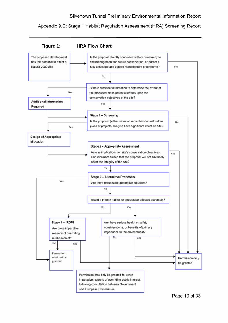
4.1.1 The requirements of the HRA comprise four distinct stages and according to prescribed guidance and methods. A flow chart after the European Commission guidance (2001) is presented in Figure 1 overleaf.
4.2 Stage 1: Screening
4.2.2 This is the process which initially identifies the likely impacts upon a European Site of the project or plan, either alone or in combination with other projects or plans, and considers whether these impacts may be significant. If the effect may be significant, or is not known, that may trigger the need for an Appropriate Assessment (Stage 2). However case law (the Dilly Lane High Court Judgement5) ruled that:
‘as a matter of principle, the Secretary of State could not be required to ignore a package of avoidance and mitigation measures that had been put forward when determining whether a development is likely to have a significant adverse impact upon the local environment.’
4.2.3 Thus mitigation may be implemented at Stage 1 as long as those mechanisms for implementation can be ensured.
4.3 Stage 2: Appropriate Assessment
This is the detailed consideration of the impact on the integrity of the European Site of the Project, either alone or in combination with other projects or plans, with respect to the site’s conservation objectives and its structure and function. This is to determine whether or not there will be adverse effects on the integrity of the site. This stage also includes the development of any additional mitigation measures to avoid or reduce any possible impacts.
5 Lunt, J., and Lischak, K. (2008) Natural England – a new dawn? Rights and responsibilities towards the natural
environment and how these may change – the ‘Dilly Lane’ case. Environmental Law & Management 246 (2008)
20. Lawtext Publishing Limited www.lawtext.com
Silvertown Tunnel Preliminary Environmental Information Report
Appendix 9.C: Stage 1 Habitat Regulation Assessment (HRA) Report
Page 18 of 33
Where there are adverse impacts, an assessment of mitigation options is carried out to determine adverse effect on the integrity of the site. If these mitigation options cannot avoid adverse effects then development consent can only be given if stages 3 and 4 are followed.
Silvertown Tunnel Preliminary Environmental Information Report
Appendix 9.C: Stage 1 Habitat Regulation Assessment (HRA) Screening Report
Page 19 of 33
Figure 1: HRA Flow Chart
Silvertown Tunnel Preliminary Environmental Information Report
Appendix 9.C: Stage 1 Habitat Regulation Assessment (HRA) Report
Page 20 of 33
4.4 Stage 3: Assessment of alternative solutions
4.4.1 This is the process which examines alternative ways of achieving the objectives of the Project that would avoid adverse impacts on the integrity of the European Site, should avoidance or mitigation measures associated with the Project be unable to cancel out adverse effects.
4.5 Stage 4: Assessment where no alternative solutions exist and where
adverse impacts remain
4.5.1 Should no alternative solutions be available, at Stage 4 an assessment is made with regard to whether or not the development is necessary for imperative reasons of overriding public interest (IROPI) and, if so, of the compensatory measures needed to maintain the overall coherence of the Natura 2000 network.
4.6 Relevant legislation and guidance
4.6.1 The following legislation and guidance documents will be consulted in the preparation of the HRA:
The Conservation of Habitats and Species Regulations 2010 (as amended);
European Commission (2000), Managing Natura 2000 sites: The provisions of Article 6 of the Habitats Directive 92/43/EEC;
European Commission (2007), Guidance document on Article 6(4) of the Habitats Directive 92/43/EEC;
European Commission (2001), Assessment of plans and projects significantly affecting Natura 2000 sites;
The Planning Inspectorate Habitat Regulations Assessment Advice Note Ten: Habitat Regulations Assessment relevant to nationally significant infrastructure projects, Version 5, August 2013;
UK Department for Transport's (DfT’s) Transport Analysis Guidance (TAG) Unit A3: Environmental Impact Appraisal;
The Highway Agency (HA) Interim Advice Note 141/11: Assessment of Implications (of Highways and/or Roads Projects) on European Sites (Including Appropriate Assessment) and the Planning Act 2008; and
Silvertown Tunnel Preliminary Environmental Information Report
Appendix 9.C: Stage 1 Habitat Regulation Assessment (HRA) Screening Report
Page 21 of 33
The Design Manual for Roads and Bridges (DMRB) Volume 11 Environmental Assessment, Section 4 Other Assessment Techniques, Part 1, HD44/09, Assessment of Implications (of Highways and/or Roads Projects) on European sites (Including Appropriate Assessment), Section 4 Assessment Methods (adopted in February 2009). This report is structured in accordance with the requirements of this guidance.

Silvertown Tunnel Preliminary Environmental Information Report
Appendix 9.C: Stage 1 Habitat Regulation Assessment (HRA) Report
Page 22 of 33
THIS PAGE IS LEFT INTENTIONALLY BLANK
Silvertown Tunnel Preliminary Environmental Information Report
Appendix 9.C: Stage 1 Habitat Regulation Assessment (HRA) Screening Report
Page 23 of 33
5. NATURA 2000 SITES POTENTIALLY WITHIN THE ZONE OF INFLUENCE
5.1 Overview
5.1.1 All Natura 2000 sites within 30km were initially assessed for their potential to be affected by the Scheme. Their qualifying features, conservation objectives and existing vulnerabilities were used as baseline data along with their proximity to the Scheme. An initial high level screening assessment was undertaken to assess whether the scheme has the potential to affect the integrity of any of the sites or their qualifying features.
5.2 Approach to assessment
5.2.1 The potential impacts of the scheme is largely determined by three key factors:
whether there were any sites or qualifying features that could be directly affected by the Scheme;
whether there are any sufficiently mobile qualifying features of the sites that while distant from the scheme may rely on functional habitat that would be affected by the scheme (largely birds and bats see section 5.3 on functional habitat); and
whether any of the potential effects of the scheme have the potential to indirectly affect receptors some distance from the scheme due to the zone of influence (for example through effects on water regime or increased traffic flow).
5.2.2 Professional judgement has been used in this assessment, taking into account the conservation objectives for European Sites, to determine whether or not significant effects are likely to result from the proposals.
5.3 Other “Areas” included for screening: functional habitat
5.3.1 Functional habitat is the term given to undesignated areas located outside the boundary of a Natura 2000 site, which contains habitats that supports the qualifying features of the sites. This relates principally to mobile species, such as birds and bats that may rely on these areas for maintenance and support. Loss of functional habitat can be deemed, in some cases, to a have a likely
Silvertown Tunnel Preliminary Environmental Information Report
Appendix 9.C: Stage 1 Habitat Regulation Assessment (HRA) Report
Page 24 of 33
significant effect (and potentially adverse effect on site integrity) for an SPA or Ramsar site.
Silvertown Tunnel Preliminary Environmental Information Report
Appendix 9.C: Stage 1 Habitat Regulation Assessment (HRA) Screening Report
Page 25 of 33
6. BASELINE RESULTS
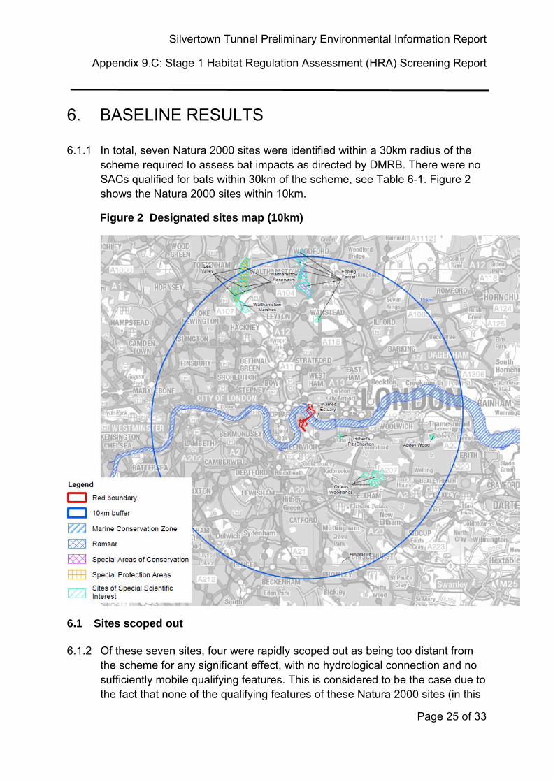
6.1.1 In total, seven Natura 2000 sites were identified within a 30km radius of the scheme required to assess bat impacts as directed by DMRB. There were no SACs qualified for bats within 30km of the scheme, see Table 6-1. Figure 2 shows the Natura 2000 sites within 10km.
Figure 2 Designated sites map (10km)
6.1 Sites scoped out
6.1.2 Of these seven sites, four were rapidly scoped out as being too distant from the scheme for any significant effect, with no hydrological connection and no sufficiently mobile qualifying features. This is considered to be the case due to the fact that none of the qualifying features of these Natura 2000 sites (in this
Silvertown Tunnel Preliminary Environmental Information Report
Appendix 9.C: Stage 1 Habitat Regulation Assessment (HRA) Report
Page 26 of 33
assessment the qualifying feature is stag beetle) would be using the area within the zone of influence of the scheme as habitat to support or maintain them, or because the potential impacts due to the scheme would have no significant effect on the habitat due to the distance from such habitat (over 20km).
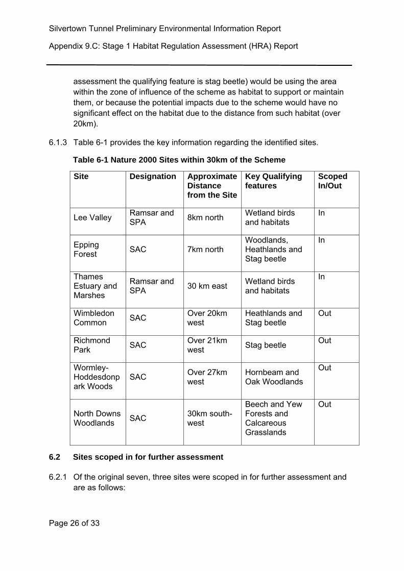
6.1.3 Table 6-1 provides the key information regarding the identified sites.
Table 6-1 Nature 2000 Sites within 30km of the Scheme
Site Designation Approximate Distance from the Site
Key Qualifying features
Scoped In/Out
Lee Valley Ramsar and SPA
8km north Wetland birds and habitats
In
Epping Forest
SAC 7km north Woodlands, Heathlands and Stag beetle
In
Thames Estuary and Marshes
Ramsar and SPA
30 km east Wetland birds and habitats
In
Wimbledon Common
SAC Over 20km west
Heathlands and Stag beetle
Out
Richmond Park
SAC Over 21km west
Stag beetle Out
Wormley-Hoddesdonpark Woods
SAC Over 27km west
Hornbeam and Oak Woodlands
Out
North Downs Woodlands
SAC 30km south-west
Beech and Yew Forests and Calcareous Grasslands
Out
6.2 Sites scoped in for further assessment
6.2.1 Of the original seven, three sites were scoped in for further assessment and are as follows:
Silvertown Tunnel Preliminary Environmental Information Report
Appendix 9.C: Stage 1 Habitat Regulation Assessment (HRA) Screening Report
Page 27 of 33
The Lee Valley SPA and Ramsar site which is approximately 8km north of the application boundary;
The Thames Estuary and Marshes SPA and Ramsar site located approximately 30km east of the application boundary; and
Epping Forest SAC is located approximately 7km north of the Scheme.
6.3 The Lee Valley SPA and Ramsar (and SSSI)
6.3.1 The Lee Valley SPA and Ramsar comprises four SSSIs spaced along the valley from just downstream of Ware in Hertfordshire to Finsbury Park in London, a total distance of about 24km. The whole site is contained within the Lee Valley Regional Park. The Lee Valley comprises a series of embanked water supply reservoirs, sewage treatment lagoons and former gravel pits along approximately 24km of the valley. These waterbodies support internationally important numbers of wintering gadwall (Anas strepera) and shoveler (Anas clypetea) and nationally important numbers of several other bird species. The site also contains a range of wetland and valley bottom habitats, both man-made and semi-natural, which support a diverse range of wetland fauna and flora.
6.4 The Thames Estuary and Marshes SPA and Ramsar
6.4.1 The Thames Estuary and Marshes SPA and Ramsar is located on the south side of the River Thames and supports a complex of brackish, floodplain grazing marsh ditches, saline lagoons and intertidal saltmarsh and mudflat. These habitats together support internationally important numbers of wintering waterbirds. The saltmarsh and grazing marsh are of international importance for their diverse assemblages of wetland plants and invertebrates.
6.5 The Epping Forest SAC
6.5.1 The Epping Forest SAC is a large ancient wood-pasture with habitats of high nature conservation value including ancient semi-natural woodland, old grassland plains, wet and dry heathland and scattered wetland. The semi-natural woodland is particularly extensive but the forest plains are also a major feature and contain a variety of unimproved acid grasslands. The semi-natural woodlands of Epping Forest include important beech forests on acid soils, which are important for a range of rare epiphytic species. The long history of pollarding, and resultant large number of veteran trees, ensures that the site is also rich in fungi and invertebrates associated with decaying timber. Stag beetle is also a qualifying feature for this site.
Silvertown Tunnel Preliminary Environmental Information Report
Appendix 9.C: Stage 1 Habitat Regulation Assessment (HRA) Report
Page 28 of 33
THIS PAGE IS LEFT INTENTIONALLY BLANK
Silvertown Tunnel Preliminary Environmental Information Report
Appendix 9.C: Stage 1 Habitat Regulation Assessment (HRA) Screening Report
Page 29 of 33
7. ASSESSMENT OF POTENTIAL EFFECTS
7.1 Effects scoped in for consideration
7.1.1 Fuller consideration is given below of the likelihood of significant effects (direct and/or indirect; in isolation and/or in combination with other plans/projects) on the European Sites in the context of their conservation objectives.
7.1.2 The following potential effects were considered:
Air Quality;
Water Regime/Quality; and
Functional Habitat Loss/Damage and/or Disturbance.
7.2 Air quality
SPAs and Ramsar
7.2.1 The Air Quality Chapter of the PEIR provides full details of the predicted Scheme effects on air quality, these data are summarised and applied for assessment within this chapter.
7.2.2 Air quality is not a particularly sensitive parameter for the SPAs or Ramsar Sites. Threshold criteria for air quality assessment are a change of +/- 1000 vehicles per day, +/- 200 Heavy Duty Vehicles (HDV), 10kph change in daily average speed or 20kph change in peak hour speeds. The impacts of the Scheme on traffic links within 200m of the SPAs and Ramsar Sites do not meet these criteria, therefore no further assessment is required as there would be no perceptible change.
7.2.3 In conclusion, no likely significant effects upon the SPAs or Ramsar Sites have been identified resulting from the Scheme, either alone or in combination with other known plans and projects.
SAC
7.2.4 Air quality at Epping SAC has been identified as a potential particular sensitivity specifically associated with any increase in traffic potentially associated with the development which could result in a decrease in air quality (associated in particular with an increase in nitrogen compounds), which could adversely affect the vegetation at Epping Forest SAC. Natural
Silvertown Tunnel Preliminary Environmental Information Report
Appendix 9.C: Stage 1 Habitat Regulation Assessment (HRA) Report
Page 30 of 33
England’s site condition record for the SAC identifies air pollution as potentially affecting the health of trees, heath and grassland.
7.2.5 The designated habitat types are lowland broadleaved, mixed and yew woodland and wet and dry heath. In terms of sensitivity to air pollution the critical load for nitrogen deposition for these types of habitat is 10–20 kg N/ha/yr.
The air quality objective for nitrogen oxides (NOx) which are levels of one form of airborne nitrogen for the protection of vegetation and ecosystems is 30 µg/m3 as an annual mean (World Health Organisation estimates). Epping Forest annual mean has declined over the last 5 years and is now at an annual average of actual NOx concentration at 33.7 μgm3) APIS6.
7.2.6 The Conservators of Epping Forest recently co-sponsored a 3 year PhD research project by Imperial College examining the levels of car exhaust pollutants (NO2 and ammonia) across a wide area of the Forest. An excess input of nitrogen can alter plant nutrition and biology, soil chemistry and encourage pests and pathogens. Concentrations in the air at most roadside locations were found to exceed, sometimes up to 3 times higher, the internationally-recommended limits above which plant health is threatened. These elevated levels extended as far as 20m from the main roads7.
7.2.7 Epping Forest is predicted by APIS to be in exceedance of its critical nitrogen (N) load (which is 10 to 20kgN/ha/yr by 15 kgN/ha/yr (i.e. N deposition: 35 kgN/ha/yr). Although the Epping Forest research study noted that modelled air pollution levels, from models such as APIS could not accurately predict levels of gaseous pollutants at roadside sites and significantly underestimated pollution levels. One of the reasons for this is the very significant contribution to nitrogen pollution from ammonia generated by car traffic, including cars with catalytic converters. Congestion and queuing may be other factors.
7.2.8 The traffic modelling data for the Scheme has showed that the N contribution from the Scheme, within 200m of Epping Forest, would not significantly increase the exceedances already present. The Scheme will therefore not meet the threshold criteria for air quality assessment (as stated in 7.2.2.) and
6 Air Pollution Information system; www.apis.ac.uk; Accessed 01 September 2015 7 Essex County Council and the City of London Corporation; Epping Forest Transport Strategy 2012-2016.
Silvertown Tunnel Preliminary Environmental Information Report
Appendix 9.C: Stage 1 Habitat Regulation Assessment (HRA) Screening Report
Page 31 of 33
that no further assessment is required as there would be no perceptible change. This will however be confirmed upon receipt of the final traffic data.
7.2.9 In conclusion no likely significant effects upon the Epping SAC site have been identified resulting from the Scheme, either alone or in combination with other known plans and projects.
7.3 Water regime and quality
7.3.1 The Volume 1, Chapter 16 - Water Environment and Chapter 10 Marine Ecology of the PEIR have full details of the predicted background and predicted Scheme effects on these sites, these data are summarised and applied for assessment within this chapter.
7.3.2 Potential impacts considered in this section are indirect effects on water quality or changes to flow. However, the River Lee is located upstream of the Scheme and therefore proposals are therefore not anticipated to result in altered water regime of this Site.
7.3.3 The Thames Estuary and Marshes is sufficiently far removed at 30km east of the Scheme not to be within the zone of influence of water quality effects.
7.3.4 Epping Forest SAC is not hydrologically linked.
7.3.5 In conclusion, no likely significant effects upon the Natura 2000 sites from water quality or flow have been identified resulting from the Scheme, either alone or in combination with other known plans and projects.
7.4 Functional habitat loss/damage and/or disturbance
7.4.1 The Volume 1, Chapter 9 - Terrestrial Ecology of the PEIR has full details of the habitats potentially suitable for wetland birds, these data are summarised and applied for assessment within this chapter. The potential effects considered are those of habitat loss, a degradation of habitat quality or disturbance to qualifying features.
7.4.2 Epping Forest has no functional habitat within the zone of influence of qualifying mobile species (i.e. stag beetle from Epping Forest will not be using any habitat that could be affected by the Scheme).
7.4.3 Although the SPAs and Ramsar Sites are distant (7km and 30km) from the Scheme there is potential for qualifying birds to use areas of functional habitat bordering the Thames within that distance. However, no significant areas of open water and/or marginal habitats will be lost/damaged or disturbed as a
Silvertown Tunnel Preliminary Environmental Information Report
Appendix 9.C: Stage 1 Habitat Regulation Assessment (HRA) Report
Page 32 of 33
result of the Scheme. Habitat loss through clearance for construction is restricted to small areas of woodland, scattered trees and scrub and species poor or amenity grassland. Some localised disturbance of the River Thames is anticipated during the temporary jetty construction but none of the habitats affected by the Scheme represent important feeding, breeding, wintering or sheltering habitats to the bird species (Gadwall, Shoveler or Bittern) that contribute to the Qualifying Interest of Lee Valley SPA. Therefore, loss of these habitats to the project does not represent a significant effect on the SPA.
7.4.4 In conclusion, no likely significant effects upon the Natura 2000 sites due to habitat loss, degradation or distrubance have been identified resulting from the Scheme, either alone or in combination with other known plans and projects.
Silvertown Tunnel Preliminary Environmental Information Report
Appendix 9.C: Stage 1 Habitat Regulation Assessment (HRA) Screening Report
Page 33 of 33
8. CONCLUSIONS
8.1.1 Following consideration of all Natura 2000 sites within 30km it can be concluded that there are no likely significant effects upon any Natura 2000 sites or their qualifying features resulting from the Scheme, either alone or in combination with other known plans and projects.