predicting bathymetry from satellite altimetry: the …€¦ · predicting bathymetry from...
TRANSCRIPT

Predicting Bathymetry from Satellite Altimetry:
The Good, The Bad, and The Ugly
• Mapping by ships - what is missing?
• Mapping by satellites – recent developments
• Finding the important gaps
David T. Sandwell - Scripps Institution of Oceanography
Walter H. F. Smith - Laboratory for Satellite Altimetry, NOAA
Joseph J. Becker - Naval Research Laboratory
Christopher Olson - Scripps Institution of Oceanography
Objective – construct the best possible global map of the deep ocean floor for
science, public outreach, and applications.
Funding:
Google Inc.
National Science Foundation
Office of Naval Research
National Geospatial Agency

Modern seafloor mapping tools
satellite altimeter(global coverage,
poor resolution ~4000 m)
shipboard
echo sounder(high resolution ~100 m,
poor coverage)
predicted from satellite gravity
multi-beamsoundings

Available soundings cover 17% of seafloor at < 1 km resolution

source # points(500 m)
% flagged % seafloor@ 1 km
NGDC_multi 127901083 4.75 5.134
NOAA_geodas 40897565 11.06 2.506
US_multi 51187020 5.32 2.219
JAMSTEC_multi 79103040 0.62 2.04
SIO_various 40754645 13.93 1.325
IBCAO_various 18302390 0.03 0.773
GEBCO_various 8950614 0.17 0.523
AGSO_grid 12875795 2.62 0.503
DNC_points 5878651 1.23 0.49
CCOM_grid 10023471 0.08 0.195
GEOMAR_grid 18138868 0.06 0.181
NGA_single 4415125 19.44 0.179
NOAA_grids 6748376 0.49 0.162
IFREMER_single 7653537 10.62 0.151
3DGBR_various 5523560 11.36 0.112
NAVO_multi 422089 0.06 0.009
total 438,775,829 16.5 % in V11
percentage of
seafloor mapped
at 1 km resolution
Edited soundings
used in
SRTM15_PLUS

SRTM30_PLUS V7

SRTM15_PLUS V1

SRTM30_PLUS V7

SRTM15_PLUS V1

Mapping by satellites - Ideal geodetic mission objectives
• high altimeter range precision
measure sea surface slopes to an accuracy of < 1 microradian
(1 μrad: 10 mm elevation change over 10 km distance)
1 μrad slope precision ~ 0.98 mGal gravity accuracy
• dense ground track spacing
< 5 km separation at the equator OR swath coverage

AltiKa is 2 times more precise than all previous altimeters
Smith [2015] showed standard GDR of AltiKa is 2 X more precise than Envisat
Zhang and Sandwell [2016] showed that AltiKa also benefits from 2-pass retracking.
In July 2016 AltiKa began geodetic mapping. Could achieve 1 mGal global marine gravity.
AltiKa 4.5 mm @ 1 Hz
Altimeter3-PAR @ 2 m 2-PAR @ 2 m
Geosat 88.0 57.0
ERS-1 93.6 61.8
Envisat 78.9 51.8
Jason-1 75.9 46.4
CryoSat-2
LRM64.7 42.7
CryoSat-2 SAR 49.5 49.7
AltiKa 34.3 20.5
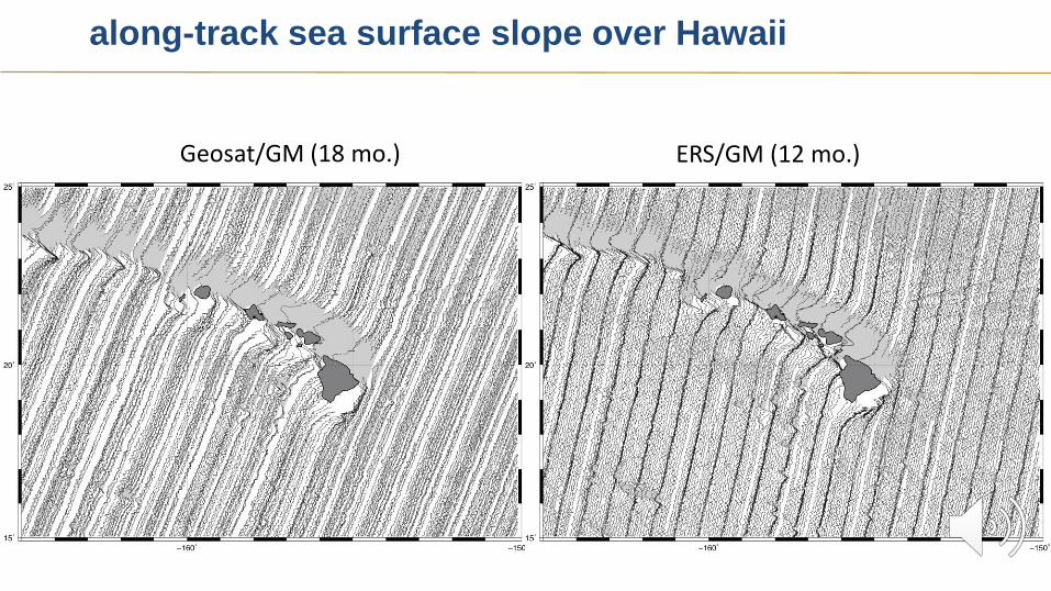
along-track sea surface slope over Hawaii
Geosat/GM (18 mo.) ERS/GM (12 mo.)

CryoSat-2 (77 mo.) AltiKa/GM (13 mo.)
along-track sea surface slope over Hawaii
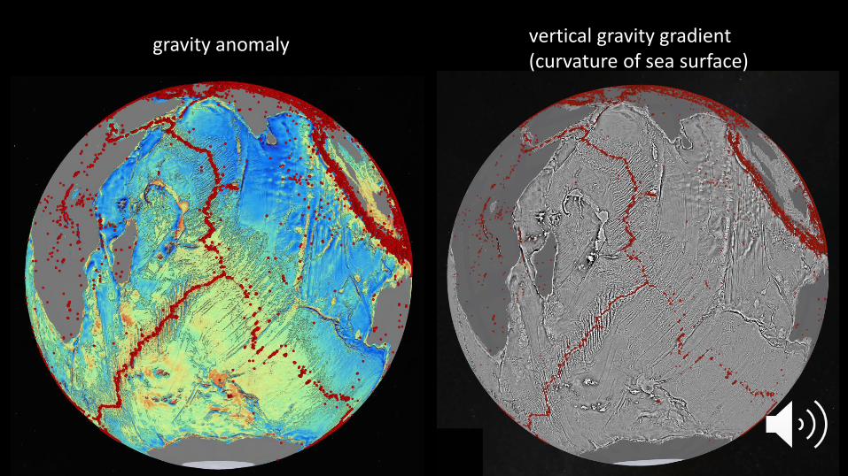
gravity anomaly vertical gravity gradient(curvature of sea surface)

VGG (V18) Geosat + ERS
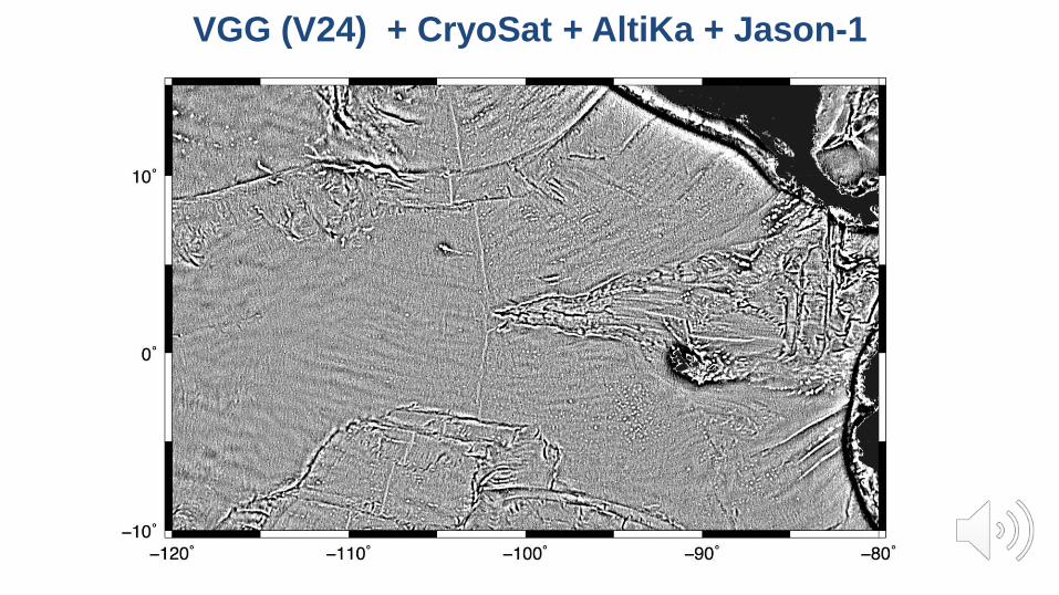
VGG (V24) + CryoSat + AltiKa + Jason-1

VGG (V18) Geosat + ERS

Discovery of small seamounts

VGG (V18) Geosat + ERS

VGG (V24) + CryoSAT + AltiKa + Jason-1

VGG (V18) Geosat + ERS

Resolution of uncharted abyssal hills

Seamount Discovery Tool
Cape Town to Punta Arenas - Melville - Feb, 2011
red - great circle = 6896 km
green - 10 new seamounts = 7130 km (1.034)
violet - 11 new seamounts = 7069 km (1.025)
[Sandwell, D. T., and P. Wessel, Seamount discovery
tool aids navigation to uncharted seafloor features,
Oceanography, 23:1 , p. 24-26, 2010.]
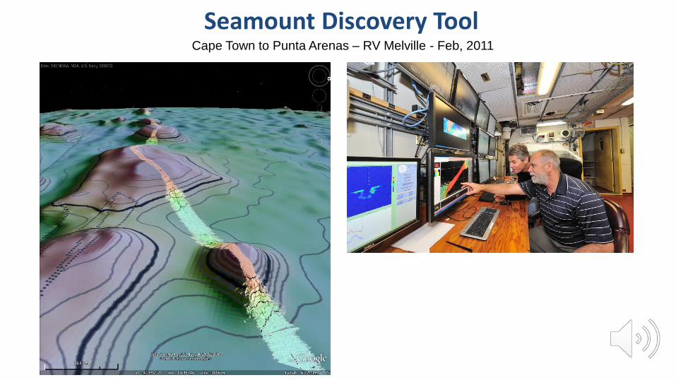
Cape Town to Punta Arenas – RV Melville - Feb, 2011
Seamount Discovery Tool

Conclusions
• GOOD
Global marine gravity from satellite altimetry will reach 1-mGal accuracy
with CryoSat-2, AltiKa, Jason-1/2, and SWOT.
It may be possible to locate all seamounts > 1 km tall and resolve abyssal
hill fabric.
• BAD
Only 17% of the seafloor has been mapped by sonar at < 1 km resolution.
Depths predicted from gravity have ~4 km resolution and an accuracy of
only 250 – 400 m.
• UGLY
Bathymetric prediction fails on continental margins because sediment
masks original topography.

Questions?