pre-restoration bird surveys at meadows on sierra · pdf filepre-restoration bird surveys at...
TRANSCRIPT

Pre-restoration bird surveys at meadows
on Sierra National Forest and Sequoia
National Park
July 15, 2011
Helen L. Loffland
Rodney B. Siegel
Robert L. Wilkerson
The Institute for Bird Populations
PO Box 1346
Point Reyes Station, CA 94956
www.birdpop.org

The Institute for Bird Populations 2010 Bird Monitoring at Meadows in the Sierra NF/Sequoia NP Region
i
Table of Contents I. Abstract 1 II. Background 2 III. Methods 3
A. Monitoring Scheme B. Site Selection 7 C. Crew Training And Certification 7 D. Data Collection 8 E. Data Analysis 9
IV. Results 9 V. Discussion 18 VI. Acknowledgments 18 VII. Literature Cited 19 VIII. Appendices
A. Geographic coordinates of survey station 22 B. Maps of meadows with survey station locations 24 C. Number of birds detected during point counts at each meadow
30
D. Average number of birds detected during area searches at each meadow
37
E. All bird species detected during point counts and area searches at each meadow
42
The Institute for Bird Populations 2010 Bird Monitoring at Meadows in the Sierra NF/Sequoia NP Region
1
ABSTRACT With funding from the National Fish and Wildlife Foundation in 2009-2010, The Institute for Bird Populations developed a monitoring protocol to assess how bird populations respond to meadow restoration activities in the Sierra Nevada. During summer 2010 we field-tested the protocol by conducting pre-restoration bird surveys at 28 meadows proposed for restoration and 32 reference meadows in the Sierra Nevada. Study sites were identified in collaboration with personnel at National Forests, National Parks, California State Lands, and private landowners. Monitoring visits included point count surveys, broadcast surveys, area searches, and vegetation and soil moisture assessments. This report describes results of the pre-restoration monitoring completed at 6 meadows (3 intended restoration sites, and 3 paired reference sites) on the Sierra National Forest and Sequoia National Park. We surveyed all meadows twice during the 2010 breeding season, conducting a total of 38 point count and broadcast surveys, and over 7 person-hours of area searching. Results of these surveys will provide baseline information for assessing the effects of future restoration activities on bird populations at each of the 3 intended restoration sites.

The Institute for Bird Populations 2010 Bird Monitoring at Meadows in the Sierra NF/Sequoia NP Region
2
BACKGROUND Montane meadows in the Sierra Nevada form ecological islands within the
surrounding forest matrix (Ratliff 1985, Fites-Kaufman et al. 2007). They provide abundant water, food, and cover for birds and other wildlife, and are among the most important breeding and foraging habitats for birds in the Sierra Nevada (Grinnell and Miller 1944, Orr and Moffit 1971, Gaines 1992, Graber 1996, Heath and Ballard 2003). However, at many Sierra meadows human activities and historic management practices have altered meadow hydrology, which in turn has changed the characteristics of meadow plant communities, and often diminished the value of meadow habitat for native bird populations (Klebenow and Oakleaf 1984, Allen-Diaz 1991, Kattelmann and Embury 1996, Cicero 1997, Siegel et al. 2008).
Throughout the Sierra Nevada, many public and private land managers are
seeking win-win solutions for humans and wildlife by restoring or enhancing meadow habitats, in many cases addressing the historical legacy of hydrological impacts that have led to poorly watered meadows (Rood and Mahoney 1990, Loheide and Gorelick 2006, Skidmore et al. 2009). Restoring meadow hydrology is often a critical first step in restoring the full complement of native biodiversity to a meadow (Poff et al. 1997, Dwire et al. 2006).
Well-functioning hydrologic processes in montane meadows not only yield
improved habitat for wildlife, but may also provide tangible benefits for humans, including:
increased water storage capacity (Loheide and Gorelick 2006, Skidmore et al. 2009),
improved water quality (Alexander et al. 2007, Simon et al. 2006),
downstream flood attenuation (Gurnell et al. 1995, Skidmore et al. 2009),
increased duration of summer flows (Alexander et al. 2007), and
improved forage quality for livestock (Ratliff 1985). One way to assess the success of meadow restoration is to monitor the
responses of bird populations that inhabit the meadow. Birds can respond rapidly and dramatically to meadow restoration efforts, with populations of meadow-associated bird species increasing in or even colonizing meadows within as little as one year after restoration efforts are implemented (Taylor and Littlefield 1986, Larison et al. 2001, Stanley and Knopf 2002, McCreedy and Heath 2004, Heltzel and Earnst 2006, Borgmann 2010).
Each of the meadow-associated bird species that utilizes montane meadows in
the Sierra Nevada has its own particular habitat needs, and the presence or absence of those specific habitat components largely predicts which species utilize a particular meadow (Wiens 1985). When meadow habitats are degraded the number of individual birds and the number of bird species occupying them tends to decline.

The Institute for Bird Populations 2010 Bird Monitoring at Meadows in the Sierra NF/Sequoia NP Region
3
The primary objective of this project was to collect pre-restoration data on bird populations at meadows where future restoration projects are planned (and at associated reference sites). These data will allow assessment of the response of bird populations to future restoration activities. Such assessments are valuable both for documenting successes of restoration activities and for facilitating improvement of restoration techniques in an adaptive management context.
We used a draft bird survey protocol (Loffland et al. 2011) under development
with funding from the National Fish and Wildlife Foundation designed specifically for pre- and post-restoration bird monitoring at meadow restoration sites. The protocol includes a combination of multi-species and single-species survey techniques, and incorporates point counts, species-specific broadcast surveys, area searches, and vegetation and soil moisture plots.
The use of a standardized survey protocol will help managers and researchers to
glean important lessons from restoration monitoring efforts—lessons that cannot be learned from monitoring at any single site. Standardized data from diverse sites that undergo a variety of restoration measures will facilitate comparison of bird responses across sites and projects. Such comparisons will lead to an improved understanding of which restoration efforts most effectively produce high-quality bird habitat, and will allow future meadow restoration efforts to incorporate those findings. METHODS
All of our methods adhered to Loffland et al.’s (2011) Avian Monitoring Protocol for Sierra Nevada Meadows. Here we provide a cursory summary of methods, but readers seeking more detail or a discussion of the merits and limitations of particular methods should refer to the protocol itself. Monitoring Scheme
Loffland et al. (2011) suggest a BACI (Before, After, Control, Impact) monitoring
scheme. Under this scheme all monitoring sites where restoration activities are planned are paired with one or more reference sites with similar hydrology and vegetation, but where no restoration activities are imminent. All monitoring activities are then conducted at both the restoration and reference sites in at least one year prior to restoration and at least one year after restoration. This design improves the manager’s ability to separate local population changes that are the result of restoration from regional changes that may be due to annual weather variation or other factors. Comparing change in bird populations at the restoration site with the reference site will allow managers to see how individual bird species and suites of species respond to restoration activities, and how the response varies by type of restoration activity, locality, and, if multiple years of post-restoration monitoring are conducted, time since restoration activity (Smucker et al. 2005, Ward et al. 2010).

The Institute for Bird Populations 2010 Bird Monitoring at Meadows in the Sierra NF/Sequoia NP Region
4
Site Selection During early spring of 2010 we met with USDA Forest Service Region 5 staff to
discuss how best to identify meadow restoration projects in the planning stage on National Forest lands. We worked closely with the Regional Hydrologist as he queried forests in Region 5. We also consulted with personnel at Yosemite and Sequoia National Parks and state agencies, and private landowners. We placed a higher priority on restoration projects that were already in the planning stage, but also included some sites that were identified as needing restoration, but for which the NEPA/CEQA process had not yet begun. Following guidance from the National Fish and Wildlife Foundation, we made restoration projects with a hydrologic component our highest priority. The resulting set of 30 restoration projects was distributed across 6 National Forests, 2 National Parks, 2 California State Wildlife Areas, 1 California State Park, and 1 private parcel. After identifying the restoration projects, we worked with local contacts to identify suitable reference sites to pair with each restoration site. These collaborations yielded 32 reference sites (in two instances multiple small sites were paired with a single restoration site). This report details the subset of our 2010 study sites that were located on the Sierra National Forest and Sequoia National Park.
Conversations with biologists and hydrologists on the Sierra National Forest and
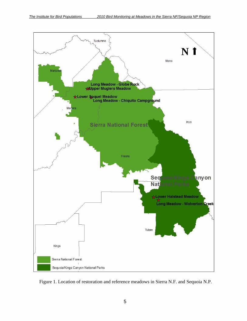
at Sequoia National Park identified 3 meadow restoration projects in various stages of planning. For each restoration site, we selected one or more reference sites based on advice of local experts and through review of aerial photography (Table 1; Figure 1). Table 1. Restoration and associated reference sites on Sierra National Forest and Sequoia National Park where pre-restoration bird surveys were conducted during the 2010 breeding season.
Restoration Site (land manager) Reference Site(s) (land manager)
Long Meadow – Chiquito Campground (Sierra N.F.)
Lower Soquel Meadow (Sierra N.F.)
Long Meadow – Globe Rock (Sierra N.F.)
Upper Muglers Meadows (Sierra N.F.)
Lower Halstead Meadow (Sequoia N.P.)
Long Meadow – Wolverton Creek (Sequoia N.P.)
The Institute for Bird Populations 2010 Bird Monitoring at Meadows in the Sierra NF/Sequoia NP Region
5
N
Figure 1. Location of restoration and reference meadows in Sierra N.F. and Sequoia N.P.
The Institute for Bird Populations 2010 Bird Monitoring at Meadows in the Sierra NF/Sequoia NP Region
6
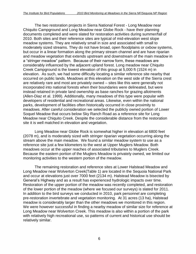
The two restoration projects in Sierra National Forest - Long Meadow near Chiquito Campground and Long Meadow near Globe Rock - have their planning documents completed and were slated for restoration activities during summer/fall of 2010. Both sites and their reference sites are typical of mid-elevation west slope meadow systems. They are relatively small in size and associated with small to moderately sized streams. They do not have broad, open floodplains or oxbow systems, but occur in a linear formation along the primary stream channel and are have riparian and meadow vegetation that extends upstream and downstream of the main meadow in a ―stringer meadow‖ pattern. Because of their narrow form, these meadows are considerably influenced by the adjacent upland forest. Long meadow near Chiquito Creek Campground is the lowest elevation of this group at 5,000 ft (1524 m) in elevation. As such, we had some difficulty locating a similar reference site nearby that occurred on public lands. Meadows at this elevation on the west side of the Sierra crest are relatively rare and most are privately owned – sites like this were generally not incorporated into national forests when their boundaries were delineated, but were instead retained in private land ownership as base ranches for grazing allotments (Allen-Diaz et al. 1999). Additionally, many meadows of this type were popular with developers of residential and recreational areas. Likewise, even within the national parks, development of facilities often historically occurred in close proximity to meadows. After careful consideration we selected the publicly owned portion of Lower Soquel Meadow that occurs below Sky Ranch Road as a reference site for Long Meadow near Chiquito Creek. Despite the considerable distance from the restoration site it is well matched in elevation and vegetation.
Long Meadow near Globe Rock is somewhat higher in elevation at 6800 feet
(2078 m), and is moderately sized with stringer riparian vegetation occurring along the stream above the main meadow. We found a similar meadow system to use as a reference site just a few kilometers to the west at Upper Muglers Meadow. Both meadows occur at the upper reaches of associated tributaries to Muglers Creek. Because the eastern portion of the Muglers Meadow is privately owned, we limited our monitoring activities to the western portion of the meadow.
The remaining restoration and reference sites at Lower Halstead Meadow and Long Meadow near Wolverton Creek(Table 1) are located in the Sequoia National Park and occur at elevations just over 7000 feet (2134 m). Halstead Meadow is bisected by General’s Highway and as a result has experienced hydrologic impacts over time. Restoration of the upper portion of the meadow was recently completed, and restoration of the lower portion of the meadow (where we focused our surveys) is slated for 2011. In addition to the bird surveys we conducted in 2010, park personnel are completing pre-restoration invertebrate and vegetation monitoring. At 31 acres (13 ha), Halstead meadow is considerably larger than the other meadows we monitored in this region. We were however successful in finding a nearby meadow of similar size for reference at Long Meadow near Wolverton Creek. This meadow is also within a portion of the park with relatively high recreational use, so patterns of current and historical use should be relatively similar.

The Institute for Bird Populations 2010 Bird Monitoring at Meadows in the Sierra NF/Sequoia NP Region
7
All 6 restoration and reference sites within this management area have a historical legacy of logging and/or grazing use. With creation of the national parks and national forests use patterns shifted, but for each reference and restoration pair, overall land management was relatively consistent. All of these sites occur in areas that experience moderate to high recreational use at this time. The mid-elevation Sierra N.F. meadows border upland forest dominated by Sierra Mixed Conifer, while the higher elevation Sequoia N.P. sites have Sierra Mixed Conifer or Lodgepole Pine along the meadow edges, depending on elevation. Occasionally areas of granite outcrop make up a portion of the surrounding upland areas.
Crew Training and Certification
All data were collected by full-time crew members working or volunteering for The Institute for Bird Populations. At the beginning of the 2010 field season, crew members underwent an intensive 3-week training session that followed the guidelines in Loffland et al. (2011) for ensuring surveyors are fully competent and qualified to collect reliable data. At the end of the training session all crew members passed a rigorous bird identification exam that tested the skills necessary to conduct point counts and area searches.
Data Collection All sites were surveyed within the May 20-July 15 temporal window specified by
the Loffland et al. (2011) protocol; at most meadows we were able to complete two full surveys (excluding the vegetation and soil moisture plots which we only completed once, in accordance with the survey protocol).
Establishing Survey Stations At restoration and reference meadows we established survey stations 250 m
apart along transects that followed the general course of stream channels within meadows, as well as in areas of meadows with no adjacent stream. Where possible, survey stations were placed at least 25 m from streams that were large enough to cause substantial noise interference during surveys – this will also help ensure that if stream restoration results in inundation or widening of the channel, survey stations do not end up under water in future years. In narrow meadows (<100 m wide), stations were placed every 250 m along a transect that traveled along the center of the meadow, regardless of where the stream channel was located. In most cases survey stations were delineated prior to the first field visit using digital aerial photos (DOQQs) and ArcMap software. Geographic coordinates of individual survey stations are provided in Appendix A and site maps with survey station locations are provided in Appendix B. In a few instances stations were inaccessible due to the unusually high water conditions in June and July of 2010. For those stations that could not be reasonably relocated to a more accessible area nearby, surveys were not completed in 2010. Nonetheless, their coordinates remain in Appendix A, and the points should be surveyed if possible during future monitoring visits.

The Institute for Bird Populations 2010 Bird Monitoring at Meadows in the Sierra NF/Sequoia NP Region
8
Point Counts
We utilized 10-minute point counts, divided into four smaller time intervals to facilitate estimating detection probability and modeling occupancy rates (MacKenzie et al. 2002) in the future, if desired. All birds were classified as being either < 50 m from the survey station at first detection, or at a distance >50 m.
Species-Specific Broadcast Surveys
Immediately following each 10-min point count, we remained at the survey station and conducted broadcast surveys for 3 rare or hard to detect species that may be particularly likely to respond to meadow restoration efforts: Willow Flycatcher, Sora, and Virginia Rail. Vocalizations for a particular species were broadcast only if we did not first detect the species within 50 m of the survey station during the preceding 10-minute point count.
Area Searches
When all of the point count and broadcast surveys were completed, surveyors remained at the meadow and began the area search portion of the survey. The amount of time spent area searching was dependent on the size of the meadow; surveyors spent at least 10 minutes area-searching for every survey station the meadow accommodated. One of the objectives of the areas search was to increase the likelihood of detecting rarer or more secretive species that were present at the site, particularly species that may have been missed during the point count and broadcast portions of the survey. When conducting the area search, surveyors moved through the meadow slowly and quietly, counting all birds detected at the site. Special attention was paid to areas along stream channels or other flooded/ponded areas, and locations where restoration activities were planned. Additionally, areas of the meadow where sight and sound were obstructed by dense vegetation were observed carefully. Although more time may have been spent in these specific portions of the meadow, all areas and vegetation communities were systematically covered. We tallied individual birds based on their location at the time of first detection, either within the meadow, or within the surrounding forest or other upland vegetation community. Vegetation and soil moisture plots
After completing bird surveys we assessed the vegetative structure and vegetative community types at each survey station to characterize the meadow and provide context for bird survey results. We recorded relative cover and vegetation height for a variety of vegetative and surface water components in each of the four quadrants formed by four 50-m transects extending away from the station in each of the cardinal directions (N, S, E, W). . For each quadrant (NW, NE, SE, SW), we recorded cover for each vegetation type after first walking the quadrant to observe the entire area. Cover was estimated as if one was looking down on the site from above. Totals of all cover

The Institute for Bird Populations 2010 Bird Monitoring at Meadows in the Sierra NF/Sequoia NP Region
9
types combined sometimes exceeded 100% because values were combined over multiple overlapping levels of the canopy: herbaceous, shrub, and tree. Data Analysis
Because only one year of baseline monitoring has been completed, the analysis reported here is relatively simple. From point count results at each meadow, we tabulated the number of species detected, the number of individuals of each species detected, and the number of individuals detected per point for all species combined. Results are provided separately for birds detected within 50 m of the survey station, and birds detected at any distance from the survey station. From area search results we provide numbers of individuals of each species, as well as the number of additional species detected that were not detected during point count surveys. We also tallied total number of individuals (of all species combined) counted and total number of species detected as the average across both visits (when two visits were completed). From broadcast surveys, we report the number, species and locations of any target species detected. Mean vegetation measurements are reported at the meadow scale, and are intended to characterize the areas of the meadows where we conducted point counts and broadcast surveys. RESULTS
During the late winter and early spring of 2010 the Sierra Nevada experienced heavier than average snowfall, and unusually late snowmelt. These conditions made planning and implementation of the monitoring work more difficult because many sites and access roads were under snow well into June and, in some cases, July. Many of our monitoring efforts had to be delayed until sites became accessible. Nonetheless, we were able to visit all sites twice within our survey window of May 20 through July 15 (Table 2). Loffland et al. (2011) encourages two visits, but the second visit is considered optional. In total, three restoration sites, and three reference sites (6 total) within the Sierra N.F./Sequoia N.P. region received two visits during 2010 breeding season. We established 38 survey stations at the 6 study sites.

The Institute for Bird Populations 2010 Bird Monitoring at Meadows in the Sierra NF/Sequoia NP Region
10
Table 2. Site location information and survey dates for meadows on Sierra N.F. and Sequoia N.P.
Meadow Namea Site Type
UTM Easting
UTM Northing
UTM Zone
Elev. (ft) USGS Quadrangle Visit 1 Date Visit 2 Date
No. of Survey
Stations
Long Meadow - Chiquito Campground Restore 288115 4142887 11s 5000 Little Shuteye Peak 6/22/2010 7/1/2010 2
Lower Soquel Meadow Reference 273592 4144234 11 5350 White Chief Mtn 6/20/2010 6/29/2010 4
Long Meadow - Globe Rock Restore 286166 4150982 11s 6800 Little Shuteye Peak 6/23/2010 7/1/2010 3
Upper Muglers Meadow Reference 284525 4150872 11 6900 Little Shuteye Peak 6/23/2010 7/1/2010 3
Lower Halstead Meadow Restore 340413 4053699 11s 7000 Giant Forest 6/23/2010 6/30/2010 3
Long Meadow - Wolverton Creek Reference 344633 4051116 11 7250 Giant Forest 6/22/2010 6/30/2010 4
aRestoration sites are indicated in bold text with associated reference sites directly below them in plain text.

The Institute for Bird Populations 2010 Bird Monitoring at Meadows in the Sierra NF/Sequoia NP Region
11
Point Counts Among the meadows with survey results reported here, no strong patterns in bird
abundance or species diversity exist relative to meadow size or location (Table 3). Table 3. Number of individual birds and number of species detected during point count surveys at all study sites.
Meadow Namea
No. of Survey
Stations
Avg. No. Birds Detected
b
Avg. No. Birds Per Station
b
Species Detected (Visits Pooled)
<50m Unlimited
Radius <50m Unlimited
Radius <50m Unlimited
Radius
Long Meadow – Chiquito Campground 2 3.0 60.0 1.5 30.0 3 27
Lower Soquel Meadow 4 11.5 55.5 2.9 13.9 12 34
Long Meadow - Globe Rock 3 5.5 32.5 1.8 10.8 8 23
Upper Muglers Meadow 3 13.0 46.0 4.3 15.3 14 25
Lower Halstead Meadow 3 6.5 47.5 2.2 15.8 5 21
Long Meadow -Wolverton Creek 4 16.5 63.5 4.1 15.9 9 25 aRestoration sites are indicated in bold text with associated reference sites directly below them in plain
text. bReported for individuals detected within a 50m radius of the survey station and for all individuals
detected at all distances from the station (unlimited radius). Number of birds detected and number of birds per station are reported as the mean value averaged across 2 visits, except for sites where only one visit was completed.
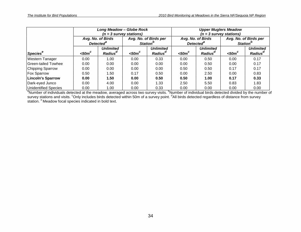
Loffland et al. (2011) identify 16 meadow-associated focal species. These species were selected because of their affinity to meadow and riparian communities, and based on the expectation that their numbers would increase if meadow restoration efforts improved the quantity or quality of habitat components important to them. One exception is the Brown-headed Cowbird. While often found in meadows, this species also uses many other open or disturbed habitats with human or livestock use. Brown-headed Cowbirds were selected by Loffland et al. (2011) as focal species because of the role they play as nest parasites of other meadow-associated birds, and the association between their relative abundance and human disturbance. Of the 16 focal species identified for Sierra Nevada meadows, 7 were detected during point counts in the Sierra N.F./Sequoia N.P. study region (Table 4).

The Institute for Bird Populations 2010 Bird Monitoring at Meadows in the Sierra NF/Sequoia NP Region
12
Table 4. Relative abundancea of strongly meadow-associated focal bird species at each meadow. Focal species were identified by Loffland et al. (2011).
Meadow Nameb S
urv
ey r
ad
ius
Red
-bre
aste
d
Sap
su
cke
r
Warb
lin
g V
ireo
Yello
w W
arb
ler
MacG
illi
vra
y’s
Warb
ler
So
ng
Sp
arr
ow
Lin
co
ln’s
Sp
arr
ow
Bro
wn
-head
ed
Co
wb
ird
Long Meadow- Chiquito Campground <50 m 0.00 0.00 0.00 0.00 0.00 0.00 0.00
Unlim. 0.00 2.50 0.50 2.00 3.00 1.50 0.00
Lower Soquel Meadow <50 m 0.00 0.00 0.13 0.00 0.50 0.00 0.13
Unlim 0.00 0.38 0.50 0.50 0.88 0.00 0.25
Long Meadow - Globe Rock <50 m 0.17 0.00 0.00 0.00 0.00 0.00 0.00
Unlim 0.33 0.00 0.17 0.33 0.00 0.50 0.00
Upper Muglers Meadow <50 m 0.17 0.33 0.00 0.00 0.00 0.17 0.00
Unlim 0.17 1.00 0.17 0.33 0.00 0.33 0.00
Lower Halstead Meadow <50 m 0.00 0.00 0.00 0.00 0.33 0.83 0.00
Unlim 0.00 0.17 0.00 0.67 0.83 2.00 0.00
Long Meadow - Wolverton Creek <50 m 0.13 0.00 0.00 0.25 0.00 1.00 0.00
Unlim 0.13 1.00 0.00 1.13 0.13 2.25 0.00 aNumber of individuals of each species divided by the number of visits and number of survey points,
based on all detections within 50m of a survey point, and at an unlimited distance. bRestoration sites are
indicated with bold type.
The number of focal species detected at a given meadow ranged from a low of 4
at Lower Soquel and Lower Halstead Meadows to a high of 5 at the remaining four meadows. Of the focal species detected, Brown-headed cowbird was only detected at Lower Soquel Meadow, while Warbling Vireo was detected at all 6 sites. Each of the remaining focal species was detected at three or more of the 10 meadows. The average number of individuals detected for each species, and the average number per survey station, are reported for all species at each restoration site and its associated reference site(s) in Appendix C.
Broadcast Surveys
Broadcast surveys for Sora, Virginia Rail, and Willow Flycatcher were completed at all survey stations. Vocalizations were only broadcast if the species was not spontaneously singing or calling within 50 m of the survey station during the preceding point count. No target species were detected using broadcast surveys in the Sierra N.F./Sequoia N.P. region.

The Institute for Bird Populations 2010 Bird Monitoring at Meadows in the Sierra NF/Sequoia NP Region
13
Area Searches In most cases, we conducted area searches immediately following point count
and broadcast surveys, but no later than 4.5 hours after sunrise. At large meadows, area searches were sometimes completed by a separate observer concurrent with point count surveys. In all but a few cases area searches were completed on the same morning as point counts. Area searches resulted in the mean detection of 3.2 (SD = 1.47) additional species per meadow in the Sierra N.F./Sequoia N.P. region, over species totals based on point count surveys alone (Table 5). Species-specific area search results for each restoration site and its associated reference site are provided in Appendix D. Appendix E contains a list of all species detected (point counts and areas searches combined) at each meadow. Table 5. Number of species detected at each site based on combined area search and point count resultsa.
Meadow Nameb
No. Species Detected
- Area Searches
No. Species Detected
- Point Counts
No. Species Detected Only During Area
Searches
No. Species - Both Methods
Combined
Long Meadow – Chiquito Campground 17 27 3 30
Lower Soquel Meadow 28 34 2 36
Long Meadow - Globe Rock 20 23 3 26
Upper Muglers Meadow 22 25 2 27
Lower Halstead Meadow 20 21 3 24
Long Meadow -Wolverton Creek 28 25 6 31 aResults are pooled across all visits. bRestoration sites are indicated with bold type.

The Institute for Bird Populations 2010 Bird Monitoring at Meadows in the Sierra NF/Sequoia NP Region
14
Vegetation Assessment
Vegetation and water measurements were collected at each survey station for the purpose of assessing the 50-m radius area surrounding each survey station, and to provide information characterizing the general vegetation communities and hydrologic conditions within the overall meadow. Table 6 provides the average cover values for each meadow, calculated from the means of the four quadrants at each survey station.
Tree and snag cover was greatest at smaller linear sites where the forest edge
regularly fell within 50 m of the survey stations. Tree cover within the meadow can be an indicator of lowered water tables and conifer encroachment. Although meadow associated birds will utilize trees for foraging and territory advertisement, brown-headed cowbirds and nest predators also use trees within the meadow as hunting perches. Stations at Long Meadow near Globe Rock and Upper Muglers Meadow had average tree cover values greater than 40%. Long Meadow near Wolverton Creek had the greatest amount of cover from riparian shrubs within the 50-m plots (8.94%), while the remaining sites had less than 5% riparian shrub cover. Extent of shrub cover is particularly important for many shrub-nesting bird species. Sagebrush cover, often an indicator of lowered water tables, did not occur at any study sites in this region. Sagebrush is relatively rare on the west slope of the Sierra when compared with the east slope, so its value as an indicator of water table height is not as meaningful in this study region.
We quantified the amount of flowing and standing water around survey stations
to assess habitat quality for bird species that are associated with water or saturated conditions. This is also a measurement expected to change with restoration activities. Water cover from flowing water was highest at the two meadows within the park
(12.83% and 10.63%). The amount of standing water was less than 7% at all sites ( = 3.96; S.E. =0.77)(Table 6).

The Institute for Bird Populations 2010 Bird Monitoring at Meadows in the Sierra NF/Sequoia NP Region
15
Table 6. Average vegetative and water cover characteristics for 50-m plots surrounding survey stations at each meadow.
Meadow Namea
No. Stations Measure
b
Percent Cover
Trees Snags Riparian Shrubs Sagebrush
Non-Woody Vegetation
Bare Ground
Gravel Bar
Flowing Water
Standing Water
Long Meadow- Chiquito Cmpgrd.
2 Mean 13.13 2.63 0.00 0.00 76.88 0.00 0.00 2.25 6.25
(S.E.) 9.88 1.88 0.00 0.00 14.38 0.00 0.00 1.25 3.75
Lower Soquel Meadow 4 Mean 31.13 0.88 2.50 0.00 47.50 9.38 4.81 4.38 0.00
(S.E.) 16.47 0.39 0.44 0.00 18.60 4.96 4.81 1.94 0.00
Long Meadow - Globe Rock
3 Mean 41.67 2.00 0.00 0.00 51.25 8.25 0.33 7.08 4.50
(S.E.) 7.41 0.29 0.00 0.00 12.64 6.51 0.17 1.10 1.81
Upper Muglers Meadow
3 Mean 45.00 1.08 4.50 0.00 42.50 8.42 0.00 3.75 6.00
(S.E.) 5.00 0.65 1.23 0.00 6.61 4.59 0.00 0.72 3.06
Lower Halstead Meadow
3 Mean 12.00 2.08 1.17 0.00 68.17 2.00 0.00 12.83 3.58
(S.E.) 9.95 1.23 0.58 0.00 10.35 0.00 0.00 3.58 0.87
Long Meadow – Wolverton Creek
4 Mean 15.75 0.19 8.94 0.00 61.25 2.13 0.00 10.63 5.13
(S.E.) 8.43 0.12 5.40 0.00 5.91 0.68 0.00 3.70 0.41
6 Meadows Pooled 19 Mean 26.83 1.32 3.30 0.00 56.55 5.37 1.07 7.13 3.96
(S.E.) 5.02 0.31 1.29 0.00 5.18 1.65 1.01 1.28 0.77 aRestoration sites are indicated in bold text.
bMean and standard error averaged over four 50-m radius quadrants at each survey station.

The Institute for Bird Populations 2010 Bird Monitoring at Meadows in the Sierra NF/Sequoia NP Region
16
For those survey stations with riparian deciduous shrub cover, we also assessed the proportion of the shrub occurring within different height and age classes, as well as taxonomic group (Table 7). Immature shrubs in the lowest height class are indicative of shrub recruitment, an important factor in maintaining suitable habitat for shrub-nesting birds. Mature shrubs in the shortest height class can indicate certain low growing species, as well as situations where livestock or native ungulates are regulating growth patterns. These factors, as well as the proportion of the shrub community in the taller height classes, are relevant to certain focal bird species that prefer to nest at heights greater than 1 m above the ground. For all sites combined, the majority of riparian shrubs (68.14%) were 1 – 2 m tall, although two sites, Long Meadow near Wolverton Creek and Upper Muglers Meadow had a relatively large amount of mature shrubs in the <1 m height class (50% and 31%, respectively). None of the meadows had shrubs in the seedling size class (Table 7). Meadows in this region differed somewhat from other regions in that almost half of their riparian shrubs were not willow or alder but other taxonomic groups (Cornus spp., Lonicera spp, Ribes spp, Rosa spp, etc.).

The Institute for Bird Populations 2010 Bird Monitoring at Meadows in the Sierra NF/Sequoia NP Region
17
Table 7. Average characteristics of riparian deciduous shrubs in 50-m plots surrounding survey stations. Vegetation plots on the 5 study sites not listed had no riparian deciduous shrubs.
Meadow Namea
No. Stations
Measure
b
Height and Age Class of Riparian Shrubs (%)
Taxonomic Composition of Riparian Shrubs
<1m (seedling)
<1m (mature) 1 - 2m >2m % Willow % Alder
% Other Riparian Shrub
Lower Halstead Meadow 2 Mean 0.00 0.00 92.50 7.50 86.25 0.00 13.75
(S.E.) 0.00 0.00 2.50 2.50 13.75 0.00 13.75
Long Meadow - Wolverton Crk. 4 Mean 0.00 33.33 60.42 5.63 100.00 0.00 0.00
(S.E.) 0.00 13.68 9.77 4.83 0.00 0.00 0.00
Lower Soquel Meadow 4 Mean 0.00 5.00 95.00 0.00 36.46 0.00 63.54
(S.E.) 0.00 5.00 5.00 0.00 22.21 0.00 22.21
Upper Muglers Meadow 3 Mean 0.00 50.00 48.33 1.67 10.00 0.00 90.00
(S.E.) 0.00 28.87 27.44 1.67 10.00 0.00 10.00
4 Meadows Pooled 13 Mean 0.00 22.63 68.14 3.27 51.54 0.00 40.77
(S.E.) 0.00 8.90 8.47 1.64 11.58 0.00 12.10 aRestoration sites are indicated in bold text.
bMean and standard error averaged over four 50m-radius quadrants at each survey station.

The Institute for Bird Populations 2010 Bird Monitoring at Meadows in the Sierra NF/Sequoia NP Region
18
Discussion
We strongly recommend continuing bird monitoring activities at meadows in the Sierra N.F. / Sequoia N.P. Region in as many pre- and post-restoration years as feasible. One way that we might alter monitoring methods from what was completed in 2010 would be to decrease the distance between survey stations to as little as 200 m if doing so would allow for the addition of even one more survey station at small meadows. Many of the meadows in this region contained three or fewer survey stations. These small sample sizes can be problematic for some analyses, and if one or more stations can be added, results would be strengthened. Nevertheless we do not recommend altering station locations for the sites listed in this report where surveys occurred in 2010. Rather, any new reference or restoration sites could benefit from maximizing the number of stations. We also assessed our 2010 results and decided that decreasing point count duration from 10 minutes to 7 minutes would provide reliable results while balancing the amount of time and effort necessary per point count. In addition, we did not find much benefit from species-specific broadcast surveys for Willow Flycatcher, Sora and Virginia Rail. Not surprisingly, these species were not often detected at sites in need of restoration. Even when they were detected, there were only three instances during our surveys across the entire Sierra Nevada where broadcast surveys detected an individual that had not already been detected during point counts. While single-species broadcast surveys may still be useful for some projects, detection probabilities of Sora and Virginia Rail may be adequately high with passive survey methods that do not incorporate broadcasts, and Willow Flycatchers are likely to be surveyed with full-protocol surveys (Bombay et al. 2003) prior to restoration as part of the state and federal permitting processes. Acknowledgments This project was made possible by funding from the National Fish and Wildlife Foundation. We thank Athena Demetry, Sylvia Haultain, K. Andrew Stone, Jeff TenPas, and Harold Werner for their assistance in identifying suitable restoration and reference sites, and their help with determining when site access would be possible. We thank our field crew for collecting the data: Jade Ajani, Adam Baz, Sara Cendejas-Zarelli, Callie Dahmen, Henry Pollock, and Lisa Vormwald (crew leader). We thank Mandy Holmgren and Lisa Vormwald for data entry. This project was conducted by The Institute for Bird Populations’ Sierra Nevada Bird Observatory and is Contribution No. 413 of The Institute for Bird Populations.

The Institute for Bird Populations 2010 Bird Monitoring at Meadows in the Sierra NF/Sequoia NP Region
19
Literature Cited
Alexander, R. B., E. W. Boyer, R. A. Smith, G. E. Schwarz, and R. B. Moore. 2007.
The role of headwater streams in downstream water quality. Journal of the American Water Resources Association 43(1):41-59.
Allen-Diaz, B. 1991. Water table and plant species relationships in Sierra Nevada
meadows. American Midland Naturalist 126:30-43. Allen-Diaz, B., R. Barrett, W. Frost, L. Huntsinger, K. Tate. 1999. Sierra Nevada
ecosystems in the presence of livestock: A report to the Pacific Southwest Station and Region. Albany, CA: USDA Forest Service;March 22. 144p.
Bombay, H. L, T. M. Benson, B. E. Valentine, and R. A. Stefani. 2003. A willow
flycatcher survey protocol for California. USDA Forest Service, Pacific Southwest Region, Vallejo, CA.
Borgmann, K. L. 2010. Mechanisms underlying intra-seasonal variation in the risk of
avian nest predation: implications for breeding phenology. Ph.D. Dissertation. University of Arizona, Tucson, AZ.
Cicero, C. 1997. Boggy meadows, livestock grazing, and interspecific interactions:
influences on the insular distribution of montane Lincoln’s Sparrows (Melospiza lincolnii alticola). Great Basin Naturalist 57(2):104-115.
Dwire, K. A., J. B. Kauffman, and J. E. Baham. 2006. Plant species distribution in
relation to water-table depth and soil redox potential in montane riparian meadows. Wetlands 26(1): 131-146
Fites-Kaufman, J., P. Rundel, N. Stephenson, and D. A. Weixelman. 2007. Montane
and subalpine vegetation of the Sierra Nevada and Cascade ranges. Pp. 456-501 in M. G. Barbour, T. Keeler-Wolf, and A. A. Schoenherr (eds). Terrestrial vegetation of California. University of California Press, Berkeley.
Gaines, D. 1992. Birds of the Yosemite Sierra. Artemisia Press. Lee Vining, CA. Graber, D. M. 1996. Status of terrestrial vertebrates. Pp. 709-734 in, D. C. Erman
(ed.), Sierra Nevada Ecosystem Project: final report to Congress, vol. II, assessments and scientific basis for management options. Centers for Water and Wildland Resources. University of California, Davis.
Grinnell, J. and A. H. Miller. 1944. The distribution of the birds of California. Pacific
Coast Avifauna 27:1-617.

The Institute for Bird Populations 2010 Bird Monitoring at Meadows in the Sierra NF/Sequoia NP Region
20
Gurnell, A.M., K.J. Gregory, and G.E. Petts. 1995. The role of coarse woody debris in forest aquatic habitats: implications for management. Aquatic Conservation: Marine and Freshwater Ecosystems 5(2):143-166.
Heath, S. K., and G. Ballard. 2003. Patterns of breeding songbird diversity and
occurrence in riparian habitats of the eastern Sierra Nevada. Pp. 21-34 in P. M. Faber (ed.), California riparian systems: processes and floodplain management, ecology and restoration. Riparian Habitat and Floodplains Conference Proceedings, Riparian Habitat Joint Venture, Sacramento, CA.
Heltzel, J. M. and S. L. Earnst. 2006. Factors influencing nest success of songbirds in
aspen and willow riparian areas in the Great Basin. Condor 108(4):842-855.
Kattelman, R. and M. Embury. 1996. Riparian areas and wetlands. Pp. 201-267 in, D. C. Erman (ed.), Sierra Nevada ecosystem project: final report to congress, vol. III chapter 5, assessments and scientific basis for management options. Centers for Water and Wildland Resources. University of California, Davis.
Klebenow, D. A., and R. J. Oakleaf. 1984. Historical avifaunal changes in the riparian
zone of the Truckee River, Nevada. Pp. 203-209 in R.E Warner, and K.M. Hendrix (eds.), California riparian systems, ecology, conservation, and productive management. University of California Press. Berkeley, CA.
Larison, B., S. A. Laymon, P. L. Williams, and T. B. Smith. 2001. Avian responses to
restoration: nest-site selection and reproductive success in Song Sparrows. Auk 118(2):432-442.
Loffland, H. L, R. B. Siegel, and R. L. Wilkerson. 2011. Avian Monitoring Protocol for
Sierra Nevada Meadows: A tool for assessing the effects of meadow restoration on birds. Version 1.0. The Institute for Bird Populations, Point Reyes Station, CA.
Loheide II, S. P. II, and S. M. Gorelick. 2006. Quantifying stream-aquifer interactions
through the analysis of remotely sensed thermographic profiles and in situ temperature histories. Environmental Science & Technology 40(10):3336-3341.
MacKenzie, D. I., J. D. Nichols, G. B. Lachman, S. Droege, J. A. Royle, and C. A.
Langtimm. 2002. Estimating site occupancy rates when detection probabilities are less than one. Ecology 83:2248-2255.
McCreedy, C. and S. Heath. 2004. Atypical Willow Flycatcher nesting sites in a
recovering riparian corridor at Mono Lake, California. Western Birds 35:197-205.

The Institute for Bird Populations 2010 Bird Monitoring at Meadows in the Sierra NF/Sequoia NP Region
21
Orr, R. T., and J. Moffitt. 1971. Birds of the Lake Tahoe Region. California Academy of Sciences, San Francisco, CA.
Poff, N. L., J. D. Allan, M. B. Bain, J. R. Karr, K. L. Prestergaard, B. Richter, R. Sparks,
and J. Stromberg. 1997. The natural flow regime: a new paradigm for riverine conservation and restoration. BioScience 47:769-784.
Ratliff, R. D. 1985. Meadows in the Sierra Nevada of California: state of knowledge.
USDA Forest Service General Technical Report GTR-PSW-84. Pacific Southwest Forest and Range Experiment Station. Albany, CA.
Rood, S. B., and J. M. Mahoney. 1990. Collapse of riparian poplar forests downstream
from dams in western prairies: probable causes and prospects for mitigation. Environmental Management 14:451-464.
Siegel, R. B., R. L. Wilkerson, and D. F. DeSante. 2008. Extirpation of the Willow
Flycatcher from Yosemite National Park. Western Birds 39:8-21. Simon, A., N. L. Pollen, and E. J. Langendoen. 2006. Influence of two woody riparian
species on critical conditions for streambank stability: Upper Truckee River, California. Journal of the American Water Resources Association 41:99-113.
Skidmore, P., C. Thorne, B. Cluer, G. Pess, T. Beechie, J. Castro, and C. Shea. 2009.
Science base and tools for evaluating stream engineering, management, and restoration proposals. Unpublished report: NOAA Fisheries and U.S. Fish and Wildlife Service, 170 pp.
Smucker, K. M., R. L. Hutto, B. M. Steele. 2005. Changes in bird abundance after
wildfire: importance of fire severity and time since fire. Ecological Applications 15:1535-1549.
Stanley, T. R., and F.L. Knopf. 2002. Avian response to late-season grazing in a shrub-
willow floodplain. Conservation Biology 16(1):225-231. Taylor, D. M., and C. D. Littlefield. 1986. Willow Flycatcher and Yellow Warbler
response to cattle grazing. American Birds 40:1169-1173. Ward, M. P., T. J. Benson, B. Semel, and J. R. Herkert. 2010. The use of social cues in
habitat selection by wetland birds. Condor 112:245-251. Wiens, J. A. 1985. Habitat selection in variable environments. Pp. 227-251 in M. L.
Cody (ed.), Habitat selection in birds. Academic Press, New York, NY.

The Institute for Bird Populations 2010 Bird Monitoring at Meadows in the Sierra NF/Sequoia NP Region
22
Appendix A. Geographic coordinates of survey stations

The Institute for Bird Populations 2010 Bird Monitoring at Meadows in the Sierra NF/Sequoia NP Region
23
Table A-1. Geographic coordinates of survey stationsa.
Meadow Name Station Number
UTM Zone
UTM Easting
UTM Northing
Long Meadow - Globe Rock 01 11 286162 4151265 Long Meadow - Globe Rock 02 11 286098 4150976 Long Meadow - Globe Rock 03 11 286053 4150713 Long Meadow - Chiquito Campground 01 11 287989 4142789 Long Meadow - Chiquito Campground 02 11 287777 4142934 Long Meadow - Wolverton Creek 01 11 344602 4051366 Long Meadow - Wolverton Creek 02 11 344586 4050833 Long Meadow - Wolverton Creek 03 11 344588 4051093 Long Meadow - Wolverton Creek 04 11 344563 4050573 Lower Halstead Meadow 01 11 340320 4053462 Lower Halstead Meadow 02 11 340356 4053714 Lower Halstead Meadow 03 11 340436 4053969 Lower Soquel Meadow 01 11 273828 4144615 Lower Soquel Meadow 02 11 273606 4144487 Lower Soquel Meadow 03 11 273549 4144151 Lower Soquel Meadow 04 11 273378 4143762 Upper Muglers Meadow 01 11 284570 4151084 Upper Muglers Meadow 02 11 284528 4150815 Upper Muglers Meadow 03 11 284662 4150580 aUTM coordinates projected in NAD 83.

The Institute for Bird Populations 2010 Bird Monitoring at Meadows in the Sierra NF/Sequoia NP Region
24
Appendix B. Maps of meadows with survey station locations

The Institute for Bird Populations 2010 Bird Monitoring at Meadows in the Sierra NF/Sequoia NP Region
25
Map B-1. Long Meadow – Chiquito Campground
Scale 1:12,000 R. Wilkerson 6/2/2011

The Institute for Bird Populations 2010 Bird Monitoring at Meadows in the Sierra NF/Sequoia NP Region
26
Map B-2. Lower Soquel Meadow
Scale 1:12,000 R. Wilkerson 6/2/2011

The Institute for Bird Populations 2010 Bird Monitoring at Meadows in the Sierra NF/Sequoia NP Region
27
Map B-3. Long Meadow – Globe Rock and Muglers Meadow
Scale 1:12,000 R. Wilkerson 6/2/2011

The Institute for Bird Populations 2010 Bird Monitoring at Meadows in the Sierra NF/Sequoia NP Region
28
Map B-4. Lower Halstead Meadow
Scale 1:12,000 R. Wilkerson 6/2/2011

The Institute for Bird Populations 2010 Bird Monitoring at Meadows in the Sierra NF/Sequoia NP Region
29
Map B-5. Long Meadow – Wolverton Creek
Scale 1:12,000 R. Wilkerson 6/2/2011

The Institute for Bird Populations 2010 Bird Monitoring at Meadows in the Sierra NF/Sequoia NP Region
30
Appendix C. Number of birds detected during point counts at each meadow

The Institute for Bird Populations 2010 Bird Monitoring at Meadows in the Sierra NF/Sequoia NP Region
31
Table C-1. Number of birds detected during point counts at Long Meadow – Chiquito Campground and Lower Soquel Meadow.
Speciese
Long Meadow – Chiquito Campground (n = 2 survey stations)
Lower Soquel Meadow (n = 4 survey stations)
Avg. No. of Birds
Detecteda
Avg. No. of Birds per
Stationb
Avg. No. of Birds
Detecteda
Avg. No. of Birds per
Stationb
<50mc
Unlimited
Radiusd <50m
c
Unlimited
Radiusd <50m
c
Unlimited
Radiusd <50m
c
Unlimited
Radiusd
Mountain Quail 0.00 1.00 0.00 0.50 0.00 0.50 0.00 0.13
California Quail 0.00 0.00 0.00 0.00 0.00 1.00 0.00 0.25
Anna's Hummingbird 0.00 1.00 0.00 0.50 0.00 0.00 0.00 0.00
Downy Woodpecker 0.00 0.00 0.00 0.00 0.00 0.50 0.00 0.13 White-headed Woodpecker 0.00 1.00 0.00 0.50 1.00 1.50 0.25 0.38
Northern Flicker 0.00 1.00 0.00 0.50 0.00 0.00 0.00 0.00
Olive-sided Flycatcher 0.00 1.00 0.00 0.50 0.00 0.00 0.00 0.00
Western Wood-Pewee 0.00 4.00 0.00 2.00 0.00 0.50 0.00 0.13
Dusky Flycatcher 0.00 2.00 0.00 1.00 0.50 2.50 0.13 0.63
Pacific-slope Flycatcher 0.00 2.00 0.00 1.00 0.50 1.00 0.13 0.25 Unidentified Empidonax Flycatcher 0.00 0.00 0.00 0.00 0.00 0.50 0.00 0.13
Cassin's Vireo 1.00 3.00 0.50 1.50 0.00 0.50 0.00 0.13
Warbling Vireo 0.00 5.00 0.00 2.50 0.00 1.50 0.00 0.38
Steller's Jay 0.00 3.00 0.00 1.50 0.50 2.50 0.13 0.63
Common Raven 0.00 2.00 0.00 1.00 0.00 0.00 0.00 0.00
Mountain Chickadee 0.00 0.00 0.00 0.00 0.00 1.50 0.00 0.38
Red-breasted Nuthatch 0.00 2.00 0.00 1.00 0.00 2.00 0.00 0.50
Brown Creeper 0.00 0.00 0.00 0.00 0.00 1.00 0.00 0.25
House Wren 0.00 1.00 0.00 0.50 0.00 0.00 0.00 0.00
Golden-crowned Kinglet 0.00 3.00 0.00 1.50 0.50 5.00 0.13 1.25
Hermit Thrush 0.00 0.00 0.00 0.00 0.00 1.00 0.00 0.25
American Robin 1.00 2.00 0.50 1.00 0.50 2.00 0.13 0.50
Yellow Warbler 0.00 1.00 0.00 0.50 0.50 2.00 0.13 0.50
Yellow-rumped Warbler 0.00 1.00 0.00 0.50 1.00 3.50 0.25 0.88

The Institute for Bird Populations 2010 Bird Monitoring at Meadows in the Sierra NF/Sequoia NP Region
32
Speciese
Long Meadow – Chiquito Campground (n = 2 survey stations)
Lower Soquel Meadow (n = 4 survey stations)
Avg. No. of Birds
Detecteda
Avg. No. of Birds per
Stationb
Avg. No. of Birds
Detecteda
Avg. No. of Birds per
Stationb
<50mc
Unlimited
Radiusd <50m
c
Unlimited
Radiusd <50m
c
Unlimited
Radiusd <50m
c
Unlimited
Radiusd
Hermit Warbler 0.00 1.00 0.00 0.50 0.00 2.00 0.00 0.50
MacGillivray's Warbler 0.00 4.00 0.00 2.00 0.00 2.00 0.00 0.50
Unidentified Warbler 0.00 0.00 0.00 0.00 0.00 0.50 0.00 0.13
Western Tanager 0.00 0.00 0.00 0.00 0.00 1.00 0.00 0.25
Green-tailed Towhee 0.00 0.00 0.00 0.00 0.00 0.50 0.00 0.13
Spotted Towhee 0.00 0.00 0.00 0.00 1.00 2.00 0.25 0.50
Chipping Sparrow 0.00 0.00 0.00 0.00 0.00 1.00 0.00 0.25
Fox Sparrow 0.00 0.00 0.00 0.00 0.00 3.00 0.00 0.75
Song Sparrow 0.00 6.00 0.00 3.00 2.00 3.50 0.50 0.88
Lincoln's Sparrow 0.00 3.00 0.00 1.50 0.00 0.00 0.00 0.00
Dark-eyed Junco 1.00 5.00 0.50 2.50 3.00 6.50 0.75 1.63
Red-winged Blackbird 0.00 0.00 0.00 0.00 0.00 0.50 0.00 0.13
Brewer's Blackbird 0.00 1.00 0.00 0.50 0.00 0.50 0.00 0.13
Brown-headed Cowbird 0.00 0.00 0.00 0.00 0.50 1.00 0.13 0.25
Purple Finch 0.00 0.00 0.00 0.00 0.00 0.50 0.00 0.13
Cassin's Finch 0.00 1.00 0.00 0.50 0.00 0.00 0.00 0.00
Pine Siskin 0.00 0.00 0.00 0.00 0.00 0.50 0.00 0.13
Lesser Goldfinch 0.00 1.00 0.00 0.50 0.00 0.00 0.00 0.00
Evening Grosbeak 0.00 2.00 0.00 1.00 0.00 0.00 0.00 0.00 aNumber of individuals detected at the meadow, averaged across two survey visits.
bNumber of individual birds detected divided by the number of
survey stations and visits. c Only includes birds detected within 50m of a survey point.
dAll birds detected regardless of distance from survey
station. eMeadow focal species indicated in bold text.

The Institute for Bird Populations 2010 Bird Monitoring at Meadows in the Sierra NF/Sequoia NP Region
33
Table C-2. Number of birds detected during point counts at Long Meadow – Globe Rock and Upper Muglers Meadow.
Speciese
Long Meadow – Globe Rock (n = 3 survey stations)
Upper Muglers Meadow (n = 3 survey stations)
Avg. No. of Birds
Detecteda
Avg. No. of Birds per
Stationb
Avg. No. of Birds
Detecteda
Avg. No. of Birds per
Stationb
<50mc
Unlimited
Radiusd <50m
c
Unlimited
Radiusd <50m
c
Unlimited
Radiusd <50m
c
Unlimited
Radiusd
Mountain Quail 0.00 0.00 0.00 0.00 0.00 1.50 0.00 0.50
Red-breasted Sapsucker 0.50 1.00 0.17 0.33 0.50 0.50 0.17 0.17 White-headed Woodpecker 0.00 1.00 0.00 0.33 0.00 0.00 0.00 0.00
Northern Flicker 0.00 1.00 0.00 0.33 0.00 0.00 0.00 0.00
Unidentified Woodpecker 0.50 0.50 0.17 0.17 0.50 1.00 0.17 0.33
Olive-sided Flycatcher 0.00 0.00 0.00 0.00 0.00 1.50 0.00 0.50
Western Wood-Pewee 0.00 0.00 0.00 0.00 0.00 0.50 0.00 0.17
Pacific-slope Flycatcher 1.00 2.00 0.33 0.67 0.00 0.00 0.00 0.00
Cassin's Vireo 0.00 0.00 0.00 0.00 0.50 0.50 0.17 0.17
Warbling Vireo 0.00 0.00 0.00 0.00 1.00 3.00 0.33 1.00
Steller's Jay 0.00 0.00 0.00 0.00 1.50 6.50 0.50 2.17
Common Raven 0.00 1.00 0.00 0.33 0.00 0.00 0.00 0.00
Mountain Chickadee 0.00 2.00 0.00 0.67 1.00 4.50 0.33 1.50
Red-breasted Nuthatch 0.00 3.00 0.00 1.00 0.00 3.00 0.00 1.00
White-breasted Nuthatch 0.00 0.00 0.00 0.00 0.00 1.00 0.00 0.33
Brown Creeper 0.50 0.50 0.17 0.17 0.50 1.00 0.17 0.33
Golden-crowned Kinglet 1.00 3.50 0.33 1.17 1.50 4.00 0.50 1.33
Townsend's Solitaire 0.00 0.50 0.00 0.17 0.00 0.00 0.00 0.00
Swainson's Thrush 0.00 1.50 0.00 0.50 0.00 0.00 0.00 0.00
Hermit Thrush 0.00 1.00 0.00 0.33 0.00 0.00 0.00 0.00
American Robin 1.00 2.00 0.33 0.67 1.00 1.50 0.33 0.50
Nashville Warbler 0.00 0.50 0.00 0.17 0.50 1.00 0.17 0.33
Yellow Warbler 0.00 0.50 0.00 0.17 0.00 0.50 0.00 0.17
Yellow-rumped Warbler 0.50 1.00 0.17 0.33 1.00 2.50 0.33 0.83
Hermit Warbler 0.00 0.00 0.00 0.00 0.00 0.50 0.00 0.17
MacGillivray's Warbler 0.00 1.00 0.00 0.33 0.00 1.00 0.00 0.33
The Institute for Bird Populations 2010 Bird Monitoring at Meadows in the Sierra NF/Sequoia NP Region
34
Speciese
Long Meadow – Globe Rock (n = 3 survey stations)
Upper Muglers Meadow (n = 3 survey stations)
Avg. No. of Birds
Detecteda
Avg. No. of Birds per
Stationb
Avg. No. of Birds
Detecteda
Avg. No. of Birds per
Stationb
<50mc
Unlimited
Radiusd <50m
c
Unlimited
Radiusd <50m
c
Unlimited
Radiusd <50m
c
Unlimited
Radiusd
Western Tanager 0.00 1.00 0.00 0.33 0.00 0.50 0.00 0.17
Green-tailed Towhee 0.00 0.00 0.00 0.00 0.00 0.50 0.00 0.17
Chipping Sparrow 0.00 0.00 0.00 0.00 0.50 0.50 0.17 0.17
Fox Sparrow 0.50 1.50 0.17 0.50 0.00 2.50 0.00 0.83
Lincoln's Sparrow 0.00 1.50 0.00 0.50 0.50 1.00 0.17 0.33
Dark-eyed Junco 0.00 4.00 0.00 1.33 2.50 5.50 0.83 1.83
Unidentified Species 0.00 1.00 0.00 0.33 0.00 0.00 0.00 0.00 aNumber of individuals detected at the meadow, averaged across two survey visits.
bNumber of individual birds detected divided by the number of
survey stations and visits. cOnly includes birds detected within 50m of a survey point.
dAll birds detected regardless of distance from survey
station. e Meadow focal species indicated in bold text.
The Institute for Bird Populations 2010 Bird Monitoring at Meadows in the Sierra NF/Sequoia NP Region
35
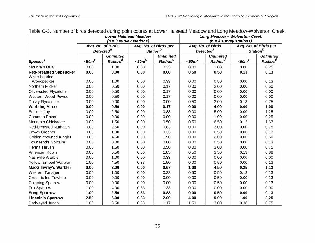
Table C-3. Number of birds detected during point counts at Lower Halstead Meadow and Long Meadow-Wolverton Creek.
Speciese
Lower Halstead Meadow (n = 3 survey stations)
Long Meadow – Wolverton Creek (n = 4 survey stations)
Avg. No. of Birds
Detecteda
Avg. No. of Birds per
Stationb
Avg. No. of Birds
Detecteda
Avg. No. of Birds per
Stationb
<50mc
Unlimited
Radiusd <50m
c
Unlimited
Radiusd <50m
c
Unlimited
Radiusd <50m
c
Unlimited
Radiusd
Mountain Quail 0.00 1.00 0.00 0.33 0.00 1.00 0.00 0.25
Red-breasted Sapsucker 0.00 0.00 0.00 0.00 0.50 0.50 0.13 0.13 White-headed Woodpecker 0.00 1.00 0.00 0.33 0.00 0.50 0.00 0.13
Northern Flicker 0.00 0.50 0.00 0.17 0.00 2.00 0.00 0.50
Olive-sided Flycatcher 0.00 0.50 0.00 0.17 0.00 0.00 0.00 0.00
Western Wood-Pewee 0.00 0.50 0.00 0.17 0.00 0.00 0.00 0.00
Dusky Flycatcher 0.00 0.00 0.00 0.00 0.50 3.00 0.13 0.75
Warbling Vireo 0.00 0.50 0.00 0.17 0.00 4.00 0.00 1.00
Steller's Jay 0.00 2.50 0.00 0.83 0.00 5.00 0.00 1.25
Common Raven 0.00 0.00 0.00 0.00 0.00 1.00 0.00 0.25
Mountain Chickadee 0.00 1.50 0.00 0.50 0.50 6.50 0.13 1.63
Red-breasted Nuthatch 0.00 2.50 0.00 0.83 0.00 3.00 0.00 0.75
Brown Creeper 0.00 1.00 0.00 0.33 0.00 0.50 0.00 0.13
Golden-crowned Kinglet 0.00 4.50 0.00 1.50 0.00 2.00 0.00 0.50
Townsend's Solitaire 0.00 0.00 0.00 0.00 0.00 0.50 0.00 0.13
Hermit Thrush 0.00 1.50 0.00 0.50 0.00 3.00 0.00 0.75
American Robin 0.00 5.50 0.00 1.83 0.50 3.50 0.13 0.88
Nashville Warbler 0.00 1.00 0.00 0.33 0.00 0.00 0.00 0.00
Yellow-rumped Warbler 1.00 4.50 0.33 1.50 0.00 0.50 0.00 0.13
MacGillivray's Warbler 0.00 2.00 0.00 0.67 1.00 4.50 0.25 1.13
Western Tanager 0.00 1.00 0.00 0.33 0.50 0.50 0.13 0.13
Green-tailed Towhee 0.00 0.00 0.00 0.00 0.00 0.50 0.00 0.13
Chipping Sparrow 0.00 0.00 0.00 0.00 0.00 0.50 0.00 0.13
Fox Sparrow 1.00 4.00 0.33 1.33 0.00 0.00 0.00 0.00
Song Sparrow 1.00 2.50 0.33 0.83 0.00 0.50 0.00 0.13
Lincoln's Sparrow 2.50 6.00 0.83 2.00 4.00 9.00 1.00 2.25
Dark-eyed Junco 1.00 3.50 0.33 1.17 1.50 3.00 0.38 0.75

The Institute for Bird Populations 2010 Bird Monitoring at Meadows in the Sierra NF/Sequoia NP Region
36
Speciese
Lower Halstead Meadow (n = 3 survey stations)
Long Meadow – Wolverton Creek (n = 4 survey stations)
Avg. No. of Birds
Detecteda
Avg. No. of Birds per
Stationb
Avg. No. of Birds
Detecteda
Avg. No. of Birds per
Stationb
<50mc
Unlimited
Radiusd <50m
c
Unlimited
Radiusd <50m
c
Unlimited
Radiusd <50m
c
Unlimited
Radiusd
Brewer's Blackbird 0.00 0.00 0.00 0.00 7.50 8.50 1.88 2.13 aNumber of individuals detected at the meadow, averaged across two survey visits.
bNumber of individual birds detected divided by the number of
survey stations and visits. cOnly includes birds detected within 50m of a survey point.
dAll birds detected regardless of distance from survey
station. eMeadow focal species indicated in bold text

The Institute for Bird Populations 2010 Bird Monitoring at Meadows in the Sierra NF/Sequoia NP Region
37
Appendix D. Average number of birds detected during area searches at each site

The Institute for Bird Populations 2010 Bird Monitoring at Meadows in the Sierra NF/Sequoia NP Region
38
Table D-1 Average number of birds detected during area searches at Long Meadow- Chiquito Campground (9 ac./3 ha).
Speciesa
Avg. No. Of Birds Detected Meadow Upland Total
White-headed Woodpecker 1.0 0.0 1.0 Western Wood-Pewee 0.0 3.0 3.0 Pacific-slope Flycatcher 0.0 2.0 2.0 Cassin’s Vireo 0.0 2.0 2.0 Warbling Vireo 0.0 3.0 3.0 Steller’s Jay 0.0 4.0 4.0 Mountain Chickadee 0.0 1.0 1.0 Brown Creeper 0.0 1.0 1.0 Golden-crowned Kinglet 0.0 1.0 1.0 American Robin 0.0 1.0 1.0 Yellow-rumped Warbler 0.0 1.0 1.0 Hermit Warbler 0.0 1.0 1.0 Song Sparrow 2.0 1.0 3.0 Lincoln’s Sparrow 2.0 1.0 3.0 Dark-eyed Junco 2.0 1.0 3.0 Brown-headed Cowbird 0.0 1.0 1.0 Cassin’s Finch 0.0 2.0 2.0 aMeadow-associated focal species are indicated in bold text.
Table D-2 Average number of birds detected during area searches at Lower Soquel Meadow (17 ac./7 ha).
Speciesa
Avg. No. Of Birds Detected Meadow Upland Total
Mountain Quail 0.0 2.0 2.0 California Quail 0.0 3.0 3.0 Downy Woodpecker 0.0 1.0 1.0 White-headed Woodpecker 0.0 1.0 1.0 Pileated Woodpecker 0.0 1.0 1.0 Hammond’s Flycatcher 0.0 2.0 2.0 Dusky Flycatcher 2.0 1.0 3.0 Pacific-slope Flycatcher 0.0 2.0 2.0 Cassin’s Vireo 0.0 1.0 1.0 Warbling Vireo 0.0 3.0 3.0 Steller’s Jay 0.5 4.5 5.0 Mountain Chickadee 0.5 1.5 2.0 Red-breasted Nuthatch 0.0 4.5 4.5 Golden-crowned Kinglet 0.5 9.0 9.5 Hermit Thrush 0.0 5.0 5.0 American Robin 2.0 2.0 4.0 Yellow Warbler 1.0 3.0 4.0 Yellow-rumped Warbler 1.0 3.5 4.5 Hermit Warbler 0.0 7.0 7.0 aMeadow-associated focal species are indicated in bold text.

The Institute for Bird Populations 2010 Bird Monitoring at Meadows in the Sierra NF/Sequoia NP Region
39
Table D-3 Average number of birds detected during area searches at Long Meadow – Globe Rock (6 ac./2 ha).
Speciesa
Avg. No. Of Birds Detected Meadow Upland Total
Mountain Quail 0.0 1.0 1.0 Red-breasted Sapsucker 0.0 1.0 1.0 White-headed Woodpecker 0.0 2.0 2.0 Northern Flicker 0.0 1.0 1.0 Hammond’s Flycatcher 0.0 4.0 4.0 Dusky Flycatcher 1.0 1.0 2.0 Common Raven 1.0 0.0 1.0 Mountain Chickadee 0.0 3.5 3.5 Red-breasted Nuthatch 0.0 4.0 4.0 Golden-crowned Kinglet 0.0 5.5 5.5 Swainson’s Thrush 0.0 4.5 4.5 Hermit Thrush 0.0 1.0 1.0 American Robin 1.0 2.0 3.0 Nashville Warbler 0.0 4.0 4.0 Yellow-rumped Warbler 0.0 4.0 4.0 MacGillivray’s Warbler 0.0 1.0 1.0 Western Tanager 0.0 1.0 1.0 Fox Sparrow 0.0 1.5 1.5 Lincoln’s Sparrow 2.0 0.5 2.5 Dark-eyed Junco 0.5 6.5 7.0 aMeadow-associated focal species are indicated in bold text.
Table D-4 Average number of birds detected during area searches at Upper Muglers Meadow (8 ac./3 ha).
Speciesa
Avg. No. Of Birds Detected Meadow Upland Total
Mountain Quail 0.0 3.0 3.0 White-headed Woodpecker 0.0 2.0 2.0 Olive-sided Flycatcher 0.0 1.5 1.5 Western Wood-Pewee 0.0 1.5 1.5 Cassin’s Vireo 0.0 2.0 2.0 Warbling Vireo 1.5 4.5 6.0 Steller’s Jay 0.5 8.0 8.5 Mountain Chickadee 0.5 6.5 7.0 Red-breasted Nuthatch 0.0 2.5 2.5 White-breasted Nuthatch 0.0 2.0 2.0 Brown Creeper 0.0 1.5 1.5 Golden-crowned Kinglet 0.0 5.0 5.0 Hermit Thrush 0.0 1.0 1.0 American Robin 0.0 2.0 2.0 Nashville Warbler 0.0 2.0 2.0 Yellow-rumped Warbler 1.0 2.0 3.0 MacGillivray’s Warbler 0.0 3.0 3.0 Green-tailed Towhee 0.0 1.0 1.0 Chipping Sparrow 1.0 1.0 2.0 Fox Sparrow 0.5 3.5 4.0 Lincoln’s Sparrow 0.5 1.0 1.5 Dark-eyed Junco 2.0 5.0 7.0 aMeadow-associated focal species are indicated in bold text.

The Institute for Bird Populations 2010 Bird Monitoring at Meadows in the Sierra NF/Sequoia NP Region
40
Table D-5 Average number of birds detected during area searches at Lower Halstead Meadow (31 ac./13 ha).
Speciesa
Avg. No. Of Birds Detected Meadow Upland Total
White-headed Woodpecker 0.0 3.0 3.0 Unidentified Woodpecker 0.0 1.0 1.0 Western Wood-Pewee 0.0 2.0 2.0 Steller’s Jay 0.5 3.5 4.0 Mountain Chickadee 0.0 5.0 5.0 Red-breasted Nuthatch 0.0 4.0 4.0 Brown Creeper 0.0 2.0 2.0 Golden-crowned Kinglet 0.0 6.0 6.0 Townsend’s Solitaire 0.0 1.0 1.0 Hermit Thrush 0.0 3.0 3.0 American Robin 5.5 7.0 12.5 Nashville Warbler 0.0 2.0 2.0 Yellow-rumped Warbler 1.0 4.5 5.5 MacGillivray’s Warbler 0.0 3.0 3.0 Western Tanager 2.0 2.0 4.0 Fox Sparrow 5.0 2.0 7.0 Song Sparrow 2.0 0.0 2.0 Lincoln’s Sparrow 11.5 0.5 12.0 Dark-eyed Junco 2.5 5.5 8.0 Brewer’s Blackbird 2.0 0.0 2.0 aMeadow-associated focal species are indicated in bold text.

The Institute for Bird Populations 2010 Bird Monitoring at Meadows in the Sierra NF/Sequoia NP Region
41
Table D-6 Average number of birds detected during area searches at Long Meadow – Wolverton Creek (47 ac./19 ha).
Speciesa
Avg. No. Of Birds Detected Meadow Upland Total
Mountain Quail 0.0 2.0 2.0 White-headed Woodpecker 0.0 2.0 2.0 Northern Flicker 0.0 1.0 1.0 Pileated Woodpecker 0.0 1.0 1.0 Western Wood-Pewee 0.0 1.0 1.0 Dusky Flycatcher 3.0 6.0 9.0 Warbling Vireo 6.0 5.0 11.0 Steller’s Jay 0.0 10.0 10.0 Common Raven 0.0 3.0 3.0 Mountain Chickadee 1.0 12.0 13.0 Red-breasted Nuthatch 0.0 7.0 7.0 White-breasted Nuthatch 0.0 2.0 2.0 Golden-crowned Kinglet 0.0 9.0 9.0 Hermit Thrush 0.0 8.0 8.0 American Robin 6.0 4.0 10.0 Nashville Warbler 0.0 2.0 2.0 Yellow-rumped Warbler 0.0 1.0 1.0 MacGillivray’s Warbler 2.0 11.0 13.0 Western Tanager 0.0 2.0 2.0 Green-tailed Towhee 0.0 3.0 3.0 Chipping Sparrow 1.0 0.0 1.0 Fox Sparrow 0.0 3.0 3.0 Song Sparrow 0.0 2.0 2.0 Lincoln’s Sparrow 16.0 4.0 20.0 Dark-eyed Junco 0.0 8.0 8.0 Brewer’s Blackbird 28.0 2.0 30.0 Brown-headed Cowbird 1.0 0.0 1.0 Evening Grosbeak 0.0 2.0 2.0 aMeadow-associated focal species are indicated in bold text.

The Institute for Bird Populations 2010 Bird Monitoring at Meadows in the Sierra NF/Sequoia NP Region
42
Appendix E. All bird species detected during point counts and area searches at each meadow

The Institute for Bird Populations 2010 Bird Monitoring at Meadows in the Sierra NF/Sequoia NP Region
43
Table E-1. All bird species detected during point counts and area searches at each meadow.
Speciesa N
o. o
f M
ead
ow
s
wit
h D
ete
cti
on
s
Lo
ng
Mead
ow
-
Ch
iqu
ito
Cam
pg
rou
nd
Lo
wer
So
qu
el
Mead
ow
Lo
ng
Mead
ow
-
Glo
be R
ock
Up
per
Mu
gle
rs
Mead
ow
Lo
wer
Hals
tead
Mead
ow
Lo
ng
Mead
ow
-
Wo
lve
rto
n
Cre
ek
Mountain Quail 6 X X X X X X
California Quail 1 X
Anna's Hummingbird 1 X
Red-breasted Sapsucker 3 X X X
Downy Woodpecker 1 X White-headed Woodpecker 6 X X X X X X
Northern Flicker 4 X X X X
Pileated Woodpecker 2 X X
Unidentified Woodpecker 3 X X X
Olive-sided Flycatcher 3 X X X
Western Wood-Pewee 5 X X X X X
Hammond's Flycatcher 2 X X
Dusky Flycatcher 4 X X X X
Pacific-slope Flycatcher 3 X X X Unidentified Empidonax Flycatcher 1 X
Cassin's Vireo 3 X X X
Warbling Vireo 5 X X X X X
Steller's Jay 5 X X X X X
Common Raven 3 X X X Mountain Chickadee 6 X X X X X X Red-breasted Nuthatch 6 X X X X X X
White-breasted Nuthatch 2 X X Brown Creeper 6 X X X X X X
House Wren 1 X Golden-crowned Kinglet 6 X X X X X X
Townsend's Solitaire 3 X X X
Swainson's Thrush 1 X
Hermit Thrush 5 X X X X X American Robin 6 X X X X X X
Nashville Warbler 4 X X X X
Yellow Warbler 4 X X X X Yellow-rumped Warbler 6 X X X X X X
Hermit Warbler 3 X X X MacGillivray's Warbler 6 X X X X X X

The Institute for Bird Populations 2010 Bird Monitoring at Meadows in the Sierra NF/Sequoia NP Region
44
Speciesa N
o. o
f M
ead
ow
s
wit
h D
ete
cti
on
s
Lo
ng
Mead
ow
-
Ch
iqu
ito
Cam
pg
rou
nd
Lo
wer
So
qu
el
Mead
ow
Lo
ng
Mead
ow
-
Glo
be R
ock
Up
per
Mu
gle
rs
Mead
ow
Lo
wer
Hals
tead
Mead
ow
Lo
ng
Mead
ow
-
Wo
lve
rto
n
Cre
ek
Unidentified Warbler 1 X
Western Tanager 5 X X X X X
Green-tailed Towhee 3 X X X
Spotted Towhee 1 X
Chipping Sparrow 3 X X X
Fox Sparrow 5 X X X X X
Song Sparrow 4 X X X X
Lincoln's Sparrow 5 X X X X X Dark-eyed Junco 6 X X X X X X
Red-winged Blackbird 1 X
Brewer's Blackbird 4 X X X X
Brown-headed Cowbird 3 X X X
Purple Finch 1 X
Cassin's Finch 1 X
Pine Siskin 1 X
Lesser Goldfinch 1 X
Evening Grosbeak 2 X X aMeadow-associated focal species are indicated in bold text.