portishead rail station location - amazon s3 · the reopening of the portishead rail line to...
TRANSCRIPT

Portishead Rail Station Location Scheme Consultation Report
MetroWest Phase 1
October 2014

2
October 2014
Version Date Author Changes v1 19/09/14 SP JWK, RA v2 25/09/14 KT, CM, JWK v3 2/10/2014 CM, JD, GC v4 10/10/2014 JWK v5 15/10/2014 JWK
FINAL 22/10/14

3
Portishead Rail Station Location Consultation Report
Contents 1 Introduction ....................................................................................................5
MetroWest Programme Overview ..................................................................5
Background ....................................................................................................5
Previous Consultation and options appraisal: ................................................6
- Portishead Station site consultation – February 2013...............................6
- Portishead Station options appraisal – June 2014 ....................................6
- Feasibility of a level crossing at Quays Avenue ........................................7
- Wider engagement and consultation ........................................................7
2 Consultation Programme ..............................................................................9 Methodology ..................................................................................................9
Consultation material .....................................................................................9
Public consultation exhibition ....................................................................... 10
Stakeholder consultation .............................................................................. 12
Statutory, community, and interest groups consultation ............................... 12
3 Consultation Responses ............................................................................. 13 Response Areas .......................................................................................... 13
Questionnaire responses ............................................................................. 14
Letters, emails and other responses ............................................................ 14
Results ......................................................................................................... 14
4 Key Themes and Issues ............................................................................... 16 Benefits, Concerns and Suggested Improvements: ..................................... 16
- Option 2A ................................................................................................ 16
- Option 2B ................................................................................................ 17
- Option 2C ............................................................................................... 18
- General comments ................................................................................. 19
- Letters emails and other correspondence ............................................... 20
Appendices ...................................................................................................... 23 Appendix A – DPD Evidence Paper February 2013 Appendix B – Options Appraisal Report June 2014 Appendix C – Consultation and publicity material Appendix D – Postcard distribution map Appendix E – Location of respondents

4
Blank

5
1. Introduction MetroWest Programme overview The reopening of the Portishead rail line to passengers is part of the MetroWest Programme, an ambitious scheme that will transform the provision of local rail services across the West of England. MetroWest comprises of a range of projects from relatively large major schemes, entailing both infrastructure and service enhancement, to smaller scale projects. MetroWest is being jointly promoted and developed by the four West of England councils (Bath & North East Somerset, Bristol City, North Somerset and South Gloucestershire Councils). Cross boundary transport projects are jointly promoted using the TravelWest brand. MetroWest Phase 1 proposes a half-hourly local service for the Severn Beach line, Bath to Bristol line and a reopened Portishead line with stations at Portishead and Pill, as illustrated below in figure 1.1. This consultation report focuses on one aspect of MetroWest Phase 1 – the siting of a new station at Portishead. Figure 1.1 - Map of the MetroWest Phase 1 proposals
Background
North Somerset Council’s Core Strategy recognises the importance of the Portishead line to achieve the objectives of:
Supporting economic growth; Delivering a more resilient transport offer;

6
Improving accessibility to the rail network; and Making a positive contribution to improving overall quality of life.
The reopening of the line was included in the council’s Replacement Local Plan with policies which safeguard the alignment of the railway line and station sites at Portishead and Pill. The council also purchased part of the track bed in 2009 to safeguard its use.
Reopening the Portishead line is also part of the medium term rail strategy of the four West of England councils. It was included in their Joint Local Transport Plan for 2006-2011 and forms part of their Major Scheme Programme in their Joint Local Transport Plan for 2011-2026.
Previous consultation and options appraisal
Since the MetroWest Phase 1 project began in 2013, substantial work to identify and assess options for the location of Portishead’s rail station has been carried out.
Portishead Station Site Consultation – February 2013
In February 2013, North Somerset Council undertook public consultation on its ‘Sites and Policies Development Plan Document’. As part of the consultation the council published an evidence paper: ‘Re-opening Portishead Railway Line and Options for the Location of Portishead Railway Station (attached as part of Appendix B). The evidence paper set out the project background and included three potential station sites, together with qualitative summary tables for each option.
The three station sites were:
Option 1 – Town centre location on Harbour Road Option 2 – Peripheral town centre location on Quays Avenue Option 3 – Edge of town location on land north of Moor Farm
An on-line consultation was undertaken together with staffed exhibitions held in Portishead. A total of 147 consultation responses were received. In summary there was both support and objections for option 1 and option 2, while for option 3 there was no support and 25 objections. Furthermore there were suggestions for the council to consider other options for the station site. In addition to this, further work showed that options 1 and 2 had some design challenges.
Portishead Station Options Appraisal – June 2014
Having considered the consultation responses and a number of significant delivery challenges with some of the three station site options, there was a clear need to take a wider examination of potential sites including looking at other locations. Further work used a number of factors including highway access and policy fit to identify a total of six potential sites. This included an additional site for option 1 off Harbour

7
Road (option 1B), and an additional two for option 2 around Quays Avenue (options 2A and 2C).
The six station sites were:
Option 1A – Rear of Travelodge on Harbour Road Option 1B – Opposite Pure Offices on Harbour Road Option 2A – East of Quays Avenue Option 2B – Across Quays Avenue Option 2C – Between Serbert Road and Harbour Road Option 3 – North of Moor Farm, Sheepway
An options appraisal report was then completed comparing all six sites, scoring each according to set criteria:
Policy fit - including planning and land use, strategic fit and equalities issues; Environmental and social impact - including air quality, noise, and socio-
distributional impacts; and Deliverability - including strategic case, economic case, management case,
financial case and commercial case.
The Options Appraisal Report concluded that the three sites around Quays Avenue (options 2A, 2B and 2C) scored the highest performance ranking and would therefore be taken forward to the next stage of consultation. Options 1A, 1B and 3 were not sufficiently robust to warrant further consideration. The full Options Appraisal Report is attached as Appendix B.
Feasibility of a level crossing at Quays Avenue
The options appraisal process ruling out option 1A and 1B took into account the feasibility of authorising a level crossing at Quays Avenue. This reflected the policy position and specific feedback provided by the Office of Rail Regulation (ORR) in 2013. The ORR have recently updated their position such that they would now consider a level crossing on the grounds of exceptional circumstances, subject to meeting ten specific criteria. A response to the ORR is being completed as a separate workstream, with an aim to complete by December 2014. Should in due course the ORR determine that it would authorise a level crossing at Quays Avenue, and should Network Rail confirm they would operate it, this would materially change the deliverability of site option 1 and therefore necessitate a review of the site options.
Wider engagement and consultation
Wider consultation has been ongoing on the programmes, projects and strategies which have influenced the scheme over a number of years. These include:
• Local Transport Body Board and Joint Transport Board (held in public)

8
• MetroWest Stakeholder meetings • Engagement with rail interest groups • MetroWest information brochures • TravelWest stakeholder event - 13 October 2013 • Joint Local Transport Plan 3 - 2011 to 2026 consultation • Consultation on the Strategic Economic Plan (SEP) • Rail conference 2011 • Memorandums of understanding –
o West of England authorities, Network Rail, First Great Western, Cross Country and South West Trains promoting ‘effective co‐ordination and cooperation’
o Bristol City Council, the West of England LEP, the Homes and Community Agency, English Heritage and Network Rail signed a 25‐year memorandum of understanding to ‘promote effective co‐ordination and co‐operation between the five organisations to achieve the development of Bristol Temple Meads Station as part of the Temple Quarter Enterprise Zone’
• Consultation on planning policy documents
The MetroWest programme, either in its current or past guises, is incorporated in to the Core Strategies of each of the four authorities as well as the Joint Local Transport Plan. As a result, the scheme has been subject to consultations at various stages in the plan preparation process.

9
2. Consultation Programme Methodology A thorough programme of consultation was planned, aimed at seeking views from the following groups:
A. The public
B. Stakeholders
C. Statutory, community and local interest groups
The main focus at this stage was to ensure those that would be most affected by the location of the station were consulted to ensure their views were taken into consideration. The consultation opened on 16th June 2014 for a six week period and closed on 28th July 2014. The consultation was managed by the MetroWest communications team who provided a single point of contact for people to ask questions about the consultation process, details of events, how to respond and get further information about the proposals. The MetroWest communications team worked with North Somerset Council's communication’s team to ensure compliance with their consultation guidelines. Consultation material The following consultation material was produced and distributed, attached as Appendix B::
• Postcards - 1200 were printed and delivered by Royal Mail to all properties within 400 metres either side of the station location options. These invited people to read about the location options online and to attend the two exhibitions. A number were also left in Portishead library, the leisure centre, cafes and with businesses close to the station location options. A distribution map is included in Appendix D.
• Leaflets - a leaflet setting out details on the three station sites (options 2A, 2B, and 2C) included a questionnaire which was distributed via the local library, sports centre, town council and some shops and cafes. This leaflet was also made available at consultation venues and via the TravelWest, Bristol and North Somerset Council websites.
• Press release – issued to local media before the consultation period began, summarising why the consultation was happening, how to get more

10
information and how to comment. Articles about the consultation were subsequently printed in the Bristol Post, the Western Daily Press, on the BBC website, on the Business Link website and in the West of England Local Enterprise Partnership’s online newsletter.
• North Somerset ward and town Councilor briefings - information about the consultation was emailed to ward and town councils adjacent to the MetroWest Phase 1 proposals.
• Online - a dedicated web page was set up for the consultation period on the TravelWest site at www.travelwest.info/mw/portishead. The site contained information about the consultation and the overall MetroWest Phase 1 project; links to all consultation materials; exhibition dates; the detailed station location options appraisal report; and a link to the online feedback form. The consultation was also promoted on the North Somerset Council site. As a result of the publicity, interest groups and other parties informally published the information on their websites as well.
• Social media – the Twitter accounts of MetroWest, MetroBus, North Somerset Council, AskBristol and Bristol City Council were used to promote the consultation, which was subsequently retweeted by a significant number of accounts.
• Newsletter - information about scheme development was also provided through the West of England’s quarterly transport newsletter, available as hard copies and via the TravelWest website.
Following the distribution of the consultation material, a programme of public and stakeholder engagement was launched. People were invited to complete a feedback form (online or hard copy), telephone, write, or email with questions or comments about the three potential sites for Portishead station. Engagment methods were tailored for each group, but included a series of exhibitions, presentations, and written correspondence. A. Public consultation exhibition
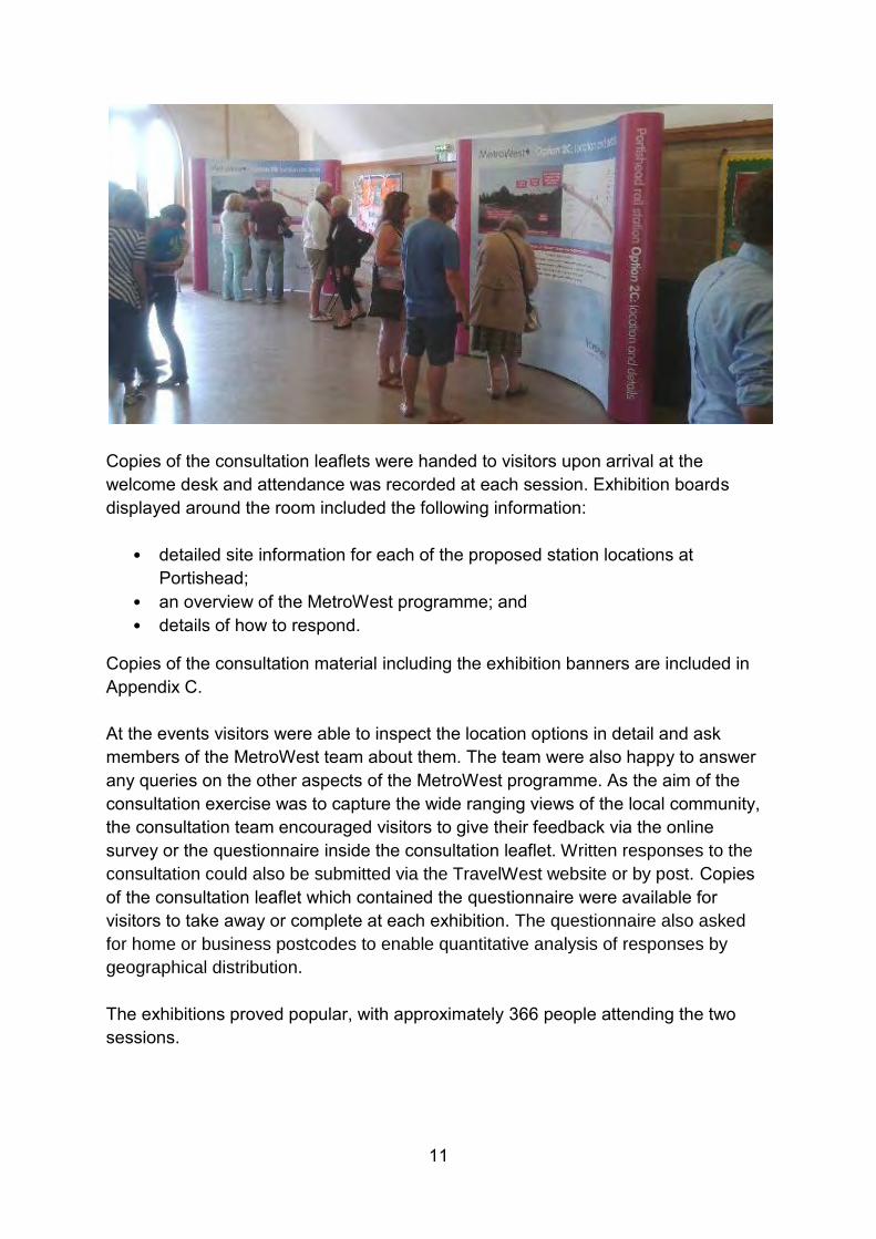
Two consultation events were held at Portishead Methodist Church, where stakeholders were able to meet the Project Team. This venue was chosen because of its close locality to the area which will be affected by the new station, has good public transport links, and is fully accessible for disabled people. The exhibitions were held on the following dates:
• Tuesday 24 June (2pm – 6.30pm) • Saturday 28 June (10am – 2pm)
11
Copies of the consultation leaflets were handed to visitors upon arrival at the welcome desk and attendance was recorded at each session. Exhibition boards displayed around the room included the following information:
• detailed site information for each of the proposed station locations at Portishead;
• an overview of the MetroWest programme; and • details of how to respond.
Copies of the consultation material including the exhibition banners are included in Appendix C. At the events visitors were able to inspect the location options in detail and ask members of the MetroWest team about them. The team were also happy to answer any queries on the other aspects of the MetroWest programme. As the aim of the consultation exercise was to capture the wide ranging views of the local community, the consultation team encouraged visitors to give their feedback via the online survey or the questionnaire inside the consultation leaflet. Written responses to the
consultation could also be submitted via the TravelWest website or by post. Copies of the consultation leaflet which contained the questionnaire were available for visitors to take away or complete at each exhibition. The questionnaire also asked
for home or business postcodes to enable quantitative analysis of responses by
geographical distribution.
The exhibitions proved popular, with approximately 366 people attending the two sessions.

12
B. Stakeholder consultation
The exhibition programme was supported by a series of stakeholder meetings. Typical meetings included a PowerPoint presentation followed by opportunity for discussion, questions and answers. Meetings were held with the following:
Local transport groups e.g. Friends of Suburban Bristol Railways, Portishead Rail Group
Transport forums e.g. Bristol Airport Forum, South Glos Council Public Transport Forum
Neighbourhood partnerships Town and parish councils Local landowners Local businesses and organisations e.g. Bristol Port Company, Trinity School Environmental groups e.g. Environment Agency, Natural England Meetings / committees e.g. Joint Transport Board
C. Statutory, community, and interest groups consultation
An email about the public consultation and how to comment on the station location options was sent to statutory stakeholders, community groups and transport interest groups.
North Somerset Council's equalities officer informed their stakeholder groups about the consultation and invited them to comment on the station location options. The officer then met with the North Somerset Disability Access Group on 11 June 2014 to discuss the station location options
The MetroWest communications team sent an email about the consultation to Bristol City Council’s equalities stakeholders. The email included the consultation leaflet and information about the consultation. The following equalities stakeholder groups were contacted this way:
• Women’s Voice • Black and Minority Ethnic Influence & Voice • Age UK • Bristol Multi-Faith Forum • Lesbian, gay, bisexual and transgender group • Bristol Disability Forum • Royal National Institute for the Blind • Guide Dogs for the Blind • British Sign Language Forum • Bristol Physical Access Chain
The consultation period opened closed on 28 July 2014 and consultation responses were accepted for a week after the closing date.

13
3. Consultation Responses A total of 421 consultation responses were received, representing a very high
response rate. The majority of people completed the questionnaires using the boxes
provided, with a small number appending further comments. This chapter
distinguishes those responses between:
• questionnaires submitted as hard copies and online; and
• letters, emails and other correspondence from individuals, businesses and
interested parties.
Response areas As part of the questionnaire, respondents were asked to include their postcode. This
was to ensure that we had reached those that would be most affected by the
scheme as planned by the focussed distribution of the consultation material. 376
gave enough of their postcode to determine postcode sector.
The vast majority of Portishead is covered by the postcode sectors of BS20 6xx,
BS20 7xx, and BS20 8xx.The breakdown of respondents is shown below in figure
3.1.
Figure 3.1 – Location of consultation respondents
Almost 90% of respondents came from the Portishead area, demonstrating that the
results from the questionnaires are from those that will be most affected by the
scheme. A full map of respondents can be viewed in Appendix E.
19%
57%
12%
12%
BS20 6
BS20 7
BS20 8
Other

14
Questionnaire responses 407 people responded to the consultation via the questionnaire and made a total of 1034 comments; of those 1014 were about the three proposed station site options. The breakdown of comments is as follows:
Option 2A – 363 comments Option 2B – 339 comments Option 2C – 327 comments Other remarks appended - 5 comments
A range of different comments and opinions were received, a summary of which can be viewed in chapter 4. The vast majority of respondents supported the idea of reopening of the Portishead rail line and construction of a new station. Letters, emails and other responses
Throughout the consultation period, stakeholders and members of the public were
encouraged to respond via the structured questionnaires, with a small number
preferring to write or email with questions or comments about the project.
Contact addresses were contained within the consultation leaflet as well as on the
website for people that wished to do this.
In total 14 written responses were received from local businesses, members of the
public, local interest groups and a developer.
Local businesses / business groups – 2 responses
Members of the public – 7 responses
Interest groups – 4 responses
Developers – 1 response
A range of different comments and opinions were received, a summary of which can be viewed in chapter 4.
Results The vast majority were for the scheme in principle, with many specifically stating they
would use the facility regardless of station site. Of those that stated concern, these
were surrounding the details of the location rather than the introduction of rail
services.
All three station options had a similar number of comments received in total. The consultation purposely did not ask people to rate each site as it was felt that at this stage it would be more useful to provide space for freetext comments to enable a

15
wider set of opinions to be recorded. An assessment was made by the MetroWest team on each point made in the comments placing them into six categories ranging from ‘strongly support’ to ‘strongly against’. This qualitative assessment enables a breakdown to compare the level of support for each of the proposed sites. This is shown below in figure 3.2. Figure 3.2 – Evaluation of support for each site option
Although all three proposed sites show support, Option 2B is the most popular. This correlates with the number of people strongly or slightly against the sites, with option 2B showing the least number of these responses. Option 2C showed both the least number of supporters and highest number of people against. However it is worth noting the levels of support for Options 2A and 2B are relatively similar, while Option 2C has a more mixed level of support. At this stage no decisions have been made regarding a preferred option for the location of Portishead station. The consultation responses as summarised in this report, will be used to inform decision making. It is anticipated that a decision on the preferred option for the location of Portishead station will be made in 2015.
0
20
40
60
80
100
120
140
160
Option 2A Option 2B Option 2C
strong support for option
some support for option
neutral
slightly against option
strongly against option
no response to option
16
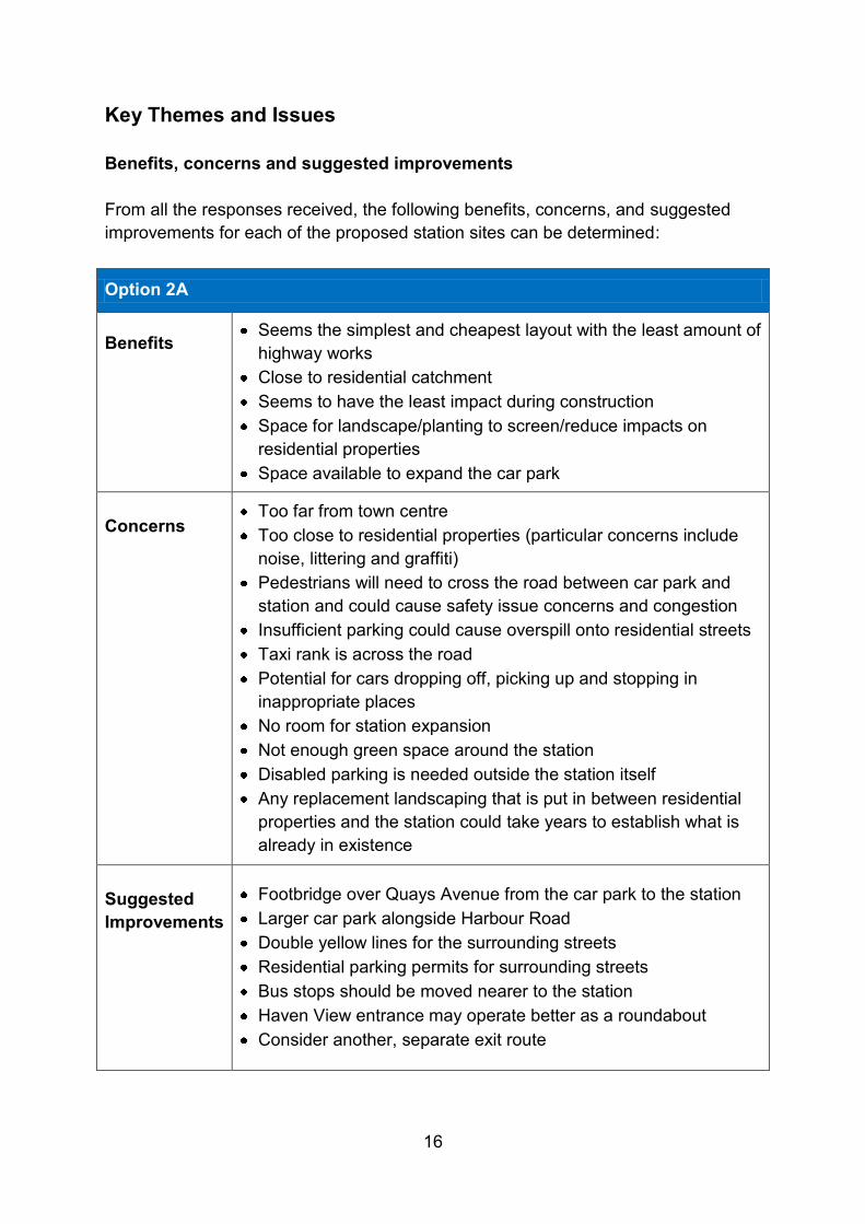
Key Themes and Issues Benefits, concerns and suggested improvements From all the responses received, the following benefits, concerns, and suggested improvements for each of the proposed station sites can be determined:
Option 2A
Benefits
Seems the simplest and cheapest layout with the least amount of highway works
Close to residential catchment Seems to have the least impact during construction Space for landscape/planting to screen/reduce impacts on
residential properties Space available to expand the car park
Concerns
Too far from town centre Too close to residential properties (particular concerns include
noise, littering and graffiti) Pedestrians will need to cross the road between car park and
station and could cause safety issue concerns and congestion Insufficient parking could cause overspill onto residential streets Taxi rank is across the road Potential for cars dropping off, picking up and stopping in
inappropriate places No room for station expansion Not enough green space around the station Disabled parking is needed outside the station itself Any replacement landscaping that is put in between residential
properties and the station could take years to establish what is already in existence
Suggested Improvements
Footbridge over Quays Avenue from the car park to the station Larger car park alongside Harbour Road Double yellow lines for the surrounding streets Residential parking permits for surrounding streets Bus stops should be moved nearer to the station Haven View entrance may operate better as a roundabout Consider another, separate exit route

17
Option 2B
Benefits
Nearer to town centre than option 2A Suggested landscaping could enhance first impressions for
visitors Highway re-design would appear to work well Would appear to not require any building demolition Main car park is next to the station with no road crossing needed Further from residential properties minimising disruption Options for laybys for user drop off and buses Seems to have the best accessibility of all three options Addition of a left turn lane out of Phoenix Way could help
congestion issues Areas around the station could open up more green space for
community use Could assist pedestrian movements in the area by removing the
roundabout currently at Quays Avenue / Phoenix Way Concerns
Too far from the town centre Too close to residential properties Insufficient parking could cause overspill onto residential streets Appears too costly compared to the other options Access to the overspill car park involves crossing the road Car park across a split site could increase traffic movements Appears to involve too many highway modifications Could cause major traffic disruption during construction Drop off areas seem too small Realignment of the road and compulsory purchase of land could
have increased financial implications and time Proposed road layout could cause problems for vehicles
accessing Phoenix Way from the re-aligned Quays Avenue Appears to not have enough landscaping planned Could create an unpleasant environment Any replacement landscaping that is put in between residential
properties and the station could take years to establish what is already in existence
Suggested Improvements
The Serbert Road connection in Option 2C could be incorporated Consideration of a footbridge over Quays Avenue (or the new
highway link) to avoid pedestrian flows affecting existing traffic on that route
The footbridge to Tansey Lane should have ramp accessibility

18
Option 2C
Benefits
Closest option to the town centre Further away from residents and the possible risk of disruption
during both construction and operation Appears to provide the best forecourt Appears to be the best option for accessibility Only traffic and buses/taxis dropping off at the station would use
Quays Avenue making that route quieter Could make parking for other facilities in the local vicinity easier Could stop the use of roads around The Vale as 'rat-runs' Appears to make it easier for residents from the village quarter to
exit Portishead during peak hours Could cause the least impact on residents of The Vale and
Village Quarter in terms of noise and outlook being spoilt Larger station footprint could accommodate a better design Shorter length of tree lined promenade could potentially be made
to be higher quality Concerns
Too far from town centre Insufficient parking could cause overspill onto residential streets Expansion for the station car park appears not to be possible Pedestrians need to cross the road between car park and station
and could cause safety and congestion issues Longer walk from overspill car park to the platform Closure of Quays Avenue could have a negative impact on traffic
flows on other routes Residents of The Vale turning left onto Quays Avenue may find it
difficult to proceed at the next roundabout, as they would have to give way to town centre/Sainsbury's/station traffic
Serbert Road’s current set up may not cope with increased traffic flows
Demolition, compensation and compulsory purchase could be costly, disruptive and time consuming
An entrance opposite access to commercial premises is undesirable
Demolition of part of a commercial building may see a reduction of social housing units as in the current planning consent
Could increase surface water run off Current bus stops on Quays Avenue would be moved further
from residential areas
Suggested Improvements
Replicate the additional 100 space car park of Option 2B to provide a total of 250 spaces

19
General comments
Benefits
The vast majority are in favour of a reinstated rail link and many said that any station site is better than none
The proposed through services to Bath Spa and Severn Beach Line could greatly encourage use
The presence of walking and cycling routes linking different areas of the town and to the station site is welcomed
Concerns
Could increase congestion and pollution on surrounding roads to residents and the school
Car park access at night could attract anti social behaviour and noise pollution
Proposed Galingale Way footbridge could have a detrimental effect on residential properties
Suggested Improvements
Station building design should be considered as something in keeping with the gateway of a growing vibrant town
The proposed promenade should lead onto some public realm works to give more prominence to the station from the town
Consider pedestrian tunnels for all road crossings Undercover walkways on routes to and from the town could
ensure use in bad weather MetroWest programme should have through ticketing and
coordinated timetables with buses Current and new bus services should be routed to serve the
station at its adjacent stops Shuttle bus around the town and further afield should be
considered to increase connectivity and potential use Consider using the route for guided buses removing the need for
multiple interchanges on some routes Smartcard and Bus / Travel Pass system should be incorporated
into the station services Train services should not just cater for commuters but early
morning / late evening visitors and residents Consider minimal parking and create an out of town park and
ride Local businesses could incorporate additional parking for the
station in their own car parks Provision of a secure, covered bicycle park Should link with the existing National Cycle Network which
passes close by the station Provision should be made in track layout and platform length for
other services e.g. charter trains or ‘steam specials’, boosting tourism
Connect Brampton Way with the Quays Avenue roundabout across the Rhyne to integrate the old and new halves of the town
Provide new road access to and from the High Street to the station to avoid the White Lion and Cabstand junctions

20
Letters, emails and other correspondence
Local businesses / business groups
2 responses
Local business
Supports the reopening of the railway Concerns raised around option 2C and the impact it may have
on the highway and traffic flows
Portishead Chamber of Commerce Objects to all three options on the grounds that they do not
include the original central location which it considers to be the best and safest location essential for the future economic and social wellbeing of the Town
Members of the public 7 responses
Suggests alternative sites to the three consulted on Suggests engineering solutions they felt had not been
considered (e.g. tunneling. Further analysis has however ruled these suggestions out). The majority of these ideas suggest solutions to the issue of a level crossing over Quays Avenue
Concerns over safety with a pedestrian crossing between the proposed station and car park, and how this fairs against the safety of a rail level crossing
Positive response to the retaining of existing cycleways and the potential introduction of a tree lined promenade
Interest groups
4 responses
The Disability Action Group (excerpt from meeting notes submitted)
The new route was welcomed Expected that both any stations and also the rolling stock should
be accessible to disabled people Access to the site of a station was highlighted as being an
important issue to disabled people Adequate dedicated car parking for disabled people close to
platform access points and facilities was essential Broadly happy with the location of the proposed station options
and had no specific disability comments Option 2B with its highway link was noted as offering a good
level of accessibility, but the reduced number of parking spaces in the main car park raised concerns that it could put pressure on the disabled drivers’ spaces with able drivers misusing the Blue Badge bays
The overflow car park in Option 2B would need to be finished to the same standard as the main car park for the benefit of anyone without a Blue Badge
The location in Option 2B is preferred for: o The taxi rank in that it appears to be directly outside the
platform o The bus stops which have laybys and are closer to the station
access

21
A number of detailed comments were made about the design of the proposed station. o Level or ramped access was required to the platforms with
adequate accessible seating o An accessible way of crossing the rail line was required. A
simple stepped footbridge was not considered acceptable. The broad location show on the Options seemed to be some distance from the platform though the links to surrounding roads was noted
o The “Drop and Go” laybys on Option 2B were welcomed, but the request was made that they should be located within the station car park
Toilet facilities should be provided
The station should be staffed whenever possible and ticket machines and other facilities must be fully accessible to disabled staff. Equipment must cater for people with sensory and dexterity impairments.
English Heritage
Have no comments to make on any of the proposals.
Portishead Town Council (excerpt from meeting notes submitted)
[The Town Council] resolves to object to the three options presented at the second stage consultation on the grounds that they do not include the original central location that is considered essential for the future economic and social wellbeing of the Town
[The Town Council] resolves to write to the Secretary of State expressing its appreciation of the work done to date to reinstate the rail link to the Town and requests that the decision to rule out a low speed level crossing of Quays Avenue is reconsidered by the Office of the Rail Regulation in the light of its importance to the Town as stated In the first resolution.
[The Town Council] recognises the value of promoting the use of the rail link when it is reinstated and resolves to set aside a fund to work with the franchise operator to promote the Town and encourage Portishead residents to use the facility
Avon Wildlife Trust
Concerns that each of the three proposed sites appear to have potential for wildlife habitats that could cause possible ecological constraints
Recommend an ecological survey, making provision for mitigation and compensation measures as mentioned in the 'Environmental & Social Impact Assessment' section of the 'Site Options Appraisal'.

22
Developer
1 response
Suggest that all three options consulted on are unsuitable and the out of town option should be reconsidered (Note: this option has already been considered through the options appraisal report but was not taken forward as it did not perform well in relation to the other options. See Appendix B for details)
Could have environmental impacts to the surrounding area Could have an impact on local residents Could have an insufficient amount of parking spaces Various suggestions made relating to cycle parking, coach
parking, urban design and the proposed footbridge near Trinity Primary School.
Appendices Appendix A – DPD Evidence Paper February 2013 Appendix B – Options Appraisal Report June 2014 Appendix C – Consultation and publicity material Appendix D – Postcard distribution map Appendix E – Location of respondents

Appendix A DPD Evidence Paper February 2013

Important Note: The delivery of the rail project has a number of challenges and constraints. These include achieving a positive outcome in relation to a detailed business case, availability of capital funding and funding approval, statutory processes and approvals, confirmation of operational costs in relation the Great Western franchising process and the overall financial position for North Somerset Council in terms of the affordability of both the capital and revenue funding requirement.
1
Sites and Policies
Development Plan Document
February 2013
North Somerset Council Local Development Framework
Evidence Paper Re-opening Portishead Railway Line and Options for the Location of Portishead
Railway Station

Important Note: The delivery of the rail project has a number of challenges and constraints. These include achieving a positive outcome in relation to a detailed business case, availability of capital funding and funding approval, statutory processes and approvals, confirmation of operational costs in relation the Great Western franchising process and the overall financial position for North Somerset Council in terms of the affordability of both the capital and revenue funding requirement.
2
Evidence Paper Policy Reference PH3
Re-opening Portishead Railway Line and
Options for the Location of Portishead Railway Station
1. Overview of the Portishead to Bristol Transport Corridor
The Portishead to Bristol corridor (A369) suffers congestion and journey time reliability problems. This not only causes delays and lost productivity for car drivers and goods vehicle operators but also presents a major hurdle for providing an attractive public transport mode along the corridor. The problems and context of the A369 corridor are summarised as:
The A369 is the only transport corridor directly linking Portishead with Bristol which is just 10 miles to the east.
The capacity constraints on the A369 are exacerbated further by the fact that the A369 crosses junction 19 of the M5. Junction 19 of the M5 is one of the busiest parts of the M5 with the Avonmouth Bridge immediately to the north towards junction 18.
The A369 continually suffers from the knock on effects of incidents on the M5 with traffic high volumes of traffic over spilling onto a constrained local road corridor with very few alternative route options.
This lack of transport network resilience and limited travel choices could be addressed by utilising the heavy rail corridor between Portishead and Bristol which is a strategic transport network asset and re-instating passenger train services. The objectives of re-opening the Portishead railway line for passenger train services are to:
Reduce traffic congestion on arterial roads and reduce journey times for commuters and business to and from Bristol, supporting economic growth,
Improve transport network resilience through the utilisation of a strategic transport alignment, which is independent from the highway network,
Deliver a sustainable transport corridor and improve air quality
The project will also:
Assist in the delivery of wider social wellbeing and quality of life objectives, Provide through rail services from Portishead to destinations beyond Bristol Temple
Meads, across the sub-region, and Form the basis of a medium to long term sub-regional programme of rail projects to
deliver a major uplift to the local the local rail network offer.
The project would increase the UK’s passenger rail network by 10 miles and connect an additional 30,000+ people to the network. There is a great amount of interest and support for the project within the local community, based on the frequency with which the project is raised positively by business, members of the public and community organisations, to the council.

Important Note: The delivery of the rail project has a number of challenges and constraints. These include achieving a positive outcome in relation to a detailed business case, availability of capital funding and funding approval, statutory processes and approvals, confirmation of operational costs in relation the Great Western franchising process and the overall financial position for North Somerset Council in terms of the affordability of both the capital and revenue funding requirement.
3
2. Overview of the Project The Portishead rail branch line was closed in 1964 as part of the Beeching cuts. In 2002 a major part of the line was reopened between Royal Portbury Dock and Bristol as a freight only line. This project involves re-instating the remaining 4 miles of track between Portishead and Pill and upgrading the branch line infrastructure to meet passenger train standards, and providing sufficient line capacity to enable both passenger and freight train to operate to the required service patterns. Re-opening the Portishead rail branch line now forms part of a larger sub-regional project known as Greater Western Metro Phase 1. GW Metro Phase 1 includes half hourly train services for the Severn Beach line, local stations between Bristol Temple Meads and Bath Spa and the reopened Portishead line. In addition there is a wider programme of local rail schemes, also being taken forward by the four West of England councils; North Somerset, Bristol City, South Gloucestershire and Bath & North East Somerset. GW Metro Phase 1 is being led by North Somerset Council on behalf of the West of England councils.
3. Brief History of the Project 1964 Line was closed 2002 Line partly re-opened for freight trains only between Parsons Street junction and
Portbury Dock 2005 Portishead Quays Master plan - identified location for station (option 1) 2006 Joint Local Transport Plan 2 - policy basis and stakeholder support for taking project
forward 2006 North Somerset Replacement Local Plan - safeguarded disused railway alignment
between Portishead and Pill 2008 Project feasibility study by consultants Halcrow 2010 Engineering feasibility by Network Rail GRIP3 Option Selection 2011 Joint Local Transport Plan 3 - policy basis, programme prioritisation and stakeholder
support for taking project forward 2011 Sub-regional rail conference - project selected by over 70 delegates as 2nd highest
rail priority for delivery 2011 Sub-regional rail study recommends combining Portishead rail project into the GW
Metro project with it included in GW Metro Phase 1 2012 Joint Transport Executive Committee endorse including re-opening Portishead line in
GW Metro Phase 1 and response to GW Franchise for its inclusion in franchise specification as a prices option
2012 Department for Transport confirm the inclusion of GW Metro Phase 1 as a priced option in GW Franchise
2012 Governance and mobilisation of sub-regional rail programme and identification of resources for mobilisation of GW Metro Phase 1 project

Important Note: The delivery of the rail project has a number of challenges and constraints. These include achieving a positive outcome in relation to a detailed business case, availability of capital funding and funding approval, statutory processes and approvals, confirmation of operational costs in relation the Great Western franchising process and the overall financial position for North Somerset Council in terms of the affordability of both the capital and revenue funding requirement.
4
4. The Safeguarded Alignment The alignment has been subject to local planning polices for many years to protect encroachment of development that would prevent the line from being re-opened. The only location where development has created an obstacle to the re-opening of the line is at Quays Avenue, which is a new road crossing over the railway alignment. At the time of the master planning of Portishead Vale development, the design standards for road easements across railway branch lines allowed for level crossings. However, the rail industry design standards have since changed and level crossings are no longer acceptable to Her Majesties Railway Inspectorate. Therefore a road over rail bridge will be needed in order for the railway line to serve Portishead town centre (station location option 1 only).
5. Timescales Taking Forward the Project as part of GW Metro Phase 1 late 2012 - 2015 Scheme Case and Powers to Build and Operate 2015 - 2016 Detailed Design and Scheme Procurement 2016 - 2017 Construction late 2017 / early 2018 Scheme Opening and Commencement of Train Services
6. Options for the Location of Portishead Railway Station While a site for the Portishead railway station was identified on Harbour Road as part of the Portishead Quays master planning, the delivery of a station at this location has a number of challenges and there is now a need to review the merits of this location and consider options for other locations. There are a wide range of factors that need to be considered in respect of identifying the best location for a railway station, these include the transport network, the environmental impact, the strategic land uses both current and future use as set out the councils Core Strategy and wider community considerations. Furthermore the site must also be able to meet technical specifications, accessibility regulations and safety requirements of rail industry and national legislation. We have commenced initial analysis on the merits and impacts of alternative station locations. Further more detailed analysis will be needed, as the project is taken forward. There are broadly eight high level transport criteria relevant to selecting the location for Portishead railway station:
1. walking and cycling catchment and access, 2. highway access, 3. car parking provision and bus interchange facilities, 4. the extent of supporting infrastructure required for each location eg highway bridges,
pedestrian bridges, new highway accesses etc 5. likely wider environmental impact 6. fit with project objectives 7. overall cost of station location 8. EQIA considerations

Important Note: The delivery of the rail project has a number of challenges and constraints. These include achieving a positive outcome in relation to a detailed business case, availability of capital funding and funding approval, statutory processes and approvals, confirmation of operational costs in relation the Great Western franchising process and the overall financial position for North Somerset Council in terms of the affordability of both the capital and revenue funding requirement.
5
We have used the above criteria to identify and compare three short listed locations for Portishead railway station, as follows: Option 1 - Town Centre location on Harbour Road. Provision for 100 car parking spaces has been made adjacent to the station site. This option requires the construction of a new road bridge over the rail alignment at Quays Avenue. This option also includes provision for a footbridge south east of Trinity Anglican Methodist Primary School. This station site is approximately 0.3 km from the town centre. Option 2 – Peripheral Town Centre location on Quays Avenue. There is space for at least 200 car parking spaces on land west of Quays Avenue. This option does not require a new road bridge at Quays Avenue. This option also includes provision for a footbridge south east of Trinity Anglican Methodist Primary School. The remaining length of redundant track bed to the town centre would be used to provide a high quality ‘Gateway’ shared use pedestrian/ cycle path. The ‘Gateway’ path would have the effect of extending the western pedestrian entrance of the station closer to the town centre. The rail alignment here is 15 to 20 meters wide, so there is considerable potential to create a very attractive public realm enhancement as well as serving as a functional pedestrian/ cycle ‘Gateway’. A new pedestrian / cycle crossing on Quays Avenue (Toucan crossing or similar) would be provided to give a through route between the station and the ‘Gateway’ path and car park. There is also potential to create a wider station forecourt/frontage using a small parcel of land adjacent to Quays Avenue, which is currently part of the Pumping Station yard. This station site is approximately 0.7 km from the town centre. Option 3 – Edge of Town location on land north of Moor Farm. There is space for at least 200 car parking spaces on land adjacent to the railway station site, together with a new highway access from Sheepway. This option does not require a new road bridge at Quays Avenue or provision for a footbridge south east of Trinity Anglican Methodist Primary School, however it would require a new highway access and link road from Sheepway. This option would operate more like a ‘Parkway’ station than a conventional station, due to its edge of town location. This station site is approximately 1.3 km from the town centre. Table 1 below sets out a high level comparison of the three station location options for Portishead Rail station. Figure 1 below shows a map of the three station location options for Portishead Rail station. We are seeking feedback as part of our Sites and Policies DPD Consultation Version, on all three station location options, to inform decision making on which location is best overall for Portishead. Please refer to the front of the DPD document on how to provide feedback.

Important Note: The delivery of the rail project has a number of challenges and constraints. These include achieving a positive outcome in relation to a detailed business case, availability of capital funding and funding approval, statutory processes and approvals, confirmation of operational costs in relation the Great Western franchising process and the overall financial position for North Somerset Council in terms of the affordability of both the capital and revenue funding requirement.
6
Table 1. Comparison of the Three Short Listed Locations for Portishead Railway Station Walking & Cycling
Catchment and Access
Highway Access
Car Parking Provision & Bus Interchange
Extent of Supporting Infrastructure Required
Likely Wider Environmental Impact
Fit with Project Objectives
Overall Cost of this station location
EQIA considerations
Station Location Option 1 Town Centre location on Harbour Road
Large catchment of housing within 800m radius of station location. Any potential re-development of Old Mill Road Industrial Estate could improve access to town centre from station. This station site is approximately 0.3 km from the town centre.
Relatively good highway access via Harbour Road, however requires a road bridge at Quays Avenue.
Provision for 100 car parking spaces has been secured as part of the Quays development however this is unlikely to be sufficient to cater for the forecast passenger demand. Bus stops are located on Harbour Road and there is potential for buses to operate via the station car park.
This location requires a new road over railway bridge at Quays Avenue and one pedestrian bridge east of Trinity school.
The road over railway bridge would entail replacing the existing roundabout at Quays Avenue, Phoenix Way & Harbour Road, with an elevated signal controlled T junction. This would have a visual and environmental impact on a number of residential properties adjacent to Quays Avenue and retirement apartments on Harbour Road.
This option would meet all the project objectives to reduce congestion, improve transport network resilience and deliver a sustainable transport corridor.
The estimated cost of the road bridge is £6m. The estimated cost of the pedestrian bridge ranges from £500k to £1.5m depending upon whether it includes mobility impairment ramps.
The road over railway bridge would mean the roads and pavements would entail gradients that some people may find more difficult than the current layout.

Important Note: The delivery of the rail project has a number of challenges and constraints. These include achieving a positive outcome in relation to a detailed business case, availability of capital funding and funding approval, statutory processes and approvals, confirmation of operational costs in relation the Great Western franchising process and the overall financial position for North Somerset Council in terms of the affordability of both the capital and revenue funding requirement.
7
Walking & Cycling Catchment and Access
Highway Access
Car Parking Provision& Bus Interchange
Extent of Supporting Infrastructure Required
Likely Wider Environmental Impact
Fit with Project Objectives
Overall Cost of this station location
EQIA considerations
Station Location Option 2 Peripheral Town Centre location on Quays Avenue
Large catchment of housing within 800m radius of station location. The remaining length of redundant track bed to the town centre would be used to provide a high quality ‘Gateway’ shared use pedestrian/ cycle path. The ‘Gateway’ path would have the effect of extending the western pedestrian entrance of the station closer to the town centre. The rail alignment here is 15 to 20 meters wide, so there is considerable potential to create a very attractive public realm enhancement as well as serving as a functional pedestrian/ cycle ‘Gateway’. This station site is approximately 0.7 km from the town centre.
Good highway access via Quays Avenue / Harbour Road, and good access from both directions via Wyndham Way.
There is space for provision of at least 200 car parking spaces. A pedestrian crossing would be needed on Quays Avenue to link the car park with the station. There are bus stops on Quays Avenue and there is potential for buses to operate via the station car park or from new bus stops / lay-bys near to the main station entrance.
This location requires a high quality ‘Gateway’ shared use pedestrian / cycle path, a new car park on land west of Quays Avenue, a new pedestrian / cycle crossing on Quays Avenue (Toucan crossing or similar) and one pedestrian bridge east of Trinity school.
This option does not require a road over railway bridge, therefore it would have a more limited environmental impact on Quays Avenue, in comparison with option 1. The need for a new 200 space car park would however result in some environmental impact. The proximity of the station to housing could result in some localised environmental impact, however there is potential to design mitigation measures reduce these impacts.
This option would meet all the project objectives to reduce congestion, improve transport network resilience and deliver a sustainable transport corridor. While the station location is not as central as option 1, this option still has a very high walking catchment. Access to the town centre could be enhanced by the provision of a high quality ‘Gateway’ shared use pedestrian/ cycle path on the remaining length of redundant track bed.
The estimated cost of the ‘Gateway’ shared use path is £250k. The estimated cost of a new car park is £850k. The estimated cost of the Toucan crossing is £50k. The estimated cost of the pedestrian bridge ranges from £500k to £1.5m depending upon whether it includes mobility impairment ramps.
No major changes are needed to the road layout, other than a new access to a new car park west of Quays Avenue. The station car park and station platform would meet all statutory accessibility standards.

Important Note: The delivery of the rail project has a number of challenges and constraints. These include achieving a positive outcome in relation to a detailed business case, availability of capital funding and funding approval, statutory processes and approvals, confirmation of operational costs in relation the Great Western franchising process and the overall financial position for North Somerset Council in terms of the affordability of both the capital and revenue funding requirement.
8
Walking & Cycling Catchment and Access
Highway Access
Car Parking Provision & Bus Interchange
Extent of Supporting Infrastructure Required
Likely Wider Environmental Impact
Fit with Project Objectives
Overall Cost of this station location
EQIA considerations
Station Location Option 3 Edge of Town location on land north of Moor Farm
More limited catchment of housing within 800m radius of station location. Approximately 60% of the 800m radius is green belt - open fields. This station site is approximately 1.3km from the town centre, if the remaining length of track bed is used as a pedestrian path. This distance is beyond a reasonable walking distance for many people.
Highway access could be provided via Quays Avenue using the rail alignment to the station, however this could prevent any future extension of the line into the town centre. A new highway access could be formed off Sheepway.
There is space for provision of at least 200 car parking spaces, either on the rail alignment or on land north of Moor Farm. Additional bus stops could be provided on Sheepway and there is potential for buses to operate via the station car park.
This location requires a new car park and a new highway access and link road from Sheepway.
This option would entail locating the station, station car park and highway access in the Green Belt and would result in some environmental impact. This option would require a sequential test and robust evidence to support a case for development in the Green Belt
The proximity of the station to housing could result in some localised environmental impact, however there is potential to design mitigation measures reduce these impacts.
This option would not fully meet all the project objectives to reduce congestion, improve transport network resilience and deliver a sustainable transport corridor. This option does not provide easy access to and from Portishead Town centre. The walking catchment of the station is relatively poor, thereby access for the majority of people would be via a car trip, bus or cycle. This option would operate more like a ‘Parkway’ station than a conventional station, due to its edge of town location.
The estimated cost of a new car park is £850k. The estimated cost of the new highway access and link road is £1m.
No major changes are needed to the highway layout, other than a new highway access and link road from Sheepway and a new car park. The station car park and station platform would meet all statutory accessibility. standards. The edge of town centre location would limit its accessibility and usability for some people, particularly those with mobility impairments.

Important Note: The delivery of the rail project has a number of challenges and constraints. These include achieving a positive outcome in relation to a detailed business case, availability of capital funding and funding approval, statutory processes and approvals, confirmation of operational costs in relation the Great Western franchising process and the overall financial position for North Somerset Council in terms of the affordability of both the capital and revenue funding requirement.
9
Fig 1. Map of the Three Station Location Options for Portishead Railway Station
Important Note: The delivery of the rail project has a number of challenges and constraints. These include achieving a positive outcome in relation to a detailed business case, availability of capital funding and funding approval, statutory processes and approvals, confirmation of operational costs in relation the Great Western franchising process and the overall financial position for North Somerset Council in terms of the affordability of both the capital and revenue funding requirement.

Appendix B Options Appraisal Report

Portishead Station Options Appraisal Report - June 2014
1
MetroWest Phase 1
Portishead Station Options Appraisal Report
June 2014

Portishead Station Options Appraisal Report - June 2014
2
DOCUMENT REFERENCE:
1 First Draft (Version 1_00) JWk JWk CM, RW, DT, MR, RK, GQ
15/01/2014
2 Reported (Version 2_00) JWk, DT JWk, GQ, JWh
CM, RW, DT, MR, RK, GQ, JWh
01/05/2014
3 Reported (Version 3_00) JWk JWk, GQ, JWh
CM, RW, DT, MR, RK, GQ, JWh
WoE Rail Programme Board
06/06/2014
Originated Checked Reviewed Authorised Date
Portishead Station Options Appraisal Report - June 2014
3
MetroWest Phase 1 - Portishead Station Options Appraisal Report
1. Background Project Overview Portishead Rail Station 2. Planning & Transport Policy Policy Context Local Planning and Transport Policy Highways Development Management Policy 3. Project Objectives & Timescales Objectives Timescales 4. Portishead Station Site Consultation – February/March 2013
NSC Sites & Policies Development Plan Document (Consultation Version) Consultation Feedback Initial Conclusions
5. Site Options Appraisal Approach Overview Area of Search Plan of Site Options
Feasibility of a Level Crossing at Quays Avenue Highway Considerations
Committed and Planned Development Proposed Footbridge Adjacent to Trinity Primary School
Description of Site Options Site Options Appraisal Methodology
6. Site Options Appraisal Assessment Qualitative Assessment
Overall Assessment Ranking 7. Conclusions Summary of Results
Recommendations Appendices
1. Sites & Policies DPD Evidence Paper – Portishead Rail Station 2. Quays Avenue Road Bridge Concept Design 3a. Station Concept Design Option 2A 3b. Station Concept Design Option 2B 3c. Station Concept Design Option 2C 3d. Station Indicative Layout plan Option 1A 3e. Station Indicative Layout plan Option 1B 3f. Station Indicative Layout plan Option 3

Portishead Station Options Appraisal Report - June 2014
4
1. Background Project Overview
1.1 The re-opening of the Portishead rail line for passenger train services is part of the MetroWest Phase 1 project, which includes enhancing the local train service for the Severn Beach line and Bath to Bristol line. The project is being jointly promoted by the four West of England councils; North Somerset, Bath & North East Somerset, Bristol City and South Gloucestershire Councils. North Somerset Council is leading the project on behalf the councils. The MetroWest Phase 1 project includes: Half hourly train services for the Severn Beach line, local stations between Bristol Temple Meads, Bath Sap and Weston-super-Mare (Bedminster and Parson Street) and the re-opened Portishead line including stations at Portishead and Pill.
1.2 All the works to deliver the train services are within the existing operational railway, with the exception of works to the line from Portishead to Portbury Dock Junction (nr Pill) which is a dis-used line. The Portishead branch originally opened in 1867 and operated passenger train services until 1964 when the line was closed as part of the Beaching cuts. Part of the line, between Bristol and Royal Portbury Dock, was re-opened in 2002 for freight trains. Since the closure of the Portishead line and stations in 1964, there has been considerable development in Portishead, particularly new housing. As a result the population has increased from 6,440 in the 1961 census to 27,048 in 2012 from the North Somerset Council mid year estimate (based on 2011 census plus subsequent house completions).
1.3 The project proposes to re-open the remaining 3 miles of dis-used line between Portishead and Portbury Dock junction, with stations at Portishead and Pill. The project is defined as a Nationally Significant Infrastructure Project under the 2008 Planning Act, which means the dis-used line will require a Development Consent Order (DCO). The remaining works can be done using Network Rail’s permitted development rights, since they are within the curtailment of the existing operational railway. The DCO process requires considerable evidence base, and is front loaded as the requirements for submission and acceptance of a DCO application are considerable. The DCO process is overseen by the Planning Inspectorate. Upon conclusion of a successful DCO application, an Order is issued, giving the promoter powers to build and operate and if necessary to compulsory purchase of property. The final part of the process is the dis-charging of the Order by the local planning authority.
1.4 The project is to be funded from Department for Transport (DfT) devolved major scheme funding and from the council’s resources, subject to acceptance of a robust business case, statutory processes, confirmation of powers to build and operate and procurement. The WoE Joint Transport Board, which oversees decision making on DfT devolved funding, determined in 2013 that MetroWest Phase 1 is their number one priority for allocation of funding. Further rail projects are planned as part of the MetroWest programme, these include MetroWest Phase 2 which proposes to re-open the Henbury line to passenger trains and enhance the train service between Yate and Bristol Temple Meads. MetroWest Phase 1 is being taken forward working with Network Rail through the Governance for Railway Investment Projects (GRIP) project governance framework. GRIP stage 1-2 has been commissioned and is due to be completed by June 2014.

Portishead Station Options Appraisal Report - June 2014
5
Portishead Rail Station 1.5 The location of Portishead rail station in 1964 prior to the closure of the line was on
land currently owned by Waitrose, on Harbour Road. In February /March 2013 North Somerset Council through the Sites and Policies Plan (Consultation Draft) consulted on this location, plus two other possible station sites. However, there are some deliverability challenges with these sites which renders the need for wider examination of site options to determine the most appropriate and deliverable site for the station. This work has been undertaken through a Site Options Appraisal and is reported in this document.

Portishead Station Options Appraisal Report - June 2014
6
2. Planning and Transport Policy Policy Context 2.1 The National Planning Policy Framework (NPPF) provides the overarching land use
policy context for all development in England. The foremost principle of the NPPF is a presumption in favour of sustainable development.
2.2 The North Somerset Replacement Local Plan 2007 (policy T/3) safeguarded a site for Portishead station at the rear of Waitrose, close to the former station site in 1964, this is known as site option 1A. Policy T/3 remains a saved Replacement Local Plan and site option 1A is currently the only safeguarded site for the station. The railway alignment has been safeguarded from development by local plan policies for many years and this has largely been successful in preserving the integrity of rail alignment for future re-opening. However, a new highway was built across the rail alignment in 2004 (Quays Avenue), on the presumption that a rail level crossing would be acceptable and deliverable, should the re-opening the rail line be taken forward. Since Quays Avenue was built the design standards for railways have evolved and the formal position of the Office of the Rail Regulation (ORR) is that it does not support the implementation of new level crossings. The ORR is in fact working with Network Rail on a programme to reduce the total number of level crossings in operation on the national rail network, as a result of concerns about the number of accidents and fatalities, each year.
2.3 Consequently, this complicates determining the most appropriate site for Portishead rail station, which also needs to be a deliverable site. There are both land use policy and transport policy considerations to take account of, in assessing the station site options. Furthermore the environmental and social impacts of each site also need to be considered. While land use policy informs spatial planning, the deliverability of the station site will also be informed by transport policy particularly in terms of the acceptability of impacts on the local highways network, and the acceptability of the environmental and social impacts. Given the need to reconcile policy objectives and environmental / social impacts, we have undertaken an Options Appraisal consider and assess site options in order to determine the most appropriate and viable site for the station.
2.4 Pill rail station is however more straight forward in terms of policy and deliverability.
Feasibility work undertaken by Network Rail has identified that the only viable location for the station is to re-use the former westbound platform, in both directions (as the line here is single track). The former Pill station is located within the existing operational railway on the Portbury freight line. The works to re-open Pill station are relatively modest and in summary include a new pedestrian access ramp, appropriate passenger facilities and car parking provision. Local Planning and Transport Policy
2.5 The North Somerset Core Strategy 2013 is the principle strategic planning document framing the context for all development in North Somerset. The North Somerset Core Strategy was formally adopted on 12th April 2012, however the High Court ruled that the part of the document relating to the number of new dwellings required up to 2026, had to be re-examined. The Core Strategy re-examination took place 18th to 20th March 2014. The Inspectors Report determined that additional housing allocation is needed. Therefore the North Somerset Sites & Policies Development Plan Document is undergoing revision and will be subject to public consultation, in due course before being formally adopted. Consequently, the North

Portishead Station Options Appraisal Report - June 2014
7
Somerset Core Strategy 2012 and saved policies from the North Somerset Replacement Local Plan 2007, comprise the current planning policies for regulatory purposes.
2.6 The North Somerset Core Strategy sets out seven vision statements, vision five relates specifically to Portishead,as follows.
Vision 5 Portishead Vision By 2026 Portishead will have undertaken an extensive period of consolidation and become an increasingly popular location for new business as well as providing opportunities for existing local businesses to expand and grow. There will be increased opportunities for residents to work locally, reducing an overreliance on commuting to Bristol and its north fringe. Access by public transport within Portishead and between the other towns will be improved. A passenger rail or rapid transit link into central Bristol will have been reinstated, providing a real alternative to residents commuting into Bristol for work. Portishead will continue to be a popular place to live while retaining the existing distinctive character and village atmosphere of the High Street. The new and old communities in Portishead will be integrated and share a joint sense of place and pride in the town. The newly extended High Street will be a thriving and popular place to shop and spend time. Strong maritime links will continue to provide important focus. The marina and surrounding coastal area will continue to attract visitors. The unique setting of the Gordano Valley will be protected with opportunities to enjoy surrounding countryside, and views enhanced around the new development.
2.7 The North Somerset Replacement Local Plan 2007 policy T/3 narrative states:
The importance of the station as a principal gateway to the town – forming first impressions – should not be under-estimated. The character, quality and local distinctiveness of the town needs to be reflected in the design of the station and it's approaches.
2.8 The proposed development is essentially re-opening a dis-used rail corridor
between Portishead and Pill (approximately 3 miles), where it is to connect to existing operational railway at Pill and associated rail station development at both Portishead and Pill. The development is class B2 General Industrial.
2.9 The Core Strategy policies relevant to the proposed development are:
CS1 Addressing climate change and carbon reduction
CS3 Environmental impacts and flood risk management
CS10 Transport and movement
CS20 Supporting a successful economy
CS26 Supporting healthy living and the provision of health care facilities
CS31 Clevedon, Nailsea and Portishead

Portishead Station Options Appraisal Report - June 2014
8
2.10 The Replacement Local Plan policies relevant to the proposed development are:
GDP/1 Preferred locations for development
GDP/2 Environmental and public protection
E/4 Proposals for new business development with towns and defined settlements
T/1 Existing and proposed railway lines
T/3 Proposed railway stations
T/10 Safety, traffic and the provision of infrastructure associated with development
RT/1 Strategy for revitalising the town and district centres
2.11 In respect of the transport policy context the principal document is the West of England Joint Local Transport Plan (JLTP) 2011 to 2026. The document was produced and formally endorsed by the Bath & North East Somerset, Bristol City, North Somerset and South Gloucestershire Councils. It sets out the overarching transport policies for the sub-region and sets out priorities, interventions and specific proposals for all modes of transport, including heavy rail. The JLTP contains five key policy themes to; reduce carbon emissions, support economic growth, promote accessibility, contribute to better safety, security and health and improve quality of life and a healthy natural environment. The JLTP provides the policy framework for investing in our strategic rail corridors to improve accessibility to and service provision of the local rail network. Both the Portishead rail corridor and the Greater Bristol Metro projects (which have since been merged into MetroWest Phase 1 and Phase 2) are supported for early delivery. Highways Development Management Policy
2.12 NPPF states that development must not have an unacceptable impact on the highway network. Policy T/10 of the RLP states:
Development giving rise to a significant number of travel movements will only be permitted if it: i) is not likely to lead to an unacceptable degree of traffic congestion or generate traffic that cannot be accommodated without seriously affecting the character of the surrounding area and can readily be integrated with public transport, cycleway and footpath links and bridleways where appropriate.
2.13 Policy T/10 is relevant to the proposed development in terms of consideration of the
sites options for Portishead station. Quays Avenue (which as referred to above is a relatively new road which crosses the rail alignment) is one of two roads feeding onto Phoenix Way. Phoenix Way serves a new development (Portishead Vale) of approximately 1,000 dwellings and population of over 2,500. Harbour Road connects Phoenix Way to Portishead town centre via Cabstand. Quays Avenue connects Phoenix Way to Wyndham Way, which forms part of external facing A369 corridor. The road route enables the residents of Portishead Vale to access the A369 without having to travel via the Cabstand junction in the town centre. Maintaining both the western (Harbour Road) and southern (Quays Avenue) highway link with Phoenix Way is necessary for efficient access and egress for local residents. Furthermore maintaining both links is necessary to maintain efficient traffic circulation both into the town centre and for outbound trips.

Portishead Station Options Appraisal Report - June 2014
9
2.14 Closing Quays Avenue either side of the rail alignment, without other interventions, such that the only way into Phoenix Way would be via Harbour Road and Cabstand, would not be feasible. This would effectively create a huge cul-de-sac causing severance problems for residents. It would also have an adverse impact on local traffic distribution and increase traffic queuing on Harbour Road and through Cab Stand, resulting an unacceptable severe highway impact. Consequently all the options assessed in the Site Options Appraisal involve maintaining two road routes to and from Phoenix Way.

Portishead Station Options Appraisal Report - June 2014
10
3. Project Objectives & Timescales
Objectives 3.1 The JLTP policies are translated into delivery, through developing projects and
interventions with objectives that are well aligned to JLTP policy. The principal objectives of the Metro Phase 1 project are: To support economic growth, through enhancing the transport links to the TQEZ
and into and across Bristol City Centre, from the Portishead, Bath & Avonmouth /Severn Beach arterial corridors.
To deliver a more resilient transport offer, providing more attractive and guaranteed (future proofed) journey times for commuters, business and residents into and across Bristol, through better utilisation of strategic heavy rail corridors from Portishead, Bath & Avonmouth /Severn Beach.
To improve accessibility to the rail network with new and re-opened rail stations and reduce the cost (generalised cost) of travel for commuters, business and residents.
To make a positive contribution to social well being, life opportunities and improving quality of life, across the three arterial corridors.
3.2 In addition are the following supporting objectives:
To contribute to reducing traffic congestion on the Portishead, Bath & Avonmouth /Severn Beach arterial corridors.
To contribute to enhancing the capacity of the local rail network, in terms of seats per hour in the AM and PM peak.
To contribute to reducing the overall environmental impact of the transport network.
Timescales
3.3 The indicative timescales for the project are: Preliminary Business case submitted to WoE Joint Transport Board Sept 2014 Outline Business case submitted to WoE Joint Transport Board Oct 2015 Full Business case submitted to WoE Joint Transport Board Oct 2017 Construction commencing Nov 2017 Project Opens and passenger train services commence May 2019

Portishead Station Options Appraisal Report - June 2014
11
4. Portishead Station Site Consultation – February/March 2013
NSC Sites & Policies Development Plan Document (Consultation Version) 4.1 In February 2013, North Somerset Council undertook public consultation on its Sites
& Policies Development Plan Document (Consultation Version). As part of the consultation the council published an evidence paper: Re-opening Portishead Railway Line and Options for the Location of Portishead Railway Station, see appendix 1. The evidence paper sets out the project background and included three potential station location sites, together with qualitative summary tables for each option.
4.2 The three station sites were: Option 1 – Town Centre location on Harbour Road Option 2 – Peripheral Town Centre location on Quays Avenue Option 3 – Edge of Town location on land north of Moor Farm
©Crown copyright and database rights 2013 Ordnance Survey 100023397. You are not permitted to copy, sub-license, distribute or sell any of this data to third parties in any form. © Aerial Photography 2009 Imagery copyright Getmapping PLC. www.getmapping.com. © and database right "Crown Copyright and Landmark Information Group Ltd" (All rights reserved (2013)). Shading indicates station footprint only without car parking for ease of illustration only. Consultation Feedback
4.3 An on-line consultation was undertaken together with staffed exhibitions held in Portishead. A total of 147 consultation responses were received. In summary there was both support and objections for option 1 and option 2, while for option 3 there was no support and 25 objections. Furthermore there were suggestions for the council to consider other station sites options.
4.4 In respect of option 3, the qualitative summary set out in the evidence paper showed that this option had more dis-advantages than the other options and would not fully meet all the project objectives. The consultation responses highlighted local environmental impact concerns and concerns about opening up development in the green belt.
4.5 In respect of options 1 and 2, the consultation responses gave a mixed picture, with both receiving both support and objections. While option 1 received the greatest support, it has considerable deliverability challenges. Since the consultation was

Portishead Station Options Appraisal Report - June 2014
12
undertaken, the council wrote to the Office of the Rail Regulation (ORR) to seek support for a level crossing on Quays Avenue. The response from the ORR was there is no special case for a level crossing. Consequently option 1 would be predicated on the construction of a road over rail bridge. A concept design for a bridge has been undertaken, see appendix 2a & 2b. There is not sufficient space for a standard bridge, therefore some departures from design standards would be necessary in order to fit a bridge into the available space. The design of the bridge has a number of wider implications, including highway impacts, environmental impacts and cost.
4.6 Option 2 had both support and objections and requires minimal infrastructure to implement. However, some consultation responses were concerned about localised environmental impacts and were concerned about commercial development (the station) within very close proximity to existing residential properties. Initial Conclusions
4.7 Having considered the consultation responses and a number of significant delivery challenges with some of the three station sites options, there was a clear need to take a wider examination of potential sites including examining other potential station sites. This wider examination of options has now been undertaken through a Site Options Appraisal and the findings are reported in this document.

Portishead Station Options Appraisal Report - June 2014
13
5. Site Options Appraisal Approach Overview
5.1 As outlined in chapter 2, the purpose of the Site Options Appraisal is to assess site options in order to determine the most appropriate and viable site for Portishead station, taking account of relevant policy objectives, project objectives, environmental and social impacts and deliverability considerations. The methodology employed for the Site Options Appraisal is set out below, it essentially comprises of an assessment of site policy fit, an assessment of environmental / social impact and an assessment of site deliverability, resulting in an overall site viability ranking. Area of Search
5.2 The safeguarded dis-used railway alignment between Portishead to Portbury Dock Junction (nr Pill) provides the only practical alignment for re-connecting Portishead to the national rail network. The alignment width varies through Portishead but is generally 15 to 20 metres wide. The land either side of the alignment has been developed over recent years, mainly as residential, with some commercial development closer to the town centre.
5.3 The area of search included in the Site Options Appraisal includes the three station sites previously consulted on, plus thee new sites options, giving a total of six site options:
Site Option 1A - previously labelled option 1 Site Option 1B - additional option immediately east of option 1A Site Option 2A - previously labelled option 2 Site Option 2B - additional option immediately west of option 2A Site Option 2C - additional option immediately west of option 2B Site Option 3 - as previously labelled option 3

Portishead Station Options Appraisal Report - June 2014
14
Plan of Site Options Considered in Site Options Appraisal
©Crown copyright and database rights 2013 Ordnance Survey 100023397. You are not permitted to copy, sub-license, distribute or sell any of this data to third parties in any form. © Aerial Photography 2009 Imagery copyright Getmapping PLC. www.getmapping.com. © and database right "Crown Copyright and Landmark Information Group Ltd" (All rights reserved (2013)). Shading indicates station footprint only without car parking for ease of illustration only.
©Crown copyright and database rights 2013 Ordnance Survey 100023397. You are not permitted to copy, sub-license, distribute or sell any of this data to third parties in any form. © Aerial Photography 2009 Imagery copyright Getmapping PLC. www.getmapping.com. © and database right "Crown Copyright and Landmark Information Group Ltd" (All rights reserved (2013)). Shading indicates station footprint only without car parking for ease of illustration only.

Portishead Station Options Appraisal Report - June 2014
15
Feasibility of a Level Crossing at Quays Avenue 5.4 Office of Rail Regulation (ORR) policy position on level crossings is set out in the
following documents: “Guide To Level Crossing Order Submissions January 2008”, “Level Crossings: A Guide for Managers, Designers and Operators December 2011” and “Strategy for Regulation of Health & Safety Risks - Level Crossings January 2014”. In respect of new level crossings, paragraph 2.3 of the January 2008 document is states “HM Railway Inspectorate [now subsumed into the Office of the Rail Regulation] DOES NOT, in principle, support the creation of any new level crossings, of any type.”
5.5 In 2013 North Somerset Council requested a view from the ORR about the
possibility of a new level crossing at Quays Avenue. The ORRs’ response was that it did not support a level crossing stating that “Level crossings are the greatest source of risk on the rail network, primarily in terms of risk to individual pedestrians or vehicle users, but also to passengers in trains colliding with vehicles and then derailing.” Furthermore in relation to the volume of traffic using Quays Avenue the regulator stated “…the risk arising from a new level crossing would be high, even at the train speeds prevailing 450 metres from the terminal. ORR would not authorise a new crossing at this point.”
5.6 Given the clarity provided by the ORR’s policy position, the specific response from the ORR regarding a level crossing at Quays Avenue and the wider activity by the industry to reduce the number of existing level crossings, it is clear there is no practical mandate for pursuing a level crossing. We have therefore concluded this Site Options Appraisal and all considerations of station sites, is undertaken on the basis that a level crossing at Quays Avenue is not viable. Highway Considerations
5.7 All the station sites were identified on the basis of the highway development management policy context (see para 2.12 – 2.14) and the following specific considerations:
Maintaining both a western and southern highway link with Phoenix Way is necessary for efficient access and egress for local residents of Portishead Vale (with a population of over 2,500). The western highway link (Harbour Road) provides access to the town centre, while the southern highway link (Quays Avenue) provides direct outbound access without having to travel via the busy Cabstand junction. In essence, the station site must not have a severe highway impact.
Sufficient highway access must be provided to the station and sufficient space must be available for a car park providing at least 150 car parking spaces.
Safe and accessible pedestrian routes to the station must be provided. Committed and Planned Development
5.8 There are a number of development sites within close proximity of Portishead town centre and the railway alignment. Some of these sites either have full planning consent or are under construction, including the remaining residential units at Portishead Quays (Newfoundland Way) and Sainsbury’s supermarket on Serbert Way. There are also a range of other commercial planning consents for Serbert Way and Harbour Road. Furthermore the Old Mill Lane industrial estate, has been zoned for a mixed use redevelopment. These development sites are close to some

Portishead Station Options Appraisal Report - June 2014
16
of the station site options, however they have particular bearing on site option 1B because of the difficulty in forming an alternative highway link, due the need to stop up Quays Avenue. Proposed Footbridge Adjacent to Trinity Primary School
5.9 Trinity Anglican Methodist Primary School is located adjacent to the rail line at an approximate distance of 1km from the town centre (from Cabstand) equidistant between station location option 2A and 3. There are two pedestrian crossings of the rail line here, one permissive crossing and one informal crossing. It will be necessary to close these pedestrian crossings and fence the boundary of the rail line in order to meet rail design standards and safety requirements. To accommodate the existing pedestrian movements to and from the school, the project is proposing to provide a fully accessible footbridge. While the footbridge would not form part of the rail station facilities, it would be located within close proximity to some of the station locations options. Therefore it is appropriate that considerations on the footbridge are made together with considerations on the station location.
5.10 In project engineering feasibility work undertaken in 2010, three options were
examined for retaining pedestrian access between Trinity School north of the line (the Village Quarter) and housing south of the line (the Vale), these options were known as:
• Western Route (Quays Avenue) – provide footpaths parallel to the railway linking to Quays Avenue to provide an indirect pedestrian route
• Middle Route (Galingale Way) – footbridge option • Eastern Route (Moor Lane) – footbridge option
5.11 Since the school was opened in 2008 a permissive pedestrian crossing over the dis-
used line was constructed, to accommodate access and egress between the Vale and the Village Quarter (Middle Route). There is sufficient space at this local for a fully accessible footbridge and pedestrian counts undertaken show that this crossing has a higher pedestrian footfall of the two crossings linking to the Primary School. A footbridge at this location would have a visual impact and the design of the bridge would need to be undertaken in consultation with neighbouring property owners to minimise its impact. We refer to this path as Trinity Primary School Middle Route permissive crossing.
Trinity Primary School Middle Route permissive crossing
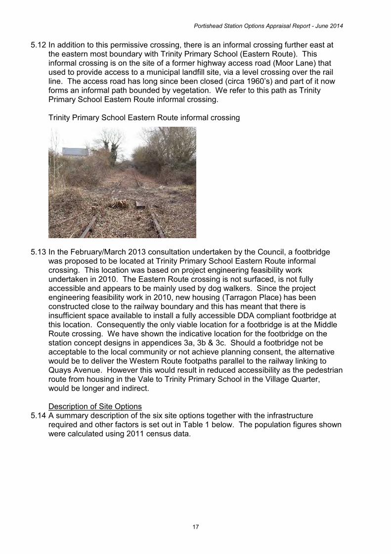
Portishead Station Options Appraisal Report - June 2014
17
5.12 In addition to this permissive crossing, there is an informal crossing further east at the eastern most boundary with Trinity Primary School (Eastern Route). This informal crossing is on the site of a former highway access road (Moor Lane) that used to provide access to a municipal landfill site, via a level crossing over the rail line. The access road has long since been closed (circa 1960’s) and part of it now forms an informal path bounded by vegetation. We refer to this path as Trinity Primary School Eastern Route informal crossing.
Trinity Primary School Eastern Route informal crossing
5.13 In the February/March 2013 consultation undertaken by the Council, a footbridge
was proposed to be located at Trinity Primary School Eastern Route informal crossing. This location was based on project engineering feasibility work undertaken in 2010. The Eastern Route crossing is not surfaced, is not fully accessible and appears to be mainly used by dog walkers. Since the project engineering feasibility work in 2010, new housing (Tarragon Place) has been constructed close to the railway boundary and this has meant that there is insufficient space available to install a fully accessible DDA compliant footbridge at this location. Consequently the only viable location for a footbridge is at the Middle Route crossing. We have shown the indicative location for the footbridge on the station concept designs in appendices 3a, 3b & 3c. Should a footbridge not be acceptable to the local community or not achieve planning consent, the alternative would be to deliver the Western Route footpaths parallel to the railway linking to Quays Avenue. However this would result in reduced accessibility as the pedestrian route from housing in the Vale to Trinity Primary School in the Village Quarter, would be longer and indirect.
Description of Site Options
5.14 A summary description of the six site options together with the infrastructure required and other factors is set out in Table 1 below. The population figures shown were calculated using 2011 census data.

Portishead Station Options Appraisal Report - June 2014
18
Table 1. Overview of Assessed Site Options
Option
Location & Population Catchment
New Highway Infrastructure Required
Wider Context
Option 1A
Rear of Travelodge Harbour Road
Location is 300 metres from Cabstand
Population within 1km radius is 15,991
Road over railway bridge at Quays Avenue. A footbridge near to Trinity Primary School. A further 50 space car park, in addition to 100 spaces already secured. Bus stops/lay-bys.
The Office of Rail Regulation has confirmed that a level crossing at Quays Avenue will not be permitted. Consequently this option requires a road over rail bridge. There is not sufficient room for a standard road bridge. The bridge design requires a steeper gradient and this causes reduced line of sight, which means the junction would have to be signal controlled. The overall environmental impact of the bridge is significant due to the highway being raised over 5 metres above the existing highway level, very close to existing residential / commercial property. The cost of the bridge is not within the funding envelope and would compromise the project business case.
Option 1B
Opposite Pure Offices Harbour Road
Location is 400 metres from Cabstand
Population within 1km radius is 15,927
This option requires substantial highway modifications to form a new highway link between Harbour Road and Wyndham Way, as an alternative route to Quays Avenue, which would be stopped up. Alternatively this option would require the road over rail bridge at Quays Avenue (as option 1A). A footbridge near to Trinity Primary School and enhanced footpath links. A 150 space car park. Bus stops/lay-bys.
Requires significant third party land /property, causing impact to commercial business. Requires closure of Quays Avenue (to through traffic) and a new highway link from Harbour Road to Wyndham Way, but this new link be an indirect route and would have a severe highway impact as it would increase pressure on key junctions, causing delays and longer journey times. It is unlikely these highway modifications would be acceptable to North Somerset Council as the highway authority.
Option 2C
Between Serbert Road and Harbour Road
Location is 550 metres from Cabstand
Population within 1km radius is 14,402
Some highway modifications to form a new highway link connecting Harbour Road to Serbert Road as an alternative route to Quays Avenue, which would be stopped up. A westbound pedestrian and cycle link. A pedestrian crossing at Serbert Road. A footbridge near to Trinity Primary School and enhanced footpath links. A 150 space car park. Bus stops/lay-bys.
Requires some third party land /property, including partial demolition of commercial property. Requires some highway modifications to form a new highway link connecting Harbour Road to Serbert Road, as a result of closing Quays Avenue to through traffic. Highway modifications cause some traffic impacts. Car park is located across the road from the station.
Option 2B
Across Quays Avenue
Location is 600 metres from Cabstand
Population within 1km radius is 13,889
Some highway modifications to re-align Quays Avenue and form a new roundabout junction with Haven View, with some modifications to Phoenix Way. A westbound pedestrian and cycle link. A pedestrian crossing at Quays Avenue. A footbridge near to Trinity Primary School and enhanced footpath links. A 100 space main car park and 50 space overflow car park. Bus stops/lay-bys.
Requires some third party land/ property. Requires some highway modifications to re-align Quays Avenue and create a new junction at Haven View.
Option 2A
East of Quays Avenue 700 metres from Cabstand Population within 1km radius is 12,990
No highway modifications. A westbound pedestrian and cycle link. A pedestrian crossing at Quays Avenue. A footbridge near to Trinity Primary School and enhanced footpath links. A 150 space car park. Bus stops/lay-bys.
No highway modifications. Location is close to existing residential property and would cause some localised environmental impacts. More limited space for station forecourt / facilities. Car park is located across the road from the station.
Option 3
North of Moor Farm Sheepway
Location is 1.3km from Cabstand
Population within 1km radius is 6,975
This location requires a new highway link road 300 metres in length with a new junction at Sheepway. A westbound pedestrian and cycle link. A pedestrian crossing at Quays Avenue. A 150 space car park. Bus stops/lay-bys.
This location is not within easy walking distance of the town centre and has a much lower catchment of households within 1 kilometre. This location requires a new highway link and junction. Location is close to some existing residential property and is in the green belt, however overall has a more limited localised environmental impact.

Portishead Station Options Appraisal Report - June 2014
19
Site Options Appraisal Methodology 5.15 The Site Options Appraisal methodology encompasses three main elements,
assessment of site policy fit, assessment of environmental / social impact and assessment of site deliverability. The methodology is based on the Department for Transport’s ‘Early Assessment and Sifting Tool (East)’, which is a multi-criteria assessment approach. Each element for each station site has been assessed qualitatively and this has resulted in a performance ranking. The results of the three elements were then combined and given equal weighting, to produce an overall site viability ranking for each station site.
5.16 The site policy fit assessment entailed a high level review of each site against a range of policy objectives. The policy objectives assessed included, strategic land use policies, strategic transport policies, highways development management policies, as summarised in chapter 2. Furthermore the policy assessment included consideration of Equalities Impact Assessment legislation and fit with project objectives.
5.17 The environmental and social impact of each station site has been assessed using
the following headings: Carbon emissions, Socio-distributional impacts and the regions, Local environment and Well being. Within each heading are various sub-headings, and each of which were assessed. Further details of the assessment is set out in chapter 6.
5.18 The site deliverability assessment entailed a high level review of each site against the transport business case (five case model). The transport five case model is the default approach used by and recommended by the Department for Transport for the development and implementation of major transport projects. The approach is based on the following five cases: the Strategic Case, the Economic Case, the Management Case, the Financial Case and the Commercial Case. Each case is developed in accordance with technical guidance, proportionate to the stage of the project. At key stages the business case (comprising the five cases) is submitted to the local funding body (WoE Joint Transport Board) for consideration and endorsement.

Portishead Station Options Appraisal Report - June 2014
20
6. Site Options Appraisal Assessment
6.1 Qualitative Assessment Table 2 sets out the qualitative site policy fit assessment. Table 3 sets out the qualitative environmental / social impact assessment. Table 4 sets out the qualitative deliverability assessment. Concept engineering design drawings have been produced for site option 2A, 2B and 2C, and indicative layout plans have been produced for options, 1A, 1B and 3, see appendix 3.

Portishead Station Options Appraisal Report - June 2014
21
Table 2. Site Options Appraisal – Policy Fit Assessment Policy Option 1A
Option 1B Option 2C Option 2B Option 2A
Option 3
Planning & Land Use Policies North Somerset Council Core Strategy and applicable elements of the Replacement Local Plan. Refer to section 2 for list of policies.
Site is in an area zoned as commercial and the use is commercial. Site is located close to the town centre assisting the vitality of the town centre. Good / excellent policy fit.
Site is in an area zoned as commercial and the use is commercial. Site is located fairly close to the town centre assisting the vitality of the town centre. Good / excellent policy fit.
Site is in an area zoned as commercial and the use is commercial. Site is more peripheral to the town centre but pedestrian/cycle promenade link to would provide strong link to the town centre. Good policy fit.
Site is in an area zoned as commercial and the use is commercial. Site is more peripheral to the town centre but pedestrian/cycle promenade link to would provide strong link to the town centre. Good policy fit.
Site is in an area zoned as residential. As the use is commercial and close to existing residential properties, there are policy implications. Site is peripheral to the town but pedestrian/cycle promenade link to would provide strong link to the town centre. Moderate / good policy fit.
Site is in an area zoned as Green Belt and is close to a number of residential properties. Poor policy fit.
WoE Joint Local Transport Plan Relevant policies include ‘Support economic growth’ and ‘Promote Accessibility’ etc
300m from the town centre and ample space for station forecourt / facilities. Good / excellent policy fit.
400m from the town centre and ample space for station forecourt / facilities. Good / excellent policy fit.
550m from town centre, ample space for station forecourt / facilities and corner (prominent) site. Good policy fit.
600m from town centre, ample space for station forecourt / facilities and corner (prominent) site. Good policy fit.
700m from town centre, limited space for station forecourt / facilities. Moderate / good policy fit.
1.3km from town centre, space for station forecourt / facilities. Poor policy fit.
Highway Development Management Policy Replacement Local Plan policy T/10 Safety, traffic and the provision of infrastructure associated with development
Quays Avenue link maintained via road over rail bridge, with signalised T junction. Gradient and derogation of design standards causes some issues for some highway users. Overall provides a poor / moderate fit with policy.
Stopping up of Quays Avenue and providing alterative in- direct highway route from Harbour Road to Wyndham Way would cause significant highway impacts resulting in, impacts on key junctions and longer journey times. Overall provides very poor policy fit.
New highway connection from Serbert Road to Harbour Road replaces Quays Avenue link (which is stopped up). New route is reasonably direct, but has narrower carriageway and more junctions. Pedestrian crossing to connect car park with station. Overall provides moderate policy fit.
Re-alignment of Quays Avenue and form a new roundabout junction with Haven View, with some modifications to Phoenix Way. Main station car park is within station grounds. Overall provides a good policy fit.
Quays Avenue link maintained as current arrangement, except a pedestrian crossing is required to link the car park with the rail station. Overall provides a moderate / good policy fit.
A new highway link is needed with new junction from Sheepway. A pedestrian crossing is needed at Quays Avenue. Highway implications are minor. Overall provides a good policy fit.
Equalities Impact Assessment Requirements include race, gender, disability equality, sexual orientation, religion or belief and age
The road over railway bridge would mean the road and pavements would entail gradients that some people may find more difficult. The footbridge near Trinity School would be fully accessible, likewise the station car park and station platform would meet all accessibility standards. Overall poor / moderate policy fit.
The required highway modifications would accord with statutory accessibility standards. The footbridge near Trinity School would be fully accessible, likewise the station car park and station platform would meet all accessibility standards. Overall good policy fit.
The required highway modifications would accord with statutory accessibility standards. The footbridge near Trinity School would be fully accessible, likewise the station car park and station platform would meet all accessibility standards. Overall good policy fit.
The required highway modifications would accord with statutory accessibility standards. The footbridge near Trinity School would be fully accessible, likewise the station car park and station platform would meet all accessibility standards. Overall good policy fit.
No changes are needed to the highway, except new access for the station car park. The footbridge near Trinity School would be fully accessible, likewise the station car park and station platform would meet all accessibility standards. Overall good policy fit.
The required highway modifications would accord with statutory accessibility standards. The station car park and station platform would meet all accessibility standards. Overall good policy fit.
Project Objectives
support economic growth deliver a more resilient transport offer improve accessibility to the rail network make a positive contribution to social well
being
contribute to reducing traffic congestion contribute to enhancing the capacity of
the local rail network contribute to reducing the overall
environmental impact of the transport network
excellent policy fit
excellent policy fit
good policy fit
good policy fit
good policy fit
good policy fit
moderate policy fit
good policy fit
moderate/good policy fit
moderate/good policy fit
good policy fit
moderate policy fit
good policy fit
good policy fit
excellent policy fit
excellent policy fit
excellent policy fit
excellent policy fit
good policy fit
good policy fit
excellent policy fit
excellent policy fit
excellent policy fit
excellent policy fit
excellent policy fit
good policy fit
good policy fit
excellent policy fit
excellent policy fit
excellent policy fit
excellent policy fit
good policy fit
good policy fit
good policy fit
good policy fit
moderate/good policy fit
moderate/good policy fit
moderate/good policy fit
moderate/good policy fit
moderate/good policy fit
good fit with policy
good fit with policy
Summary Overall policy fit
Overall weaker policy fit. Policy fit ranking 4th best.
Overall weak policy fit. Policy fit ranking 5th best.
Overall strong policy fit. Policy fit ranking 2nd best.
Overall very strong policy fit. Policy fit ranking 1st best.
Overall good policy fit. Policy fit ranking 3rd best.
Overall very weak policy fit. Policy fit ranking 6th best.

Portishead Station Options Appraisal Report - June 2014
22
Table 3. Site Options Appraisal – Environmental & Social Impact Assessment Environmental & Social Impact
Option 1A
Option 1B Option 2C Option 2B Option 2A
Option 3
Carbon emissions
Change in total vehicle kilometres
Impact on carbon emissions, for construction and when operational
Total fuel used and fuel efficiency
Central location close to the town centre, results in attractive and competitive travel option, resulting in a high level of passenger demand and modal switch. However, the construction of the road bridge requires a large volume of concrete, resulting in carbon emissions.
Central location close to the town centre, results in attractive and competitive travel option, resulting in a high level of passenger demand and modal switch.
While the site is more peripheral to the town centre, it provides an attractive and competitive travel option, resulting in a comparatively high level of passenger demand and modal switch.
While the site is more peripheral to the town centre, it provides an attractive and competitive travel option, resulting in a comparatively high level of passenger demand and modal switch.
While the site is more peripheral to the town centre, it provides an attractive and competitive travel option, resulting in a comparatively high level of passenger demand and modal switch.
The out of town station site means the station is more akin to a park & ride than a conventional station. The limited walking catchment for trip origins and for visitors to Portishead, the lack of easy walking distance to the town centre, results in lower passenger demand and modal switch.
Soicio-distributional impacts and the regions Socio-distribution Impacts on specific groups and equalities considerations, including impacts from changes to: Local environment Well being User benefits Personal affordability Regeneration Impact on targeted regeneration
Regional Imbalance Impact on competitiveness of local economy
The road bridge causes accessibility problems for some people. The road bridge causes environmental impacts for some residents. The impacts are particularly felt by residents with limited mobility and residents close to road bridge.
The highway modifications result in longer and indirect routes particularly between the Village Quarter Wyndham Way resulting in some severance issues. The highway modifications result in some environmental impacts and the traffic impacts could have a long term negative impact on the local economy. Residents of the Village Quarter are particularly affected.
The highway modifications are relatively minor, but some on-street parking will be displaced. Serbert Road and Serbert Way (a commercial area) becomes a through route, however this would increase the prominence of the businesses and as a result would possibly be beneficial to them.
The highway modifications are relatively minor, but would result in some localised environmental impacts.
No changes are needed to the highway, except new access for the station car park. The station site is close to residential properties and causes some localised environmental impacts.
The out of town station site means that most people would need access to a car to use the station. This has a particular impact on young people and older people who generally have more limited access to a car. The station site is close to some residential properties and causes some localised environmental impacts.
Local environment Air quality Noise Natural environment*, heritage and landscape Streetscape and urban environment
The road bridge causes a range of negative environmental impacts for some people.
The highway modifications cause traffic impacts (causing delays and longer journey times), resulting in environmental impacts.
The highway modifications enable the station to be located west of the residential housing. Much of the existing traffic on Quays Avenue would transfer onto Serbert Road and Serbert Way.
The re-alignment of Quays Avenue enables the station to be located west of some the residential housing and provides space for an area of public open space and environmental mitigation.
The proximity of the station to residential properties causes some localised environmental impacts.
The out of town station site reduces the total number of properties close to the station and the rail line, resulting in reduced environmental impact overall. However, there are a small number of properties close to station, resulting in some localised environmental impacts.
Well being Physical activity Injury or deaths Crime Terrorism Accessibility Severance
Moderately good accessibility for active modes (walking and cycling), buses and taxis.
Moderately good accessibility for active modes (walking and cycling), buses and taxis, but severance issues due to indirect highway route
Very good accessibility for active modes (walking and cycling), buses and taxis
Very good accessibility for active modes (walking and cycling), buses and taxis
Moderately good accessibility for active modes (walking and cycling), buses and taxis
More limited accessibility for active modes (walking and cycling), buses and taxis but reduced severance issues compared with some options.
Summary Overall environmental & social Impact
6th best 5th best Joint 1st best Joint 1st best Joint 3rd best Joint 3rd best
* includes ecology, biodiversity, habitats, soils, geology, hydrology / drainage and vibration

Portishead Station Options Appraisal Report - June 2014
23
Table 4. Sites Options Appraisal – Deliverability Assessment Business Case Section
Option 1A
Option 1B Option 2C Option 2B Option 2A
Option 3
Strategic Case
Compelling case & fit with policy objectives. Positive impact on business case.
Case less clearly made and some policy objectives not adequately addressed. Moderately positive impact on business case.
Compelling case & fit with policy objectives. Positive impact on business case.
Compelling case & fit with policy objectives. Positive impact on business case.
Compelling case but some policy objectives slightly less fully addressed. Positive impact on business case.
Case less clearly made and some policy objectives not adequately addressed. Neutral impact on business case.
Economic Case
Substantial additional costs (road bridge) reduces BCR. Estimated cost is approx £8m more than option 2A. Project value for money is marginal (BCR estimated at 1.5 to 2.0). Some localised environmental impacts. Negative impact on business case.
Substantial additional costs (highway and property) reduces BCR. Estimated cost is approx £5m more than option 2A. Project value for money is marginal (BCR estimated at 1.5 to 2.0). More limited environmental impacts. Negative impact on business case.
Moderate additional costs (highway & property) but this doesn’t have a significant impact on achieving a good BCR. Project value for money is good (BCR estimated at 2.0 to 2.5). More limited environmental impacts. Moderately positive impact on business case.
Some additional costs (highway & property) but this doesn’t have any significant impact on achieving a good BCR. Project value for money is good (BCR estimated at 2.0 to 2.5). More limited environmental impacts. Moderately positive impact on business case.
Low cost option enables good BCR. Project value for money is good (BCR estimated at 2.0 to 2.5). Some localised environmental impacts. Moderately positive impact on business case.
Low cost option enables good BCR. Project value for money is good (BCR estimated at 2.0 to 2.5). More limited localised environmental impacts. Moderately positive impact on business case.
Management Case
Substantial delivery challenges. Predicated on road over rail bridge which is a very tight fit in the available space and has significant environmental impacts. Negative impact on business case.
Substantial delivery challenges. Predicated on significant take of third party land, additional supporting infrastructure and impacts on commercial businesses. Negative impact on business case.
Moderate delivery challenges. Predicated on obtaining part of a third party property (which has full planning consent for conversion from commercial to residential use) and partial demolition. Negative impact on business case.
Some delivery challenges. Predicated on obtaining third party property (commercial). Slightly negative impact on business case.
Some delivery challenges. Predicated on gaining planning approval for the station site which adjoins a residential area. Slightly negative impact on business case.
Some delivery challenges. Predicated on gaining planning approval for the station site which adjoins a residential area and is in the green belt. Slightly negative impact on business case.
Financial Case
Cost is above the available funding envelope. There are major affordability issues with this option. Negative impact on business case.
Cost is above the available funding envelope. There are major affordability issues with this option. Negative impact on business case.
Higher cost than some options but is within the available funding envelope. Slightly negative impact on business case.
Higher cost than some options but is within the available funding envelope. Slightly negative impact on business case.
Cost is within the available funding envelope. Positive impact on business case.
Cost is within the available funding envelope. Positive impact on business case.
Commercial Case
Strong case with some potential for saleability / innovation by train operator. Positive impact on business case.
Strong case with some potential for saleability / innovation by train operator. Positive impact on business case.
Strong case with some potential for saleability / innovation by train operator. Positive impact on business case.
Strong case with some potential for saleability / innovation by train operator. Positive impact on business case.
Strong case with some potential for saleability / innovation by train operator. Positive impact on business case.
Case less certain but due to lower passenger demand because of station site. Neutral impact on business case.
Summary Overall business case viability
Overall business case is not sufficiently robust to take forward to delivery. Deliverability ranking – 5th best.
Overall business case is not sufficiently robust to take forward to delivery. Deliverability ranking – 6th best.
Overall marginal business case, requiring property acquisition and partial demolition of a building. Deliverability ranking – 4th best.
Overall sound business case, but requires some property acquisition. Deliverability ranking – 2nd best.
Overall sound business case, with some localised environmental issues. Deliverability ranking – 1st best
Overall sound business case to take forward to delivery. Deliverability ranking – 3rd best.

Portishead Station Options Appraisal Report - June 2014
24
This page is intentionally left bank

Portishead Station Options Appraisal Report - June 2014
25
Overall Assessment Ranking 6.2 The overall assessment combining the policy fit, environmental / social impact
and deliverability assessment, using an equal weighting to produce an aggregate site option performance ranking, is shown in the table below. Table 5. Overall Assessment Ranking Results
Option
1A Option
1B Option
2C Option
2B Option
2A Option 3
Policy fit Ranking 4th 5th 2nd 1st 3rd 6th Environmental & Social Impact ranking 6th 5th 1st 1st 3rd 3rd Deliverability Ranking 5th 6th 4th 2nd 1st 3rd Average ranking Score 5.00 5.33 2.33 1.33 2.33 4.00
Aggregate ranking 5th best 6th best Joint 2nd
best 1st best Joint 2nd
best 4th best

Portishead Station Options Appraisal Report - June 2014
26
7. Conclusions
Summary of Results 7.1 Chapter 6 para 6.1 shows the outcome of the overall assessment combining
the policy fit, environmental / social impact and deliverability assessment. In summary site 2B, has the best policy fit ranking, followed by site 2C and 2A, each having a good, strong or very strong policy fit. Site options 1A, 1B and 3 have either a weaker, weak or very weak policy fit. In respect of the Environmental / Social Impact assessment, site 2C and 2B are the joint best performing options, with 2A and 3, joint 3rd best. Site options 1B and 1A have the greatest Environmental / Social Impact and are ranked 5th and 6th. In respect of the deliverability assessment, site 2A has the best deliverability ranking, followed by 2B and 3 with all three having a sound business case. The business case for option 2C is marginal, while the business case for site options, 1A and 1B is not sufficiently robust to take forward. The best overall performing options are 2A, 2B and 2C and these are the only options to achieve at least one ranking of 1st in the assessment. Site Option 2A photograph taken west of the station site, looking east
Site Option 2B photograph taken north of the station site, looking south east

Portishead Station Options Appraisal Report - June 2014
27
Site Option 2C photograph taken north of the station site, looking south east
Recommendations
7.2 The three overall best performing options 2B, 2A and 2C, should be taken forward for further consideration. The three site options bound each other and comprise a total linear length of approximately 250 metres (excluding car parks), spanning the railway alignment either side of Quays Avenue. Based on the body of evidence set out in this document, consideration should be given to safeguarding site options 2B, 2A and 2C in the North Somerset Sites & Policies Development Plan Document, as an area of search spanning approximately 250 metres, plus space for car parks . As the technical work for MetroWest Phase 1 progresses (project consultation, engineering design, business case development etc), a preferred station site within this relatively contained area of search can be identified to take through a major planning application process (Development Consent Order) and ultimately to construction and opening.

Portishead Station Options Appraisal Report - June 2014
28
Appendices

Important Note: The delivery of the rail project has a number of challenges and constraints. These include achieving a positive outcome in relation to a detailed business case, availability of capital funding and funding approval, statutory processes and approvals, confirmation of operational costs in relation the Great Western franchising process and the overall financial position for North Somerset Council in terms of the affordability of both the capital and revenue funding requirement.
1
Sites and Policies
Development Plan Document
February 2013
North Somerset Council
Local Development Framework
Evidence Paper Re-opening Portishead Railway Line and Options for the Location of Portishead
Railway Station

Important Note: The delivery of the rail project has a number of challenges and constraints. These include achieving a positive outcome in relation to a detailed business case, availability of capital funding and funding approval, statutory processes and approvals, confirmation of operational costs in relation the Great Western franchising process and the overall financial position for North Somerset Council in terms of the affordability of both the capital and revenue funding requirement.
2
Evidence Paper Policy Reference PH3
Re-opening Portishead Railway Line and Options for the Location of Portishead Railway Station
1. Overview of the Portishead to Bristol Transport Corridor
The Portishead to Bristol corridor (A369) suffers congestion and journey time reliability problems. This not only causes delays and lost productivity for car drivers and goods vehicle operators but also presents a major hurdle for providing an attractive public transport mode along the corridor. The problems and context of the A369 corridor are summarised as:
The A369 is the only transport corridor directly linking Portishead with Bristol which is just 10 miles to the east.
The capacity constraints on the A369 are exacerbated further by the fact that the A369 crosses junction 19 of the M5. Junction 19 of the M5 is one of the busiest parts of the M5 with the Avonmouth Bridge immediately to the north towards junction 18.
The A369 continually suffers from the knock on effects of incidents on the M5 with traffic high volumes of traffic over spilling onto a constrained local road corridor with very few alternative route options.
This lack of transport network resilience and limited travel choices could be addressed by utilising the heavy rail corridor between Portishead and Bristol which is a strategic transport network asset and re-instating passenger train services. The objectives of re-opening the Portishead railway line for passenger train services are to:
Reduce traffic congestion on arterial roads and reduce journey times for commuters and business to and from Bristol, supporting economic growth,
Improve transport network resilience through the utilisation of a strategic transport alignment, which is independent from the highway network,
Deliver a sustainable transport corridor and improve air quality
The project will also:
Assist in the delivery of wider social wellbeing and quality of life objectives, Provide through rail services from Portishead to destinations beyond Bristol Temple
Meads, across the sub-region, and Form the basis of a medium to long term sub-regional programme of rail projects to
deliver a major uplift to the local the local rail network offer.
The project would increase the UK’s passenger rail network by 10 miles and connect an additional 30,000+ people to the network. There is a great amount of interest and support for the project within the local community, based on the frequency with which the project is raised positively by business, members of the public and community organisations, to the council.

Important Note: The delivery of the rail project has a number of challenges and constraints. These include achieving a positive outcome in relation to a detailed business case, availability of capital funding and funding approval, statutory processes and approvals, confirmation of operational costs in relation the Great Western franchising process and the overall financial position for North Somerset Council in terms of the affordability of both the capital and revenue funding requirement.
3
2. Overview of the Project The Portishead rail branch line was closed in 1964 as part of the Beeching cuts. In 2002 a major part of the line was reopened between Royal Portbury Dock and Bristol as a freight only line. This project involves re-instating the remaining 4 miles of track between Portishead and Pill and upgrading the branch line infrastructure to meet passenger train standards, and providing sufficient line capacity to enable both passenger and freight train to operate to the required service patterns. Re-opening the Portishead rail branch line now forms part of a larger sub-regional project known as Greater Western Metro Phase 1. GW Metro Phase 1 includes half hourly train services for the Severn Beach line, local stations between Bristol Temple Meads and Bath Spa and the reopened Portishead line. In addition there is a wider programme of local rail schemes, also being taken forward by the four West of England councils; North Somerset, Bristol City, South Gloucestershire and Bath & North East Somerset. GW Metro Phase 1 is being led by North Somerset Council on behalf of the West of England councils.
3. Brief History of the Project 1964 Line was closed
2002 Line partly re-opened for freight trains only between Parsons Street junction and Portbury Dock
2005 Portishead Quays Master plan - identified location for station (option 1)
2006 Joint Local Transport Plan 2 - policy basis and stakeholder support for taking project forward
2006 North Somerset Replacement Local Plan - safeguarded disused railway alignment between Portishead and Pill
2008 Project feasibility study by consultants Halcrow
2010 Engineering feasibility by Network Rail GRIP3 Option Selection
2011 Joint Local Transport Plan 3 - policy basis, programme prioritisation and stakeholder support for taking project forward
2011 Sub-regional rail conference - project selected by over 70 delegates as 2nd highest rail priority for delivery
2011 Sub-regional rail study recommends combining Portishead rail project into the GW Metro project with it included in GW Metro Phase 1
2012 Joint Transport Executive Committee endorse including re-opening Portishead line in GW Metro Phase 1 and response to GW Franchise for its inclusion in franchise specification as a prices option
2012 Department for Transport confirm the inclusion of GW Metro Phase 1 as a priced option in GW Franchise
2012 Governance and mobilisation of sub-regional rail programme and identification of resources for mobilisation of GW Metro Phase 1 project
Important Note: The delivery of the rail project has a number of challenges and constraints. These include achieving a positive outcome in relation to a detailed business case, availability of capital funding and funding approval, statutory processes and approvals, confirmation of operational costs in relation the Great Western franchising process and the overall financial position for North Somerset Council in terms of the affordability of both the capital and revenue funding requirement.
4
4. The Safeguarded Alignment
The alignment has been subject to local planning polices for many years to protect encroachment of development that would prevent the line from being re-opened. The only location where development has created an obstacle to the re-opening of the line is at Quays Avenue, which is a new road crossing over the railway alignment. At the time of the master planning of Portishead Vale development, the design standards for road easements across railway branch lines allowed for level crossings. However, the rail industry design standards have since changed and level crossings are no longer acceptable to Her Majesties Railway Inspectorate. Therefore a road over rail bridge will be needed in order for the railway line to serve Portishead town centre (station location option 1 only).
5. Timescales Taking Forward the Project as part of GW Metro Phase 1 late 2012 - 2015 Scheme Case and Powers to Build and Operate 2015 - 2016 Detailed Design and Scheme Procurement 2016 - 2017 Construction late 2017 / early 2018 Scheme Opening and Commencement of Train Services
6. Options for the Location of Portishead Railway Station
While a site for the Portishead railway station was identified on Harbour Road as part of the Portishead Quays master planning, the delivery of a station at this location has a number of challenges and there is now a need to review the merits of this location and consider options for other locations. There are a wide range of factors that need to be considered in respect of identifying the best location for a railway station, these include the transport network, the environmental impact, the strategic land uses both current and future use as set out the councils Core Strategy and wider community considerations. Furthermore the site must also be able to meet technical specifications, accessibility regulations and safety requirements of rail industry and national legislation. We have commenced initial analysis on the merits and impacts of alternative station locations. Further more detailed analysis will be needed, as the project is taken forward. There are broadly eight high level transport criteria relevant to selecting the location for Portishead railway station:
1. walking and cycling catchment and access, 2. highway access, 3. car parking provision and bus interchange facilities, 4. the extent of supporting infrastructure required for each location eg highway bridges,
pedestrian bridges, new highway accesses etc 5. likely wider environmental impact 6. fit with project objectives 7. overall cost of station location 8. EQIA considerations

Important Note: The delivery of the rail project has a number of challenges and constraints. These include achieving a positive outcome in relation to a detailed business case, availability of capital funding and funding approval, statutory processes and approvals, confirmation of operational costs in relation the Great Western franchising process and the overall financial position for North Somerset Council in terms of the affordability of both the capital and revenue funding requirement.
5
We have used the above criteria to identify and compare three short listed locations for Portishead railway station, as follows: Option 1 - Town Centre location on Harbour Road. Provision for 100 car parking spaces has been made adjacent to the station site. This option requires the construction of a new road bridge over the rail alignment at Quays Avenue. This option also includes provision for a footbridge south east of Trinity Anglican Methodist Primary School. This station site is approximately 0.3 km from the town centre. Option 2 – Peripheral Town Centre location on Quays Avenue. There is space for at least 200 car parking spaces on land west of Quays Avenue. This option does not require a new road bridge at Quays Avenue. This option also includes provision for a footbridge south east of Trinity Anglican Methodist Primary School. The remaining length of redundant track bed to the town centre would be used to provide a high quality ‘Gateway’ shared use pedestrian/ cycle path. The ‘Gateway’ path would have the effect of extending the western pedestrian entrance of the station closer to the town centre. The rail alignment here is 15 to 20 meters wide, so there is considerable potential to create a very attractive public realm enhancement as well as serving as a functional pedestrian/ cycle ‘Gateway’. A new pedestrian / cycle crossing on Quays Avenue (Toucan crossing or similar) would be provided to give a through route between the station and the ‘Gateway’ path and car park. There is also potential to create a wider station forecourt/frontage using a small parcel of land adjacent to Quays Avenue, which is currently part of the Pumping Station yard. This station site is approximately 0.7 km from the town centre. Option 3 – Edge of Town location on land north of Moor Farm. There is space for at least 200 car parking spaces on land adjacent to the railway station site, together with a new highway access from Sheepway. This option does not require a new road bridge at Quays Avenue or provision for a footbridge south east of Trinity Anglican Methodist Primary School, however it would require a new highway access and link road from Sheepway. This option would operate more like a ‘Parkway’ station than a conventional station, due to its edge of town location. This station site is approximately 1.3 km from the town centre. Table 1 below sets out a high level comparison of the three station location options for Portishead Rail station. Figure 1 below shows a map of the three station location options for Portishead Rail station. We are seeking feedback as part of our Sites and Policies DPD Consultation Version, on all three station location options, to inform decision making on which location is best overall for Portishead. Please refer to the front of the DPD document on how to provide feedback.

Important Note: The delivery of the rail project has a number of challenges and constraints. These include achieving a positive outcome in relation to a detailed business case, availability of capital funding and funding approval, statutory processes and approvals, confirmation of operational costs in relation the Great Western franchising process and the overall financial position for North Somerset Council in terms of the affordability of both the capital and revenue funding requirement.
6
Table 1. Comparison of the Three Short Listed Locations for Portishead Railway Station
Walking & Cycling Catchment and Access
Highway Access
Car Parking Provision & Bus Interchange
Extent of Supporting Infrastructure Required
Likely Wider Environmental Impact
Fit with Project Objectives
Overall Cost of this station location
EQIA considerations
Station Location Option 1 Town Centre location on Harbour Road
Large catchment of housing within 800m radius of station location. Any potential re-development of Old Mill Road Industrial Estate could improve access to town centre from station. This station site is approximately 0.3 km from the town centre.
Relatively good highway access via Harbour Road, however requires a road bridge at Quays Avenue.
Provision for 100 car parking spaces has been secured as part of the Quays development however this is unlikely to be sufficient to cater for the forecast passenger demand. Bus stops are located on Harbour Road and there is potential for buses to operate via the station car park.
This location requires a new road over railway bridge at Quays Avenue and one pedestrian bridge east of Trinity school.
The road over railway bridge would entail replacing the existing roundabout at Quays Avenue, Phoenix Way & Harbour Road, with an elevated signal controlled T junction. This would have a visual and environmental impact on a number of residential properties adjacent to Quays Avenue and retirement apartments on Harbour Road.
This option would meet all the project objectives to reduce congestion, improve transport network resilience and deliver a sustainable transport corridor.
The estimated cost of the road bridge is £6m. The estimated cost of the pedestrian bridge ranges from £500k to £1.5m depending upon whether it includes mobility impairment ramps.
The road over railway bridge would mean the roads and pavements would entail gradients that some people may find more difficult than the current layout.

Important Note: The delivery of the rail project has a number of challenges and constraints. These include achieving a positive outcome in relation to a detailed business case, availability of capital funding and funding approval, statutory processes and approvals, confirmation of operational costs in relation the Great Western franchising process and the overall financial position for North Somerset Council in terms of the affordability of both the capital and revenue funding requirement.
7
Walking & Cycling Catchment and Access
Highway Access
Car Parking Provision& Bus Interchange
Extent of Supporting Infrastructure Required
Likely Wider Environmental Impact
Fit with Project Objectives
Overall Cost of this station location
EQIA considerations
Station Location Option 2 Peripheral Town Centre location on Quays Avenue
Large catchment of housing within 800m radius of station location. The remaining length of redundant track bed to the town centre would be used to provide a high quality ‘Gateway’ shared use pedestrian/ cycle path. The ‘Gateway’ path would have the effect of extending the western pedestrian entrance of the station closer to the town centre. The rail alignment here is 15 to 20 meters wide, so there is considerable potential to create a very attractive public realm enhancement as well as serving as a functional pedestrian/ cycle ‘Gateway’. This station site is approximately 0.7 km from the town centre.
Good highway access via Quays Avenue / Harbour Road, and good access from both directions via Wyndham Way.
There is space for provision of at least 200 car parking spaces. A pedestrian crossing would be needed on Quays Avenue to link the car park with the station. There are bus stops on Quays Avenue and there is potential for buses to operate via the station car park or from new bus stops / lay-bys near to the main station entrance.
This location requires a high quality ‘Gateway’ shared use pedestrian / cycle path, a new car park on land west of Quays Avenue, a new pedestrian / cycle crossing on Quays Avenue (Toucan crossing or similar) and one pedestrian bridge east of Trinity school.
This option does not require a road over railway bridge, therefore it would have a more limited environmental impact on Quays Avenue, in comparison with option 1.
The need for a new 200 space car park would however result in some environmental impact.
The proximity of the station to housing could result in some localised environmental impact, however there is potential to design mitigation measures reduce these impacts.
This option would meet all the project objectives to reduce congestion, improve transport network resilience and deliver a sustainable transport corridor. While the station location is not as central as option 1, this option still has a very high walking catchment. Access to the town centre could be enhanced by the provision of a high quality ‘Gateway’ shared use pedestrian/ cycle path on the remaining length of redundant track bed.
The estimated cost of the ‘Gateway’ shared use path is £250k. The estimated cost of a new car park is £850k. The estimated cost of the Toucan crossing is £50k. The estimated cost of the pedestrian bridge ranges from £500k to £1.5m depending upon whether it includes mobility impairment ramps.
No major changes are needed to the road layout, other than a new access to a new car park west of Quays Avenue. The station car park and station platform would meet all statutory accessibility standards.

Important Note: The delivery of the rail project has a number of challenges and constraints. These include achieving a positive outcome in relation to a detailed business case, availability of capital funding and funding approval, statutory processes and approvals, confirmation of operational costs in relation the Great Western franchising process and the overall financial position for North Somerset Council in terms of the affordability of both the capital and revenue funding requirement.
8
Walking & Cycling Catchment and Access
Highway Access
Car Parking Provision & Bus Interchange
Extent of Supporting Infrastructure Required
Likely Wider Environmental Impact
Fit with Project Objectives
Overall Cost of this station location
EQIA considerations
Station Location Option 3 Edge of Town location on land north of Moor Farm
More limited catchment of housing within 800m radius of station location. Approximately 60% of the 800m radius is green belt - open fields. This station site is approximately 1.3km from the town centre, if the remaining length of track bed is used as a pedestrian path. This distance is beyond a reasonable walking distance for many people.
Highway access could be provided via Quays Avenue using the rail alignment to the station, however this could prevent any future extension of the line into the town centre. A new highway access could be formed off Sheepway.
There is space for provision of at least 200 car parking spaces, either on the rail alignment or on land north of Moor Farm. Additional bus stops could be provided on Sheepway and there is potential for buses to operate via the station car park.
This location requires a new car park and a new highway access and link road from Sheepway.
This option would entail locating the station, station car park and highway access in the Green Belt and would result in some environmental impact. This option would require a sequential test and robust evidence to support a case for development in the Green Belt
The proximity of the station to housing could result in some localised environmental impact, however there is potential to design mitigation measures reduce these impacts.
This option would not fully meet all the project objectives to reduce congestion, improve transport network resilience and deliver a sustainable transport corridor. This option does not provide easy access to and from Portishead Town centre. The walking catchment of the station is relatively poor, thereby access for the majority of people would be via a car trip, bus or cycle. This option would operate more like a ‘Parkway’ station than a conventional station, due to its edge of town location.
The estimated cost of a new car park is £850k. The estimated cost of the new highway access and link road is £1m.
No major changes are needed to the highway layout, other than a new highway access and link road from Sheepway and a new car park. The station car park and station platform would meet all statutory accessibility. standards. The edge of town centre location would limit its accessibility and usability for some people, particularly those with mobility impairments.

Important Note: The delivery of the rail project has a number of challenges and constraints. These include achieving a positive outcome in relation to a detailed business case, availability of capital funding and funding approval, statutory processes and approvals, confirmation of operational costs in relation the Great Western franchising process and the overall financial position for North Somerset Council in terms of the affordability of both the capital and revenue funding requirement.
9
Fig 1. Map of the Three Station Location Options for Portishead Railway Station
Important Note: The delivery of the rail project has a number of challenges and constraints. These include achieving a positive outcome in relation to a detailed business case, availability of capital funding and funding approval, statutory processes and approvals, confirmation of operational costs in relation the Great Western franchising process and the overall financial position for North Somerset Council in terms of the affordability of both the capital and revenue funding requirement.


VEHICLE ENTRANCE / EXIT
TO CAR PARK
S
T
A
T
I
O
N
C
A
R
P
A
R
K
1
5
0
S
P
A
C
E
S
VEHICLE EXIT
LEFT TURN ONLY
CONSENTED HIGHWAY
ACCESS
PEDESTRIAN CROSSING
EXISTING BUS STOPS
W
A
L
K
I
N
G
A
N
D
C
Y
C
L
I
N
G
P
R
O
M
E
N
A
D
E
W
I
T
H
T
R
E
E
L
I
N
E
D
B
U
F
F
E
R
CONNECTS TO EXISTING
WALKING / CYCLE PATHS
CONNECTS TO EXISTING
WALKING / CYCLE PATHS
PROPOSED
FOOTBRIDGE
STATION PLATFORM
AND BUILDINGS
PROPOSED PEDESTRIAN
AND CYCLE LINK
AREA FOR TAXI RANK

SAINSBURYS
DEVELOPMENT
SAINSBURYS PUBLIC ACCESS
ROAD
CONNECTS TO EXISTING
WALKING / CYCLE PATHS
CONNECTS TO EXISTING
WALKING / CYCLE PATHS
S
T
A
T
I
O
N
C
A
R
P
A
R
K
1
0
0
S
P
A
C
E
S
AREA FOR
TAXI RANK
OVERFLOW CAR PARK
ENTRANCE
BUS STOPS
(OPTION FOR LAY-BYS)
AREA OF PUBLIC OPEN SPACE
WITH LANDSCAPING
O
V
E
R
F
L
O
W
C
A
R
P
A
R
K
5
0
+
S
P
A
C
E
S
W
A
L
K
I
N
G
A
N
D
C
Y
C
L
I
N
G
P
R
O
M
E
N
A
D
E
W
I
T
H
T
R
E
E
L
I
N
E
D
B
U
F
F
E
R
LEFT TURN LANE ONTO QUAYS
AVENUE
PEDESTRIAN CROSSING
'KISS AND DROP'
LAY-BYS
PROPOSED
FOOTBRIDGE
PROPOSED PEDESTRIAN
AND CYCLE LINK
STATION FORECOURT

SAINSBURYS
DEVELOPMENT
SAINSBURYS PUBLIC ACCESS
ROAD
SAINSBURYS DELIVERY
ACCESS ROAD
VEHICLE ENTRANCE / EXIT
KISS AND DROP / TAXIS
STATION PLATFORM
AND BUILDINGS
COMMERCIAL BUILDING
REDUCED IN SIZE TO MAKE WAY
FOR NEW HIGHWAY LINK
S
T
A
T
I
O
N
F
O
R
E
C
O
U
R
T
A
N
D
K
I
S
S
A
N
D
D
R
O
P
A
R
E
A
S
T
A
T
I
O
N
C
A
R
P
A
R
K
1
5
0
S
P
A
C
E
S
CONSENTED HIGHWAY
ACCESS
TWO WAY VEHICLE ENTRANCE
CONNECTS TO EXISTING
WALKING / CYCLE PATHS
CONNECTS TO EXISTING
WALKING / CYCLE PATHS
PEDESTRIAN CROSSING
PROPOSED
FOOTBRIDGE
PROPOSED PEDESTRIAN
AND CYCLE LINK
QUAYS AVENUE STOPPED UP
W
A
L
K
I
N
G
A
N
D
C
Y
C
L
I
N
G
P
R
O
M
E
N
A
D
E
W
I
T
H
T
R
E
E
L
I
N
E
D
B
U
F
F
E
R
PROPOSED
BUS STOPS

©Crown copyright and database rights 2014 Ordnance Survey 100023397. You are not permitted to copy, sub-license, distribute or sell any of this data to third parties in any form. © Aerial Photography 2009 Imagery copyright Getmapping PLC. www.getmapping.com. © and database right "Crown Copyright and Landmark Information Group Ltd" (All rights reserved (2014)).
Scale: 1:3500
Date: 21 May 2014Portishead Station Option 1A

©Crown copyright and database rights 2014 Ordnance Survey 100023397. You are not permitted to copy, sub-license, distribute or sell any of this data to third parties in any form. © Aerial Photography 2009 Imagery copyright Getmapping PLC. www.getmapping.com. © and database right "Crown Copyright and Landmark Information Group Ltd" (All rights reserved (2014)).
Scale: 1:3500
Date: 21 May 2014Portishead Station Option 1B

©Crown copyright and database rights 2014 Ordnance Survey 100023397. You are not permitted to copy, sub-license, distribute or sell any of this data to third parties in any form. © Aerial Photography 2009 Imagery copyright Getmapping PLC. www.getmapping.com. © and database right "Crown Copyright and Landmark Information Group Ltd" (All rights reserved (2014)).
Scale: 1:5000
Date: 21 May 2014Portishead Station Option 3

Appendix C Consultation and publicity material

Bath & North East Somerset, Bristol, North Somerset and South Gloucestershirecouncils working together to improve your local transport
Consultation on thelocation forPortishead rail station
June/July 2014

MetroWestThe West of England councilsare working together onproposals which will deliverinvestment of up to £100 millionin improvements to our localrail network, over the next fiveto ten years.
The proposals, calledMetroWest, are a series ofprojects, including large tosmall scale enhancements toour local rail network.
Our overall aim is to introducefast and frequent metro railservices across the local area.
MetroWest Phase 1MetroWest Phase 1 proposes toreopen the Portishead line topassenger train services and willintroduce half-hourly train services forthe Severn Beach line and the BathSpa to Bristol line.
Portishead station locationassessmentSince theMetroWest Phase1 project beganin 2013 we’vedone substantialwork to identifyand assess optionsfor the location ofPortishead railstation.
This work has been informed by feedback fromconsultation we carried out in spring 2013 andfollowing confirmation from the Office of RailRegulation that a level crossing at Quays Avenuewill not be allowed.
We have now identified and assessed a total of sixpotential station locations. These are the threelocations included in the 2013 consultation plusthree new potential sites.
Our assessment has shown three options arepotentially viable and three are not. We are nowconsulting with the local community, localbusinesses and statutory organisations on the threeviable station options.
The tables on the following pages summarise theviability of the station options.
1. how each location fits with NorthSomerset Council planning policy,
2. the environmental and social impact ofeach station location,
3. deliverability of each station location.
We assessed the six potential stationlocations using three main criteria:

Summary of station viability assessment
Consultation on the location for Portishead rail station
Station location optionsOur assessment has shown that the following options are viable. These are the location options we want your views on.
The option numbering (2A, 2B, 2C) is taken from our detailed assessment report. The detailedassessment is available from www.travelwest.info/mw/portishead
Option 2C: Between Serbert Road and Harbour Road
550 metres from town centre.
Requires some third party land/property, including partial demolition of property.
Closes Quays Avenue to through traffic which means highway modifications would beneeded to connect Harbour Road to Serbert Road.
Highway modifications would cause some traffic impacts.
Car park is located accross the road from the station.
Option 2B: Across Quays Avenue
600 metres from town centre.
Requires some third party land/property.
Requires some highway modifications to realign Quays Avenue and creation of a new junctionat Haven View.
Option 2A: East of Quays Avenue
700 metres from town centre.
No highway modifications needed, other than new access for the car park.
Location is close to existing residential property and would cause some localisedenvironmental impacts.
Limited space for station forecourt and other facilities.
Car park is located across the road from the station.

Location Reasons for rejecting
Rear of Travelodge,Harbour Road
300 metres from town centre
The Office of Rail Regulation won’t allow a level crossing atQuays Avenue so this option would require a road bridge overthe railway.
However, there is not enough room for a standard road bridgeand a bridge here would need a steep slope which wouldreduce visibility for drivers. Traffic lights would also be required.
The bridge would have a significant environmental impact andwould be very close to existing residential and commercialproperties.
The highway would be raised over five metres above theexisting level.
A bridge would also cost more than available funding andcompromise the project’s business case.
Opposite Pure offices,Harbour Road
400 metres from town centre
Adverse impact on commercial businesses because it requiressignificant third party land/property.
Requires closure of Quays Avenue to through traffic and a newhighway link from Harbour Road to Wyndham Way. There isvery limited space available so this link would have to connectonto Old Mill Road providing a very indirect route.
The new highway link would increase pressure on key junctionsand create delays and longer journey times. This is unlikely tobe acceptable to North Somerset Council as the highwayauthority.
North of Moor Farm,Sheepway
1.3 kilometres from town centre
Location is not within easy walking distance of the town centre.
Has a much lower catchment of households within 1 kilometre.
Requires a new highway link and junction.
Location is close to some existing residential properties and isin the green belt.
Non-viable station locationsOur assessment has shown that the following options are non-viable. We are not consulting on these options.

Consultation on the location for Portishead rail station
Option 2A: location and details
Pedestrian and cycle link
Photograph taken west of the station site, looking east© Crown copyright and database rights 2011Ordnance Survey 100023397 You are not permitted to copy, sub-licence, distribute or sell this data to third parties in any form.
Small station buildingcomprising of ticket kiosk,seating and public toilets
Station platformand canopy
Pedestrian and cycle link
VEHICLE ENTRANCE / EXITTO CAR PARK
STATION CAR PARK150 SPACES
VEHICLE EXITLEFT TURN ONLY
CONSENTED HIGHWAYACCESS
PEDESTRIAN CROSSING
EXISTING BUS STOPS
WALKING AND CYCLING PROMENADE WITH TREE LINED BUFFER
CONNECTS TO EXISTINGWALKING / CYCLE PATHS
CONNECTS TO EXISTINGWALKING / CYCLE PATHS
PROPOSED FOOTBRIDGE
STATION PLATFORMAND BUILDINGS
PROPOSED PEDESTRIANAND CYCLE LINK
AREA FOR TAXI RANK
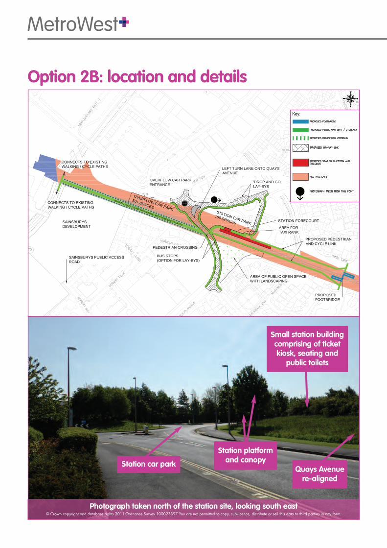
SAINSBURYSDEVELOPMENT
SAINSBURYS PUBLIC ACCESSROAD
CONNECTS TO EXISTINGWALKING / CYCLE PATHS
CONNECTS TO EXISTINGWALKING / CYCLE PATHS
STATION CAR PARK100 SPACES
AREA FORTAXI RANK
OVERFLOW CAR PARKENTRANCE
BUS STOPS(OPTION FOR LAY-BYS)
AREA OF PUBLIC OPEN SPACEWITH LANDSCAPING
OVERFLOW CAR PARK
50+ SPACESWALKING AND CYCLING PROMENADE WITH TREE LINED BUFFER
LEFT TURN LANE ONTO QUAYSAVENUE
PEDESTRIAN CROSSING
'DROP AND GO'LAY-BYS
PROPOSED FOOTBRIDGE
PROPOSED PEDESTRIANAND CYCLE LINK
STATION FORECOURT
Option 2B: location and details
Station car parkQuays Avenue re-aligned
Station platformand canopy
Small station buildingcomprising of ticketkiosk, seating andpublic toilets
Photograph taken north of the station site, looking south east© Crown copyright and database rights 2011Ordnance Survey 100023397 You are not permitted to copy, sub-licence, distribute or sell this data to third parties in any form.

Photograph taken north of the station site, looking south east© Crown copyright and database rights 2011Ordnance Survey 100023397 You are not permitted to copy, sub-licence, distribute or sell this data to third parties in any form.
Stationplatform
Platformcanopy
Stationforecourt
Grassed area is not ownedby the council and may bedeveloped in the future
Small station buildingcomprising of ticketkiosk, seating andpublic toilets
Consultation on the location for Portishead rail station
SAINSBURYSDEVELOPMENT
SAINSBURYS PUBLIC ACCESSROAD
SAINSBURYS DELIVERYACCESS ROAD
VEHICLE ENTRANCE / EXITDROP AND GO / TAXIS
STATION PLATFORMAND BUILDINGS
COMMERCIAL BUILDINGREDUCED IN SIZE TO MAKE WAYFOR NEW HIGHWAY LINK
STATION FORECOURT AND
KISS AND DROP AREA
STATION CAR PARK 150 SPACES
CONSENTED HIGHWAYACCESS
TWO WAY VEHICLE ENTRANCE
CONNECTS TO EXISTINGWALKING / CYCLE PATHS
CONNECTS TO EXISTINGWALKING / CYCLE PATHS
PEDESTRIAN CROSSING
PROPOSED FOOTBRIDGE
PROPOSED PEDESTRIANAND CYCLE LINK
QUAYS AVENUE STOPPED UP
WALKING AND CYCLING PROMENADE WITH TREE LINED BUFFER
PROPOSEDBUS STOPS
Option 2C: location and details

MetroWest Phase 1
The MetroWest services need to fit into the busy national rail network. To ensure this we areinvestigating different options for the routing of trains between the three rail lines: Severn Beach, Bathand Portishead via Bristol Temple Meads.
Part of the Portishead line is used by freight trains to Royal Portbury Dock, at Bristol Port. The Port is aninternational gateway that is important to our local, regional and national economy and capacity onthe Portishead line must be retained for freight trains.
MetroWest Phase 1 will upgrade the train service for Avonmouth and stations to Bristol Temple Meadsto half-hourly. At this early stage we don’t yet know if the service for St Andrew’s Road and SevernBeach stations can be upgraded to half-hourly, but we intend to introduce at least an hourly service.We are also investigating increasing train services to Parson Street and/or Bedminster.
Although the Bath line has a frequent train service, not all trains stop at Keynsham and Oldfield Park,which currently only have an hourly service for most of the day. MetroWest Phase 1 will introduce ahalf-hourly service for these two stations.
The new train service to Bath will require a site for empty trains to turn around near BathamptonJunction with a short section of additional track and signalling.
Portishead
Pill
Ashton Gate
Saltford
Line to South Wales
to Weston-super-Mareand South West
to Severn Beach
to London Paddington
ParsonStreet
Royal Portbury Dock
Avonmouth Dock St AndrewsRoad
AvonmouthShirehampton
Sea Mills
CliftonDown
Redland
Montpellier
Bedminster
Stapleton Road
Lawrence Hill
Keynsham
OldfieldPark Bath
Spa
BristolTempleMeads
Railway
Existing station
Proposed station
Possible future station (subject to seperate business case)

Summary of MetroWest Phase 1� Reopen the Portishead to Pill railway line
� Construct station at Portishead
� Reopen former station at Pill (westboundplatform)
� Double track works at Pill and Ashton Gate
� Improve road access for maintenance at Pilltunnel
� Environmental mitigation measures
� Improve Parson Street Junction, including lineworks from the junction to Temple Meads
� Install additional signal at Avonmouth stationand re-signal entire line between Portisheadand Temple Meads
� Construct turnback at Bathampton with shortsection of additional track and signalling
MetroWest Phase 1 timescales2014 – 2016� Consultation on station options
� Detailed project engineering design,environmental assessment and business case
� Formal project consultation for major planningapplication
� Detailed technical work and preparation formajor planning application
� Project procurement2017� Planning consent awarded
� Procurement completed
� Full business case completed
� Funding approval and contractualarrangements finalised
� Begin construction2019� Construction completed
� Train services operating from Spring 2019
Consultation on the location for Portishead rail station
The above are indicative only and assume positive outcomes on the project business case, allocation of funding for construction and for the train service, statutory processes,technical and legal approvals and contractual arrangements.
AccessibilityThe new station will be designed to meet allstatutory accessibility standards, this meansit will be as step-free as possible. There willbe accessible routes from the stationentrance to the platform and anyfootbridges will have ramps. Step-free accessnot only benefits disabled people or thosewith reduced mobility but also people withchildren, heavy luggage or shopping.

Have your say on the location for Portisheadrail stationWe are holding two exhibitions at: Portishead Methodist Church, High Street, Portishead BS20 6EN
� Tuesday 24 June, 1pm to 6.30pm
� Saturday 28 June, 10am to 2pm
The three station options will be displayed at both exhibitions. The MetroWest project team will alsobe there to discuss the options and the project.
We will publish a summary of the consultation responses later this summer on our website:www.travelwest.info/mw/portishead
North Somerset Council will use your views to inform their decision later this year on where Portisheadrail station will be located.
How to comment � Complete the online form at www.travelwest.info/mw/portishead� Fill in the form opposite and send it to: MetroWest, Engine Shed, Station Approach, Temple
Meads, Bristol, BS1 6QH
� Give your completed leaflet to us at one of our exhibitions at Portishead Methodist ChurchThe consultation lasts for six weeks and closes on 28 July 2014, so make sure you return yourresponse to us by this date.
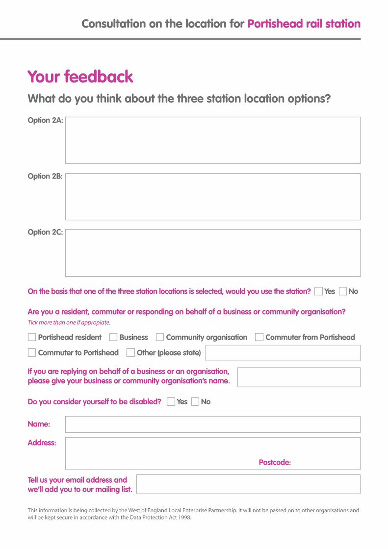
Consultation on the location for Portishead rail station
Your feedbackWhat do you think about the three station location options?
Option 2A:
Option 2B:
Option 2C:
On the basis that one of the three station locations is selected, would you use the station? Yes No
Are you a resident, commuter or responding on behalf of a business or community organisation?Tick more than one if appropiate.
Portishead resident Business Community organisation Commuter from Portishead
Commuter to Portishead Other (please state)
If you are replying on behalf of a business or an organisation, please give your business or community organisation’s name.
Do you consider yourself to be disabled? Yes No
Name:
Address:
Tell us your email address and we’ll add you to our mailing list.
Postcode:
This information is being collected by the West of England Local Enterprise Partnership. It will not be passed on to other organisations andwill be kept secure in accordance with the Data Protection Act 1998.

www.travelwest.info24474 06/14
More informationIf you want to receive regular MetroWest updates email us at [email protected]
The following websites have information about local rail projects:
� www.travelwest.info/metrowest � www.n-somerset.gov.uk/prs� www.severnside-rail.org.uk � www.severnbeachline.org
Contact usMetroWest, Engine Shed, Station Approach, Temple Meads, Bristol BS1 6QH
Working with partnersThe West of England councils are workingwith Network Rail and First Great Western todeliver MetroWest. This means we have tofollow rail industry requirements and makesure that the new MetroWest train services donot cause problems with the operation of theexisting national rail network.
Next stepsWe’ll be providing more information anddoing further consultation over the next 18months. Keep an eye on the local press andour website for more details.
We’ll also be working with pedestrian andcycling groups, local landowners, businesses,community groups and interest groups tokeep them informed of our plans.

Bath & North East Somerset, Bristol, North Somerset and South Gloucestershirecouncils working together to improve your local transport
Consultation on the location for Portisheadrail station
Have your say We would like to hear your views on three options for the location of a new rail station in Portishead.
The consultation is now open and runs for six weeks until 28 July 2014.Come along to one of our exhibitions at Portishead Methodist Church,High Street, Portishead BS20 6EN on Tues 24 June (2pm to 6.30pm)or Sat 28 June (10am to 2pm).
You will be able to view the options in detail, discuss them with theMetroWest project team and give your feedback.
You can also view the options and submit your comments online atwww.travelwest.info/mw/portishead

MetroWest Phase 1 Reopening the Portishead railway line for passenger servicesThe West of England councils are working together on proposals which willinvest up to £100 million in improvements to our local rail network, over thenext five to ten years.
MetroWest Phase 1 will reopen the Portishead line to passenger trainservices and introduce half hourly train services for the Severn Beach lineand the Bath Spa to Bristol line.
Station locationSince the MetroWest Phase 1 project began in 2013 we’ve done substantialwork to identify and assess options for the location of Portishead rail station.
This work has been informed by feedback from consultation we carried outin spring 2013 and following confirmation from the Office of Rail Regulationthat a level crossing at Quays Avenue will not be allowed.
We would now like to hear your views on three options for the location of anew rail station in Portishead.
More informationwww.travelwest.info/mw/portishead • www.n-somerset.gov.uk/prs


Option 2A: location and details
Option 2A: East of Quays Avenue
700 metres from town centre.
No highway modifications needed, other than new access for the car park.
Location is close to existing residential property and would cause some localised environmental impacts.
Limited space for station forecourt and other facilities.
Car park is located across the road from the station.
www.travelwest.info
VEHICLE ENTRANCE / EXITTO CAR PARK
STATION CAR PARK
150 SPACES
VEHICLE EXITLEFT TURN ONLY
CONSENTED HIGHWAYACCESS
PEDESTRIAN CROSSING
EXISTING BUS STOPS
WALKING AND CYCLING PROMENADE WITH TREE LINED BUFFER
CONNECTS TO EXISTINGWALKING / CYCLE PATHS
CONNECTS TO EXISTINGWALKING / CYCLE PATHS
PROPOSED FOOTBRIDGE
STATION PLATFORMAND BUILDINGS
PROPOSED PEDESTRIANAND CYCLE LINK
AREA FOR TAXI RANK
Pedestrian and cycle link
Photograph taken west of the station site, looking east© Crown copyright and database rights 2011 Ordnance Survey 100023397 You are not permitted to copy, sub-licence, distribute or sell this data to third parties in any form.
Small station buildingcomprising of ticket kiosk,seating and public toilets
Station platformand canopy
Pedestrian and cycle link
Option 2A:location and details
Opt
ion
2A:l
ocat
ion
and
deta
ils
Option 2B: location and details
Option 2B: Across Quays Avenue
600 metres from town centre.
Requires some third party land/property.
Requires some highway modifications to realign Quays Avenue and creation of a new junction at Haven View.
www.travelwest.info
Option 2B:location and details
SAINSBURYSDEVELOPMENT
SAINSBURYS PUBLIC ACCESSROAD
CONNECTS TO EXISTINGWALKING / CYCLE PATHS
CONNECTS TO EXISTINGWALKING / CYCLE PATHS
STATION CAR PARK
100 SPACESAREA FORTAXI RANK
OVERFLOW CAR PARKENTRANCE
BUS STOPS(OPTION FOR LAY-BYS)
AREA OF PUBLIC OPEN SPACEWITH LANDSCAPING
OVERFLOW CAR PARK
50+ SPACES
WALKING AND CYCLING PROMENADE WITH TREE LINED BUFFER
LEFT TURN LANE ONTO QUAYSAVENUE
PEDESTRIAN CROSSING
'DROP AND GO'LAY-BYS
PROPOSED FOOTBRIDGE
PROPOSED PEDESTRIANAND CYCLE LINK
STATION FORECOURT
Station car parkQuays Avenue
re-aligned
Station platformand canopy
Small station buildingcomprising of ticketkiosk, seating and
public toilets
Photograph taken north of the station site, looking south east© Crown copyright and database rights 2011 Ordnance Survey 100023397 You are not permitted to copy, sub-licence, distribute or sell this data to third parties in any form.
Opt
ion
2B:l
ocat
ion
and
deta
ils

Option 2C: location and details
Option 2C: Between Serbert Road and Harbour Road
550 metres from town centre.
Requires some third party land/property, including partial demolition of property.
Closes Quays Avenue to through traffic which means highway modifications would be needed to connect Harbour Road to Serbert Road.
Highway modifications would cause some traffic impacts.
Car park is located accross the road from the station.
www.travelwest.info
Opt
ion
2C:l
ocat
ion
and
deta
ils
SAINSBURYSDEVELOPMENT
SAINSBURYS PUBLIC ACCESSROAD
SAINSBURYS DELIVERYACCESS ROAD
VEHICLE ENTRANCE / EXITDROP AND GO / TAXIS
STATION PLATFORMAND BUILDINGS
COMMERCIAL BUILDINGREDUCED IN SIZE TO MAKE WAYFOR NEW HIGHWAY LINK
STATION FORECOURT AND
KISS AND DROP AREA
STATION CAR PARK 150 SPACES
CONSENTED HIGHWAYACCESS
TWO WAY VEHICLE ENTRANCE
CONNECTS TO EXISTINGWALKING / CYCLE PATHS
CONNECTS TO EXISTINGWALKING / CYCLE PATHS
PEDESTRIAN CROSSING
PROPOSED FOOTBRIDGE
PROPOSED PEDESTRIANAND CYCLE LINK
QUAYS AVENUE STOPPED UP
WALKING AND CYCLING PROMENADE WITH TREE LINED BUFFER
PROPOSEDBUS STOPS
Photograph taken north of the station site, looking south east© Crown copyright and database rights 2011 Ordnance Survey 100023397 You are not permitted to copy, sub-licence, distribute or sell this data to third parties in any form.
Stationplatform
Platformcanopy
Stationforecourt
Grassed area is not ownedby the council and may be
developed in the future
Small station buildingcomprising of ticketkiosk, seating and
public toilets
Option 2C:location and details
Location forPortishead rail stationLoca
tion
forP
ortis
head
rail
stat
ion
Bath & North East Somerset, Bristol, North Somerset and South Gloucestershirecouncils working together to improve your local transport
Consultation on the locationfor Portishead rail station
How to comment � Complete the online form at www.travelwest.info/mw/portishead� Send your completed leaflet to: MetroWest, Engine Shed, Station Approach, Temple
Meads, Bristol BS1 6QH
� Give your completed leaflet to us at one of our exhibitions at Portishead Methodist Church
The consultation lasts for six weeks and closes on 28 July 2014, so make sure you return yourresponse to us by this date.

Improvem
ents to our local rail networkIm
prov
emen
ts to
our
loca
l rai
l net
wor
k
www.travelwest.info
MetroWest Phase 1
Portishead
Pill
Ashton Gate
Saltford
Line to South Wales
to Weston-super-Mareand South West
to Severn Beach
to London Paddington
ParsonStreet
Royal Portbury Dock
Avonmouth Dock St AndrewsRoad
AvonmouthShirehampton
Sea Mills
CliftonDown
Redland
Montpellier
Bedminster
Stapleton Road
Lawrence Hill
Keynsham
OldfieldPark Bath
Spa
BristolTempleMeads
Railway
Existing station
Proposed station
Possible future station (subject to seperate business case)
Summary of MetroWest Phase 1� Reopen the Portishead to Pill railway line� Construct station at Portishead� Reopen former station at Pill (westbound platform)� Double track works at Pill and Ashton Gate� Improve road access for maintenance at Pill tunnel� Environmental mitigation measures� Improve Parson Street Junction, including line works
from the junction to Temple Meads� Install additional signal at Avonmouth station and re-
signal entire line between Portishead and Temple Meads� Construct turnback at Bathampton with short section of
additional track and signalling
MetroWest Phase 1 timescales2014 – 2016� Consultation on station options� Detailed project engineering design, environmental
assessment and business case� Formal project consultation for major planning
application� Detailed technical work and preparation for major
planning application� Project procurement2017� Planning consent awarded� Procurement completed� Full business case completed� Funding approval and contractual arrangements
finalised� Begin construction2019� Construction completed� Train services operating from Spring 2019
Improvem
ents to our local rail networkIm
prov
emen
ts to
our
loca
l rai
l net
wor
k
The West of England councils areworking together on proposalswhich will deliver investment of upto £100 million in improvements toour local rail network, over thenext five to ten years.
The proposals, called MetroWest,are a series of projects, includinglarge to small scaleenhancements to our local railnetwork.
Our overall aim is to introduce fastand frequent metro rail servicesacross the local area.
MetroWest Phase 1MetroWest Phase 1 proposes to reopenthe Portishead line to passenger trainservices and will introduce half-hourlytrain services for the Severn Beach lineand the Bath Spa to Bristol line.
Portishead stationlocation assessmentSince the MetroWest Phase 1 project began in2013 we’ve done substantial work to identifyand assess options for the location of Portisheadrail station.
This work has been informed by feedback fromconsultation we carried out in spring 2013 andfollowing confirmation from the Office of RailRegulation that a level crossing at Quays Avenuewill not be allowed.
We have now identified and assessed a total ofsix potential station locations. These are thethree locations included in the 2013consultation plus three new potential sites.
Our assessment has shown three options arepotentially viable and three are not. We are nowconsulting with the local community, localbusinesses and statutory organisations on thethree viable station options.
1. how each location fits with NorthSomerset Council planning policy,
2. the environmental and social impactof each station location,
3. deliverability of each station location.
We assessed the six potential stationlocations using three main criteria:
www.travelwest.info

Appendix D – Postcard distribution

Appendix E – Location of respondents