portage-arcadia creek watershed...
TRANSCRIPT
KIESER & ASSOCIATES
PORTAGE-ARCADIA CREEK WATERSHED LAKES The Portage-Arcadia watershed includes a variety of lakes and surface water features ranging in size from 10-acre ponds to 190-acre recreational lakes. Many of the Portage-Arcadia watershed lakes are hydraulically connected (i.e., they have flowing inlets and outlets) with the surficial receiving waters of the four watershed creeks. As a result, these lakes have been categorically termed “contributing” lakes within the context of this project. The contributing lakes within the watershed deliver both hydraulic and pollutant loads downstream, thus imparting potential influences and impacts on downstream surface waters.
There are also many lakes in the watershed that do not have outlets connected with surficial receiving creeks in the watershed. Such lakes have been characterized as “non-contributing” lakes within the context of this project. Although they may not exhibit a surficial discharge to downstream surface waters, many of these lakes have at least one stormwater inlet (often many) from surrounding drainage areas. Since these water bodies do infiltrate to the underlying groundwater, their observed water quality, possible impairments and lake management goals are still of great importance to the watershed and the environment.
In all, there are thirteen (13) contributing lakes, eight (8) non-contributing lakes
and five (5) surface water wetlands/marshes within the Portage-Arcadia watershed. The five major wetlands in the watershed also do not surficially contribute to the four Portage-Arcadia creeks. These wetlands/marshes are not identified as “lakes” within this narrative (despite the name of some of these water bodies). Figure A-1 depicts an illustration of the relative location of all Portage-Arcadia watershed lakes and wetlands.
Table B-1 presents a summary of available information for lake characteristics
such as general description, known impairments, pollutant sources, goals, management strategies, control structures, and informational resources. Local township officials, municipal representatives and knowledgeable private landowners were contacted to assist with identification of previous reports and available management information associated with each of these water bodies. Many of these area lakes have received a great deal of previous study and local planning directed toward improving their overall water quality. Consequently, these well-studied lakes already benefit from established technical recommendations, water quality monitoring strategies, and lake managerial tasks, which are necessary to achieve specific goals. Some examples of such lakes include: Asylum Lake, Cherry Creek Lake, Willow Lake, Kleinstuck Marsh, Pike’s Pond and Woods Lake.
The remainder of this document provides information on these lakes that
addresses U.S. EPA requirements for approvable watershed management plans. As such, more detailed information is provided within the text and attachments that follow.
KIESER & ASSOCIATES
Page 2
Summary of Lakes
The following is a summary list of the various lakes identified within the Portage-Arcadia Creek Watershed. To view the relative location of all of these water bodies on one map, refer to Figure A-1. To view the location of each lake in more detail, click on the appropriate links below. Refer to Table B-1 for a detailed description of available information pertaining to each lake.
Contributing Lakes (13) o Asylum Lake (view map image) (view aerial photo)
This lake is located along the northern edge of the West Fork Portage Creek watershed (northern headwaters). The lake and riparian land belongs to Western Michigan University and is accessible to the public. The Asylum Lake Policy and Management Council initiate the management and policy decisions regarding the use of the property. Current land use includes: 1) research; and, 2) passive recreation. The lake is located near a highly urban area, upstream of Little Asylum Lake and the Parkview Hills Community. Two major storm sewer outfalls on the west end of the lake have been estimated to contribute 126,711 lbs TSS/yr and 407 lbs TP/yr (K&A, 2000). Surficial discharge from the lake is quite low; most discharge occurs via infiltration to groundwater.
o Little Asylum Lake (view map image) (view aerial photo) This lake is located in the City of Kalamazoo along the northern edge of the West Fork Portage Creek watershed (northern headwaters). The lake and riparian land belongs to Western Michigan University and is accessible to the public. The Asylum Lake Policy and Management Council initiate the management and policy decisions regarding the use of the property. Current land use includes: 1) research; and, 2) passive recreation. The lake is located near a highly urban area, downstream of Asylum Lake and upstream of Cherry Creek Lake in the Parkview Hills Community. There are three known storm sewer outfalls that discharge into the lake. Estimated annual pollutant loads to the lake are 9,612 lbs TSS/yr and 33 lbs TP/yr (K&A, 2000). Eurasian milfoil is becoming increasingly problematic. Surficial discharge from the lake is quite low; most discharge occurs via infiltration to groundwater.
o Atwater Millpond (view map image) Atwater Millpond (a.k.a., Birchwood Lake) is located downstream of Scouters Pond and Bass Lake (west of US-131) and upstream of Howard Lake (east of US-131). It is located within the West Fork Portage Creek watershed (Texas Township) and has a surface area of approximately 44 acres (Wesley, 2005). The approximate drainage area is 1,254 acres (K&A, 2005). Estimated annual runoff EMC loads, based on land cover for this drainage area, are 245 lbs TP/yr and 63,532 lbs TSS/yr (K&A, 2005). The Al Sabo Land Preserve (741 acres) is also located upstream and was established in the early 1970's in order to protect the groundwater supply of the Atwater wellfield (18 wells). The City of Kalamazoo has an

KIESER & ASSOCIATES
Page 3
ordinance in place to ensure the Al Sabo wetlands protection as a water resource.
o Bass Lake (view map image) Bass Lake is one of three small headwater lakes on the southwestern portion of West Fork Portage Creek in Texas Township. It is located upstream of Atwater Millpond, and the lake shoreline is largely uninhabited. The approximate drainage area is 254 acres (K&A, 2005). Estimated annual runoff EMC loads, based on land cover for this drainage area, are 38 lbs TP/yr and 11,890 lbs TSS/yr (K&A, 2005). A notable riparian steward is the Rota-Kiwan Reservation and Boy Scout Camp. Bass Lake has no surface inlet, and the outlet (a small intermittent stream) exits at the northeast end.
o Cherry Creek Lake (view map image) (view aerial photo) Part of the West Fork Portage Creek, this lake is a small impoundment managed and maintained by the Parkview Hills Community Association (PHCA). It is located downstream of Little Asylum Lake within the Parkview Hills Community and was created via excavation circa 1970. It is immediately upstream of Willow Lake. Surficial flows are maintained by an augmentation well with nearly constant pumping (50 gpm). It has an approximate drainage area of 74 acres (K&A, 2000). There are three known storm sewer outfalls. The Parkview Hills runoff contributes most of the pollutant load (notably solids). Nuisance waterfowl also contribute to solids loading. Estimated annual runoff loads include 12,479 lbs TSS/yr; 35 lbs TP/yr; 11 lbs SRP/yr (K&A, 2000).
o Fishcamp Pond (view map image) Fishcamp Pond is one of three small headwater lakes on the southwestern portion of West Fork Portage Creek in Texas Township (along the west side of 8th Street). The approximate drainage area is 112 acres (K&A, 2005). Estimated annual runoff EMC loads, based on land cover for this drainage area, are 16 lbs TP/yr and 6,544 lbs TSS/yr (K&A, 2005). Fishcamp Pond has no surface inlet, and the outlet (a small intermittent stream) exits at the northeast end into Scouters Pond. The lake shoreline appears uninhabited. It is unknown if a formal managing authority exists for this water body.
o Hampton Lake (view map image) (view aerial photo) Located at the headwaters of Portage Creek in the City of Portage, Michigan, this lake is quite important to the water quality of Portage Creek. Urban stormwater runoff threatens water quality (FTC&H, 2001). The approximate drainage area is 2,538 acres (K&A, 2005). Estimated annual runoff EMC loads, based on land cover for this drainage area, are 557 lbs TP/yr and 176,136 lbs TSS/yr (K&A, 2005). It is a cold-water resource relative to the downstream urban portion of Portage Creek north of Kilgore Road. High dissolved oxygen concentrations >15 mg/L have been documented during past studies (FTC&H, 1998). Many of the wetlands adjacent to Hampton Lake were historically prairie-fen. Emergent marsh is now observed immediately adjacent to the lake
KIESER & ASSOCIATES
Page 4
(Bruederle, 1995). Purple loostrife has been observed along the lakeshore of Hampton Lake and poses a real threat to all other wetlands in the Portage Creek Basin (Bruederle, 1995). The lake shoreline appears largely uninhabited.
o Howard Lake (view map image) (view aerial photo) Howard Lake is situated within a chain of connected surface waters along the West Fork of Portage Creek within the City of Kalamazoo. It is positioned downstream of Atwater Millpond and upstream of Lake Hill’n Brook (east of US-131). This lake is arguably part of Lake Hill’n Brook. The combined drainage area of Howard Lake and Lake Hill’n Brook amounts to approximately 763 acres. Similarly, the estimated annual runoff loads to these two lakes are 166,474 lbs TSS/yr; 553 lbs TP/yr; 234 lbs SRP/yr (K&A, 2000). The lake shoreline appears uninhabited. It is unknown if a formal managing authority exists for this water body.
o Lake Hill’n Brook (view map image) (view aerial photo) Lake Hill’n Brook is situated within a chain of connected surface waters along the West Fork of Portage Creek within the City of Kalamazoo. It is positioned downstream of Howard Lake and upstream of Lake Lime Kiln (east of US-131). This lake is arguably part of Howard Lake. The combined drainage area of Howard Lake and Lake Hill’n Brook amounts to approximately 763 acres. Similarly, the estimated annual runoff loads to these two lakes are 166,474 lbs TSS/yr; 553 lbs TP/yr; 234 lbs SRP/yr (K&A, 2000). The lake shoreline appears uninhabited. It is unknown if a formal managing authority exists for this water body.
o Lake Lime Kiln (view map image) (view aerial photo) This lake is located downstream of Willow Lake (to its north) and Lake Hill’n Brook (to its west). It is the last connected lake positioned along West Fork Portage Creek prior the creek’s convergence with Main Branch Portage Creek near Milham Park. Lake Lime Kiln has one known storm sewer outfall. It’s estimated drainage area is approximately 54 acres (K&A, 2000). The surface area of Lake Lime Kiln is 21 acres, and the average depth is approximately 2 feet (Wesley, 2005). Estimated annual runoff loads include 5,037 lbs TSS/yr; 20 lbs TP/yr; 8 lbs SRP/yr (K&A, 2000). A dam control structure was built on the outlet in 1988 and is owned by Kalamazoo County (Wesley, 2005).
o Monarch Millpond (view map image) (view aerial photo) The Monarch Millpond is located along Portage Creek in the City of Kalamazoo south of Cork Street and downstream of Milham Park. It has an approximate surface area of 21 acres and an average depth of 3.9 feet (Wesley, 2005). There are three known urban storm sewer outfalls that discharge into the lake. The approximate drainage area is 276 acres (K&A, 2005). Estimated annual runoff EMC loads, based on land cover for this drainage area, are 72 lbs TP/yr and 15,556 lbs TSS/yr (K&A, 2005). A dam structure was built on the outlet in 1916 (Wesley, 2005).
KIESER & ASSOCIATES
Page 5
o Scouters Pond (view map image) Scouters Pond is also one of three small headwater lakes on the southwestern portion of West Fork Portage Creek in Texas Township. It is located upstream of Atwater Millpond, and the lake shoreline is largely uninhabited. The approximate drainage area is 881 acres (K&A, 2005). Estimated annual runoff EMC loads, based on land cover for this drainage area, are 138 lbs TP/yr and 53,457 lbs TSS/yr (K&A, 2005). A notable riparian steward is the Rota-Kiwan Reservation and Boy Scout Camp. Souters Pond receives intermittent surface flows from Fishcamp Pond, and the outlet (another small intermittent stream) exits at the northeast end.
o Willow Lake (view map image) (view aerial photo) Willow Lake is managed and maintained by the Parkview Hills Community Association (PHCA). It is located downstream of Cherry Creek Lake within the Parkview Hills Community and was created via excavation circa 1970. It is immediately upstream of Lake Lime Kiln. Surficial inflows are maintained by an upstream augmentation well (at Cherry Creek Lake) with nearly constant pumping (50 gpm). There are three known storm sewer outfalls discharging into the lake from an approximate drainage area of 101 acres (K&A, 2000). The Parkview Hills runoff contributes most of the pollutant load (notably solids). Nuisance waterfowl also contribute to solids loading. Estimated annual runoff loads include 12,564 lbs TSS/yr; 55 lbs TP/yr; 25 lbs SRP/yr (K&A, 2000). The lake shoreline is kept in a natural, native state. Known impairments include: 1) dense Eurasian milfoil, pondweed, white lily, and chara; 2) accumulating organic solids in the bottom; 3) shallow depth; and, 4) purple loostrife along the shoreline near the clubhouse.
Non-Contributing Lakes (8) o Bonnie Castle Lake (view map image)
Bonnie Castle Lake is located in Oshtemo Township within the non-contributing portion of the Arcadia Creek watershed. The surface area of the lake is approximately 131 acres (Wesley, 2005). The approximate topographic drainage area is 388 acres (K&A, 2005). Estimated annual runoff EMC loads, based on land cover for this drainage area, are 55 lbs TP/yr and 18,677 lbs TSS/yr (K&A, 2005). No surface water outlets/overflow locations are known. This lake is assumed to be groundwater controlled (Elliott, 2005). The lake shoreline appears uninhabited. Information regarding township storm sewer outfalls and runoff is not known.
o Crooked Lake (view map image) This lake is located within the non-contributing portion of the West Fork Portage Creek watershed (Texas Township). It has no surficial inflows or outflows. The lake surface area is approximately 162 acres (USGS 1970). The approximate topographic drainage area is 859 acres (K&A, 2005). Estimated annual runoff EMC loads, based on land cover for this drainage area, are 165 lbs TP/yr and 42,807 lbs TSS/yr (K&A, 2005). The

KIESER & ASSOCIATES
Page 6
Kalamazoo County Human Services Department collects periodic water quality samples. The maximum water depth is approximately 50ft. Staff gage readings were recorded daily during the 1960's. There is no known legal lake elevation. Since April 10, 1965, water has been pumped into the lake from a well finished in a deep aquifer to raise the lake level. Pumping was continuous until Oct 20, 1966 and has been intermittent since. On Oct 6, 1965, a discharge of 1.54cfs was measured flowing into the lake from the pumping well (USGS 1970). Information regarding township storm sewer outfalls is not known. Many residential homes are located along the shoreline.
o Duck Lake (view map image) Duck Lake is a small, non-contributing lake within the West Fork Portage Creek watershed (Texas Township). The surface area of the lake is approximately 10 acres (Wesley, 2005). The approximate topographic drainage area is 157 acres (K&A, 2005). Estimated annual runoff EMC loads, based on land cover for this drainage area, are 24 lbs TP/yr and 7,401 lbs TSS/yr (K&A, 2005). It has no surficial inflows or outflows. The lake shoreline appears uninhabited. It is unknown if a formal managing authority exists for this water body. Information regarding township storm sewer outfalls and runoff is not known.
o Eagle Lake (view map image) Eagle Lake is located within the non-contributing portion of the West Fork Portage Creek watershed in Texas Township. The surface area of Eagle Lake is approximately 194 acres (Wesley, 2005). The Kalamazoo County Human Services Department collects periodic water quality samples. The approximate topographic drainage area is 1,822 acres (K&A, 2005). Estimated annual runoff EMC loads, based on land cover for this drainage area, are 354 lbs TP/yr and 108,056 lbs TSS/yr (K&A, 2005). The maximum water depth is approximately 16ft. Staff gage readings were recorded intermittently during the 1960's (USGS, 1970). Starting in late December 1965, water has been pumped into Eagle Lake from a well finished in a deep aquifer to maintain the lake level. Eagle Lake has no surface inlet or outlet. Groundwater pumped into Eagle Lake has been estimated to be from 1,000 to 1,200 gallons per minute (USGS, 1970). Information regarding township storm sewer outfalls and runoff is not known. Many residential homes are located along the shoreline.
o Pike’s Pond (view map image) (view aerial photo) This non-contributing water body is located in the urban Axtell Creek watershed within the City of Kalamazoo. It is a 2.25-acre pond with a drainage area of approximately 112 acres (K&A, 2002). The average depth is between 3-4 feet, with an observed maximum depth of 11-12 feet. There are six known urban stormwater outfalls that discharge into the lake. Estimated annual runoff loads are 58 lbs TP/yr and 36,218 lbs TSS/yr (K&A, 2002). Known water quality concerns include: 1) excessive weed growth (50% surface water coverage); 2) stratification and nutrient

KIESER & ASSOCIATES
Page 7
dispersion during turnover; 3) external nutrient sources; and, 4) low dissolved oxygen concentrations.
o Pretty Lake (view map image) Pretty Lake is an 88-acre water body located within the non-contributing portion of the West Fork Portage Creek watershed (Texas Township). It has no known surface water inflows or outflows. The approximate topographic drainage area is 1,135 acres (K&A, 2005). Estimated annual runoff EMC loads, based on land cover for this drainage area, are 150 lbs TP/yr and 47,911 lbs TSS/yr (K&A, 2005). Information regarding township storm sewer outfalls and runoff is not known. The riparian portion of this area appears uninhabited. All of the Portage-Arcadia lakes are located within the City of Kalamazoo Water Reclamation Plant sanitary sewer service area with the exception of Pretty Lake. Refer to Figures B-2 and B-3 for maps illustrating the sanitary sewer service area boundary identified by the City of Kalamazoo. Lakes within the sanitary sewer service area are presumed as being constructed with that utility service. Since Pretty Lake is located beyond the sanitary sewer service boundary, all residential dwellings on the lakeshore (<250 ft) are presumed as having private septic tanks within the context of this project. As a result, these septic tanks likely contribute annual nutrient loads to the lake via infiltration and groundwater recharge along the perimeter shoreline. The septic system nutrient loads for Pretty Lake were estimated as follows:
Aerial photographs were observed to obtain estimates for the number of residential dwellings around the riparian perimeter of Pretty Lake. These images revealed approximately 45-50 riparian dwellings (within 250 ft of the lake, and along 3,960 ft of shoreline = 22.7 acres). Within the context of this study, each residential dwelling was presumed occupied by a family size of 3.5 persons. Previous studies of septic tank loads were referenced to obtain published estimates for nitrogen and phosphorus. Nitrogen loads for Texas Township septic tanks are estimated to be 1.29 lbs N/acre/year (Rheaume, 1990). Phosphorus loads for septic tanks are estimated to be 0.25 lbs P/capita/year (Walterhouse, 2004). Using these published loading rates for septic tanks, the estimated nutrient loads to Pretty Lake are 29.3 lbs N/yr and 41.5 lb P/yr.
o Whites Lake (view map image) (view aerial photo) This non-contributing water body is located in the urban West Fork Portage Creek watershed within the City of Kalamazoo. The surface area is approximately 22 acres (Wesley, 2005). The approximate topographic drainage area is 382 acres (K&A, 2005). Estimated annual runoff EMC loads, based on land cover for this drainage area, are 87 lbs TP/yr and 26,169 lbs TSS/yr (K&A, 2005). The Kalamazoo Country Club Golf course is situated along the northern side of the lake. There are three known storm sewer outfalls that discharge into Whites Lake.

KIESER & ASSOCIATES
Page 8
o Woods Lake (view map image) (view aerial photo) Woods Lake is a non-contributing urban lake located within the Axtell Creek watershed (City of Kalamazoo). All management and policy decisions are directed by the Woods Lake Association. The surface area is approximately 24 acres. The lake has a maximum water depth observed at greater than 40 feet. No surface streams flow in or out of lake. It has 199 acres of residential and commercial lands that drain stormwater into the lake (K&A, 1997). Urban stormwater contributions enter the lake at 5 known outfalls. Wet weather sampling confirmed the transport of sediments and nutrients (phosphorus and organic nitrogen) at concentrations higher than national runoff averages (EPA, 1983). Annual loads of 44.3 lbs TP/yr and 2,900 lbs TSS/yr have been estimated for Woods Lake runoff inputs (K&A, 1997). Sediments are also high in phosphorus content as a result of internal recycling in oxygen deficient bottom waters. The lack of an outflowing stream only exacerbates the accumulation of phosphorus because there is no flushing of organic-rich sediment materials from the lake. Improvements in water quality, targeted reduction of phosphorus entering the lake (in-line BMPs), and recommended engineering controls (2001 Kensington outfall stormwater treatment system) are estimated to reduce solids and total phosphorus by 60% and 67%, respectively. Water quality monitoring is ongoing. The City of Kalamazoo continues to look for opportunities to improve roadway drainage features related to curb and gutter systems, swales, and non-curbed areas as appropriate to reduce solids transport into storm sewers.
Wetlands/Marshes (5) o Gourdneck State Game Area (view map photo)
This is a wetland/marsh area located with the state-owned lands near the headwaters of the Portage Creek watershed. It is a non-contributing wetland/marsh complex with no distinct surface inflow or outflow. Relative to the downstream urban portion of Portage Creek (north of Kilgore Rd), it is a cold-water resource. The Gourdneck State Game Area is located northwest of Hampton Lake.
o Kleinstuck Marsh (view map image) (view aerial photo) This is a 153-acre wetland/marsh area that is owned and maintained by Western Michigan University. This property is located north of Pike’s Pond and east of Oakland Drive within the City of Kalamazoo. It has no known surface water inflows or outflows. Two urban storm sewer outfalls discharge into the marsh. Current land management includes: 1) research, and 2) passive recreational use. WMU considers this property to be a nature preserve. Water levels in the marsh have been an ongoing concern since the 1950's. The removal of a clay layer during construction of a moat in 1961 drastically altered the hydrology and hydrogeology. What used to be a perched water system, is now directly connected to the lower aquifer. There is a direct relationship between the pumping at the City Well Field #4 (Crosstown and Maple St.) and the water levels in the

KIESER & ASSOCIATES
Page 9
marsh. A spring has been reported at the base of Chevy Chase trail (western end of the marsh). Historic logging of the preserve caused erosion problems and sedimentation within the marsh. Peat mining and dredging in the late 1950's and early 1960's changed the hydrology of the marsh from ombrotrohpic or bog conditions, to mesotrophic or poor fen conditions (Buechler, 1996).
o Pine Island Lake (view map image) Pine Island Lake is a non-contributing wetland/marsh area (West Fork Portage Creek watershed) that is located north of Pretty Lake and south of Eagle Lake in Texas Township. The approximate topographic drainage area is 724 acres (K&A, 2005). Estimated annual runoff EMC loads, based on land cover for this drainage area, are 156 lbs TP/yr and 58,786 lbs TSS/yr (K&A, 2005). It has no known surface water inflows or outflows. Information regarding township storm sewer outfalls and runoff is not known. The riparian portion of this area appears uninhabited.
o South Lake (view map image) This wetland/marsh area is located in Oshtemo Township within the non-contributing portion of the Arcadia Creek watershed. It has no known surface water inflows or outflows. The approximate topographic drainage area is 149 acres (K&A, 2005). Estimated annual runoff EMC loads, based on land cover for this drainage area, are 35 lbs TP/yr and 11,247 lbs TSS/yr (K&A, 2005). Information regarding township storm sewer outfalls and runoff is not known. The riparian portion of this area appears uninhabited. This wetland/marsh area is assumed to be groundwater controlled (Elliott, 2005). The lake shoreline appears uninhabited.
o Weeds Lake (view map image) Weeds Lake is a non-contributing wetland/marsh area (Portage Creek watershed) that is located southwest of Hampton Lake in Texas Township. It has no known surface water inflows or outflows. The approximate topographic drainage area is 881 acres (K&A, 2005). Estimated annual runoff EMC loads, based on land cover for this drainage area, are 173 lbs TP/yr and 65,528 lbs TSS/yr (K&A, 2005). Information regarding township storm sewer outfalls runoff around Weeds Lake is not known. The riparian portion of this area appears largely uninhabited.
For the lakes listed within Table B-1 that have little known or specific
information available, the following narrative is targeted at lake dwellers and riparian property stewards for consideration of general lake management practices and recommendations. General Lake Management Recommendations 1. Maintain/install a buffer of native vegetation along the lakeshore
A zone of native vegetation between a residence and the lakeshore serves to: a. Decrease shoreline erosion by buffering wave action. b. “Filter” stormwater runoff by slowing overland flow and allowing particles to

KIESER & ASSOCIATES
Page 10
settle out before reaching the water. c. Provides nutrient reduction through vegetative uptake. d. Provides wildlife habitat and improves fishery. e. Stabilize bottom sediments.
2. Septic system considerations
On those lakes served by septic systems, the following practices can help to decrease nutrients entering the lake via septic systems:
a. Increase clean-out/maintenance frequency of septic systems. On average, septic tank clean-out should be conducted every 2-5 years depending on the number of individuals residing in the home and the size of the system. Faulty or improperly maintained systems can result in increased leaching of nutrients from the drainfields to the lake.
b. Replace old or failing systems. For older homes with older septic systems (>25 years) that have drain fields within 100 feet of the lake, a septic system and drainfield replacement should be considered, especially if there has been infrequent maintenance. Drainfield soils can become saturated with nutrients and thereby directly transport phosphorus and nitrogen from wastewater to the lake. (The soils are the “treatment” whereby soil particles bind phosphorus molecules until they are saturated and then lose this binding capacity).
c. Use dishwashing detergent containing low or no phosphorus levels. Dishwashing detergents are not subject to the phosphorus bans applied to laundry detergents in the 1970s. This source of phosphorus can comprise a large percentage of the phosphorus load entering a lake. Available phosphorus-free brands of dishwashing detergents include: Shaklee; Bi-O-Kleen; Earth Friendly Products; Ecover; Enviro-Rite; Life Tree; President's Choice; Seventh Generation; and Ultra Citra-Dish.
d. Reduce water use. Flooded septic system drainfields don’t provide the pollutant removal efficiencies that unsaturated soils do.
e. Eliminate septic systems by sewering lake properties. 3. Stabilize erosion problem areas
Any areas of exposed soils should be stabilized to reduce both sediment and sediment-bound nutrients entering the lake. These erosion-prone areas should be stabilized with native vegetation or a combination of vegetation and structural devices.
In addition, appropriate measures should be taken to contain sediment on-site during any construction activities. 4. Minimize impervious surfaces
Impervious surfaces like rooftops, driveways and sidewalks prevent stormwater from infiltrating back into the soils. This stormwater runoff can then enter the lake. By increasing pervious areas, the rainwater can infiltrate the soil, reducing runoff pollutants to the lake.

KIESER & ASSOCIATES
Page 11
5. Eliminate exotic species Determine whether any exotic species are present at your lake. Control methods
will vary depending on the species present. Control of exotics is essential because they can out compete beneficial native flora and fauna in a short time frame and create a habitat with limited diversity.
Boats, motors and trailers should be inspected after each use to ensure that exotic species are not transported to another site. Many of these exotics can be introduced via a small plant fragment or by attaching themselves to a solid surface. 6. Minimize animal waste entering lake
Properly dispose of pet waste and discourage feeding of resident waterfowl. This minimizes both the addition of nutrients and bacteria entering the lake. 7. Keep leaf litter, grass clippings and ashes out of lake.
Leaves and other lawn debris will decay in the lake and act as a nutrient source for nuisance algae and other aquatic plants. 8. Use lawn fertilizer containing zero-phosphorus to avoid fertilizing the lake.
Many lawn fertilizers contain phosphorus, so be sure not to over fertilize or you’ll be adding a nutrient source to the lake via surface runoff from your lawn.
9. Wash cars in lawn areas
This allows wash water to infiltrate into the ground instead of running off pavement into storm drains entering the lake.

KIESER & ASSOCIATES
Page 12
References Allen, William B. et al., U.S. Geological Survey. Availability of Water in Kalamazoo
County, Southwestern Michigan. Geological Survey Water-Supply Paper. 1973. Buechler, Robert J. 1996. The Effects of the Kalamazoo Station No. 4 on the Nearby
Kleinstuck Nature Preserve. Western Michigan University, Geology Department, Masters Thesis.
Buening, Vincent E. 1994. Investigations of Glacial-Drift Aquifer-Lake Interactions
using Hydrogeology, Geochemistry, and Stable Isotopes at Asylum Lake, Michigan. Western Michigan University, Geology Department, Masters Thesis.
Bruederle, Leo P., et al., Biology Department, University of Michigan-Flint. Natural
Features Inventory of Portage Creek Basin. Prepared for the City of Portage. 1995.
Elliott, M. August 2005. Written Communication. Prein & Hewhof. Oshtemo
Township Consulting Engineer. Fishbeck, Thompson, Carr & Huber, Inc. Portage Creek Assessment: Hampton Lake to
Central Park. 1998. Fishbeck, Thompson, Carr & Huber, Inc. Davis Creek, Gourdneck Creek, and Portage
Creek Watershed Management Plan. Prepared for the City of Portage. 2001. Kalamazoo County Human Services Department Environmental Health & Laboratory
Services Bureau. 2000-2001 Background Surface Water Quality Sampling Locations and Results. Electronic format. 2001.
Kalamazoo County Human Services Department Environmental Health & Laboratory
Services Bureau. October 1, 2003 to September 30, 2004 Surface Water Monitoring Program Annual Report. 2005.
Kalamazoo County Human Services Department Environmental Health & Laboratory
Services Bureau. Kalamazoo River Watershed Stream Monitoring Project. Project Number: 480644-01. Prepared for the Michigan Department of Environmental Quality. 2003.
Kalamazoo River Watershed Public Advisory Council. The Kalamazoo River: Beauty
and the Beast Remedial and Preventive Action Plan for the Kalamazoo River Watershed Area of Concern. 1998.
Kieser & Associates. Water Quality Evaluation of Pike’s Pond with Management
Planning & Pond Improvement Options. Prepared for Pike’s Pond Association. 2002.

KIESER & ASSOCIATES
Page 13
Kieser & Associates. Water Quality Evaluation of Willow Lake and Adjoining Waters
with Management Planning and Lake Management Recommendations. Prepared for Parkview Hills Planned Unit Development. 2000.
Kieser & Associates. Woods Lake Water Quality Study. Prepared for Woods Lake
Association and City of Kalamazoo. 1997. MacNellis, Paul. November 2005. Personal Communication. Western Michigan
University, Landscape Services. Rheaume, S.J. U.S. Geological Survey. Geohydrology and Water Quality of Kalamazoo
County, Michigan, 1986-88. Water-Resources Investigations Report 90-4028. in cooperation with Michigan Department of Natural Resources, Geological Survey Division. 1990.
United States Department of the Interior. U.S. Geological Survey. Simulation of the
Ground-Water-Flow System in the Kalamazoo County Area, Michigan. Scientific Investigations Report 2004-5054 in cooperation with the City of Kalamazoo, City of Portage, Kalamazoo County Human Services Department, and Michigan Department of Environmental Quality. 2004.
U.S. Environmental Protection Agency. 1983. “Results of the Nationwide Urban Runoff
Program”, Vol. 1 - Final Report, EPA PB 84-18552. Walterhouse, M. 2004. Phosphorus Total Maximum Daily Load for Great Bear Lake,
Van Buren County (Draft). MDEQ Water Division. Wayne County Rouge River National Wet Weather Demonstration Project. 1998. Urban
Nonpoint Source Quantification Protocols: Working Draft. Wesley, J K. 2005. Draft Kalamazoo River Assessment. Michigan Department of
Natural Resources, Fisheries Division, Draft Report, Ann Arbor.

EAGLE LAKE
PRETTY LAKE
DUCK LAKE
CROOKED LAKE
BASS LAKE
FISH CAMP POND
SCOUTERS POND
ATWATER MILLPOND
HAMPTON LAKE
BONNIE CASTLE LAKE
SOUTH LAKE
ASYLUM LAKE
LITTLE ASYLUM LAKE
CHERRY CREEK LAKE
WEEDS LAKE
WOODS LAKE PIKES
POND
KLEINSTUCK MARSH
WILLOW LAKEWHITES LAKE
HOWARD LAKE
LAKE HILL’N BROOK
LAKE LIME KILN
MONARCH MILLPOND
PINE ISLAND LAKE
GOURDNECK STATE GAME AREA
LEGEND
Red Text = Contributing Lake
Green Text = Non-Contributing Lake
Brown Text = Swamp/Marsh
FIGURE A-1. Portage-Arcadia Watershed Lakes
WEST FORK PORTAGE CREEK
PORTAGE CREEK
AXTELL CREEK
ARCADIA CREEK
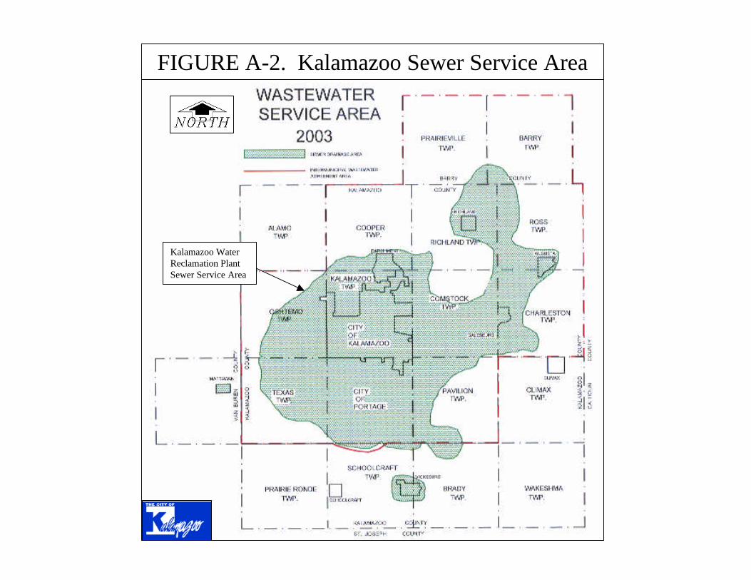
Kalamazoo Water Reclamation Plant Sewer Service Area
FIGURE A-2. Kalamazoo Sewer Service Area

WEST FORK PORTAGE CREEK
PORTAGE CREEK
AXTELL CREEK
ARCADIA CREEK
Kalamazoo Water Reclamation Plant Sewer Service Area
No Sanitary Sewer Service
Pretty Lake
OSHTEMO TWP.
TEXAS TWP.
KALAMAZOO
PORTAGE
FIGURE A-3. Portage-Arcadia Watershed Lakes

Table B-1.
Portage-Arcadia Creek Watershed Contributing Lakes (13 total)Lake Name
and Map Link Current Description Impairments Pollutants, Causes, Sources Available Information GoalsManagement
Strategies Timeline for Implementation RecommendationsControl
Structure Reports & WeblinksAsylum Lake Western Michigan
University http://www. wmich.edu/asylumlake/
http://www.placenames.com/us/p620293/
Kalamazoo Nature Center Report http://www.wmich.edu/asylumlake/natural/KNC%20Survey/Asylum%20Lake,%202002.pdf
Asylum Lake Research Area http://www. wmich.edu/asylumlake/research/index.html
Kalamazoo County Health Dept 2001 Report http://www. kalcounty.com/EH/swqmp/pdf_files/SurfaceWater2001AnnualReport.pdf
Surface Water Monitoring Program Annual Report (Kalamazoo County Human Services Department, 2004).
Observations on Asylum Lake, Kalamazoo, MI (Engemann, 1976).
Investigations of Glacial-Drift Aquifer-Lake Interactions... (Buening, 1994).
Little Asylum Lake West Fork Portage Creek Subwatershed; Located upstream of Parkview Hills; Kalamazoo County T2S, R11W, Sec 30; Latitude: 42.26228; Longitude: -85.63358; Downstream of Asylum Lake and upstream of Cherry Creek Lake (in Parkview Hills); There are residential homes located east of the lake (no riparian access).
Eurasian milfoil is becoming problematic (MacNellis, 2005).
Estimated annual runoff loads include 9,612 lbs TSS/yr and 33 lbs TP/yr (K&A, 2000).
Riparian property owned by Western Michigan University. Management and policy decisions originate from Asylum Lake Policy and Management Council (MacNellis, 2005). 3 known storm sewer outfalls discharge into the lake. Even during wet weather conditions, flows are nearly imperceptible in the culvert exiting the lake toward Cherry Creek in the Parkview Hills Community (K&A, 2000). Asylum and Little Asylum Lakes provide groundwater recharge and contribute minimally to downstream Cherry Creek and Willow Lake (Buening, 1994).
Maintain as a natural setting, while allowing research and passive recreational use.
Current land use management includes: 1) research, and 2) passive recreational use. WMU considers this property to be a nature preserve. (MacNellis, 2005). Restore and enhance native vegetation around perimeter shoreline. Asylum Lake Policy and Management Council is currently developing a long-term land management plan.
The Asylum Lake Policy and Management Council anticipates that implementation of a land management plan (currently under development) will be achieved within 3-5 years (MacNellis, 2005).
Water quality and storm sewer inputs should be investigated further. Aquatic plant growth concerns may also require further study.
Outflow channel; no restriction on flow.
Water Quality Evaluation of Willow Lake and Adjoining Waters with Management Planning and Lake Management Recommendations. (K&A, 2000).
Outflow channel; no restriction on flow.
Maintain as a natural setting, while allowing research and passive recreational use.
Current land use management includes: 1) research, and 2) passive recreational use. WMU considers this property to be a nature preserve (MacNellis, 2005). Restore and enhance native vegetation around perimeter shoreline. Asylum Lake Policy and Management Council is currently developing a long-term land management plan.
The Asylum Lake Policy and Management Council anticipates that implementation of a land management plan (currently under development) will be achieved within 3-5 years (MacNellis, 2005).
In-lake water quality and investigation of Drake Road runoff is recommended. Alternative stormwater routing options should be explored by the City and WMU to encorporate pretreatment BMP concepts prior to discharge into the lake.
West Fork Portage Creek Subwatershed (northern edge); Located upstream of Parkview Hills and upstream of Little Asylum Lake; surface area = 49.2 Acres; Kalamazoo County T2S, R11W, Sec 30; Latitude: 42.26667; Longitude: -85.64; Elevation: 868 ft; No upstream surface waters are connected; Lake shoreline is uninhabited.
Elevated levels of copper and chloride in the 1970's (Engemann, 1976).
Elevated levels of copper during wet weather (circa 1972) likely due to runoff from highly urban commercial areas in the watershed; 2 major municipal stormwater outfalls located at the western end; historic septic systems in nearby trailer park; stormwater runoff from US-131 eastern clover leaf ramps meanders into the western end of the lake. Estimated annual runoff loads (EPA, 1983) include 126,711 lbs TSS/yr; 407 lbs TP/yr; 167 lbs SRP/yr (K&A, 2000). Periodic E. coli exceedances observed by Kalamazoo County Human Services Dept (unidentified pollutant source). Water Quality and downgradient groundwater are significantly impacted by surface runoff and infiltration from US-131, Drake Rd, and Stadium Dr (most notably from winter road salting with sodium and chloride) (Buening, 1994).
Riparian property owned by Western Michigan University. Management and policy decisions originate from the Asylum Lake Policy and Management Council (MacNellis, 2005). Limited flow contribution to downstream lakes (Little Asylum, Cherry Creek and Willow Lakes); Asylum Lake acts as a TSS and TP "sink"; 600 acre drainage area is highly developed; Kalamazoo County Human Services Dept collects periodic water quality samples; Maximum depth reported >50 ft (Buening, 1994).
Contributing Lakes Page 1 of 4

Table B-1.Portage-Arcadia Creek Watershed Contributing Lakes (13 total)
Lake Name and Map Link Current Description Impairments Pollutants, Causes, Sources Available Information Goals
Management Strategies Timeline for Implementation Recommendations
Control Structure Reports & Weblinks
Atwater Millpond (a.k.a., Birchwood Lake)
Compilation of Data for Michigan Lakes (USGS, 1970).
http://www.placenames.com/us/p620312/
Draft Kalamazoo River Assessment (Wesley, 2005).
Bass Lake
http://www.placenames.com/us/p620680/
http://www.bsaswmc.org/Map%20of%20RK.pdf
Compilation of Data for Michigan Lakes (USGS, 1970).
Cherry Creek Lake Willow Lake Management http://parkviewhills.com/management.htm
Water Quality Evaluation of Willow Lake and Adjoining Waters with Management Planning and Lake Management Recommendations. (K&A, 2000).
At the time of reporting in 2000, plans were being discussed for roadway improvements and installation of structural controls.
Improved stormwater solids management; prioritize Parkview Ave. runoff control options; construction of erosion control swales; explore street sweeping options; consider settlement basins along Greenleaf Blvd. and review land use considerations. Conduct a sediment thickness survey and sediment quality survey.
Information unknown.
Parkview Hills runoff contributes pollutants (notably solids), nuisance waterfowl also contribute to solids loading; Estimated annual runoff loads include 12,479 lbs TSS/yr; 35 lbs TP/yr; 11 lbs SRP/yr (K&A, 2000).
Parkview Hills Community Association (PHCA) Management; 3 known storm sewer outfalls discharge into the lake. Cherry Creek Lake was created via excavation circa 1970; Flow is maintained by an augmentation well with nearly constant pumping; Approx. drainage area of 74 acres (K&A, 2000).
Maintain aesthetic qualities as an open water lake system (PHCA)
Maintain minimum outflow of 50 gallons per minute to maintain downstream habitat. In-lake short term strategies include chemical weed controls and harvesting. Long-term strategies include dredging, water level drawdown, and biological controls.
Information unknown.
West Fork Portage Creek Subwatershed; Kalamazoo County T3S, R12W, Sec 14; Latitude: 42.21333; Longitude: -85.68194; Elevation: 884 ft; One of three headwater lakes of West Fork Portage Creek; located upstream of Atwater Millpond; 60-70% of lake shoreline appears largely uninhabited (Boy Scout Camp Grounds along north end).
West Fork Portage Creek Subwatershed; Kalamazoo County T2S, R11W, Sec 31; Latitude: 42.25685; Longitude: -85.63009; Located downstream of Little Asylum Lake and upstream of Willow Lake (near Parkview Hills); Lake shoreline appears largely uninhabited
Dense chara accumulating organic solids in the bottom; shallow depth
Information unknown.
Information unknown.
Approx. surface area 39 acres (Wesley, 2005). Included in a 2001 Natural Features Inventory Project by K&A. Maximum depth unknown. Drainage area unknown. Bass Lake has no surface inlet. The outlet, a small intermittent stream at the northeast end of Bass Lake, flows about 0.4mi to West Fork Portage Creek (USGS, 1970).
Approximate drainage area of 254 acres (K&A, 2005). Estimated annual runoff EMC loads based on land cover for this drainage area are 38 lbs TP/yr and 11,890 lbs TSS/yr (K&A, 2005).
Kalamazoo County Health Dept 2001 Report http://www.kalcounty.com/EH/swqmp/pdf_files/SurfaceWater2001AnnualReport.pdf
Information unknown.
Monitor water quality
Information unknown.
West Fork Portage Creek Subwatershed; Kalamazoo County T3S, R12W, Sec 1; Latitude: 42.23278; Longitude: -85.65722; Elevation: 871 ft; Located east of US-131 (downstream of Scouters Pond and Bass Lake), and west of US-131 (upstream of Howard Lake); Lake shoreline appears uninhabited.
Information unknown.
Approximate drainage area of 1,254 acres (K&A, 2005). Estimated annual runoff EMC loads based on land cover for this drainage area are 245 lbs TP/yr and 63,532 lbs TSS/yr (K&A, 2005).
Approx. surface area 44 acres (Wesley, 2005). The Al Sabo Land Preserve (741 acres) is located upstream and was established in the early 1970's in order to protect the groundwater supply of the Atwater wellfield (18 wells). In the late 1960's and a master plan was developed for its use as a passive recreation nature preserve. The wetlands here serve as part of the headwaters of the West Fork of Portage Creek. The drainage area is approx. 13 sq mi (USGS, 1970). Intermittent staff gage readings were recorded during the 1960's. West Fork Portage Creek flows into the southwest end and out of the east end. Discharge measurements are available for the downstream 12th Sreet USGS station (04106320).
Information unknown.
The City of Kalamazoo has an ordinance in place to ensure the Al Sabo wetlands protection as a water resource. The wetlands and sandy soils serve as a recharge area for the area's groundwater.
Information unknown.
Information unknown.
Information unknown.
Contributing Lakes Page 2 of 4

Table B-1.Portage-Arcadia Creek Watershed Contributing Lakes (13 total)
Lake Name and Map Link Current Description Impairments Pollutants, Causes, Sources Available Information Goals
Management Strategies Timeline for Implementation Recommendations
Control Structure Reports & Weblinks
Fishcamp Pond Draft Kalamazoo River Assessment (Wesley, 2005).
http://www.placenames.com/us/p626025/
Hampton Lake Portage Creek Assessment: Hampton Lake to Central Park. (FTC&H, 1998).
http://www.placenames.com/us/p627704/
Davis Creek, Gourdneck Creek, and Portage Creek Watershed Management Plan. (FTC&H, 2001).
Natural Features Inventory of Portage Creek Basin (Bruederle et al., 1995).
Howard Lake West Fork Portage Creek Subwatershed; Kalamazoo County T2S, R11W, Sec 31; Latitude: 42.24611; Longitude: -85.63636; Located downstream of Atwater Millpond and upstream of Lake Hill'n Brook; north of I-94 and east of US-131; upstream of the convergence with Main Branch Portage Creek; Lake shoreline appears uninhabited.
Information unknown.
Estimated annual stormwater runoff loads to Howard Lake and Lake Hill 'n Brook (combined) surface waters amount to 166,474 lbs TSS/yr; 553 lbs TP/yr; 234 lbs SRP/yr (K&A, 2000).
A combined 763 acre drainage area to Howard Lake and Lake Hill 'n Brook; Low TP, TSS and SRP loads, incoming flows (dry weather) range from 1 - 3.2 cfs (K&A, 2000). Kalamazoo County Human Services Dept collects periodic water quality samples. It is unknown if a lake management authority (i.e., lake association, etc.) is currently established.
Information unknown.
Information unknown.
Information unknown.
Information unknown.
Information unknown.
Water Quality Evaluation of Willow Lake and Adjoining Waters with Management Planning and Lake Improvement Recommendations (K&A, 2000)
Lake Hill 'n Brook West Fork Portage Creek Subwatershed; Kalamazoo County T2S, R11W, Sec 31; Latitude: 42.24667; Longitude: -85.63278; Altitude: 863 ft; Located downstream of Howard Lake and upstream of Lake Lime Kiln; north of I-94; upstream of the convergence with Main Branch Portage Creek; Lake shoreline appears uninhabited.
Purple loostrife noted near the outlet dam (K&A, 2000).
Estimated annual runoff loads to Howard Lake and Lake Hill 'n Brook (combined) surface waters amount to 166,474 lbs TSS/yr; 553 lbs TP/yr; 234 lbs SRP/yr (K&A, 2000).
A combined 763 acre drainage area to Howard Lake and Lake Hill 'n Brook; 5 known storm sewer outfalls. Low TP, TSS and SRP loads, incoming flows (dry weather) range from 2.7 - 4.4 cfs (K&A, 2000). Kalamazoo County Human Services Dept collects periodic water quality samples. It is unknown if a lake management authority (i.e., lake association, etc.) is currently established.
Information unknown.
Information unknown.
Information unknown.
Information unknown.
Information unknown.
Water Quality Evaluation of Willow Lake and Adjoining Waters with Management Planning and Lake Improvement Recommendations (K&A, 2000)
Information unknown.
Portage Creek Subwatershed; Kalamazoo County T3S, R11W, Sec 19; Latitude: 42.19111; Longitude: -85.63194; Elevation: 857 ft; Lake shoreline appears uninhabited.
Purple loostrife observed along the lakeshore of Hampton Lake and poses a real threat to all other wetlands in the Portage Creek Basin (Bruederle, 1995).
Urban stormwater runoff threatens water quality (FTC&H, 2001). Approximate drainage area of 2,538 acres (K&A, 2005). Estimated annual runoff EMC loads based on land cover for this drainage area are 557 lbs TP/yr and 176,136 lbs TSS/yr (K&A, 2005).
Cold water resource, relative to downstream urban portion of Portage Creek north of Kilgore Rd; high dissolved oxygen concentrations >15 mg/L (FTC&H, 1998). Many of the wetlands adjacent to Hampton Lake were historically prairie-fen. Emergent marsh now observed immediately adjacent to the lake (Bruederle, 1995).
Information unknown.
Information unknown.
Information unknown.
Establish protection policies for the south side of lake; encourage and maintain native riparian vegitation (FTC&H, 2001).
Information unknown.
Information unknown.
Information unknown.
Information unknown.
Monitor water qualityWest Fork Portage Creek Subwatershed; Kalamazoo County T3S, R12W, Sec 10,15; Latitude: 42.21528; Longitude: -85.68806; Elevation: 884 ft; One of three headwater lakes of West Fork Portage Creek; located upstream of Scouters Pond; Lake shoreline appears uninhabited.
Information unknown.
Approximate drainage area of 112 acres (K&A, 2005). Estimated annual runoff EMC loads based on land cover for this drainage area are 16 lbs TP/yr and 6,544 lbs TSS/yr (K&A, 2005).
Approx. surface area 11 acres (Wesley, 2005). Included in a 2001 Natural Features Inventory Project by K&A.
Contributing Lakes Page 3 of 4

Table B-1.Portage-Arcadia Creek Watershed Contributing Lakes (13 total)
Lake Name and Map Link Current Description Impairments Pollutants, Causes, Sources Available Information Goals
Management Strategies Timeline for Implementation Recommendations
Control Structure Reports & Weblinks
Lake Lime Kiln West Fork Portage Creek Subwatershed; Kalamazoo County T2S, R11W, Sec 32; Latitude: 42.25319; Longitude: -85.62651; Elevation: 863 ft; Located downstream of Lake Hill 'n Brook; last connected lake before West Fork converges with Portage Creek; 70-80% of shoreline appears mostly uninhabited (approx. 15-16 residential dwellings).
Information unknown.
Estimated annual runoff loads include 5,037 lbs TSS/yr; 20 lbs TP/yr; 8 lbs SRP/yr (K&A, 2000).
Low TP, TSS and SRP contributions; 1 known storm sewer outfall. Estimated drainage area of 54 acres (K&A, 2000); Approx. surface area 21 acres and average depth approx. 2 ft (Wesley, 2005). Approximate discharge information available at downstream USGS station 04106400. It is unknown if a lake management authority (i.e., lake association, etc.) is currently established.
Information unknown.
Information unknown.
Information unknown.
Monitor water quality Dam control structure was built on the outlet in 1988 owned by Kalamazoo County (Wesley, 2005).
Surface Water Monitoring Program Annual Report (Kalamazoo County Human Services Department 2004).
Draft Kalamazoo River Assessment (Wesley, 2005).
Water Quality Evaluation of Willow Lake and Adjoining Waters with Management Planning and Lake Improvement Recommendations (K&A, 2000)
Monarch Millpond Draft Kalamazoo River Assessment (Wesley, 2005).
http://www.placenames.com/us/p632563/
Scouters Pond Draft Kalamazoo River Assessment (Wesley, 2005).
http://www.placenames.com/us/p637487/
http://www.bsaswmc.org/Map%20of%20RK.pdf
Willow Lake Water Quality Evaluation of Willow Lake and Adjoining Waters with Management Planning and Lake Improvement Recommendations (K&A, 2000)
Willow Lake Management http://parkviewhills.com/management.htm
West Fork Portage Creek Subwatershed; Kalamazoo County T2S, R11W, Sec 31; Latitude: 42.25685; Longitude: -85.63009; Located downstream of Cherry Creek Lake (within Parkview Hills) and upstream of Lake Lime Kiln. Lake shoreline is kept in a natural, native state.
Maintain aesthetic qualities as an open water lake system (PHCA)
Parkview Hills Community Association (PHCA) Management; 3 known storm sewer outfalls discharge into the lake. Willow Lake was created circa 1970; The major source of water flowing into Willow Lake is from a pump established on the northeast side of Cheery Creek Lake operating continuously at a rate of 750 gpm (K&A, 2000). Upstream source water is cold, high quality groundwater; low stormwater sediment loading; at least one-pretreatment stormwater settling basin is present; estimated 101 acre drainage area (K&A, 2000). Substrate is marl (calcium carbonate). 1999 land cover data available.
Apparent minimal stormwater pollutants; shallow depth (<3.5 feet) and good water clarity results in plant growth; nuisance waterfowl contribute to solids loading; Estimated annual runoff loads include 12,564 lbs TSS/yr; 55 lbs TP/yr; 25 lbs SRP/yr (K&A, 2000). Dense growth of Eurasian milfoil, pondweed, white lily and chara were documented in 2000. The rate of decay is much slower than the rate of production of plant material, resulting in sediment (organic) accumulation, estimated at 0.36-1 inch per year (K&A, 2000).
Dense chara; accumulating organic solids in the bottom; shallow depth; purple loostrife noted along the shoreline near the clubhouse
Outlet weir drop structure maintains 50 gallons per minute to downstream habitat.
Increase capacity of existing sediment basins; establish a regular cleanout schedule and tracking program (sediment accumulation gages). Continue non-structural practices (e.g. phosphorus free fertilizer, gutter cleaning, waterfowl deterrents. Focus on in-lake controls to discourage/prevent/manage plant growth. Establish no mow riparian zones (buffers) to deter waterfowl. Stabilize eroding trail system. Consider street sweeping. Sustainable lawn care. Car washing reduction. Eliminate invasive vegetation and extend a native vegetation buffer at least 30 ft from the Willow Lake shoreline in the area adjacent to the Black Swan Restaurant.
Information unknown.
Maintain minimum outflow of 50 gallons per minute to maintain downstream habitat. In-lake short term options include chemical weed controls and harvesting. Long-term options include dredging, water level drawdown, and biological controls.
Portage Creek Subwatershed; Kalamazoo County T2S, R11W, Sec 34; Latitude: 42.255; Longitude: -85.57417; Elevation: 810 ft; Located south of Cork Street and downstream of Milham Park.
Information unknown.
Monitor water quality
Information unknown.
Information unknown.
Information unknown.
Approx. surface area 17 acres (Wesley, 2005). Included in a 2001 Natural Features Inventory Project by K&A. Souters Pond receives intermittent surface flows from Fishcamp Pond, and the outlet (another small intermittent stream) exits at the northeast end.
Approximate drainage area of 881 acres (K&A, 2005). Estimated annual runoff EMC loads based on land cover for this drainage area are 138 lbs TP/yr and 53,457 lbs TSS/yr (K&A, 2005).
Information unknown.
West Fork Portage Creek Subwatershed; Kalamazoo County T3S, R12W, Sec 11; Latitude: 42.21806; Longitude: -85.68444; Elevation: 884 ft; Located downstream of Fishcamp Pond and upstream of Atwater Millpond; Lake shoreline appears uninhabited (Boy Scout camp along eastern shoreline area).
Reduction of stormwater nutrient loads in relation to the Kalamazoo River/Lake Allegan Phosphorus TMDL
Surface area approx. 21 acres and avg depth 3.9 ft (Wesley, 2005). 3 known storm sewer outfalls discharge into this impoundment.
Approximate drainage area of 276 acres (K&A, 2005). Estimated annual runoff EMC loads based on land cover for this drainage area are 72 lbs TP/yr and 15,556 lbs TSS/yr (K&A, 2005).
Information unknown.
Dam structure built in 1916 (Wesley, 2005).
Erosion control; Riparian vegetation management; Public awareness through ongoing education
Information unknown.
Encourage low-impact development; Maximize compatible riparian uses that offer future protection of this tributary.
Contributing Lakes Page 4 of 4

Table B-1.
Portage-Arcadia Creek Watershed Non-Contributing Lakes (8 total)Lake Name
and Map Link Current Description Impairments Pollutants, Causes, Sources Available Information GoalsManagement
Strategies Timeline for Implementation RecommendationsControl
StructureReports & Weblinks
Bonnie Castle Lake
Draft Kalamazoo River Assessment (Wesley, 2005).
http://www.placenames.com/us/p621715/
http://www.oshtemo.org/MAP.htm
Crooked Lake Allen, W.B. (USGS 1973)
Draft Kalamazoo River Assessment (Wesley, 2005).
http://www.placenames.com/us/p624092/
Kalamazoo County Health Dept 2001 Report http://www.kalcounty.com/EH/swqmp/pdf_files/SurfaceWater2001AnnualReport.pdf
Miller, J.B. (USGS 1970)
Duck Lake Draft Kalamazoo River Assessment (Wesley, 2005).
http://www.placenames.com/us/p624924/
Written communication. (Elliott, 2005)
Arcadia Creek Subwatershed (non-contributing); Latitude: 42.28944; Longitude: -85.71139; Elevation: 912 ft; Lake shoreline appears uninhabited.
No known impairments (Elliott, 2005).
Approximate drainage area of 388 acres (K&A, 2005). Estimated annual runoff EMC loads based on land cover for this drainage area are 55 lbs TP/yr and 18,677 lbs TSS/yr (K&A, 2005).
Surface area approx. 131 acres (Wesley, 2005). No known sanitary or storm sewer service for properties adjacent to this lake (Elliott, 2005). No surface water outlets/overflow locations are known. This lake is assumed to be groundwater controlled (Elliott, 2005). It is unknown if a lake management authority (i.e., lake association, etc.) is currently established.
Information unknown.
Oshtemo Township requires on-site management of stormwater (Elliott, 2005).
Information unknown.
Information unknown.
No surficial outlets.
West Fork Portage Creek Subwatershed (non-contributing); Kalamazoo County T3S, R12W, Sec 15,16; Latitude: 42.20583; Longitude: -85.70167; Elevation: 893 ft; 70-80% of lake shoreline appears to be residential riparian use (approx. 140-150 residential dwellings).
Information unknown.
Periodic E. coli exceedances observed by Kalamazoo County Human Services Dept. (unidentified pollutant source). Pumping wells can influence dissolved solids content of receiving lakes. However, the higher head can serve to retard the inflow of nutrient-rich effluent from surrounding septic tanks. Approximate drainage area of 859 acres (K&A, 2005). Estimated annual runoff EMC loads based on land cover for this drainage area are 165 lbs TP/yr and 42,807 lbs TSS/yr (K&A, 2005).
Surface area approx. 162 acres (USGS, 1970); Lower Crooked Lake stocked with 641 Northern Muskellunge in 2000; 3,451 Tiger Muskellunge in 1991 (Wesley, 2005). Kalamazoo County Human Services Dept collects periodic water quality samples. Maximum depth approx. 50ft. Staff gage read daily during the 1960's. No known legal lake elevation. Since April 10, 1965 water has been pumped into the lake from a well finished in a deep aquifer to raise the lake level. Pumping was continuous until Oct 20, 1966 and has been intermittent since (circa 1970). It is unknown if pumping still occurs. On Oct 6, 1965, a discharge of 1.54cfs was measured flowing into the lake from the pumping well (USGS, 1970). Crooked Lake has no surface inlet or outlet.
Information unknown.
Information unknown.
Information unknown.
Information unknown.
No surficial outlets.
No surficial outlets.
Information unknown.
Information unknown.
Information unknown.
Information unknown.
Surface area approx. 10 acres (Wesley, 2005). It is unknown if a lake management authority (i.e., lake association, etc.) is currently established.
Approximate drainage area of 157 acres (K&A, 2005). Estimated annual runoff EMC loads based on land cover for this drainage area are 24 lbs TP/yr and 7,401 lbs TSS/yr (K&A, 2005).Information
unknown.
West Fork Portage Creek Subwatershed (non-contributing); Latitude: 42.19917; Longitude: -85.71944; Elevation: 895 ft; Lake shoreline appears largely uninhabited (approx. 3 residential dwellings).
Non-Contributing Lakes Page 1 of 3

Table B-1.Portage-Arcadia Creek Watershed Non-Contributing Lakes (8 total)
Lake Name and Map Link Current Description Impairments Pollutants, Causes, Sources Available Information Goals
Management Strategies Timeline for Implementation Recommendations
Control Structure
Reports & Weblinks
Eagle Lake Kalamazoo County Health Dept 2001 Report http://www.kalcounty.com/EH/swqmp/pdf_files/SurfaceWater2001AnnualReport.pdf
http://www.placenames.com/us/p625081/
Kalamazoo County Human Services Department. 2004. Surface Water Monitoring Program Annual Report. Oct-Sep 2004.
Miller, J.B. (USGS 1970)
Allen, W.B. (USGS 1973)
Draft Kalamazoo River Pike's Pond Axtell Creek Subwatershed (non-contributing); Kalamazoo County T2S, R11W, Sec 28; Latitude: 42.26361; Longitude: -85.60556; Located north of Whites Rd, east of Oakland Dr; 2.25 acres (K&A, 2002); 50% of surface covered with emergent plants; 2.0 acres of adjacent wooded wetland; shoreline appears uninhabited.
Nearly 50% of surface water is covered by emergent aquatic plants (yellow pond lily), Low dissolved oxygen; nutrient enrichment eutrophic-hypereutrophic; copper, lead and zinc in sediments, considered highly polluted; chromium considered moderately polluted; decreased water clarity
Six known urban stormwater outfalls discharge into the lake; excessive weed growth; stratification and nutrient dispersion during turnover; external nutrient sources are likely higher than internal sources; estimated annual TP load of 58 lbs/yr and TSS load of 36,218 lbs/yr (K&A, 2002).
2.25 acre pond with 112 acre watershed drainage area (K&A, 2002); shallow 3-4 feet with 11-12 foot maximum depth; 1997 land cover data
Reduce nuisance weed growth; minimize stormwater contributions; maintain/enhance wildlife habitat and aesthetics
Management options include: 1) aquatic plant harvesting, 2) chemical weed treatment, 3) sediment dredging, 4) storm sewer pretreatment, 5) riparian lakescaping with natives, 6) fisheries manipulation, and 7) develop a wildlife management plan.
Information unknown.
Aquatic vegetation controls to immediately improve pond aesthetics. Riparian area management improvement beginning with nateive species plantings in low/no traffic and eroding areas. Immediately initiate discussions for stormwater controls between riparians and the City of Kalamazoo followed by pre-engineering and costing, identification of funding sources, final engineering and implementation. Develop and implement wildlife improvement strategies following other improvements.
No surficial outlets. Water Quality Evaluation of Pike’s Pond with Management Planning and Pond Improvement Options (K&A, 2002).
Pretty Lake Draft Kalamazoo River Assessment (Wesley, 2005).
http://www.placenames.com/us/p635443/
Kalamazoo County Health Dept 2001 Report http://www.kalcounty.com/EH/swqmp/pdf_files/SurfaceWater2001AnnualReport.pdf
Geohydrology and Water Quality of Kalamazoo County, Michigan (Rheaume, 1990).
Phosphorus Total Maximum Daily Load for Great Bear Lake, Van Buren County (Draft) (Walterhouse, 2004).
West Fork Portage Creek Subwatershed (non-contributing); Kalamazoo County T3S, R12W, Sec 9,16; Latitude: 42.21861; Longitude: -85.72; Elevation: 898 ft; 70-80% of lake shoreline appears to be residential riparian use (approx. 150-160 residential dwellings).
Information unknown.
Pumping wells can influence dissolved solids content of receiving lakes. However, the higher head can serve to retard the inflow of nutrient-rich effluent from surrounding septic tanks. Approximate drainage area of 1,822 acres (K&A, 2005). Estimated annual runoff EMC loads based on land cover for this drainage area are 354 lbs TP/yr and 108,056 lbs TSS/yr (K&A, 2005).
Surface area approx. 194 acres (Wesley, 2005). Kalamazoo County Human Services Dept collects periodic water quality samples. Maximum depth approx. 16ft. Staff gage read intermittently during the 1960's (USGS, 1970). Starting in late Dec 1965, water has been pumped into Eagle Lake from a well finished in a deep aquifer to maintain the lake level. Eagle lake has no surface inlet or outlet. Ground water pumped into Eagle Lake has been estimated to be from 1,000 to 1,200 gallons per minute (USGS, 1970).
Information unknown.
Information unknown.
Information unknown.
Information unknown.
No surficial outlets.
No surficial outlets.
Information unknown.
Information unknown.
Information unknown.
Information unknown.
Surface area approx. 88 acres (Wesley, 2005). Information regarding township storm sewer outfalls is unknown. It is unknown if a lake management authority (i.e., lake association, etc.) is currently established.
Approximate drainage area of 1,135 acres (K&A, 2005). Estimated annual runoff EMC loads based on land cover for this drainage area are 150 lbs TP/yr and 47,911 lbs TSS/yr (K&A, 2005). Estimated riparian nutrient loads from septic tanks to Pretty Lake are 29.3 lbs N/yr (Rheaume, 1990) and 41.5 lb P/yr (Walterhouse, 2004).
Information unknown.
West Fork Portage Creek Subwatershed (non-contributing); Kalamazoo County T3S, R12W, Sec 20; Latitude: 42.19361; Longitude: -85.72917; Elevation: 897 ft; Lake shoreline appears 50% uninhabited (approx. 45-50 residential dwellings).
Non-Contributing Lakes Page 2 of 3

Table B-1.Portage-Arcadia Creek Watershed Non-Contributing Lakes (8 total)
Lake Name and Map Link Current Description Impairments Pollutants, Causes, Sources Available Information Goals
Management Strategies Timeline for Implementation Recommendations
Control Structure
Reports & Weblinks
Whites Lake Draft Kalamazoo River Assessment (Wesley, 2005).
http://www.placenames.com/us/p1616370/
Woods Lake Woods Lake Water Quality Study (K&A, 1997)
http://www.placenames.com/us/p1616791/
No surficial outlets. Scenario #1 extended dry detention and treatment wetlands (recommended and implemented); Scenario #2 grassed swales (recommended); Scenario #3 infiltration basin (recommended); Scenario #4 stormwater diverted to sanitary sewer; Scenario #5 increased street sweeping (recommended); Scenario #6 sand infiltration trenches (recommended); Scenario #7 dry detention basin; Scenario #8 and #9 divert stormwater to Pikes Pond Scenario #10 extended dry detention/infiltration basin;
In-lake restoration options include dredging nearshore, alum treatment for deep water sediments (rich in phosphorus), maintain the existing weed treatment program; implementation of an education program (brochure distribution); targeted reduction of phosphorus entering the lake via stormwater to acheive in-lake water quality improvements.
Information unknown.
No surficial outlets.
Information unknown.
Surface area approx. 22 acres (Wesley, 2005). Golf course along northern boundary; Three known storm sewer outfalls discharge into the lake. It is unknown if a lake management authority (i.e., lake association, etc.) is currently established.
Information unknown.
Information unknown.
West Fork Portage Creek Subwatershed (non-contributing); Kalamazoo County T2S, R11W, Sec 28; Latitude: 42.25083; Longitude: -85.60639; Elevation: 850 ft; Lake shoreline appears largely uninhabited.
Information unknown.
The approximate topographic drainage area is 382 acres (K&A, 2005). Estimated annual runoff EMC loads, based on land cover for this drainage area, are 87 lbs TP/yr and 26,169 lbs TSS/yr (K&A, 2005).
Urban stormwater contributions from 5 known outfalls; wet weather sampling confirmed the transport of sediments and nutrients (phosphorus and organic nitrogen) at concentrations higher than national averages as determined by NURP (zinc was present but below average); sediments are also high in phosphorus content as a result of internal recycling in oxygen deficient bottom waters. The lack of an outflowing stream only exacerbates the accumulation of phosphorus because there is no flushing of organic-rich sediment materials from the lake. Average water samples in 1996 were observed at 40ug/L (eutrophic classification). High concentrations of chlorides have been observed in the lake as a result of road salting. Annual stormwater runoff loads of 44.3 lbs TP/yr and 2,900 lbs TSS/yr were estimated for Woods Lake runoff inputs.
Nuisance weed growths, diminished water clarity, bacterial contamination, sedimentation, and accumulation of various pollutants from roadway runoff; phosphorus levels considered eutrophic. Chlorophyll levels are considered eutrophic, but dependent on conditions. High chloride concentrations; elevated E. coli frequently observed in runoff and open lake samples. Severe oxygen depletion in bottom waters.
Axtell Creek Subwatershed (non-contributing); Kalamazoo County T2S, R11W, Sec 29; Latitude: 42.26167; Longitude: -85.61583; Elevation: 852 ft; Perched above local groundwater (thus considered a losing lake); many residential homes on the lake shorline.
Refer to Scenario #1 - Kensington stormwater treatment system implemented in fall 2001. Treatment of <2-yr storm events includes a sediment forebay, stone-lined infiltration trench and wet detention. Water quality monitoring of the treatment system is ongoing. The City of Kalamazoo conducted in-lake sediment dredging at all five storm sewer outfall locations in early 2000. The City of Kalamazoo continues to look for opportunities to improve roadway drainage features related to curb and gutter systems, swales and non-curbed areas as appropriate to reduce solids transport into storm sewers.
Educational materials for watershed dwellers; riparian shoreline management (natives); monitor sedimentation near stormwater outfalls and within sediment forebay at Kensington; explore alum treatment for phosphorus reduction (K&A, 2004); installed a stormwater treatment system at Kensington outfall in 2001; conduct routine weed and algae control (removal); subasins have been delineated and loading has been modeled for various parameters of concern to assist in decision-making and prioritization of recommendation options.
Improvements in water quality; targeted reduction of phosphorus entering the lake; recommended engineering controls (Kensington outfall) are estimated to reduce solids and total phosphorus by 60% and 67%, respectively.
A Woods Lake Association exists and is actively involved in lake management issues; 24 acre water body; maximum depth greater than 40 ft; no surface streams flow into or out of lake, 199 acre watershed of residential and commercial land that drain stormwater into the lake; extensive mapping of watershed land cover available
Non-Contributing Lakes Page 3 of 3
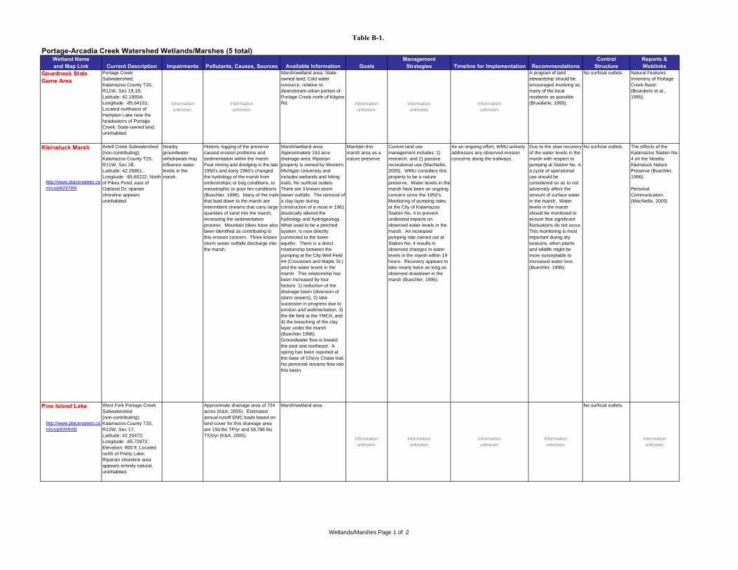
Table B-1.
Portage-Arcadia Creek Watershed Wetlands/Marshes (5 total)Wetland Name and Map Link Current Description Impairments Pollutants, Causes, Sources Available Information Goals
Management Strategies Timeline for Implementation Recommendations
Control Structure
Reports & Weblinks
Gourdneck State Game Area
Portage Creek Subwatershed; Kalamazoo County T3S, R11W, Sec 19,18; Latitude: 42.19934; Longitude: -85.64101; Located northwest of Hampton Lake near the headwaters of Portage Creek; State-owned land, uninhabited.
Information unknown.
Information unknown.
Marsh/wetland area; State-owned land; Cold water resource, relative to downstream urban portion of Portage Creek north of Kilgore Rd. Information
unknown.Information unknown.
Information unknown.
A program of land stewardship should be encouraged involving as many of the local residents as possible (Bruederle, 1995).
No surficial outlets. Natural Features Inventory of Portage Creek Basin (Bruederle et al., 1995).
Kleinstuck Marsh
http://www.placenames.com/us/p629789/
Pine Island Lake
http://www.placenames.com/us/p634948/
No surficial outlets.
Information unknown.
Information unknown.
Information unknown.
Information unknown.
Information unknown.
West Fork Portage Creek Subwatershed (non-contributing); Kalamazoo County T3S, R12W, Sec 17; Latitude: 42.20472; Longitude: -85.72972; Elevation: 900 ft; Located north of Pretty Lake; Riparian shoreline area appears entirely natural, uninhabited.
Approximate drainage area of 724 acres (K&A, 2005). Estimated annual runoff EMC loads based on land cover for this drainage area are 156 lbs TP/yr and 58,786 lbs TSS/yr (K&A, 2005).
Marsh/wetland area
No surficial outlets. The effects of the Kalamazoo Station No. 4 on the Nearby Kleinstuck Nature Preserve (Buechler, 1996).
Personal Communication. (MacNellis, 2005)
Maintain this marsh area as a nature preserve
Current land use management includes: 1) research, and 2) passive recreational use (MacNellis, 2005). WMU considers this property to be a nature preserve. Water levels in the marsh have been an ongoing concern since the 1950's. Monitoring of pumping rates at the City of Kalamazoo Station No. 4 to prevent undesired impacts on observed water levels in the marsh. An increased pumping rate carried out at Station No. 4 results in observed changes in water levels in the marsh within 19 hours. Recovery appears to take nearly twice as long as observed drawdown in the marsh (Buechler, 1996).
As an ongoing effort, WMU actively addresses any observed erosion concerns along the trailways.
Due to the slow recovery of the water levels in the marsh with respect to pumping at Station No. 4, a cycle of operational use should be considered so as to not adversely affect the amount of surface water in the marsh. Water levels in the marsh should be monitored to ensure that significant fluctuations do not occur. This monitoring is most important during dry seasons, when plants and wildlife might be more susceptable to increased water loss (Buechler, 1996).
Axtell Creek Subwatershed (non-contributing); Kalamazoo County T2S, R11W, Sec 28; Latitude: 42.26861; Longitude: -85.60222; North of Pikes Pond, east of Oakland Dr; riparian shoreline appears uninhabited.
Nearby groundwater withdrawals may influence water levels in the marsh.
Historic logging of the preserve caused erosion problems and sedimentation within the marsh. Peat mining and dredging in the late 1950's and early 1960's changed the hydrology of the marsh from ombrotrohpic or bog conditions, to mesotrophic or poor fen conditions (Buechler, 1996). Many of the trails that lead down to the marsh are intermittent streams that carry large quanities of sand into the marsh, increasing the sedimentation process. Mountain bikes have also been identified as contributing to this erosion concern. Three known storm sewer outfalls discharge into the marsh.
Marsh/wetland area; Approximately 153 acre drainage area; Riparian property is owned by Western Michigan University and includes wetlands and hiking trails; No surficial outlets. There are 3 known storm sewer outfalls. The removal of a clay layer during construction of a moat in 1961 drastically altered the hydrology and hydrogeology. What used to be a perched system, is now directly connected to the lower aquifer. There is a direct relationship between the pumping at the City Well Field #4 (Crosstown and Maple St.) and the water levels in the marsh. This relationship has been increased by four factors: 1) reduction of the drainage basin (diversion of storm sewers), 2) lake sucession in progress due to erosion and sedimentation, 3) the tile field at the YMCA, and 4) the breaching of the clay layer under the marsh (Buechler 1996). Groundwater flow is toward the east and northeast. A spring has been reported at the base of Chevy Chase trail. No perennial streams flow into this basin.
Wetlands/Marshes Page 1 of 2
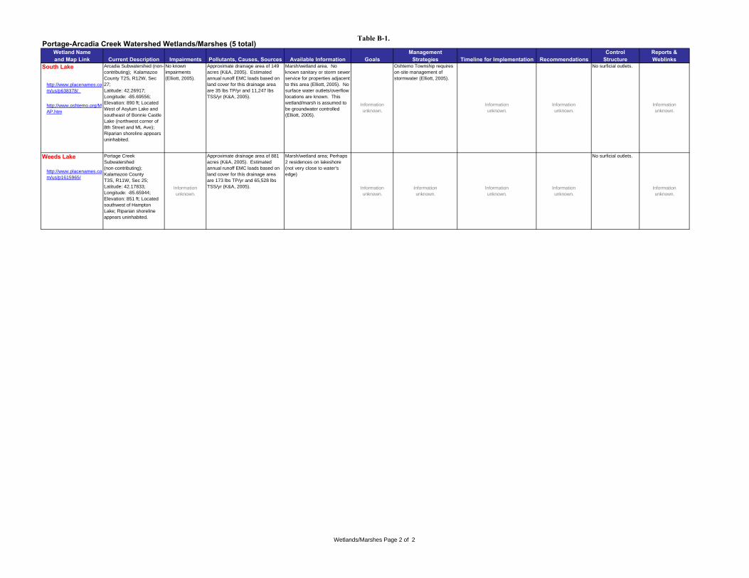
Table B-1. Portage-Arcadia Creek Watershed Wetlands/Marshes (5 total)
Wetland Name and Map Link Current Description Impairments Pollutants, Causes, Sources Available Information Goals
Management Strategies Timeline for Implementation Recommendations
Control Structure
Reports & Weblinks
South Lake
http://www.placenames.com/us/p638378/
http://www.oshtemo.org/MAP.htm
Weeds Lake
http://www.placenames.com/us/p1615965/
Marsh/wetland area; Perhaps 2 residences on lakeshore (not very close to water's edge)
Approximate drainage area of 881 acres (K&A, 2005). Estimated annual runoff EMC loads based on land cover for this drainage area are 173 lbs TP/yr and 65,528 lbs TSS/yr (K&A, 2005).Information
unknown.
Portage Creek Subwatershed (non-contributing); Kalamazoo County T3S, R11W, Sec 25; Latitude: 42.17833; Longitude: -85.65944; Elevation: 851 ft; Located southwest of Hampton Lake; Riparian shoreline appears uninhabited.
Information unknown.
Information unknown.
Information unknown.
Information unknown.
No surficial outlets.
Information unknown.
Information unknown.
No surficial outlets.
Arcadia Subwatershed (non-contributing); Kalamazoo County T2S, R12W, Sec 27; Latitude: 42.26917; Longitude: -85.69556; Elevation: 890 ft; Located West of Asylum Lake and southeast of Bonnie Castle Lake (northwest corner of 8th Street and ML Ave); Riparian shoreline appears uninhabited.
No known impairments (Elliott, 2005).
Approximate drainage area of 149 acres (K&A, 2005). Estimated annual runoff EMC loads based on land cover for this drainage area are 35 lbs TP/yr and 11,247 lbs TSS/yr (K&A, 2005).
Marsh/wetland area. No known sanitary or storm sewer service for properties adjacent to this area (Elliott, 2005). No surface water outlets/overflow locations are known. This wetland/marsh is assumed to be groundwater controlled (Elliott, 2005).
Information unknown.
Oshtemo Township requires on-site management of stormwater (Elliott, 2005).
Information unknown.
Information unknown.
Wetlands/Marshes Page 2 of 2

Asylum Lake & Little Asylum Lake
DISCLAIMER: This map is neither a legally recorded map nor a survey and is not intended to be used as one. This map is a compilation of records, information and data located in various city, county, state and federal offices and other sources regarding the area shown, and is to be used for reference purposes only.
SOURCES: City of Kalamazoo, Plansight LLC;August 2005, Zoning, Rentals; July 2005, Land Use, Ownership Data; May 2005, Parking; March 2005, Voting Precincts; December 2004, Elevation Contours, Centerlines;

Asylum Lake
DISCLAIMER: This map is neither a legally recorded map nor a survey and is not intended to be used as one. This map is a compilation of records, information and data located in various city, county, state and federal offices and other sources regarding the area shown, and is to be used for reference purposes only.
SOURCES: City of Kalamazoo, Plansight LLC;August 2005, Zoning, Rentals; July 2005, Land Use, Ownership Data; May 2005, Parking; March 2005, Voting Precincts; December 2004, Elevation Contours, Centerlines;

Atwater Millpond
West Fork Portage Creek
Atwater Millpond
US-131
I-94

US
-131
M-43
Bonnie Castle Lake
South Lake
Bonnie Castle Lake and South Lake

Cherry Creek Lake, Willow Lake & Lime Kiln Lake
DISCLAIMER: This map is neither a legally recorded map nor a survey and is not intended to be used as one. This map is a compilation of records, information and data located in various city, county, state and federal offices and other sources regarding the area shown, and is to be used for reference purposes only.
SOURCES: City of Kalamazoo, Plansight LLC;August 2005, Zoning, Rentals; July 2005, Land Use, Ownership Data; May 2005, Parking; March 2005, Voting Precincts; December 2004, Elevation Contours, Centerlines;
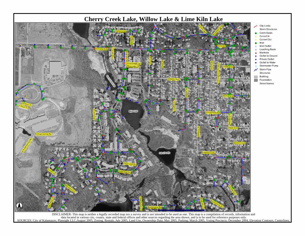
Bass Lake
Fishcamp Pond, Bass Lake and Scouters PondWest Fork Portage Creek
Scouters Pond
Fishcamp Pond
Texas Twp.

Hampton Lake
DISCLAIMER: This map is neither a legally recorded map nor a survey and is not intended to be used as one. This map is a compilation of records, information and data located in various city, county, state and federal offices and other sources regarding the area shown, and is to be used for reference purposes only. Please contact City of Portage Assessors office (329-4433) for current property assessment information.
SOURCES: City of Portage; Portage Public Schools; Plansight LLC;Spring 2005 for Parcel Data; Aerial imagery as noted in overlay; School boundaries are approximate and should be confirmed with the Portage Public
Howard Lake, Lake Hill 'n Brook & Lime Kiln Lake
DISCLAIMER: This map is neither a legally recorded map nor a survey and is not intended to be used as one. This map is a compilation of records, information and data located in various city, county, state and federal offices and other sources regarding the area shown, and is to be used for reference purposes only.
SOURCES: City of Kalamazoo, Plansight LLC;August 2005, Zoning, Rentals; July 2005, Land Use, Ownership Data; May 2005, Parking; March 2005, Voting Precincts; December 2004, Elevation Contours, Centerlines;

Monarch Millpond
DISCLAIMER: This map is neither a legally recorded map nor a survey and is not intended to be used as one. This map is a compilation of records, information and data located in various city, county, state and federal offices and other sources regarding the area shown, and is to be used for reference purposes only.
SOURCES: City of Kalamazoo, Plansight LLC;August 2005, Zoning, Rentals; July 2005, Land Use, Ownership Data; May 2005, Parking; March 2005, Voting Precincts; December 2004, Elevation Contours, Centerlines;

Pikes Pond & Kleinstuck Marsh
DISCLAIMER: This map is neither a legally recorded map nor a survey and is not intended to be used as one. This map is a compilation of records, information and data located in various city, county, state and federal offices and other sources regarding the area shown, and is to be used for reference purposes only.
SOURCES: City of Kalamazoo, Plansight LLC;August 2005, Zoning, Rentals; July 2005, Land Use, Ownership Data; May 2005, Parking; March 2005, Voting Precincts; December 2004, Elevation Contours, Centerlines;

Pike's Pond & Kleinstuck Marsh
DISCLAIMER: This map is neither a legally recorded map nor a survey and is not intended to be used as one. This map is a compilation of records, information and data located in various city, county, state and federal offices and other sources regarding the area shown, and is to be used for reference purposes only.
SOURCES: City of Kalamazoo, Plansight LLC;August 2005, Zoning, Rentals; July 2005, Land Use, Ownership Data; May 2005, Parking; March 2005, Voting Precincts; December 2004, Elevation Contours, Centerlines;

Crooked Lake
Pretty, Duck, Pine Island, Eagle and Crooked LakesWest Fork Portage Creek
Eagle Lake
Pretty Lake
Texas Twp.Duck Lake
Pine Island Lake
Hampton Lake
Weeds Lake, Hampton Lake and Gourdneck State Game Area
West Fork Portage CreekGourdneck
State Game Area
Weeds Lake

Whites Lake
DISCLAIMER: This map is neither a legally recorded map nor a survey and is not intended to be used as one. This map is a compilation of records, information and data located in various city, county, state and federal offices and other sources regarding the area shown, and is to be used for reference purposes only.
SOURCES: City of Kalamazoo, Plansight LLC;November 2005, Ownership Data; October 2005, Zoning; August 2005, Rentals; July 2005, Land Use; May 2005, Parking; March 2005, Voting Precincts; December 2004,
Whites Lake
DISCLAIMER: This map is neither a legally recorded map nor a survey and is not intended to be used as one. This map is a compilation of records, information and data located in various city, county, state and federal offices and other sources regarding the area shown, and is to be used for reference purposes only.
SOURCES: City of Kalamazoo, Plansight LLC;August 2005, Zoning, Rentals; July 2005, Land Use, Ownership Data; May 2005, Parking; March 2005, Voting Precincts; December 2004, Elevation Contours, Centerlines;

Woods Lake
DISCLAIMER: This map is neither a legally recorded map nor a survey and is not intended to be used as one. This map is a compilation of records, information and data located in various city, county, state and federal offices and other sources regarding the area shown, and is to be used for reference purposes only.
SOURCES: City of Kalamazoo, Plansight LLC;August 2005, Zoning, Rentals; July 2005, Land Use, Ownership Data; May 2005, Parking; March 2005, Voting Precincts; December 2004, Elevation Contours, Centerlines;