political geography - al vazquez · political geography ... protection against attack from another...
TRANSCRIPT

AP Human Geography
Political Geography

Nations of the World
Human geographers emphasize a thematic approach, concerned with the location of activities in the world, the reasons for particular spatial distributions, and the significance of these arrangements.
Political geographers study how people have organized Earth’s land surface into countries (states), alliances, reasons underlying the observed arrangements, and the conflicts that result from the organization.

Political Geography Essential Questions:
1. How is space politically organized into states and nations?
2. What are the challenges in defining states?3. How do states spatially organize their
governments?4. How are boundaries established and why do
boundary disputes exist?5. What is geopolitics and how does it help us
understand the world?6. What are supranational organizations and
what is the future of the state?

Into The New Millennium With the end of the Cold War in the 1990s, the
global political landscape changed fundamentally. Geographic concepts help us to understand this
changing political organization of Earth’s surface. We can also use geographic methods to examine
the causes of political change. Boundary lines are not painted on Earth, but they
might as well be, for these national divisions are very real.
To many, national boundaries are more meaningful than natural features.

End of the Cold War In the post Cold War era, the familiar division of
the world into countries or states is crumbling. Between the mid-1940s and the late 1980s two
superpowers, the United States and the Soviet Union, promoted two opposing economic and political ideologies and competed for international influence along these lines.
But the United States is less dominant in the political landscape of the twenty-first century, and the Soviet Union no longer exists.
Today globalization means more connections among states.
Power is exercised through connections among states created primarily for economic cooperation.

Key Issue 1: Defining States and Development of the State Concept Problems of defining states
• Korea: one state or two?• China and Taiwan: one state or two?• Western Sahara• Varying sizes of states
Development of the state concept• Ancient and medieval states• Colonies

Antarctica: National Claims Antarctica is the only large
landmass on Earth’s surface that is not part of a state.
Several states claim portions of Antarctica.
The United States, Russia, and a number of other states do not recognize the claims of any country to Antarctica.
The Treaty of Antarctica, signed in 1959 and renewed in 1991, provides a legal framework for managing Antarctica.
Fig. 8-2: Antarctica is the only large landmass that is not part of a state, but several countries claim portions of it.

Korea: One State or Two? A colony of Japan for many
years, Korea was divided into two occupation zones by the United States and former Soviet Union after they defeated Japan in World War II.
Both Korean governments are committed to reuniting the country into one sovereign state.
Meanwhile, in 1992, North Korea and South Korea were admitted to the United Nations as separate countries.

China and Taiwan: One State or Two?
According to China’s government officials, Taiwan is not a separate sovereign state but is a part of China.
Until 1999 the government of Taiwan agreed.
This confusing situation arose from a civil war.
After losing, nationalist leaders in 1949 fled to the island of Taiwan, 200 kilometers (120 miles) off the Chinese coast (and) proclaimed that they were still the legitimate rulers of the entire country of China.
Most other governments in the world consider China and Taiwan as two separate and sovereign states.
Taiwan’s president announced in 1999 that Taiwan would also regard itself as a sovereign independent state.

Western Sahara (Sahrawi Republic) The Sahrawi Arab
Democratic Republic is considered by most African countries as a sovereign state.
Morocco, however, controls the territory, which it calls Western Sahara.
The United Nations is sponsoring a referendum for the residents of Western Sahara to decide whether they want independence or want to continue to be part of Morocco.
Varying Sizes of States The land area occupied by the states of the world
varies considerably. The largest state is Russia, which encompasses 17.1
million square kilometers (6.6 million square miles), or 11 percent of the world’s entire land area.
(Five) other states with more than 5 million square kilometers (2 million square miles) include China, Canada, United States, Brazil, and Australia.
At the other extreme are about two dozen microstates, which are states with very small land areas.
The smallest microstate in the United Nations, Monaco, encompasses only 1.5 square kilometers (0.6 square miles).
Many of these are islands, which explains both their small size and sovereignty.

Development of the State Concept The concept of
dividing the world into a collection of independent states is recent.
Prior to the 1800s, Earth’s surface was organized in other ways, such as city-states, empires, and tribes.
Much of Earth’s surface consisted of unorganized territory.

The Fertile Crescent
Fig. 8-3: The Fertile Crescent was the site of early city-states and a succession of ancient empires.

Earliest Civilizations The first states to evolve in Mesopotamia were
known as city-states. A city-state is a sovereign state that comprises a
town and the surrounding countryside. Periodically, one city or tribe in Mesopotamia would
gain military dominance over the others and form an empire.
Meanwhile, the state of Egypt emerged as a separate empire at the western end of the Fertile Crescent (in a) long, narrow region along the banks of the Nile River.
Egypt’s empire lasted from approximately 3000 B.C. until the fourth century B.C.


Europe: 1 AD to 1650 AD

Colonial Possessions, 1914
Fig. 8-4: By the outbreak of World War I, European states held colonies throughout the world, especially throughout Africa and in much of Asia.

European Empires
The United Kingdom assembled by far the largest colonial empire, (with) colonies on every continent.
France had the second-largest overseas territory, although its colonies were concentrated in West Africa and Southeast Asia.
Both the British and the French also took control of a large number of strategic islands.
Portugal, Spain, Germany, Italy, Denmark, the Netherlands, and Belgium all established colonies outside Europe, but they controlled less territory than the British and French.
Germany tried to compete with Britain and France by obtaining African colonies that would interfere with communications in the rival European holdings.

Colonial Practices
The colonial practices of European states varied.
France attempted to assimilate its colonies into French culture.
The British created different government structures and policies for various territories of their empire.• This decentralized
approach helped to protect the diverse cultures.
Most African and Asian colonies became independent after World War II.
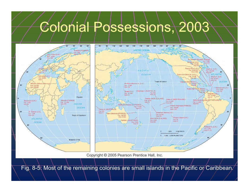
Colonial Possessions, 2003
Fig. 8-5: Most of the remaining colonies are small islands in the Pacific or Caribbean.

Boundaries and Boundary Problems of States
Shapes of states• Five basic shapes• Landlocked states
Types of boundaries• Physical boundaries• Cultural boundaries
Boundaries inside states• Unitary and federal states• Trend toward federal
government• Electoral geography

African States
Fig. 8-6: Southern, central, and eastern Africa include states that are compact, elongated, prorupted, fragmented, and perforated.

Compact States: Efficient
In a compact state, the distance from the center to any boundary does not vary significantly.
Compactness is a beneficial characteristic for most smaller states, because good communications can be more easily established to all regions.

Prorupted States: Access or Disruption
An otherwise compact state with a large projecting extension is a prorupted state.
Proruptions are created for two principal reasons.
First, a proruption can provide a state with access to a resource, such as water.
Proruptions can also separate two states that otherwise would share a boundary.


Elongated States:Potential Isolation
There are a handful of elongated states, or states with a long and narrow shape.
The best example is Chile.
Elongated states may suffer from poor internal communications.

A less extreme example of an elongated state is Italy.

Fragmented States: Problematic
A fragmented state includes several discontinuous pieces of territory.
There are two kinds of fragmented states: those with areas separated by water, and those separated by an intervening state.
A difficult type of fragmentation occurs if the two pieces of territory are separated by another state.
Consider the difficulty of communicating between Alaska and the lower 48 states if Canada were not a friendly neighbor.
For most of the twentieth century, Panama was an example of a fragmented state divided in two parts by the Canal, built in 1914 by the United States.

India: The Tin Bigha Corridor
Fig. 8-7: The Tin Bigha corridor fragmented two sections of the country of Bangladesh. When it was leased to Bangladesh, a section of India was fragmented.

Perforated States: South Africa
A state that completely surrounds another one is a perforated state.
A good example of a perforated state is South Africa, which completely surrounds the state of Lesotho.

Landlocked States
Lesotho is unique in being completely surrounded by only one state, but it shares an important feature with several other states in southern Africa, as well as in other regions: It is landlocked.
The prevalence of landlocked states in Africa is a remnant of the colonial era, when Britain and France controlled extensive regions.
Direct access to an ocean is critical to states because it facilitates international trade.
To send and receive goods by sea, a landlocked state must arrange to use another country’s seaport.

Frontiers in the Arabian Peninsula
Fig. 8-8: Several states in the Arabian Peninsula are separated by frontiers rather than precise boundaries.

Boundaries are of two types: physical and cultural
Neither type of boundary is better or more “natural,” and many boundaries are a combination of both types.
Important physical features on Earth’s surface can make good boundaries because they are easily seen, both on a map and on the ground.
Three types of physical elements serve as boundaries between states: • mountains, • deserts, • and water.

Mountain Boundaries
Mountains can be effective boundaries if they are difficult to cross (and) because they are rather permanent and usually are sparsely inhabited.
Mountains do not always provide for the amicable separation of neighbors.
Argentina and Chile agreed to be divided by the crest of the Andes Mountains but could not decide on the precise location of the crest.

Desert Boundaries
Like mountains, deserts are hard to cross and sparsely inhabited.
Desert boundaries are common in Africa and Asia.

Water Boundaries Rivers, lakes, and oceans are the physical features most commonly used as boundaries.
Water boundaries are especially common in East Africa.
Boundaries are typically in the middle of the water, although the boundary between Malawi and Tanzania follows the north shore of Lake Malawi (Lake Nyasa).
Again, the boundaries result from nineteenth-century colonial practices: Malawi was a British colony, whereas Tanzania was German.
Water boundaries can offer good protection against attack from another state, because an invading state must secure a landing spot.
The state being invaded can concentrate its defense at the landing point.

Coastal Waters The use of water as boundaries between states can cause
difficulties, though. One problem is that the precise position of the water may
change over time. Rivers, in particular, can slowly change their course. Ocean boundaries also cause problems because states generally
claim that the boundary lies not at the coastline but out at sea. The reasons are for defense and for control of valuable fishing
industries.

Cultural Boundaries
The boundaries between some states coincide with differences in ethnicity.
Other cultural boundaries are drawn according to geometry; they simply are straight lines drawn on a map.

Geometric Boundaries Part of the northern U.S.
boundary with Canada is a 2,100-kilometer (1,300 mile) straight line (more precisely, an arc) along 49° north latitude, established in 1846 by a treaty between the United States and Great Britain, which still controlled Canada.
The United States and Canada share an additional 1,100-kilometer (700-mile) geometric boundary between Alaska and the Yukon Territory along the north-south arc of 14° west longitude.

Aozou Strip: A Geometric Boundary
Fig. 8-9: The straight boundary between Libya and Chad was drawn by European powers, and the strip is the subject of controversy between the two countries.

Ethnic Groups in Southwest Asia
Fig. 8-14: Ethnic boundaries do not match country boundaries, especially in Iraq, Iran, Afghanistan, and Pakistan.

Language Boundaries
Language is an important cultural characteristic for drawing boundaries, especially in Europe.
By global standards, European languages have substantial literary traditions and formal rules of grammar and spelling.
The French language was a major element in the development of France as a unified state in the seventeenth century.
In the nineteenth century, Italy and Germany also emerged as states that unified the speakers of particular languages.
The movement to identify nationalities on the basis of language spread throughout Europe in the twentieth century.

Division of Cyprus
Fig. 8-10: Cyprus has been divided into Greek and Turkish portions since 1974.

Boundaries inside States
Within countries, local government boundaries are sometimes drawn to separate different nationalities or ethnicities.
They are also drawn sometimes to provide advantage to a political party.

Unitary and Federal States In the face of increasing demands
by ethnicities for more self-determination, states have restructured their governments to transfer some authority from the national government to local government units.
The governments of states are organized according to one of two approaches: the unitary system or the federal system.
The unitary state places most power in the hands of central government officials, whereas the federal state allocates strong power to units of local government within the country.

Unitary and Federal States Continued Unitary states are especially common in
Europe. In reality, multinational states often
have adopted unitary systems, so that the values of one nationality can be imposed on others.
In a federal state, such as the United States, local governments possess more authority to adopt their own laws.
Multinational states may adopt a federal system of government to empower different nationalities, especially if they live in separate regions of the country.
The federal system is also more suitable for very large states because the national capital may be too remote to provide effective control over isolated regions.

France: Curbing a Unitary Government
A good example of a nation-state, France has a long tradition of unitary government in which a very strong national government dominates local government decisions.
Their basic local government unit is the département.
A second tier of local government in France is the commune.
The French government has granted additional legal powers to the departments and communes in recent years.
In addition, 22 regional councils that previously held minimal authority have been converted into full-fledged local government units.

Poland: A New Federal Government
Poland switched from a unitary to a federal system after control of the national government was wrested from the Communists.
Under the Communists’ unitary system, local governments held no legal authority.
Poland’s 1989 constitution called for a peaceful revolution: creation of 2,400 new municipalities, to be headed by directly elected officials.
To these municipalities, the national government turned over ownership of housing, water supplies, transportation systems, and other publicly owned structures.
Businesses owned by the national government were either turned over to the municipalities or converted into private enterprises.

Electoral Geography The boundaries separating legislative
districts within the United States and other countries are redrawn periodically to ensure that each district has approximately the same population.
Boundaries must be redrawn because migration inevitably results in some districts gaining population, whereas others are losing.
The job of redrawing boundaries in most European countries is entrusted to independent commissions.
In most U.S. states the job of redrawing boundaries is entrusted to the state legislature.
The process of redrawing legislative boundaries for the purpose of benefiting the party in power is called gerrymandering.

Types of Gerrymandering Gerrymandering takes
three forms. “Wasted vote” spreads
opposition supporters across many districts but in the minority.
“Excess vote” concentrates opposition supporters into a few districts.
“Stacked vote” links distant areas of like-minded voters through oddly shaped boundaries.

Gerrymandering: Florida and Georgia
Recent gerrymandering in the United States has been primarily “stacked vote.”
“Stacked vote” gerrymandering has been especially attractive to create districts inclined to elect ethnic minorities.
Through gerrymandering, only about one-tenth of Congressional seats are competitive, making a shift of more than a few seats increasingly improbable from one election to another in the United States.
Fig. 8-11: State legislature boundaries were drawn to maximize the number of legislators for Republicans in Florida and Georgia.

Cooperation among States Political and military cooperation
• The United Nations• Regional military alliances
Economic cooperation• The European Union

United Nations Members
Fig. 8-1: The UN has increased from 51 members in 1945 to 191 in 2003.

United Nation Forces U.N. members can vote to establish a
peacekeeping force and request states to contribute military forces.
During the Cold War era, U.N. peacekeeping efforts were often stymied because any one of the five permanent members of the Security Council could veto the operation.
Because it must rely on individual countries to supply troops, the United Nations often lacks enough troops to keep peace effectively.
Despite its shortcomings the United Nations represents a forum where, for the first time in history, virtually all states of the world can meet and vote on issues without resorting to war.

Super Powers in History In addition to joining the United Nations, many states
joined regional military alliances after World War II. During the Cold War era, the United States and the
Soviet Union were the world’s two superpowers. Before then, the world typically contained more than
two superpowers. During the Napoleonic Wars in the early 1800s, Europe
boasted eight major powers. Before the outbreak of World War I in the early
twentieth century, eight great powers again existed. When a large number of states ranked as great powers
were of approximately equal strength, no single state could dominate.

Super Powers Before WWII
Prior to WWII, major powers joined together to form temporary alliances.
A condition of roughly equal strength between opposing alliances is known as a balance of power.
Historically, the addition of one or two states to an alliance could tip the balance of power.
The British in particular entered alliances to restore the balance of power and prevent any other state from becoming too strong.

Era of Two Superpowers
In contrast, the post World War II balance of power was bipolar between the United States and the Soviet Union.
Other states lost the ability to tip the scales significantly in favor of one or the other superpower.
They were relegated to a new role, that of ally or satellite.
Both superpowers repeatedly demonstrated that they would use military force if necessary to prevent an ally from becoming too independent.

Military Cooperation in Europe After World War II, most European states
joined one of two military alliances dominated by the superpowers: NATO or the Warsaw Pact.
NATO and the Warsaw Pact were designed to maintain a bipolar balance of power in Europe.
In a Europe no longer dominated by military confrontation between two blocs, the Warsaw Pact and NATO became obsolete.
Rather than disbanding, NATO expanded its membership in 1997 to include several former Warsaw Pact countries.
The Organization on Security and Cooperation in Europe (OSCE) has 55 members, including the United States, Canada, and Russia, as well as most European countries.
Although the OSCE does not directly command armed forces, it can call upon member states to supply troops if necessary.

Regional Organizations
The Organization of American States (OAS) includes all 35 states in the Western Hemisphere.
Cuba is a member but was suspended in 1962.
The OAS promotes social, cultural, political, and economic links among member states.
The Commonwealth of Nations includes the United Kingdom and 53 other states that were once British colonies.
Commonwealth members seek economic and cultural cooperation.

Regional Organizations (continued)
Another regional organization encompassing all countries in Africa is the Organization for African Unity (OAU).
Founded in 1963, the OAU has promoted the end of colonialism in Africa.
The OAU was disbanded in 2002 and replaced by the African Union (AU)
The AU’s primary objectives are to promote political and socio-economic integration of the continent and to defend the sovereignty, territorial integrity and independence of its member states

Economic Cooperation The era of a bipolar balance of
power formally ended when the Soviet Union was disbanded in 1992.
The world has returned to the pattern of more than two superpowers.
But the contemporary pattern of global power displays two key differences.
The most important elements of state power are increasingly economic rather than military, (and) the leading superpower in the 1990s is not a single state.

The European Union and NATO
Fig. 8-12: NATO and the European Union have expanded and accepted new members as the Warsaw Pact and COMECON have disintegrated.

European Boundary Changes
Fig. 8-13: Twentieth-century boundary changes in Europe, 1914 to 2003. Germany’s boundaries changed after each world war and the collapse of the Soviet Union.

Terrorism Terrorism by
individuals and organizations
State support for terrorism• Libya• Afghanistan• Iraq• Iran

Terrorism by Individuals and Organizations
The United States suffered several terrorist attacks during the late twentieth century.
With the exception of the Oklahoma City bombing, which killed 168 people in 1995, Americans generally paid little attention to the attacks and had only a vague notion of who had committed them.
It took the attack on the World Trade Center and Pentagon on September 11, 2001, for most Americans to feel threatened by terrorism.

American Terrorists
Some of the terrorists during the 1990s were American citizens operating alone or with a handful of others.
Theodore J. Kaczynski, known as the Unabomber, was convicted of killing 3 people and injuring 23 others by sending bombs through the mail during a 17-year period.
His targets were mainly academics in technological disciplines and executives in businesses whose actions he considered to be adversely affecting the environment.
Timothy J. McVeigh claimed his terrorist act was provoked by rage against the U.S. government for such actions as the Federal Bureau of Investigation’s 51-day siege of the Branch Davidian religious compound near Waco, Texas, culminating with an attack on April 19, 1993, that resulted in 80 deaths.

World Trade Center
Ikonos satellite images of the World Trade Center June 30, 2000, before the attack.

World Trade Center Site September 15, 2001
Ikonos satellite images of the World Trade Center September 15, 2001, after the attack.

State-Sponsored Terrorism States sponsored terrorism at three increasing levels of
involvement:• providing sanctuary for terrorists wanted by other
countries;• supplying weapons, money, and intelligence to terrorists;• planning attacks using terrorists.
In response to the September 11, 2001, terrorist attack against the United States, the U.S. government accused first Afghanistan, then Iraq, and then Iran of providing at least one of the three levels of state support for terrorists.
As part of its war against terrorism, the U.S. government in cooperation with other countries attacked Afghanistan in 2001 and Iraq in 2003 to depose those countries’ government leaders considered supporters of terrorism.
A generation earlier, the United States also attacked Libya in retaliation for using terrorists to plan attacks during the 1980s.

Libya Terrorists sponsored by Libya in 1986 bombed a nightclub in Berlin popular with U.S. military personnel stationed there, killing two U.S. soldiers (three, including one civilian).
In response, U.S. bombers attacked the Libyan cities of Tripoli and Benghazi in a failed attempt to kill Colonel Qaddafi.
In 1990, investigators announced that the 1988 destruction of Pan Am Flight 103 over Lockerbie, Scotland, was conducted by Libyan agents.
Following eight years of U.N. economic sanctions, Colonel Qaddafi turned over the suspects for a trial that was held in the Netherlands under Scottish law.
One of the two was convicted and sentenced to life imprisonment, while the other was acquitted.

Afghanistan 1979
Afghanistan’s civil war began when their King was overthrown by a military coup in 1973 and replaced five years later in a bloody coup by a government sympathetic to the Soviet Union.
The Soviet Union sent 115,000 troops to Afghanistan beginning in 1979 after fundamentalist Muslims, known as mujahedeen, or “holy warriors,” started a rebellion against the pro-Soviet government.
Unable to subdue the mujahedeen, the Soviet Union withdrew its troops in 1989, and the Soviet-installed government in Afghanistan collapsed in 1992.
The Taliban gained power in Afghanistan in 1995, temporarily suppressing a civil war that had lasted for more than two decades and imposing strict Islamic fundamentalist law on the population.

Afghanistan 2001
After several years of infighting among the factions that had defeated the Soviet Union, the Taliban gained control over most of the country.
The United States attacked Afghanistan in 2001 when its leaders, known as Taliban, sheltered Osama bin Laden and other al-Qaeda terrorists.
Six years of Taliban rule came to an end in 2001 following the U.S. invasion. Destroying Taliban was necessary for the United States in order to go after al-Qaeda leaders, including Osama bin Laden, who were living in Afghanistan as guests of the Taliban.
Removal of Taliban unleashed a new struggle for control of Afghanistan among the country’s many ethnic groups.

Iraq The first confrontation between the U.S. and Iraq predated the war on terrorism.
After Iraq invaded neighboring Kuwait in 1990 and attempted to annex it, a U.S. led coalition launched the 1991 Gulf War known as Operation Desert Storm to drive Iraq out of Kuwait.
Although Iraq was defeated in the 1991 Gulf War, Saddam Hussein and the Ba’ath Party remained in power until the 2003 war.
The United States attacked Iraq again in 2003 to remove from power the country’s longtime dictator Saddam Hussein.
U.S. officials, supported by the United Kingdom, argued that Hussein was developing weapons of mass destruction that could be turned over to terrorists.

Iraq 2003 In contrast with the 1991 Gulf War,
most U.N. member states did not support the U.S. led attack in 2003. Most other countries did not view as sufficiently strong the evidence that Iraq still possessed weapons of mass destruction or intended to use them.
Hussein’s brutal treatment of Iraqis over several decades was widely acknowledged by other countries but not accepted as justification for military action against him.
The U.S. assertion that Hussein had close links with al-Qaeda was also challenged by most other countries, as well as by U.S. intelligence agencies.
One reason was that Hussein’s Ba’ath Party, which ruled Iraq between 1968 and 2003, espoused different principles than the al-Qaeda terrorists.

Iran Hostility between the United States
and Iran dates from 1979, when a revolution forced abdication of Iran’s pro-U.S. Shah Mohammad Reza Pahiavi.
Iran and Iraq fought a war between 1980 and 1988 over control of the Shatt al-Arab waterway, formed by the confluence of the Tigris and Euphrates rivers flowing into the Persian Gulf.
An estimated 1.5 million died in the war, until it ended when the two countries accepted a UN peace plan.
When the United States launched its war on terrorism, Iran was a less immediate target than Afghanistan and Iraq.
However, the United States accused Iran of harboring al-Qaeda members and of trying to install a Shiite-dominated government in Iraq after the United States removed Saddam Hussein from power in 2003.

Other Terrorist States
Other states considered by the United States to be state sponsors of terrorism in recent years have included the following:• Yemen, which serves as a base
for al-Qaeda cells and sheltered terrorists who attacked the USS Cole;
• Sudan, which sheltered Islamic militants, including Osama bin Laden;
• Iran, which has the capability to produce enriched uranium;
• Syria, which was implicated in support of Iranian and Libyan terrorists;
• North Korea, which is developing nuclear weapons capability (and selling it).