planning - dallas fort worth...
TRANSCRIPT

45
PLANNING
2CHAPTER
Freeways and controversy. Since the early 1970s, you can’t say one without the other in North Texas. If
there is one near-certainty about any planned freeway or tollway project, it’s that a controversy will erupt. And in North Texas there have been some tremendous controver-sies, turning freeway ambition into Texas-sized freeway battles.
The seemingly never-ending controversy is a conse-quence of the active and extensive planning process in North Texas. After all, if nothing is being planned or built, there won’t be any controversy. North Texas has been among the leaders in the United States in terms of regional planning and building freeways and tollways—and conse-quently also among the leaders in controversy.
Freeway planners haven’t always gotten what they wanted. The list of canceled freeways from past versions of the official regional transportation plan is long. But the North Texas freeway plan has always recovered from its setbacks, adapting to changing times and changing needs. In 2013 the North Texas regional transportation plan is the most ambitious in the United States in terms of new added capacity, nearly all of it via toll roads.
For North Texas, it seems certain that the future will be a lot like the past. Population will continue to increase, typically by around 100,000 people per year. The need for new freeways and tollways will grow. Planners will work to build the new capacity that the region needs. And contro-versies will rage.
Planning, Controversy and Cancellations
Early Freeway PlanningThe original freeway planning in North Texas began in the late 1930s in Dallas and Fort Worth, with each city working independently to plan and build their first freeways.
In Dallas, construction of Central Boulevard on the alignment of the Houston and Texas Central Railroad (H&TC) had been first proposed in 1911 and by the late 1930s the project became Dallas’ top priority for civic im-provement. In 1940 the project was designated to become a state-of-the-art, limited-access freeway. The City of Dallas acquired the H&TC railroad in 1941 and after World War II the project was finally ready to move forward to construc-tion with the first section opening in 1949.
In Fort Worth, early efforts focused on present-day Interstate 35W south and Interstate 30 west. Preliminary planning for both freeways was underway in the late 1930s but was placed on hold due to World War II. In August 1945, the month the United States achieved victory over Japan, TxDOT resumed efforts to build both IH 35W south and IH 30 west. The first section of US 81, on the alignment of IH 35W, opened in September 1949.1
The present-day Interstate Highway System began to take shape in the early 1940s, with the planning process well underway in January 1943 when a special commit-tee appointed by President Roosevelt delivered a report
calling for a nationwide network of interregional express highways. The 1943 plan showed present-day Interstates 20, 30 and 35 converging on North Texas. The Federal-Aid Highway Act of 1944 officially authorized the construction of a 40,000-mile National System of Interstate Highways but provided no funding. The Interstate Highway System would be funded and large-scale construction would begin with the Federal-Aid Highway Act of 1956. In the mean-time, it was still mostly the responsibility of state highway departments and local governments to plan and build freeways.2
In the early 1950s in both Dallas and Fort Worth, addi-tional freeways were being planned on a freeway-by-free-way basis. In Dallas the alignment of the planned East-West Expressway was approved in 1953 and efforts to define the alignment of present-day Stemmons Freeway began in 1952. In 1952 business interests began efforts to build a freeway between Dallas and Fort Worth which became the Dallas-Fort Worth Turnpike, opened in August 1957. Fort Worth officials focused their efforts on present-day IH 35W north of downtown and present-day IH 20 on the south side of Fort Worth.
In February 1952 a delegation of 56 North Texas of-ficials led by Dallas Chamber of Commerce President Ben Wooten went to Los Angeles to study the nation-leading

Dallas-Fort Worth Freeways Chapter 246
California Dreaming In February 1952 a delegation of 56 North Texas officials led by Dallas Chamber of Commerce President Ben Wooten went to California to study the progress and success of the Los Angeles freeway system with the goal of bringing the knowledge back to North Texas to expedite freeway construction. Here the delegation is shown in front of the iconic “stack” interchange at the intersection of the Harbor Freeway (CA 110) and Hollywood Freeway (US 101). Posing for the photo from left to right: Harrison Baker, member of the California Highway Commission; W.W. Overton Jr, chairman of the board of the Texas Bank and Trust Company; Ben Wooten; Paul Harding, California assistant state highway engineer.21
Dallas magazine, March 1952
Los Angeles freeway construction program and its success (see photo). In terms of freeway planning, Los Angeles had published its key planning documents in 1939, 1941 and 1943, formulating plans for a sprawling regional network which was well ahead of anything being planned for North Texas. Catching up with California would prove to be impossible in the following two decades as the California Division of Highways (now Caltrans) would go on in the 1950s and 1960s to become the mightiest freeway con-struction machine the world has ever known. But in the short term, seeing California’s progress surely inspired lo-cal officials and more comprehensive plans for North Texas freeways began to appear soon afterward.3
In January 1953 TxDOT approved a long-range plan
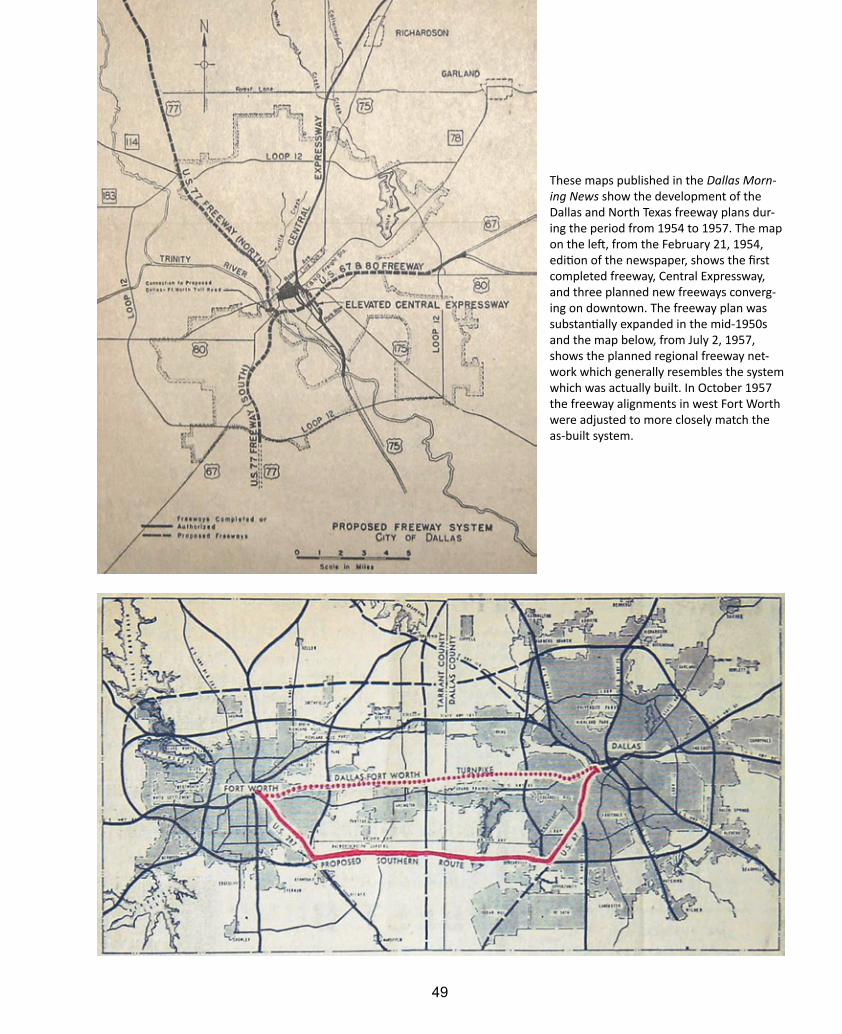
for Dallas which included present-day IH 30 (east and west), IH 35E south, the downtown Mixmaster interchange and IH 35E north. However, it was still more of an evolv-ing freeway-by-freeway plan rather than a comprehensive long-term regional plan. A map published in the Dallas Morning News on February 21, 1954, showed the develop-ing plan (see image page 49).4
Progress toward a comprehensive plan which became today’s Dallas freeway system accelerated in 1955. The preliminary blueprint for the Interstate Highway Sys-tem, the so-called “Yellow Book” due to its cover color, added the eastern bypass loop around Dallas, present-day Interstates 635 and 20. In 1957 a map published in the Dallas Morning News showed a freeway plan which closely

Planning, Controversy and Cancellations 47
Dallas Public Library22
Freeway Desire This undated photo most likely from 1952 shows an event, possibly a press conference, to promote freeway construction in Dallas. In the background the poster shows “Dallas’ Dilemma Today”—traffic congestion and inadequate roads. An injection of engineering in the middle produces “Dallas’ Desire Tomorrow”—a modern four-level freeway interchange. In the front row from left to right: city manager Charles Ford, Citizens Traffic Commission (CTC) member Rex Leutz, CTC honorary chairman C.J. Rutland and CTC member George McBlair. Standing in back are Dallas Traffic Engineer Lloyd Braff (left) and Dallas Planning Director Marvin Springer. Springer (1914-2008) was among the most influential persons in planning the freeways and streets of Dallas, responsible for determining the alignment of many freeways. He is regarded as one of the leading urban plan-ners of the post-World War II era and, through his consulting firm started in 1960, helped develop master plans for about 50 cities including Plano, McKinney and Grand Prairie.23
resembles today’s freeway system.5In Fort Worth a regional plan closely resembling
today’s freeway system was released by TxDOT in 1955. It was dubbed the “dream” freeway plan in a Fort Worth Star-Telegram report, which described the plan as a “gigantic freeway ring around the outskirts of the city proper plus spokes radiating out from the center of the business dis-trict into all sections of the county.” The plan was modified in 1957 to swing the loop further west. But for the most
part, the dream freeway plan of 1955 became reality and still defines Fort Worth freeways today.6
The North Texas Freeway GridAs freeway systems were planned for cities throughout the United States in the years after World War II, design pat-terns emerged based on regional geographic constraints and political boundaries. Regions with a single central urban focus and minimal geographic constraints adopted

Dallas-Fort Worth Freeways Chapter 248
Freeway Jackpot Local governments were responsible for a share of the right-of-way costs for new freeways, and this 1957 bro-chure was in support of a bond issue to cover Dallas County’s share. The $17.3 million bond issue ($143 million in 2013 dollars) passed with 86% of the vote in favor.24
49
These maps published in the Dallas Morn-ing News show the development of the Dallas and North Texas freeway plans dur-ing the period from 1954 to 1957. The map on the left, from the February 21, 1954, edition of the newspaper, shows the first completed freeway, Central Expressway, and three planned new freeways converg-ing on downtown. The freeway plan was substantially expanded in the mid-1950s and the map below, from July 2, 1957, shows the planned regional freeway net-work which generally resembles the system which was actually built. In October 1957 the freeway alignments in west Fort Worth were adjusted to more closely match the as-built system.

Dallas-Fort Worth Freeways Chapter 250
This planning map shows Fort Worth’s “dream” freeway plan which was unveiled to the public in July 1955. The freeway plan on the west side of Fort Worth was adjusted in October 1957 to remove the north-south freeway through the west side (signed with Texas 199 and US 377) and align the west loop further to the west near its actually built location.25
the loop and radial system, with numerous freeway spokes converging on downtown and one or more loops encir-cling the region. This is the most widely used pattern, with Houston, Atlanta and Washington DC the largest regions using this pattern. Houston, with its two complete freeway loops and third loop under development, has the most ex-tensive loop and radial design pattern in the United States. Regions with multiple urban focus points and minimal geographic constraints adopted a grid system with vary-ing degrees of radial service to the urban focus points. Los Angeles has the most extensive freeway grid system, fol-lowed by Dallas-Fort Worth and Minneapolis-St. Paul. Geo-graphically constrained regions adopted freeway networks suitable to their geography, often with both grid and radial elements. The New York City region, Chicago, San Francisco Bay Area region and South Florida are the largest regions with these hybrid patterns.
So which pattern is best? As jobs and population dispersed to the suburbs in the period from 1950 to 2000, travel patterns shifted from the suburb-to-downtown
commute toward the suburb-to-suburb commute. The loop and radial freeway system performed poorly with the increasing prevalence of the suburb-to-suburb commute as traffic funneled onto the loops, causing severe congestion at bottleneck points on the loops. Downtown interchange complexes designed for originating and terminating traffic performed poorly for through-traffic.
The freeway grid design pattern does a better job of handling the suburb-to-suburb commute due to its disper-sion of traffic throughout the grid and greater number of alternative routes for traffic. However, freeway grids were still plagued by traffic bottlenecks at major activity points, for example downtown Los Angeles, Interstate 405 (the San Diego Freeway) at numerous points in the Los Angeles region, the downtown Dallas Mixmaster and Interstate 635 (LBJ Freeway) in north Dallas.
With Dallas on the east, Fort Worth on the west and many other politically viable cities around the region, North Texas was tailor-made for the superior grid system. By 1957 plans for the grid network were in place, with

Planning, Controversy and Cancellations 51
the regional plan showing three parallel freeways con-necting the east and west sides of the region. A third focus point was added to the North Texas freeway grid in 1965 with the designation of the site for the Dallas-Fort Worth International Airport. In September 1967 TxDOT updated the regional freeway plan to make the airport a freeway hub. In March 1970 the Dallas Morning News reported that “Grapevine, a once-sleepy town with an economy depen-dent upon farming, will become a major freeway hub as a result of its geographic location and construction of the 18,000-acre regional airport on its south doorstep.” With the completion of the $1.1 billion DFW Connector project in 2013, which expanded the freeway complex on the north side of the airport, North Texas’ third freeway focus point is positioned to become an even busier freeway hub.7
Geographic, political and development factors all were favorably aligned to build one of the world’s most extensive freeway networks in North Texas. Only Southern California has a more extensive grid, although it serves a population base about three times as large as North Texas. North Texas, with long-term plans for an outer loop around most of the existing grid, is the only region which is posi-tioned to develop a freeway network which rivals Southern California.
Regional Planning and the Monumental 1967 PlanWhile freeway planning had proceeded mostly indepen-dently in Dallas and Fort Worth during the formulation of the original freeway plans in the mid-1950s, the era of regional freeway planning arrived with the monumental 1967 Dallas-Fort Worth Regional Transportation Study. It was monumental in the sense that it proposed a very dense network of new freeways around downtown Dallas and a regional freeway grid which began to rival the extensive Southern California plan.
The 1967 freeway plan had its roots in the Federal-Aid Highway Act of 1962 which required all cities with a 1960 population exceeding 50,000 to have a comprehensive, cooperative and continuing transportation plan—the so-called “3C” process. Local authorities launched a transpor-tation study in 1964 to develop plans for projected 1985 traffic volumes. For the next three years the study team collected and analyzed data, then devised a plan. The final report and its recommended freeway network for 1985 was published in 1967 in a multi-volume document.
The study team recognized emerging trends in North Texas transportation and designed the plan to meet those future needs. The team realized that fewer and fewer daily trips would originate or terminate in downtown Dallas, and traffic passing through the downtown interchange complex going to other destinations would eventually cause gridlock. To handle this need, the planners added a second loop of freeways around downtown about 1-2 miles beyond the first loop, with new radial freeways connect-ing to the loop to take motorists to suburban destinations. The team also recognized the growing importance of the
suburb-to-suburb commute and strengthened the grid network of freeways around North Texas.
When the study team began its efforts in 1964, new freeways could be built through residential areas with little or no opposition and it was less costly to build new freeways on new alignments than it was to expand existing freeways. Consequently, an extensive network of new free-ways was recommended to cut through generally declining residential areas and industrial zones in the inner city. The proposed freeways are shown in the views of historical planning maps on the following pages, and are also shown in the map of canceled freeways on page 71 and the tabular list of canceled freeways on page 72.
While the team was clairvoyant in predicting future transportation patterns and needs, it did not recognize other trends which were developing far more quickly: public opposition to inner-city freeways, declining politi-cal support for controversial projects and diminishing financial resources for freeway construction combined with skyrocketing construction costs. Still, the proposed new freeways remained in the 1971 update of the regional transportation plan as the climate for new freeways was becoming hostile. In June 1974 reality finally set in. The regional planning authority, now NCTCOG, erased all the inner-city Dallas freeways except the Trinity Parkway from the plan. Several freeways in the Dallas north suburbs and a Fort Worth freeway were also deleted (see comparison of freeway plan maps on page 57).8
The proposed inner-city Dallas freeways never had any chance of actually being constructed. Due to the collapse in highway construction funding, just completing the previ-ously planned downtown freeway system turned out to be a huge challenge. After a long delay, the Woodall Rodgers Freeway opened in May 1983. It was expected to be the last freeway to be built in the interior of Dallas, but one last project, the highly controversial Trinity Parkway tollway (page 328), could still be built.
The authors of the 1967 plan deserve credit for ac-curately predicting future needs and proposing a plan which would have solved the problem. The freeway routes proposed in the 1967 plan would be a godsend to today’s motorists. But a solution suitable for a certain era of time, the 1950s through the mid-1960s, became unsuitable as times changed. The problem of downtown Dallas traf-fic has remained, and in 2013 the proposed solution for downtown freeway congestion is the Trinity Parkway tollway, a new bypass route around downtown in the Trinity River floodway. Plans for expanding and modern-izing existing downtown freeways were developed during the Project Pegasus study from 2001 to 2005, but in 2013 only the downtown Mixmaster interchange is funded for improvement and no work on the rest of downtown Dallas freeways is planned prior to 2035.

Dallas-Fort Worth Freeways Chapter 252
This map of the planned freeway system for Fort Worth is from the 1967 Dallas-Fort Worth Regional Transportation Study. The freeway plan for Fort Worth was not as ambitious as the Dallas plan, and only three freeways were later canceled. Nearly all of the South East-West Freeway was canceled in 1974; only the far west section west of Loop 820 was built, opening in 1986 as Interstate 20. The Northwest Freeway inside Loop 820 and the North Side Freeway on the north and west sides of downtown were canceled in 2000. This freeway plan shows a convergence of three freeways on the southwest side of downtown, which would have potentially been an impressive interchange complex if it had moved forward to construction.
Planning, Controversy and Cancellations 53
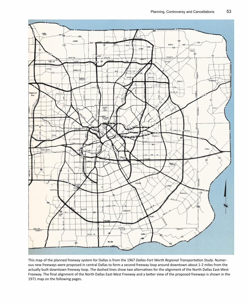
This map of the planned freeway system for Dallas is from the 1967 Dallas-Fort Worth Regional Transportation Study. Numer-ous new freeways were proposed in central Dallas to form a second freeway loop around downtown about 1-2 miles from the actually built downtown freeway loop. The dashed lines show two alternatives for the alignment of the North Dallas East-West Freeway. The final alignment of the North Dallas East-West Freeway and a better view of the proposed freeways is shown in the 1971 map on the following pages.

Dallas-Fort Worth Freeways Chapter 254
This map of the Fort Worth region from the 1971 Regional Transportation Study shows the same freeways as the 1967 map and fully defined the freeways on the north side of Dallas-Fort Worth International Airport.
Planning, Controversy and Cancellations 55
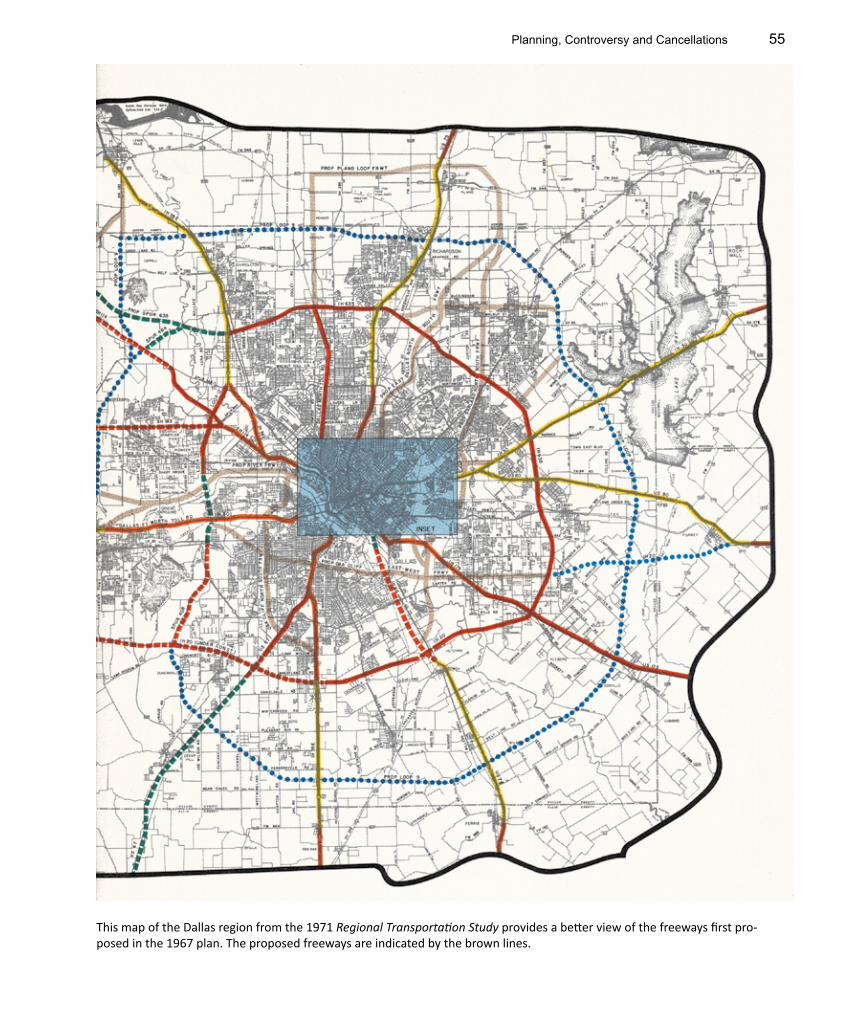
This map of the Dallas region from the 1971 Regional Transportation Study provides a better view of the freeways first pro-posed in the 1967 plan. The proposed freeways are indicated by the brown lines.

Dallas-Fort Worth Freeways Chapter 256
These views of downtown Dallas and Fort Worth from the 1971 Regional Transportation Study show the proposed freeways in the downtown areas. The alignment of the North Dallas East-West Freeway was just south of exclusive Highland Park. But offi-cials soon realized it would be impossible to build new freeways anywhere in urban areas, even through decayed areas of Dallas.

Planning, Controversy and Cancellations 57
These maps from the Dallas Morning News show the regional freeway plan before and after the 1974 adjustments. The above view, from September 17, 1967, shows the extensive network of proposed new freeways including the incredibly dense network around downtown Dallas and in northeast Dallas into Garland. The lower view from June 17, 1974, shows the plan after nearly all the proposed freeways in Dallas were deleted.

Dallas-Fort Worth Freeways Chapter 258
This map from the 1978 regional planning document shows the new plan which emerged after the adjustments made in the mid-1970s. Most of the planned freeways in this plan were built, many as toll roads. Some of the interesting proposed freeways which were later canceled are the “Mid-Cities Freeway” north of Dallas-Fort Worth Airport, the extension of Loop 12 (present-day Spur 408) south of Interstate 20 in southeast Dallas and the proposed freeway along the Trinity River between downtown Dallas and downtown Fort Worth. This plan does not include several new freeways and tollways which were later added to the plan and actually built, including SH 121 north of Dallas, the extension of the Dallas North Tollway, SH 114 through Southlake and SH 170 in north Fort Worth.26
The Toll Road Moves to the ForefrontIn the 1990s and 2000s the most dominant and influential trend in North Texas planning has been the shift to toll-based financing of highway facilities. In 2013 nearly all planned projects scheduled for construction before 2035 are tolled facilities or include a combination of new regular (non-tolled) lanes and tolled lanes. The shift toward toll-dominated highway financing is the result of insufficient and stagnant revenue from traditional sources of highway funding, mainly the gasoline tax, as inflation erodes the fixed-value fuel tax and the better gasoline mileage of new
vehicles reduces gasoline consumption. As a general pat-tern, dwindling revenue from traditional sources is being used to maintain and rebuild existing free lanes, while most new capacity is being financed with tolls.
The shift toward reliance on tolls began in August 1991 when political leaders endorsed greater use of tolls and the regional planning council (NCTCOG) studied the conversion of 18 planned new freeway projects into toll road projects. In 1991 transportation planners also began to promote the idea of adding tolled express lanes to existing freeways, saying tolled lanes would likely be the

Planning, Controversy and Cancellations 59
North Texas vs. Houston
North Texas vs. Houston, Centerline Miles and Lane-Miles Houston percent of North TexasNorth Texas Houston Region
Centerline Miles*
Freeway 519 357 69%
Toll road 141 151 107%
Total limited access 660 508 77%
Lane-miles† Freeway and toll road 3705 3309 89%
Why North Texas Has More Freeways than Houston
1940s and 1950s
More political advocacy Both Dallas and Fort Worth worked independently to plan and fund freeway systems, while Hous-ton had only one advocate.
Freeway grid The grid design for North Texas freeways results in more centerline miles of freeway as compared to the loop and radial system used in Houston.
The Dallas-Fort Worth Turnpike The 29.6-mile toll road opened in 1957 would have consumed substantial funding if built as a freeway. State highway funds which would have been used for a Dallas-Fort Worth freeway were available for other projects. Houston did not build any toll roads until the 1980s.
More land donations Large land donations were received for IH 35E north of downtown Dallas and a long section of the Carpenter Freeway (SH 183 and SH 114). Houston received only one large donation, for US 59.
1950s and 1960sMore interstate highways North Texas has Interstates 20, 30, 35E, 35W, 45, 345, 635 and 820. Houston has only Interstates 10,
45 and 610. (US 59 in Houston is in the process of being co-signed with IH 69 in 2013.)
1960s and 1970sLower-cost construction al-lowed available funding to build more miles
Frontage roads were omitted from many sections of North Texas freeways, while they were always included in Houston when feasible. Low-cost designs were often used for North Texas freeway-to-freeway intersections, for example the original IH 635/US 75 interchange and the freeway intersec-tions in Irving around the site of the former Texas Stadium. Houston consistently used multilevel interchanges. In general, North Texas freeways have fewer lanes than Houston freeways.
Dallas-Fort Worth International Airport
The site was designated in 1965 and in 1967 political leaders announced plans for a network of freeways to serve the airport. This created a third hub for North Texas freeways and kept new free-way construction at full speed in the early 1970s while Houston construction was in decline.
Dallas-Fort Worth has outperformed Houston in terms of freeway centerline miles and centerline miles of all limited-access highways, which includes both freeways and tollways. While the population of the Houston region has averaged about 91% of North Texas since 1950, Hous-ton has only 69% the freeway centerline miles and 77% the overall limited-access highway centerline miles as Dallas-Fort Worth.
The chart below summarizes the reasons why North Texas has outperformed Houston in freeway centerline miles. For freeways, the critical period was the 1950s when the original master plans for both cities were formulated. North Texas developed a grid-style network with more freeways and stronger political advocacy propelled the freeways to construction.
While North Texas was an early leader in toll roads
with the Dallas-Fort Worth Turnpike, opened in 1957, and the Dallas North Tollway, first opened in 1968, Houston has pulled slightly ahead of North Texas in toll road cen-terline miles. Still, Houston’s edge in toll roads is negligible compared to the 162-mile North Texas lead in freeways.
So why did Houston interests stand by and let Dallas-Fort Worth get ahead? In reality, the difference in center-line miles is really a consequence of differing priorities since highway funding is proportional to regional popula-tion over the long run. While Houston has fewer freeways, they typically have more lanes and include frontage roads more often than North Texas freeways. In terms of lane-miles, the ratio of Houston to Dallas as reported by the Texas A&M Transportation Institute is 89%, very close to the popula-tion ratio of 91%.
Population of North Texas and HoustonMetropolitan area
population, millions‡Houston, percent of North TexasNorth Texas Houston
1950 0.971 0.914 94%
1960 1.74 1.43 82%
1970 2.35 2.06 88%
1980 3.05 2.95 97%
1990 3.99 3.77 94%
2000 5.16 4.72 91%
2010 6.37 5.95 93%
Average 91%
* Values computed by the author in 2012. The limit for radial freeways is the approximate edge of the urbanized area. † Lane-miles are from the Texas A&M Transportation Institute 2012 Urban Mobility Report. Limits do not correspond to the centerline miles values.
‡ Population is from the Statistical Abstract of the United States, 1951, 1981, 1991, 2001 and 2012 editions.
Dallas-Fort Worth Freeways Chapter 260
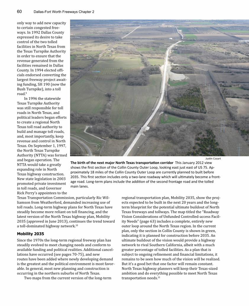
The birth of the next major North Texas transportation corridor This January 2012 view shows the first section of the Collin County Outer Loop, looking east just east of US 75. Ap-proximately 18 miles of the Collin County Outer Loop are currently planned to built before 2035. This first section includes only a two-lane roadway which will ultimately become a front-age road. Long-term plans include the addition of the second frontage road and the tolled main lanes.
Justin Cozart
only way to add new capacity to certain congested free-ways. In 1992 Dallas County expressed its desire to take control of the two tolled facilities in North Texas from the Texas Turnpike Authority in order to ensure that the revenue generated from the facilities remained in Dallas County. In 1994 elected offi-cials endorsed converting the largest freeway project await-ing funding, SH 190 (now the Bush Turnpike), into a toll road.9
In 1996 the statewide Texas Turnpike Authority was still responsible for toll roads in North Texas, and political leaders began efforts to create a regional North Texas toll road authority to build and manage toll roads, and, most importantly, keep revenue and control in North Texas. On September 1, 1997, the North Texas Turnpike Authority (NTTA) was formed and began operation. The NTTA would take a greatly expanding role in North Texas highway construction. New state legislation in 2003 promoted private investment in toll roads, and Governor Rick Perry’s appointees to the Texas Transportation Commission, particularly Ric Wil-liamson from Weatherford, demanded increasing use of toll roads. Long-term highway plans for North Texas have steadily become more reliant on toll financing, and the latest version of the North Texas highway plan, Mobility 2035 (approved in June 2013), continues the trend toward a toll-dominated highway network.10
Mobility 2035Since the 1970s the long-term regional freeway plan has steadily evolved to meet changing needs and conform to available funding and political realities. Additional cancel-lations have occurred (see pages 70-75), and new routes have been added where newly developing demand is the greatest and the political environment is most favor-able. In general, most new planning and construction is occurring in the northern suburbs of North Texas.
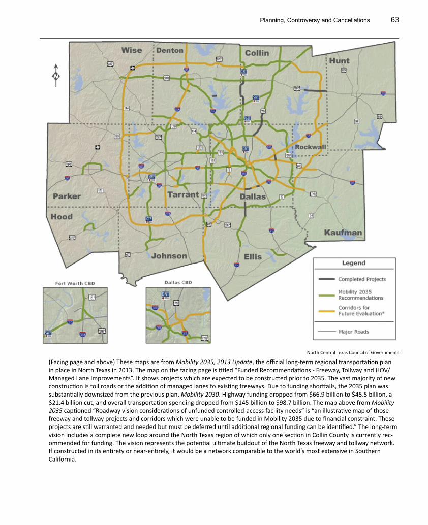
Two maps from the current version of the long-term
regional transportation plan, Mobility 2035, show the proj-ects expected to be built in the next 20 years and the long-term blueprint for the potential ultimate buildout of North Texas freeways and tollways. The map titled the “Roadway Vision Considerations of Unfunded Controlled-access Facil-ity Needs” (page 63) includes a complete, entirely new outer loop around the North Texas region. In the current plan, only the section in Collin County is shown in green, indicating it is planned for construction before 2035. An ultimate buildout of the vision would provide a highway network to rival Southern California, albeit with a much greater percentage of tolled facilities. As a plan that is subject to ongoing refinement and financial limitations, it remains to be seen how much of the vision will be realized. But it’s a good bet that one factor will remain constant. North Texas highway planners will keep their Texas-sized ambition and do everything possible to meet North Texas transportation needs.11

Planning, Controversy and Cancellations 61
Major Mobility 2035 Projects Planned for Completion Prior to 2035Based on North Central Texas Council of Governments Mobility 2035 plan, 2013 update
Project Name Cost Routes and/or Limit Description Status Completion
Bush Turnpike $414 million SH 161, final 6.5-mile section in Grand Prairie
Add tolled main lanes and new interchanges
Opened October 2012
All work done by early 2013
DFW Connector $1.0 billion SH 121 and SH 114 north of DFW Airport
Major expansion with the addition of regular and man-aged lanes
Complete August 2013
Chisholm Trail Parkway
$1.4 billion Formerly SH 121, the South-west Parkway in southwest Fort Worth
New 27.6-mile toll road Under construction
2014
LBJ Express $2.7 billion IH 635 between IH 35E and US 75, and IH 35E from Loop 12 to IH 635
Add managed lanes; rebuild IH 635 existing regular lanes
Under construction
2015
North Tarrant Express
$4.1 billion IH 35W north of downtown Fort Worth; IH 820 between IH 35W and SH 121; SH 121 from IH 820 to SH 183
Add managed lanes to all highways; add regular lanes to IH 820 and IH 35W
Under construction
2015-2018
Horseshoe Project
$798 million IH 35E and IH 30 in down-town Dallas
Rebuild and expand the Trinity River bridges and Mixmaster interchange
Under construction
2017
35E Express $1.5 billion for phase 1
IH 35E from IH 635 to Denton Add regular lanes and revers-ible managed lanes; down-sized from original $5 billion plan
Work underway in 2014
2016-2018
SH 360 $600 million South of IH 20 to US 287 Tolled main lanes, 9.7 miles Est. 2017
SH 183 $1.8 billion, including the Diamond Inter-change Phase 2
IH 35E in Dallas to SH 360 near DFW Airport
Expand main lanes and add managed lanes on 9 miles in Dallas and Irving
In the proposal phase to select private partners in 2014
Three-phase construction planned
SH 114 In Irving, Loop 12 to SH 121 Add regular & managed lanes Likely to be com-bined with SH 183
Potentially 2015-2020
SH 170 Between IH 35W and SH 114 Tolled main lanes, 5.8 miles In design Expected be-fore 2020
Trinity Parkway estimated $1.76 billion
IH 35E near SH 183 to US 175 New 9-mile toll road around downtown Dallas
Mired in contro-versy and status is uncertain
Earliest pos-sible comple-tion is 2020
Dallas North Tollway
Northward extension New toll road Undetermined
Collin County Outer Loop
SH 121 to Dallas North Tollway
New toll road Undetermined
SH 190 East From IH 30 to IH 20 New toll road Study phase Undetermined
Loop 9 South From IH 20 to US 287 New toll road Long-term Undetermined
Southern Gate-way
IH 35E from downtown to US 67; US 67 to Duncanville
Add regular & managed lanes Undetermined
Loop 12 SH 183 to Spur 408 Add regular & managed lanes Undetermined
Interstate 635 US 75 to IH 30 Add regular & managed lanes Undetermined
Notable Deferrals and Omissions from Mobility 2035Project Pegasus IH 35E and IH 30 in down-
town DallasRebuild and expand freeways After 2035
Interstate 30 Arlington Add regular & managed lanes After 2035

Dallas-Fort Worth Freeways Chapter 262
North Central Texas Council of Governments
Planning, Controversy and Cancellations 63
(Facing page and above) These maps are from Mobility 2035, 2013 Update, the official long-term regional transportation plan in place in North Texas in 2013. The map on the facing page is titled “Funded Recommendations - Freeway, Tollway and HOV/Managed Lane Improvements”. It shows projects which are expected to be constructed prior to 2035. The vast majority of new construction is toll roads or the addition of managed lanes to existing freeways. Due to funding shortfalls, the 2035 plan was substantially downsized from the previous plan, Mobility 2030. Highway funding dropped from $66.9 billion to $45.5 billion, a $21.4 billion cut, and overall transportation spending dropped from $145 billion to $98.7 billion. The map above from Mobility 2035 captioned “Roadway vision considerations of unfunded controlled-access facility needs” is “an illustrative map of those freeway and tollway projects and corridors which were unable to be funded in Mobility 2035 due to financial constraint. These projects are still warranted and needed but must be deferred until additional regional funding can be identified.” The long-term vision includes a complete new loop around the North Texas region of which only one section in Collin County is currently rec-ommended for funding. The vision represents the potential ultimate buildout of the North Texas freeway and tollway network. If constructed in its entirety or near-entirely, it would be a network comparable to the world’s most extensive in Southern California.
North Central Texas Council of Governments

Dallas-Fort Worth Freeways Chapter 264
CONTROVERSY
The first anti-freeway protest in North Texas occurred in 1945 in downtown Fort Worth before the first freeways opened in North Texas in 1949. Business interests along Lancaster Boulevard protested right-of-way acquisition for the planned east-west freeway, temporarily delaying the freeway and later prompting a design change. But when the first freeways opened in 1949, the love affair with free-ways was underway.12
The 1950s and 1960s were the golden age of freeway construction, and it was a remarkably peaceful and non-controversial period for freeways in North Texas. Every-one wanted freeways, and they wanted their freeways to be built as fast as possible. With freeway construction in progress just about everywhere, cutting paths through neighborhoods and urbanized areas in both Dallas and Fort Worth, there was not a peep of public opposition in the 1950s and 1960s except for a minor squabble along the Dallas North Tollway in 1965, quickly and easily solved by building underpasses instead of overpasses.
During this long period of freeway tranquility the only complaints public officials heard were from civic groups upset that freeways were not routed to or through their areas. When the alignment of IH 35E south of downtown
Dallas through Oak Cliff was finalized in 1953, civic inter-ests in west Oak Cliff which wanted a freeway along West Clarendon Drive protested that the approved alignment left them without a freeway. As the president of the Oak Cliff Chamber of Commerce explained, “We were led to believe it would go out Clarendon. We need an expressway to serve western Oak Cliff, as the traffic survey showed.” When the planned expressway between Dallas and Fort Worth was designated to become the Dallas-Fort Worth Turnpike in 1954, the civic group in east Fort Worth demanded that the area be served with a freeway, ideally along East Rosedale Street. A compromise agreement was reached in 1955 promising a freeway for east Fort Worth, but the Rosedale Street freeway was never built.13
In 1970 the North Texas love affair with new free-ways came to an abrupt end as the public began turning against planned projects. At an April 1970 public hearing in Richardson for the proposed Loop 9 freeway along the alignment of Campbell Road, a hostile crowd of 700 “booed and hooted down highway officials” to express their oppo-sition to the project. A few months later in August, a small civic group representing a low-income area in south Dallas along the path of the soon-to-be-built IH 45 announced
Planning, Controversy and Cancellations 65
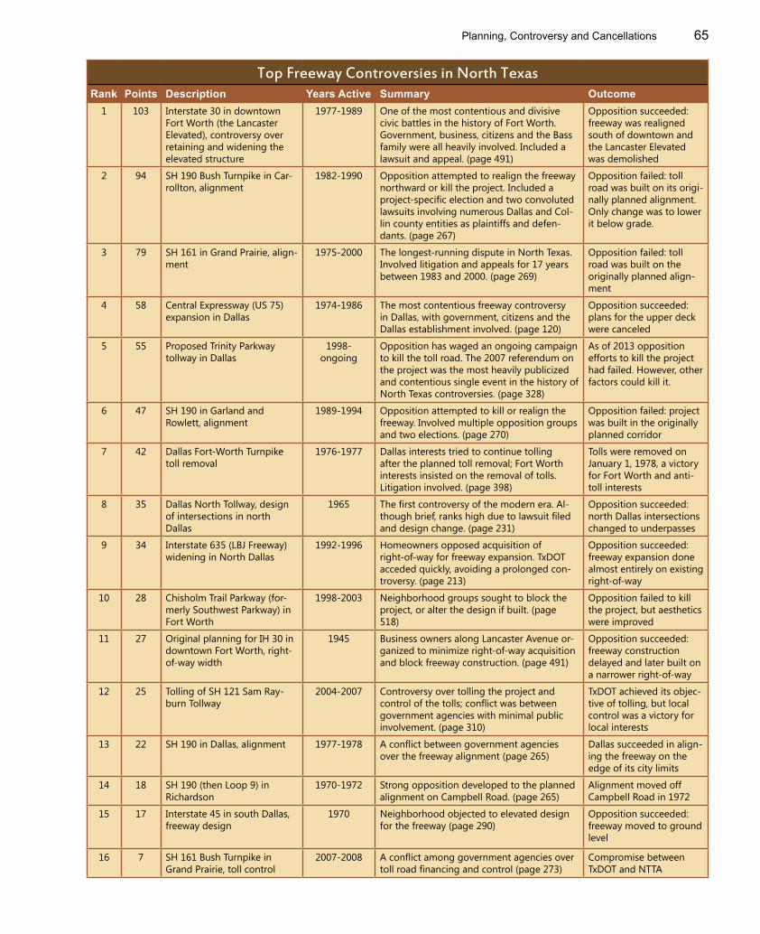
Top Freeway Controversies in North TexasRank Points Description Years Active Summary Outcome
1 103 Interstate 30 in downtown Fort Worth (the Lancaster Elevated), controversy over retaining and widening the elevated structure
1977-1989 One of the most contentious and divisive civic battles in the history of Fort Worth. Government, business, citizens and the Bass family were all heavily involved. Included a lawsuit and appeal. (page 491)
Opposition succeeded: freeway was realigned south of downtown and the Lancaster Elevated was demolished
2 94 SH 190 Bush Turnpike in Car-rollton, alignment
1982-1990 Opposition attempted to realign the freeway northward or kill the project. Included a project-specific election and two convoluted lawsuits involving numerous Dallas and Col-lin county entities as plaintiffs and defen-dants. (page 267)
Opposition failed: toll road was built on its origi-nally planned alignment. Only change was to lower it below grade.
3 79 SH 161 in Grand Prairie, align-ment
1975-2000 The longest-running dispute in North Texas. Involved litigation and appeals for 17 years between 1983 and 2000. (page 269)
Opposition failed: toll road was built on the originally planned align-ment
4 58 Central Expressway (US 75) expansion in Dallas
1974-1986 The most contentious freeway controversy in Dallas, with government, citizens and the Dallas establishment involved. (page 120)
Opposition succeeded: plans for the upper deck were canceled
5 55 Proposed Trinity Parkway tollway in Dallas
1998-ongoing
Opposition has waged an ongoing campaign to kill the toll road. The 2007 referendum on the project was the most heavily publicized and contentious single event in the history of North Texas controversies. (page 328)
As of 2013 opposition efforts to kill the project had failed. However, other factors could kill it.
6 47 SH 190 in Garland and Rowlett, alignment
1989-1994 Opposition attempted to kill or realign the freeway. Involved multiple opposition groups and two elections. (page 270)
Opposition failed: project was built in the originally planned corridor
7 42 Dallas Fort-Worth Turnpike toll removal
1976-1977 Dallas interests tried to continue tolling after the planned toll removal; Fort Worth interests insisted on the removal of tolls. Litigation involved. (page 398)
Tolls were removed on January 1, 1978, a victory for Fort Worth and anti-toll interests
8 35 Dallas North Tollway, design of intersections in north Dallas
1965 The first controversy of the modern era. Al-though brief, ranks high due to lawsuit filed and design change. (page 231)
Opposition succeeded: north Dallas intersections changed to underpasses
9 34 Interstate 635 (LBJ Freeway) widening in North Dallas
1992-1996 Homeowners opposed acquisition of right-of-way for freeway expansion. TxDOT acceded quickly, avoiding a prolonged con-troversy. (page 213)
Opposition succeeded: freeway expansion done almost entirely on existing right-of-way
10 28 Chisholm Trail Parkway (for-merly Southwest Parkway) in Fort Worth
1998-2003 Neighborhood groups sought to block the project, or alter the design if built. (page 518)
Opposition failed to kill the project, but aesthetics were improved
11 27 Original planning for IH 30 in downtown Fort Worth, right-of-way width
1945 Business owners along Lancaster Avenue or-ganized to minimize right-of-way acquisition and block freeway construction. (page 491)
Opposition succeeded: freeway construction delayed and later built on a narrower right-of-way
12 25 Tolling of SH 121 Sam Ray-burn Tollway
2004-2007 Controversy over tolling the project and control of the tolls; conflict was between government agencies with minimal public involvement. (page 310)
TxDOT achieved its objec-tive of tolling, but local control was a victory for local interests
13 22 SH 190 in Dallas, alignment 1977-1978 A conflict between government agencies over the freeway alignment (page 265)
Dallas succeeded in align-ing the freeway on the edge of its city limits
14 18 SH 190 (then Loop 9) in Richardson
1970-1972 Strong opposition developed to the planned alignment on Campbell Road. (page 265)
Alignment moved off Campbell Road in 1972
15 17 Interstate 45 in south Dallas, freeway design
1970 Neighborhood objected to elevated design for the freeway (page 290)
Opposition succeeded: freeway moved to ground level
16 7 SH 161 Bush Turnpike in Grand Prairie, toll control
2007-2008 A conflict among government agencies over toll road financing and control (page 273)
Compromise between TxDOT and NTTA
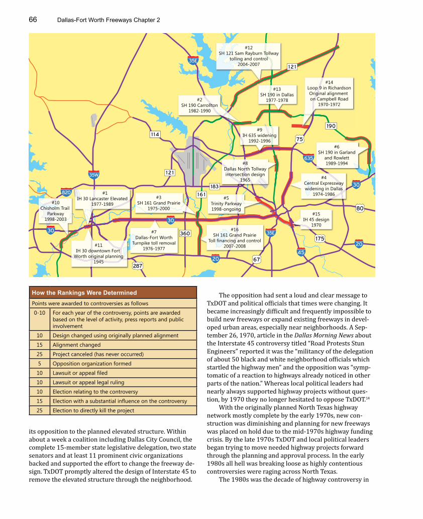
Dallas-Fort Worth Freeways Chapter 266
#1IH 30 Lancaster Elevated
1977-1989
#2SH 190 Carrollton
1982-1990
#3SH 161 Grand Prairie
1975-2000
#4Central Expresswaywidening in Dallas
1974-1986#5
Trinity Parkway1998-ongoing
#6SH 190 in Garland
and Rowlett1989-1994
#7Dallas-Fort Worth
Turnpike toll removal1976-1977
#8Dallas North Tollwayintersection design
1965
#9IH 635 widening
1992-1996
#11IH 30 downtown Fort
Worth original planning1945
#12SH 121 Sam Rayburn Tollway
tolling and control2004-2007
#13SH 190 in Dallas
1977-1978
#14Loop 9 in RichardsonOriginal alignment on Campbell Road
1970-1972
#15IH 45 design
1970#16
SH 161 Grand PrairieToll financing and control
2007-2008
#10Chisholm Trail
Parkway1998-2003
635
20
175
80
35E
67
360
75
183
287
20
30
1 2 1
820
30
35W
1 6 1
1 2 1
190
45
35E
30
1 1 4
its opposition to the planned elevated structure. Within about a week a coalition including Dallas City Council, the complete 15-member state legislative delegation, two state senators and at least 11 prominent civic organizations backed and supported the effort to change the freeway de-sign. TxDOT promptly altered the design of Interstate 45 to remove the elevated structure through the neighborhood.
The opposition had sent a loud and clear message to TxDOT and political officials that times were changing. It became increasingly difficult and frequently impossible to build new freeways or expand existing freeways in devel-oped urban areas, especially near neighborhoods. A Sep-tember 26, 1970, article in the Dallas Morning News about the Interstate 45 controversy titled “Road Protests Stun Engineers” reported it was the “militancy of the delegation of about 50 black and white neighborhood officials which startled the highway men” and the opposition was “symp-tomatic of a reaction to highways already noticed in other parts of the nation.” Whereas local political leaders had nearly always supported highway projects without ques-tion, by 1970 they no longer hesitated to oppose TxDOT.14
With the originally planned North Texas highway network mostly complete by the early 1970s, new con-struction was diminishing and planning for new freeways was placed on hold due to the mid-1970s highway funding crisis. By the late 1970s TxDOT and local political leaders began trying to move needed highway projects forward through the planning and approval process. In the early 1980s all hell was breaking loose as highly contentious controversies were raging across North Texas.
The 1980s was the decade of highway controversy in
How the Rankings Were Determined
Points were awarded to controversies as follows
0-10 For each year of the controversy, points are awarded based on the level of activity, press reports and public involvement
10 Design changed using originally planned alignment
15 Alignment changed
25 Project canceled (has never occurred)
5 Opposition organization formed
10 Lawsuit or appeal filed
10 Lawsuit or appeal legal ruling
10 Election relating to the controversy
15 Election with a substantial influence on the controversy
25 Election to directly kill the project

Planning, Controversy and Cancellations 67
0
10
20
30
40
50
60
70
80
1970s116 Points
1980s299 points
1990s99 points
2000s109 pointsC
ontr
over
sy P
oint
s
Central Expresswaywidening, 1974-1986
SH 161 (Bush Turnpike) inGrand Prairie, 1975-2000
IH 30 Lancaster Elevatedin Fort Worth, 1977-1989
SH 190 (Bush Turnpike) inCarrollton, 1982-1990
Trinity Parkway1998-ongoing
Trinity Parkwayreferendum, 2007
Six lawsuits/appeals filed or court rulings, 1983-1985
1983: Most controversial year
1965 1970 1975 1980 20051985 1990 1995 2000 2010
SH 190 (Bush Turnpike) in Garland and Rowlett, 1989-1994
This bar graph shows the level of controversy on a year-by-year basis since the beginning of the modern era of controversy in 1965. The 1980s were by far the most controversial decade, 2.6 times more controversial than the next most controversial decade, the 1970s.
North Texas. The top four highway controversies in North Texas were at their peak during the decade, and 1983 was the most contentious year for North Texas freeways. The battle over the IH 30 Lancaster Elevated in Fort Worth is the number one highway controversy in the history of North Texas freeways. It was one of the most contentious civic controversies to ever occur in Fort Worth, involving the entire Fort Worth political establishment, businesses, prominent citizens, the influential Bass family and law-yers navigating the case through the courts. The Central Expressway controversy was raging in Dallas, and disputes
on SH 190 and SH 161 in the suburbs were work-ing their way through the judicial system.
While controversy has subsided since the 1980s peak, the ongoing need to improve and expand North Texas highways ensures that new controversies regularly arise. In the 2000s the Trinity Parkway toll road in Dallas became a lightning rod for dispute and controversy. The 2007 referendum on the project was the most visible, costly and hard-fought single event in the history of North Texas freeway controversies. Other recent controversies relating to toll roads have mostly been battles among feuding govern-ment agencies, not ranking as high as controver-
sies fueled by public opposition. North Texas is perennially one of the national leaders
in population and economic growth. As the growth con-tinues, so does the need for new and expanded highway infrastructure. As long as political leaders continue to plan and build new infrastructure to meet regional needs, there will be controversy. To be sure, everyone hopes controver-sies will be small and quickly resolved—no one wants a repeat of the 1980s!
Other controversies not among the top-ranked
1944-1953 Study and effort to define the alignment of Thornton Freeway in Dallas, IH 30 east and IH 35E south
A final alignment was ap-proved in 1953
1954-1955 Opposition to the Dallas-Fort Worth Turnpike in east Fort Worth
New freeways were des-ignated to serve east Fort Worth
1976-1979 Efforts to build a toll road to Garland
Study ceased in 1979, mainly due to opposition from the City of Dallas
1988-1990 North Tarrant County freeway Deleted from long-term plans due to opposition in Southlake and Colleyville
Dallas-Fort Worth Freeways Chapter 268
In 1964 the Automotive Safety Foundation published this 56-page, large-size booklet What Freeways Mean to Your City. The pro-freeway booklet included photos of new freeways across the United States with descriptions of the economic and safety benefits provided by the freeways. North Texas was well-featured in the booklet. The chapter “An Incentive to Industry” began with a photo of Stemmons Freeway very similar to the photo at Inwood Road on page 193, and the photo of the Houston & Texas Central Railroad on page 79 is included along with a photo of the completed free-way built on the railroad location. Photos of Six Flags Over Texas are included in the chapter “Freeways and Recreation”.
The Safety Foundation published the booklet likely because of emerging anti-freeway sentiment. The publication states “Although 90 percent of the cost of Interstate Highway construction is borne by the Federal-Aid program, urban freeways, nevertheless, become the center of considerable controversy in many communities. … But controversy should not be permitted to obscure in the mind of any thoughtful citizen the basic considerations, good or bad, which underlie this vital program.”
After the first North Texas freeways opened in 1949, North Texas experienced its first freeway controversy fueled by public op-position in 1965 along the Dallas North Tollway.
North Texas Freeway Controversy Interesting FactsFirst controversy 1945-1946 Original planning for IH 30 in downtown Fort Worth
Longest controversy 25 years1975-2000
SH 161 in Grand Prairie, alignment dispute
Shortest controversy 35 daysMay 20 - June 24, 1965
Dallas North Tollway, design of intersections in north Dallas
Decade with the most controversy
1980s 299 points were awarded to 1980s controversies. Other decades were far less controversial: 1970s, 116; 2000s, 109; 1990s, 99
Most controversial highway Bush Turnpike (Loop 9, SH 190 and SH 161)
Six of the top sixteen controversies, spanning from 1970 to 2008
Most controversial event Trinity Parkway referendumNovember 7, 2007
Trinity Parkway in Dallas
Controversies with lawsuits 5 Dallas North Tollway intersection design; Dallas-Fort Worth Turnpike toll removal; IH 30 Lancaster Elevated in Fort Worth; SH 161 alignment dispute in Grand Prairie; SH 190 in Carrollton
Longest lawsuit 17 yearsApril 6, 1983 - February 11, 2000
SH 161 in Grand Prairie, alignment dispute
Controversies with elections 3 Trinity Parkway in Dallas; SH 190 in Carrollton; SH 190 in Rowlett
Controversy affected by the 1982 governor election
Central Expressway widening Mark White’s victory resulted in an immediate suspension of planning for the upper deck
Freeways or tollways can-celed due to opposition
0
Planning, Controversy and Cancellations 69
Freeway Opposition GroupsGroup Name Acronym Project Issue Years Active Influence Outcome
Interstate 30 Citizen Advocates for Responsible Expansion
I-CARE IH 30 in downtown Fort Worth; Chisholm Trail Parkway (CTP) in Fort Worth
Removal of elevated freeway; opposed CTP
1983-1989; 2000
Very high The most influential, well-organized and successful anti-freeway organization in North Texas freeway history. Backed by Fort Worth business interests and the Bass family. Achieved its goal of removing the Lancaster Elevated. Organization was resurrected in 2000 to oppose the Chisholm Trail Parkway.
Association Concerned about Tomorrow
ACT SH 161 in Grand Prairie
Change alignment
1975-2000 High Financed the longest-running legal dispute, 17 years between 1983 and 2000. Lost on appeal in 2000, tollway opened in 2009.
Homeowner Association for Values Essential to Neighborhoods
HAVEN SH 190 Bush Turnpike in Carrollton
Block construction
1982-1990 High Financed lawsuits to block the construction of SH 190 Bush Turnpike in Carrollton. Courts ruled in favor of the freeway in 1989 and 1990. Tollway opened in 2001.
Citizens United to Relocate Vehicular Expressway
CURVE SH 190 Bush Turnpike in Carrollton
Change alignment
1982-1983 High Attempted to move the alignment north of the planned alignment. Was influential in 1982 election on freeway buffer zone.
Highway Information Committee
- Interstate 30 in downtown Fort Worth
Corridor width and right-of-way acquisition
1945-1946 High Delayed the freeway and altered the design
Community Response Coalition
- Interstate 635 widening in north Dallas
Opposition to widening
1991-1992 High TxDOT quickly scrapped its original widening plans
Fort Worth Alliance for Responsible Development
FORWARD Southwest Parkway in Fort Worth
Opposed construction
1998-2000 Moderate Failed to stop the project but prompted more study and improvement of aesthetics
People Against Double Decking
PADD Central Expressway widening in Dallas
Opposed elevated structures
1982-1983 Moderate One of several groups opposing elevated structures. Elevated structures were ultimately removed from the design.
North Central Beautification Committee
- Central Expressway widening in Dallas
Opposed elevated structures
1979 Moderate One of several groups opposing elevated structures. Elevated structures were ultimately removed from the design.
Families for Rowlett, Concerned Citizens of Rowlett
- SH 190 Bush Turnpike in Rowlett
Change alignment or block construction
1989 Moderate Used its influence to have a public vote on a city ordinance opposing the project. The ordinance passed, but the tollway was eventually built.
Citizens for Fair Government
- SH 190 Bush Turnpike in Garland
Change alignment or block construction
1989-1990 Low Had little political influence
Stop121Tolls.com - Tolling of SH 121 Sam Rayburn Tollway
Opposed tolling
2004 Very low Had negligible influence on the toll road dispute, which was mostly a conflict among government agencies
Dallas-Fort Worth Freeways Chapter 270
CANCELLATIONSNorth Texas freeway planners have planned big and dreamed big since the 1950s. Most of the freeway aspi-rations became today’s extensive freeway network. But financial limitations, public opposition and shifting needs delivered a dose of reality to many proposed freeways, resulting in a lengthy list of canceled freeways. A few other freeways, while never included on the official regional plan, were proposed and discussed by officials, only to be quickly discarded as wishful thinking.
While the list of canceled freeways may be long, the impact of the cancellations on North Texas has been gener-ally low. Nearly all the critically needed freeways were built—only the cancellation of the north and west sides of the downtown Fort Worth freeway loop may have a long-term negative transportation impact. Many of the canceled freeways were added to the regional plan in 1967 and were almost instantly unrealistic as the political climate soon became hostile toward new urban freeways. Only three canceled freeways, all in Fort Worth, had officially been ad-opted into the state highway system. And most amazingly, the present-day North Texas freeway network is entirely free of artifacts of canceled freeways—there’s nothing ac-tually built to suggest that plans were once more extensive.
The Age of Cancellations BeginsFrom the 1940s through 1974, the story of freeway plan-ning in North Texas was growth and expansion. The basic network was added to planning maps in the 1950s, and the 1967 Dallas-Fort Worth Regional Transportation Study (see page 51) greatly expanded the planned freeway network, proposing a freeway system which began to ap-proach the amazingly extensive Los Angeles plan. But add-ing freeways to an official planning map is far easier than actually building the freeways, and in the 1970s the overly ambitious freeway plans of North Texas and other cities around the United States were due for a major downsizing.
In North Texas the era of freeway cancellation began in June 1974 with the approval of a revised version of the long-term regional transportation plan. In Dallas, nearly all unbuilt freeways inside the Interstate 635/Interstate 20 loop were removed from the plan. As the head of TxDOT’s regional planning office Dan Walden stated in June 1974, “It seems to me it became obvious to most people in the highway department, perhaps five years ago, that it was no longer feasible to build freeways through densely devel-oped areas.” The only remaining newly planned freeway in Dallas was the River Freeway, today’s proposed Trinity Parkway, planned to be built on vacant land in the Trinity floodway. But he added, “Just because we took those free-ways out, it doesn’t mean there isn’t a need in those areas. There is still a transportation need.” Walden’s statement
was confirmed in the following decades as downtown Dal-las became a major traffic choke point, and in 2013 hopes for providing relief still rest on construction of the contro-versial Trinity Parkway toll road and a potential long-term reconstruction of freeways on the west and south sides of downtown, the proposed but deferred Project Pegasus.15
Fort Worth had fewer planned freeways, and in 1974 there was only one immediate cancellation, the proposed South East-West Freeway which was aligned along East Rosedale Street in east Fort Worth. The freeway was originally envisioned in 1955 when east Fort Worth civic interests demanded a toll-free freeway after the Fort Worth to Dallas freeway was designated to become the Dallas-Fort Worth Turnpike. The section of the turnpike in east Fort Worth became toll-free in 1964, eliminating the toll issue. In 1974, after the cancellation, TxDOT Fort Worth District Head J.R. Stone also noted that “The proposal [for the South East-West Freeway] drew strong opposition from neighborhood groups.”16
With the downsizing of the regional transportation plan in 1974, North Texas was experiencing the same transportation planning adjustments that were occurring in cities all over the United States as planned freeways were being erased from freeway-heavy planning maps developed in the 1950s and 1960s. The more grandiose the freeway plans, the more extensive were the freeway casu-alties. Los Angeles had the densest network of proposed freeways, a planned 1540-mile system of which 680 miles had been completed in 1975. After a spate of cancellations in the mid-1970s resulting from both declining funding and public opposition, nearly all the planned but unbuilt freeways were canceled. The few remaining planned routes were slowly built over the following decades, with only one new freeway built in Los Angeles (Interstate 105, opened in 1993) and all others in suburban areas.17
The Absence of Canceled Freeway ArtifactsIn most large cities, cancellation of planned freeways has left artifacts in the design of existing freeways which allow the modern-day amateur freeway archaeologist to gather clues about the plans of the past. But, curiously, existing North Texas freeways are entirely devoid of artifacts of canceled freeways.
The most obvious and dramatic sign of a canceled freeway is a freeway which comes to an abrupt and illogi-cal end—the dead-end freeway. Other more subtle artifacts provide clues about canceled freeways. The “ghost ramp” is an abandoned or unused connection to a freeway which was never built. In other cases, large or high-capacity con-nection ramps were built to accommodate future freeways, but after the freeway cancellation the ramp is used by
Planning, Controversy and Cancellations 71
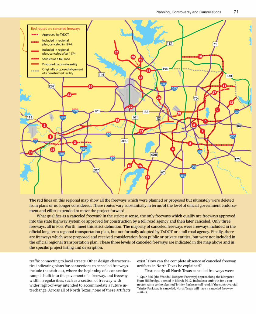
The red lines on this regional map show all the freeways which were planned or proposed but ultimately were deleted from plans or no longer considered. These routes vary substantially in terms of the level of official government endorse-ment and effort expended to move the project forward.
What qualifies as a canceled freeway? In the strictest sense, the only freeways which qualify are freeways approved into the state highway system or approved for construction by a toll road agency and then later canceled. Only three freeways, all in Fort Worth, meet this strict definition. The majority of canceled freeways were freeways included in the official long-term regional transportation plan, but not formally adopted by TxDOT or a toll road agency. Finally, there are freeways which were proposed and received consideration from public or private entities, but were not included in the official regional transportation plan. These three levels of canceled freeways are indicated in the map above and in the specific project listing and description.
1 2
635
20 175
80
67
360
75
183
28720
30
1 2 1820
30
35W 1 6 1
1 2 1
190
45
35E
30
1 1 4
35E
635
35W
75
820
408
190
1 99
287
Approved by TxDOT
Included in regionalplan, canceled in 1974
Included in regionalplan, canceled after 1974
Studied as a toll road
Proposed by private entity
Originally proposed alignmentof a constructed facility
1
2
3
6
45
7
8
9
10
11
12
13
15
1616
17
18
18
19
21
22
23
20
14
24
28
Red routes are canceled freeways
25
2627
traffic connecting to local streets. Other design characteris-tics indicating plans for connections to canceled freeways include the stub-out, where the beginning of a connection ramp is built into the pavement of a freeway, and freeway width irregularities, such as a section of freeway with wider right-of-way intended to accommodate a future in-terchange. Across all of North Texas, none of these artifacts
exist.* How can the complete absence of canceled freeway artifacts in North Texas be explained?
First, nearly all North Texas canceled freeways were * Spur 366 (the Woodall Rodgers Freeway) approaching the Margaret Hunt Hill bridge, opened in March 2012, includes a stub-out for a con-nector ramp to the planned Trinity Parkway toll road. If the controversial Trinity Parkway is canceled, North Texas will have a canceled freeway artifact.

Dallas-Fort Worth Freeways Chapter 272
Freeways Adopted Into the State Highway System by TxDOTThese freeways meet the strictest definition of a canceled freeway
Item Name or Route Number
First Proposed Canceled Effort Expended
Notes
1 SH 121 downtown Fort Worth
1958 by City of Fort Worth; first included in the official regional plan in 1967
2000 Very High This section of SH 121 would have completed the loop around downtown Fort Worth. This canceled freeway received far more political and administrative effort than any other can-celed freeway in North Texas. For the complete story, see page 513.
2 SH 199 inside Loop 820, Fort Worth; shown as the North-west Freeway in plans
1967 Regional Plan 2000 Low This section of SH 199 would have connected into the canceled section of SH 121 around downtown Fort Worth and was canceled at the same time as the downtown section of SH 121. Effort to build this section was minimal.
3 Fort Worth South East-West Freeway, also called the Rose-dale Avenue Freeway
East section was part of a 1955 compromise to appease east Fort Worth residents upset over the DFW Turnpike; route was included in the 1967 regional plan
1974 Low There appears to have been minimal effort to actually construct this freeway, especially after the Fort Worth section of the Dallas-Fort Worth Turnpike was made toll-free in 1964. TxDOT was quick to abandon this freeway in 1974.
Freeways Proposed in the 1967 Regional Transportation Plan and Canceled in 1974Nearly all of these freeways crossed through urbanized areas and were infeasible both politically and financially by the early 1970s. Other than being included in the 1967 and 1971 regional plans, there appears to have been negligible progress toward construction of these freeways.
4 Oak Cliff North-South Freeway
1967 Regional Plan 1974 Very Low
5 Oak Cliff East-West Freeway
6 North Dallas East-West Freeway
Two alternate alignments were shown in the 1967 plan; the 1971 plan showed the recom-mended alignment.
7 East Dallas North-South Freeway
This freeway was intended to provide relief to Central Expressway. At the time it was proposed, it was easier to build a new freeway through residential areas than to expand Cen-tral Expressway.
8 Woodall Rodgers Freeway (Spur 366) east extension
9 Garland North-South Freeway
10 Plano Loop This alignment is close to present-day SH 190/Bush Turnpike but was further distanced from the originally planned alignment of Loop 9
11,12
Connectors from IH 635 to Loop 9
13 River Freeway to IH 30 connector
14 Fort Worth South East-West Freeway27
It is unclear if this section of the South East-West Freeway was adopted in to the state highway system.
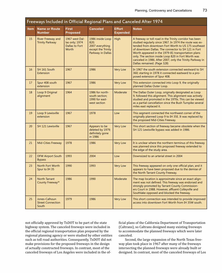
Planning, Controversy and Cancellations 73
Freeways Included in Official Regional Plans and Canceled After 1974Item Name or Route
NumberFirst Proposed
Canceled Effort Expended
Notes
15 River Freeway and Trinity Parkway
1967 west Dal-las only; 1974 Dallas to Fort Worth
1986 inside Loop 820;2007 everything except the Trinity Parkway in Dallas
High A freeway or toll road in the Trinity corridor has been studied regularly since 1967. In 1974 the route was ex-tended from downtown Fort Worth to US 175 southeast of downtown Dallas. The connector to SH 121 in Fort Worth appeared in the 1979-81 transportation plans only. The section inside Loop 820 in Fort Worth was canceled in 1986. After 2007, only the Trinity Parkway in Dallas remained. (Page 328)
16 SH 161 South Extension
1967 1986 Very Low In 1967 the south extension connected westward to SH 360; starting in 1978 it connected eastward to a pro-posed extension of Spur 408.
17 Spur 408 south extension
1967 1986 Very Low This extension connected into Loop 9, the originally planned Dallas Outer Loop.
18 Loop 9 Original alignment
1964 1986 for north-south section; 1990 for east-west section
Moderate The Dallas Outer Loop, originally designated as Loop 9, followed this alignment. This alignment was actively studied and promoted in the 1970s. This can be viewed as a partial cancellation since the Bush Turnpike several miles east replaced it.
19 Loop 9 Lewisville extension
1967 1978 Low This segment connected the northwest corner of the originally planned Loop 9 to IH 35E. It was replaced by the proposed Mid-Cities Freeway.
20 SH 121 Lewisville 1967 Appears to be deleted by 1979; definitely gone in 1986
Very Low This short section of freeway became obsolete when the SH 121 Lewisville bypass was added in 1986.
21 Mid-Cities Freeway 1978 1986 Very Low It is unclear where the northern terminus of this freeway was planned since this proposed freeway extended to the edge of the study area.
22 DFW Airport South Bypass
1993 2004 Low Downsized to an arterial street in 2004
23 North Fort Worth Spur to IH 35
1990 1993 Very Low This freeway appeared on only one official plan, and it appears to have been proposed due to the demise of the North Tarrant County Freeway.
24 North Tarrant County Freeway28
1986 1990 Moderate The map location is approximate since an exact align-ment was not defined. This freeway was endorsed and strongly promoted by Tarrant County Commission-ers Court in 1988. However, affluent Colleyville and Southlake opposed and blocked the freeway.
25 Jones-Calhoun Street Connection South
1979 1986 Very Low This short connection was intended to provide improved access into downtown Fort Worth from IH 35W south.
not officially approved by TxDOT to be part of the state highway system. The canceled freeways were included in the official regional transportation plan prepared by the regional planning agency or were studied by other entities such as toll road authorities. Consequently, TxDOT did not make provisions for the proposed freeways in the design of actually constructed freeways. In contrast, most of the canceled freeways of Los Angeles were included in the of-
ficial plans of the California Department of Transportation (Caltrans), so Caltrans designed many existing freeways to accommodate the planned freeways which were later canceled.
Second, the large expansion of the North Texas free-way plan took place in 1967 after many of the freeways intersecting the planned freeways were already built or designed. In contrast, most of the canceled freeways of Los
Dallas-Fort Worth Freeways Chapter 274
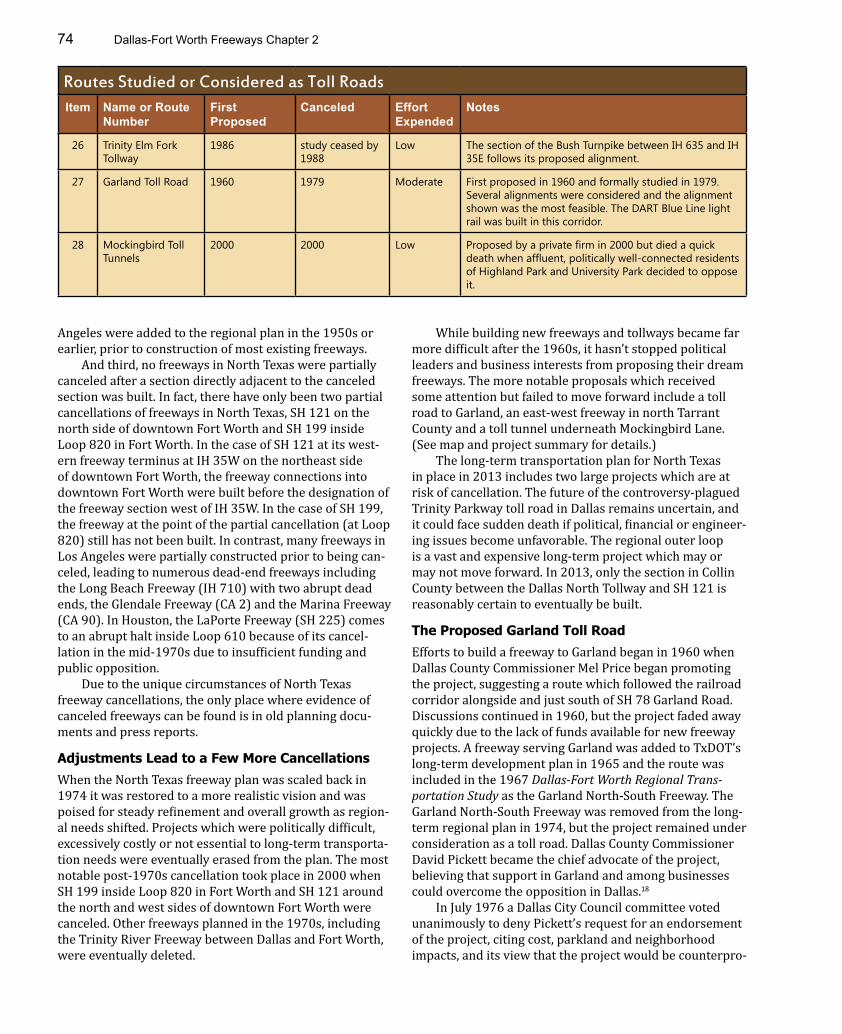
Routes Studied or Considered as Toll RoadsItem Name or Route
NumberFirst Proposed
Canceled Effort Expended
Notes
26 Trinity Elm Fork Tollway
1986 study ceased by 1988
Low The section of the Bush Turnpike between IH 635 and IH 35E follows its proposed alignment.
27 Garland Toll Road 1960 1979 Moderate First proposed in 1960 and formally studied in 1979. Several alignments were considered and the alignment shown was the most feasible. The DART Blue Line light rail was built in this corridor.
28 Mockingbird Toll Tunnels
2000 2000 Low Proposed by a private firm in 2000 but died a quick death when affluent, politically well-connected residents of Highland Park and University Park decided to oppose it.
Angeles were added to the regional plan in the 1950s or earlier, prior to construction of most existing freeways.
And third, no freeways in North Texas were partially canceled after a section directly adjacent to the canceled section was built. In fact, there have only been two partial cancellations of freeways in North Texas, SH 121 on the north side of downtown Fort Worth and SH 199 inside Loop 820 in Fort Worth. In the case of SH 121 at its west-ern freeway terminus at IH 35W on the northeast side of downtown Fort Worth, the freeway connections into downtown Fort Worth were built before the designation of the freeway section west of IH 35W. In the case of SH 199, the freeway at the point of the partial cancellation (at Loop 820) still has not been built. In contrast, many freeways in Los Angeles were partially constructed prior to being can-celed, leading to numerous dead-end freeways including the Long Beach Freeway (IH 710) with two abrupt dead ends, the Glendale Freeway (CA 2) and the Marina Freeway (CA 90). In Houston, the LaPorte Freeway (SH 225) comes to an abrupt halt inside Loop 610 because of its cancel-lation in the mid-1970s due to insufficient funding and public opposition.
Due to the unique circumstances of North Texas freeway cancellations, the only place where evidence of canceled freeways can be found is in old planning docu-ments and press reports.
Adjustments Lead to a Few More CancellationsWhen the North Texas freeway plan was scaled back in 1974 it was restored to a more realistic vision and was poised for steady refinement and overall growth as region-al needs shifted. Projects which were politically difficult, excessively costly or not essential to long-term transporta-tion needs were eventually erased from the plan. The most notable post-1970s cancellation took place in 2000 when SH 199 inside Loop 820 in Fort Worth and SH 121 around the north and west sides of downtown Fort Worth were canceled. Other freeways planned in the 1970s, including the Trinity River Freeway between Dallas and Fort Worth, were eventually deleted.
While building new freeways and tollways became far more difficult after the 1960s, it hasn’t stopped political leaders and business interests from proposing their dream freeways. The more notable proposals which received some attention but failed to move forward include a toll road to Garland, an east-west freeway in north Tarrant County and a toll tunnel underneath Mockingbird Lane. (See map and project summary for details.)
The long-term transportation plan for North Texas in place in 2013 includes two large projects which are at risk of cancellation. The future of the controversy-plagued Trinity Parkway toll road in Dallas remains uncertain, and it could face sudden death if political, financial or engineer-ing issues become unfavorable. The regional outer loop is a vast and expensive long-term project which may or may not move forward. In 2013, only the section in Collin County between the Dallas North Tollway and SH 121 is reasonably certain to eventually be built.
The Proposed Garland Toll RoadEfforts to build a freeway to Garland began in 1960 when Dallas County Commissioner Mel Price began promoting the project, suggesting a route which followed the railroad corridor alongside and just south of SH 78 Garland Road. Discussions continued in 1960, but the project faded away quickly due to the lack of funds available for new freeway projects. A freeway serving Garland was added to TxDOT’s long-term development plan in 1965 and the route was included in the 1967 Dallas-Fort Worth Regional Trans-portation Study as the Garland North-South Freeway. The Garland North-South Freeway was removed from the long-term regional plan in 1974, but the project remained under consideration as a toll road. Dallas County Commissioner David Pickett became the chief advocate of the project, believing that support in Garland and among businesses could overcome the opposition in Dallas.18
In July 1976 a Dallas City Council committee voted unanimously to deny Pickett’s request for an endorsement of the project, citing cost, parkland and neighborhood impacts, and its view that the project would be counterpro-

Planning, Controversy and Cancellations 75
CitationsDMN=Dallas Morning News; DTH=Dallas Times Herald; FWST=Fort Worth Star-Telegram1. “State about ready to negotiate for two su-per highways through city” FWST, 194508172. “Dallas to become one hub of extensive federal road system” DMN, 19430113; “First interregional highways promised for Dallas area” DMN, 19440428; America’s Highways, 1776-1976, A History of the Federal-Aid Pro-gram, U.S. Department of Transportation, 1976, page 1523. “Highway trip: a lesson for leaders” Dal-las, March 1952; LA Freeway, an Appreciative Essay, David Brodsly, 19814. “Dallas area road plans given OK” DMN, 195301305. General location of national system of inter-state highways, including all additional routes at urban areas designated in September 1955, U.S. Bureau of Public Roads, 1955; “Tomor-row’s Dallas” DMN, 195707026. “‘Dream’ freeway plan to serve city un-veiled” FWST, 195507077. “Loop to encircle airport” DMN, 19670917; “Jetport arteries sought” DTH, 19680116; “Sharing in costs of roads urged” DMN, 19680117; “Grapevine as hub” DMN, 197003198. “Freeway plan includes two new routes” DMN, 197406179. “Officials want more toll roads” DMN, 19910826; “Not-so-freeway toll lanes called best way to give drivers elbow room” DMN, 19910912; “Tollway strategy–county takeover will improve options” DMN, 19921022; “Turn-pike panel clears way for county to run toll-
way, bridge” DMN, 19921211; “Leaders want 190 toll road–plan could open loop decade ahead of schedule” DMN, 1994060310. “North Texas toll authority considered” DMN, 19960413; “Tollway funds take different route today” DMN, 1997090111. Mobility 2035, North Central Texas Coun-cil of Governments, March 201112. “Council told expressway extravagant” FWST, 19451031; “Property owners protest route of expressway” FWST, 19451010; “Woodward explains expressway, says 369 feet is minimum width” FWST, 1946010813. “Routing of expressway protested in Oak Cliff” DMN, 19530930; “Freeway-toll road fight ends with council action” FWST, 19550127; “East side to ask freeway plan rejection” FWST, 19550726; “Freeway-toll road battle appears near settlement” FWST, 1955012514. “Richardson citizens protest proposed route for Loop 9” DMN, 19700423; “Route 45 elevation draws south Dallas group’s wrath” DMN, 19700812; “Council asks for another road hearing” DMN, 19700818; “Spence area fights road” DMN, 19700824; “IH 45 battle tied city together” DMN, 1970092515. “Freeway plan includes two new routes” DMN, 1974061716. “East-west freeway eliminated by DPS” DMN, 1974111717. Los Angeles Times, 1975091418. “Northeastern freeway to downtown called need” DTH, 19600626; “Area urged to push for expressway” DMN, 19600709; Dal-las-Fort Worth Regional Transportation Study,
Study Office Staff Texas Highway Department, July 1967; “Pickett foresees toll road support” DTH, 1976061119. “Council panel rejects NE Dallas tollway” DTH, 19760709; “Planner: more harm than help in NE tollway” DTH, 19760609; “NE tollroad idea rejected by committee” DMN, 1976070920. “Turnpike authority seeks study of tollway extension” DTH, 19790130; “Study on Garland tollway projected for July finish” DMN, 19790503; “Rough ride possible for toll road” Dallas Downtown News, 19791029; Initial Feasibility Assessment Dallas Tollways, prepared for Texas Turnpike Authority by Wilbur Smith and Associates, New Haven, Connecticut, October 197921. “Highway trip: a lesson for leaders” Dal-las, March 1952; “Dallas party to study traffic in Los Angeles” DMN, 1952022422. PA76-1-1780-123. “Honoring Dallas’ man with the plan” DMN, 20030614; “Marvin Springer, icon of urban planning helped to shape the city” DMN, 2009020724. “County road program gets 6-to-1 major-ity” DMN, 1957110625. “‘Dream’ freeway plan to serve city un-veiled” FWST, 1955070726. 1978 Transportation Program for North Central Texas27. “East-west freeway eliminated by DPS” DMN, 1974111728. “Step taken for freeway in Tarrant” FWST, 19881025; “Loop 820: The road more trav-eled” FWST, 20080706
ductive to inner-city revitalization efforts.19
Pickett continued efforts to advance the toll road proj-ect without the support of Dallas, asking the Texas Turn-pike Authority (TTA) to study its feasibility. The City of Dal-las blocked a formal study of the toll road for the next two years, but then allowed it to move forward and the TTA began a study in January 1979. In October 1979 the study concluded that the most feasible alignment for the toll road started near the intersection of Central Expressway and Mockingbird, following the MKT railroad corridor to
Garland. This railroad corridor later became the DART Blue Line light rail to Garland. The toll road faced a broad spec-trum of difficulties. In addition to the lack of support from Dallas, there was controversy over which alignment was best, uncertain financial feasibility as a standalone project, expected strong opposition from neighborhoods, no politi-cally powerful advocate for the project and complications for any alignment terminating at Central Expressway. The Garland Tollway was doomed, and after 1979 it was dead, never to be considered or discussed again.20