pitney bowes software geocoding: capabilities and...
TRANSCRIPT

1
Pitney Bowes Software Geocoding:Capabilities and Roadmap
� Berk Charlton – Global Director of Geocoding Product Management
� Kevin Cartin – Managing Director of Geocoding Engineering
2
Overview
� Looking Back
� A Brief History of Geocoding
� 2007 – Quite a year
� Releases
� What’s going on now?
� Geocoding Integration
� Current Development
� Crystal Ball
� US Roadmap
� International Roadmap
3
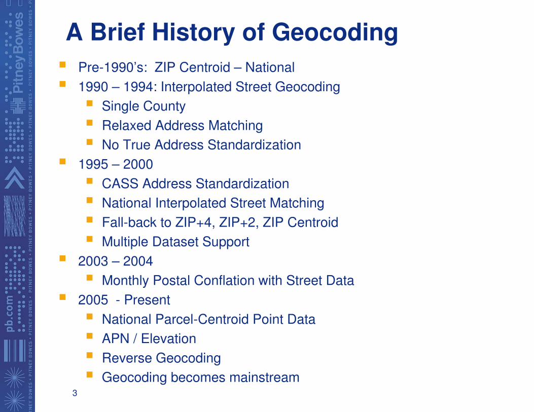
A Brief History of Geocoding
� Pre-1990’s: ZIP Centroid – National
� 1990 – 1994: Interpolated Street Geocoding
� Single County
� Relaxed Address Matching
� No True Address Standardization
� 1995 – 2000
� CASS Address Standardization
� National Interpolated Street Matching
� Fall-back to ZIP+4, ZIP+2, ZIP Centroid
� Multiple Dataset Support
� 2003 – 2004
� Monthly Postal Conflation with Street Data
� 2005 - Present
� National Parcel-Centroid Point Data
� APN / Elevation
� Reverse Geocoding
� Geocoding becomes mainstream
4
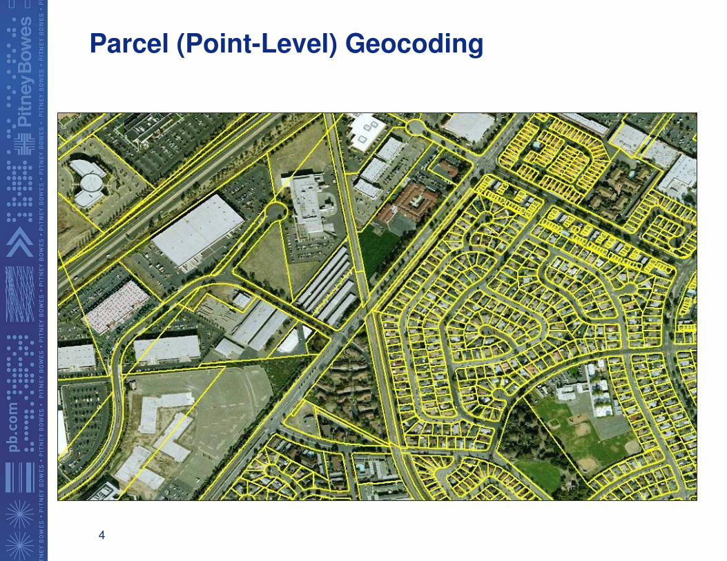
Parcel (Point-Level) Geocoding
5
2007 – An Extraordinary Year
� April: Pitney Bowes Acquires MapInfo
� May: Pitney Bowes Acquires Cadastra
� June: Decision to Integrate MM and GeoStan U.S. Geocoders
� July: Boulder Geocoding Team Moved Under MapInfo
� August: Geocoding Integration Begins – Target April 2009
� September: Group 1 and MapInfo Merge Operations to Create
Pitney Bowes Software
� September: World-Wide Geocoding Engineering
Consolidated under Kevin Cartin
� November: Initial Release of Centrus Points and Parcels with
70 Million Parcels
� December: World-Wide Geocoding Product Management
Consolidated under Berk Charlton
6
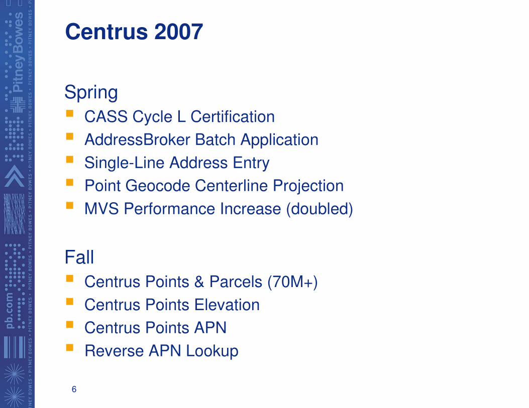
Centrus 2007
Spring
� CASS Cycle L Certification
� AddressBroker Batch Application
� Single-Line Address Entry
� Point Geocode Centerline Projection
� MVS Performance Increase (doubled)
Fall
� Centrus Points & Parcels (70M+)
� Centrus Points Elevation
� Centrus Points APN
� Reverse APN Lookup
7
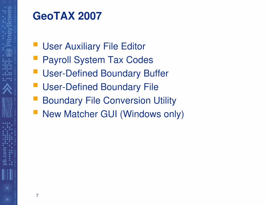
GeoTAX 2007
� User Auxiliary File Editor
� Payroll System Tax Codes
� User-Defined Boundary Buffer
� User-Defined Boundary File
� Boundary File Conversion Utility
� New Matcher GUI (Windows only)
8
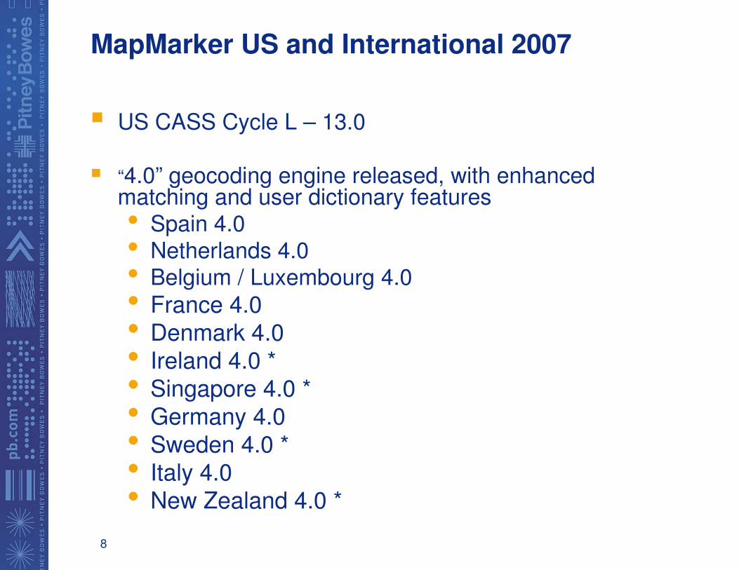
MapMarker US and International 2007
� US CASS Cycle L – 13.0
� “4.0” geocoding engine released, with enhanced matching and user dictionary features• Spain 4.0
• Netherlands 4.0• Belgium / Luxembourg 4.0
• France 4.0
• Denmark 4.0
• Ireland 4.0 *
• Singapore 4.0 *
• Germany 4.0
• Sweden 4.0 *
• Italy 4.0
• New Zealand 4.0 *
9
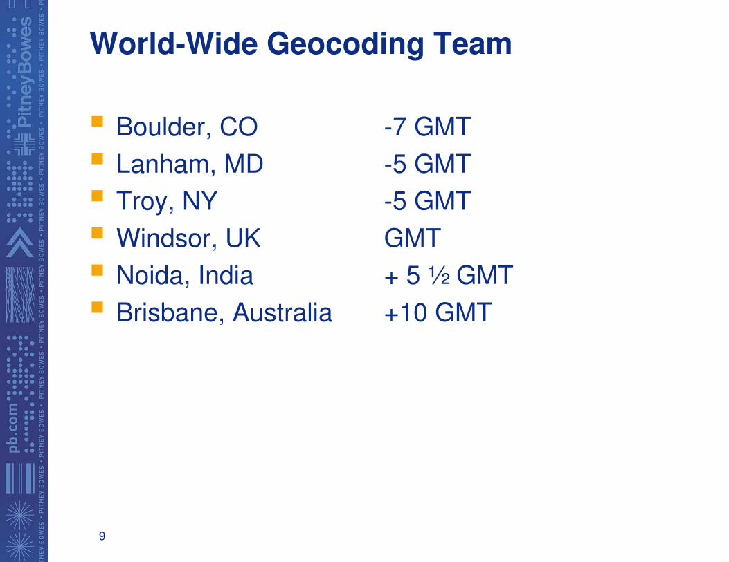
World-Wide Geocoding Team
� Boulder, CO -7 GMT
� Lanham, MD -5 GMT
� Troy, NY -5 GMT
� Windsor, UK GMT
� Noida, India + 5 ½ GMT
� Brisbane, Australia +10 GMT

10
Around the World in 12 Days!
11
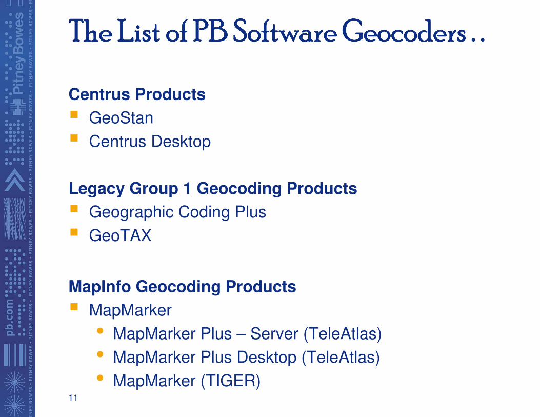
The List of PB Software The List of PB Software The List of PB Software The List of PB Software GeocodersGeocodersGeocodersGeocoders . .. .. .. .
Centrus Products
� GeoStan
� Centrus Desktop
Legacy Group 1 Geocoding Products
� Geographic Coding Plus
� GeoTAX
MapInfo Geocoding Products
� MapMarker
• MapMarker Plus – Server (TeleAtlas)
• MapMarker Plus Desktop (TeleAtlas)
• MapMarker (TIGER)
12
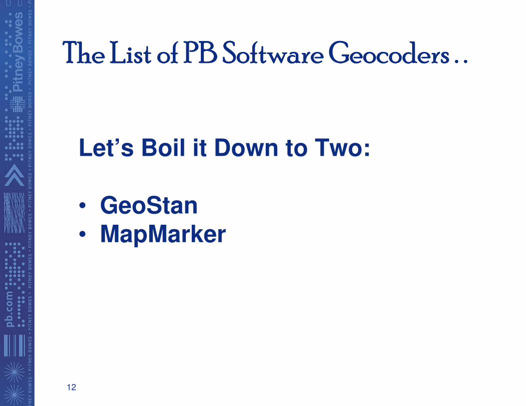
The List of PB Software The List of PB Software The List of PB Software The List of PB Software GeocodersGeocodersGeocodersGeocoders . . . . . . . .
Let’s Boil it Down to Two:
• GeoStan• MapMarker
13
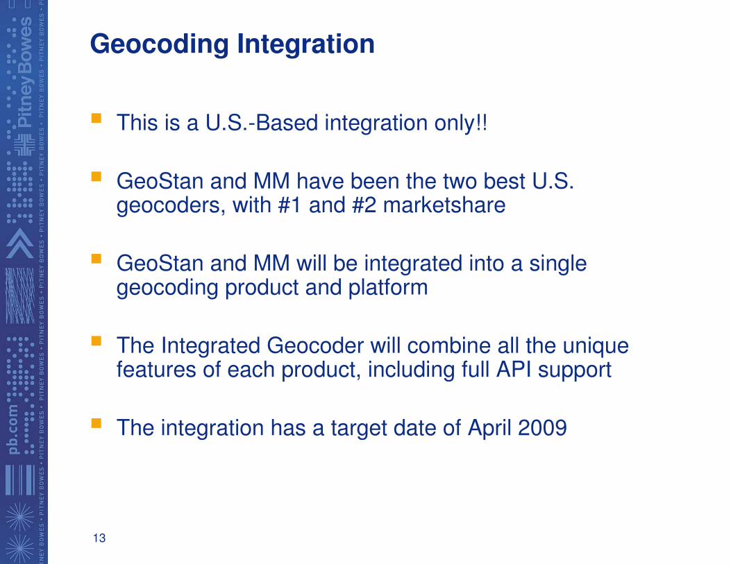
Geocoding Integration
� This is a U.S.-Based integration only!!
� GeoStan and MM have been the two best U.S. geocoders, with #1 and #2 marketshare
� GeoStan and MM will be integrated into a single geocoding product and platform
� The Integrated Geocoder will combine all the unique features of each product, including full API support
� The integration has a target date of April 2009

14
A thought . . .
� “You will either step forward into growth or you will step back into safety”
Abraham Maslow
15
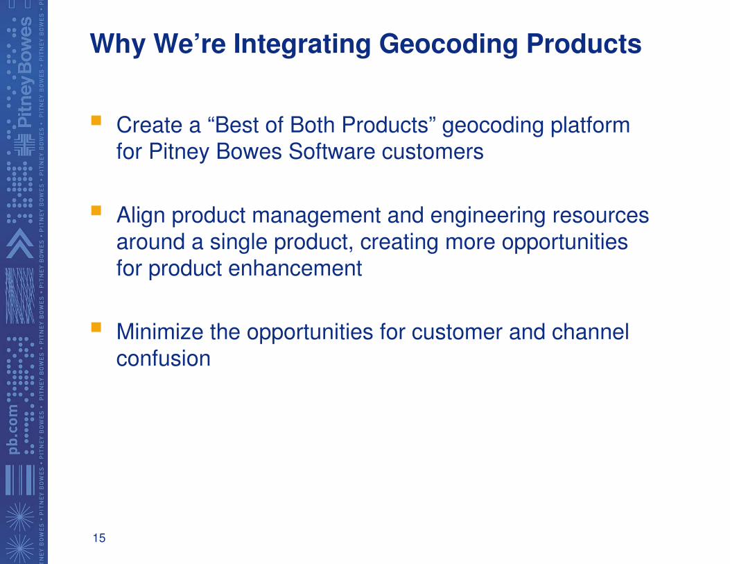
Why We’re Integrating Geocoding Products
� Create a “Best of Both Products” geocoding platform for Pitney Bowes Software customers
� Align product management and engineering resources
around a single product, creating more opportunities for product enhancement
� Minimize the opportunities for customer and channel
confusion
16
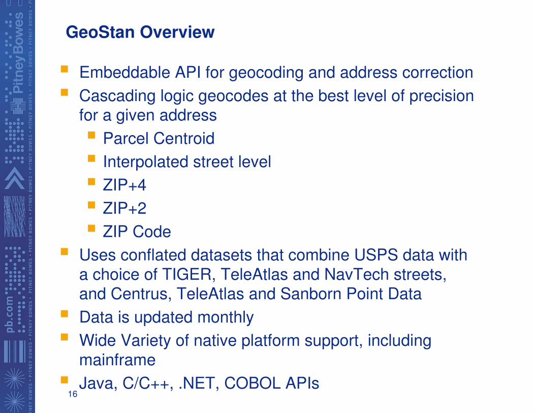
GeoStan Overview
� Embeddable API for geocoding and address correction
� Cascading logic geocodes at the best level of precision for a given address
� Parcel Centroid
� Interpolated street level
� ZIP+4
� ZIP+2
� ZIP Code
� Uses conflated datasets that combine USPS data with
a choice of TIGER, TeleAtlas and NavTech streets, and Centrus, TeleAtlas and Sanborn Point Data
� Data is updated monthly
� Wide Variety of native platform support, including
mainframe
� Java, C/C++, .NET, COBOL APIs
17
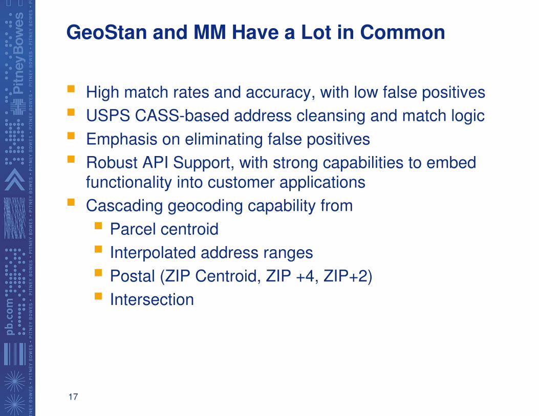
GeoStan and MM Have a Lot in Common
� High match rates and accuracy, with low false positives
� USPS CASS-based address cleansing and match logic
� Emphasis on eliminating false positives
� Robust API Support, with strong capabilities to embed
functionality into customer applications
� Cascading geocoding capability from
� Parcel centroid
� Interpolated address ranges
� Postal (ZIP Centroid, ZIP +4, ZIP+2)
� Intersection
18
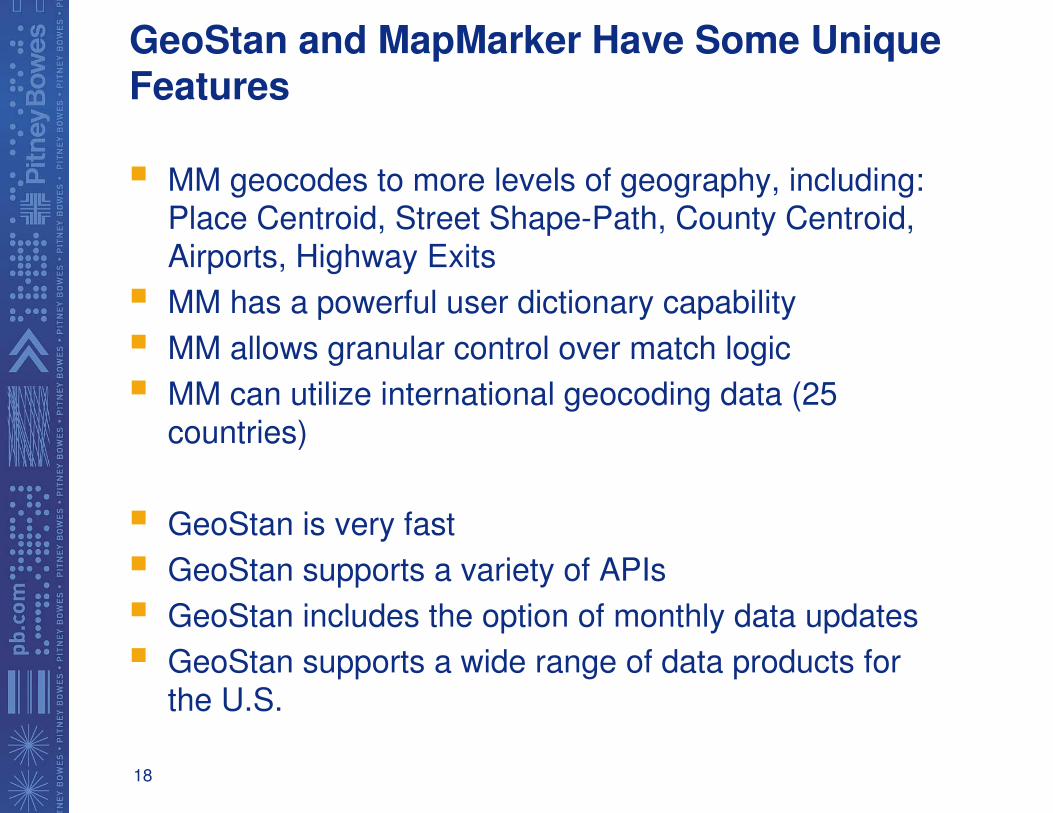
GeoStan and MapMarker Have Some Unique Features
� MM geocodes to more levels of geography, including: Place Centroid, Street Shape-Path, County Centroid,
Airports, Highway Exits
� MM has a powerful user dictionary capability
� MM allows granular control over match logic
� MM can utilize international geocoding data (25
countries)
� GeoStan is very fast
� GeoStan supports a variety of APIs
� GeoStan includes the option of monthly data updates
� GeoStan supports a wide range of data products for
the U.S.
19
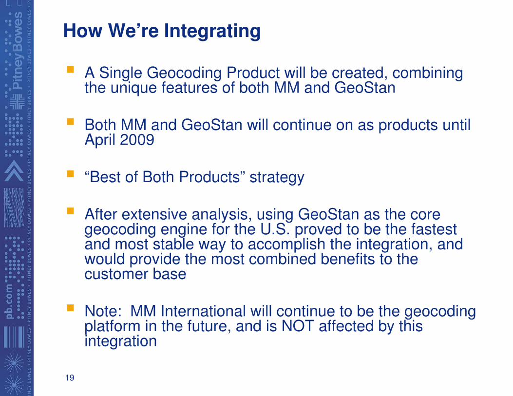
How We’re Integrating
� A Single Geocoding Product will be created, combining the unique features of both MM and GeoStan
� Both MM and GeoStan will continue on as products until April 2009
� “Best of Both Products” strategy
� After extensive analysis, using GeoStan as the core geocoding engine for the U.S. proved to be the fastest and most stable way to accomplish the integration, and would provide the most combined benefits to the customer base
� Note: MM International will continue to be the geocoding platform in the future, and is NOT affected by this integration
20
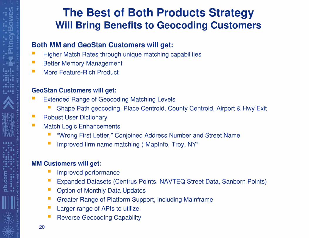
The Best of Both Products Strategy Will Bring Benefits to Geocoding Customers
Both MM and GeoStan Customers will get:
� Higher Match Rates through unique matching capabilities
� Better Memory Management
� More Feature-Rich Product
GeoStan Customers will get:
� Extended Range of Geocoding Matching Levels
� Shape Path geocoding, Place Centroid, County Centroid, Airport & Hwy Exit
� Robust User Dictionary
� Match Logic Enhancements
� “Wrong First Letter,” Conjoined Address Number and Street Name
� Improved firm name matching (“MapInfo, Troy, NY”
MM Customers will get:
� Improved performance
� Expanded Datasets (Centrus Points, NAVTEQ Street Data, Sanborn Points)
� Option of Monthly Data Updates
� Greater Range of Platform Support, including Mainframe
� Larger range of APIs to utilize
� Reverse Geocoding Capability
21
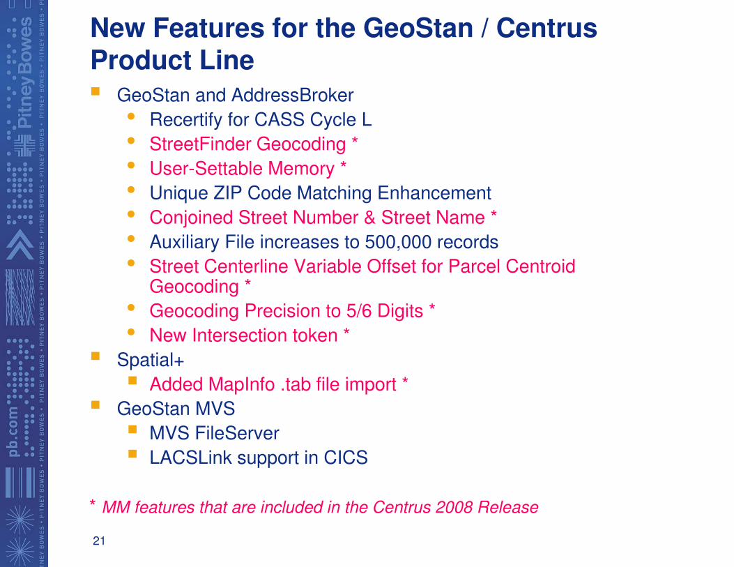
New Features for the GeoStan / Centrus Product Line� GeoStan and AddressBroker
• Recertify for CASS Cycle L
• StreetFinder Geocoding *
• User-Settable Memory *
• Unique ZIP Code Matching Enhancement
• Conjoined Street Number & Street Name *
• Auxiliary File increases to 500,000 records
• Street Centerline Variable Offset for Parcel CentroidGeocoding *
• Geocoding Precision to 5/6 Digits *
• New Intersection token *
� Spatial+
� Added MapInfo .tab file import *
� GeoStan MVS
� MVS FileServer
� LACSLink support in CICS
* MM features that are included in the Centrus 2008 Release
22
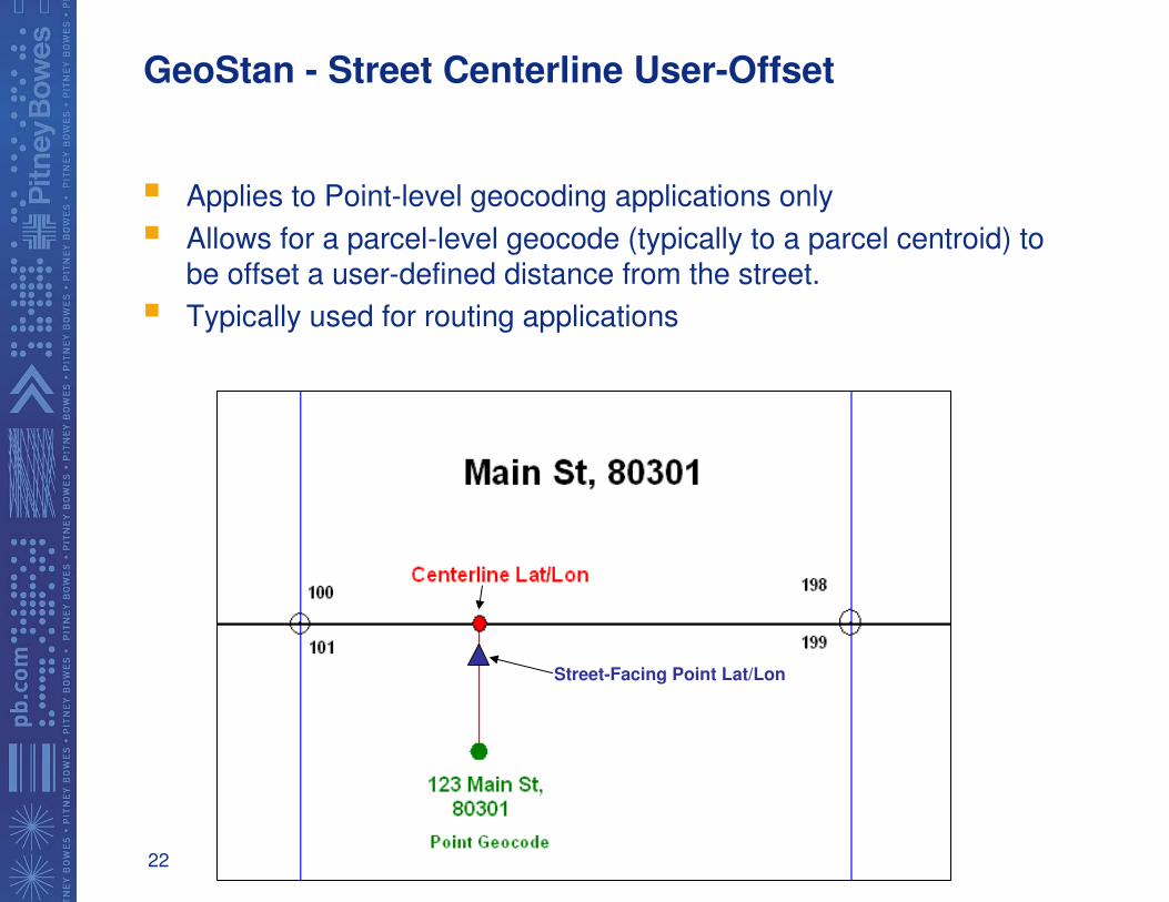
GeoStan - Street Centerline User-Offset
� Applies to Point-level geocoding applications only
� Allows for a parcel-level geocode (typically to a parcel centroid) to be offset a user-defined distance from the street.
� Typically used for routing applications
Street-Facing Point Lat/Lon
23
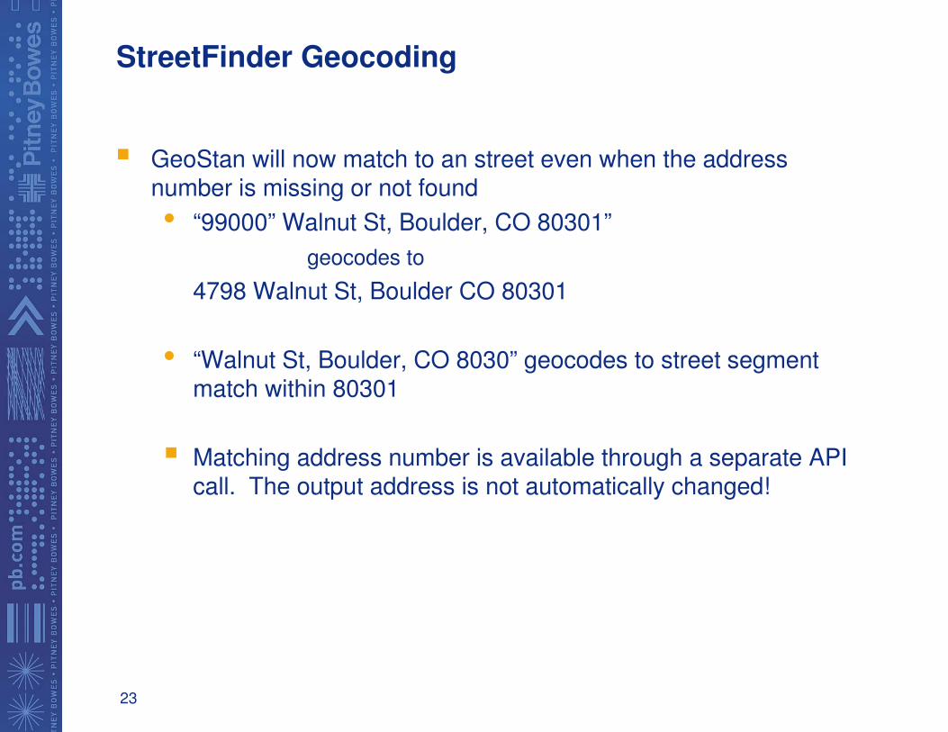
StreetFinder Geocoding
� GeoStan will now match to an street even when the address number is missing or not found
• “99000” Walnut St, Boulder, CO 80301”
geocodes to
4798 Walnut St, Boulder CO 80301
• “Walnut St, Boulder, CO 8030” geocodes to street segment match within 80301
� Matching address number is available through a separate API call. The output address is not automatically changed!
24
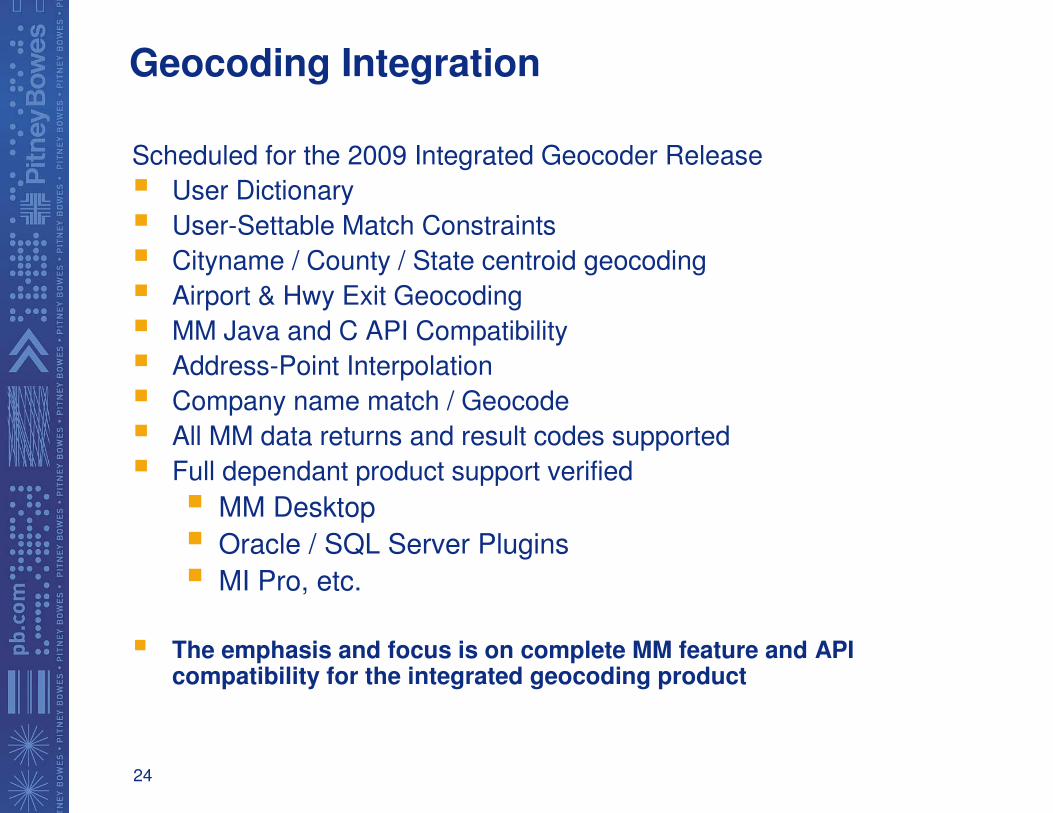
Geocoding Integration
Scheduled for the 2009 Integrated Geocoder Release
� User Dictionary
� User-Settable Match Constraints
� Cityname / County / State centroid geocoding
� Airport & Hwy Exit Geocoding
� MM Java and C API Compatibility
� Address-Point Interpolation
� Company name match / Geocode
� All MM data returns and result codes supported
� Full dependant product support verified
� MM Desktop
� Oracle / SQL Server Plugins
� MI Pro, etc.
� The emphasis and focus is on complete MM feature and API compatibility for the integrated geocoding product
25
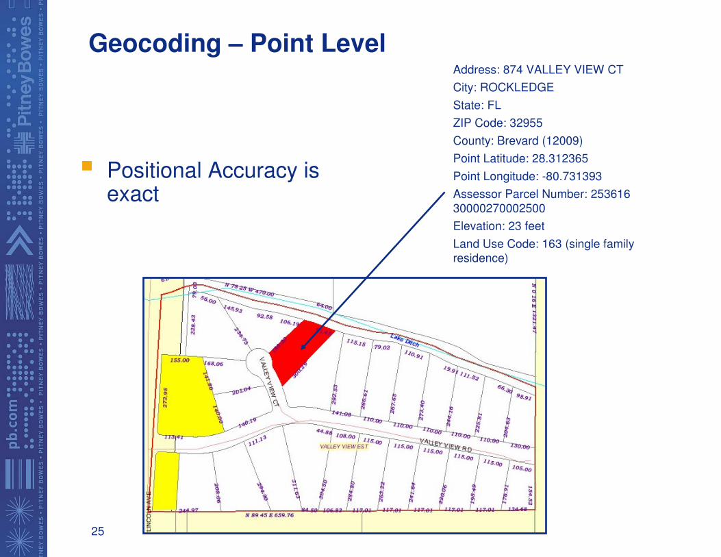
Geocoding – Point Level
� Positional Accuracy is exact
Address: 874 VALLEY VIEW CT
City: ROCKLEDGE
State: FL
ZIP Code: 32955
County: Brevard (12009)
Point Latitude: 28.312365
Point Longitude: -80.731393
Assessor Parcel Number: 253616
30000270002500
Elevation: 23 feet
Land Use Code: 163 (single family
residence)
26
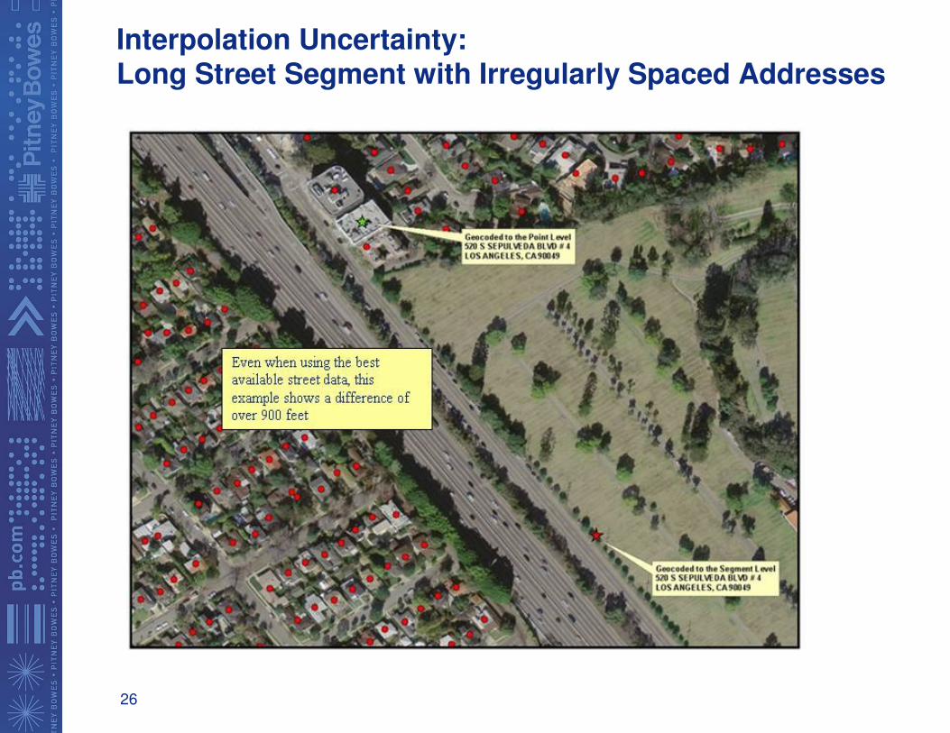
Interpolation Uncertainty:Long Street Segment with Irregularly Spaced Addresses
27
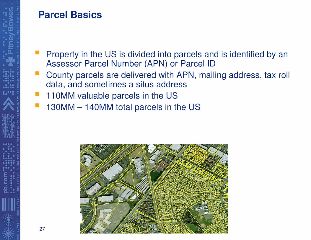
Parcel Basics
� Property in the US is divided into parcels and is identified by an Assessor Parcel Number (APN) or Parcel ID
� County parcels are delivered with APN, mailing address, tax rolldata, and sometimes a situs address
� 110MM valuable parcels in the US
� 130MM – 140MM total parcels in the US
28
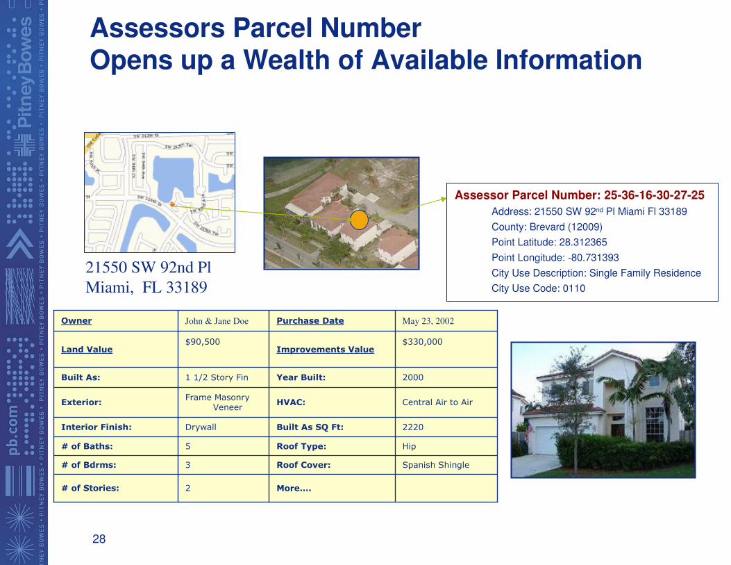
Assessors Parcel Number Opens up a Wealth of Available Information
May 23, 2002Purchase DateJohn & Jane DoeOwner
$330,000Improvements Value
$90,500Land Value
More….2# of Stories:
Spanish ShingleRoof Cover:3# of Bdrms:
HipRoof Type:5# of Baths:
2220Built As SQ Ft:DrywallInterior Finish:
Central Air to AirHVAC:Frame Masonry
VeneerExterior:
2000Year Built:1 1/2 Story FinBuilt As:
Assessor Parcel Number: 25-36-16-30-27-25
Address: 21550 SW 92nd Pl Miami Fl 33189
County: Brevard (12009)
Point Latitude: 28.312365
Point Longitude: -80.731393
City Use Description: Single Family Residence
City Use Code: 0110
21550 SW 92nd Pl
Miami, FL 33189
29
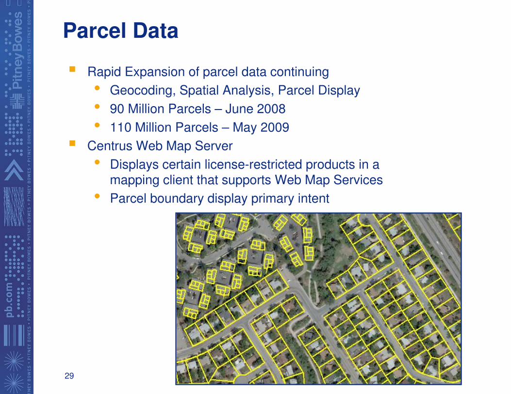
Parcel Data
� Rapid Expansion of parcel data continuing
• Geocoding, Spatial Analysis, Parcel Display
• 90 Million Parcels – June 2008
• 110 Million Parcels – May 2009
� Centrus Web Map Server
• Displays certain license-restricted products in a mapping client that supports Web Map Services
• Parcel boundary display primary intent
30
MapMarker Plus 14.0 US& Canada 9.0
� Project File Open / Save (Desktop)
� Enhanced Point-in Polygon Attribution features (Desktop)
� CASS Recertification (U.S.)
� Enhanced Quick-Find (Desktop)
� Expanded Input File and Output File Support (Desktop)
• .CSV
• Fixed Length
• Shapefile
� Expanded Match Mode Support (Desktop and Server)
• Relaxed Mode
• Close Mode
• Exact Mode
• Close Mode
� DPV Performance Improvements (U.S)
� SERP Match Logic (Canada)
31
International Geocoding – MapMarker International
� 24 Countries Currently Supported with Street Level Geocoding and
address Standardization
� Norway & Austria will in Q2/Q3 will complete coverage of W. Europe
� 5+ new countries under development for release in 2008, including:
� Norway
� Austria
� Brazil
� Thailand
� Malaysia
� Other countries being researched:
� India
� Chile
� Argentina
� Mexico
� China
� Japan
� World Geocoder
� 248 Countries with City-level and Post-code geocoding support
� Enhancements planned for 2008
32
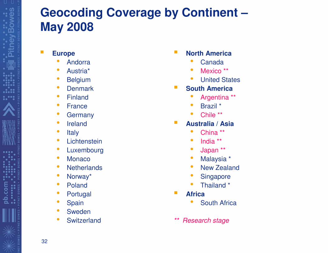
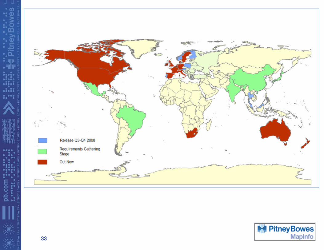
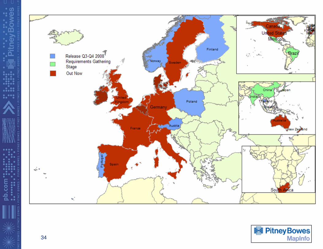
Geocoding Coverage by Continent –May 2008
� Europe
• Andorra
• Austria*
• Belgium
• Denmark
• Finland
• France
• Germany
• Ireland
• Italy
• Lichtenstein
• Luxembourg
• Monaco
• Netherlands
• Norway*
• Poland
• Portugal
• Spain
• Sweden
• Switzerland
� North America
• Canada
• Mexico **
• United States
� South America
• Argentina **
• Brazil *
• Chile **
� Australia / Asia
• China **
• India **
• Japan **
• Malaysia *
• New Zealand
• Singapore
• Thailand *
� Africa
• South Africa
** Research stage
33
34
35
Questions?