phase ii environmental site assessment … ii environmental site assessment wycliffe drive...
TRANSCRIPT
PHASE II
ENVIRONMENTAL SITE ASSESSMENT WYCLIFFE DRIVE (CHATTERTON DR.)
AREA DRAINAGE & PAVING WBS NO.: M-001010-0001-3
HOUSTON, HARRIS COUNTY, TEXAS
PREPARED FOR: CITY OF HOUSTON
DEPARTMENT OF PUBLIC WORKS & ENGINEERING ENGINEERING AND CONSTRUCTION DIVISION
GEO-ENVIRONMENTAL SERVICES BRANCH 611 WALKER STREET, 14 FLOOR
HOUSTON, TEXAS 77002
PREPARED BY: HVJ ASSOCIATES, INC.
HOUSTON, TEXAS FEBRUARY 19, 2016
REPORT NO. HE1516700 KEY MAP GRID 449T
February 19, 2016 Mr. Maher Tanbouz, P.E. Supervising Engineer City of Houston, Public Works & Engineering Department Engineering and Construction Division/Geo-Environmental Services Branch 611 Walker Street, 14th Floor Houston, Texas 77002 Re: Phase II Environmental Site Assessment Report
Wycliffe Drive (Chatterton Dr.) Area Drainage & Paving WBS No.: M-001010-0001-3 Owner: City of Houston
HVJ Project No. HE1516700 Dear Mr. Tanbouz: Presented herein is our Phase II Environmental Site Assessment draft report for the above referenced project. The assessment was performed in general accordance with our Proposal No. HE1517600 dated April 20, 2015 and revised on January 13, 2016); current ASTM Standard Practice E-1903 - 97 (2002) “Standard Guide for Environmental Site Assessments: Phase II Environmental Site Assessment Process” as modified by the City of Houston (COH) Department of Public Works and Engineering Infrastructure Design Manual “Geotechnical and Environmental Requirements” (July 2012). This report presents HVJ Associates' understanding of the project's scope, the methodology we employed in executing the work, and the conclusions we reached subject to the limitations discussed in Section 6 of the report. It has been a pleasure to work with you on this project, and we appreciate the opportunity to be of service.
Sincerely,
HVJ ASSOCIATES, INC. Texas Firm Registration No. F-000646
Edward Hawkinson, PG, MS, MBA Project Manager EH/NL Copies submitted: 2 draft + 1 electronic The following lists the pages which complete this report:
● Main Text – 9 pages ● Appendix B – 4 pages ● Plates – 3 pages ● Appendix C – 14 pages ● Appendix A – 19 pages ● Appendix D – 1 pages
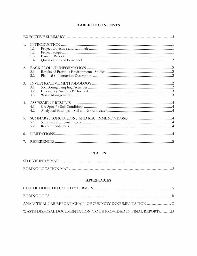
TABLE OF CONTENTS
EXECUTIVE SUMMARY............................................................................................................................... i
1. INTRODUCTION ...................................................................................................................1 1.1 Project Objective and Rationale ......................................................................................1 1.2 Project Scope ..................................................................................................................1 1.3 Basis of Report ...............................................................................................................1 1.4 Qualifications of Personnel .............................................................................................2
2. BACKGROUND INFORMATION ........................................................................................2 2.1 Results of Previous Environmental Studies .....................................................................2 2.2 Planned Construction Description ..................................................................................2
3. INVESTIGATIVE METHODOLOGY ...................................................................................2 3.1 Soil Boring Sampling Activities .......................................................................................2 3.2 Laboratory Analysis Performed .......................................................................................3 3.3 Waste Management .........................................................................................................3
4. ASSESSMENT RESULTS ........................................................................................................4 4.1 Site Specific Soil Conditions ...........................................................................................4 4.2 Analytical Findings – Soil and Groundwater ...................................................................4
5. SUMMARY, CONCLUSIONS AND RECOMMENDATIONS .............................................4 5.1 Summary and Conclusions ..............................................................................................4 5.2 Recommendations ..........................................................................................................4
6. LIMITATIONS .........................................................................................................................4
7. REFERENCES .........................................................................................................................5
PLATES
SITE VICINITY MAP ..................................................................................................................................... 1
BORING LOCATION MAP ......................................................................................................................... 2
APPENDICES
CITY OF HOUSTON FACILITY PERMITS ........................................................................................... A
BORING LOGS .............................................................................................................................................. B
ANALYTICAL LAB REPORT/CHAIN OF CUSTODY DOCUMENTATION ............................ C
WASTE DISPOSAL DOCUMENTATION (TO BE PROVIDED IN FINAL REPORT) ............. D
i
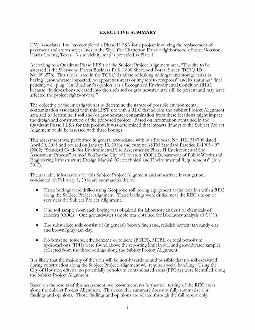
EXECUTIVE SUMMARY
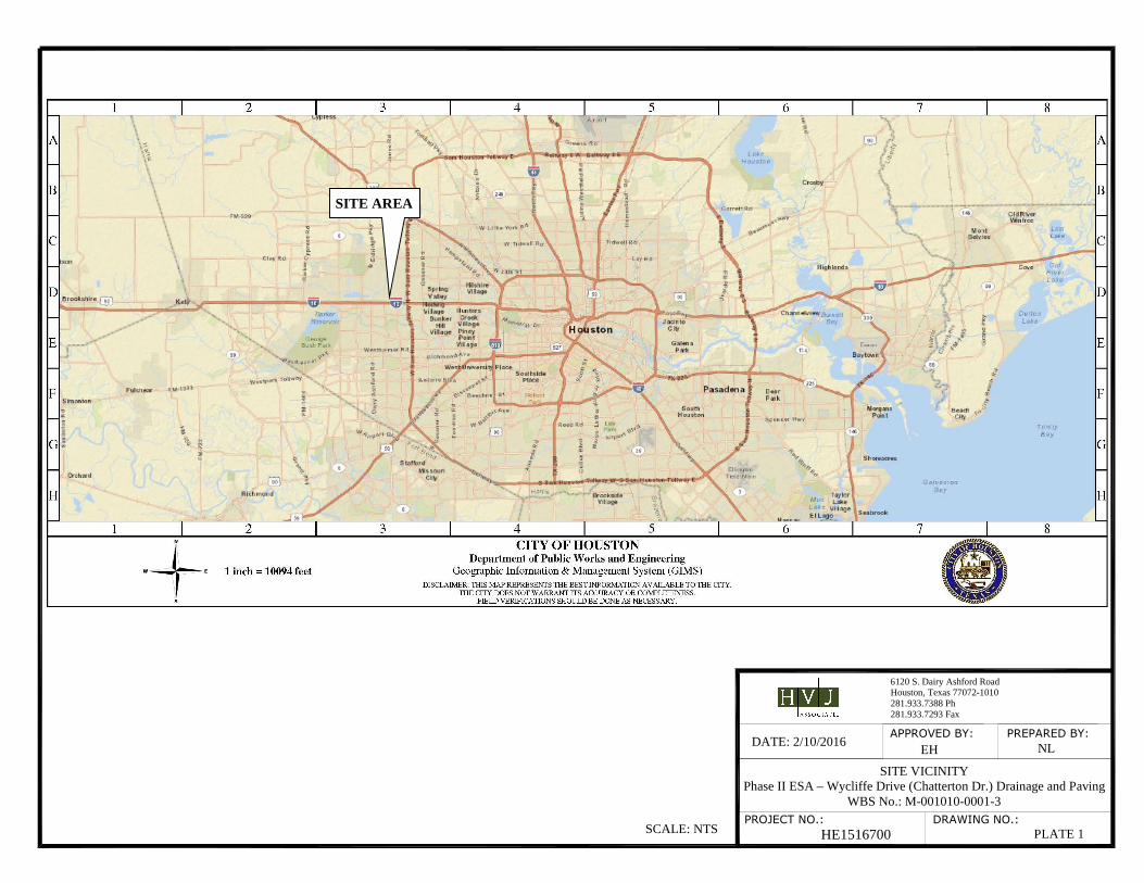
HVJ Associates, Inc. has completed a Phase II ESA for a project involving the replacement of pavement and storm sewer lines in the Wycliffe/Chatterton Drive neighborhood of west Houston, Harris County, Texas. A site vicinity map is provided as Plate 1. According to a Quadrant Phase I ESA of the Subject Project Alignment area, “The site to be assessed is the Sherwood Forest Business Park, 1800 Sherwood Forest Street (TCEQ ID No. 096578). This site is listed in the TCEQ database of leaking underground storage tanks as having “groundwater impacted, no apparent threats or impacts to receptors” and its status as “final pending well plug.” In Quadrant’s opinion it is a Recognized Environmental Condition (REC) because “hydrocarbons released into the site’s soil or groundwater may still be present and may have affected the project rights-of-way.” The objective of the investigation is to determine the nature of possible environmental contamination associated with this LPST site with a REC that adjoins the Subject Project Alignment area and to determine if soil and/or groundwater contamination from these locations might impact the design and construction of the proposed project. Based on information contained in the Quadrant Phase I ESA for this project, it was determined that impacts (if any) to the Subject Project Alignment could be assessed with three borings. This assessment was performed in general accordance with our Proposal No. HE1516700 dated April 20, 2015 and revised on January 13, 2016) and current ASTM Standard Practice E-1903 - 97 (2002) “Standard Guide for Environmental Site Assessments: Phase II Environmental Site Assessment Process” as modified by the City of Houston (COH) Department of Public Works and Engineering Infrastructure Design Manual “Geotechnical and Environmental Requirements” (July 2012).
The available information for this Subject Project Alignment and subsurface investigation, conducted on February 1, 2016 are summarized below:
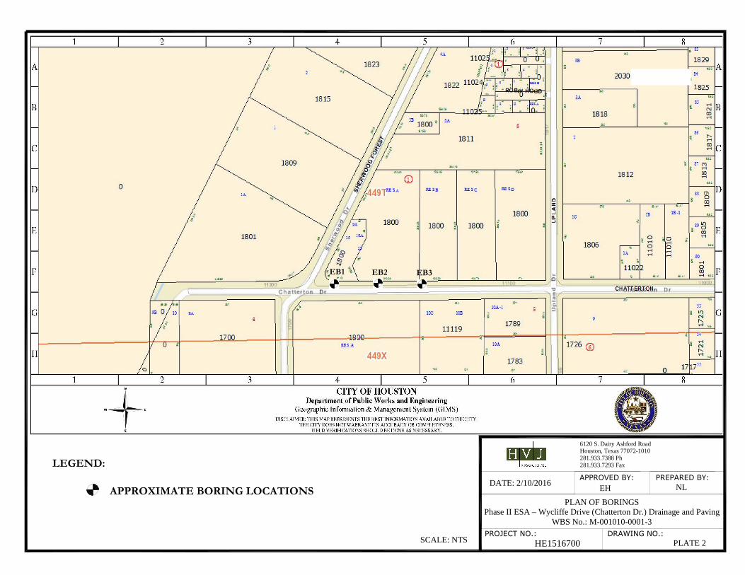
• Three borings were drilled using Geoprobe soil boring equipment at the location with a REC along the Subject Project Alignment. These borings were drilled near the REC site on or very near the Subject Project Alignment.
• One soil sample from each boring was obtained for laboratory analysis of chemicals of concern (COCs). One groundwater sample was obtained for laboratory analysis of COCs.
• The subsurface soils consist of (in general) brown fine sand, reddish brown/tan sandy clay and brown/gray/tan clay.
• No benzene, toluene, ethylbenzene or toluene (BTEX), MTBE or total petroleum hydrocarbons (TPH) were found above the reporting limit in soil and groundwater samples collected from the three borings along the Subject Project Alignment.
It is likely that the majority of the soils will be non-hazardous and possible that no soil excavated during construction along the Subject Project Alignment will require special handling. Using the City of Houston criteria, no potentially petroleum contaminated areas (PPCAs) were identified along the Subject Project Alignment.
Based on the results of this assessment, we recommend no further soil testing of the REC areas along the Subject Project Alignment. This executive summary does not fully summarize our findings and opinions. Those findings and opinions are related through the full report only.
1
1. INTRODUCTION
1.1 Project Objective and Rationale HVJ Associates, Inc. (HVJ Associates) was contracted by the City of Houston to perform a Phase II Environmental Site Assessment (ESA) for a project involving the replacement of pavement and storm sewer lines in the Wycliffe/Chatterton Drive neighborhood of west Houston, Harris County, Texas. A site vicinity map is provided as Plate 1.
The assessment was done in accordance with City of Houston, Department of Public Works and Engineering Infrastructure Design Manual Chapter 11 “Geotechnical and Environmental Requirements” and the current ASTM Standard Practice E-1903 - 97 (2002) “Standard Guide for Environmental Site Assessments: Phase II Environmental Site Assessment Process.” The objective of the assessment was to determine the nature of possible environmental contamination associated with the former LPST site adjoining the Subject Project Alignment. Groundwater was encountered in sufficient quantity for sampling at one boring location. 1.2 Project Scope The following tasks were performed:
1. Prepared a site-specific health and safety plan per 29 CFR 1910.120 (a copy of this document is not attached but is available upon request).
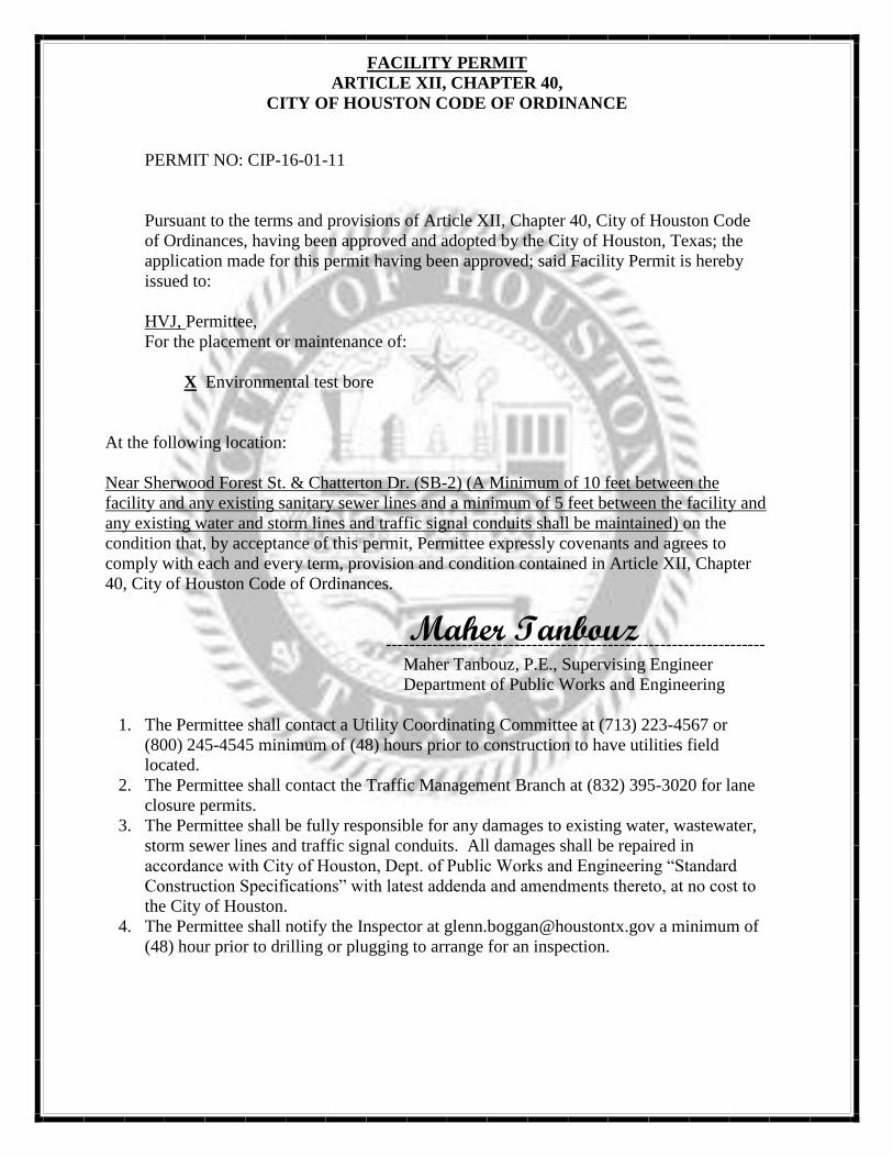
2. Obtained City of Houston facility permits for all boring locations. Copies of these permits and related documents are provided in Appendix A.
3. Installed three borings to approximately five feet below the proposed depth of construction or to the top of the water table. We encountered no auger refusal at any of the boring locations. All borings were installed using Geoprobe equipment.
4. Performed soil sample field screening with an organic vapor meter (OVM) and obtained selected samples for subsequent laboratory analyses.
5. Prepared boring logs (copies of these logs are provided in Appendix B).
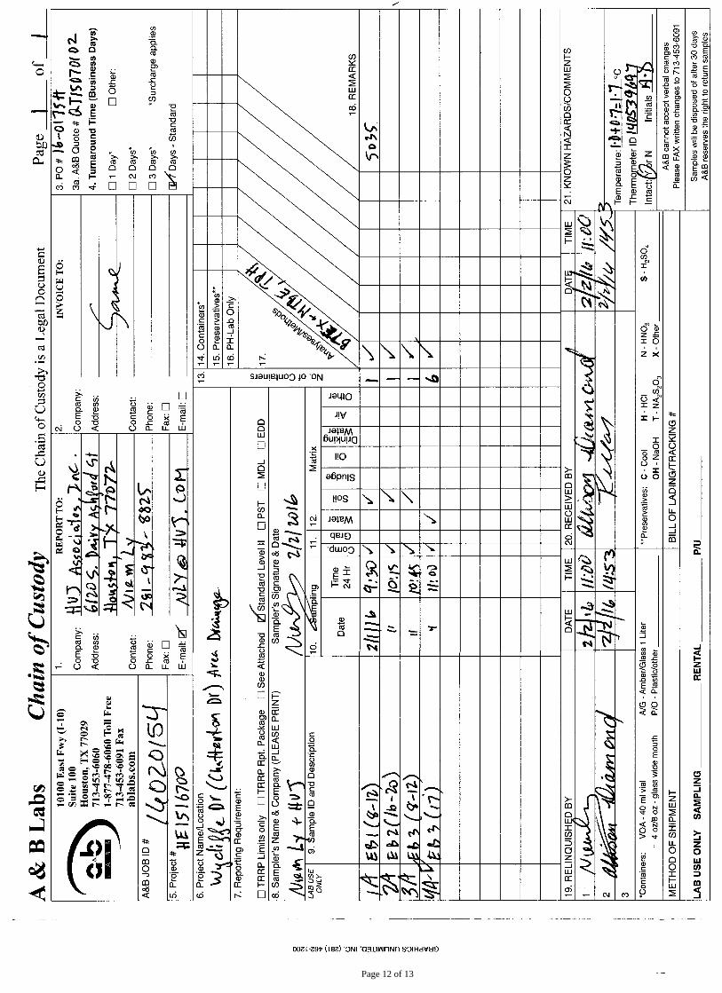
6. Submitted soil samples collected from borings EB1 through EB3 to A&B Laboratory for MTBE, BTEX and TPH analysis. Groundwater was encountered at boring EB3 and one water sample was submitted for MTBE, BTEX and TPH analysis. Laboratory data sheets, QA/QC documentation and chain-of-custody form are provided in Appendix C.
7. Coordinated drilled cuttings and related drummed non-hazardous waste disposal. Waste disposal is currently pending on landfill approval. Waste material will be transported to a state approved landfill upon receipt of this approval. Waste disposal documentation will be provided in Appendix D of the final version of this report.
8. Prepared this report summarizing our findings with conclusions and recommendations.
1.3 Basis of Report Although this assessment has been a reasonably thorough attempt to identify soil and groundwater contamination at the REC location, there is a possibility that contamination may have escaped detection due to the limitations of this assessment, or the presence of undetected and unreported environmental releases. HVJ Associates reserves the right to alter our conclusions and recommendations based on our review of any information obtained after the date of this report.
2
Our professional services have been performed using that degree of care and skill ordinarily exercised, under similar conditions, by environmental consultants practicing in this or similar localities. No warranty, express or implied, is made as to the professional information included in this report.
1.4 Qualifications of Personnel The primary investigator for this Phase II ESA is Mr. Edward Hawkinson, PG. Mr. Hawkinson holds BS and MS degrees in geology from The Ohio State University and the University of Cincinnati respectively. Mr. Hawkinson is a registered Professional Geologist in Arkansas, Tennessee and Texas. His career encompasses a period exceeding 30 years involving environmental investigations, hydrogeology, water resource evaluations and energy exploration.
2. BACKGROUND INFORMATION
2.1 Results of Previous Environmental Studies HVJ Associates environmental personnel reviewed a Quadrant Phase I ESA of the Subject Project Alignment area. In Quadrant’s opinion, “The site to be assessed is the Sherwood Forest Business Park, 1800 Sherwood Forest Street (TCEQ ID No. 096578). This site is listed in the TCEQ database of leaking underground storage tanks as having “groundwater impacted, no apparent threats or impacts to receptors” and its status as “final pending well plug.” Quadrant indicated that the business park location is a REC because “hydrocarbons released into the site’s soil or groundwater may still be present and may have affected the project rights-of-way.” HVJ Associates concluded that there “is a potential for environmental contamination to affect the Subject Project Alignment at the REC location discussed above and recommended further environmental investigation if the proposed project construction activity involves excavation deeper than five feet below the existing grade.” 2.2 Planned Construction Description The project involves the replacement of pavement and storm sewer lines in the Wycliffe/Chatterton Drive neighborhood of west Houston.
3. INVESTIGATIVE METHODOLOGY
3.1 Soil Boring Sampling Activities HVJ Associates performed this Phase II ESA in general accordance with the guidance contained in the American Society for Testing and Materials Designation E 1903-97 (2002), Standard Guide for Environmental Site Assessments: Phase II Environmental Site Assessments (ASTM E 1903) as modified by the City of Houston Public Works and Engineering Infrastructure Design Manual “Geotechnical and Environmental Requirements” (July 2012). Prior to conducting our on-site investigation, City of Houston maps were reviewed to determine the location of water and sewer utilities in the project area. Texas One-Call was contacted to mark other near surface utilities in the Subject Project Alignment area.
Based on HVJ Associates’ understanding of the proposed construction plans, all borings were installed to a total depth of 20 feet below ground surface (bgs). The proposed boring/well depths were based on information provided by the City of Houston. Borings were spaced at regular intervals along the Subject Project Alignment near the REC location. A borings location map is provided as Plate 2. The borings were advanced using direct push (Geoprobe) techniques and were continuously sampled from the surface to the boring total depth bgs. Soil samples were screened for evidence of impacts in the field using an organic vapor meter (OVM). One soil sample was collected from each boring and submitted for laboratory analysis. OVM readings, along with visual evidence of impact and a physical description of the soils, were recorded on a boring log. The soil samples were obtained for laboratory analysis from the zone of the highest OVM readings. If there were no
3
OVM readings (above background), a soil sample was obtained from the top of the water table. If no groundwater was encountered, the soil samples were obtained from the approximate depth of construction. Groundwater was encountered and sampled at one location. Prior to mobilization, a site-specific health and safety plan was prepared in accordance with 29 CFR 1910.120. Prior to drilling and sample screening, all sampling equipment was thoroughly cleaned to prevent cross contamination. All environmental soil borings and temporary groundwater monitoring wells were installed by driller Total Support Services, Inc. using Geoprobe sampling equipment. At each location, the unit collected four-foot long soil cores from the ground surface to the top of the water bearing zone or to predetermined boring depths based on depth of construction information provided by the City of Houston. The soil borings were placed in the best practicable locations, considering the location of utilities and other site-specific conditions. Soil samples obtained were continuously examined for impact using visual and olfactory methods. Samples were also screened for organic vapors with a properly calibrated Organic Vapor Meter (OVM). Descriptions of the materials encountered are presented on the boring logs (Appendix B).
The on-site screening was conducted by cutting a sub-sample from each one-foot interval of core with a decontaminated knife. The soil samples were placed in airtight containers (sealable plastic bags) and held for approximately twenty minutes to allow the volatilization of organic vapors. At the end of this period, the headspace air inside the container was screened with the OVM. This was accomplished by inserting the OVM probe tip into a narrow opening in the plastic bag seal. The headspace reading and corresponding depth was recorded on the boring log. Following OVM screening, one soil sample from each borehole was selected for laboratory analyses (OVM readings are presented on the boring logs). Samples were selected for analysis based on criteria contained in the project proposal. The samples selected were placed into pre-labeled laboratory supplied glass jars, placed on water ice in an insulated cooler and shipped under chain-of-custody to A&B Laboratory for analysis.
A groundwater sample was collected from one inch diameter temporary groundwater monitoring wells using clean disposable bailers from boring EB3. Subsequent to the drilling and sampling activities, each borehole was plugged from total depth to the surface using bentonite plugging material in accordance with standard drilling practice. 3.2 Laboratory Analysis Performed A&B Laboratory performed the following analyses on selected soil and groundwater samples from the environmental borings installed along the Subject Project Alignment as follows:
• TPH using TCEQ TX Method 1005; and • BTEX + MTBE by EPA SW-846 8021B.
Copies of laboratory reports by A&B Laboratory as well as the standard chain-of-custody documentation are included in Appendix C.
3.3 Waste Management Investigation derived wastes (primarily soil cuttings) were generated in a small amounts during this investigation. Approximately five kilograms of soil cuttings were generated per boring. These materials were containerized and transported to HVJ Associates property for temporary storage until the results of the laboratory analyses were received in order to determine disposal requirements. Landfill disposal under Republic Services Non-Hazardous Waste Manifest by an agent of USA Environment is pending landfill review of laboratory analyses. Copies of the Republic Services Special Waste Profile and manifest documents will be provided in Appendix D of the final version of this report.
4
4. ASSESSMENT RESULTS
4.1 Site Specific Soil Conditions The subsurface soils consist of (in general) brown fine sand, reddish brown/tan sandy clay and brown/gray/tan clay. Specific soil descriptions and field observations for the soil borings are included on the boring logs contained in Appendix B. Soil classifications presented on the boring logs are based on visual field classification and have not been verified by geotechnical laboratory tests. Actual soil conditions may differ from those presented on the boring logs.
4.2 Analytical Findings – Soil and Groundwater No BTEX + MTBE or TPH constituents were found at or above the reporting limit for soil and groundwater. Using the City of Houston criteria, no potentially petroleum contaminated areas (PPCAs) were identified along the Subject Project Alignment. The City of Houston Guide Specifications 02105 (03-18-2005) Chemical Sampling and Analysis and 02120 (03-18-2005) Transportation and Disposal for construction defines a PPCA as “an area within station-to-station locations identified on drawings where petroleum contamination has been detected in soil or groundwater.”
5. SUMMARY, CONCLUSIONS AND RECOMMENDATIONS
5.1 Summary and Conclusions The subsurface soils consist of (in general) brown fine sand, reddish brown/tan sandy clay and brown/gray/tan clay. We conclude that no BTEX + MTBE or TPH constituents are present in soil samples collected from borings EB1, EB2 and EB3. We conclude that no BTEX + MTBE or TPH constituents are present in groundwater sample collected from borings EB3. We conclude that no PPCAs are present along the Subject Project Alignment. 5.2 Recommendations Based on a comparison of analytical results detailed in this report and other information, we recommend no further environmental studies adjacent to or near the REC along the Subject Project Alignment. We recommend no enhanced worker protection since no levels of BTEX + MTBE and/or TPH contamination was found in the samples analyzed. We recommend no contaminated design/protocols for project construction. In the event that environmental contamination is found during construction, we recommend health, safety and other procedures as outlined in the current COH Guide Specifications 02105 and 02120.
6. LIMITATIONS
This report is an instrument of service of HVJ Associates, Inc. The report was prepared for and is intended for the exclusive use of the COH. The report's contents may not be relied upon by any other party without the express written permission of HVJ Associates. With the written permission of the COH, HVJ Associates will meet with a third party to help identify the additional services required, if any, to permit such third party to rely on the information contained in this report, but only to the same extent of the COH reliance, and subject to the same contractual, technological, and other limitations to which the COH has agreed. The report's findings are based on conditions that existed on the date of HVJ Associates site visit and field investigations and should not be relied upon to precisely represent conditions at any other time. The scope of service executed for this project is not equivalent to the scope of service needed to provide the information to completely establish the quantities and distribution of the petroleum hydrocarbon and/or other compounds affected soils present at the Subject Project Alignment. HVJ Associates has based the conclusions included in this report on its observation of existing site conditions, its interpretation of site history, its interpretation of the site usage information it was
5
able to access, and the results of a limited program of subsurface exploration, sample screening and chemical analysis. The concentration of contaminants HVJ Associates measured were all below the method detection level but may not be representative of conditions between locations sampled. Be aware that conditions may change at any sampled or unsampled location as a function of time, in response to natural conditions, chemical reactions, and/or other events. Conclusions about Subject Project Alignment conditions under no circumstances comprise a warranty that conditions in all areas within the Subject Project Alignment area (and below existing grade) are of the same quality as the Subject Project Alignment area sampled.
The scope of service HVJ Associates implemented was based, in part, on the rules and regulations for contaminated sites as promulgated by the TCEQ and the COH. The rules, regulations and guidelines by which this investigation was conducted were understood to be current or expected at the time HVJ Associates developed its proposal. Any additional information about this site that becomes available should be provided to HVJ Associates for its review, so HVJ Associates can modify its recommendations as necessary.
7. REFERENCES
The following references were used to compile this report:
1. ASTM Standard Practice E-1903 - 97 (2002) “Standard Guide for Environmental Site Assessments: Phase II Environmental Site Assessment Process.”
2. City of Houston, Department of Public Works and Engineering Infrastructure Design Manual Chapter 11 “Geotechnical and Environmental Requirements.”
3. City of Houston Guide Specifications 02105 and 02120.
4. TCEQ TRRP Residential Soil and Groundwater Protective Concentration Limits (PCLs) Tables (June 29, 2012).
5. Quadrant Consultants Inc., Phase I Environmental Site Assessment Report – Wycliffe Drive Area dated March 24, 2015.

PLATES
APPROVED BY:
6120 S. Dairy Ashford RoadHouston, Texas 77072-1010281.933.7388 Ph281.933.7293 Fax
PROJECT NO.:
PREPARED BY:
DRAWING NO.:
DATE: 2/10/2016 EH NL
SITE VICINITY Phase II ESA – Wycliffe Drive (Chatterton Dr.) Drainage and Paving
WBS No.: M-001010-0001-3
HE1516700 PLATE 1
SCALE: NTS
SITE AREA
APPROVED BY:
6120 S. Dairy Ashford RoadHouston, Texas 77072-1010281.933.7388 Ph281.933.7293 Fax
PROJECT NO.:
PREPARED BY:
DRAWING NO.:
DATE: 2/10/2016 EH NL
PLAN OF BORINGS Phase II ESA – Wycliffe Drive (Chatterton Dr.) Drainage and Paving
WBS No.: M-001010-0001-3
HE1516700 PLATE 2
LEGEND:
APPROXIMATE BORING LOCATIONS
SCALE: NTS
EB1
EB3
EB2

APPENDIX A
CITY OF HOUSTON FACILITY PERMITS

FACILITY PERMIT
ARTICLE XII, CHAPTER 40,
CITY OF HOUSTON CODE OF ORDINANCE
PERMIT NO: CIP-16-01-10
Pursuant to the terms and provisions of Article XII, Chapter 40, City of Houston Code
of Ordinances, having been approved and adopted by the City of Houston, Texas; the
application made for this permit having been approved; said Facility Permit is hereby
issued to:
HVJ, Permittee,
For the placement or maintenance of:
X Environmental test bore
At the following location:
Near Sherwood Forest St. & Chatterton Dr. (SB-1) (A Minimum of 10 feet between the
facility and any existing sanitary sewer lines and a minimum of 5 feet between the facility and
any existing water and storm lines and traffic signal conduits shall be maintained) on the
condition that, by acceptance of this permit, Permittee expressly covenants and agrees to
comply with each and every term, provision and condition contained in Article XII, Chapter
40, City of Houston Code of Ordinances.
-----------------------------------------------------------------
Maher Tanbouz, P.E., Supervising Engineer
Department of Public Works and Engineering
1. The Permittee shall contact a Utility Coordinating Committee at (713) 223-4567 or
(800) 245-4545 minimum of (48) hours prior to construction to have utilities field
located.
2. The Permittee shall contact the Traffic Management Branch at (832) 395-3020 for lane
closure permits.
3. The Permittee shall be fully responsible for any damages to existing water, wastewater,
storm sewer lines and traffic signal conduits. All damages shall be repaired in
accordance with City of Houston, Dept. of Public Works and Engineering “Standard
Construction Specifications” with latest addenda and amendments thereto, at no cost to
the City of Houston.
4. The Permittee shall notify the Inspector at [email protected] a minimum of
(48) hour prior to drilling or plugging to arrange for an inspection.
Maher Tanbouz
FACILITY PERMIT
ARTICLE XII, CHAPTER 40,
CITY OF HOUSTON CODE OF ORDINANCE
PERMIT NO: CIP-16-01-11
Pursuant to the terms and provisions of Article XII, Chapter 40, City of Houston Code
of Ordinances, having been approved and adopted by the City of Houston, Texas; the
application made for this permit having been approved; said Facility Permit is hereby
issued to:
HVJ, Permittee,
For the placement or maintenance of:
X Environmental test bore
At the following location:
Near Sherwood Forest St. & Chatterton Dr. (SB-2) (A Minimum of 10 feet between the
facility and any existing sanitary sewer lines and a minimum of 5 feet between the facility and
any existing water and storm lines and traffic signal conduits shall be maintained) on the
condition that, by acceptance of this permit, Permittee expressly covenants and agrees to
comply with each and every term, provision and condition contained in Article XII, Chapter
40, City of Houston Code of Ordinances.
-----------------------------------------------------------------
Maher Tanbouz, P.E., Supervising Engineer
Department of Public Works and Engineering
1. The Permittee shall contact a Utility Coordinating Committee at (713) 223-4567 or
(800) 245-4545 minimum of (48) hours prior to construction to have utilities field
located.
2. The Permittee shall contact the Traffic Management Branch at (832) 395-3020 for lane
closure permits.
3. The Permittee shall be fully responsible for any damages to existing water, wastewater,
storm sewer lines and traffic signal conduits. All damages shall be repaired in
accordance with City of Houston, Dept. of Public Works and Engineering “Standard
Construction Specifications” with latest addenda and amendments thereto, at no cost to
the City of Houston.
4. The Permittee shall notify the Inspector at [email protected] a minimum of
(48) hour prior to drilling or plugging to arrange for an inspection.
Maher Tanbouz

FACILITY PERMIT
ARTICLE XII, CHAPTER 40,
CITY OF HOUSTON CODE OF ORDINANCE
PERMIT NO: CIP-16-01-12
Pursuant to the terms and provisions of Article XII, Chapter 40, City of Houston Code
of Ordinances, having been approved and adopted by the City of Houston, Texas; the
application made for this permit having been approved; said Facility Permit is hereby
issued to:
HVJ, Permittee,
For the placement or maintenance of:
X Environmental test bore
At the following location:
Near Sherwood Forest St. & Chatterton Dr. (SB-3) (A Minimum of 10 feet between the
facility and any existing sanitary sewer lines and a minimum of 5 feet between the facility and
any existing water and storm lines and traffic signal conduits shall be maintained) on the
condition that, by acceptance of this permit, Permittee expressly covenants and agrees to
comply with each and every term, provision and condition contained in Article XII, Chapter
40, City of Houston Code of Ordinances.
-----------------------------------------------------------------
Maher Tanbouz, P.E., Supervising Engineer
Department of Public Works and Engineering
1. The Permittee shall contact a Utility Coordinating Committee at (713) 223-4567 or
(800) 245-4545 minimum of (48) hours prior to construction to have utilities field
located.
2. The Permittee shall contact the Traffic Management Branch at (832) 395-3020 for lane
closure permits.
3. The Permittee shall be fully responsible for any damages to existing water, wastewater,
storm sewer lines and traffic signal conduits. All damages shall be repaired in
accordance with City of Houston, Dept. of Public Works and Engineering “Standard
Construction Specifications” with latest addenda and amendments thereto, at no cost to
the City of Houston.
4. The Permittee shall notify the Inspector at [email protected] a minimum of
(48) hour prior to drilling or plugging to arrange for an inspection.
Maher Tanbouz
APPROVED BY:
6120 S. Dairy Ashford RoadHouston, Texas 77072-1010281.933.7388 Ph281.933.7293 Fax
PROJECT NO.:
PREPARED BY:
DRAWING NO.:
DATE: 4/21/2015 EH NL
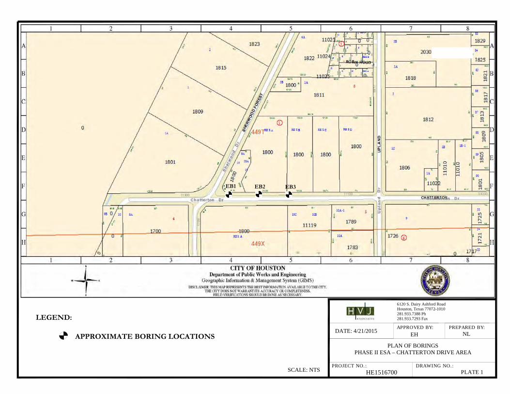
PLAN OF BORINGS PHASE II ESA – CHATTERTON DRIVE AREA
HE1516700 PLATE 1
LEGEND:
APPROXIMATE BORING LOCATIONS
SCALE: NTS
EB1
EB3
EB2
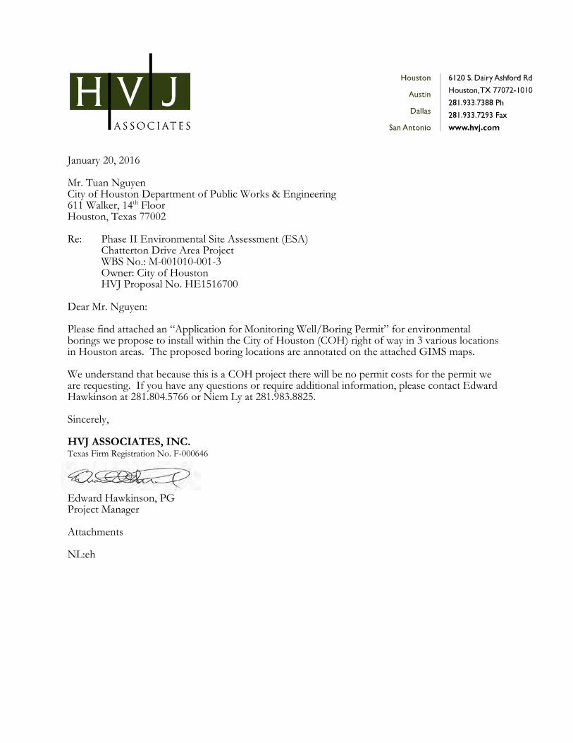
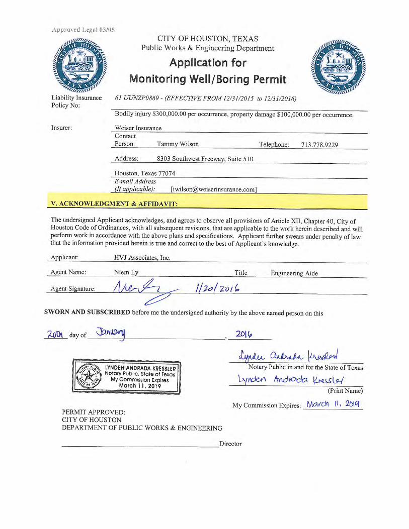
January 20, 2016 Mr. Tuan Nguyen City of Houston Department of Public Works & Engineering 611 Walker, 14th Floor Houston, Texas 77002 Re: Phase II Environmental Site Assessment (ESA)
Chatterton Drive Area Project WBS No.: M-001010-001-3 Owner: City of Houston
HVJ Proposal No. HE1516700 Dear Mr. Nguyen: Please find attached an “Application for Monitoring Well/Boring Permit” for environmental borings we propose to install within the City of Houston (COH) right of way in 3 various locations in Houston areas. The proposed boring locations are annotated on the attached GIMS maps. We understand that because this is a COH project there will be no permit costs for the permit we are requesting. If you have any questions or require additional information, please contact Edward Hawkinson at 281.804.5766 or Niem Ly at 281.983.8825. Sincerely, HVJ ASSOCIATES, INC. Texas Firm Registration No. F-000646
Edward Hawkinson, PG Project Manager Attachments NL:eh
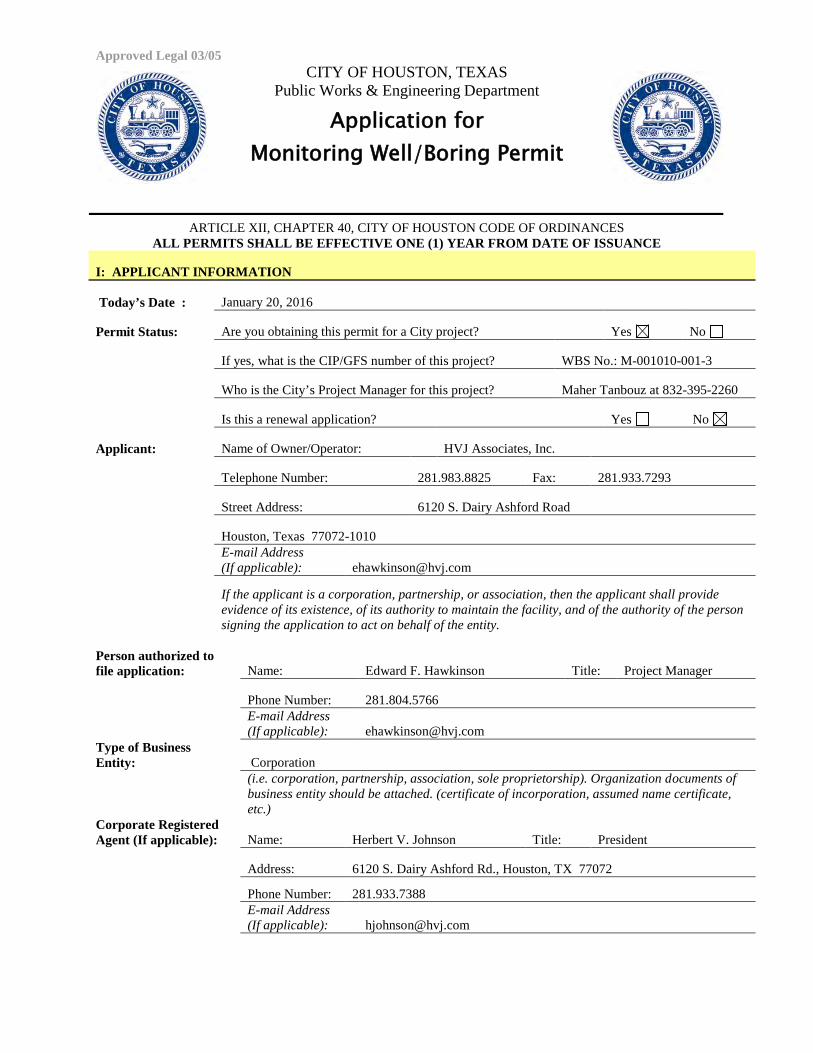
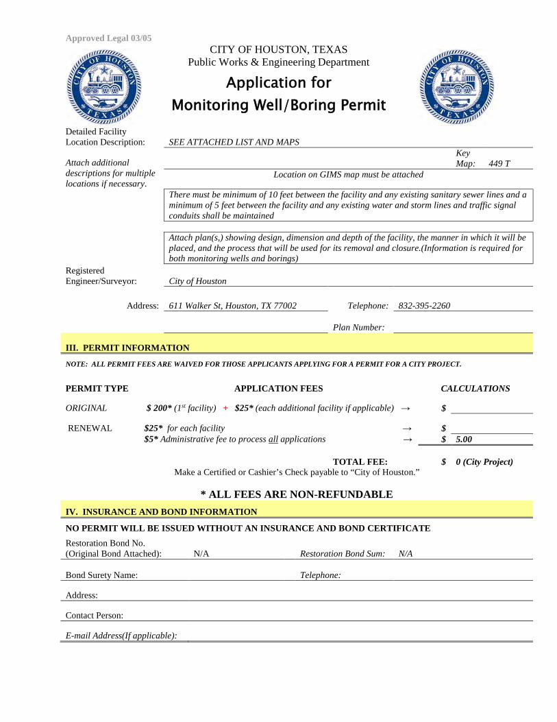
Approved Legal 03/05 CITY OF HOUSTON, TEXAS
Public Works & Engineering Department
Application for Monitoring Well/Boring Permit
ARTICLE XII, CHAPTER 40, CITY OF HOUSTON CODE OF ORDINANCES ALL PERMITS SHALL BE EFFECTIVE ONE (1) YEAR FROM DATE OF ISSUANCE
I: APPLICANT INFORMATION
Today’s Date : January 20, 2016
Permit Status: Are you obtaining this permit for a City project? Yes No
If yes, what is the CIP/GFS number of this project? WBS No.: M-001010-001-3
Who is the City’s Project Manager for this project? Maher Tanbouz at 832-395-2260
Is this a renewal application? Yes No
Applicant: Name of Owner/Operator: HVJ Associates, Inc.
Telephone Number: 281.983.8825 Fax: 281.933.7293
Street Address: 6120 S. Dairy Ashford Road
Houston, Texas 77072-1010 E-mail Address (If applicable): [email protected]
If the applicant is a corporation, partnership, or association, then the applicant shall provide evidence of its existence, of its authority to maintain the facility, and of the authority of the person signing the application to act on behalf of the entity.
Person authorized to file application: Name: Edward F. Hawkinson Title: Project Manager
Phone Number: 281.804.5766
E-mail Address (If applicable): [email protected]
Type of Business Entity: Corporation
(i.e. corporation, partnership, association, sole proprietorship). Organization documents of business entity should be attached. (certificate of incorporation, assumed name certificate, etc.)
Corporate Registered Agent (If applicable): Name: Herbert V. Johnson Title: President
Address: 6120 S. Dairy Ashford Rd., Houston, TX 77072
Phone Number: 281.933.7388 E-mail Address (If applicable): [email protected]
Approved Legal 03/05 CITY OF HOUSTON, TEXAS
Public Works & Engineering Department
Application for Monitoring Well/Boring Permit
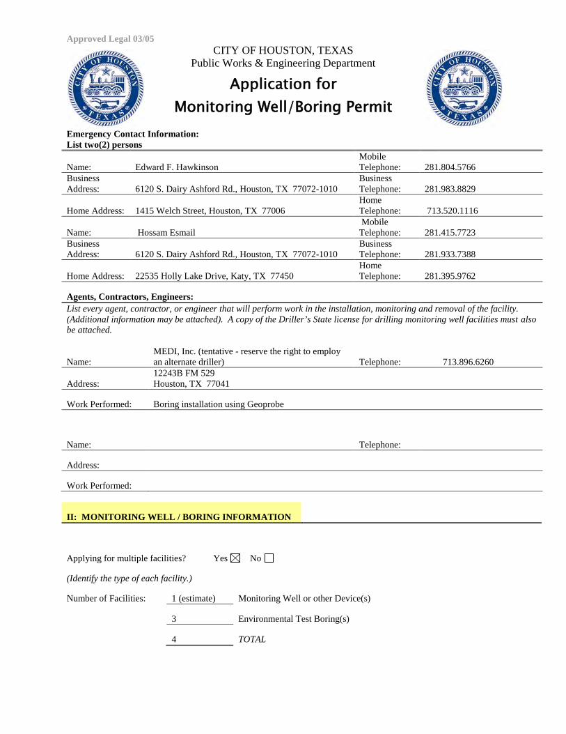
Emergency Contact Information: List two(2) persons
Name: Edward F. Hawkinson Mobile Telephone: 281.804.5766
Business Address: 6120 S. Dairy Ashford Rd., Houston, TX 77072-1010
Business Telephone: 281.983.8829
Home Address: 1415 Welch Street, Houston, TX 77006 Home Telephone: 713.520.1116
Name: Hossam Esmail Mobile Telephone: 281.415.7723
Business Address: 6120 S. Dairy Ashford Rd., Houston, TX 77072-1010
Business Telephone: 281.933.7388
Home Address: 22535 Holly Lake Drive, Katy, TX 77450 Home Telephone: 281.395.9762
Agents, Contractors, Engineers: List every agent, contractor, or engineer that will perform work in the installation, monitoring and removal of the facility. (Additional information may be attached). A copy of the Driller’s State license for drilling monitoring well facilities must also be attached.
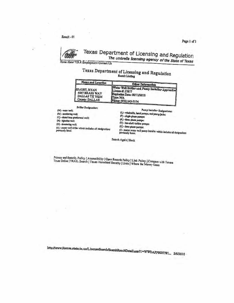
Name: MEDI, Inc. (tentative - reserve the right to employ an alternate driller) Telephone: 713.896.6260
Address: 12243B FM 529 Houston, TX 77041
Work Performed: Boring installation using Geoprobe
Name: Telephone:
Address:
Work Performed:
II: MONITORING WELL / BORING INFORMATION
Applying for multiple facilities? Yes No
(Identify the type of each facility.)
Number of Facilities: 1 (estimate) Monitoring Well or other Device(s)
3 Environmental Test Boring(s)
4 TOTAL
Approved Legal 03/05 CITY OF HOUSTON, TEXAS
Public Works & Engineering Department
Application for Monitoring Well/Boring Permit
Detailed Facility Location Description: SEE ATTACHED LIST AND MAPS
Attach additional descriptions for multiple locations if necessary.
Key Map: 449 T
Location on GIMS map must be attached
There must be minimum of 10 feet between the facility and any existing sanitary sewer lines and a minimum of 5 feet between the facility and any existing water and storm lines and traffic signal conduits shall be maintained
Attach plan(s,) showing design, dimension and depth of the facility, the manner in which it will be placed, and the process that will be used for its removal and closure.(Information is required for both monitoring wells and borings)
Registered Engineer/Surveyor: City of Houston
Address: 611 Walker St, Houston, TX 77002 Telephone: 832-395-2260
Plan Number:
III. PERMIT INFORMATION
NOTE: ALL PERMIT FEES ARE WAIVED FOR THOSE APPLICANTS APPLYING FOR A PERMIT FOR A CITY PROJECT.
PERMIT TYPE APPLICATION FEES CALCULATIONS
ORIGINAL $ 200* (1st facility) + $25* (each additional facility if applicable) → $
RENEWAL $25* for each facility → $ $5* Administrative fee to process all applications → $ 5.00
TOTAL FEE: $ 0 (City Project) Make a Certified or Cashier’s Check payable to “City of Houston.”
* ALL FEES ARE NON-REFUNDABLE
IV. INSURANCE AND BOND INFORMATION
NO PERMIT WILL BE ISSUED WITHOUT AN INSURANCE AND BOND CERTIFICATE Restoration Bond No. (Original Bond Attached): N/A Restoration Bond Sum: N/A
Bond Surety Name: Telephone:
Address:
Contact Person:
E-mail Address(If applicable):
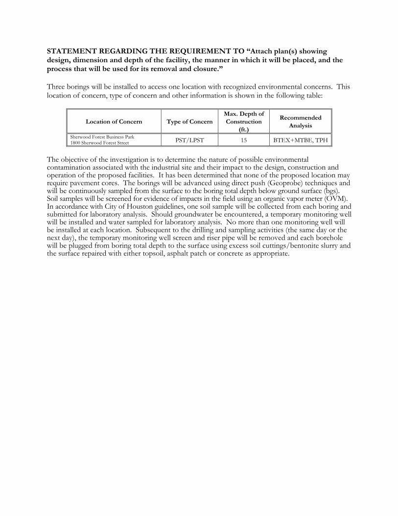
STATEMENT REGARDING THE REQUIREMENT TO “Attach plan(s) showing design, dimension and depth of the facility, the manner in which it will be placed, and the process that will be used for its removal and closure.” Three borings will be installed to access one location with recognized environmental concerns. This location of concern, type of concern and other information is shown in the following table:
Location of Concern Type of Concern Max. Depth of Construction
(ft.)
Recommended Analysis
Sherwood Forest Business Park 1800 Sherwood Forest Street PST/LPST 15 BTEX+MTBE, TPH
The objective of the investigation is to determine the nature of possible environmental contamination associated with the industrial site and their impact to the design, construction and operation of the proposed facilities. It has been determined that none of the proposed location may require pavement cores. The borings will be advanced using direct push (Geoprobe) techniques and will be continuously sampled from the surface to the boring total depth below ground surface (bgs). Soil samples will be screened for evidence of impacts in the field using an organic vapor meter (OVM). In accordance with City of Houston guidelines, one soil sample will be collected from each boring and submitted for laboratory analysis. Should groundwater be encountered, a temporary monitoring well will be installed and water sampled for laboratory analysis. No more than one monitoring well will be installed at each location. Subsequent to the drilling and sampling activities (the same day or the next day), the temporary monitoring well screen and riser pipe will be removed and each borehole will be plugged from boring total depth to the surface using excess soil cuttings/bentonite slurry and the surface repaired with either topsoil, asphalt patch or concrete as appropriate.
The ACORD name and logo are registered marks of ACORD
CERTIFICATE HOLDER
© 1988-2014 ACORD CORPORATION. All rights reserved.ACORD 25 (2014/01)
AUTHORIZED REPRESENTATIVE
CANCELLATION
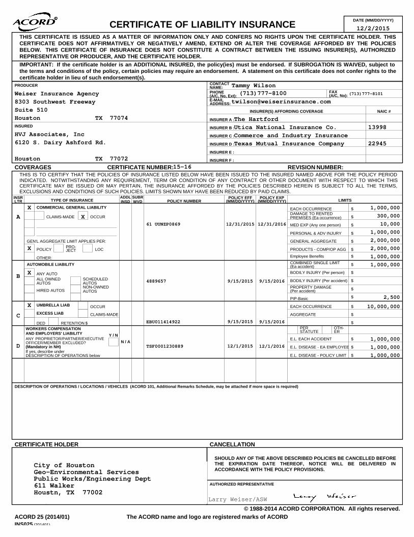
DATE (MM/DD/YYYY)CERTIFICATE OF LIABILITY INSURANCE
LOCJECTPRO-POLICY
GEN'L AGGREGATE LIMIT APPLIES PER:
OCCURCLAIMS-MADE
COMMERCIAL GENERAL LIABILITY
PREMISES (Ea occurrence) $DAMAGE TO RENTEDEACH OCCURRENCE $
MED EXP (Any one person) $
PERSONAL & ADV INJURY $
GENERAL AGGREGATE $
PRODUCTS - COMP/OP AGG $
$RETENTIONDED
CLAIMS-MADE
OCCUR
$
AGGREGATE $
EACH OCCURRENCE $UMBRELLA LIAB
EXCESS LIAB
DESCRIPTION OF OPERATIONS / LOCATIONS / VEHICLES (ACORD 101, Additional Remarks Schedule, may be attached if more space is required)
INSRLTR TYPE OF INSURANCE POLICY NUMBER
POLICY EFF(MM/DD/YYYY)
POLICY EXP(MM/DD/YYYY) LIMITS
PERSTATUTE
OTH-ER
E.L. EACH ACCIDENT
E.L. DISEASE - EA EMPLOYEE
E.L. DISEASE - POLICY LIMIT
$
$
$
ANY PROPRIETOR/PARTNER/EXECUTIVE
If yes, describe underDESCRIPTION OF OPERATIONS below
(Mandatory in NH)OFFICER/MEMBER EXCLUDED?
WORKERS COMPENSATIONAND EMPLOYERS' LIABILITY Y / N
AUTOMOBILE LIABILITY
ANY AUTOALL OWNED SCHEDULED
HIRED AUTOSNON-OWNED
AUTOS AUTOS
AUTOS
COMBINED SINGLE LIMIT
BODILY INJURY (Per person)
BODILY INJURY (Per accident)PROPERTY DAMAGE $
$
$
$
THIS IS TO CERTIFY THAT THE POLICIES OF INSURANCE LISTED BELOW HAVE BEEN ISSUED TO THE INSURED NAMED ABOVE FOR THE POLICY PERIODINDICATED. NOTWITHSTANDING ANY REQUIREMENT, TERM OR CONDITION OF ANY CONTRACT OR OTHER DOCUMENT WITH RESPECT TO WHICH THISCERTIFICATE MAY BE ISSUED OR MAY PERTAIN, THE INSURANCE AFFORDED BY THE POLICIES DESCRIBED HEREIN IS SUBJECT TO ALL THE TERMS,EXCLUSIONS AND CONDITIONS OF SUCH POLICIES. LIMITS SHOWN MAY HAVE BEEN REDUCED BY PAID CLAIMS.
INSDADDL
WVDSUBR
N / A
$
$
(Ea accident)
(Per accident)
OTHER:
THIS CERTIFICATE IS ISSUED AS A MATTER OF INFORMATION ONLY AND CONFERS NO RIGHTS UPON THE CERTIFICATE HOLDER. THISCERTIFICATE DOES NOT AFFIRMATIVELY OR NEGATIVELY AMEND, EXTEND OR ALTER THE COVERAGE AFFORDED BY THE POLICIESBELOW. THIS CERTIFICATE OF INSURANCE DOES NOT CONSTITUTE A CONTRACT BETWEEN THE ISSUING INSURER(S), AUTHORIZEDREPRESENTATIVE OR PRODUCER, AND THE CERTIFICATE HOLDER.IMPORTANT: If the certificate holder is an ADDITIONAL INSURED, the policy(ies) must be endorsed. If SUBROGATION IS WAIVED, subject tothe terms and conditions of the policy, certain policies may require an endorsement. A statement on this certificate does not confer rights to thecertificate holder in lieu of such endorsement(s).
COVERAGES CERTIFICATE NUMBER: REVISION NUMBER:
INSURED
PHONE(A/C, No, Ext):
PRODUCER
ADDRESS:E-MAIL
FAX(A/C, No):
CONTACTNAME:
NAIC #
INSURER A :
INSURER B :
INSURER C :
INSURER D :
INSURER E :
INSURER F :
INSURER(S) AFFORDING COVERAGE
SHOULD ANY OF THE ABOVE DESCRIBED POLICIES BE CANCELLED BEFORETHE EXPIRATION DATE THEREOF, NOTICE WILL BE DELIVERED INACCORDANCE WITH THE POLICY PROVISIONS.
INS025 (201401)
12/2/2015
Weiser Insurance Agency8303 Southwest FreewaySuite 510Houston TX 77074
Tammy Wilson(713)777-8100 (713)777-8101
HVJ Associates, Inc6120 S. Dairy Ashford Rd.
Houston TX 77072
The HartfordUtica National Insurance Co. 13998Commerce and Industry InsuranceTexas Mutual Insurance Company 22945
15-16
AX
X
X
61 UUNZP0869 12/31/2015 12/31/2016
1,000,000300,00010,000
1,000,0002,000,0002,000,000
Employee Benefits 1,000,000
B X4889657 9/15/2015 9/15/2016
1,000,000
PIP-Basic 2,500
CX
EBU011414922 9/15/2015 9/15/2016
10,000,000
D TSF0001230889 12/1/2015 12/1/20161,000,0001,000,0001,000,000
Larry Weiser/ASW
City of Houston Geo-Environmental Services Public Works/Engineering Dept 611 Walker Houstn, TX 77002
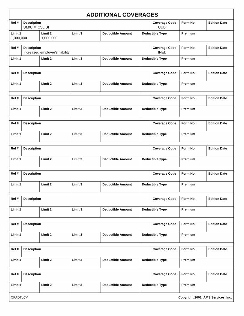
ADDITIONAL COVERAGESRef # Description Edition DateForm No.Coverage Code
Limit 1 Limit 2 Limit 3 Deductible Amount Deductible Type Premium
Ref # Description Coverage Code Form No. Edition Date
Limit 1 Limit 2 Limit 3 Deductible Amount Deductible Type Premium
Ref # Description Coverage Code Form No. Edition Date
Limit 1 Limit 2 Limit 3 Deductible Amount Deductible Type Premium
Ref # Description Coverage Code Form No. Edition Date
Limit 1 Limit 2 Limit 3 Deductible Amount Deductible Type Premium
Ref # Description Coverage Code Form No. Edition Date
Limit 1 Limit 2 Limit 3 Deductible Amount Deductible Type Premium
Ref # Description Coverage Code Form No. Edition Date
Limit 1 Limit 2 Limit 3 Deductible Amount Deductible Type Premium
Ref # Description Coverage Code Form No. Edition Date
Limit 1 Limit 2 Limit 3 Deductible Amount Deductible Type Premium
Ref # Description Coverage Code Form No. Edition Date
Limit 1 Limit 2 Limit 3 Deductible Amount Deductible Type Premium
Ref # Description Coverage Code Form No. Edition Date
Limit 1 Limit 2 Limit 3 Deductible Amount Deductible Type Premium
Ref # Description Coverage Code Form No. Edition Date
Limit 1 Limit 2 Limit 3 Deductible Amount Deductible Type Premium
Ref # Description Coverage Code Form No. Edition Date
Limit 1 Limit 2 Limit 3 Deductible Amount Deductible Type Premium
Copyright 2001, AMS Services, Inc.OFADTLCV
UM/UIM CSL BI UUBI
1,000,000 1,000,000
Increased employer's liability INEL
COMMENTS/REMARKS
COPYRIGHT 2000, AMS SERVICES INC.OFREMARK
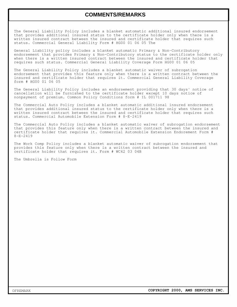
The General Liability Policy includes a blanket automatic additional insured endorsement that provides additional insured status to the certificate holder only when there is a written insured contract between the insured and certificate holder that requires such status. Commercial General Liability Form # HG00 01 06 05 The General Liability policy includes a blanket automatic Primary & Non-Contributory endorsement that provides Primary & Non-Contributory status to the certificate holder only when there is a written insured contract between the insured and certificate holder that requires such status. Commercial General Liability Coverage Form HG00 01 06 05 The General Liability Policy includes a blanket automatic waiver of subrogation endorsement that provides this feature only when there is a written contract between the insured and certificate holder that requires it. Commercial General Liability Coverage form # HG00 01 06 05 The General Liability Policy includes an endorsement providing that 30 days' notice of cancellation will be furnished to the certificate holder except 10 days notice of nonpayment of premium. Common Policy Conditions form # IL 001711 98 The Commercial Auto Policy includes a blanket automatic additional insured endorsement that provides additional insured status to the certificate holder only when there is a written insured contract between the insured and certificate holder that requires such status. Commercial Automobile Extension Form # 8-E-2419 The Commercial Auto Policy includes a blanket automatic waiver of subrogation endorsement that provides this feature only when there is a written contract between the insured and certificate holder that requires it. Commercial Automobile Extension Endorement Form # 8-E-2419 The Work Comp Policy includes a blanket automatic waiver of subrogation endorsement that provides this feature only when there is a written contract between the insured and certificate holder that requires it. Form # WC42 03 04B The Umbrella is Follow Form

APPENDIX B
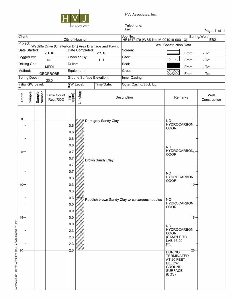
BORING LOGS
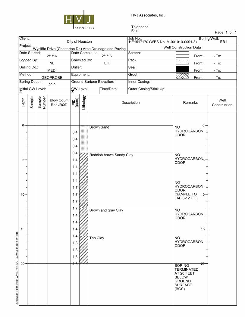
NOHYDROCARBONODOR
NOHYDROCARBONODOR
NOHYDROCARBONODOR(SAMPLE TOLAB 8-12 FT.)
NOHYDROCARBONODOR
NOHYDROCARBONODOR
BORINGTERMINATEDAT 20 FEETBELOWGROUNDSURFACE(BGS)
Brown Sand
Reddish brown Sandy Clay
Brown and gray Clay
Tan Clay
0.4
0.4
0.4
0.4
1.4
1.4
1.4
1.4
1.7
1.7
1.7
1.7
1.4
1.4
1.4
1.4
1.3
1.3
1.3
1.3
Outer Casing/Stick Up:
Date Completed:
Checked By:
Driller:
Equipment:
From:
From:
From:
From:
GW Level: Time/Date:
Ground Surface Elevation:
Well Construction Data
2/1/16
NL
MEDI
GEOPROBE
20.0
2/1/16
EH
0 0
- To:
- To:
- To:
- To:
Screen:
Pack:
Seal:
Grout:
Inner Casing:
Date Started:
Logged By:
Drilling Co.:
Method:
Boring Depth:
Initial GW Level:
Dep
th
Sam
ple
Lith
olo
gy
Description RemarksPID
(ppm
)
Sam
ple
Num
ber
Blow CountRec./RQD
WellConstruction
Client:
Project:
Page 1 of 1
City of Houston
Wycliffe Drive (Chatterton Dr.) Area Drainage and Paving
5
10
15
20
5
10
15
20
HVJ Associates, Inc.
Telephone:Fax:
Job No.: Boring/Well:EB1HE1517170 (WBS No. M-001010-0001-3)
LAE
WN
L03
HE
1516
700
WY
CLI
FF
E.G
PJ
LA
EW
NL0
3.G
DT
2/1
0/16
NOHYDROCARBONODOR
NOHYDROCARBONODOR
NOHYDROCARBONODOR
NOHYDROCARBONODOR
NOHYDROCARBONODOR(SAMPLE TOLAB 16-20FT.)
BORINGTERMINATEDAT 20 FEETBELOWGROUNDSURFACE(BGS)
Dark gray Sandy Clay
Brown Sandy Clay
Reddish brown Sandy Clay w/ calcareous nodules
0.6
0.6
0.6
0.6
0.7
0.7
0.7
0.7
0.3
0.3
0.3
0.3
0.0
0.0
0.0
0.0
2.3
2.3
2.3
2.3
Outer Casing/Stick Up:
Date Completed:
Checked By:
Driller:
Equipment:
From:
From:
From:
From:
GW Level: Time/Date:
Ground Surface Elevation:
Well Construction Data
2/1/16
NL
MEDI
GEOPROBE
20.0
2/1/16
EH
0 0
- To:
- To:
- To:
- To:
Screen:
Pack:
Seal:
Grout:
Inner Casing:
Date Started:
Logged By:
Drilling Co.:
Method:
Boring Depth:
Initial GW Level:
Dep
th
Sam
ple
Lith
olo
gy
Description RemarksPID
(ppm
)
Sam
ple
Num
ber
Blow CountRec./RQD
WellConstruction
Client:
Project:
Page 1 of 1
City of Houston
Wycliffe Drive (Chatterton Dr.) Area Drainage and Paving
5
10
15
20
5
10
15
20
HVJ Associates, Inc.
Telephone:Fax:
Job No.: Boring/Well:EB2HE1517170 (WBS No. M-001010-0001-3)
LAE
WN
L03
HE
1516
700
WY
CLI
FF
E.G
PJ
LA
EW
NL0
3.G
DT
2/1
0/16
NOHYDROCARBONODOR
NOHYDROCARBONODOR
NOHYDROCARBONODOR(SAMPLE TOLAB 8-12 FT.)
NOHYDROCARBONODOR
NOHYDROCARBONODOR
BORINGTERMINATEDAT 20 FEETBELOWGROUNDSURFACE(BGS)
Brown Sandy Clay
Reddish brown Sandy Clay
Tan Sandy Clay
4.2
4.2
4.2
4.2
4.2
4.2
4.2
4.2
4.8
4.8
4.8
4.8
2.3
2.3
2.3
2.3
3.0
3.0
3.0
3.0
Outer Casing/Stick Up:
Date Completed:
Checked By:
Driller:
Equipment:
From:
From:
From:
From:
GW Level: Time/Date:
Ground Surface Elevation:
Well Construction Data
2/1/16
NL
MEDI
GEOPROBE
20.0
2/1/16
EH
0 0
- To:
- To:
- To:
- To:
Screen:
Pack:
Seal:
Grout:
Inner Casing:
Date Started:
Logged By:
Drilling Co.:
Method:
Boring Depth:
Initial GW Level:
Dep
th
Sam
ple
Lith
olo
gy
Description RemarksPID
(ppm
)
Sam
ple
Num
ber
Blow CountRec./RQD
WellConstruction
Client:
Project:
Page 1 of 1
City of Houston
Wycliffe Drive (Chatterton Dr.) Area Drainage and Paving
5
10
15
20
5
10
15
20
HVJ Associates, Inc.
Telephone:Fax:
Job No.: Boring/Well:EB3HE1517170 (WBS No. M-001010-0001-3)
LAE
WN
L03
HE
1516
700
WY
CLI
FF
E.G
PJ
LA
EW
NL0
3.G
DT
2/1
0/16
APPENDIX C
ANALYTICAL LAB REPORT/CHAIN OF CUSTODY DOCUMENTATION
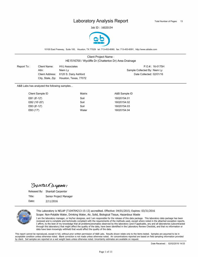
16020154
10100 East Freeway, Suite 100, Houston, TX 77029 tel: 713-453-6060, fax: 713-453-6091, http://www.ablabs.com
Laboratory Analysis Report
Job ID :
Total Number of Pages: 13
City, State, Zip:
HE1516700 / Wycliffe Dr (Chatterton Dr) Area Drainage
Niem Ly
Client Address:
Client Name:
Client Project Name :
P.O.#.:
Sample Collected By:
16-0175H
6120 S. Dairy Ashford
HVJ AssociatesReport To :
Attn:
Houston, Texas, 77072
Niem Ly
Date Collected: 02/01/16
Client Sample ID A&B Sample ID
A&B Labs has analyzed the following samples...
Matrix
EB1 (8'-12') 16020154.01Soil
EB2 (16'-20') 16020154.02Soil
EB3 (8'-12') 16020154.03Soil
EB3 (17') 16020154.04Water
This report cannot be reproduced, except in full, without prior written permission of A&B Labs. Results shown relate only to the items tested. Samples are assumed to be inacceptable condition unless otherwise noted. Blank correction is not made unless otherwise noted. Air concentrations reported are based on field sampling information providedby client. Soil samples are reported on a wet weight basis unless otherwise noted. Uncertainty estimates are available on request.
2/11/2016
Title:
Released By:
Senior Project Manager
Shantall Carpenter
Date Received : 02/02/2016 14:53
This Laboratory is NELAP (T104704213-15-13) accredited. Effective: 04/01/2015; Expires: 03/31/2016
I am the laboratory manager, or his/her designee, and I am responsible for the release of this data package. This laboratory data package has beenreviewed and is complete and technically compliant with the requirements of the methods used, except where noted in the attached exception reports.I affirm, to the best of my knowledge that all problems/anomalies observed by this laboratory (and if applicable, any and all laboratories subcontractedthrough this laboratory) that might affect the quality of the data, have been identified in the Laboratory Review Checklist, and that no information ordata have been knowingly withheld that would affect the quality of the data.
Date:
Scope: Non-Potable Water, Drinking Water, Air, Solid, Biological Tissue, Hazardous Waste
Page 1 of 13
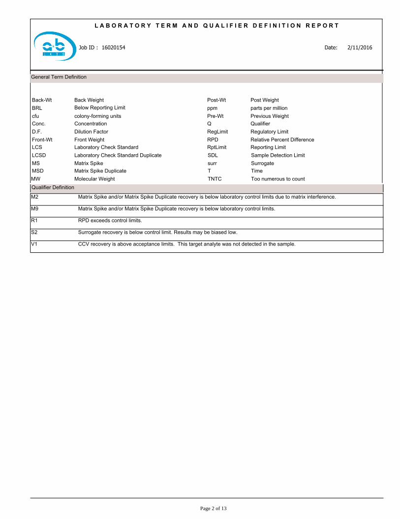
General Term Definition
BRL
Front-Wt
Below Reporting Limit
Front Weight
Back WeightBack-Wt
cfu colony-forming units
Conc. Concentration
D.F. Dilution Factor
LCS Laboratory Check Standard
LCSD Laboratory Check Standard Duplicate
MS Matrix Spike
MSD Matrix Spike Duplicate
Molecular WeightMW
RPD
ppm parts per million
Relative Percent Difference
TNTC Too numerous to count
Post-Wt
Pre-Wt Previous Weight
Q Qualifier
RegLimit Regulatory Limit
RptLimit Reporting Limit
T Time
Post Weight
surr Surrogate
SDL Sample Detection Limit
16020154
L A B O R A T O R Y T E R M A N D Q U A L I F I E R D E F I N I T I O N R E P O R T
Date:Job ID : 2/11/2016
Qualifier Definition
Matrix Spike and/or Matrix Spike Duplicate recovery is below laboratory control limits due to matrix interference.M2
Matrix Spike and/or Matrix Spike Duplicate recovery is below laboratory control limits.M9
RPD exceeds control limits.R1
Surrogate recovery is below control limit. Results may be biased low.S2
CCV recovery is above acceptance limits. This target analyte was not detected in the sample.V1
Page 2 of 13
L A B O R A T O R Y T E S T R E S U L T S
Soil
16020154.01
Sample Matrix
Job Sample ID:
AnalystDate TimeQReg LimitRpt LimitDFUnitsResultParameter/Test DescriptionTest Method
EB1 (8'-12')
Other Information:
Time Collected:
Client Sample ID:
Date Collected:
Niem LyAttn:
HE1516700 / Wycliffe Dr (Chatterton Dr) Area DrainageProject Name:
HVJ AssociatesClient Name:
Date16020154Job ID :
2/11/2016
02/01/16
09:30 13.7% Moisture
% MoistureSM 2540G
MAM02/04/16 09:250.11%13.7% Moisture
Total Petroleum HydrocarbonsTX 1005
SuG02/03/16 21:2025.80.938mg/KgBRLC6-C12
SuG02/03/16 21:2022.10.938mg/KgBRL>C12-C28
SuG02/03/16 21:2019.20.938mg/KgBRL>C28-C35
SuG02/03/16 21:200.938mg/KgBRLTotal C6-C35
SuG02/03/16 21:2060-1430.938%80.61-Chlorooctane(surr)
SuG02/03/16 21:2060-1500.938%77.5Chlorooctadecane(surr)
Purgeable AromaticsSW-846 8021B
GLQ02/11/16 02:520.00230.4mg/KgBRLMTBE
GLQ02/11/16 02:520.00230.4mg/KgBRLBenzene
GLQ02/11/16 02:520.00230.4mg/KgBRLToluene
GLQ02/11/16 02:520.00230.4mg/KgBRLEthylbenzene
GLQ02/11/16 02:52V10.00460.4mg/KgBRLm- & p-Xylenes
GLQ02/11/16 02:520.00230.4mg/KgBRLo-Xylene
GLQ02/11/16 02:52V10.0070.4mg/KgBRLXylenes
GLQ02/11/16 02:5281-1110.4%95Trifluorotoluene(surr)
Soil results reported on dry weight basis
Page 3 of 13

L A B O R A T O R Y T E S T R E S U L T S
Soil
16020154.02
Sample Matrix
Job Sample ID:
AnalystDate TimeQReg LimitRpt LimitDFUnitsResultParameter/Test DescriptionTest Method
EB2 (16'-20')
Other Information:
Time Collected:
Client Sample ID:
Date Collected:
Niem LyAttn:
HE1516700 / Wycliffe Dr (Chatterton Dr) Area DrainageProject Name:
HVJ AssociatesClient Name:
Date16020154Job ID :
2/11/2016
02/01/16
10:15 15.7% Moisture
% MoistureSM 2540G
MAM02/04/16 09:250.11%15.7% Moisture
Total Petroleum HydrocarbonsTX 1005
SuG02/03/16 22:1730.21.073mg/KgBRLC6-C12
SuG02/03/16 22:1725.81.073mg/KgBRL>C12-C28
SuG02/03/16 22:1722.51.073mg/KgBRL>C28-C35
SuG02/03/16 22:171.073mg/KgBRLTotal C6-C35
SuG02/03/16 22:1760-1431.073%85.91-Chlorooctane(surr)
SuG02/03/16 22:1760-1501.073%81.3Chlorooctadecane(surr)
Purgeable AromaticsSW-846 8021B
GLQ02/11/16 03:190.00240.4mg/KgBRLMTBE
GLQ02/11/16 03:190.00240.4mg/KgBRLBenzene
GLQ02/11/16 03:190.00240.4mg/KgBRLToluene
GLQ02/11/16 03:190.00240.4mg/KgBRLEthylbenzene
GLQ02/11/16 03:19V10.00470.4mg/KgBRLm- & p-Xylenes
GLQ02/11/16 03:190.00240.4mg/KgBRLo-Xylene
GLQ02/11/16 03:19V10.00710.4mg/KgBRLXylenes
GLQ02/11/16 03:1981-1110.4%92.5Trifluorotoluene(surr)
Soil results reported on dry weight basis
Page 4 of 13

L A B O R A T O R Y T E S T R E S U L T S
Soil
16020154.03
Sample Matrix
Job Sample ID:
AnalystDate TimeQReg LimitRpt LimitDFUnitsResultParameter/Test DescriptionTest Method
EB3 (8'-12')
Other Information:
Time Collected:
Client Sample ID:
Date Collected:
Niem LyAttn:
HE1516700 / Wycliffe Dr (Chatterton Dr) Area DrainageProject Name:
HVJ AssociatesClient Name:
Date16020154Job ID :
2/11/2016
02/01/16
10:45 16.2% Moisture
% MoistureSM 2540G
MAM02/04/16 09:250.11%16.2% Moisture
Total Petroleum HydrocarbonsTX 1005
SuG02/03/16 22:4526.70.943mg/KgBRLC6-C12
SuG02/03/16 22:4522.80.943mg/KgBRL>C12-C28
SuG02/03/16 22:4519.90.943mg/KgBRL>C28-C35
SuG02/03/16 22:450.943mg/KgBRLTotal C6-C35
SuG02/03/16 22:4560-1430.943%80.61-Chlorooctane(surr)
SuG02/03/16 22:4560-1500.943%71.4Chlorooctadecane(surr)
Purgeable AromaticsSW-846 8021B
GLQ02/11/16 03:450.00240.4mg/KgBRLMTBE
GLQ02/11/16 03:450.00240.4mg/KgBRLBenzene
GLQ02/11/16 03:450.00240.4mg/KgBRLToluene
GLQ02/11/16 03:450.00240.4mg/KgBRLEthylbenzene
GLQ02/11/16 03:45V10.00480.4mg/KgBRLm- & p-Xylenes
GLQ02/11/16 03:450.00240.4mg/KgBRLo-Xylene
GLQ02/11/16 03:45V10.00720.4mg/KgBRLXylenes
GLQ02/11/16 03:4581-1110.4%92.5Trifluorotoluene(surr)
Soil results reported on dry weight basis
Page 5 of 13
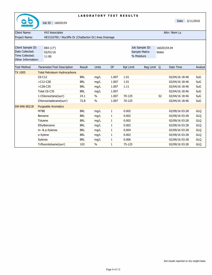
L A B O R A T O R Y T E S T R E S U L T S
Water
16020154.04
Sample Matrix
Job Sample ID:
AnalystDate TimeQReg LimitRpt LimitDFUnitsResultParameter/Test DescriptionTest Method
EB3 (17')
Other Information:
Time Collected:
Client Sample ID:
Date Collected:
Niem LyAttn:
HE1516700 / Wycliffe Dr (Chatterton Dr) Area DrainageProject Name:
HVJ AssociatesClient Name:
Date16020154Job ID :
2/11/2016
02/01/16
11:00 % Moisture
Total Petroleum HydrocarbonsTX 1005
SuG02/04/16 18:461.011.007mg/LBRLC6-C12
SuG02/04/16 18:461.011.007mg/LBRL>C12-C28
SuG02/04/16 18:461.111.007mg/LBRL>C28-C35
SuG02/04/16 18:461.007mg/LBRLTotal C6-C35
SuG02/04/16 18:46S270-1251.007%24.11-Chlorooctane(surr)
SuG02/04/16 18:4670-1251.007%72.8Chlorooctadecane(surr)
Purgeable AromaticsSW-846 8021B
GLQ02/09/16 03:280.0021mg/LBRLMTBE
GLQ02/09/16 03:280.0021mg/LBRLBenzene
GLQ02/09/16 03:280.0021mg/LBRLToluene
GLQ02/09/16 03:280.0021mg/LBRLEthylbenzene
GLQ02/09/16 03:280.0041mg/LBRLm- & p-Xylenes
GLQ02/09/16 03:280.0021mg/LBRLo-Xylene
GLQ02/09/16 03:280.0061mg/LBRLXylenes
GLQ02/09/16 03:2875-1251%103Trifluorotoluene(surr)
Soil results reported on dry weight basis
Page 6 of 13
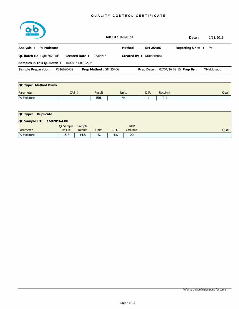
Q U A L I T Y C O N T R O L C E R T I F I C A T E
Date :16020154Job ID :
KUnderbrink
Samples in This QC Batch :
Qb16020403
% Moisture
16020154.01,02,03
Reporting Units :
02/04/16QC Batch ID :
Method :
Created Date :
Analysis :
Created By :
%SM 2540G
2/11/2016
Prep Date : 02/04/16 09:15SM 2540GPrep Method :PB16020402Sample Preparation : MMaldonadoPrep By :
QC Type: Method Blank
D.F. RptLimitParameter Result Units QualCAS #
% 0.1BRL 1% Moisture
QC Type: Duplicate
16020164.08QC Sample ID:
Parameter UnitsSampleResult QualRPD
RPDCtrlLimit
QCSampleResult
%% Moisture 15.5 4.6 2014.8
Refer to the Definition page for terms.
Page 7 of 13
Q U A L I T Y C O N T R O L C E R T I F I C A T E
Date :16020154Job ID :
SGautam
Samples in This QC Batch :
Qb16020433
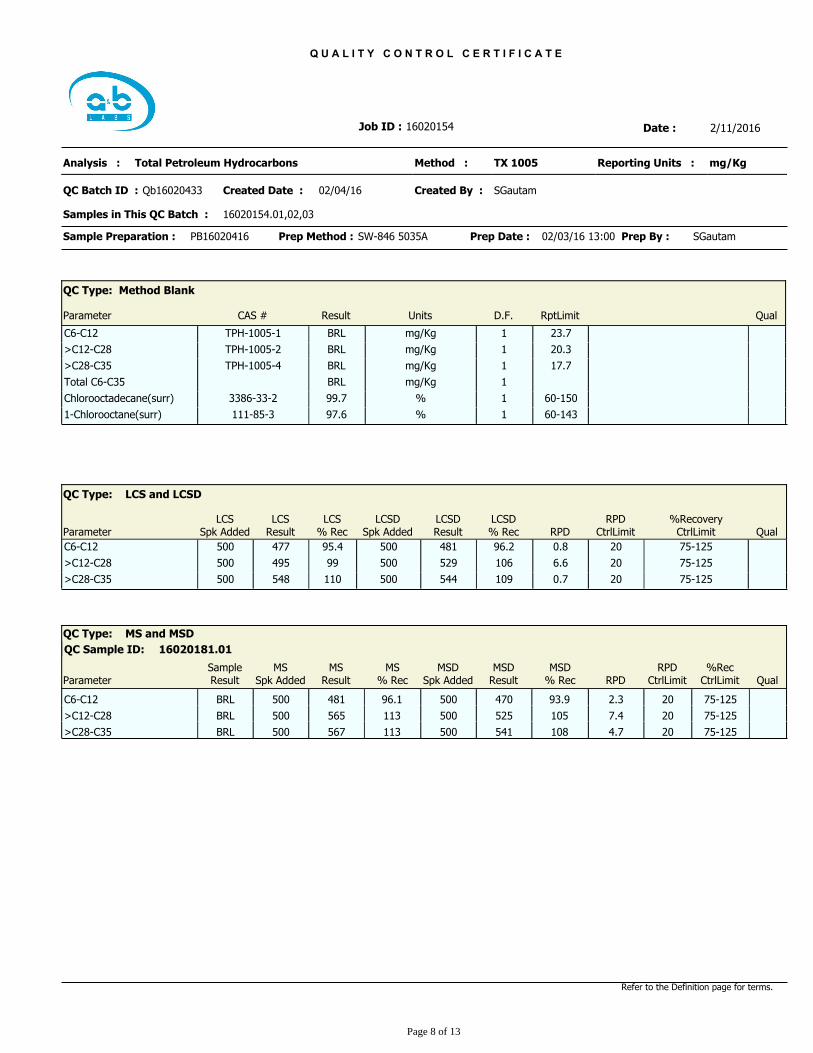
Total Petroleum Hydrocarbons
16020154.01,02,03
Reporting Units :
02/04/16QC Batch ID :
Method :
Created Date :
Analysis :
Created By :
mg/KgTX 1005
2/11/2016
Prep Date : 02/03/16 13:00SW-846 5035APrep Method :PB16020416Sample Preparation : SGautamPrep By :
QC Type: Method Blank
D.F. RptLimitParameter Result Units QualCAS #
mg/Kg 23.7BRL 1C6-C12 TPH-1005-1
mg/Kg 20.3BRL 1>C12-C28 TPH-1005-2
mg/Kg 17.7BRL 1>C28-C35 TPH-1005-4
mg/KgBRL 1Total C6-C35
% 60-15099.7 1Chlorooctadecane(surr) 3386-33-2
% 60-14397.6 11-Chlorooctane(surr) 111-85-3
%RecoveryCtrlLimit
LCSDResult
LCSResult
RPDCtrlLimitRPD
LCSSpk Added
LCSD% Rec
LCS% RecParameter
LCSDSpk Added
QC Type: LCS and LCSD
Qual
0.896.2500 75-12595.4 20477C6-C12 500 481
6.6106500 75-12599 20495>C12-C28 500 529
0.7109500 75-125110 20548>C28-C35 500 544
QC Type: MS and MSD
16020181.01QC Sample ID:
ParameterSampleResult
RPDCtrlLimit
MSResult
MSSpk Added RPD Qual
MS% Rec
MSDSpk Added
MSD% Rec
%RecCtrlLimit
MSDResult
BRLC6-C12 500 96.1 2.3500 470481 20 75-12593.9
BRL>C12-C28 500 113 7.4500 525565 20 75-125105
BRL>C28-C35 500 113 4.7500 541567 20 75-125108
Refer to the Definition page for terms.
Page 8 of 13
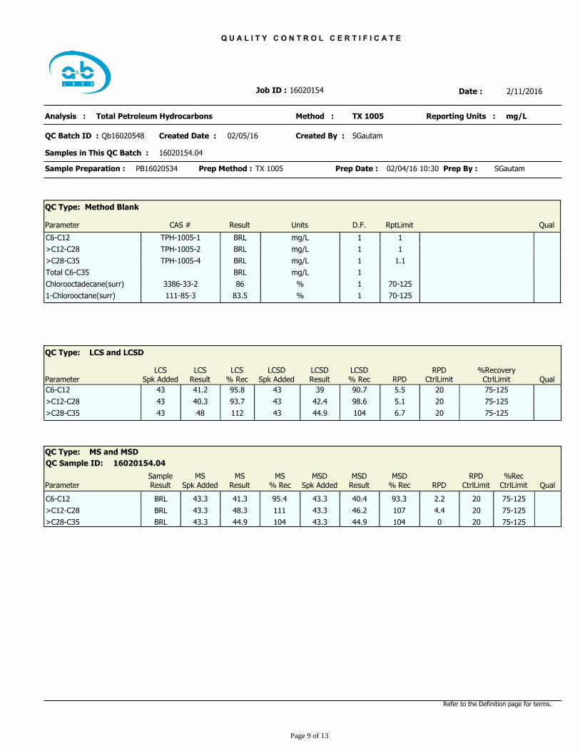
Q U A L I T Y C O N T R O L C E R T I F I C A T E
Date :16020154Job ID :
SGautam
Samples in This QC Batch :
Qb16020548
Total Petroleum Hydrocarbons
16020154.04
Reporting Units :
02/05/16QC Batch ID :
Method :
Created Date :
Analysis :
Created By :
mg/LTX 1005
2/11/2016
Prep Date : 02/04/16 10:30TX 1005Prep Method :PB16020534Sample Preparation : SGautamPrep By :
QC Type: Method Blank
D.F. RptLimitParameter Result Units QualCAS #
mg/L 1BRL 1C6-C12 TPH-1005-1
mg/L 1BRL 1>C12-C28 TPH-1005-2
mg/L 1.1BRL 1>C28-C35 TPH-1005-4
mg/LBRL 1Total C6-C35
% 70-12586 1Chlorooctadecane(surr) 3386-33-2
% 70-12583.5 11-Chlorooctane(surr) 111-85-3
%RecoveryCtrlLimit
LCSDResult
LCSResult
RPDCtrlLimitRPD
LCSSpk Added
LCSD% Rec
LCS% RecParameter
LCSDSpk Added
QC Type: LCS and LCSD
Qual
5.590.743 75-12595.8 2041.2C6-C12 43 39
5.198.643 75-12593.7 2040.3>C12-C28 43 42.4
6.710443 75-125112 2048>C28-C35 43 44.9
QC Type: MS and MSD
16020154.04QC Sample ID:
ParameterSampleResult
RPDCtrlLimit
MSResult
MSSpk Added RPD Qual
MS% Rec
MSDSpk Added
MSD% Rec
%RecCtrlLimit
MSDResult
BRLC6-C12 43.3 95.4 2.243.3 40.441.3 20 75-12593.3
BRL>C12-C28 43.3 111 4.443.3 46.248.3 20 75-125107
BRL>C28-C35 43.3 104 043.3 44.944.9 20 75-125104
Refer to the Definition page for terms.
Page 9 of 13
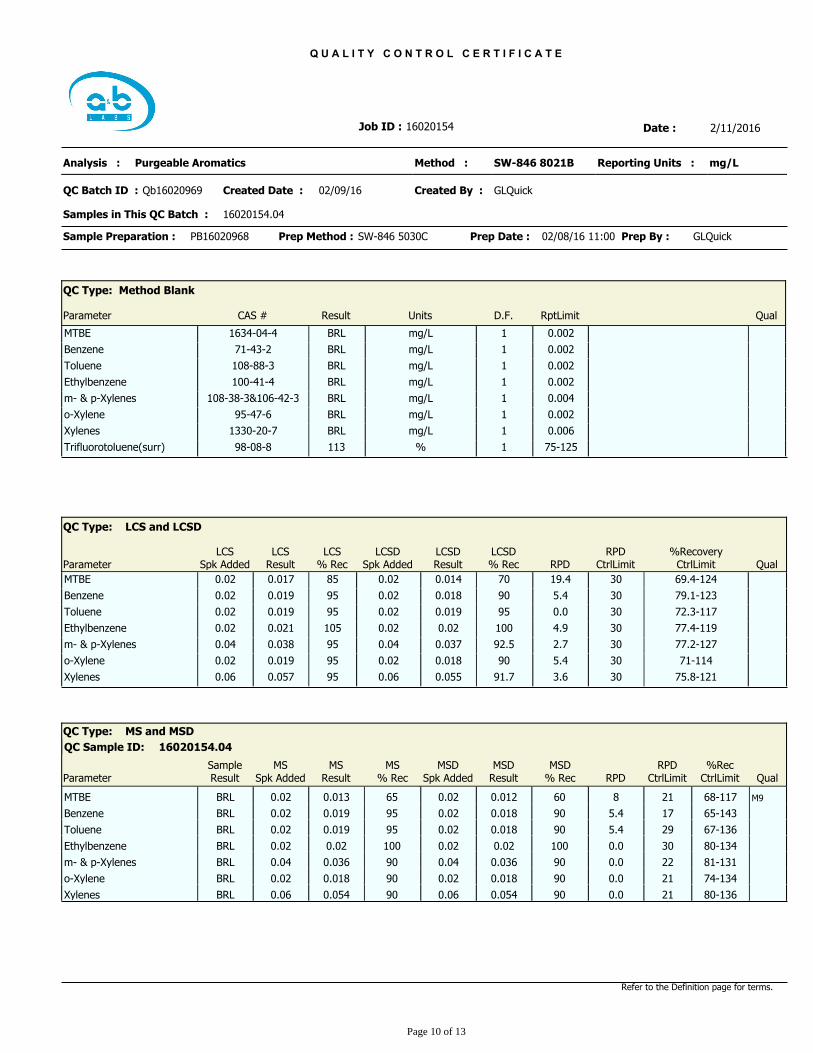
Q U A L I T Y C O N T R O L C E R T I F I C A T E
Date :16020154Job ID :
GLQuick
Samples in This QC Batch :
Qb16020969
Purgeable Aromatics
16020154.04
Reporting Units :
02/09/16QC Batch ID :
Method :
Created Date :
Analysis :
Created By :
mg/LSW-846 8021B
2/11/2016
Prep Date : 02/08/16 11:00SW-846 5030CPrep Method :PB16020968Sample Preparation : GLQuickPrep By :
QC Type: Method Blank
D.F. RptLimitParameter Result Units QualCAS #
mg/L 0.002BRL 1MTBE 1634-04-4
mg/L 0.002BRL 1Benzene 71-43-2
mg/L 0.002BRL 1Toluene 108-88-3
mg/L 0.002BRL 1Ethylbenzene 100-41-4
mg/L 0.004BRL 1m- & p-Xylenes 108-38-3&106-42-3
mg/L 0.002BRL 1o-Xylene 95-47-6
mg/L 0.006BRL 1Xylenes 1330-20-7
% 75-125113 1Trifluorotoluene(surr) 98-08-8
%RecoveryCtrlLimit
LCSDResult
LCSResult
RPDCtrlLimitRPD
LCSSpk Added
LCSD% Rec
LCS% RecParameter
LCSDSpk Added
QC Type: LCS and LCSD
Qual
19.4700.02 69.4-12485 300.017MTBE 0.02 0.014
5.4900.02 79.1-12395 300.019Benzene 0.02 0.018
0.0950.02 72.3-11795 300.019Toluene 0.02 0.019
4.91000.02 77.4-119105 300.021Ethylbenzene 0.02 0.02
2.792.50.04 77.2-12795 300.038m- & p-Xylenes 0.04 0.037
5.4900.02 71-11495 300.019o-Xylene 0.02 0.018
3.691.70.06 75.8-12195 300.057Xylenes 0.06 0.055
QC Type: MS and MSD
16020154.04QC Sample ID:
ParameterSampleResult
RPDCtrlLimit
MSResult
MSSpk Added RPD Qual
MS% Rec
MSDSpk Added
MSD% Rec
%RecCtrlLimit
MSDResult
BRLMTBE 0.02 65 M980.02 0.0120.013 21 68-11760
BRLBenzene 0.02 95 5.40.02 0.0180.019 17 65-14390
BRLToluene 0.02 95 5.40.02 0.0180.019 29 67-13690
BRLEthylbenzene 0.02 100 0.00.02 0.020.02 30 80-134100
BRLm- & p-Xylenes 0.04 90 0.00.04 0.0360.036 22 81-13190
BRLo-Xylene 0.02 90 0.00.02 0.0180.018 21 74-13490
BRLXylenes 0.06 90 0.00.06 0.0540.054 21 80-13690
Refer to the Definition page for terms.
Page 10 of 13
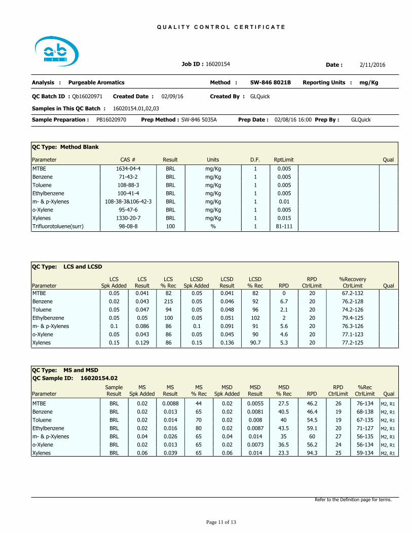
Q U A L I T Y C O N T R O L C E R T I F I C A T E
Date :16020154Job ID :
GLQuick
Samples in This QC Batch :
Qb16020971
Purgeable Aromatics
16020154.01,02,03
Reporting Units :
02/09/16QC Batch ID :
Method :
Created Date :
Analysis :
Created By :
mg/KgSW-846 8021B
2/11/2016
Prep Date : 02/08/16 16:00SW-846 5035APrep Method :PB16020970Sample Preparation : GLQuickPrep By :
QC Type: Method Blank
D.F. RptLimitParameter Result Units QualCAS #
mg/Kg 0.005BRL 1MTBE 1634-04-4
mg/Kg 0.005BRL 1Benzene 71-43-2
mg/Kg 0.005BRL 1Toluene 108-88-3
mg/Kg 0.005BRL 1Ethylbenzene 100-41-4
mg/Kg 0.01BRL 1m- & p-Xylenes 108-38-3&106-42-3
mg/Kg 0.005BRL 1o-Xylene 95-47-6
mg/Kg 0.015BRL 1Xylenes 1330-20-7
% 81-111100 1Trifluorotoluene(surr) 98-08-8
%RecoveryCtrlLimit
LCSDResult
LCSResult
RPDCtrlLimitRPD
LCSSpk Added
LCSD% Rec
LCS% RecParameter
LCSDSpk Added
QC Type: LCS and LCSD
Qual
0820.05 67.2-13282 200.041MTBE 0.05 0.041
6.7920.02 76.2-128215 200.043Benzene 0.05 0.046
2.1960.05 74.2-12694 200.047Toluene 0.05 0.048
21020.05 79.4-125100 200.05Ethylbenzene 0.05 0.051
5.6910.1 76.3-12686 200.086m- & p-Xylenes 0.1 0.091
4.6900.05 77.1-12386 200.043o-Xylene 0.05 0.045
5.390.70.15 77.2-12586 200.129Xylenes 0.15 0.136
QC Type: MS and MSD
16020154.02QC Sample ID:
ParameterSampleResult
RPDCtrlLimit
MSResult
MSSpk Added RPD Qual
MS% Rec
MSDSpk Added
MSD% Rec
%RecCtrlLimit
MSDResult
BRLMTBE 0.02 44 M2, R146.20.02 0.00550.0088 26 76-13427.5
BRLBenzene 0.02 65 M2, R146.40.02 0.00810.013 19 68-13840.5
BRLToluene 0.02 70 M2, R154.50.02 0.0080.014 19 67-13540
BRLEthylbenzene 0.02 80 M2, R159.10.02 0.00870.016 20 71-12743.5
BRLm- & p-Xylenes 0.04 65 M2, R1600.04 0.0140.026 27 56-13535
BRLo-Xylene 0.02 65 M2, R156.20.02 0.00730.013 24 56-13436.5
BRLXylenes 0.06 65 M2, R194.30.06 0.0140.039 25 59-13423.3
Refer to the Definition page for terms.
Page 11 of 13
Page 12 of 13
Sample Condition Checklist
pH Paper ID : na Thermometer ID : 140539697
Sample pH : na Temperature : 1.0+.7cf=1.7°C
Client Name : HVJ Associates
Time Received : 2:53PMDate Received : 02/02/2016 A&B JobID : 16020154
X Has client been contacted about sub-out18
X Sample accepted.17.
X VOA vials completely filled.16.
X Samples were received within the hold time.15.
X Sample volume is sufficient for analyses requested.14.
X Bottle count on C-O-C matches bottles found.13.
X Sample ID labels match C-O-C ID's12.
X All samples were logged or labeled.11.
X Sample(s) were received with proper preservative10.
X Sample(s) were received in appropriate container(s).9.
Matrix:
Sludge Cassette Tube BulkSolidLiquidSoilWater Badge Food Other8.
X Sample containers arrived intact. (If no comment).7.
X Sample(s) received with signed sample custody seal.6.
X C-O-C signed and dated.5.
X Sample(s) received with chain-of-custody.4.
X If yes, ice in cooler.3.
X Sample(s) in a cooler.2.
X Cooler seal present and signed.1.
N/ANoYesCheck Points
Received by : Check in by/date : TKellar / 02/02/2016TKellar
Phone : www.ablabs.com 713-453-6060
Page 13 of 13
Comments : Include actions taken to resolve discrepancies/problem:
Only received 1 pre-weighed vial per soil sample; lab needs 3 pre-weighed vials for TPH, 3 pre-weighed vials for BTEX/MTBE, and 1 bulk container for
%moisture.
APPENDIX D
WASTE DISPOSAL DOCUMENTATION
WILL BE INCLUDED IN THE FINAL REPORT