petroliferous characteristics of the congo basin wang lei, petroliferous characteristics of the...
TRANSCRIPT
CHINA PETROLEUM EXPLORATION
Volume 21, Issue 5, September 2016
Received date: 23 Oct. 2015; Revised date: 22 Feb. 2016. Corresponding author. E-mail: [email protected] Foundation item: Copyright © 2016, Petroleum Industry Press, PetroChina. All rights reserved.
Petroliferous characteristics of the Congo Basin
Wang Lei1,2
1. Paleomagnetism and Geochronology Laboratory, Institute of Geology and Geophysics, Chinese Academy of Sciences;
2. Sinopec International Petroleum Exploration and Production Corporation
Abstract: Based on the stratigraphic sequence and the structural characteristics of the Congo Basin, models of its hydrocarbon
accumulation conditions as well as the main controlling factors of the Congo Basin were studied. The Congo Basin is a depres-
sion basin formed due to thermal events and the remobilization of its removable basement after the Neoproterozoic Kilaran oro-
genic movement. There are multiple sets of stratigraphic units with hydrocarbon generation potentials in the Congo Basin, among
which the Silurian-Devonian Aruwimi Group Alolo Formation shale has the greatest hydrocarbon generation potential. The res-
ervoirs of the Congo Basin are composed of Mesoproterozoic stromatolite reef limestone, Cambrian-Ordovician Bobwamboli
Group conglomerate and glutenite, Silurian-Devonian Aruwimi Group Mamungi Formation, Galamboge Formation, and Banalia
Ark Formation sandstones, Upper Carboniferous-Lower Jurassic Lower Lukuga Group, Upper Lukuga Group, and Haute Leuki
Group sandstone and glutenite, Upper Jurassic-Lower Cretaceous Stanley Ville Group delta and channel sandstones, and Middle
Cretaceous Loia Formation sheet sandin fluvial-shallow lacustrine facies. The syn-rift cap rock is typically made up of local cap
rock with a limited lateral extension and abrupt changes in physical properties. The post-rift cap rock is typically made up of re-
gional cap rock. The preservation condition is the main controlling factor for hydrocarbon accumulation.
Key words: Congo Basin, source rock, reservoir, cap rock, hydrocarbon accumulation model, main controlling factor
The Congo Basin is one of the largest continental basins in the world that still have a low degree of exploration. There are multiple sets of stratigraphic units with hydrocar-bon generation potentials in this basin. Among them, the Devonian has the greatest hydrocarbon generation potential, followed by the Cambrian-Ordovician Bobwamboli Group, the Upper Carboniferous Lower Lukuga Group, and the Permian Lukuga Group. The reservoir beds of the Congo Basin include Mesoproterozoic stromatolite reef limestone, Cambrian-Ordovician conglomerate, and glutenite in allu-vial fan facies, Silurian-Devonian sandstone, and Upper Carboniferous-Lower Jurassic sandstone, making the reser-voir beds oil and gas exploration regions worthy of explor-ing. Daly et al. conducted comprehensive interpretation of the seismic data and well logging data acquired in the 1980s[1]. Most of the current tectonic cognitions on the Congo Basin are based on Daly’s interpretation results. Some scholars have studied the structure, evolution, and stratigraphy of this basin[27]. Giresse summarized the geo-logic evolution history of this basin during the Meso-zoic-Cenozoic[8]. Kadima et al. studied and summarized the tectonic and geologic histories of the Congo Basin by applying gravity, magnetic, and seismic reflection data[9].
The Congo Basin underwent multi-phase tectonic and deposit evolution, with the four stages of the Paleozoic un-conformity boundary sedimentary sequences representing
this evolution. These sedimentary sequences are covered by 1-2 km thick deposits in the Upper Jurassic (Lower Creta-ceous)-Neogene[1]. The oldest sedimentary rock in this basin is Neoproterozoic. It is still not clear whether the basement faults were formed earlier or at the same period of the low-est sedimentary sequence in this basin. Surely, however, the collision event, related to the formation of the Gondwana land during early and late Palaeozoic eras, reverted these fault movements[1]. Daly et al. believed that thermal relaxa-tion after the Neoproterozoic rifting event was the major mechanism driving subsidence during the deposition of the four underlying sedimentary sequences[1]. The Congo Basin has been very stable since the early Mesozoic, without col-lision and rifting events. Thus, it is hard to ascertain the deposition and subsidence mechanisms of this basin from the early Cretaceous to the Neogene.
1. Regional geology
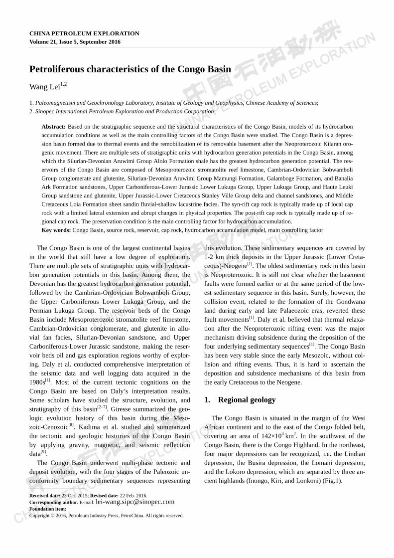
The Congo Basin is situated in the margin of the West African continent and to the east of the Congo folded belt, covering an area of 142×104 km2. In the southwest of the Congo Basin, there is the Congo Highland. In the northeast, four major depressions can be recognized, i.e. the Lindian depression, the Busira depression, the Lomani depression, and the Lokoro depression, which are separated by three an-cient highlands (Inongo, Kiri, and Lonkoni) (Fig.1).
2 CHINA PETROLEUM EXPLORATION Vol. 21, No. 5, 2016
Fig. 1 Tectonic division of the Congo Basin
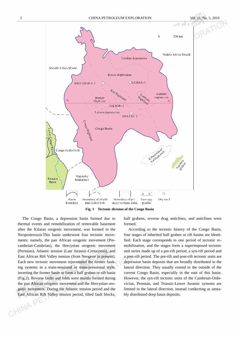
The Congo Basin, a depression basin formed due to thermal events and remobilization of removable basement after the Kilaran orogenic movement, was formed in the NeoproterozoicThis basin underwent four tectonic move-ments: namely, the pan African orogenic movement (Pre-cambrian-Cambrian), the Hercynian orogenic movement (Permian), Atlantic tension (Late Jurassic-Cretaceous), and East African Rift Valley tension (from Neogene to present). Each new tectonic movement rejuvenated the former fault-ing systems in a trans-tensional or trans-pressional style, inverting the former basin to form a half graben or rift basin (Fig.2). Reverse faults and folds were mainly formed during the pan African orogenic movement and the Hercynian oro-genic movement. During the Atlantic tension period and the East African Rift Valley tension period, tilted fault blocks,
half grabens, reverse drag anticlines, and anticlines were formed.
According to the tectonic history of the Congo Basin, four stages of inherited half graben or rift basins are identi-fied. Each stage corresponds to one period of tectonic re-mobilization, and the stages form a superimposed tectonic unit series made up of a pre-rift period, a syn-rift period and a post-rift period. The pre-rift and post-rift tectonic units are depression basin deposits that are broadly distributed in the lateral direction. They usually extend to the outside of the current Congo Basin, especially in the east of this basin. However, the syn-rift tectonic units of the Cambrian-Ordo-vician, Permian, and Triassic-Lower Jurassic systems are limited in the lateral direction, instead conducting as unsta-bly distributed deep basin deposits.
Wang Lei, Petroliferous characteristics of the Congo Basin 3
Fig. 2 Regional geology profile of the Congo Basin
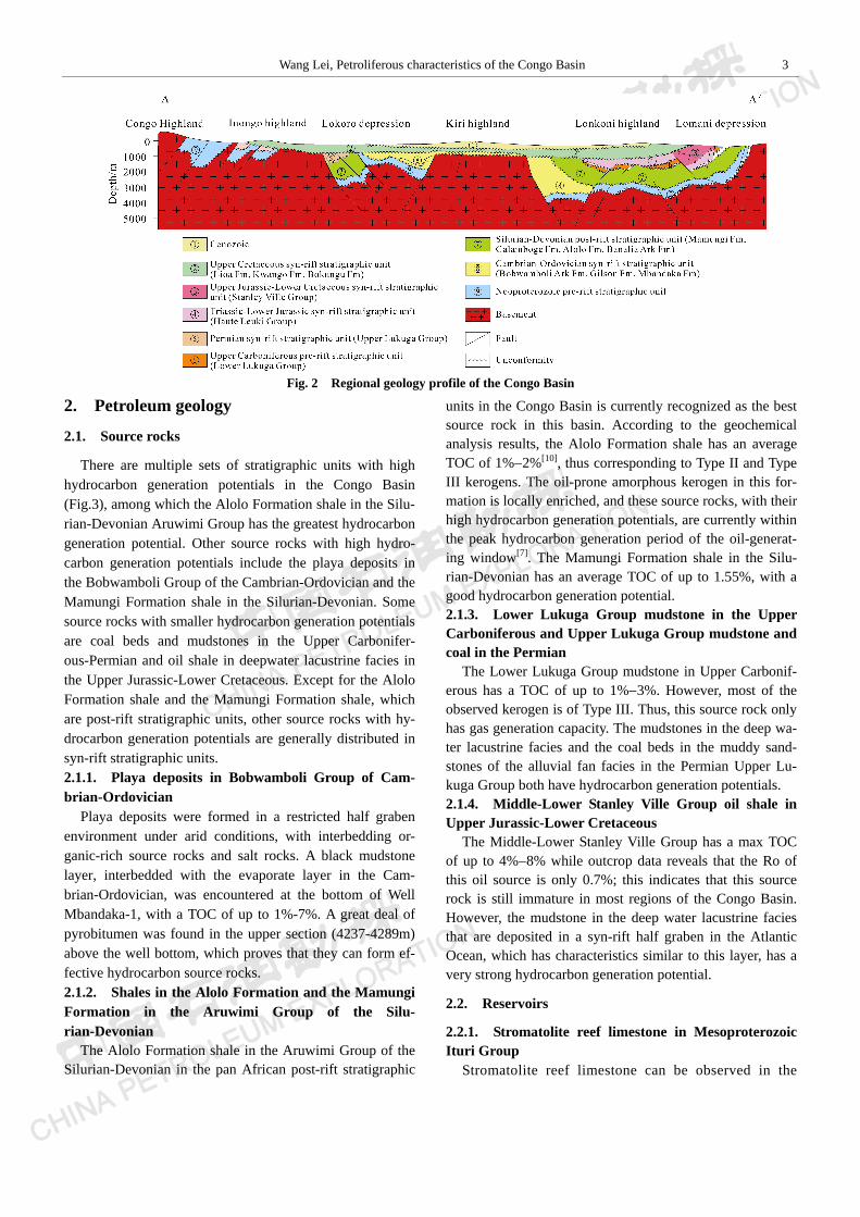
2. Petroleum geology
2.1. Source rocks
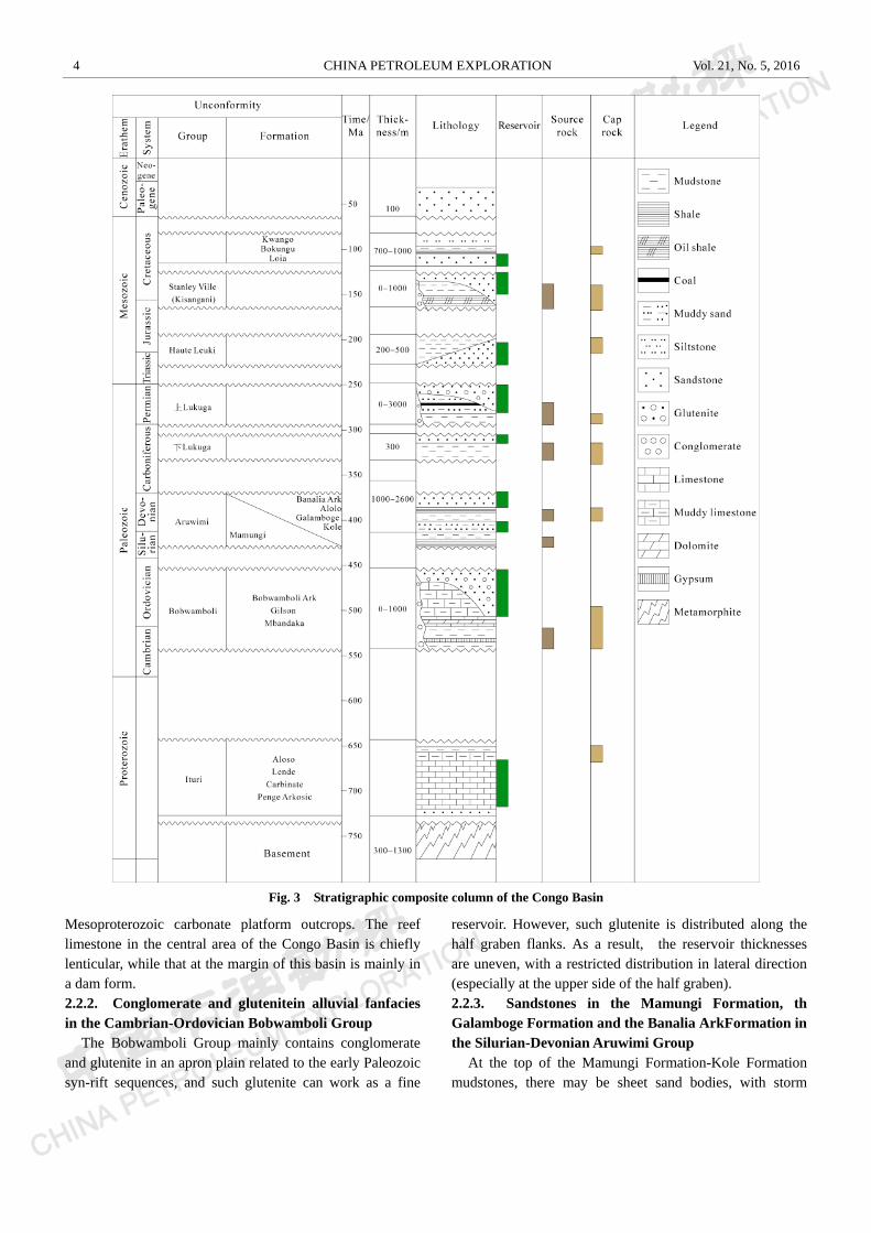
There are multiple sets of stratigraphic units with high hydrocarbon generation potentials in the Congo Basin (Fig.3), among which the Alolo Formation shale in the Silu-rian-Devonian Aruwimi Group has the greatest hydrocarbon generation potential. Other source rocks with high hydro-carbon generation potentials include the playa deposits in the Bobwamboli Group of the Cambrian-Ordovician and the Mamungi Formation shale in the Silurian-Devonian. Some source rocks with smaller hydrocarbon generation potentials are coal beds and mudstones in the Upper Carbonifer-ous-Permian and oil shale in deepwater lacustrine facies in the Upper Jurassic-Lower Cretaceous. Except for the Alolo Formation shale and the Mamungi Formation shale, which are post-rift stratigraphic units, other source rocks with hy-drocarbon generation potentials are generally distributed in syn-rift stratigraphic units. 2.1.1. Playa deposits in Bobwamboli Group of Cam-brian-Ordovician
Playa deposits were formed in a restricted half graben environment under arid conditions, with interbedding or-ganic-rich source rocks and salt rocks. A black mudstone layer, interbedded with the evaporate layer in the Cam-brian-Ordovician, was encountered at the bottom of Well Mbandaka-1, with a TOC of up to 1%-7%. A great deal of pyrobitumen was found in the upper section (4237-4289m) above the well bottom, which proves that they can form ef-fective hydrocarbon source rocks. 2.1.2. Shales in the Alolo Formation and the Mamungi Formation in the Aruwimi Group of the Silu-rian-Devonian
The Alolo Formation shale in the Aruwimi Group of the Silurian-Devonian in the pan African post-rift stratigraphic
units in the Congo Basin is currently recognized as the best source rock in this basin. According to the geochemical analysis results, the Alolo Formation shale has an average TOC of 1%2%[10], thus corresponding to Type II and Type III kerogens. The oil-prone amorphous kerogen in this for-mation is locally enriched, and these source rocks, with their high hydrocarbon generation potentials, are currently within the peak hydrocarbon generation period of the oil-generat-ing window[7]. The Mamungi Formation shale in the Silu-rian-Devonian has an average TOC of up to 1.55%, with a good hydrocarbon generation potential. 2.1.3. Lower Lukuga Group mudstone in the Upper Carboniferous and Upper Lukuga Group mudstone and coal in the Permian
The Lower Lukuga Group mudstone in Upper Carbonif-erous has a TOC of up to 1%3%. However, most of the observed kerogen is of Type III. Thus, this source rock only has gas generation capacity. The mudstones in the deep wa-ter lacustrine facies and the coal beds in the muddy sand-stones of the alluvial fan facies in the Permian Upper Lu-kuga Group both have hydrocarbon generation potentials. 2.1.4. Middle-Lower Stanley Ville Group oil shale in Upper Jurassic-Lower Cretaceous
The Middle-Lower Stanley Ville Group has a max TOC of up to 4%8% while outcrop data reveals that the Ro of this oil source is only 0.7%; this indicates that this source rock is still immature in most regions of the Congo Basin. However, the mudstone in the deep water lacustrine facies that are deposited in a syn-rift half graben in the Atlantic Ocean, which has characteristics similar to this layer, has a very strong hydrocarbon generation potential.
2.2. Reservoirs
2.2.1. Stromatolite reef limestone in Mesoproterozoic Ituri Group
Stromatolite reef limestone can be observed in the
4 CHINA PETROLEUM EXPLORATION Vol. 21, No. 5, 2016
Fig. 3 Stratigraphic composite column of the Congo Basin
Mesoproterozoic carbonate platform outcrops. The reef limestone in the central area of the Congo Basin is chiefly lenticular, while that at the margin of this basin is mainly in a dam form. 2.2.2. Conglomerate and glutenitein alluvial fanfacies in the Cambrian-Ordovician Bobwamboli Group
The Bobwamboli Group mainly contains conglomerate and glutenite in an apron plain related to the early Paleozoic syn-rift sequences, and such glutenite can work as a fine
reservoir. However, such glutenite is distributed along the half graben flanks. As a result, the reservoir thicknesses are uneven, with a restricted distribution in lateral direction (especially at the upper side of the half graben). 2.2.3. Sandstones in the Mamungi Formation, th Galamboge Formation and the Banalia ArkFormation in the Silurian-Devonian Aruwimi Group
At the top of the Mamungi Formation-Kole Formation mudstones, there may be sheet sand bodies, with storm
Wang Lei, Petroliferous characteristics of the Congo Basin 5
genesis or muddy sand streaks, which were formed by de-bris reformed by waves. The muddy sand reservoirs have a sporadic distribution. The Galamboge Formation sand bod-ies in the delta front facies can form fine reservoirs. These delta front sand bodies have a built-up huge sand streak that is distributed along and parallel to the margin of the Congo Basin. Its front extends dozens of kilometers to the center of this basin. On outcrops, the thicknesses of the Galamboge Formation sandstones are 150300 m. The porosity inter-preted by well logging data ranges from 7% to 12%, the SP curves have bigger deviation amplitudes from the baselines, and the resistivity curves are separated, indicating larger permeability values[7]. The composite sand bodies in the mouth bar and fluvial facies in the Banalia Ark Formation are developed at the top of the large complex delta in the Aruwimi Group. These sand bodies form thick sand lens in regionally distributed sand-mud sheets. 2.2.4. Sandstone and glutenite in Lower Lukuga Group, Upper Lukuga Group and Haute Leuki Group in Upper Carboniferous-Lower Jurassic
The periglacial sandstones form irregular sand bodies in the upper part of the Lower Lukuga Group. As with the Cambrian-Ordovician alluvial fan deposits, the fan delta deposits in the Upper Lukuga Group in Permian are also distributed along the flanks of the half graben. Particularly, at the flexuring or the reverse drag side of the half graben, the glutenite streaks are also restricted in the lateral direc-tion, with uneven thicknesses. The alluvial bodies in the Haute Leuki Group are regionally distributed sand bodies, with thicknesses ranging from 200500 m. 2.2.5. Sandstone in the Stanley Ville Group in the Up-per Jurassic-Lower Cretaceous
The Stanley Ville Group contains deep lacustrine-fluvial deposits, and its reservoir is made up of a complex of delta and channel sandstones, with an equivalent storage capacity to that of the glutenite in the Upper Lukuga Group in the Permian. 2.2.6. Sand bodies in LoiaFormation in Middle Creta-ceous
The lower Loia Formation in the Middle Cretaceous is composed of sheet sand bodies in fluvial-shallow lacustrine facies, giving it a stronger storage capacity. However, because it lacks a cap rock in the upper Loia Formation, the detrital sand reservoir in the uppermost part of this forma-tion does not fit the conditions for hydrocarbon accumula-tion.
2.3. Cap rocks
The cap rocks of the syn-rift stratigraphic units in the Congo Basin have a limited lateral extension, have physical
properties that vary rapidly with lateral changes, and gener-ally act as local cap rocks; in contrast, the cap rocks of the post-rift stratigraphic units are generally regional cap rocks, have far lateral extensions, and have physical properties that don’t vary as much with lateral changes. The Congo Basin mainly contains the following cap rocks:
(1) The mudstone and muddy limestone in the Mesopro-terozoic Ituri Group can act as regional cap rocks.
(2) The mudstone, gypsum interlayer, muddy limestone, and dolomite in the Cambrian-Ordovician Bobwamboli Group can act as the local cap rocks in the half graben.
(3) The Mamungi Formation shale in the Silu-rian-Devonian can serve as an effective regional cap rock.
(4) The Alolo Formation shale in the Devonian has a lim-ited lateral extension and a local sealing capacity.
(5) The Lower Lukuga Group mudstone in the Upper Carboniferous has a local sealing capacity, but this layer becomes thinner to the north; thus, its sealing capacity de-creases there.
(6) The mudstone in the deep lacustrine facies in the Up-per Lukuga Group in the Permian has a local sealing capac-ity.
(7) The thick lacustrine mudstones in the Haute Leuki Group in the Upper Triassic-Lower Jurassic have a regional sealing capacity.
(8) The mudstone in the deep lacustrine facies in the Up-per Jurassic-Lower Cretaceous has a local sealing capacity.
(9) The mudstone and siltstone in the shallow lacustrine facies in the Kwango Formation and the Bokungu Forma-tion in the Upper Cretaceous have a regional sealing capac-ity.
3. Hydrocarbon accumulation model and main controlling factors
3.1. Hydrocarbon accumulation model
3.1.1. The petroleum system in Lower Paleozoic The representative of the source rock is the playa depos-
its in the Cambrian-Ordovician syn-rift stratigraphic unit (Bobwamboli Group). It constitutes the hydrocarbon kitchen of the predicted petroleum system in the Lower Paleozoic, and it supplies oil to the overlying formations. It can be sup-posed that the half graben subsided and was quickly filled, which caused the most deeply buried source rocks to generate oil in the early stage and to act as a deep hydro-carbon kitchen. Although massive oil generation occurred in the post-rift period in the Middle Paleozoic (Silu-rian-Devonian) or in the later period of the massive secon-dary migration of oil and gas, the oil generation process even occurred in the later stage of the syn-rift period.
6 CHINA PETROLEUM EXPLORATION Vol. 21, No. 5, 2016
With the further geologic evolution of the Congo Basin, the hydrocarbons generated in the Cambrian-Ordovician source rocks charged the later formed structural traps (espe-cially the ones generated by inverted structures) and thusly became the predominant oil and gas accumulation. The Mamungi Formation shale in Silurian-Devonian can act as the cap rock of this petroleum system. 3.1.2. The petroleum system in Middle Paleozoic
The petroleum system in the Middle Paleozoic contains two sets of source rocks (Mamungi Formation shale and Alolo Formation shale). The hydrocarbons generated in the Mamungi Formation at the bottom of the Silurian-Devonian post-rift stratigraphic unit supplied oil and gas to the traps that were closer to the center of the Congo Basin. During the secondary migration, these hydrocarbons migrated pref-erentially to the overlying muddy sandstone in the Kole Formation and the sandstone in the delta front facies in the Galamboge Formation. In contrast, the hydrocarbons gener-ated in the Alolo Formation shale in the upper Aruwimi Group were supplied to the traps that were closer to the boundary of the Congo Basin. During the secondary migra-tion, these hydrocarbons migrated preferentially to the sand bodies in the delta front facies in the Galamboge Formation and the complex sand bodies in the mouth bar-fluvial facies in the Banalia Ark Formation that were close to the Alolo Formation shale. The Alolo Formation shale itself can act as a cap rock.
The maturation and hydrocarbon generation of these two sets of source rocks and the subsequent hydrocarbon migra-tion were caused by the late Hercynian orogeny and the tectonic stress related to the extension of the Atlantic Ocean. As the formations overlying the Banalia Ark Formation sandstone have no effective cap rocks, it is possible that the hydrocarbons generated in the Mamungi Formation shale and the Alolo Formation shale might have undergone sec-ondary or tertiary migration to the upper reservoir beds. 3.1.3. The petroleum system in the Upper Paleozoic
The hydrocarbon accumulation models of the petroleum systems in the Upper Paleozoic and Lower Paleozoic have much in common, as they both generated oil in the syn-rift period. Because the deposit fillings in the deeper part of the half graben were quickly buried, the mudstone in the deep lacustrine facies and the coal beds in the muddy sandstones in the Upper Lukuga Group in the Permian syn-rift period might have generated oil and supply oil in the early stage. However, oil generation was mostly controlled by tectonic reconstruction related to the extension of the Atlantic Ocean and the consequent subsidence. The existence of only a few fine cap rocks might be the major factor in trapping the mi-grated hydrocarbons. The mudstone in the Haute Leuki
Group in the Upper Triassic-Lower Jurassic might have acted as the cap rock while the stratigraphic traps related to the unconformity between the syn-rift period and the post-rift period were being formed. The mudstone in the deep lacustrine facies in the Stanley Ville Group in the Up-per Jurassic-Lower Cretaceous might have acted as the local cap rock for the secondary migration to the structural traps related to the reversion of the Atlantic Ocean.
3.2. Main controlling factors
According to the above analysis of the petroleum systems and the hydrocarbon accumulation models in the Congo Ba-sin, it is found that major hydrocarbon potentials are en-dowed in several rift sequences in the Paleozoic and the Mesozoic. The Congo Basin has experienced a multiphase of tectonic evolution (extension, subsidence and strata ero-sion, etc.). These tectonic movements and the subsequent structural reconstruction seriously destroyed the sealing ca-pacity of the traps and reservoir beds, making them unfa-vorable for hydrocarbon generation and preservation. Thus, the preservation condition is the major controlling factor for hydrocarbon accumulation.
4. Conclusions
The Congo Basin is a depression basin formed due to four tectonic movements (i.e. the pan African orogenic movement, the Hercynian orogenic movement, Atlantic ten-sion, and East African Rift Valley tension) after the Kilaran orogenic movement. The Congo Basin contains several sets of petroleum systems with favorable oil and gas potentials in the Lower Paleozoic, the Middle Paleozoic, and the Up-per Paleozoic. However, the preservation condition, which was destroyed and reformed by tectonic movements, is very important for hydrocarbon accumulation in this basin. Future exploration in this basin should focus on regions that have complete formations, less instances of late destruction, and well-developed source rocks.
References
[1] Daly M C, Lawrence S R, DiemuTshiband K, et al. Tectonic evolution of
the Cuvette Centrale, Congo [J]. Journal of the Geological Society, 1992,
149(4): 539546.
[2] Crosby A G, Fishwick S, White N. Structure and evolution of the intrac-
ratonic Congo Basin [J]. Geochemistry Geophysics Geosystems, 2010,
11(6): 449463.
[3] Etienne K K, Stanislas S M N, Francis L. A proterozoic-rift origin for the
structure and the evolution of the cratonic Congo basin [J]. EPSL, 2011,
304(1): 240250.
[4] Ayele A. Active compressional tectonics in central Africa and implica-
Wang Lei, Petroliferous characteristics of the Congo Basin 7
tions for plate tectonic models: evidence from fault mechanism studies of
the 1998 earthquakes in the Congo Basin [J]. Journal of African Earth Sci-
ences, 2002, 35(1): 4550.
[5] Dork L S. Structural evolution of African basins: stratigraphic synthesis
[J]. Basin Research, 1993, 5(5): 4154.
[6] Hartley R W, Allen P A. Interior cratonic basins of Africa: relation to
continental break-up and role of mantle convection [J]. Basin Research,
1994, 6(2-3): 95113.
[7] Downey N J, Gurnis M. Instantaneous dynamics of the cratonic Congo
basin [J]. Journal of Geophysical Research, 2009, 114(B6): 161169.
[8] Pierre G. Mesozoic-Cenozoic history of the Congo Basin [J]. Journal of
African Earth Sciences, 2005, 43(1-3): 301315.
[9] Kadima E, Delvaux D, Sebagenzi S N, et al. Structure and geological
history of the Congo Basin: an integrated interpretation of gravity, mag-
netic and reflection seismic data [J]. Basin Research, 2011, 23(5):
499527.
[10] Fournier J L. Alternative model upgrades exploration potential of Congo
Basin [J]. Oil and Gas Journal, 1994, 92(4): 5153.