peoples’ use of, and concerns about, green space networks: a case...
TRANSCRIPT

Peoples’ use of, and concerns about, green space networks: A case study of
Birchwood, Warrington New Town, UKTzoulas, K and James, P
http://dx.doi.org/10.1016/j.ufug.2009.12.001
Title Peoples’ use of, and concerns about, green space networks: A case study of Birchwood, Warrington New Town, UK
Authors Tzoulas, K and James, P
Type Article
URL This version is available at: http://usir.salford.ac.uk/9495/
Published Date 2010
USIR is a digital collection of the research output of the University of Salford. Where copyright permits, full text material held in the repository is made freely available online and can be read, downloaded and copied for noncommercial private study or research purposes. Please check the manuscript for any further copyright restrictions.
For more information, including our policy and submission procedure, pleasecontact the Repository Team at: [email protected].

Urban Forestry & Urban Greening 9 (2010) 121–128
doi:10.1016/j.ufug.2009.12.001
Peoples’ Use of, and Concerns about, Green Space Networks: A Case Study of
Birchwood, Warrington New Town, UK.
Konstantinos TZOULASa, Philip JAMES
b,
a) Corresponding author: School of Environment and Life Sciences, Peel Building,
The University of Salford, Greater Manchester, M5 4WT, UK,
Tel: +44(0) 161 295 2133, Fax: +44(0) 161 295 5015, [email protected]
b) School of Environment and Life Sciences, Peel Building, The University of
Salford, Greater Manchester, M5 4WT, UK
Abstract
Cultural services provided by green space networks and in particular leisure and
recreational opportunities are central to the quality of life of those living in urban
areas. However, the literature concerned with green space networks has mainly
focussed on planning aspects rather than on recreational use. The aim of this study
was to evaluate the recreational use of, and concerns about, a naturalistic green space
network. The case study location was the naturalistic woodland framework in
Birchwood, Warrington, UK, known as Birchwood Forest Park. Non-participant
observation and content analysis of local archives were used to collect quantitative
and qualitative data. Birchwood Forest Park was used more for leisure activities
(52.8%, N = 1,825; i.e. recreation, sports or play) than for utilitarian purposes (47.2%,
N = 1,825; i.e. as walking or cycling thoroughfare). However, utilitarian walking
(30%, N = 1,825) was the most frequent type of activity observed. The maintenance
of the naturalistic woodland framework was the most frequent concern mentioned in
the local archives (33.3%, N = 234). This case study suggests that the recreational
patterns in, as well as peoples’ concerns about, naturalistic urban landscapes may be a
factor of high quality maintenance and associated local aesthetic and cultural
perceptions. In developing, planning or managing comprehensive urban green space
networks it is important to ensure that natural looking scenes are well maintained and
that the local community is culturally connected to such scenes.
Key words: content analysis, green infrastructure, non-participant observation,
recreation, naturalistic landscape

1. Introduction
Urban green space network, in this study, is defined broadly to include physically
and/or functionally interconnected formally designated green spaces as well as
informal natural areas irrespective of their size, composition or use. Urban green
space networks could provide important ecosystem services (Tzoulas et al., 2007;
Millennium Ecosystem Assessment, 2005; Bolund and Hunhammar, 1999).
Ecosystem services are fundamental ecological processes that support all life on earth.
These include the provision of basic commodities (e.g. food, clean air and water
resources); the regulation of abiotic and biotic conditions (e.g. climate and spread of
diseases); the support of primary production and soil formation; and cultural services
(e.g. aesthetic, spiritual and psychological benefits from contact with nature as well as
leisure and recreation opportunities; Millennium Ecosystem Assessment, 2005). The
recreational activities that take place in urban green spaces are particularly important
because they could be linked to both physical health and psychological well-being
benefits for people (Maas et al., 2008; Tzoulas et al., 2007).
In the UK the main recreational activities that people engage in when visiting urban
green spaces include going for a walk; dog-walking; taking children to play areas;
sitting to relax and enjoy nature; playing informal or formal games; walking; cycling;
taking exercise; and taking part in social activities and events (GreenSpace, 2007;
Mulder et al., 2005; Ward-Thompson, 2005; Bell et al., 2004; Moore, 2003; Dunnett
et al., 2002). A common finding amongst surveys of the recreational use of urban
green spaces is that sports users are the minority of all users of parks and that informal

activity is more common than formal activity (GreenSpace, 2007; Mulder et al., 2005;
Ward-Thompson, 2005; Bell et al., 2004; Moore, 2003; Dunnett et al., 2002).
The potential of green spaces in promoting place identity and in residential preference
have also received research attention. Evidence suggests that urban scenes that feature
natural elements are preferred over scenes that do not (Ozguner and Kendle, 2006;
Ulrich, 1981). However, not all natural views are equally liked. For example views
of scattered trees with no dense understorey vegetation are preferred to views with
dense understorey (Ulrich, 1993; Kaplan and Kaplan, 1989). Specifically,
multilayered woodland edges have been found to be the least preferred option of
woodland edge (Jorgensen et al., 2002). Furthermore, there is evidence to suggest that
although people may like to visit wild areas they do not like to live in very close
proximity to them, preferring well kept landscapes near their homes instead (Nassauer
1995). Consequently, these studies indicate that wild looking woodland type
landscapes in close proximity to residential areas may not be liked by urban people.
If this is so, would there be different recreational patterns in naturalistic looking
landscapes than in well-kept parks?
Some authors have argued that poor outdoor urban design could lead to the loss of
community identity; and that enhancing the identity of the physical environment could
lead to increased sense of community attachment (Matsuoka and Kaplan, 2008). Also,
green spaces could have an important role in promoting community identity when
they offer opportunities to the residents to learn about, to get involved in activities in,
and to improve their local landscapes (Stewart et al., 2004). Nonetheless, further

research is needed to substantiate the role of urban green space in promoting
community identity (Matsuoka and Kaplan, 2008).
Studies on the recreational use of urban green space tend to focus on individual green
spaces rather than green space networks. Green space networks are more integrated
functionally or physically, and, therefore, may provide more formal and informal
recreation opportunities, than individual green spaces. The literature concerned with
urban forests, greenbelts and green hearts, green fingers or wedges, greenways, green
infrastructure and ecological networks tends to focus on their planning aspects rather
than on their recreational use (Opdam et al., 2006; Sandström et al., 2006; Walmsley,
2006; Li et al., 2005; Weber et al., 2005; Frischenbruder and Pellegrino, 2004; Jim
and Chen, 2003; Kühn, 2003; Sandstrom, 2002; Konijnendijk, 2000; Schrijnen, 2000;
Walmsley, 1995). So, there is little knowledge on the patterns of recreational use of
urban green space networks. However, knowledge of recreational use is vital in
understanding the multifunctional potential of urban green space networks and in
integrating social and ecological systems in land use planning and management
(James et al. 2009).
The aim of this study was to contribute knowledge in developing new insights in the
planning and management of an urban green space network. The objectives of this
study were to collect quantitative and qualitative data through observational and
document analysis methods to answer two questions. First, how is the urban green
space network used by the local community? Second, what are the local community’s
concerns about its green space network?

The case study location for this research was Birchwood, Warrington, UK. This is a
mixed use suburban area (811 hectares) with 11,395 residents (Office for National
Statistics, 2004). Birchwood was one of five districts of Warrington New Town and it
was developed during the 1970s and the 1980s. The development of Birchwood was
an experiment in urban design where for the first time in the UK naturalistic
principles were employed in creating an ecological woodland framework (Jorgensen
et al., 2007; Scott, 1991).
The woodland framework was established first and became known as Birchwood
Forest Park. This comprised three District Parks, one Golf Course, one Local Nature
Reserve, and numerous woodland belts and woodland fingers (Fig 1). The built
environment was developed subsequently and included three villages, four business
and two soft manufacturing employment areas. The different land uses were separated
by woodland belts, which were used to define the boundaries and give character to
each area (Scott, 1991). Furthermore, woodland fingers were created to interweave
within the built up areas. All the planting in the woodland framework, as well as in
the open spaces, involved naturalistic techniques and used indigenous species (Scott,
1991). This has recreated a naturalistic looking landscape, with a variety of habitats
including woodlands, ponds, meadows, shrubs and incorporated remnants of moss
land.

Figure 1: The case study location showing the main components of Birchwood Forest
Park, residential and employment areas, and the routes walked during structured
observations
Key: Woodland Belts: small woodland belts and woodland fingers are too fine to show on
this scale; Risley Moss LNR Public: the part of the Local Nature Reserve that is open to
public access; Risley Moss LNR Restricted: the part of the Local Nature Reserve that is not
open to the public access; Residential Villages: Oakwood; Gorse Cover; Locking Stumps;
Business Areas: Birchwood Shopping Centre; Birchwood Boulevard Business Park; and
Birchwood Business and Science Parks; Soft Manufacturing: Risley Employment Area
including Trident Employment Park; East Route: Stating at the train station and heading
Eastwards covers the areas of Oakwood, Birchwood Brook Park, the northern part of
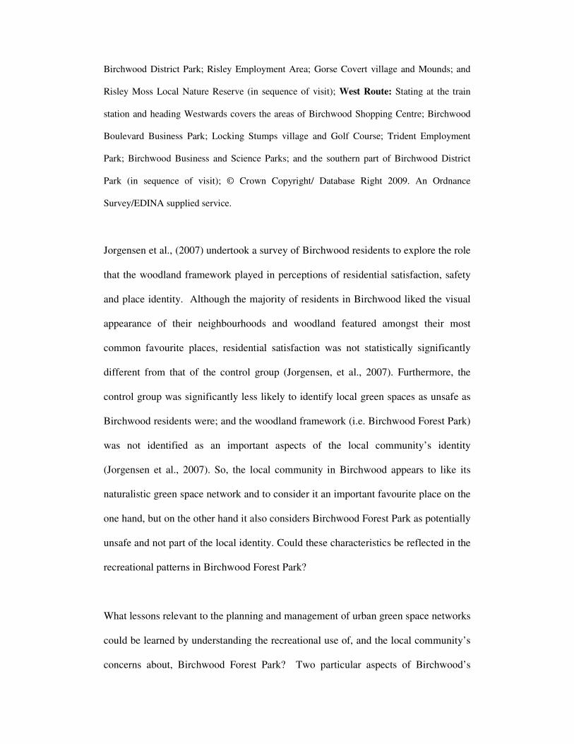
Birchwood District Park; Risley Employment Area; Gorse Covert village and Mounds; and
Risley Moss Local Nature Reserve (in sequence of visit); West Route: Stating at the train
station and heading Westwards covers the areas of Birchwood Shopping Centre; Birchwood
Boulevard Business Park; Locking Stumps village and Golf Course; Trident Employment
Park; Birchwood Business and Science Parks; and the southern part of Birchwood District
Park (in sequence of visit); © Crown Copyright/ Database Right 2009. An Ordnance
Survey/EDINA supplied service.
Jorgensen et al., (2007) undertook a survey of Birchwood residents to explore the role
that the woodland framework played in perceptions of residential satisfaction, safety
and place identity. Although the majority of residents in Birchwood liked the visual
appearance of their neighbourhoods and woodland featured amongst their most
common favourite places, residential satisfaction was not statistically significantly
different from that of the control group (Jorgensen, et al., 2007). Furthermore, the
control group was significantly less likely to identify local green spaces as unsafe as
Birchwood residents were; and the woodland framework (i.e. Birchwood Forest Park)
was not identified as an important aspects of the local community’s identity
(Jorgensen et al., 2007). So, the local community in Birchwood appears to like its
naturalistic green space network and to consider it an important favourite place on the
one hand, but on the other hand it also considers Birchwood Forest Park as potentially
unsafe and not part of the local identity. Could these characteristics be reflected in the
recreational patterns in Birchwood Forest Park?
What lessons relevant to the planning and management of urban green space networks
could be learned by understanding the recreational use of, and the local community’s
concerns about, Birchwood Forest Park? Two particular aspects of Birchwood’s

wooded landscape make this an extreme example of an urban green space network.
First, the recreated woodland framework comprising multilayered vegetation gives to
the landscape a natural and wild looking character. Second, natural looking woodland
engulfs and woodland fingers interweave through residential areas bringing residents
in very close proximity to the green space network.
Selecting extreme examples can be useful in collecting information about special
cases that may be particularly good or problematic and in illustrating vividly a point
(Flyvbjerg, 2004). Therefore, Birchwood Forest Park is a good case to illustrate the
recreational patterns and concerns that may be associated with natural looking
landscapes that are well-integrated in residential areas. This knowledge could be
useful in informing the planning, design and management of urban green space
networks.
2. Methods
Survey and interview methods are often used in studies that are focussed on the
recreational use of urban green space. However, methods that do not require the
researcher to interact with the study participants may collect data on attitudes and
behaviours that are not influenced by the knowledge that these are being studied
(O’Reilly, 2005; Robson, 1993). This was an important consideration in this study.
Hence, the methods that were used included unstructured and structured observations
(O’Reilly, 2005; Robson, 1993) and content analysis of local documents (Bengston et
al., 2005; Bickerstaff et al., 2002; Vuorisalo et al., 2001).

2.1 Unstructured observations
This study started with unstructured observations. These aimed to establish possible
activity hotspots in, and the variety of activities that took place in different parts of,
Birchwood Forest Park. An Ordnance Survey map of Warrington (scale 1: 15,840)
was used to identify all main routes and paths within the area (Ordnance Survey,
2000). Initially, these were walked at different days of the week and at different times
between 0830hrs and 2030hrs to capture day time outdoor physical activities. During
these initial walks hand written notes were made about any observations of activities
that were taking place, of the people who were engaged in them, and of the area
where the activities were happening. Notes were also kept on weather, date and time,
any special occasions and the socio-economic characteristics of the area.
The unstructured observations were undertaken in April 2003. The qualitative data
generated from these observations were summarised and grouped into two broad
categories of activities: utilitarian and leisure. The former category comprised
utilitarian walking and cycling while the latter included twenty types of leisure
pursuits under the broad themes of recreation, sport and play activities (Table 1).
These were used to create a field record-sheet that was used during the structured
observations (Table 2).

Table 1: Definitions of observations of activities used in the structured observations
Observations of
activities Definition
Uti
lita
rian
Walking/ cycling
somewhere
Walking/ cycling at a relative speed and not
carrying anything, or just carrying a handbag
Walking/ cycling to
shops
Walking/ cycling to or from the shops and
carrying shopping bags full of shopping (a)
Rec
rea
tion
Walking/ cycling the
dog
Walking/ cycling and having one or more
dogs with them
Walk/ cycling for
leisure
Walking/ cycling at a strolling pace, carrying
rucksacks or walking sticks and watching
people and surroundings; Also cycling at
relative speed and being dressed with cycling
gear
Chatting to people Two or more people chatting to each other
while standing in the streets, paths or in parks
Relaxing People sitting on park benches or lying on
the grass reading or sunbathing
Bird watching People with bird watching equipment who are
using bird watching facilities
Family outing Young man and woman with at least one child
having a picnic or sitting and playing in the
park (sometimes with grandparents)
Collecting flowers People collecting flowers, berries or sticks
Sp
ort
Football, Golf, Jogging,
Skate boarding, Tennis,
Flying kites, Frisbee,
Cricket
People or groups of people engaging formally
or informally in any of these sports and
exercise activities alone or in groups
Pla
y
Play in the park Children climbing trees, making dens in
shrubs and running about in green spaces
Play in a play area Children playing in any designated play areas
Play in the street Children playing seek and hide and/ or
running about in the streets
N.B.: (a) Observations of persons walking or cycling to the shops were only
made when the subjects were both near enough and had a clear direction
towards the shops

Table 2: Example of completed field record sheet used in the structured observations
Date: 21.12.04 Time: 11:40 am Transect: East Area: Science Park
Act
ors
Male 1 1 2 2 1 1
Female 1 1 3
≤10 years old 2
11 – 18 years old
19 – 39 years old 1 1 1 2 1 1 1
40 – 59 years old 2
≥ 60 years old 1
Uti
lita
rian
Cycling somewhere
Cycling to shops
Walking somewhere 1 1 1
Walking to shops
Recr
eati
on
Bird watching
Chatting to people
Collecting flowers
Cycling for leisure
Cycling with dog
Family outing
Relaxing
Walk for leisure 1 3 2
Walking the dog
Sp
ort
Cricket
Flying kites
Football
Frisbee
Golf
Jogging 1 2 1
Skate boarding
Tennis
Pla
y
Play in a play area
Play in the park
Play in the street
Comments: Very cold but bright and dry weather; no special occasions

2.2 Structured observations
Non-participant observation presents the difficulty of interpreting what is been
observed. For instance someone walking towards the shops may be going to the
shops, or to visit someone living near the shops, or may be strolling for leisure. This
difficulty was avoided in this study by clearly defining the criteria by which each
observation was categorised and recorded (Table 1). These criteria were defined by
summarising, and classifying notes made during the unstructured observations.
The aim of structured observations was to capture the variety of day time recreational
activities throughout the week, and at different seasons of the year. Field observations
were made according to a simple stratified unaligned sampling strategy (Hill et al.,
2005). Firstly, the study area was systematically subdivided into twenty five hectare
squares by overlaying a grid on an Ordnance Survey map (scale 1: 15,840; Ordnance
Survey, 2000). Twenty three such squares covered the whole study area. Secondly,
each one of the twenty five hectare squares was subdivided into one hundred equal
sized smaller squares. Thirdly, a table of random digits was used to select x and y sub-
coordinates in order to identify a point randomly within each twenty five hectare
square.
The resultant twenty three random points were then connected to form two routes one
covering the eastern and one covering the western parts of Birchwood Forest Park
(Fig 1). These routes were created in a way that captured the variation amongst the
residential areas and village centres, the employment areas, the woodland belts and
fingers, the local parks and the local nature reserve within the study area. Linking the

points into two routes provided an additional advantage. With the East route being
8.2 km and the West route being 6.3 km long it was possible to walk each of them in
2.5 to 3 hours. This meant that the routes could be walked at different times of day,
and thus capture time related changes in recreational activities.
All field visits were made between 0830hrs and 2030hrs on different days and times
each week (e.g. if one week field work was planned for Monday and Tuesday the
following week it would be planned for Wednesday and Thursday and so on). Field
visits were also made during weekends, Bank Holidays, School Holidays and over
Christmas and Easter Holidays (UK). Field visits were made irrespective of weather
conditions. This allowed complete seasonal coverage of observations during daylight.
During observations the age of actors was estimated by making deductions based on
their visual appearance.
The routes were walked in the same sequence of areas and both qualitative and
quantitative observations were made using an observation field-sheet (Table 2). The
East route started at the train station and covered two residential villages, the District
Parks (except the southern part of Birchwood District Park), the Local Nature Reserve
and Risley Employment Area. The West route started at the train station and covered
the business parks, the remaining residential village, the golf course, the southern part
of Birchwood District Park, and the Trident Employment Park (Fig 1). Each route
was visited an average twice a week and a total of 136 visits for structured
observations were made between May 2003 and February 2005.

An observation comprised an individual being involved in a recreational activity in
any part of Birchwood Forest Park. People being involved in group activities were
recorded as separate observations (e.g. if three females of different age were walking
for leisure their age group would be recorded individually and the activity would be
recorded three times; Table 2). While many of the single observations were recorded
on the field record while walking, near popular recreational areas where there were
often simultaneous and/ or group activities the observer stopped to make and record
the observations. Throughout the field work, and especially when it was necessary to
stop and keep notes, observations were done discreetly to ensure that people did not
feel that they were being observed.
2.3 Local documents content analysis
Content analysis of local documents has been used to explore peoples’ attitudes and
behaviours towards their local environment (Vuorisalo et al., 2001); to evaluate
experiences of public participation processes (Bickerstaff et al., 2002); and to evaluate
changing attitudes of the public towards urban sprawl (Bengston et al., 2005).
Therefore, this method can be used to find out about different aspects of a local
community. For this study the content analysis of local documents was designed to
explore in an unobtrusive way the local community’s concerns about its green space
network.
The document content analysis sought to cover the widest possible representation of
the population and reflect recent views at the time of the study. Hence, the sample
included archives of local newsletters and meetings minutes between 2002 and 2005

(reflecting the time span of this research project). The archives covered all main
interest groups of the area (i.e. residential, local community, business and
conservation; Table 3). The complete archives were collected by contacting the
respective organisation or local group.
Table 3: Local archives used in the content analysis study
Group Type of archive Group Interest
Birchwood Town Council Meeting minutes Local community
REPG (a) Meeting minutes Open spaces
Risley Moss LNR (b) Newsletter Open spaces
The Birchwood Forum Meeting minutes Business
The Birchwood Forum Newsletter Business
The Birchwood Partnership Meeting minutes Local community
N.B: All archives covered the period 2002 to 2005; (a) Risley Environmental Protection
Group; (b) Local Nature Reserve
The local archives were from local community, voluntary and business groups that
aim to improve the local area and so they concentrated mainly on negative rather than
positive aspects of the local area. This is why these archives were a good source for
collecting information about local concerns relating to Birchwood Forest Park.
Furthermore, the meetings in Birchwood Town Council, Birchwood Forum and
Birchwood Partnership were often attended by key local decision makers and so were
less likely to reflect misinformed views about the area.
A sample comprising three issues of each archive was initially read and this revealed
quotes that could be grouped into five categories of concern about Birchwood Forest

Park (Table 4). During the content analysis the local archives were read, and by using
a record sheet quotes about each different category of concern were recorded. This
produced both quantitative and qualitative information about concerns relating to
Birchwood Forest Park.
Table 4: Definitions of categories of concern used in the local document analysis
The quantitative data produced by the observational and content analysis studies were
summarised by descriptive statistics using Microsoft Excel XP®
Professional Edition
2001. The qualitative data that was produced by these methods were used to add
understanding to the interpretation of the quantitative data.
Concern category Definition
Facilities
maintenance
Restoring vandalised or worn out park facilities such
as benches, litterbins, signs, play and sport areas and
vandalism on the visitor centre or other buildings
Woodland
maintenance
Woodland maintenance needs, costs of maintenance,
street cleansing, landscaping issues, local wildlife
related concerns, trees and shrubs causing obstructed
views
Litter Litter issues along paths, in shrubs, along some streets
and abandoned trolleys
Paths Broken street and path lights, condition of paths,
requests for, and concerns about, footpath closures
Dog mess Mentions of dog mess issues, dog litter bins and
relevant bylaws

3. Results
3.1 Observational study
During the observational study 1,825 observations were made, of people using
Birchwood Forest Park, and of these 61% were male and 39% were female (Table 5).
The proportion of females noted in the survey is lower than that reported in other
surveys (e.g. Moore, 2003) and could be due to perceived safety issues in Birchwood
(Jorgensen et al., 2007).
Table 5: Sex and age of people observed to use Birchwood Forest Park
Sex & Age (a)
Frequency Percent (N=1825)
Male 1113 61.0
Female 712 39.0
Sum 1825 100
≤10 years old 315 17.3
11 – 18 years old 210 11.5
19 – 39 years old 687 37.6
40 – 59 years old 410 22.5
≥ 60 years old 203 11.1
Sum 1825 100
(a) Age is based on visual estimates
People in the age group between nineteen and thirty nine years old used Birchwood
Forest Park more than any other age group (37.6%, N = 1,825; Table 5). Teenagers
(11.5%) and people over sixty years old (11.1%) were the least observed groups using
the local urban green space network.

What do the local residents use the green space in Birchwood for? Forty seven point
two percent (N = 1,825) of the activity observed was for utilitarian purposes such as
walking or cycling to, or returning from, the local shops or another destination (Table
6). This proportion of utilitarian use may reflect that residents are using the well
interconnected network of paths through woodland belts for going to places.
Nine types of recreational activities were observed and these collectively represented
the second most popular group of activities taking place in the green spaces in
Birchwood (29.1%, N = 1,825; Table 6). The most frequent recreational activities
were dog walking (8.9%), walking for leisure (8.3%) and standing or sitting to discuss
with acquaintances or friends (4.9%). So, walking seems to be a main group of
recreational activities in a naturalistic green space network as it is in other types of
urban green space (Ward-Thompson, 2005; Bell et al., 2004; Moore, 2003; Dunnett et
al., 2002).
Eight sporting and exercise activities were observed in Birchwood Forest Park
(17.2%, N = 1,825; Table 6). However, two of these activities were only observed
twice (i.e. flying Frisbee and playing cricket). The most frequent types of sport that
were observed were football (6.5%) and golf (5.4%). This may be indicative of the
lack of other sports facilities in the area.

Table 6: Types of public use observed to take place in Birchwood Forest Park
Activities Grouped Frequency Percent (N = 1825)
Utilitarian 861 47.2
Recreation 531 29.1
Sport 314 17.2
Play 119 6.5
Sum 1825 100
Activities Detailed Frequency Percent (N = 1825)
Uti
lita
rian
Walking somewhere 547 30.0
Walking to shops 198 10.8
Cycling somewhere 108 5.9
Cycling to shops 8 0.4
Rec
reat
ion
Walking the dog 162 8.9
Walk for leisure 152 8.3
Chatting to people 89 4.9
Cycling for leisure 47 2.6
Relaxing 35 1.9
Bird watching 17 0.9
Family outing 11 0.6
Cycling with dog 9 0.5
Collecting flowers 9 0.5
Sport
Football 119 6.5
Golf 98 5.4
Jogging 47 2.6
Skate boarding 29 1.6
Tennis 10 0.5
Flying kites 7 0.4
Frisbee 2 0.1
Cricket 2 0.1
Pla
y
Play in the park 56 3.1
Play in a play area 34 1.9
Play in the street 29 1.6
Sum 1825 100
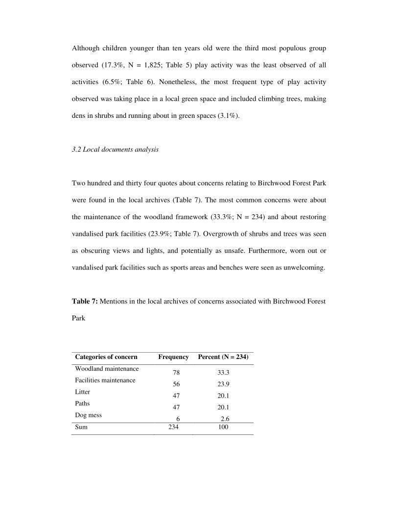
Although children younger than ten years old were the third most populous group
observed (17.3%, N = 1,825; Table 5) play activity was the least observed of all
activities (6.5%; Table 6). Nonetheless, the most frequent type of play activity
observed was taking place in a local green space and included climbing trees, making
dens in shrubs and running about in green spaces (3.1%).
3.2 Local documents analysis
Two hundred and thirty four quotes about concerns relating to Birchwood Forest Park
were found in the local archives (Table 7). The most common concerns were about
the maintenance of the woodland framework (33.3%; N = 234) and about restoring
vandalised park facilities (23.9%; Table 7). Overgrowth of shrubs and trees was seen
as obscuring views and lights, and potentially as unsafe. Furthermore, worn out or
vandalised park facilities such as sports areas and benches were seen as unwelcoming.
Table 7: Mentions in the local archives of concerns associated with Birchwood Forest
Park
Categories of concern Frequency Percent (N = 234)
Woodland maintenance 78 33.3
Facilities maintenance 56 23.9
Litter 47 20.1
Paths 47 20.1
Dog mess 6 2.6
Sum 234 100

Other green space concerns related mainly to litter and to poor path conditions (20.1%
each, N = 234) as well as to dog mess (2.6%; Table 7). Litter and dog mess are
common issues associated with urban green spaces (Ward-Thompson, 2005; Bell et
al., 2004; Moore, 2003; Dunnett et al., 2002; Todorovic and Wellington, 2000).
However, poor path lights are an issue particularly relevant to Birchwood Forest Park,
which has an extensive network of paths that often are overgrown. These conditions
did not seem to make the paths welcoming.
4. Discussion
This study used the unobtrusive methods of non-participant observation and of
content analysis of local archives to evaluate what types of activities people undertake
in, and what concerns they have about, a naturalistic urban green space network.
Collectively there was more leisure than utilitarian activities observed in Birchwood’s
green spaces. However, when leisure is split into more specific activities such as
recreation, sport and play, it becomes evident that utilitarian walking and cycling
outnumber any other type of activity (Table 6). Although twenty types of leisure
activities were recorded the majority of these were observed quite infrequently at less
than a hundred times each over a period of two and half years.
Recreational activities like walking the dog or walking for leisure are often the most
common in urban green spaces and woodlands (Ward-Thompson, 2005; Bell et al.,
2004; Moore, 2003; Dunnett et al., 2002; Todorovic and Wellington, 2000). Walking
the dog or walking for leisure were also the most frequently observed activities in
Birchwood Forest Park, indicating that there may be no difference in the patterns of

recreational walking in naturalistic looking landscapes and in other types of urban
green space.
The decision on whether to use urban green space or not for recreation may be
influenced by social and cultural factors (Snape and Binks, 2008; Sasidharan et al.,
2005), by individual preferences, or by the availability of alternative forms of
recreation. (Mulder et al., 2005). McDonald and Price (2009) identified a number of
reasons why people did not visit urban parks including not being a priority compared
to shopping or other leisure activities; lack of variety of leisure opportunities in parks;
access difficulties; and failed promotional efforts. Furthermore, people who do not use
parks or woodlands may do so because they are not interested (Moore, 2003) or
because of other perceptions of personal insecurity (Jorgensen et al., 2007). Factors
like these may explain the range and frequency of recreational activities observed in
Birchwood Forest Park. However, more detailed studies are needed to establish
exactly which factors are in place and their relative significance in determining
recreational choices in urban green space networks.
Although sport users are often a minority in public parks (Ward-Thompson, 2005;
Bell et al., 2004) in Birchwood they seemed to be a populous minority. The types of
sports and exercise that were seen in Birchwood’s green spaces reflected the
availability of public sports facilities. The Locking Stumps Golf Course and the
playing fields and the skate park in Birchwood District Park (Fig 1) are the only
public sports facilities in the area and this may explain the frequency of these types of
sports. At one time there had been greater provision of sports facilities as two
basketball courts, now both derelict and vandalised, were seen (Fig 1). This may be

reflecting changing personal choices of sports and/ or budgetary cuts in the
maintenance of sports facilities. So, the choice of sport or exercise in Birchwood may
be influenced by personal choice (Bandura, 2001), social perceptions (Ajzen, 1991)
and access to facilities.
Smith et al., (1997) proposed a conceptual model that linked urban form
characteristics and community quality. The three most important design criteria
having the strongest relationship to physical activity were walkable spaces, outdoor
amenities and available seating (Smith et al., 1997). In another study King et al.,
(2000) were able to correlate enjoyable scenery in neighbourhoods with more physical
activity. The scenery in Birchwood Forest Park is primarily dominated by
multilayered and wild looking woodland edges, which are in very close proximity to
houses. Some evidence suggests that multilayered woodland edges (Jorgensen et al.,
2002) and wild looking landscapes close to homes (Nassauer, 1995) are least
preferred amongst urban people. Furthermore, a study has found that the presence of
the woodland framework did not make Birchwood residents like their residential
scenes more than people who did not live in this area (Jorgensen et al., 2007).
Therefore, the recreational patterns in Birchwood Forest Park characterised by a wide
range of mostly infrequent activities may be reflecting the local community’s
contradictory perceptions of its green space network of both liking it on the one hand
and perceiving it as potentially unsafe on the other (Jorgensen et al., 2007).
Since personal choices (Bandura, 2001) and social perceptions (Ajzen, 1991) may be
central in determining visual preference, it may be that the local community in
Birchwood is not well connected culturally with its Forest Park. Indeed, Jorgensen et

al., (2007) found that the woodland framework in Birchwood was not identified by
local residents as a feature of community identity. This may be due the wild looking
woodland edges being perceived by the local residents as signs of poor maintenance
rather than signs of community care (Nassauer, 1995). Some authors have argued that
for innovative residential ecological designs to be successful it is important to
establish a threshold of cultural engagement amongst urban communities (Nassauer et
al., 2009). So, it may be that if the local residents in Birchwood were more culturally
integrated with the woodland framework than they are now they would identify it as
part of their community identity as well as using it more frequently for recreational
activities. Anthropological studies of the cultural meanings of Birchwood Forest Park
for its residents are needed to clarify how the local community relates to its
naturalistic landscape.
Issues that often raise concern in relation to the use of urban green space and
community woodlands include dog mess, litter and vandalism (Ward-Thompson,
2005; Bell et al., 2004; Moore, 2003; Dunnett et al., 2002; Todorovic and Wellington,
2000). Restoring vandalised facilities and too much litter were also identified as main
concerns relating to Birchwood Forest Park (Table 7). Dog mess was also identified
as a concern but less frequently so. Therefore, these types of concern seem to be
common amongst different types of urban green space.
On the other hand the concerns about maintaining the overgrowth of woodland edges
and poor lighting and conditions along paths are issues particularly relevant to
Birchwood. Birchwood Forest Park is an extreme example of an urban green space
network characterised by wild looking and interconnected multilayered woodland

edges that engulf and interweave through residential areas. So, the concerns revealed
in the local archives about the maintenance of the woodland framework and about the
paths may also be relevant to other naturalistic looking landscapes and interconnected
green space networks.
Using Birchwood Forest Park as a special case of a green space network, which is
particularly naturalistic in its outlook, has illustrated vividly two points that are
relevant to other New Towns or other urban areas with similar comprehensive green
space networks such as Garden Cities, Community Forest areas and potentially new
Eco Towns in the UK (Communities and Local Government, 2009). First,
comprehensive and natural looking woodland frameworks may raise specific
woodland and path maintenance concerns. Second, it is important to have an
understanding of the cultural and aesthetic factors that influence the frequency and
choice of recreational activities in naturalistic residential areas. So, in developing,
planning or managing comprehensive green space networks it is important to ensure
that appropriate views and visual penetration through the woodland edges are allowed
(Jorgensen et al., 2004), that the scenes are well kept and maintained (Nassauer
1995), and that the local community is culturally connected with its ecological design
(Nassauer et al., 2009).
5. Conclusions
In the case study presented in this paper the recreational use of, and concerns about,
an extreme example of a green space network have been evaluated by using
observational and document analysis methods. Although observations may reveal

what recreational activities may take place they cannot reveal the reasons why these
activities might be chosen over other activities. So, although it was been possible to
evaluate the range of day time activities and their frequency in Birchwood Forest Park
it was not possible to evaluate why these were taking place. Further anthropological
studies could provide evidence on the reasons for the observed recreational patterns.
Furthermore, the types of archives used in document analysis will limit the type of
information that can be gained from them. In this case archives from local
community, business and voluntary groups were selected and these were good sources
of the local community’s concerns about its living and working environments.
However, incorporating focus-group and/or in-depth interviews with a random sample
of the local population could provide more detailed qualitative data than document
analysis alone. Despite the limitations of the methodology the Birchwood case study
captures the recreational patterns in a naturalistic and interconnected urban green
space network as well as the main concerns that may be associated with such a
landscape.
6. References
Ajzen, I., 1991. The theory of planned behaviour. Organisational Behaviour and
Human Decision Processes 50, 179-211.
Bandura, A., 2001. Social cognitive theory: an agentic perspective. Annual Review of
Psychology 52, 1-26.

Bell, S., Morris, N., Findlay, C., Travlou, P., Montarzino, A., Gooch, D., Gregory, G.,
Ward-Thompson, C., 2004. Nature for people: the importance of green spaces to East
Midlands communities. English Nature Research Reports no. 567. English Nature,
Peterborough.
Bengston, D.N., Potts, R.S., Fan, D.P., Goetz, E.G., 2005. An Analysis of the public
discourse about urban sprawl in the United States: monitoring concern about a major
threat to forests. Forest Policy and Economics 7, 745– 756.
Bickerstaff, K., Tolley, R., Walker, G., 2002. Transport planning and participation:
the rhetoric and realities of public involvement. Journal of Transport Geography 10,
61–73.
Bolund, P., Hunhammar, S., 1999. Ecosystem services in urban areas. Ecological
Economics 29, 293–301.
Communities and Local Government, 2009. Planning policy statement: eco-towns: a
supplement to planning policy statement 1. UK Government Department for
Communities and Local Government, London.
Dunnett, N., Swanwick, C., Wooley, H.., 2002. Improving urban parks, play areas and
open spaces. UK Government Department of Transport, Local Government and the
Regions; London.

Flyvbjerg, B., 2004. Five misunderstandings about case-study research. In Seale, C.,
Gobo, G., Gubrium, J.F., Silverman, D., (Eds.), 2004 Qualitative Research Practice.
Sage, London and Thousand Oaks, pp. 420-434.
Frischenbruder, M.T., Pellegrino, P., 2004. Using greenways to reclaim nature in
Brazilian cities. Landscape and Urban Planning 76, 67-78.
GreenSpace, 2007. The Park Life report. GreenSpace, Reading.
Hill, D., Fasham, M., Tucker, G., Shewry, M., Shaw, P., (Eds.) 2005. Handbook of
biodiversity methods: survey, evaluation and monitoring. Cambridge University
Press, Cambridge.
James, P., Tzoulas, K., Adams, M.D., Barber, A., Box, J., Breuste, J., Elmqvist, T.,
Frith, M., Gordon, C., Greening, K.L., Handley, J., Haworth, S., Kazmierczak, A.E.,
Johnston, M., Korpela, K., Moretti, M., Niemelä, J., Pauleit, S., Roe, M.H., Sadler,
J.P., Ward Thompson, C., 2009. Towards an integrated understanding of green space
in the European built environment. Urban Forestry and Urban Greening, 8, 2, 65-75.
Jim, C.Y., Chen, S.S., 2003. Comprehensive green space planning based on landscape
ecology principles in compact Nanjing city, China. Landscape and Urban Planning
65, 95–116.

Jorgensen, A., 2004. The social and cultural context of ecological plantings. In
Dunnett, N., Hitchmough, J. (Eds.), 2004 The Dynamic Landscape. Spon, London,
pp. 416-458.
Jorgensen, A., Hitchmough, J., Calvert, T., 2002. Woodland spaces and edges: their
impact on perception of safety and preference. Landscape and Urban Planning 60,
135–150.
Jorgensen, A., Hitchmough, J., Dunnett N., 2007. Woodland as a setting for housing
appreciation and fear and the contribution to residential satisfaction and place identity
in Warrington New Town, UK. Landscape and Urban Planning 79, 273–287.
Kaplan, R., Kaplan, S., 1989. The experience of nature: a psychological perspective.
Cambridge University Press, Cambridge
King, A.C., Castro, C., Wilcox, S., Eyler, A.A., Sallis, J.F., Brownson, R.C., 2000.
Personal and environmental factors associated with physical inactivity among
different racial-ethnic groups of U.S. middle-aged and older-aged women. Health
Psychology 19, 4, 354-364.
Konijnendijk, C.C., 2000. Adapting forestry to urban demands: the role of
communication in urban forestry in Europe. Landscape and Urban Planning 52, 89-
100.

Kühn, M., 2003. Greenbelt and green heart: separating and integrating landscapes in
European city regions. Landscape and Urban Planning 64, 19–27.
Li, F., Wang, R., Paulussen, J., Liu, X., 2005. Comprehensive concept panning of
urban greening based on ecological principles: a case study in Beijing, China.
Landscape and Urban Planning 72, 325-336.
Maas, J., Verheij, R.A., Spreeuwenberg, P., Groenewegen, P.P., 2008. Physical
activity as a possible mechanism behind the relationship between green space and
health: a multilevel analysis. BMC Public Health 8: 206 doi:10.1186/1471-2458-8-
206.
Matsuoka, R.H., Kaplan, R., 2008. People needs in the urban landscape: analysis of
Landscape and Urban Planning contributions. Landscape and Urban Planning 84; 7–
19.
McDonald, S.M., Price, G.G., 2009. Addressing declining metropolitan park use: a
case study of Melbourne, Victoria, Australia. Managing Leisure 14, 1, 28-37.
Millennium Ecosystem Assessment, 2005. Ecosystems and human well-being:
synthesis. Island Press; Washington DC
Moore, S., 2003. The use of public parks in England. Sport England, Countryside
Agency and English Heritage; s.l.
Mulder, C., Shibli, S., Hale, J., 2005. Young people's demand for countryside
recreation: a function of supply, tastes and preferences? Managing Leisure 10, 2, 106
- 127.
Nassauer, J.I., 1995. Messy ecosystems, orderly frames. Landscape Journal 14, 161–
170.
Nassauer, J.I., Wang, Z., Dayrell, E., 2009. What will the neighbours think? Cultural
norms and ecological design. Landscape and Urban Planning 92; 282-292.
O’Reilly, K., 2005. Ethnographic methods. Routledge, London.
Office for National Statistics, 2004. Census 2001: key statistics for urban areas in the
North. Office for National Statistics and The Stationary Office; London.
Opdam, P., Steingrover, E., van Rooij, S., 2006. Ecological networks: a spatial
concept for multi-actor planning of sustainable landscapes. Landscape and Urban
Planning 75, 322–332.
Ordnance Survey, 2000. Warrington street A-Z atlas. 2nd
Ed. Ordnance Survey,
Sevenoaks.
Ozguner, H., Kendle, A. D., 2006. Public attitudes towards naturalistic versus
designed landscapes in the city Sheffield (UK). Landscape and Urban Planning 74;
139-157.

Robson, C., 1993. Real world research: a resource for social scientists and
practitioner-researchers. Blackwell Publishers, Oxford.
Sandström, U.F., 2002. Green infrastructure planning in urban Sweden. Planning
Practice and Research 17, 4, 373–385.
Sandström, U.G., Angelstam, P., Khakee, A., 2006. Urban comprehensive planning:
identifying barriers for the maintenance of functional habitat networks. Landscape and
Urban Planning 75, 43–57.
Sasidharan, V., Willits, F., Godbey, G., 2005. Cultural differences in urban recreation
patterns: an examination of park usage and activity participation across six population
subgroups. Managing Leisure 10, 1, 19 – 38.
Schrijnen, P.M., 2000. Infrastructure networks and red-green patterns in city regions.
Landscape and Urban Planning 48, 191–204.
Scott, D., 1991. The greening of Warrington. Landscape Design, February, 24-25.
Smith, T., Nelischer, M., Perkins, N., 1997. Quality of an urban community: a
framework for understanding the relationship between quality and physical form.
Landscape and Urban Planning 39, 229-241.

Snape, R., Binks, P., 2008. Re-thinking sport: physical activity and healthy living in
British South Asian Muslim communities. Managing Leisure 13, 1, 23- 35.
Southwood, T.R.E., Henderson, P.A., (Eds.) 2000. Ecological methods. 3rd
Ed.
Blackwell Science, London.
Stewart, W.P., Liebert, D., Larkin, K.W., 2004. Community identities as visions for
landscape change. Landscape and Urban Planning 69; 315–334.
Todorovic, J., Wellington, S., 2000. Living in urban England: attitudes and
aspirations. UK Government Department for the Environment, Transport and the
Regions; London.
Tzoulas, K., Korpela, K., Venn, S., Yli-Pelkonen, V., Kazmierczak, A., Niemelä, J.,
James, P., 2007. Promoting ecosystem and human health in urban areas using green
infrastructure: a literature review. Landscape and Urban Planning 81, 167–178.
Ulrich, R.S., 1981. Natural versus urban scenes: some psychological effects.
Environment and Behaviour 13, 5, 523–556.
Ulrich, R.S., 1993. Biophilia, biophobia and natural landscapes. In Kellert, S.R.,
Wilson, E.O. (Eds.), The Biophilia Hypothesis. Island Press / Shearwater Books,
Washington, DC, pp. 74-137.

Vuorisalo, T., Lahtinen, R., Laaksonen, H., 2001. Urban biodiversity in local
newspapers: a historical perspective. Biodiversity and Conservation 10, 10, 1739-
1756.
Walmsley, A., 1995. Greenways and the making of urban form. Landscape and Urban
Planning 33, 81-127.
Walmsley, A., 2006. Greenways: multiplying and diversifying in the 21st century.
Landscape and Urban Planning 76, 252–290.
Ward-Thompson, C., 2005. “It gets you away from everyday life”: local woodlands
and community use – what makes a difference? Landscape Research 30, 1, 109-146.
Weber, T., Sloan, A., Wolf, J., 2005. Maryland’s Green Infrastructure Assessment:
development of a comprehensive approach to land conservation. Landscape and
Urban Planning 77, 94-110.