pedestrians who are vision impaired - victoria · pdf fileroad safety audit tool for...
TRANSCRIPT
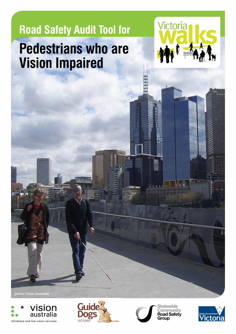
Road Safety Audit Tool for
Pedestrians who are Vision Impaired
(photo: Vision Australia)
Principal authorDuane Burtt, Victoria Walks Inc.
Contributing authors Vision Australia and Guide Dogs Victoria Working Group – Marcus Bleechmore, Nicola Misso, Gayle McPherson, Caroline Maplesden, Sandro Cirianni and Darlene McIntosh.
Malcolm Daff, Malcolm Daff Consulting (transport engineering input).
Robert Morgan, Robert Morgan Traffic Engineering and Road Safety (road safety auditor input).
Ben Rossiter, Victoria Walks, Project Director.
Recommended citationBurtt, D (2014). Road Safety Audit Tool for Pedestrians who are Vision Impaired, Vision Australia (Victoria), Melbourne.
1 Road Safety Audit Tool for Pedestrians who are Vision Impaired
Contents
Part 1 – Introduction ........................................................................................................................................................................2
About this tool .............................................................................................................................................................................2
Safety issues and management for vision impaired pedestrians ...............................................................................................3
Intersection types .......................................................................................................................................................................4
Tactile Ground Surface Indicators (TGSI) ....................................................................................................................................5
Crossings and audio tactiles ......................................................................................................................................................6
Vehicle speed .............................................................................................................................................................................7
Shared paths and interaction with bicycles ................................................................................................................................7
Footpaths ....................................................................................................................................................................................8
Kerbs and kerb ramps ..............................................................................................................................................................10
Public transport access ............................................................................................................................................................11
Design guidance .......................................................................................................................................................................11
References ................................................................................................................................................................................12
Part 2 – Conducting an Audit .........................................................................................................................................................13
Audit instructions – how to use the checklists ..........................................................................................................................13
Audit cover sheet ......................................................................................................................................................................14
Audit Area .................................................................................................................................................................................14
Checklist for Signalised Intersections and Crossings ...............................................................................................................15
Comments and key issues ........................................................................................................................................................18
Checklist for Non-Signalised Intersections or Crossings ..........................................................................................................19
Tactile Ground Surface Indicators (TGSI) ..................................................................................................................................20
Kerbs and kerb ramps ..............................................................................................................................................................21
Comments and key issues ........................................................................................................................................................21
Checklist for Path Infrastructure ................................................................................................................................................22
Footpath Infrastructure .............................................................................................................................................................22
Major driveways / access ways and cycle paths crossing footpaths ......................................................................................23
Public transport access ............................................................................................................................................................24
Taxi ranks ..................................................................................................................................................................................24
Train stations .............................................................................................................................................................................24
Bus stops ..................................................................................................................................................................................24
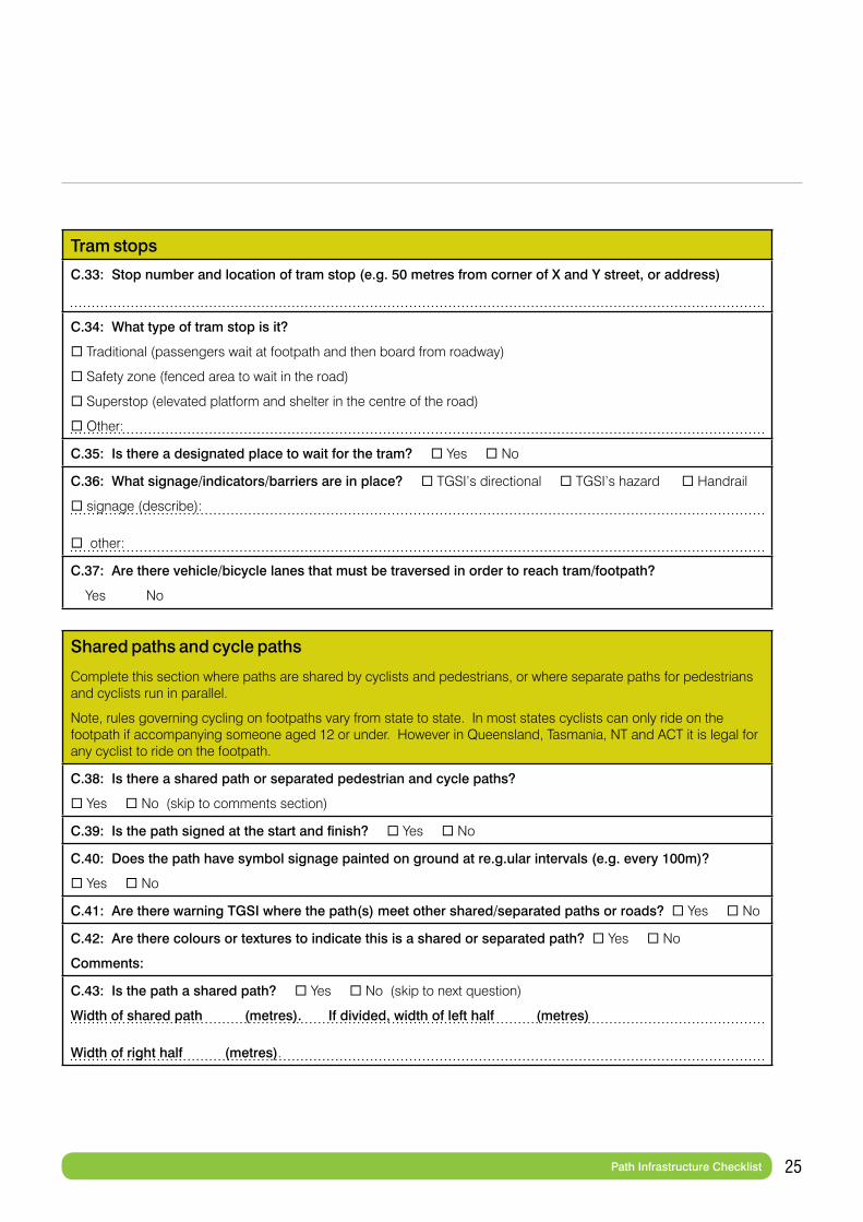
Tram stops ................................................................................................................................................................................25
Shared paths and cycle paths ..................................................................................................................................................25
Comments and key issues ........................................................................................................................................................26
Audit Conclusions .....................................................................................................................................................................27
Priority issues ............................................................................................................................................................................27
Overall comments .....................................................................................................................................................................27
Audit Map..................................................................................................................................................................................28
* This document is best viewed using Adobe Reader.
2 Road Safety Audit Tool for Pedestrians who are Vision Impaired
About this toolThis document provides:
• An overview of safety issues facing pedestrians with vision impairment in the road environment
• A checklist based audit tool for assessing the safety and convenience of road environments for pedestrians with vision impairment.
It has been prepared by Victoria Walks in association with Vision Australia and Guide Dogs Victoria, with funding from the Victorian Community Road Safety Partnership Program, administered by VicRoads.
The document provides an accessible but comprehensive tool for assessing the walkability and safety of road environments for pedestrians with vision impairment. It is designed to be used by anyone who has an interest in road safety for people with vision impairment, from traffic engineers to volunteer advocates. It is also designed to facilitate reporting of issues in a way that gives road management authorities a comprehensive picture of the road environment as it relates to pedestrians who are blind or have low vision.
This report was produced with the support of the Victorian Community Road Safety Partnership program.
Part 1 – Introduction
3 Road Safety Audit Tool for Pedestrians who are Vision Impaired
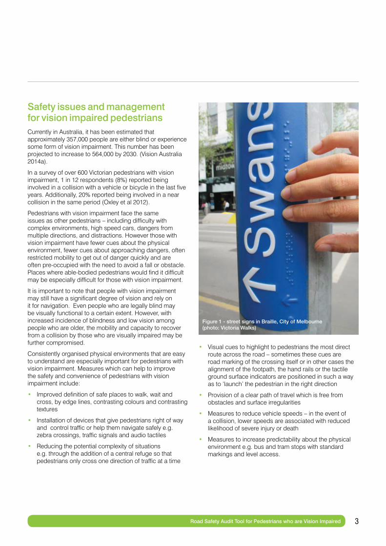
Figure 1 - street signs in Braille, City of Melbourne(photo: Victoria Walks)
Safety issues and management for vision impaired pedestriansCurrently in Australia, it has been estimated that approximately 357,000 people are either blind or experience some form of vision impairment. This number has been projected to increase to 564,000 by 2030. (Vision Australia 2014a).
In a survey of over 600 Victorian pedestrians with vision impairment, 1 in 12 respondents (8%) reported being involved in a collision with a vehicle or bicycle in the last five years. Additionally, 20% reported being involved in a near collision in the same period (Oxley et al 2012).
Pedestrians with vision impairment face the same issues as other pedestrians – including difficulty with complex environments, high speed cars, dangers from multiple directions, and distractions. However those with vision impairment have fewer cues about the physical environment, fewer cues about approaching dangers, often restricted mobility to get out of danger quickly and are often pre-occupied with the need to avoid a fall or obstacle. Places where able-bodied pedestrians would find it difficult may be especially difficult for those with vision impairment.
It is important to note that people with vision impairment may still have a significant degree of vision and rely on it for navigation. Even people who are legally blind may be visually functional to a certain extent. However, with increased incidence of blindness and low vision among people who are older, the mobility and capacity to recover from a collision by those who are visually impaired may be further compromised.
Consistently organised physical environments that are easy to understand are especially important for pedestrians with vision impairment. Measures which can help to improve the safety and convenience of pedestrians with vision impairment include:
• Improved definition of safe places to walk, wait and cross, by edge lines, contrasting colours and contrasting textures
• Installation of devices that give pedestrians right of way and control traffic or help them navigate safely e.g. zebra crossings, traffic signals and audio tactiles
• Reducing the potential complexity of situations e.g. through the addition of a central refuge so that pedestrians only cross one direction of traffic at a time
• Visual cues to highlight to pedestrians the most direct route across the road – sometimes these cues are road marking of the crossing itself or in other cases the alignment of the footpath, the hand rails or the tactile ground surface indicators are positioned in such a way as to ‘launch’ the pedestrian in the right direction
• Provision of a clear path of travel which is free from obstacles and surface irregularities
• Measures to reduce vehicle speeds – in the event of a collision, lower speeds are associated with reduced likelihood of severe injury or death
• Measures to increase predictability about the physical environment e.g. bus and tram stops with standard markings and level access.
4 Road Safety Audit Tool for Pedestrians who are Vision Impaired
Intersection types Signalised intersections and pedestrian crossings (traffic lights) are safer than unsignalised crossings, because they regulate traffic and indicate to the pedestrian when it is safe to cross. In the survey of vision impaired pedestrians, 61% of the pedestrians who were surveyed indicated that they were very confident at signalised crossings, but confidence at all other intersection types was much lower. In the same survey, only 6% of collisions were reported at signalised crossings (Oxley et al 2012).
At unsignalised roundabouts, vehicles have right of way over pedestrians and movements through the roundabout are determined by visual interaction between vehicles. It has been noted that “This can make it very difficult, if not dangerous, for pedestrians to cross” (Blind Citizens Australia 2009). Of all intersection types pedestrians with vision impairment have the lowest level of confidence at roundabouts (Oxley et al 2012). Raised pedestrian crossings immediately adjacent to the roundabout offer a treatment which may provide a good level of service and safety for pedestrians. Pedestrians with vision impairment may be unable to locate a crossing that is separated from the roundabout and able-bodied pedestrians are unlikely to make the detour to use it, unless the traffic hazard is extreme.
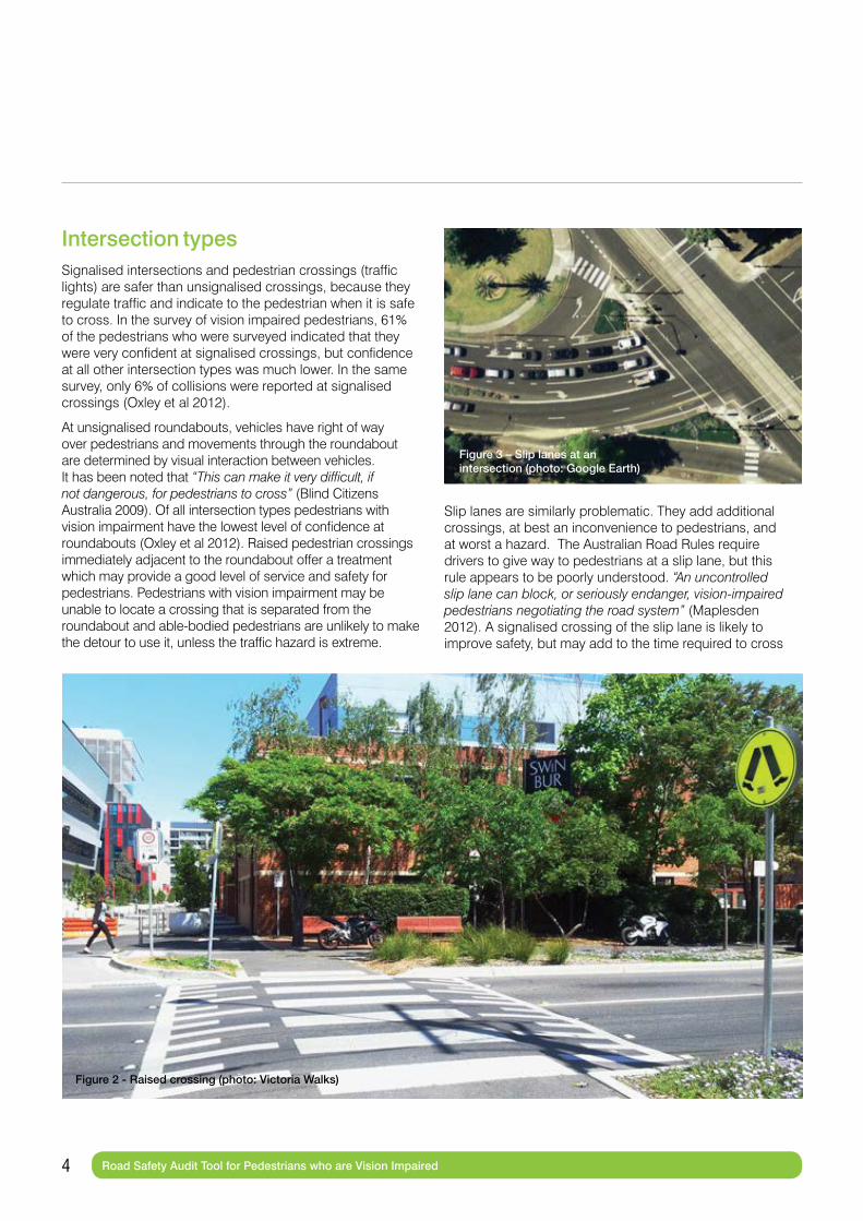
Slip lanes are similarly problematic. They add additional crossings, at best an inconvenience to pedestrians, and at worst a hazard. The Australian Road Rules require drivers to give way to pedestrians at a slip lane, but this rule appears to be poorly understood. “An uncontrolled slip lane can block, or seriously endanger, vision-impaired pedestrians negotiating the road system” (Maplesden 2012). A signalised crossing of the slip lane is likely to improve safety, but may add to the time required to cross
Figure 2 - Raised crossing (photo: Victoria Walks)
Figure 3 – Slip lanes at an intersection (photo: Google Earth)
5 Road Safety Audit Tool for Pedestrians who are Vision Impaired
and therefore reduce convenience for both drivers and pedestrians. A raised crossing may provide a reasonable balance between safety and convenience for pedestrians. In areas with lots of pedestrians such as town centres, consideration should be given to removing the slip lane altogether.
Roads or intersections which do not have a marked or signalised pedestrian crossing can be unsafe. Particularly problematic are natural but uncontrolled crossing points where traffic does not need to slow or stop for an intersection. “Generally, the blind will not utilise busy arterial road uncontrolled crossing points due to the obvious inherent danger of crossing a road or vehicle circulation path without being able to safely decide when to cross” (Government of South Australia 2008).
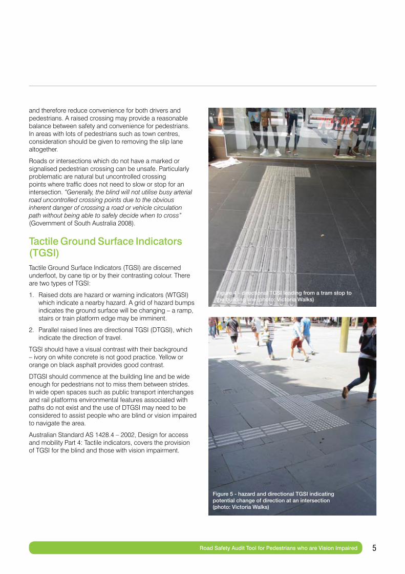
Tactile Ground Surface Indicators (TGSI)Tactile Ground Surface Indicators (TGSI) are discerned underfoot, by cane tip or by their contrasting colour. There are two types of TGSI:
1. Raised dots are hazard or warning indicators (WTGSI) which indicate a nearby hazard. A grid of hazard bumps indicates the ground surface will be changing – a ramp, stairs or train platform edge may be imminent.
2. Parallel raised lines are directional TGSI (DTGSI), which indicate the direction of travel.
TGSI should have a visual contrast with their background – ivory on white concrete is not good practice. Yellow or orange on black asphalt provides good contrast.
DTGSI should commence at the building line and be wide enough for pedestrians not to miss them between strides. In wide open spaces such as public transport interchanges and rail platforms environmental features associated with paths do not exist and the use of DTGSI may need to be considered to assist people who are blind or vision impaired to navigate the area.
Australian Standard AS 1428.4 – 2002, Design for access and mobility Part 4: Tactile indicators, covers the provision of TGSI for the blind and those with vision impairment.
Figure 4 - directional TGSI leading from a tram stop to the building line (photo: Victoria Walks)
Figure 5 - hazard and directional TGSI indicating potential change of direction at an intersection (photo: Victoria Walks)
6 Road Safety Audit Tool for Pedestrians who are Vision Impaired
Crossings and audio tactilesIt should be noted that pedestrians who are blind or have low vision may have difficulty locating places to cross in complex environments. Once the crossing has been located, crossing safely may still be a challenge.
Signalised crossings with audio tactiles are the safest type of crossing to use because they provide audio, visual and tactile indications of when it is safe to cross (Vision Australia 2014b). Audio tactiles are mechanical or electronic devices connected to the pedestrian ‘call button’ box on crossing poles that pulse (which can be detected by someone’s hand) and emit a ticking or beeping sound. Audio tactiles are designed to synchronise with the slow clicking phase (when the red man is illuminated) and fast clicking phase (when the green man is illuminated) of traffic signals. A ticking audio tactile device should be louder than ambient noise. Push buttons for pedestrian activated signals and audio tactiles should be located within easy reach of the kerb ramp.
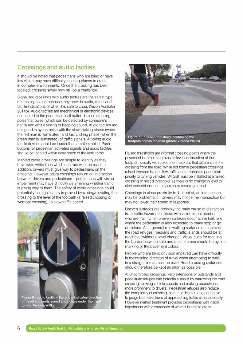
Marked zebra crossings are simple to identify as they have wide white lines which contrast with the road. In addition, drivers must give way to pedestrians on the crossing. However zebra crossings rely on an interaction between drivers and pedestrians – pedestrians with vision impairment may have difficulty determining whether traffic is giving way to them. The safety of zebra crossings could potentially be significantly improved by raising/elevating the crossing to the level of the footpath (a raised crossing or wombat crossing), to slow traffic speed.
Raised thresholds are informal crossing points where the pavement is raised to provide a level continuation of the footpath, usually with colours or materials that differentiate the crossing from the road. While not formal pedestrian crossings, raised thresholds can slow traffic and emphasise pedestrian priority to turning vehicles. WTGSI must be installed at a raised crossing or raised threshold, as there is no change in level to alert pedestrians that they are now crossing a road.
Crossings in close proximity to, but not at, an intersection may be problematic. Drivers may notice the intersection but may not lower their speed in response.
Uneven surfaces are possibly the main cause of distraction from traffic hazards for those with vision impairment or who are frail. Often uneven surfaces occur at the kerb line where the pedestrian is also expected to make stop or go decisions. As a general rule walking surfaces on centre of the road refuges, medians and traffic islands should be at road level without a level change. Visual cues for marking the border between safe and unsafe areas should be by line marking or the pavement colour.
People who are blind or vision impaired can have difficulty in maintaining direction of travel when attempting to walk in a straight line across the road. Road crossing distances should therefore be kept as short as possible.
At uncontrolled crossings, kerb extensions or outstands and pedestrian refuges can potentially assist by narrowing the road crossing, slowing vehicle speeds and making pedestrians more prominent to drivers. Pedestrian refuges also reduce the complexity of crossing, as the pedestrian does not have to judge both directions of approaching traffic simultaneously. However neither treatment provides pedestrians with vision impairment with assurances of when it is safe to cross.
Figure 6 - audio tactile – the arrow indicates direction of travel and emits sound and pulses under the hand (photo: Victoria Walks)
Figure 7 – a raised threshold, continuing the footpath across the road (photo: Victoria Walks)

7 Road Safety Audit Tool for Pedestrians who are Vision Impaired
Vehicle speedTraffic volume and speed are significant factors in pedestrian exposure to crash risk (Oxley 2010). It is well established that pedestrians have a rapidly increasing likelihood of death at collision speeds beyond 30km/h. Consideration should be given to 30 or 40 km/h speed limits in areas where there are likely to be significant numbers of pedestrians or vulnerable pedestrians such as seniors, children and vision impaired. Detailed guidance on setting speed limits is provided in VicRoads’ Speed Zoning Guidelines.
If it is not possible to reduce speeds generally, traffic calming techniques or signals should be used in an attempt to reduce vehicle speeds at crossing points used by pedestrians with vision impairment.
100
90
80
70
60
50
40
30
20
10
00 10 20 30 40 50 60 70
Impact Speed (km/h)
Risk
of D
eath
(%)
Shared paths and interaction with bicyclesWhile motor vehicles are the main threat to the safety of vision impaired pedestrians, the risk of collision with bicycles should not be overlooked. Unlike a motor vehicle, a bicycle does not emit sufficient noise to alert the pedestrian of the bicycle’s approach and for those individuals who rely on residual vision, bicycles are also more difficult to see. In the survey of pedestrians with vision impairment, 24% of collisions and near collisions were with bicycles. Only 19% of respondents expressed confidence in their interaction with cyclists (Oxley et al 2012). Older pedestrians generally are also uncomfortable sharing walking space with cyclists. In a survey of 1,128 Victorian seniors, 39% identified “bicycle riders on shared walking and cycling paths” as a moderate or major constraint on their walking (Garrard 2013). Shared paths should not be installed where there are significant numbers of elderly or pedestrians with vision impairment, large numbers of walkers generally, or high speed cyclists. Generally, existing footpaths should not be converted to shared or separated paths. Any shared paths should meet the applicable design standards.
Where it is considered necessary to provide for both off-road cycling and walking, separated path(s) better provide for walkers and cyclists. However, separated paths should have a physical barrier between them to prevent pedestrians with vision impairment inadvertently moving into the cycle path.
Figure 8 – Risk of pedestrian death as a function of vehicle impact speed (Oxley 2010)

8 Road Safety Audit Tool for Pedestrians who are Vision Impaired
FootpathsPeople who are blind or vision impaired use what is known as ‘shore lining’ to navigate. Features such as building lines or walls, edges of formed footpaths and fences are all used for orientation along a footpath. It is important that built features align wherever possible. A clear footpath (minimum 1.8 metres wide) adjacent to the building line is important for people with vision impairment to remain oriented, locate shop entrances and avoid obstacles such as sandwich boards, café seating and utilities (which should be located next to the kerb). Maintaining an unobstructed path of travel is likely to require ongoing management and enforcement regarding business use of footpaths and parking of cars and other vehicle types (e.g., motorcycles) across the footpath.
The need to provide an unobstructed path of travel includes obstructions such as over-hanging vegetation or signs that may intrude into the head space above the footpath. Clear headroom of 2,200mm should be maintained.
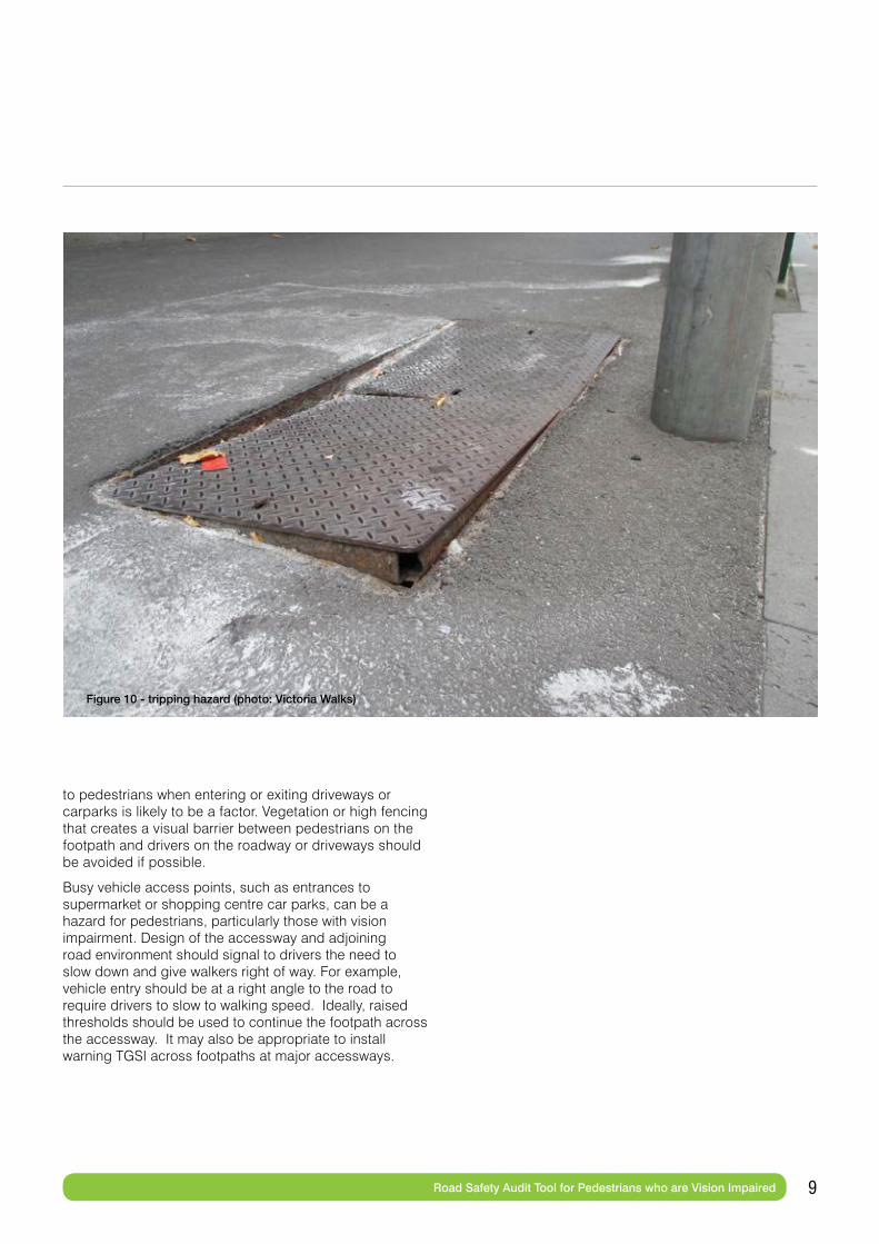
It is particularly important to ensure footpaths are free of tripping hazards. Poor or uneven surfaces on paths and roads are a hazard for all pedestrians, but especially for the elderly and vision impaired. Falls may account for up to 75% of pedestrian injuries in public spaces (International Transport Forum 2011). Walking surfaces should be a consistent level and where changes in level are necessary, gentle slopes, as opposed to steps, are preferred. Management of utilities such as service pit covers and trenches should not create uneven surfaces.
Lighting of streets and pedestrian open spaces should be sufficient to ensure that the surrounding environment, traffic and other obstacles are clearly visible.
In addition to the risk of trips and falls, the potential for collisions on the footpath should be considered. In the survey of pedestrians with vision impairment, 29% of collisions affecting these pedestrians were on the footpath (Oxley et al 2012). The exact nature of these collisions is unclear, but motorists failing to give way
Figure 9 - bins and motorcycles located adjacent to the kerb to provide a clear path along the building line (photo: Victoria Walks)
9 Road Safety Audit Tool for Pedestrians who are Vision Impaired
Figure 10 - tripping hazard (photo: Victoria Walks)
to pedestrians when entering or exiting driveways or carparks is likely to be a factor. Vegetation or high fencing that creates a visual barrier between pedestrians on the footpath and drivers on the roadway or driveways should be avoided if possible.
Busy vehicle access points, such as entrances to supermarket or shopping centre car parks, can be a hazard for pedestrians, particularly those with vision impairment. Design of the accessway and adjoining road environment should signal to drivers the need to slow down and give walkers right of way. For example, vehicle entry should be at a right angle to the road to require drivers to slow to walking speed. Ideally, raised thresholds should be used to continue the footpath across the accessway. It may also be appropriate to install warning TGSI across footpaths at major accessways.

10 Road Safety Audit Tool for Pedestrians who are Vision Impaired
Kerbs and kerb rampsPeople who are blind or have impaired vision rely on kerbs to indicate where the footpath ends and the road begins.
Rollover kerbs or treatments that do not provide a noticeable drop from the footpath to street level may present pedestrians with vision impairment with difficulty. Without a clear definition of where the roadway begins, pedestrians with vision impairment can find themselves in the middle of the road without knowing that they have left the footpath. WTGSI may need to be considered at locations where there is no level change between footpath and roadway surfaces.
Shared space, where vehicles and pedestrians share the road, can be similarly problematic. Design and signage of these areas needs to ensure that traffic speeds are very low and pedestrians are given clear priority. Warning and directional TGSI may be required.
Kerb ramps (sometimes called pram ramps or pram crossings) are important for seniors, those using wheelchairs or mobility scooters, children and their guardians (legally) riding bicycles on the footpath. However they can present a hazard for pedestrians with vision impairment who may not detect the transition from the footpath to the road. Kerb ramps should have a sufficient slope to be detectable under foot and should not merge into the road (Blind Citizens Australia 2009), and also should not be so steep as to cause a tripping hazard or be difficult for someone unsteady on their feet to negotiate. Generally there should be no vertical surface (sometimes called a bullnose) where the water runs along the gutter. In some cases it may be desirable to construct a vertical surface of 5mm (or so and no higher) to provide a tactile indication of the edge of the safe area for white cane users. WTGSI should be provided in all accessible kerb ramps and median openings.
When crossing a road, people who have impaired vision often use the kerb ramp to align themselves and then walk in a straight line to the other side. It is important that kerb ramps on either side of the road are directly aligned with each other and with any pedestrian refuge islands (Government of South Australia 2008).
Figure 11 - kerb extension/outstand bringing the footpath to the road. (photo: City of Port Phillip)
Figure 12 - good alignment of TGSI, ramps and median pedestrian refuge in a straight line across the road (photo: Victoria Walks)
Figure 13 - the orientation of this ramp could send people into the path of oncoming traffic, rather than across the crossing. (photo: Victoria Walks)
11 Road Safety Audit Tool for Pedestrians who are Vision Impaired
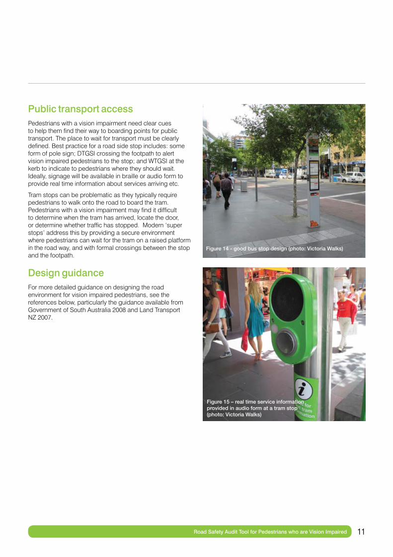
Public transport accessPedestrians with a vision impairment need clear cues to help them find their way to boarding points for public transport. The place to wait for transport must be clearly defined. Best practice for a road side stop includes: some form of pole sign; DTGSI crossing the footpath to alert vision impaired pedestrians to the stop; and WTGSI at the kerb to indicate to pedestrians where they should wait. Ideally, signage will be available in braille or audio form to provide real time information about services arriving etc.
Tram stops can be problematic as they typically require pedestrians to walk onto the road to board the tram. Pedestrians with a vision impairment may find it difficult to determine when the tram has arrived, locate the door, or determine whether traffic has stopped. Modern ‘super stops’ address this by providing a secure environment where pedestrians can wait for the tram on a raised platform in the road way, and with formal crossings between the stop and the footpath.
Design guidanceFor more detailed guidance on designing the road environment for vision impaired pedestrians, see the references below, particularly the guidance available from Government of South Australia 2008 and Land Transport NZ 2007.
Figure 15 – real time service information provided in audio form at a tram stop (photo: Victoria Walks)
Figure 14 - good bus stop design (photo: Victoria Walks)

12 Road Safety Audit Tool for Pedestrians who are Vision Impaired
ReferencesBlind Citizens Australia (2009). Policy Statement Pedestrian Safety.
Garrard, J (2013). Senior Victorians and walking: obstacles and opportunities, Victoria Walks, Melbourne.
Government of South Australia (2008). Guidelines for Disability Access in the Pedestrian Environment.
Guide Dogs NSW/ACT, http://www.guidedogs.com.au/what-we-do/advocacy/ accessed 29 January 2014.
International Transport Forum (2011). Working Group on Pedestrian Safety, Urban Space and Health Report for Approval 5-6 April 2011. Organisation for Economic Co-operation and Development (OECD).
Land Transport NZ (2007). RTS 14 Guidelines for facilities for blind and vision-impaired pedestrians 2nd edition 2007.
Maplesden C, (2012). A dim view of pedestrian safety: Raising awareness of the needs of vision-impaired pedestrians, Journal of the Australasian College of Road Safety – Volume 23 No.3, 2012.
National Council for the Blind Ireland (NCBI). Guidelines for Accessibility of the Built External Environment. www.ncbi.ie/information-for/architects-engineers/guidelines-for-accessibility-of-the-built-environment, accessed 29 January 2013.
New Zealand Transport Agency (2009). Pedestrian Planning and Design Guide.
Oxley, J (2010). Fact Sheet No.6: Improving Pedestrian Safety, Curtin-Monash Accident Research Centre.
Oxley, J; Liu, S; Langford, J; Bleechmore, M; Guaglio A (2012). Road Safety for Pedestrians Who Are Blind or Have Low Vision, Monash University Accident Research Centre and Vision Australia.
VicRoads (2014a). Traffic Engineering Manual Volume 1, Chapter 7: Speed Zoning Guidelines.
Vision Australia (2013a). Estimate based on ABS Survey of Disability and Carers 4430.0, and ABS Population data 3101.0
Vision Australia (2014b). http://www.visionaustralia.org/living-with-low-vision/learning-to-live-independently/in-the-community/getting-around-safely/crossing-roads Accessed 6 March 2014.
13 Audit Instructions
Audit instructions – how to use the checklistsThe following checklists can be used to audit an area to identify safety and walkability issues for people with vision impairment. Once an audit has been completed, it can be provided to the relevant road management agencies to inform decision making on potential infrastructure improvements. See the Introduction for background on issues facing pedestrians with vision impairment (separate document when viewed electronically).
There are 3 different checklists for different situations:
1. Signalised intersections and crossings (traffic lights).
2. Non-signalised intersections and crossings.
3. Path infrastructure, including footpaths, shared paths and access to public transport.
To undertake an audit:
1. Complete the audit cover sheet.
2. Complete a separate checklist for each intersection; road crossing; or stretch of path that you walk along. Be careful to select the correct checklist. Number each checklist in order of completion (the first box on each checklist).
3. Complete the audit conclusion sheet.
4. Cut and paste a map of the audit area from an online map. Label each part of the audit route with a number that corresponds with the checklist number.
Tips:
• Take lots of photos! Photograph any intersection or crossing on the route; key facilities on the route (the footpath, public transport stops); any problems you identify (tripping hazards, major driveways etc). Photos can be inserted in the audit checklists or attached separately.
• Where you answer ‘other’ or ‘differs’ to a question, describe the situation (and photograph it).
• Identify the location of an issue by finding the nearest street number and recording the address.
• Note anything you see as a problem, even if it is not specified in the checklist.
• Read the applicable checklist immediately before completing it, to remind you of things to look for.
To complete the audit, you will need to take:
1. Tablet or laptop to complete the audit electronically, or pen and paper copies of the checklists. If completing paper copies, it would be wise to look at your route online or in a street directory to identify the number of copies you will need of each checklist.
2. Camera, or mobile phone with camera capabilities.
3. Ideally, a tape measure (especially if auditing a shared or separated cycle path) and a stopwatch or other mechanism for measuring short periods of time (e.g. 45 seconds).
If in doubt, take a photo!
Part 2 – Conducting an Audit
DOWNLOAD
14 Audit Instructions
Audit cover sheetAuditor/s: (include name, company/organisation and contact details):
Day and Date:
Start and Finishing time:
Audit Area
Map reference No: (Melways/UBD/Vic Roads)
Suburb:
Street/Road:
Starting Point A: Address/Landmark
Finishing Point B: Address/Landmark

15 Signalised Intersections and Crossings Checklist
Checklist for Signalised Intersections and Crossings
Checklist for intersections or mid-block crossings with traffic lights.
Where different legs (crossings) of the intersection have different treatments, describe each of them in the space provided.
Checklist number:
A.1: Intersections – names of intersecting streets:
OR Mid-block crossings – address:
A.2: Type of intersection/crossing: Crossroads T junction Mid-block crossing
Other:
A.3: Speed limit (write road name and limit for each street at the intersection. For mid-block crossings only one line will need to be completed)
Road name Limit km/h
Road name Limit km/h
A.4: Other than the traffic lights, are there any traffic controls in place prior to the intersection/crossing to control vehicles? Warning Signs Partial lane closure Speed enforcement/camera Speed Hump Chicane
Other:
Road name Describe controls
Road name Describe controls
A.5: How many lanes are there to cross? (e.g. 2 in each direction = 4) 1 2 3 4
Other (please specify):
A.6: How long is the walk sign (green man) phase?
Road name (road being crossed) Seconds
Road name Seconds
A.7: How long is the red flashing phase? (don’t include the non-flashing red man)
Road name (road being crossed) Seconds
Road name Seconds
A.8: At a slow to normal walking speed, is there enough time to complete the crossing without waiting on a pedestrian island or refuge?
Road name Yes No, how much time does it take? (seconds)
Road name Yes No, how much time does it take? (seconds)
DOWNLOAD

16 Signalised Intersections and Crossings Checklist
A.9: Is there a protected or dedicated cycle lane at (or approaching) the intersection?
Yes (specify where): No
A.10: Does the intersection have slip lane(s)? Yes No (skip to A.13)
A.11: How many slip lanes (figure 2) are there at the intersection? 1 2 3 4
Describe location of slip lanes (e.g. SE corner)
A.12: What provision is there for pedestrians to cross the slip lane?
Signalised crossing Raised crossing Zebra crossing (not raised) None – no marked crossing
Other (e.g. different crossings for different slip lanes):
Audio Tactiles
Audio tactiles are described and discussed in the introduction (page 6). Check all audio tactiles at the intersection or crossing in answering the questions below.
A.13: Are audio tactile devices installed on the pedestrian call-button poles?
Yes No (skip to A.20) Other/differs:
A.14: Is the audio tactile on a pole within arm’s reach of a pedestrian waiting at the kerb ramp?
Yes No (skip to A.20) Other/differs:
A.15: Does the audio tactile pulse under your hand and emit sound? (check all tactiles at intersection)
Yes – pulse and emit sound Pulse under hand only Sound only No – not working (skip to A.20)
Other/differs:
A.16: Does the audio tactile emit a sound during both the wait and walk phases?
Yes No Other/differs:
A.17: If audio only, can a waiting pedestrian hear the fast phase clicking, above the ambient traffic noise?
Yes No Other/differs:
A.18: Is the volume of the slow phase audible over ambient traffic noise?
Yes No Other/differs:
A.19: Can the fast phase of the audio tactiles be heard from the centre of the crossing?
Yes No Other/differs:
Tactile Ground Surface Indicators (TGSI)
TGSIs are described and discussed in the introduction (page 5). Check all TGSI at the intersection or crossing in answering the questions below.
A.20: Are there TGSI at the intersection or crossing?
Yes No Other/differs:
17 Signalised Intersections and Crossings Checklist
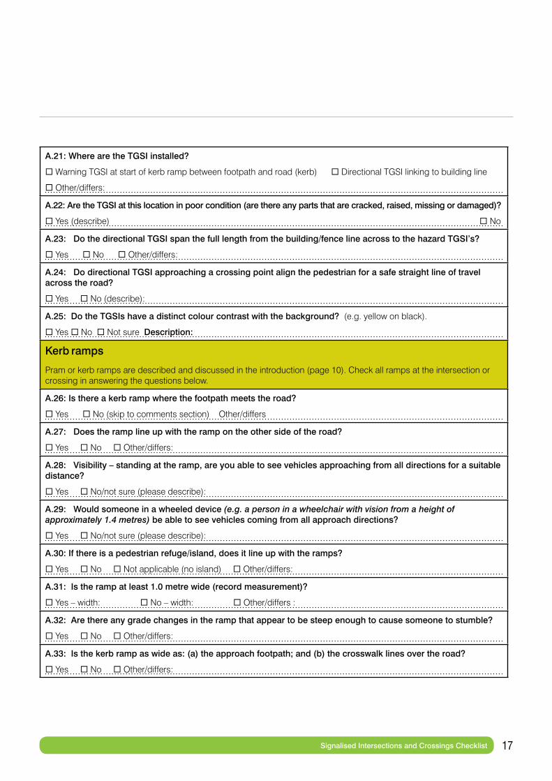
A.21: Where are the TGSI installed?
Warning TGSI at start of kerb ramp between footpath and road (kerb) Directional TGSI linking to building line
Other/differs:
A.22: Are the TGSI at this location in poor condition (are there any parts that are cracked, raised, missing or damaged)?
Yes (describe) No
A.23: Do the directional TGSI span the full length from the building/fence line across to the hazard TGSI’s?
Yes No Other/differs:
A.24: Do directional TGSI approaching a crossing point align the pedestrian for a safe straight line of travel across the road?
Yes No (describe):
A.25: Do the TGSIs have a distinct colour contrast with the background? (e.g. yellow on black).
Yes No Not sure Description:
Kerb ramps
Pram or kerb ramps are described and discussed in the introduction (page 10). Check all ramps at the intersection or crossing in answering the questions below.
A.26: Is there a kerb ramp where the footpath meets the road?
Yes No (skip to comments section) Other/differs
A.27: Does the ramp line up with the ramp on the other side of the road?
Yes No Other/differs:
A.28: Visibility – standing at the ramp, are you able to see vehicles approaching from all directions for a suitable distance?
Yes No/not sure (please describe):
A.29: Would someone in a wheeled device (e.g. a person in a wheelchair with vision from a height of approximately 1.4 metres) be able to see vehicles coming from all approach directions?
Yes No/not sure (please describe):
A.30: If there is a pedestrian refuge/island, does it line up with the ramps?
Yes No Not applicable (no island) Other/differs:
A.31: Is the ramp at least 1.0 metre wide (record measurement)?
Yes – width: No – width: Other/differs :
A.32: Are there any grade changes in the ramp that appear to be steep enough to cause someone to stumble?
Yes No Other/differs:
A.33: Is the kerb ramp as wide as: (a) the approach footpath; and (b) the crosswalk lines over the road?
Yes No Other/differs:
18 Signalised Intersections and Crossings Checklist
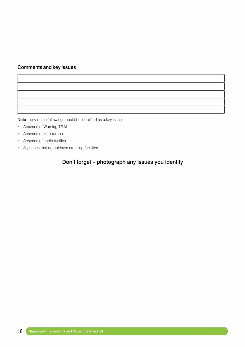
Comments and key issues
Note – any of the following should be identified as a key issue:
• Absence of Warning TGSI
• Absence of kerb ramps
• Absence of audio tactiles
• Slip lanes that do not have crossing facilities
Don’t forget – photograph any issues you identify

19 Non-Signalised Intersections and Crossings Checklist
Checklist for Non-Signalised Intersections or Crossings
Checklist for any intersection or crossing that does not have traffic lights. These include zebra crossings, school crossings roundabouts, rail crossings and unmarked crossings. For intersections, assess each leg (crossing) of the intersection in relation to each question. If different legs have a different treatment, describe them.
Checklist number:
B.1: Type of intersection/crossing:
Crossroads T junction Mid-block crossing Other:
B.2: Intersections – names of intersecting streets:
OR Mid-block crossings – address:
B.3: (Intersections only) What controls are in place to control vehicles/road users?
Stop signs Give Way Signs Roundabout Boom Gates Other
Describe controls for each approach to the intersection :
B.4: How many lanes are there to cross? (e.g. 2 in each direction = 4)
1 2 3 4 Other/differs
B.5: Speed limit (write road name and limit for each street at the intersection. For mid-block crossings only one line will need to be completed)
Road name Limit km/h
Road name Limit km/h
B.6: Are there any traffic controls in place prior to the intersection/crossing to control vehicles?
Warning Signs Partial lane closure Speed enforcement/camera Speed Hump Chicane No
Other/differs:
B.7: Identify type of crossing
Raised crossing Zebra Crossing Raised threshold Flashing lights No crossing
Other (describe if different crossings apply to different parts of an intersection)
B.8: (Intersections only) Is the crossing offset (a small distance away) from the intersection?
Yes (estimate distance): No Other/differs:
B.9: Is there a median pedestrian island or refuge?
Yes No (skip to B.12) Other/differs:
B.10: Is the pedestrian refuge raised or painted?
Raised Painted Other/differs:
B.11: Is the pedestrian refuge large enough to hold a motorized mobility device (about 2m long and 0.8m wide)?
Yes No Unsure/differs:
DOWNLOAD

20 Non-Signalised Intersections and Crossings Checklist
B.12: Is there a protected or dedicated cycle lane at (or approaching) the intersection?
Yes No Other/differs:
B.13: Visibility of pedestrian to road user e.g. driver/rider. Does a driver/rider have an unimpeded view of a pedestrian standing at the entrance to the crossing?
Yes No Other/differs:
B.14: Do you believe the pedestrian’s ability to cross safely is compromised by any of the following (do not tick if you do not think safety is compromised):
There is no crossing facility
Crossing is near the crest of a hill
Other traffic lights close to crossing
Roundabout close to crossing
Vegetation around the crossing
High vehicle speeds
Car parking close to crossing
Other/differs:
Tactile Ground Surface Indicators (TGSI)
TGSIs are described and discussed in the introduction (page 5). Check all TGSI at the intersection or crossing in answering the questions below.
B.15: Are there TGSI at the intersection or crossing?
Yes No (skip to B.21) Other/differs
B.16: Where are the TGSI installed?
Warning TGSI at start of kerb ramp between footpath and road (kerb)
Directional TGSI linking to building line
Other/differs:
B.17: Are the TGSI at this location in poor condition (are there any parts that are cracked, raised, missing or damaged)?
Yes (describe): No
B.18: Do the directional TGSI link span the full length from the building/fence line across to the hazard TGSI’s?
Yes No Other/differs
B.19: Do directional TGSI approaching a crossing point align the pedestrian for a safe straight line of travel across the road? Yes No (describe):
B.20: Do the TGSIs have a distinct colour contrast with the background? e.g. yellow on black.
Yes No Not sure Description:

21 Non-Signalised Intersections and Crossings Checklist
Kerbs and kerb ramps
Pram or kerb ramps are described and discussed in the introduction (page 10). Check all ramps at the intersection or crossing in answering the questions below.
B.21: Is there a kerb extension/outstand?
Yes No Other/differs
B.22: Is there a kerb ramp where the footpath meets the road?
Yes Other/differs No (skip to comments)
B.23: Does the ramp line up with the ramp on the other side of the road?
Yes No Other/differs
B.24: Would someone in a wheeled device (e.g. a person in a wheelchair with vision from a height of approximately 1.4 metres) be able to see vehicles coming from all approach directions?
Yes No/not sure (please describe):
B.25: If there is a pedestrian refuge/island, does it line up with the ramps?
Yes No Not applicable (no island) Other/differs:
B.26: Is the ramp at least 1.0 metre wide (record measurement)?
Yes No Width: Other/differs:
B.27: Are there any grade changes in the ramp that appear to be steep enough to cause someone to stumble?
Yes No Other/differs:
B.28: Is the kerb ramp as wide as: (a) the approach footpath; and (b) the crosswalk lines over the road?
Yes No Other/differs:
Comments and key issues
Note – any of the following should be identified as a key issue:
• Single lane roundabouts without raised crossings• Multi-lane roundabout (with or without crossings)• Crossing points without formal pedestrian crossings or devices/signage to reduce speed.• Absence of kerb ramps.• Crossing between 10 and 100 metres from an intersection.
Don’t forget – photograph any issues you identify

22 Path Infrastructure Checklist
Checklist for Path Infrastructure
Checklist for walking alongside roads (footpath section) and for shared paths.
Checklist number:
C.1: Type of path
Footpath (or walking alongside a road) Shared path beside a road
Shared path in park or similar (skip to that section) Other:
Footpath Infrastructure
C.2: Name of street:
C.3: Which direction are you walking? North South East West
On which side of the street are you walking? North South East West
C.4: Posted speed limit on the road
30 40 50 60 Other/not sure (specify):
C.5: Type of buildings/activity
Residential Retail/Commercial Education/Health Industrial
Other:
C.6: Is there a footpath? Yes No Other
C.7: What is the predominant surfacing of the footpath?
Concrete Bitumen Flat pavers Uneven pavers (e.g. bluestone)
loose gravel/stones Other (specify if surfacing changes):
C.8: Is there a parallel separation between vehicle traffic on the roadway and pedestrian traffic on the footpath?
Periodic parking (e.g. clearway) Angle parking Parallel parking Bicycle lane No Other:
C.9: Is there a distinct kerb between the roadway and the footpath or nature strip?
Yes No – describe (note any TGSI):
C.10: Street trading – is the footpath area being used for outdoor dining, display of goods, advertising?
Yes No
C.11: Is there a clear, continuous and accessible path of travel on the footpath? (minimum 1.8 metre clearance between the boundary/fence/building and the gutter or any obstruction) Yes Mostly No
DOWNLOAD
23 Path Infrastructure Checklist
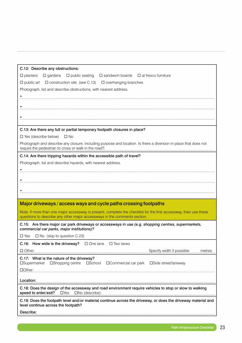
C.12: Describe any obstructions:
planters gardens public seating sandwich boards al fresco furniture
public art construction site (see C.13) overhanging branches
Photograph, list and describe obstructions, with nearest address.
•
•
•
C.13: Are there any full or partial temporary footpath closures in place?
Yes (describe below) No
Photograph and describe any closure, including purpose and location. Is there a diversion in place that does not require the pedestrian to cross or walk in the road?:
C.14: Are there tripping hazards within the accessible path of travel?
Photograph, list and describe hazards, with nearest address.
•
•
•
Major driveways / access ways and cycle paths crossing footpaths
Note: if more than one major accessway is present, complete the checklist for the first accessway, than use these questions to describe any other major accessways in the comments section.
C.15: Are there major car park driveways or accessways in use (e.g. shopping centres, supermarkets, commercial car parks, major institutions)?
Yes No (skip to question C.23)
C.16: How wide is the driveway? One lane Two lanes
Other: Specify width if possible: metres
C.17: What is the nature of the driveway? Supermarket Shopping centre School Commercial car park Side street/laneway
Other:
Location:
C.18: Does the design of the accessway and road environment require vehicles to stop or slow to walking speed to enter/exit? Yes No (describe):
C.19: Does the footpath level and/or material continue across the driveway, or does the driveway material and level continue across the footpath?
Describe:
24 Path Infrastructure Checklist
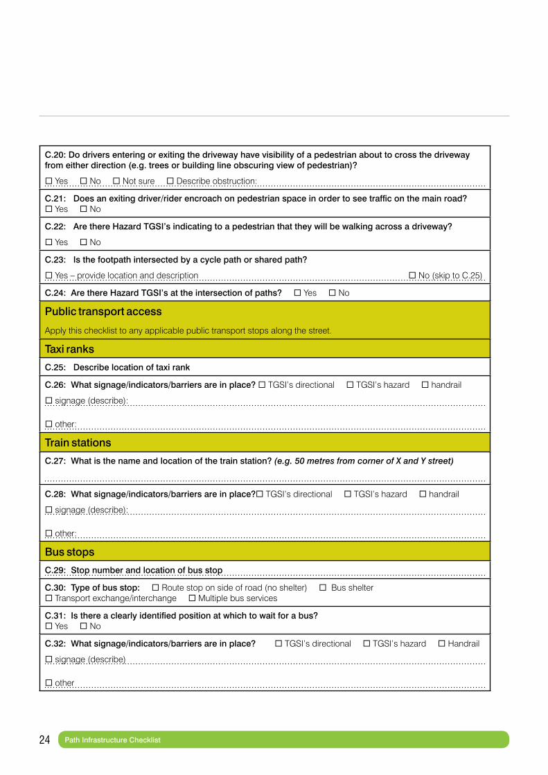
C.20: Do drivers entering or exiting the driveway have visibility of a pedestrian about to cross the driveway from either direction (e.g. trees or building line obscuring view of pedestrian)?
Yes No Not sure Describe obstruction:
C.21: Does an exiting driver/rider encroach on pedestrian space in order to see traffic on the main road? Yes No
C.22: Are there Hazard TGSI’s indicating to a pedestrian that they will be walking across a driveway?
Yes No
C.23: Is the footpath intersected by a cycle path or shared path?
Yes – provide location and description No (skip to C.25)
C.24: Are there Hazard TGSI’s at the intersection of paths? Yes No
Public transport access
Apply this checklist to any applicable public transport stops along the street.
Taxi ranks
C.25: Describe location of taxi rank
C.26: What signage/indicators/barriers are in place? TGSI’s directional TGSI’s hazard handrail
signage (describe):
other:
Train stations
C.27: What is the name and location of the train station? (e.g. 50 metres from corner of X and Y street)
C.28: What signage/indicators/barriers are in place? TGSI’s directional TGSI’s hazard handrail
signage (describe):
other:
Bus stops
C.29: Stop number and location of bus stop
C.30: Type of bus stop: Route stop on side of road (no shelter) Bus shelter Transport exchange/interchange Multiple bus services
C.31: Is there a clearly identified position at which to wait for a bus? Yes No
C.32: What signage/indicators/barriers are in place? TGSI’s directional TGSI’s hazard Handrail
signage (describe)
other
25 Path Infrastructure Checklist
Tram stops
C.33: Stop number and location of tram stop (e.g. 50 metres from corner of X and Y street, or address)
C.34: What type of tram stop is it?
Traditional (passengers wait at footpath and then board from roadway)
Safety zone (fenced area to wait in the road)
Superstop (elevated platform and shelter in the centre of the road)
Other:
C.35: Is there a designated place to wait for the tram? Yes No
C.36: What signage/indicators/barriers are in place? TGSI’s directional TGSI’s hazard Handrail
signage (describe):
other:
C.37: Are there vehicle/bicycle lanes that must be traversed in order to reach tram/footpath?
Yes No
Shared paths and cycle paths
Complete this section where paths are shared by cyclists and pedestrians, or where separate paths for pedestrians and cyclists run in parallel.
Note, rules governing cycling on footpaths vary from state to state. In most states cyclists can only ride on the footpath if accompanying someone aged 12 or under. However in Queensland, Tasmania, NT and ACT it is legal for any cyclist to ride on the footpath.
C.38: Is there a shared path or separated pedestrian and cycle paths?
Yes No (skip to comments section)
C.39: Is the path signed at the start and finish? Yes No
C.40: Does the path have symbol signage painted on ground at re.g.ular intervals (e.g. every 100m)?
Yes No
C.41: Are there warning TGSI where the path(s) meet other shared/separated paths or roads? Yes No
C.42: Are there colours or textures to indicate this is a shared or separated path? Yes No
Comments:
C.43: Is the path a shared path? Yes No (skip to next question)
Width of shared path (metres). If divided, width of left half (metres)
Width of right half (metres).
26 Path Infrastructure Checklist
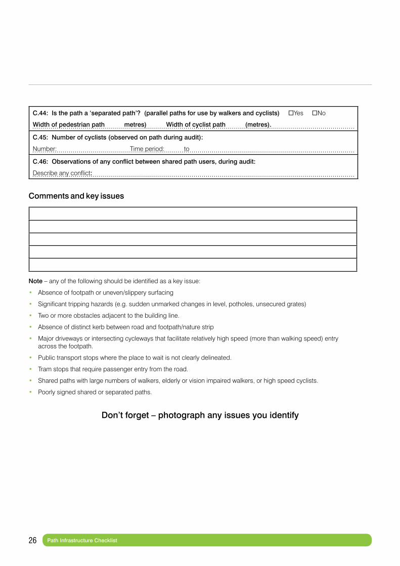
C.44: Is the path a ‘separated path’? (parallel paths for use by walkers and cyclists) Yes No
Width of pedestrian path metres) Width of cyclist path (metres).
C.45: Number of cyclists (observed on path during audit):
Number: Time period: to
C.46: Observations of any conflict between shared path users, during audit:
Describe any conflict:
Comments and key issues
Note – any of the following should be identified as a key issue:
• Absence of footpath or uneven/slippery surfacing
• Significant tripping hazards (e.g. sudden unmarked changes in level, potholes, unsecured grates)
• Two or more obstacles adjacent to the building line.
• Absence of distinct kerb between road and footpath/nature strip
• Major driveways or intersecting cycleways that facilitate relatively high speed (more than walking speed) entry across the footpath.
• Public transport stops where the place to wait is not clearly delineated.
• Tram stops that require passenger entry from the road.
• Shared paths with large numbers of walkers, elderly or vision impaired walkers, or high speed cyclists.
• Poorly signed shared or separated paths.
Don’t forget – photograph any issues you identify

27 Audit Instructions
Audit Conclusions
Priority issues
Rank the most important issues you have identified, with 1 being the worst. You may identify less than five.
1
2
3
4
5
Overall comments
Provide any general concluding comments
DOWNLOAD
28 Audit Instructions
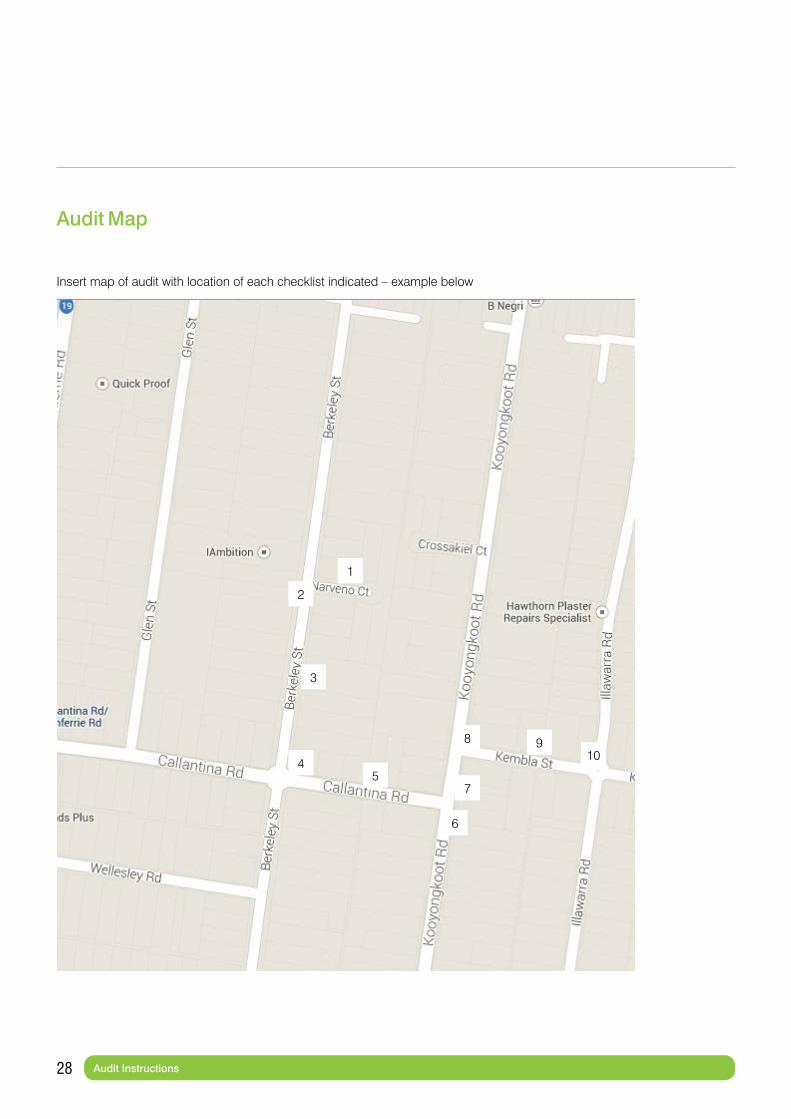
Audit Map
Insert map of audit with location of each checklist indicated – example below
1
2
3
45
8
7
6
910
You can download the audit documents as editable (Word) files here:
1 Audit instructions and audit cover sheet
2 Signalised Intersections and Crossings Checklist
3 Non-Signalised Intersections and Crossings Checklist
4 Path Infrastructure Checklist
5 Audit conclusions sheet
Victoria Walks: Level 7, 225 Bourke Street, Melbourne VIC 3000P: 03 9662 3975 E: [email protected] W: www.victoriawalks.org.au
Vision Australia P: 1300 847 466 W: www.visionaustralia.org
Guide Dogs Victoria P: 9854 4444 W: www.guidedogsvictoria.com.au