pavement management system update - hollister,...
TRANSCRIPT
Pavement Management System UpdateFINAL REPORT
The City of HollisterPROJECT NO. 150292
JULY 2016
Pavement Engineering Inc.You can ride on our reputation
City of Hollister
Pavement Management Report
July 2016
CITY COUNCIL
Mayor Ignacio Velazquez Vice Mayor Victor Gomez
Karson Klauer Raymond Friend
Mickie Solorio
Special thanks to:
William Avera, City Manager, for his input and direction.
David Rubcic, Interim Engineering Manager/City Engineer for his input and facilitation.
Rene Anchieta, San Benito County GIS Department,
for his support with integrating GIS information
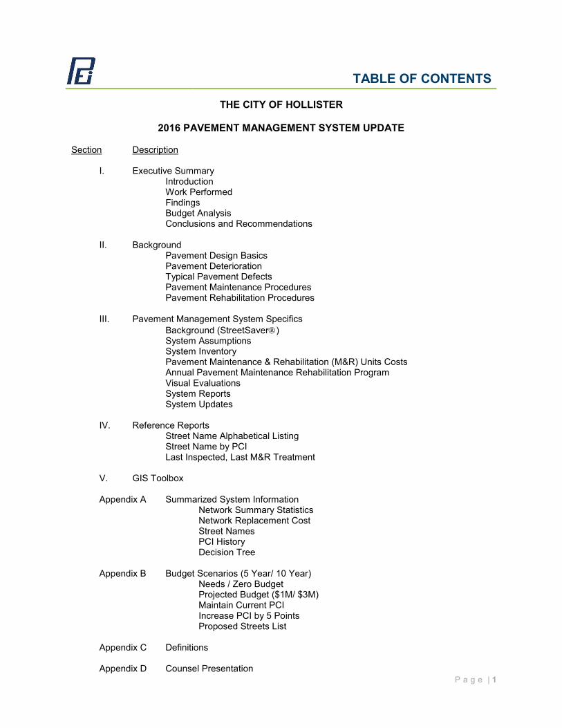
TABLE OF CONTENTS
P a g e | 1
THE CITY OF HOLLISTER
2016 PAVEMENT MANAGEMENT SYSTEM UPDATE Section Description
I. Executive Summary Introduction Work Performed Findings Budget Analysis Conclusions and Recommendations
II. Background Pavement Design Basics Pavement Deterioration Typical Pavement Defects Pavement Maintenance Procedures Pavement Rehabilitation Procedures III. Pavement Management System Specifics Background (StreetSaver) System Assumptions System Inventory
Pavement Maintenance & Rehabilitation (M&R) Units Costs Annual Pavement Maintenance Rehabilitation Program Visual Evaluations System Reports System Updates IV. Reference Reports Street Name Alphabetical Listing Street Name by PCI Last Inspected, Last M&R Treatment V. GIS Toolbox Appendix A Summarized System Information Network Summary Statistics Network Replacement Cost Street Names PCI History Decision Tree
Appendix B Budget Scenarios (5 Year/ 10 Year) Needs / Zero Budget Projected Budget ($1M/ $3M) Maintain Current PCI Increase PCI by 5 Points Proposed Streets List Appendix C Definitions Appendix D Counsel Presentation
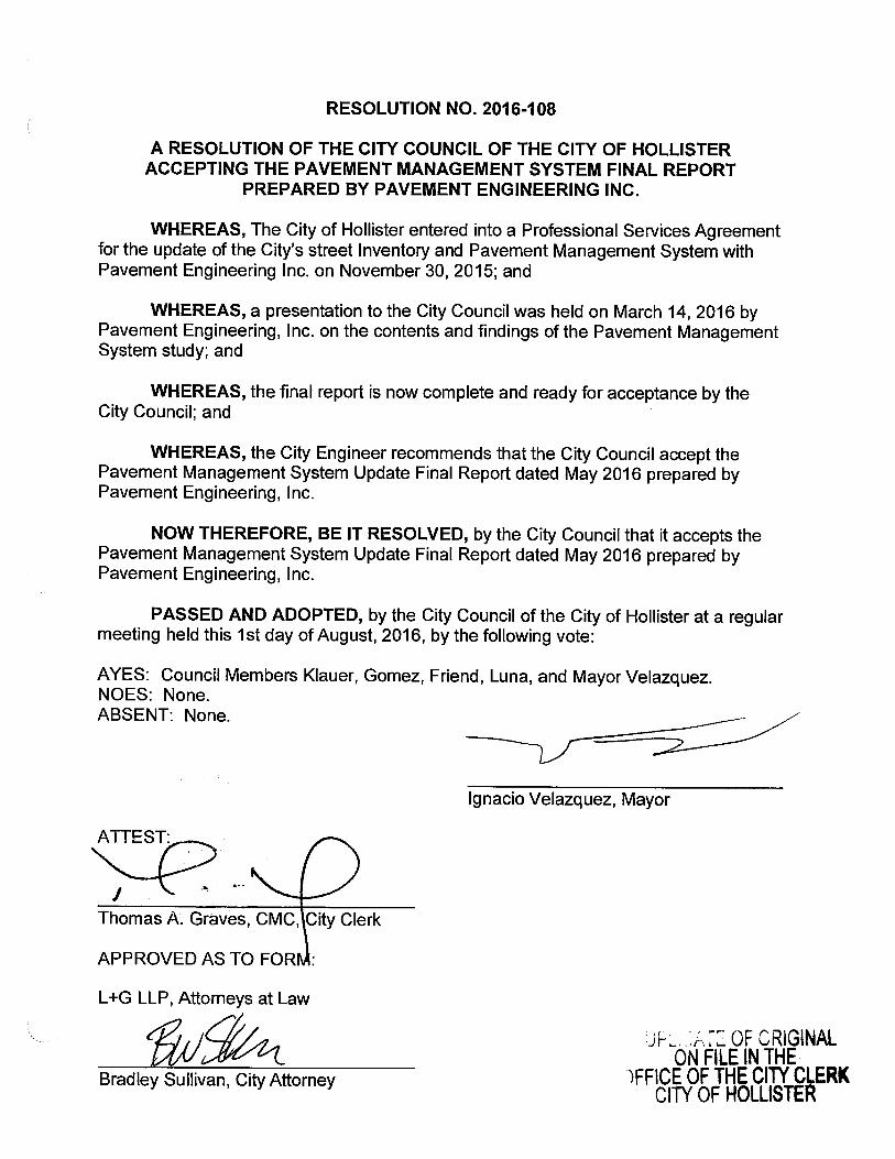
RESOLUTION NO. 2016-108
A RESOLUTION OF THE CITY COUNCIL OF THE CITY OF HOLLISTERACCEPTING THE PAVEMENT MANAGEMENT SYSTEM FINAL REPORT
PREPARED BY PAVEMENT ENGINEERING INC.
WHEREAS, The City of Hollister entered into a Professional Services Agreementfor the update of the City' s street Inventory and Pavement Management System withPavement Engineering Inc. on November 30, 2015; and
WHEREAS, a presentation to the City Council was held on March 14, 2016 byPavement Engineering, Inc. on the contents and findings of the Pavement ManagementSystem study; and
WHEREAS, the final report is now complete and ready for acceptance by theCity Council; and
WHEREAS, the City Engineer recommends that the City Council accept thePavement Management System Update Final Report dated May 2016 prepared byPavement Engineering, Inc.
NOW THEREFORE, BE IT RESOLVED, by the City Council that it accepts thePavement Management System Update Final Report dated May 2016 prepared byPavement Engineering, Inc.
PASSED AND ADOPTED, by the City Council of the City of Hollister at a regularmeeting held this 1st day of August, 2016, by the following vote:
AYES: Council Members Klauer, Gomez, Friend, Luna, and Mayor Velazquez.NOES: None.
ABSENT: None.
Ignacio Velazquez, Mayor
ATTEST:
Thomas A. Graves, CMC, City Clerk
APPROVED AS TO FOR :
L+ G LLP, Attorneys at Law
ff/(1e OF ORIGINALON FILE IN THE
Bradley Sullivan, City Attorney FFICE OF THE CITY CLERKCITY OF HOLLISTER
EXECUTIVE SUMMARY
P a g e | 1
The City of Hollister currently maintains approximately 104.4 centerline miles of roads representing 21,656,111 square feet of pavement asset with a replacement value of approximately $253,965,054 as calculated by StreetSaver. Pavement Engineering Inc. (PEI) updated the City’s Pavement Management System using the Metropolitan Transportation Commission's (MTC) StreetSaver program. The purpose of a Pavement Management System is to track inventory, store work history and furnish budget estimates to optimize funding for improving the city’s pavement system. INTRODUCTION A Pavement Management System has several distinctive uses:
As a budgeting tool, a Pavement Management System uses treatment costs that are based on recently bid projects, by the participating agency, so that budgets reflect historical costs for the area.
As an inventory tool, a Pavement Management System provides a quick and easy reference for pavement areas and use.
As a pavement condition record, a Pavement Management System provides age, load-related, non-load related and climate-related pavement condition and deterioration information. The Pavement Management System uses pavement deterioration curves, based on nationwide research, which allow the program to predict a pavement’s future condition.
A Pavement Management System is not capable of providing detailed engineering designs for a street. The Pavement Management System instead helps the user identify candidate streets for potential repair and maintenance. Project level pavement analysis and engineering is an essential feature of future pavement maintenance and rehabilitation projects. Additional investigation, or project level analysis, can optimize the City’s pavement management dollars. Project level engineering examines the pavements in significantly more detail than the visual evaluation required for the Pavement Management System Update and optimizes designs for all of the peculiar constraints of a set of project streets. When updating the Pavement Management System for the City of Hollister, PEI had three primary goals: 1. Provide an accurate and complete inventory of the City’s pavements and their
condition. 2. Identify and quantify maintenance and rehabilitation needs and costs for the street
system. 3. Provide on-going training and assistance
P a g e | 2
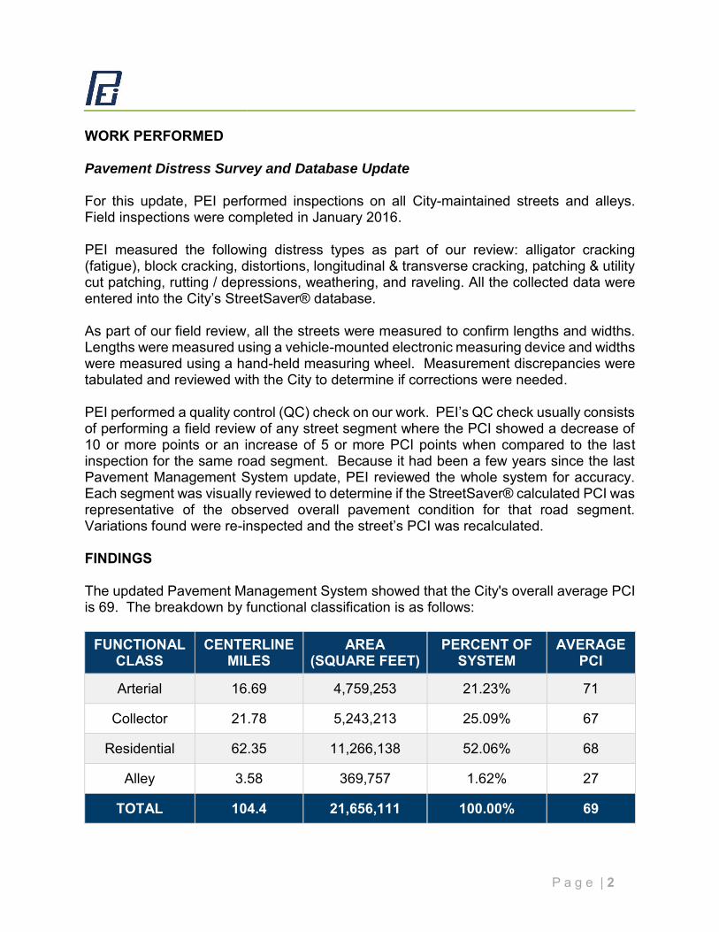
WORK PERFORMED Pavement Distress Survey and Database Update For this update, PEI performed inspections on all City-maintained streets and alleys. Field inspections were completed in January 2016. PEI measured the following distress types as part of our review: alligator cracking (fatigue), block cracking, distortions, longitudinal & transverse cracking, patching & utility cut patching, rutting / depressions, weathering, and raveling. All the collected data were entered into the City’s StreetSaver® database. As part of our field review, all the streets were measured to confirm lengths and widths. Lengths were measured using a vehicle-mounted electronic measuring device and widths were measured using a hand-held measuring wheel. Measurement discrepancies were tabulated and reviewed with the City to determine if corrections were needed. PEI performed a quality control (QC) check on our work. PEI’s QC check usually consists of performing a field review of any street segment where the PCI showed a decrease of 10 or more points or an increase of 5 or more PCI points when compared to the last inspection for the same road segment. Because it had been a few years since the last Pavement Management System update, PEI reviewed the whole system for accuracy. Each segment was visually reviewed to determine if the StreetSaver® calculated PCI was representative of the observed overall pavement condition for that road segment. Variations found were re-inspected and the street’s PCI was recalculated. FINDINGS The updated Pavement Management System showed that the City's overall average PCI is 69. The breakdown by functional classification is as follows:
FUNCTIONAL CLASS
CENTERLINE MILES
AREA (SQUARE FEET)
PERCENT OF SYSTEM
AVERAGE PCI
Arterial 16.69 4,759,253 21.23% 71
Collector 21.78 5,243,213 25.09% 67
Residential 62.35 11,266,138 52.06% 68
Alley 3.58 369,757 1.62% 27
TOTAL 104.4 21,656,111 100.00% 69
P a g e | 3
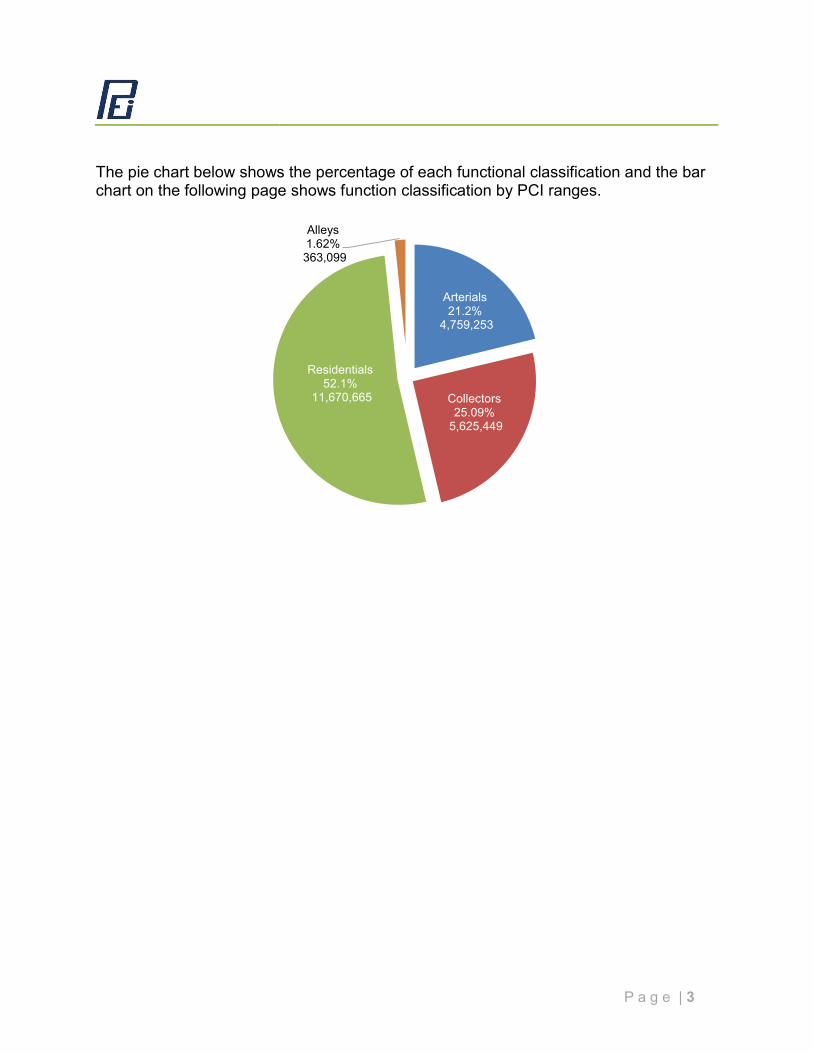
The pie chart below shows the percentage of each functional classification and the bar chart on the following page shows function classification by PCI ranges.
Arterials21.2%
4,759,253
Collectors25.09%
5,625,449
Residentials52.1%
11,670,665
Alleys1.62%363,099
P a g e | 4
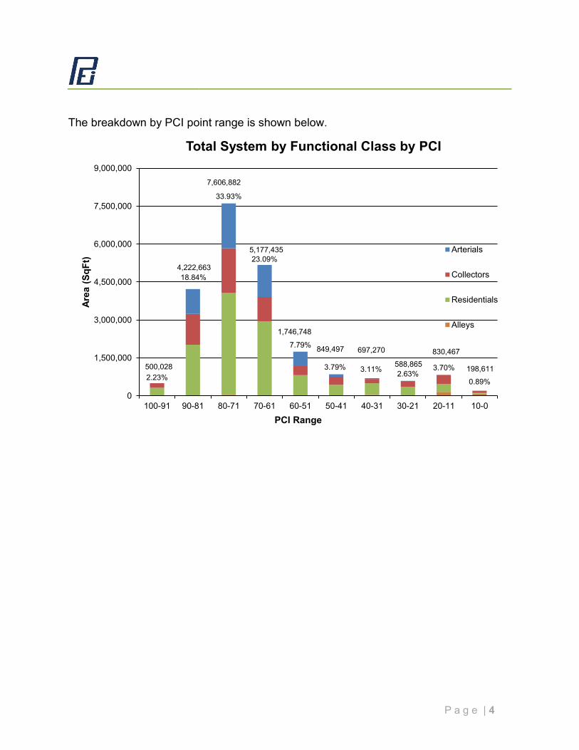
The breakdown by PCI point range is shown below.
2.23%
18.84%
33.93%
23.09%
7.79%
3.79% 3.11% 2.63%3.70%
0.89%
500,028
4,222,663
7,606,882
5,177,435
1,746,748
849,497 697,270
588,865 830,467
198,611
0
1,500,000
3,000,000
4,500,000
6,000,000
7,500,000
9,000,000
100-91 90-81 80-71 70-61 60-51 50-41 40-31 30-21 20-11 10-0
Area
(SqF
t)
PCI Range
Total System by Functional Class by PCI
Arterials
Collectors
Residentials
Alleys
P a g e | 5
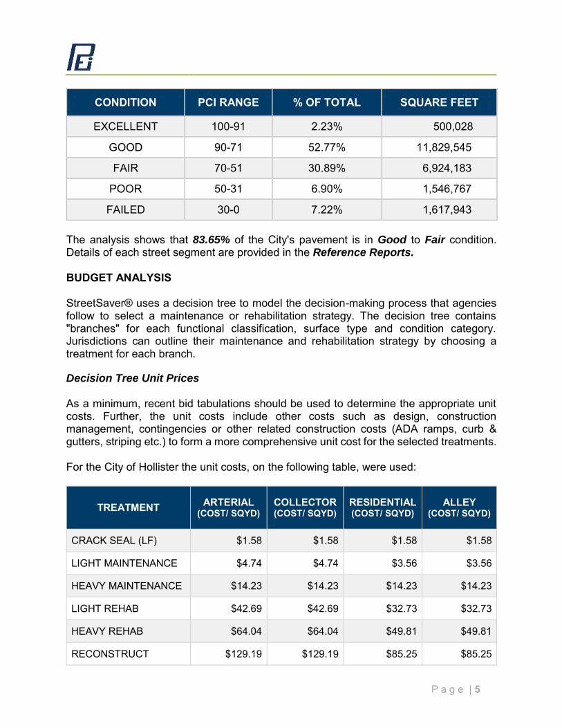
CONDITION PCI RANGE % OF TOTAL SQUARE FEET
EXCELLENT 100-91 2.23% 500,028
GOOD 90-71 52.77% 11,829,545
FAIR 70-51 30.89% 6,924,183
POOR 50-31 6.90% 1,546,767
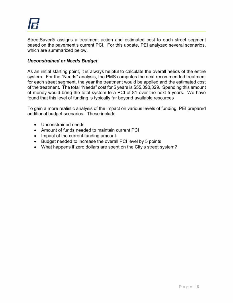
FAILED 30-0 7.22% 1,617,943 The analysis shows that 83.65% of the City's pavement is in Good to Fair condition. Details of each street segment are provided in the Reference Reports. BUDGET ANALYSIS StreetSaver® uses a decision tree to model the decision-making process that agencies follow to select a maintenance or rehabilitation strategy. The decision tree contains "branches" for each functional classification, surface type and condition category. Jurisdictions can outline their maintenance and rehabilitation strategy by choosing a treatment for each branch. Decision Tree Unit Prices As a minimum, recent bid tabulations should be used to determine the appropriate unit costs. Further, the unit costs include other costs such as design, construction management, contingencies or other related construction costs (ADA ramps, curb & gutters, striping etc.) to form a more comprehensive unit cost for the selected treatments. For the City of Hollister the unit costs, on the following table, were used:
TREATMENT ARTERIAL (COST/ SQYD)
COLLECTOR (COST/ SQYD)
RESIDENTIAL (COST/ SQYD)
ALLEY (COST/ SQYD)
CRACK SEAL (LF) $1.58 $1.58 $1.58 $1.58
LIGHT MAINTENANCE $4.74 $4.74 $3.56 $3.56
HEAVY MAINTENANCE $14.23 $14.23 $14.23 $14.23
LIGHT REHAB $42.69 $42.69 $32.73 $32.73
HEAVY REHAB $64.04 $64.04 $49.81 $49.81
RECONSTRUCT $129.19 $129.19 $85.25 $85.25
P a g e | 6
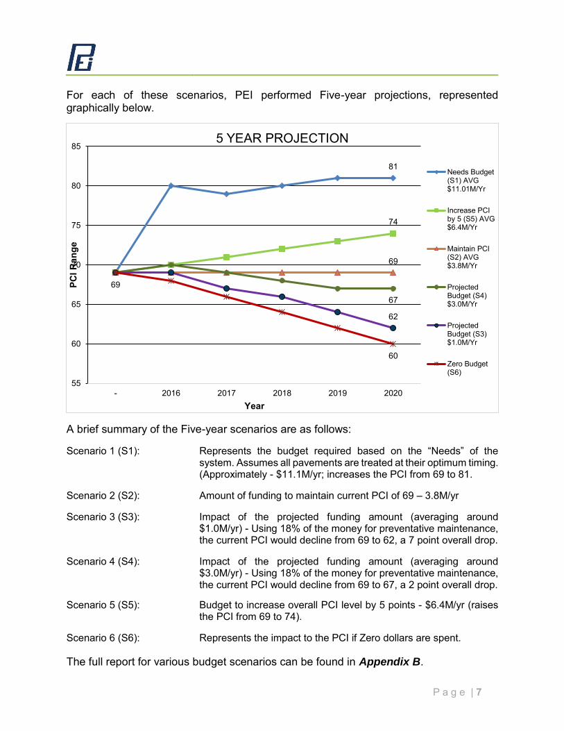
StreetSaver assigns a treatment action and estimated cost to each street segment based on the pavement's current PCI. For this update, PEI analyzed several scenarios, which are summarized below. Unconstrained or Needs Budget As an initial starting point, it is always helpful to calculate the overall needs of the entire system. For the “Needs” analysis, the PMS computes the next recommended treatment for each street segment, the year the treatment would be applied and the estimated cost of the treatment. The total “Needs” cost for 5 years is $55,090,329. Spending this amount of money would bring the total system to a PCI of 81 over the next 5 years. We have found that this level of funding is typically far beyond available resources To gain a more realistic analysis of the impact on various levels of funding, PEI prepared additional budget scenarios. These include:
Unconstrained needs Amount of funds needed to maintain current PCI Impact of the current funding amount Budget needed to increase the overall PCI level by 5 points What happens if zero dollars are spent on the City’s street system?
P a g e | 7
For each of these scenarios, PEI performed Five-year projections, represented graphically below.
A brief summary of the Five-year scenarios are as follows: Scenario 1 (S1): Represents the budget required based on the “Needs” of the
system. Assumes all pavements are treated at their optimum timing. (Approximately - $11.1M/yr; increases the PCI from 69 to 81.
Scenario 2 (S2): Amount of funding to maintain current PCI of 69 – 3.8M/yr Scenario 3 (S3): Impact of the projected funding amount (averaging around
$1.0M/yr) - Using 18% of the money for preventative maintenance, the current PCI would decline from 69 to 62, a 7 point overall drop.
Scenario 4 (S4): Impact of the projected funding amount (averaging around
$3.0M/yr) - Using 18% of the money for preventative maintenance, the current PCI would decline from 69 to 67, a 2 point overall drop.
Scenario 5 (S5): Budget to increase overall PCI level by 5 points - $6.4M/yr (raises
the PCI from 69 to 74). Scenario 6 (S6): Represents the impact to the PCI if Zero dollars are spent. The full report for various budget scenarios can be found in Appendix B.
81
74
69
67
62
69
60
55
60
65
70
75
80
85
- 2016 2017 2018 2019 2020
PCI R
ange
Year
5 YEAR PROJECTION
Needs Budget(S1) AVG$11.01M/Yr
Increase PCIby 5 (S5) AVG$6.4M/Yr
Maintain PCI(S2) AVG$3.8M/Yr
ProjectedBudget (S4)$3.0M/Yr
ProjectedBudget (S3)$1.0M/Yr
Zero Budget(S6)
P a g e | 8
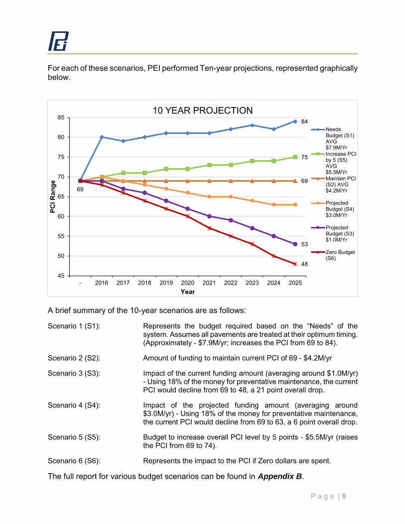
For each of these scenarios, PEI performed Ten-year projections, represented graphically below.
A brief summary of the 10-year scenarios are as follows: Scenario 1 (S1): Represents the budget required based on the “Needs” of the
system. Assumes all pavements are treated at their optimum timing. (Approximately - $7.9M/yr; increases the PCI from 69 to 84).
Scenario 2 (S2): Amount of funding to maintain current PCI of 69 - $4.2M/yr Scenario 3 (S3): Impact of the current funding amount (averaging around $1.0M/yr)
- Using 18% of the money for preventative maintenance, the current PCI would decline from 69 to 48, a 21 point overall drop.
Scenario 4 (S4): Impact of the projected funding amount (averaging around
$3.0M/yr) - Using 18% of the money for preventative maintenance, the current PCI would decline from 69 to 63, a 6 point overall drop.
Scenario 5 (S5): Budget to increase overall PCI level by 5 points - $5.5M/yr (raises
the PCI from 69 to 74). Scenario 6 (S6): Represents the impact to the PCI if Zero dollars are spent. The full report for various budget scenarios can be found in Appendix B.
84
75
69
53
69
48
45
50
55
60
65
70
75
80
85
- 2016 2017 2018 2019 2020 2021 2022 2023 2024 2025
PCI R
ange
Year
10 YEAR PROJECTION
NeedsBudget (S1)AVG$7.9M/YrIncrease PCIby 5 (S5)AVG$5.5M/YrMaintain PCI(S2) AVG$4.2M/Yr
ProjectedBudget (S4)$3.0M/Yr
ProjectedBudget (S3)$1.0M/Yr
Zero Budget(S6)
P a g e | 9
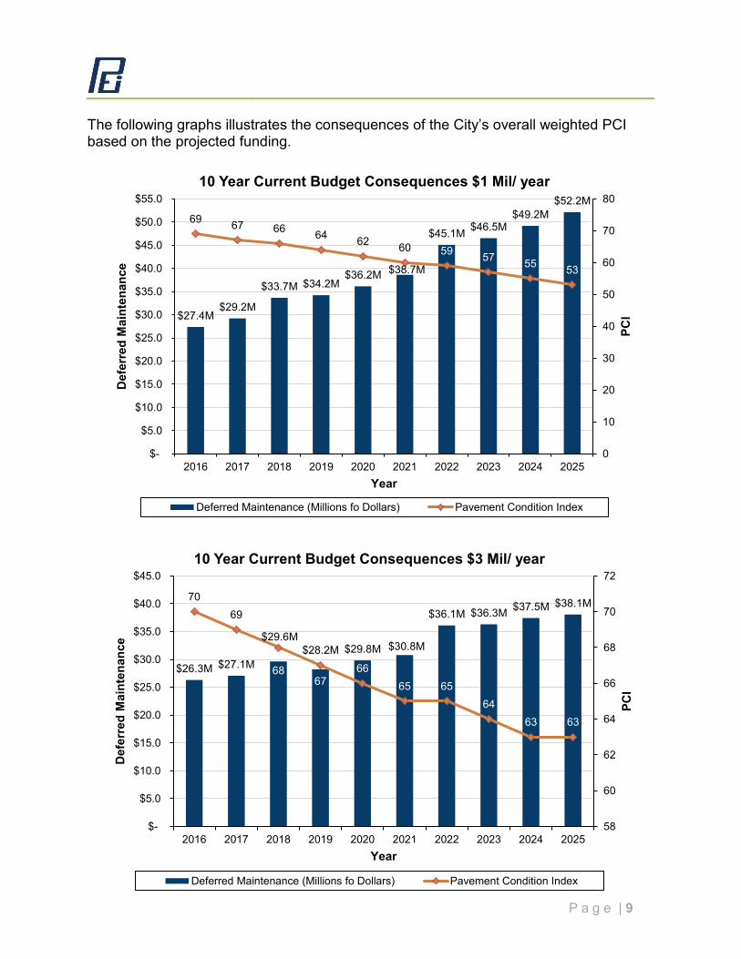
The following graphs illustrates the consequences of the City’s overall weighted PCI based on the projected funding.
$27.4M$29.2M
$33.7M $34.2M$36.2M $38.7M
$45.1M $46.5M$49.2M
$52.2M69 67 66 64 62 60 59 57 55 53
0
10
20
30
40
50
60
70
80
$-
$5.0
$10.0
$15.0
$20.0
$25.0
$30.0
$35.0
$40.0
$45.0
$50.0
$55.0
2016 2017 2018 2019 2020 2021 2022 2023 2024 2025
PCI
Def
erre
d M
aint
enan
ce
Year
10 Year Current Budget Consequences $1 Mil/ year
Deferred Maintenance (Millions fo Dollars) Pavement Condition Index
$26.3M $27.1M
$29.6M$28.2M $29.8M $30.8M
$36.1M $36.3M $37.5M $38.1M7069
6867
6665 65
6463 63
58
60
62
64
66
68
70
72
$-
$5.0
$10.0
$15.0
$20.0
$25.0
$30.0
$35.0
$40.0
$45.0
2016 2017 2018 2019 2020 2021 2022 2023 2024 2025
PCI
Def
erre
d M
aint
enan
ce
Year
10 Year Current Budget Consequences $3 Mil/ year
Deferred Maintenance (Millions fo Dollars) Pavement Condition Index
P a g e | 10
CONCLUSIONS AND RECOMMENDATIONS This Executive Summary provides a review of the 2015/2016 Pavement Management System Update performed by PEI. PEI inspected and performed QC on all of the road segments in the City. The average overall PCI for the City is 69. 83.65% of the City's pavement is in Good to Fair condition. To maintain the system at its current overall PCI of 69, the City will need to spend an average of $4.2M annually over the next ten years. Maintaining the projected funding level of approximately $1.0M annually will result in a PCI loss of 21 points in ten years to a PCI of 48. Maintaining the projected funding level of approximately $3.0M annually will result in a PCI loss of 6 points in ten years to a PCI of 63. A review of the City’s street system, by functional classification, shows that the arterial streets have the highest average PCI of 71, the Collector streets follow with an average PCI of 70, the Residential streets have an average PCI of 68, and the Alleys have the lowest average PCI of 28. As a general rule, agencies typically try to keep their arterials in the best condition because they carry the bulk of the traffic and loading, followed by collectors, then the residential/ local streets. Moving forward, PEI recommends the City carefully evaluate the overall annual budget to determine the amount it wants to commit to pavement maintenance and rehabilitation projects. We recommend the City set priorities for each functional classification and perhaps certain streets within each classification. This Pavement Management System will assist the City in its efforts to monitor treatments and track their effectiveness and help the City in setting future priorities and treatment policies. PEI suggests the City update its Pavement Management System on a regular basis and review entire system every two to three years. As the City maintains and updates its Pavement Management System, the program will become a valuable tool in its efforts to maximize performance and minimize the spending for pavements.
BACKGROUND
P a g e | 1
This section is intended to introduce important pavement design definitions and calculations as a background for understanding the Pavement Management System (PMS) assumptions. PAVEMENT DESIGN BASICS Pavements are a structural support system generally considered to act like a beam. But unlike beams in buildings, which generally have static loads, the pavement structure is flexed many times from traffic loading. Cars and light trucks have little impact on the pavement structure. Larger/Heavier trucks have very significant impacts on the pavement due to the high axle weights. The impact of trucks is measured in equivalent single 18,000-pound axle loads (EALs). The total EALs are converted into a design Traffic Index (TI). As an example, a design TI of 5 is equal to 7,160 EALs. A Design TI of 8 is equal to 372,000 EALs. Therefore, the design TI is the total number of EALs that the pavement will support before it begins to fail, regardless of the passage of time. Normally for a new pavement, the EALs over a 20-year period are used. For rehabilitation procedures such as overlays, 10 years is generally used. The other element of pavement design is the support of the beam. The support is provided by the sub-grade soils. The support value is designated by the R-value test. Using the design TI and R-value, the pavement designer chooses various materials to construct the structural section. The most common pavement section is a thin layer of asphalt concrete over aggregate base(s). Many options are available depending on specific project requirements and conditions. The design methods used in California is based on a 50 percent reliability. This means that the average pavement life of all pavements constructed using the design procedure will last the design life. It also means that about half will not last that long and the other half will last longer. To express this concept, a design life is often expressed in a span of years, such as 17 to 23 years for 20-year design life. PAVEMENT DETERIORATION Pavement deteriorates from two processes. There are fatigue and aging. The processes occur simultaneously. In a well-designed and constructed pavement, the two processes result in the need to rehabilitate the pavement at approximately the same time. This is called the design life. The design life for most new pavements is 20 years. Each aging process has its own set of pavement defects, which are related to the process. Fatigue The first deterioration process is fatigue from heavy axle loads. As the pavement structure flexes or bends from heavy wheel loads, the asphalt concrete layer’s ability to flex is consumed. With sufficient bending, the asphalt concrete layer begins to break at the bottom. This cracking progresses upward until it reaches the surface and appears as alligator cracking. These areas are repaired by removal and replacement of the asphalt concrete in the affected areas. These repairs are commonly called digouts.
P a g e | 2
As the pavement structure, its supporting soils, and the precise loading from wheel loads vary, so does the time it takes for alligator cracking to appear. As alligator cracking appears, the pavement is repaired with digouts. Generally, when total cumulative quantity of digouts reaches approximately 10 percent of the total area, the pavement is considered to have reached its design life and requires major rehabilitation. Aging The major element of the pavement structure that ages is the asphalt concrete layer. To a minor extent, aggregate bases can age if contaminated by fine soil particles, which are transported from the subsoil into the aggregate base. Asphalt concrete is composed of aggregates and asphalt cement. The aggregates used are generally of fair quality and do experience some breakdown over time. Aggregate aging problems need to be addressed in maintenance procedures. The asphalt concrete binder ages as well. As the asphalt binder ages, it loses volume through loss of volatile components in the asphalt. As the volume decreases, the pavement will progressively crack from the resulting tensile strain in the layer. Normally, these cracks first show up as transverse cracks. They also show up as weak areas such as paving joints. These cracks widen and increase over time until the pavement has a checkerboard appearance. The aging process also causes the pavement to become more brittle. The increased stiffness results in additional cracking from loaded vehicles. This load induced cracking from the brittleness of the asphalt concrete is very similar to fatigue cracking in appearance. The major agent for deterioration of the asphalt concrete binder is oxygen. The carrier of the oxygen is water. Water enters the pavement either from the surface or as water vapor from underneath.
P a g e | 3
TYPICAL PAVEMENT DEFECTS StreetSaver identifies seven different Asphalt Concrete distress types. These are:
1. Alligator Cracking (Fatigue) 2. Block Cracking 3. Distortions 4. Longitudinal and Transverse Cracking 5. Patching and Utility Cut Patching 6. Rutting and Depression 7. Weathering and Raveling
These defects are common to virtually the entire pavement as aging progresses. Age cracking begins with longitudinal and transverse cracking and progresses to block shrinkage cracking. For purposes of understanding the levels of these distresses, the condition level descriptions from the rating manual are included herein: Alligator Cracking (Fatigue) Description:
Alligator or fatigue cracking is a series of interconnecting cracks caused by fatigue failure of the asphalt concrete surface under repeated traffic loading. Cracking begins at the bottom of the asphalt surface (or stabilized base) where tensile stress and strain are highest under wheel load. The cracks propagate to the surface initially as a series of parallel longitudinal cracks. After repeated traffic loading, the cracks connect, forming many sided, sharp-angled pieces that develop a pattern resembling chicken wire or the skin of an alligator. The pieces are generally less than 0.6 m (2 ft) on the longest side. Alligator cracking occurs only in areas subjected to repeated traffic loading, such as wheel paths. Therefore, it would not occur over an entire area unless the entire area were subject to traffic loading (pattern-type cracking that occurs over an entire area not subjected to loading is called “block cracking,” which is not a load-associated distress). Severity Levels:
L Fine, longitudinal hairline cracks running parallel to each other with no, or only a few interconnecting cracks. The cracks are not spalled.
M Further development of light alligator cracks into a pattern or network of
cracks that may be lightly spalled.
P a g e | 4
H Network or pattern cracking has progressed so that the pieces are well defined and spalled at the edges. Some of the pieces may rock under traffic.
Block Cracking Description:
Block cracks are interconnected cracks that divide the pavement into approximately rectangular pieces. The blocks may range in size from approximately 0.3 by 0.3 m (1 by 1 ft) to 3 by 3 m (10 by 10 ft). Block cracking is caused mainly by shrinkage of the asphalt concrete and daily temperature cycling (which results in daily stress/strain cycling). It is not load-associated. Block cracking usually indicates that the asphalt has hardened significantly. Block cracking normally occurs over a large portion of the pavement area, but sometimes will occur only in non-traffic areas. This type of distress differs from alligator cracking in that alligator cracks form smaller, many-sided pieces with sharp angles. Also, unlike block cracks, alligator cracks are caused by repeated traffic loadings and therefore found only in traffic areas (i.e., wheel paths). Severity Levels: L Blocks are defined by low-severity* cracks. M Blocks are defined by medium-severity* cracks. H Blocks are defined by high-severity* cracks. *See definitions of longitudinal transverse cracking.
Distortions Description:
Distortions are usually caused by corrugations, bumps, sags and shoving. They are localized abrupt upward or downward displacements in the pavement surface, a series of closely spaced ridges and valley or localized longitudinal displacements of the pavement surface. Distortions affect ride quality. Severity Levels:
L Distortion produces vehicle vibrations, which are noticeable, but no reduction in speed is necessary for comfort or safety and/or individual distortions cause the vehicle to bounce slightly, but create little discomfort.
P a g e | 5
M Distortion produces vehicle vibrations, which are significant, and some reduction in speed is necessary for safety and comfort.
H Distortion produces vehicle vibrations, which are so excessive that
speed must be reduced considerably for safety and comfort.
Longitudinal and Transverse Cracking (Non-PCC Slab Joint Reflective) Description:
Longitudinal cracks are parallel to the pavement’s centerline or laydown direction. They may be caused by:
1. A poorly constructed paving lane joint. 2. Shrinkage of the AC surface due to low temperature or hardening of the
asphalt and/or daily temperature cycling.
3. A reflective crack caused by cracking beneath the surface course, including crack in PCC slabs.
4. Decreased support or thickness near the edge of the pavement.
Transverse cracks extend across the pavement at approximately right angles to the pavement centerline or direction of laydown. These may be caused by conditions (2) and (3) above. These types of cracks are not usually load-associated. Severity Levels: L One of the following conditions exists:
(1) non-filling crack width is less than 10 mm (3/8 in.) or (2) filled crack of any width (filler in satisfactory condition).
M One of the following conditions exists:
(1) non-filled crack width is greater than or equal to 10 mm and less than 75 mm (3/8 to 3 in.)
(2) non-filled crack is less than or equal to 75 mm (3 in.) surrounded by light and random cracking, or
(3) filled crack is of any width surrounded by light random cracking.
H One of the following conditions exists:
(1) any crack filled or non-filled surrounded by medium or high severity random cracking,
(2) non-filled crack greater than 75 mm (3 in.) or
P a g e | 6
(3) A crack of any width where approximately 100 mm (4 in.) of pavement around the crack is severely broken.
Patching and Utility Cut Patching Description:
A patch is an area of pavement that has been replaced with new material to repair the existing pavement. A patch is considered a defect no matter how well it is performed (a patched area or adjacent area usually does not perform as well as an original pavement section). Generally, some roughness is associated with this distress. Severity Levels:
L Patch is in good condition and satisfactory. Ride quality* is rated as low severity or better.
M Patch is moderately deteriorated and/or ride quality* is rated as medium
severity.
H Patch is badly deteriorated and/or ride quality* is rated as high severity. Needs replacement soon.
*Ride quality is defined in the severity levels of distortions.
Rutting and Depressions Description:
A rut is a surface depression in the wheel paths. Pavement uplift may occur along the sides of the rut, but in many instances, ruts are noticeable only after a rainfall when the paths are filled with water. Rutting stems from a permanent deformation in any of the pavement layers or sub-grades, usually caused by consolidated or lateral movement of the materials due to traffic load. Significant rutting can lead to major structural failure of the pavement. Depressions are localized areas where the pavement structure is lower than the surrounding area but the transition is not abrupt enough to be considered a distortion. They are often referred to as “bird baths”.
Severity Levels: Mean Rut or Depression Depth; L 1/2" to less than 1” (13 to 25mm). M 1” to less than 2” (25 to 50mm).
P a g e | 7
H equal to or greater than 2” (over 50mm).
Weathering and Raveling Description:
Weathering and raveling are the wearing away of the pavement surface due to a loss of asphalt binder and dislodged aggregate particles. These distresses indicate that either the asphalt binder has hardened appreciably or that a poor-quality mixture is present. In addition, weathering and raveling may be caused by certain types of traffic, e.g., tracked vehicles. Softening of the surface and dislodging of the aggregates due to oil spillage areas also included under these distresses. Severity Levels:
L Aggregate or binder has started to wear away. In some areas, the surface is starting to pit. In the case of oil spillage, the oil spillage can be seen, but the surface is hard and cannot be penetrated with a coin.
M Aggregate or binder has worn away. The surface texture is moderately
rough and pitted. In the case of oil spillage, the surface is soft and can be penetrated with a coin.
H Aggregate or binder has been worn away considerably. The surface
texture is very rough and severely pitted. The edge of the pavement has broken up to the extent that pieces are missing within 1 to 2 ft (.3 to .6m) of the edge. In the case of oil spillage, the asphalt binder has lost its binding effect and the aggregate has become loose.
P a g e | 8
PAVEMENT MAINTENANCE PROCEDURES Pavement maintenance procedures are designed to slow the pavement aging process. Mainly, the procedures are designed to protect the pavement from the adverse effects of water and to some extent vehicle traffic. Maintenance procedures, which protect the pavement from aging, are crack sealing, digouts, slurry seals, and cape seals. When pavements have extensive cracking and are beyond their design life, interim holding measures including skin patches and thin overlays are used as a stop gap prior to major rehabilitation. The following outlines some of the more common types of maintenance procedures: Crack Sealing Crack sealing prevents surface water from getting beneath the asphalt concrete layer into the aggregate bases. Crack sealing is generally performed using hot rubberized crack sealing material. The procedure includes routing small cracks, cleaning and sealing. Digouts Digouts are small areas of deteriorated pavements, which are removed and replaced with new asphalt concrete. Pavement removal is accomplished by cold planning or saw cutting and excavation. New asphalt is installed in at least two lifts. The digout depth is determined depending on the street type and construction. Slurry Seals Slurry seals consist of a combination of fine aggregate and emulsified oil. A new type of slurry seal called Rubberized Asphalt Slurry (RAS) is in the development stage. Currently, the cost of RAS is 2 to 3 times as much as a conventional slurry seal, which makes the product economically unattractive. Slurry seals are used when the existing pavement surface is severely raveled. Cape Seals Cape seals consist of a chip seal over coated with a slurry seal. A chip seal is an application of small angular rock (chips) approximately 1/4" to 3/8” in a maximum size embedded into a thick application of asphalt emulsion. Most chip seals incorporate polymer modified binders. Cape seals are used on residential and collector streets to maintain a pavement, which may need an overlay, but there are not sufficient funds available. Chip seals are placed over low to moderate alligator cracks and block shrinkage cracking. Due to the distress covered by the chip seal, small areas of disbanding or failure may occur and will require patching. Cape sealed surfaces are fairly coarse compared to new paving. Due to this characteristic, they may not be acceptable to some segments of the public.
P a g e | 9
Interim Holding Measures or “Stop Gap” in StreetSaver® Terms Interim holding measures or stop gap treatments are used to “hold” the pavement together until funds become available for major rehabilitation. The common holding measures used by City include skin patches and thin overlays. Skin patches are thin lifts of fine asphalt concrete placed over deteriorated areas. Thin maintenance overlays are placed to hold the surface together. The asphalt concrete layer is generally 3/4 to 1 inch think and 3/8 inch aggregate is used. PAVEMENT REHABILITATION PROCEDURES Pavement rehabilitation consists of procedures used to restore the existing pavement quality or to add additional structural support to the pavement. Rehabilitation procedures include conventional overlays; pulverization and resurfacing; ARHM (asphalt rubber hot mix) overlays; AC removal and replacement (Mill and Fill); and reconstruction. The following outlines some of the more common types of rehabilitation procedures: Conventional Overlays Conventional overlays generally consist of surface preparation, pavement fabric and varying thicknesses of asphalt concrete. Surface preparation can consist of crack filling, pavement repairs of base failures and leveling courses. Pavement fabric is often used as a water inhibiting membrane and to retard reflective cracking. Care must be used with fabric to avoid intersections with heavy truck breaking, steep grades (generally over 8 percent), and areas where subsurface water might be trapped. The overlay thickness is determined by the structural requirement of the deflection analysis and reflective cracking criteria. The reflective cracking criteria requires the thickness of the overlay to be a minimum 1/2 the thickness of the existing bonded layers. Pavement fabric can account for 0.10 ft of asphalt for reflective cracking criteria if the structural requirements from the deflection analysis are met. Conventional overlays have an expected service life of 7 to 13 years if they are designed to meet structural and reflective cracking criteria and are well constructed.
P a g e | 10
Pulverization and Resurfacing Pulverization and resurfacing is an alternative to conventional overlays for streets that are structurally adequate but exhibit sufficient cracking to warrant improvement to the asphalt surface. Pulverization and resurfacing are an intermediate step between overlays and reconstruction. The existing asphalt concrete is recycled into aggregate base and the recycled base increases the total structural section. The surface is re-graded to conform to flush facilities similar to the way the pavement is keycut for overlays. The re-grading allows for some improvement to the cross section and profile. This method eliminates the stress history and cracking of the old asphalt concrete pavement, thus eliminating negative impacts on the new asphalt concrete surface. Some instability can be encountered when the pulverization method is used. PEI typically recommends budgeting 5 to 10 percent of the pulverized sub-grade area for stabilization. Stabilization can be performed using 6-inch deep lift asphalt concrete. Pulverization and resurfacing has a life expectancy of 13 to 18 years. The life expectancy is slightly less than full reconstruction because some residual deficiencies in thickness or quality of the unaffected layers may still exist. Additional testing is necessary to determine if pulverization is a viable alternative. This testing includes measuring the existing structural section and testing the native soil for bearing capacity (R-value). RHMA Overlays RHMA is the shortened reference for Rubberized Hot Mix Asphalt. This new material uses crumb rubber mixed with traditional asphalt binders to produce a more flexible paving material than conventional dense graded hot mix asphalt (HMA). Caltrans has developed design criteria for use of this material based on accelerated performance testing using its dual wheel accelerated pavement testing equipment. The Caltrans criteria allows RHMA to be used in a one to two ratio to conventional hot mix asphalt. Thus 1 inch of RHMA is equal to two inches of conventional hot mix asphalt. This is true for both structural and reflective cracking criteria. RHMA costs approximately 1-3/4 times as much as conventional asphalt and provides a similar service life to that of conventional hot mix asphalt, 7 to 13 years. RHMA is generally only feasible when vertical constraints such as curb and gutter restrict the thickness of the overlay. RHMA typically has more open surface than conventional hot mix asphalt and is more difficult to obtain a high quality finished product.
P a g e | 11
AC Removal and Replacement (Mill and Fill) On some thick asphalt concrete pavements, the most economical approach to rehabilitating the pavement is to remove some of the existing asphalt concrete surface, which matches the existing profile. The replacement material can be either conventional hot mix asphalt (HMA) or RHMA, depending on the design criteria. In other cases, due to drainage or other physical constraints, additional thickness cannot be placed. If the underlying base is sufficient to support anticipated loading, the asphalt layer can be removed and replaced. Depending on existing conditions, this method should have a life of 15 to 20 years. Reconstruction When the pavement has severe cross section deficiencies or requires significant structural strengthening, reconstruction may be the only alternative. Generally, existing pavement materials are recycled and incorporated into the new pavement structure. Structural section material alternatives include treated soils, full depth asphalt concrete, recycled materials and Portland cement concrete.
PAVEMENT MANAGEMENT SYSTEM SPECIFICS
P a g e | 1
This section discusses the characteristics of the Pavement Management System and its application for the City of Hollister. BACKGROUND (STREETSAVER) During the early years of Pavement Management software development, many companies developed private software packages focused on management of municipal street systems. Though these programs were versatile and sophisticated, the user was also dependent upon the software vendor for training, program updates, and software servicing. Many of the vendors had difficulty maintaining their software, leaving agencies stranded after making a substantial investment. In 1982, the Metropolitan Transportation Commission (MTC) completed a study of local road and street maintenance needs and revenue short falls in the San Francisco Bay Area. The results of the study indicated that local jurisdictions were spending only 60 percent of funds required to maintain roads in a condition considered adequate. This indicated a need to improve pavement maintenance and rehabilitation techniques and practices. A committee was formed to evaluate pavement management efforts. At approximately the same time, six public works directors reviewed a proposal to develop a prototype Pavement Management System (PMS); however, it was felt that the proposed system was too complex. This group strongly emphasized that simplicity was the most important objective to be developed in a PMS if it was to be adopted and used by cities and counties. In 1983, a consultant was retained to assist MTC in determining PMS needs, PMS resources, and problems. In addition, they were to develop three basic elements of a standardized prototype PMS: a pavement condition index (PCI), effective maintenance treatments for the Bay Area, and a network level assignment procedure. The result was the first version of the MTC PMS. Since that time the program has evolved into StreetSaver. Today, the Metropolitan Transportation Commission (MTC) for California's San Francisco Bay Area uses StreetSaver to help local cities and counties better allocate resources, predict the future condition of their pavements at different levels of funding, and demonstrate the effects of underfunded road programs. The Bay Area was one of the first regions in the country to implement a pavement management system that is used by nearly all of its localities. Using StreetSaver, cities and counties can plan and manage road improvement projects, document budget needs and shortfalls, and use the collected data to build support for additional transportation funding. (FHWD) StreetSaver manages a collection of related data organized for easy storage and retrieval. The StreetSaver program includes a database comprised of several sets of related data ("tables") that contain information about the street network in the jurisdiction. This information includes pavement condition, the available
P a g e | 2
maintenance/rehabilitation treatments and their costs, and the history of the network. Based on this information, budget analyses are performed. A budget analysis allows the user to project network maintenance and rehabilitation needs, and costs to evaluate the consequences of various budget allocation alternatives. Alternatives can be evaluated in terms of maintenance and rehabilitation that can actually be performed, future pavement condition, and deferred costs. For some agencies, use of the StreetSaver program is cyclical. For others, pavement management is integrated into an ongoing effort to manage their street networks. Implementation There are a number of steps involved in implementing an effective Pavement Management System. These tasks should be completed on a periodic basis. These tasks include: 1. Collect pavement condition and maintenance/rehabilitation data. 2. Enter re-inspection data and/or applied maintenance and rehabilitation
information. 3. Check/update maintenance treatment definitions and pavement category
definitions. 4. Calculate Pavement Condition Index (PCI) 5. Evaluate system and current Maintenance/Rehabilitation strategies. Determine
Budget needs and if necessary develop alternate Budget Summaries. 6. Present analysis outputs to funding bodies. 7. Acquire funds and apply maintenance/rehabilitation treatments. SYSTEM ASSUMPTIONS The goal of the Pavement Management System is to furnish budgetary amounts in order to achieve system wide improvements in the overall pavement condition. The goal of project engineering is to obtain the maximum economical affect for a given subset of the system to be maintained. Using the Pavement Management System, management is able to realistically budget for economically maintaining the City’s pavement system. Annually updating maintenance activity and costs keeps the system current.
P a g e | 3
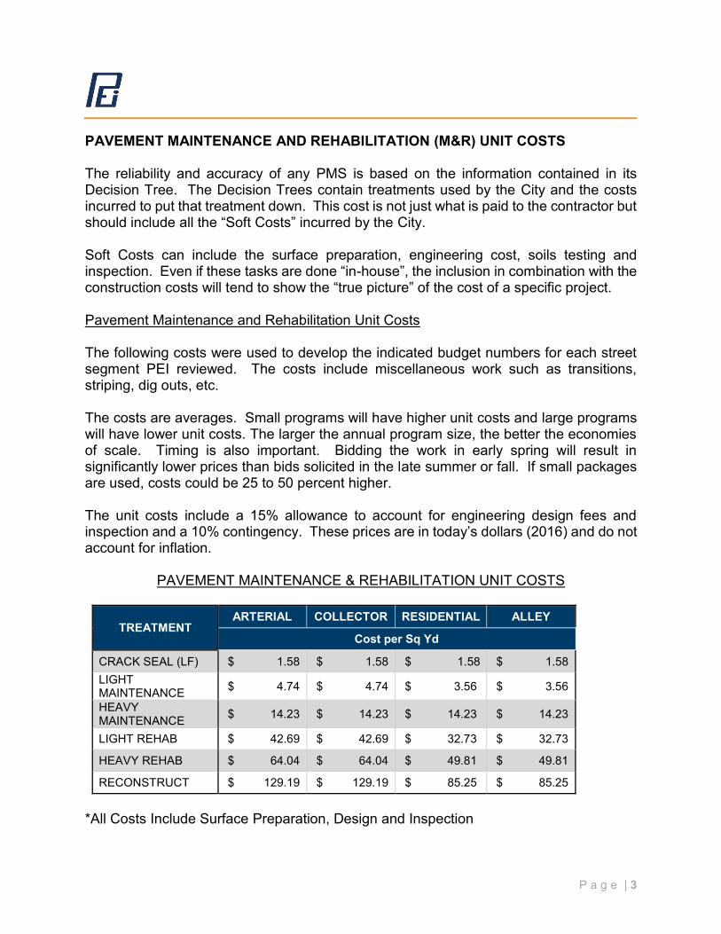
PAVEMENT MAINTENANCE AND REHABILITATION (M&R) UNIT COSTS The reliability and accuracy of any PMS is based on the information contained in its Decision Tree. The Decision Trees contain treatments used by the City and the costs incurred to put that treatment down. This cost is not just what is paid to the contractor but should include all the “Soft Costs” incurred by the City. Soft Costs can include the surface preparation, engineering cost, soils testing and inspection. Even if these tasks are done “in-house”, the inclusion in combination with the construction costs will tend to show the “true picture” of the cost of a specific project. Pavement Maintenance and Rehabilitation Unit Costs The following costs were used to develop the indicated budget numbers for each street segment PEI reviewed. The costs include miscellaneous work such as transitions, striping, dig outs, etc. The costs are averages. Small programs will have higher unit costs and large programs will have lower unit costs. The larger the annual program size, the better the economies of scale. Timing is also important. Bidding the work in early spring will result in significantly lower prices than bids solicited in the late summer or fall. If small packages are used, costs could be 25 to 50 percent higher. The unit costs include a 15% allowance to account for engineering design fees and inspection and a 10% contingency. These prices are in today’s dollars (2016) and do not account for inflation.
PAVEMENT MAINTENANCE & REHABILITATION UNIT COSTS
TREATMENT ARTERIAL COLLECTOR RESIDENTIAL ALLEY
Cost per Sq Yd
CRACK SEAL (LF) $ 1.58 $ 1.58 $ 1.58 $ 1.58 LIGHT MAINTENANCE $ 4.74 $ 4.74 $ 3.56 $ 3.56
HEAVY MAINTENANCE $ 14.23 $ 14.23 $ 14.23 $ 14.23
LIGHT REHAB $ 42.69 $ 42.69 $ 32.73 $ 32.73
HEAVY REHAB $ 64.04 $ 64.04 $ 49.81 $ 49.81
RECONSTRUCT $ 129.19 $ 129.19 $ 85.25 $ 85.25
*All Costs Include Surface Preparation, Design and Inspection
P a g e | 4
Decision Trees / Treatment Strategies The Decision Trees are broken down into two main areas; Preventive Maintenance (PM) and Rehabilitation. StreetSaver® makes preventive maintenance a top priority. The longer a segment can be kept in good condition the lower the overall cost of its treatments. Preventive Maintenance addresses the sections that have a PCI of 71 and greater. This area is further broken down to specific treatments that could be better termed as Crack Sealing, Surface Treating and Restoration Treatments. The Decision Tree allows the user to program these treatments on a cyclical basis. As part of this cyclical process, once a road has reached the point where it can no longer be maintained by a crack seal or a surface seal the program will shift to a Restoration Treatment. The program uses this treatment to restore the pavement in long term budgeting scenarios to the Very Good category. The Decision Tree for Preventive Maintenance and Rehabilitation was reviewed with the City of Hollister and updated by PEI. The decision tree customizes the logic for how and what maintenance and rehabilitation treatments StreetSaver® selects. Five general pavement treatment categories were used to account for the various treatments in the decision tree: reconstruction, heavy overlays, light overlays, heavy maintenance, light maintenance and no action. Specifying a general treatment category allows the user to stay focused on a budget level analysis rather than moving to a project level analysis. The PMS software assumes average construction and material quality. Pavement life is very sensitive to materials and workmanship quality. Poor quality new construction may result in up to a 50 percent loss in the pavement life. In other words, poor quality new construction may last 10 to 15 years, whereas excellent quality construction may last 20 to 30 years. Investing in quality, both in design and construction, provides significant returns in extended pavement life resulting in lowered annual maintenance costs. The Decision Tree for the City of Hollister can be found in Appendix A of this report.
P a g e | 5
ANNUAL PAVEMENT MAINTENANCE / REHABILITATION PROGRAM DEVELOPMENT The PCI range of 0 to 100 is broken down into five categories for budget calculation purposes. StreetSaver default PCI breakpoints were used in the development of the City of Hollister Pavement Management System. These breakpoints are as follows: Maintenance PCI PCI Treatment Type Category Ranges
Preventive Maintenance I 100 – 70 Rehabilitation II 70> - 50
(Non-load related distresses)
Rehabilitation III 70> - 50 (Non-load related distresses)
Rehabilitation IV 50> - 25 Rehabilitation V 25> - 0 When a pavement section is identified for maintenance or rehabilitation, a user defined network-level cost category for a pavement of that functional class, type and condition is used to determine the needed funds for that section. For sections falling within the preventive maintenance category (PCI 100 - 70), a time sequence is used to identify the appropriate treatment and cost. For those sections falling into rehabilitation (PCI <70), the PCI is used to determine the repair category for a pavement section. The repair category is combined with functional classification (as a surrogate for traffic) and surface type (as a surrogate for structural adequacy) to identify the appropriate treatment and cost. The treatment and cost identified for the section is a network-level budget planning treatment and is generally considered as a cost category for budgeting purposes rather than an actual treatment. Some sections will require more money than estimated, some will require less. A project-level analysis is used to determine the actual treatment to be used for a given section based on condition, structural capacity and other factors. The funding needs are summed for all sections needing work for each year of the analysis period to determine the annual budget needs. The needs analysis provides a list of
P a g e | 6
sections needing work over the selected analysis period and an estimate of the funds needed. In StreetSaver, this analysis period is 5 years. It identifies maintenance and rehabilitation needs without considering funding constraints, i.e. the Needs Analysis is unconstrained by the available budget. StreetSaver identifies candidate sections and funds needed to provide the level of service to meet agency-defined goals. When an agency has a considerable backlog of maintenance and repair needs, the first year needs will include the bulk of sections needing work. From a funding standpoint, this may appear unrealistic; however, the needs analysis is only the first step in planning and programming. The information from the needs analysis is generally best presented to management as the total 5 year needs or the average needs per year of the 5 year period. Few agencies will be able to meet the first year needs as developed by the program. The StreetSaver Needs Analysis provides information on the condition of the network over the analysis period with and without application of the treatments. Since the application of treatments assume no limit on funds, this can be considered the upper limit of condition that could be reached by the agency and the condition without treatment can be considered the lower limit. StreetSaver uses a ranking process based on cost-effectiveness concepts. Basically, the longer a pavement is in good condition, the more benefit the user gets from the pavement. This can be approximated by the area under the PCI-time curve. The larger that area, the longer the pavement provides the desired level of service. That area is divided by annualized costs per unit area. This ratio is weighted for different usage so that arterial streets are selected for repair before collectors in the same condition, which are selected for repair before residential/locals in the same condition. Sections of pavements that provide the best service for the least money are then selected as those that should be repaired first. StreetSaver provides a ranked listing based on this cost-effectiveness analysis. StreetSaver also shows the condition with and without treatment, the estimated costs for each section, the calculations used to determine the ranking, and a listing of sections not recommended for treatment. VISUAL EVALUATIONS Jacob Seely, and Wes Harmon of PEI’s technical staff evaluated all of the pavements. The streets were rated based on the StreetSaver system described in the Background. Once the data was entered into the program, Joe Seely completed a quality assurance review of the system and verified the results in the field. The street inventory was based on visual evaluations. SYSTEM UPDATES

P a g e | 7
The Pavement Management System is a dynamic program. It is expected that the City will continue to visually rate the street network and update the database at least every three years. In addition to the visual review, the City should update the database by adding new streets incorporated into the City as well as new maintenance and rehabilitation work performed to a particular street segment.
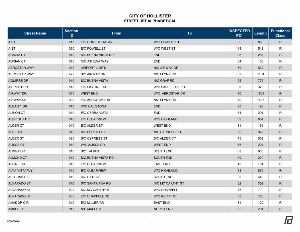
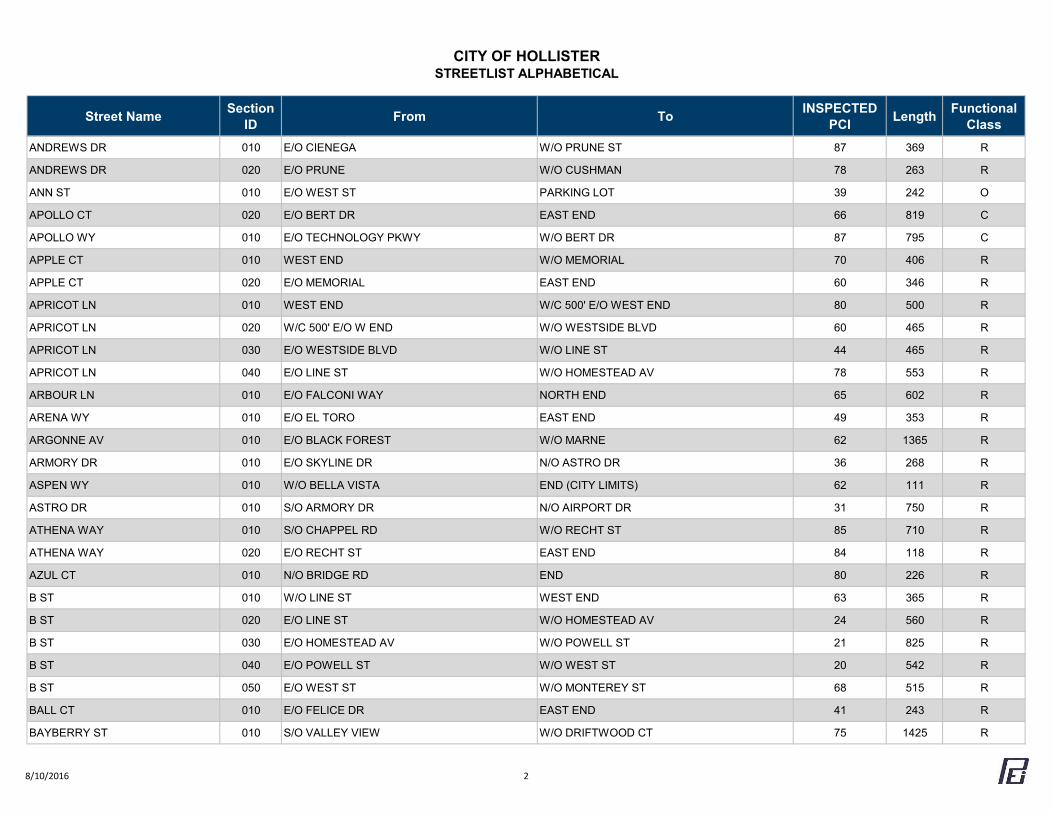
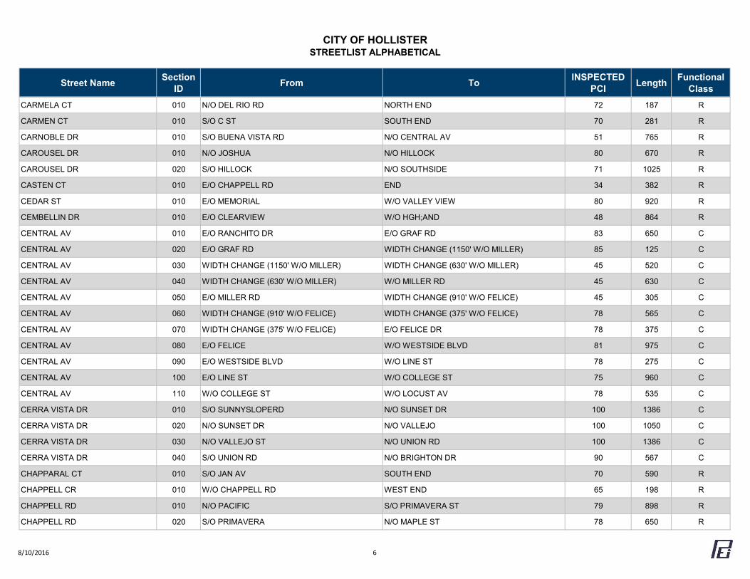
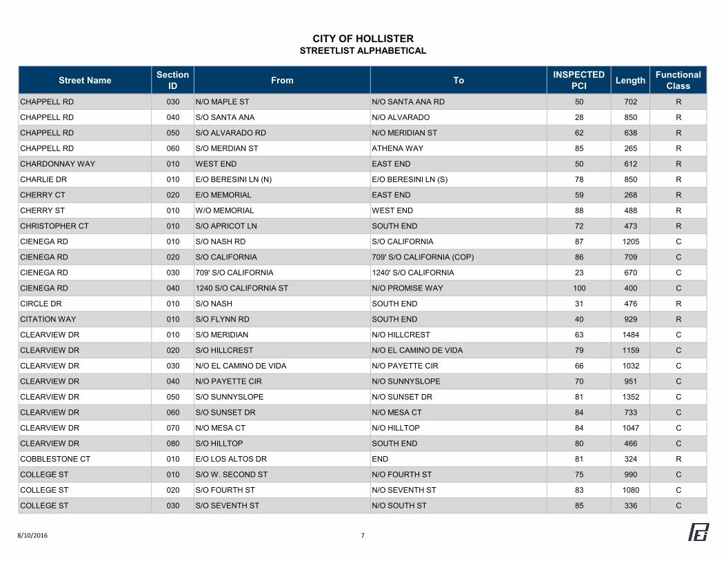
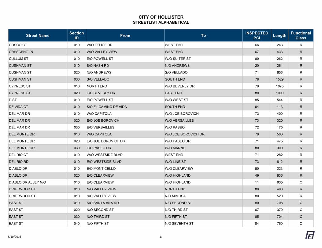
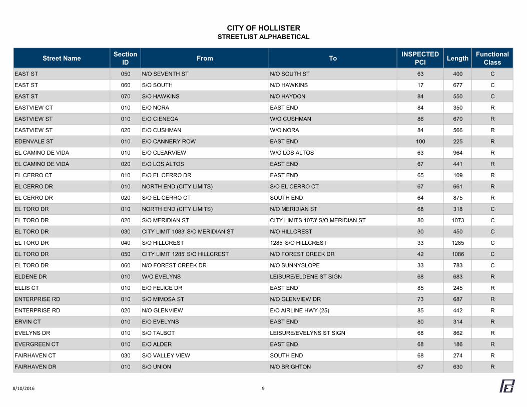
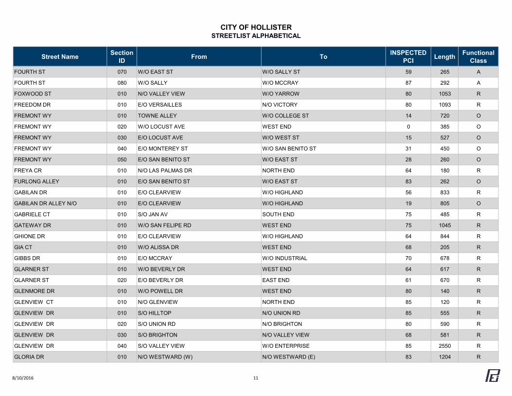
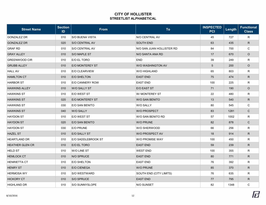
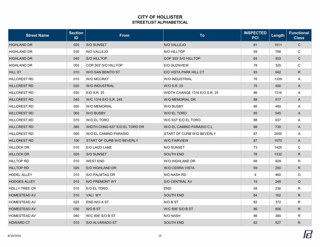
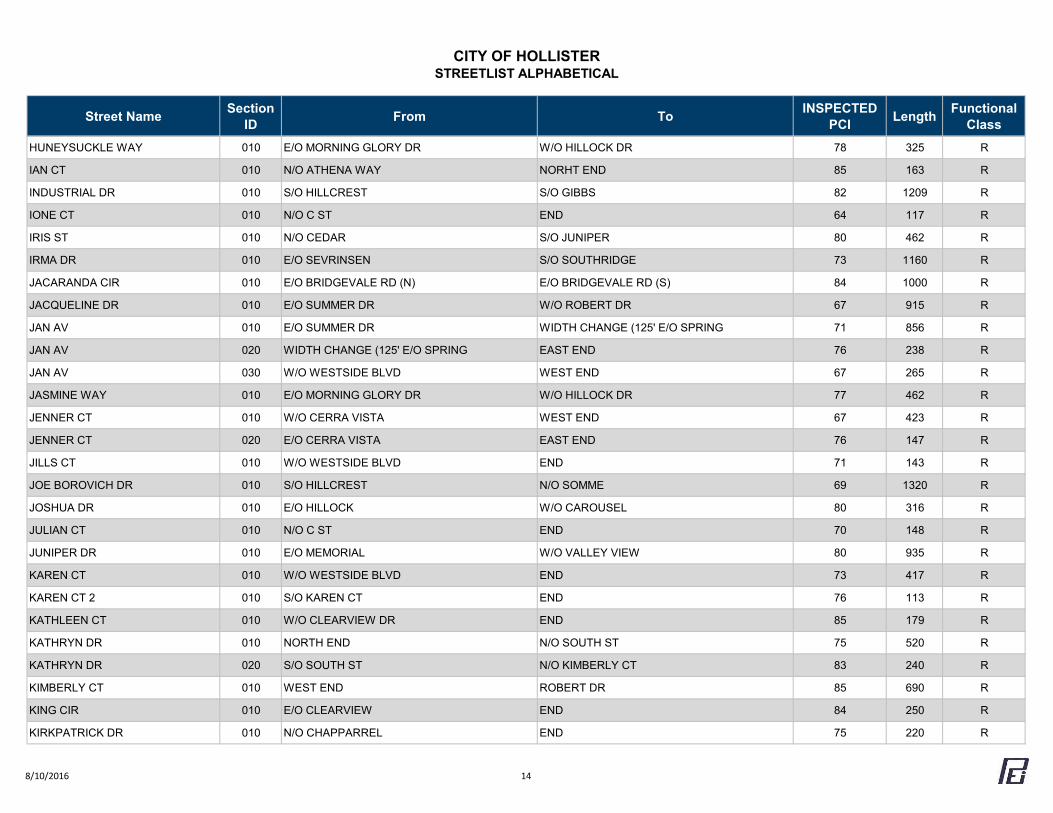
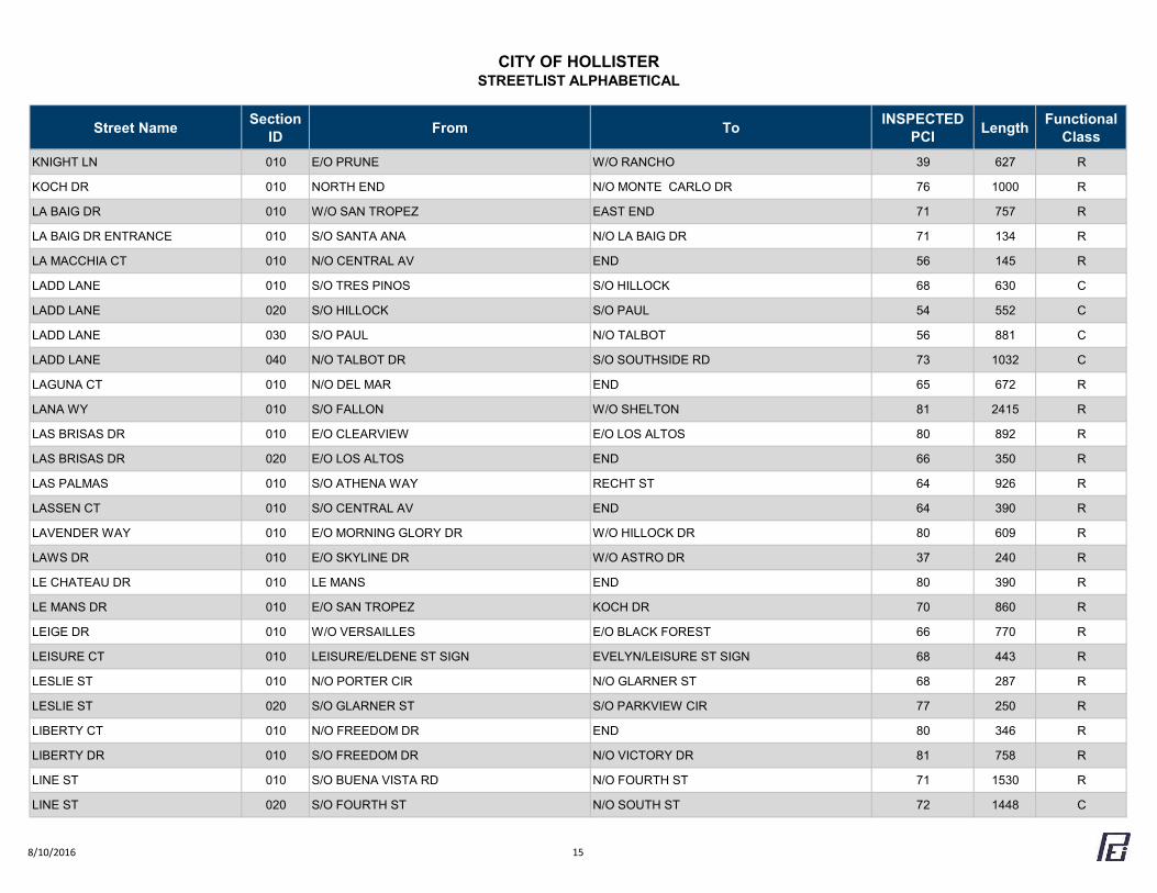
CITY OF HOLLISTERSTREETLIST ALPHABETICAL
Street Name Section ID From To INSPECTED
PCI Length Functional Class
A ST 010 E/O HOMESTEAD AV W/O POWELL ST 65 856 R
A ST 020 E/O POWELL ST W/O WEST ST 18 548 R
ACACIA CT 010 S/O BUENA VISTA RD END 38 286 R
ADRIAN CT 010 N/O ATHENA WAY END 84 160 R
AEROSTAR WAY 010 AIRPORT LIMITS N/O AIRWAY DR 69 632 R
AEROSTAR WAY 020 S/O AIRWAY DR N/O FLYNN RD 69 1104 R
AGUIRRE DR 010 S/O BUENA VISTA N/O GRAF RD 95 775 R
AIRPORT DR 010 E/O SKYLINE DR W/O SAN FELIPE RD 30 375 R
AIRWAY DR 010 WEST END W/O AEROSTAR DR 70 1604 R
AIRWAY DR 020 E/O AEROSTAR DR N/O FLYNN RD 70 1605 R
ALBANY DR 010 W/O CALISTOGA END 80 193 R
ALBION CT 010 E/O CERRA VISTA END 64 201 R
ALBRIGHT DR 010 E/O CLEARVIEW W/O HIGHLAND 39 864 R
ALDER CT 010 E/O ALDER ST WEST END 81 169 R
ALDER ST 010 S/O POPLAR CT N/O CYPRESS RD 80 977 R
ALDER ST 020 S/O CYPRESS ST S/O ALDER CT 75 532 R
ALISSA CT 010 W/O ALISSA DR WEST END 68 204 R
ALISSA DR 010 S/O TALBOT SOUTH END 68 663 R
ALMOND CT 010 S/O BUENA VISTA RD SOUTH END 40 230 R
ALPINE CR 010 E/O CLEARVIEW EAST END 49 161 R
ALTA VISTA WY 010 E/O CLEARVIEW W/O HIGHLAND 83 859 R
ALTURAS CT 010 S/O HILLTOP SOUTH END 80 440 R
ALVARADO ST 010 S/O SANTA ANA RD N/O MC CARTHY ST 82 302 R
ALVARADO ST 020 S/O MC CARTHY ST W/O CHAPPELL 78 710 R
ALVARADO ST 030 E/O CHAPPELL RD W/O RECHT ST 50 700 R
AMADOR CIR 010 E/O MILLER RD EAST END 61 120 R
AMBER CT 010 N/O MAPLE ST NORTH END 85 201 R
8/10/2016 1
CITY OF HOLLISTERSTREETLIST ALPHABETICAL
Street Name Section ID From To INSPECTED
PCI Length Functional Class
ANDREWS DR 010 E/O CIENEGA W/O PRUNE ST 87 369 R
ANDREWS DR 020 E/O PRUNE W/O CUSHMAN 78 263 R
ANN ST 010 E/O WEST ST PARKING LOT 39 242 O
APOLLO CT 020 E/O BERT DR EAST END 66 819 C
APOLLO WY 010 E/O TECHNOLOGY PKWY W/O BERT DR 87 795 C
APPLE CT 010 WEST END W/O MEMORIAL 70 406 R
APPLE CT 020 E/O MEMORIAL EAST END 60 346 R
APRICOT LN 010 WEST END W/C 500' E/O WEST END 80 500 R
APRICOT LN 020 W/C 500' E/O W END W/O WESTSIDE BLVD 60 465 R
APRICOT LN 030 E/O WESTSIDE BLVD W/O LINE ST 44 465 R
APRICOT LN 040 E/O LINE ST W/O HOMESTEAD AV 78 553 R
ARBOUR LN 010 E/O FALCONI WAY NORTH END 65 602 R
ARENA WY 010 E/O EL TORO EAST END 49 353 R
ARGONNE AV 010 E/O BLACK FOREST W/O MARNE 62 1365 R
ARMORY DR 010 E/O SKYLINE DR N/O ASTRO DR 36 268 R
ASPEN WY 010 W/O BELLA VISTA END (CITY LIMITS) 62 111 R
ASTRO DR 010 S/O ARMORY DR N/O AIRPORT DR 31 750 R
ATHENA WAY 010 S/O CHAPPEL RD W/O RECHT ST 85 710 R
ATHENA WAY 020 E/O RECHT ST EAST END 84 118 R
AZUL CT 010 N/O BRIDGE RD END 80 226 R
B ST 010 W/O LINE ST WEST END 63 365 R
B ST 020 E/O LINE ST W/O HOMESTEAD AV 24 560 R
B ST 030 E/O HOMESTEAD AV W/O POWELL ST 21 825 R
B ST 040 E/O POWELL ST W/O WEST ST 20 542 R
B ST 050 E/O WEST ST W/O MONTEREY ST 68 515 R
BALL CT 010 E/O FELICE DR EAST END 41 243 R
BAYBERRY ST 010 S/O VALLEY VIEW W/O DRIFTWOOD CT 75 1425 R
8/10/2016 2
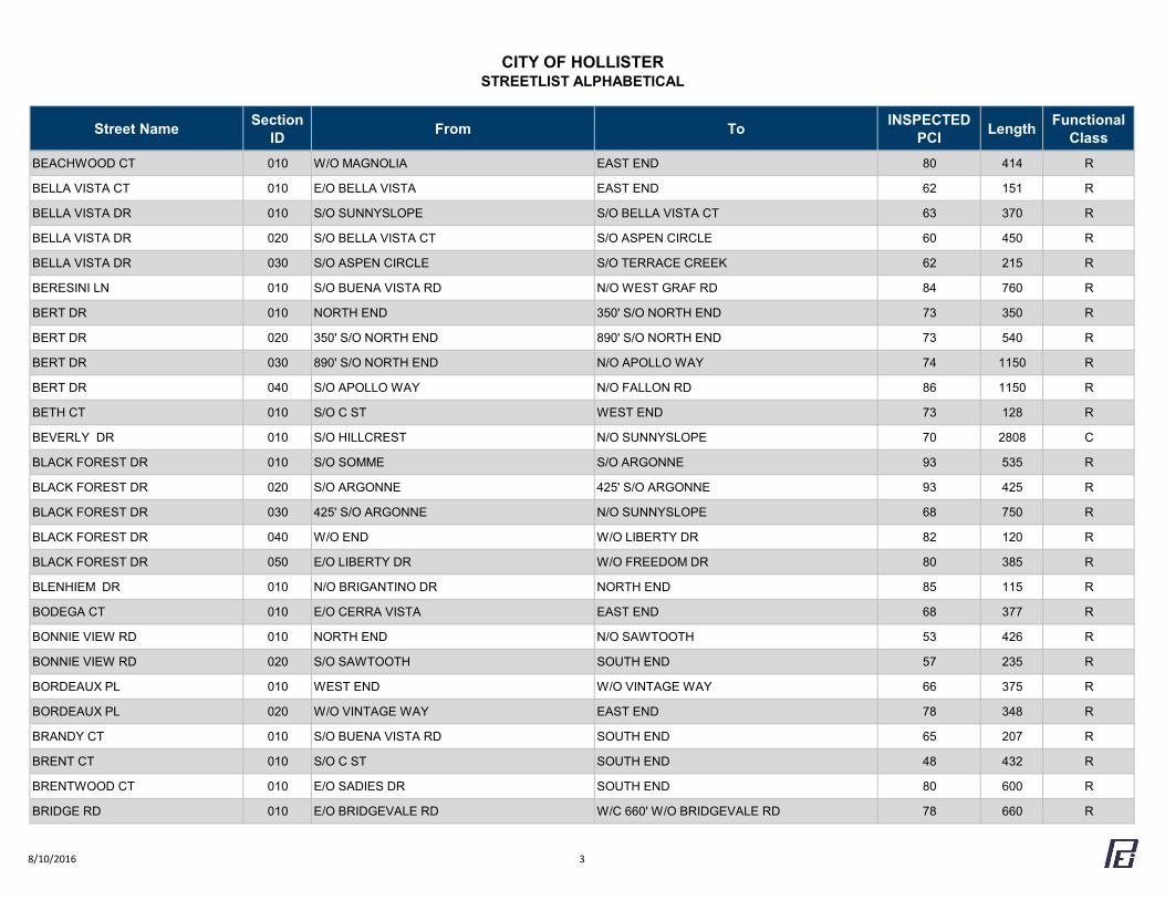
CITY OF HOLLISTERSTREETLIST ALPHABETICAL
Street Name Section ID From To INSPECTED
PCI Length Functional Class
BEACHWOOD CT 010 W/O MAGNOLIA EAST END 80 414 R
BELLA VISTA CT 010 E/O BELLA VISTA EAST END 62 151 R
BELLA VISTA DR 010 S/O SUNNYSLOPE S/O BELLA VISTA CT 63 370 R
BELLA VISTA DR 020 S/O BELLA VISTA CT S/O ASPEN CIRCLE 60 450 R
BELLA VISTA DR 030 S/O ASPEN CIRCLE S/O TERRACE CREEK 62 215 R
BERESINI LN 010 S/O BUENA VISTA RD N/O WEST GRAF RD 84 760 R
BERT DR 010 NORTH END 350' S/O NORTH END 73 350 R
BERT DR 020 350' S/O NORTH END 890' S/O NORTH END 73 540 R
BERT DR 030 890' S/O NORTH END N/O APOLLO WAY 74 1150 R
BERT DR 040 S/O APOLLO WAY N/O FALLON RD 86 1150 R
BETH CT 010 S/O C ST WEST END 73 128 R
BEVERLY DR 010 S/O HILLCREST N/O SUNNYSLOPE 70 2808 C
BLACK FOREST DR 010 S/O SOMME S/O ARGONNE 93 535 R
BLACK FOREST DR 020 S/O ARGONNE 425' S/O ARGONNE 93 425 R
BLACK FOREST DR 030 425' S/O ARGONNE N/O SUNNYSLOPE 68 750 R
BLACK FOREST DR 040 W/O END W/O LIBERTY DR 82 120 R
BLACK FOREST DR 050 E/O LIBERTY DR W/O FREEDOM DR 80 385 R
BLENHIEM DR 010 N/O BRIGANTINO DR NORTH END 85 115 R
BODEGA CT 010 E/O CERRA VISTA EAST END 68 377 R
BONNIE VIEW RD 010 NORTH END N/O SAWTOOTH 53 426 R
BONNIE VIEW RD 020 S/O SAWTOOTH SOUTH END 57 235 R
BORDEAUX PL 010 WEST END W/O VINTAGE WAY 66 375 R
BORDEAUX PL 020 W/O VINTAGE WAY EAST END 78 348 R
BRANDY CT 010 S/O BUENA VISTA RD SOUTH END 65 207 R
BRENT CT 010 S/O C ST SOUTH END 48 432 R
BRENTWOOD CT 010 E/O SADIES DR SOUTH END 80 600 R
BRIDGE RD 010 E/O BRIDGEVALE RD W/C 660' W/O BRIDGEVALE RD 78 660 R
8/10/2016 3
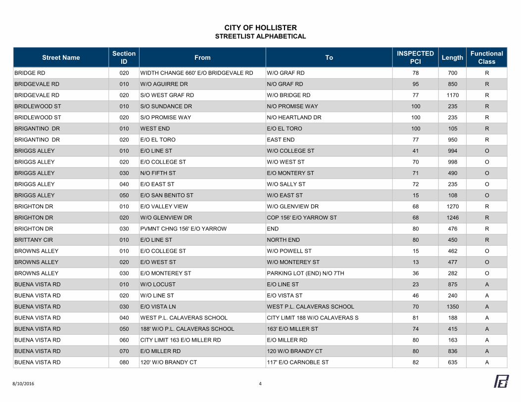
CITY OF HOLLISTERSTREETLIST ALPHABETICAL
Street Name Section ID From To INSPECTED
PCI Length Functional Class
BRIDGE RD 020 WIDTH CHANGE 660' E/O BRIDGEVALE RD W/O GRAF RD 78 700 R
BRIDGEVALE RD 010 W/O AGUIRRE DR N/O GRAF RD 95 850 R
BRIDGEVALE RD 020 S/O WEST GRAF RD W/O BRIDGE RD 77 1170 R
BRIDLEWOOD ST 010 S/O SUNDANCE DR N/O PROMISE WAY 100 235 R
BRIDLEWOOD ST 020 S/O PROMISE WAY N/O HEARTLAND DR 100 235 R
BRIGANTINO DR 010 WEST END E/O EL TORO 100 105 R
BRIGANTINO DR 020 E/O EL TORO EAST END 77 950 R
BRIGGS ALLEY 010 E/O LINE ST W/O COLLEGE ST 41 994 O
BRIGGS ALLEY 020 E/O COLLEGE ST W/O WEST ST 70 998 O
BRIGGS ALLEY 030 N/O FIFTH ST E/O MONTERY ST 71 490 O
BRIGGS ALLEY 040 E/O EAST ST W/O SALLY ST 72 235 O
BRIGGS ALLEY 050 E/O SAN BENITO ST W/O EAST ST 15 108 O
BRIGHTON DR 010 E/O VALLEY VIEW W/O GLENVIEW DR 68 1270 R
BRIGHTON DR 020 W/O GLENVIEW DR COP 156' E/O YARROW ST 68 1246 R
BRIGHTON DR 030 PVMNT CHNG 156' E/O YARROW END 80 476 R
BRITTANY CIR 010 E/O LINE ST NORTH END 80 450 R
BROWNS ALLEY 010 E/O COLLEGE ST W/O POWELL ST 15 462 O
BROWNS ALLEY 020 E/O WEST ST W/O MONTEREY ST 13 477 O
BROWNS ALLEY 030 E/O MONTEREY ST PARKING LOT (END) N/O 7TH 36 282 O
BUENA VISTA RD 010 W/O LOCUST E/O LINE ST 23 875 A
BUENA VISTA RD 020 W/O LINE ST E/O VISTA ST 46 240 A
BUENA VISTA RD 030 E/O VISTA LN WEST P.L. CALAVERAS SCHOOL 70 1350 A
BUENA VISTA RD 040 WEST P.L. CALAVERAS SCHOOL CITY LIMIT 188 W/O CALAVERAS S 81 188 A
BUENA VISTA RD 050 188' W/O P.L. CALAVERAS SCHOOL 163' E/O MILLER ST 74 415 A
BUENA VISTA RD 060 CITY LIMIT 163 E/O MILLER RD E/O MILLER RD 80 163 A
BUENA VISTA RD 070 E/O MILLER RD 120 W/O BRANDY CT 80 836 A
BUENA VISTA RD 080 120' W/O BRANDY CT 117' E/O CARNOBLE ST 82 635 A
8/10/2016 4
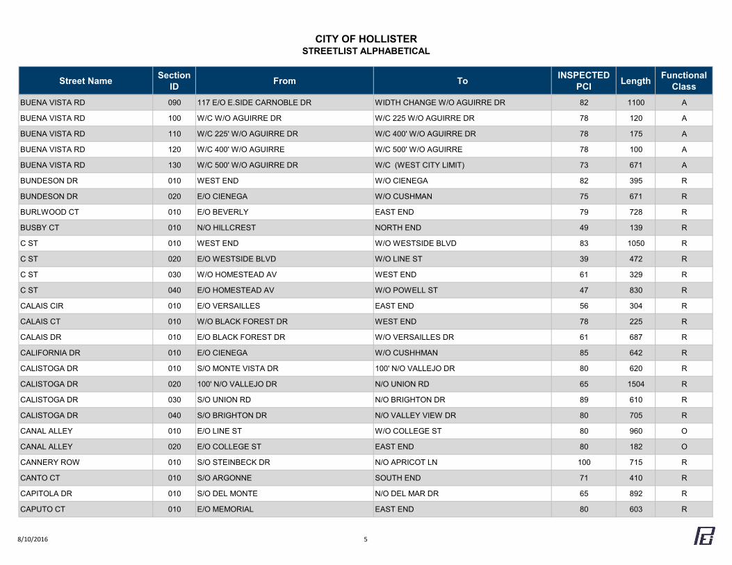
CITY OF HOLLISTERSTREETLIST ALPHABETICAL
Street Name Section ID From To INSPECTED
PCI Length Functional Class
BUENA VISTA RD 090 117 E/O E.SIDE CARNOBLE DR WIDTH CHANGE W/O AGUIRRE DR 82 1100 A
BUENA VISTA RD 100 W/C W/O AGUIRRE DR W/C 225 W/O AGUIRRE DR 78 120 A
BUENA VISTA RD 110 W/C 225' W/O AGUIRRE DR W/C 400' W/O AGUIRRE DR 78 175 A
BUENA VISTA RD 120 W/C 400' W/O AGUIRRE W/C 500' W/O AGUIRRE 78 100 A
BUENA VISTA RD 130 W/C 500' W/O AGUIRRE DR W/C (WEST CITY LIMIT) 73 671 A
BUNDESON DR 010 WEST END W/O CIENEGA 82 395 R
BUNDESON DR 020 E/O CIENEGA W/O CUSHMAN 75 671 R
BURLWOOD CT 010 E/O BEVERLY EAST END 79 728 R
BUSBY CT 010 N/O HILLCREST NORTH END 49 139 R
C ST 010 WEST END W/O WESTSIDE BLVD 83 1050 R
C ST 020 E/O WESTSIDE BLVD W/O LINE ST 39 472 R
C ST 030 W/O HOMESTEAD AV WEST END 61 329 R
C ST 040 E/O HOMESTEAD AV W/O POWELL ST 47 830 R
CALAIS CIR 010 E/O VERSAILLES EAST END 56 304 R
CALAIS CT 010 W/O BLACK FOREST DR WEST END 78 225 R
CALAIS DR 010 E/O BLACK FOREST DR W/O VERSAILLES DR 61 687 R
CALIFORNIA DR 010 E/O CIENEGA W/O CUSHHMAN 85 642 R
CALISTOGA DR 010 S/O MONTE VISTA DR 100' N/O VALLEJO DR 80 620 R
CALISTOGA DR 020 100' N/O VALLEJO DR N/O UNION RD 65 1504 R
CALISTOGA DR 030 S/O UNION RD N/O BRIGHTON DR 89 610 R
CALISTOGA DR 040 S/O BRIGHTON DR N/O VALLEY VIEW DR 80 705 R
CANAL ALLEY 010 E/O LINE ST W/O COLLEGE ST 80 960 O
CANAL ALLEY 020 E/O COLLEGE ST EAST END 80 182 O
CANNERY ROW 010 S/O STEINBECK DR N/O APRICOT LN 100 715 R
CANTO CT 010 S/O ARGONNE SOUTH END 71 410 R
CAPITOLA DR 010 S/O DEL MONTE N/O DEL MAR DR 65 892 R
CAPUTO CT 010 E/O MEMORIAL EAST END 80 603 R
8/10/2016 5
CITY OF HOLLISTERSTREETLIST ALPHABETICAL
Street Name Section ID From To INSPECTED
PCI Length Functional Class
CARMELA CT 010 N/O DEL RIO RD NORTH END 72 187 R
CARMEN CT 010 S/O C ST SOUTH END 70 281 R
CARNOBLE DR 010 S/O BUENA VISTA RD N/O CENTRAL AV 51 765 R
CAROUSEL DR 010 N/O JOSHUA N/O HILLOCK 80 670 R
CAROUSEL DR 020 S/O HILLOCK N/O SOUTHSIDE 71 1025 R
CASTEN CT 010 E/O CHAPPELL RD END 34 382 R
CEDAR ST 010 E/O MEMORIAL W/O VALLEY VIEW 80 920 R
CEMBELLIN DR 010 E/O CLEARVIEW W/O HGH;AND 48 864 R
CENTRAL AV 010 E/O RANCHITO DR E/O GRAF RD 83 650 C
CENTRAL AV 020 E/O GRAF RD WIDTH CHANGE (1150' W/O MILLER) 85 125 C
CENTRAL AV 030 WIDTH CHANGE (1150' W/O MILLER) WIDTH CHANGE (630' W/O MILLER) 45 520 C
CENTRAL AV 040 WIDTH CHANGE (630' W/O MILLER) W/O MILLER RD 45 630 C
CENTRAL AV 050 E/O MILLER RD WIDTH CHANGE (910' W/O FELICE) 45 305 C
CENTRAL AV 060 WIDTH CHANGE (910' W/O FELICE) WIDTH CHANGE (375' W/O FELICE) 78 565 C
CENTRAL AV 070 WIDTH CHANGE (375' W/O FELICE) E/O FELICE DR 78 375 C
CENTRAL AV 080 E/O FELICE W/O WESTSIDE BLVD 81 975 C
CENTRAL AV 090 E/O WESTSIDE BLVD W/O LINE ST 78 275 C
CENTRAL AV 100 E/O LINE ST W/O COLLEGE ST 75 960 C
CENTRAL AV 110 W/O COLLEGE ST W/O LOCUST AV 78 535 C
CERRA VISTA DR 010 S/O SUNNYSLOPERD N/O SUNSET DR 100 1386 C
CERRA VISTA DR 020 N/O SUNSET DR N/O VALLEJO 100 1050 C
CERRA VISTA DR 030 N/O VALLEJO ST N/O UNION RD 100 1386 C
CERRA VISTA DR 040 S/O UNION RD N/O BRIGHTON DR 90 567 C
CHAPPARAL CT 010 S/O JAN AV SOUTH END 70 590 R
CHAPPELL CR 010 W/O CHAPPELL RD WEST END 65 198 R
CHAPPELL RD 010 N/O PACIFIC S/O PRIMAVERA ST 79 898 R
CHAPPELL RD 020 S/O PRIMAVERA N/O MAPLE ST 78 650 R
8/10/2016 6
CITY OF HOLLISTERSTREETLIST ALPHABETICAL
Street Name Section ID From To INSPECTED
PCI Length Functional Class
CHAPPELL RD 030 N/O MAPLE ST N/O SANTA ANA RD 50 702 R
CHAPPELL RD 040 S/O SANTA ANA N/O ALVARADO 28 850 R
CHAPPELL RD 050 S/O ALVARADO RD N/O MERIDIAN ST 62 638 R
CHAPPELL RD 060 S/O MERDIAN ST ATHENA WAY 85 265 R
CHARDONNAY WAY 010 WEST END EAST END 50 612 R
CHARLIE DR 010 E/O BERESINI LN (N) E/O BERESINI LN (S) 78 850 R
CHERRY CT 020 E/O MEMORIAL EAST END 59 268 R
CHERRY ST 010 W/O MEMORIAL WEST END 88 488 R
CHRISTOPHER CT 010 S/O APRICOT LN SOUTH END 72 473 R
CIENEGA RD 010 S/O NASH RD S/O CALIFORNIA 87 1205 C
CIENEGA RD 020 S/O CALIFORNIA 709' S/O CALIFORNIA (COP) 86 709 C
CIENEGA RD 030 709' S/O CALIFORNIA 1240' S/O CALIFORNIA 23 670 C
CIENEGA RD 040 1240 S/O CALIFORNIA ST N/O PROMISE WAY 100 400 C
CIRCLE DR 010 S/O NASH SOUTH END 31 476 R
CITATION WAY 010 S/O FLYNN RD SOUTH END 40 929 R
CLEARVIEW DR 010 S/O MERIDIAN N/O HILLCREST 63 1484 C
CLEARVIEW DR 020 S/O HILLCREST N/O EL CAMINO DE VIDA 79 1159 C
CLEARVIEW DR 030 N/O EL CAMINO DE VIDA N/O PAYETTE CIR 66 1032 C
CLEARVIEW DR 040 N/O PAYETTE CIR N/O SUNNYSLOPE 70 951 C
CLEARVIEW DR 050 S/O SUNNYSLOPE N/O SUNSET DR 81 1352 C
CLEARVIEW DR 060 S/O SUNSET DR N/O MESA CT 84 733 C
CLEARVIEW DR 070 N/O MESA CT N/O HILLTOP 84 1047 C
CLEARVIEW DR 080 S/O HILLTOP SOUTH END 80 466 C
COBBLESTONE CT 010 E/O LOS ALTOS DR END 81 324 R
COLLEGE ST 010 S/O W. SECOND ST N/O FOURTH ST 75 990 C
COLLEGE ST 020 S/O FOURTH ST N/O SEVENTH ST 83 1080 C
COLLEGE ST 030 S/O SEVENTH ST N/O SOUTH ST 85 336 C
8/10/2016 7
CITY OF HOLLISTERSTREETLIST ALPHABETICAL
Street Name Section ID From To INSPECTED
PCI Length Functional Class
COSCO CT 010 W/O FELICE DR WEST END 66 243 R
CRESCENT LN 010 W/O VALLEY VIEW WEST END 67 433 R
CULLUM ST 010 E/O POWELL ST W/O SUITER ST 80 262 R
CUSHMAN ST 010 S/O NASH RD N/O ANDREWS 20 261 R
CUSHMAN ST 020 N/O ANDREWS S/O VELLADO 71 656 R
CUSHMAN ST 030 S/O VELLADO SOUTH END 78 1529 R
CYPRESS ST 010 NORTH END W/O BEVERLY DR 79 1875 R
CYPRESS ST 020 E/O BEVERLY DR EAST END 80 1000 R
D ST 010 E/O POWELL ST W/O WEST ST 85 544 R
DE VIDA CT 010 S/O EL CAMINO DE VIDA SOUTH END 64 113 R
DEL MAR DR 010 W/O CAPITOLA W/O JOE BOROVICH 73 400 R
DEL MAR DR 020 E/O JOE BOROVICH W/O VERSAILLES 73 320 R
DEL MAR DR 030 E/O VERSAILLES W/O PASEO 72 175 R
DEL MONTE DR 010 W/O CAPITOLA W/O JOE BOROVICH DR 70 500 R
DEL MONTE DR 020 E/O JOE BOROVICH DR W/O PASEO DR 71 475 R
DEL MONTE DR 030 E/O PASEO DR W/O MARNE 80 300 R
DEL RIO CT 010 W/O WESTSIDE BLVD WEST END 71 282 R
DEL RIO RD 010 E/O WESTSIDE BLVD W/O LINE ST 73 612 R
DIABLO DR 010 E/O MONTICELLO W/O CLEARVIEW 50 223 R
DIABLO DR 020 E/O CLEARVIEW W/O HIGHLAND 49 836 R
DIABLO DR ALLEY N/O 010 E/O CLEARVIEW W/O HIGHLAND 11 835 O
DRIFTWOOD CT 010 N/O VALLEY VIEW NORTH END 80 490 R
DRIFTWOOD ST 010 S/O VALLEY VIEW N/O MIMOSA 80 520 R
EAST ST 010 S/O SANTA ANA RD N/O SECOND ST 80 708 C
EAST ST 020 N/O SECOND ST N/O THIRD ST 67 370 C
EAST ST 030 N/O THIRD ST N/O FIFTH ST 85 704 C
EAST ST 040 N/O FIFTH ST N/O SEVENTH ST 84 760 C
8/10/2016 8
CITY OF HOLLISTERSTREETLIST ALPHABETICAL
Street Name Section ID From To INSPECTED
PCI Length Functional Class
EAST ST 050 N/O SEVENTH ST N/O SOUTH ST 63 400 C
EAST ST 060 S/O SOUTH N/O HAWKINS 17 677 C
EAST ST 070 S/O HAWKINS N/O HAYDON 84 550 C
EASTVIEW CT 010 E/O NORA EAST END 84 350 R
EASTVIEW ST 010 E/O CIENEGA W/O CUSHMAN 86 670 R
EASTVIEW ST 020 E/O CUSHMAN W/O NORA 84 566 R
EDENVALE ST 010 E/O CANNERY ROW EAST END 100 225 R
EL CAMINO DE VIDA 010 E/O CLEARVIEW W/O LOS ALTOS 63 964 R
EL CAMINO DE VIDA 020 E/O LOS ALTOS EAST END 67 441 R
EL CERRO CT 010 E/O EL CERRO DR EAST END 65 109 R
EL CERRO DR 010 NORTH END (CITY LIMITS) S/O EL CERRO CT 67 661 R
EL CERRO DR 020 S/O EL CERRO CT SOUTH END 64 875 R
EL TORO DR 010 NORTH END (CITY LIMITS) N/O MERIDIAN ST 68 318 C
EL TORO DR 020 S/O MERIDIAN ST CITY LIMITS 1073' S/O MERIDIAN ST 80 1073 C
EL TORO DR 030 CITY LIMIT 1083' S/O MERIDIAN ST N/O HILLCREST 30 450 C
EL TORO DR 040 S/O HILLCREST 1285' S/O HILLCREST 33 1285 C
EL TORO DR 050 CITY LIMIT 1285' S/O HILLCREST N/O FOREST CREEK DR 42 1086 C
EL TORO DR 060 N/O FOREST CREEK DR N/O SUNNYSLOPE 33 783 C
ELDENE DR 010 W/O EVELYNS LEISURE/ELDENE ST SIGN 68 683 R
ELLIS CT 010 E/O FELICE DR EAST END 85 245 R
ENTERPRISE RD 010 S/O MIMOSA ST N/O GLENVIEW DR 73 687 R
ENTERPRISE RD 020 N/O GLENVIEW E/O AIRLINE HWY (25) 85 442 R
ERVIN CT 010 E/O EVELYNS EAST END 80 314 R
EVELYNS DR 010 S/O TALBOT LEISURE/EVELYNS ST SIGN 68 862 R
EVERGREEN CT 010 E/O ALDER EAST END 68 186 R
FAIRHAVEN CT 030 S/O VALLEY VIEW SOUTH END 68 274 R
FAIRHAVEN DR 010 S/O UNION N/O BRIGHTON 67 630 R
8/10/2016 9

CITY OF HOLLISTERSTREETLIST ALPHABETICAL
Street Name Section ID From To INSPECTED
PCI Length Functional Class
FAIRHAVEN DR 020 S/O BRIGHTON N/O VALLEY VIEW 68 450 R
FALCONI WAY 010 S/O SANTA ANA RD N/O CHARDONNAY WAY 68 540 R
FALLON RD 010 E/O SAN FELIPE W/O BERT CT 54 1864 R
FALLON RD 020 W/O BERT CT CITY LIMITS (PVMNT CHNG W/O C 64 678 R
FARRAGOT DR 010 E/O CLEARVIEW CITY LIMIT 530' E/O CLEARVIEW 75 530 R
FELICE DR 010 S/O CENTRAL AV N/O FOURTH ST 85 720 R
FIFTH ST 010 E/O LINE ST W/O COLLEGE ST 40 990 R
FIFTH ST 020 E/O COLLEGE ST W/O POWELL ST 51 462 R
FIFTH ST 030 E/O POWELL ST W/O MONTEREY ST 17 1046 R
FIFTH ST 040 E/O MONTEREY ST W/O EAST ST 81 475 C
FIFTH ST 050 E/O SAN BENITO ST W/O EAST ST 80 263 C
FIFTH ST 060 E/O EAST ST W/O SALLY ST 80 233 C
FIRST ST 010 MONTEREY ST W/O THOMPSON ST 0 162 R
FIRST ST 020 W/O THOMPSON ST W/O SAN BENITO ST 85 332 R
FIRST ST 030 E/O SAN BENITO ST W/O EAST ST 15 266 R
FLORA AVE 010 W/O SAN BENITO ST END (RR ROW) 48 825 R
FLYNN RD 010 W/O SAN FELIPE RDRD 1125' W/O SAN FELIIPE RD 58 1125 C
FLYNN RD 020 1125' W/O SAN FELIPE RD W/O AEROSTAR DR 64 1300 C
FLYNN RD 030 W/O AEROSTAR DR 675' W/O AEROSTAR DR 50 675 C
FLYNN RD 040 675' W/O AEROSTAR DR 1075' W/O AEROSTAR DR (CITY LIMIT) 41 400 C
FOREST CREEK DR 010 W/O EL TORO W/O EL CERRO DR 50 477 R
FOURTH ST 010 W/O WESTSIDE BLVD E/O LINE ST 54 391 A
FOURTH ST 020 E/O LINE ST W/O POWELL ST 63 1503 A
FOURTH ST 030 W/O POWELL E/O MONTEREY 57 1160 A
FOURTH ST 040 E/O MONTEREY ST 193 E/O MONTEREY ST 57 193 A
FOURTH ST 050 193 E/O MONTEREY ST W/O SAN BENITO ST 74 265 A
FOURTH ST 060 E/O SAN BENITO ST W/O EAST ST 76 320 A
8/10/2016 10
CITY OF HOLLISTERSTREETLIST ALPHABETICAL
Street Name Section ID From To INSPECTED
PCI Length Functional Class
FOURTH ST 070 W/O EAST ST W/O SALLY ST 59 265 A
FOURTH ST 080 W/O SALLY W/O MCCRAY 87 292 A
FOXWOOD ST 010 N/O VALLEY VIEW W/O YARROW 80 1053 R
FREEDOM DR 010 E/O VERSAILLES N/O VICTORY 80 1093 R
FREMONT WY 010 TOWNE ALLEY W/O COLLEGE ST 14 720 O
FREMONT WY 020 W/O LOCUST AVE WEST END 0 385 O
FREMONT WY 030 E/O LOCUST AVE W/O WEST ST 15 527 O
FREMONT WY 040 E/O MONTEREY ST W/O SAN BENITO ST 31 450 O
FREMONT WY 050 E/O SAN BENITO ST W/O EAST ST 28 260 O
FREYA CR 010 N/O LAS PALMAS DR NORTH END 64 180 R
FURLONG ALLEY 010 E/O SAN BENITO ST W/O EAST ST 83 262 O
GABILAN DR 010 E/O CLEARVIEW W/O HIGHLAND 56 833 R
GABILAN DR ALLEY N/O 010 E/O CLEARVIEW W/O HIGHLAND 19 805 O
GABRIELE CT 010 S/O JAN AV SOUTH END 75 485 R
GATEWAY DR 010 W/O SAN FELIPE RD WEST END 75 1045 R
GHIONE DR 010 E/O CLEARVIEW W/O HIGHLAND 64 844 R
GIA CT 010 W/O ALISSA DR WEST END 68 205 R
GIBBS DR 010 E/O MCCRAY W/O INDUSTRIAL 70 678 R
GLARNER ST 010 W/O BEVERLY DR WEST END 64 617 R
GLARNER ST 020 E/O BEVERLY DR EAST END 61 670 R
GLENMORE DR 010 W/O POWELL DR WEST END 80 140 R
GLENVIEW CT 010 N/O GLENVIEW NORTH END 85 120 R
GLENVIEW DR 010 S/O HILLTOP N/O UNION RD 85 555 R
GLENVIEW DR 020 S/O UNION RD N/O BRIGHTON 80 590 R
GLENVIEW DR 030 S/O BRIGHTON N/O VALLEY VIEW 68 581 R
GLENVIEW DR 040 S/O VALLEY VIEW W/O ENTERPRISE 85 2550 R
GLORIA DR 010 N/O WESTWARD (W) N/O WESTWARD (E) 83 1204 R
8/10/2016 11
CITY OF HOLLISTERSTREETLIST ALPHABETICAL
Street Name Section ID From To INSPECTED
PCI Length Functional Class
GONZALEZ DR 010 S/O BUENA VISTA N/O CENTRAL AV 45 727 R
GONZALEZ DR 020 S/O CENTRAL AV SOUTH END 63 435 R
GRAF RD 010 S/O CENTRAL AV N/O SAN JUAN HOLLISTER RD 84 700 C
GRAY ALLEY 010 S/O MAPLE ST N/O SANTA ANA RD 17 670 O
GREENWOOD CIR 010 E/O EL TORO END 39 249 R
GRUBB ALLEY 010 E/O MONTEREY ST W/O WASHINGTON AV 5 200 O
HALL AV 010 E/O CLEARVIEW W/O HIGHLAND 65 803 R
HAMILTON CT 010 E/O SHELTON EAST END 75 474 R
HARBOR ST 010 E/O CANNERY ROW EAST END 100 225 R
HAWKINS ALLEY 010 W/O SALLY ST E/O EAST ST 71 190 O
HAWKINS ST 010 E/O WEST ST W/ MONTEREY ST 22 480 R
HAWKINS ST 020 E/O MONTEREY ST W/O SAN BENITO 13 540 R
HAWKINS ST 030 E/O SAN BENITO W/O SALLY 80 545 C
HAWKINS ST 040 W/O SALLY W/O PROSPECT 83 1281 C
HAYDON ST 010 E/O WEST ST W/O SAN BENITO RD 57 1002 R
HAYDON ST 020 E/O SAN BENITO W/O PRUNE 82 878 C
HAYDON ST 030 E/O PRUNE W/O SHERWOOD 66 256 R
HAZEL ST 010 E/O SALLY ST W/O PROSPECT AV 18 914 R
HEARTLAND DR 010 E/O SADDLEBROOK ST W/O PROMISE WAY 100 450 R
HEATHER GLEN CR 010 E/O EL TORO EAST END 59 239 R
HELD ST 010 W/O LINE ST WEST END 100 355 R
HEMLOCK CT 010 N/O SPRUCE EAST END 80 771 R
HENRIETTA CT 010 E/O SHELTON EAST END 76 392 R
HENRY ST 010 E/O CIENEGA W/O PRUNE 85 370 R
HERMOSA WY 010 S/O WESTWARD SOUTH END (CITY LIMITS) 76 635 R
HICKORY CT 010 S/O SPRUCE EAST END 77 795 R
HIGHLAND DR 010 S/O SUNNYSLOPE N/O SUNSET 82 1348 C
8/10/2016 12
CITY OF HOLLISTERSTREETLIST ALPHABETICAL
Street Name Section ID From To INSPECTED
PCI Length Functional Class
HIGHLAND DR 020 S/O SUNSET N/O VALLEJO 81 1011 C
HIGHLAND DR 030 N/O VALLEJO N/O HILLTOP 59 788 C
HIGHLAND DR 040 S/O HILLTOP COP 303' S/O HILLTOP 64 303 C
HIGHLAND DR 050 COP 303' S/O HILLTOP E/O GLENVIEW 78 325 C
HILL ST 010 W/O SAN BENITO ST E/O VISTA PARK HILL CT 93 642 R
HILLCREST RD 010 W/O MCCRAY W/O INDUSTRIAL 76 1339 A
HILLCREST RD 020 W/O INDUSTRIAL W/O S.R. 25 75 400 A
HILLCREST RD 030 E/O S.R. 25 WIDTH CHANGE 1316 E/O S.R. 25 86 1316 A
HILLCREST RD 040 W/C 1316 E/O S.R. 245 W/O MEMORIAL DR 88 517 A
HILLCREST RD 050 W/O MEMORIAL W/O BUSBY 86 480 A
HILLCREST RD 060 W/O BUSBY W/O EL TORO 85 545 A
HILLCREST RD 070 W/O EL TORO W/C 637' E/O EL TORO 88 637 A
HILLCREST RD 080 WIDTH CHNG 637' E/O EL TORO DR W/O EL CAMINO PARASIO C.L. 88 730 A
HILLCREST RD 090 W/O EL CAMINO PARASIO START OF CURB W/O BEVERLY 87 2000 A
HILLCREST RD 100 START OF CURB W/O BEVERLY W/O FAIRVIEW 87 1570 A
HILLOCK DR 010 E/O LADD LANE N/O SUNSET 73 1425 C
HILLOCK DR 020 S/O SUNSET SOUTH END 78 1332 R
HILLTOP RD 010 WEST END W/O HIGHLAND DR 68 929 R
HILLTOP RD 020 E/O HIGHLAND DR W/O CERRA VISTA 69 250 R
HODEL ALLEY 010 S/O PALMTAG DR N/O NASH RD 4 460 O
HODGES ALLEY 010 N/O FREMONT WY S/O CENTRAL AV 19 248 O
HOLLY TREE CR 010 E/O EL TORO END 58 236 R
HOMESTEAD AV 010 VALI WY SOUTH END 84 162 R
HOMESTEAD AV 020 END N/O A ST N/O B ST 82 372 R
HOMESTEAD AV 030 N/O B ST W/C 806' S/O B ST 86 806 R
HOMESTEAD AV 040 W/C 806' S/O B ST N/O NASH 86 380 R
HOWARD CT 010 S/O ALVARADO ST SOUTH END 62 527 R
8/10/2016 13
CITY OF HOLLISTERSTREETLIST ALPHABETICAL
Street Name Section ID From To INSPECTED
PCI Length Functional Class
HUNEYSUCKLE WAY 010 E/O MORNING GLORY DR W/O HILLOCK DR 78 325 R
IAN CT 010 N/O ATHENA WAY NORHT END 85 163 R
INDUSTRIAL DR 010 S/O HILLCREST S/O GIBBS 82 1209 R
IONE CT 010 N/O C ST END 64 117 R
IRIS ST 010 N/O CEDAR S/O JUNIPER 80 462 R
IRMA DR 010 E/O SEVRINSEN S/O SOUTHRIDGE 73 1160 R
JACARANDA CIR 010 E/O BRIDGEVALE RD (N) E/O BRIDGEVALE RD (S) 84 1000 R
JACQUELINE DR 010 E/O SUMMER DR W/O ROBERT DR 67 915 R
JAN AV 010 E/O SUMMER DR WIDTH CHANGE (125' E/O SPRING 71 856 R
JAN AV 020 WIDTH CHANGE (125' E/O SPRING EAST END 76 238 R
JAN AV 030 W/O WESTSIDE BLVD WEST END 67 265 R
JASMINE WAY 010 E/O MORNING GLORY DR W/O HILLOCK DR 77 462 R
JENNER CT 010 W/O CERRA VISTA WEST END 67 423 R
JENNER CT 020 E/O CERRA VISTA EAST END 76 147 R
JILLS CT 010 W/O WESTSIDE BLVD END 71 143 R
JOE BOROVICH DR 010 S/O HILLCREST N/O SOMME 69 1320 R
JOSHUA DR 010 E/O HILLOCK W/O CAROUSEL 80 316 R
JULIAN CT 010 N/O C ST END 70 148 R
JUNIPER DR 010 E/O MEMORIAL W/O VALLEY VIEW 80 935 R
KAREN CT 010 W/O WESTSIDE BLVD END 73 417 R
KAREN CT 2 010 S/O KAREN CT END 76 113 R
KATHLEEN CT 010 W/O CLEARVIEW DR END 85 179 R
KATHRYN DR 010 NORTH END N/O SOUTH ST 75 520 R
KATHRYN DR 020 S/O SOUTH ST N/O KIMBERLY CT 83 240 R
KIMBERLY CT 010 WEST END ROBERT DR 85 690 R
KING CIR 010 E/O CLEARVIEW END 84 250 R
KIRKPATRICK DR 010 N/O CHAPPARREL END 75 220 R
8/10/2016 14
CITY OF HOLLISTERSTREETLIST ALPHABETICAL
Street Name Section ID From To INSPECTED
PCI Length Functional Class
KNIGHT LN 010 E/O PRUNE W/O RANCHO 39 627 R
KOCH DR 010 NORTH END N/O MONTE CARLO DR 76 1000 R
LA BAIG DR 010 W/O SAN TROPEZ EAST END 71 757 R
LA BAIG DR ENTRANCE 010 S/O SANTA ANA N/O LA BAIG DR 71 134 R
LA MACCHIA CT 010 N/O CENTRAL AV END 56 145 R
LADD LANE 010 S/O TRES PINOS S/O HILLOCK 68 630 C
LADD LANE 020 S/O HILLOCK S/O PAUL 54 552 C
LADD LANE 030 S/O PAUL N/O TALBOT 56 881 C
LADD LANE 040 N/O TALBOT DR S/O SOUTHSIDE RD 73 1032 C
LAGUNA CT 010 N/O DEL MAR END 65 672 R
LANA WY 010 S/O FALLON W/O SHELTON 81 2415 R
LAS BRISAS DR 010 E/O CLEARVIEW E/O LOS ALTOS 80 892 R
LAS BRISAS DR 020 E/O LOS ALTOS END 66 350 R
LAS PALMAS 010 S/O ATHENA WAY RECHT ST 64 926 R
LASSEN CT 010 S/O CENTRAL AV END 64 390 R
LAVENDER WAY 010 E/O MORNING GLORY DR W/O HILLOCK DR 80 609 R
LAWS DR 010 E/O SKYLINE DR W/O ASTRO DR 37 240 R
LE CHATEAU DR 010 LE MANS END 80 390 R
LE MANS DR 010 E/O SAN TROPEZ KOCH DR 70 860 R
LEIGE DR 010 W/O VERSAILLES E/O BLACK FOREST 66 770 R
LEISURE CT 010 LEISURE/ELDENE ST SIGN EVELYN/LEISURE ST SIGN 68 443 R
LESLIE ST 010 N/O PORTER CIR N/O GLARNER ST 68 287 R
LESLIE ST 020 S/O GLARNER ST S/O PARKVIEW CIR 77 250 R
LIBERTY CT 010 N/O FREEDOM DR END 80 346 R
LIBERTY DR 010 S/O FREEDOM DR N/O VICTORY DR 81 758 R
LINE ST 010 S/O BUENA VISTA RD N/O FOURTH ST 71 1530 R
LINE ST 020 S/O FOURTH ST N/O SOUTH ST 72 1448 C
8/10/2016 15
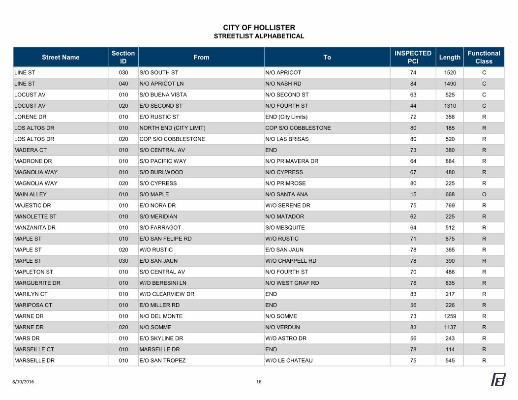
CITY OF HOLLISTERSTREETLIST ALPHABETICAL
Street Name Section ID From To INSPECTED
PCI Length Functional Class
LINE ST 030 S/O SOUTH ST N/O APRICOT 74 1520 C
LINE ST 040 N/O APRICOT LN N/O NASH RD 84 1490 C
LOCUST AV 010 S/O BUENA VISTA N/O SECOND ST 63 525 C
LOCUST AV 020 E/O SECOND ST N/O FOURTH ST 44 1310 C
LORENE DR 010 E/O RUSTIC ST END (City Limits) 72 358 R
LOS ALTOS DR 010 NORTH END (CITY LIMIT) COP S/O COBBLESTONE 80 185 R
LOS ALTOS DR 020 COP S/O COBBLESTONE N/O LAS BRISAS 80 520 R
MADERA CT 010 S/O CENTRAL AV END 73 380 R
MADRONE DR 010 S/O PACIFIC WAY N/O PRIMAVERA DR 64 884 R
MAGNOLIA WAY 010 S/O BURLWOOD N/O CYPRESS 67 480 R
MAGNOLIA WAY 020 S/O CYPRESS N/O PRIMROSE 80 225 R
MAIN ALLEY 010 S/O MAPLE N/O SANTA ANA 15 668 O
MAJESTIC DR 010 E/O NORA DR W/O SERENE DR 75 769 R
MANOLETTE ST 010 S/O MERIDIAN N/O MATADOR 62 225 R
MANZANITA DR 010 S/O FARRAGOT S/O MESQUITE 64 512 R
MAPLE ST 010 E/O SAN FELIPE RD W/O RUSTIC 71 875 R
MAPLE ST 020 W/O RUSTIC E/O SAN JAUN 78 365 R
MAPLE ST 030 E/O SAN JAUN W/O CHAPPELL RD 78 390 R
MAPLETON ST 010 S/O CENTRAL AV N/O FOURTH ST 70 486 R
MARGUERITE DR 010 W/O BERESINI LN N/O WEST GRAF RD 78 835 R
MARILYN CT 010 W/O CLEARVIEW DR END 83 217 R
MARIPOSA CT 010 E/O MILLER RD END 56 226 R
MARNE DR 010 N/O DEL MONTE N/O SOMME 73 1259 R
MARNE DR 020 N/O SOMME N/O VERDUN 83 1137 R
MARS DR 010 E/O SKYLINE DR W/O ASTRO DR 56 243 R
MARSEILLE CT 010 MARSEILLE DR END 78 114 R
MARSEILLE DR 010 E/O SAN TROPEZ W/O LE CHATEAU 75 545 R
8/10/2016 16
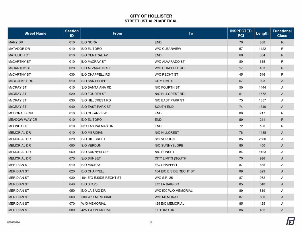
CITY OF HOLLISTERSTREETLIST ALPHABETICAL
Street Name Section ID From To INSPECTED
PCI Length Functional Class
MARY DR 010 E/O NORA END 76 838 R
MATADOR DR 010 E/O EL TORO W/O CLEARVIEW 57 1122 R
MATULICH CT 010 S/O CENTRAL AV END 60 334 R
McCARTHY ST 010 E/O McCRAY ST W/O ALVARADO ST 80 315 R
McCARTHY ST 020 E/O ALVARADO ST W/O CHAPPELL RD 17 433 R
McCARTHY ST 030 E/O CHAPPELL RD W/O RECHT ST 45 546 R
McCLOSKEY RD 010 E/O SAN FELIPE CITY LIMITS 67 993 A
McCRAY ST 010 S/O SANTA ANA RD N/O FOURTH ST 50 1444 A
McCRAY ST 020 S/O FOURTH ST N/O HILLCREST RD 61 1672 A
McCRAY ST 030 S/O HILLCREST RD N/O EAST PARK ST 75 1857 A
McCRAY ST 040 S/O EAST PARK ST SOUTH END 74 1349 A
MCDONALD CIR 010 E/O CLEARVIEW END 80 217 R
MEADOW WAY CR 010 E/O EL TORO END 59 241 R
MELINDA CT 010 N/O LAS PALMAS DR END 72 180 R
MEMORIAL DR 010 S/O MERIDIAN N/O HILLCREST 78 1488 A
MEMORIAL DR 020 S/O HILLCREST S/O VERDUN 85 2560 A
MEMORIAL DR 050 S/O VERDUN N/O SUNNYSLOPE 85 450 A
MEMORIAL DR 060 S/O SUNNYSLOPE N/O SUNSET 84 1423 A
MEMORIAL DR 070 S/O SUNSET CITY LIMITS (SOUTH) 75 996 A
MERIDIAN ST 010 E/O McCRAY E/O CHAPPELL 87 655 A
MERIDIAN ST 020 E/O CHAPPELL 104 E/O E.SIDE RECHT ST 89 829 A
MERIDIAN ST 030 104 E/O E.SIDE RECHT ST W/O S.R. 25 87 972 A
MERIDIAN ST 040 E/O S.R.25 E/O LA BAIG DR 85 540 A
MERIDIAN ST 050 E/O LA BAIG DR W/C 500 W/O MEMORIAL 89 819 A
MERIDIAN ST 060 500 W/O MEMORIAL W/O MEMORAIL 87 500 A
MERIDIAN ST 070 W/O MEMORIAL 425 E/O MEMORIAL 85 425 A
MERIDIAN ST 080 425' E/O MEMORAIL EL TORO DR 86 485 A
8/10/2016 17
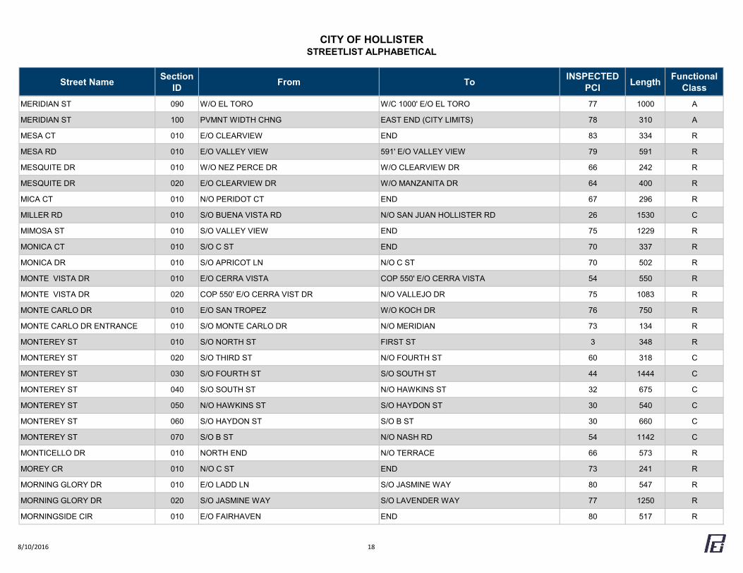
CITY OF HOLLISTERSTREETLIST ALPHABETICAL
Street Name Section ID From To INSPECTED
PCI Length Functional Class
MERIDIAN ST 090 W/O EL TORO W/C 1000' E/O EL TORO 77 1000 A
MERIDIAN ST 100 PVMNT WIDTH CHNG EAST END (CITY LIMITS) 78 310 A
MESA CT 010 E/O CLEARVIEW END 83 334 R
MESA RD 010 E/O VALLEY VIEW 591' E/O VALLEY VIEW 79 591 R
MESQUITE DR 010 W/O NEZ PERCE DR W/O CLEARVIEW DR 66 242 R
MESQUITE DR 020 E/O CLEARVIEW DR W/O MANZANITA DR 64 400 R
MICA CT 010 N/O PERIDOT CT END 67 296 R
MILLER RD 010 S/O BUENA VISTA RD N/O SAN JUAN HOLLISTER RD 26 1530 C
MIMOSA ST 010 S/O VALLEY VIEW END 75 1229 R
MONICA CT 010 S/O C ST END 70 337 R
MONICA DR 010 S/O APRICOT LN N/O C ST 70 502 R
MONTE VISTA DR 010 E/O CERRA VISTA COP 550' E/O CERRA VISTA 54 550 R
MONTE VISTA DR 020 COP 550' E/O CERRA VIST DR N/O VALLEJO DR 75 1083 R
MONTE CARLO DR 010 E/O SAN TROPEZ W/O KOCH DR 76 750 R
MONTE CARLO DR ENTRANCE 010 S/O MONTE CARLO DR N/O MERIDIAN 73 134 R
MONTEREY ST 010 S/O NORTH ST FIRST ST 3 348 R
MONTEREY ST 020 S/O THIRD ST N/O FOURTH ST 60 318 C
MONTEREY ST 030 S/O FOURTH ST S/O SOUTH ST 44 1444 C
MONTEREY ST 040 S/O SOUTH ST N/O HAWKINS ST 32 675 C
MONTEREY ST 050 N/O HAWKINS ST S/O HAYDON ST 30 540 C
MONTEREY ST 060 S/O HAYDON ST S/O B ST 30 660 C
MONTEREY ST 070 S/O B ST N/O NASH RD 54 1142 C
MONTICELLO DR 010 NORTH END N/O TERRACE 66 573 R
MOREY CR 010 N/O C ST END 73 241 R
MORNING GLORY DR 010 E/O LADD LN S/O JASMINE WAY 80 547 R
MORNING GLORY DR 020 S/O JASMINE WAY S/O LAVENDER WAY 77 1250 R
MORNINGSIDE CIR 010 E/O FAIRHAVEN END 80 517 R
8/10/2016 18
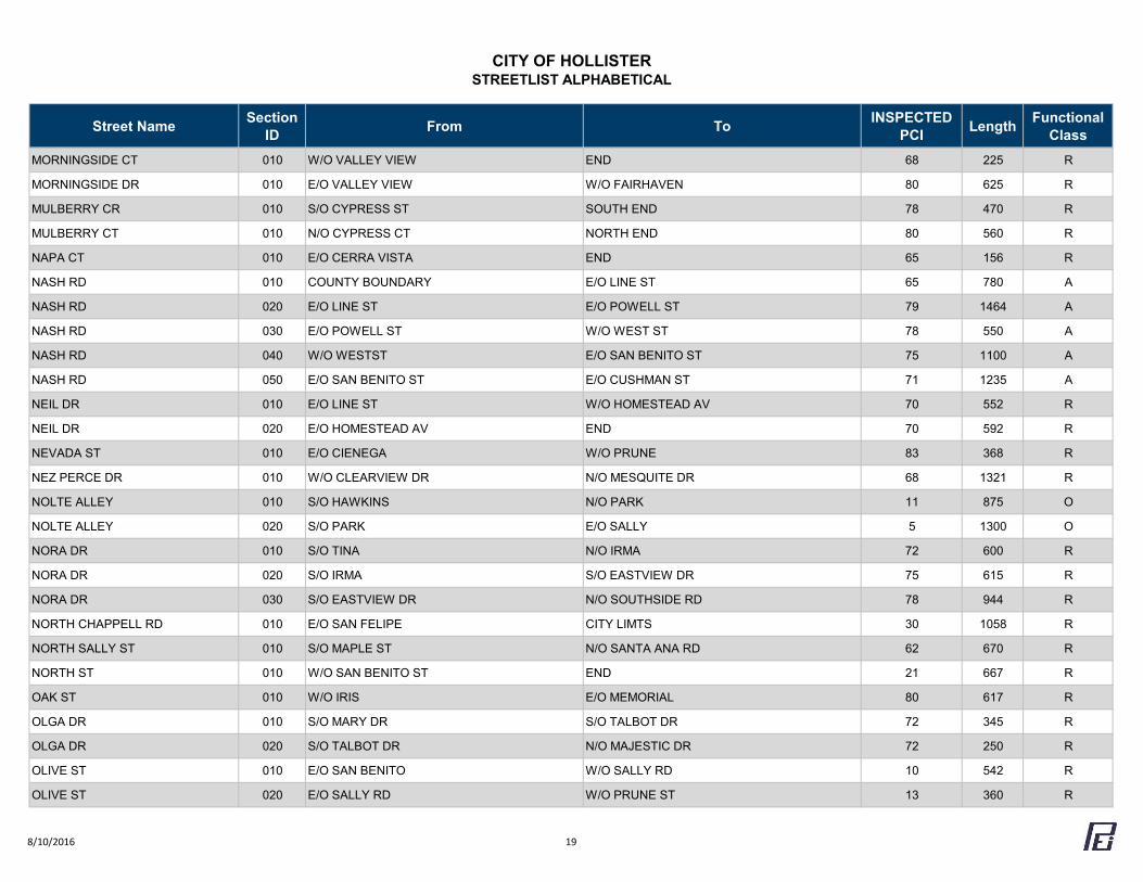
CITY OF HOLLISTERSTREETLIST ALPHABETICAL
Street Name Section ID From To INSPECTED
PCI Length Functional Class
MORNINGSIDE CT 010 W/O VALLEY VIEW END 68 225 R
MORNINGSIDE DR 010 E/O VALLEY VIEW W/O FAIRHAVEN 80 625 R
MULBERRY CR 010 S/O CYPRESS ST SOUTH END 78 470 R
MULBERRY CT 010 N/O CYPRESS CT NORTH END 80 560 R
NAPA CT 010 E/O CERRA VISTA END 65 156 R
NASH RD 010 COUNTY BOUNDARY E/O LINE ST 65 780 A
NASH RD 020 E/O LINE ST E/O POWELL ST 79 1464 A
NASH RD 030 E/O POWELL ST W/O WEST ST 78 550 A
NASH RD 040 W/O WESTST E/O SAN BENITO ST 75 1100 A
NASH RD 050 E/O SAN BENITO ST E/O CUSHMAN ST 71 1235 A
NEIL DR 010 E/O LINE ST W/O HOMESTEAD AV 70 552 R
NEIL DR 020 E/O HOMESTEAD AV END 70 592 R
NEVADA ST 010 E/O CIENEGA W/O PRUNE 83 368 R
NEZ PERCE DR 010 W/O CLEARVIEW DR N/O MESQUITE DR 68 1321 R
NOLTE ALLEY 010 S/O HAWKINS N/O PARK 11 875 O
NOLTE ALLEY 020 S/O PARK E/O SALLY 5 1300 O
NORA DR 010 S/O TINA N/O IRMA 72 600 R
NORA DR 020 S/O IRMA S/O EASTVIEW DR 75 615 R
NORA DR 030 S/O EASTVIEW DR N/O SOUTHSIDE RD 78 944 R
NORTH CHAPPELL RD 010 E/O SAN FELIPE CITY LIMTS 30 1058 R
NORTH SALLY ST 010 S/O MAPLE ST N/O SANTA ANA RD 62 670 R
NORTH ST 010 W/O SAN BENITO ST END 21 667 R
OAK ST 010 W/O IRIS E/O MEMORIAL 80 617 R
OLGA DR 010 S/O MARY DR S/O TALBOT DR 72 345 R
OLGA DR 020 S/O TALBOT DR N/O MAJESTIC DR 72 250 R
OLIVE ST 010 E/O SAN BENITO W/O SALLY RD 10 542 R
OLIVE ST 020 E/O SALLY RD W/O PRUNE ST 13 360 R
8/10/2016 19
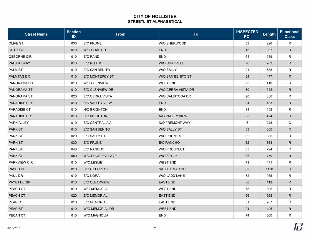
CITY OF HOLLISTERSTREETLIST ALPHABETICAL
Street Name Section ID From To INSPECTED
PCI Length Functional Class
OLIVE ST 030 E/O PRUNE W/O SHERWOOD 59 226 R
ORTIZ CT 010 W/O GRAF RD END 15 397 R
OSBORNE CIR 010 E/O RAND END 64 539 R
PACIFIC WAY 010 E/O RUSTIC W/O CHAPPELL 76 703 R
PALM ST 010 E/O SAN BENITO W/O SALLY 21 538 R
PALMTAG DR 010 E/O MONTEREY ST W/O SAN BENITO ST 84 477 R
PANORAMA DR 010 W/O GLENVIEW WEST END 80 410 R
PANORAMA ST 010 E/O GLENVIEW DR W/O CERRA VISTA DR 80 542 R
PANORAMA ST 020 E/O CERRA VISTA W/O CALISTOGA DR 90 856 R
PARADISE CIR 010 S/O VALLEY VIEW END 84 403 R
PARADISE CT 010 N/O BRIGHTON END 84 152 R
PARADISE DR 010 S/O BRIGHTON N/O VALLEY VIEW 80 424 R
PARK ALLEY 010 S/O CENTRAL AV N/O FREMONT WAY 6 248 O
PARK ST 010 E/O SAN BENITO W/O SALLY ST 83 550 R
PARK ST 020 E/O SALLY ST W/O PRUNE ST 82 335 R
PARK ST 030 E/O PRUNE E/O RANCHO 62 663 R
PARK ST 040 E/O RANCHO W/O PROSPECT 83 794 R
PARK ST 050 W/O PROSPECT AVE W/O S.R. 25 85 770 R
PARKVIEW CIR 010 W/O LESLIE WEST END 73 471 R
PASEO DR 010 S/O HILLCREST S/O DEL MAR DR 80 1120 R
PAUL DR 010 E/O NORA W/O LADD LANE 72 955 R
PAYETTE CIR 010 E/O CLEARVIEW EAST END 66 113 R
PEACH CT 010 W/O MEMORIAL WEST END 78 396 R
PEACH CT 020 E/O MEMORIAL EAST END 56 268 R
PEAR CT 010 E/O MEMORIAL EAST END 51 267 R
PEAR ST 010 W/O MEMORIAL DR WEST END 24 495 R
PECAN CT 010 W/O MAGNOLIA END 74 300 R
8/10/2016 20
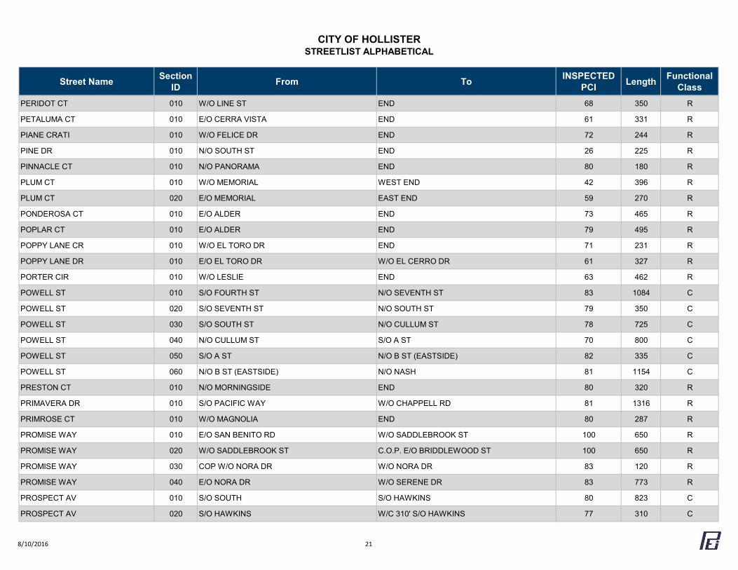
CITY OF HOLLISTERSTREETLIST ALPHABETICAL
Street Name Section ID From To INSPECTED
PCI Length Functional Class
PERIDOT CT 010 W/O LINE ST END 68 350 R
PETALUMA CT 010 E/O CERRA VISTA END 61 331 R
PIANE CRATI 010 W/O FELICE DR END 72 244 R
PINE DR 010 N/O SOUTH ST END 26 225 R
PINNACLE CT 010 N/O PANORAMA END 80 180 R
PLUM CT 010 W/O MEMORIAL WEST END 42 396 R
PLUM CT 020 E/O MEMORIAL EAST END 59 270 R
PONDEROSA CT 010 E/O ALDER END 73 465 R
POPLAR CT 010 E/O ALDER END 79 495 R
POPPY LANE CR 010 W/O EL TORO DR END 71 231 R
POPPY LANE DR 010 E/O EL TORO DR W/O EL CERRO DR 61 327 R
PORTER CIR 010 W/O LESLIE END 63 462 R
POWELL ST 010 S/O FOURTH ST N/O SEVENTH ST 83 1084 C
POWELL ST 020 S/O SEVENTH ST N/O SOUTH ST 79 350 C
POWELL ST 030 S/O SOUTH ST N/O CULLUM ST 78 725 C
POWELL ST 040 N/O CULLUM ST S/O A ST 70 800 C
POWELL ST 050 S/O A ST N/O B ST (EASTSIDE) 82 335 C
POWELL ST 060 N/O B ST (EASTSIDE) N/O NASH 81 1154 C
PRESTON CT 010 N/O MORNINGSIDE END 80 320 R
PRIMAVERA DR 010 S/O PACIFIC WAY W/O CHAPPELL RD 81 1316 R
PRIMROSE CT 010 W/O MAGNOLIA END 80 287 R
PROMISE WAY 010 E/O SAN BENITO RD W/O SADDLEBROOK ST 100 650 R
PROMISE WAY 020 W/O SADDLEBROOK ST C.O.P. E/O BRIDDLEWOOD ST 100 650 R
PROMISE WAY 030 COP W/O NORA DR W/O NORA DR 83 120 R
PROMISE WAY 040 E/O NORA DR W/O SERENE DR 83 773 R
PROSPECT AV 010 S/O SOUTH S/O HAWKINS 80 823 C
PROSPECT AV 020 S/O HAWKINS W/C 310' S/O HAWKINS 77 310 C
8/10/2016 21
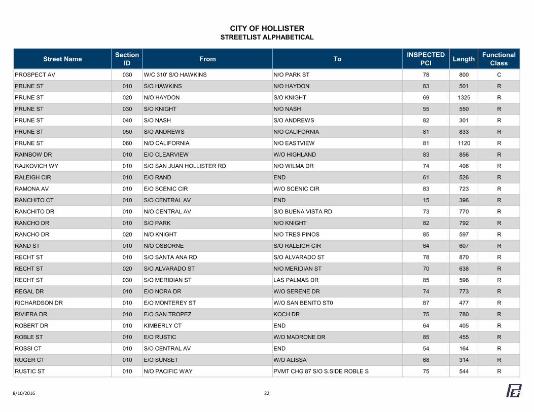
CITY OF HOLLISTERSTREETLIST ALPHABETICAL
Street Name Section ID From To INSPECTED
PCI Length Functional Class
PROSPECT AV 030 W/C 310' S/O HAWKINS N/O PARK ST 78 800 C
PRUNE ST 010 S/O HAWKINS N/O HAYDON 83 501 R
PRUNE ST 020 N/O HAYDON S/O KNIGHT 69 1325 R
PRUNE ST 030 S/O KNIGHT N/O NASH 55 550 R
PRUNE ST 040 S/O NASH S/O ANDREWS 82 301 R
PRUNE ST 050 S/O ANDREWS N/O CALIFORNIA 81 833 R
PRUNE ST 060 N/O CALIFORNIA N/O EASTVIEW 81 1120 R
RAINBOW DR 010 E/O CLEARVIEW W/O HIGHLAND 83 856 R
RAJKOVICH WY 010 S/O SAN JUAN HOLLISTER RD N/O WILMA DR 74 406 R
RALEIGH CIR 010 E/O RAND END 61 526 R
RAMONA AV 010 E/O SCENIC CIR W/O SCENIC CIR 83 723 R
RANCHITO CT 010 S/O CENTRAL AV END 15 396 R
RANCHITO DR 010 N/O CENTRAL AV S/O BUENA VISTA RD 73 770 R
RANCHO DR 010 S/O PARK N/O KNIGHT 82 792 R
RANCHO DR 020 N/O KNIGHT N/O TRES PINOS 85 597 R
RAND ST 010 N/O OSBORNE S/O RALEIGH CIR 64 607 R
RECHT ST 010 S/O SANTA ANA RD S/O ALVARADO ST 78 870 R
RECHT ST 020 S/O ALVARADO ST N/O MERIDIAN ST 70 638 R
RECHT ST 030 S/O MERIDIAN ST LAS PALMAS DR 85 598 R
REGAL DR 010 E/O NORA DR W/O SERENE DR 74 773 R
RICHARDSON DR 010 E/O MONTEREY ST W/O SAN BENITO ST0 87 477 R
RIVIERA DR 010 E/O SAN TROPEZ KOCH DR 75 780 R
ROBERT DR 010 KIMBERLY CT END 64 405 R
ROBLE ST 010 E/O RUSTIC W/O MADRONE DR 85 455 R
ROSSI CT 010 S/O CENTRAL AV END 54 164 R
RUGER CT 010 E/O SUNSET W/O ALISSA 68 314 R
RUSTIC ST 010 N/O PACIFIC WAY PVMT CHG 87 S/O S.SIDE ROBLE S 75 544 R
8/10/2016 22
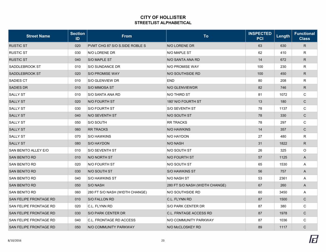
CITY OF HOLLISTERSTREETLIST ALPHABETICAL
Street Name Section ID From To INSPECTED
PCI Length Functional Class
RUSTIC ST 020 PVMT CHG 87 S/O S.SIDE ROBLE S N/O LORENE DR 63 630 R
RUSTIC ST 030 N/O LORENE DR N/O MAPLE ST 62 410 R
RUSTIC ST 040 S/O MAPLE ST N/O SANTA ANA RD 14 672 R
SADDLEBROOK ST 010 S/O SUNDANCE DR N/O PROMISE WAY 100 230 R
SADDLEBROOK ST 020 S/O PROMISE WAY N/O SOUTHSIDE RD 100 450 R
SADIES CT 010 S/O GLENVIEW DR END 80 208 R
SADIES DR 010 S/O MIMOSA ST N/O GLENVIEWDR 82 746 R
SALLY ST 010 S/O SANTA ANA RD N/O THIRD ST 81 1072 C
SALLY ST 020 N/O FOURTH ST 180' N/O FOURTH ST 13 180 C
SALLY ST 030 S/O FOURTH ST S/O SEVENTH ST 78 1137 C
SALLY ST 040 N/O SEVENTH ST N/O SOUTH ST 78 330 C
SALLY ST 050 S/O SOUTH RR TRACKS 78 297 C
SALLY ST 060 RR TRACKS N/O HAWKINS 14 357 C
SALLY ST 070 S/O HAWKINS N/O HAYDON 27 480 R
SALLY ST 080 S/O HAYDON N/O NASH 31 1822 R
SAN BENITO ALLEY E/O 010 S/O SEVENTH ST N/O SOUTH ST 26 325 O
SAN BENITO RD 010 N/O NORTH ST N/O FOURTH ST 57 1125 A
SAN BENITO RD 020 N/O FOURTH ST N/O SOUTH ST 65 1530 A
SAN BENITO RD 030 N/O SOUTH ST S/O HAWKINS ST 56 757 A
SAN BENITO RD 040 S/O HAWKINS ST N/O NASH ST 53 2361 A
SAN BENITO RD 050 S/O NASH 280 FT S/O NASH (WIDTH CHANGE) 67 260 A
SAN BENITO RD 060 280 FT S/O NASH (WIDTH CHANGE) N/O SOUTHSIDE RD 60 3450 A
SAN FELIPE FRONTAGE RD 010 S/O FALLON RD C.L. FLYNN RD 87 1500 C
SAN FELIPE FRONTAGE RD 020 C.L. FLYNN RD S/O PARK CENTER DR 87 380 C
SAN FELIPE FRONTAGE RD 030 S/O PARK CENTER DR C.L. FRNTAGE ACCESS RD 87 1978 C
SAN FELIPE FRONTAGE RD 040 C.L. FRONTAGE RD ACCESS N/O COMMUNITY PARKWAY 87 1036 C
SAN FELIPE FRONTAGE RD 050 N/O COMMUNITY PARKWAY N/O McCLOSKEY RD 89 1117 C
8/10/2016 23
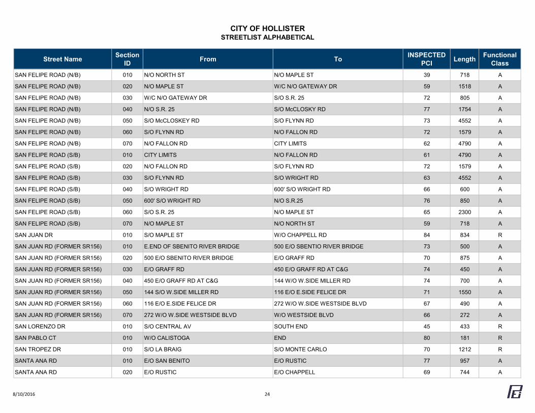
CITY OF HOLLISTERSTREETLIST ALPHABETICAL
Street Name Section ID From To INSPECTED
PCI Length Functional Class
SAN FELIPE ROAD (N/B) 010 N/O NORTH ST N/O MAPLE ST 39 718 A
SAN FELIPE ROAD (N/B) 020 N/O MAPLE ST W/C N/O GATEWAY DR 59 1518 A
SAN FELIPE ROAD (N/B) 030 W/C N/O GATEWAY DR S/O S.R. 25 72 805 A
SAN FELIPE ROAD (N/B) 040 N/O S.R. 25 S/O McCLOSKY RD 77 1754 A
SAN FELIPE ROAD (N/B) 050 S/O McCLOSKEY RD S/O FLYNN RD 73 4552 A
SAN FELIPE ROAD (N/B) 060 S/O FLYNN RD N/O FALLON RD 72 1579 A
SAN FELIPE ROAD (N/B) 070 N/O FALLON RD CITY LIMITS 62 4790 A
SAN FELIPE ROAD (S/B) 010 CITY LIMITS N/O FALLON RD 61 4790 A
SAN FELIPE ROAD (S/B) 020 N/O FALLON RD S/O FLYNN RD 72 1579 A
SAN FELIPE ROAD (S/B) 030 S/O FLYNN RD S/O WRIGHT RD 63 4552 A
SAN FELIPE ROAD (S/B) 040 S/O WRIGHT RD 600' S/O WRIGHT RD 66 600 A
SAN FELIPE ROAD (S/B) 050 600' S/O WRIGHT RD N/O S.R.25 76 850 A
SAN FELIPE ROAD (S/B) 060 S/O S.R. 25 N/O MAPLE ST 65 2300 A
SAN FELIPE ROAD (S/B) 070 N/O MAPLE ST N/O NORTH ST 59 718 A
SAN JUAN DR 010 S/O MAPLE ST W/O CHAPPELL RD 84 834 R
SAN JUAN RD (FORMER SR156) 010 E.END OF SBENITO RIVER BRIDGE 500 E/O SBENTIO RIVER BRIDGE 73 500 A
SAN JUAN RD (FORMER SR156) 020 500 E/O SBENITO RIVER BRIDGE E/O GRAFF RD 70 875 A
SAN JUAN RD (FORMER SR156) 030 E/O GRAFF RD 450 E/O GRAFF RD AT C&G 74 450 A
SAN JUAN RD (FORMER SR156) 040 450 E/O GRAFF RD AT C&G 144 W/O W.SIDE MILLER RD 74 700 A
SAN JUAN RD (FORMER SR156) 050 144 S/O W.SIDE MILLER RD 116 E/O E.SIDE FELICE DR 71 1550 A
SAN JUAN RD (FORMER SR156) 060 116 E/O E.SIDE FELICE DR 272 W/O W.SIDE WESTSIDE BLVD 67 490 A
SAN JUAN RD (FORMER SR156) 070 272 W/O W.SIDE WESTSIDE BLVD W/O WESTSIDE BLVD 66 272 A
SAN LORENZO DR 010 S/O CENTRAL AV SOUTH END 45 433 R
SAN PABLO CT 010 W/O CALISTOGA END 80 181 R
SAN TROPEZ DR 010 S/O LA BRAIG S/O MONTE CARLO 70 1212 R
SANTA ANA RD 010 E/O SAN BENITO E/O RUSTIC 77 957 A
SANTA ANA RD 020 E/O RUSTIC E/O CHAPPELL 69 744 A
8/10/2016 24
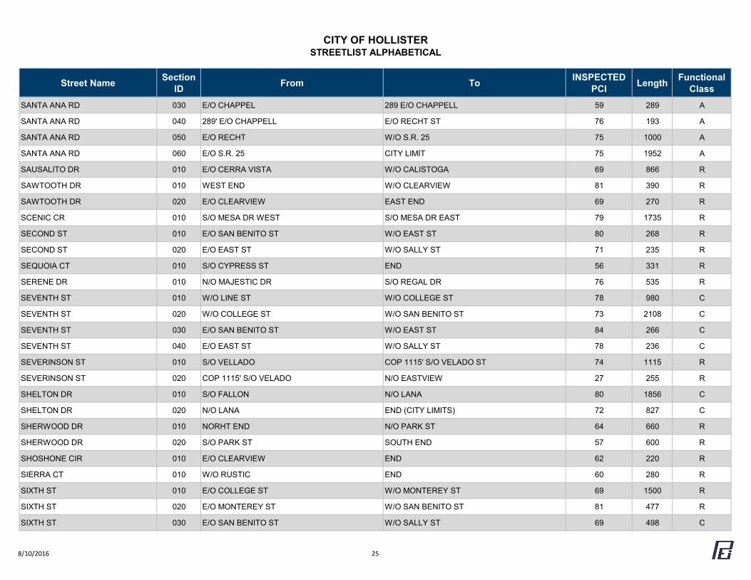
CITY OF HOLLISTERSTREETLIST ALPHABETICAL
Street Name Section ID From To INSPECTED
PCI Length Functional Class
SANTA ANA RD 030 E/O CHAPPEL 289 E/O CHAPPELL 59 289 A
SANTA ANA RD 040 289' E/O CHAPPELL E/O RECHT ST 76 193 A
SANTA ANA RD 050 E/O RECHT W/O S.R. 25 75 1000 A
SANTA ANA RD 060 E/O S.R. 25 CITY LIMIT 75 1952 A
SAUSALITO DR 010 E/O CERRA VISTA W/O CALISTOGA 69 866 R
SAWTOOTH DR 010 WEST END W/O CLEARVIEW 81 390 R
SAWTOOTH DR 020 E/O CLEARVIEW EAST END 69 270 R
SCENIC CR 010 S/O MESA DR WEST S/O MESA DR EAST 79 1735 R
SECOND ST 010 E/O SAN BENITO ST W/O EAST ST 80 268 R
SECOND ST 020 E/O EAST ST W/O SALLY ST 71 235 R
SEQUOIA CT 010 S/O CYPRESS ST END 56 331 R
SERENE DR 010 N/O MAJESTIC DR S/O REGAL DR 76 535 R
SEVENTH ST 010 W/O LINE ST W/O COLLEGE ST 78 980 C
SEVENTH ST 020 W/O COLLEGE ST W/O SAN BENITO ST 73 2108 C
SEVENTH ST 030 E/O SAN BENITO ST W/O EAST ST 84 266 C
SEVENTH ST 040 E/O EAST ST W/O SALLY ST 78 236 C
SEVERINSON ST 010 S/O VELLADO COP 1115' S/O VELADO ST 74 1115 R
SEVERINSON ST 020 COP 1115' S/O VELADO N/O EASTVIEW 27 255 R
SHELTON DR 010 S/O FALLON N/O LANA 80 1856 C
SHELTON DR 020 N/O LANA END (CITY LIMITS) 72 827 C
SHERWOOD DR 010 NORHT END N/O PARK ST 64 660 R
SHERWOOD DR 020 S/O PARK ST SOUTH END 57 600 R
SHOSHONE CIR 010 E/O CLEARVIEW END 62 220 R
SIERRA CT 010 W/O RUSTIC END 60 280 R
SIXTH ST 010 E/O COLLEGE ST W/O MONTEREY ST 69 1500 R
SIXTH ST 020 E/O MONTEREY ST W/O SAN BENITO ST 81 477 R
SIXTH ST 030 E/O SAN BENITO ST W/O SALLY ST 69 498 C
8/10/2016 25
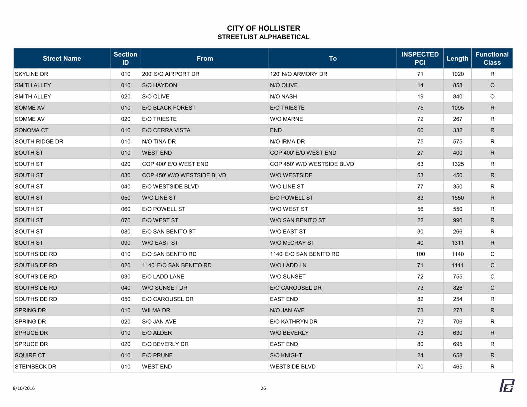
CITY OF HOLLISTERSTREETLIST ALPHABETICAL
Street Name Section ID From To INSPECTED
PCI Length Functional Class
SKYLINE DR 010 200' S/O AIRPORT DR 120' N/O ARMORY DR 71 1020 R
SMITH ALLEY 010 S/O HAYDON N/O OLIVE 14 858 O
SMITH ALLEY 020 S/O OLIVE N/O NASH 19 840 O
SOMME AV 010 E/O BLACK FOREST E/O TRIESTE 75 1095 R
SOMME AV 020 E/O TRIESTE W/O MARNE 72 267 R
SONOMA CT 010 E/O CERRA VISTA END 60 332 R
SOUTH RIDGE DR 010 N/O TINA DR N/O IRMA DR 75 575 R
SOUTH ST 010 WEST END COP 400' E/O WEST END 27 400 R
SOUTH ST 020 COP 400' E/O WEST END COP 450' W/O WESTSIDE BLVD 63 1325 R
SOUTH ST 030 COP 450' W/O WESTSIDE BLVD W/O WESTSIDE 53 450 R
SOUTH ST 040 E/O WESTSIDE BLVD W/O LINE ST 77 350 R
SOUTH ST 050 W/O LINE ST E/O POWELL ST 83 1550 R
SOUTH ST 060 E/O POWELL ST W/O WEST ST 56 550 R
SOUTH ST 070 E/O WEST ST W/O SAN BENITO ST 22 990 R
SOUTH ST 080 E/O SAN BENITO ST W/O EAST ST 30 266 R
SOUTH ST 090 W/O EAST ST W/O McCRAY ST 40 1311 R
SOUTHSIDE RD 010 E/O SAN BENITO RD 1140' E/O SAN BENITO RD 100 1140 C
SOUTHSIDE RD 020 1140' E/O SAN BENITO RD W/O LADD LN 71 1111 C
SOUTHSIDE RD 030 E/O LADD LANE W/O SUNSET 72 755 C
SOUTHSIDE RD 040 W/O SUNSET DR E/O CAROUSEL DR 73 826 C
SOUTHSIDE RD 050 E/O CAROUSEL DR EAST END 82 254 R
SPRING DR 010 WILMA DR N/O JAN AVE 73 273 R
SPRING DR 020 S/O JAN AVE E/O KATHRYN DR 73 706 R
SPRUCE DR 010 E/O ALDER W/O BEVERLY 73 630 R
SPRUCE DR 020 E/O BEVERLY DR EAST END 80 695 R
SQUIRE CT 010 E/O PRUNE S/O KNIGHT 24 658 R
STEINBECK DR 010 WEST END WESTSIDE BLVD 70 465 R
8/10/2016 26
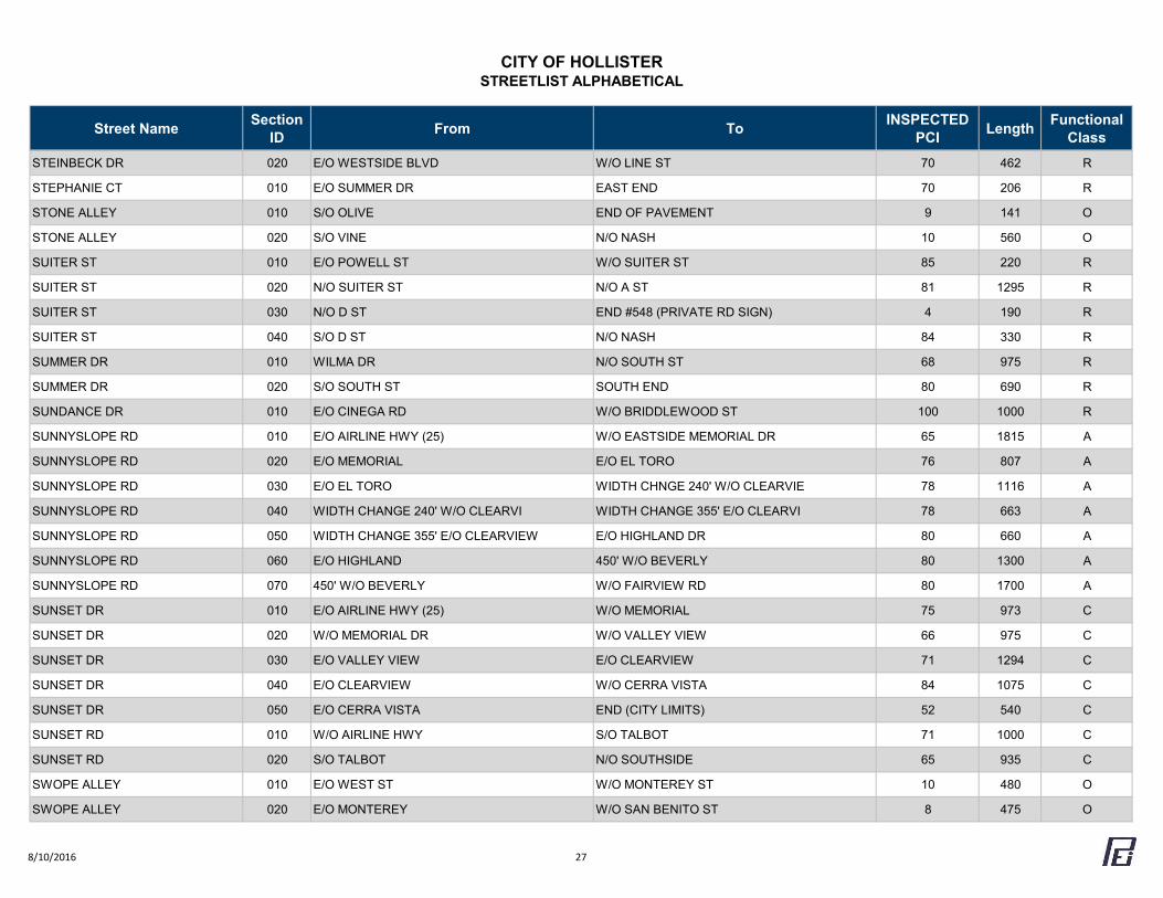
CITY OF HOLLISTERSTREETLIST ALPHABETICAL
Street Name Section ID From To INSPECTED
PCI Length Functional Class
STEINBECK DR 020 E/O WESTSIDE BLVD W/O LINE ST 70 462 R
STEPHANIE CT 010 E/O SUMMER DR EAST END 70 206 R
STONE ALLEY 010 S/O OLIVE END OF PAVEMENT 9 141 O
STONE ALLEY 020 S/O VINE N/O NASH 10 560 O
SUITER ST 010 E/O POWELL ST W/O SUITER ST 85 220 R
SUITER ST 020 N/O SUITER ST N/O A ST 81 1295 R
SUITER ST 030 N/O D ST END #548 (PRIVATE RD SIGN) 4 190 R
SUITER ST 040 S/O D ST N/O NASH 84 330 R
SUMMER DR 010 WILMA DR N/O SOUTH ST 68 975 R
SUMMER DR 020 S/O SOUTH ST SOUTH END 80 690 R
SUNDANCE DR 010 E/O CINEGA RD W/O BRIDDLEWOOD ST 100 1000 R
SUNNYSLOPE RD 010 E/O AIRLINE HWY (25) W/O EASTSIDE MEMORIAL DR 65 1815 A
SUNNYSLOPE RD 020 E/O MEMORIAL E/O EL TORO 76 807 A
SUNNYSLOPE RD 030 E/O EL TORO WIDTH CHNGE 240' W/O CLEARVIE 78 1116 A
SUNNYSLOPE RD 040 WIDTH CHANGE 240' W/O CLEARVI WIDTH CHANGE 355' E/O CLEARVI 78 663 A
SUNNYSLOPE RD 050 WIDTH CHANGE 355' E/O CLEARVIEW E/O HIGHLAND DR 80 660 A
SUNNYSLOPE RD 060 E/O HIGHLAND 450' W/O BEVERLY 80 1300 A
SUNNYSLOPE RD 070 450' W/O BEVERLY W/O FAIRVIEW RD 80 1700 A
SUNSET DR 010 E/O AIRLINE HWY (25) W/O MEMORIAL 75 973 C
SUNSET DR 020 W/O MEMORIAL DR W/O VALLEY VIEW 66 975 C
SUNSET DR 030 E/O VALLEY VIEW E/O CLEARVIEW 71 1294 C
SUNSET DR 040 E/O CLEARVIEW W/O CERRA VISTA 84 1075 C
SUNSET DR 050 E/O CERRA VISTA END (CITY LIMITS) 52 540 C
SUNSET RD 010 W/O AIRLINE HWY S/O TALBOT 71 1000 C
SUNSET RD 020 S/O TALBOT N/O SOUTHSIDE 65 935 C
SWOPE ALLEY 010 E/O WEST ST W/O MONTEREY ST 10 480 O
SWOPE ALLEY 020 E/O MONTEREY W/O SAN BENITO ST 8 475 O
8/10/2016 27
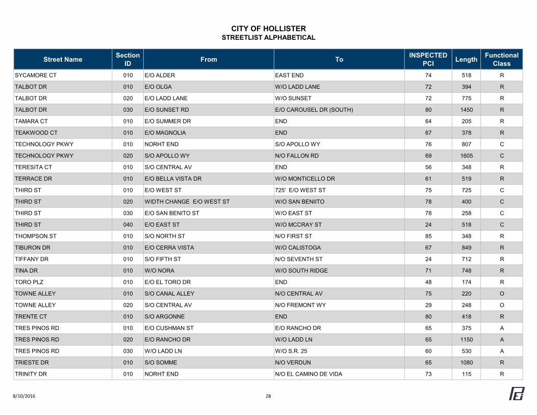
CITY OF HOLLISTERSTREETLIST ALPHABETICAL
Street Name Section ID From To INSPECTED
PCI Length Functional Class
SYCAMORE CT 010 E/O ALDER EAST END 74 518 R
TALBOT DR 010 E/O OLGA W/O LADD LANE 72 394 R
TALBOT DR 020 E/O LADD LANE W/O SUNSET 72 775 R
TALBOT DR 030 E/O SUNSET RD E/O CAROUSEL DR (SOUTH) 80 1450 R
TAMARA CT 010 E/O SUMMER DR END 64 205 R
TEAKWOOD CT 010 E/O MAGNOLIA END 67 378 R
TECHNOLOGY PKWY 010 NORHT END S/O APOLLO WY 76 807 C
TECHNOLOGY PKWY 020 S/O APOLLO WY N/O FALLON RD 69 1605 C
TERESITA CT 010 S/O CENTRAL AV END 56 348 R
TERRACE DR 010 E/O BELLA VISTA DR W/O MONTICELLO DR 61 519 R
THIRD ST 010 E/O WEST ST 725' E/O WEST ST 75 725 C
THIRD ST 020 WIDTH CHANGE E/O WEST ST W/O SAN BENIITO 78 400 C
THIRD ST 030 E/O SAN BENITO ST W/O EAST ST 78 258 C
THIRD ST 040 E/O EAST ST W/O MCCRAY ST 24 518 C
THOMPSON ST 010 S/O NORTH ST N/O FIRST ST 85 348 R
TIBURON DR 010 E/O CERRA VISTA W/O CALISTOGA 67 849 R
TIFFANY DR 010 S/O FIFTH ST N/O SEVENTH ST 24 712 R
TINA DR 010 W/O NORA W/O SOUTH RIDGE 71 748 R
TORO PLZ 010 E/O EL TORO DR END 48 174 R
TOWNE ALLEY 010 S/O CANAL ALLEY N/O CENTRAL AV 75 220 O
TOWNE ALLEY 020 S/O CENTRAL AV N/O FREMONT WY 29 248 O
TRENTE CT 010 S/O ARGONNE END 80 418 R
TRES PINOS RD 010 E/O CUSHMAN ST E/O RANCHO DR 65 375 A
TRES PINOS RD 020 E/O RANCHO DR W/O LADD LN 65 1150 A
TRES PINOS RD 030 W/O LADD LN W/O S.R. 25 60 530 A
TRIESTE DR 010 S/O SOMME N/O VERDUN 65 1080 R
TRINITY DR 010 NORHT END N/O EL CAMINO DE VIDA 73 115 R
8/10/2016 28
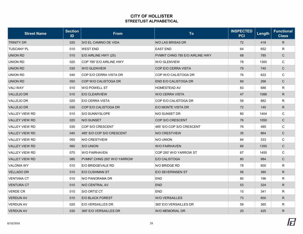
CITY OF HOLLISTERSTREETLIST ALPHABETICAL
Street Name Section ID From To INSPECTED
PCI Length Functional Class
TRINITY DR 020 S/O EL CAMINO DE VIDA N/O LAS BRISAS DR 72 418 R
TUSCANY PL 010 WEST END EAST END 64 652 R
UNION RD 010 E/O AIRLINE HWY (25) PVMNT CHNG 785 E/O AIRLINE HWY 68 785 C
UNION RD 020 COP 785' E/O AIRLINE HWY W/O GLENVIEW 78 1300 C
UNION RD 030 W/O GLENVIEW COP E/O CERRA VISTA 79 740 C
UNION RD 040 COP E/O CERRA VISTA DR COP W/O CALISTOGA DR 76 622 C
UNION RD 050 COP W/O CALISTOGA DR END E/O CALISTOGA DR 69 266 C
VALI WAY 010 W/O POWELL ST HOMESTEAD AV 83 686 R
VALLEJO DR 010 E/O CLEARVIEW W/O CERRA VISTA 47 1086 R
VALLEJO DR 020 E/O CERRA VISTA COP E/O CALISTOGA DR 59 882 R
VALLEJO DR 030 COP E/O CALISTOGA DR E/O MONTE VISTA DR 72 140 R
VALLEY VIEW RD 010 S/O SUNNYSLOPE N/O SUNSET DR 80 1404 C
VALLEY VIEW RD 020 N/O SUNSET COP S/O CRESCENT 76 1050 C
VALLEY VIEW RD 030 COP S/O CRESCENT 485' S/O COP S/O CRESCENT 76 485 C
VALLEY VIEW RD 040 485' S/O COP S/O CRESCENT N/O CRESTVIEW 35 864 C
VALLEY VIEW RD 050 N/O CRESTVIEW N/O UNION 84 333 C
VALLEY VIEW RD 060 S/O UNION W/O FAIRHAVEN 66 1350 C
VALLEY VIEW RD 070 W/O FAIRHAVEN COP 293' W/O YARROW ST 67 1450 C
VALLEY VIEW RD 080 PVMNT CHNG 293' W/O YARROW E/O CALISTOGA 80 984 C
VALONIA WY 010 E/O BRIDGEVALE RD N/O BRIDGE RD 78 600 R
VELLADO DR 010 E/O CUSHMAN ST E/O SEVERINSEN ST 56 380 R
VENTANA CT 010 N/O PANORAMA DR END 80 196 R
VENTURA CT 010 N/O CENTRAL AV END 53 324 R
VERDE CR 010 S/O ORTIZ CT END 15 341 R
VERDUN AV 010 E/O BLACK FOREST W/O VERSAILLES 73 600 R
VERDUN AV 020 E/O VERSAILLES DR 365' E/O VERSAILLES DR 59 365 R
VERDUN AV 030 365' E/O VERSAILLES DR W/O MEMORIAL DR 20 425 R
8/10/2016 29
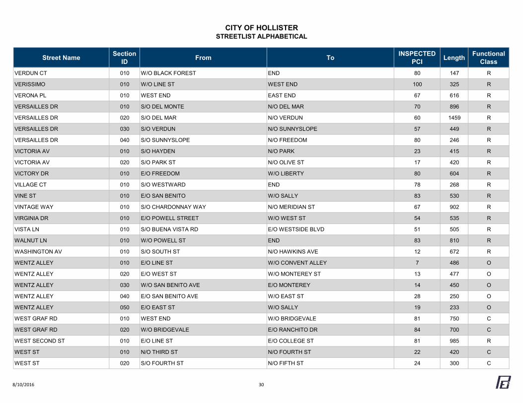
CITY OF HOLLISTERSTREETLIST ALPHABETICAL
Street Name Section ID From To INSPECTED
PCI Length Functional Class
VERDUN CT 010 W/O BLACK FOREST END 80 147 R
VERISSIMO 010 W/O LINE ST WEST END 100 325 R
VERONA PL 010 WEST END EAST END 67 616 R
VERSAILLES DR 010 S/O DEL MONTE N/O DEL MAR 70 896 R
VERSAILLES DR 020 S/O DEL MAR N/O VERDUN 60 1459 R
VERSAILLES DR 030 S/O VERDUN N/O SUNNYSLOPE 57 449 R
VERSAILLES DR 040 S/O SUNNYSLOPE N/O FREEDOM 80 246 R
VICTORIA AV 010 S/O HAYDEN N/O PARK 23 415 R
VICTORIA AV 020 S/O PARK ST N/O OLIVE ST 17 420 R
VICTORY DR 010 E/O FREEDOM W/O LIBERTY 80 604 R
VILLAGE CT 010 S/O WESTWARD END 78 268 R
VINE ST 010 E/O SAN BENITO W/O SALLY 83 530 R
VINTAGE WAY 010 S/O CHARDONNAY WAY N/O MERIDIAN ST 67 902 R
VIRGINIA DR 010 E/O POWELL STREET W/O WEST ST 54 535 R
VISTA LN 010 S/O BUENA VISTA RD E/O WESTSIDE BLVD 51 505 R
WALNUT LN 010 W/O POWELL ST END 83 810 R
WASHINGTON AV 010 S/O SOUTH ST N/O HAWKINS AVE 12 672 R
WENTZ ALLEY 010 E/O LINE ST W/O CONVENT ALLEY 7 486 O
WENTZ ALLEY 020 E/O WEST ST W/O MONTEREY ST 13 477 O
WENTZ ALLEY 030 W/O SAN BENITO AVE E/O MONTEREY 14 450 O
WENTZ ALLEY 040 E/O SAN BENITO AVE W/O EAST ST 28 250 O
WENTZ ALLEY 050 E/O EAST ST W/O SALLY 19 233 O
WEST GRAF RD 010 WEST END W/O BRIDGEVALE 81 750 C
WEST GRAF RD 020 W/O BRIDGEVALE E/O RANCHITO DR 84 700 C
WEST SECOND ST 010 E/O LINE ST E/O COLLEGE ST 81 985 R
WEST ST 010 N/O THIRD ST N/O FOURTH ST 22 420 C
WEST ST 020 S/O FOURTH ST N/O FIFTH ST 24 300 C
8/10/2016 30
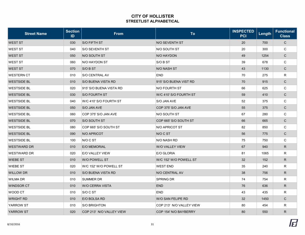
CITY OF HOLLISTERSTREETLIST ALPHABETICAL
Street Name Section ID From To INSPECTED
PCI Length Functional Class
WEST ST 030 S/O FIFTH ST N/O SEVENTH ST 20 700 C
WEST ST 040 S/O SEVENTH ST N/O SOUTH ST 20 300 C
WEST ST 050 N/O SOUTH ST N/O HAYDON 49 1254 C
WEST ST 060 N/O HAYDON ST S/O B ST 39 678 C
WEST ST 070 S/O B ST N/O NASH ST 43 1130 C
WESTERN CT 010 S/O CENTRAL AV END 70 275 R
WESTSIDE BL 010 S/O BUENA VISTA RD 915' S/O BUENA VIST RD 70 915 C
WESTSIDE BL 020 915' S/O BUENA VISTA RD N/O FOURTH ST 66 625 C
WESTSIDE BL 030 S/O FOURTH ST W/C 410' S/O FOURTH ST 59 410 C
WESTSIDE BL 040 W/C 410' S/O FOURTH ST S/O JAN AVE 52 375 C
WESTSIDE BL 050 S/O JAN AVE COP 375' S/O JAN AVE 55 375 C
WESTSIDE BL 060 COP 375' S/O JAN AVE N/O SOUTH ST 67 280 C
WESTSIDE BL 070 S/O SOUTH ST COP 665' S/O SOUTH ST 66 665 C
WESTSIDE BL 080 COP 665' S/O SOUTH ST N/O APRICOT ST 82 850 C
WESTSIDE BL 090 N/O APRICOT N/O C ST 56 775 C
WESTSIDE BL 100 N/O C ST N/O NASH RD 75 750 C
WESTWARD DR 010 E/O MEMORIAL W/O VALLEY VIEW 67 940 R
WESTWARD DR 020 E/O VALLEY VIEW E/O GLORIA 81 1065 R
WIEBE ST 010 W/O POWELL ST W/C 152' W/O POWELL ST 32 152 R
WIEBE ST 020 W/C 152' W/O POWELL ST WEST END 35 240 R
WILLOW DR 010 S/O BUENA VISTA RD N/O CENTRAL AV 38 756 R
WILMA DR 010 SUMMER DR SPRING DR 74 754 R
WINDSOR CT 010 W/O CERRA VISTA END 76 636 R
WOOD CT 010 S/O C ST END 43 435 R
WRIGHT RD 010 E/O BOLSA RD W/O SAN FELIPE RD 32 1450 C
YARROW ST 010 S/O BRIGHTON COP 213' N/O VALLEY VIEW 80 454 R
YARROW ST 020 COP 213' N/O VALLEY VIEW COP 154' N/O BAYBERRY 80 550 R
8/10/2016 31

CITY OF HOLLISTERSTREETLIST ALPHABETICAL
Street Name Section ID From To INSPECTED
PCI Length Functional Class
YARROW ST 030 COP 54' N/O BAYBERRY N/O MIMOSA 80 420 R
YARROW ST 040 S/O MIMOSA N/O GLENVIEW 80 228 R
YOUNG ALLEY 010 S/O WENTZ ALLEY N/O SEVENTH ST 5 530 O
8/10/2016 32
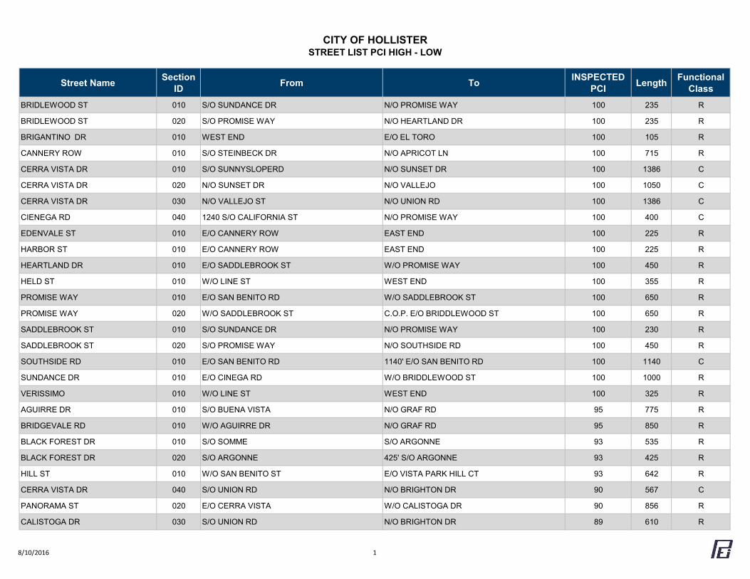
CITY OF HOLLISTERSTREET LIST PCI HIGH - LOW
Street Name Section ID From To INSPECTED
PCI Length Functional Class
BRIDLEWOOD ST 010 S/O SUNDANCE DR N/O PROMISE WAY 100 235 R
BRIDLEWOOD ST 020 S/O PROMISE WAY N/O HEARTLAND DR 100 235 R
BRIGANTINO DR 010 WEST END E/O EL TORO 100 105 R
CANNERY ROW 010 S/O STEINBECK DR N/O APRICOT LN 100 715 R
CERRA VISTA DR 010 S/O SUNNYSLOPERD N/O SUNSET DR 100 1386 C
CERRA VISTA DR 020 N/O SUNSET DR N/O VALLEJO 100 1050 C
CERRA VISTA DR 030 N/O VALLEJO ST N/O UNION RD 100 1386 C
CIENEGA RD 040 1240 S/O CALIFORNIA ST N/O PROMISE WAY 100 400 C
EDENVALE ST 010 E/O CANNERY ROW EAST END 100 225 R
HARBOR ST 010 E/O CANNERY ROW EAST END 100 225 R
HEARTLAND DR 010 E/O SADDLEBROOK ST W/O PROMISE WAY 100 450 R
HELD ST 010 W/O LINE ST WEST END 100 355 R
PROMISE WAY 010 E/O SAN BENITO RD W/O SADDLEBROOK ST 100 650 R
PROMISE WAY 020 W/O SADDLEBROOK ST C.O.P. E/O BRIDDLEWOOD ST 100 650 R
SADDLEBROOK ST 010 S/O SUNDANCE DR N/O PROMISE WAY 100 230 R
SADDLEBROOK ST 020 S/O PROMISE WAY N/O SOUTHSIDE RD 100 450 R
SOUTHSIDE RD 010 E/O SAN BENITO RD 1140' E/O SAN BENITO RD 100 1140 C
SUNDANCE DR 010 E/O CINEGA RD W/O BRIDDLEWOOD ST 100 1000 R
VERISSIMO 010 W/O LINE ST WEST END 100 325 R
AGUIRRE DR 010 S/O BUENA VISTA N/O GRAF RD 95 775 R
BRIDGEVALE RD 010 W/O AGUIRRE DR N/O GRAF RD 95 850 R
BLACK FOREST DR 010 S/O SOMME S/O ARGONNE 93 535 R
BLACK FOREST DR 020 S/O ARGONNE 425' S/O ARGONNE 93 425 R
HILL ST 010 W/O SAN BENITO ST E/O VISTA PARK HILL CT 93 642 R
CERRA VISTA DR 040 S/O UNION RD N/O BRIGHTON DR 90 567 C
PANORAMA ST 020 E/O CERRA VISTA W/O CALISTOGA DR 90 856 R
CALISTOGA DR 030 S/O UNION RD N/O BRIGHTON DR 89 610 R
8/10/2016 1
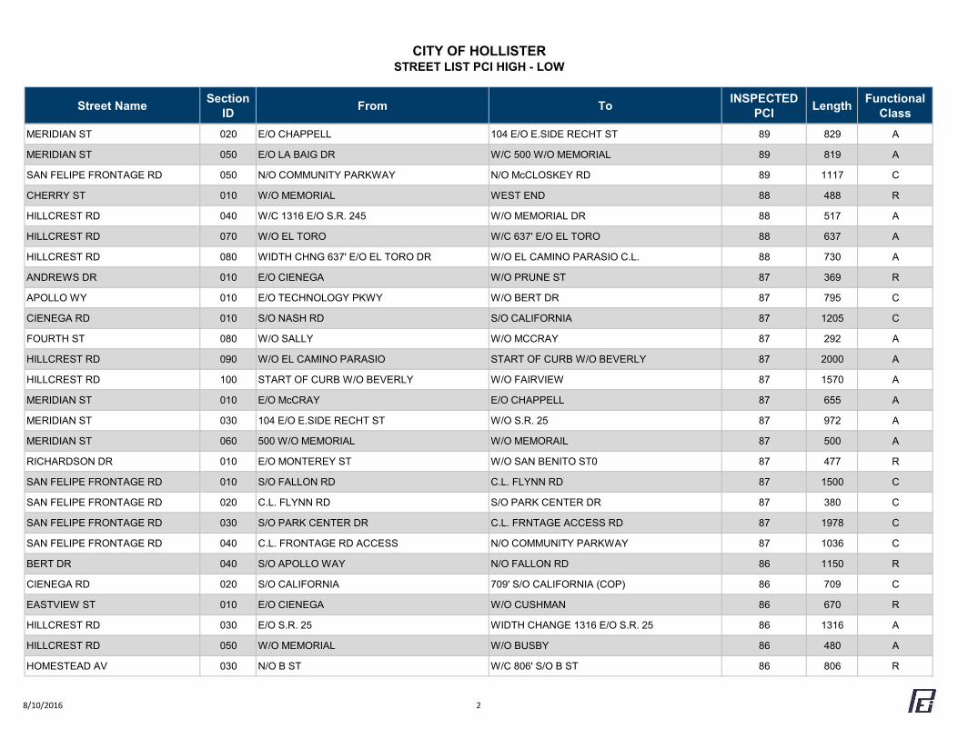
CITY OF HOLLISTERSTREET LIST PCI HIGH - LOW
Street Name Section ID From To INSPECTED
PCI Length Functional Class
MERIDIAN ST 020 E/O CHAPPELL 104 E/O E.SIDE RECHT ST 89 829 A
MERIDIAN ST 050 E/O LA BAIG DR W/C 500 W/O MEMORIAL 89 819 A
SAN FELIPE FRONTAGE RD 050 N/O COMMUNITY PARKWAY N/O McCLOSKEY RD 89 1117 C
CHERRY ST 010 W/O MEMORIAL WEST END 88 488 R
HILLCREST RD 040 W/C 1316 E/O S.R. 245 W/O MEMORIAL DR 88 517 A
HILLCREST RD 070 W/O EL TORO W/C 637' E/O EL TORO 88 637 A
HILLCREST RD 080 WIDTH CHNG 637' E/O EL TORO DR W/O EL CAMINO PARASIO C.L. 88 730 A
ANDREWS DR 010 E/O CIENEGA W/O PRUNE ST 87 369 R
APOLLO WY 010 E/O TECHNOLOGY PKWY W/O BERT DR 87 795 C
CIENEGA RD 010 S/O NASH RD S/O CALIFORNIA 87 1205 C
FOURTH ST 080 W/O SALLY W/O MCCRAY 87 292 A
HILLCREST RD 090 W/O EL CAMINO PARASIO START OF CURB W/O BEVERLY 87 2000 A
HILLCREST RD 100 START OF CURB W/O BEVERLY W/O FAIRVIEW 87 1570 A
MERIDIAN ST 010 E/O McCRAY E/O CHAPPELL 87 655 A
MERIDIAN ST 030 104 E/O E.SIDE RECHT ST W/O S.R. 25 87 972 A
MERIDIAN ST 060 500 W/O MEMORIAL W/O MEMORAIL 87 500 A
RICHARDSON DR 010 E/O MONTEREY ST W/O SAN BENITO ST0 87 477 R
SAN FELIPE FRONTAGE RD 010 S/O FALLON RD C.L. FLYNN RD 87 1500 C
SAN FELIPE FRONTAGE RD 020 C.L. FLYNN RD S/O PARK CENTER DR 87 380 C
SAN FELIPE FRONTAGE RD 030 S/O PARK CENTER DR C.L. FRNTAGE ACCESS RD 87 1978 C
SAN FELIPE FRONTAGE RD 040 C.L. FRONTAGE RD ACCESS N/O COMMUNITY PARKWAY 87 1036 C
BERT DR 040 S/O APOLLO WAY N/O FALLON RD 86 1150 R
CIENEGA RD 020 S/O CALIFORNIA 709' S/O CALIFORNIA (COP) 86 709 C
EASTVIEW ST 010 E/O CIENEGA W/O CUSHMAN 86 670 R
HILLCREST RD 030 E/O S.R. 25 WIDTH CHANGE 1316 E/O S.R. 25 86 1316 A
HILLCREST RD 050 W/O MEMORIAL W/O BUSBY 86 480 A
HOMESTEAD AV 030 N/O B ST W/C 806' S/O B ST 86 806 R
8/10/2016 2
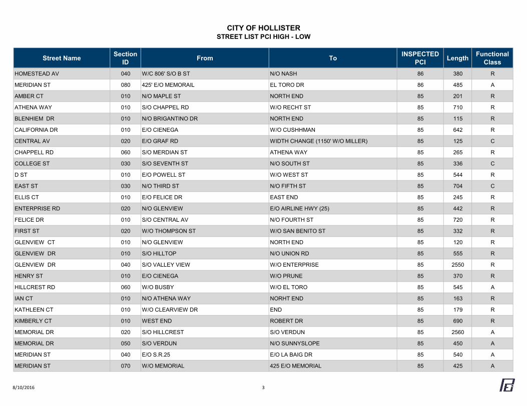
CITY OF HOLLISTERSTREET LIST PCI HIGH - LOW
Street Name Section ID From To INSPECTED
PCI Length Functional Class
HOMESTEAD AV 040 W/C 806' S/O B ST N/O NASH 86 380 R
MERIDIAN ST 080 425' E/O MEMORAIL EL TORO DR 86 485 A
AMBER CT 010 N/O MAPLE ST NORTH END 85 201 R
ATHENA WAY 010 S/O CHAPPEL RD W/O RECHT ST 85 710 R
BLENHIEM DR 010 N/O BRIGANTINO DR NORTH END 85 115 R
CALIFORNIA DR 010 E/O CIENEGA W/O CUSHHMAN 85 642 R
CENTRAL AV 020 E/O GRAF RD WIDTH CHANGE (1150' W/O MILLER) 85 125 C
CHAPPELL RD 060 S/O MERDIAN ST ATHENA WAY 85 265 R
COLLEGE ST 030 S/O SEVENTH ST N/O SOUTH ST 85 336 C
D ST 010 E/O POWELL ST W/O WEST ST 85 544 R
EAST ST 030 N/O THIRD ST N/O FIFTH ST 85 704 C
ELLIS CT 010 E/O FELICE DR EAST END 85 245 R
ENTERPRISE RD 020 N/O GLENVIEW E/O AIRLINE HWY (25) 85 442 R
FELICE DR 010 S/O CENTRAL AV N/O FOURTH ST 85 720 R
FIRST ST 020 W/O THOMPSON ST W/O SAN BENITO ST 85 332 R
GLENVIEW CT 010 N/O GLENVIEW NORTH END 85 120 R
GLENVIEW DR 010 S/O HILLTOP N/O UNION RD 85 555 R
GLENVIEW DR 040 S/O VALLEY VIEW W/O ENTERPRISE 85 2550 R
HENRY ST 010 E/O CIENEGA W/O PRUNE 85 370 R
HILLCREST RD 060 W/O BUSBY W/O EL TORO 85 545 A
IAN CT 010 N/O ATHENA WAY NORHT END 85 163 R
KATHLEEN CT 010 W/O CLEARVIEW DR END 85 179 R
KIMBERLY CT 010 WEST END ROBERT DR 85 690 R
MEMORIAL DR 020 S/O HILLCREST S/O VERDUN 85 2560 A
MEMORIAL DR 050 S/O VERDUN N/O SUNNYSLOPE 85 450 A
MERIDIAN ST 040 E/O S.R.25 E/O LA BAIG DR 85 540 A
MERIDIAN ST 070 W/O MEMORIAL 425 E/O MEMORIAL 85 425 A
8/10/2016 3
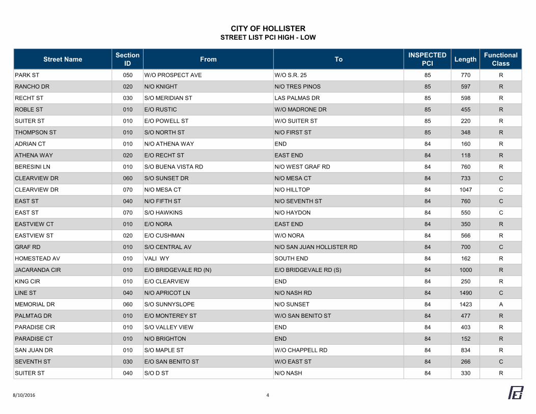
CITY OF HOLLISTERSTREET LIST PCI HIGH - LOW
Street Name Section ID From To INSPECTED
PCI Length Functional Class
PARK ST 050 W/O PROSPECT AVE W/O S.R. 25 85 770 R
RANCHO DR 020 N/O KNIGHT N/O TRES PINOS 85 597 R
RECHT ST 030 S/O MERIDIAN ST LAS PALMAS DR 85 598 R
ROBLE ST 010 E/O RUSTIC W/O MADRONE DR 85 455 R
SUITER ST 010 E/O POWELL ST W/O SUITER ST 85 220 R
THOMPSON ST 010 S/O NORTH ST N/O FIRST ST 85 348 R
ADRIAN CT 010 N/O ATHENA WAY END 84 160 R
ATHENA WAY 020 E/O RECHT ST EAST END 84 118 R
BERESINI LN 010 S/O BUENA VISTA RD N/O WEST GRAF RD 84 760 R
CLEARVIEW DR 060 S/O SUNSET DR N/O MESA CT 84 733 C
CLEARVIEW DR 070 N/O MESA CT N/O HILLTOP 84 1047 C
EAST ST 040 N/O FIFTH ST N/O SEVENTH ST 84 760 C
EAST ST 070 S/O HAWKINS N/O HAYDON 84 550 C
EASTVIEW CT 010 E/O NORA EAST END 84 350 R
EASTVIEW ST 020 E/O CUSHMAN W/O NORA 84 566 R
GRAF RD 010 S/O CENTRAL AV N/O SAN JUAN HOLLISTER RD 84 700 C
HOMESTEAD AV 010 VALI WY SOUTH END 84 162 R
JACARANDA CIR 010 E/O BRIDGEVALE RD (N) E/O BRIDGEVALE RD (S) 84 1000 R
KING CIR 010 E/O CLEARVIEW END 84 250 R
LINE ST 040 N/O APRICOT LN N/O NASH RD 84 1490 C
MEMORIAL DR 060 S/O SUNNYSLOPE N/O SUNSET 84 1423 A
PALMTAG DR 010 E/O MONTEREY ST W/O SAN BENITO ST 84 477 R
PARADISE CIR 010 S/O VALLEY VIEW END 84 403 R
PARADISE CT 010 N/O BRIGHTON END 84 152 R
SAN JUAN DR 010 S/O MAPLE ST W/O CHAPPELL RD 84 834 R
SEVENTH ST 030 E/O SAN BENITO ST W/O EAST ST 84 266 C
SUITER ST 040 S/O D ST N/O NASH 84 330 R
8/10/2016 4
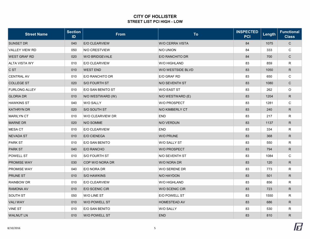
CITY OF HOLLISTERSTREET LIST PCI HIGH - LOW
Street Name Section ID From To INSPECTED
PCI Length Functional Class
SUNSET DR 040 E/O CLEARVIEW W/O CERRA VISTA 84 1075 C
VALLEY VIEW RD 050 N/O CRESTVIEW N/O UNION 84 333 C
WEST GRAF RD 020 W/O BRIDGEVALE E/O RANCHITO DR 84 700 C
ALTA VISTA WY 010 E/O CLEARVIEW W/O HIGHLAND 83 859 R
C ST 010 WEST END W/O WESTSIDE BLVD 83 1050 R
CENTRAL AV 010 E/O RANCHITO DR E/O GRAF RD 83 650 C
COLLEGE ST 020 S/O FOURTH ST N/O SEVENTH ST 83 1080 C
FURLONG ALLEY 010 E/O SAN BENITO ST W/O EAST ST 83 262 O
GLORIA DR 010 N/O WESTWARD (W) N/O WESTWARD (E) 83 1204 R
HAWKINS ST 040 W/O SALLY W/O PROSPECT 83 1281 C
KATHRYN DR 020 S/O SOUTH ST N/O KIMBERLY CT 83 240 R
MARILYN CT 010 W/O CLEARVIEW DR END 83 217 R
MARNE DR 020 N/O SOMME N/O VERDUN 83 1137 R
MESA CT 010 E/O CLEARVIEW END 83 334 R
NEVADA ST 010 E/O CIENEGA W/O PRUNE 83 368 R
PARK ST 010 E/O SAN BENITO W/O SALLY ST 83 550 R
PARK ST 040 E/O RANCHO W/O PROSPECT 83 794 R
POWELL ST 010 S/O FOURTH ST N/O SEVENTH ST 83 1084 C
PROMISE WAY 030 COP W/O NORA DR W/O NORA DR 83 120 R
PROMISE WAY 040 E/O NORA DR W/O SERENE DR 83 773 R
PRUNE ST 010 S/O HAWKINS N/O HAYDON 83 501 R
RAINBOW DR 010 E/O CLEARVIEW W/O HIGHLAND 83 856 R
RAMONA AV 010 E/O SCENIC CIR W/O SCENIC CIR 83 723 R
SOUTH ST 050 W/O LINE ST E/O POWELL ST 83 1550 R
VALI WAY 010 W/O POWELL ST HOMESTEAD AV 83 686 R
VINE ST 010 E/O SAN BENITO W/O SALLY 83 530 R
WALNUT LN 010 W/O POWELL ST END 83 810 R
8/10/2016 5
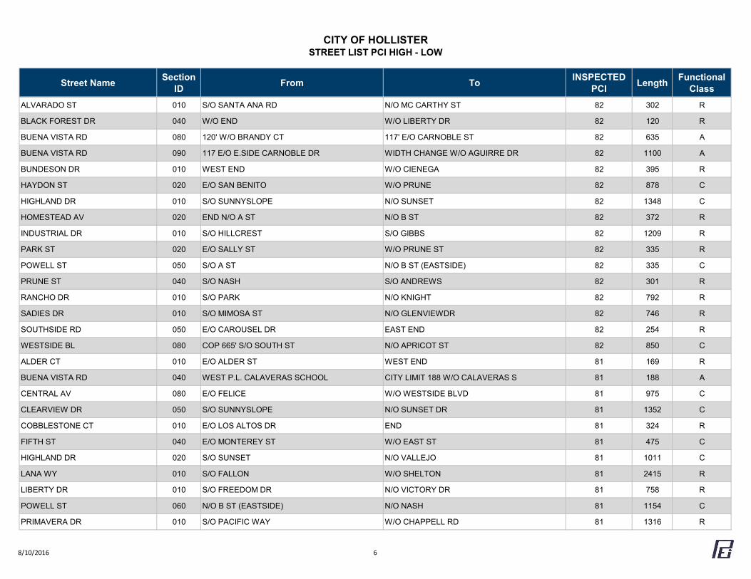
CITY OF HOLLISTERSTREET LIST PCI HIGH - LOW
Street Name Section ID From To INSPECTED
PCI Length Functional Class
ALVARADO ST 010 S/O SANTA ANA RD N/O MC CARTHY ST 82 302 R
BLACK FOREST DR 040 W/O END W/O LIBERTY DR 82 120 R
BUENA VISTA RD 080 120' W/O BRANDY CT 117' E/O CARNOBLE ST 82 635 A
BUENA VISTA RD 090 117 E/O E.SIDE CARNOBLE DR WIDTH CHANGE W/O AGUIRRE DR 82 1100 A
BUNDESON DR 010 WEST END W/O CIENEGA 82 395 R
HAYDON ST 020 E/O SAN BENITO W/O PRUNE 82 878 C
HIGHLAND DR 010 S/O SUNNYSLOPE N/O SUNSET 82 1348 C
HOMESTEAD AV 020 END N/O A ST N/O B ST 82 372 R
INDUSTRIAL DR 010 S/O HILLCREST S/O GIBBS 82 1209 R
PARK ST 020 E/O SALLY ST W/O PRUNE ST 82 335 R
POWELL ST 050 S/O A ST N/O B ST (EASTSIDE) 82 335 C
PRUNE ST 040 S/O NASH S/O ANDREWS 82 301 R
RANCHO DR 010 S/O PARK N/O KNIGHT 82 792 R
SADIES DR 010 S/O MIMOSA ST N/O GLENVIEWDR 82 746 R
SOUTHSIDE RD 050 E/O CAROUSEL DR EAST END 82 254 R
WESTSIDE BL 080 COP 665' S/O SOUTH ST N/O APRICOT ST 82 850 C
ALDER CT 010 E/O ALDER ST WEST END 81 169 R
BUENA VISTA RD 040 WEST P.L. CALAVERAS SCHOOL CITY LIMIT 188 W/O CALAVERAS S 81 188 A
CENTRAL AV 080 E/O FELICE W/O WESTSIDE BLVD 81 975 C
CLEARVIEW DR 050 S/O SUNNYSLOPE N/O SUNSET DR 81 1352 C
COBBLESTONE CT 010 E/O LOS ALTOS DR END 81 324 R
FIFTH ST 040 E/O MONTEREY ST W/O EAST ST 81 475 C
HIGHLAND DR 020 S/O SUNSET N/O VALLEJO 81 1011 C
LANA WY 010 S/O FALLON W/O SHELTON 81 2415 R
LIBERTY DR 010 S/O FREEDOM DR N/O VICTORY DR 81 758 R
POWELL ST 060 N/O B ST (EASTSIDE) N/O NASH 81 1154 C
PRIMAVERA DR 010 S/O PACIFIC WAY W/O CHAPPELL RD 81 1316 R
8/10/2016 6
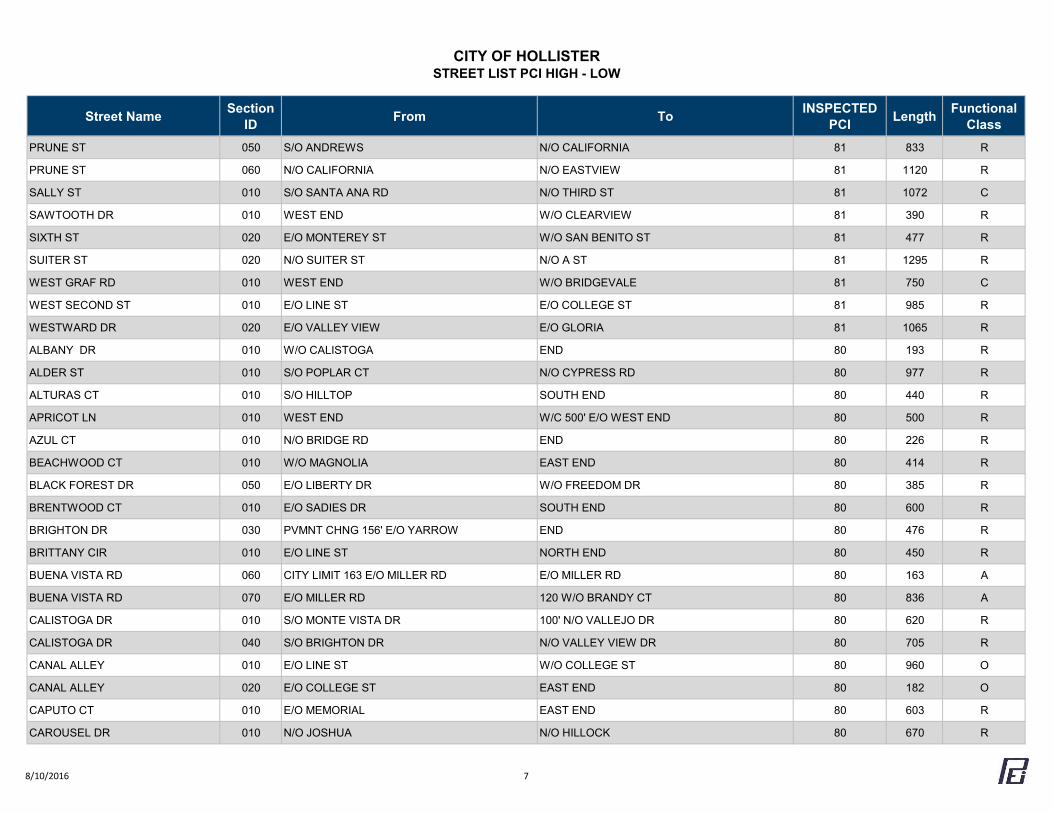
CITY OF HOLLISTERSTREET LIST PCI HIGH - LOW
Street Name Section ID From To INSPECTED
PCI Length Functional Class
PRUNE ST 050 S/O ANDREWS N/O CALIFORNIA 81 833 R
PRUNE ST 060 N/O CALIFORNIA N/O EASTVIEW 81 1120 R
SALLY ST 010 S/O SANTA ANA RD N/O THIRD ST 81 1072 C
SAWTOOTH DR 010 WEST END W/O CLEARVIEW 81 390 R
SIXTH ST 020 E/O MONTEREY ST W/O SAN BENITO ST 81 477 R
SUITER ST 020 N/O SUITER ST N/O A ST 81 1295 R
WEST GRAF RD 010 WEST END W/O BRIDGEVALE 81 750 C
WEST SECOND ST 010 E/O LINE ST E/O COLLEGE ST 81 985 R
WESTWARD DR 020 E/O VALLEY VIEW E/O GLORIA 81 1065 R
ALBANY DR 010 W/O CALISTOGA END 80 193 R
ALDER ST 010 S/O POPLAR CT N/O CYPRESS RD 80 977 R
ALTURAS CT 010 S/O HILLTOP SOUTH END 80 440 R
APRICOT LN 010 WEST END W/C 500' E/O WEST END 80 500 R
AZUL CT 010 N/O BRIDGE RD END 80 226 R
BEACHWOOD CT 010 W/O MAGNOLIA EAST END 80 414 R
BLACK FOREST DR 050 E/O LIBERTY DR W/O FREEDOM DR 80 385 R
BRENTWOOD CT 010 E/O SADIES DR SOUTH END 80 600 R
BRIGHTON DR 030 PVMNT CHNG 156' E/O YARROW END 80 476 R
BRITTANY CIR 010 E/O LINE ST NORTH END 80 450 R
BUENA VISTA RD 060 CITY LIMIT 163 E/O MILLER RD E/O MILLER RD 80 163 A
BUENA VISTA RD 070 E/O MILLER RD 120 W/O BRANDY CT 80 836 A
CALISTOGA DR 010 S/O MONTE VISTA DR 100' N/O VALLEJO DR 80 620 R
CALISTOGA DR 040 S/O BRIGHTON DR N/O VALLEY VIEW DR 80 705 R
CANAL ALLEY 010 E/O LINE ST W/O COLLEGE ST 80 960 O
CANAL ALLEY 020 E/O COLLEGE ST EAST END 80 182 O
CAPUTO CT 010 E/O MEMORIAL EAST END 80 603 R
CAROUSEL DR 010 N/O JOSHUA N/O HILLOCK 80 670 R
8/10/2016 7
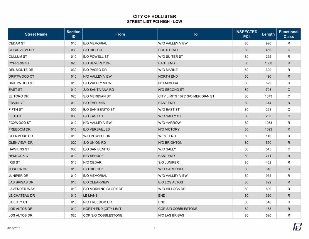
CITY OF HOLLISTERSTREET LIST PCI HIGH - LOW
Street Name Section ID From To INSPECTED
PCI Length Functional Class
CEDAR ST 010 E/O MEMORIAL W/O VALLEY VIEW 80 920 R
CLEARVIEW DR 080 S/O HILLTOP SOUTH END 80 466 C
CULLUM ST 010 E/O POWELL ST W/O SUITER ST 80 262 R
CYPRESS ST 020 E/O BEVERLY DR EAST END 80 1000 R
DEL MONTE DR 030 E/O PASEO DR W/O MARNE 80 300 R
DRIFTWOOD CT 010 N/O VALLEY VIEW NORTH END 80 490 R
DRIFTWOOD ST 010 S/O VALLEY VIEW N/O MIMOSA 80 520 R
EAST ST 010 S/O SANTA ANA RD N/O SECOND ST 80 708 C
EL TORO DR 020 S/O MERIDIAN ST CITY LIMITS 1073' S/O MERIDIAN ST 80 1073 C
ERVIN CT 010 E/O EVELYNS EAST END 80 314 R
FIFTH ST 050 E/O SAN BENITO ST W/O EAST ST 80 263 C
FIFTH ST 060 E/O EAST ST W/O SALLY ST 80 233 C
FOXWOOD ST 010 N/O VALLEY VIEW W/O YARROW 80 1053 R
FREEDOM DR 010 E/O VERSAILLES N/O VICTORY 80 1093 R
GLENMORE DR 010 W/O POWELL DR WEST END 80 140 R
GLENVIEW DR 020 S/O UNION RD N/O BRIGHTON 80 590 R
HAWKINS ST 030 E/O SAN BENITO W/O SALLY 80 545 C
HEMLOCK CT 010 N/O SPRUCE EAST END 80 771 R
IRIS ST 010 N/O CEDAR S/O JUNIPER 80 462 R
JOSHUA DR 010 E/O HILLOCK W/O CAROUSEL 80 316 R
JUNIPER DR 010 E/O MEMORIAL W/O VALLEY VIEW 80 935 R
LAS BRISAS DR 010 E/O CLEARVIEW E/O LOS ALTOS 80 892 R
LAVENDER WAY 010 E/O MORNING GLORY DR W/O HILLOCK DR 80 609 R
LE CHATEAU DR 010 LE MANS END 80 390 R
LIBERTY CT 010 N/O FREEDOM DR END 80 346 R
LOS ALTOS DR 010 NORTH END (CITY LIMIT) COP S/O COBBLESTONE 80 185 R
LOS ALTOS DR 020 COP S/O COBBLESTONE N/O LAS BRISAS 80 520 R
8/10/2016 8
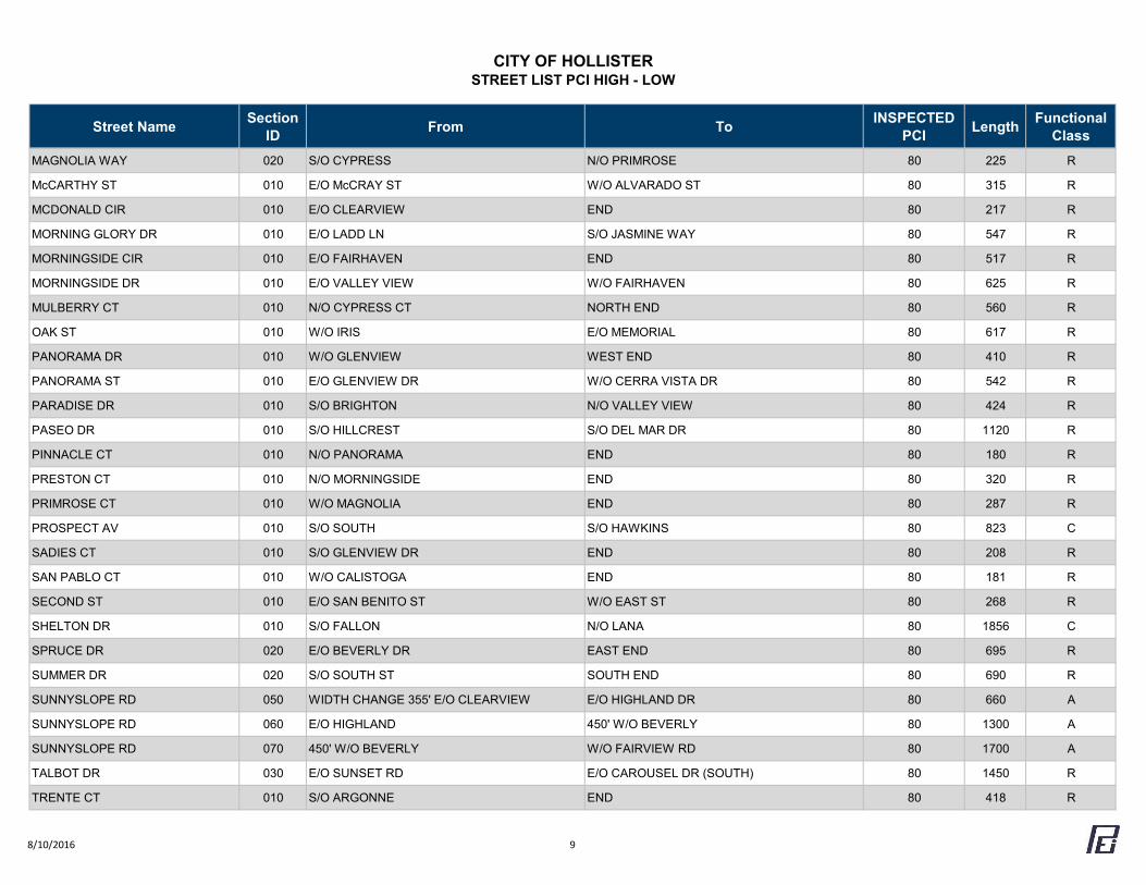
CITY OF HOLLISTERSTREET LIST PCI HIGH - LOW
Street Name Section ID From To INSPECTED
PCI Length Functional Class
MAGNOLIA WAY 020 S/O CYPRESS N/O PRIMROSE 80 225 R
McCARTHY ST 010 E/O McCRAY ST W/O ALVARADO ST 80 315 R
MCDONALD CIR 010 E/O CLEARVIEW END 80 217 R
MORNING GLORY DR 010 E/O LADD LN S/O JASMINE WAY 80 547 R
MORNINGSIDE CIR 010 E/O FAIRHAVEN END 80 517 R
MORNINGSIDE DR 010 E/O VALLEY VIEW W/O FAIRHAVEN 80 625 R
MULBERRY CT 010 N/O CYPRESS CT NORTH END 80 560 R
OAK ST 010 W/O IRIS E/O MEMORIAL 80 617 R
PANORAMA DR 010 W/O GLENVIEW WEST END 80 410 R
PANORAMA ST 010 E/O GLENVIEW DR W/O CERRA VISTA DR 80 542 R
PARADISE DR 010 S/O BRIGHTON N/O VALLEY VIEW 80 424 R
PASEO DR 010 S/O HILLCREST S/O DEL MAR DR 80 1120 R
PINNACLE CT 010 N/O PANORAMA END 80 180 R
PRESTON CT 010 N/O MORNINGSIDE END 80 320 R
PRIMROSE CT 010 W/O MAGNOLIA END 80 287 R
PROSPECT AV 010 S/O SOUTH S/O HAWKINS 80 823 C
SADIES CT 010 S/O GLENVIEW DR END 80 208 R
SAN PABLO CT 010 W/O CALISTOGA END 80 181 R
SECOND ST 010 E/O SAN BENITO ST W/O EAST ST 80 268 R
SHELTON DR 010 S/O FALLON N/O LANA 80 1856 C
SPRUCE DR 020 E/O BEVERLY DR EAST END 80 695 R
SUMMER DR 020 S/O SOUTH ST SOUTH END 80 690 R
SUNNYSLOPE RD 050 WIDTH CHANGE 355' E/O CLEARVIEW E/O HIGHLAND DR 80 660 A
SUNNYSLOPE RD 060 E/O HIGHLAND 450' W/O BEVERLY 80 1300 A
SUNNYSLOPE RD 070 450' W/O BEVERLY W/O FAIRVIEW RD 80 1700 A
TALBOT DR 030 E/O SUNSET RD E/O CAROUSEL DR (SOUTH) 80 1450 R
TRENTE CT 010 S/O ARGONNE END 80 418 R
8/10/2016 9
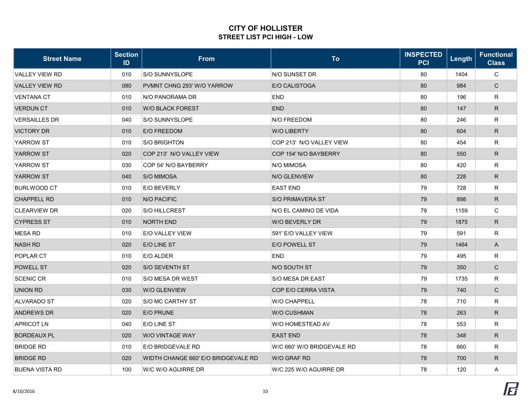
CITY OF HOLLISTERSTREET LIST PCI HIGH - LOW
Street Name Section ID From To INSPECTED
PCI Length Functional Class
VALLEY VIEW RD 010 S/O SUNNYSLOPE N/O SUNSET DR 80 1404 C
VALLEY VIEW RD 080 PVMNT CHNG 293' W/O YARROW E/O CALISTOGA 80 984 C
VENTANA CT 010 N/O PANORAMA DR END 80 196 R
VERDUN CT 010 W/O BLACK FOREST END 80 147 R
VERSAILLES DR 040 S/O SUNNYSLOPE N/O FREEDOM 80 246 R
VICTORY DR 010 E/O FREEDOM W/O LIBERTY 80 604 R
YARROW ST 010 S/O BRIGHTON COP 213' N/O VALLEY VIEW 80 454 R
YARROW ST 020 COP 213' N/O VALLEY VIEW COP 154' N/O BAYBERRY 80 550 R
YARROW ST 030 COP 54' N/O BAYBERRY N/O MIMOSA 80 420 R
YARROW ST 040 S/O MIMOSA N/O GLENVIEW 80 228 R
BURLWOOD CT 010 E/O BEVERLY EAST END 79 728 R
CHAPPELL RD 010 N/O PACIFIC S/O PRIMAVERA ST 79 898 R
CLEARVIEW DR 020 S/O HILLCREST N/O EL CAMINO DE VIDA 79 1159 C
CYPRESS ST 010 NORTH END W/O BEVERLY DR 79 1875 R
MESA RD 010 E/O VALLEY VIEW 591' E/O VALLEY VIEW 79 591 R
NASH RD 020 E/O LINE ST E/O POWELL ST 79 1464 A
POPLAR CT 010 E/O ALDER END 79 495 R
POWELL ST 020 S/O SEVENTH ST N/O SOUTH ST 79 350 C
SCENIC CR 010 S/O MESA DR WEST S/O MESA DR EAST 79 1735 R
UNION RD 030 W/O GLENVIEW COP E/O CERRA VISTA 79 740 C
ALVARADO ST 020 S/O MC CARTHY ST W/O CHAPPELL 78 710 R
ANDREWS DR 020 E/O PRUNE W/O CUSHMAN 78 263 R
APRICOT LN 040 E/O LINE ST W/O HOMESTEAD AV 78 553 R
BORDEAUX PL 020 W/O VINTAGE WAY EAST END 78 348 R
BRIDGE RD 010 E/O BRIDGEVALE RD W/C 660' W/O BRIDGEVALE RD 78 660 R
BRIDGE RD 020 WIDTH CHANGE 660' E/O BRIDGEVALE RD W/O GRAF RD 78 700 R
BUENA VISTA RD 100 W/C W/O AGUIRRE DR W/C 225 W/O AGUIRRE DR 78 120 A
8/10/2016 10
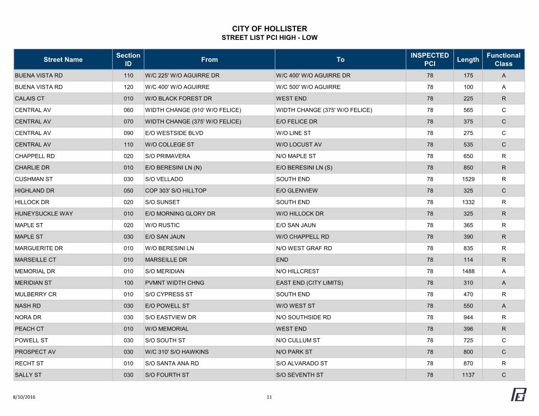
CITY OF HOLLISTERSTREET LIST PCI HIGH - LOW
Street Name Section ID From To INSPECTED
PCI Length Functional Class
BUENA VISTA RD 110 W/C 225' W/O AGUIRRE DR W/C 400' W/O AGUIRRE DR 78 175 A
BUENA VISTA RD 120 W/C 400' W/O AGUIRRE W/C 500' W/O AGUIRRE 78 100 A
CALAIS CT 010 W/O BLACK FOREST DR WEST END 78 225 R
CENTRAL AV 060 WIDTH CHANGE (910' W/O FELICE) WIDTH CHANGE (375' W/O FELICE) 78 565 C
CENTRAL AV 070 WIDTH CHANGE (375' W/O FELICE) E/O FELICE DR 78 375 C
CENTRAL AV 090 E/O WESTSIDE BLVD W/O LINE ST 78 275 C
CENTRAL AV 110 W/O COLLEGE ST W/O LOCUST AV 78 535 C
CHAPPELL RD 020 S/O PRIMAVERA N/O MAPLE ST 78 650 R
CHARLIE DR 010 E/O BERESINI LN (N) E/O BERESINI LN (S) 78 850 R
CUSHMAN ST 030 S/O VELLADO SOUTH END 78 1529 R
HIGHLAND DR 050 COP 303' S/O HILLTOP E/O GLENVIEW 78 325 C
HILLOCK DR 020 S/O SUNSET SOUTH END 78 1332 R
HUNEYSUCKLE WAY 010 E/O MORNING GLORY DR W/O HILLOCK DR 78 325 R
MAPLE ST 020 W/O RUSTIC E/O SAN JAUN 78 365 R
MAPLE ST 030 E/O SAN JAUN W/O CHAPPELL RD 78 390 R
MARGUERITE DR 010 W/O BERESINI LN N/O WEST GRAF RD 78 835 R
MARSEILLE CT 010 MARSEILLE DR END 78 114 R
MEMORIAL DR 010 S/O MERIDIAN N/O HILLCREST 78 1488 A
MERIDIAN ST 100 PVMNT WIDTH CHNG EAST END (CITY LIMITS) 78 310 A
MULBERRY CR 010 S/O CYPRESS ST SOUTH END 78 470 R
NASH RD 030 E/O POWELL ST W/O WEST ST 78 550 A
NORA DR 030 S/O EASTVIEW DR N/O SOUTHSIDE RD 78 944 R
PEACH CT 010 W/O MEMORIAL WEST END 78 396 R
POWELL ST 030 S/O SOUTH ST N/O CULLUM ST 78 725 C
PROSPECT AV 030 W/C 310' S/O HAWKINS N/O PARK ST 78 800 C
RECHT ST 010 S/O SANTA ANA RD S/O ALVARADO ST 78 870 R
SALLY ST 030 S/O FOURTH ST S/O SEVENTH ST 78 1137 C
8/10/2016 11
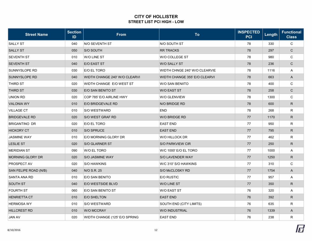
CITY OF HOLLISTERSTREET LIST PCI HIGH - LOW
Street Name Section ID From To INSPECTED
PCI Length Functional Class
SALLY ST 040 N/O SEVENTH ST N/O SOUTH ST 78 330 C
SALLY ST 050 S/O SOUTH RR TRACKS 78 297 C
SEVENTH ST 010 W/O LINE ST W/O COLLEGE ST 78 980 C
SEVENTH ST 040 E/O EAST ST W/O SALLY ST 78 236 C
SUNNYSLOPE RD 030 E/O EL TORO WIDTH CHNGE 240' W/O CLEARVIE 78 1116 A
SUNNYSLOPE RD 040 WIDTH CHANGE 240' W/O CLEARVI WIDTH CHANGE 355' E/O CLEARVI 78 663 A
THIRD ST 020 WIDTH CHANGE E/O WEST ST W/O SAN BENIITO 78 400 C
THIRD ST 030 E/O SAN BENITO ST W/O EAST ST 78 258 C
UNION RD 020 COP 785' E/O AIRLINE HWY W/O GLENVIEW 78 1300 C
VALONIA WY 010 E/O BRIDGEVALE RD N/O BRIDGE RD 78 600 R
VILLAGE CT 010 S/O WESTWARD END 78 268 R
BRIDGEVALE RD 020 S/O WEST GRAF RD W/O BRIDGE RD 77 1170 R
BRIGANTINO DR 020 E/O EL TORO EAST END 77 950 R
HICKORY CT 010 S/O SPRUCE EAST END 77 795 R
JASMINE WAY 010 E/O MORNING GLORY DR W/O HILLOCK DR 77 462 R
LESLIE ST 020 S/O GLARNER ST S/O PARKVIEW CIR 77 250 R
MERIDIAN ST 090 W/O EL TORO W/C 1000' E/O EL TORO 77 1000 A
MORNING GLORY DR 020 S/O JASMINE WAY S/O LAVENDER WAY 77 1250 R
PROSPECT AV 020 S/O HAWKINS W/C 310' S/O HAWKINS 77 310 C
SAN FELIPE ROAD (N/B) 040 N/O S.R. 25 S/O McCLOSKY RD 77 1754 A
SANTA ANA RD 010 E/O SAN BENITO E/O RUSTIC 77 957 A
SOUTH ST 040 E/O WESTSIDE BLVD W/O LINE ST 77 350 R
FOURTH ST 060 E/O SAN BENITO ST W/O EAST ST 76 320 A
HENRIETTA CT 010 E/O SHELTON EAST END 76 392 R
HERMOSA WY 010 S/O WESTWARD SOUTH END (CITY LIMITS) 76 635 R
HILLCREST RD 010 W/O MCCRAY W/O INDUSTRIAL 76 1339 A
JAN AV 020 WIDTH CHANGE (125' E/O SPRING EAST END 76 238 R
8/10/2016 12
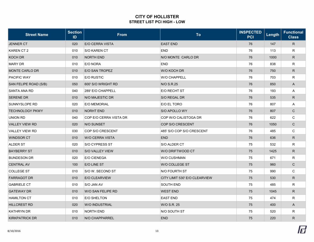
CITY OF HOLLISTERSTREET LIST PCI HIGH - LOW
Street Name Section ID From To INSPECTED
PCI Length Functional Class
JENNER CT 020 E/O CERRA VISTA EAST END 76 147 R
KAREN CT 2 010 S/O KAREN CT END 76 113 R
KOCH DR 010 NORTH END N/O MONTE CARLO DR 76 1000 R
MARY DR 010 E/O NORA END 76 838 R
MONTE CARLO DR 010 E/O SAN TROPEZ W/O KOCH DR 76 750 R
PACIFIC WAY 010 E/O RUSTIC W/O CHAPPELL 76 703 R
SAN FELIPE ROAD (S/B) 050 600' S/O WRIGHT RD N/O S.R.25 76 850 A
SANTA ANA RD 040 289' E/O CHAPPELL E/O RECHT ST 76 193 A
SERENE DR 010 N/O MAJESTIC DR S/O REGAL DR 76 535 R
SUNNYSLOPE RD 020 E/O MEMORIAL E/O EL TORO 76 807 A
TECHNOLOGY PKWY 010 NORHT END S/O APOLLO WY 76 807 C
UNION RD 040 COP E/O CERRA VISTA DR COP W/O CALISTOGA DR 76 622 C
VALLEY VIEW RD 020 N/O SUNSET COP S/O CRESCENT 76 1050 C
VALLEY VIEW RD 030 COP S/O CRESCENT 485' S/O COP S/O CRESCENT 76 485 C
WINDSOR CT 010 W/O CERRA VISTA END 76 636 R
ALDER ST 020 S/O CYPRESS ST S/O ALDER CT 75 532 R
BAYBERRY ST 010 S/O VALLEY VIEW W/O DRIFTWOOD CT 75 1425 R
BUNDESON DR 020 E/O CIENEGA W/O CUSHMAN 75 671 R
CENTRAL AV 100 E/O LINE ST W/O COLLEGE ST 75 960 C
COLLEGE ST 010 S/O W. SECOND ST N/O FOURTH ST 75 990 C
FARRAGOT DR 010 E/O CLEARVIEW CITY LIMIT 530' E/O CLEARVIEW 75 530 R
GABRIELE CT 010 S/O JAN AV SOUTH END 75 485 R
GATEWAY DR 010 W/O SAN FELIPE RD WEST END 75 1045 R
HAMILTON CT 010 E/O SHELTON EAST END 75 474 R
HILLCREST RD 020 W/O INDUSTRIAL W/O S.R. 25 75 400 A
KATHRYN DR 010 NORTH END N/O SOUTH ST 75 520 R
KIRKPATRICK DR 010 N/O CHAPPARREL END 75 220 R
8/10/2016 13
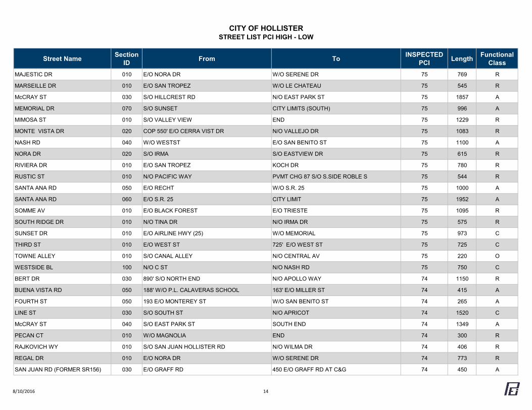
CITY OF HOLLISTERSTREET LIST PCI HIGH - LOW
Street Name Section ID From To INSPECTED
PCI Length Functional Class
MAJESTIC DR 010 E/O NORA DR W/O SERENE DR 75 769 R
MARSEILLE DR 010 E/O SAN TROPEZ W/O LE CHATEAU 75 545 R
McCRAY ST 030 S/O HILLCREST RD N/O EAST PARK ST 75 1857 A
MEMORIAL DR 070 S/O SUNSET CITY LIMITS (SOUTH) 75 996 A
MIMOSA ST 010 S/O VALLEY VIEW END 75 1229 R
MONTE VISTA DR 020 COP 550' E/O CERRA VIST DR N/O VALLEJO DR 75 1083 R
NASH RD 040 W/O WESTST E/O SAN BENITO ST 75 1100 A
NORA DR 020 S/O IRMA S/O EASTVIEW DR 75 615 R
RIVIERA DR 010 E/O SAN TROPEZ KOCH DR 75 780 R
RUSTIC ST 010 N/O PACIFIC WAY PVMT CHG 87 S/O S.SIDE ROBLE S 75 544 R
SANTA ANA RD 050 E/O RECHT W/O S.R. 25 75 1000 A
SANTA ANA RD 060 E/O S.R. 25 CITY LIMIT 75 1952 A
SOMME AV 010 E/O BLACK FOREST E/O TRIESTE 75 1095 R
SOUTH RIDGE DR 010 N/O TINA DR N/O IRMA DR 75 575 R
SUNSET DR 010 E/O AIRLINE HWY (25) W/O MEMORIAL 75 973 C
THIRD ST 010 E/O WEST ST 725' E/O WEST ST 75 725 C
TOWNE ALLEY 010 S/O CANAL ALLEY N/O CENTRAL AV 75 220 O
WESTSIDE BL 100 N/O C ST N/O NASH RD 75 750 C
BERT DR 030 890' S/O NORTH END N/O APOLLO WAY 74 1150 R
BUENA VISTA RD 050 188' W/O P.L. CALAVERAS SCHOOL 163' E/O MILLER ST 74 415 A
FOURTH ST 050 193 E/O MONTEREY ST W/O SAN BENITO ST 74 265 A
LINE ST 030 S/O SOUTH ST N/O APRICOT 74 1520 C
McCRAY ST 040 S/O EAST PARK ST SOUTH END 74 1349 A
PECAN CT 010 W/O MAGNOLIA END 74 300 R
RAJKOVICH WY 010 S/O SAN JUAN HOLLISTER RD N/O WILMA DR 74 406 R
REGAL DR 010 E/O NORA DR W/O SERENE DR 74 773 R
SAN JUAN RD (FORMER SR156) 030 E/O GRAFF RD 450 E/O GRAFF RD AT C&G 74 450 A
8/10/2016 14
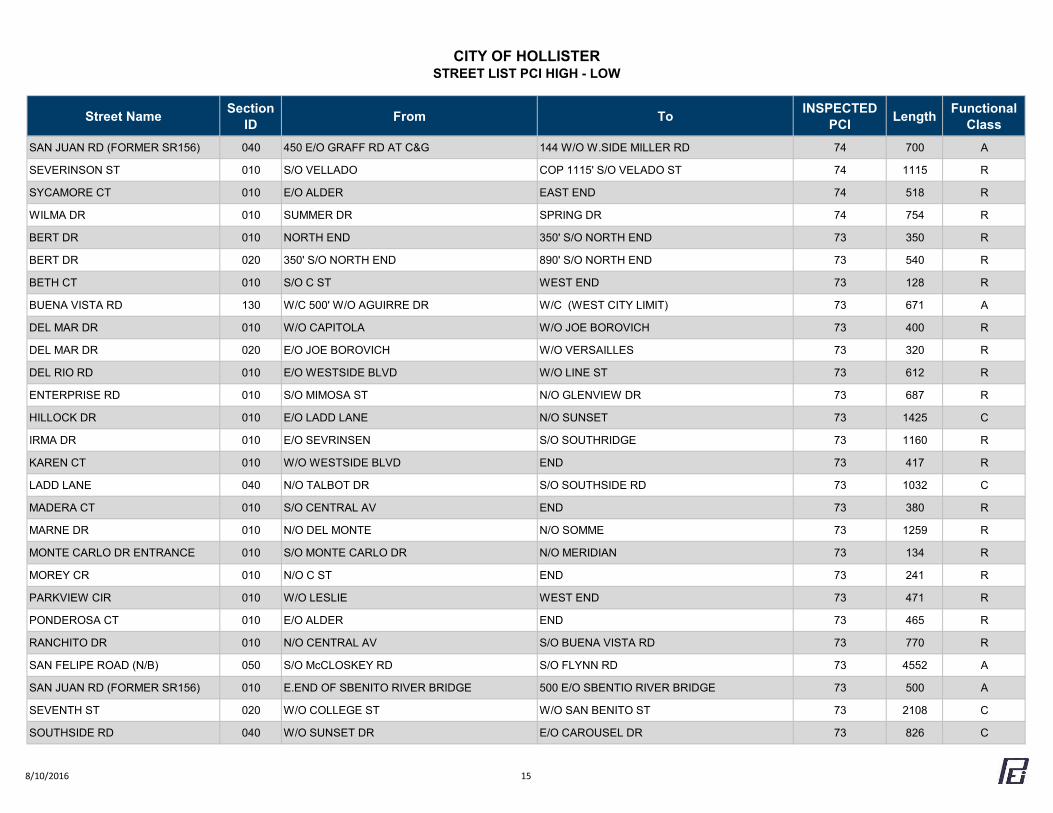
CITY OF HOLLISTERSTREET LIST PCI HIGH - LOW
Street Name Section ID From To INSPECTED
PCI Length Functional Class
SAN JUAN RD (FORMER SR156) 040 450 E/O GRAFF RD AT C&G 144 W/O W.SIDE MILLER RD 74 700 A
SEVERINSON ST 010 S/O VELLADO COP 1115' S/O VELADO ST 74 1115 R
SYCAMORE CT 010 E/O ALDER EAST END 74 518 R
WILMA DR 010 SUMMER DR SPRING DR 74 754 R
BERT DR 010 NORTH END 350' S/O NORTH END 73 350 R
BERT DR 020 350' S/O NORTH END 890' S/O NORTH END 73 540 R
BETH CT 010 S/O C ST WEST END 73 128 R
BUENA VISTA RD 130 W/C 500' W/O AGUIRRE DR W/C (WEST CITY LIMIT) 73 671 A
DEL MAR DR 010 W/O CAPITOLA W/O JOE BOROVICH 73 400 R
DEL MAR DR 020 E/O JOE BOROVICH W/O VERSAILLES 73 320 R
DEL RIO RD 010 E/O WESTSIDE BLVD W/O LINE ST 73 612 R
ENTERPRISE RD 010 S/O MIMOSA ST N/O GLENVIEW DR 73 687 R
HILLOCK DR 010 E/O LADD LANE N/O SUNSET 73 1425 C
IRMA DR 010 E/O SEVRINSEN S/O SOUTHRIDGE 73 1160 R
KAREN CT 010 W/O WESTSIDE BLVD END 73 417 R
LADD LANE 040 N/O TALBOT DR S/O SOUTHSIDE RD 73 1032 C
MADERA CT 010 S/O CENTRAL AV END 73 380 R
MARNE DR 010 N/O DEL MONTE N/O SOMME 73 1259 R
MONTE CARLO DR ENTRANCE 010 S/O MONTE CARLO DR N/O MERIDIAN 73 134 R
MOREY CR 010 N/O C ST END 73 241 R
PARKVIEW CIR 010 W/O LESLIE WEST END 73 471 R
PONDEROSA CT 010 E/O ALDER END 73 465 R
RANCHITO DR 010 N/O CENTRAL AV S/O BUENA VISTA RD 73 770 R
SAN FELIPE ROAD (N/B) 050 S/O McCLOSKEY RD S/O FLYNN RD 73 4552 A
SAN JUAN RD (FORMER SR156) 010 E.END OF SBENITO RIVER BRIDGE 500 E/O SBENTIO RIVER BRIDGE 73 500 A
SEVENTH ST 020 W/O COLLEGE ST W/O SAN BENITO ST 73 2108 C
SOUTHSIDE RD 040 W/O SUNSET DR E/O CAROUSEL DR 73 826 C
8/10/2016 15
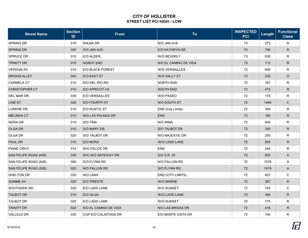
CITY OF HOLLISTERSTREET LIST PCI HIGH - LOW
Street Name Section ID From To INSPECTED
PCI Length Functional Class
SPRING DR 010 WILMA DR N/O JAN AVE 73 273 R
SPRING DR 020 S/O JAN AVE E/O KATHRYN DR 73 706 R
SPRUCE DR 010 E/O ALDER W/O BEVERLY 73 630 R
TRINITY DR 010 NORHT END N/O EL CAMINO DE VIDA 73 115 R
VERDUN AV 010 E/O BLACK FOREST W/O VERSAILLES 73 600 R
BRIGGS ALLEY 040 E/O EAST ST W/O SALLY ST 72 235 O
CARMELA CT 010 N/O DEL RIO RD NORTH END 72 187 R
CHRISTOPHER CT 010 S/O APRICOT LN SOUTH END 72 473 R
DEL MAR DR 030 E/O VERSAILLES W/O PASEO 72 175 R
LINE ST 020 S/O FOURTH ST N/O SOUTH ST 72 1448 C
LORENE DR 010 E/O RUSTIC ST END (City Limits) 72 358 R
MELINDA CT 010 N/O LAS PALMAS DR END 72 180 R
NORA DR 010 S/O TINA N/O IRMA 72 600 R
OLGA DR 010 S/O MARY DR S/O TALBOT DR 72 345 R
OLGA DR 020 S/O TALBOT DR N/O MAJESTIC DR 72 250 R
PAUL DR 010 E/O NORA W/O LADD LANE 72 955 R
PIANE CRATI 010 W/O FELICE DR END 72 244 R
SAN FELIPE ROAD (N/B) 030 W/C N/O GATEWAY DR S/O S.R. 25 72 805 A
SAN FELIPE ROAD (N/B) 060 S/O FLYNN RD N/O FALLON RD 72 1579 A
SAN FELIPE ROAD (S/B) 020 N/O FALLON RD S/O FLYNN RD 72 1579 A
SHELTON DR 020 N/O LANA END (CITY LIMITS) 72 827 C
SOMME AV 020 E/O TRIESTE W/O MARNE 72 267 R
SOUTHSIDE RD 030 E/O LADD LANE W/O SUNSET 72 755 C
TALBOT DR 010 E/O OLGA W/O LADD LANE 72 394 R
TALBOT DR 020 E/O LADD LANE W/O SUNSET 72 775 R
TRINITY DR 020 S/O EL CAMINO DE VIDA N/O LAS BRISAS DR 72 418 R
VALLEJO DR 030 COP E/O CALISTOGA DR E/O MONTE VISTA DR 72 140 R
8/10/2016 16
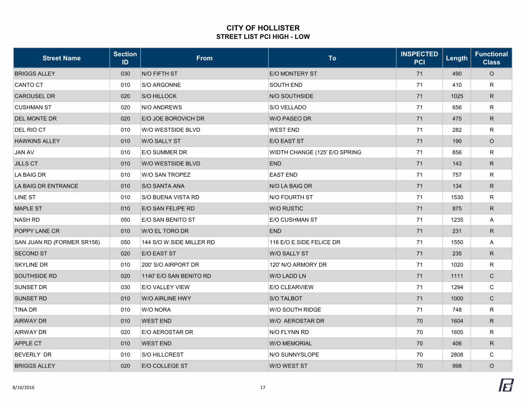
CITY OF HOLLISTERSTREET LIST PCI HIGH - LOW
Street Name Section ID From To INSPECTED
PCI Length Functional Class
BRIGGS ALLEY 030 N/O FIFTH ST E/O MONTERY ST 71 490 O
CANTO CT 010 S/O ARGONNE SOUTH END 71 410 R
CAROUSEL DR 020 S/O HILLOCK N/O SOUTHSIDE 71 1025 R
CUSHMAN ST 020 N/O ANDREWS S/O VELLADO 71 656 R
DEL MONTE DR 020 E/O JOE BOROVICH DR W/O PASEO DR 71 475 R
DEL RIO CT 010 W/O WESTSIDE BLVD WEST END 71 282 R
HAWKINS ALLEY 010 W/O SALLY ST E/O EAST ST 71 190 O
JAN AV 010 E/O SUMMER DR WIDTH CHANGE (125' E/O SPRING 71 856 R
JILLS CT 010 W/O WESTSIDE BLVD END 71 143 R
LA BAIG DR 010 W/O SAN TROPEZ EAST END 71 757 R
LA BAIG DR ENTRANCE 010 S/O SANTA ANA N/O LA BAIG DR 71 134 R
LINE ST 010 S/O BUENA VISTA RD N/O FOURTH ST 71 1530 R
MAPLE ST 010 E/O SAN FELIPE RD W/O RUSTIC 71 875 R
NASH RD 050 E/O SAN BENITO ST E/O CUSHMAN ST 71 1235 A
POPPY LANE CR 010 W/O EL TORO DR END 71 231 R
SAN JUAN RD (FORMER SR156) 050 144 S/O W.SIDE MILLER RD 116 E/O E.SIDE FELICE DR 71 1550 A
SECOND ST 020 E/O EAST ST W/O SALLY ST 71 235 R
SKYLINE DR 010 200' S/O AIRPORT DR 120' N/O ARMORY DR 71 1020 R
SOUTHSIDE RD 020 1140' E/O SAN BENITO RD W/O LADD LN 71 1111 C
SUNSET DR 030 E/O VALLEY VIEW E/O CLEARVIEW 71 1294 C
SUNSET RD 010 W/O AIRLINE HWY S/O TALBOT 71 1000 C
TINA DR 010 W/O NORA W/O SOUTH RIDGE 71 748 R
AIRWAY DR 010 WEST END W/O AEROSTAR DR 70 1604 R
AIRWAY DR 020 E/O AEROSTAR DR N/O FLYNN RD 70 1605 R
APPLE CT 010 WEST END W/O MEMORIAL 70 406 R
BEVERLY DR 010 S/O HILLCREST N/O SUNNYSLOPE 70 2808 C
BRIGGS ALLEY 020 E/O COLLEGE ST W/O WEST ST 70 998 O
8/10/2016 17
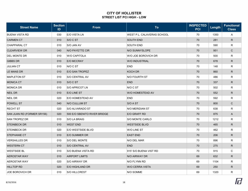
CITY OF HOLLISTERSTREET LIST PCI HIGH - LOW
Street Name Section ID From To INSPECTED
PCI Length Functional Class
BUENA VISTA RD 030 E/O VISTA LN WEST P.L. CALAVERAS SCHOOL 70 1350 A
CARMEN CT 010 S/O C ST SOUTH END 70 281 R
CHAPPARAL CT 010 S/O JAN AV SOUTH END 70 590 R
CLEARVIEW DR 040 N/O PAYETTE CIR N/O SUNNYSLOPE 70 951 C
DEL MONTE DR 010 W/O CAPITOLA W/O JOE BOROVICH DR 70 500 R
GIBBS DR 010 E/O MCCRAY W/O INDUSTRIAL 70 678 R
JULIAN CT 010 N/O C ST END 70 148 R
LE MANS DR 010 E/O SAN TROPEZ KOCH DR 70 860 R
MAPLETON ST 010 S/O CENTRAL AV N/O FOURTH ST 70 486 R
MONICA CT 010 S/O C ST END 70 337 R
MONICA DR 010 S/O APRICOT LN N/O C ST 70 502 R
NEIL DR 010 E/O LINE ST W/O HOMESTEAD AV 70 552 R
NEIL DR 020 E/O HOMESTEAD AV END 70 592 R
POWELL ST 040 N/O CULLUM ST S/O A ST 70 800 C
RECHT ST 020 S/O ALVARADO ST N/O MERIDIAN ST 70 638 R
SAN JUAN RD (FORMER SR156) 020 500 E/O SBENITO RIVER BRIDGE E/O GRAFF RD 70 875 A
SAN TROPEZ DR 010 S/O LA BRAIG S/O MONTE CARLO 70 1212 R
STEINBECK DR 010 WEST END WESTSIDE BLVD 70 465 R
STEINBECK DR 020 E/O WESTSIDE BLVD W/O LINE ST 70 462 R
STEPHANIE CT 010 E/O SUMMER DR EAST END 70 206 R
VERSAILLES DR 010 S/O DEL MONTE N/O DEL MAR 70 896 R
WESTERN CT 010 S/O CENTRAL AV END 70 275 R
WESTSIDE BL 010 S/O BUENA VISTA RD 915' S/O BUENA VIST RD 70 915 C
AEROSTAR WAY 010 AIRPORT LIMITS N/O AIRWAY DR 69 632 R
AEROSTAR WAY 020 S/O AIRWAY DR N/O FLYNN RD 69 1104 R
HILLTOP RD 020 E/O HIGHLAND DR W/O CERRA VISTA 69 250 R
JOE BOROVICH DR 010 S/O HILLCREST N/O SOMME 69 1320 R
8/10/2016 18
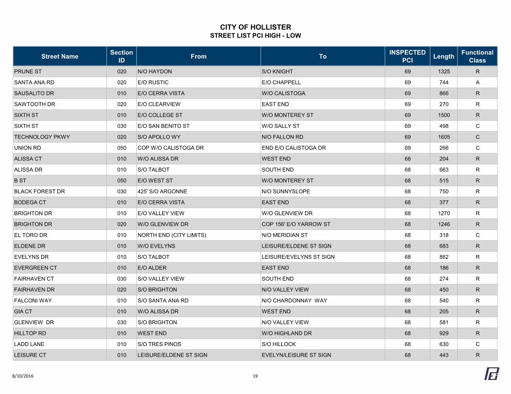
CITY OF HOLLISTERSTREET LIST PCI HIGH - LOW
Street Name Section ID From To INSPECTED
PCI Length Functional Class
PRUNE ST 020 N/O HAYDON S/O KNIGHT 69 1325 R
SANTA ANA RD 020 E/O RUSTIC E/O CHAPPELL 69 744 A
SAUSALITO DR 010 E/O CERRA VISTA W/O CALISTOGA 69 866 R
SAWTOOTH DR 020 E/O CLEARVIEW EAST END 69 270 R
SIXTH ST 010 E/O COLLEGE ST W/O MONTEREY ST 69 1500 R
SIXTH ST 030 E/O SAN BENITO ST W/O SALLY ST 69 498 C
TECHNOLOGY PKWY 020 S/O APOLLO WY N/O FALLON RD 69 1605 C
UNION RD 050 COP W/O CALISTOGA DR END E/O CALISTOGA DR 69 266 C
ALISSA CT 010 W/O ALISSA DR WEST END 68 204 R
ALISSA DR 010 S/O TALBOT SOUTH END 68 663 R
B ST 050 E/O WEST ST W/O MONTEREY ST 68 515 R
BLACK FOREST DR 030 425' S/O ARGONNE N/O SUNNYSLOPE 68 750 R
BODEGA CT 010 E/O CERRA VISTA EAST END 68 377 R
BRIGHTON DR 010 E/O VALLEY VIEW W/O GLENVIEW DR 68 1270 R
BRIGHTON DR 020 W/O GLENVIEW DR COP 156' E/O YARROW ST 68 1246 R
EL TORO DR 010 NORTH END (CITY LIMITS) N/O MERIDIAN ST 68 318 C
ELDENE DR 010 W/O EVELYNS LEISURE/ELDENE ST SIGN 68 683 R
EVELYNS DR 010 S/O TALBOT LEISURE/EVELYNS ST SIGN 68 862 R
EVERGREEN CT 010 E/O ALDER EAST END 68 186 R
FAIRHAVEN CT 030 S/O VALLEY VIEW SOUTH END 68 274 R
FAIRHAVEN DR 020 S/O BRIGHTON N/O VALLEY VIEW 68 450 R
FALCONI WAY 010 S/O SANTA ANA RD N/O CHARDONNAY WAY 68 540 R
GIA CT 010 W/O ALISSA DR WEST END 68 205 R
GLENVIEW DR 030 S/O BRIGHTON N/O VALLEY VIEW 68 581 R
HILLTOP RD 010 WEST END W/O HIGHLAND DR 68 929 R
LADD LANE 010 S/O TRES PINOS S/O HILLOCK 68 630 C
LEISURE CT 010 LEISURE/ELDENE ST SIGN EVELYN/LEISURE ST SIGN 68 443 R
8/10/2016 19
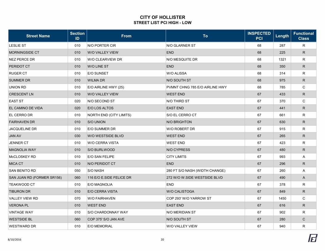
CITY OF HOLLISTERSTREET LIST PCI HIGH - LOW
Street Name Section ID From To INSPECTED
PCI Length Functional Class
LESLIE ST 010 N/O PORTER CIR N/O GLARNER ST 68 287 R
MORNINGSIDE CT 010 W/O VALLEY VIEW END 68 225 R
NEZ PERCE DR 010 W/O CLEARVIEW DR N/O MESQUITE DR 68 1321 R
PERIDOT CT 010 W/O LINE ST END 68 350 R
RUGER CT 010 E/O SUNSET W/O ALISSA 68 314 R
SUMMER DR 010 WILMA DR N/O SOUTH ST 68 975 R
UNION RD 010 E/O AIRLINE HWY (25) PVMNT CHNG 785 E/O AIRLINE HWY 68 785 C
CRESCENT LN 010 W/O VALLEY VIEW WEST END 67 433 R
EAST ST 020 N/O SECOND ST N/O THIRD ST 67 370 C
EL CAMINO DE VIDA 020 E/O LOS ALTOS EAST END 67 441 R
EL CERRO DR 010 NORTH END (CITY LIMITS) S/O EL CERRO CT 67 661 R
FAIRHAVEN DR 010 S/O UNION N/O BRIGHTON 67 630 R
JACQUELINE DR 010 E/O SUMMER DR W/O ROBERT DR 67 915 R
JAN AV 030 W/O WESTSIDE BLVD WEST END 67 265 R
JENNER CT 010 W/O CERRA VISTA WEST END 67 423 R
MAGNOLIA WAY 010 S/O BURLWOOD N/O CYPRESS 67 480 R
McCLOSKEY RD 010 E/O SAN FELIPE CITY LIMITS 67 993 A
MICA CT 010 N/O PERIDOT CT END 67 296 R
SAN BENITO RD 050 S/O NASH 280 FT S/O NASH (WIDTH CHANGE) 67 260 A
SAN JUAN RD (FORMER SR156) 060 116 E/O E.SIDE FELICE DR 272 W/O W.SIDE WESTSIDE BLVD 67 490 A
TEAKWOOD CT 010 E/O MAGNOLIA END 67 378 R
TIBURON DR 010 E/O CERRA VISTA W/O CALISTOGA 67 849 R
VALLEY VIEW RD 070 W/O FAIRHAVEN COP 293' W/O YARROW ST 67 1450 C
VERONA PL 010 WEST END EAST END 67 616 R
VINTAGE WAY 010 S/O CHARDONNAY WAY N/O MERIDIAN ST 67 902 R
WESTSIDE BL 060 COP 375' S/O JAN AVE N/O SOUTH ST 67 280 C
WESTWARD DR 010 E/O MEMORIAL W/O VALLEY VIEW 67 940 R
8/10/2016 20
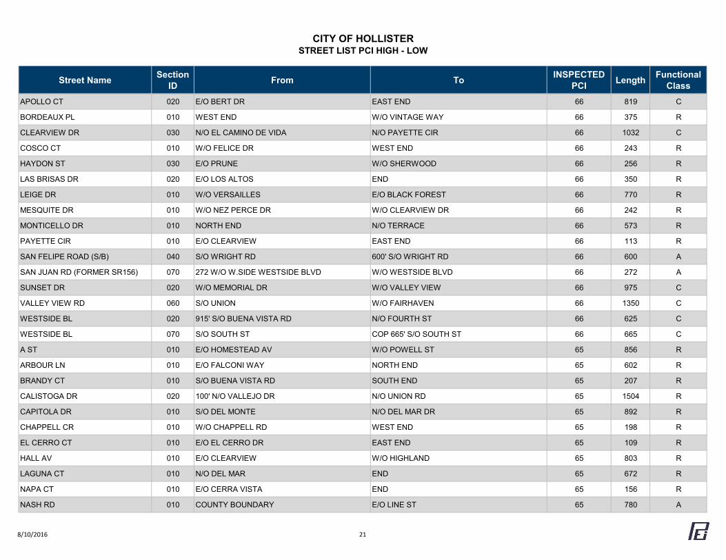
CITY OF HOLLISTERSTREET LIST PCI HIGH - LOW
Street Name Section ID From To INSPECTED
PCI Length Functional Class
APOLLO CT 020 E/O BERT DR EAST END 66 819 C
BORDEAUX PL 010 WEST END W/O VINTAGE WAY 66 375 R
CLEARVIEW DR 030 N/O EL CAMINO DE VIDA N/O PAYETTE CIR 66 1032 C
COSCO CT 010 W/O FELICE DR WEST END 66 243 R
HAYDON ST 030 E/O PRUNE W/O SHERWOOD 66 256 R
LAS BRISAS DR 020 E/O LOS ALTOS END 66 350 R
LEIGE DR 010 W/O VERSAILLES E/O BLACK FOREST 66 770 R
MESQUITE DR 010 W/O NEZ PERCE DR W/O CLEARVIEW DR 66 242 R
MONTICELLO DR 010 NORTH END N/O TERRACE 66 573 R
PAYETTE CIR 010 E/O CLEARVIEW EAST END 66 113 R
SAN FELIPE ROAD (S/B) 040 S/O WRIGHT RD 600' S/O WRIGHT RD 66 600 A
SAN JUAN RD (FORMER SR156) 070 272 W/O W.SIDE WESTSIDE BLVD W/O WESTSIDE BLVD 66 272 A
SUNSET DR 020 W/O MEMORIAL DR W/O VALLEY VIEW 66 975 C
VALLEY VIEW RD 060 S/O UNION W/O FAIRHAVEN 66 1350 C
WESTSIDE BL 020 915' S/O BUENA VISTA RD N/O FOURTH ST 66 625 C
WESTSIDE BL 070 S/O SOUTH ST COP 665' S/O SOUTH ST 66 665 C
A ST 010 E/O HOMESTEAD AV W/O POWELL ST 65 856 R
ARBOUR LN 010 E/O FALCONI WAY NORTH END 65 602 R
BRANDY CT 010 S/O BUENA VISTA RD SOUTH END 65 207 R
CALISTOGA DR 020 100' N/O VALLEJO DR N/O UNION RD 65 1504 R
CAPITOLA DR 010 S/O DEL MONTE N/O DEL MAR DR 65 892 R
CHAPPELL CR 010 W/O CHAPPELL RD WEST END 65 198 R
EL CERRO CT 010 E/O EL CERRO DR EAST END 65 109 R
HALL AV 010 E/O CLEARVIEW W/O HIGHLAND 65 803 R
LAGUNA CT 010 N/O DEL MAR END 65 672 R
NAPA CT 010 E/O CERRA VISTA END 65 156 R
NASH RD 010 COUNTY BOUNDARY E/O LINE ST 65 780 A
8/10/2016 21
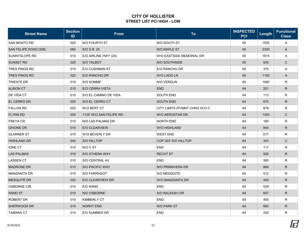
CITY OF HOLLISTERSTREET LIST PCI HIGH - LOW
Street Name Section ID From To INSPECTED
PCI Length Functional Class
SAN BENITO RD 020 N/O FOURTH ST N/O SOUTH ST 65 1530 A
SAN FELIPE ROAD (S/B) 060 S/O S.R. 25 N/O MAPLE ST 65 2300 A
SUNNYSLOPE RD 010 E/O AIRLINE HWY (25) W/O EASTSIDE MEMORIAL DR 65 1815 A
SUNSET RD 020 S/O TALBOT N/O SOUTHSIDE 65 935 C
TRES PINOS RD 010 E/O CUSHMAN ST E/O RANCHO DR 65 375 A
TRES PINOS RD 020 E/O RANCHO DR W/O LADD LN 65 1150 A
TRIESTE DR 010 S/O SOMME N/O VERDUN 65 1080 R
ALBION CT 010 E/O CERRA VISTA END 64 201 R
DE VIDA CT 010 S/O EL CAMINO DE VIDA SOUTH END 64 113 R
EL CERRO DR 020 S/O EL CERRO CT SOUTH END 64 875 R
FALLON RD 020 W/O BERT CT CITY LIMITS (PVMNT CHNG W/O C 64 678 R
FLYNN RD 020 1125' W/O SAN FELIPE RD W/O AEROSTAR DR 64 1300 C
FREYA CR 010 N/O LAS PALMAS DR NORTH END 64 180 R
GHIONE DR 010 E/O CLEARVIEW W/O HIGHLAND 64 844 R
GLARNER ST 010 W/O BEVERLY DR WEST END 64 617 R
HIGHLAND DR 040 S/O HILLTOP COP 303' S/O HILLTOP 64 303 C
IONE CT 010 N/O C ST END 64 117 R
LAS PALMAS 010 S/O ATHENA WAY RECHT ST 64 926 R
LASSEN CT 010 S/O CENTRAL AV END 64 390 R
MADRONE DR 010 S/O PACIFIC WAY N/O PRIMAVERA DR 64 884 R
MANZANITA DR 010 S/O FARRAGOT S/O MESQUITE 64 512 R
MESQUITE DR 020 E/O CLEARVIEW DR W/O MANZANITA DR 64 400 R
OSBORNE CIR 010 E/O RAND END 64 539 R
RAND ST 010 N/O OSBORNE S/O RALEIGH CIR 64 607 R
ROBERT DR 010 KIMBERLY CT END 64 405 R
SHERWOOD DR 010 NORHT END N/O PARK ST 64 660 R
TAMARA CT 010 E/O SUMMER DR END 64 205 R
8/10/2016 22
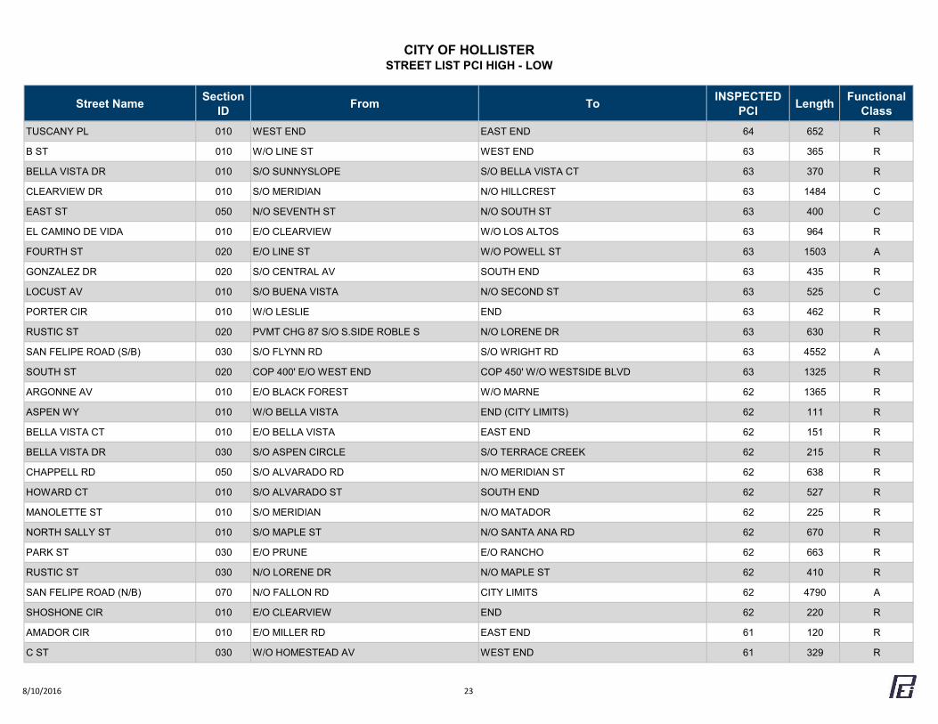
CITY OF HOLLISTERSTREET LIST PCI HIGH - LOW
Street Name Section ID From To INSPECTED
PCI Length Functional Class
TUSCANY PL 010 WEST END EAST END 64 652 R
B ST 010 W/O LINE ST WEST END 63 365 R
BELLA VISTA DR 010 S/O SUNNYSLOPE S/O BELLA VISTA CT 63 370 R
CLEARVIEW DR 010 S/O MERIDIAN N/O HILLCREST 63 1484 C
EAST ST 050 N/O SEVENTH ST N/O SOUTH ST 63 400 C
EL CAMINO DE VIDA 010 E/O CLEARVIEW W/O LOS ALTOS 63 964 R
FOURTH ST 020 E/O LINE ST W/O POWELL ST 63 1503 A
GONZALEZ DR 020 S/O CENTRAL AV SOUTH END 63 435 R
LOCUST AV 010 S/O BUENA VISTA N/O SECOND ST 63 525 C
PORTER CIR 010 W/O LESLIE END 63 462 R
RUSTIC ST 020 PVMT CHG 87 S/O S.SIDE ROBLE S N/O LORENE DR 63 630 R
SAN FELIPE ROAD (S/B) 030 S/O FLYNN RD S/O WRIGHT RD 63 4552 A
SOUTH ST 020 COP 400' E/O WEST END COP 450' W/O WESTSIDE BLVD 63 1325 R
ARGONNE AV 010 E/O BLACK FOREST W/O MARNE 62 1365 R
ASPEN WY 010 W/O BELLA VISTA END (CITY LIMITS) 62 111 R
BELLA VISTA CT 010 E/O BELLA VISTA EAST END 62 151 R
BELLA VISTA DR 030 S/O ASPEN CIRCLE S/O TERRACE CREEK 62 215 R
CHAPPELL RD 050 S/O ALVARADO RD N/O MERIDIAN ST 62 638 R
HOWARD CT 010 S/O ALVARADO ST SOUTH END 62 527 R
MANOLETTE ST 010 S/O MERIDIAN N/O MATADOR 62 225 R
NORTH SALLY ST 010 S/O MAPLE ST N/O SANTA ANA RD 62 670 R
PARK ST 030 E/O PRUNE E/O RANCHO 62 663 R
RUSTIC ST 030 N/O LORENE DR N/O MAPLE ST 62 410 R
SAN FELIPE ROAD (N/B) 070 N/O FALLON RD CITY LIMITS 62 4790 A
SHOSHONE CIR 010 E/O CLEARVIEW END 62 220 R
AMADOR CIR 010 E/O MILLER RD EAST END 61 120 R
C ST 030 W/O HOMESTEAD AV WEST END 61 329 R
8/10/2016 23
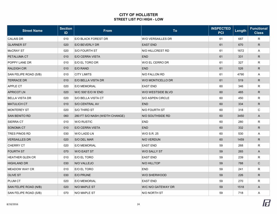
CITY OF HOLLISTERSTREET LIST PCI HIGH - LOW
Street Name Section ID From To INSPECTED
PCI Length Functional Class
CALAIS DR 010 E/O BLACK FOREST DR W/O VERSAILLES DR 61 687 R
GLARNER ST 020 E/O BEVERLY DR EAST END 61 670 R
McCRAY ST 020 S/O FOURTH ST N/O HILLCREST RD 61 1672 A
PETALUMA CT 010 E/O CERRA VISTA END 61 331 R
POPPY LANE DR 010 E/O EL TORO DR W/O EL CERRO DR 61 327 R
RALEIGH CIR 010 E/O RAND END 61 526 R
SAN FELIPE ROAD (S/B) 010 CITY LIMITS N/O FALLON RD 61 4790 A
TERRACE DR 010 E/O BELLA VISTA DR W/O MONTICELLO DR 61 519 R
APPLE CT 020 E/O MEMORIAL EAST END 60 346 R
APRICOT LN 020 W/C 500' E/O W END W/O WESTSIDE BLVD 60 465 R
BELLA VISTA DR 020 S/O BELLA VISTA CT S/O ASPEN CIRCLE 60 450 R
MATULICH CT 010 S/O CENTRAL AV END 60 334 R
MONTEREY ST 020 S/O THIRD ST N/O FOURTH ST 60 318 C
SAN BENITO RD 060 280 FT S/O NASH (WIDTH CHANGE) N/O SOUTHSIDE RD 60 3450 A
SIERRA CT 010 W/O RUSTIC END 60 280 R
SONOMA CT 010 E/O CERRA VISTA END 60 332 R
TRES PINOS RD 030 W/O LADD LN W/O S.R. 25 60 530 A
VERSAILLES DR 020 S/O DEL MAR N/O VERDUN 60 1459 R
CHERRY CT 020 E/O MEMORIAL EAST END 59 268 R
FOURTH ST 070 W/O EAST ST W/O SALLY ST 59 265 A
HEATHER GLEN CR 010 E/O EL TORO EAST END 59 239 R
HIGHLAND DR 030 N/O VALLEJO N/O HILLTOP 59 788 C
MEADOW WAY CR 010 E/O EL TORO END 59 241 R
OLIVE ST 030 E/O PRUNE W/O SHERWOOD 59 226 R
PLUM CT 020 E/O MEMORIAL EAST END 59 270 R
SAN FELIPE ROAD (N/B) 020 N/O MAPLE ST W/C N/O GATEWAY DR 59 1518 A
SAN FELIPE ROAD (S/B) 070 N/O MAPLE ST N/O NORTH ST 59 718 A
8/10/2016 24
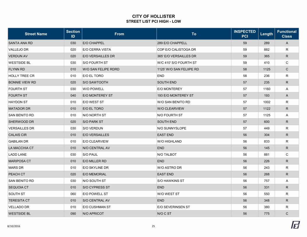
CITY OF HOLLISTERSTREET LIST PCI HIGH - LOW
Street Name Section ID From To INSPECTED
PCI Length Functional Class
SANTA ANA RD 030 E/O CHAPPEL 289 E/O CHAPPELL 59 289 A
VALLEJO DR 020 E/O CERRA VISTA COP E/O CALISTOGA DR 59 882 R
VERDUN AV 020 E/O VERSAILLES DR 365' E/O VERSAILLES DR 59 365 R
WESTSIDE BL 030 S/O FOURTH ST W/C 410' S/O FOURTH ST 59 410 C
FLYNN RD 010 W/O SAN FELIPE RDRD 1125' W/O SAN FELIIPE RD 58 1125 C
HOLLY TREE CR 010 E/O EL TORO END 58 236 R
BONNIE VIEW RD 020 S/O SAWTOOTH SOUTH END 57 235 R
FOURTH ST 030 W/O POWELL E/O MONTEREY 57 1160 A
FOURTH ST 040 E/O MONTEREY ST 193 E/O MONTEREY ST 57 193 A
HAYDON ST 010 E/O WEST ST W/O SAN BENITO RD 57 1002 R
MATADOR DR 010 E/O EL TORO W/O CLEARVIEW 57 1122 R
SAN BENITO RD 010 N/O NORTH ST N/O FOURTH ST 57 1125 A
SHERWOOD DR 020 S/O PARK ST SOUTH END 57 600 R
VERSAILLES DR 030 S/O VERDUN N/O SUNNYSLOPE 57 449 R
CALAIS CIR 010 E/O VERSAILLES EAST END 56 304 R
GABILAN DR 010 E/O CLEARVIEW W/O HIGHLAND 56 833 R
LA MACCHIA CT 010 N/O CENTRAL AV END 56 145 R
LADD LANE 030 S/O PAUL N/O TALBOT 56 881 C
MARIPOSA CT 010 E/O MILLER RD END 56 226 R
MARS DR 010 E/O SKYLINE DR W/O ASTRO DR 56 243 R
PEACH CT 020 E/O MEMORIAL EAST END 56 268 R
SAN BENITO RD 030 N/O SOUTH ST S/O HAWKINS ST 56 757 A
SEQUOIA CT 010 S/O CYPRESS ST END 56 331 R
SOUTH ST 060 E/O POWELL ST W/O WEST ST 56 550 R
TERESITA CT 010 S/O CENTRAL AV END 56 348 R
VELLADO DR 010 E/O CUSHMAN ST E/O SEVERINSEN ST 56 380 R
WESTSIDE BL 090 N/O APRICOT N/O C ST 56 775 C
8/10/2016 25
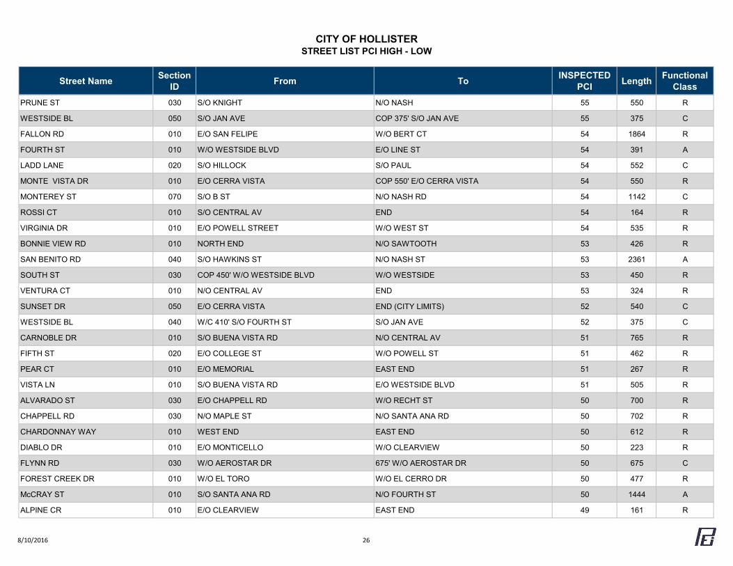
CITY OF HOLLISTERSTREET LIST PCI HIGH - LOW
Street Name Section ID From To INSPECTED
PCI Length Functional Class
PRUNE ST 030 S/O KNIGHT N/O NASH 55 550 R
WESTSIDE BL 050 S/O JAN AVE COP 375' S/O JAN AVE 55 375 C
FALLON RD 010 E/O SAN FELIPE W/O BERT CT 54 1864 R
FOURTH ST 010 W/O WESTSIDE BLVD E/O LINE ST 54 391 A
LADD LANE 020 S/O HILLOCK S/O PAUL 54 552 C
MONTE VISTA DR 010 E/O CERRA VISTA COP 550' E/O CERRA VISTA 54 550 R
MONTEREY ST 070 S/O B ST N/O NASH RD 54 1142 C
ROSSI CT 010 S/O CENTRAL AV END 54 164 R
VIRGINIA DR 010 E/O POWELL STREET W/O WEST ST 54 535 R
BONNIE VIEW RD 010 NORTH END N/O SAWTOOTH 53 426 R
SAN BENITO RD 040 S/O HAWKINS ST N/O NASH ST 53 2361 A
SOUTH ST 030 COP 450' W/O WESTSIDE BLVD W/O WESTSIDE 53 450 R
VENTURA CT 010 N/O CENTRAL AV END 53 324 R
SUNSET DR 050 E/O CERRA VISTA END (CITY LIMITS) 52 540 C
WESTSIDE BL 040 W/C 410' S/O FOURTH ST S/O JAN AVE 52 375 C
CARNOBLE DR 010 S/O BUENA VISTA RD N/O CENTRAL AV 51 765 R
FIFTH ST 020 E/O COLLEGE ST W/O POWELL ST 51 462 R
PEAR CT 010 E/O MEMORIAL EAST END 51 267 R
VISTA LN 010 S/O BUENA VISTA RD E/O WESTSIDE BLVD 51 505 R
ALVARADO ST 030 E/O CHAPPELL RD W/O RECHT ST 50 700 R
CHAPPELL RD 030 N/O MAPLE ST N/O SANTA ANA RD 50 702 R
CHARDONNAY WAY 010 WEST END EAST END 50 612 R
DIABLO DR 010 E/O MONTICELLO W/O CLEARVIEW 50 223 R
FLYNN RD 030 W/O AEROSTAR DR 675' W/O AEROSTAR DR 50 675 C
FOREST CREEK DR 010 W/O EL TORO W/O EL CERRO DR 50 477 R
McCRAY ST 010 S/O SANTA ANA RD N/O FOURTH ST 50 1444 A
ALPINE CR 010 E/O CLEARVIEW EAST END 49 161 R
8/10/2016 26
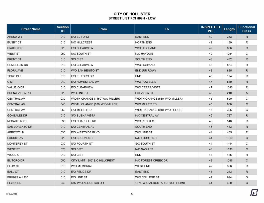
CITY OF HOLLISTERSTREET LIST PCI HIGH - LOW
Street Name Section ID From To INSPECTED
PCI Length Functional Class
ARENA WY 010 E/O EL TORO EAST END 49 353 R
BUSBY CT 010 N/O HILLCREST NORTH END 49 139 R
DIABLO DR 020 E/O CLEARVIEW W/O HIGHLAND 49 836 R
WEST ST 050 N/O SOUTH ST N/O HAYDON 49 1254 C
BRENT CT 010 S/O C ST SOUTH END 48 432 R
CEMBELLIN DR 010 E/O CLEARVIEW W/O HGH;AND 48 864 R
FLORA AVE 010 W/O SAN BENITO ST END (RR ROW) 48 825 R
TORO PLZ 010 E/O EL TORO DR END 48 174 R
C ST 040 E/O HOMESTEAD AV W/O POWELL ST 47 830 R
VALLEJO DR 010 E/O CLEARVIEW W/O CERRA VISTA 47 1086 R
BUENA VISTA RD 020 W/O LINE ST E/O VISTA ST 46 240 A
CENTRAL AV 030 WIDTH CHANGE (1150' W/O MILLER) WIDTH CHANGE (630' W/O MILLER) 45 520 C
CENTRAL AV 040 WIDTH CHANGE (630' W/O MILLER) W/O MILLER RD 45 630 C
CENTRAL AV 050 E/O MILLER RD WIDTH CHANGE (910' W/O FELICE) 45 305 C
GONZALEZ DR 010 S/O BUENA VISTA N/O CENTRAL AV 45 727 R
McCARTHY ST 030 E/O CHAPPELL RD W/O RECHT ST 45 546 R
SAN LORENZO DR 010 S/O CENTRAL AV SOUTH END 45 433 R
APRICOT LN 030 E/O WESTSIDE BLVD W/O LINE ST 44 465 R
LOCUST AV 020 E/O SECOND ST N/O FOURTH ST 44 1310 C
MONTEREY ST 030 S/O FOURTH ST S/O SOUTH ST 44 1444 C
WEST ST 070 S/O B ST N/O NASH ST 43 1130 C
WOOD CT 010 S/O C ST END 43 435 R
EL TORO DR 050 CITY LIMIT 1285' S/O HILLCREST N/O FOREST CREEK DR 42 1086 C
PLUM CT 010 W/O MEMORIAL WEST END 42 396 R
BALL CT 010 E/O FELICE DR EAST END 41 243 R
BRIGGS ALLEY 010 E/O LINE ST W/O COLLEGE ST 41 994 O
FLYNN RD 040 675' W/O AEROSTAR DR 1075' W/O AEROSTAR DR (CITY LIMIT) 41 400 C
8/10/2016 27
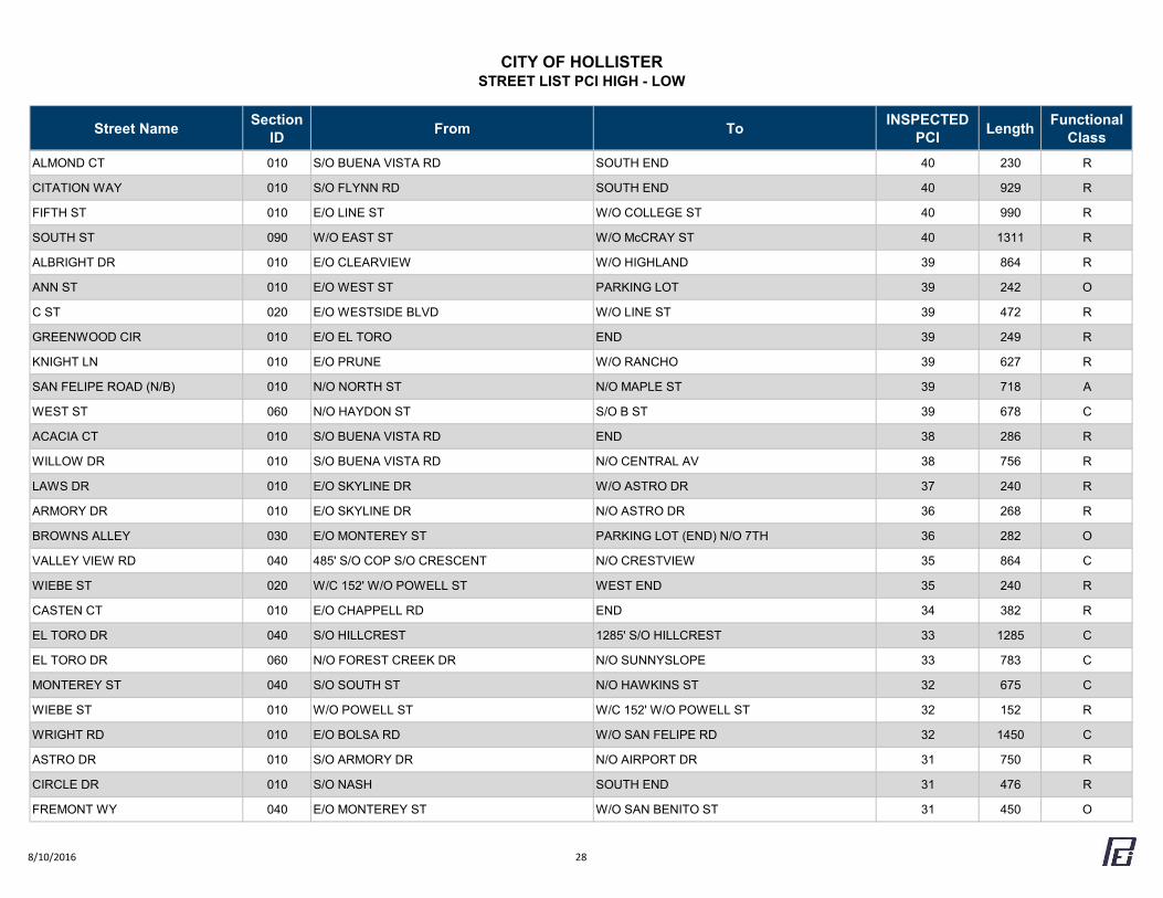
CITY OF HOLLISTERSTREET LIST PCI HIGH - LOW
Street Name Section ID From To INSPECTED
PCI Length Functional Class
ALMOND CT 010 S/O BUENA VISTA RD SOUTH END 40 230 R
CITATION WAY 010 S/O FLYNN RD SOUTH END 40 929 R
FIFTH ST 010 E/O LINE ST W/O COLLEGE ST 40 990 R
SOUTH ST 090 W/O EAST ST W/O McCRAY ST 40 1311 R
ALBRIGHT DR 010 E/O CLEARVIEW W/O HIGHLAND 39 864 R
ANN ST 010 E/O WEST ST PARKING LOT 39 242 O
C ST 020 E/O WESTSIDE BLVD W/O LINE ST 39 472 R
GREENWOOD CIR 010 E/O EL TORO END 39 249 R
KNIGHT LN 010 E/O PRUNE W/O RANCHO 39 627 R
SAN FELIPE ROAD (N/B) 010 N/O NORTH ST N/O MAPLE ST 39 718 A
WEST ST 060 N/O HAYDON ST S/O B ST 39 678 C
ACACIA CT 010 S/O BUENA VISTA RD END 38 286 R
WILLOW DR 010 S/O BUENA VISTA RD N/O CENTRAL AV 38 756 R
LAWS DR 010 E/O SKYLINE DR W/O ASTRO DR 37 240 R
ARMORY DR 010 E/O SKYLINE DR N/O ASTRO DR 36 268 R
BROWNS ALLEY 030 E/O MONTEREY ST PARKING LOT (END) N/O 7TH 36 282 O
VALLEY VIEW RD 040 485' S/O COP S/O CRESCENT N/O CRESTVIEW 35 864 C
WIEBE ST 020 W/C 152' W/O POWELL ST WEST END 35 240 R
CASTEN CT 010 E/O CHAPPELL RD END 34 382 R
EL TORO DR 040 S/O HILLCREST 1285' S/O HILLCREST 33 1285 C
EL TORO DR 060 N/O FOREST CREEK DR N/O SUNNYSLOPE 33 783 C
MONTEREY ST 040 S/O SOUTH ST N/O HAWKINS ST 32 675 C
WIEBE ST 010 W/O POWELL ST W/C 152' W/O POWELL ST 32 152 R
WRIGHT RD 010 E/O BOLSA RD W/O SAN FELIPE RD 32 1450 C
ASTRO DR 010 S/O ARMORY DR N/O AIRPORT DR 31 750 R
CIRCLE DR 010 S/O NASH SOUTH END 31 476 R
FREMONT WY 040 E/O MONTEREY ST W/O SAN BENITO ST 31 450 O
8/10/2016 28
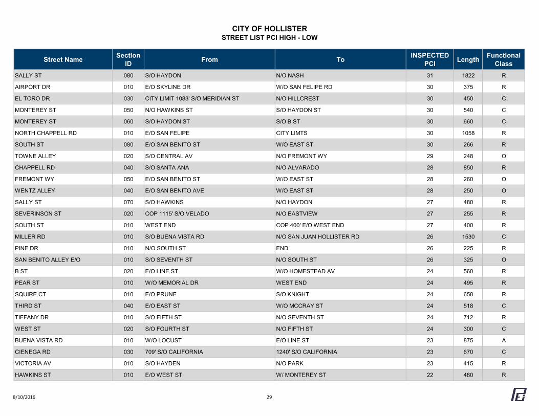
CITY OF HOLLISTERSTREET LIST PCI HIGH - LOW
Street Name Section ID From To INSPECTED
PCI Length Functional Class
SALLY ST 080 S/O HAYDON N/O NASH 31 1822 R
AIRPORT DR 010 E/O SKYLINE DR W/O SAN FELIPE RD 30 375 R
EL TORO DR 030 CITY LIMIT 1083' S/O MERIDIAN ST N/O HILLCREST 30 450 C
MONTEREY ST 050 N/O HAWKINS ST S/O HAYDON ST 30 540 C
MONTEREY ST 060 S/O HAYDON ST S/O B ST 30 660 C
NORTH CHAPPELL RD 010 E/O SAN FELIPE CITY LIMTS 30 1058 R
SOUTH ST 080 E/O SAN BENITO ST W/O EAST ST 30 266 R
TOWNE ALLEY 020 S/O CENTRAL AV N/O FREMONT WY 29 248 O
CHAPPELL RD 040 S/O SANTA ANA N/O ALVARADO 28 850 R
FREMONT WY 050 E/O SAN BENITO ST W/O EAST ST 28 260 O
WENTZ ALLEY 040 E/O SAN BENITO AVE W/O EAST ST 28 250 O
SALLY ST 070 S/O HAWKINS N/O HAYDON 27 480 R
SEVERINSON ST 020 COP 1115' S/O VELADO N/O EASTVIEW 27 255 R
SOUTH ST 010 WEST END COP 400' E/O WEST END 27 400 R
MILLER RD 010 S/O BUENA VISTA RD N/O SAN JUAN HOLLISTER RD 26 1530 C
PINE DR 010 N/O SOUTH ST END 26 225 R
SAN BENITO ALLEY E/O 010 S/O SEVENTH ST N/O SOUTH ST 26 325 O
B ST 020 E/O LINE ST W/O HOMESTEAD AV 24 560 R
PEAR ST 010 W/O MEMORIAL DR WEST END 24 495 R
SQUIRE CT 010 E/O PRUNE S/O KNIGHT 24 658 R
THIRD ST 040 E/O EAST ST W/O MCCRAY ST 24 518 C
TIFFANY DR 010 S/O FIFTH ST N/O SEVENTH ST 24 712 R
WEST ST 020 S/O FOURTH ST N/O FIFTH ST 24 300 C
BUENA VISTA RD 010 W/O LOCUST E/O LINE ST 23 875 A
CIENEGA RD 030 709' S/O CALIFORNIA 1240' S/O CALIFORNIA 23 670 C
VICTORIA AV 010 S/O HAYDEN N/O PARK 23 415 R
HAWKINS ST 010 E/O WEST ST W/ MONTEREY ST 22 480 R
8/10/2016 29
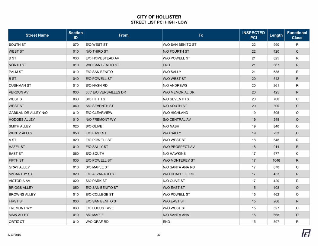
CITY OF HOLLISTERSTREET LIST PCI HIGH - LOW
Street Name Section ID From To INSPECTED
PCI Length Functional Class
SOUTH ST 070 E/O WEST ST W/O SAN BENITO ST 22 990 R
WEST ST 010 N/O THIRD ST N/O FOURTH ST 22 420 C
B ST 030 E/O HOMESTEAD AV W/O POWELL ST 21 825 R
NORTH ST 010 W/O SAN BENITO ST END 21 667 R
PALM ST 010 E/O SAN BENITO W/O SALLY 21 538 R
B ST 040 E/O POWELL ST W/O WEST ST 20 542 R
CUSHMAN ST 010 S/O NASH RD N/O ANDREWS 20 261 R
VERDUN AV 030 365' E/O VERSAILLES DR W/O MEMORIAL DR 20 425 R
WEST ST 030 S/O FIFTH ST N/O SEVENTH ST 20 700 C
WEST ST 040 S/O SEVENTH ST N/O SOUTH ST 20 300 C
GABILAN DR ALLEY N/O 010 E/O CLEARVIEW W/O HIGHLAND 19 805 O
HODGES ALLEY 010 N/O FREMONT WY S/O CENTRAL AV 19 248 O
SMITH ALLEY 020 S/O OLIVE N/O NASH 19 840 O
WENTZ ALLEY 050 E/O EAST ST W/O SALLY 19 233 O
A ST 020 E/O POWELL ST W/O WEST ST 18 548 R
HAZEL ST 010 E/O SALLY ST W/O PROSPECT AV 18 914 R
EAST ST 060 S/O SOUTH N/O HAWKINS 17 677 C
FIFTH ST 030 E/O POWELL ST W/O MONTEREY ST 17 1046 R
GRAY ALLEY 010 S/O MAPLE ST N/O SANTA ANA RD 17 670 O
McCARTHY ST 020 E/O ALVARADO ST W/O CHAPPELL RD 17 433 R
VICTORIA AV 020 S/O PARK ST N/O OLIVE ST 17 420 R
BRIGGS ALLEY 050 E/O SAN BENITO ST W/O EAST ST 15 108 O
BROWNS ALLEY 010 E/O COLLEGE ST W/O POWELL ST 15 462 O
FIRST ST 030 E/O SAN BENITO ST W/O EAST ST 15 266 R
FREMONT WY 030 E/O LOCUST AVE W/O WEST ST 15 527 O
MAIN ALLEY 010 S/O MAPLE N/O SANTA ANA 15 668 O
ORTIZ CT 010 W/O GRAF RD END 15 397 R
8/10/2016 30
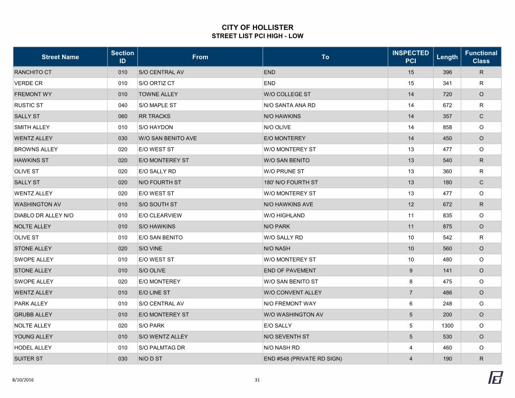
CITY OF HOLLISTERSTREET LIST PCI HIGH - LOW
Street Name Section ID From To INSPECTED
PCI Length Functional Class
RANCHITO CT 010 S/O CENTRAL AV END 15 396 R
VERDE CR 010 S/O ORTIZ CT END 15 341 R
FREMONT WY 010 TOWNE ALLEY W/O COLLEGE ST 14 720 O
RUSTIC ST 040 S/O MAPLE ST N/O SANTA ANA RD 14 672 R
SALLY ST 060 RR TRACKS N/O HAWKINS 14 357 C
SMITH ALLEY 010 S/O HAYDON N/O OLIVE 14 858 O
WENTZ ALLEY 030 W/O SAN BENITO AVE E/O MONTEREY 14 450 O
BROWNS ALLEY 020 E/O WEST ST W/O MONTEREY ST 13 477 O
HAWKINS ST 020 E/O MONTEREY ST W/O SAN BENITO 13 540 R
OLIVE ST 020 E/O SALLY RD W/O PRUNE ST 13 360 R
SALLY ST 020 N/O FOURTH ST 180' N/O FOURTH ST 13 180 C
WENTZ ALLEY 020 E/O WEST ST W/O MONTEREY ST 13 477 O
WASHINGTON AV 010 S/O SOUTH ST N/O HAWKINS AVE 12 672 R
DIABLO DR ALLEY N/O 010 E/O CLEARVIEW W/O HIGHLAND 11 835 O
NOLTE ALLEY 010 S/O HAWKINS N/O PARK 11 875 O
OLIVE ST 010 E/O SAN BENITO W/O SALLY RD 10 542 R
STONE ALLEY 020 S/O VINE N/O NASH 10 560 O
SWOPE ALLEY 010 E/O WEST ST W/O MONTEREY ST 10 480 O
STONE ALLEY 010 S/O OLIVE END OF PAVEMENT 9 141 O
SWOPE ALLEY 020 E/O MONTEREY W/O SAN BENITO ST 8 475 O
WENTZ ALLEY 010 E/O LINE ST W/O CONVENT ALLEY 7 486 O
PARK ALLEY 010 S/O CENTRAL AV N/O FREMONT WAY 6 248 O
GRUBB ALLEY 010 E/O MONTEREY ST W/O WASHINGTON AV 5 200 O
NOLTE ALLEY 020 S/O PARK E/O SALLY 5 1300 O
YOUNG ALLEY 010 S/O WENTZ ALLEY N/O SEVENTH ST 5 530 O
HODEL ALLEY 010 S/O PALMTAG DR N/O NASH RD 4 460 O
SUITER ST 030 N/O D ST END #548 (PRIVATE RD SIGN) 4 190 R
8/10/2016 31
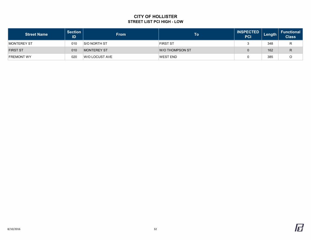
CITY OF HOLLISTERSTREET LIST PCI HIGH - LOW
Street Name Section ID From To INSPECTED
PCI Length Functional Class
MONTEREY ST 010 S/O NORTH ST FIRST ST 3 348 R
FIRST ST 010 MONTEREY ST W/O THOMPSON ST 0 162 R
FREMONT WY 020 W/O LOCUST AVE WEST END 0 385 O
8/10/2016 32
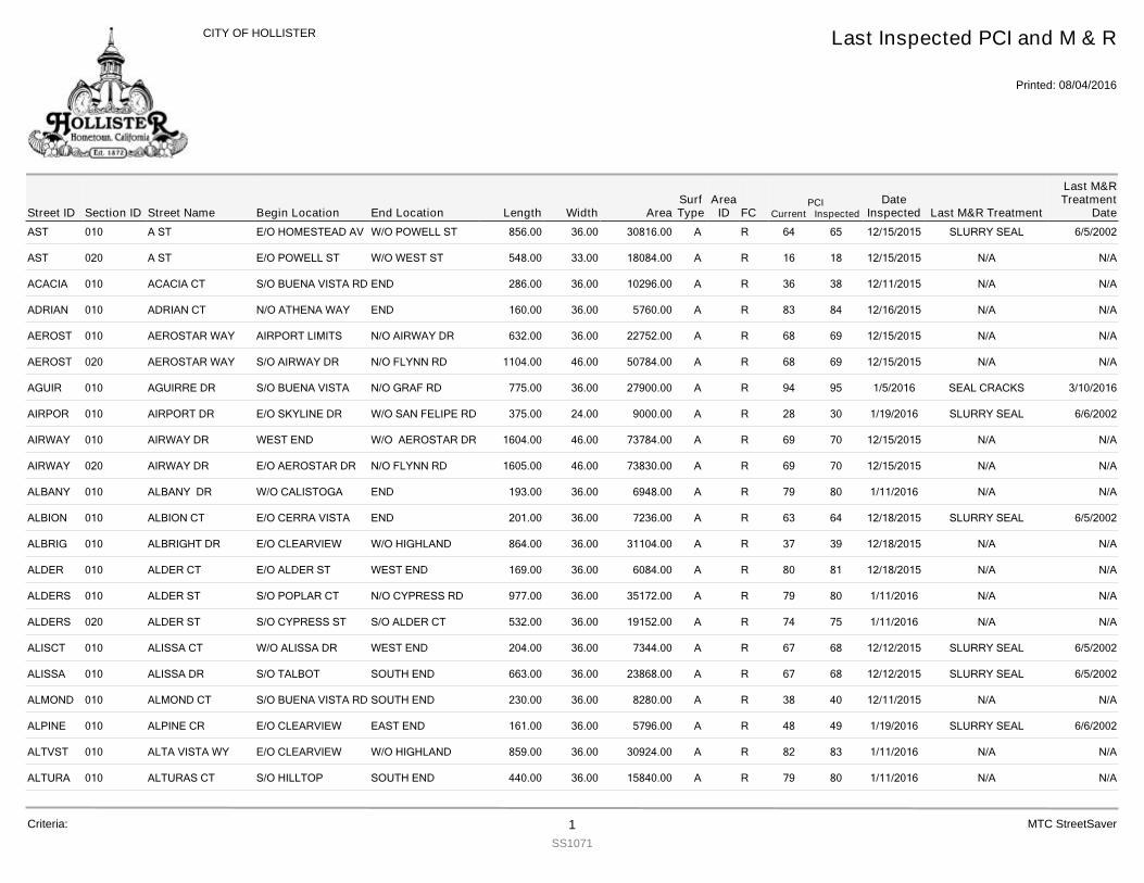
AST 010 A ST 856.00E/O HOMESTEAD AV W/O POWELL ST 36.00 30816.00 R 65 12/15/2015 SLURRY SEAL 6/5/200264A
AST 020 A ST 548.00E/O POWELL ST W/O WEST ST 33.00 18084.00 R 18 12/15/2015 N/A N/A16A
ACACIA 010 ACACIA CT 286.00S/O BUENA VISTA RD END 36.00 10296.00 R 38 12/11/2015 N/A N/A36A
ADRIAN 010 ADRIAN CT 160.00N/O ATHENA WAY END 36.00 5760.00 R 84 12/16/2015 N/A N/A83A
AEROST 010 AEROSTAR WAY 632.00AIRPORT LIMITS N/O AIRWAY DR 36.00 22752.00 R 69 12/15/2015 N/A N/A68A
AEROST 020 AEROSTAR WAY 1104.00S/O AIRWAY DR N/O FLYNN RD 46.00 50784.00 R 69 12/15/2015 N/A N/A68A
AGUIR 010 AGUIRRE DR 775.00S/O BUENA VISTA N/O GRAF RD 36.00 27900.00 R 95 1/5/2016 SEAL CRACKS 3/10/201694A
AIRPOR 010 AIRPORT DR 375.00E/O SKYLINE DR W/O SAN FELIPE RD 24.00 9000.00 R 30 1/19/2016 SLURRY SEAL 6/6/200228A
AIRWAY 010 AIRWAY DR 1604.00WEST END W/O AEROSTAR DR 46.00 73784.00 R 70 12/15/2015 N/A N/A69A
AIRWAY 020 AIRWAY DR 1605.00E/O AEROSTAR DR N/O FLYNN RD 46.00 73830.00 R 70 12/15/2015 N/A N/A69A
ALBANY 010 ALBANY DR 193.00W/O CALISTOGA END 36.00 6948.00 R 80 1/11/2016 N/A N/A79A
ALBION 010 ALBION CT 201.00E/O CERRA VISTA END 36.00 7236.00 R 64 12/18/2015 SLURRY SEAL 6/5/200263A
ALBRIG 010 ALBRIGHT DR 864.00E/O CLEARVIEW W/O HIGHLAND 36.00 31104.00 R 39 12/18/2015 N/A N/A37A
ALDER 010 ALDER CT 169.00E/O ALDER ST WEST END 36.00 6084.00 R 81 12/18/2015 N/A N/A80A
ALDERS 010 ALDER ST 977.00S/O POPLAR CT N/O CYPRESS RD 36.00 35172.00 R 80 1/11/2016 N/A N/A79A
ALDERS 020 ALDER ST 532.00S/O CYPRESS ST S/O ALDER CT 36.00 19152.00 R 75 1/11/2016 N/A N/A74A
ALISCT 010 ALISSA CT 204.00W/O ALISSA DR WEST END 36.00 7344.00 R 68 12/12/2015 SLURRY SEAL 6/5/200267A
ALISSA 010 ALISSA DR 663.00S/O TALBOT SOUTH END 36.00 23868.00 R 68 12/12/2015 SLURRY SEAL 6/5/200267A
ALMOND 010 ALMOND CT 230.00S/O BUENA VISTA RD SOUTH END 36.00 8280.00 R 40 12/11/2015 N/A N/A38A
ALPINE 010 ALPINE CR 161.00E/O CLEARVIEW EAST END 36.00 5796.00 R 49 1/19/2016 SLURRY SEAL 6/6/200248A
ALTVST 010 ALTA VISTA WY 859.00E/O CLEARVIEW W/O HIGHLAND 36.00 30924.00 R 83 1/11/2016 N/A N/A82A
ALTURA 010 ALTURAS CT 440.00S/O HILLTOP SOUTH END 36.00 15840.00 R 80 1/11/2016 N/A N/A79A
Street IDPCI
Current InspectedEnd Location Width FC
Last Inspected PCI and M & R
Printed: 08/04/2016
CITY OF HOLLISTER
Section ID Begin Location Length AreaDate
Inspected Last M&R Treatment
Last M&RTreatment
DateStreet NameArea
IDSurfType
Criteria: 1SS1071
MTC StreetSaver
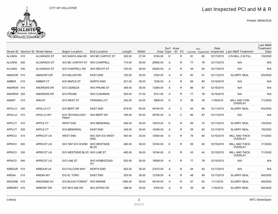
ALVARA 010 ALVARADO ST 302.00S/O SANTA ANA RD N/O MC CARTHY ST 27.00 8154.00 R 82 12/17/2015 2 IN MILL 2 IN FILL 7/6/200281O
ALVARA 020 ALVARADO ST 710.00S/O MC CARTHY ST W/O CHAPPELL 36.00 25560.00 R 78 12/17/2015 N/A N/A77A
ALVARA 030 ALVARADO ST 700.00E/O CHAPPELL RD W/O RECHT ST 36.00 25200.00 R 50 12/17/2015 N/A N/A49A
AMADOR 010 AMADOR CIR 120.00E/O MILLER RD EAST END 36.00 4320.00 R 61 12/11/2015 SLURRY SEAL 6/5/200260A
AMBER 010 AMBER CT 201.00N/O MAPLE ST NORTH END 36.00 7236.00 R 85 12/16/2015 N/A N/A84A
ANDREW 010 ANDREWS DR 369.00E/O CIENEGA W/O PRUNE ST 36.00 13284.00 R 87 12/16/2015 N/A N/A86A
ANDREW 020 ANDREWS DR 263.00E/O PRUNE W/O CUSHMAN 37.00 9731.00 R 78 12/16/2015 N/A N/A77A
ANNST 010 ANN ST 242.00E/O WEST ST PARKING LOT 24.00 5808.00 O 39 1/18/2016 MILL AND THINOVERLAY
7/1/200238O
APOLLO 020 APOLLO CT 819.00E/O BERT DR EAST END 60.00 49140.00 C 66 12/11/2015 SLURRY SEAL 6/5/200264A
APOLLO 010 APOLLO WY 795.00E/O TECHNOLOGYPKWY
W/O BERT DR 50.00 39750.00 C 87 12/11/2015 N/A N/A86A
APPLCT 010 APPLE CT 406.00WEST END W/O MEMORIAL 36.00 14616.00 R 70 12/17/2015 SLURRY SEAL 7/6/200269O
APPLCT 020 APPLE CT 346.00E/O MEMORIAL EAST END 36.00 12456.00 R 60 12/17/2015 SLURRY SEAL 7/6/200259A
APRICO 010 APRICOT LN 500.00WEST END W/C 500' E/O WESTEND
25.00 12500.00 R 80 12/15/2015 MILL AND THICKOVERLAY
7/1/200279O
APRICO 020 APRICOT LN 465.00W/C 500' E/O W END W/O WESTSIDEBLVD
36.00 16740.00 R 60 12/15/2015 MILL AND THICKOVERLAY
7/1/200259O
APRICO 030 APRICOT LN 465.00E/O WESTSIDE BLVD W/O LINE ST 36.00 16740.00 R 44 12/15/2015 MILL AND THICKOVERLAY
7/1/200243O
APRICO 040 APRICOT LN 553.00E/O LINE ST W/O HOMESTEADAV
36.00 19908.00 R 78 12/15/2015 N/A N/A77A
ARBOUR 010 ARBOUR LN 602.00E/O FALCONI WAY NORTH END 36.00 21672.00 R 65 12/17/2015 N/A N/A64A
ARENA 010 ARENA WY 353.00E/O EL TORO EAST END 36.00 12708.00 R 49 12/17/2015 SLURRY SEAL 6/6/200248A
ARGONE 010 ARGONNE AV 1365.00E/O BLACK FOREST W/O MARNE 36.00 49140.00 R 62 1/11/2016 SLURRY SEAL 6/6/200261A
ARMORY 010 ARMORY DR 268.00E/O SKYLINE DR N/O ASTRO DR 25.00 6700.00 R 36 1/19/2016 SLURRY SEAL 6/6/200235A
Street IDPCI
Current InspectedEnd Location Width FC
Last Inspected PCI and M & R
Printed: 08/04/2016
CITY OF HOLLISTER
Section ID Begin Location Length AreaDate
Inspected Last M&R Treatment
Last M&RTreatment
DateStreet NameArea
IDSurfType
Criteria: 2SS1071
MTC StreetSaver
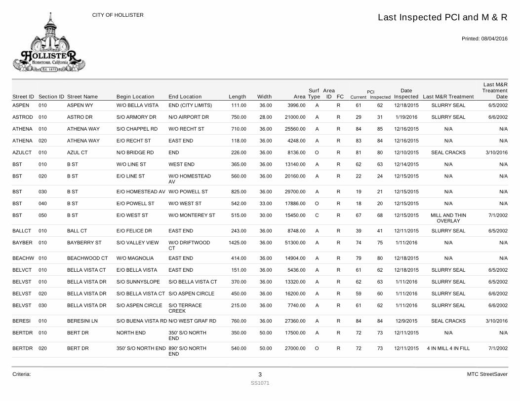
ASPEN 010 ASPEN WY 111.00W/O BELLA VISTA END (CITY LIMITS) 36.00 3996.00 R 62 12/18/2015 SLURRY SEAL 6/5/200261A
ASTROD 010 ASTRO DR 750.00S/O ARMORY DR N/O AIRPORT DR 28.00 21000.00 R 31 1/19/2016 SLURRY SEAL 6/6/200229A
ATHENA 010 ATHENA WAY 710.00S/O CHAPPEL RD W/O RECHT ST 36.00 25560.00 R 85 12/16/2015 N/A N/A84A
ATHENA 020 ATHENA WAY 118.00E/O RECHT ST EAST END 36.00 4248.00 R 84 12/16/2015 N/A N/A83A
AZULCT 010 AZUL CT 226.00N/O BRIDGE RD END 36.00 8136.00 R 80 12/10/2015 SEAL CRACKS 3/10/201681O
BST 010 B ST 365.00W/O LINE ST WEST END 36.00 13140.00 R 63 12/14/2015 N/A N/A62A
BST 020 B ST 560.00E/O LINE ST W/O HOMESTEADAV
36.00 20160.00 R 24 12/15/2015 N/A N/A22A
BST 030 B ST 825.00E/O HOMESTEAD AV W/O POWELL ST 36.00 29700.00 R 21 12/15/2015 N/A N/A19A
BST 040 B ST 542.00E/O POWELL ST W/O WEST ST 33.00 17886.00 R 20 12/15/2015 N/A N/A18O
BST 050 B ST 515.00E/O WEST ST W/O MONTEREY ST 30.00 15450.00 R 68 12/15/2015 MILL AND THINOVERLAY
7/1/200267C
BALLCT 010 BALL CT 243.00E/O FELICE DR EAST END 36.00 8748.00 R 41 12/11/2015 SLURRY SEAL 6/5/200239A
BAYBER 010 BAYBERRY ST 1425.00S/O VALLEY VIEW W/O DRIFTWOODCT
36.00 51300.00 R 75 1/11/2016 N/A N/A74A
BEACHW 010 BEACHWOOD CT 414.00W/O MAGNOLIA EAST END 36.00 14904.00 R 80 12/18/2015 N/A N/A79A
BELVCT 010 BELLA VISTA CT 151.00E/O BELLA VISTA EAST END 36.00 5436.00 R 62 12/18/2015 SLURRY SEAL 6/5/200261A
BELVST 010 BELLA VISTA DR 370.00S/O SUNNYSLOPE S/O BELLA VISTA CT 36.00 13320.00 R 63 1/11/2016 SLURRY SEAL 6/5/200262A
BELVST 020 BELLA VISTA DR 450.00S/O BELLA VISTA CT S/O ASPEN CIRCLE 36.00 16200.00 R 60 1/11/2016 SLURRY SEAL 6/6/200259A
BELVST 030 BELLA VISTA DR 215.00S/O ASPEN CIRCLE S/O TERRACECREEK
36.00 7740.00 R 62 1/11/2016 SLURRY SEAL 6/6/200261A
BERESI 010 BERESINI LN 760.00S/O BUENA VISTA RD N/O WEST GRAF RD 36.00 27360.00 R 84 12/9/2015 SEAL CRACKS 3/10/201684A
BERTDR 010 BERT DR 350.00NORTH END 350' S/O NORTHEND
50.00 17500.00 R 73 12/11/2015 N/A N/A72A
BERTDR 020 BERT DR 540.00350' S/O NORTH END 890' S/O NORTHEND
50.00 27000.00 R 73 12/11/2015 4 IN MILL 4 IN FILL 7/1/200272O
Street IDPCI
Current InspectedEnd Location Width FC
Last Inspected PCI and M & R
Printed: 08/04/2016
CITY OF HOLLISTER
Section ID Begin Location Length AreaDate
Inspected Last M&R Treatment
Last M&RTreatment
DateStreet NameArea
IDSurfType
Criteria: 3SS1071
MTC StreetSaver
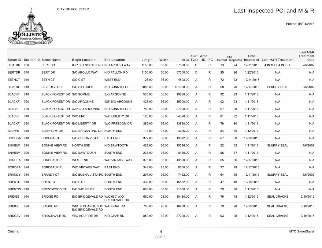
BERTDR 030 BERT DR 1150.00890' S/O NORTH END N/O APOLLO WAY 50.00 57500.00 R 74 12/11/2015 4 IN MILL 4 IN FILL 7/6/200273O
BERTDR 040 BERT DR 1150.00S/O APOLLO WAY N/O FALLON RD 50.00 57500.00 R 86 1/22/2016 N/A N/A85O
BETHCT 010 BETH CT 128.00S/O C ST WEST END 36.00 4608.00 R 73 12/14/2015 N/A N/A72A
BEVERL 010 BEVERLY DR 2808.00S/O HILLCREST N/O SUNNYSLOPE 36.00 101088.00 C 70 12/17/2015 SLURRY SEAL 6/6/200268A
BLACKF 010 BLACK FOREST DR 535.00S/O SOMME S/O ARGONNE 36.00 19260.00 R 93 1/11/2016 N/A N/A92A
BLACKF 020 BLACK FOREST DR 425.00S/O ARGONNE 425' S/O ARGONNE 36.00 15300.00 R 93 1/11/2016 N/A N/A92A
BLACKF 030 BLACK FOREST DR 750.00425' S/O ARGONNE N/O SUNNYSLOPE 36.00 27000.00 R 68 1/11/2016 N/A N/A67A
BLACKF 040 BLACK FOREST DR 120.00W/O END W/O LIBERTY DR 36.00 4320.00 R 82 1/11/2016 N/A N/A81A
BLACKF 050 BLACK FOREST DR 385.00E/O LIBERTY DR W/O FREEDOM DR 36.00 13860.00 R 80 1/11/2016 N/A N/A79A
BLENHI 010 BLENHIEM DR 115.00N/O BRIGANTINO DR NORTH END 37.00 4255.00 R 85 1/12/2016 N/A N/A84A
BODEGA 010 BODEGA CT 377.00E/O CERRA VISTA EAST END 36.00 13572.00 R 68 12/18/2015 N/A N/A67A
BNVIEW 010 BONNIE VIEW RD 426.00NORTH END N/O SAWTOOTH 36.00 15336.00 R 53 1/11/2016 SLURRY SEAL 6/6/200252A
BNVIEW 020 BONNIE VIEW RD 235.00S/O SAWTOOTH SOUTH END 36.00 8460.00 R 57 1/11/2016 N/A N/A56A
BORDEA 010 BORDEAUX PL 375.00WEST END W/O VINTAGE WAY 36.00 13500.00 R 66 12/17/2015 N/A N/A65A
BORDEA 020 BORDEAUX PL 348.00W/O VINTAGE WAY EAST END 25.00 8700.00 R 78 12/17/2015 N/A N/A77A
BRANDY 010 BRANDY CT 207.00S/O BUENA VISTA RD SOUTH END 36.00 7452.00 R 65 12/11/2015 SLURRY SEAL 6/5/200264A
BRENTC 010 BRENT CT 432.00S/O C ST SOUTH END 36.00 15552.00 R 48 12/15/2015 N/A N/A47A
BRENTW 010 BRENTWOOD CT 600.00E/O SADIES DR SOUTH END 36.00 21600.00 R 80 1/11/2016 N/A N/A79A
BRIDGE 010 BRIDGE RD 660.00E/O BRIDGEVALE RD W/C 660' W/OBRIDGEVALE RD
28.00 18480.00 R 78 1/12/2016 SEAL CRACKS 3/10/201679A
BRIDGE 020 BRIDGE RD 700.00WIDTH CHANGE 660'E/O BRIDGEVALE RD
W/O GRAF RD 26.00 18200.00 R 78 12/10/2015 SEAL CRACKS 3/10/201679A
BRDGEV 010 BRIDGEVALE RD 850.00W/O AGUIRRE DR N/O GRAF RD 32.00 27200.00 R 95 1/12/2016 SEAL CRACKS 3/10/201693A
Street IDPCI
Current InspectedEnd Location Width FC
Last Inspected PCI and M & R
Printed: 08/04/2016
CITY OF HOLLISTER
Section ID Begin Location Length AreaDate
Inspected Last M&R Treatment
Last M&RTreatment
DateStreet NameArea
IDSurfType
Criteria: 4SS1071
MTC StreetSaver
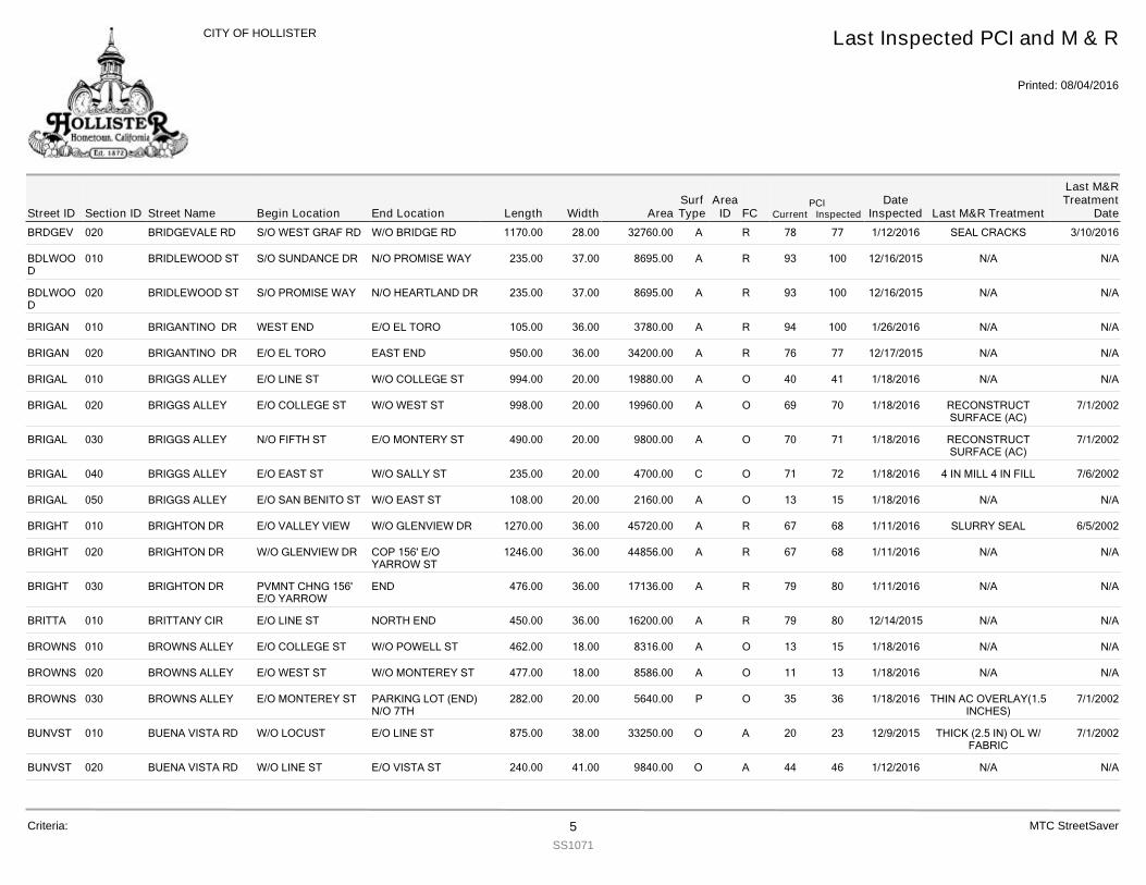
BRDGEV 020 BRIDGEVALE RD 1170.00S/O WEST GRAF RD W/O BRIDGE RD 28.00 32760.00 R 77 1/12/2016 SEAL CRACKS 3/10/201678A
BDLWOOD
010 BRIDLEWOOD ST 235.00S/O SUNDANCE DR N/O PROMISE WAY 37.00 8695.00 R 100 12/16/2015 N/A N/A93A
BDLWOOD
020 BRIDLEWOOD ST 235.00S/O PROMISE WAY N/O HEARTLAND DR 37.00 8695.00 R 100 12/16/2015 N/A N/A93A
BRIGAN 010 BRIGANTINO DR 105.00WEST END E/O EL TORO 36.00 3780.00 R 100 1/26/2016 N/A N/A94A
BRIGAN 020 BRIGANTINO DR 950.00E/O EL TORO EAST END 36.00 34200.00 R 77 12/17/2015 N/A N/A76A
BRIGAL 010 BRIGGS ALLEY 994.00E/O LINE ST W/O COLLEGE ST 20.00 19880.00 O 41 1/18/2016 N/A N/A40A
BRIGAL 020 BRIGGS ALLEY 998.00E/O COLLEGE ST W/O WEST ST 20.00 19960.00 O 70 1/18/2016 RECONSTRUCTSURFACE (AC)
7/1/200269A
BRIGAL 030 BRIGGS ALLEY 490.00N/O FIFTH ST E/O MONTERY ST 20.00 9800.00 O 71 1/18/2016 RECONSTRUCTSURFACE (AC)
7/1/200270A
BRIGAL 040 BRIGGS ALLEY 235.00E/O EAST ST W/O SALLY ST 20.00 4700.00 O 72 1/18/2016 4 IN MILL 4 IN FILL 7/6/200271C
BRIGAL 050 BRIGGS ALLEY 108.00E/O SAN BENITO ST W/O EAST ST 20.00 2160.00 O 15 1/18/2016 N/A N/A13A
BRIGHT 010 BRIGHTON DR 1270.00E/O VALLEY VIEW W/O GLENVIEW DR 36.00 45720.00 R 68 1/11/2016 SLURRY SEAL 6/5/200267A
BRIGHT 020 BRIGHTON DR 1246.00W/O GLENVIEW DR COP 156' E/OYARROW ST
36.00 44856.00 R 68 1/11/2016 N/A N/A67A
BRIGHT 030 BRIGHTON DR 476.00PVMNT CHNG 156'E/O YARROW
END 36.00 17136.00 R 80 1/11/2016 N/A N/A79A
BRITTA 010 BRITTANY CIR 450.00E/O LINE ST NORTH END 36.00 16200.00 R 80 12/14/2015 N/A N/A79A
BROWNS 010 BROWNS ALLEY 462.00E/O COLLEGE ST W/O POWELL ST 18.00 8316.00 O 15 1/18/2016 N/A N/A13A
BROWNS 020 BROWNS ALLEY 477.00E/O WEST ST W/O MONTEREY ST 18.00 8586.00 O 13 1/18/2016 N/A N/A11A
BROWNS 030 BROWNS ALLEY 282.00E/O MONTEREY ST PARKING LOT (END)N/O 7TH
20.00 5640.00 O 36 1/18/2016 THIN AC OVERLAY(1.5INCHES)
7/1/200235P
BUNVST 010 BUENA VISTA RD 875.00W/O LOCUST E/O LINE ST 38.00 33250.00 A 23 12/9/2015 THICK (2.5 IN) OL W/FABRIC
7/1/200220O
BUNVST 020 BUENA VISTA RD 240.00W/O LINE ST E/O VISTA ST 41.00 9840.00 A 46 1/12/2016 N/A N/A44O
Street IDPCI
Current InspectedEnd Location Width FC
Last Inspected PCI and M & R
Printed: 08/04/2016
CITY OF HOLLISTER
Section ID Begin Location Length AreaDate
Inspected Last M&R Treatment
Last M&RTreatment
DateStreet NameArea
IDSurfType
Criteria: 5SS1071
MTC StreetSaver
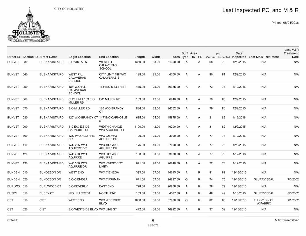
BUNVST 030 BUENA VISTA RD 1350.00E/O VISTA LN WEST P.L.CALAVERASSCHOOL
38.00 51300.00 A 70 12/9/2015 N/A N/A68A
BUNVST 040 BUENA VISTA RD 188.00WEST P.L.CALAVERASSCHOOL
CITY LIMIT 188 W/OCALAVERAS S
25.00 4700.00 A 81 12/9/2015 N/A N/A80A
BUNVST 050 BUENA VISTA RD 415.00188' W/O P.L.CALAVERASSCHOOL
163' E/O MILLER ST 25.00 10375.00 A 74 1/12/2016 N/A N/A73A
BUNVST 060 BUENA VISTA RD 163.00CITY LIMIT 163 E/OMILLER RD
E/O MILLER RD 42.00 6846.00 A 80 12/9/2015 N/A N/A79A
BUNVST 070 BUENA VISTA RD 836.00E/O MILLER RD 120 W/O BRANDYCT
32.00 26752.00 A 80 12/9/2015 N/A N/A79A
BUNVST 080 BUENA VISTA RD 635.00120' W/O BRANDY CT 117' E/O CARNOBLEST
25.00 15875.00 A 82 1/12/2016 N/A N/A81A
BUNVST 090 BUENA VISTA RD 1100.00117 E/O E.SIDECARNOBLE DR
WIDTH CHANGEW/O AGUIRRE DR
42.00 46200.00 A 82 12/9/2015 N/A N/A81A
BUNVST 100 BUENA VISTA RD 120.00W/C W/O AGUIRREDR
W/C 225 W/OAGUIRRE DR
25.00 3000.00 A 78 1/12/2016 N/A N/A77A
BUNVST 110 BUENA VISTA RD 175.00W/C 225' W/OAGUIRRE DR
W/C 400' W/OAGUIRRE DR
40.00 7000.00 A 78 12/9/2015 N/A N/A77A
BUNVST 120 BUENA VISTA RD 100.00W/C 400' W/OAGUIRRE
W/C 500' W/OAGUIRRE
30.00 3000.00 A 78 1/12/2016 N/A N/A77A
BUNVST 130 BUENA VISTA RD 671.00W/C 500' W/OAGUIRRE DR
W/C (WEST CITYLIMIT)
40.00 26840.00 A 73 1/12/2016 N/A N/A72A
BUNDSN 010 BUNDESON DR 395.00WEST END W/O CIENEGA 37.00 14615.00 R 82 12/16/2015 N/A N/A81A
BUNDSN 020 BUNDESON DR 671.00E/O CIENEGA W/O CUSHMAN 37.00 24827.00 R 75 12/16/2015 SLURRY SEAL 7/6/200274O
BURLWD 010 BURLWOOD CT 728.00E/O BEVERLY EAST END 36.00 26208.00 R 79 12/18/2015 N/A N/A78A
BUSBY 010 BUSBY CT 139.00N/O HILLCREST NORTH END 33.00 4587.00 R 49 1/18/2016 SLURRY SEAL 6/6/200248A
CST 010 C ST 1050.00WEST END W/O WESTSIDEBLVD
36.00 37800.00 R 83 12/15/2015 THIN (2 IN) OLW/FABRIC
7/1/200282O
CST 020 C ST 472.00E/O WESTSIDE BLVD W/O LINE ST 36.00 16992.00 R 39 12/15/2015 N/A N/A37A
Street IDPCI
Current InspectedEnd Location Width FC
Last Inspected PCI and M & R
Printed: 08/04/2016
CITY OF HOLLISTER
Section ID Begin Location Length AreaDate
Inspected Last M&R Treatment
Last M&RTreatment
DateStreet NameArea
IDSurfType
Criteria: 6SS1071
MTC StreetSaver
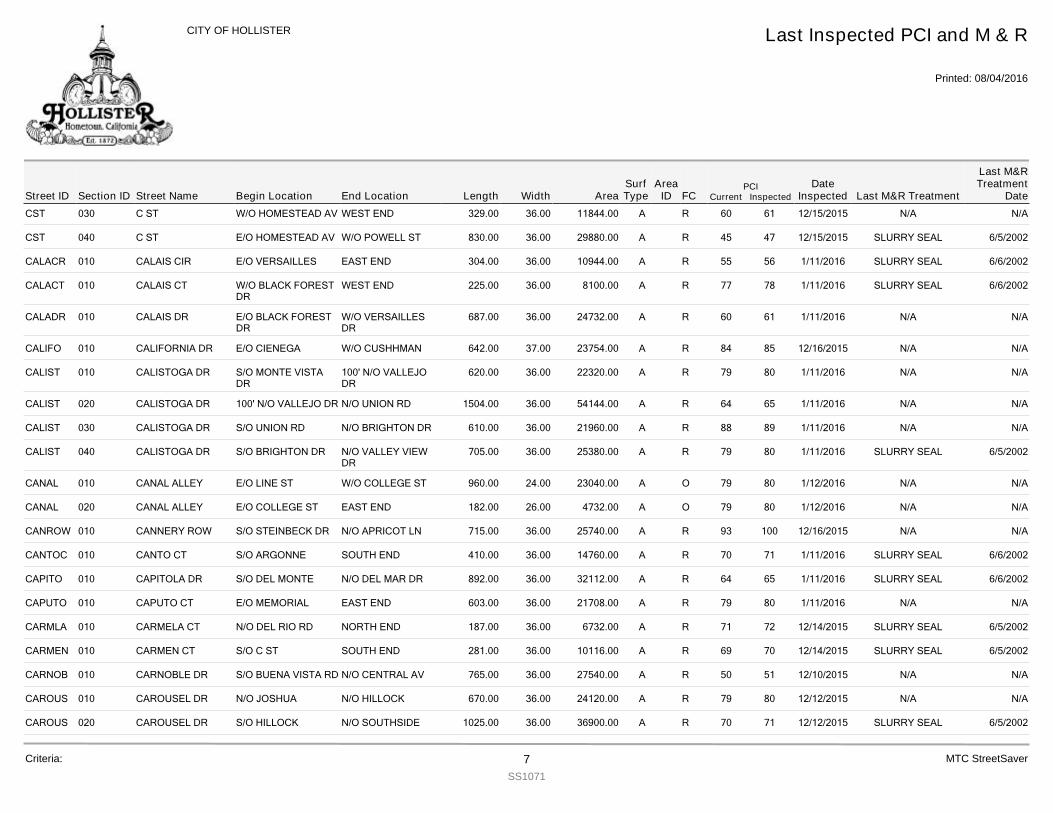
CST 030 C ST 329.00W/O HOMESTEAD AV WEST END 36.00 11844.00 R 61 12/15/2015 N/A N/A60A
CST 040 C ST 830.00E/O HOMESTEAD AV W/O POWELL ST 36.00 29880.00 R 47 12/15/2015 SLURRY SEAL 6/5/200245A
CALACR 010 CALAIS CIR 304.00E/O VERSAILLES EAST END 36.00 10944.00 R 56 1/11/2016 SLURRY SEAL 6/6/200255A
CALACT 010 CALAIS CT 225.00W/O BLACK FORESTDR
WEST END 36.00 8100.00 R 78 1/11/2016 SLURRY SEAL 6/6/200277A
CALADR 010 CALAIS DR 687.00E/O BLACK FORESTDR
W/O VERSAILLESDR
36.00 24732.00 R 61 1/11/2016 N/A N/A60A
CALIFO 010 CALIFORNIA DR 642.00E/O CIENEGA W/O CUSHHMAN 37.00 23754.00 R 85 12/16/2015 N/A N/A84A
CALIST 010 CALISTOGA DR 620.00S/O MONTE VISTADR
100' N/O VALLEJODR
36.00 22320.00 R 80 1/11/2016 N/A N/A79A
CALIST 020 CALISTOGA DR 1504.00100' N/O VALLEJO DR N/O UNION RD 36.00 54144.00 R 65 1/11/2016 N/A N/A64A
CALIST 030 CALISTOGA DR 610.00S/O UNION RD N/O BRIGHTON DR 36.00 21960.00 R 89 1/11/2016 N/A N/A88A
CALIST 040 CALISTOGA DR 705.00S/O BRIGHTON DR N/O VALLEY VIEWDR
36.00 25380.00 R 80 1/11/2016 SLURRY SEAL 6/5/200279A
CANAL 010 CANAL ALLEY 960.00E/O LINE ST W/O COLLEGE ST 24.00 23040.00 O 80 1/12/2016 N/A N/A79A
CANAL 020 CANAL ALLEY 182.00E/O COLLEGE ST EAST END 26.00 4732.00 O 80 1/12/2016 N/A N/A79A
CANROW 010 CANNERY ROW 715.00S/O STEINBECK DR N/O APRICOT LN 36.00 25740.00 R 100 12/16/2015 N/A N/A93A
CANTOC 010 CANTO CT 410.00S/O ARGONNE SOUTH END 36.00 14760.00 R 71 1/11/2016 SLURRY SEAL 6/6/200270A
CAPITO 010 CAPITOLA DR 892.00S/O DEL MONTE N/O DEL MAR DR 36.00 32112.00 R 65 1/11/2016 SLURRY SEAL 6/6/200264A
CAPUTO 010 CAPUTO CT 603.00E/O MEMORIAL EAST END 36.00 21708.00 R 80 1/11/2016 N/A N/A79A
CARMLA 010 CARMELA CT 187.00N/O DEL RIO RD NORTH END 36.00 6732.00 R 72 12/14/2015 SLURRY SEAL 6/5/200271A
CARMEN 010 CARMEN CT 281.00S/O C ST SOUTH END 36.00 10116.00 R 70 12/14/2015 SLURRY SEAL 6/5/200269A
CARNOB 010 CARNOBLE DR 765.00S/O BUENA VISTA RD N/O CENTRAL AV 36.00 27540.00 R 51 12/10/2015 N/A N/A50A
CAROUS 010 CAROUSEL DR 670.00N/O JOSHUA N/O HILLOCK 36.00 24120.00 R 80 12/12/2015 N/A N/A79A
CAROUS 020 CAROUSEL DR 1025.00S/O HILLOCK N/O SOUTHSIDE 36.00 36900.00 R 71 12/12/2015 SLURRY SEAL 6/5/200270A
Street IDPCI
Current InspectedEnd Location Width FC
Last Inspected PCI and M & R
Printed: 08/04/2016
CITY OF HOLLISTER
Section ID Begin Location Length AreaDate
Inspected Last M&R Treatment
Last M&RTreatment
DateStreet NameArea
IDSurfType
Criteria: 7SS1071
MTC StreetSaver
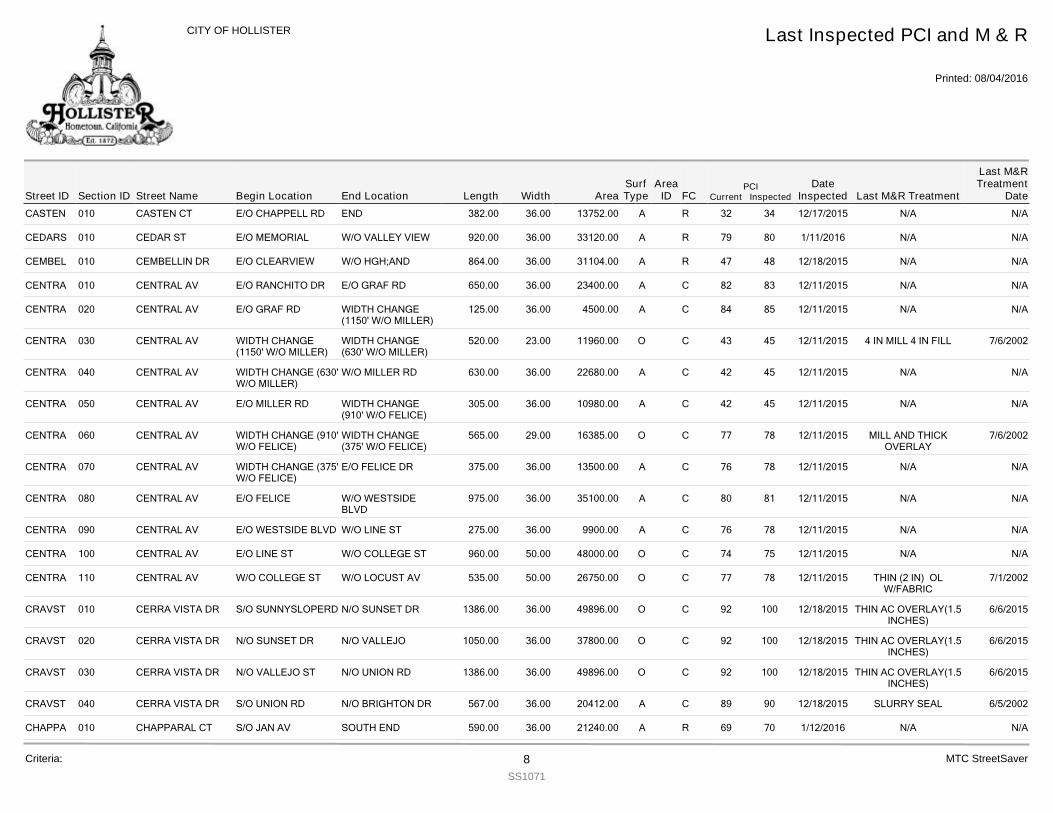
CASTEN 010 CASTEN CT 382.00E/O CHAPPELL RD END 36.00 13752.00 R 34 12/17/2015 N/A N/A32A
CEDARS 010 CEDAR ST 920.00E/O MEMORIAL W/O VALLEY VIEW 36.00 33120.00 R 80 1/11/2016 N/A N/A79A
CEMBEL 010 CEMBELLIN DR 864.00E/O CLEARVIEW W/O HGH;AND 36.00 31104.00 R 48 12/18/2015 N/A N/A47A
CENTRA 010 CENTRAL AV 650.00E/O RANCHITO DR E/O GRAF RD 36.00 23400.00 C 83 12/11/2015 N/A N/A82A
CENTRA 020 CENTRAL AV 125.00E/O GRAF RD WIDTH CHANGE(1150' W/O MILLER)
36.00 4500.00 C 85 12/11/2015 N/A N/A84A
CENTRA 030 CENTRAL AV 520.00WIDTH CHANGE(1150' W/O MILLER)
WIDTH CHANGE(630' W/O MILLER)
23.00 11960.00 C 45 12/11/2015 4 IN MILL 4 IN FILL 7/6/200243O
CENTRA 040 CENTRAL AV 630.00WIDTH CHANGE (630'W/O MILLER)
W/O MILLER RD 36.00 22680.00 C 45 12/11/2015 N/A N/A42A
CENTRA 050 CENTRAL AV 305.00E/O MILLER RD WIDTH CHANGE(910' W/O FELICE)
36.00 10980.00 C 45 12/11/2015 N/A N/A42A
CENTRA 060 CENTRAL AV 565.00WIDTH CHANGE (910'W/O FELICE)
WIDTH CHANGE(375' W/O FELICE)
29.00 16385.00 C 78 12/11/2015 MILL AND THICKOVERLAY
7/6/200277O
CENTRA 070 CENTRAL AV 375.00WIDTH CHANGE (375'W/O FELICE)
E/O FELICE DR 36.00 13500.00 C 78 12/11/2015 N/A N/A76A
CENTRA 080 CENTRAL AV 975.00E/O FELICE W/O WESTSIDEBLVD
36.00 35100.00 C 81 12/11/2015 N/A N/A80A
CENTRA 090 CENTRAL AV 275.00E/O WESTSIDE BLVD W/O LINE ST 36.00 9900.00 C 78 12/11/2015 N/A N/A76A
CENTRA 100 CENTRAL AV 960.00E/O LINE ST W/O COLLEGE ST 50.00 48000.00 C 75 12/11/2015 N/A N/A74O
CENTRA 110 CENTRAL AV 535.00W/O COLLEGE ST W/O LOCUST AV 50.00 26750.00 C 78 12/11/2015 THIN (2 IN) OLW/FABRIC
7/1/200277O
CRAVST 010 CERRA VISTA DR 1386.00S/O SUNNYSLOPERD N/O SUNSET DR 36.00 49896.00 C 100 12/18/2015 THIN AC OVERLAY(1.5INCHES)
6/6/201592O
CRAVST 020 CERRA VISTA DR 1050.00N/O SUNSET DR N/O VALLEJO 36.00 37800.00 C 100 12/18/2015 THIN AC OVERLAY(1.5INCHES)
6/6/201592O
CRAVST 030 CERRA VISTA DR 1386.00N/O VALLEJO ST N/O UNION RD 36.00 49896.00 C 100 12/18/2015 THIN AC OVERLAY(1.5INCHES)
6/6/201592O
CRAVST 040 CERRA VISTA DR 567.00S/O UNION RD N/O BRIGHTON DR 36.00 20412.00 C 90 12/18/2015 SLURRY SEAL 6/5/200289A
CHAPPA 010 CHAPPARAL CT 590.00S/O JAN AV SOUTH END 36.00 21240.00 R 70 1/12/2016 N/A N/A69A
Street IDPCI
Current InspectedEnd Location Width FC
Last Inspected PCI and M & R
Printed: 08/04/2016
CITY OF HOLLISTER
Section ID Begin Location Length AreaDate
Inspected Last M&R Treatment
Last M&RTreatment
DateStreet NameArea
IDSurfType
Criteria: 8SS1071
MTC StreetSaver
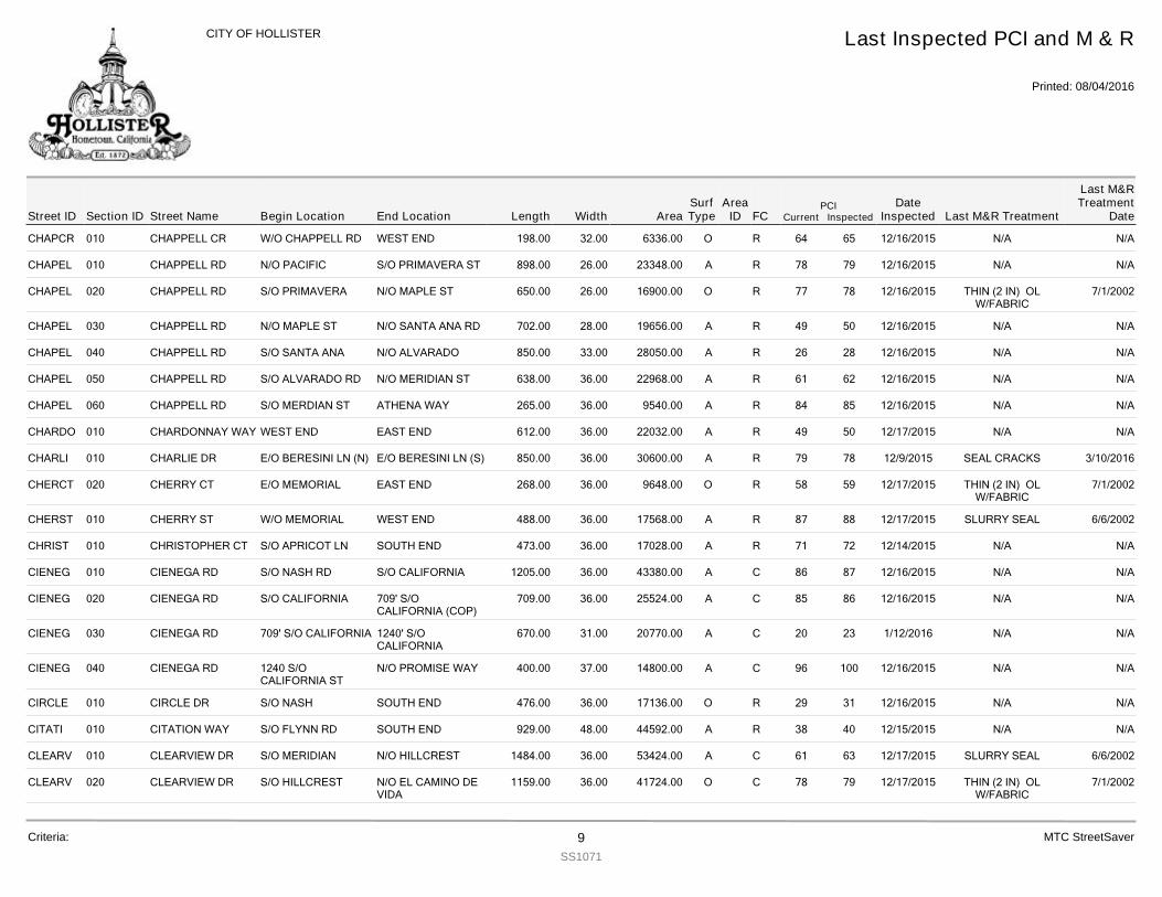
CHAPCR 010 CHAPPELL CR 198.00W/O CHAPPELL RD WEST END 32.00 6336.00 R 65 12/16/2015 N/A N/A64O
CHAPEL 010 CHAPPELL RD 898.00N/O PACIFIC S/O PRIMAVERA ST 26.00 23348.00 R 79 12/16/2015 N/A N/A78A
CHAPEL 020 CHAPPELL RD 650.00S/O PRIMAVERA N/O MAPLE ST 26.00 16900.00 R 78 12/16/2015 THIN (2 IN) OLW/FABRIC
7/1/200277O
CHAPEL 030 CHAPPELL RD 702.00N/O MAPLE ST N/O SANTA ANA RD 28.00 19656.00 R 50 12/16/2015 N/A N/A49A
CHAPEL 040 CHAPPELL RD 850.00S/O SANTA ANA N/O ALVARADO 33.00 28050.00 R 28 12/16/2015 N/A N/A26A
CHAPEL 050 CHAPPELL RD 638.00S/O ALVARADO RD N/O MERIDIAN ST 36.00 22968.00 R 62 12/16/2015 N/A N/A61A
CHAPEL 060 CHAPPELL RD 265.00S/O MERDIAN ST ATHENA WAY 36.00 9540.00 R 85 12/16/2015 N/A N/A84A
CHARDO 010 CHARDONNAY WAY 612.00WEST END EAST END 36.00 22032.00 R 50 12/17/2015 N/A N/A49A
CHARLI 010 CHARLIE DR 850.00E/O BERESINI LN (N) E/O BERESINI LN (S) 36.00 30600.00 R 78 12/9/2015 SEAL CRACKS 3/10/201679A
CHERCT 020 CHERRY CT 268.00E/O MEMORIAL EAST END 36.00 9648.00 R 59 12/17/2015 THIN (2 IN) OLW/FABRIC
7/1/200258O
CHERST 010 CHERRY ST 488.00W/O MEMORIAL WEST END 36.00 17568.00 R 88 12/17/2015 SLURRY SEAL 6/6/200287A
CHRIST 010 CHRISTOPHER CT 473.00S/O APRICOT LN SOUTH END 36.00 17028.00 R 72 12/14/2015 N/A N/A71A
CIENEG 010 CIENEGA RD 1205.00S/O NASH RD S/O CALIFORNIA 36.00 43380.00 C 87 12/16/2015 N/A N/A86A
CIENEG 020 CIENEGA RD 709.00S/O CALIFORNIA 709' S/OCALIFORNIA (COP)
36.00 25524.00 C 86 12/16/2015 N/A N/A85A
CIENEG 030 CIENEGA RD 670.00709' S/O CALIFORNIA 1240' S/OCALIFORNIA
31.00 20770.00 C 23 1/12/2016 N/A N/A20A
CIENEG 040 CIENEGA RD 400.001240 S/OCALIFORNIA ST
N/O PROMISE WAY 37.00 14800.00 C 100 12/16/2015 N/A N/A96A
CIRCLE 010 CIRCLE DR 476.00S/O NASH SOUTH END 36.00 17136.00 R 31 12/16/2015 N/A N/A29O
CITATI 010 CITATION WAY 929.00S/O FLYNN RD SOUTH END 48.00 44592.00 R 40 12/15/2015 N/A N/A38A
CLEARV 010 CLEARVIEW DR 1484.00S/O MERIDIAN N/O HILLCREST 36.00 53424.00 C 63 12/17/2015 SLURRY SEAL 6/6/200261A
CLEARV 020 CLEARVIEW DR 1159.00S/O HILLCREST N/O EL CAMINO DEVIDA
36.00 41724.00 C 79 12/17/2015 THIN (2 IN) OLW/FABRIC
7/1/200278O
Street IDPCI
Current InspectedEnd Location Width FC
Last Inspected PCI and M & R
Printed: 08/04/2016
CITY OF HOLLISTER
Section ID Begin Location Length AreaDate
Inspected Last M&R Treatment
Last M&RTreatment
DateStreet NameArea
IDSurfType
Criteria: 9SS1071
MTC StreetSaver
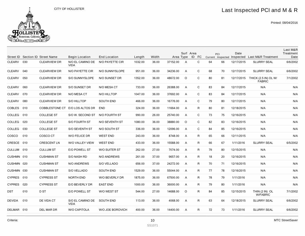
CLEARV 030 CLEARVIEW DR 1032.00N/O EL CAMINO DEVIDA
N/O PAYETTE CIR 36.00 37152.00 C 66 12/17/2015 SLURRY SEAL 6/6/200264A
CLEARV 040 CLEARVIEW DR 951.00N/O PAYETTE CIR N/O SUNNYSLOPE 36.00 34236.00 C 70 12/17/2015 SLURRY SEAL 6/6/200268A
CLEARV 050 CLEARVIEW DR 1352.00S/O SUNNYSLOPE N/O SUNSET DR 36.00 48672.00 C 81 12/17/2015 THICK (2.5 IN) OL W/FABRIC
7/1/200280O
CLEARV 060 CLEARVIEW DR 733.00S/O SUNSET DR N/O MESA CT 36.00 26388.00 C 84 12/17/2015 N/A N/A83A
CLEARV 070 CLEARVIEW DR 1047.00N/O MESA CT N/O HILLTOP 36.00 37692.00 C 84 12/17/2015 N/A N/A83A
CLEARV 080 CLEARVIEW DR 466.00S/O HILLTOP SOUTH END 36.00 16776.00 C 80 12/17/2015 N/A N/A79A
COBLES 010 COBBLESTONE CT 324.00E/O LOS ALTOS DR END 36.00 11664.00 R 81 12/18/2015 N/A N/A80A
COLLEG 010 COLLEGE ST 990.00S/O W. SECOND ST N/O FOURTH ST 26.00 25740.00 C 75 12/16/2015 N/A N/A73A
COLLEG 020 COLLEGE ST 1080.00S/O FOURTH ST N/O SEVENTH ST 36.00 38880.00 C 83 12/16/2015 N/A N/A82O
COLLEG 030 COLLEGE ST 336.00S/O SEVENTH ST N/O SOUTH ST 36.00 12096.00 C 85 12/16/2015 N/A N/A84A
COSCO 010 COSCO CT 243.00W/O FELICE DR WEST END 36.00 8748.00 R 66 12/11/2015 N/A N/A65A
CRESCE 010 CRESCENT LN 433.00W/O VALLEY VIEW WEST END 36.00 15588.00 R 67 1/11/2016 SLURRY SEAL 6/5/200266A
CULLUM 010 CULLUM ST 262.00E/O POWELL ST W/O SUITER ST 27.00 7074.00 R 80 12/15/2015 N/A N/A79A
CUSHMN 010 CUSHMAN ST 261.00S/O NASH RD N/O ANDREWS 37.00 9657.00 R 20 12/16/2015 N/A N/A18A
CUSHMN 020 CUSHMAN ST 656.00N/O ANDREWS S/O VELLADO 37.00 24272.00 R 71 12/16/2015 N/A N/A70A
CUSHMN 030 CUSHMAN ST 1529.00S/O VELLADO SOUTH END 36.00 55044.00 R 78 12/16/2015 N/A N/A77A
CYPRES 010 CYPRESS ST 1875.00NORTH END W/O BEVERLY DR 36.00 67500.00 R 79 1/11/2016 N/A N/A78A
CYPRES 020 CYPRESS ST 1000.00E/O BEVERLY DR EAST END 36.00 36000.00 R 80 1/11/2016 N/A N/A79A
DST 010 D ST 544.00E/O POWELL ST W/O WEST ST 27.00 14688.00 R 85 12/15/2015 THIN (2 IN) OLW/FABRIC
7/1/200284O
DEVIDA 010 DE VIDA CT 113.00S/O EL CAMINO DEVIDA
SOUTH END 36.00 4068.00 R 64 12/18/2015 SLURRY SEAL 6/6/200263A
DELMAR 010 DEL MAR DR 400.00W/O CAPITOLA W/O JOE BOROVICH 36.00 14400.00 R 73 1/11/2016 SLURRY SEAL 6/6/200272A
Street IDPCI
Current InspectedEnd Location Width FC
Last Inspected PCI and M & R
Printed: 08/04/2016
CITY OF HOLLISTER
Section ID Begin Location Length AreaDate
Inspected Last M&R Treatment
Last M&RTreatment
DateStreet NameArea
IDSurfType
Criteria: 10SS1071
MTC StreetSaver
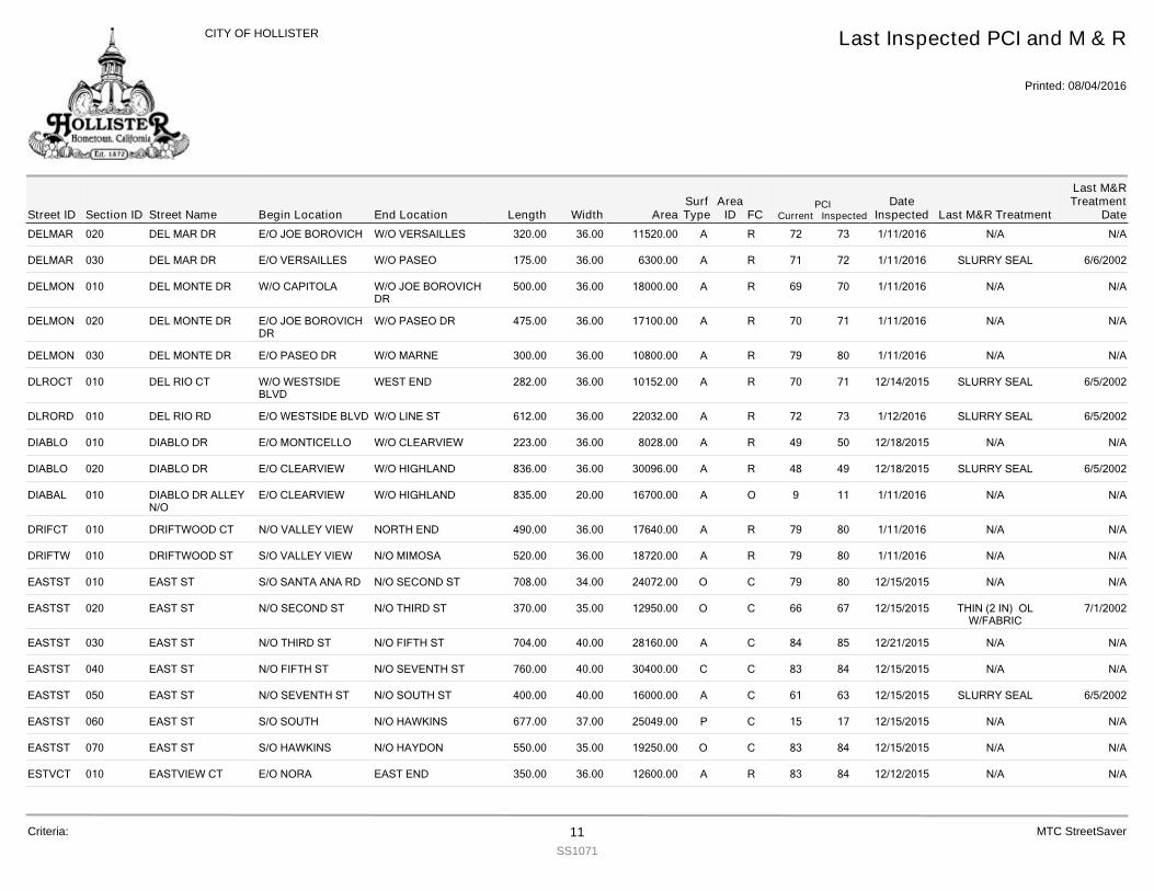
DELMAR 020 DEL MAR DR 320.00E/O JOE BOROVICH W/O VERSAILLES 36.00 11520.00 R 73 1/11/2016 N/A N/A72A
DELMAR 030 DEL MAR DR 175.00E/O VERSAILLES W/O PASEO 36.00 6300.00 R 72 1/11/2016 SLURRY SEAL 6/6/200271A
DELMON 010 DEL MONTE DR 500.00W/O CAPITOLA W/O JOE BOROVICHDR
36.00 18000.00 R 70 1/11/2016 N/A N/A69A
DELMON 020 DEL MONTE DR 475.00E/O JOE BOROVICHDR
W/O PASEO DR 36.00 17100.00 R 71 1/11/2016 N/A N/A70A
DELMON 030 DEL MONTE DR 300.00E/O PASEO DR W/O MARNE 36.00 10800.00 R 80 1/11/2016 N/A N/A79A
DLROCT 010 DEL RIO CT 282.00W/O WESTSIDEBLVD
WEST END 36.00 10152.00 R 71 12/14/2015 SLURRY SEAL 6/5/200270A
DLRORD 010 DEL RIO RD 612.00E/O WESTSIDE BLVD W/O LINE ST 36.00 22032.00 R 73 1/12/2016 SLURRY SEAL 6/5/200272A
DIABLO 010 DIABLO DR 223.00E/O MONTICELLO W/O CLEARVIEW 36.00 8028.00 R 50 12/18/2015 N/A N/A49A
DIABLO 020 DIABLO DR 836.00E/O CLEARVIEW W/O HIGHLAND 36.00 30096.00 R 49 12/18/2015 SLURRY SEAL 6/5/200248A
DIABAL 010 DIABLO DR ALLEYN/O
835.00E/O CLEARVIEW W/O HIGHLAND 20.00 16700.00 O 11 1/11/2016 N/A N/A9A
DRIFCT 010 DRIFTWOOD CT 490.00N/O VALLEY VIEW NORTH END 36.00 17640.00 R 80 1/11/2016 N/A N/A79A
DRIFTW 010 DRIFTWOOD ST 520.00S/O VALLEY VIEW N/O MIMOSA 36.00 18720.00 R 80 1/11/2016 N/A N/A79A
EASTST 010 EAST ST 708.00S/O SANTA ANA RD N/O SECOND ST 34.00 24072.00 C 80 12/15/2015 N/A N/A79O
EASTST 020 EAST ST 370.00N/O SECOND ST N/O THIRD ST 35.00 12950.00 C 67 12/15/2015 THIN (2 IN) OLW/FABRIC
7/1/200266O
EASTST 030 EAST ST 704.00N/O THIRD ST N/O FIFTH ST 40.00 28160.00 C 85 12/21/2015 N/A N/A84A
EASTST 040 EAST ST 760.00N/O FIFTH ST N/O SEVENTH ST 40.00 30400.00 C 84 12/15/2015 N/A N/A83C
EASTST 050 EAST ST 400.00N/O SEVENTH ST N/O SOUTH ST 40.00 16000.00 C 63 12/15/2015 SLURRY SEAL 6/5/200261A
EASTST 060 EAST ST 677.00S/O SOUTH N/O HAWKINS 37.00 25049.00 C 17 12/15/2015 N/A N/A15P
EASTST 070 EAST ST 550.00S/O HAWKINS N/O HAYDON 35.00 19250.00 C 84 12/15/2015 N/A N/A83O
ESTVCT 010 EASTVIEW CT 350.00E/O NORA EAST END 36.00 12600.00 R 84 12/12/2015 N/A N/A83A
Street IDPCI
Current InspectedEnd Location Width FC
Last Inspected PCI and M & R
Printed: 08/04/2016
CITY OF HOLLISTER
Section ID Begin Location Length AreaDate
Inspected Last M&R Treatment
Last M&RTreatment
DateStreet NameArea
IDSurfType
Criteria: 11SS1071
MTC StreetSaver
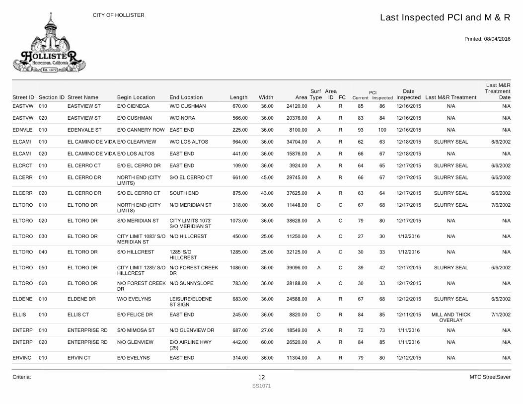
EASTVW 010 EASTVIEW ST 670.00E/O CIENEGA W/O CUSHMAN 36.00 24120.00 R 86 12/16/2015 N/A N/A85A
EASTVW 020 EASTVIEW ST 566.00E/O CUSHMAN W/O NORA 36.00 20376.00 R 84 12/16/2015 N/A N/A83A
EDNVLE 010 EDENVALE ST 225.00E/O CANNERY ROW EAST END 36.00 8100.00 R 100 12/16/2015 N/A N/A93A
ELCAMI 010 EL CAMINO DE VIDA 964.00E/O CLEARVIEW W/O LOS ALTOS 36.00 34704.00 R 63 12/18/2015 SLURRY SEAL 6/6/200262A
ELCAMI 020 EL CAMINO DE VIDA 441.00E/O LOS ALTOS EAST END 36.00 15876.00 R 67 12/18/2015 N/A N/A66A
ELCRCT 010 EL CERRO CT 109.00E/O EL CERRO DR EAST END 36.00 3924.00 R 65 12/17/2015 SLURRY SEAL 6/6/200264A
ELCERR 010 EL CERRO DR 661.00NORTH END (CITYLIMITS)
S/O EL CERRO CT 45.00 29745.00 R 67 12/17/2015 SLURRY SEAL 6/6/200266A
ELCERR 020 EL CERRO DR 875.00S/O EL CERRO CT SOUTH END 43.00 37625.00 R 64 12/17/2015 SLURRY SEAL 6/6/200263A
ELTORO 010 EL TORO DR 318.00NORTH END (CITYLIMITS)
N/O MERIDIAN ST 36.00 11448.00 C 68 12/17/2015 SLURRY SEAL 7/6/200267O
ELTORO 020 EL TORO DR 1073.00S/O MERIDIAN ST CITY LIMITS 1073'S/O MERIDIAN ST
36.00 38628.00 C 80 12/17/2015 N/A N/A79A
ELTORO 030 EL TORO DR 450.00CITY LIMIT 1083' S/OMERIDIAN ST
N/O HILLCREST 25.00 11250.00 C 30 1/12/2016 N/A N/A27A
ELTORO 040 EL TORO DR 1285.00S/O HILLCREST 1285' S/OHILLCREST
25.00 32125.00 C 33 1/12/2016 N/A N/A30A
ELTORO 050 EL TORO DR 1086.00CITY LIMIT 1285' S/OHILLCREST
N/O FOREST CREEKDR
36.00 39096.00 C 42 12/17/2015 SLURRY SEAL 6/6/200239A
ELTORO 060 EL TORO DR 783.00N/O FOREST CREEKDR
N/O SUNNYSLOPE 36.00 28188.00 C 33 12/17/2015 N/A N/A30A
ELDENE 010 ELDENE DR 683.00W/O EVELYNS LEISURE/ELDENEST SIGN
36.00 24588.00 R 68 12/12/2015 SLURRY SEAL 6/5/200267A
ELLIS 010 ELLIS CT 245.00E/O FELICE DR EAST END 36.00 8820.00 R 85 12/11/2015 MILL AND THICKOVERLAY
7/1/200284O
ENTERP 010 ENTERPRISE RD 687.00S/O MIMOSA ST N/O GLENVIEW DR 27.00 18549.00 R 73 1/11/2016 N/A N/A72A
ENTERP 020 ENTERPRISE RD 442.00N/O GLENVIEW E/O AIRLINE HWY(25)
60.00 26520.00 R 85 1/11/2016 N/A N/A84A
ERVINC 010 ERVIN CT 314.00E/O EVELYNS EAST END 36.00 11304.00 R 80 12/12/2015 N/A N/A79A
Street IDPCI
Current InspectedEnd Location Width FC
Last Inspected PCI and M & R
Printed: 08/04/2016
CITY OF HOLLISTER
Section ID Begin Location Length AreaDate
Inspected Last M&R Treatment
Last M&RTreatment
DateStreet NameArea
IDSurfType
Criteria: 12SS1071
MTC StreetSaver
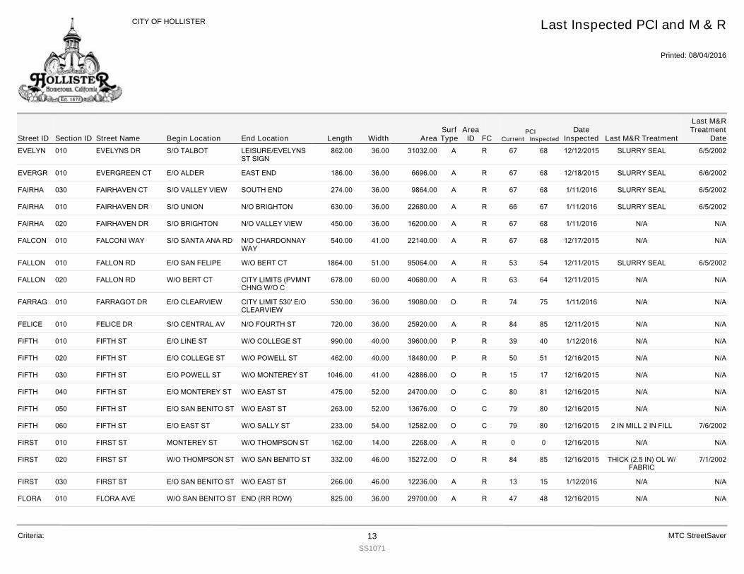
EVELYN 010 EVELYNS DR 862.00S/O TALBOT LEISURE/EVELYNSST SIGN
36.00 31032.00 R 68 12/12/2015 SLURRY SEAL 6/5/200267A
EVERGR 010 EVERGREEN CT 186.00E/O ALDER EAST END 36.00 6696.00 R 68 12/18/2015 SLURRY SEAL 6/6/200267A
FAIRHA 030 FAIRHAVEN CT 274.00S/O VALLEY VIEW SOUTH END 36.00 9864.00 R 68 1/11/2016 SLURRY SEAL 6/5/200267A
FAIRHA 010 FAIRHAVEN DR 630.00S/O UNION N/O BRIGHTON 36.00 22680.00 R 67 1/11/2016 SLURRY SEAL 6/5/200266A
FAIRHA 020 FAIRHAVEN DR 450.00S/O BRIGHTON N/O VALLEY VIEW 36.00 16200.00 R 68 1/11/2016 N/A N/A67A
FALCON 010 FALCONI WAY 540.00S/O SANTA ANA RD N/O CHARDONNAYWAY
41.00 22140.00 R 68 12/17/2015 N/A N/A67A
FALLON 010 FALLON RD 1864.00E/O SAN FELIPE W/O BERT CT 51.00 95064.00 R 54 12/11/2015 SLURRY SEAL 6/5/200253A
FALLON 020 FALLON RD 678.00W/O BERT CT CITY LIMITS (PVMNTCHNG W/O C
60.00 40680.00 R 64 12/11/2015 N/A N/A63A
FARRAG 010 FARRAGOT DR 530.00E/O CLEARVIEW CITY LIMIT 530' E/OCLEARVIEW
36.00 19080.00 R 75 1/11/2016 N/A N/A74O
FELICE 010 FELICE DR 720.00S/O CENTRAL AV N/O FOURTH ST 36.00 25920.00 R 85 12/11/2015 N/A N/A84A
FIFTH 010 FIFTH ST 990.00E/O LINE ST W/O COLLEGE ST 40.00 39600.00 R 40 1/12/2016 N/A N/A39P
FIFTH 020 FIFTH ST 462.00E/O COLLEGE ST W/O POWELL ST 40.00 18480.00 R 51 12/16/2015 N/A N/A50P
FIFTH 030 FIFTH ST 1046.00E/O POWELL ST W/O MONTEREY ST 41.00 42886.00 R 17 12/16/2015 N/A N/A15O
FIFTH 040 FIFTH ST 475.00E/O MONTEREY ST W/O EAST ST 52.00 24700.00 C 81 12/16/2015 N/A N/A80O
FIFTH 050 FIFTH ST 263.00E/O SAN BENITO ST W/O EAST ST 52.00 13676.00 C 80 12/16/2015 N/A N/A79O
FIFTH 060 FIFTH ST 233.00E/O EAST ST W/O SALLY ST 54.00 12582.00 C 80 12/16/2015 2 IN MILL 2 IN FILL 7/6/200279O
FIRST 010 FIRST ST 162.00MONTEREY ST W/O THOMPSON ST 14.00 2268.00 R 0 12/16/2015 N/A N/A0A
FIRST 020 FIRST ST 332.00W/O THOMPSON ST W/O SAN BENITO ST 46.00 15272.00 R 85 12/16/2015 THICK (2.5 IN) OL W/FABRIC
7/1/200284O
FIRST 030 FIRST ST 266.00E/O SAN BENITO ST W/O EAST ST 46.00 12236.00 R 15 1/12/2016 N/A N/A13A
FLORA 010 FLORA AVE 825.00W/O SAN BENITO ST END (RR ROW) 36.00 29700.00 R 48 12/16/2015 N/A N/A47A
Street IDPCI
Current InspectedEnd Location Width FC
Last Inspected PCI and M & R
Printed: 08/04/2016
CITY OF HOLLISTER
Section ID Begin Location Length AreaDate
Inspected Last M&R Treatment
Last M&RTreatment
DateStreet NameArea
IDSurfType
Criteria: 13SS1071
MTC StreetSaver
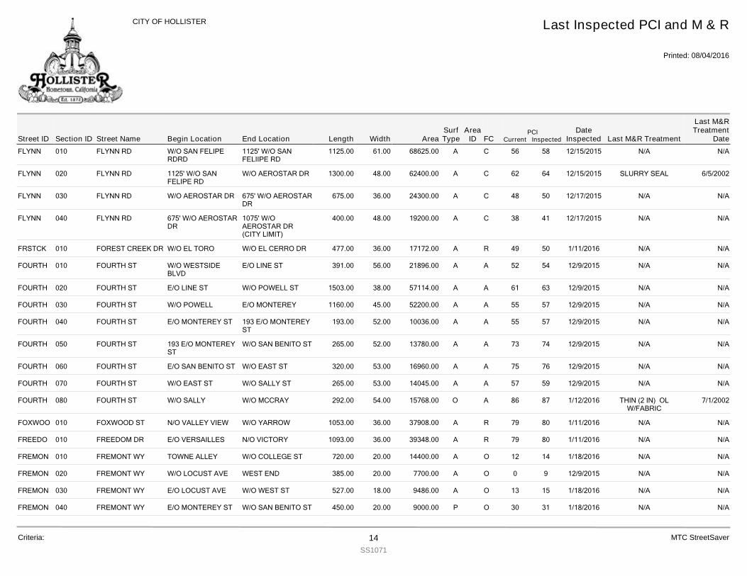
FLYNN 010 FLYNN RD 1125.00W/O SAN FELIPERDRD
1125' W/O SANFELIIPE RD
61.00 68625.00 C 58 12/15/2015 N/A N/A56A
FLYNN 020 FLYNN RD 1300.001125' W/O SANFELIPE RD
W/O AEROSTAR DR 48.00 62400.00 C 64 12/15/2015 SLURRY SEAL 6/5/200262A
FLYNN 030 FLYNN RD 675.00W/O AEROSTAR DR 675' W/O AEROSTARDR
36.00 24300.00 C 50 12/17/2015 N/A N/A48A
FLYNN 040 FLYNN RD 400.00675' W/O AEROSTARDR
1075' W/OAEROSTAR DR(CITY LIMIT)
48.00 19200.00 C 41 12/17/2015 N/A N/A38A
FRSTCK 010 FOREST CREEK DR 477.00W/O EL TORO W/O EL CERRO DR 36.00 17172.00 R 50 1/11/2016 N/A N/A49A
FOURTH 010 FOURTH ST 391.00W/O WESTSIDEBLVD
E/O LINE ST 56.00 21896.00 A 54 12/9/2015 N/A N/A52A
FOURTH 020 FOURTH ST 1503.00E/O LINE ST W/O POWELL ST 38.00 57114.00 A 63 12/9/2015 N/A N/A61A
FOURTH 030 FOURTH ST 1160.00W/O POWELL E/O MONTEREY 45.00 52200.00 A 57 12/9/2015 N/A N/A55A
FOURTH 040 FOURTH ST 193.00E/O MONTEREY ST 193 E/O MONTEREYST
52.00 10036.00 A 57 12/9/2015 N/A N/A55A
FOURTH 050 FOURTH ST 265.00193 E/O MONTEREYST
W/O SAN BENITO ST 52.00 13780.00 A 74 12/9/2015 N/A N/A73A
FOURTH 060 FOURTH ST 320.00E/O SAN BENITO ST W/O EAST ST 53.00 16960.00 A 76 12/9/2015 N/A N/A75A
FOURTH 070 FOURTH ST 265.00W/O EAST ST W/O SALLY ST 53.00 14045.00 A 59 12/9/2015 N/A N/A57A
FOURTH 080 FOURTH ST 292.00W/O SALLY W/O MCCRAY 54.00 15768.00 A 87 1/12/2016 THIN (2 IN) OLW/FABRIC
7/1/200286O
FOXWOO 010 FOXWOOD ST 1053.00N/O VALLEY VIEW W/O YARROW 36.00 37908.00 R 80 1/11/2016 N/A N/A79A
FREEDO 010 FREEDOM DR 1093.00E/O VERSAILLES N/O VICTORY 36.00 39348.00 R 80 1/11/2016 N/A N/A79A
FREMON 010 FREMONT WY 720.00TOWNE ALLEY W/O COLLEGE ST 20.00 14400.00 O 14 1/18/2016 N/A N/A12A
FREMON 020 FREMONT WY 385.00W/O LOCUST AVE WEST END 20.00 7700.00 O 9 12/9/2015 N/A N/A0A
FREMON 030 FREMONT WY 527.00E/O LOCUST AVE W/O WEST ST 18.00 9486.00 O 15 1/18/2016 N/A N/A13A
FREMON 040 FREMONT WY 450.00E/O MONTEREY ST W/O SAN BENITO ST 20.00 9000.00 O 31 1/18/2016 N/A N/A30P
Street IDPCI
Current InspectedEnd Location Width FC
Last Inspected PCI and M & R
Printed: 08/04/2016
CITY OF HOLLISTER
Section ID Begin Location Length AreaDate
Inspected Last M&R Treatment
Last M&RTreatment
DateStreet NameArea
IDSurfType
Criteria: 14SS1071
MTC StreetSaver
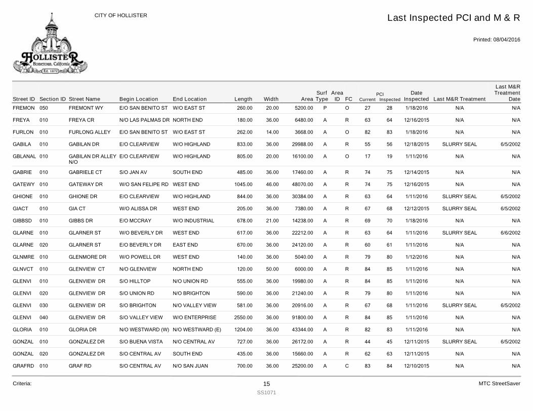
FREMON 050 FREMONT WY 260.00E/O SAN BENITO ST W/O EAST ST 20.00 5200.00 O 28 1/18/2016 N/A N/A27P
FREYA 010 FREYA CR 180.00N/O LAS PALMAS DR NORTH END 36.00 6480.00 R 64 12/16/2015 N/A N/A63A
FURLON 010 FURLONG ALLEY 262.00E/O SAN BENITO ST W/O EAST ST 14.00 3668.00 O 83 1/18/2016 N/A N/A82A
GABILA 010 GABILAN DR 833.00E/O CLEARVIEW W/O HIGHLAND 36.00 29988.00 R 56 12/18/2015 SLURRY SEAL 6/5/200255A
GBLANAL 010 GABILAN DR ALLEYN/O
805.00E/O CLEARVIEW W/O HIGHLAND 20.00 16100.00 O 19 1/11/2016 N/A N/A17A
GABRIE 010 GABRIELE CT 485.00S/O JAN AV SOUTH END 36.00 17460.00 R 75 12/14/2015 N/A N/A74A
GATEWY 010 GATEWAY DR 1045.00W/O SAN FELIPE RD WEST END 46.00 48070.00 R 75 12/16/2015 N/A N/A74A
GHIONE 010 GHIONE DR 844.00E/O CLEARVIEW W/O HIGHLAND 36.00 30384.00 R 64 1/11/2016 SLURRY SEAL 6/5/200263A
GIACT 010 GIA CT 205.00W/O ALISSA DR WEST END 36.00 7380.00 R 68 12/12/2015 SLURRY SEAL 6/5/200267A
GIBBSD 010 GIBBS DR 678.00E/O MCCRAY W/O INDUSTRIAL 21.00 14238.00 R 70 1/18/2016 N/A N/A69A
GLARNE 010 GLARNER ST 617.00W/O BEVERLY DR WEST END 36.00 22212.00 R 64 1/11/2016 SLURRY SEAL 6/6/200263A
GLARNE 020 GLARNER ST 670.00E/O BEVERLY DR EAST END 36.00 24120.00 R 61 1/11/2016 N/A N/A60A
GLNMRE 010 GLENMORE DR 140.00W/O POWELL DR WEST END 36.00 5040.00 R 80 1/12/2016 N/A N/A79A
GLNVCT 010 GLENVIEW CT 120.00N/O GLENVIEW NORTH END 50.00 6000.00 R 85 1/11/2016 N/A N/A84A
GLENVI 010 GLENVIEW DR 555.00S/O HILLTOP N/O UNION RD 36.00 19980.00 R 85 1/11/2016 N/A N/A84A
GLENVI 020 GLENVIEW DR 590.00S/O UNION RD N/O BRIGHTON 36.00 21240.00 R 80 1/11/2016 N/A N/A79A
GLENVI 030 GLENVIEW DR 581.00S/O BRIGHTON N/O VALLEY VIEW 36.00 20916.00 R 68 1/11/2016 SLURRY SEAL 6/5/200267A
GLENVI 040 GLENVIEW DR 2550.00S/O VALLEY VIEW W/O ENTERPRISE 36.00 91800.00 R 85 1/11/2016 N/A N/A84A
GLORIA 010 GLORIA DR 1204.00N/O WESTWARD (W) N/O WESTWARD (E) 36.00 43344.00 R 83 1/11/2016 N/A N/A82A
GONZAL 010 GONZALEZ DR 727.00S/O BUENA VISTA N/O CENTRAL AV 36.00 26172.00 R 45 12/11/2015 SLURRY SEAL 6/5/200244A
GONZAL 020 GONZALEZ DR 435.00S/O CENTRAL AV SOUTH END 36.00 15660.00 R 63 12/11/2015 N/A N/A62A
GRAFRD 010 GRAF RD 700.00S/O CENTRAL AV N/O SAN JUANHOLLISTER RD
36.00 25200.00 C 84 12/10/2015 N/A N/A83A
Street IDPCI
Current InspectedEnd Location Width FC
Last Inspected PCI and M & R
Printed: 08/04/2016
CITY OF HOLLISTER
Section ID Begin Location Length AreaDate
Inspected Last M&R Treatment
Last M&RTreatment
DateStreet NameArea
IDSurfType
Criteria: 15SS1071
MTC StreetSaver
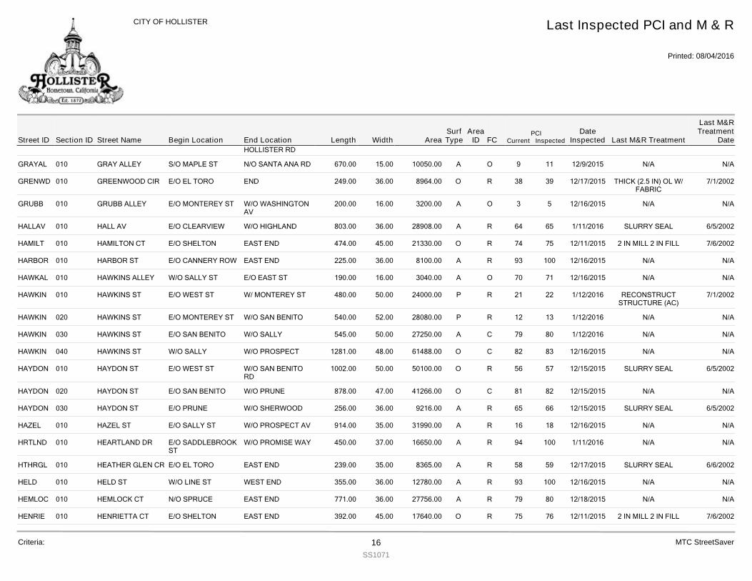
GRAFRD 010 GRAF RD 700.00S/O CENTRAL AV N/O SAN JUANHOLLISTER RD
36.00 25200.00 C 84 12/10/2015 N/A N/A83A
GRAYAL 010 GRAY ALLEY 670.00S/O MAPLE ST N/O SANTA ANA RD 15.00 10050.00 O 11 12/9/2015 N/A N/A9A
GRENWD 010 GREENWOOD CIR 249.00E/O EL TORO END 36.00 8964.00 R 39 12/17/2015 THICK (2.5 IN) OL W/FABRIC
7/1/200238O
GRUBB 010 GRUBB ALLEY 200.00E/O MONTEREY ST W/O WASHINGTONAV
16.00 3200.00 O 5 12/16/2015 N/A N/A3A
HALLAV 010 HALL AV 803.00E/O CLEARVIEW W/O HIGHLAND 36.00 28908.00 R 65 1/11/2016 SLURRY SEAL 6/5/200264A
HAMILT 010 HAMILTON CT 474.00E/O SHELTON EAST END 45.00 21330.00 R 75 12/11/2015 2 IN MILL 2 IN FILL 7/6/200274O
HARBOR 010 HARBOR ST 225.00E/O CANNERY ROW EAST END 36.00 8100.00 R 100 12/16/2015 N/A N/A93A
HAWKAL 010 HAWKINS ALLEY 190.00W/O SALLY ST E/O EAST ST 16.00 3040.00 O 71 12/16/2015 N/A N/A70A
HAWKIN 010 HAWKINS ST 480.00E/O WEST ST W/ MONTEREY ST 50.00 24000.00 R 22 1/12/2016 RECONSTRUCTSTRUCTURE (AC)
7/1/200221P
HAWKIN 020 HAWKINS ST 540.00E/O MONTEREY ST W/O SAN BENITO 52.00 28080.00 R 13 1/12/2016 N/A N/A12P
HAWKIN 030 HAWKINS ST 545.00E/O SAN BENITO W/O SALLY 50.00 27250.00 C 80 1/12/2016 N/A N/A79A
HAWKIN 040 HAWKINS ST 1281.00W/O SALLY W/O PROSPECT 48.00 61488.00 C 83 12/16/2015 N/A N/A82O
HAYDON 010 HAYDON ST 1002.00E/O WEST ST W/O SAN BENITORD
50.00 50100.00 R 57 12/15/2015 SLURRY SEAL 6/5/200256O
HAYDON 020 HAYDON ST 878.00E/O SAN BENITO W/O PRUNE 47.00 41266.00 C 82 12/15/2015 N/A N/A81O
HAYDON 030 HAYDON ST 256.00E/O PRUNE W/O SHERWOOD 36.00 9216.00 R 66 12/15/2015 SLURRY SEAL 6/5/200265A
HAZEL 010 HAZEL ST 914.00E/O SALLY ST W/O PROSPECT AV 35.00 31990.00 R 18 12/16/2015 N/A N/A16A
HRTLND 010 HEARTLAND DR 450.00E/O SADDLEBROOKST
W/O PROMISE WAY 37.00 16650.00 R 100 1/11/2016 N/A N/A94A
HTHRGL 010 HEATHER GLEN CR 239.00E/O EL TORO EAST END 35.00 8365.00 R 59 12/17/2015 SLURRY SEAL 6/6/200258A
HELD 010 HELD ST 355.00W/O LINE ST WEST END 36.00 12780.00 R 100 12/16/2015 N/A N/A93A
HEMLOC 010 HEMLOCK CT 771.00N/O SPRUCE EAST END 36.00 27756.00 R 80 12/18/2015 N/A N/A79A
HENRIE 010 HENRIETTA CT 392.00E/O SHELTON EAST END 45.00 17640.00 R 76 12/11/2015 2 IN MILL 2 IN FILL 7/6/200275O
Street IDPCI
Current InspectedEnd Location Width FC
Last Inspected PCI and M & R
Printed: 08/04/2016
CITY OF HOLLISTER
Section ID Begin Location Length AreaDate
Inspected Last M&R Treatment
Last M&RTreatment
DateStreet NameArea
IDSurfType
Criteria: 16SS1071
MTC StreetSaver
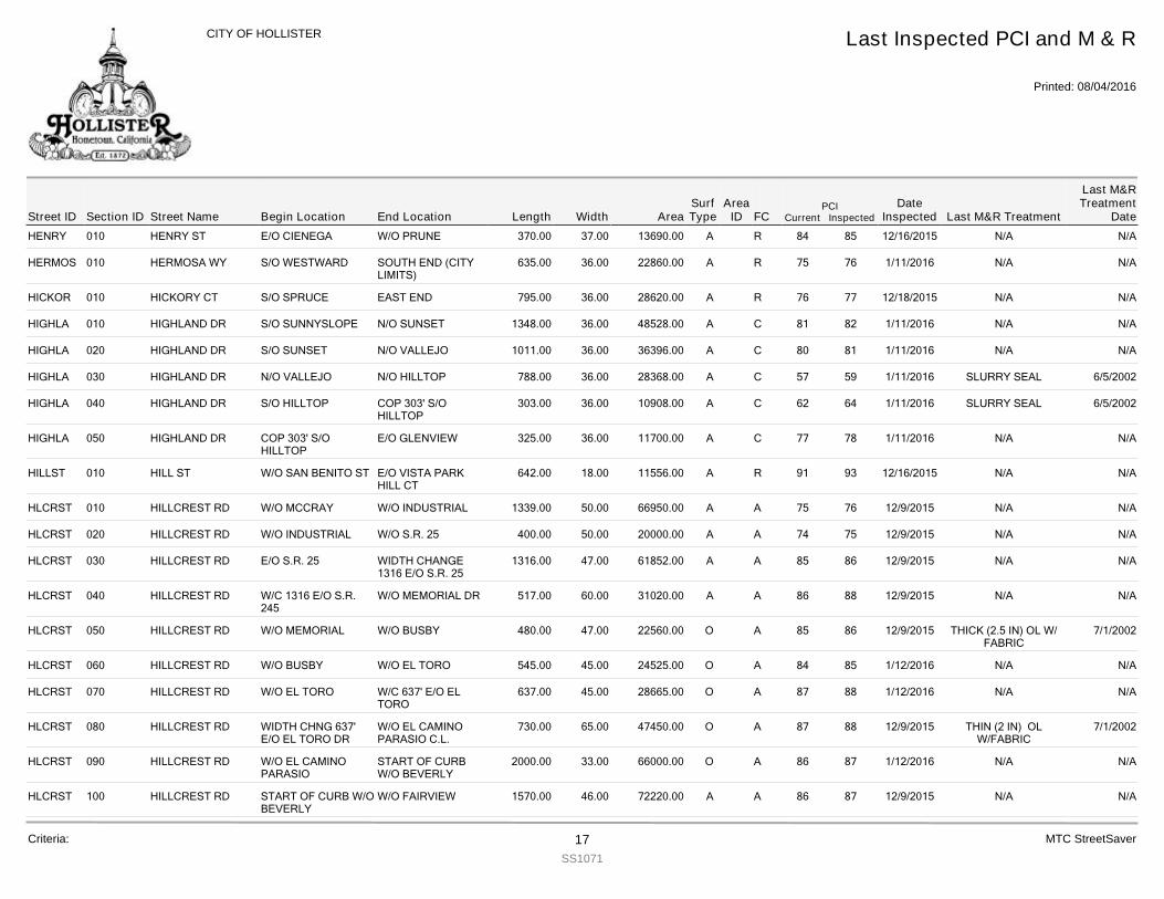
HENRY 010 HENRY ST 370.00E/O CIENEGA W/O PRUNE 37.00 13690.00 R 85 12/16/2015 N/A N/A84A
HERMOS 010 HERMOSA WY 635.00S/O WESTWARD SOUTH END (CITYLIMITS)
36.00 22860.00 R 76 1/11/2016 N/A N/A75A
HICKOR 010 HICKORY CT 795.00S/O SPRUCE EAST END 36.00 28620.00 R 77 12/18/2015 N/A N/A76A
HIGHLA 010 HIGHLAND DR 1348.00S/O SUNNYSLOPE N/O SUNSET 36.00 48528.00 C 82 1/11/2016 N/A N/A81A
HIGHLA 020 HIGHLAND DR 1011.00S/O SUNSET N/O VALLEJO 36.00 36396.00 C 81 1/11/2016 N/A N/A80A
HIGHLA 030 HIGHLAND DR 788.00N/O VALLEJO N/O HILLTOP 36.00 28368.00 C 59 1/11/2016 SLURRY SEAL 6/5/200257A
HIGHLA 040 HIGHLAND DR 303.00S/O HILLTOP COP 303' S/OHILLTOP
36.00 10908.00 C 64 1/11/2016 SLURRY SEAL 6/5/200262A
HIGHLA 050 HIGHLAND DR 325.00COP 303' S/OHILLTOP
E/O GLENVIEW 36.00 11700.00 C 78 1/11/2016 N/A N/A77A
HILLST 010 HILL ST 642.00W/O SAN BENITO ST E/O VISTA PARKHILL CT
18.00 11556.00 R 93 12/16/2015 N/A N/A91A
HLCRST 010 HILLCREST RD 1339.00W/O MCCRAY W/O INDUSTRIAL 50.00 66950.00 A 76 12/9/2015 N/A N/A75A
HLCRST 020 HILLCREST RD 400.00W/O INDUSTRIAL W/O S.R. 25 50.00 20000.00 A 75 12/9/2015 N/A N/A74A
HLCRST 030 HILLCREST RD 1316.00E/O S.R. 25 WIDTH CHANGE1316 E/O S.R. 25
47.00 61852.00 A 86 12/9/2015 N/A N/A85A
HLCRST 040 HILLCREST RD 517.00W/C 1316 E/O S.R.245
W/O MEMORIAL DR 60.00 31020.00 A 88 12/9/2015 N/A N/A86A
HLCRST 050 HILLCREST RD 480.00W/O MEMORIAL W/O BUSBY 47.00 22560.00 A 86 12/9/2015 THICK (2.5 IN) OL W/FABRIC
7/1/200285O
HLCRST 060 HILLCREST RD 545.00W/O BUSBY W/O EL TORO 45.00 24525.00 A 85 1/12/2016 N/A N/A84O
HLCRST 070 HILLCREST RD 637.00W/O EL TORO W/C 637' E/O ELTORO
45.00 28665.00 A 88 1/12/2016 N/A N/A87O
HLCRST 080 HILLCREST RD 730.00WIDTH CHNG 637'E/O EL TORO DR
W/O EL CAMINOPARASIO C.L.
65.00 47450.00 A 88 12/9/2015 THIN (2 IN) OLW/FABRIC
7/1/200287O
HLCRST 090 HILLCREST RD 2000.00W/O EL CAMINOPARASIO
START OF CURBW/O BEVERLY
33.00 66000.00 A 87 1/12/2016 N/A N/A86O
HLCRST 100 HILLCREST RD 1570.00START OF CURB W/OBEVERLY
W/O FAIRVIEW 46.00 72220.00 A 87 12/9/2015 N/A N/A86A
Street IDPCI
Current InspectedEnd Location Width FC
Last Inspected PCI and M & R
Printed: 08/04/2016
CITY OF HOLLISTER
Section ID Begin Location Length AreaDate
Inspected Last M&R Treatment
Last M&RTreatment
DateStreet NameArea
IDSurfType
Criteria: 17SS1071
MTC StreetSaver
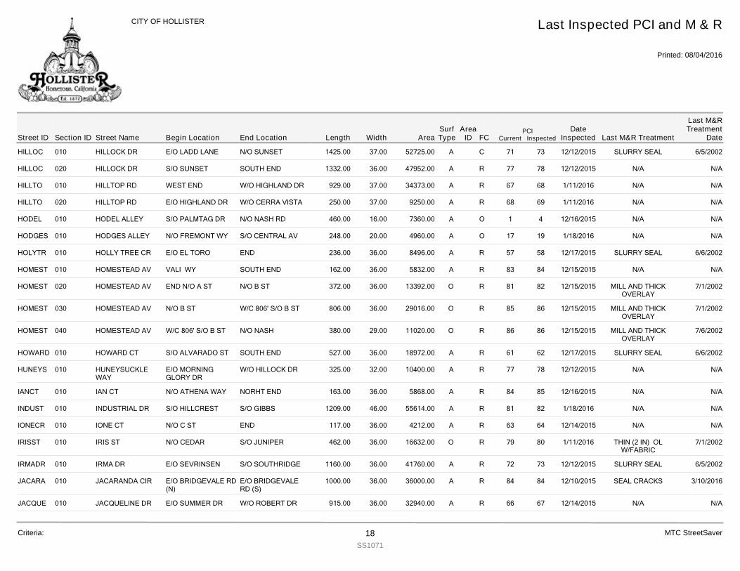
HILLOC 010 HILLOCK DR 1425.00E/O LADD LANE N/O SUNSET 37.00 52725.00 C 73 12/12/2015 SLURRY SEAL 6/5/200271A
HILLOC 020 HILLOCK DR 1332.00S/O SUNSET SOUTH END 36.00 47952.00 R 78 12/12/2015 N/A N/A77A
HILLTO 010 HILLTOP RD 929.00WEST END W/O HIGHLAND DR 37.00 34373.00 R 68 1/11/2016 N/A N/A67A
HILLTO 020 HILLTOP RD 250.00E/O HIGHLAND DR W/O CERRA VISTA 37.00 9250.00 R 69 1/11/2016 N/A N/A68A
HODEL 010 HODEL ALLEY 460.00S/O PALMTAG DR N/O NASH RD 16.00 7360.00 O 4 12/16/2015 N/A N/A1A
HODGES 010 HODGES ALLEY 248.00N/O FREMONT WY S/O CENTRAL AV 20.00 4960.00 O 19 1/18/2016 N/A N/A17A
HOLYTR 010 HOLLY TREE CR 236.00E/O EL TORO END 36.00 8496.00 R 58 12/17/2015 SLURRY SEAL 6/6/200257A
HOMEST 010 HOMESTEAD AV 162.00VALI WY SOUTH END 36.00 5832.00 R 84 12/15/2015 N/A N/A83A
HOMEST 020 HOMESTEAD AV 372.00END N/O A ST N/O B ST 36.00 13392.00 R 82 12/15/2015 MILL AND THICKOVERLAY
7/1/200281O
HOMEST 030 HOMESTEAD AV 806.00N/O B ST W/C 806' S/O B ST 36.00 29016.00 R 86 12/15/2015 MILL AND THICKOVERLAY
7/1/200285O
HOMEST 040 HOMESTEAD AV 380.00W/C 806' S/O B ST N/O NASH 29.00 11020.00 R 86 12/15/2015 MILL AND THICKOVERLAY
7/6/200286O
HOWARD 010 HOWARD CT 527.00S/O ALVARADO ST SOUTH END 36.00 18972.00 R 62 12/17/2015 SLURRY SEAL 6/6/200261A
HUNEYS 010 HUNEYSUCKLEWAY
325.00E/O MORNINGGLORY DR
W/O HILLOCK DR 32.00 10400.00 R 78 12/12/2015 N/A N/A77A
IANCT 010 IAN CT 163.00N/O ATHENA WAY NORHT END 36.00 5868.00 R 85 12/16/2015 N/A N/A84A
INDUST 010 INDUSTRIAL DR 1209.00S/O HILLCREST S/O GIBBS 46.00 55614.00 R 82 1/18/2016 N/A N/A81A
IONECR 010 IONE CT 117.00N/O C ST END 36.00 4212.00 R 64 12/14/2015 N/A N/A63A
IRISST 010 IRIS ST 462.00N/O CEDAR S/O JUNIPER 36.00 16632.00 R 80 1/11/2016 THIN (2 IN) OLW/FABRIC
7/1/200279O
IRMADR 010 IRMA DR 1160.00E/O SEVRINSEN S/O SOUTHRIDGE 36.00 41760.00 R 73 12/12/2015 SLURRY SEAL 6/5/200272A
JACARA 010 JACARANDA CIR 1000.00E/O BRIDGEVALE RD(N)
E/O BRIDGEVALERD (S)
36.00 36000.00 R 84 12/10/2015 SEAL CRACKS 3/10/201684A
JACQUE 010 JACQUELINE DR 915.00E/O SUMMER DR W/O ROBERT DR 36.00 32940.00 R 67 12/14/2015 N/A N/A66A
Street IDPCI
Current InspectedEnd Location Width FC
Last Inspected PCI and M & R
Printed: 08/04/2016
CITY OF HOLLISTER
Section ID Begin Location Length AreaDate
Inspected Last M&R Treatment
Last M&RTreatment
DateStreet NameArea
IDSurfType
Criteria: 18SS1071
MTC StreetSaver
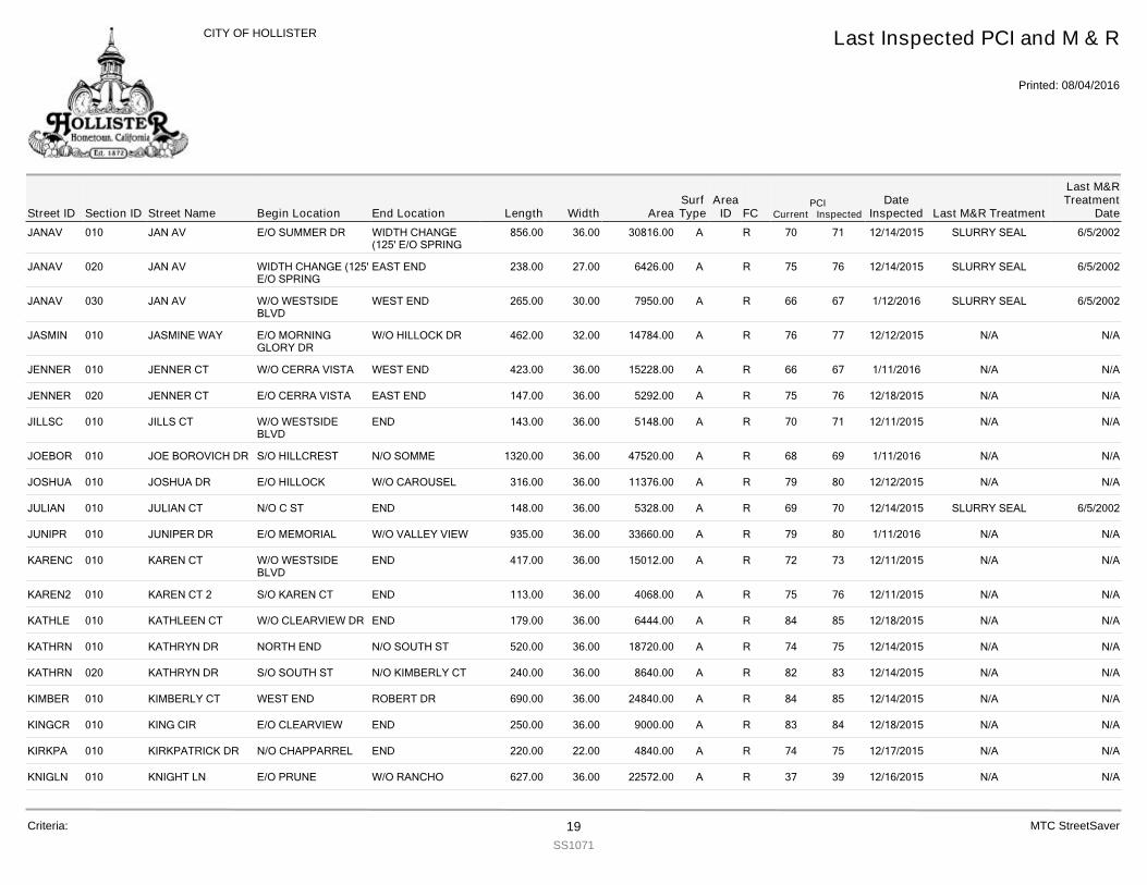
JANAV 010 JAN AV 856.00E/O SUMMER DR WIDTH CHANGE(125' E/O SPRING
36.00 30816.00 R 71 12/14/2015 SLURRY SEAL 6/5/200270A
JANAV 020 JAN AV 238.00WIDTH CHANGE (125'E/O SPRING
EAST END 27.00 6426.00 R 76 12/14/2015 SLURRY SEAL 6/5/200275A
JANAV 030 JAN AV 265.00W/O WESTSIDEBLVD
WEST END 30.00 7950.00 R 67 1/12/2016 SLURRY SEAL 6/5/200266A
JASMIN 010 JASMINE WAY 462.00E/O MORNINGGLORY DR
W/O HILLOCK DR 32.00 14784.00 R 77 12/12/2015 N/A N/A76A
JENNER 010 JENNER CT 423.00W/O CERRA VISTA WEST END 36.00 15228.00 R 67 1/11/2016 N/A N/A66A
JENNER 020 JENNER CT 147.00E/O CERRA VISTA EAST END 36.00 5292.00 R 76 12/18/2015 N/A N/A75A
JILLSC 010 JILLS CT 143.00W/O WESTSIDEBLVD
END 36.00 5148.00 R 71 12/11/2015 N/A N/A70A
JOEBOR 010 JOE BOROVICH DR 1320.00S/O HILLCREST N/O SOMME 36.00 47520.00 R 69 1/11/2016 N/A N/A68A
JOSHUA 010 JOSHUA DR 316.00E/O HILLOCK W/O CAROUSEL 36.00 11376.00 R 80 12/12/2015 N/A N/A79A
JULIAN 010 JULIAN CT 148.00N/O C ST END 36.00 5328.00 R 70 12/14/2015 SLURRY SEAL 6/5/200269A
JUNIPR 010 JUNIPER DR 935.00E/O MEMORIAL W/O VALLEY VIEW 36.00 33660.00 R 80 1/11/2016 N/A N/A79A
KARENC 010 KAREN CT 417.00W/O WESTSIDEBLVD
END 36.00 15012.00 R 73 12/11/2015 N/A N/A72A
KAREN2 010 KAREN CT 2 113.00S/O KAREN CT END 36.00 4068.00 R 76 12/11/2015 N/A N/A75A
KATHLE 010 KATHLEEN CT 179.00W/O CLEARVIEW DR END 36.00 6444.00 R 85 12/18/2015 N/A N/A84A
KATHRN 010 KATHRYN DR 520.00NORTH END N/O SOUTH ST 36.00 18720.00 R 75 12/14/2015 N/A N/A74A
KATHRN 020 KATHRYN DR 240.00S/O SOUTH ST N/O KIMBERLY CT 36.00 8640.00 R 83 12/14/2015 N/A N/A82A
KIMBER 010 KIMBERLY CT 690.00WEST END ROBERT DR 36.00 24840.00 R 85 12/14/2015 N/A N/A84A
KINGCR 010 KING CIR 250.00E/O CLEARVIEW END 36.00 9000.00 R 84 12/18/2015 N/A N/A83A
KIRKPA 010 KIRKPATRICK DR 220.00N/O CHAPPARREL END 22.00 4840.00 R 75 12/17/2015 N/A N/A74A
KNIGLN 010 KNIGHT LN 627.00E/O PRUNE W/O RANCHO 36.00 22572.00 R 39 12/16/2015 N/A N/A37A
Street IDPCI
Current InspectedEnd Location Width FC
Last Inspected PCI and M & R
Printed: 08/04/2016
CITY OF HOLLISTER
Section ID Begin Location Length AreaDate
Inspected Last M&R Treatment
Last M&RTreatment
DateStreet NameArea
IDSurfType
Criteria: 19SS1071
MTC StreetSaver
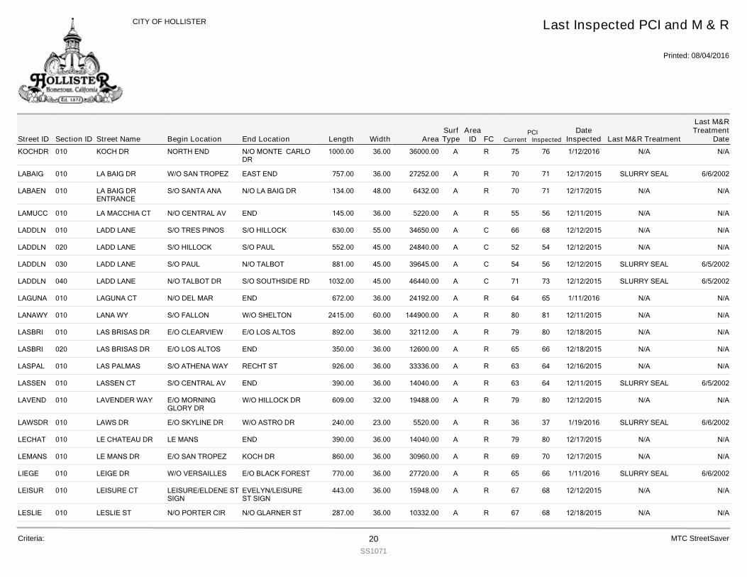
KOCHDR 010 KOCH DR 1000.00NORTH END N/O MONTE CARLODR
36.00 36000.00 R 76 1/12/2016 N/A N/A75A
LABAIG 010 LA BAIG DR 757.00W/O SAN TROPEZ EAST END 36.00 27252.00 R 71 12/17/2015 SLURRY SEAL 6/6/200270A
LABAEN 010 LA BAIG DRENTRANCE
134.00S/O SANTA ANA N/O LA BAIG DR 48.00 6432.00 R 71 12/17/2015 N/A N/A70A
LAMUCC 010 LA MACCHIA CT 145.00N/O CENTRAL AV END 36.00 5220.00 R 56 12/11/2015 N/A N/A55A
LADDLN 010 LADD LANE 630.00S/O TRES PINOS S/O HILLOCK 55.00 34650.00 C 68 12/12/2015 N/A N/A66A
LADDLN 020 LADD LANE 552.00S/O HILLOCK S/O PAUL 45.00 24840.00 C 54 12/12/2015 N/A N/A52A
LADDLN 030 LADD LANE 881.00S/O PAUL N/O TALBOT 45.00 39645.00 C 56 12/12/2015 SLURRY SEAL 6/5/200254A
LADDLN 040 LADD LANE 1032.00N/O TALBOT DR S/O SOUTHSIDE RD 45.00 46440.00 C 73 12/12/2015 SLURRY SEAL 6/5/200271A
LAGUNA 010 LAGUNA CT 672.00N/O DEL MAR END 36.00 24192.00 R 65 1/11/2016 N/A N/A64A
LANAWY 010 LANA WY 2415.00S/O FALLON W/O SHELTON 60.00 144900.00 R 81 12/11/2015 N/A N/A80A
LASBRI 010 LAS BRISAS DR 892.00E/O CLEARVIEW E/O LOS ALTOS 36.00 32112.00 R 80 12/18/2015 N/A N/A79A
LASBRI 020 LAS BRISAS DR 350.00E/O LOS ALTOS END 36.00 12600.00 R 66 12/18/2015 N/A N/A65A
LASPAL 010 LAS PALMAS 926.00S/O ATHENA WAY RECHT ST 36.00 33336.00 R 64 12/16/2015 N/A N/A63A
LASSEN 010 LASSEN CT 390.00S/O CENTRAL AV END 36.00 14040.00 R 64 12/11/2015 SLURRY SEAL 6/5/200263A
LAVEND 010 LAVENDER WAY 609.00E/O MORNINGGLORY DR
W/O HILLOCK DR 32.00 19488.00 R 80 12/12/2015 N/A N/A79A
LAWSDR 010 LAWS DR 240.00E/O SKYLINE DR W/O ASTRO DR 23.00 5520.00 R 37 1/19/2016 SLURRY SEAL 6/6/200236A
LECHAT 010 LE CHATEAU DR 390.00LE MANS END 36.00 14040.00 R 80 12/17/2015 N/A N/A79A
LEMANS 010 LE MANS DR 860.00E/O SAN TROPEZ KOCH DR 36.00 30960.00 R 70 12/17/2015 N/A N/A69A
LIEGE 010 LEIGE DR 770.00W/O VERSAILLES E/O BLACK FOREST 36.00 27720.00 R 66 1/11/2016 SLURRY SEAL 6/6/200265A
LEISUR 010 LEISURE CT 443.00LEISURE/ELDENE STSIGN
EVELYN/LEISUREST SIGN
36.00 15948.00 R 68 12/12/2015 N/A N/A67A
LESLIE 010 LESLIE ST 287.00N/O PORTER CIR N/O GLARNER ST 36.00 10332.00 R 68 12/18/2015 N/A N/A67A
Street IDPCI
Current InspectedEnd Location Width FC
Last Inspected PCI and M & R
Printed: 08/04/2016
CITY OF HOLLISTER
Section ID Begin Location Length AreaDate
Inspected Last M&R Treatment
Last M&RTreatment
DateStreet NameArea
IDSurfType
Criteria: 20SS1071
MTC StreetSaver
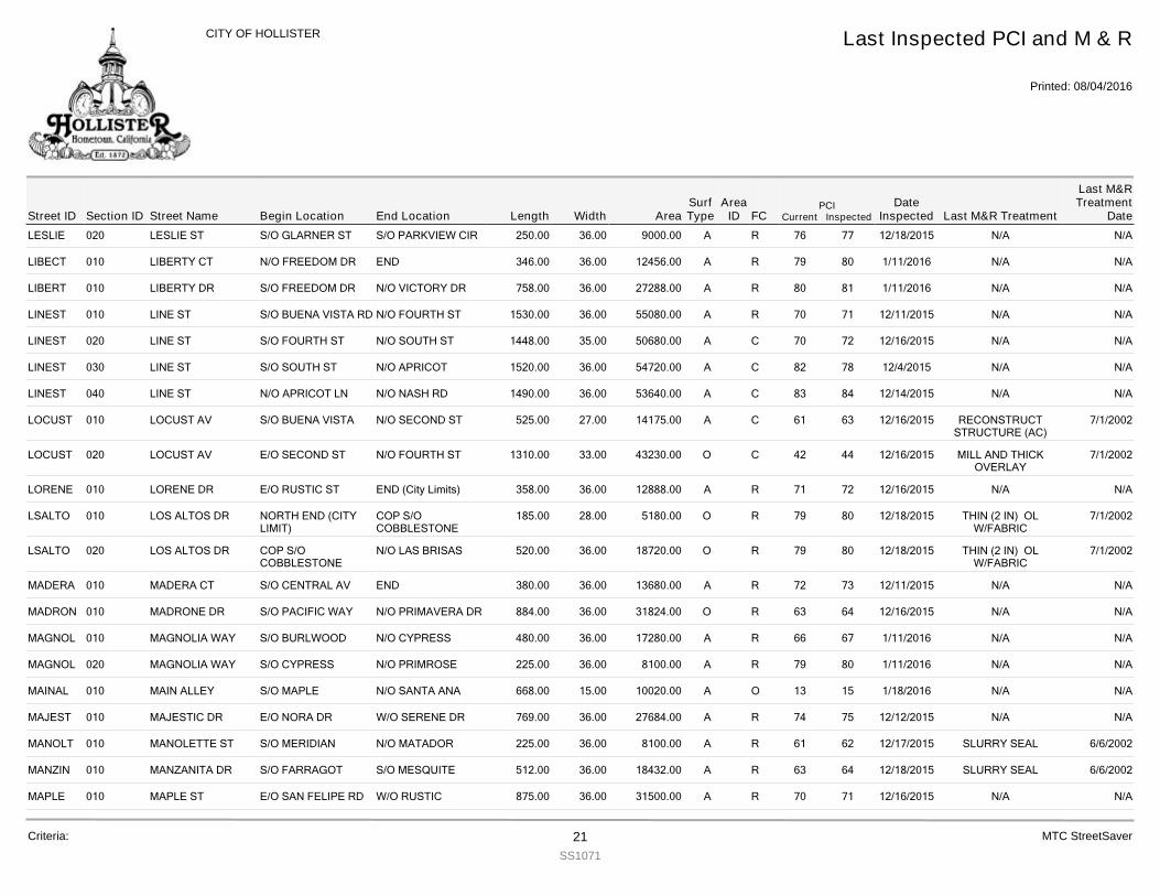
LESLIE 020 LESLIE ST 250.00S/O GLARNER ST S/O PARKVIEW CIR 36.00 9000.00 R 77 12/18/2015 N/A N/A76A
LIBECT 010 LIBERTY CT 346.00N/O FREEDOM DR END 36.00 12456.00 R 80 1/11/2016 N/A N/A79A
LIBERT 010 LIBERTY DR 758.00S/O FREEDOM DR N/O VICTORY DR 36.00 27288.00 R 81 1/11/2016 N/A N/A80A
LINEST 010 LINE ST 1530.00S/O BUENA VISTA RD N/O FOURTH ST 36.00 55080.00 R 71 12/11/2015 N/A N/A70A
LINEST 020 LINE ST 1448.00S/O FOURTH ST N/O SOUTH ST 35.00 50680.00 C 72 12/16/2015 N/A N/A70A
LINEST 030 LINE ST 1520.00S/O SOUTH ST N/O APRICOT 36.00 54720.00 C 78 12/4/2015 N/A N/A82A
LINEST 040 LINE ST 1490.00N/O APRICOT LN N/O NASH RD 36.00 53640.00 C 84 12/14/2015 N/A N/A83A
LOCUST 010 LOCUST AV 525.00S/O BUENA VISTA N/O SECOND ST 27.00 14175.00 C 63 12/16/2015 RECONSTRUCTSTRUCTURE (AC)
7/1/200261A
LOCUST 020 LOCUST AV 1310.00E/O SECOND ST N/O FOURTH ST 33.00 43230.00 C 44 12/16/2015 MILL AND THICKOVERLAY
7/1/200242O
LORENE 010 LORENE DR 358.00E/O RUSTIC ST END (City Limits) 36.00 12888.00 R 72 12/16/2015 N/A N/A71A
LSALTO 010 LOS ALTOS DR 185.00NORTH END (CITYLIMIT)
COP S/OCOBBLESTONE
28.00 5180.00 R 80 12/18/2015 THIN (2 IN) OLW/FABRIC
7/1/200279O
LSALTO 020 LOS ALTOS DR 520.00COP S/OCOBBLESTONE
N/O LAS BRISAS 36.00 18720.00 R 80 12/18/2015 THIN (2 IN) OLW/FABRIC
7/1/200279O
MADERA 010 MADERA CT 380.00S/O CENTRAL AV END 36.00 13680.00 R 73 12/11/2015 N/A N/A72A
MADRON 010 MADRONE DR 884.00S/O PACIFIC WAY N/O PRIMAVERA DR 36.00 31824.00 R 64 12/16/2015 N/A N/A63O
MAGNOL 010 MAGNOLIA WAY 480.00S/O BURLWOOD N/O CYPRESS 36.00 17280.00 R 67 1/11/2016 N/A N/A66A
MAGNOL 020 MAGNOLIA WAY 225.00S/O CYPRESS N/O PRIMROSE 36.00 8100.00 R 80 1/11/2016 N/A N/A79A
MAINAL 010 MAIN ALLEY 668.00S/O MAPLE N/O SANTA ANA 15.00 10020.00 O 15 1/18/2016 N/A N/A13A
MAJEST 010 MAJESTIC DR 769.00E/O NORA DR W/O SERENE DR 36.00 27684.00 R 75 12/12/2015 N/A N/A74A
MANOLT 010 MANOLETTE ST 225.00S/O MERIDIAN N/O MATADOR 36.00 8100.00 R 62 12/17/2015 SLURRY SEAL 6/6/200261A
MANZIN 010 MANZANITA DR 512.00S/O FARRAGOT S/O MESQUITE 36.00 18432.00 R 64 12/18/2015 SLURRY SEAL 6/6/200263A
MAPLE 010 MAPLE ST 875.00E/O SAN FELIPE RD W/O RUSTIC 36.00 31500.00 R 71 12/16/2015 N/A N/A70A
Street IDPCI
Current InspectedEnd Location Width FC
Last Inspected PCI and M & R
Printed: 08/04/2016
CITY OF HOLLISTER
Section ID Begin Location Length AreaDate
Inspected Last M&R Treatment
Last M&RTreatment
DateStreet NameArea
IDSurfType
Criteria: 21SS1071
MTC StreetSaver
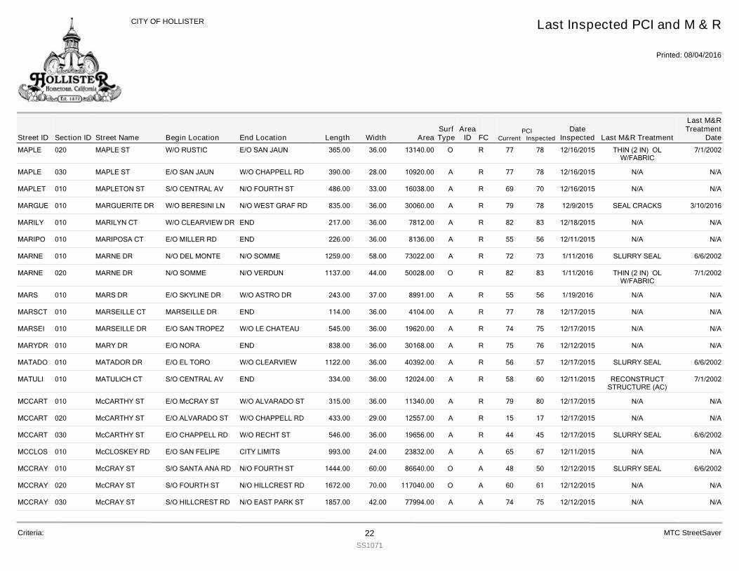
MAPLE 020 MAPLE ST 365.00W/O RUSTIC E/O SAN JAUN 36.00 13140.00 R 78 12/16/2015 THIN (2 IN) OLW/FABRIC
7/1/200277O
MAPLE 030 MAPLE ST 390.00E/O SAN JAUN W/O CHAPPELL RD 28.00 10920.00 R 78 12/16/2015 N/A N/A77A
MAPLET 010 MAPLETON ST 486.00S/O CENTRAL AV N/O FOURTH ST 33.00 16038.00 R 70 12/16/2015 N/A N/A69A
MARGUE 010 MARGUERITE DR 835.00W/O BERESINI LN N/O WEST GRAF RD 36.00 30060.00 R 78 12/9/2015 SEAL CRACKS 3/10/201679A
MARILY 010 MARILYN CT 217.00W/O CLEARVIEW DR END 36.00 7812.00 R 83 12/18/2015 N/A N/A82A
MARIPO 010 MARIPOSA CT 226.00E/O MILLER RD END 36.00 8136.00 R 56 12/11/2015 N/A N/A55A
MARNE 010 MARNE DR 1259.00N/O DEL MONTE N/O SOMME 58.00 73022.00 R 73 1/11/2016 SLURRY SEAL 6/6/200272A
MARNE 020 MARNE DR 1137.00N/O SOMME N/O VERDUN 44.00 50028.00 R 83 1/11/2016 THIN (2 IN) OLW/FABRIC
7/1/200282O
MARS 010 MARS DR 243.00E/O SKYLINE DR W/O ASTRO DR 37.00 8991.00 R 56 1/19/2016 N/A N/A55A
MARSCT 010 MARSEILLE CT 114.00MARSEILLE DR END 36.00 4104.00 R 78 12/17/2015 N/A N/A77A
MARSEI 010 MARSEILLE DR 545.00E/O SAN TROPEZ W/O LE CHATEAU 36.00 19620.00 R 75 12/17/2015 N/A N/A74A
MARYDR 010 MARY DR 838.00E/O NORA END 36.00 30168.00 R 76 12/12/2015 N/A N/A75A
MATADO 010 MATADOR DR 1122.00E/O EL TORO W/O CLEARVIEW 36.00 40392.00 R 57 12/17/2015 SLURRY SEAL 6/6/200256A
MATULI 010 MATULICH CT 334.00S/O CENTRAL AV END 36.00 12024.00 R 60 12/11/2015 RECONSTRUCTSTRUCTURE (AC)
7/1/200258A
MCCART 010 McCARTHY ST 315.00E/O McCRAY ST W/O ALVARADO ST 36.00 11340.00 R 80 12/17/2015 N/A N/A79A
MCCART 020 McCARTHY ST 433.00E/O ALVARADO ST W/O CHAPPELL RD 29.00 12557.00 R 17 12/17/2015 N/A N/A15A
MCCART 030 McCARTHY ST 546.00E/O CHAPPELL RD W/O RECHT ST 36.00 19656.00 R 45 12/17/2015 SLURRY SEAL 6/6/200244A
MCCLOS 010 McCLOSKEY RD 993.00E/O SAN FELIPE CITY LIMITS 24.00 23832.00 A 67 12/11/2015 N/A N/A65A
MCCRAY 010 McCRAY ST 1444.00S/O SANTA ANA RD N/O FOURTH ST 60.00 86640.00 A 50 12/12/2015 SLURRY SEAL 6/6/200248O
MCCRAY 020 McCRAY ST 1672.00S/O FOURTH ST N/O HILLCREST RD 70.00 117040.00 A 61 12/12/2015 N/A N/A60O
MCCRAY 030 McCRAY ST 1857.00S/O HILLCREST RD N/O EAST PARK ST 42.00 77994.00 A 75 12/12/2015 N/A N/A74A
Street IDPCI
Current InspectedEnd Location Width FC
Last Inspected PCI and M & R
Printed: 08/04/2016
CITY OF HOLLISTER
Section ID Begin Location Length AreaDate
Inspected Last M&R Treatment
Last M&RTreatment
DateStreet NameArea
IDSurfType
Criteria: 22SS1071
MTC StreetSaver
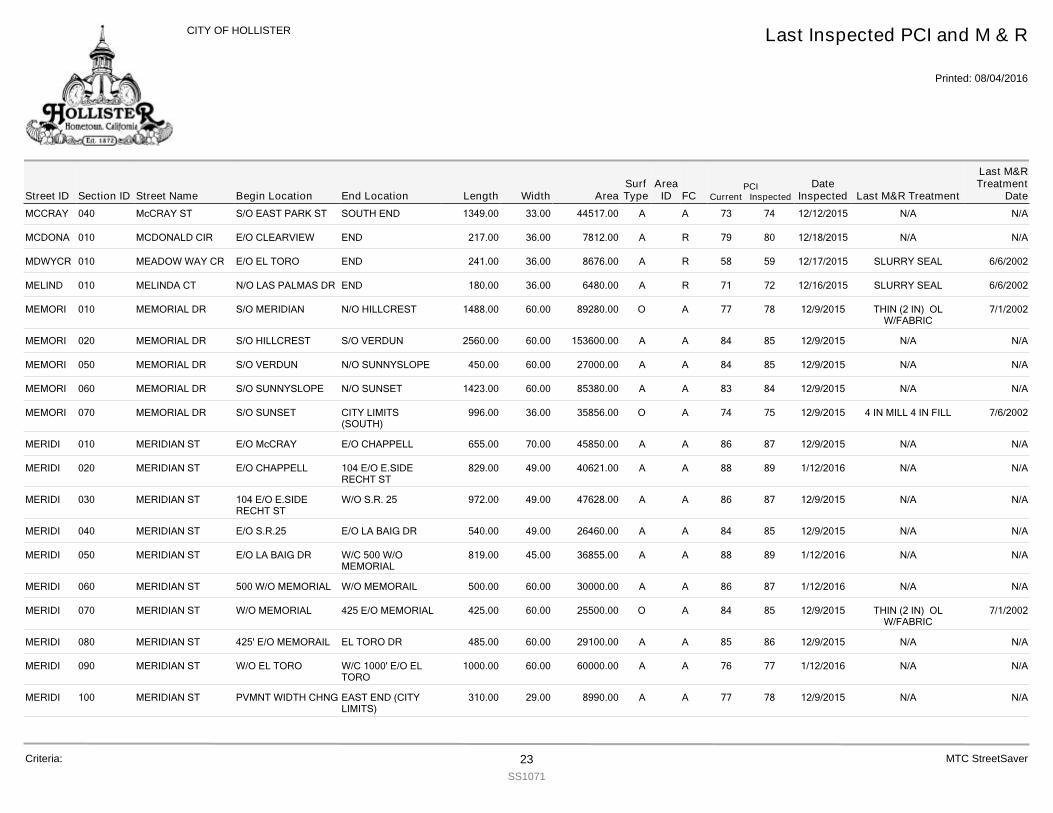
MCCRAY 040 McCRAY ST 1349.00S/O EAST PARK ST SOUTH END 33.00 44517.00 A 74 12/12/2015 N/A N/A73A
MCDONA 010 MCDONALD CIR 217.00E/O CLEARVIEW END 36.00 7812.00 R 80 12/18/2015 N/A N/A79A
MDWYCR 010 MEADOW WAY CR 241.00E/O EL TORO END 36.00 8676.00 R 59 12/17/2015 SLURRY SEAL 6/6/200258A
MELIND 010 MELINDA CT 180.00N/O LAS PALMAS DR END 36.00 6480.00 R 72 12/16/2015 SLURRY SEAL 6/6/200271A
MEMORI 010 MEMORIAL DR 1488.00S/O MERIDIAN N/O HILLCREST 60.00 89280.00 A 78 12/9/2015 THIN (2 IN) OLW/FABRIC
7/1/200277O
MEMORI 020 MEMORIAL DR 2560.00S/O HILLCREST S/O VERDUN 60.00 153600.00 A 85 12/9/2015 N/A N/A84A
MEMORI 050 MEMORIAL DR 450.00S/O VERDUN N/O SUNNYSLOPE 60.00 27000.00 A 85 12/9/2015 N/A N/A84A
MEMORI 060 MEMORIAL DR 1423.00S/O SUNNYSLOPE N/O SUNSET 60.00 85380.00 A 84 12/9/2015 N/A N/A83A
MEMORI 070 MEMORIAL DR 996.00S/O SUNSET CITY LIMITS(SOUTH)
36.00 35856.00 A 75 12/9/2015 4 IN MILL 4 IN FILL 7/6/200274O
MERIDI 010 MERIDIAN ST 655.00E/O McCRAY E/O CHAPPELL 70.00 45850.00 A 87 12/9/2015 N/A N/A86A
MERIDI 020 MERIDIAN ST 829.00E/O CHAPPELL 104 E/O E.SIDERECHT ST
49.00 40621.00 A 89 1/12/2016 N/A N/A88A
MERIDI 030 MERIDIAN ST 972.00104 E/O E.SIDERECHT ST
W/O S.R. 25 49.00 47628.00 A 87 12/9/2015 N/A N/A86A
MERIDI 040 MERIDIAN ST 540.00E/O S.R.25 E/O LA BAIG DR 49.00 26460.00 A 85 12/9/2015 N/A N/A84A
MERIDI 050 MERIDIAN ST 819.00E/O LA BAIG DR W/C 500 W/OMEMORIAL
45.00 36855.00 A 89 1/12/2016 N/A N/A88A
MERIDI 060 MERIDIAN ST 500.00500 W/O MEMORIAL W/O MEMORAIL 60.00 30000.00 A 87 1/12/2016 N/A N/A86A
MERIDI 070 MERIDIAN ST 425.00W/O MEMORIAL 425 E/O MEMORIAL 60.00 25500.00 A 85 12/9/2015 THIN (2 IN) OLW/FABRIC
7/1/200284O
MERIDI 080 MERIDIAN ST 485.00425' E/O MEMORAIL EL TORO DR 60.00 29100.00 A 86 12/9/2015 N/A N/A85A
MERIDI 090 MERIDIAN ST 1000.00W/O EL TORO W/C 1000' E/O ELTORO
60.00 60000.00 A 77 1/12/2016 N/A N/A76A
MERIDI 100 MERIDIAN ST 310.00PVMNT WIDTH CHNG EAST END (CITYLIMITS)
29.00 8990.00 A 78 12/9/2015 N/A N/A77A
Street IDPCI
Current InspectedEnd Location Width FC
Last Inspected PCI and M & R
Printed: 08/04/2016
CITY OF HOLLISTER
Section ID Begin Location Length AreaDate
Inspected Last M&R Treatment
Last M&RTreatment
DateStreet NameArea
IDSurfType
Criteria: 23SS1071
MTC StreetSaver
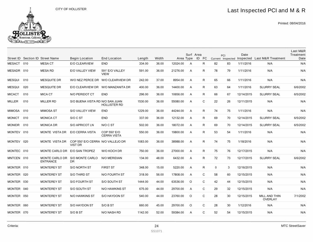
MESACT 010 MESA CT 334.00E/O CLEARVIEW END 36.00 12024.00 R 83 1/11/2016 N/A N/A82A
MESADR 010 MESA RD 591.00E/O VALLEY VIEW 591' E/O VALLEYVIEW
36.00 21276.00 R 79 1/11/2016 N/A N/A78A
MESQUI 010 MESQUITE DR 242.00W/O NEZ PERCE DR W/O CLEARVIEW DR 37.00 8954.00 R 66 1/11/2016 N/A N/A65A
MESQUI 020 MESQUITE DR 400.00E/O CLEARVIEW DR W/O MANZANITA DR 36.00 14400.00 R 64 1/11/2016 SLURRY SEAL 6/6/200263A
MICACT 010 MICA CT 296.00N/O PERIDOT CT END 36.00 10656.00 R 67 12/14/2015 SLURRY SEAL 6/5/200266A
MILLER 010 MILLER RD 1530.00S/O BUENA VISTA RD N/O SAN JUANHOLLISTER RD
36.00 55080.00 C 26 12/11/2015 N/A N/A22A
MIMOSA 010 MIMOSA ST 1229.00S/O VALLEY VIEW END 36.00 44244.00 R 75 1/11/2016 N/A N/A74A
MONICT 010 MONICA CT 337.00S/O C ST END 36.00 12132.00 R 70 12/14/2015 SLURRY SEAL 6/5/200269A
MONIDR 010 MONICA DR 502.00S/O APRICOT LN N/O C ST 36.00 18072.00 R 70 12/14/2015 SLURRY SEAL 6/5/200269A
MONTEV 010 MONTE VISTA DR 550.00E/O CERRA VISTA COP 550' E/OCERRA VISTA
36.00 19800.00 R 54 1/11/2016 N/A N/A53A
MONTEV 020 MONTE VISTA DR 1083.00COP 550' E/O CERRAVIST DR
N/O VALLEJO DR 36.00 38988.00 R 75 1/18/2016 N/A N/A74A
MONTEC 010 MONTE CARLO DR 750.00E/O SAN TROPEZ W/O KOCH DR 36.00 27000.00 R 76 12/17/2015 N/A N/A75A
MNTCEN 010 MONTE CARLO DRENTRANCE
134.00S/O MONTE CARLODR
N/O MERIDIAN 48.00 6432.00 R 73 12/17/2015 SLURRY SEAL 6/6/200272A
MONTER 010 MONTEREY ST 348.00S/O NORTH ST FIRST ST 15.00 5220.00 R 3 12/16/2015 N/A N/A0A
MONTER 020 MONTEREY ST 318.00S/O THIRD ST N/O FOURTH ST 56.00 17808.00 C 60 12/15/2015 N/A N/A58A
MONTER 030 MONTEREY ST 1444.00S/O FOURTH ST S/O SOUTH ST 44.00 63536.00 C 44 12/15/2015 N/A N/A42O
MONTER 040 MONTEREY ST 675.00S/O SOUTH ST N/O HAWKINS ST 44.00 29700.00 C 32 12/15/2015 N/A N/A29A
MONTER 050 MONTEREY ST 540.00N/O HAWKINS ST S/O HAYDON ST 44.00 23760.00 C 30 12/15/2015 MILL AND THINOVERLAY
7/1/200228O
MONTER 060 MONTEREY ST 660.00S/O HAYDON ST S/O B ST 45.00 29700.00 C 30 1/12/2016 N/A N/A28O
MONTER 070 MONTEREY ST 1142.00S/O B ST N/O NASH RD 52.00 59384.00 C 54 12/15/2015 N/A N/A52A
Street IDPCI
Current InspectedEnd Location Width FC
Last Inspected PCI and M & R
Printed: 08/04/2016
CITY OF HOLLISTER
Section ID Begin Location Length AreaDate
Inspected Last M&R Treatment
Last M&RTreatment
DateStreet NameArea
IDSurfType
Criteria: 24SS1071
MTC StreetSaver
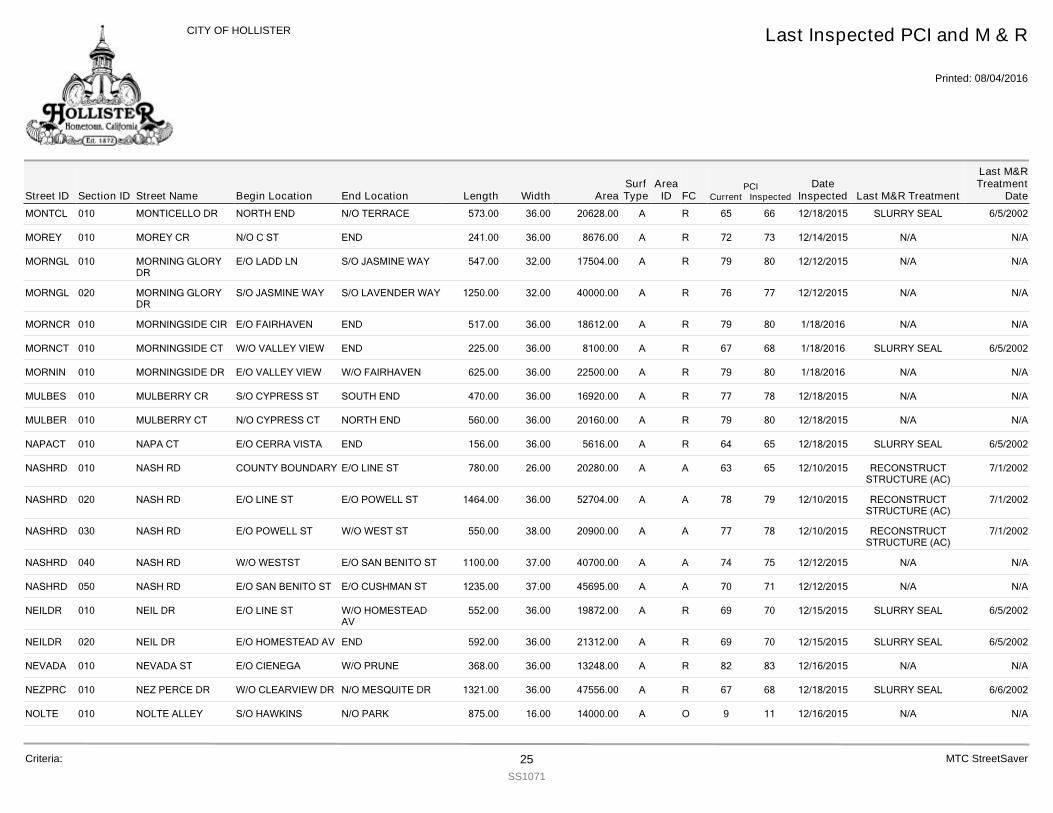
MONTCL 010 MONTICELLO DR 573.00NORTH END N/O TERRACE 36.00 20628.00 R 66 12/18/2015 SLURRY SEAL 6/5/200265A
MOREY 010 MOREY CR 241.00N/O C ST END 36.00 8676.00 R 73 12/14/2015 N/A N/A72A
MORNGL 010 MORNING GLORYDR
547.00E/O LADD LN S/O JASMINE WAY 32.00 17504.00 R 80 12/12/2015 N/A N/A79A
MORNGL 020 MORNING GLORYDR
1250.00S/O JASMINE WAY S/O LAVENDER WAY 32.00 40000.00 R 77 12/12/2015 N/A N/A76A
MORNCR 010 MORNINGSIDE CIR 517.00E/O FAIRHAVEN END 36.00 18612.00 R 80 1/18/2016 N/A N/A79A
MORNCT 010 MORNINGSIDE CT 225.00W/O VALLEY VIEW END 36.00 8100.00 R 68 1/18/2016 SLURRY SEAL 6/5/200267A
MORNIN 010 MORNINGSIDE DR 625.00E/O VALLEY VIEW W/O FAIRHAVEN 36.00 22500.00 R 80 1/18/2016 N/A N/A79A
MULBES 010 MULBERRY CR 470.00S/O CYPRESS ST SOUTH END 36.00 16920.00 R 78 12/18/2015 N/A N/A77A
MULBER 010 MULBERRY CT 560.00N/O CYPRESS CT NORTH END 36.00 20160.00 R 80 12/18/2015 N/A N/A79A
NAPACT 010 NAPA CT 156.00E/O CERRA VISTA END 36.00 5616.00 R 65 12/18/2015 SLURRY SEAL 6/5/200264A
NASHRD 010 NASH RD 780.00COUNTY BOUNDARY E/O LINE ST 26.00 20280.00 A 65 12/10/2015 RECONSTRUCTSTRUCTURE (AC)
7/1/200263A
NASHRD 020 NASH RD 1464.00E/O LINE ST E/O POWELL ST 36.00 52704.00 A 79 12/10/2015 RECONSTRUCTSTRUCTURE (AC)
7/1/200278A
NASHRD 030 NASH RD 550.00E/O POWELL ST W/O WEST ST 38.00 20900.00 A 78 12/10/2015 RECONSTRUCTSTRUCTURE (AC)
7/1/200277A
NASHRD 040 NASH RD 1100.00W/O WESTST E/O SAN BENITO ST 37.00 40700.00 A 75 12/12/2015 N/A N/A74A
NASHRD 050 NASH RD 1235.00E/O SAN BENITO ST E/O CUSHMAN ST 37.00 45695.00 A 71 12/12/2015 N/A N/A70A
NEILDR 010 NEIL DR 552.00E/O LINE ST W/O HOMESTEADAV
36.00 19872.00 R 70 12/15/2015 SLURRY SEAL 6/5/200269A
NEILDR 020 NEIL DR 592.00E/O HOMESTEAD AV END 36.00 21312.00 R 70 12/15/2015 SLURRY SEAL 6/5/200269A
NEVADA 010 NEVADA ST 368.00E/O CIENEGA W/O PRUNE 36.00 13248.00 R 83 12/16/2015 N/A N/A82A
NEZPRC 010 NEZ PERCE DR 1321.00W/O CLEARVIEW DR N/O MESQUITE DR 36.00 47556.00 R 68 12/18/2015 SLURRY SEAL 6/6/200267A
NOLTE 010 NOLTE ALLEY 875.00S/O HAWKINS N/O PARK 16.00 14000.00 O 11 12/16/2015 N/A N/A9A
Street IDPCI
Current InspectedEnd Location Width FC
Last Inspected PCI and M & R
Printed: 08/04/2016
CITY OF HOLLISTER
Section ID Begin Location Length AreaDate
Inspected Last M&R Treatment
Last M&RTreatment
DateStreet NameArea
IDSurfType
Criteria: 25SS1071
MTC StreetSaver
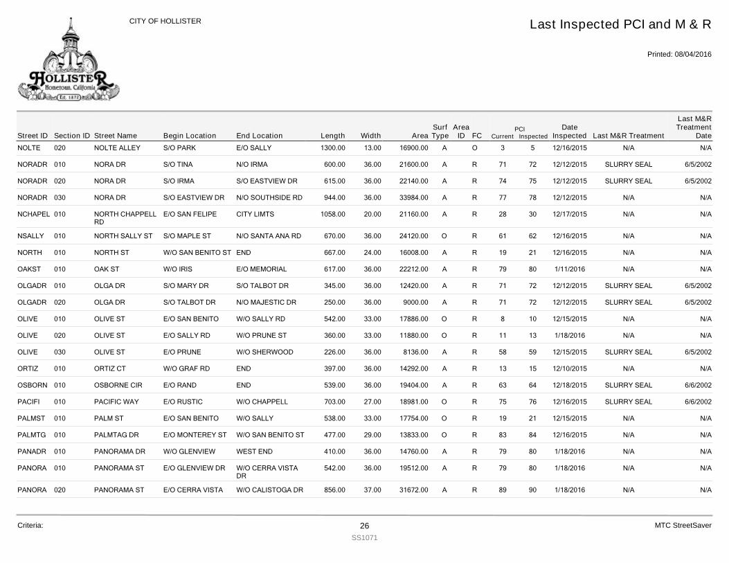
NOLTE 020 NOLTE ALLEY 1300.00S/O PARK E/O SALLY 13.00 16900.00 O 5 12/16/2015 N/A N/A3A
NORADR 010 NORA DR 600.00S/O TINA N/O IRMA 36.00 21600.00 R 72 12/12/2015 SLURRY SEAL 6/5/200271A
NORADR 020 NORA DR 615.00S/O IRMA S/O EASTVIEW DR 36.00 22140.00 R 75 12/12/2015 SLURRY SEAL 6/5/200274A
NORADR 030 NORA DR 944.00S/O EASTVIEW DR N/O SOUTHSIDE RD 36.00 33984.00 R 78 12/12/2015 N/A N/A77A
NCHAPEL 010 NORTH CHAPPELLRD
1058.00E/O SAN FELIPE CITY LIMTS 20.00 21160.00 R 30 12/17/2015 N/A N/A28A
NSALLY 010 NORTH SALLY ST 670.00S/O MAPLE ST N/O SANTA ANA RD 36.00 24120.00 R 62 12/16/2015 N/A N/A61O
NORTH 010 NORTH ST 667.00W/O SAN BENITO ST END 24.00 16008.00 R 21 12/16/2015 N/A N/A19A
OAKST 010 OAK ST 617.00W/O IRIS E/O MEMORIAL 36.00 22212.00 R 80 1/11/2016 N/A N/A79A
OLGADR 010 OLGA DR 345.00S/O MARY DR S/O TALBOT DR 36.00 12420.00 R 72 12/12/2015 SLURRY SEAL 6/5/200271A
OLGADR 020 OLGA DR 250.00S/O TALBOT DR N/O MAJESTIC DR 36.00 9000.00 R 72 12/12/2015 SLURRY SEAL 6/5/200271A
OLIVE 010 OLIVE ST 542.00E/O SAN BENITO W/O SALLY RD 33.00 17886.00 R 10 12/15/2015 N/A N/A8O
OLIVE 020 OLIVE ST 360.00E/O SALLY RD W/O PRUNE ST 33.00 11880.00 R 13 1/18/2016 N/A N/A11O
OLIVE 030 OLIVE ST 226.00E/O PRUNE W/O SHERWOOD 36.00 8136.00 R 59 12/15/2015 SLURRY SEAL 6/5/200258A
ORTIZ 010 ORTIZ CT 397.00W/O GRAF RD END 36.00 14292.00 R 15 12/10/2015 N/A N/A13A
OSBORN 010 OSBORNE CIR 539.00E/O RAND END 36.00 19404.00 R 64 12/18/2015 SLURRY SEAL 6/6/200263A
PACIFI 010 PACIFIC WAY 703.00E/O RUSTIC W/O CHAPPELL 27.00 18981.00 R 76 12/16/2015 SLURRY SEAL 6/6/200275O
PALMST 010 PALM ST 538.00E/O SAN BENITO W/O SALLY 33.00 17754.00 R 21 12/15/2015 N/A N/A19O
PALMTG 010 PALMTAG DR 477.00E/O MONTEREY ST W/O SAN BENITO ST 29.00 13833.00 R 84 12/16/2015 N/A N/A83O
PANADR 010 PANORAMA DR 410.00W/O GLENVIEW WEST END 36.00 14760.00 R 80 1/18/2016 N/A N/A79A
PANORA 010 PANORAMA ST 542.00E/O GLENVIEW DR W/O CERRA VISTADR
36.00 19512.00 R 80 1/18/2016 N/A N/A79A
PANORA 020 PANORAMA ST 856.00E/O CERRA VISTA W/O CALISTOGA DR 37.00 31672.00 R 90 1/18/2016 N/A N/A89A
Street IDPCI
Current InspectedEnd Location Width FC
Last Inspected PCI and M & R
Printed: 08/04/2016
CITY OF HOLLISTER
Section ID Begin Location Length AreaDate
Inspected Last M&R Treatment
Last M&RTreatment
DateStreet NameArea
IDSurfType
Criteria: 26SS1071
MTC StreetSaver
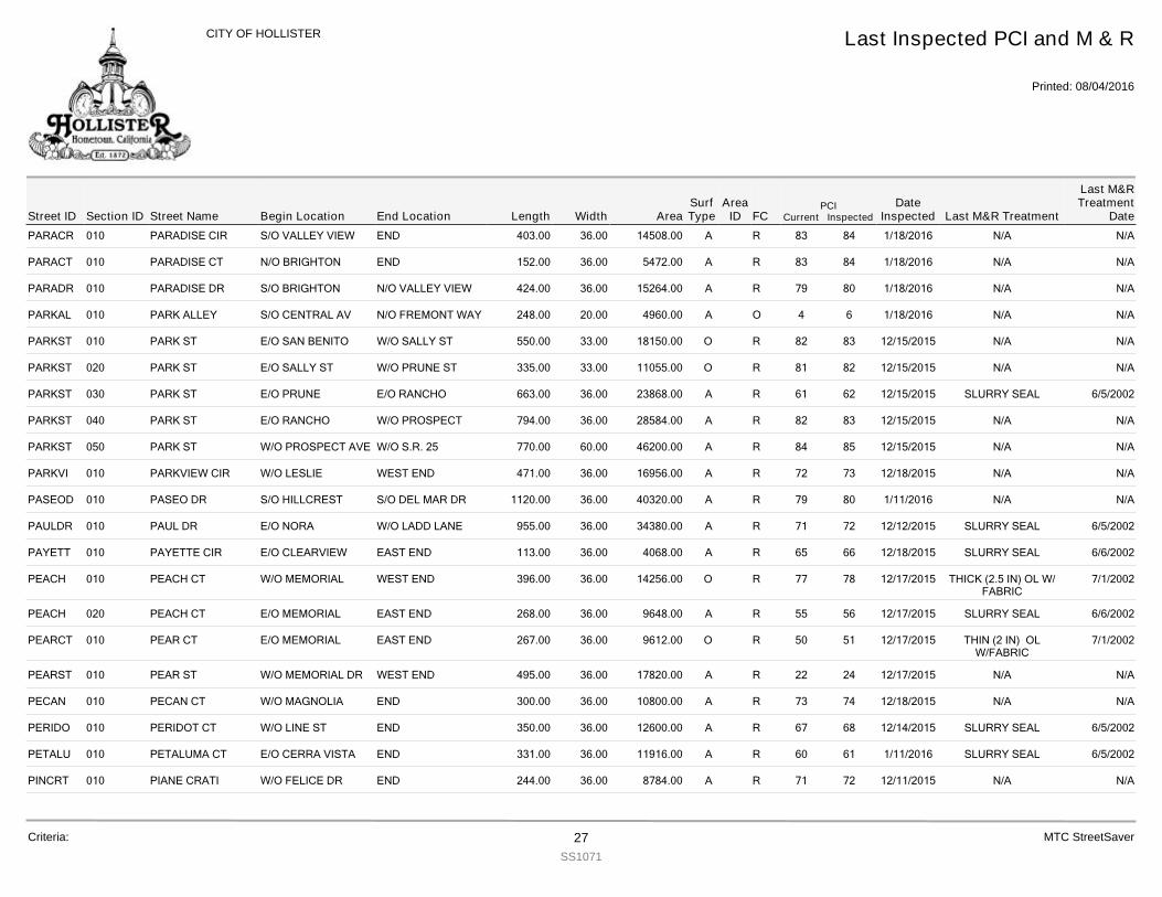
PARACR 010 PARADISE CIR 403.00S/O VALLEY VIEW END 36.00 14508.00 R 84 1/18/2016 N/A N/A83A
PARACT 010 PARADISE CT 152.00N/O BRIGHTON END 36.00 5472.00 R 84 1/18/2016 N/A N/A83A
PARADR 010 PARADISE DR 424.00S/O BRIGHTON N/O VALLEY VIEW 36.00 15264.00 R 80 1/18/2016 N/A N/A79A
PARKAL 010 PARK ALLEY 248.00S/O CENTRAL AV N/O FREMONT WAY 20.00 4960.00 O 6 1/18/2016 N/A N/A4A
PARKST 010 PARK ST 550.00E/O SAN BENITO W/O SALLY ST 33.00 18150.00 R 83 12/15/2015 N/A N/A82O
PARKST 020 PARK ST 335.00E/O SALLY ST W/O PRUNE ST 33.00 11055.00 R 82 12/15/2015 N/A N/A81O
PARKST 030 PARK ST 663.00E/O PRUNE E/O RANCHO 36.00 23868.00 R 62 12/15/2015 SLURRY SEAL 6/5/200261A
PARKST 040 PARK ST 794.00E/O RANCHO W/O PROSPECT 36.00 28584.00 R 83 12/15/2015 N/A N/A82A
PARKST 050 PARK ST 770.00W/O PROSPECT AVE W/O S.R. 25 60.00 46200.00 R 85 12/15/2015 N/A N/A84A
PARKVI 010 PARKVIEW CIR 471.00W/O LESLIE WEST END 36.00 16956.00 R 73 12/18/2015 N/A N/A72A
PASEOD 010 PASEO DR 1120.00S/O HILLCREST S/O DEL MAR DR 36.00 40320.00 R 80 1/11/2016 N/A N/A79A
PAULDR 010 PAUL DR 955.00E/O NORA W/O LADD LANE 36.00 34380.00 R 72 12/12/2015 SLURRY SEAL 6/5/200271A
PAYETT 010 PAYETTE CIR 113.00E/O CLEARVIEW EAST END 36.00 4068.00 R 66 12/18/2015 SLURRY SEAL 6/6/200265A
PEACH 010 PEACH CT 396.00W/O MEMORIAL WEST END 36.00 14256.00 R 78 12/17/2015 THICK (2.5 IN) OL W/FABRIC
7/1/200277O
PEACH 020 PEACH CT 268.00E/O MEMORIAL EAST END 36.00 9648.00 R 56 12/17/2015 SLURRY SEAL 6/6/200255A
PEARCT 010 PEAR CT 267.00E/O MEMORIAL EAST END 36.00 9612.00 R 51 12/17/2015 THIN (2 IN) OLW/FABRIC
7/1/200250O
PEARST 010 PEAR ST 495.00W/O MEMORIAL DR WEST END 36.00 17820.00 R 24 12/17/2015 N/A N/A22A
PECAN 010 PECAN CT 300.00W/O MAGNOLIA END 36.00 10800.00 R 74 12/18/2015 N/A N/A73A
PERIDO 010 PERIDOT CT 350.00W/O LINE ST END 36.00 12600.00 R 68 12/14/2015 SLURRY SEAL 6/5/200267A
PETALU 010 PETALUMA CT 331.00E/O CERRA VISTA END 36.00 11916.00 R 61 1/11/2016 SLURRY SEAL 6/5/200260A
PINCRT 010 PIANE CRATI 244.00W/O FELICE DR END 36.00 8784.00 R 72 12/11/2015 N/A N/A71A
Street IDPCI
Current InspectedEnd Location Width FC
Last Inspected PCI and M & R
Printed: 08/04/2016
CITY OF HOLLISTER
Section ID Begin Location Length AreaDate
Inspected Last M&R Treatment
Last M&RTreatment
DateStreet NameArea
IDSurfType
Criteria: 27SS1071
MTC StreetSaver
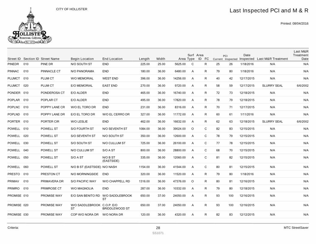
PINEDR 010 PINE DR 225.00N/O SOUTH ST END 25.00 5625.00 R 26 1/18/2016 N/A N/A25C
PINNAC 010 PINNACLE CT 180.00N/O PANORAMA END 36.00 6480.00 R 80 1/18/2016 N/A N/A79A
PLUMCT 010 PLUM CT 396.00W/O MEMORIAL WEST END 36.00 14256.00 R 42 12/17/2015 N/A N/A40A
PLUMCT 020 PLUM CT 270.00E/O MEMORIAL EAST END 36.00 9720.00 R 59 12/17/2015 SLURRY SEAL 6/6/200258A
PONDER 010 PONDEROSA CT 465.00E/O ALDER END 36.00 16740.00 R 73 12/18/2015 N/A N/A72A
POPLAR 010 POPLAR CT 495.00E/O ALDER END 36.00 17820.00 R 79 12/18/2015 N/A N/A78A
POPLNC 010 POPPY LANE CR 231.00W/O EL TORO DR END 36.00 8316.00 R 71 12/17/2015 N/A N/A70A
POPLND 010 POPPY LANE DR 327.00E/O EL TORO DR W/O EL CERRO DR 36.00 11772.00 R 61 1/11/2016 N/A N/A60A
PORTER 010 PORTER CIR 462.00W/O LESLIE END 36.00 16632.00 R 63 12/18/2015 SLURRY SEAL 6/6/200262A
POWELL 010 POWELL ST 1084.00S/O FOURTH ST N/O SEVENTH ST 36.00 39024.00 C 83 12/15/2015 N/A N/A82O
POWELL 020 POWELL ST 350.00S/O SEVENTH ST N/O SOUTH ST 36.00 12600.00 C 79 12/15/2015 N/A N/A78A
POWELL 030 POWELL ST 725.00S/O SOUTH ST N/O CULLUM ST 36.00 26100.00 C 78 12/15/2015 N/A N/A77A
POWELL 040 POWELL ST 800.00N/O CULLUM ST S/O A ST 36.00 28800.00 C 70 12/15/2015 N/A N/A68A
POWELL 050 POWELL ST 335.00S/O A ST N/O B ST(EASTSIDE)
36.00 12060.00 C 82 12/15/2015 N/A N/A81A
POWELL 060 POWELL ST 1154.00N/O B ST (EASTSIDE) N/O NASH 36.00 41544.00 C 81 12/15/2015 N/A N/A80A
PRESTO 010 PRESTON CT 320.00N/O MORNINGSIDE END 36.00 11520.00 R 80 1/18/2016 N/A N/A79A
PRIMAV 010 PRIMAVERA DR 1316.00S/O PACIFIC WAY W/O CHAPPELL RD 36.00 47376.00 R 81 12/16/2015 N/A N/A80O
PRIMRO 010 PRIMROSE CT 287.00W/O MAGNOLIA END 36.00 10332.00 R 80 12/18/2015 N/A N/A79A
PROMISE 010 PROMISE WAY 650.00E/O SAN BENITO RD W/O SADDLEBROOKST
37.00 24050.00 R 100 12/16/2015 N/A N/A93A
PROMISE 020 PROMISE WAY 650.00W/O SADDLEBROOKST
C.O.P. E/OBRIDDLEWOOD ST
37.00 24050.00 R 100 12/16/2015 N/A N/A93A
PROMISE 030 PROMISE WAY 120.00COP W/O NORA DR W/O NORA DR 36.00 4320.00 R 83 12/12/2015 N/A N/A82A
Street IDPCI
Current InspectedEnd Location Width FC
Last Inspected PCI and M & R
Printed: 08/04/2016
CITY OF HOLLISTER
Section ID Begin Location Length AreaDate
Inspected Last M&R Treatment
Last M&RTreatment
DateStreet NameArea
IDSurfType
Criteria: 28SS1071
MTC StreetSaver
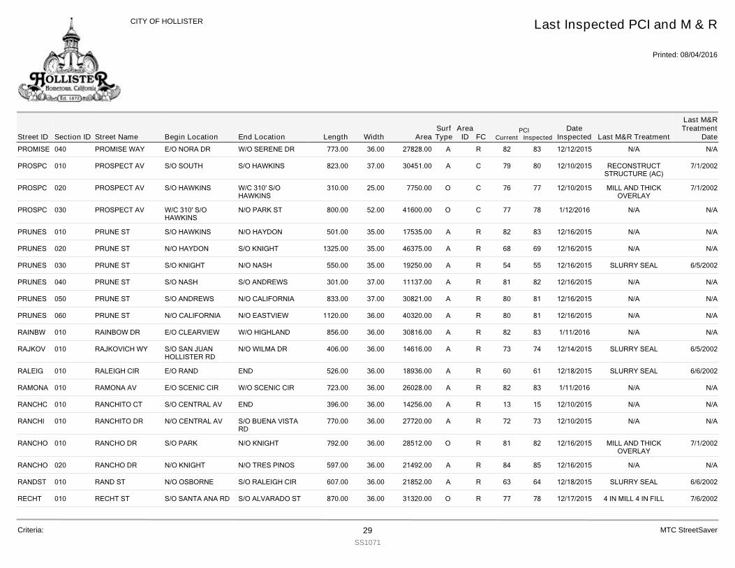
PROMISE 040 PROMISE WAY 773.00E/O NORA DR W/O SERENE DR 36.00 27828.00 R 83 12/12/2015 N/A N/A82A
PROSPC 010 PROSPECT AV 823.00S/O SOUTH S/O HAWKINS 37.00 30451.00 C 80 12/10/2015 RECONSTRUCTSTRUCTURE (AC)
7/1/200279A
PROSPC 020 PROSPECT AV 310.00S/O HAWKINS W/C 310' S/OHAWKINS
25.00 7750.00 C 77 12/10/2015 MILL AND THICKOVERLAY
7/1/200276O
PROSPC 030 PROSPECT AV 800.00W/C 310' S/OHAWKINS
N/O PARK ST 52.00 41600.00 C 78 1/12/2016 N/A N/A77O
PRUNES 010 PRUNE ST 501.00S/O HAWKINS N/O HAYDON 35.00 17535.00 R 83 12/16/2015 N/A N/A82A
PRUNES 020 PRUNE ST 1325.00N/O HAYDON S/O KNIGHT 35.00 46375.00 R 69 12/16/2015 N/A N/A68A
PRUNES 030 PRUNE ST 550.00S/O KNIGHT N/O NASH 35.00 19250.00 R 55 12/16/2015 SLURRY SEAL 6/5/200254A
PRUNES 040 PRUNE ST 301.00S/O NASH S/O ANDREWS 37.00 11137.00 R 82 12/16/2015 N/A N/A81A
PRUNES 050 PRUNE ST 833.00S/O ANDREWS N/O CALIFORNIA 37.00 30821.00 R 81 12/16/2015 N/A N/A80A
PRUNES 060 PRUNE ST 1120.00N/O CALIFORNIA N/O EASTVIEW 36.00 40320.00 R 81 12/16/2015 N/A N/A80A
RAINBW 010 RAINBOW DR 856.00E/O CLEARVIEW W/O HIGHLAND 36.00 30816.00 R 83 1/11/2016 N/A N/A82A
RAJKOV 010 RAJKOVICH WY 406.00S/O SAN JUANHOLLISTER RD
N/O WILMA DR 36.00 14616.00 R 74 12/14/2015 SLURRY SEAL 6/5/200273A
RALEIG 010 RALEIGH CIR 526.00E/O RAND END 36.00 18936.00 R 61 12/18/2015 SLURRY SEAL 6/6/200260A
RAMONA 010 RAMONA AV 723.00E/O SCENIC CIR W/O SCENIC CIR 36.00 26028.00 R 83 1/11/2016 N/A N/A82A
RANCHC 010 RANCHITO CT 396.00S/O CENTRAL AV END 36.00 14256.00 R 15 12/10/2015 N/A N/A13A
RANCHI 010 RANCHITO DR 770.00N/O CENTRAL AV S/O BUENA VISTARD
36.00 27720.00 R 73 12/10/2015 N/A N/A72A
RANCHO 010 RANCHO DR 792.00S/O PARK N/O KNIGHT 36.00 28512.00 R 82 12/16/2015 MILL AND THICKOVERLAY
7/1/200281O
RANCHO 020 RANCHO DR 597.00N/O KNIGHT N/O TRES PINOS 36.00 21492.00 R 85 12/16/2015 N/A N/A84A
RANDST 010 RAND ST 607.00N/O OSBORNE S/O RALEIGH CIR 36.00 21852.00 R 64 12/18/2015 SLURRY SEAL 6/6/200263A
RECHT 010 RECHT ST 870.00S/O SANTA ANA RD S/O ALVARADO ST 36.00 31320.00 R 78 12/17/2015 4 IN MILL 4 IN FILL 7/6/200277O
Street IDPCI
Current InspectedEnd Location Width FC
Last Inspected PCI and M & R
Printed: 08/04/2016
CITY OF HOLLISTER
Section ID Begin Location Length AreaDate
Inspected Last M&R Treatment
Last M&RTreatment
DateStreet NameArea
IDSurfType
Criteria: 29SS1071
MTC StreetSaver
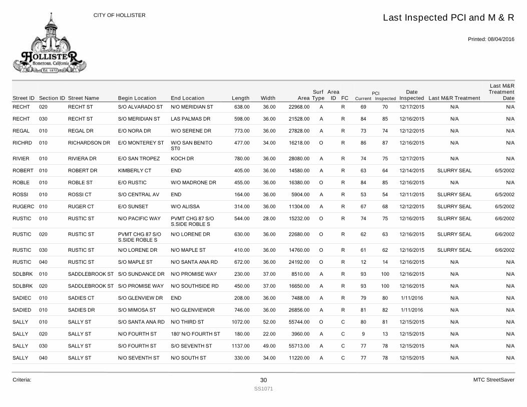
RECHT 020 RECHT ST 638.00S/O ALVARADO ST N/O MERIDIAN ST 36.00 22968.00 R 70 12/17/2015 N/A N/A69A
RECHT 030 RECHT ST 598.00S/O MERIDIAN ST LAS PALMAS DR 36.00 21528.00 R 85 12/16/2015 N/A N/A84A
REGAL 010 REGAL DR 773.00E/O NORA DR W/O SERENE DR 36.00 27828.00 R 74 12/12/2015 N/A N/A73A
RICHRD 010 RICHARDSON DR 477.00E/O MONTEREY ST W/O SAN BENITOST0
34.00 16218.00 R 87 12/16/2015 N/A N/A86O
RIVIER 010 RIVIERA DR 780.00E/O SAN TROPEZ KOCH DR 36.00 28080.00 R 75 12/17/2015 N/A N/A74A
ROBERT 010 ROBERT DR 405.00KIMBERLY CT END 36.00 14580.00 R 64 12/14/2015 SLURRY SEAL 6/5/200263A
ROBLE 010 ROBLE ST 455.00E/O RUSTIC W/O MADRONE DR 36.00 16380.00 R 85 12/16/2015 N/A N/A84O
ROSSI 010 ROSSI CT 164.00S/O CENTRAL AV END 36.00 5904.00 R 54 12/11/2015 SLURRY SEAL 6/5/200253A
RUGERC 010 RUGER CT 314.00E/O SUNSET W/O ALISSA 36.00 11304.00 R 68 12/12/2015 SLURRY SEAL 6/5/200267A
RUSTIC 010 RUSTIC ST 544.00N/O PACIFIC WAY PVMT CHG 87 S/OS.SIDE ROBLE S
28.00 15232.00 R 75 12/16/2015 SLURRY SEAL 6/6/200274O
RUSTIC 020 RUSTIC ST 630.00PVMT CHG 87 S/OS.SIDE ROBLE S
N/O LORENE DR 36.00 22680.00 R 63 12/16/2015 SLURRY SEAL 6/6/200262O
RUSTIC 030 RUSTIC ST 410.00N/O LORENE DR N/O MAPLE ST 36.00 14760.00 R 62 12/16/2015 SLURRY SEAL 6/6/200261O
RUSTIC 040 RUSTIC ST 672.00S/O MAPLE ST N/O SANTA ANA RD 36.00 24192.00 R 14 12/16/2015 N/A N/A12O
SDLBRK 010 SADDLEBROOK ST 230.00S/O SUNDANCE DR N/O PROMISE WAY 37.00 8510.00 R 100 12/16/2015 N/A N/A93A
SDLBRK 020 SADDLEBROOK ST 450.00S/O PROMISE WAY N/O SOUTHSIDE RD 37.00 16650.00 R 100 12/16/2015 N/A N/A93A
SADIEC 010 SADIES CT 208.00S/O GLENVIEW DR END 36.00 7488.00 R 80 1/11/2016 N/A N/A79A
SADIED 010 SADIES DR 746.00S/O MIMOSA ST N/O GLENVIEWDR 36.00 26856.00 R 82 1/11/2016 N/A N/A81A
SALLY 010 SALLY ST 1072.00S/O SANTA ANA RD N/O THIRD ST 52.00 55744.00 C 81 12/15/2015 N/A N/A80O
SALLY 020 SALLY ST 180.00N/O FOURTH ST 180' N/O FOURTH ST 22.00 3960.00 C 13 12/15/2015 N/A N/A9A
SALLY 030 SALLY ST 1137.00S/O FOURTH ST S/O SEVENTH ST 49.00 55713.00 C 78 12/15/2015 N/A N/A77A
SALLY 040 SALLY ST 330.00N/O SEVENTH ST N/O SOUTH ST 34.00 11220.00 C 78 12/15/2015 N/A N/A77A
Street IDPCI
Current InspectedEnd Location Width FC
Last Inspected PCI and M & R
Printed: 08/04/2016
CITY OF HOLLISTER
Section ID Begin Location Length AreaDate
Inspected Last M&R Treatment
Last M&RTreatment
DateStreet NameArea
IDSurfType
Criteria: 30SS1071
MTC StreetSaver
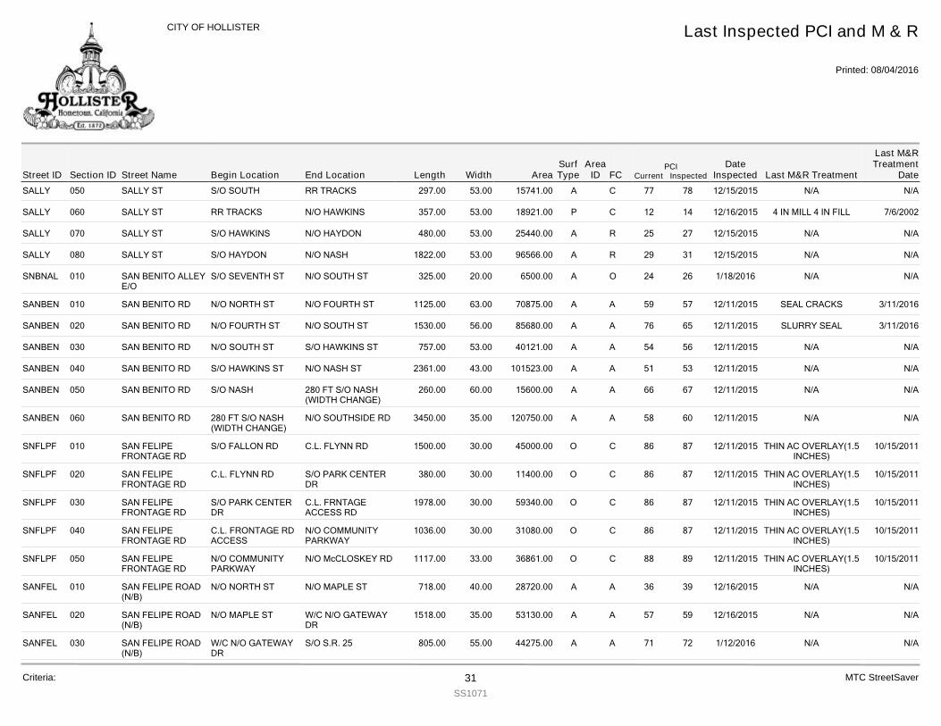
SALLY 050 SALLY ST 297.00S/O SOUTH RR TRACKS 53.00 15741.00 C 78 12/15/2015 N/A N/A77A
SALLY 060 SALLY ST 357.00RR TRACKS N/O HAWKINS 53.00 18921.00 C 14 12/16/2015 4 IN MILL 4 IN FILL 7/6/200212P
SALLY 070 SALLY ST 480.00S/O HAWKINS N/O HAYDON 53.00 25440.00 R 27 12/15/2015 N/A N/A25A
SALLY 080 SALLY ST 1822.00S/O HAYDON N/O NASH 53.00 96566.00 R 31 12/15/2015 N/A N/A29A
SNBNAL 010 SAN BENITO ALLEYE/O
325.00S/O SEVENTH ST N/O SOUTH ST 20.00 6500.00 O 26 1/18/2016 N/A N/A24A
SANBEN 010 SAN BENITO RD 1125.00N/O NORTH ST N/O FOURTH ST 63.00 70875.00 A 57 12/11/2015 SEAL CRACKS 3/11/201659A
SANBEN 020 SAN BENITO RD 1530.00N/O FOURTH ST N/O SOUTH ST 56.00 85680.00 A 65 12/11/2015 SLURRY SEAL 3/11/201676A
SANBEN 030 SAN BENITO RD 757.00N/O SOUTH ST S/O HAWKINS ST 53.00 40121.00 A 56 12/11/2015 N/A N/A54A
SANBEN 040 SAN BENITO RD 2361.00S/O HAWKINS ST N/O NASH ST 43.00 101523.00 A 53 12/11/2015 N/A N/A51A
SANBEN 050 SAN BENITO RD 260.00S/O NASH 280 FT S/O NASH(WIDTH CHANGE)
60.00 15600.00 A 67 12/11/2015 N/A N/A66A
SANBEN 060 SAN BENITO RD 3450.00280 FT S/O NASH(WIDTH CHANGE)
N/O SOUTHSIDE RD 35.00 120750.00 A 60 12/11/2015 N/A N/A58A
SNFLPF 010 SAN FELIPEFRONTAGE RD
1500.00S/O FALLON RD C.L. FLYNN RD 30.00 45000.00 C 87 12/11/2015 THIN AC OVERLAY(1.5INCHES)
10/15/201186O
SNFLPF 020 SAN FELIPEFRONTAGE RD
380.00C.L. FLYNN RD S/O PARK CENTERDR
30.00 11400.00 C 87 12/11/2015 THIN AC OVERLAY(1.5INCHES)
10/15/201186O
SNFLPF 030 SAN FELIPEFRONTAGE RD
1978.00S/O PARK CENTERDR
C.L. FRNTAGEACCESS RD
30.00 59340.00 C 87 12/11/2015 THIN AC OVERLAY(1.5INCHES)
10/15/201186O
SNFLPF 040 SAN FELIPEFRONTAGE RD
1036.00C.L. FRONTAGE RDACCESS
N/O COMMUNITYPARKWAY
30.00 31080.00 C 87 12/11/2015 THIN AC OVERLAY(1.5INCHES)
10/15/201186O
SNFLPF 050 SAN FELIPEFRONTAGE RD
1117.00N/O COMMUNITYPARKWAY
N/O McCLOSKEY RD 33.00 36861.00 C 89 12/11/2015 THIN AC OVERLAY(1.5INCHES)
10/15/201188O
SANFEL 010 SAN FELIPE ROAD(N/B)
718.00N/O NORTH ST N/O MAPLE ST 40.00 28720.00 A 39 12/16/2015 N/A N/A36A
SANFEL 020 SAN FELIPE ROAD(N/B)
1518.00N/O MAPLE ST W/C N/O GATEWAYDR
35.00 53130.00 A 59 12/16/2015 N/A N/A57A
SANFEL 030 SAN FELIPE ROAD(N/B)
805.00W/C N/O GATEWAYDR
S/O S.R. 25 55.00 44275.00 A 72 1/12/2016 N/A N/A71A
Street IDPCI
Current InspectedEnd Location Width FC
Last Inspected PCI and M & R
Printed: 08/04/2016
CITY OF HOLLISTER
Section ID Begin Location Length AreaDate
Inspected Last M&R Treatment
Last M&RTreatment
DateStreet NameArea
IDSurfType
Criteria: 31SS1071
MTC StreetSaver
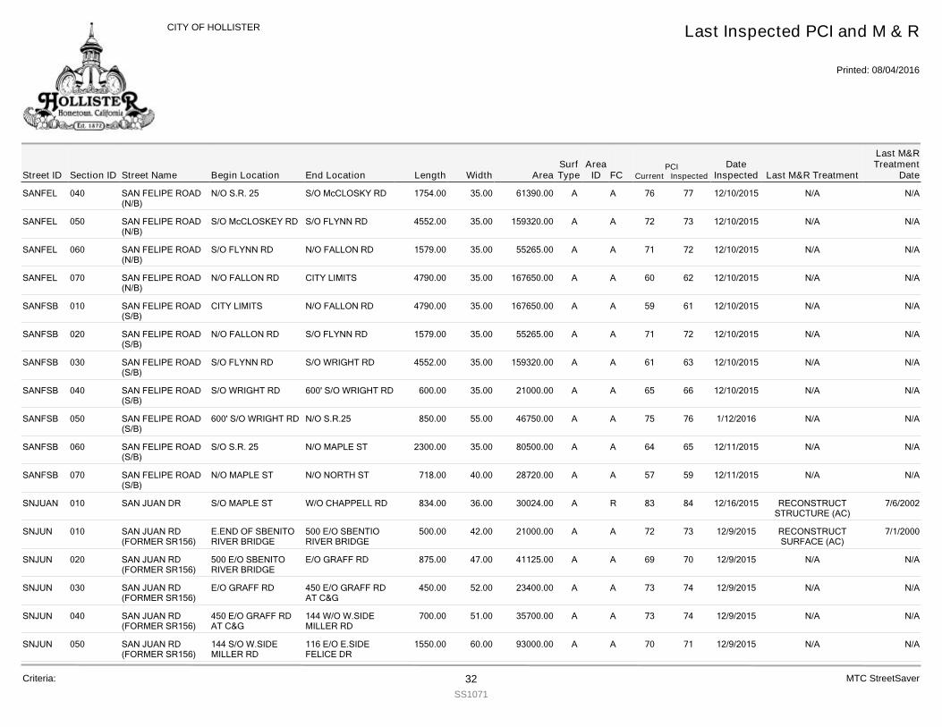
SANFEL 040 SAN FELIPE ROAD(N/B)
1754.00N/O S.R. 25 S/O McCLOSKY RD 35.00 61390.00 A 77 12/10/2015 N/A N/A76A
SANFEL 050 SAN FELIPE ROAD(N/B)
4552.00S/O McCLOSKEY RD S/O FLYNN RD 35.00 159320.00 A 73 12/10/2015 N/A N/A72A
SANFEL 060 SAN FELIPE ROAD(N/B)
1579.00S/O FLYNN RD N/O FALLON RD 35.00 55265.00 A 72 12/10/2015 N/A N/A71A
SANFEL 070 SAN FELIPE ROAD(N/B)
4790.00N/O FALLON RD CITY LIMITS 35.00 167650.00 A 62 12/10/2015 N/A N/A60A
SANFSB 010 SAN FELIPE ROAD(S/B)
4790.00CITY LIMITS N/O FALLON RD 35.00 167650.00 A 61 12/10/2015 N/A N/A59A
SANFSB 020 SAN FELIPE ROAD(S/B)
1579.00N/O FALLON RD S/O FLYNN RD 35.00 55265.00 A 72 12/10/2015 N/A N/A71A
SANFSB 030 SAN FELIPE ROAD(S/B)
4552.00S/O FLYNN RD S/O WRIGHT RD 35.00 159320.00 A 63 12/10/2015 N/A N/A61A
SANFSB 040 SAN FELIPE ROAD(S/B)
600.00S/O WRIGHT RD 600' S/O WRIGHT RD 35.00 21000.00 A 66 12/10/2015 N/A N/A65A
SANFSB 050 SAN FELIPE ROAD(S/B)
850.00600' S/O WRIGHT RD N/O S.R.25 55.00 46750.00 A 76 1/12/2016 N/A N/A75A
SANFSB 060 SAN FELIPE ROAD(S/B)
2300.00S/O S.R. 25 N/O MAPLE ST 35.00 80500.00 A 65 12/11/2015 N/A N/A64A
SANFSB 070 SAN FELIPE ROAD(S/B)
718.00N/O MAPLE ST N/O NORTH ST 40.00 28720.00 A 59 12/11/2015 N/A N/A57A
SNJUAN 010 SAN JUAN DR 834.00S/O MAPLE ST W/O CHAPPELL RD 36.00 30024.00 R 84 12/16/2015 RECONSTRUCTSTRUCTURE (AC)
7/6/200283A
SNJUN 010 SAN JUAN RD(FORMER SR156)
500.00E.END OF SBENITORIVER BRIDGE
500 E/O SBENTIORIVER BRIDGE
42.00 21000.00 A 73 12/9/2015 RECONSTRUCTSURFACE (AC)
7/1/200072A
SNJUN 020 SAN JUAN RD(FORMER SR156)
875.00500 E/O SBENITORIVER BRIDGE
E/O GRAFF RD 47.00 41125.00 A 70 12/9/2015 N/A N/A69A
SNJUN 030 SAN JUAN RD(FORMER SR156)
450.00E/O GRAFF RD 450 E/O GRAFF RDAT C&G
52.00 23400.00 A 74 12/9/2015 N/A N/A73A
SNJUN 040 SAN JUAN RD(FORMER SR156)
700.00450 E/O GRAFF RDAT C&G
144 W/O W.SIDEMILLER RD
51.00 35700.00 A 74 12/9/2015 N/A N/A73A
SNJUN 050 SAN JUAN RD(FORMER SR156)
1550.00144 S/O W.SIDEMILLER RD
116 E/O E.SIDEFELICE DR
60.00 93000.00 A 71 12/9/2015 N/A N/A70A
Street IDPCI
Current InspectedEnd Location Width FC
Last Inspected PCI and M & R
Printed: 08/04/2016
CITY OF HOLLISTER
Section ID Begin Location Length AreaDate
Inspected Last M&R Treatment
Last M&RTreatment
DateStreet NameArea
IDSurfType
Criteria: 32SS1071
MTC StreetSaver
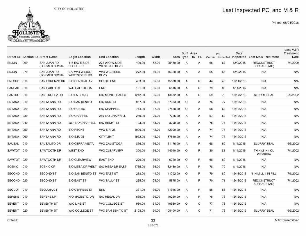
SNJUN 060 SAN JUAN RD(FORMER SR156)
490.00116 E/O E.SIDEFELICE DR
272 W/O W.SIDEWESTSIDE BLVD
52.00 25480.00 A 67 12/9/2015 RECONSTRUCTSURFACE (AC)
7/1/200066A
SNJUN 070 SAN JUAN RD(FORMER SR156)
272.00272 W/O W.SIDEWESTSIDE BLVD
W/O WESTSIDEBLVD
60.00 16320.00 A 66 12/9/2015 N/A N/A65A
SNLORE 010 SAN LORENZO DR 433.00S/O CENTRAL AV SOUTH END 36.00 15588.00 R 45 12/11/2015 N/A N/A44A
SANPAB 010 SAN PABLO CT 181.00W/O CALISTOGA END 36.00 6516.00 R 80 1/11/2016 N/A N/A79A
SANTRO 010 SAN TROPEZ DR 1212.00S/O LA BRAIG S/O MONTE CARLO 36.00 43632.00 R 70 12/17/2015 SLURRY SEAL 6/6/200269A
SNTANA 010 SANTA ANA RD 957.00E/O SAN BENITO E/O RUSTIC 39.00 37323.00 A 77 12/10/2015 N/A N/A76O
SNTANA 020 SANTA ANA RD 744.00E/O RUSTIC E/O CHAPPELL 37.00 27528.00 A 69 12/10/2015 N/A N/A68O
SNTANA 030 SANTA ANA RD 289.00E/O CHAPPEL 289 E/O CHAPPELL 25.00 7225.00 A 59 12/10/2015 N/A N/A57A
SNTANA 040 SANTA ANA RD 193.00289' E/O CHAPPELL E/O RECHT ST 43.00 8299.00 A 76 12/10/2015 N/A N/A75A
SNTANA 050 SANTA ANA RD 1000.00E/O RECHT W/O S.R. 25 42.00 42000.00 A 75 12/10/2015 N/A N/A74A
SNTANA 060 SANTA ANA RD 1952.00E/O S.R. 25 CITY LIMIT 45.00 87840.00 A 75 12/10/2015 N/A N/A74A
SAUSAL 010 SAUSALITO DR 866.00E/O CERRA VISTA W/O CALISTOGA 36.00 31176.00 R 69 1/11/2016 SLURRY SEAL 6/5/200268A
SAWTOT 010 SAWTOOTH DR 390.00WEST END W/O CLEARVIEW 36.00 14040.00 R 81 1/11/2016 THIN (2 IN) OLW/FABRIC
7/1/200280O
SAWTOT 020 SAWTOOTH DR 270.00E/O CLEARVIEW EAST END 36.00 9720.00 R 69 1/11/2016 N/A N/A68O
SCENIC 010 SCENIC CR 1735.00S/O MESA DR WEST S/O MESA DR EAST 36.00 62460.00 R 79 1/11/2016 N/A N/A78A
SECOND 010 SECOND ST 268.00E/O SAN BENITO ST W/O EAST ST 44.00 11792.00 R 80 12/16/2015 4 IN MILL 4 IN FILL 7/6/200279O
SECOND 020 SECOND ST 235.00E/O EAST ST W/O SALLY ST 25.00 5875.00 R 71 12/16/2015 RECONSTRUCTSURFACE (AC)
7/1/200270A
SEQUOI 010 SEQUOIA CT 331.00S/O CYPRESS ST END 36.00 11916.00 R 56 12/18/2015 N/A N/A55A
SERENE 010 SERENE DR 535.00N/O MAJESTIC DR S/O REGAL DR 36.00 19260.00 R 76 12/12/2015 N/A N/A75A
SEVENT 010 SEVENTH ST 980.00W/O LINE ST W/O COLLEGE ST 51.00 49980.00 C 78 12/16/2015 N/A N/A77O
SEVENT 020 SEVENTH ST 2108.00W/O COLLEGE ST W/O SAN BENITO ST 50.00 105400.00 C 73 12/16/2015 SLURRY SEAL 6/5/200271A
Street IDPCI
Current InspectedEnd Location Width FC
Last Inspected PCI and M & R
Printed: 08/04/2016
CITY OF HOLLISTER
Section ID Begin Location Length AreaDate
Inspected Last M&R Treatment
Last M&RTreatment
DateStreet NameArea
IDSurfType
Criteria: 33SS1071
MTC StreetSaver
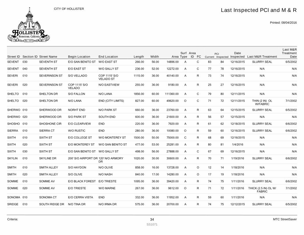
SEVENT 030 SEVENTH ST 266.00E/O SAN BENITO ST W/O EAST ST 56.00 14896.00 C 84 12/16/2015 SLURRY SEAL 6/5/200283A
SEVENT 040 SEVENTH ST 236.00E/O EAST ST W/O SALLY ST 52.00 12272.00 C 78 12/16/2015 N/A N/A77A
SEVERI 010 SEVERINSON ST 1115.00S/O VELLADO COP 1115' S/OVELADO ST
36.00 40140.00 R 74 12/16/2015 N/A N/A73A
SEVERI 020 SEVERINSON ST 255.00COP 1115' S/OVELADO
N/O EASTVIEW 36.00 9180.00 R 27 12/16/2015 N/A N/A25A
SHELTO 010 SHELTON DR 1856.00S/O FALLON N/O LANA 60.00 111360.00 C 80 12/11/2015 N/A N/A79A
SHELTO 020 SHELTON DR 827.00N/O LANA END (CITY LIMITS) 60.00 49620.00 C 72 12/11/2015 THIN (2 IN) OLW/FABRIC
7/1/200271O
SHERWO 010 SHERWOOD DR 660.00NORHT END N/O PARK ST 36.00 23760.00 R 64 12/15/2015 SLURRY SEAL 6/5/200263A
SHERWO 020 SHERWOOD DR 600.00S/O PARK ST SOUTH END 36.00 21600.00 R 57 12/15/2015 N/A N/A56A
SHOSHO 010 SHOSHONE CIR 220.00E/O CLEARVIEW END 36.00 7920.00 R 62 12/18/2015 SLURRY SEAL 6/6/200261A
SIERRA 010 SIERRA CT 280.00W/O RUSTIC END 36.00 10080.00 R 60 12/16/2015 SLURRY SEAL 6/6/200259O
SIXTH 010 SIXTH ST 1500.00E/O COLLEGE ST W/O MONTEREY ST 50.00 75000.00 R 69 12/16/2015 N/A N/A68C
SIXTH 020 SIXTH ST 477.00E/O MONTEREY ST W/O SAN BENITO ST 53.00 25281.00 R 81 1/4/2016 N/A N/A80A
SIXTH 030 SIXTH ST 498.00E/O SAN BENITO ST W/O SALLY ST 56.00 27888.00 C 69 12/16/2015 N/A N/A67A
SKYLIN 010 SKYLINE DR 1020.00200' S/O AIRPORT DR 120' N/O ARMORYDR
30.00 30600.00 R 71 1/19/2016 SLURRY SEAL 6/6/200270A
SMITH 010 SMITH ALLEY 858.00S/O HAYDON N/O OLIVE 16.00 13728.00 O 14 1/18/2016 N/A N/A12A
SMITH 020 SMITH ALLEY 840.00S/O OLIVE N/O NASH 17.00 14280.00 O 19 1/18/2016 N/A N/A17A
SOMME 010 SOMME AV 1095.00E/O BLACK FOREST E/O TRIESTE 36.00 39420.00 R 75 1/11/2016 SLURRY SEAL 6/6/200274A
SOMME 020 SOMME AV 267.00E/O TRIESTE W/O MARNE 36.00 9612.00 R 72 1/11/2016 THICK (2.5 IN) OL W/FABRIC
7/1/200271O
SONOMA 010 SONOMA CT 332.00E/O CERRA VISTA END 36.00 11952.00 R 60 1/11/2016 N/A N/A59A
SRIDGE 010 SOUTH RIDGE DR 575.00N/O TINA DR N/O IRMA DR 36.00 20700.00 R 75 12/12/2015 SLURRY SEAL 6/5/200274A
Street IDPCI
Current InspectedEnd Location Width FC
Last Inspected PCI and M & R
Printed: 08/04/2016
CITY OF HOLLISTER
Section ID Begin Location Length AreaDate
Inspected Last M&R Treatment
Last M&RTreatment
DateStreet NameArea
IDSurfType
Criteria: 34SS1071
MTC StreetSaver
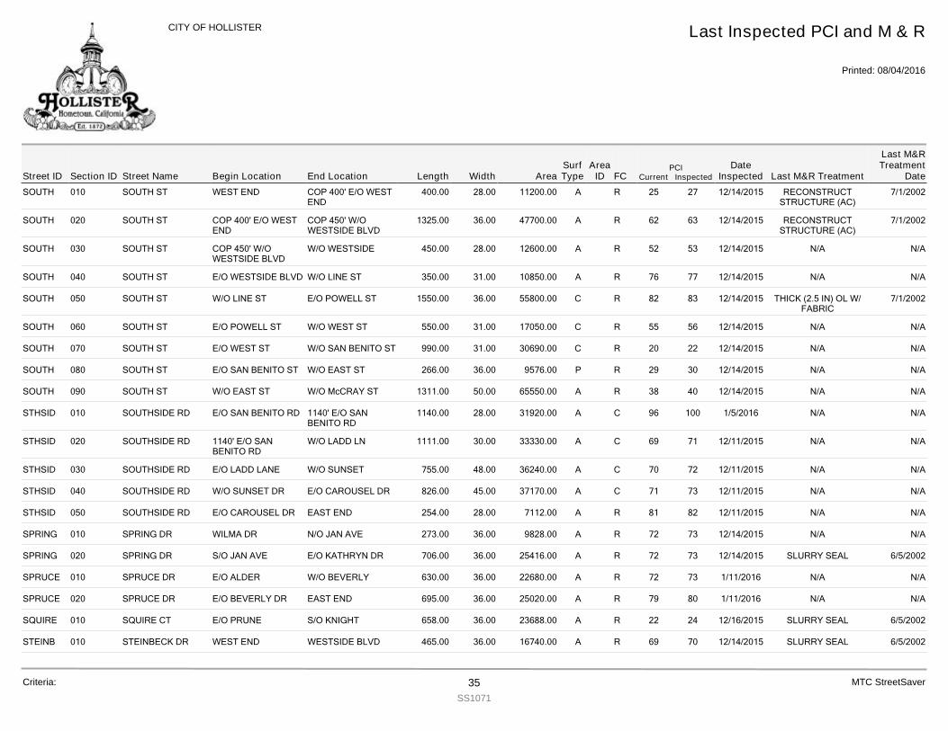
SOUTH 010 SOUTH ST 400.00WEST END COP 400' E/O WESTEND
28.00 11200.00 R 27 12/14/2015 RECONSTRUCTSTRUCTURE (AC)
7/1/200225A
SOUTH 020 SOUTH ST 1325.00COP 400' E/O WESTEND
COP 450' W/OWESTSIDE BLVD
36.00 47700.00 R 63 12/14/2015 RECONSTRUCTSTRUCTURE (AC)
7/1/200262A
SOUTH 030 SOUTH ST 450.00COP 450' W/OWESTSIDE BLVD
W/O WESTSIDE 28.00 12600.00 R 53 12/14/2015 N/A N/A52A
SOUTH 040 SOUTH ST 350.00E/O WESTSIDE BLVD W/O LINE ST 31.00 10850.00 R 77 12/14/2015 N/A N/A76A
SOUTH 050 SOUTH ST 1550.00W/O LINE ST E/O POWELL ST 36.00 55800.00 R 83 12/14/2015 THICK (2.5 IN) OL W/FABRIC
7/1/200282C
SOUTH 060 SOUTH ST 550.00E/O POWELL ST W/O WEST ST 31.00 17050.00 R 56 12/14/2015 N/A N/A55C
SOUTH 070 SOUTH ST 990.00E/O WEST ST W/O SAN BENITO ST 31.00 30690.00 R 22 12/14/2015 N/A N/A20C
SOUTH 080 SOUTH ST 266.00E/O SAN BENITO ST W/O EAST ST 36.00 9576.00 R 30 12/14/2015 N/A N/A29P
SOUTH 090 SOUTH ST 1311.00W/O EAST ST W/O McCRAY ST 50.00 65550.00 R 40 12/14/2015 N/A N/A38A
STHSID 010 SOUTHSIDE RD 1140.00E/O SAN BENITO RD 1140' E/O SANBENITO RD
28.00 31920.00 C 100 1/5/2016 N/A N/A96A
STHSID 020 SOUTHSIDE RD 1111.001140' E/O SANBENITO RD
W/O LADD LN 30.00 33330.00 C 71 12/11/2015 N/A N/A69A
STHSID 030 SOUTHSIDE RD 755.00E/O LADD LANE W/O SUNSET 48.00 36240.00 C 72 12/11/2015 N/A N/A70A
STHSID 040 SOUTHSIDE RD 826.00W/O SUNSET DR E/O CAROUSEL DR 45.00 37170.00 C 73 12/11/2015 N/A N/A71A
STHSID 050 SOUTHSIDE RD 254.00E/O CAROUSEL DR EAST END 28.00 7112.00 R 82 12/11/2015 N/A N/A81A
SPRING 010 SPRING DR 273.00WILMA DR N/O JAN AVE 36.00 9828.00 R 73 12/14/2015 N/A N/A72A
SPRING 020 SPRING DR 706.00S/O JAN AVE E/O KATHRYN DR 36.00 25416.00 R 73 12/14/2015 SLURRY SEAL 6/5/200272A
SPRUCE 010 SPRUCE DR 630.00E/O ALDER W/O BEVERLY 36.00 22680.00 R 73 1/11/2016 N/A N/A72A
SPRUCE 020 SPRUCE DR 695.00E/O BEVERLY DR EAST END 36.00 25020.00 R 80 1/11/2016 N/A N/A79A
SQUIRE 010 SQUIRE CT 658.00E/O PRUNE S/O KNIGHT 36.00 23688.00 R 24 12/16/2015 SLURRY SEAL 6/5/200222A
STEINB 010 STEINBECK DR 465.00WEST END WESTSIDE BLVD 36.00 16740.00 R 70 12/14/2015 SLURRY SEAL 6/5/200269A
Street IDPCI
Current InspectedEnd Location Width FC
Last Inspected PCI and M & R
Printed: 08/04/2016
CITY OF HOLLISTER
Section ID Begin Location Length AreaDate
Inspected Last M&R Treatment
Last M&RTreatment
DateStreet NameArea
IDSurfType
Criteria: 35SS1071
MTC StreetSaver
STEINB 020 STEINBECK DR 462.00E/O WESTSIDE BLVD W/O LINE ST 36.00 16632.00 R 70 12/14/2015 SLURRY SEAL 6/5/200269A
STEPHA 010 STEPHANIE CT 206.00E/O SUMMER DR EAST END 36.00 7416.00 R 70 12/14/2015 SLURRY SEAL 6/5/200269A
STONE 010 STONE ALLEY 141.00S/O OLIVE END OF PAVEMENT 15.00 2115.00 O 9 1/18/2016 N/A N/A7A
STONE 020 STONE ALLEY 560.00S/O VINE N/O NASH 20.00 11200.00 O 10 1/18/2016 N/A N/A8A
SUITER 010 SUITER ST 220.00E/O POWELL ST W/O SUITER ST 16.00 3520.00 R 85 12/15/2015 N/A N/A84A
SUITER 020 SUITER ST 1295.00N/O SUITER ST N/O A ST 27.00 34965.00 R 81 12/15/2015 N/A N/A80A
SUITER 030 SUITER ST 190.00N/O D ST END #548 (PRIVATERD SIGN)
25.00 4750.00 R 4 12/15/2015 N/A N/A1A
SUITER 040 SUITER ST 330.00S/O D ST N/O NASH 38.00 12540.00 R 84 12/15/2015 N/A N/A83A
SUMMER 010 SUMMER DR 975.00WILMA DR N/O SOUTH ST 36.00 35100.00 R 68 12/14/2015 SLURRY SEAL 6/5/200267A
SUMMER 020 SUMMER DR 690.00S/O SOUTH ST SOUTH END 36.00 24840.00 R 80 12/14/2015 N/A N/A79A
SNDNCE 010 SUNDANCE DR 1000.00E/O CINEGA RD W/O BRIDDLEWOODST
37.00 37000.00 R 100 12/16/2015 N/A N/A93A
SUNSLP 010 SUNNYSLOPE RD 1815.00E/O AIRLINE HWY(25)
W/O EASTSIDEMEMORIAL DR
60.00 108900.00 A 65 12/9/2015 N/A N/A63A
SUNSLP 020 SUNNYSLOPE RD 807.00E/O MEMORIAL E/O EL TORO 60.00 48420.00 A 76 12/9/2015 N/A N/A75A
SUNSLP 030 SUNNYSLOPE RD 1116.00E/O EL TORO WIDTH CHNGE 240'W/O CLEARVIE
36.00 40176.00 A 78 12/9/2015 THICK (2.5 IN) OL W/FABRIC
7/1/200277O
SUNSLP 040 SUNNYSLOPE RD 663.00WIDTH CHANGE 240'W/O CLEARVI
WIDTH CHANGE355' E/O CLEARVI
54.00 35802.00 A 78 12/9/2015 N/A N/A77A
SUNSLP 050 SUNNYSLOPE RD 660.00WIDTH CHANGE 355'E/O CLEARVIEW
E/O HIGHLAND DR 62.00 40920.00 A 80 12/9/2015 N/A N/A79A
SUNSLP 060 SUNNYSLOPE RD 1300.00E/O HIGHLAND 450' W/O BEVERLY 45.00 58500.00 A 80 12/9/2015 N/A N/A79A
SUNSLP 070 SUNNYSLOPE RD 1700.00450' W/O BEVERLY W/O FAIRVIEW RD 60.00 102000.00 A 80 12/9/2015 N/A N/A79A
SNSTDR 010 SUNSET DR 973.00E/O AIRLINE HWY(25)
W/O MEMORIAL 60.00 58380.00 C 75 12/12/2015 N/A N/A73A
SNSTDR 020 SUNSET DR 975.00W/O MEMORIAL DR W/O VALLEY VIEW 34.00 33150.00 C 66 12/12/2015 N/A N/A64A
Street IDPCI
Current InspectedEnd Location Width FC
Last Inspected PCI and M & R
Printed: 08/04/2016
CITY OF HOLLISTER
Section ID Begin Location Length AreaDate
Inspected Last M&R Treatment
Last M&RTreatment
DateStreet NameArea
IDSurfType
Criteria: 36SS1071
MTC StreetSaver
SNSTDR 030 SUNSET DR 1294.00E/O VALLEY VIEW E/O CLEARVIEW 36.00 46584.00 C 71 12/12/2015 N/A N/A69A
SNSTDR 040 SUNSET DR 1075.00E/O CLEARVIEW W/O CERRA VISTA 36.00 38700.00 C 84 12/12/2015 N/A N/A83A
SNSTDR 050 SUNSET DR 540.00E/O CERRA VISTA END (CITY LIMITS) 36.00 19440.00 C 52 12/12/2015 SLURRY SEAL 6/5/200250A
SNSTRD 010 SUNSET RD 1000.00W/O AIRLINE HWY S/O TALBOT 60.00 60000.00 C 71 12/12/2015 SLURRY SEAL 6/5/200269A
SNSTRD 020 SUNSET RD 935.00S/O TALBOT N/O SOUTHSIDE 37.00 34595.00 C 65 12/12/2015 SLURRY SEAL 6/5/200263A
SWOPE 010 SWOPE ALLEY 480.00E/O WEST ST W/O MONTEREY ST 18.00 8640.00 O 10 1/18/2016 N/A N/A8A
SWOPE 020 SWOPE ALLEY 475.00E/O MONTEREY W/O SAN BENITO ST 18.00 8550.00 O 8 1/18/2016 N/A N/A6A
SYCAMO 010 SYCAMORE CT 518.00E/O ALDER EAST END 36.00 18648.00 R 74 12/18/2015 N/A N/A73A
TALBOT 010 TALBOT DR 394.00E/O OLGA W/O LADD LANE 36.00 14184.00 R 72 12/12/2015 SLURRY SEAL 6/5/200271A
TALBOT 020 TALBOT DR 775.00E/O LADD LANE W/O SUNSET 36.00 27900.00 R 72 12/12/2015 N/A N/A71A
TALBOT 030 TALBOT DR 1450.00E/O SUNSET RD E/O CAROUSEL DR(SOUTH)
36.00 52200.00 R 80 12/12/2015 N/A N/A79A
TAMARA 010 TAMARA CT 205.00E/O SUMMER DR END 36.00 7380.00 R 64 12/14/2015 SLURRY SEAL 6/5/200263A
TEAKWO 010 TEAKWOOD CT 378.00E/O MAGNOLIA END 36.00 13608.00 R 67 12/18/2015 SLURRY SEAL 6/6/200266A
TECHNO 010 TECHNOLOGYPKWY
807.00NORHT END S/O APOLLO WY 50.00 40350.00 C 76 12/11/2015 N/A N/A74A
TECHNO 020 TECHNOLOGYPKWY
1605.00S/O APOLLO WY N/O FALLON RD 50.00 80250.00 C 69 12/11/2015 SLURRY SEAL 6/5/200267A
TERESC 010 TERESITA CT 348.00S/O CENTRAL AV END 36.00 12528.00 R 56 12/11/2015 SLURRY SEAL 6/5/200255A
TERRAC 010 TERRACE DR 519.00E/O BELLA VISTA DR W/O MONTICELLODR
36.00 18684.00 R 61 12/18/2015 SLURRY SEAL 6/5/200260A
THIRD 010 THIRD ST 725.00E/O WEST ST 725' E/O WEST ST 36.00 26100.00 C 75 12/16/2015 THICK (2.5 IN) OL W/FABRIC
7/1/200274O
THIRD 020 THIRD ST 400.00WIDTH CHANGE E/OWEST ST
W/O SAN BENIITO 60.00 24000.00 C 78 1/12/2016 N/A N/A77O
THIRD 030 THIRD ST 258.00E/O SAN BENITO ST W/O EAST ST 56.00 14448.00 C 78 1/12/2016 N/A N/A77A
Street IDPCI
Current InspectedEnd Location Width FC
Last Inspected PCI and M & R
Printed: 08/04/2016
CITY OF HOLLISTER
Section ID Begin Location Length AreaDate
Inspected Last M&R Treatment
Last M&RTreatment
DateStreet NameArea
IDSurfType
Criteria: 37SS1071
MTC StreetSaver
THIRD 040 THIRD ST 518.00E/O EAST ST W/O MCCRAY ST 38.00 19684.00 C 24 12/16/2015 N/A N/A20A
THOMPS 010 THOMPSON ST 348.00S/O NORTH ST N/O FIRST ST 28.00 9744.00 R 85 12/16/2015 RECONSTRUCTSTRUCTURE (AC)
7/1/200284A
TIBURN 010 TIBURON DR 849.00E/O CERRA VISTA W/O CALISTOGA 36.00 30564.00 R 67 1/11/2016 SLURRY SEAL 6/5/200266A
TIFFAN 010 TIFFANY DR 712.00S/O FIFTH ST N/O SEVENTH ST 35.00 24920.00 R 24 12/16/2015 N/A N/A22A
TINADR 010 TINA DR 748.00W/O NORA W/O SOUTH RIDGE 36.00 26928.00 R 71 12/12/2015 SLURRY SEAL 6/5/200270A
TOROPL 010 TORO PLZ 174.00E/O EL TORO DR END 36.00 6264.00 R 48 12/17/2015 SLURRY SEAL 6/6/200247A
TOWNE 010 TOWNE ALLEY 220.00S/O CANAL ALLEY N/O CENTRAL AV 16.00 3520.00 O 75 1/12/2016 N/A N/A74A
TOWNE 020 TOWNE ALLEY 248.00S/O CENTRAL AV N/O FREMONT WY 16.00 3968.00 O 29 1/12/2016 N/A N/A27A
TRENTE 010 TRENTE CT 418.00S/O ARGONNE END 36.00 15048.00 R 80 1/11/2016 N/A N/A79A
TRPINO 010 TRES PINOS RD 375.00E/O CUSHMAN ST E/O RANCHO DR 40.00 15000.00 A 65 12/12/2015 N/A N/A63A
TRPINO 020 TRES PINOS RD 1150.00E/O RANCHO DR W/O LADD LN 60.00 69000.00 A 65 1/12/2016 N/A N/A64A
TRPINO 030 TRES PINOS RD 530.00W/O LADD LN W/O S.R. 25 95.00 50350.00 A 60 1/12/2016 N/A N/A59A
TRIEST 010 TRIESTE DR 1080.00S/O SOMME N/O VERDUN 36.00 38880.00 R 65 1/11/2016 SLURRY SEAL 6/6/200264A
TRINIT 010 TRINITY DR 115.00NORHT END N/O EL CAMINO DEVIDA
36.00 4140.00 R 73 1/11/2016 SLURRY SEAL 6/6/200272A
TRINIT 020 TRINITY DR 418.00S/O EL CAMINO DEVIDA
N/O LAS BRISAS DR 36.00 15048.00 R 72 1/11/2016 N/A N/A71A
TUSCAN 010 TUSCANY PL 652.00WEST END EAST END 36.00 23472.00 R 64 12/17/2015 N/A N/A63A
UNION 010 UNION RD 785.00E/O AIRLINE HWY(25)
PVMNT CHNG 785E/O AIRLINE HWY
60.00 47100.00 C 68 1/11/2016 SLURRY SEAL 6/5/200266A
UNION 020 UNION RD 1300.00COP 785' E/OAIRLINE HWY
W/O GLENVIEW 60.00 78000.00 C 78 1/11/2016 N/A N/A77A
UNION 030 UNION RD 740.00W/O GLENVIEW COP E/O CERRAVISTA
60.00 44400.00 C 79 1/11/2016 SLURRY SEAL 6/5/200278A
UNION 040 UNION RD 622.00COP E/O CERRAVISTA DR
COP W/OCALISTOGA DR
30.00 18660.00 C 76 1/11/2016 N/A N/A75A
Street IDPCI
Current InspectedEnd Location Width FC
Last Inspected PCI and M & R
Printed: 08/04/2016
CITY OF HOLLISTER
Section ID Begin Location Length AreaDate
Inspected Last M&R Treatment
Last M&RTreatment
DateStreet NameArea
IDSurfType
Criteria: 38SS1071
MTC StreetSaver
UNION 050 UNION RD 266.00COP W/OCALISTOGA DR
END E/OCALISTOGA DR
60.00 15960.00 C 69 1/11/2016 SLURRY SEAL 6/5/200267A
VALIWY 010 VALI WAY 686.00W/O POWELL ST HOMESTEAD AV 36.00 24696.00 R 83 12/15/2015 N/A N/A82A
VALLEJ 010 VALLEJO DR 1086.00E/O CLEARVIEW W/O CERRA VISTA 36.00 39096.00 R 47 1/11/2016 N/A N/A46A
VALLEJ 020 VALLEJO DR 882.00E/O CERRA VISTA COP E/OCALISTOGA DR
36.00 31752.00 R 59 1/11/2016 SLURRY SEAL 6/5/200258A
VALLEJ 030 VALLEJO DR 140.00COP E/O CALISTOGADR
E/O MONTE VISTADR
36.00 5040.00 R 72 1/18/2016 N/A N/A71A
VALVEW 010 VALLEY VIEW RD 1404.00S/O SUNNYSLOPE N/O SUNSET DR 36.00 50544.00 C 80 1/11/2016 N/A N/A79O
VALVEW 020 VALLEY VIEW RD 1050.00N/O SUNSET COP S/O CRESCENT 36.00 37800.00 C 76 1/11/2016 N/A N/A75A
VALVEW 030 VALLEY VIEW RD 485.00COP S/O CRESCENT 485' S/O COP S/OCRESCENT
32.00 15520.00 C 76 1/11/2016 N/A N/A75A
VALVEW 040 VALLEY VIEW RD 864.00485' S/O COP S/OCRESCENT
N/O CRESTVIEW 26.00 22464.00 C 35 1/11/2016 SLURRY SEAL 6/5/200232A
VALVEW 050 VALLEY VIEW RD 333.00N/O CRESTVIEW N/O UNION 36.00 11988.00 C 84 1/11/2016 N/A N/A83A
VALVEW 060 VALLEY VIEW RD 1350.00S/O UNION W/O FAIRHAVEN 36.00 48600.00 C 66 1/11/2016 SLURRY SEAL 6/5/200264A
VALVEW 070 VALLEY VIEW RD 1450.00W/O FAIRHAVEN COP 293' W/OYARROW ST
36.00 52200.00 C 67 1/11/2016 N/A N/A65A
VALVEW 080 VALLEY VIEW RD 984.00PVMNT CHNG 293'W/O YARROW
E/O CALISTOGA 36.00 35424.00 C 80 1/11/2016 N/A N/A79A
VALONI 010 VALONIA WY 600.00E/O BRIDGEVALE RD N/O BRIDGE RD 36.00 21600.00 R 78 12/10/2015 SEAL CRACKS 3/10/201679A
VELLAD 010 VELLADO DR 380.00E/O CUSHMAN ST E/O SEVERINSENST
36.00 13680.00 R 56 12/16/2015 N/A N/A55A
VENTAN 010 VENTANA CT 196.00N/O PANORAMA DR END 36.00 7056.00 R 80 1/18/2016 N/A N/A79A
VENTUR 010 VENTURA CT 324.00N/O CENTRAL AV END 36.00 11664.00 R 53 12/11/2015 N/A N/A52A
VERDE 010 VERDE CR 341.00S/O ORTIZ CT END 36.00 12276.00 R 15 12/10/2015 N/A N/A13A
VERDUN 010 VERDUN AV 600.00E/O BLACK FOREST W/O VERSAILLES 36.00 21600.00 R 73 1/11/2016 N/A N/A72A
Street IDPCI
Current InspectedEnd Location Width FC
Last Inspected PCI and M & R
Printed: 08/04/2016
CITY OF HOLLISTER
Section ID Begin Location Length AreaDate
Inspected Last M&R Treatment
Last M&RTreatment
DateStreet NameArea
IDSurfType
Criteria: 39SS1071
MTC StreetSaver
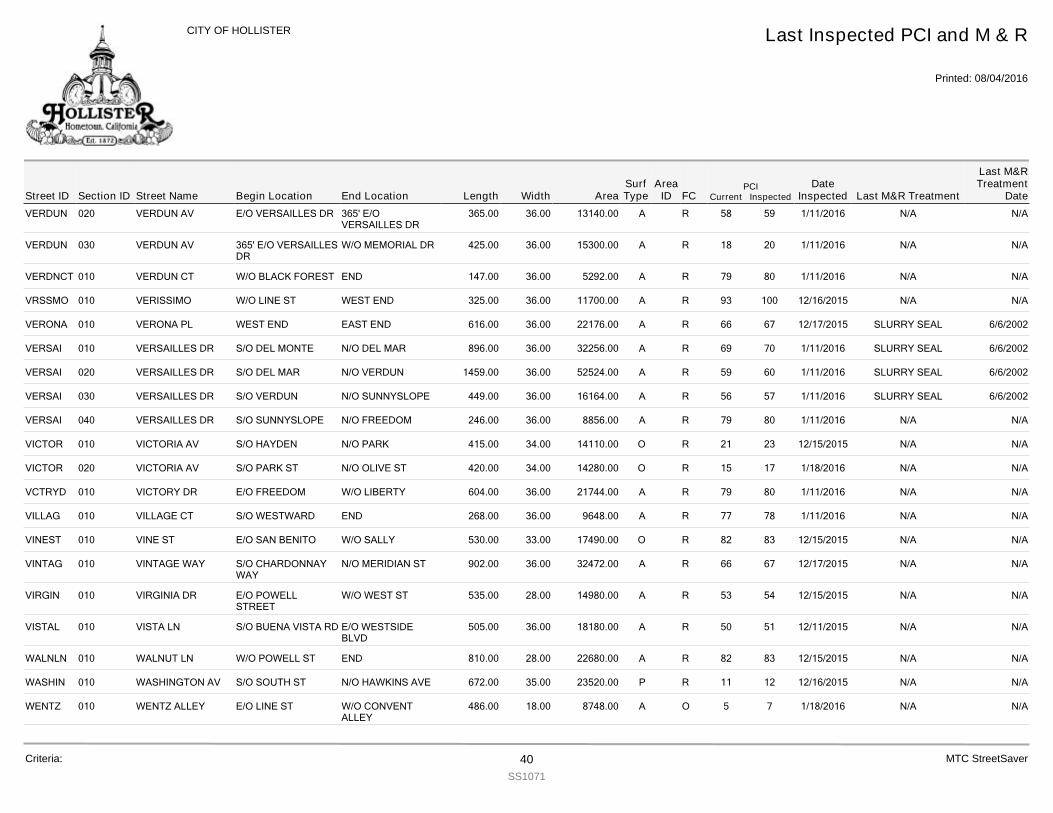
VERDUN 020 VERDUN AV 365.00E/O VERSAILLES DR 365' E/OVERSAILLES DR
36.00 13140.00 R 59 1/11/2016 N/A N/A58A
VERDUN 030 VERDUN AV 425.00365' E/O VERSAILLESDR
W/O MEMORIAL DR 36.00 15300.00 R 20 1/11/2016 N/A N/A18A
VERDNCT 010 VERDUN CT 147.00W/O BLACK FOREST END 36.00 5292.00 R 80 1/11/2016 N/A N/A79A
VRSSMO 010 VERISSIMO 325.00W/O LINE ST WEST END 36.00 11700.00 R 100 12/16/2015 N/A N/A93A
VERONA 010 VERONA PL 616.00WEST END EAST END 36.00 22176.00 R 67 12/17/2015 SLURRY SEAL 6/6/200266A
VERSAI 010 VERSAILLES DR 896.00S/O DEL MONTE N/O DEL MAR 36.00 32256.00 R 70 1/11/2016 SLURRY SEAL 6/6/200269A
VERSAI 020 VERSAILLES DR 1459.00S/O DEL MAR N/O VERDUN 36.00 52524.00 R 60 1/11/2016 SLURRY SEAL 6/6/200259A
VERSAI 030 VERSAILLES DR 449.00S/O VERDUN N/O SUNNYSLOPE 36.00 16164.00 R 57 1/11/2016 SLURRY SEAL 6/6/200256A
VERSAI 040 VERSAILLES DR 246.00S/O SUNNYSLOPE N/O FREEDOM 36.00 8856.00 R 80 1/11/2016 N/A N/A79A
VICTOR 010 VICTORIA AV 415.00S/O HAYDEN N/O PARK 34.00 14110.00 R 23 12/15/2015 N/A N/A21O
VICTOR 020 VICTORIA AV 420.00S/O PARK ST N/O OLIVE ST 34.00 14280.00 R 17 1/18/2016 N/A N/A15O
VCTRYD 010 VICTORY DR 604.00E/O FREEDOM W/O LIBERTY 36.00 21744.00 R 80 1/11/2016 N/A N/A79A
VILLAG 010 VILLAGE CT 268.00S/O WESTWARD END 36.00 9648.00 R 78 1/11/2016 N/A N/A77A
VINEST 010 VINE ST 530.00E/O SAN BENITO W/O SALLY 33.00 17490.00 R 83 12/15/2015 N/A N/A82O
VINTAG 010 VINTAGE WAY 902.00S/O CHARDONNAYWAY
N/O MERIDIAN ST 36.00 32472.00 R 67 12/17/2015 N/A N/A66A
VIRGIN 010 VIRGINIA DR 535.00E/O POWELLSTREET
W/O WEST ST 28.00 14980.00 R 54 12/15/2015 N/A N/A53A
VISTAL 010 VISTA LN 505.00S/O BUENA VISTA RD E/O WESTSIDEBLVD
36.00 18180.00 R 51 12/11/2015 N/A N/A50A
WALNLN 010 WALNUT LN 810.00W/O POWELL ST END 28.00 22680.00 R 83 12/15/2015 N/A N/A82A
WASHIN 010 WASHINGTON AV 672.00S/O SOUTH ST N/O HAWKINS AVE 35.00 23520.00 R 12 12/16/2015 N/A N/A11P
WENTZ 010 WENTZ ALLEY 486.00E/O LINE ST W/O CONVENTALLEY
18.00 8748.00 O 7 1/18/2016 N/A N/A5A
Street IDPCI
Current InspectedEnd Location Width FC
Last Inspected PCI and M & R
Printed: 08/04/2016
CITY OF HOLLISTER
Section ID Begin Location Length AreaDate
Inspected Last M&R Treatment
Last M&RTreatment
DateStreet NameArea
IDSurfType
Criteria: 40SS1071
MTC StreetSaver
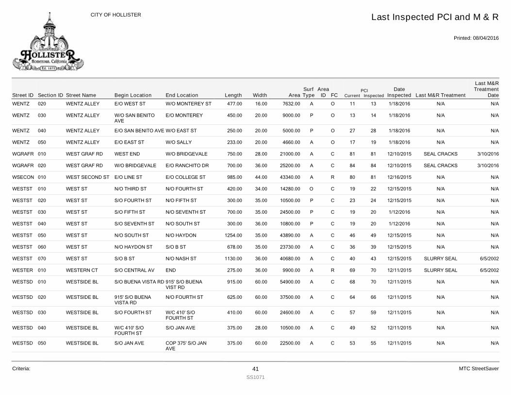
WENTZ 020 WENTZ ALLEY 477.00E/O WEST ST W/O MONTEREY ST 16.00 7632.00 O 13 1/18/2016 N/A N/A11A
WENTZ 030 WENTZ ALLEY 450.00W/O SAN BENITOAVE
E/O MONTEREY 20.00 9000.00 O 14 1/18/2016 N/A N/A13P
WENTZ 040 WENTZ ALLEY 250.00E/O SAN BENITO AVE W/O EAST ST 20.00 5000.00 O 28 1/18/2016 N/A N/A27P
WENTZ 050 WENTZ ALLEY 233.00E/O EAST ST W/O SALLY 20.00 4660.00 O 19 1/18/2016 N/A N/A17A
WGRAFR 010 WEST GRAF RD 750.00WEST END W/O BRIDGEVALE 28.00 21000.00 C 81 12/10/2015 SEAL CRACKS 3/10/201681A
WGRAFR 020 WEST GRAF RD 700.00W/O BRIDGEVALE E/O RANCHITO DR 36.00 25200.00 C 84 12/10/2015 SEAL CRACKS 3/10/201684A
WSECON 010 WEST SECOND ST 985.00E/O LINE ST E/O COLLEGE ST 44.00 43340.00 R 81 12/16/2015 N/A N/A80A
WESTST 010 WEST ST 420.00N/O THIRD ST N/O FOURTH ST 34.00 14280.00 C 22 12/15/2015 N/A N/A19O
WESTST 020 WEST ST 300.00S/O FOURTH ST N/O FIFTH ST 35.00 10500.00 C 24 12/15/2015 N/A N/A23P
WESTST 030 WEST ST 700.00S/O FIFTH ST N/O SEVENTH ST 35.00 24500.00 C 20 1/12/2016 N/A N/A19P
WESTST 040 WEST ST 300.00S/O SEVENTH ST N/O SOUTH ST 36.00 10800.00 C 20 1/12/2016 N/A N/A19P
WESTST 050 WEST ST 1254.00N/O SOUTH ST N/O HAYDON 35.00 43890.00 C 49 12/15/2015 N/A N/A46A
WESTST 060 WEST ST 678.00N/O HAYDON ST S/O B ST 35.00 23730.00 C 39 12/15/2015 N/A N/A36A
WESTST 070 WEST ST 1130.00S/O B ST N/O NASH ST 36.00 40680.00 C 43 12/15/2015 SLURRY SEAL 6/5/200240A
WESTER 010 WESTERN CT 275.00S/O CENTRAL AV END 36.00 9900.00 R 70 12/11/2015 SLURRY SEAL 6/5/200269A
WESTSD 010 WESTSIDE BL 915.00S/O BUENA VISTA RD 915' S/O BUENAVIST RD
60.00 54900.00 C 70 12/11/2015 N/A N/A68A
WESTSD 020 WESTSIDE BL 625.00915' S/O BUENAVISTA RD
N/O FOURTH ST 60.00 37500.00 C 66 12/11/2015 N/A N/A64A
WESTSD 030 WESTSIDE BL 410.00S/O FOURTH ST W/C 410' S/OFOURTH ST
60.00 24600.00 C 59 12/11/2015 N/A N/A57A
WESTSD 040 WESTSIDE BL 375.00W/C 410' S/OFOURTH ST
S/O JAN AVE 28.00 10500.00 C 52 12/11/2015 N/A N/A49A
WESTSD 050 WESTSIDE BL 375.00S/O JAN AVE COP 375' S/O JANAVE
60.00 22500.00 C 55 12/11/2015 N/A N/A53A
Street IDPCI
Current InspectedEnd Location Width FC
Last Inspected PCI and M & R
Printed: 08/04/2016
CITY OF HOLLISTER
Section ID Begin Location Length AreaDate
Inspected Last M&R Treatment
Last M&RTreatment
DateStreet NameArea
IDSurfType
Criteria: 41SS1071
MTC StreetSaver
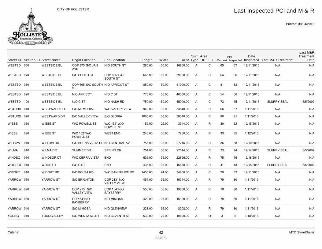
WESTSD 060 WESTSIDE BL 280.00COP 375' S/O JANAVE
N/O SOUTH ST 60.00 16800.00 C 67 12/11/2015 N/A N/A65A
WESTSD 070 WESTSIDE BL 665.00S/O SOUTH ST COP 665' S/OSOUTH ST
60.00 39900.00 C 66 12/11/2015 N/A N/A64A
WESTSD 080 WESTSIDE BL 850.00COP 665' S/O SOUTHST
N/O APRICOT ST 60.00 51000.00 C 82 12/11/2015 N/A N/A81A
WESTSD 090 WESTSIDE BL 775.00N/O APRICOT N/O C ST 60.00 46500.00 C 56 12/11/2015 N/A N/A54A
WESTSD 100 WESTSIDE BL 750.00N/O C ST N/O NASH RD 60.00 45000.00 C 75 12/11/2015 SLURRY SEAL 6/5/200273A
WSTURD 010 WESTWARD DR 940.00E/O MEMORIAL W/O VALLEY VIEW 36.00 33840.00 R 67 1/11/2016 N/A N/A66A
WSTURD 020 WESTWARD DR 1065.00E/O VALLEY VIEW E/O GLORIA 36.00 38340.00 R 81 1/11/2016 N/A N/A80A
WIEBE 010 WIEBE ST 152.00W/O POWELL ST W/C 152' W/OPOWELL ST
22.00 3344.00 R 32 12/15/2015 N/A N/A30A
WIEBE 020 WIEBE ST 240.00W/C 152' W/OPOWELL ST
WEST END 30.00 7200.00 R 35 1/12/2016 N/A N/A33A
WILLOW 010 WILLOW DR 756.00S/O BUENA VISTA RD N/O CENTRAL AV 36.00 27216.00 R 38 12/10/2015 N/A N/A36A
WILMA 010 WILMA DR 754.00SUMMER DR SPRING DR 36.00 27144.00 R 74 12/14/2015 SLURRY SEAL 6/5/200273A
WINDSO 010 WINDSOR CT 636.00W/O CERRA VISTA END 36.00 22896.00 R 76 12/18/2015 N/A N/A75A
WOODCT 010 WOOD CT 435.00S/O C ST END 36.00 15660.00 R 43 12/15/2015 SLURRY SEAL 6/5/200241A
WRIGHT 010 WRIGHT RD 1450.00E/O BOLSA RD W/O SAN FELIPE RD 24.00 34800.00 C 32 12/11/2015 N/A N/A29A
YARROW 010 YARROW ST 454.00S/O BRIGHTON COP 213' N/OVALLEY VIEW
36.00 16344.00 R 80 1/11/2016 N/A N/A79A
YARROW 020 YARROW ST 550.00COP 213' N/OVALLEY VIEW
COP 154' N/OBAYBERRY
36.00 19800.00 R 80 1/11/2016 N/A N/A79A
YARROW 030 YARROW ST 420.00COP 54' N/OBAYBERRY
N/O MIMOSA 36.00 15120.00 R 80 1/11/2016 N/A N/A79A
YARROW 040 YARROW ST 228.00S/O MIMOSA N/O GLENVIEW 36.00 8208.00 R 80 1/11/2016 N/A N/A79A
YOUNG 010 YOUNG ALLEY 530.00S/O WENTZ ALLEY N/O SEVENTH ST 20.00 10600.00 O 5 1/18/2016 N/A N/A3A
Street IDPCI
Current InspectedEnd Location Width FC
Last Inspected PCI and M & R
Printed: 08/04/2016
CITY OF HOLLISTER
Section ID Begin Location Length AreaDate
Inspected Last M&R Treatment
Last M&RTreatment
DateStreet NameArea
IDSurfType
Criteria: 42SS1071
MTC StreetSaver
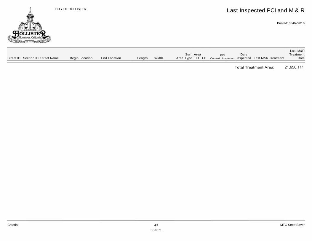
Street IDPCI
Current InspectedEnd Location Width FC
Last Inspected PCI and M & R
Printed: 08/04/2016
CITY OF HOLLISTER
Section ID Begin Location Length AreaDate
Inspected Last M&R Treatment
Last M&RTreatment
DateStreet NameArea
IDSurfType
21,656,111Total Treatment Area:
Criteria: 43SS1071
MTC StreetSaver
GIS TOOLBOX
P a g e | 1
This section is intended to introduce the new feature in StreetSaver. The GIS portion of the program is specifically designed for those agencies that do not have “in-house” GIS departments. GIS TOOLBOX The GIS toolbox is a new feature available within StreetSaver. This is one of the most powerful tools available in StreetSaver. The ability to link the existing road segments to a base map and produce maps displaying the Current Condition, Age of Pavement, Needs Treatments, Scenario Treatments, Last Treatment and Last Year Inspected are now available with just a few key strokes. No longer does an agency need to access “outside resources” or “wait” for graphical representations of their road system. Maps that reflect the current condition of an agency’s road system are a valuable asset when meeting with City Councils and the general public. A map of future maintenance treatments can be used to inform the residents when future work is scheduled on their road. A basic “shapefile” is already loaded into the StreetSaver system. From this shapefile it is just a matter of “linking” or “assigning” the beginning location and ending location of each management section found in the database. There are a few cautions that the City of Hollister should be aware of in regard to the GIS mapping. GIS is a “node” to “node” application. It uses intersections or nodes as its way to pinpoint a specific location. This means that each of the City’s management sections needs to begin and end at a point that can be defined or found by the GIS link. Using house numbers or change in pavements will need to be defined as “feet” from the nearest “node”. This will produce a more precise map. Next the Street Names will need to match and that will mean a more precise accounting of “street tags”. The difference between calling a tag a “drive” or an “avenue” can hinder the linking process. TERMINOLOGY Once the GIS Toolbox is opened there will be two master items that can be accessed. First there is the “GIS Reporting”. This screen is used to “mine” StreetSaver data for display in GIS format. Queries can be performed using the standard StreetSaver filter screen, using pre-defined criteria defined by the system, or by selecting an area of the map. If Section data is returned those shapes can be exported to GIS shapefiles or printed out in a map format. Then there is the “Section Link” screen which will match segments in the basemap based on street name, type (street tag) and/or direction. Each Section can be linked to a segment or segments in the basemap.
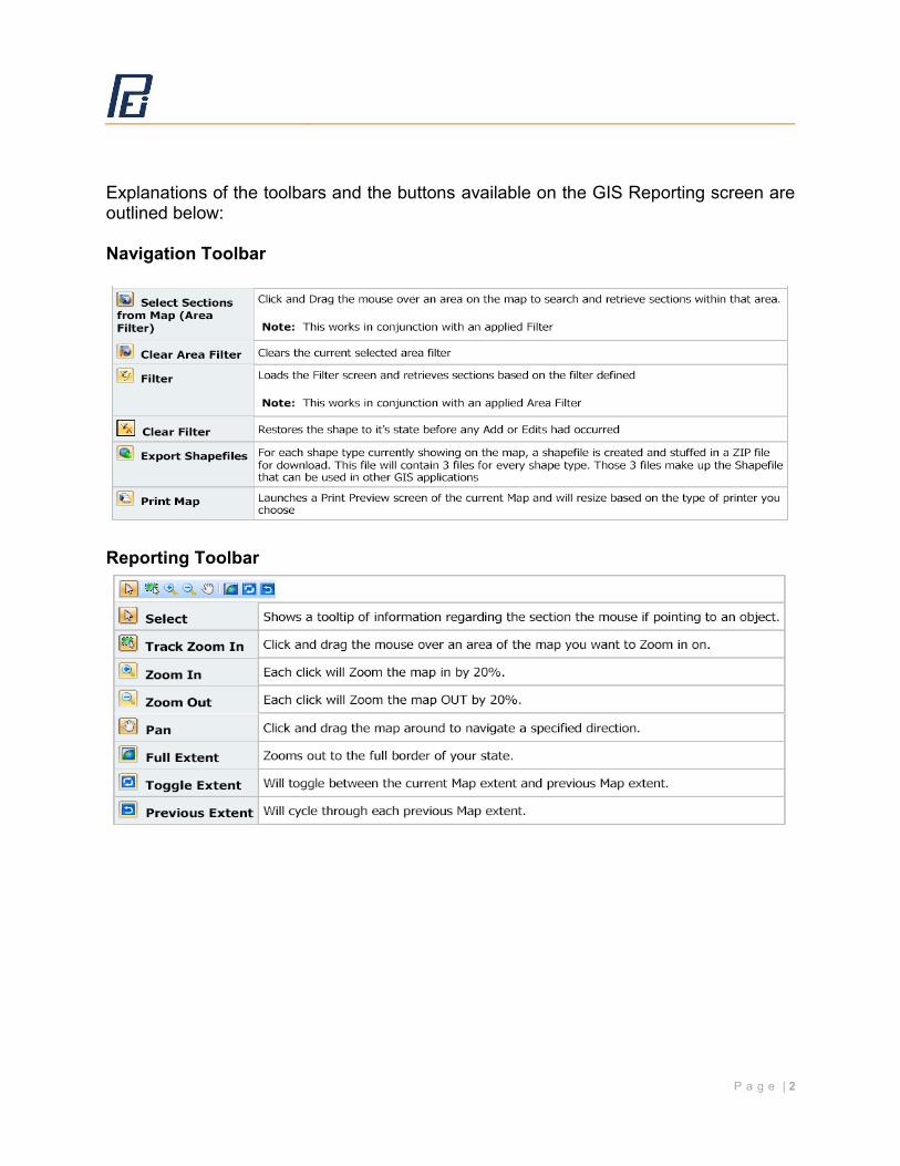
P a g e | 2
Explanations of the toolbars and the buttons available on the GIS Reporting screen are outlined below: Navigation Toolbar
Reporting Toolbar
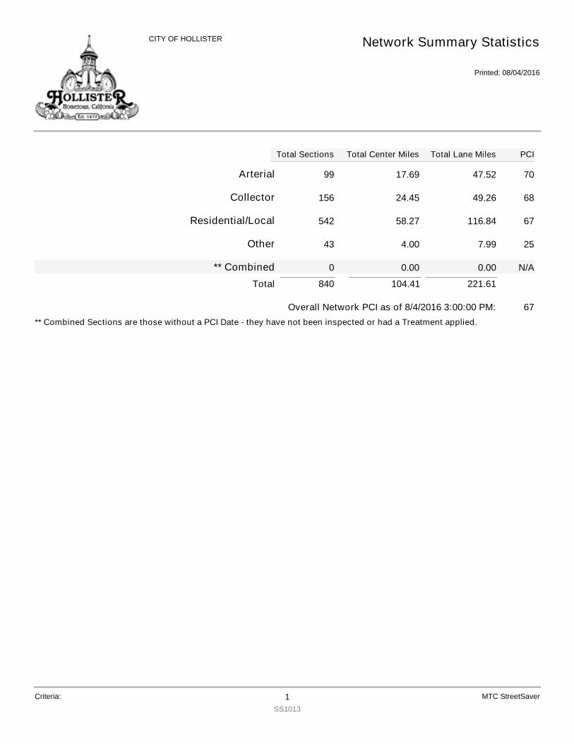
99Arterial 17.69 47.52 70
156Collector 24.45 49.26 68
542Residential/Local 58.27 116.84 67
43Other 4.00 7.99 25
0** Combined 0.00 0.00 N/A
221.61104.41840Total
67Overall Network PCI as of 8/4/2016 3:00:00 PM:** Combined Sections are those without a PCI Date - they have not been inspected or had a Treatment applied.
Total Center MilesTotal Sections Total Lane Miles
Network Summary Statistics
Printed: 08/04/2016
CITY OF HOLLISTER
PCI
Criteria: 1SS1013
MTC StreetSaver
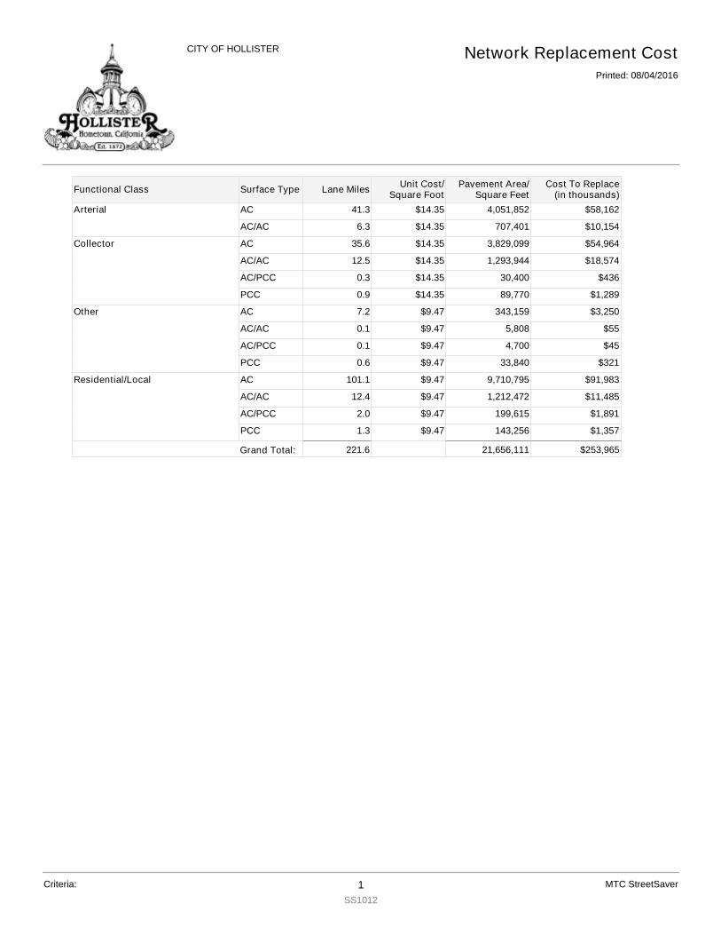
Arterial AC 41.3 $14.35 4,051,852 $58,162
AC/AC 6.3 $14.35 707,401 $10,154
Collector AC 35.6 $14.35 3,829,099 $54,964
AC/AC 12.5 $14.35 1,293,944 $18,574
AC/PCC 0.3 $14.35 30,400 $436
PCC 0.9 $14.35 89,770 $1,289
Other AC 7.2 $9.47 343,159 $3,250
AC/AC 0.1 $9.47 5,808 $55
AC/PCC 0.1 $9.47 4,700 $45
PCC 0.6 $9.47 33,840 $321
Residential/Local AC 101.1 $9.47 9,710,795 $91,983
AC/AC 12.4 $9.47 1,212,472 $11,485
AC/PCC 2.0 $9.47 199,615 $1,891
PCC 1.3 $9.47 143,256 $1,357
Functional Class
Network Replacement CostPrinted: 08/04/2016
CITY OF HOLLISTER
Surface Type Lane Miles Unit Cost/Square Foot
Cost To Replace(in thousands)
Pavement Area/Square Feet
Criteria: 1SS1012
MTC StreetSaver
Grand Total: 221.6 $253,96521,656,111

ACACIA ACACIA CTADRIAN ADRIAN CTAEROSTAR AEROSTAR WAYAGUIR AGUIRRE DRAIRPOR AIRPORT DRAIRWAY AIRWAY DRALBANY ALBANY DRALBION ALBION CTALBRIG ALBRIGHT DRALDERC ALDER CTALDERS ALDER STALISCT ALISSA CTALISSA ALISSA DRALMOND ALMOND CTALPINE ALPINE CRALTURA ALTURAS CTALTVST ALTA VISTA WYALVARA ALVARADO STAMADOR AMADOR CIRAMBER AMBER CTANDREW ANDREWS DRANNST ANN STAPOLLOW APOLLO CTAPOLLOW APOLLO WYAPPLCT APPLE CTAPRICO APRICOT LNARBOUR ARBOUR LNARENA ARENA WYARGONE ARGONNE AVARMORY ARMORY DRASPEN ASPEN WYAST A STASTROD ASTRO DRATHENA ATHENA WAYAZULCT AZUL CTBALLCT BALL CTBAYBER BAYBERRY STBDLWOOD BRIDLEWOOD STBEACHW BEACHWOOD CT
Street Inventory
Printed: 08/04/2016
CITY OF HOLLISTER
Street Number Street Name
Criteria: 1SS1021
MTC StreetSaver
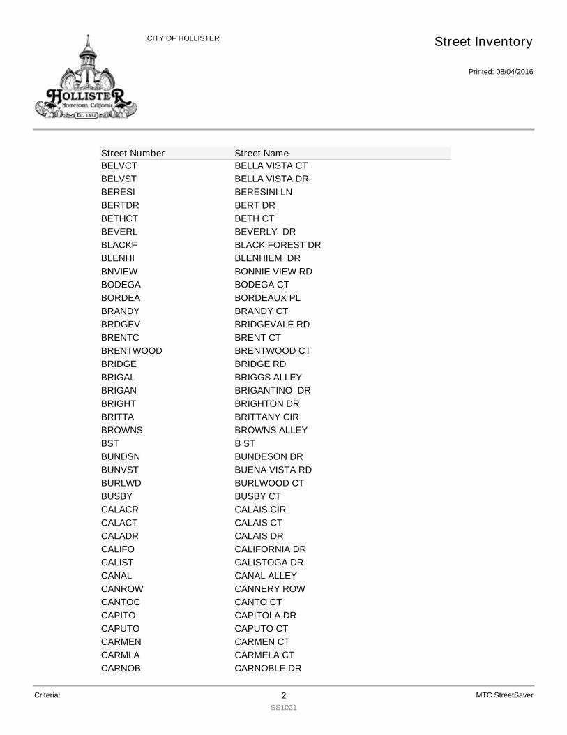
BELVCT BELLA VISTA CTBELVST BELLA VISTA DRBERESI BERESINI LNBERTDR BERT DRBETHCT BETH CTBEVERL BEVERLY DRBLACKF BLACK FOREST DRBLENHI BLENHIEM DRBNVIEW BONNIE VIEW RDBODEGA BODEGA CTBORDEA BORDEAUX PLBRANDY BRANDY CTBRDGEV BRIDGEVALE RDBRENTC BRENT CTBRENTWOOD BRENTWOOD CTBRIDGE BRIDGE RDBRIGAL BRIGGS ALLEYBRIGAN BRIGANTINO DRBRIGHT BRIGHTON DRBRITTA BRITTANY CIRBROWNS BROWNS ALLEYBST B STBUNDSN BUNDESON DRBUNVST BUENA VISTA RDBURLWD BURLWOOD CTBUSBY BUSBY CTCALACR CALAIS CIRCALACT CALAIS CTCALADR CALAIS DRCALIFO CALIFORNIA DRCALIST CALISTOGA DRCANAL CANAL ALLEYCANROW CANNERY ROWCANTOC CANTO CTCAPITO CAPITOLA DRCAPUTO CAPUTO CTCARMEN CARMEN CTCARMLA CARMELA CTCARNOB CARNOBLE DR
Street Inventory
Printed: 08/04/2016
CITY OF HOLLISTER
Street Number Street Name
Criteria: 2SS1021
MTC StreetSaver
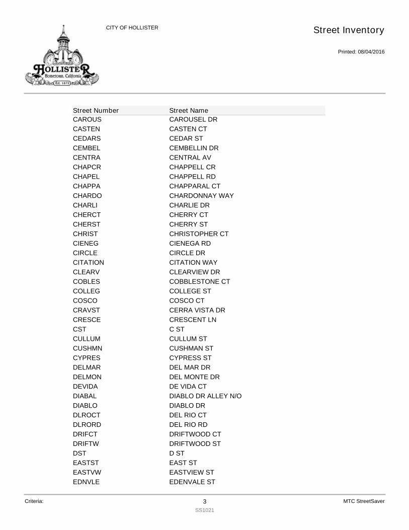
CAROUS CAROUSEL DRCASTEN CASTEN CTCEDARS CEDAR STCEMBEL CEMBELLIN DRCENTRA CENTRAL AVCHAPCR CHAPPELL CRCHAPEL CHAPPELL RDCHAPPA CHAPPARAL CTCHARDO CHARDONNAY WAYCHARLI CHARLIE DRCHERCT CHERRY CTCHERST CHERRY STCHRIST CHRISTOPHER CTCIENEG CIENEGA RDCIRCLE CIRCLE DRCITATION CITATION WAYCLEARV CLEARVIEW DRCOBLES COBBLESTONE CTCOLLEG COLLEGE STCOSCO COSCO CTCRAVST CERRA VISTA DRCRESCE CRESCENT LNCST C STCULLUM CULLUM STCUSHMN CUSHMAN STCYPRES CYPRESS STDELMAR DEL MAR DRDELMON DEL MONTE DRDEVIDA DE VIDA CTDIABAL DIABLO DR ALLEY N/ODIABLO DIABLO DRDLROCT DEL RIO CTDLRORD DEL RIO RDDRIFCT DRIFTWOOD CTDRIFTW DRIFTWOOD STDST D STEASTST EAST STEASTVW EASTVIEW STEDNVLE EDENVALE ST
Street Inventory
Printed: 08/04/2016
CITY OF HOLLISTER
Street Number Street Name
Criteria: 3SS1021
MTC StreetSaver
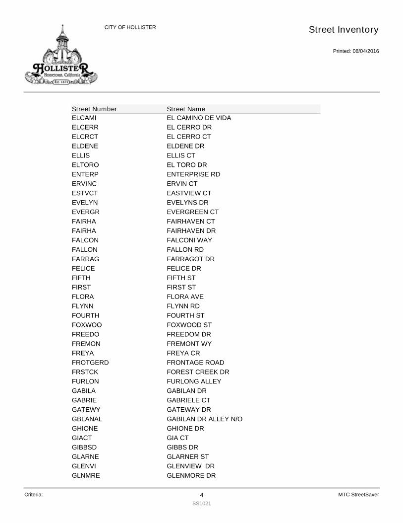
ELCAMI EL CAMINO DE VIDAELCERR EL CERRO DRELCRCT EL CERRO CTELDENE ELDENE DRELLIS ELLIS CTELTORO EL TORO DRENTERP ENTERPRISE RDERVINC ERVIN CTESTVCT EASTVIEW CTEVELYN EVELYNS DREVERGR EVERGREEN CTFAIRHA FAIRHAVEN CTFAIRHA FAIRHAVEN DRFALCON FALCONI WAYFALLON FALLON RDFARRAG FARRAGOT DRFELICE FELICE DRFIFTH FIFTH STFIRST FIRST STFLORA FLORA AVEFLYNN FLYNN RDFOURTH FOURTH STFOXWOO FOXWOOD STFREEDO FREEDOM DRFREMON FREMONT WYFREYA FREYA CRFROTGERD FRONTAGE ROADFRSTCK FOREST CREEK DRFURLON FURLONG ALLEYGABILA GABILAN DRGABRIE GABRIELE CTGATEWY GATEWAY DRGBLANAL GABILAN DR ALLEY N/OGHIONE GHIONE DRGIACT GIA CTGIBBSD GIBBS DRGLARNE GLARNER STGLENVI GLENVIEW DRGLNMRE GLENMORE DR
Street Inventory
Printed: 08/04/2016
CITY OF HOLLISTER
Street Number Street Name
Criteria: 4SS1021
MTC StreetSaver
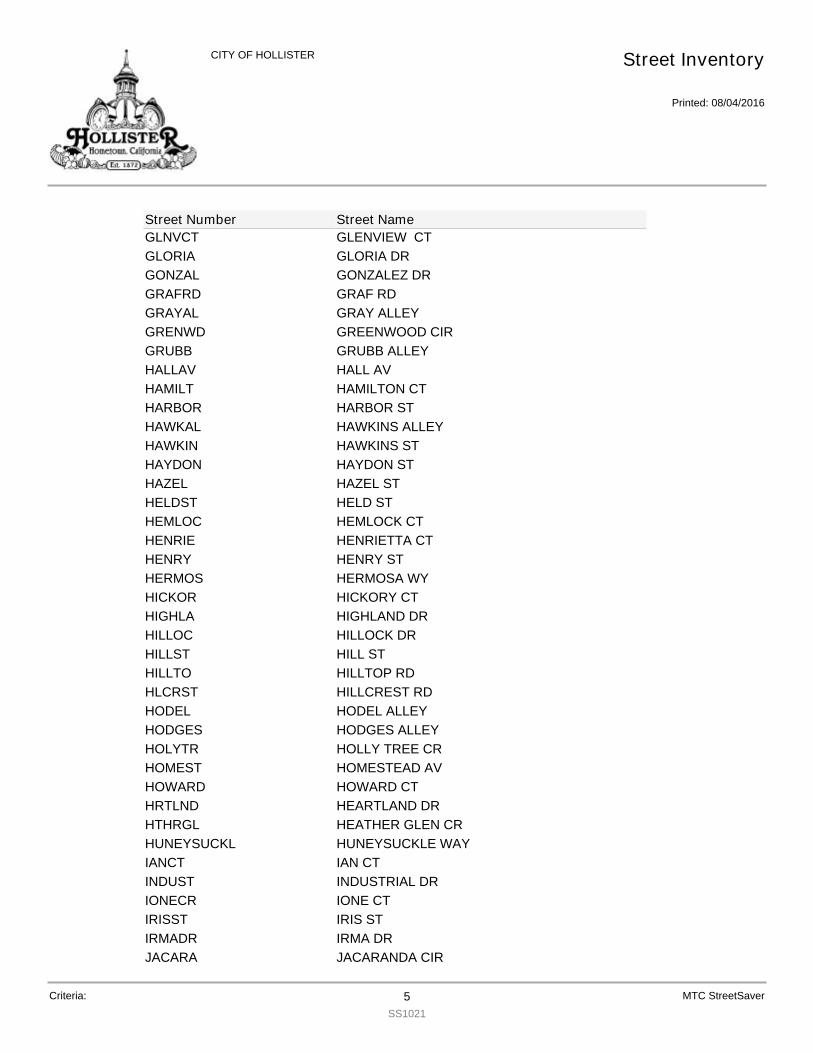
GLNVCT GLENVIEW CTGLORIA GLORIA DRGONZAL GONZALEZ DRGRAFRD GRAF RDGRAYAL GRAY ALLEYGRENWD GREENWOOD CIRGRUBB GRUBB ALLEYHALLAV HALL AVHAMILT HAMILTON CTHARBOR HARBOR STHAWKAL HAWKINS ALLEYHAWKIN HAWKINS STHAYDON HAYDON STHAZEL HAZEL STHELDST HELD STHEMLOC HEMLOCK CTHENRIE HENRIETTA CTHENRY HENRY STHERMOS HERMOSA WYHICKOR HICKORY CTHIGHLA HIGHLAND DRHILLOC HILLOCK DRHILLST HILL STHILLTO HILLTOP RDHLCRST HILLCREST RDHODEL HODEL ALLEYHODGES HODGES ALLEYHOLYTR HOLLY TREE CRHOMEST HOMESTEAD AVHOWARD HOWARD CTHRTLND HEARTLAND DRHTHRGL HEATHER GLEN CRHUNEYSUCKL HUNEYSUCKLE WAYIANCT IAN CTINDUST INDUSTRIAL DRIONECR IONE CTIRISST IRIS STIRMADR IRMA DRJACARA JACARANDA CIR
Street Inventory
Printed: 08/04/2016
CITY OF HOLLISTER
Street Number Street Name
Criteria: 5SS1021
MTC StreetSaver
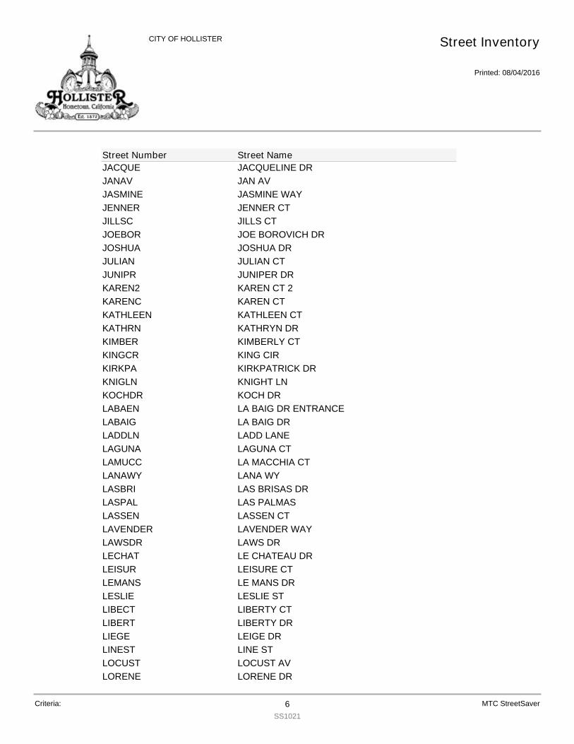
JACQUE JACQUELINE DRJANAV JAN AVJASMINE JASMINE WAYJENNER JENNER CTJILLSC JILLS CTJOEBOR JOE BOROVICH DRJOSHUA JOSHUA DRJULIAN JULIAN CTJUNIPR JUNIPER DRKAREN2 KAREN CT 2KARENC KAREN CTKATHLEEN KATHLEEN CTKATHRN KATHRYN DRKIMBER KIMBERLY CTKINGCR KING CIRKIRKPA KIRKPATRICK DRKNIGLN KNIGHT LNKOCHDR KOCH DRLABAEN LA BAIG DR ENTRANCELABAIG LA BAIG DRLADDLN LADD LANELAGUNA LAGUNA CTLAMUCC LA MACCHIA CTLANAWY LANA WYLASBRI LAS BRISAS DRLASPAL LAS PALMASLASSEN LASSEN CTLAVENDER LAVENDER WAYLAWSDR LAWS DRLECHAT LE CHATEAU DRLEISUR LEISURE CTLEMANS LE MANS DRLESLIE LESLIE STLIBECT LIBERTY CTLIBERT LIBERTY DRLIEGE LEIGE DRLINEST LINE STLOCUST LOCUST AVLORENE LORENE DR
Street Inventory
Printed: 08/04/2016
CITY OF HOLLISTER
Street Number Street Name
Criteria: 6SS1021
MTC StreetSaver
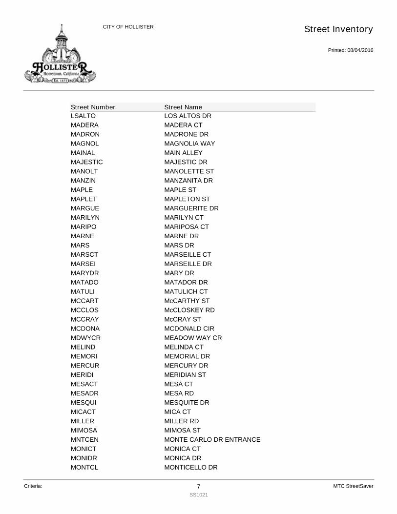
LSALTO LOS ALTOS DRMADERA MADERA CTMADRON MADRONE DRMAGNOL MAGNOLIA WAYMAINAL MAIN ALLEYMAJESTIC MAJESTIC DRMANOLT MANOLETTE STMANZIN MANZANITA DRMAPLE MAPLE STMAPLET MAPLETON STMARGUE MARGUERITE DRMARILYN MARILYN CTMARIPO MARIPOSA CTMARNE MARNE DRMARS MARS DRMARSCT MARSEILLE CTMARSEI MARSEILLE DRMARYDR MARY DRMATADO MATADOR DRMATULI MATULICH CTMCCART McCARTHY STMCCLOS McCLOSKEY RDMCCRAY McCRAY STMCDONA MCDONALD CIRMDWYCR MEADOW WAY CRMELIND MELINDA CTMEMORI MEMORIAL DRMERCUR MERCURY DRMERIDI MERIDIAN STMESACT MESA CTMESADR MESA RDMESQUI MESQUITE DRMICACT MICA CTMILLER MILLER RDMIMOSA MIMOSA STMNTCEN MONTE CARLO DR ENTRANCEMONICT MONICA CTMONIDR MONICA DRMONTCL MONTICELLO DR
Street Inventory
Printed: 08/04/2016
CITY OF HOLLISTER
Street Number Street Name
Criteria: 7SS1021
MTC StreetSaver
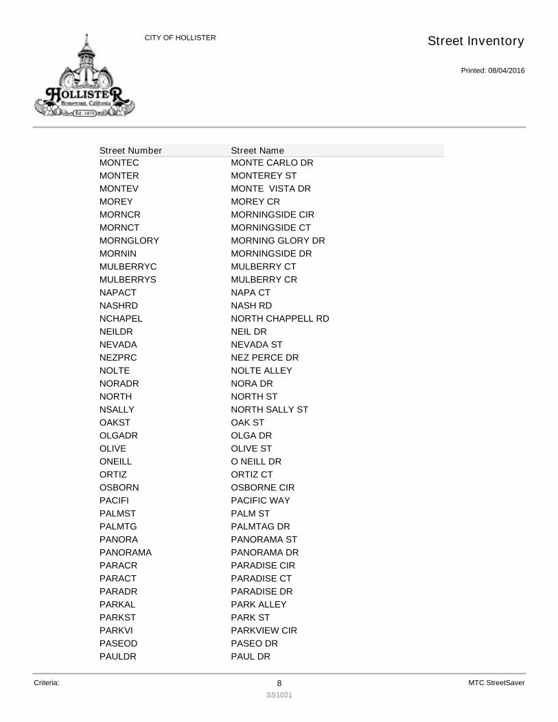
MONTEC MONTE CARLO DRMONTER MONTEREY STMONTEV MONTE VISTA DRMOREY MOREY CRMORNCR MORNINGSIDE CIRMORNCT MORNINGSIDE CTMORNGLORY MORNING GLORY DRMORNIN MORNINGSIDE DRMULBERRYC MULBERRY CTMULBERRYS MULBERRY CRNAPACT NAPA CTNASHRD NASH RDNCHAPEL NORTH CHAPPELL RDNEILDR NEIL DRNEVADA NEVADA STNEZPRC NEZ PERCE DRNOLTE NOLTE ALLEYNORADR NORA DRNORTH NORTH STNSALLY NORTH SALLY STOAKST OAK STOLGADR OLGA DROLIVE OLIVE STONEILL O NEILL DRORTIZ ORTIZ CTOSBORN OSBORNE CIRPACIFI PACIFIC WAYPALMST PALM STPALMTG PALMTAG DRPANORA PANORAMA STPANORAMA PANORAMA DRPARACR PARADISE CIRPARACT PARADISE CTPARADR PARADISE DRPARKAL PARK ALLEYPARKST PARK STPARKVI PARKVIEW CIRPASEOD PASEO DRPAULDR PAUL DR
Street Inventory
Printed: 08/04/2016
CITY OF HOLLISTER
Street Number Street Name
Criteria: 8SS1021
MTC StreetSaver

PAYETT PAYETTE CIRPEACH PEACH CTPEARCT PEAR CTPEARST PEAR STPECAN PECAN CTPERIDO PERIDOT CTPETALU PETALUMA CTPINCRT PIANE CRATIPINEDR PINE DRPINNAC PINNACLE CTPLUMCT PLUM CTPONDER PONDEROSA CTPOPLAR POPLAR CTPOPLNC POPPY LANE CRPOPLND POPPY LANE DRPORTER PORTER CIRPOWELL POWELL STPRESTO PRESTON CTPRIMAV PRIMAVERA DRPRIMRO PRIMROSE CTPROMISE PROMISE WAYPROSPC PROSPECT AVPRUNES PRUNE STRAINBW RAINBOW DRRAJKOV RAJKOVICH WYRALEIG RALEIGH CIRRAMONA RAMONA AVRANCHC RANCHITO CTRANCHI RANCHITO DRRANCHO RANCHO DRRANDST RAND STRECHT RECHT STREGAL REGAL DRRICHRD RICHARDSON DRRIVIER RIVIERA DRROBERT ROBERT DRROBLE ROBLE STROSSI ROSSI CTRUGERC RUGER CT
Street Inventory
Printed: 08/04/2016
CITY OF HOLLISTER
Street Number Street Name
Criteria: 9SS1021
MTC StreetSaver
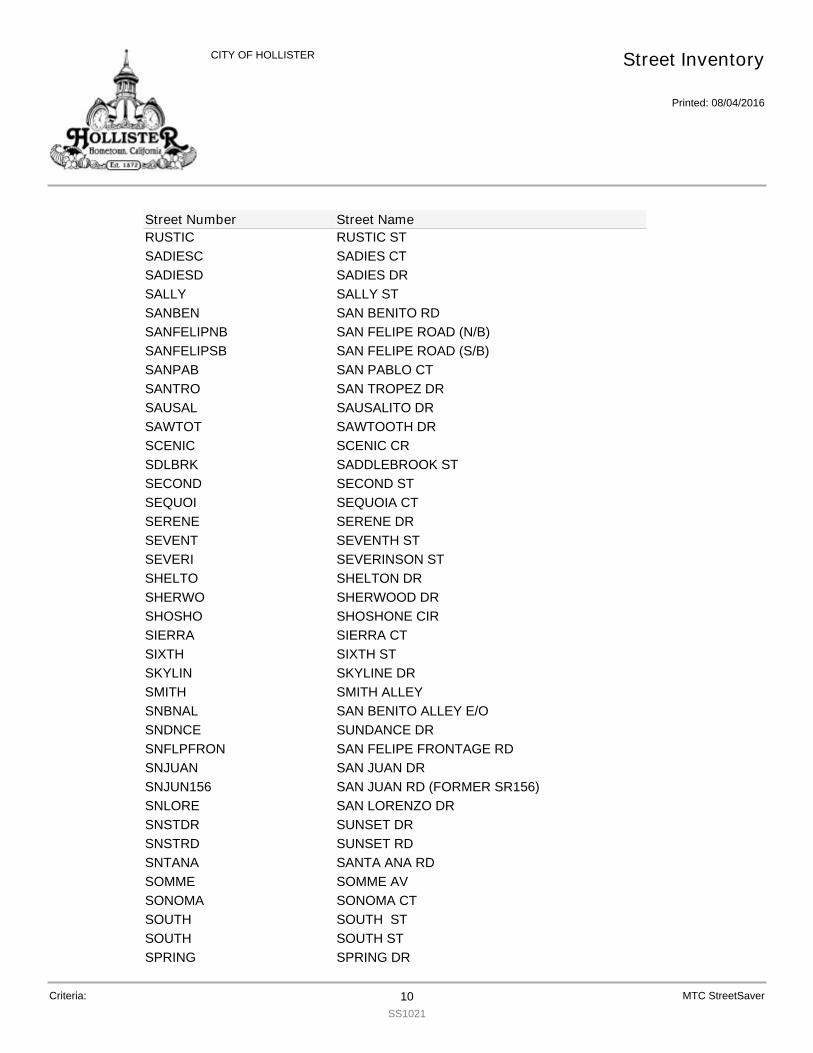
RUSTIC RUSTIC STSADIESC SADIES CTSADIESD SADIES DRSALLY SALLY STSANBEN SAN BENITO RDSANFELIPNB SAN FELIPE ROAD (N/B)SANFELIPSB SAN FELIPE ROAD (S/B)SANPAB SAN PABLO CTSANTRO SAN TROPEZ DRSAUSAL SAUSALITO DRSAWTOT SAWTOOTH DRSCENIC SCENIC CRSDLBRK SADDLEBROOK STSECOND SECOND STSEQUOI SEQUOIA CTSERENE SERENE DRSEVENT SEVENTH STSEVERI SEVERINSON STSHELTO SHELTON DRSHERWO SHERWOOD DRSHOSHO SHOSHONE CIRSIERRA SIERRA CTSIXTH SIXTH STSKYLIN SKYLINE DRSMITH SMITH ALLEYSNBNAL SAN BENITO ALLEY E/OSNDNCE SUNDANCE DRSNFLPFRON SAN FELIPE FRONTAGE RDSNJUAN SAN JUAN DRSNJUN156 SAN JUAN RD (FORMER SR156)SNLORE SAN LORENZO DRSNSTDR SUNSET DRSNSTRD SUNSET RDSNTANA SANTA ANA RDSOMME SOMME AVSONOMA SONOMA CTSOUTH SOUTH STSOUTH SOUTH STSPRING SPRING DR
Street Inventory
Printed: 08/04/2016
CITY OF HOLLISTER
Street Number Street Name
Criteria: 10SS1021
MTC StreetSaver
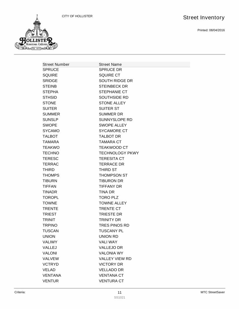
SPRUCE SPRUCE DRSQUIRE SQUIRE CTSRIDGE SOUTH RIDGE DRSTEINB STEINBECK DRSTEPHA STEPHANIE CTSTHSID SOUTHSIDE RDSTONE STONE ALLEYSUITER SUITER STSUMMER SUMMER DRSUNSLP SUNNYSLOPE RDSWOPE SWOPE ALLEYSYCAMO SYCAMORE CTTALBOT TALBOT DRTAMARA TAMARA CTTEAKWO TEAKWOOD CTTECHNO TECHNOLOGY PKWYTERESC TERESITA CTTERRAC TERRACE DRTHIRD THIRD STTHOMPS THOMPSON STTIBURN TIBURON DRTIFFAN TIFFANY DRTINADR TINA DRTOROPL TORO PLZTOWNE TOWNE ALLEYTRENTE TRENTE CTTRIEST TRIESTE DRTRINIT TRINITY DRTRPINO TRES PINOS RDTUSCAN TUSCANY PLUNION UNION RDVALIWY VALI WAYVALLEJ VALLEJO DRVALONI VALONIA WYVALVEW VALLEY VIEW RDVCTRYD VICTORY DRVELAD VELLADO DRVENTANA VENTANA CTVENTUR VENTURA CT
Street Inventory
Printed: 08/04/2016
CITY OF HOLLISTER
Street Number Street Name
Criteria: 11SS1021
MTC StreetSaver
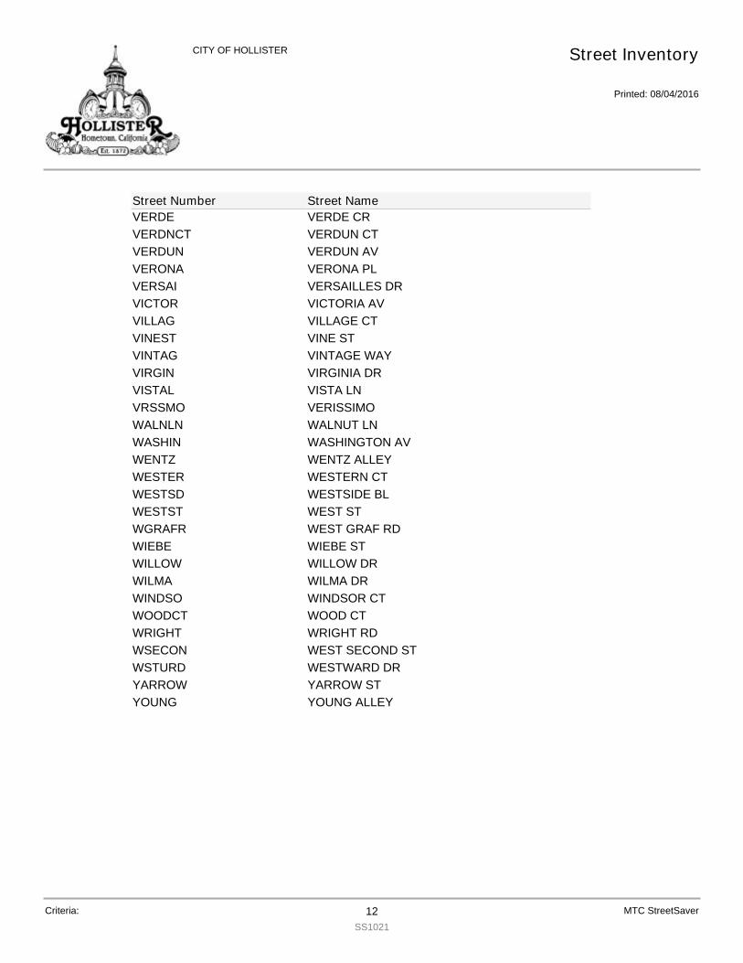
VERDE VERDE CRVERDNCT VERDUN CTVERDUN VERDUN AVVERONA VERONA PLVERSAI VERSAILLES DRVICTOR VICTORIA AVVILLAG VILLAGE CTVINEST VINE STVINTAG VINTAGE WAYVIRGIN VIRGINIA DRVISTAL VISTA LNVRSSMO VERISSIMOWALNLN WALNUT LNWASHIN WASHINGTON AVWENTZ WENTZ ALLEYWESTER WESTERN CTWESTSD WESTSIDE BLWESTST WEST STWGRAFR WEST GRAF RDWIEBE WIEBE STWILLOW WILLOW DRWILMA WILMA DRWINDSO WINDSOR CTWOODCT WOOD CTWRIGHT WRIGHT RDWSECON WEST SECOND STWSTURD WESTWARD DRYARROW YARROW STYOUNG YOUNG ALLEY
Street Inventory
Printed: 08/04/2016
CITY OF HOLLISTER
Street Number Street Name
Criteria: 12SS1021
MTC StreetSaver

ACACIA
Date Updated PCI Hist Comments
010 ACACIA CT 12/11/2015 38
PCI from Inspection12/11/2015 38 Yes05/01/2000 83 Yes
ADRIAN
Date Updated PCI Hist Comments
010 ADRIAN CT 12/16/2015 84
PCI from Inspection12/16/2015 84 Yes05/01/2000 100 Yes
AEROST
Date Updated PCI Hist Comments
010 AEROSTAR WAY 12/15/2015 69
PCI from Inspection12/15/2015 69 Yes10/17/2003 100 Yes
AEROST
Date Updated PCI Hist Comments
020 AEROSTAR WAY 12/15/2015 69
PCI from Inspection12/15/2015 69 Yes10/17/2003 100 Yes
AGUIR
Date Updated PCI Hist Comments
010 AGUIRRE DR 03/10/2016 95
PCI from Inspection03/10/2016 95 No01/05/2016 95 Yes
AIRPOR
Date Updated PCI Hist Comments
010 AIRPORT DR 01/19/2016 30
PCI from Inspection01/19/2016 30 Yes06/06/2002 83 No05/01/2000 79 Yes
AIRWAY
Date Updated PCI Hist Comments
010 AIRWAY DR 12/15/2015 70
PCI from Inspection12/15/2015 70 Yes10/17/2003 100 Yes
AIRWAY
Date Updated PCI Hist Comments
020 AIRWAY DR 12/15/2015 70
PCI from Inspection12/15/2015 70 Yes10/17/2003 100 Yes
ALBANY
Date Updated PCI Hist Comments
010 ALBANY DR 01/11/2016 80
PCI from Inspection01/11/2016 80 Yes05/01/2000 99 Yes
PCI History
Printed: 08/04/2016
CITY OF HOLLISTER
Street ID Section ID Street Name Last Updated PCI
Criteria: 1SS1017
MTC StreetSaver

ALBION
Date Updated PCI Hist Comments
010 ALBION CT 12/18/2015 64
PCI from Inspection12/18/2015 64 Yes06/05/2002 85 No05/01/2000 81 Yes
ALBRIG
Date Updated PCI Hist Comments
010 ALBRIGHT DR 12/18/2015 39
PCI from Inspection12/18/2015 39 Yes05/01/2000 57 Yes
ALDER
Date Updated PCI Hist Comments
010 ALDER CT 12/18/2015 81
PCI from Inspection12/18/2015 81 Yes10/29/2003 83 Yes
ALDERS
Date Updated PCI Hist Comments
010 ALDER ST 01/11/2016 80
PCI from Inspection01/11/2016 80 Yes05/01/2000 82 Yes
ALDERS
Date Updated PCI Hist Comments
020 ALDER ST 01/11/2016 75
PCI from Inspection01/11/2016 75 Yes
ALISCT
Date Updated PCI Hist Comments
010 ALISSA CT 12/12/2015 68
PCI from Inspection12/12/2015 68 Yes06/05/2002 86 No05/01/2000 82 Yes
ALISSA
Date Updated PCI Hist Comments
010 ALISSA DR 12/12/2015 68
PCI from Inspection12/12/2015 68 Yes06/05/2002 85 No05/01/2000 81 Yes
ALMOND
Date Updated PCI Hist Comments
010 ALMOND CT 12/11/2015 40
PCI from Inspection12/11/2015 40 Yes05/01/2000 82 Yes
ALPINE
Date Updated PCI Hist Comments
010 ALPINE CR 01/19/2016 49
PCI from Inspection01/19/2016 49 Yes06/06/2002 82 No
PCI History
Printed: 08/04/2016
CITY OF HOLLISTER
Street ID Section ID Street Name Last Updated PCI
Criteria: 2SS1017
MTC StreetSaver

ALPINE
Date Updated PCI Hist Comments
010 ALPINE CR 01/19/2016 80
PCI from Inspection05/01/2000 77 Yes
ALTURA
Date Updated PCI Hist Comments
010 ALTURAS CT 01/11/2016 80
PCI from Inspection01/11/2016 80 Yes05/01/2000 87 Yes
ALTVST
Date Updated PCI Hist Comments
010 ALTA VISTA WY 01/11/2016 83
PCI from Inspection01/11/2016 83 Yes05/01/2000 26 Yes
ALVARA
Date Updated PCI Hist Comments
010 ALVARADO ST 12/17/2015 82
PCI from Inspection12/17/2015 82 Yes07/06/2002 100 No05/01/2000 49 Yes
ALVARA
Date Updated PCI Hist Comments
020 ALVARADO ST 12/17/2015 78
PCI from Inspection12/17/2015 78 Yes05/01/2000 83 Yes
ALVARA
Date Updated PCI Hist Comments
030 ALVARADO ST 12/17/2015 50
PCI from Inspection12/17/2015 50 Yes05/01/2000 80 Yes
AMADOR
Date Updated PCI Hist Comments
010 AMADOR CIR 12/11/2015 61
PCI from Inspection12/11/2015 61 Yes06/05/2002 82 No05/01/2000 76 Yes
AMBER
Date Updated PCI Hist Comments
010 AMBER CT 12/16/2015 85
PCI from Inspection12/16/2015 85 Yes05/01/2000 83 Yes
ANDREW
Date Updated PCI Hist Comments
010 ANDREWS DR 12/16/2015 87
PCI from Inspection12/16/2015 87 Yes05/01/2000 18 Yes
PCI History
Printed: 08/04/2016
CITY OF HOLLISTER
Street ID Section ID Street Name Last Updated PCI
Criteria: 3SS1017
MTC StreetSaver
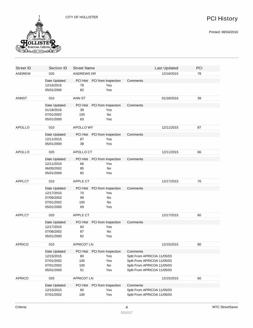
ANDREW
Date Updated PCI Hist Comments
020 ANDREWS DR 12/16/2015 78
PCI from Inspection12/16/2015 78 Yes05/01/2000 82 Yes
ANNST
Date Updated PCI Hist Comments
010 ANN ST 01/18/2016 39
PCI from Inspection01/18/2016 39 Yes07/01/2002 100 No05/01/2000 63 Yes
APOLLO
Date Updated PCI Hist Comments
010 APOLLO WY 12/11/2015 87
PCI from Inspection12/11/2015 87 Yes05/01/2000 38 Yes
APOLLO
Date Updated PCI Hist Comments
020 APOLLO CT 12/11/2015 66
PCI from Inspection12/11/2015 66 Yes06/05/2002 85 No05/01/2000 82 Yes
APPLCT
Date Updated PCI Hist Comments
010 APPLE CT 12/17/2015 70
PCI from Inspection12/17/2015 70 Yes07/06/2002 99 No07/01/2002 100 No05/01/2000 69 Yes
APPLCT
Date Updated PCI Hist Comments
020 APPLE CT 12/17/2015 60
PCI from Inspection12/17/2015 60 Yes07/06/2002 87 No05/01/2000 82 Yes
APRICO
Date Updated PCI Hist Comments
010 APRICOT LN 12/15/2015 80
PCI from Inspection12/15/2015 80 Split From APRICOA 11/05/03Yes07/01/2002 100 Split From APRICOA 11/05/03Yes07/01/2002 100 Split From APRICOA 11/05/03No05/01/2000 51 Split From APRICOA 11/05/03Yes
APRICO
Date Updated PCI Hist Comments
020 APRICOT LN 12/15/2015 60
PCI from Inspection12/15/2015 60 Split From APRICOA 11/05/03Yes07/01/2002 100 Split From APRICOA 11/05/03Yes
PCI History
Printed: 08/04/2016
CITY OF HOLLISTER
Street ID Section ID Street Name Last Updated PCI
Criteria: 4SS1017
MTC StreetSaver
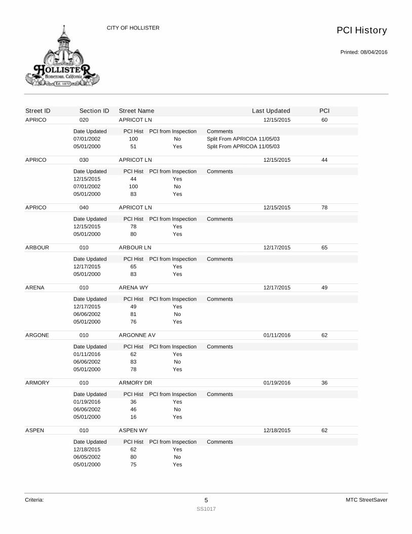
APRICO
Date Updated PCI Hist Comments
020 APRICOT LN 12/15/2015 60
PCI from Inspection07/01/2002 100 Split From APRICOA 11/05/03No05/01/2000 51 Split From APRICOA 11/05/03Yes
APRICO
Date Updated PCI Hist Comments
030 APRICOT LN 12/15/2015 44
PCI from Inspection12/15/2015 44 Yes07/01/2002 100 No05/01/2000 83 Yes
APRICO
Date Updated PCI Hist Comments
040 APRICOT LN 12/15/2015 78
PCI from Inspection12/15/2015 78 Yes05/01/2000 80 Yes
ARBOUR
Date Updated PCI Hist Comments
010 ARBOUR LN 12/17/2015 65
PCI from Inspection12/17/2015 65 Yes05/01/2000 83 Yes
ARENA
Date Updated PCI Hist Comments
010 ARENA WY 12/17/2015 49
PCI from Inspection12/17/2015 49 Yes06/06/2002 81 No05/01/2000 76 Yes
ARGONE
Date Updated PCI Hist Comments
010 ARGONNE AV 01/11/2016 62
PCI from Inspection01/11/2016 62 Yes06/06/2002 83 No05/01/2000 78 Yes
ARMORY
Date Updated PCI Hist Comments
010 ARMORY DR 01/19/2016 36
PCI from Inspection01/19/2016 36 Yes06/06/2002 46 No05/01/2000 16 Yes
ASPEN
Date Updated PCI Hist Comments
010 ASPEN WY 12/18/2015 62
PCI from Inspection12/18/2015 62 Yes06/05/2002 80 No05/01/2000 75 Yes
PCI History
Printed: 08/04/2016
CITY OF HOLLISTER
Street ID Section ID Street Name Last Updated PCI
Criteria: 5SS1017
MTC StreetSaver

AST
Date Updated PCI Hist Comments
010 A ST 12/15/2015 65
PCI from Inspection12/15/2015 65 Yes06/05/2002 85 No05/01/2000 80 Yes
AST
Date Updated PCI Hist Comments
020 A ST 12/15/2015 18
PCI from Inspection12/15/2015 18 Yes05/01/2000 31 Yes
ASTROD
Date Updated PCI Hist Comments
010 ASTRO DR 01/19/2016 31
PCI from Inspection01/19/2016 31 Yes06/06/2002 87 No05/01/2000 83 Yes
ATHENA
Date Updated PCI Hist Comments
010 ATHENA WAY 12/16/2015 85
PCI from Inspection12/16/2015 85 Yes05/01/2000 100 Yes
ATHENA
Date Updated PCI Hist Comments
020 ATHENA WAY 12/16/2015 84
PCI from Inspection12/16/2015 84 Yes05/01/2000 100 Yes
AZULCT
Date Updated PCI Hist Comments
010 AZUL CT 03/10/2016 82
PCI from Inspection03/10/2016 82 No12/10/2015 80 Yes07/06/2002 100 No05/01/2000 19 Yes
BALLCT
Date Updated PCI Hist Comments
010 BALL CT 12/11/2015 41
PCI from Inspection12/11/2015 41 Yes06/05/2002 84 No05/01/2000 78 Yes
BAYBER
Date Updated PCI Hist Comments
010 BAYBERRY ST 01/11/2016 75
PCI from Inspection01/11/2016 75 Yes05/01/2000 82 Yes
PCI History
Printed: 08/04/2016
CITY OF HOLLISTER
Street ID Section ID Street Name Last Updated PCI
Criteria: 6SS1017
MTC StreetSaver
BDLWOOD
Date Updated PCI Hist Comments
010 BRIDLEWOOD ST 12/16/2015 100
PCI from Inspection12/16/2015 100 Yes
BDLWOOD
Date Updated PCI Hist Comments
020 BRIDLEWOOD ST 12/16/2015 100
PCI from Inspection12/16/2015 100 Yes
BEACHW
Date Updated PCI Hist Comments
010 BEACHWOOD CT 12/18/2015 80
PCI from Inspection12/18/2015 80 Yes05/01/2000 82 Yes
BELVCT
Date Updated PCI Hist Comments
010 BELLA VISTA CT 12/18/2015 62
PCI from Inspection12/18/2015 62 Yes06/05/2002 82 No05/01/2000 77 Yes
BELVST
Date Updated PCI Hist Comments
010 BELLA VISTA DR 01/11/2016 63
PCI from Inspection01/11/2016 63 Yes06/05/2002 83 No05/01/2000 78 Yes
BELVST
Date Updated PCI Hist Comments
020 BELLA VISTA DR 01/11/2016 60
PCI from Inspection01/11/2016 60 Yes06/06/2002 77 No05/01/2000 72 Yes
BELVST
Date Updated PCI Hist Comments
030 BELLA VISTA DR 01/11/2016 62
PCI from Inspection01/11/2016 62 Yes06/06/2002 88 No05/01/2000 83 Yes
BERESI
Date Updated PCI Hist Comments
010 BERESINI LN 03/10/2016 85
PCI from Inspection03/10/2016 85 No12/09/2015 84 Yes05/01/2000 100 Yes
BERTDR
Date Updated PCI Hist Comments
010 BERT DR 12/11/2015 73
PCI from Inspection12/11/2015 73 Split From BERTDRA 07/26/02Yes
PCI History
Printed: 08/04/2016
CITY OF HOLLISTER
Street ID Section ID Street Name Last Updated PCI
Criteria: 7SS1017
MTC StreetSaver
BERTDR
Date Updated PCI Hist Comments
010 BERT DR 12/11/2015 73
PCI from Inspection05/01/2000 65 Split From BERTDRA 07/26/02Yes
BERTDR
Date Updated PCI Hist Comments
020 BERT DR 12/11/2015 73
PCI from Inspection12/11/2015 73 Split From BERTDRA 07/26/02Yes07/01/2002 100 Split From BERTDRA 07/26/02No05/01/2000 65 Split From BERTDRA 07/26/02Yes
BERTDR
Date Updated PCI Hist Comments
030 BERT DR 12/11/2015 74
PCI from Inspection12/11/2015 74 Yes07/06/2002 100 No05/01/2000 21 Yes
BERTDR
Date Updated PCI Hist Comments
040 BERT DR 01/22/2016 86
PCI from Inspection01/22/2016 86 Yes
BETHCT
Date Updated PCI Hist Comments
010 BETH CT 12/14/2015 73
PCI from Inspection12/14/2015 73 Yes05/01/2000 83 Yes
BEVERL
Date Updated PCI Hist Comments
010 BEVERLY DR 12/17/2015 70
PCI from Inspection12/17/2015 70 Yes06/06/2002 81 No05/01/2000 78 Yes
BLACKF
Date Updated PCI Hist Comments
010 BLACK FOREST DR 01/11/2016 93
PCI from Inspection01/11/2016 93 Yes05/01/2000 82 Yes
BLACKF
Date Updated PCI Hist Comments
020 BLACK FOREST DR 01/11/2016 93
PCI from Inspection01/11/2016 93 Yes05/01/2000 94 Yes
BLACKF
Date Updated PCI Hist Comments
030 BLACK FOREST DR 01/11/2016 68
PCI from Inspection01/11/2016 68 Yes
PCI History
Printed: 08/04/2016
CITY OF HOLLISTER
Street ID Section ID Street Name Last Updated PCI
Criteria: 8SS1017
MTC StreetSaver

BLACKF
Date Updated PCI Hist Comments
040 BLACK FOREST DR 01/11/2016 82
PCI from Inspection01/11/2016 82 Yes05/01/2000 99 Yes
BLACKF
Date Updated PCI Hist Comments
050 BLACK FOREST DR 01/11/2016 80
PCI from Inspection01/11/2016 80 Yes
BLENHI
Date Updated PCI Hist Comments
010 BLENHIEM DR 01/12/2016 85
PCI from Inspection01/12/2016 85 Yes
BNVIEW
Date Updated PCI Hist Comments
010 BONNIE VIEW RD 01/11/2016 53
PCI from Inspection01/11/2016 53 Yes06/06/2002 85 No05/01/2000 80 Yes
BNVIEW
Date Updated PCI Hist Comments
020 BONNIE VIEW RD 01/11/2016 57
PCI from Inspection01/11/2016 57 Yes
BODEGA
Date Updated PCI Hist Comments
010 BODEGA CT 12/18/2015 68
PCI from Inspection12/18/2015 68 Yes05/01/2000 79 Yes
BORDEA
Date Updated PCI Hist Comments
010 BORDEAUX PL 12/17/2015 66
PCI from Inspection12/17/2015 66 Yes05/01/2000 83 Yes
BORDEA
Date Updated PCI Hist Comments
020 BORDEAUX PL 12/17/2015 78
PCI from Inspection12/17/2015 78 Yes
BRANDY
Date Updated PCI Hist Comments
010 BRANDY CT 12/11/2015 65
PCI from Inspection12/11/2015 65 Yes06/05/2002 88 No05/01/2000 83 Yes
BRDGEV
Date Updated PCI Hist Comments
010 BRIDGEVALE RD 03/10/2016 94
PCI from Inspection03/10/2016 94 No
PCI History
Printed: 08/04/2016
CITY OF HOLLISTER
Street ID Section ID Street Name Last Updated PCI
Criteria: 9SS1017
MTC StreetSaver

BRDGEV
Date Updated PCI Hist Comments
010 BRIDGEVALE RD 03/10/2016 79
PCI from Inspection01/12/2016 95 Yes
BRDGEV
Date Updated PCI Hist Comments
020 BRIDGEVALE RD 03/10/2016 79
PCI from Inspection03/10/2016 79 No01/12/2016 77 Yes05/01/2000 100 Yes
BRENTC
Date Updated PCI Hist Comments
010 BRENT CT 12/15/2015 48
PCI from Inspection12/15/2015 48 Yes05/01/2000 58 Yes
BRENTW
Date Updated PCI Hist Comments
010 BRENTWOOD CT 01/11/2016 80
PCI from Inspection01/11/2016 80 Yes10/29/2003 100 Yes
BRIDGE
Date Updated PCI Hist Comments
010 BRIDGE RD 03/10/2016 80
PCI from Inspection03/10/2016 80 No01/12/2016 78 Yes
BRIDGE
Date Updated PCI Hist Comments
020 BRIDGE RD 03/10/2016 80
PCI from Inspection03/10/2016 80 No12/10/2015 78 Yes05/01/2000 86 Yes
BRIGAL
Date Updated PCI Hist Comments
010 BRIGGS ALLEY 01/18/2016 41
PCI from Inspection01/18/2016 41 Yes05/01/2000 59 Yes
BRIGAL
Date Updated PCI Hist Comments
020 BRIGGS ALLEY 01/18/2016 70
PCI from Inspection01/18/2016 70 Yes07/01/2002 100 No05/01/2000 62 Yes
BRIGAL
Date Updated PCI Hist Comments
030 BRIGGS ALLEY 01/18/2016 71
PCI from Inspection01/18/2016 71 Yes07/01/2002 100 No
PCI History
Printed: 08/04/2016
CITY OF HOLLISTER
Street ID Section ID Street Name Last Updated PCI
Criteria: 10SS1017
MTC StreetSaver
BRIGAL
Date Updated PCI Hist Comments
030 BRIGGS ALLEY 01/18/2016 72
PCI from Inspection05/01/2000 48 Yes
BRIGAL
Date Updated PCI Hist Comments
040 BRIGGS ALLEY 01/18/2016 72
PCI from Inspection01/18/2016 72 Yes07/06/2002 100 No05/01/2000 47 Yes
BRIGAL
Date Updated PCI Hist Comments
050 BRIGGS ALLEY 01/18/2016 15
PCI from Inspection01/18/2016 15 CLOSED TO PUBLICYes
BRIGAN
Date Updated PCI Hist Comments
010 BRIGANTINO DR 01/26/2016 100
PCI from Inspection01/26/2016 100 Yes
BRIGAN
Date Updated PCI Hist Comments
020 BRIGANTINO DR 12/17/2015 77
PCI from Inspection12/17/2015 77 Yes05/01/2000 100 Yes
BRIGHT
Date Updated PCI Hist Comments
010 BRIGHTON DR 01/11/2016 68
PCI from Inspection01/11/2016 68 Yes06/05/2002 85 No05/01/2000 81 Yes
BRIGHT
Date Updated PCI Hist Comments
020 BRIGHTON DR 01/11/2016 68
PCI from Inspection01/11/2016 68 Yes
BRIGHT
Date Updated PCI Hist Comments
030 BRIGHTON DR 01/11/2016 80
PCI from Inspection01/11/2016 80 Yes05/01/2000 96 Yes
BRITTA
Date Updated PCI Hist Comments
010 BRITTANY CIR 12/14/2015 80
PCI from Inspection12/14/2015 80 Yes05/01/2000 83 Yes
BROWNS
Date Updated PCI Hist Comments
010 BROWNS ALLEY 01/18/2016 15
PCI from Inspection01/18/2016 15 Yes
PCI History
Printed: 08/04/2016
CITY OF HOLLISTER
Street ID Section ID Street Name Last Updated PCI
Criteria: 11SS1017
MTC StreetSaver

BROWNS
Date Updated PCI Hist Comments
010 BROWNS ALLEY 01/18/2016 13
PCI from Inspection05/01/2000 10 Yes
BROWNS
Date Updated PCI Hist Comments
020 BROWNS ALLEY 01/18/2016 13
PCI from Inspection01/18/2016 13 Yes05/01/2000 11 Yes
BROWNS
Date Updated PCI Hist Comments
030 BROWNS ALLEY 01/18/2016 36
PCI from Inspection01/18/2016 36 Yes07/01/2002 100 No05/01/2000 45 Yes
BST
Date Updated PCI Hist Comments
010 B ST 12/14/2015 63
PCI from Inspection12/14/2015 63 Yes05/01/2000 83 Yes
BST
Date Updated PCI Hist Comments
020 B ST 12/15/2015 24
PCI from Inspection12/15/2015 24 Yes05/01/2000 30 Yes
BST
Date Updated PCI Hist Comments
030 B ST 12/15/2015 21
PCI from Inspection12/15/2015 21 Yes05/01/2000 34 Yes
BST
Date Updated PCI Hist Comments
040 B ST 12/15/2015 20
PCI from Inspection12/15/2015 20 Yes05/01/2000 25 Yes
BST
Date Updated PCI Hist Comments
050 B ST 12/15/2015 68
PCI from Inspection12/15/2015 68 Yes07/01/2002 100 No05/01/2000 49 Yes
BUNDSN
Date Updated PCI Hist Comments
010 BUNDESON DR 12/16/2015 82
PCI from Inspection12/16/2015 82 Yes05/01/2000 99 Yes
PCI History
Printed: 08/04/2016
CITY OF HOLLISTER
Street ID Section ID Street Name Last Updated PCI
Criteria: 12SS1017
MTC StreetSaver
BUNDSN
Date Updated PCI Hist Comments
020 BUNDESON DR 12/16/2015 75
PCI from Inspection12/16/2015 75 Yes07/06/2002 99 No07/01/2002 100 No05/01/2000 64 Yes
BUNVST
Date Updated PCI Hist Comments
010 BUENA VISTA RD 12/09/2015 23
PCI from Inspection12/09/2015 23 Yes07/01/2002 100 No05/01/2000 14 Yes
BUNVST
Date Updated PCI Hist Comments
020 BUENA VISTA RD 01/12/2016 46
PCI from Inspection01/12/2016 46 Yes
BUNVST
Date Updated PCI Hist Comments
030 BUENA VISTA RD 12/09/2015 70
PCI from Inspection12/09/2015 70 Split From BUNVSTB 11/06/03Yes05/01/2000 33 Split From BUNVSTB 11/06/03Yes
BUNVST
Date Updated PCI Hist Comments
040 BUENA VISTA RD 12/09/2015 81
PCI from Inspection12/09/2015 81 Split From BUNVSTB 11/06/03Yes05/01/2000 33 Split From BUNVSTB 11/06/03Yes
BUNVST
Date Updated PCI Hist Comments
050 BUENA VISTA RD 01/12/2016 74
PCI from Inspection01/12/2016 74 Yes
BUNVST
Date Updated PCI Hist Comments
060 BUENA VISTA RD 12/09/2015 80
PCI from Inspection12/09/2015 80 Split From BUNVSTB 11/06/03Yes05/01/2000 33 Split From BUNVSTB 11/06/03Yes
BUNVST
Date Updated PCI Hist Comments
070 BUENA VISTA RD 12/09/2015 80
PCI from Inspection12/09/2015 80 Split From BUNVSTC 11/06/03Yes05/01/2000 31 Split From BUNVSTC 11/06/03Yes
BUNVST
Date Updated PCI Hist Comments
080 BUENA VISTA RD 01/12/2016 82
PCI from Inspection01/12/2016 82 Yes
PCI History
Printed: 08/04/2016
CITY OF HOLLISTER
Street ID Section ID Street Name Last Updated PCI
Criteria: 13SS1017
MTC StreetSaver
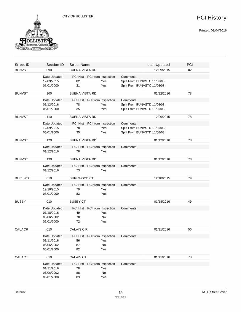
BUNVST
Date Updated PCI Hist Comments
090 BUENA VISTA RD 12/09/2015 82
PCI from Inspection12/09/2015 82 Split From BUNVSTC 11/06/03Yes05/01/2000 31 Split From BUNVSTC 11/06/03Yes
BUNVST
Date Updated PCI Hist Comments
100 BUENA VISTA RD 01/12/2016 78
PCI from Inspection01/12/2016 78 Split From BUNVSTD 11/06/03Yes05/01/2000 35 Split From BUNVSTD 11/06/03Yes
BUNVST
Date Updated PCI Hist Comments
110 BUENA VISTA RD 12/09/2015 78
PCI from Inspection12/09/2015 78 Split From BUNVSTD 11/06/03Yes05/01/2000 35 Split From BUNVSTD 11/06/03Yes
BUNVST
Date Updated PCI Hist Comments
120 BUENA VISTA RD 01/12/2016 78
PCI from Inspection01/12/2016 78 Yes
BUNVST
Date Updated PCI Hist Comments
130 BUENA VISTA RD 01/12/2016 73
PCI from Inspection01/12/2016 73 Yes
BURLWD
Date Updated PCI Hist Comments
010 BURLWOOD CT 12/18/2015 79
PCI from Inspection12/18/2015 79 Yes05/01/2000 83 Yes
BUSBY
Date Updated PCI Hist Comments
010 BUSBY CT 01/18/2016 49
PCI from Inspection01/18/2016 49 Yes06/06/2002 78 No05/01/2000 72 Yes
CALACR
Date Updated PCI Hist Comments
010 CALAIS CIR 01/11/2016 56
PCI from Inspection01/11/2016 56 Yes06/06/2002 87 No05/01/2000 82 Yes
CALACT
Date Updated PCI Hist Comments
010 CALAIS CT 01/11/2016 78
PCI from Inspection01/11/2016 78 Yes06/06/2002 88 No05/01/2000 83 Yes
PCI History
Printed: 08/04/2016
CITY OF HOLLISTER
Street ID Section ID Street Name Last Updated PCI
Criteria: 14SS1017
MTC StreetSaver
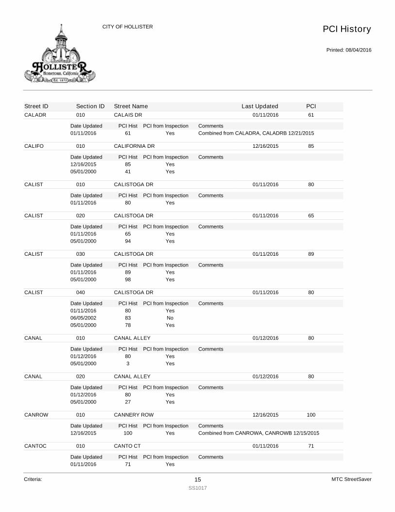
CALADR
Date Updated PCI Hist Comments
010 CALAIS DR 01/11/2016 61
PCI from Inspection01/11/2016 61 Combined from CALADRA, CALADRB 12/21/2015Yes
CALIFO
Date Updated PCI Hist Comments
010 CALIFORNIA DR 12/16/2015 85
PCI from Inspection12/16/2015 85 Yes05/01/2000 41 Yes
CALIST
Date Updated PCI Hist Comments
010 CALISTOGA DR 01/11/2016 80
PCI from Inspection01/11/2016 80 Yes
CALIST
Date Updated PCI Hist Comments
020 CALISTOGA DR 01/11/2016 65
PCI from Inspection01/11/2016 65 Yes05/01/2000 94 Yes
CALIST
Date Updated PCI Hist Comments
030 CALISTOGA DR 01/11/2016 89
PCI from Inspection01/11/2016 89 Yes05/01/2000 98 Yes
CALIST
Date Updated PCI Hist Comments
040 CALISTOGA DR 01/11/2016 80
PCI from Inspection01/11/2016 80 Yes06/05/2002 83 No05/01/2000 78 Yes
CANAL
Date Updated PCI Hist Comments
010 CANAL ALLEY 01/12/2016 80
PCI from Inspection01/12/2016 80 Yes05/01/2000 3 Yes
CANAL
Date Updated PCI Hist Comments
020 CANAL ALLEY 01/12/2016 80
PCI from Inspection01/12/2016 80 Yes05/01/2000 27 Yes
CANROW
Date Updated PCI Hist Comments
010 CANNERY ROW 12/16/2015 100
PCI from Inspection12/16/2015 100 Combined from CANROWA, CANROWB 12/15/2015Yes
CANTOC
Date Updated PCI Hist Comments
010 CANTO CT 01/11/2016 71
PCI from Inspection01/11/2016 71 Yes
PCI History
Printed: 08/04/2016
CITY OF HOLLISTER
Street ID Section ID Street Name Last Updated PCI
Criteria: 15SS1017
MTC StreetSaver

CANTOC
Date Updated PCI Hist Comments
010 CANTO CT 01/11/2016 71
PCI from Inspection06/06/2002 86 No05/01/2000 82 Yes
CAPITO
Date Updated PCI Hist Comments
010 CAPITOLA DR 01/11/2016 65
PCI from Inspection01/11/2016 65 Yes06/06/2002 84 No05/01/2000 79 Yes
CAPUTO
Date Updated PCI Hist Comments
010 CAPUTO CT 01/11/2016 80
PCI from Inspection01/11/2016 80 Yes05/01/2000 41 Yes
CARMEN
Date Updated PCI Hist Comments
010 CARMEN CT 12/14/2015 70
PCI from Inspection12/14/2015 70 Yes06/05/2002 86 No05/01/2000 81 Yes
CARMLA
Date Updated PCI Hist Comments
010 CARMELA CT 12/14/2015 72
PCI from Inspection12/14/2015 72 Yes06/05/2002 88 No05/01/2000 83 Yes
CARNOB
Date Updated PCI Hist Comments
010 CARNOBLE DR 12/10/2015 51
PCI from Inspection12/10/2015 51 Yes05/01/2000 58 Yes
CAROUS
Date Updated PCI Hist Comments
010 CAROUSEL DR 12/12/2015 80
PCI from Inspection12/12/2015 80 Yes05/01/2000 87 Yes
CAROUS
Date Updated PCI Hist Comments
020 CAROUSEL DR 12/12/2015 71
PCI from Inspection12/12/2015 71 Yes06/05/2002 85 No05/01/2000 81 Yes
PCI History
Printed: 08/04/2016
CITY OF HOLLISTER
Street ID Section ID Street Name Last Updated PCI
Criteria: 16SS1017
MTC StreetSaver

CASTEN
Date Updated PCI Hist Comments
010 CASTEN CT 12/17/2015 34
PCI from Inspection12/17/2015 34 Yes05/01/2000 82 Yes
CEDARS
Date Updated PCI Hist Comments
010 CEDAR ST 01/11/2016 80
PCI from Inspection01/11/2016 80 Combined from CEDARSA, CEDARSB 12/21/2015Yes
CEMBEL
Date Updated PCI Hist Comments
010 CEMBELLIN DR 12/18/2015 48
PCI from Inspection12/18/2015 48 Yes05/01/2000 59 Yes
CENTRA
Date Updated PCI Hist Comments
010 CENTRAL AV 12/11/2015 83
PCI from Inspection12/11/2015 83 Yes05/01/2000 11 Yes
CENTRA
Date Updated PCI Hist Comments
020 CENTRAL AV 12/11/2015 85
PCI from Inspection12/11/2015 85 Yes05/01/2000 59 Yes
CENTRA
Date Updated PCI Hist Comments
030 CENTRAL AV 12/11/2015 45
PCI from Inspection12/11/2015 45 Yes07/06/2002 100 No05/01/2000 28 Yes
CENTRA
Date Updated PCI Hist Comments
040 CENTRAL AV 12/11/2015 45
PCI from Inspection12/11/2015 45 Yes05/01/2000 42 Yes
CENTRA
Date Updated PCI Hist Comments
050 CENTRAL AV 12/11/2015 45
PCI from Inspection12/11/2015 45 Yes05/01/2000 60 Yes
CENTRA
Date Updated PCI Hist Comments
060 CENTRAL AV 12/11/2015 78
PCI from Inspection12/11/2015 78 Yes07/06/2002 100 No05/01/2000 49 Yes
PCI History
Printed: 08/04/2016
CITY OF HOLLISTER
Street ID Section ID Street Name Last Updated PCI
Criteria: 17SS1017
MTC StreetSaver
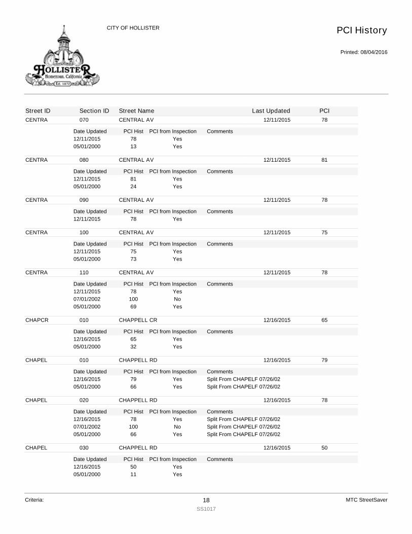
CENTRA
Date Updated PCI Hist Comments
070 CENTRAL AV 12/11/2015 78
PCI from Inspection12/11/2015 78 Yes05/01/2000 13 Yes
CENTRA
Date Updated PCI Hist Comments
080 CENTRAL AV 12/11/2015 81
PCI from Inspection12/11/2015 81 Yes05/01/2000 24 Yes
CENTRA
Date Updated PCI Hist Comments
090 CENTRAL AV 12/11/2015 78
PCI from Inspection12/11/2015 78 Yes
CENTRA
Date Updated PCI Hist Comments
100 CENTRAL AV 12/11/2015 75
PCI from Inspection12/11/2015 75 Yes05/01/2000 73 Yes
CENTRA
Date Updated PCI Hist Comments
110 CENTRAL AV 12/11/2015 78
PCI from Inspection12/11/2015 78 Yes07/01/2002 100 No05/01/2000 69 Yes
CHAPCR
Date Updated PCI Hist Comments
010 CHAPPELL CR 12/16/2015 65
PCI from Inspection12/16/2015 65 Yes05/01/2000 32 Yes
CHAPEL
Date Updated PCI Hist Comments
010 CHAPPELL RD 12/16/2015 79
PCI from Inspection12/16/2015 79 Split From CHAPELF 07/26/02Yes05/01/2000 66 Split From CHAPELF 07/26/02Yes
CHAPEL
Date Updated PCI Hist Comments
020 CHAPPELL RD 12/16/2015 78
PCI from Inspection12/16/2015 78 Split From CHAPELF 07/26/02Yes07/01/2002 100 Split From CHAPELF 07/26/02No05/01/2000 66 Split From CHAPELF 07/26/02Yes
CHAPEL
Date Updated PCI Hist Comments
030 CHAPPELL RD 12/16/2015 50
PCI from Inspection12/16/2015 50 Yes05/01/2000 11 Yes
PCI History
Printed: 08/04/2016
CITY OF HOLLISTER
Street ID Section ID Street Name Last Updated PCI
Criteria: 18SS1017
MTC StreetSaver
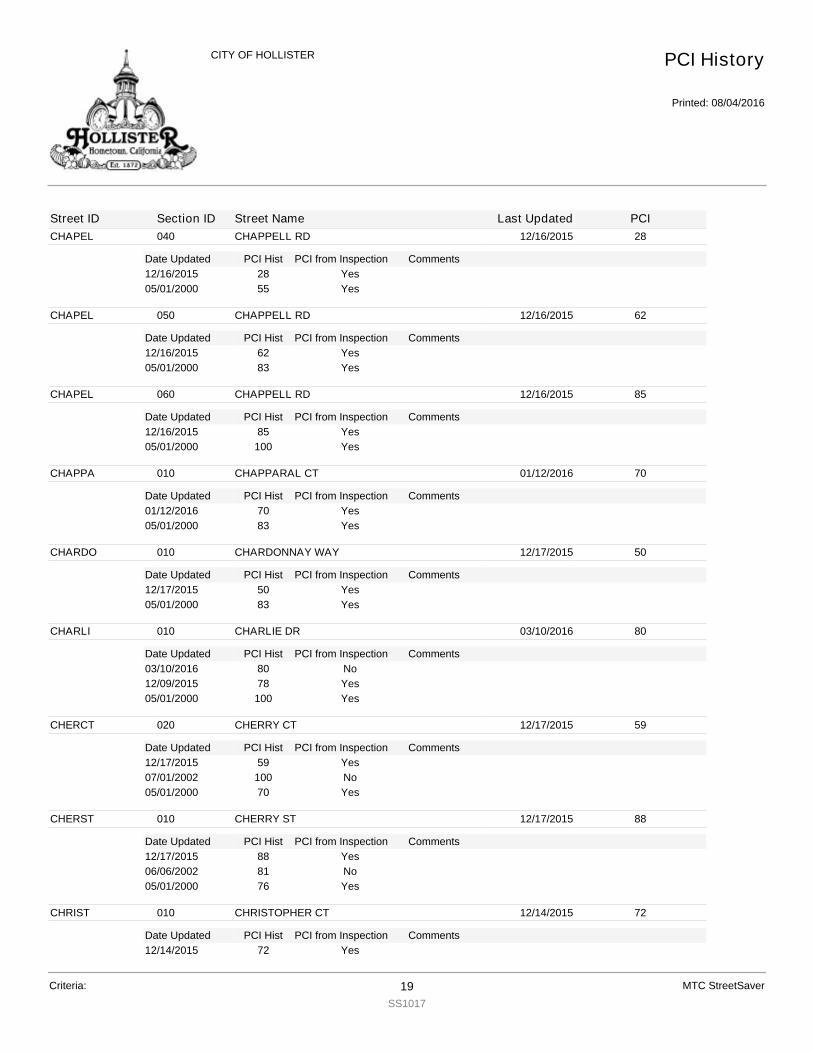
CHAPEL
Date Updated PCI Hist Comments
040 CHAPPELL RD 12/16/2015 28
PCI from Inspection12/16/2015 28 Yes05/01/2000 55 Yes
CHAPEL
Date Updated PCI Hist Comments
050 CHAPPELL RD 12/16/2015 62
PCI from Inspection12/16/2015 62 Yes05/01/2000 83 Yes
CHAPEL
Date Updated PCI Hist Comments
060 CHAPPELL RD 12/16/2015 85
PCI from Inspection12/16/2015 85 Yes05/01/2000 100 Yes
CHAPPA
Date Updated PCI Hist Comments
010 CHAPPARAL CT 01/12/2016 70
PCI from Inspection01/12/2016 70 Yes05/01/2000 83 Yes
CHARDO
Date Updated PCI Hist Comments
010 CHARDONNAY WAY 12/17/2015 50
PCI from Inspection12/17/2015 50 Yes05/01/2000 83 Yes
CHARLI
Date Updated PCI Hist Comments
010 CHARLIE DR 03/10/2016 80
PCI from Inspection03/10/2016 80 No12/09/2015 78 Yes05/01/2000 100 Yes
CHERCT
Date Updated PCI Hist Comments
020 CHERRY CT 12/17/2015 59
PCI from Inspection12/17/2015 59 Yes07/01/2002 100 No05/01/2000 70 Yes
CHERST
Date Updated PCI Hist Comments
010 CHERRY ST 12/17/2015 88
PCI from Inspection12/17/2015 88 Yes06/06/2002 81 No05/01/2000 76 Yes
CHRIST
Date Updated PCI Hist Comments
010 CHRISTOPHER CT 12/14/2015 72
PCI from Inspection12/14/2015 72 Yes
PCI History
Printed: 08/04/2016
CITY OF HOLLISTER
Street ID Section ID Street Name Last Updated PCI
Criteria: 19SS1017
MTC StreetSaver
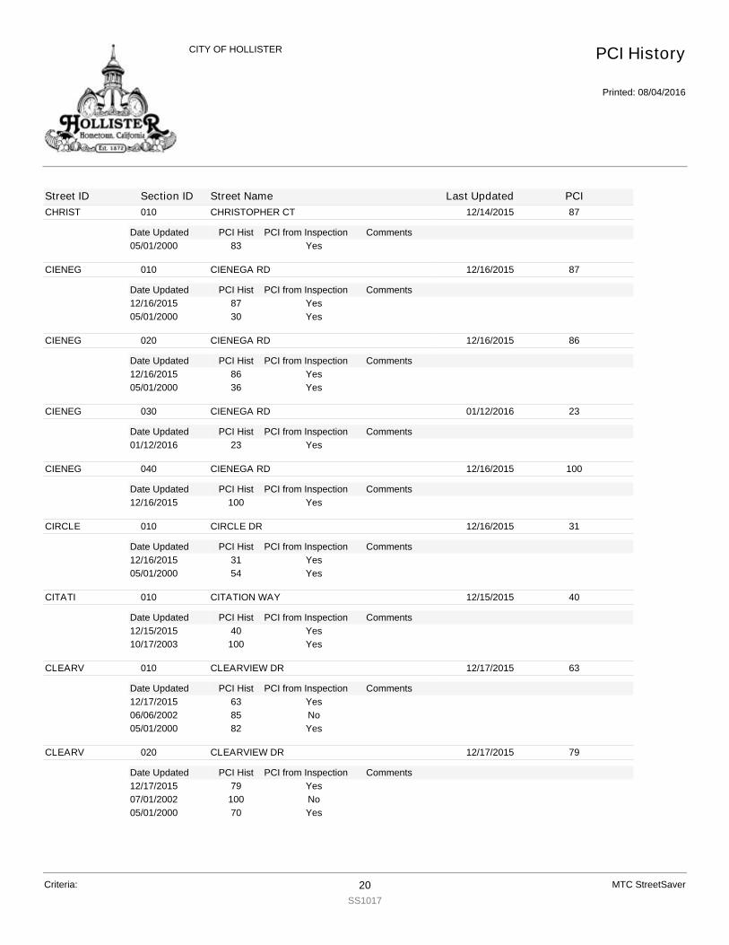
CHRIST
Date Updated PCI Hist Comments
010 CHRISTOPHER CT 12/14/2015 87
PCI from Inspection05/01/2000 83 Yes
CIENEG
Date Updated PCI Hist Comments
010 CIENEGA RD 12/16/2015 87
PCI from Inspection12/16/2015 87 Yes05/01/2000 30 Yes
CIENEG
Date Updated PCI Hist Comments
020 CIENEGA RD 12/16/2015 86
PCI from Inspection12/16/2015 86 Yes05/01/2000 36 Yes
CIENEG
Date Updated PCI Hist Comments
030 CIENEGA RD 01/12/2016 23
PCI from Inspection01/12/2016 23 Yes
CIENEG
Date Updated PCI Hist Comments
040 CIENEGA RD 12/16/2015 100
PCI from Inspection12/16/2015 100 Yes
CIRCLE
Date Updated PCI Hist Comments
010 CIRCLE DR 12/16/2015 31
PCI from Inspection12/16/2015 31 Yes05/01/2000 54 Yes
CITATI
Date Updated PCI Hist Comments
010 CITATION WAY 12/15/2015 40
PCI from Inspection12/15/2015 40 Yes10/17/2003 100 Yes
CLEARV
Date Updated PCI Hist Comments
010 CLEARVIEW DR 12/17/2015 63
PCI from Inspection12/17/2015 63 Yes06/06/2002 85 No05/01/2000 82 Yes
CLEARV
Date Updated PCI Hist Comments
020 CLEARVIEW DR 12/17/2015 79
PCI from Inspection12/17/2015 79 Yes07/01/2002 100 No05/01/2000 70 Yes
PCI History
Printed: 08/04/2016
CITY OF HOLLISTER
Street ID Section ID Street Name Last Updated PCI
Criteria: 20SS1017
MTC StreetSaver

CLEARV
Date Updated PCI Hist Comments
030 CLEARVIEW DR 12/17/2015 66
PCI from Inspection12/17/2015 66 Yes06/06/2002 86 No05/01/2000 82 Yes
CLEARV
Date Updated PCI Hist Comments
040 CLEARVIEW DR 12/17/2015 70
PCI from Inspection12/17/2015 70 Yes06/06/2002 83 No05/01/2000 79 Yes
CLEARV
Date Updated PCI Hist Comments
050 CLEARVIEW DR 12/17/2015 81
PCI from Inspection12/17/2015 81 Yes07/01/2002 100 No05/01/2000 44 Yes
CLEARV
Date Updated PCI Hist Comments
060 CLEARVIEW DR 12/17/2015 84
PCI from Inspection12/17/2015 84 Yes05/01/2000 26 Yes
CLEARV
Date Updated PCI Hist Comments
070 CLEARVIEW DR 12/17/2015 84
PCI from Inspection12/17/2015 84 Yes05/01/2000 59 Yes
CLEARV
Date Updated PCI Hist Comments
080 CLEARVIEW DR 12/17/2015 80
PCI from Inspection12/17/2015 80 Yes05/01/2000 94 Yes
COBLES
Date Updated PCI Hist Comments
010 COBBLESTONE CT 12/18/2015 81
PCI from Inspection12/18/2015 81 Yes10/17/2003 100 Yes
COLLEG
Date Updated PCI Hist Comments
010 COLLEGE ST 12/16/2015 75
PCI from Inspection12/16/2015 75 Yes05/01/2000 35 Yes
COLLEG
Date Updated PCI Hist Comments
020 COLLEGE ST 12/16/2015 83
PCI from Inspection12/16/2015 83 Yes
PCI History
Printed: 08/04/2016
CITY OF HOLLISTER
Street ID Section ID Street Name Last Updated PCI
Criteria: 21SS1017
MTC StreetSaver

COLLEG
Date Updated PCI Hist Comments
020 COLLEGE ST 12/16/2015 85
PCI from Inspection05/01/2000 42 Yes
COLLEG
Date Updated PCI Hist Comments
030 COLLEGE ST 12/16/2015 85
PCI from Inspection12/16/2015 85 Yes05/01/2000 26 Yes
COSCO
Date Updated PCI Hist Comments
010 COSCO CT 12/11/2015 66
PCI from Inspection12/11/2015 66 Yes05/01/2000 54 Yes
CRAVST
Date Updated PCI Hist Comments
010 CERRA VISTA DR 12/18/2015 100
PCI from Inspection12/18/2015 100 Yes06/06/2015 100 No06/05/2002 83 No05/01/2000 80 Yes
CRAVST
Date Updated PCI Hist Comments
020 CERRA VISTA DR 12/18/2015 100
PCI from Inspection12/18/2015 100 Yes06/06/2015 100 No05/01/2000 66 Yes
CRAVST
Date Updated PCI Hist Comments
030 CERRA VISTA DR 12/18/2015 100
PCI from Inspection12/18/2015 100 Yes06/06/2015 100 No06/05/2002 77 No05/01/2000 74 Yes
CRAVST
Date Updated PCI Hist Comments
040 CERRA VISTA DR 12/18/2015 90
PCI from Inspection12/18/2015 90 Yes06/05/2002 86 No05/01/2000 82 Yes
CRESCE
Date Updated PCI Hist Comments
010 CRESCENT LN 01/11/2016 67
PCI from Inspection01/11/2016 67 Yes06/05/2002 82 No05/01/2000 77 Yes
PCI History
Printed: 08/04/2016
CITY OF HOLLISTER
Street ID Section ID Street Name Last Updated PCI
Criteria: 22SS1017
MTC StreetSaver
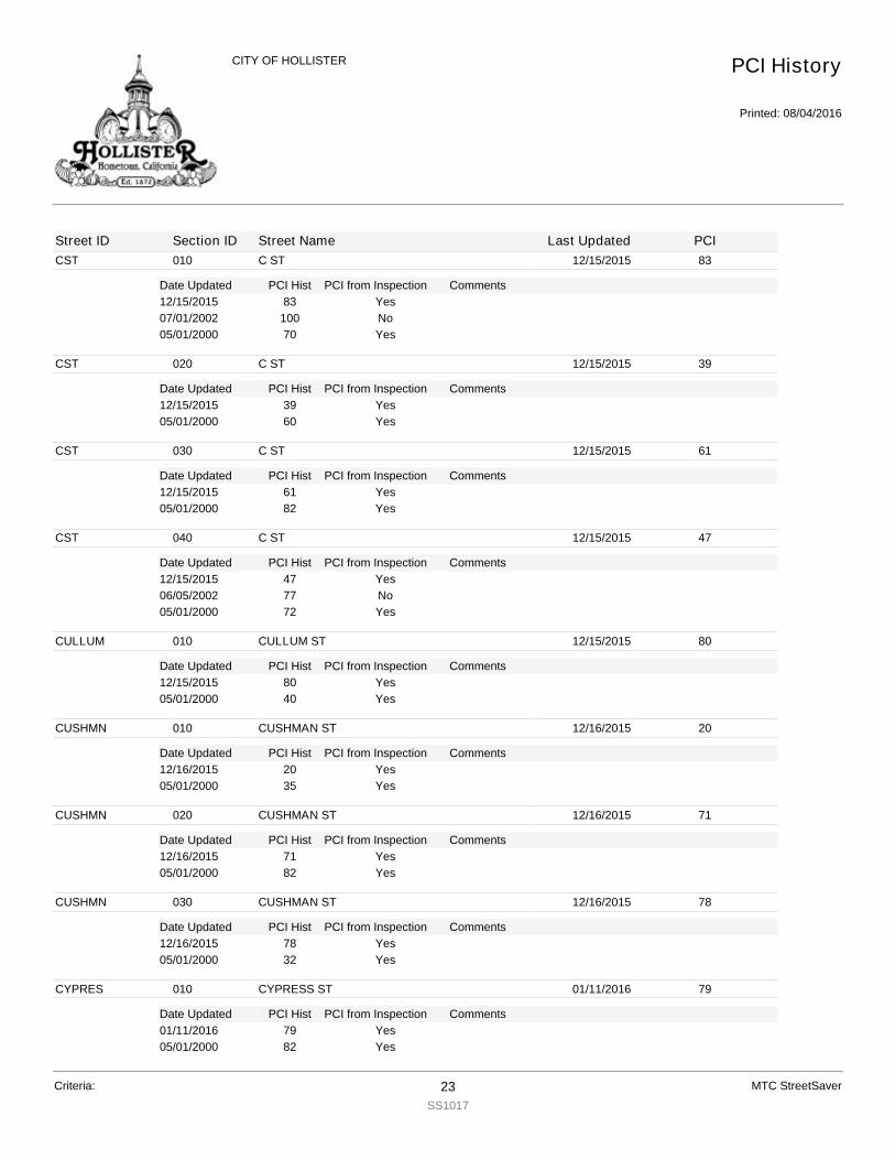
CST
Date Updated PCI Hist Comments
010 C ST 12/15/2015 83
PCI from Inspection12/15/2015 83 Yes07/01/2002 100 No05/01/2000 70 Yes
CST
Date Updated PCI Hist Comments
020 C ST 12/15/2015 39
PCI from Inspection12/15/2015 39 Yes05/01/2000 60 Yes
CST
Date Updated PCI Hist Comments
030 C ST 12/15/2015 61
PCI from Inspection12/15/2015 61 Yes05/01/2000 82 Yes
CST
Date Updated PCI Hist Comments
040 C ST 12/15/2015 47
PCI from Inspection12/15/2015 47 Yes06/05/2002 77 No05/01/2000 72 Yes
CULLUM
Date Updated PCI Hist Comments
010 CULLUM ST 12/15/2015 80
PCI from Inspection12/15/2015 80 Yes05/01/2000 40 Yes
CUSHMN
Date Updated PCI Hist Comments
010 CUSHMAN ST 12/16/2015 20
PCI from Inspection12/16/2015 20 Yes05/01/2000 35 Yes
CUSHMN
Date Updated PCI Hist Comments
020 CUSHMAN ST 12/16/2015 71
PCI from Inspection12/16/2015 71 Yes05/01/2000 82 Yes
CUSHMN
Date Updated PCI Hist Comments
030 CUSHMAN ST 12/16/2015 78
PCI from Inspection12/16/2015 78 Yes05/01/2000 32 Yes
CYPRES
Date Updated PCI Hist Comments
010 CYPRESS ST 01/11/2016 79
PCI from Inspection01/11/2016 79 Yes05/01/2000 82 Yes
PCI History
Printed: 08/04/2016
CITY OF HOLLISTER
Street ID Section ID Street Name Last Updated PCI
Criteria: 23SS1017
MTC StreetSaver

CYPRES
Date Updated PCI Hist Comments
020 CYPRESS ST 01/11/2016 80
PCI from Inspection01/11/2016 80 Yes05/01/2000 83 Yes
DELMAR
Date Updated PCI Hist Comments
010 DEL MAR DR 01/11/2016 73
PCI from Inspection01/11/2016 73 Yes06/06/2002 82 No05/01/2000 77 Yes
DELMAR
Date Updated PCI Hist Comments
020 DEL MAR DR 01/11/2016 73
PCI from Inspection01/11/2016 73 Yes
DELMAR
Date Updated PCI Hist Comments
030 DEL MAR DR 01/11/2016 72
PCI from Inspection01/11/2016 72 Yes06/06/2002 87 No05/01/2000 82 Yes
DELMON
Date Updated PCI Hist Comments
010 DEL MONTE DR 01/11/2016 70
PCI from Inspection01/11/2016 70 Yes05/01/2000 82 Yes
DELMON
Date Updated PCI Hist Comments
020 DEL MONTE DR 01/11/2016 71
PCI from Inspection01/11/2016 71 Yes
DELMON
Date Updated PCI Hist Comments
030 DEL MONTE DR 01/11/2016 80
PCI from Inspection01/11/2016 80 Yes05/01/2000 82 Yes
DEVIDA
Date Updated PCI Hist Comments
010 DE VIDA CT 12/18/2015 64
PCI from Inspection12/18/2015 64 Yes06/06/2002 81 No05/01/2000 76 Yes
DIABAL
Date Updated PCI Hist Comments
010 DIABLO DR ALLEY N/O 01/11/2016 11
PCI from Inspection01/11/2016 11 Yes06/01/2000 14 Yes
PCI History
Printed: 08/04/2016
CITY OF HOLLISTER
Street ID Section ID Street Name Last Updated PCI
Criteria: 24SS1017
MTC StreetSaver

DIABLO
Date Updated PCI Hist Comments
010 DIABLO DR 12/18/2015 50
PCI from Inspection12/18/2015 50 Yes05/01/2000 59 Yes
DIABLO
Date Updated PCI Hist Comments
020 DIABLO DR 12/18/2015 49
PCI from Inspection12/18/2015 49 Yes06/05/2002 80 No05/01/2000 74 Yes
DLROCT
Date Updated PCI Hist Comments
010 DEL RIO CT 12/14/2015 71
PCI from Inspection12/14/2015 71 Yes06/05/2002 87 No05/01/2000 82 Yes
DLRORD
Date Updated PCI Hist Comments
010 DEL RIO RD 01/12/2016 73
PCI from Inspection01/12/2016 73 Yes06/05/2002 87 No05/01/2000 82 Yes
DRIFCT
Date Updated PCI Hist Comments
010 DRIFTWOOD CT 01/11/2016 80
PCI from Inspection01/11/2016 80 Yes05/01/2000 99 Yes
DRIFTW
Date Updated PCI Hist Comments
010 DRIFTWOOD ST 01/11/2016 80
PCI from Inspection01/11/2016 80 Yes05/01/2000 98 Yes
DST
Date Updated PCI Hist Comments
010 D ST 12/15/2015 85
PCI from Inspection12/15/2015 85 Yes07/01/2002 100 No05/01/2000 44 Yes
EASTST
Date Updated PCI Hist Comments
010 EAST ST 12/15/2015 80
PCI from Inspection12/15/2015 80 Yes05/01/2000 16 Yes
PCI History
Printed: 08/04/2016
CITY OF HOLLISTER
Street ID Section ID Street Name Last Updated PCI
Criteria: 25SS1017
MTC StreetSaver
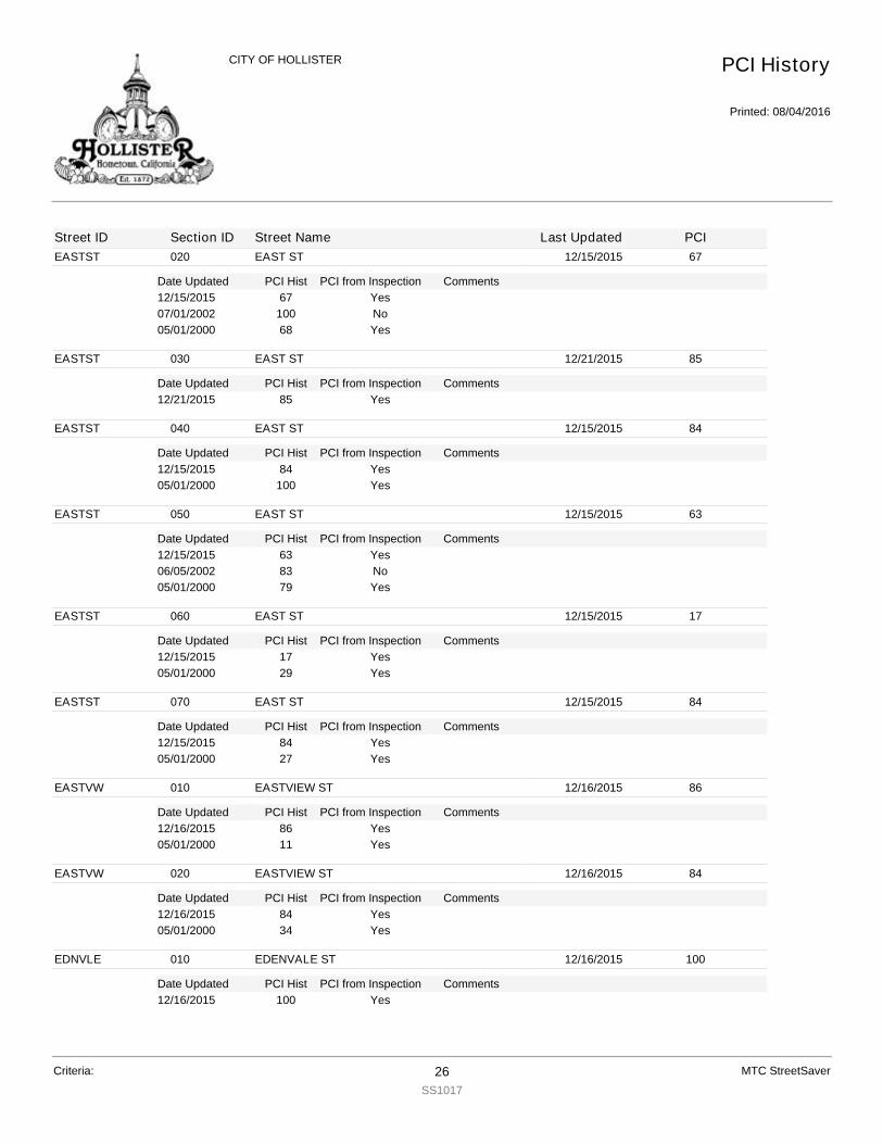
EASTST
Date Updated PCI Hist Comments
020 EAST ST 12/15/2015 67
PCI from Inspection12/15/2015 67 Yes07/01/2002 100 No05/01/2000 68 Yes
EASTST
Date Updated PCI Hist Comments
030 EAST ST 12/21/2015 85
PCI from Inspection12/21/2015 85 Yes
EASTST
Date Updated PCI Hist Comments
040 EAST ST 12/15/2015 84
PCI from Inspection12/15/2015 84 Yes05/01/2000 100 Yes
EASTST
Date Updated PCI Hist Comments
050 EAST ST 12/15/2015 63
PCI from Inspection12/15/2015 63 Yes06/05/2002 83 No05/01/2000 79 Yes
EASTST
Date Updated PCI Hist Comments
060 EAST ST 12/15/2015 17
PCI from Inspection12/15/2015 17 Yes05/01/2000 29 Yes
EASTST
Date Updated PCI Hist Comments
070 EAST ST 12/15/2015 84
PCI from Inspection12/15/2015 84 Yes05/01/2000 27 Yes
EASTVW
Date Updated PCI Hist Comments
010 EASTVIEW ST 12/16/2015 86
PCI from Inspection12/16/2015 86 Yes05/01/2000 11 Yes
EASTVW
Date Updated PCI Hist Comments
020 EASTVIEW ST 12/16/2015 84
PCI from Inspection12/16/2015 84 Yes05/01/2000 34 Yes
EDNVLE
Date Updated PCI Hist Comments
010 EDENVALE ST 12/16/2015 100
PCI from Inspection12/16/2015 100 Yes
PCI History
Printed: 08/04/2016
CITY OF HOLLISTER
Street ID Section ID Street Name Last Updated PCI
Criteria: 26SS1017
MTC StreetSaver

ELCAMI
Date Updated PCI Hist Comments
010 EL CAMINO DE VIDA 12/18/2015 63
PCI from Inspection12/18/2015 63 Yes06/06/2002 79 No05/01/2000 74 Yes
ELCAMI
Date Updated PCI Hist Comments
020 EL CAMINO DE VIDA 12/18/2015 67
PCI from Inspection12/18/2015 67 Yes05/01/2000 82 Yes
ELCERR
Date Updated PCI Hist Comments
010 EL CERRO DR 12/17/2015 67
PCI from Inspection12/17/2015 67 Yes06/06/2002 84 No05/01/2000 80 Yes
ELCERR
Date Updated PCI Hist Comments
020 EL CERRO DR 12/17/2015 64
PCI from Inspection12/17/2015 64 Yes06/06/2002 85 No05/01/2000 81 Yes
ELCRCT
Date Updated PCI Hist Comments
010 EL CERRO CT 12/17/2015 65
PCI from Inspection12/17/2015 65 Yes06/06/2002 83 No05/01/2000 79 Yes
ELDENE
Date Updated PCI Hist Comments
010 ELDENE DR 12/12/2015 68
PCI from Inspection12/12/2015 68 Yes06/05/2002 85 No05/01/2000 81 Yes
ELLIS
Date Updated PCI Hist Comments
010 ELLIS CT 12/11/2015 85
PCI from Inspection12/11/2015 85 Yes07/01/2002 100 No05/01/2000 42 Yes
ELTORO
Date Updated PCI Hist Comments
010 EL TORO DR 12/17/2015 68
PCI from Inspection12/17/2015 68 Yes07/06/2002 98 No07/01/2002 100 No
PCI History
Printed: 08/04/2016
CITY OF HOLLISTER
Street ID Section ID Street Name Last Updated PCI
Criteria: 27SS1017
MTC StreetSaver

ELTORO
Date Updated PCI Hist Comments
010 EL TORO DR 12/17/2015 80
PCI from Inspection05/01/2000 83 Yes
ELTORO
Date Updated PCI Hist Comments
020 EL TORO DR 12/17/2015 80
PCI from Inspection12/17/2015 80 Yes05/01/2000 64 Yes
ELTORO
Date Updated PCI Hist Comments
030 EL TORO DR 01/12/2016 30
PCI from Inspection01/12/2016 30 Yes
ELTORO
Date Updated PCI Hist Comments
040 EL TORO DR 01/12/2016 33
PCI from Inspection01/12/2016 33 Yes
ELTORO
Date Updated PCI Hist Comments
050 EL TORO DR 12/17/2015 42
PCI from Inspection12/17/2015 42 Yes06/06/2002 81 No05/01/2000 78 Yes
ELTORO
Date Updated PCI Hist Comments
060 EL TORO DR 12/17/2015 33
PCI from Inspection12/17/2015 33 Yes05/01/2000 61 Yes
ENTERP
Date Updated PCI Hist Comments
010 ENTERPRISE RD 01/11/2016 73
PCI from Inspection01/11/2016 73 Yes10/29/2003 83 Yes
ENTERP
Date Updated PCI Hist Comments
020 ENTERPRISE RD 01/11/2016 85
PCI from Inspection01/11/2016 85 Yes05/01/2000 100 Yes
ERVINC
Date Updated PCI Hist Comments
010 ERVIN CT 12/12/2015 80
PCI from Inspection12/12/2015 80 Yes05/01/2000 82 Yes
ESTVCT
Date Updated PCI Hist Comments
010 EASTVIEW CT 12/12/2015 84
PCI from Inspection12/12/2015 84 Yes
PCI History
Printed: 08/04/2016
CITY OF HOLLISTER
Street ID Section ID Street Name Last Updated PCI
Criteria: 28SS1017
MTC StreetSaver

ESTVCT
Date Updated PCI Hist Comments
010 EASTVIEW CT 12/12/2015 68
PCI from Inspection05/01/2000 98 Yes
EVELYN
Date Updated PCI Hist Comments
010 EVELYNS DR 12/12/2015 68
PCI from Inspection12/12/2015 68 Yes06/05/2002 85 No05/01/2000 81 Yes
EVERGR
Date Updated PCI Hist Comments
010 EVERGREEN CT 12/18/2015 68
PCI from Inspection12/18/2015 68 Yes06/06/2002 86 No05/01/2000 82 Yes
FAIRHA
Date Updated PCI Hist Comments
010 FAIRHAVEN DR 01/11/2016 67
PCI from Inspection01/11/2016 67 Yes06/05/2002 85 No05/01/2000 81 Yes
FAIRHA
Date Updated PCI Hist Comments
020 FAIRHAVEN DR 01/11/2016 68
PCI from Inspection01/11/2016 68 Yes
FAIRHA
Date Updated PCI Hist Comments
030 FAIRHAVEN CT 01/11/2016 68
PCI from Inspection01/11/2016 68 Yes06/05/2002 86 No05/01/2000 82 Yes
FALCON
Date Updated PCI Hist Comments
010 FALCONI WAY 12/17/2015 68
PCI from Inspection12/17/2015 68 Yes05/01/2000 83 Yes
FALLON
Date Updated PCI Hist Comments
010 FALLON RD 12/11/2015 54
PCI from Inspection12/11/2015 54 Yes06/05/2002 83 No05/01/2000 78 Yes
FALLON
Date Updated PCI Hist Comments
020 FALLON RD 12/11/2015 64
PCI from Inspection12/11/2015 64 Yes
PCI History
Printed: 08/04/2016
CITY OF HOLLISTER
Street ID Section ID Street Name Last Updated PCI
Criteria: 29SS1017
MTC StreetSaver

FALLON
Date Updated PCI Hist Comments
020 FALLON RD 12/11/2015 75
PCI from Inspection05/01/2000 82 Yes
FARRAG
Date Updated PCI Hist Comments
010 FARRAGOT DR 01/11/2016 75
PCI from Inspection01/11/2016 75 Split From FARRAGA 11/04/03 - Combined from FARRAGA1,
FARRAGA2 12/21/2015Yes
FELICE
Date Updated PCI Hist Comments
010 FELICE DR 12/11/2015 85
PCI from Inspection12/11/2015 85 Yes05/01/2000 31 Yes
FIFTH
Date Updated PCI Hist Comments
010 FIFTH ST 01/12/2016 40
PCI from Inspection01/12/2016 40 Yes
FIFTH
Date Updated PCI Hist Comments
020 FIFTH ST 12/16/2015 51
PCI from Inspection12/16/2015 51 Yes05/01/2000 57 Yes
FIFTH
Date Updated PCI Hist Comments
030 FIFTH ST 12/16/2015 17
PCI from Inspection12/16/2015 17 Yes05/01/2000 10 Yes
FIFTH
Date Updated PCI Hist Comments
040 FIFTH ST 12/16/2015 81
PCI from Inspection12/16/2015 81 Yes05/01/2000 80 Yes
FIFTH
Date Updated PCI Hist Comments
050 FIFTH ST 12/16/2015 80
PCI from Inspection12/16/2015 80 Yes
FIFTH
Date Updated PCI Hist Comments
060 FIFTH ST 12/16/2015 80
PCI from Inspection12/16/2015 80 Yes07/06/2002 100 No05/01/2000 45 Yes
FIRST
Date Updated PCI Hist Comments
010 FIRST ST 12/16/2015 0
PCI from Inspection12/16/2015 0 Yes
PCI History
Printed: 08/04/2016
CITY OF HOLLISTER
Street ID Section ID Street Name Last Updated PCI
Criteria: 30SS1017
MTC StreetSaver

FIRST
Date Updated PCI Hist Comments
010 FIRST ST 12/16/2015 85
PCI from Inspection05/01/2000 21 Yes
FIRST
Date Updated PCI Hist Comments
020 FIRST ST 12/16/2015 85
PCI from Inspection12/16/2015 85 Yes07/01/2002 100 No05/01/2000 65 Yes
FIRST
Date Updated PCI Hist Comments
030 FIRST ST 01/12/2016 15
PCI from Inspection01/12/2016 15 Yes05/01/2000 32 Yes
FLORA
Date Updated PCI Hist Comments
010 FLORA AVE 12/16/2015 48
PCI from Inspection12/16/2015 48 Yes10/28/2003 4 Yes
FLYNN
Date Updated PCI Hist Comments
010 FLYNN RD 12/15/2015 58
PCI from Inspection12/15/2015 58 Yes05/01/2000 4 Yes
FLYNN
Date Updated PCI Hist Comments
020 FLYNN RD 12/15/2015 64
PCI from Inspection12/15/2015 64 Yes06/05/2002 75 No05/01/2000 72 Yes
FLYNN
Date Updated PCI Hist Comments
030 FLYNN RD 12/17/2015 50
PCI from Inspection12/17/2015 50 Yes
FLYNN
Date Updated PCI Hist Comments
040 FLYNN RD 12/17/2015 41
PCI from Inspection12/17/2015 41 Yes
FOURTH
Date Updated PCI Hist Comments
010 FOURTH ST 12/09/2015 54
PCI from Inspection12/09/2015 54 Yes11/06/2003 83 Yes
PCI History
Printed: 08/04/2016
CITY OF HOLLISTER
Street ID Section ID Street Name Last Updated PCI
Criteria: 31SS1017
MTC StreetSaver

FOURTH
Date Updated PCI Hist Comments
020 FOURTH ST 12/09/2015 63
PCI from Inspection12/09/2015 63 Yes11/06/2003 83 Yes
FOURTH
Date Updated PCI Hist Comments
030 FOURTH ST 12/09/2015 57
PCI from Inspection12/09/2015 57 Yes11/06/2003 83 Yes
FOURTH
Date Updated PCI Hist Comments
040 FOURTH ST 12/09/2015 57
PCI from Inspection12/09/2015 57 Yes11/06/2003 56 Yes
FOURTH
Date Updated PCI Hist Comments
050 FOURTH ST 12/09/2015 74
PCI from Inspection12/09/2015 74 Yes11/07/2003 83 Yes
FOURTH
Date Updated PCI Hist Comments
060 FOURTH ST 12/09/2015 76
PCI from Inspection12/09/2015 76 Yes05/01/2000 100 Yes
FOURTH
Date Updated PCI Hist Comments
070 FOURTH ST 12/09/2015 59
PCI from Inspection12/09/2015 59 Yes05/01/2000 54 Yes
FOURTH
Date Updated PCI Hist Comments
080 FOURTH ST 01/12/2016 87
PCI from Inspection01/12/2016 87 Yes07/01/2002 100 No05/01/2000 52 Yes
FOXWOO
Date Updated PCI Hist Comments
010 FOXWOOD ST 01/11/2016 80
PCI from Inspection01/11/2016 80 Yes05/01/2000 82 Yes
FREEDO
Date Updated PCI Hist Comments
010 FREEDOM DR 01/11/2016 80
PCI from Inspection01/11/2016 80 Yes05/01/2000 100 Yes
PCI History
Printed: 08/04/2016
CITY OF HOLLISTER
Street ID Section ID Street Name Last Updated PCI
Criteria: 32SS1017
MTC StreetSaver
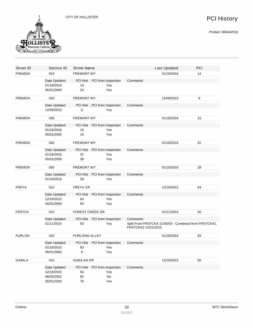
FREMON
Date Updated PCI Hist Comments
010 FREMONT WY 01/18/2016 14
PCI from Inspection01/18/2016 14 Yes05/01/2000 24 Yes
FREMON
Date Updated PCI Hist Comments
020 FREMONT WY 12/09/2015 9
PCI from Inspection12/09/2015 9 Yes
FREMON
Date Updated PCI Hist Comments
030 FREMONT WY 01/18/2016 15
PCI from Inspection01/18/2016 15 Yes05/01/2000 10 Yes
FREMON
Date Updated PCI Hist Comments
040 FREMONT WY 01/18/2016 31
PCI from Inspection01/18/2016 31 Yes05/01/2000 38 Yes
FREMON
Date Updated PCI Hist Comments
050 FREMONT WY 01/18/2016 28
PCI from Inspection01/18/2016 28 Yes
FREYA
Date Updated PCI Hist Comments
010 FREYA CR 12/16/2015 64
PCI from Inspection12/16/2015 64 Yes05/01/2000 83 Yes
FRSTCK
Date Updated PCI Hist Comments
010 FOREST CREEK DR 01/11/2016 50
PCI from Inspection01/11/2016 50 Split From FRSTCKA 11/05/03 - Combined from FRSTCKA1,
FRSTCKA2 12/21/2015Yes
FURLON
Date Updated PCI Hist Comments
010 FURLONG ALLEY 01/18/2016 83
PCI from Inspection01/18/2016 83 Yes05/01/2000 8 Yes
GABILA
Date Updated PCI Hist Comments
010 GABILAN DR 12/18/2015 56
PCI from Inspection12/18/2015 56 Yes06/05/2002 82 No05/01/2000 76 Yes
PCI History
Printed: 08/04/2016
CITY OF HOLLISTER
Street ID Section ID Street Name Last Updated PCI
Criteria: 33SS1017
MTC StreetSaver
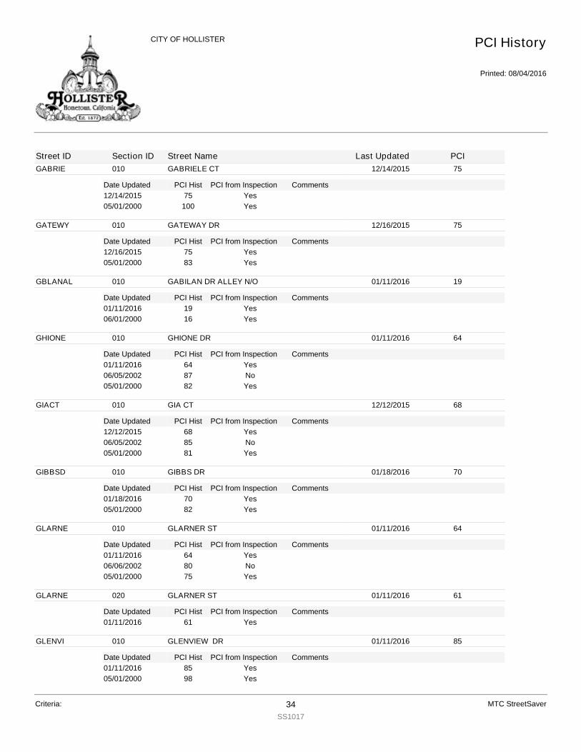
GABRIE
Date Updated PCI Hist Comments
010 GABRIELE CT 12/14/2015 75
PCI from Inspection12/14/2015 75 Yes05/01/2000 100 Yes
GATEWY
Date Updated PCI Hist Comments
010 GATEWAY DR 12/16/2015 75
PCI from Inspection12/16/2015 75 Yes05/01/2000 83 Yes
GBLANAL
Date Updated PCI Hist Comments
010 GABILAN DR ALLEY N/O 01/11/2016 19
PCI from Inspection01/11/2016 19 Yes06/01/2000 16 Yes
GHIONE
Date Updated PCI Hist Comments
010 GHIONE DR 01/11/2016 64
PCI from Inspection01/11/2016 64 Yes06/05/2002 87 No05/01/2000 82 Yes
GIACT
Date Updated PCI Hist Comments
010 GIA CT 12/12/2015 68
PCI from Inspection12/12/2015 68 Yes06/05/2002 85 No05/01/2000 81 Yes
GIBBSD
Date Updated PCI Hist Comments
010 GIBBS DR 01/18/2016 70
PCI from Inspection01/18/2016 70 Yes05/01/2000 82 Yes
GLARNE
Date Updated PCI Hist Comments
010 GLARNER ST 01/11/2016 64
PCI from Inspection01/11/2016 64 Yes06/06/2002 80 No05/01/2000 75 Yes
GLARNE
Date Updated PCI Hist Comments
020 GLARNER ST 01/11/2016 61
PCI from Inspection01/11/2016 61 Yes
GLENVI
Date Updated PCI Hist Comments
010 GLENVIEW DR 01/11/2016 85
PCI from Inspection01/11/2016 85 Yes05/01/2000 98 Yes
PCI History
Printed: 08/04/2016
CITY OF HOLLISTER
Street ID Section ID Street Name Last Updated PCI
Criteria: 34SS1017
MTC StreetSaver
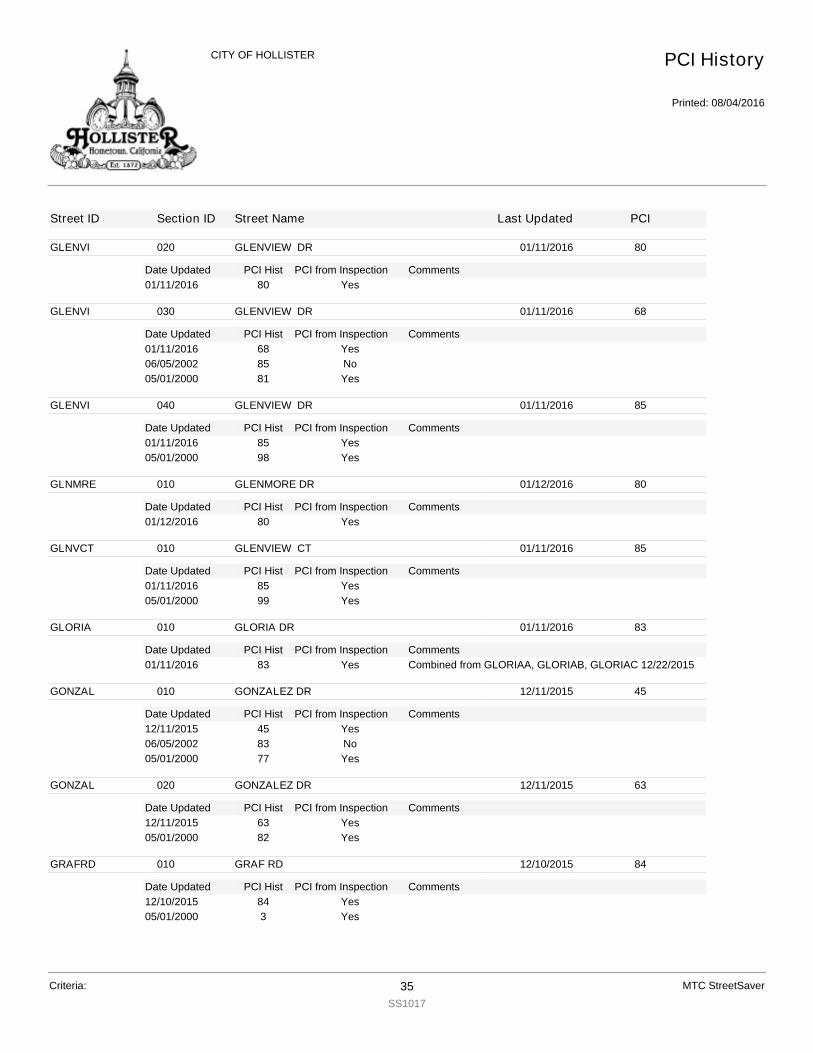
GLENVI
Date Updated PCI Hist Comments
020 GLENVIEW DR 01/11/2016 80
PCI from Inspection01/11/2016 80 Yes
GLENVI
Date Updated PCI Hist Comments
030 GLENVIEW DR 01/11/2016 68
PCI from Inspection01/11/2016 68 Yes06/05/2002 85 No05/01/2000 81 Yes
GLENVI
Date Updated PCI Hist Comments
040 GLENVIEW DR 01/11/2016 85
PCI from Inspection01/11/2016 85 Yes05/01/2000 98 Yes
GLNMRE
Date Updated PCI Hist Comments
010 GLENMORE DR 01/12/2016 80
PCI from Inspection01/12/2016 80 Yes
GLNVCT
Date Updated PCI Hist Comments
010 GLENVIEW CT 01/11/2016 85
PCI from Inspection01/11/2016 85 Yes05/01/2000 99 Yes
GLORIA
Date Updated PCI Hist Comments
010 GLORIA DR 01/11/2016 83
PCI from Inspection01/11/2016 83 Combined from GLORIAA, GLORIAB, GLORIAC 12/22/2015Yes
GONZAL
Date Updated PCI Hist Comments
010 GONZALEZ DR 12/11/2015 45
PCI from Inspection12/11/2015 45 Yes06/05/2002 83 No05/01/2000 77 Yes
GONZAL
Date Updated PCI Hist Comments
020 GONZALEZ DR 12/11/2015 63
PCI from Inspection12/11/2015 63 Yes05/01/2000 82 Yes
GRAFRD
Date Updated PCI Hist Comments
010 GRAF RD 12/10/2015 84
PCI from Inspection12/10/2015 84 Yes05/01/2000 3 Yes
PCI History
Printed: 08/04/2016
CITY OF HOLLISTER
Street ID Section ID Street Name Last Updated PCI
Criteria: 35SS1017
MTC StreetSaver

GRAYAL
Date Updated PCI Hist Comments
010 GRAY ALLEY 12/09/2015 11
PCI from Inspection12/09/2015 11 Yes
GRENWD
Date Updated PCI Hist Comments
010 GREENWOOD CIR 12/17/2015 39
PCI from Inspection12/17/2015 39 Yes07/01/2002 100 No05/01/2000 50 Yes
GRUBB
Date Updated PCI Hist Comments
010 GRUBB ALLEY 12/16/2015 5
PCI from Inspection12/16/2015 5 Yes05/01/2000 0 Yes
HALLAV
Date Updated PCI Hist Comments
010 HALL AV 01/11/2016 65
PCI from Inspection01/11/2016 65 Yes06/05/2002 84 No05/01/2000 79 Yes
HAMILT
Date Updated PCI Hist Comments
010 HAMILTON CT 12/11/2015 75
PCI from Inspection12/11/2015 75 Yes07/06/2002 100 No05/01/2000 48 Yes
HARBOR
Date Updated PCI Hist Comments
010 HARBOR ST 12/16/2015 100
PCI from Inspection12/16/2015 100 Yes
HAWKAL
Date Updated PCI Hist Comments
010 HAWKINS ALLEY 12/16/2015 71
PCI from Inspection12/16/2015 71 Yes05/01/2000 74 Yes
HAWKIN
Date Updated PCI Hist Comments
010 HAWKINS ST 01/12/2016 22
PCI from Inspection01/12/2016 22 Yes07/01/2002 100 No05/01/2000 26 Yes
HAWKIN
Date Updated PCI Hist Comments
020 HAWKINS ST 01/12/2016 13
PCI from Inspection01/12/2016 13 Yes
PCI History
Printed: 08/04/2016
CITY OF HOLLISTER
Street ID Section ID Street Name Last Updated PCI
Criteria: 36SS1017
MTC StreetSaver
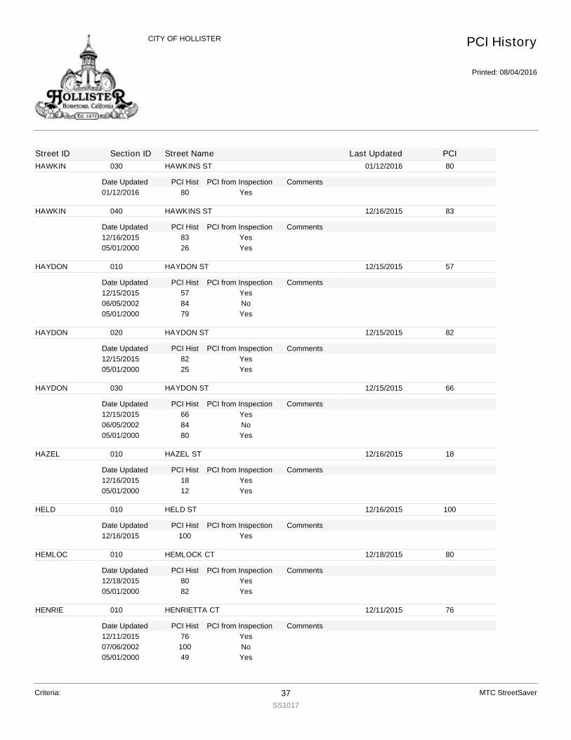
HAWKIN
Date Updated PCI Hist Comments
030 HAWKINS ST 01/12/2016 80
PCI from Inspection01/12/2016 80 Yes
HAWKIN
Date Updated PCI Hist Comments
040 HAWKINS ST 12/16/2015 83
PCI from Inspection12/16/2015 83 Yes05/01/2000 26 Yes
HAYDON
Date Updated PCI Hist Comments
010 HAYDON ST 12/15/2015 57
PCI from Inspection12/15/2015 57 Yes06/05/2002 84 No05/01/2000 79 Yes
HAYDON
Date Updated PCI Hist Comments
020 HAYDON ST 12/15/2015 82
PCI from Inspection12/15/2015 82 Yes05/01/2000 25 Yes
HAYDON
Date Updated PCI Hist Comments
030 HAYDON ST 12/15/2015 66
PCI from Inspection12/15/2015 66 Yes06/05/2002 84 No05/01/2000 80 Yes
HAZEL
Date Updated PCI Hist Comments
010 HAZEL ST 12/16/2015 18
PCI from Inspection12/16/2015 18 Yes05/01/2000 12 Yes
HELD
Date Updated PCI Hist Comments
010 HELD ST 12/16/2015 100
PCI from Inspection12/16/2015 100 Yes
HEMLOC
Date Updated PCI Hist Comments
010 HEMLOCK CT 12/18/2015 80
PCI from Inspection12/18/2015 80 Yes05/01/2000 82 Yes
HENRIE
Date Updated PCI Hist Comments
010 HENRIETTA CT 12/11/2015 76
PCI from Inspection12/11/2015 76 Yes07/06/2002 100 No05/01/2000 49 Yes
PCI History
Printed: 08/04/2016
CITY OF HOLLISTER
Street ID Section ID Street Name Last Updated PCI
Criteria: 37SS1017
MTC StreetSaver

HENRY
Date Updated PCI Hist Comments
010 HENRY ST 12/16/2015 85
PCI from Inspection12/16/2015 85 Yes05/01/2000 32 Yes
HERMOS
Date Updated PCI Hist Comments
010 HERMOSA WY 01/11/2016 76
PCI from Inspection01/11/2016 76 Yes05/01/2000 36 Yes
HICKOR
Date Updated PCI Hist Comments
010 HICKORY CT 12/18/2015 77
PCI from Inspection12/18/2015 77 Yes05/01/2000 82 Yes
HIGHLA
Date Updated PCI Hist Comments
010 HIGHLAND DR 01/11/2016 82
PCI from Inspection01/11/2016 82 Yes05/01/2000 27 Yes
HIGHLA
Date Updated PCI Hist Comments
020 HIGHLAND DR 01/11/2016 81
PCI from Inspection01/11/2016 81 Yes05/01/2000 23 Yes
HIGHLA
Date Updated PCI Hist Comments
030 HIGHLAND DR 01/11/2016 59
PCI from Inspection01/11/2016 59 Yes06/05/2002 85 No05/01/2000 82 Yes
HIGHLA
Date Updated PCI Hist Comments
040 HIGHLAND DR 01/11/2016 64
PCI from Inspection01/11/2016 64 Yes06/05/2002 85 No05/01/2000 82 Yes
HIGHLA
Date Updated PCI Hist Comments
050 HIGHLAND DR 01/11/2016 78
PCI from Inspection01/11/2016 78 Yes05/01/2000 98 Yes
HILLOC
Date Updated PCI Hist Comments
010 HILLOCK DR 12/12/2015 73
PCI from Inspection12/12/2015 73 Yes06/05/2002 84 No
PCI History
Printed: 08/04/2016
CITY OF HOLLISTER
Street ID Section ID Street Name Last Updated PCI
Criteria: 38SS1017
MTC StreetSaver
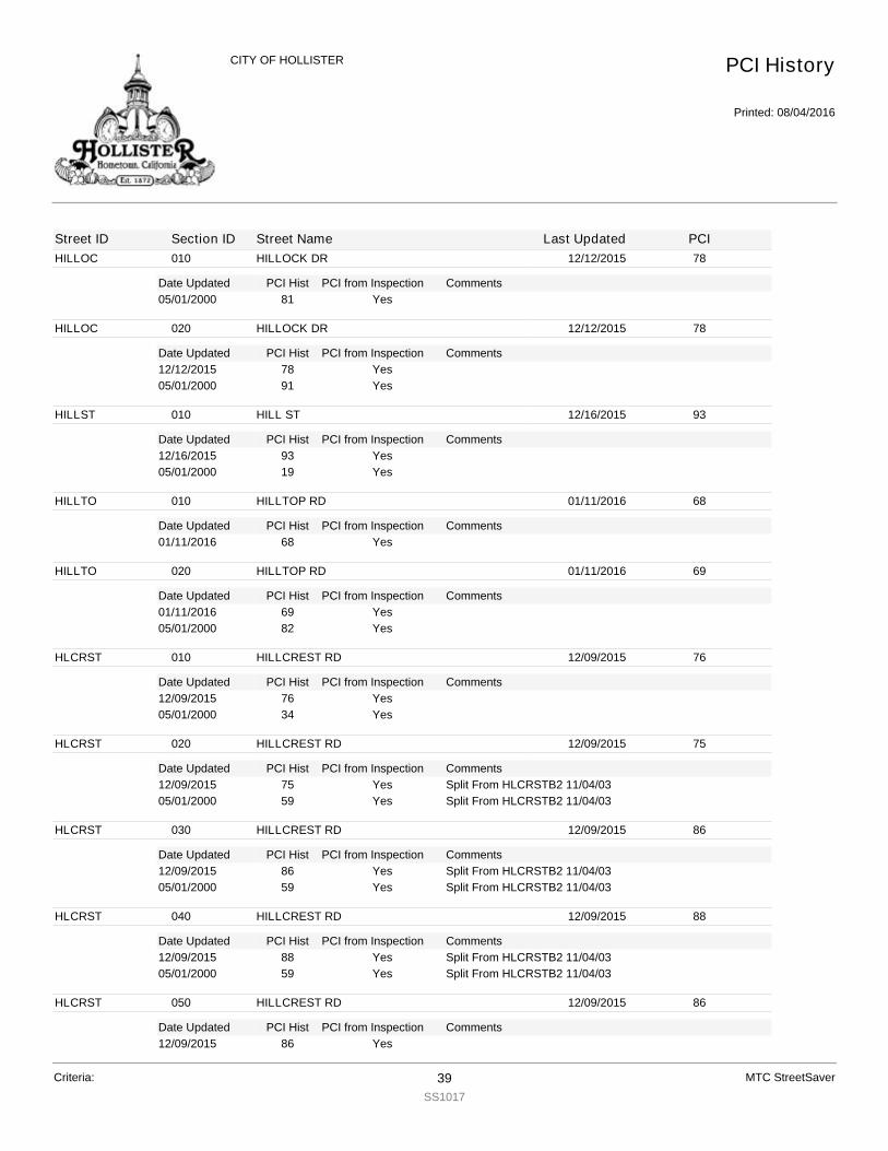
HILLOC
Date Updated PCI Hist Comments
010 HILLOCK DR 12/12/2015 78
PCI from Inspection05/01/2000 81 Yes
HILLOC
Date Updated PCI Hist Comments
020 HILLOCK DR 12/12/2015 78
PCI from Inspection12/12/2015 78 Yes05/01/2000 91 Yes
HILLST
Date Updated PCI Hist Comments
010 HILL ST 12/16/2015 93
PCI from Inspection12/16/2015 93 Yes05/01/2000 19 Yes
HILLTO
Date Updated PCI Hist Comments
010 HILLTOP RD 01/11/2016 68
PCI from Inspection01/11/2016 68 Yes
HILLTO
Date Updated PCI Hist Comments
020 HILLTOP RD 01/11/2016 69
PCI from Inspection01/11/2016 69 Yes05/01/2000 82 Yes
HLCRST
Date Updated PCI Hist Comments
010 HILLCREST RD 12/09/2015 76
PCI from Inspection12/09/2015 76 Yes05/01/2000 34 Yes
HLCRST
Date Updated PCI Hist Comments
020 HILLCREST RD 12/09/2015 75
PCI from Inspection12/09/2015 75 Split From HLCRSTB2 11/04/03Yes05/01/2000 59 Split From HLCRSTB2 11/04/03Yes
HLCRST
Date Updated PCI Hist Comments
030 HILLCREST RD 12/09/2015 86
PCI from Inspection12/09/2015 86 Split From HLCRSTB2 11/04/03Yes05/01/2000 59 Split From HLCRSTB2 11/04/03Yes
HLCRST
Date Updated PCI Hist Comments
040 HILLCREST RD 12/09/2015 88
PCI from Inspection12/09/2015 88 Split From HLCRSTB2 11/04/03Yes05/01/2000 59 Split From HLCRSTB2 11/04/03Yes
HLCRST
Date Updated PCI Hist Comments
050 HILLCREST RD 12/09/2015 86
PCI from Inspection12/09/2015 86 Yes
PCI History
Printed: 08/04/2016
CITY OF HOLLISTER
Street ID Section ID Street Name Last Updated PCI
Criteria: 39SS1017
MTC StreetSaver

HLCRST
Date Updated PCI Hist Comments
050 HILLCREST RD 12/09/2015 86
PCI from Inspection07/01/2002 100 No05/01/2000 64 Yes
HLCRST
Date Updated PCI Hist Comments
060 HILLCREST RD 01/12/2016 85
PCI from Inspection01/12/2016 85 Yes
HLCRST
Date Updated PCI Hist Comments
070 HILLCREST RD 01/12/2016 88
PCI from Inspection01/12/2016 88 Yes
HLCRST
Date Updated PCI Hist Comments
080 HILLCREST RD 12/09/2015 88
PCI from Inspection12/09/2015 88 Yes07/01/2002 100 No05/01/2000 47 Yes
HLCRST
Date Updated PCI Hist Comments
090 HILLCREST RD 01/12/2016 87
PCI from Inspection01/12/2016 87 Yes
HLCRST
Date Updated PCI Hist Comments
100 HILLCREST RD 12/09/2015 87
PCI from Inspection12/09/2015 87 Yes05/01/2000 75 Yes
HODEL
Date Updated PCI Hist Comments
010 HODEL ALLEY 12/16/2015 4
PCI from Inspection12/16/2015 4 Yes05/01/2000 10 Yes
HODGES
Date Updated PCI Hist Comments
010 HODGES ALLEY 01/18/2016 19
PCI from Inspection01/18/2016 19 Yes05/01/2000 1 Yes
HOLYTR
Date Updated PCI Hist Comments
010 HOLLY TREE CR 12/17/2015 58
PCI from Inspection12/17/2015 58 Yes06/06/2002 83 No05/01/2000 78 Yes
PCI History
Printed: 08/04/2016
CITY OF HOLLISTER
Street ID Section ID Street Name Last Updated PCI
Criteria: 40SS1017
MTC StreetSaver
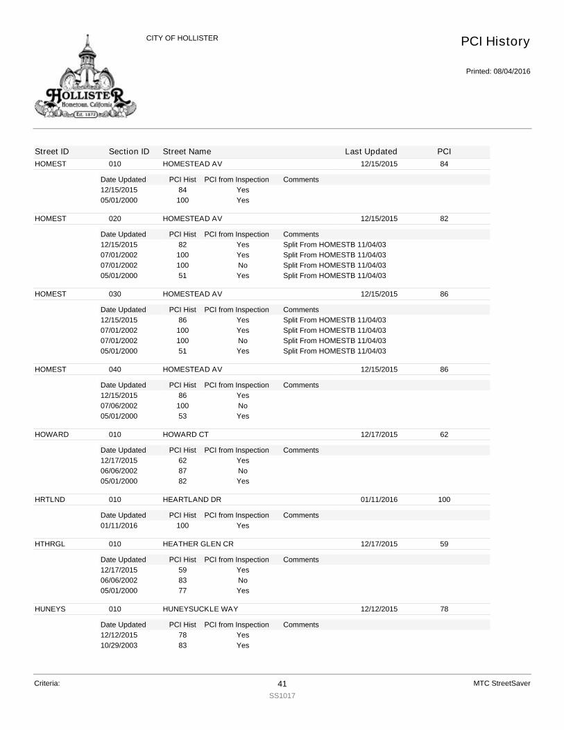
HOMEST
Date Updated PCI Hist Comments
010 HOMESTEAD AV 12/15/2015 84
PCI from Inspection12/15/2015 84 Yes05/01/2000 100 Yes
HOMEST
Date Updated PCI Hist Comments
020 HOMESTEAD AV 12/15/2015 82
PCI from Inspection12/15/2015 82 Split From HOMESTB 11/04/03Yes07/01/2002 100 Split From HOMESTB 11/04/03Yes07/01/2002 100 Split From HOMESTB 11/04/03No05/01/2000 51 Split From HOMESTB 11/04/03Yes
HOMEST
Date Updated PCI Hist Comments
030 HOMESTEAD AV 12/15/2015 86
PCI from Inspection12/15/2015 86 Split From HOMESTB 11/04/03Yes07/01/2002 100 Split From HOMESTB 11/04/03Yes07/01/2002 100 Split From HOMESTB 11/04/03No05/01/2000 51 Split From HOMESTB 11/04/03Yes
HOMEST
Date Updated PCI Hist Comments
040 HOMESTEAD AV 12/15/2015 86
PCI from Inspection12/15/2015 86 Yes07/06/2002 100 No05/01/2000 53 Yes
HOWARD
Date Updated PCI Hist Comments
010 HOWARD CT 12/17/2015 62
PCI from Inspection12/17/2015 62 Yes06/06/2002 87 No05/01/2000 82 Yes
HRTLND
Date Updated PCI Hist Comments
010 HEARTLAND DR 01/11/2016 100
PCI from Inspection01/11/2016 100 Yes
HTHRGL
Date Updated PCI Hist Comments
010 HEATHER GLEN CR 12/17/2015 59
PCI from Inspection12/17/2015 59 Yes06/06/2002 83 No05/01/2000 77 Yes
HUNEYS
Date Updated PCI Hist Comments
010 HUNEYSUCKLE WAY 12/12/2015 78
PCI from Inspection12/12/2015 78 Yes10/29/2003 83 Yes
PCI History
Printed: 08/04/2016
CITY OF HOLLISTER
Street ID Section ID Street Name Last Updated PCI
Criteria: 41SS1017
MTC StreetSaver
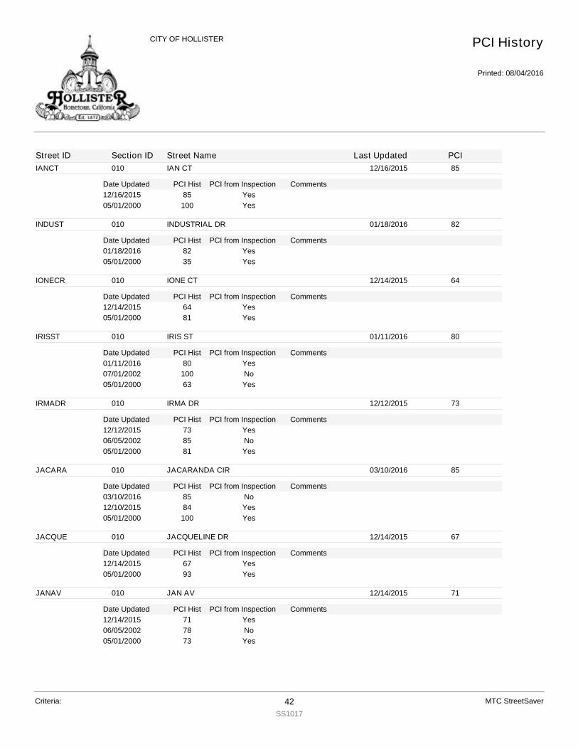
IANCT
Date Updated PCI Hist Comments
010 IAN CT 12/16/2015 85
PCI from Inspection12/16/2015 85 Yes05/01/2000 100 Yes
INDUST
Date Updated PCI Hist Comments
010 INDUSTRIAL DR 01/18/2016 82
PCI from Inspection01/18/2016 82 Yes05/01/2000 35 Yes
IONECR
Date Updated PCI Hist Comments
010 IONE CT 12/14/2015 64
PCI from Inspection12/14/2015 64 Yes05/01/2000 81 Yes
IRISST
Date Updated PCI Hist Comments
010 IRIS ST 01/11/2016 80
PCI from Inspection01/11/2016 80 Yes07/01/2002 100 No05/01/2000 63 Yes
IRMADR
Date Updated PCI Hist Comments
010 IRMA DR 12/12/2015 73
PCI from Inspection12/12/2015 73 Yes06/05/2002 85 No05/01/2000 81 Yes
JACARA
Date Updated PCI Hist Comments
010 JACARANDA CIR 03/10/2016 85
PCI from Inspection03/10/2016 85 No12/10/2015 84 Yes05/01/2000 100 Yes
JACQUE
Date Updated PCI Hist Comments
010 JACQUELINE DR 12/14/2015 67
PCI from Inspection12/14/2015 67 Yes05/01/2000 93 Yes
JANAV
Date Updated PCI Hist Comments
010 JAN AV 12/14/2015 71
PCI from Inspection12/14/2015 71 Yes06/05/2002 78 No05/01/2000 73 Yes
PCI History
Printed: 08/04/2016
CITY OF HOLLISTER
Street ID Section ID Street Name Last Updated PCI
Criteria: 42SS1017
MTC StreetSaver
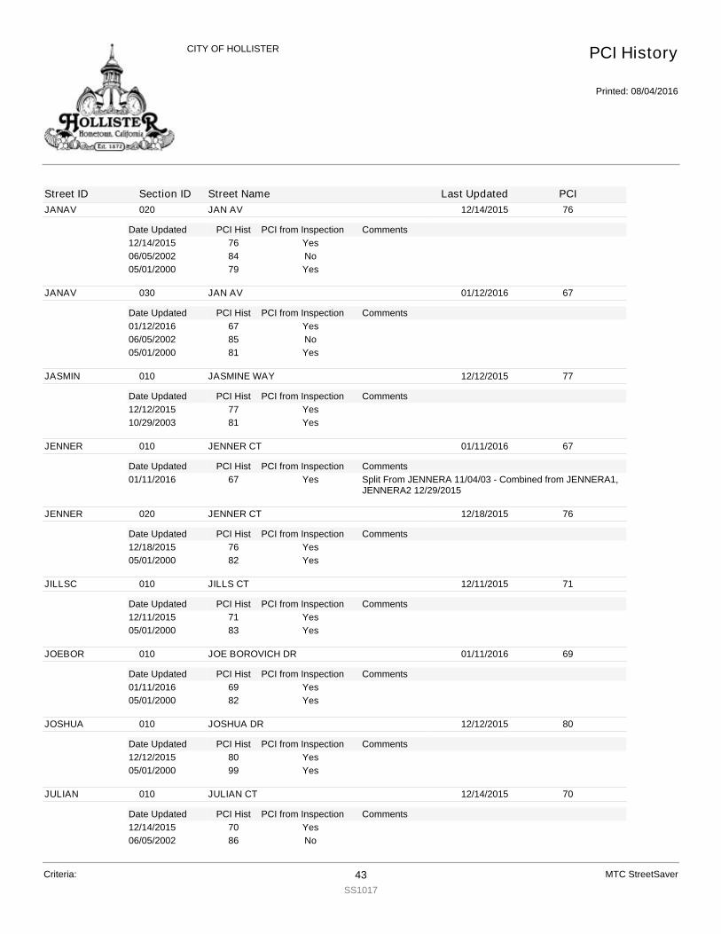
JANAV
Date Updated PCI Hist Comments
020 JAN AV 12/14/2015 76
PCI from Inspection12/14/2015 76 Yes06/05/2002 84 No05/01/2000 79 Yes
JANAV
Date Updated PCI Hist Comments
030 JAN AV 01/12/2016 67
PCI from Inspection01/12/2016 67 Yes06/05/2002 85 No05/01/2000 81 Yes
JASMIN
Date Updated PCI Hist Comments
010 JASMINE WAY 12/12/2015 77
PCI from Inspection12/12/2015 77 Yes10/29/2003 81 Yes
JENNER
Date Updated PCI Hist Comments
010 JENNER CT 01/11/2016 67
PCI from Inspection01/11/2016 67 Split From JENNERA 11/04/03 - Combined from JENNERA1,
JENNERA2 12/29/2015Yes
JENNER
Date Updated PCI Hist Comments
020 JENNER CT 12/18/2015 76
PCI from Inspection12/18/2015 76 Yes05/01/2000 82 Yes
JILLSC
Date Updated PCI Hist Comments
010 JILLS CT 12/11/2015 71
PCI from Inspection12/11/2015 71 Yes05/01/2000 83 Yes
JOEBOR
Date Updated PCI Hist Comments
010 JOE BOROVICH DR 01/11/2016 69
PCI from Inspection01/11/2016 69 Yes05/01/2000 82 Yes
JOSHUA
Date Updated PCI Hist Comments
010 JOSHUA DR 12/12/2015 80
PCI from Inspection12/12/2015 80 Yes05/01/2000 99 Yes
JULIAN
Date Updated PCI Hist Comments
010 JULIAN CT 12/14/2015 70
PCI from Inspection12/14/2015 70 Yes06/05/2002 86 No
PCI History
Printed: 08/04/2016
CITY OF HOLLISTER
Street ID Section ID Street Name Last Updated PCI
Criteria: 43SS1017
MTC StreetSaver
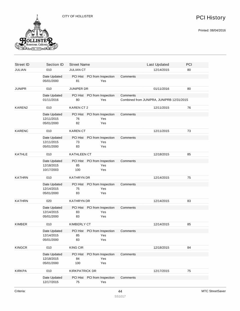
JULIAN
Date Updated PCI Hist Comments
010 JULIAN CT 12/14/2015 80
PCI from Inspection05/01/2000 81 Yes
JUNIPR
Date Updated PCI Hist Comments
010 JUNIPER DR 01/11/2016 80
PCI from Inspection01/11/2016 80 Combined from JUNIPRA, JUNIPRB 12/31/2015Yes
KAREN2
Date Updated PCI Hist Comments
010 KAREN CT 2 12/11/2015 76
PCI from Inspection12/11/2015 76 Yes05/01/2000 82 Yes
KARENC
Date Updated PCI Hist Comments
010 KAREN CT 12/11/2015 73
PCI from Inspection12/11/2015 73 Yes05/01/2000 83 Yes
KATHLE
Date Updated PCI Hist Comments
010 KATHLEEN CT 12/18/2015 85
PCI from Inspection12/18/2015 85 Yes10/17/2003 100 Yes
KATHRN
Date Updated PCI Hist Comments
010 KATHRYN DR 12/14/2015 75
PCI from Inspection12/14/2015 75 Yes05/01/2000 83 Yes
KATHRN
Date Updated PCI Hist Comments
020 KATHRYN DR 12/14/2015 83
PCI from Inspection12/14/2015 83 Yes05/01/2000 83 Yes
KIMBER
Date Updated PCI Hist Comments
010 KIMBERLY CT 12/14/2015 85
PCI from Inspection12/14/2015 85 Yes05/01/2000 83 Yes
KINGCR
Date Updated PCI Hist Comments
010 KING CIR 12/18/2015 84
PCI from Inspection12/18/2015 84 Yes05/01/2000 100 Yes
KIRKPA
Date Updated PCI Hist Comments
010 KIRKPATRICK DR 12/17/2015 75
PCI from Inspection12/17/2015 75 Yes
PCI History
Printed: 08/04/2016
CITY OF HOLLISTER
Street ID Section ID Street Name Last Updated PCI
Criteria: 44SS1017
MTC StreetSaver
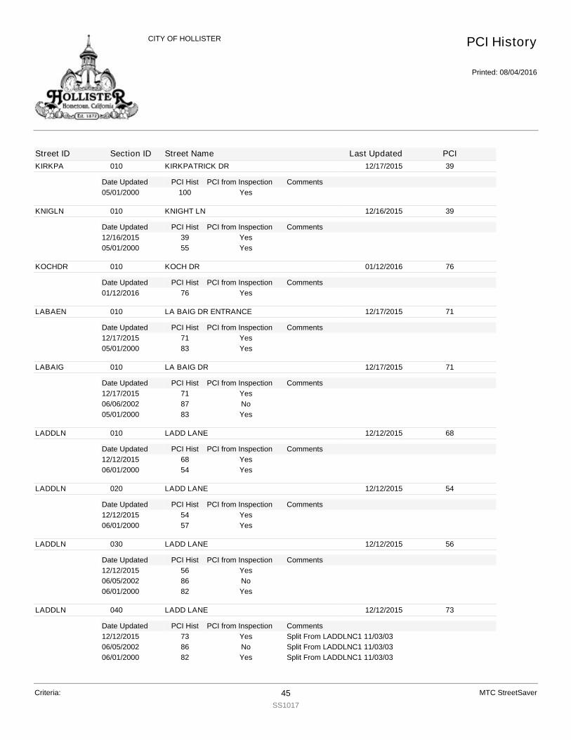
KIRKPA
Date Updated PCI Hist Comments
010 KIRKPATRICK DR 12/17/2015 39
PCI from Inspection05/01/2000 100 Yes
KNIGLN
Date Updated PCI Hist Comments
010 KNIGHT LN 12/16/2015 39
PCI from Inspection12/16/2015 39 Yes05/01/2000 55 Yes
KOCHDR
Date Updated PCI Hist Comments
010 KOCH DR 01/12/2016 76
PCI from Inspection01/12/2016 76 Yes
LABAEN
Date Updated PCI Hist Comments
010 LA BAIG DR ENTRANCE 12/17/2015 71
PCI from Inspection12/17/2015 71 Yes05/01/2000 83 Yes
LABAIG
Date Updated PCI Hist Comments
010 LA BAIG DR 12/17/2015 71
PCI from Inspection12/17/2015 71 Yes06/06/2002 87 No05/01/2000 83 Yes
LADDLN
Date Updated PCI Hist Comments
010 LADD LANE 12/12/2015 68
PCI from Inspection12/12/2015 68 Yes06/01/2000 54 Yes
LADDLN
Date Updated PCI Hist Comments
020 LADD LANE 12/12/2015 54
PCI from Inspection12/12/2015 54 Yes06/01/2000 57 Yes
LADDLN
Date Updated PCI Hist Comments
030 LADD LANE 12/12/2015 56
PCI from Inspection12/12/2015 56 Yes06/05/2002 86 No06/01/2000 82 Yes
LADDLN
Date Updated PCI Hist Comments
040 LADD LANE 12/12/2015 73
PCI from Inspection12/12/2015 73 Split From LADDLNC1 11/03/03Yes06/05/2002 86 Split From LADDLNC1 11/03/03No06/01/2000 82 Split From LADDLNC1 11/03/03Yes
PCI History
Printed: 08/04/2016
CITY OF HOLLISTER
Street ID Section ID Street Name Last Updated PCI
Criteria: 45SS1017
MTC StreetSaver

LAGUNA
Date Updated PCI Hist Comments
010 LAGUNA CT 01/11/2016 65
PCI from Inspection01/11/2016 65 Yes05/01/2000 81 Yes
LAMUCC
Date Updated PCI Hist Comments
010 LA MACCHIA CT 12/11/2015 56
PCI from Inspection12/11/2015 56 Yes05/01/2000 83 Yes
LANAWY
Date Updated PCI Hist Comments
010 LANA WY 12/11/2015 81
PCI from Inspection12/11/2015 81 Yes05/01/2000 33 Yes
LASBRI
Date Updated PCI Hist Comments
010 LAS BRISAS DR 12/18/2015 80
PCI from Inspection12/18/2015 80 Yes05/01/2000 82 Yes
LASBRI
Date Updated PCI Hist Comments
020 LAS BRISAS DR 12/18/2015 66
PCI from Inspection12/18/2015 66 Yes05/01/2000 82 Yes
LASPAL
Date Updated PCI Hist Comments
010 LAS PALMAS 12/16/2015 64
PCI from Inspection12/16/2015 64 Yes05/01/2000 83 Yes
LASSEN
Date Updated PCI Hist Comments
010 LASSEN CT 12/11/2015 64
PCI from Inspection12/11/2015 64 Yes06/05/2002 83 No05/01/2000 77 Yes
LAVEND
Date Updated PCI Hist Comments
010 LAVENDER WAY 12/12/2015 80
PCI from Inspection12/12/2015 80 Yes10/29/2003 83 Yes
LAWSDR
Date Updated PCI Hist Comments
010 LAWS DR 01/19/2016 37
PCI from Inspection01/19/2016 37 Yes06/06/2002 64 No06/01/2000 56 Yes
PCI History
Printed: 08/04/2016
CITY OF HOLLISTER
Street ID Section ID Street Name Last Updated PCI
Criteria: 46SS1017
MTC StreetSaver
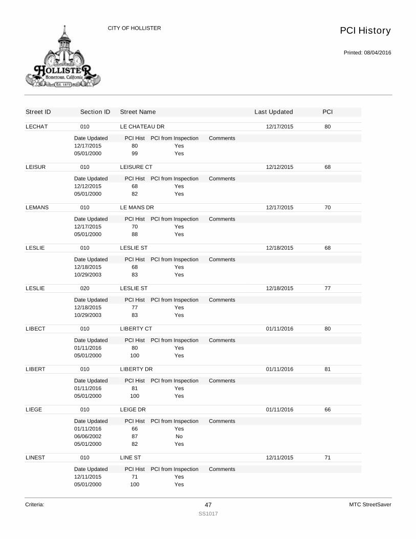
LECHAT
Date Updated PCI Hist Comments
010 LE CHATEAU DR 12/17/2015 80
PCI from Inspection12/17/2015 80 Yes05/01/2000 99 Yes
LEISUR
Date Updated PCI Hist Comments
010 LEISURE CT 12/12/2015 68
PCI from Inspection12/12/2015 68 Yes05/01/2000 82 Yes
LEMANS
Date Updated PCI Hist Comments
010 LE MANS DR 12/17/2015 70
PCI from Inspection12/17/2015 70 Yes05/01/2000 88 Yes
LESLIE
Date Updated PCI Hist Comments
010 LESLIE ST 12/18/2015 68
PCI from Inspection12/18/2015 68 Yes10/29/2003 83 Yes
LESLIE
Date Updated PCI Hist Comments
020 LESLIE ST 12/18/2015 77
PCI from Inspection12/18/2015 77 Yes10/29/2003 83 Yes
LIBECT
Date Updated PCI Hist Comments
010 LIBERTY CT 01/11/2016 80
PCI from Inspection01/11/2016 80 Yes05/01/2000 100 Yes
LIBERT
Date Updated PCI Hist Comments
010 LIBERTY DR 01/11/2016 81
PCI from Inspection01/11/2016 81 Yes05/01/2000 100 Yes
LIEGE
Date Updated PCI Hist Comments
010 LEIGE DR 01/11/2016 66
PCI from Inspection01/11/2016 66 Yes06/06/2002 87 No05/01/2000 82 Yes
LINEST
Date Updated PCI Hist Comments
010 LINE ST 12/11/2015 71
PCI from Inspection12/11/2015 71 Yes05/01/2000 100 Yes
PCI History
Printed: 08/04/2016
CITY OF HOLLISTER
Street ID Section ID Street Name Last Updated PCI
Criteria: 47SS1017
MTC StreetSaver

LINEST
Date Updated PCI Hist Comments
020 LINE ST 12/16/2015 72
PCI from Inspection12/16/2015 72 Yes05/01/2000 100 Yes
LINEST
Date Updated PCI Hist Comments
030 LINE ST 07/01/2002 74
PCI from Inspection12/04/2015 78 Combined from LINESTB1, LINESTB2, LINESTB3 12/31/2015Yes
LINEST
Date Updated PCI Hist Comments
040 LINE ST 12/14/2015 84
PCI from Inspection12/14/2015 84 Yes05/01/2000 26 Yes
LOCUST
Date Updated PCI Hist Comments
010 LOCUST AV 12/16/2015 63
PCI from Inspection12/16/2015 63 Yes07/01/2002 100 No05/01/2000 42 Yes
LOCUST
Date Updated PCI Hist Comments
020 LOCUST AV 12/16/2015 44
PCI from Inspection12/16/2015 44 Yes07/01/2002 100 No05/01/2000 45 Yes
LORENE
Date Updated PCI Hist Comments
010 LORENE DR 12/16/2015 72
PCI from Inspection12/16/2015 72 Yes05/01/2000 60 Yes
LSALTO
Date Updated PCI Hist Comments
010 LOS ALTOS DR 12/18/2015 80
PCI from Inspection12/18/2015 80 Split From LSALTOA 11/04/03Yes07/01/2002 100 Split From LSALTOA 11/04/03Yes07/01/2002 100 Split From LSALTOA 11/04/03No05/01/2000 63 Split From LSALTOA 11/04/03Yes
LSALTO
Date Updated PCI Hist Comments
020 LOS ALTOS DR 12/18/2015 80
PCI from Inspection12/18/2015 80 Split From LSALTOA 11/04/03Yes07/01/2002 100 Split From LSALTOA 11/04/03Yes07/01/2002 100 Split From LSALTOA 11/04/03No05/01/2000 63 Split From LSALTOA 11/04/03Yes
PCI History
Printed: 08/04/2016
CITY OF HOLLISTER
Street ID Section ID Street Name Last Updated PCI
Criteria: 48SS1017
MTC StreetSaver

MADERA
Date Updated PCI Hist Comments
010 MADERA CT 12/11/2015 73
PCI from Inspection12/11/2015 73 Yes05/01/2000 83 Yes
MADRON
Date Updated PCI Hist Comments
010 MADRONE DR 12/16/2015 64
PCI from Inspection12/16/2015 64 Yes05/01/2000 83 Yes
MAGNOL
Date Updated PCI Hist Comments
010 MAGNOLIA WAY 01/11/2016 67
PCI from Inspection01/11/2016 67 Yes05/01/2000 83 Yes
MAGNOL
Date Updated PCI Hist Comments
020 MAGNOLIA WAY 01/11/2016 80
PCI from Inspection01/11/2016 80 Yes
MAINAL
Date Updated PCI Hist Comments
010 MAIN ALLEY 01/18/2016 15
PCI from Inspection01/18/2016 15 Yes05/01/2000 9 Yes
MAJEST
Date Updated PCI Hist Comments
010 MAJESTIC DR 12/12/2015 75
PCI from Inspection12/12/2015 75 Yes10/29/2003 88 Yes
MANOLT
Date Updated PCI Hist Comments
010 MANOLETTE ST 12/17/2015 62
PCI from Inspection12/17/2015 62 Yes06/06/2002 84 No05/01/2000 79 Yes
MANZIN
Date Updated PCI Hist Comments
010 MANZANITA DR 12/18/2015 64
PCI from Inspection12/18/2015 64 Yes06/06/2002 84 No05/01/2000 80 Yes
MAPLE
Date Updated PCI Hist Comments
010 MAPLE ST 12/16/2015 71
PCI from Inspection12/16/2015 71 Yes05/01/2000 8 Yes
PCI History
Printed: 08/04/2016
CITY OF HOLLISTER
Street ID Section ID Street Name Last Updated PCI
Criteria: 49SS1017
MTC StreetSaver
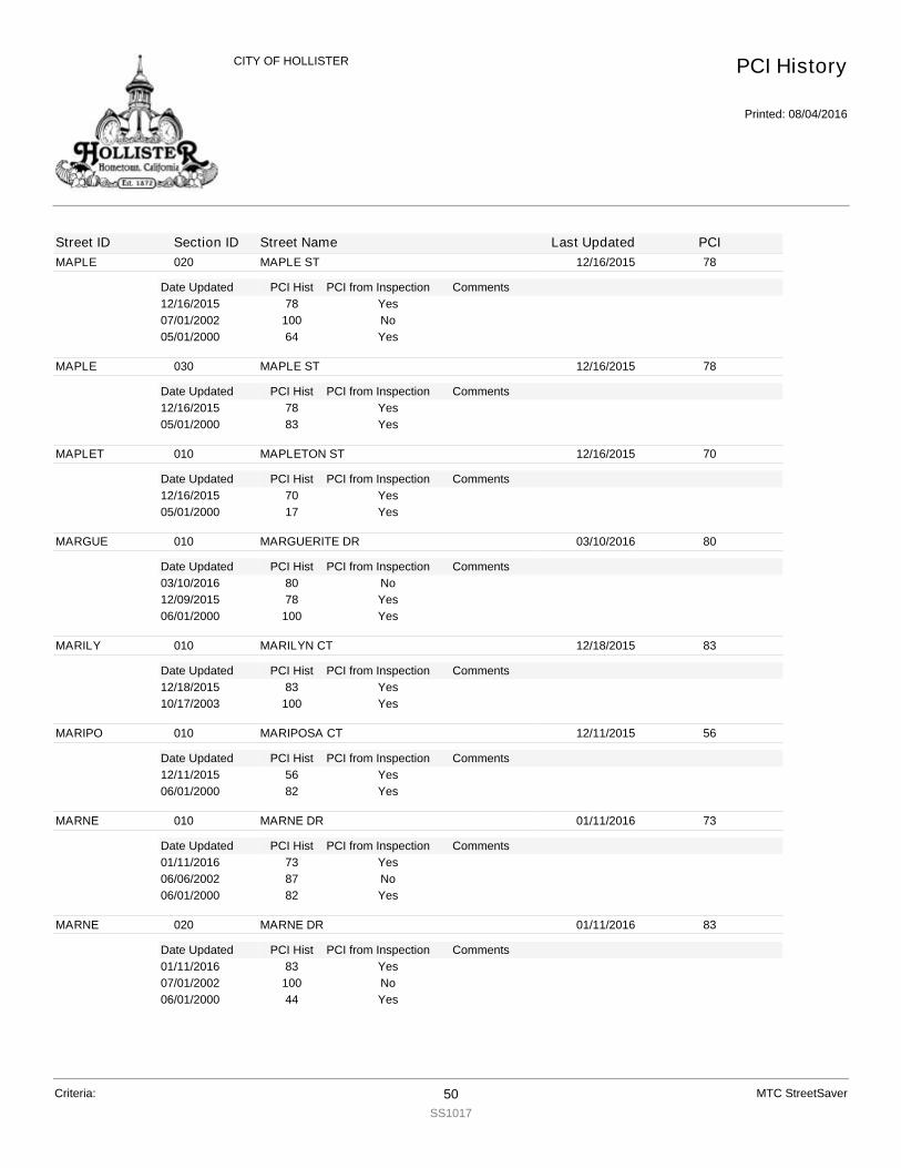
MAPLE
Date Updated PCI Hist Comments
020 MAPLE ST 12/16/2015 78
PCI from Inspection12/16/2015 78 Yes07/01/2002 100 No05/01/2000 64 Yes
MAPLE
Date Updated PCI Hist Comments
030 MAPLE ST 12/16/2015 78
PCI from Inspection12/16/2015 78 Yes05/01/2000 83 Yes
MAPLET
Date Updated PCI Hist Comments
010 MAPLETON ST 12/16/2015 70
PCI from Inspection12/16/2015 70 Yes05/01/2000 17 Yes
MARGUE
Date Updated PCI Hist Comments
010 MARGUERITE DR 03/10/2016 80
PCI from Inspection03/10/2016 80 No12/09/2015 78 Yes06/01/2000 100 Yes
MARILY
Date Updated PCI Hist Comments
010 MARILYN CT 12/18/2015 83
PCI from Inspection12/18/2015 83 Yes10/17/2003 100 Yes
MARIPO
Date Updated PCI Hist Comments
010 MARIPOSA CT 12/11/2015 56
PCI from Inspection12/11/2015 56 Yes06/01/2000 82 Yes
MARNE
Date Updated PCI Hist Comments
010 MARNE DR 01/11/2016 73
PCI from Inspection01/11/2016 73 Yes06/06/2002 87 No06/01/2000 82 Yes
MARNE
Date Updated PCI Hist Comments
020 MARNE DR 01/11/2016 83
PCI from Inspection01/11/2016 83 Yes07/01/2002 100 No06/01/2000 44 Yes
PCI History
Printed: 08/04/2016
CITY OF HOLLISTER
Street ID Section ID Street Name Last Updated PCI
Criteria: 50SS1017
MTC StreetSaver

MARS
Date Updated PCI Hist Comments
010 MARS DR 01/19/2016 56
PCI from Inspection01/19/2016 56 Yes10/16/2003 100 Yes
MARSCT
Date Updated PCI Hist Comments
010 MARSEILLE CT 12/17/2015 78
PCI from Inspection12/17/2015 78 Yes06/01/2000 99 Yes
MARSEI
Date Updated PCI Hist Comments
010 MARSEILLE DR 12/17/2015 75
PCI from Inspection12/17/2015 75 Yes06/01/2000 90 Yes
MARYDR
Date Updated PCI Hist Comments
010 MARY DR 12/12/2015 76
PCI from Inspection12/12/2015 76 Yes06/01/2000 82 Yes
MATADO
Date Updated PCI Hist Comments
010 MATADOR DR 12/17/2015 57
PCI from Inspection12/17/2015 57 Yes06/06/2002 85 No06/01/2000 80 Yes
MATULI
Date Updated PCI Hist Comments
010 MATULICH CT 12/11/2015 60
PCI from Inspection12/11/2015 60 Yes07/01/2002 100 No06/01/2000 66 Yes
MCCART
Date Updated PCI Hist Comments
010 McCARTHY ST 12/17/2015 80
PCI from Inspection12/17/2015 80 Yes06/01/2000 83 Yes
MCCART
Date Updated PCI Hist Comments
020 McCARTHY ST 12/17/2015 17
PCI from Inspection12/17/2015 17 Yes06/01/2000 33 Yes
MCCART
Date Updated PCI Hist Comments
030 McCARTHY ST 12/17/2015 45
PCI from Inspection12/17/2015 45 Yes06/06/2002 77 No
PCI History
Printed: 08/04/2016
CITY OF HOLLISTER
Street ID Section ID Street Name Last Updated PCI
Criteria: 51SS1017
MTC StreetSaver
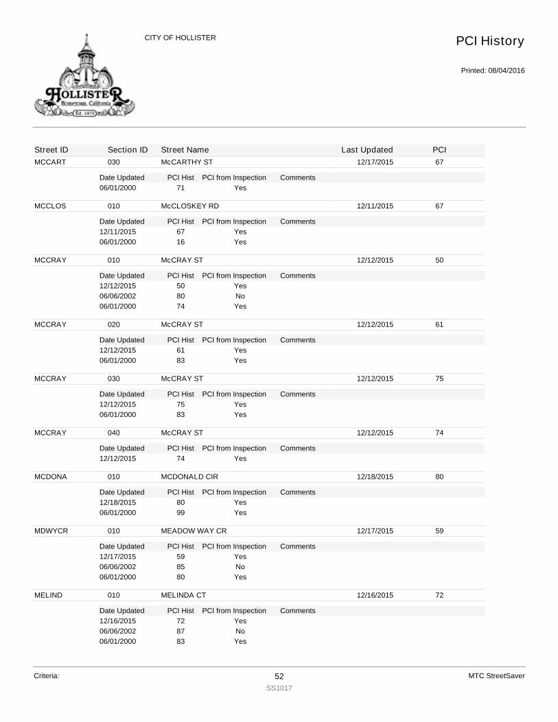
MCCART
Date Updated PCI Hist Comments
030 McCARTHY ST 12/17/2015 67
PCI from Inspection06/01/2000 71 Yes
MCCLOS
Date Updated PCI Hist Comments
010 McCLOSKEY RD 12/11/2015 67
PCI from Inspection12/11/2015 67 Yes06/01/2000 16 Yes
MCCRAY
Date Updated PCI Hist Comments
010 McCRAY ST 12/12/2015 50
PCI from Inspection12/12/2015 50 Yes06/06/2002 80 No06/01/2000 74 Yes
MCCRAY
Date Updated PCI Hist Comments
020 McCRAY ST 12/12/2015 61
PCI from Inspection12/12/2015 61 Yes06/01/2000 83 Yes
MCCRAY
Date Updated PCI Hist Comments
030 McCRAY ST 12/12/2015 75
PCI from Inspection12/12/2015 75 Yes06/01/2000 83 Yes
MCCRAY
Date Updated PCI Hist Comments
040 McCRAY ST 12/12/2015 74
PCI from Inspection12/12/2015 74 Yes
MCDONA
Date Updated PCI Hist Comments
010 MCDONALD CIR 12/18/2015 80
PCI from Inspection12/18/2015 80 Yes06/01/2000 99 Yes
MDWYCR
Date Updated PCI Hist Comments
010 MEADOW WAY CR 12/17/2015 59
PCI from Inspection12/17/2015 59 Yes06/06/2002 85 No06/01/2000 80 Yes
MELIND
Date Updated PCI Hist Comments
010 MELINDA CT 12/16/2015 72
PCI from Inspection12/16/2015 72 Yes06/06/2002 87 No06/01/2000 83 Yes
PCI History
Printed: 08/04/2016
CITY OF HOLLISTER
Street ID Section ID Street Name Last Updated PCI
Criteria: 52SS1017
MTC StreetSaver
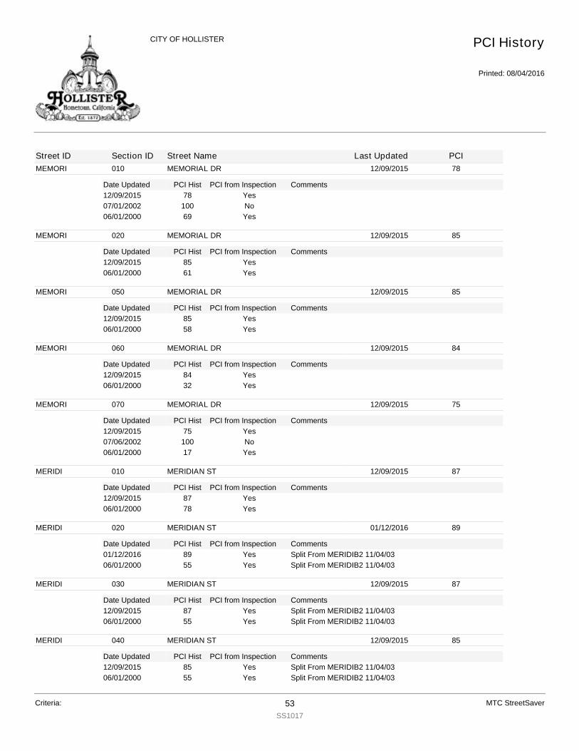
MEMORI
Date Updated PCI Hist Comments
010 MEMORIAL DR 12/09/2015 78
PCI from Inspection12/09/2015 78 Yes07/01/2002 100 No06/01/2000 69 Yes
MEMORI
Date Updated PCI Hist Comments
020 MEMORIAL DR 12/09/2015 85
PCI from Inspection12/09/2015 85 Yes06/01/2000 61 Yes
MEMORI
Date Updated PCI Hist Comments
050 MEMORIAL DR 12/09/2015 85
PCI from Inspection12/09/2015 85 Yes06/01/2000 58 Yes
MEMORI
Date Updated PCI Hist Comments
060 MEMORIAL DR 12/09/2015 84
PCI from Inspection12/09/2015 84 Yes06/01/2000 32 Yes
MEMORI
Date Updated PCI Hist Comments
070 MEMORIAL DR 12/09/2015 75
PCI from Inspection12/09/2015 75 Yes07/06/2002 100 No06/01/2000 17 Yes
MERIDI
Date Updated PCI Hist Comments
010 MERIDIAN ST 12/09/2015 87
PCI from Inspection12/09/2015 87 Yes06/01/2000 78 Yes
MERIDI
Date Updated PCI Hist Comments
020 MERIDIAN ST 01/12/2016 89
PCI from Inspection01/12/2016 89 Split From MERIDIB2 11/04/03Yes06/01/2000 55 Split From MERIDIB2 11/04/03Yes
MERIDI
Date Updated PCI Hist Comments
030 MERIDIAN ST 12/09/2015 87
PCI from Inspection12/09/2015 87 Split From MERIDIB2 11/04/03Yes06/01/2000 55 Split From MERIDIB2 11/04/03Yes
MERIDI
Date Updated PCI Hist Comments
040 MERIDIAN ST 12/09/2015 85
PCI from Inspection12/09/2015 85 Split From MERIDIB2 11/04/03Yes06/01/2000 55 Split From MERIDIB2 11/04/03Yes
PCI History
Printed: 08/04/2016
CITY OF HOLLISTER
Street ID Section ID Street Name Last Updated PCI
Criteria: 53SS1017
MTC StreetSaver
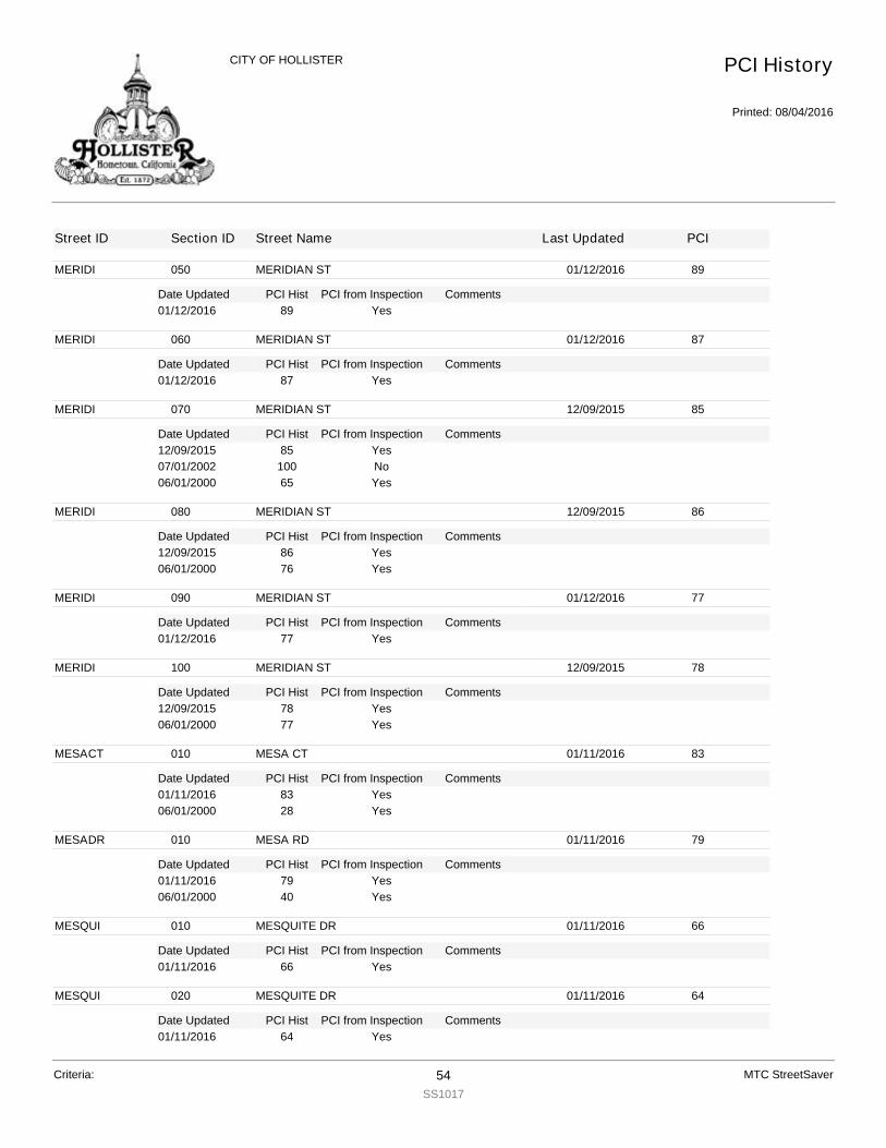
MERIDI
Date Updated PCI Hist Comments
050 MERIDIAN ST 01/12/2016 89
PCI from Inspection01/12/2016 89 Yes
MERIDI
Date Updated PCI Hist Comments
060 MERIDIAN ST 01/12/2016 87
PCI from Inspection01/12/2016 87 Yes
MERIDI
Date Updated PCI Hist Comments
070 MERIDIAN ST 12/09/2015 85
PCI from Inspection12/09/2015 85 Yes07/01/2002 100 No06/01/2000 65 Yes
MERIDI
Date Updated PCI Hist Comments
080 MERIDIAN ST 12/09/2015 86
PCI from Inspection12/09/2015 86 Yes06/01/2000 76 Yes
MERIDI
Date Updated PCI Hist Comments
090 MERIDIAN ST 01/12/2016 77
PCI from Inspection01/12/2016 77 Yes
MERIDI
Date Updated PCI Hist Comments
100 MERIDIAN ST 12/09/2015 78
PCI from Inspection12/09/2015 78 Yes06/01/2000 77 Yes
MESACT
Date Updated PCI Hist Comments
010 MESA CT 01/11/2016 83
PCI from Inspection01/11/2016 83 Yes06/01/2000 28 Yes
MESADR
Date Updated PCI Hist Comments
010 MESA RD 01/11/2016 79
PCI from Inspection01/11/2016 79 Yes06/01/2000 40 Yes
MESQUI
Date Updated PCI Hist Comments
010 MESQUITE DR 01/11/2016 66
PCI from Inspection01/11/2016 66 Yes
MESQUI
Date Updated PCI Hist Comments
020 MESQUITE DR 01/11/2016 64
PCI from Inspection01/11/2016 64 Yes
PCI History
Printed: 08/04/2016
CITY OF HOLLISTER
Street ID Section ID Street Name Last Updated PCI
Criteria: 54SS1017
MTC StreetSaver

MESQUI
Date Updated PCI Hist Comments
020 MESQUITE DR 01/11/2016 64
PCI from Inspection06/06/2002 84 No06/01/2000 79 Yes
MICACT
Date Updated PCI Hist Comments
010 MICA CT 12/14/2015 67
PCI from Inspection12/14/2015 67 Yes06/05/2002 87 No06/01/2000 83 Yes
MILLER
Date Updated PCI Hist Comments
010 MILLER RD 12/11/2015 26
PCI from Inspection12/11/2015 26 Yes06/01/2000 6 Yes
MIMOSA
Date Updated PCI Hist Comments
010 MIMOSA ST 01/11/2016 75
PCI from Inspection01/11/2016 75 Yes06/01/2000 82 Yes
MNTCEN
Date Updated PCI Hist Comments
010 MONTE CARLO DR ENTRANCE 12/17/2015 73
PCI from Inspection12/17/2015 73 Yes06/06/2002 86 No06/01/2000 81 Yes
MONICT
Date Updated PCI Hist Comments
010 MONICA CT 12/14/2015 70
PCI from Inspection12/14/2015 70 Yes06/05/2002 85 No06/01/2000 80 Yes
MONIDR
Date Updated PCI Hist Comments
010 MONICA DR 12/14/2015 70
PCI from Inspection12/14/2015 70 Yes06/05/2002 86 No06/01/2000 81 Yes
MONTCL
Date Updated PCI Hist Comments
010 MONTICELLO DR 12/18/2015 66
PCI from Inspection12/18/2015 66 Yes06/05/2002 86 No06/01/2000 81 Yes
PCI History
Printed: 08/04/2016
CITY OF HOLLISTER
Street ID Section ID Street Name Last Updated PCI
Criteria: 55SS1017
MTC StreetSaver

MONTEC
Date Updated PCI Hist Comments
010 MONTE CARLO DR 12/17/2015 76
PCI from Inspection12/17/2015 76 Yes06/01/2000 82 Yes
MONTER
Date Updated PCI Hist Comments
010 MONTEREY ST 12/16/2015 3
PCI from Inspection12/16/2015 3 Yes06/01/2000 10 Yes
MONTER
Date Updated PCI Hist Comments
020 MONTEREY ST 12/15/2015 60
PCI from Inspection12/15/2015 60 Yes06/01/2000 11 Yes
MONTER
Date Updated PCI Hist Comments
030 MONTEREY ST 12/15/2015 44
PCI from Inspection12/15/2015 44 Yes06/01/2000 59 Yes
MONTER
Date Updated PCI Hist Comments
040 MONTEREY ST 12/15/2015 32
PCI from Inspection12/15/2015 32 Yes06/01/2000 58 Yes
MONTER
Date Updated PCI Hist Comments
050 MONTEREY ST 12/15/2015 30
PCI from Inspection12/15/2015 30 Yes07/01/2002 100 No06/01/2000 45 Yes
MONTER
Date Updated PCI Hist Comments
060 MONTEREY ST 01/12/2016 30
PCI from Inspection01/12/2016 30 Yes
MONTER
Date Updated PCI Hist Comments
070 MONTEREY ST 12/15/2015 54
PCI from Inspection12/15/2015 54 Yes06/01/2000 54 Yes
MONTEV
Date Updated PCI Hist Comments
010 MONTE VISTA DR 01/11/2016 54
PCI from Inspection01/11/2016 54 Yes06/01/2000 81 Yes
PCI History
Printed: 08/04/2016
CITY OF HOLLISTER
Street ID Section ID Street Name Last Updated PCI
Criteria: 56SS1017
MTC StreetSaver

MONTEV
Date Updated PCI Hist Comments
020 MONTE VISTA DR 01/18/2016 75
PCI from Inspection01/18/2016 75 Yes
MOREY
Date Updated PCI Hist Comments
010 MOREY CR 12/14/2015 73
PCI from Inspection12/14/2015 73 Yes06/01/2000 82 Yes
MORNCR
Date Updated PCI Hist Comments
010 MORNINGSIDE CIR 01/18/2016 80
PCI from Inspection01/18/2016 80 Yes06/01/2000 82 Yes
MORNCT
Date Updated PCI Hist Comments
010 MORNINGSIDE CT 01/18/2016 68
PCI from Inspection01/18/2016 68 Yes06/05/2002 87 No06/01/2000 82 Yes
MORNGL
Date Updated PCI Hist Comments
010 MORNING GLORY DR 12/12/2015 80
PCI from Inspection12/12/2015 80 Yes10/29/2003 83 Yes
MORNGL
Date Updated PCI Hist Comments
020 MORNING GLORY DR 12/12/2015 77
PCI from Inspection12/12/2015 77 Yes10/29/2003 83 Yes
MORNIN
Date Updated PCI Hist Comments
010 MORNINGSIDE DR 01/18/2016 80
PCI from Inspection01/18/2016 80 Yes06/01/2000 82 Yes
MULBER
Date Updated PCI Hist Comments
010 MULBERRY CT 12/18/2015 80
PCI from Inspection12/18/2015 80 Yes10/29/2003 83 Yes
MULBES
Date Updated PCI Hist Comments
010 MULBERRY CR 12/18/2015 78
PCI from Inspection12/18/2015 78 Yes10/29/2003 83 Yes
PCI History
Printed: 08/04/2016
CITY OF HOLLISTER
Street ID Section ID Street Name Last Updated PCI
Criteria: 57SS1017
MTC StreetSaver

NAPACT
Date Updated PCI Hist Comments
010 NAPA CT 12/18/2015 65
PCI from Inspection12/18/2015 65 Yes06/05/2002 85 No06/01/2000 80 Yes
NASHRD
Date Updated PCI Hist Comments
010 NASH RD 12/10/2015 65
PCI from Inspection12/10/2015 65 Yes07/01/2002 100 No06/01/2000 12 Yes
NASHRD
Date Updated PCI Hist Comments
020 NASH RD 12/10/2015 79
PCI from Inspection12/10/2015 79 Yes07/01/2002 100 No06/01/2000 6 Yes
NASHRD
Date Updated PCI Hist Comments
030 NASH RD 12/10/2015 78
PCI from Inspection12/10/2015 78 Yes07/01/2002 100 No06/01/2000 8 Yes
NASHRD
Date Updated PCI Hist Comments
040 NASH RD 12/12/2015 75
PCI from Inspection12/12/2015 75 Yes
NASHRD
Date Updated PCI Hist Comments
050 NASH RD 12/12/2015 71
PCI from Inspection12/12/2015 71 Yes
NCHAPEL
Date Updated PCI Hist Comments
010 NORTH CHAPPELL RD 12/17/2015 30
PCI from Inspection12/17/2015 30 Yes05/01/2000 53 Yes
NEILDR
Date Updated PCI Hist Comments
010 NEIL DR 12/15/2015 70
PCI from Inspection12/15/2015 70 Yes06/05/2002 88 No06/01/2000 83 Yes
NEILDR
Date Updated PCI Hist Comments
020 NEIL DR 12/15/2015 70
PCI from Inspection12/15/2015 70 Yes
PCI History
Printed: 08/04/2016
CITY OF HOLLISTER
Street ID Section ID Street Name Last Updated PCI
Criteria: 58SS1017
MTC StreetSaver
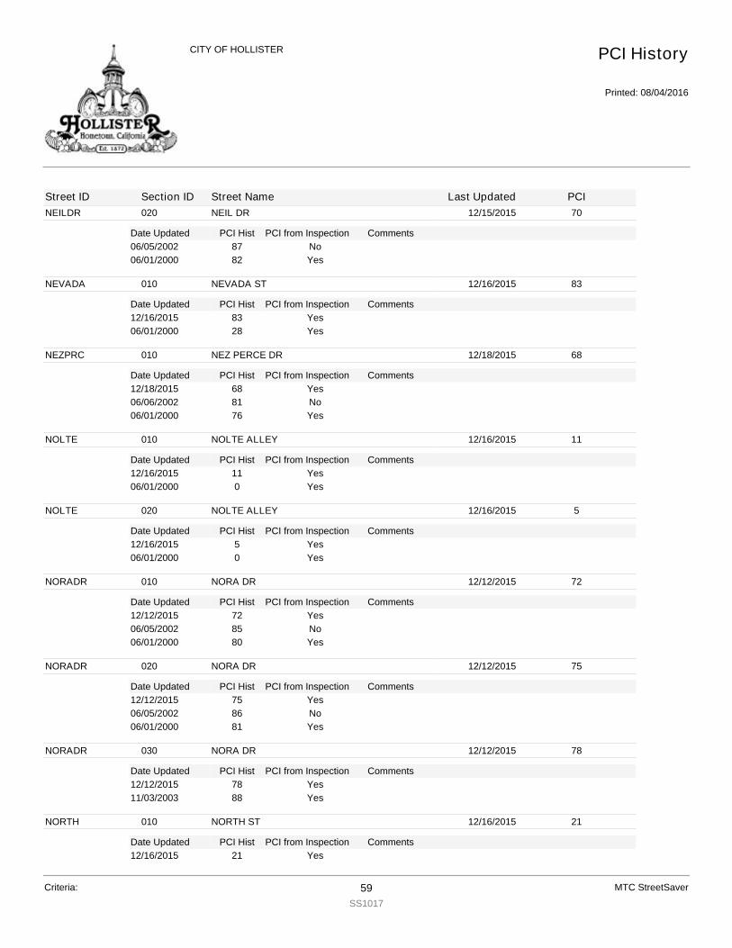
NEILDR
Date Updated PCI Hist Comments
020 NEIL DR 12/15/2015 70
PCI from Inspection06/05/2002 87 No06/01/2000 82 Yes
NEVADA
Date Updated PCI Hist Comments
010 NEVADA ST 12/16/2015 83
PCI from Inspection12/16/2015 83 Yes06/01/2000 28 Yes
NEZPRC
Date Updated PCI Hist Comments
010 NEZ PERCE DR 12/18/2015 68
PCI from Inspection12/18/2015 68 Yes06/06/2002 81 No06/01/2000 76 Yes
NOLTE
Date Updated PCI Hist Comments
010 NOLTE ALLEY 12/16/2015 11
PCI from Inspection12/16/2015 11 Yes06/01/2000 0 Yes
NOLTE
Date Updated PCI Hist Comments
020 NOLTE ALLEY 12/16/2015 5
PCI from Inspection12/16/2015 5 Yes06/01/2000 0 Yes
NORADR
Date Updated PCI Hist Comments
010 NORA DR 12/12/2015 72
PCI from Inspection12/12/2015 72 Yes06/05/2002 85 No06/01/2000 80 Yes
NORADR
Date Updated PCI Hist Comments
020 NORA DR 12/12/2015 75
PCI from Inspection12/12/2015 75 Yes06/05/2002 86 No06/01/2000 81 Yes
NORADR
Date Updated PCI Hist Comments
030 NORA DR 12/12/2015 78
PCI from Inspection12/12/2015 78 Yes11/03/2003 88 Yes
NORTH
Date Updated PCI Hist Comments
010 NORTH ST 12/16/2015 21
PCI from Inspection12/16/2015 21 Yes
PCI History
Printed: 08/04/2016
CITY OF HOLLISTER
Street ID Section ID Street Name Last Updated PCI
Criteria: 59SS1017
MTC StreetSaver
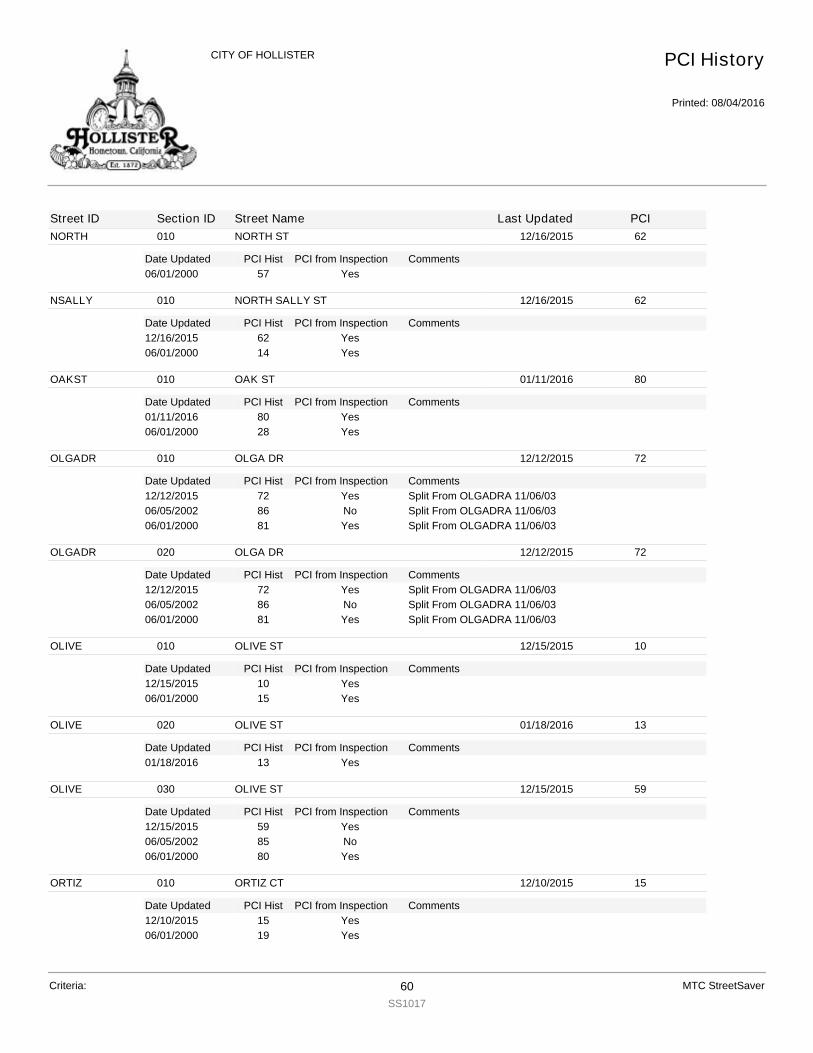
NORTH
Date Updated PCI Hist Comments
010 NORTH ST 12/16/2015 62
PCI from Inspection06/01/2000 57 Yes
NSALLY
Date Updated PCI Hist Comments
010 NORTH SALLY ST 12/16/2015 62
PCI from Inspection12/16/2015 62 Yes06/01/2000 14 Yes
OAKST
Date Updated PCI Hist Comments
010 OAK ST 01/11/2016 80
PCI from Inspection01/11/2016 80 Yes06/01/2000 28 Yes
OLGADR
Date Updated PCI Hist Comments
010 OLGA DR 12/12/2015 72
PCI from Inspection12/12/2015 72 Split From OLGADRA 11/06/03Yes06/05/2002 86 Split From OLGADRA 11/06/03No06/01/2000 81 Split From OLGADRA 11/06/03Yes
OLGADR
Date Updated PCI Hist Comments
020 OLGA DR 12/12/2015 72
PCI from Inspection12/12/2015 72 Split From OLGADRA 11/06/03Yes06/05/2002 86 Split From OLGADRA 11/06/03No06/01/2000 81 Split From OLGADRA 11/06/03Yes
OLIVE
Date Updated PCI Hist Comments
010 OLIVE ST 12/15/2015 10
PCI from Inspection12/15/2015 10 Yes06/01/2000 15 Yes
OLIVE
Date Updated PCI Hist Comments
020 OLIVE ST 01/18/2016 13
PCI from Inspection01/18/2016 13 Yes
OLIVE
Date Updated PCI Hist Comments
030 OLIVE ST 12/15/2015 59
PCI from Inspection12/15/2015 59 Yes06/05/2002 85 No06/01/2000 80 Yes
ORTIZ
Date Updated PCI Hist Comments
010 ORTIZ CT 12/10/2015 15
PCI from Inspection12/10/2015 15 Yes06/01/2000 19 Yes
PCI History
Printed: 08/04/2016
CITY OF HOLLISTER
Street ID Section ID Street Name Last Updated PCI
Criteria: 60SS1017
MTC StreetSaver

OSBORN
Date Updated PCI Hist Comments
010 OSBORNE CIR 12/18/2015 64
PCI from Inspection12/18/2015 64 Yes06/06/2002 81 No06/01/2000 76 Yes
PACIFI
Date Updated PCI Hist Comments
010 PACIFIC WAY 12/16/2015 76
PCI from Inspection12/16/2015 76 Yes06/06/2002 85 No06/01/2000 80 Yes
PALMST
Date Updated PCI Hist Comments
010 PALM ST 12/15/2015 21
PCI from Inspection12/15/2015 21 Yes06/01/2000 29 Yes
PALMTG
Date Updated PCI Hist Comments
010 PALMTAG DR 12/16/2015 84
PCI from Inspection12/16/2015 84 Yes06/01/2000 20 Yes
PANADR
Date Updated PCI Hist Comments
010 PANORAMA DR 01/18/2016 80
PCI from Inspection01/18/2016 80 Yes10/29/2003 83 Yes
PANORA
Date Updated PCI Hist Comments
010 PANORAMA ST 01/18/2016 80
PCI from Inspection01/18/2016 80 Yes06/01/2000 93 Yes
PANORA
Date Updated PCI Hist Comments
020 PANORAMA ST 01/18/2016 90
PCI from Inspection01/18/2016 90 Yes
PARACR
Date Updated PCI Hist Comments
010 PARADISE CIR 01/18/2016 84
PCI from Inspection01/18/2016 84 Yes06/01/2000 98 Yes
PARACT
Date Updated PCI Hist Comments
010 PARADISE CT 01/18/2016 84
PCI from Inspection01/18/2016 84 Yes06/01/2000 82 Yes
PCI History
Printed: 08/04/2016
CITY OF HOLLISTER
Street ID Section ID Street Name Last Updated PCI
Criteria: 61SS1017
MTC StreetSaver
PARADR
Date Updated PCI Hist Comments
010 PARADISE DR 01/18/2016 80
PCI from Inspection01/18/2016 80 Yes06/01/2000 82 Yes
PARKAL
Date Updated PCI Hist Comments
010 PARK ALLEY 01/18/2016 6
PCI from Inspection01/18/2016 6 Yes06/01/2000 16 Yes
PARKST
Date Updated PCI Hist Comments
010 PARK ST 12/15/2015 83
PCI from Inspection12/15/2015 83 Yes06/01/2000 24 Yes
PARKST
Date Updated PCI Hist Comments
020 PARK ST 12/15/2015 82
PCI from Inspection12/15/2015 82 Yes
PARKST
Date Updated PCI Hist Comments
030 PARK ST 12/15/2015 62
PCI from Inspection12/15/2015 62 Yes06/05/2002 84 No06/01/2000 79 Yes
PARKST
Date Updated PCI Hist Comments
040 PARK ST 12/15/2015 83
PCI from Inspection12/15/2015 83 Yes06/01/2000 33 Yes
PARKST
Date Updated PCI Hist Comments
050 PARK ST 12/15/2015 85
PCI from Inspection12/15/2015 85 Yes
PARKVI
Date Updated PCI Hist Comments
010 PARKVIEW CIR 12/18/2015 73
PCI from Inspection12/18/2015 73 Yes06/01/2000 82 Yes
PASEOD
Date Updated PCI Hist Comments
010 PASEO DR 01/11/2016 80
PCI from Inspection01/11/2016 80 Yes06/01/2000 82 Yes
PCI History
Printed: 08/04/2016
CITY OF HOLLISTER
Street ID Section ID Street Name Last Updated PCI
Criteria: 62SS1017
MTC StreetSaver
PAULDR
Date Updated PCI Hist Comments
010 PAUL DR 12/12/2015 72
PCI from Inspection12/12/2015 72 Yes06/05/2002 85 No06/01/2000 80 Yes
PAYETT
Date Updated PCI Hist Comments
010 PAYETTE CIR 12/18/2015 66
PCI from Inspection12/18/2015 66 Yes06/06/2002 86 No06/01/2000 81 Yes
PEACH
Date Updated PCI Hist Comments
010 PEACH CT 12/17/2015 78
PCI from Inspection12/17/2015 78 Yes07/01/2002 100 No06/01/2000 44 Yes
PEACH
Date Updated PCI Hist Comments
020 PEACH CT 12/17/2015 56
PCI from Inspection12/17/2015 56 Yes06/06/2002 81 No06/01/2000 76 Yes
PEARCT
Date Updated PCI Hist Comments
010 PEAR CT 12/17/2015 51
PCI from Inspection12/17/2015 51 Yes07/01/2002 100 No06/01/2000 65 Yes
PEARST
Date Updated PCI Hist Comments
010 PEAR ST 12/17/2015 24
PCI from Inspection12/17/2015 24 Yes06/01/2000 29 Yes
PECAN
Date Updated PCI Hist Comments
010 PECAN CT 12/18/2015 74
PCI from Inspection12/18/2015 74 Yes06/01/2000 84 Yes
PERIDO
Date Updated PCI Hist Comments
010 PERIDOT CT 12/14/2015 68
PCI from Inspection12/14/2015 68 Yes06/05/2002 87 No06/01/2000 83 Yes
PCI History
Printed: 08/04/2016
CITY OF HOLLISTER
Street ID Section ID Street Name Last Updated PCI
Criteria: 63SS1017
MTC StreetSaver
PETALU
Date Updated PCI Hist Comments
010 PETALUMA CT 01/11/2016 61
PCI from Inspection01/11/2016 61 Yes06/05/2002 84 No06/01/2000 78 Yes
PINCRT
Date Updated PCI Hist Comments
010 PIANE CRATI 12/11/2015 72
PCI from Inspection12/11/2015 72 Yes06/01/2000 83 Yes
PINEDR
Date Updated PCI Hist Comments
010 PINE DR 01/18/2016 26
PCI from Inspection01/18/2016 26 Yes
PINNAC
Date Updated PCI Hist Comments
010 PINNACLE CT 01/18/2016 80
PCI from Inspection01/18/2016 80 Yes06/01/2000 97 Yes
PLUMCT
Date Updated PCI Hist Comments
010 PLUM CT 12/17/2015 42
PCI from Inspection12/17/2015 42 Yes06/01/2000 58 Yes
PLUMCT
Date Updated PCI Hist Comments
020 PLUM CT 12/17/2015 59
PCI from Inspection12/17/2015 59 Yes06/06/2002 84 No06/01/2000 79 Yes
PONDER
Date Updated PCI Hist Comments
010 PONDEROSA CT 12/18/2015 73
PCI from Inspection12/18/2015 73 Yes06/01/2000 82 Yes
POPLAR
Date Updated PCI Hist Comments
010 POPLAR CT 12/18/2015 79
PCI from Inspection12/18/2015 79 Yes06/01/2000 82 Yes
POPLNC
Date Updated PCI Hist Comments
010 POPPY LANE CR 12/17/2015 71
PCI from Inspection12/17/2015 71 Yes06/01/2000 96 Yes
PCI History
Printed: 08/04/2016
CITY OF HOLLISTER
Street ID Section ID Street Name Last Updated PCI
Criteria: 64SS1017
MTC StreetSaver
POPLND
Date Updated PCI Hist Comments
010 POPPY LANE DR 01/11/2016 61
PCI from Inspection01/11/2016 61 Split From POPLNDA 11/05/03 - Combined from POPLNDA1,
POPLNDA2 12/31/2015Yes
PORTER
Date Updated PCI Hist Comments
010 PORTER CIR 12/18/2015 63
PCI from Inspection12/18/2015 63 Yes06/06/2002 86 No06/01/2000 81 Yes
POWELL
Date Updated PCI Hist Comments
010 POWELL ST 12/15/2015 83
PCI from Inspection12/15/2015 83 Yes06/01/2000 25 Yes
POWELL
Date Updated PCI Hist Comments
020 POWELL ST 12/15/2015 79
PCI from Inspection12/15/2015 79 Yes06/01/2000 41 Yes
POWELL
Date Updated PCI Hist Comments
030 POWELL ST 12/15/2015 78
PCI from Inspection12/15/2015 78 Yes06/01/2000 39 Yes
POWELL
Date Updated PCI Hist Comments
040 POWELL ST 12/15/2015 70
PCI from Inspection12/15/2015 70 Yes06/01/2000 100 Yes
POWELL
Date Updated PCI Hist Comments
050 POWELL ST 12/15/2015 82
PCI from Inspection12/15/2015 82 Yes06/01/2000 21 Yes
POWELL
Date Updated PCI Hist Comments
060 POWELL ST 12/15/2015 81
PCI from Inspection12/15/2015 81 Yes06/01/2000 40 Yes
PRESTO
Date Updated PCI Hist Comments
010 PRESTON CT 01/18/2016 80
PCI from Inspection01/18/2016 80 Yes06/01/2000 82 Yes
PCI History
Printed: 08/04/2016
CITY OF HOLLISTER
Street ID Section ID Street Name Last Updated PCI
Criteria: 65SS1017
MTC StreetSaver

PRIMAV
Date Updated PCI Hist Comments
010 PRIMAVERA DR 12/16/2015 81
PCI from Inspection12/16/2015 81 Yes06/01/2000 83 Yes
PRIMRO
Date Updated PCI Hist Comments
010 PRIMROSE CT 12/18/2015 80
PCI from Inspection12/18/2015 80 Yes06/01/2000 82 Yes
PROMISE
Date Updated PCI Hist Comments
010 PROMISE WAY 12/16/2015 100
PCI from Inspection12/16/2015 100 Yes
PROMISE
Date Updated PCI Hist Comments
020 PROMISE WAY 12/16/2015 100
PCI from Inspection12/16/2015 100 Yes
PROMISE
Date Updated PCI Hist Comments
030 PROMISE WAY 12/12/2015 83
PCI from Inspection12/12/2015 83 Yes10/29/2003 83 Yes
PROMISE
Date Updated PCI Hist Comments
040 PROMISE WAY 12/12/2015 83
PCI from Inspection12/12/2015 83 Yes10/29/2003 92 Yes
PROSPC
Date Updated PCI Hist Comments
010 PROSPECT AV 12/10/2015 80
PCI from Inspection12/10/2015 80 Yes07/01/2002 100 No06/01/2000 22 Yes
PROSPC
Date Updated PCI Hist Comments
020 PROSPECT AV 12/10/2015 77
PCI from Inspection12/10/2015 77 Yes07/01/2002 100 No06/01/2000 45 Yes
PROSPC
Date Updated PCI Hist Comments
030 PROSPECT AV 01/12/2016 78
PCI from Inspection01/12/2016 78 Yes
PCI History
Printed: 08/04/2016
CITY OF HOLLISTER
Street ID Section ID Street Name Last Updated PCI
Criteria: 66SS1017
MTC StreetSaver

PRUNES
Date Updated PCI Hist Comments
010 PRUNE ST 12/16/2015 83
PCI from Inspection12/16/2015 83 Yes06/01/2000 33 Yes
PRUNES
Date Updated PCI Hist Comments
020 PRUNE ST 12/16/2015 69
PCI from Inspection12/16/2015 69 Yes06/01/2000 82 Yes
PRUNES
Date Updated PCI Hist Comments
030 PRUNE ST 12/16/2015 55
PCI from Inspection12/16/2015 55 Yes06/05/2002 84 No06/01/2000 79 Yes
PRUNES
Date Updated PCI Hist Comments
040 PRUNE ST 12/16/2015 82
PCI from Inspection12/16/2015 82 Yes06/01/2000 82 Yes
PRUNES
Date Updated PCI Hist Comments
050 PRUNE ST 12/16/2015 81
PCI from Inspection12/16/2015 81 Yes06/01/2000 28 Yes
PRUNES
Date Updated PCI Hist Comments
060 PRUNE ST 12/16/2015 81
PCI from Inspection12/16/2015 81 Yes06/01/2000 28 Yes
RAINBW
Date Updated PCI Hist Comments
010 RAINBOW DR 01/11/2016 83
PCI from Inspection01/11/2016 83 Yes06/01/2000 25 Yes
RAJKOV
Date Updated PCI Hist Comments
010 RAJKOVICH WY 12/14/2015 74
PCI from Inspection12/14/2015 74 Yes06/05/2002 88 No06/01/2000 83 Yes
RALEIG
Date Updated PCI Hist Comments
010 RALEIGH CIR 12/18/2015 61
PCI from Inspection12/18/2015 61 Yes06/06/2002 81 No
PCI History
Printed: 08/04/2016
CITY OF HOLLISTER
Street ID Section ID Street Name Last Updated PCI
Criteria: 67SS1017
MTC StreetSaver

RALEIG
Date Updated PCI Hist Comments
010 RALEIGH CIR 12/18/2015 83
PCI from Inspection06/01/2000 76 Yes
RAMONA
Date Updated PCI Hist Comments
010 RAMONA AV 01/11/2016 83
PCI from Inspection01/11/2016 83 Yes06/01/2000 29 Yes
RANCHC
Date Updated PCI Hist Comments
010 RANCHITO CT 12/10/2015 15
PCI from Inspection12/10/2015 15 Yes06/01/2000 11 Yes
RANCHI
Date Updated PCI Hist Comments
010 RANCHITO DR 12/10/2015 73
PCI from Inspection12/10/2015 73 Yes06/01/2000 13 Yes
RANCHO
Date Updated PCI Hist Comments
010 RANCHO DR 12/16/2015 82
PCI from Inspection12/16/2015 82 Yes07/01/2002 100 No06/01/2000 50 Yes
RANCHO
Date Updated PCI Hist Comments
020 RANCHO DR 12/16/2015 85
PCI from Inspection12/16/2015 85 Yes06/01/2000 37 Yes
RANDST
Date Updated PCI Hist Comments
010 RAND ST 12/18/2015 64
PCI from Inspection12/18/2015 64 Yes06/06/2002 77 No06/01/2000 71 Yes
RECHT
Date Updated PCI Hist Comments
010 RECHT ST 12/17/2015 78
PCI from Inspection12/17/2015 78 Yes07/06/2002 100 No06/01/2000 47 Yes
RECHT
Date Updated PCI Hist Comments
020 RECHT ST 12/17/2015 70
PCI from Inspection12/17/2015 70 Yes06/01/2000 83 Yes
PCI History
Printed: 08/04/2016
CITY OF HOLLISTER
Street ID Section ID Street Name Last Updated PCI
Criteria: 68SS1017
MTC StreetSaver
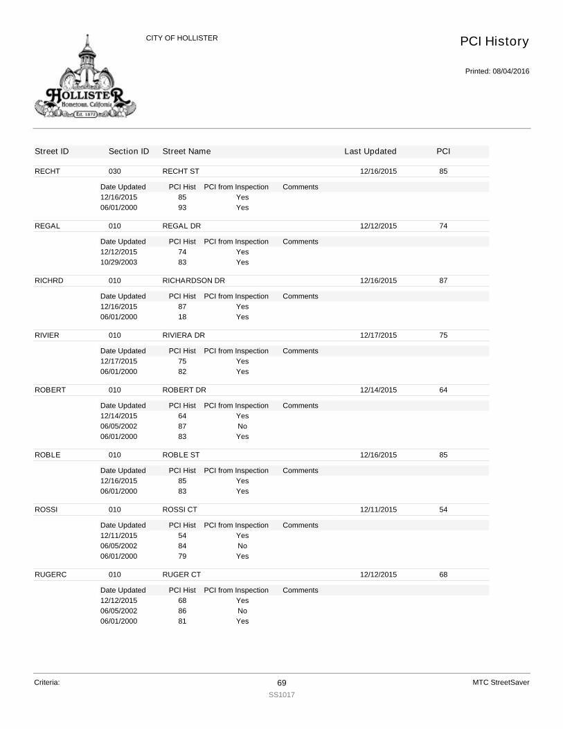
RECHT
Date Updated PCI Hist Comments
030 RECHT ST 12/16/2015 85
PCI from Inspection12/16/2015 85 Yes06/01/2000 93 Yes
REGAL
Date Updated PCI Hist Comments
010 REGAL DR 12/12/2015 74
PCI from Inspection12/12/2015 74 Yes10/29/2003 83 Yes
RICHRD
Date Updated PCI Hist Comments
010 RICHARDSON DR 12/16/2015 87
PCI from Inspection12/16/2015 87 Yes06/01/2000 18 Yes
RIVIER
Date Updated PCI Hist Comments
010 RIVIERA DR 12/17/2015 75
PCI from Inspection12/17/2015 75 Yes06/01/2000 82 Yes
ROBERT
Date Updated PCI Hist Comments
010 ROBERT DR 12/14/2015 64
PCI from Inspection12/14/2015 64 Yes06/05/2002 87 No06/01/2000 83 Yes
ROBLE
Date Updated PCI Hist Comments
010 ROBLE ST 12/16/2015 85
PCI from Inspection12/16/2015 85 Yes06/01/2000 83 Yes
ROSSI
Date Updated PCI Hist Comments
010 ROSSI CT 12/11/2015 54
PCI from Inspection12/11/2015 54 Yes06/05/2002 84 No06/01/2000 79 Yes
RUGERC
Date Updated PCI Hist Comments
010 RUGER CT 12/12/2015 68
PCI from Inspection12/12/2015 68 Yes06/05/2002 86 No06/01/2000 81 Yes
PCI History
Printed: 08/04/2016
CITY OF HOLLISTER
Street ID Section ID Street Name Last Updated PCI
Criteria: 69SS1017
MTC StreetSaver
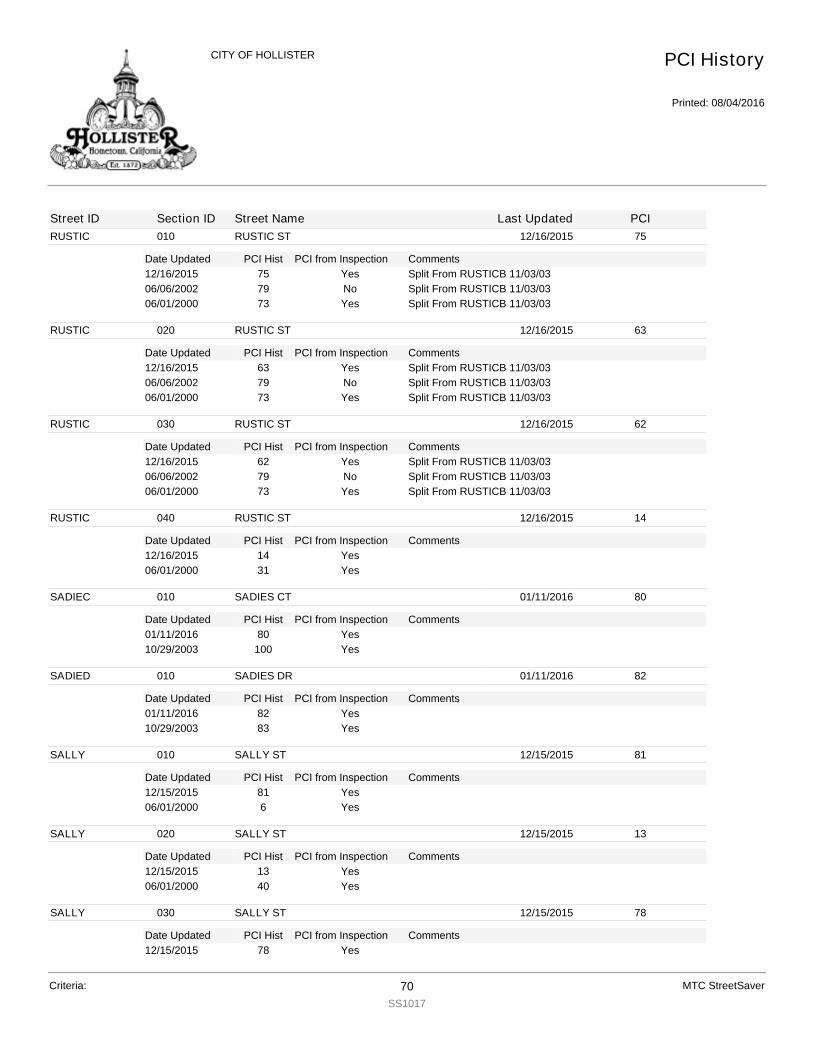
RUSTIC
Date Updated PCI Hist Comments
010 RUSTIC ST 12/16/2015 75
PCI from Inspection12/16/2015 75 Split From RUSTICB 11/03/03Yes06/06/2002 79 Split From RUSTICB 11/03/03No06/01/2000 73 Split From RUSTICB 11/03/03Yes
RUSTIC
Date Updated PCI Hist Comments
020 RUSTIC ST 12/16/2015 63
PCI from Inspection12/16/2015 63 Split From RUSTICB 11/03/03Yes06/06/2002 79 Split From RUSTICB 11/03/03No06/01/2000 73 Split From RUSTICB 11/03/03Yes
RUSTIC
Date Updated PCI Hist Comments
030 RUSTIC ST 12/16/2015 62
PCI from Inspection12/16/2015 62 Split From RUSTICB 11/03/03Yes06/06/2002 79 Split From RUSTICB 11/03/03No06/01/2000 73 Split From RUSTICB 11/03/03Yes
RUSTIC
Date Updated PCI Hist Comments
040 RUSTIC ST 12/16/2015 14
PCI from Inspection12/16/2015 14 Yes06/01/2000 31 Yes
SADIEC
Date Updated PCI Hist Comments
010 SADIES CT 01/11/2016 80
PCI from Inspection01/11/2016 80 Yes10/29/2003 100 Yes
SADIED
Date Updated PCI Hist Comments
010 SADIES DR 01/11/2016 82
PCI from Inspection01/11/2016 82 Yes10/29/2003 83 Yes
SALLY
Date Updated PCI Hist Comments
010 SALLY ST 12/15/2015 81
PCI from Inspection12/15/2015 81 Yes06/01/2000 6 Yes
SALLY
Date Updated PCI Hist Comments
020 SALLY ST 12/15/2015 13
PCI from Inspection12/15/2015 13 Yes06/01/2000 40 Yes
SALLY
Date Updated PCI Hist Comments
030 SALLY ST 12/15/2015 78
PCI from Inspection12/15/2015 78 Yes
PCI History
Printed: 08/04/2016
CITY OF HOLLISTER
Street ID Section ID Street Name Last Updated PCI
Criteria: 70SS1017
MTC StreetSaver
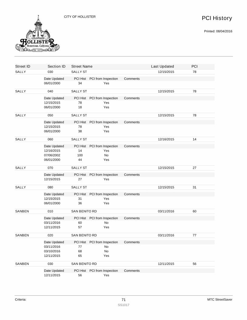
SALLY
Date Updated PCI Hist Comments
030 SALLY ST 12/15/2015 78
PCI from Inspection06/01/2000 34 Yes
SALLY
Date Updated PCI Hist Comments
040 SALLY ST 12/15/2015 78
PCI from Inspection12/15/2015 78 Yes06/01/2000 18 Yes
SALLY
Date Updated PCI Hist Comments
050 SALLY ST 12/15/2015 78
PCI from Inspection12/15/2015 78 Yes06/01/2000 38 Yes
SALLY
Date Updated PCI Hist Comments
060 SALLY ST 12/16/2015 14
PCI from Inspection12/16/2015 14 Yes07/06/2002 100 No06/01/2000 44 Yes
SALLY
Date Updated PCI Hist Comments
070 SALLY ST 12/15/2015 27
PCI from Inspection12/15/2015 27 Yes
SALLY
Date Updated PCI Hist Comments
080 SALLY ST 12/15/2015 31
PCI from Inspection12/15/2015 31 Yes06/01/2000 36 Yes
SANBEN
Date Updated PCI Hist Comments
010 SAN BENITO RD 03/11/2016 60
PCI from Inspection03/11/2016 60 No12/11/2015 57 Yes
SANBEN
Date Updated PCI Hist Comments
020 SAN BENITO RD 03/11/2016 77
PCI from Inspection03/11/2016 77 No03/10/2016 68 No12/11/2015 65 Yes
SANBEN
Date Updated PCI Hist Comments
030 SAN BENITO RD 12/11/2015 56
PCI from Inspection12/11/2015 56 Yes
PCI History
Printed: 08/04/2016
CITY OF HOLLISTER
Street ID Section ID Street Name Last Updated PCI
Criteria: 71SS1017
MTC StreetSaver
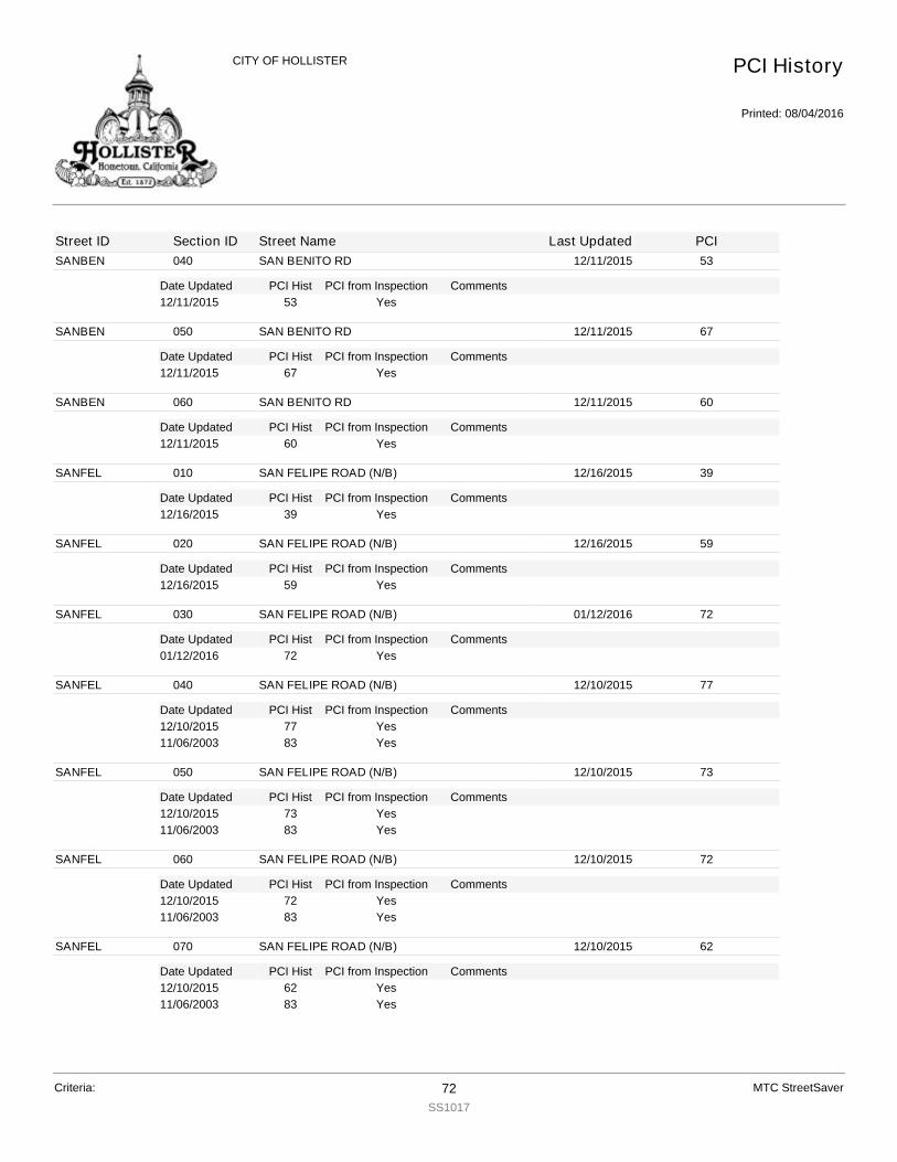
SANBEN
Date Updated PCI Hist Comments
040 SAN BENITO RD 12/11/2015 53
PCI from Inspection12/11/2015 53 Yes
SANBEN
Date Updated PCI Hist Comments
050 SAN BENITO RD 12/11/2015 67
PCI from Inspection12/11/2015 67 Yes
SANBEN
Date Updated PCI Hist Comments
060 SAN BENITO RD 12/11/2015 60
PCI from Inspection12/11/2015 60 Yes
SANFEL
Date Updated PCI Hist Comments
010 SAN FELIPE ROAD (N/B) 12/16/2015 39
PCI from Inspection12/16/2015 39 Yes
SANFEL
Date Updated PCI Hist Comments
020 SAN FELIPE ROAD (N/B) 12/16/2015 59
PCI from Inspection12/16/2015 59 Yes
SANFEL
Date Updated PCI Hist Comments
030 SAN FELIPE ROAD (N/B) 01/12/2016 72
PCI from Inspection01/12/2016 72 Yes
SANFEL
Date Updated PCI Hist Comments
040 SAN FELIPE ROAD (N/B) 12/10/2015 77
PCI from Inspection12/10/2015 77 Yes11/06/2003 83 Yes
SANFEL
Date Updated PCI Hist Comments
050 SAN FELIPE ROAD (N/B) 12/10/2015 73
PCI from Inspection12/10/2015 73 Yes11/06/2003 83 Yes
SANFEL
Date Updated PCI Hist Comments
060 SAN FELIPE ROAD (N/B) 12/10/2015 72
PCI from Inspection12/10/2015 72 Yes11/06/2003 83 Yes
SANFEL
Date Updated PCI Hist Comments
070 SAN FELIPE ROAD (N/B) 12/10/2015 62
PCI from Inspection12/10/2015 62 Yes11/06/2003 83 Yes
PCI History
Printed: 08/04/2016
CITY OF HOLLISTER
Street ID Section ID Street Name Last Updated PCI
Criteria: 72SS1017
MTC StreetSaver
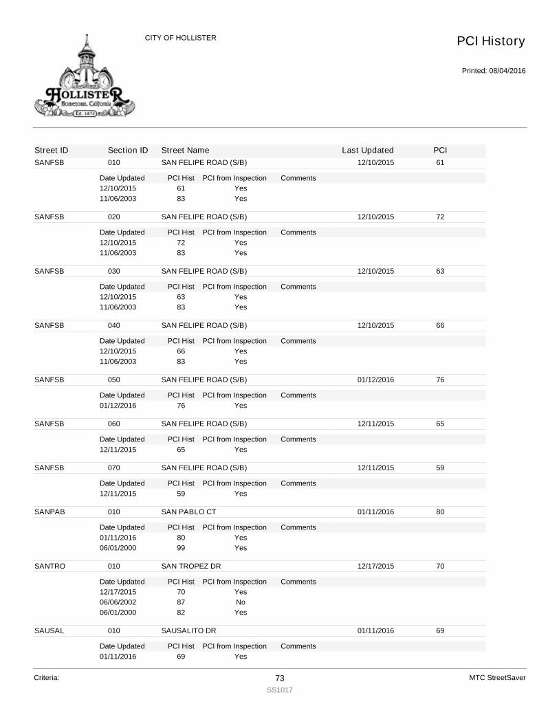
SANFSB
Date Updated PCI Hist Comments
010 SAN FELIPE ROAD (S/B) 12/10/2015 61
PCI from Inspection12/10/2015 61 Yes11/06/2003 83 Yes
SANFSB
Date Updated PCI Hist Comments
020 SAN FELIPE ROAD (S/B) 12/10/2015 72
PCI from Inspection12/10/2015 72 Yes11/06/2003 83 Yes
SANFSB
Date Updated PCI Hist Comments
030 SAN FELIPE ROAD (S/B) 12/10/2015 63
PCI from Inspection12/10/2015 63 Yes11/06/2003 83 Yes
SANFSB
Date Updated PCI Hist Comments
040 SAN FELIPE ROAD (S/B) 12/10/2015 66
PCI from Inspection12/10/2015 66 Yes11/06/2003 83 Yes
SANFSB
Date Updated PCI Hist Comments
050 SAN FELIPE ROAD (S/B) 01/12/2016 76
PCI from Inspection01/12/2016 76 Yes
SANFSB
Date Updated PCI Hist Comments
060 SAN FELIPE ROAD (S/B) 12/11/2015 65
PCI from Inspection12/11/2015 65 Yes
SANFSB
Date Updated PCI Hist Comments
070 SAN FELIPE ROAD (S/B) 12/11/2015 59
PCI from Inspection12/11/2015 59 Yes
SANPAB
Date Updated PCI Hist Comments
010 SAN PABLO CT 01/11/2016 80
PCI from Inspection01/11/2016 80 Yes06/01/2000 99 Yes
SANTRO
Date Updated PCI Hist Comments
010 SAN TROPEZ DR 12/17/2015 70
PCI from Inspection12/17/2015 70 Yes06/06/2002 87 No06/01/2000 82 Yes
SAUSAL
Date Updated PCI Hist Comments
010 SAUSALITO DR 01/11/2016 69
PCI from Inspection01/11/2016 69 Yes
PCI History
Printed: 08/04/2016
CITY OF HOLLISTER
Street ID Section ID Street Name Last Updated PCI
Criteria: 73SS1017
MTC StreetSaver
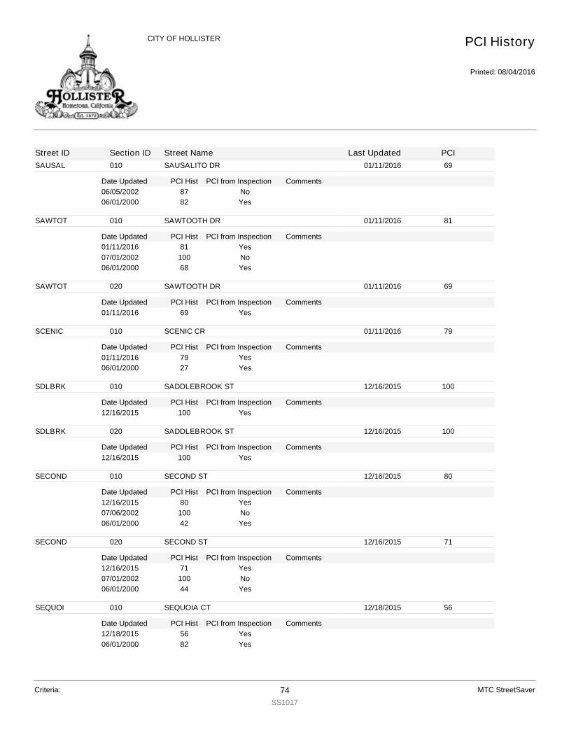
SAUSAL
Date Updated PCI Hist Comments
010 SAUSALITO DR 01/11/2016 69
PCI from Inspection06/05/2002 87 No06/01/2000 82 Yes
SAWTOT
Date Updated PCI Hist Comments
010 SAWTOOTH DR 01/11/2016 81
PCI from Inspection01/11/2016 81 Yes07/01/2002 100 No06/01/2000 68 Yes
SAWTOT
Date Updated PCI Hist Comments
020 SAWTOOTH DR 01/11/2016 69
PCI from Inspection01/11/2016 69 Yes
SCENIC
Date Updated PCI Hist Comments
010 SCENIC CR 01/11/2016 79
PCI from Inspection01/11/2016 79 Yes06/01/2000 27 Yes
SDLBRK
Date Updated PCI Hist Comments
010 SADDLEBROOK ST 12/16/2015 100
PCI from Inspection12/16/2015 100 Yes
SDLBRK
Date Updated PCI Hist Comments
020 SADDLEBROOK ST 12/16/2015 100
PCI from Inspection12/16/2015 100 Yes
SECOND
Date Updated PCI Hist Comments
010 SECOND ST 12/16/2015 80
PCI from Inspection12/16/2015 80 Yes07/06/2002 100 No06/01/2000 42 Yes
SECOND
Date Updated PCI Hist Comments
020 SECOND ST 12/16/2015 71
PCI from Inspection12/16/2015 71 Yes07/01/2002 100 No06/01/2000 44 Yes
SEQUOI
Date Updated PCI Hist Comments
010 SEQUOIA CT 12/18/2015 56
PCI from Inspection12/18/2015 56 Yes06/01/2000 82 Yes
PCI History
Printed: 08/04/2016
CITY OF HOLLISTER
Street ID Section ID Street Name Last Updated PCI
Criteria: 74SS1017
MTC StreetSaver
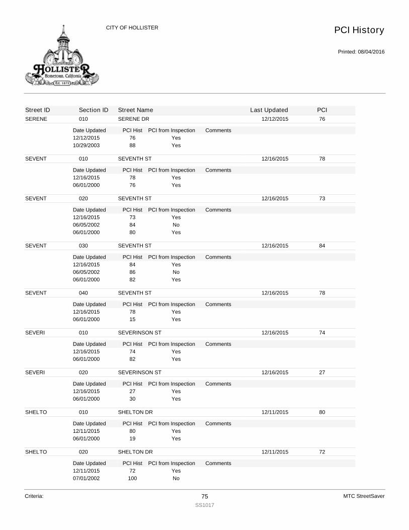
SERENE
Date Updated PCI Hist Comments
010 SERENE DR 12/12/2015 76
PCI from Inspection12/12/2015 76 Yes10/29/2003 88 Yes
SEVENT
Date Updated PCI Hist Comments
010 SEVENTH ST 12/16/2015 78
PCI from Inspection12/16/2015 78 Yes06/01/2000 76 Yes
SEVENT
Date Updated PCI Hist Comments
020 SEVENTH ST 12/16/2015 73
PCI from Inspection12/16/2015 73 Yes06/05/2002 84 No06/01/2000 80 Yes
SEVENT
Date Updated PCI Hist Comments
030 SEVENTH ST 12/16/2015 84
PCI from Inspection12/16/2015 84 Yes06/05/2002 86 No06/01/2000 82 Yes
SEVENT
Date Updated PCI Hist Comments
040 SEVENTH ST 12/16/2015 78
PCI from Inspection12/16/2015 78 Yes06/01/2000 15 Yes
SEVERI
Date Updated PCI Hist Comments
010 SEVERINSON ST 12/16/2015 74
PCI from Inspection12/16/2015 74 Yes06/01/2000 82 Yes
SEVERI
Date Updated PCI Hist Comments
020 SEVERINSON ST 12/16/2015 27
PCI from Inspection12/16/2015 27 Yes06/01/2000 30 Yes
SHELTO
Date Updated PCI Hist Comments
010 SHELTON DR 12/11/2015 80
PCI from Inspection12/11/2015 80 Yes06/01/2000 19 Yes
SHELTO
Date Updated PCI Hist Comments
020 SHELTON DR 12/11/2015 72
PCI from Inspection12/11/2015 72 Yes07/01/2002 100 No
PCI History
Printed: 08/04/2016
CITY OF HOLLISTER
Street ID Section ID Street Name Last Updated PCI
Criteria: 75SS1017
MTC StreetSaver
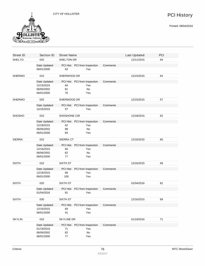
SHELTO
Date Updated PCI Hist Comments
020 SHELTON DR 12/11/2015 64
PCI from Inspection06/01/2000 63 Yes
SHERWO
Date Updated PCI Hist Comments
010 SHERWOOD DR 12/15/2015 64
PCI from Inspection12/15/2015 64 Yes06/05/2002 81 No06/01/2000 76 Yes
SHERWO
Date Updated PCI Hist Comments
020 SHERWOOD DR 12/15/2015 57
PCI from Inspection12/15/2015 57 Yes
SHOSHO
Date Updated PCI Hist Comments
010 SHOSHONE CIR 12/18/2015 62
PCI from Inspection12/18/2015 62 Yes06/06/2002 88 No06/01/2000 83 Yes
SIERRA
Date Updated PCI Hist Comments
010 SIERRA CT 12/16/2015 60
PCI from Inspection12/16/2015 60 Yes06/06/2002 82 No06/01/2000 77 Yes
SIXTH
Date Updated PCI Hist Comments
010 SIXTH ST 12/16/2015 69
PCI from Inspection12/16/2015 69 Yes06/01/2000 100 Yes
SIXTH
Date Updated PCI Hist Comments
020 SIXTH ST 01/04/2016 81
PCI from Inspection01/04/2016 81 Yes
SIXTH
Date Updated PCI Hist Comments
030 SIXTH ST 12/16/2015 69
PCI from Inspection12/16/2015 69 Yes06/01/2000 41 Yes
SKYLIN
Date Updated PCI Hist Comments
010 SKYLINE DR 01/19/2016 71
PCI from Inspection01/19/2016 71 Yes06/06/2002 82 No06/01/2000 77 Yes
PCI History
Printed: 08/04/2016
CITY OF HOLLISTER
Street ID Section ID Street Name Last Updated PCI
Criteria: 76SS1017
MTC StreetSaver
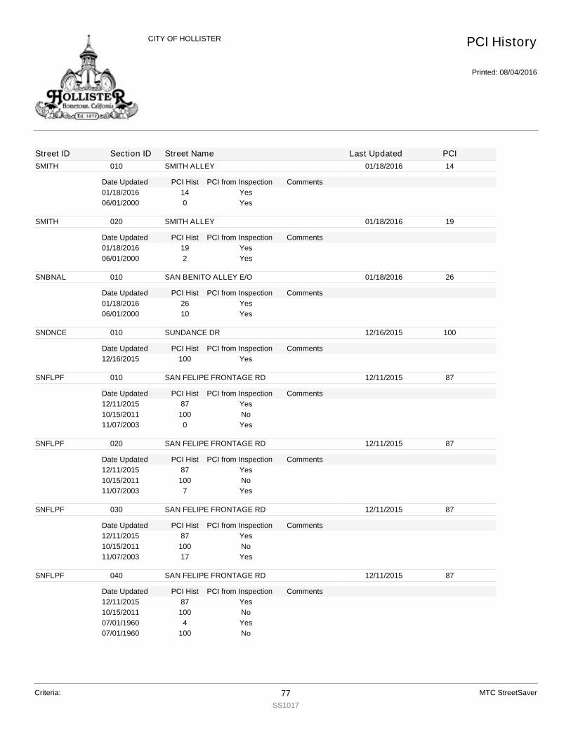
SMITH
Date Updated PCI Hist Comments
010 SMITH ALLEY 01/18/2016 14
PCI from Inspection01/18/2016 14 Yes06/01/2000 0 Yes
SMITH
Date Updated PCI Hist Comments
020 SMITH ALLEY 01/18/2016 19
PCI from Inspection01/18/2016 19 Yes06/01/2000 2 Yes
SNBNAL
Date Updated PCI Hist Comments
010 SAN BENITO ALLEY E/O 01/18/2016 26
PCI from Inspection01/18/2016 26 Yes06/01/2000 10 Yes
SNDNCE
Date Updated PCI Hist Comments
010 SUNDANCE DR 12/16/2015 100
PCI from Inspection12/16/2015 100 Yes
SNFLPF
Date Updated PCI Hist Comments
010 SAN FELIPE FRONTAGE RD 12/11/2015 87
PCI from Inspection12/11/2015 87 Yes10/15/2011 100 No11/07/2003 0 Yes
SNFLPF
Date Updated PCI Hist Comments
020 SAN FELIPE FRONTAGE RD 12/11/2015 87
PCI from Inspection12/11/2015 87 Yes10/15/2011 100 No11/07/2003 7 Yes
SNFLPF
Date Updated PCI Hist Comments
030 SAN FELIPE FRONTAGE RD 12/11/2015 87
PCI from Inspection12/11/2015 87 Yes10/15/2011 100 No11/07/2003 17 Yes
SNFLPF
Date Updated PCI Hist Comments
040 SAN FELIPE FRONTAGE RD 12/11/2015 87
PCI from Inspection12/11/2015 87 Yes10/15/2011 100 No07/01/1960 4 Yes07/01/1960 100 No
PCI History
Printed: 08/04/2016
CITY OF HOLLISTER
Street ID Section ID Street Name Last Updated PCI
Criteria: 77SS1017
MTC StreetSaver
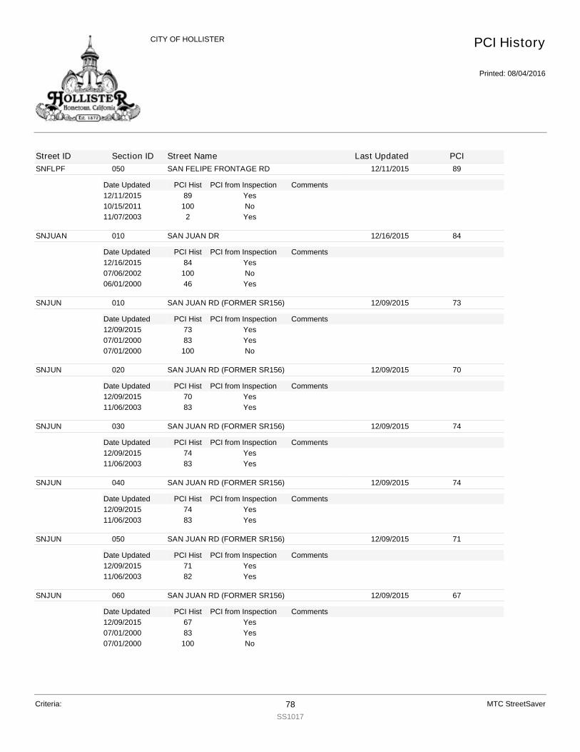
SNFLPF
Date Updated PCI Hist Comments
050 SAN FELIPE FRONTAGE RD 12/11/2015 89
PCI from Inspection12/11/2015 89 Yes10/15/2011 100 No11/07/2003 2 Yes
SNJUAN
Date Updated PCI Hist Comments
010 SAN JUAN DR 12/16/2015 84
PCI from Inspection12/16/2015 84 Yes07/06/2002 100 No06/01/2000 46 Yes
SNJUN
Date Updated PCI Hist Comments
010 SAN JUAN RD (FORMER SR156) 12/09/2015 73
PCI from Inspection12/09/2015 73 Yes07/01/2000 83 Yes07/01/2000 100 No
SNJUN
Date Updated PCI Hist Comments
020 SAN JUAN RD (FORMER SR156) 12/09/2015 70
PCI from Inspection12/09/2015 70 Yes11/06/2003 83 Yes
SNJUN
Date Updated PCI Hist Comments
030 SAN JUAN RD (FORMER SR156) 12/09/2015 74
PCI from Inspection12/09/2015 74 Yes11/06/2003 83 Yes
SNJUN
Date Updated PCI Hist Comments
040 SAN JUAN RD (FORMER SR156) 12/09/2015 74
PCI from Inspection12/09/2015 74 Yes11/06/2003 83 Yes
SNJUN
Date Updated PCI Hist Comments
050 SAN JUAN RD (FORMER SR156) 12/09/2015 71
PCI from Inspection12/09/2015 71 Yes11/06/2003 82 Yes
SNJUN
Date Updated PCI Hist Comments
060 SAN JUAN RD (FORMER SR156) 12/09/2015 67
PCI from Inspection12/09/2015 67 Yes07/01/2000 83 Yes07/01/2000 100 No
PCI History
Printed: 08/04/2016
CITY OF HOLLISTER
Street ID Section ID Street Name Last Updated PCI
Criteria: 78SS1017
MTC StreetSaver
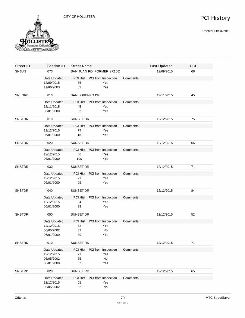
SNJUN
Date Updated PCI Hist Comments
070 SAN JUAN RD (FORMER SR156) 12/09/2015 66
PCI from Inspection12/09/2015 66 Yes11/06/2003 83 Yes
SNLORE
Date Updated PCI Hist Comments
010 SAN LORENZO DR 12/11/2015 45
PCI from Inspection12/11/2015 45 Yes06/01/2000 82 Yes
SNSTDR
Date Updated PCI Hist Comments
010 SUNSET DR 12/12/2015 75
PCI from Inspection12/12/2015 75 Yes06/01/2000 18 Yes
SNSTDR
Date Updated PCI Hist Comments
020 SUNSET DR 12/12/2015 66
PCI from Inspection12/12/2015 66 Yes06/01/2000 100 Yes
SNSTDR
Date Updated PCI Hist Comments
030 SUNSET DR 12/12/2015 71
PCI from Inspection12/12/2015 71 Yes06/01/2000 99 Yes
SNSTDR
Date Updated PCI Hist Comments
040 SUNSET DR 12/12/2015 84
PCI from Inspection12/12/2015 84 Yes06/01/2000 28 Yes
SNSTDR
Date Updated PCI Hist Comments
050 SUNSET DR 12/12/2015 52
PCI from Inspection12/12/2015 52 Yes06/05/2002 83 No06/01/2000 80 Yes
SNSTRD
Date Updated PCI Hist Comments
010 SUNSET RD 12/12/2015 71
PCI from Inspection12/12/2015 71 Yes06/05/2002 85 No06/01/2000 82 Yes
SNSTRD
Date Updated PCI Hist Comments
020 SUNSET RD 12/12/2015 65
PCI from Inspection12/12/2015 65 Yes06/05/2002 82 No
PCI History
Printed: 08/04/2016
CITY OF HOLLISTER
Street ID Section ID Street Name Last Updated PCI
Criteria: 79SS1017
MTC StreetSaver
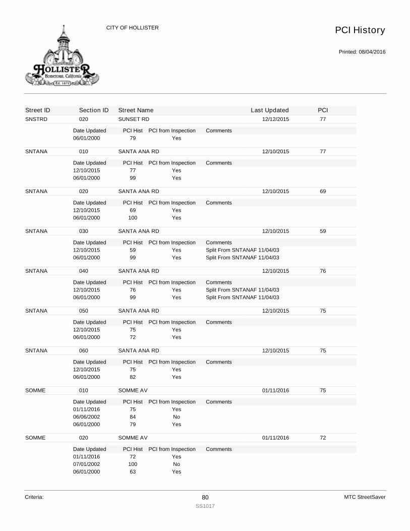
SNSTRD
Date Updated PCI Hist Comments
020 SUNSET RD 12/12/2015 77
PCI from Inspection06/01/2000 79 Yes
SNTANA
Date Updated PCI Hist Comments
010 SANTA ANA RD 12/10/2015 77
PCI from Inspection12/10/2015 77 Yes06/01/2000 99 Yes
SNTANA
Date Updated PCI Hist Comments
020 SANTA ANA RD 12/10/2015 69
PCI from Inspection12/10/2015 69 Yes06/01/2000 100 Yes
SNTANA
Date Updated PCI Hist Comments
030 SANTA ANA RD 12/10/2015 59
PCI from Inspection12/10/2015 59 Split From SNTANAF 11/04/03Yes06/01/2000 99 Split From SNTANAF 11/04/03Yes
SNTANA
Date Updated PCI Hist Comments
040 SANTA ANA RD 12/10/2015 76
PCI from Inspection12/10/2015 76 Split From SNTANAF 11/04/03Yes06/01/2000 99 Split From SNTANAF 11/04/03Yes
SNTANA
Date Updated PCI Hist Comments
050 SANTA ANA RD 12/10/2015 75
PCI from Inspection12/10/2015 75 Yes06/01/2000 72 Yes
SNTANA
Date Updated PCI Hist Comments
060 SANTA ANA RD 12/10/2015 75
PCI from Inspection12/10/2015 75 Yes06/01/2000 82 Yes
SOMME
Date Updated PCI Hist Comments
010 SOMME AV 01/11/2016 75
PCI from Inspection01/11/2016 75 Yes06/06/2002 84 No06/01/2000 79 Yes
SOMME
Date Updated PCI Hist Comments
020 SOMME AV 01/11/2016 72
PCI from Inspection01/11/2016 72 Yes07/01/2002 100 No06/01/2000 63 Yes
PCI History
Printed: 08/04/2016
CITY OF HOLLISTER
Street ID Section ID Street Name Last Updated PCI
Criteria: 80SS1017
MTC StreetSaver
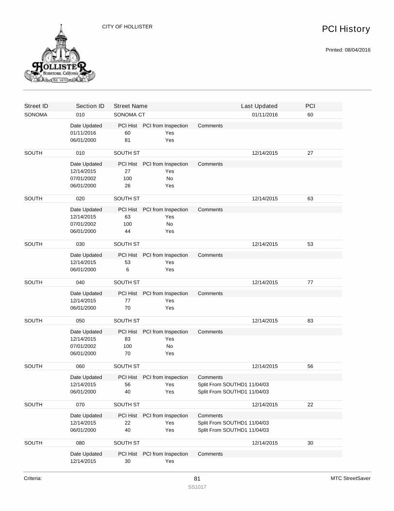
SONOMA
Date Updated PCI Hist Comments
010 SONOMA CT 01/11/2016 60
PCI from Inspection01/11/2016 60 Yes06/01/2000 81 Yes
SOUTH
Date Updated PCI Hist Comments
010 SOUTH ST 12/14/2015 27
PCI from Inspection12/14/2015 27 Yes07/01/2002 100 No06/01/2000 26 Yes
SOUTH
Date Updated PCI Hist Comments
020 SOUTH ST 12/14/2015 63
PCI from Inspection12/14/2015 63 Yes07/01/2002 100 No06/01/2000 44 Yes
SOUTH
Date Updated PCI Hist Comments
030 SOUTH ST 12/14/2015 53
PCI from Inspection12/14/2015 53 Yes06/01/2000 6 Yes
SOUTH
Date Updated PCI Hist Comments
040 SOUTH ST 12/14/2015 77
PCI from Inspection12/14/2015 77 Yes06/01/2000 70 Yes
SOUTH
Date Updated PCI Hist Comments
050 SOUTH ST 12/14/2015 83
PCI from Inspection12/14/2015 83 Yes07/01/2002 100 No06/01/2000 70 Yes
SOUTH
Date Updated PCI Hist Comments
060 SOUTH ST 12/14/2015 56
PCI from Inspection12/14/2015 56 Split From SOUTHD1 11/04/03Yes06/01/2000 40 Split From SOUTHD1 11/04/03Yes
SOUTH
Date Updated PCI Hist Comments
070 SOUTH ST 12/14/2015 22
PCI from Inspection12/14/2015 22 Split From SOUTHD1 11/04/03Yes06/01/2000 40 Split From SOUTHD1 11/04/03Yes
SOUTH
Date Updated PCI Hist Comments
080 SOUTH ST 12/14/2015 30
PCI from Inspection12/14/2015 30 Yes
PCI History
Printed: 08/04/2016
CITY OF HOLLISTER
Street ID Section ID Street Name Last Updated PCI
Criteria: 81SS1017
MTC StreetSaver

SOUTH
Date Updated PCI Hist Comments
080 SOUTH ST 12/14/2015 40
PCI from Inspection06/01/2000 53 Yes
SOUTH
Date Updated PCI Hist Comments
090 SOUTH ST 12/14/2015 40
PCI from Inspection12/14/2015 40 Yes06/01/2000 56 Yes
SPRING
Date Updated PCI Hist Comments
010 SPRING DR 12/14/2015 73
PCI from Inspection12/14/2015 73 Yes06/01/2000 82 Yes
SPRING
Date Updated PCI Hist Comments
020 SPRING DR 12/14/2015 73
PCI from Inspection12/14/2015 73 Yes06/05/2002 86 No06/01/2000 81 Yes
SPRUCE
Date Updated PCI Hist Comments
010 SPRUCE DR 01/11/2016 73
PCI from Inspection01/11/2016 73 Yes06/01/2000 82 Yes
SPRUCE
Date Updated PCI Hist Comments
020 SPRUCE DR 01/11/2016 80
PCI from Inspection01/11/2016 80 Yes
SQUIRE
Date Updated PCI Hist Comments
010 SQUIRE CT 12/16/2015 24
PCI from Inspection12/16/2015 24 Yes06/05/2002 79 No06/01/2000 73 Yes
SRIDGE
Date Updated PCI Hist Comments
010 SOUTH RIDGE DR 12/12/2015 75
PCI from Inspection12/12/2015 75 Yes06/05/2002 80 No06/01/2000 75 Yes
STEINB
Date Updated PCI Hist Comments
010 STEINBECK DR 12/14/2015 70
PCI from Inspection12/14/2015 70 Yes06/05/2002 87 No06/01/2000 83 Yes
PCI History
Printed: 08/04/2016
CITY OF HOLLISTER
Street ID Section ID Street Name Last Updated PCI
Criteria: 82SS1017
MTC StreetSaver

STEINB
Date Updated PCI Hist Comments
020 STEINBECK DR 12/14/2015 70
PCI from Inspection12/14/2015 70 Yes06/05/2002 87 No06/01/2000 83 Yes
STEPHA
Date Updated PCI Hist Comments
010 STEPHANIE CT 12/14/2015 70
PCI from Inspection12/14/2015 70 Yes06/05/2002 88 No06/01/2000 83 Yes
STHSID
Date Updated PCI Hist Comments
010 SOUTHSIDE RD 01/05/2016 100
PCI from Inspection01/05/2016 100 Yes
STHSID
Date Updated PCI Hist Comments
020 SOUTHSIDE RD 12/11/2015 71
PCI from Inspection12/11/2015 71 Yes10/29/2003 83 Yes
STHSID
Date Updated PCI Hist Comments
030 SOUTHSIDE RD 12/11/2015 72
PCI from Inspection12/11/2015 72 Yes10/29/2003 82 Yes
STHSID
Date Updated PCI Hist Comments
040 SOUTHSIDE RD 12/11/2015 73
PCI from Inspection12/11/2015 73 Yes10/29/2003 94 Yes
STHSID
Date Updated PCI Hist Comments
050 SOUTHSIDE RD 12/11/2015 82
PCI from Inspection12/11/2015 82 Yes10/29/2003 83 Yes
STONE
Date Updated PCI Hist Comments
010 STONE ALLEY 01/18/2016 9
PCI from Inspection01/18/2016 9 Yes06/01/2000 1 Yes
STONE
Date Updated PCI Hist Comments
020 STONE ALLEY 01/18/2016 10
PCI from Inspection01/18/2016 10 Yes06/01/2000 0 Yes
PCI History
Printed: 08/04/2016
CITY OF HOLLISTER
Street ID Section ID Street Name Last Updated PCI
Criteria: 83SS1017
MTC StreetSaver
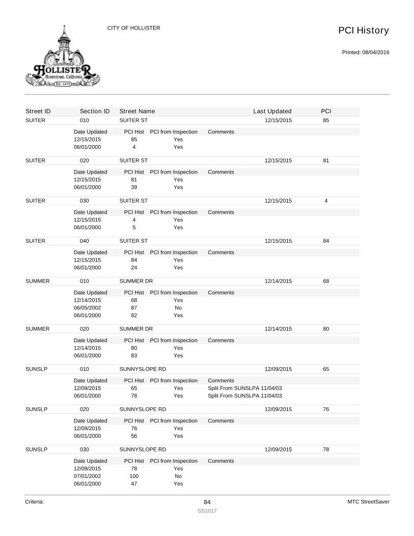
SUITER
Date Updated PCI Hist Comments
010 SUITER ST 12/15/2015 85
PCI from Inspection12/15/2015 85 Yes06/01/2000 4 Yes
SUITER
Date Updated PCI Hist Comments
020 SUITER ST 12/15/2015 81
PCI from Inspection12/15/2015 81 Yes06/01/2000 39 Yes
SUITER
Date Updated PCI Hist Comments
030 SUITER ST 12/15/2015 4
PCI from Inspection12/15/2015 4 Yes06/01/2000 5 Yes
SUITER
Date Updated PCI Hist Comments
040 SUITER ST 12/15/2015 84
PCI from Inspection12/15/2015 84 Yes06/01/2000 24 Yes
SUMMER
Date Updated PCI Hist Comments
010 SUMMER DR 12/14/2015 68
PCI from Inspection12/14/2015 68 Yes06/05/2002 87 No06/01/2000 82 Yes
SUMMER
Date Updated PCI Hist Comments
020 SUMMER DR 12/14/2015 80
PCI from Inspection12/14/2015 80 Yes06/01/2000 83 Yes
SUNSLP
Date Updated PCI Hist Comments
010 SUNNYSLOPE RD 12/09/2015 65
PCI from Inspection12/09/2015 65 Split From SUNSLPA 11/04/03Yes06/01/2000 78 Split From SUNSLPA 11/04/03Yes
SUNSLP
Date Updated PCI Hist Comments
020 SUNNYSLOPE RD 12/09/2015 76
PCI from Inspection12/09/2015 76 Yes06/01/2000 56 Yes
SUNSLP
Date Updated PCI Hist Comments
030 SUNNYSLOPE RD 12/09/2015 78
PCI from Inspection12/09/2015 78 Yes07/01/2002 100 No06/01/2000 47 Yes
PCI History
Printed: 08/04/2016
CITY OF HOLLISTER
Street ID Section ID Street Name Last Updated PCI
Criteria: 84SS1017
MTC StreetSaver
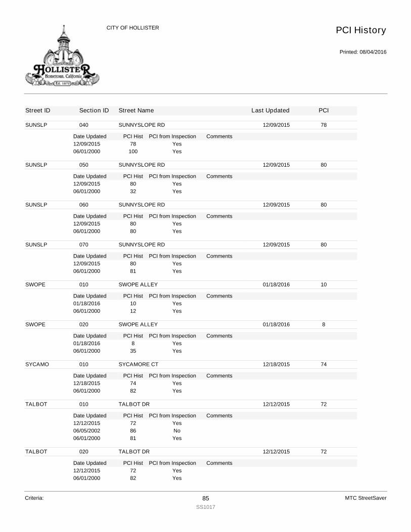
SUNSLP
Date Updated PCI Hist Comments
040 SUNNYSLOPE RD 12/09/2015 78
PCI from Inspection12/09/2015 78 Yes06/01/2000 100 Yes
SUNSLP
Date Updated PCI Hist Comments
050 SUNNYSLOPE RD 12/09/2015 80
PCI from Inspection12/09/2015 80 Yes06/01/2000 32 Yes
SUNSLP
Date Updated PCI Hist Comments
060 SUNNYSLOPE RD 12/09/2015 80
PCI from Inspection12/09/2015 80 Yes06/01/2000 80 Yes
SUNSLP
Date Updated PCI Hist Comments
070 SUNNYSLOPE RD 12/09/2015 80
PCI from Inspection12/09/2015 80 Yes06/01/2000 81 Yes
SWOPE
Date Updated PCI Hist Comments
010 SWOPE ALLEY 01/18/2016 10
PCI from Inspection01/18/2016 10 Yes06/01/2000 12 Yes
SWOPE
Date Updated PCI Hist Comments
020 SWOPE ALLEY 01/18/2016 8
PCI from Inspection01/18/2016 8 Yes06/01/2000 35 Yes
SYCAMO
Date Updated PCI Hist Comments
010 SYCAMORE CT 12/18/2015 74
PCI from Inspection12/18/2015 74 Yes06/01/2000 82 Yes
TALBOT
Date Updated PCI Hist Comments
010 TALBOT DR 12/12/2015 72
PCI from Inspection12/12/2015 72 Yes06/05/2002 86 No06/01/2000 81 Yes
TALBOT
Date Updated PCI Hist Comments
020 TALBOT DR 12/12/2015 72
PCI from Inspection12/12/2015 72 Yes06/01/2000 82 Yes
PCI History
Printed: 08/04/2016
CITY OF HOLLISTER
Street ID Section ID Street Name Last Updated PCI
Criteria: 85SS1017
MTC StreetSaver

TALBOT
Date Updated PCI Hist Comments
030 TALBOT DR 12/12/2015 80
PCI from Inspection12/12/2015 80 Yes10/29/2003 83 Yes
TAMARA
Date Updated PCI Hist Comments
010 TAMARA CT 12/14/2015 64
PCI from Inspection12/14/2015 64 Yes06/05/2002 88 No06/01/2000 83 Yes
TEAKWO
Date Updated PCI Hist Comments
010 TEAKWOOD CT 12/18/2015 67
PCI from Inspection12/18/2015 67 Yes06/06/2002 87 No06/01/2000 83 Yes
TECHNO
Date Updated PCI Hist Comments
010 TECHNOLOGY PKWY 12/11/2015 76
PCI from Inspection12/11/2015 76 Yes06/01/2000 40 Yes
TECHNO
Date Updated PCI Hist Comments
020 TECHNOLOGY PKWY 12/11/2015 69
PCI from Inspection12/11/2015 69 Yes06/05/2002 84 No06/01/2000 81 Yes
TERESC
Date Updated PCI Hist Comments
010 TERESITA CT 12/11/2015 56
PCI from Inspection12/11/2015 56 Yes06/05/2002 81 No06/01/2000 75 Yes
TERRAC
Date Updated PCI Hist Comments
010 TERRACE DR 12/18/2015 61
PCI from Inspection12/18/2015 61 Yes06/05/2002 83 No06/01/2000 78 Yes
THIRD
Date Updated PCI Hist Comments
010 THIRD ST 12/16/2015 75
PCI from Inspection12/16/2015 75 Yes07/01/2002 100 No06/01/2000 46 Yes
PCI History
Printed: 08/04/2016
CITY OF HOLLISTER
Street ID Section ID Street Name Last Updated PCI
Criteria: 86SS1017
MTC StreetSaver

THIRD
Date Updated PCI Hist Comments
020 THIRD ST 01/12/2016 78
PCI from Inspection01/12/2016 78 Yes
THIRD
Date Updated PCI Hist Comments
030 THIRD ST 01/12/2016 78
PCI from Inspection01/12/2016 78 Yes
THIRD
Date Updated PCI Hist Comments
040 THIRD ST 12/16/2015 24
PCI from Inspection12/16/2015 24 Yes06/01/2000 17 Yes
THOMPS
Date Updated PCI Hist Comments
010 THOMPSON ST 12/16/2015 85
PCI from Inspection12/16/2015 85 Yes07/01/2002 100 No06/01/2000 51 Yes
TIBURN
Date Updated PCI Hist Comments
010 TIBURON DR 01/11/2016 67
PCI from Inspection01/11/2016 67 Yes06/05/2002 86 No06/01/2000 81 Yes
TIFFAN
Date Updated PCI Hist Comments
010 TIFFANY DR 12/16/2015 24
PCI from Inspection12/16/2015 24 Yes06/01/2000 13 Yes
TINADR
Date Updated PCI Hist Comments
010 TINA DR 12/12/2015 71
PCI from Inspection12/12/2015 71 Yes06/05/2002 85 No06/01/2000 80 Yes
TOROPL
Date Updated PCI Hist Comments
010 TORO PLZ 12/17/2015 48
PCI from Inspection12/17/2015 48 Yes06/06/2002 84 No06/01/2000 79 Yes
TOWNE
Date Updated PCI Hist Comments
010 TOWNE ALLEY 01/12/2016 75
PCI from Inspection01/12/2016 75 Yes06/01/2000 5 Yes
PCI History
Printed: 08/04/2016
CITY OF HOLLISTER
Street ID Section ID Street Name Last Updated PCI
Criteria: 87SS1017
MTC StreetSaver
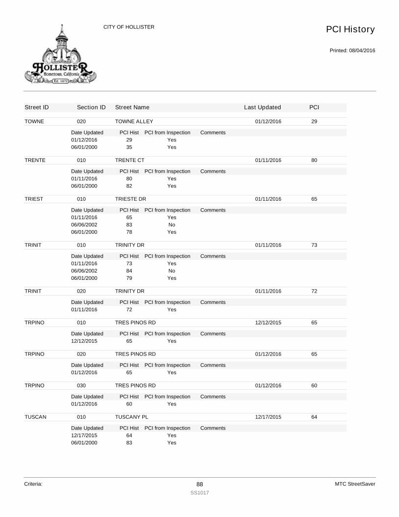
TOWNE
Date Updated PCI Hist Comments
020 TOWNE ALLEY 01/12/2016 29
PCI from Inspection01/12/2016 29 Yes06/01/2000 35 Yes
TRENTE
Date Updated PCI Hist Comments
010 TRENTE CT 01/11/2016 80
PCI from Inspection01/11/2016 80 Yes06/01/2000 82 Yes
TRIEST
Date Updated PCI Hist Comments
010 TRIESTE DR 01/11/2016 65
PCI from Inspection01/11/2016 65 Yes06/06/2002 83 No06/01/2000 78 Yes
TRINIT
Date Updated PCI Hist Comments
010 TRINITY DR 01/11/2016 73
PCI from Inspection01/11/2016 73 Yes06/06/2002 84 No06/01/2000 79 Yes
TRINIT
Date Updated PCI Hist Comments
020 TRINITY DR 01/11/2016 72
PCI from Inspection01/11/2016 72 Yes
TRPINO
Date Updated PCI Hist Comments
010 TRES PINOS RD 12/12/2015 65
PCI from Inspection12/12/2015 65 Yes
TRPINO
Date Updated PCI Hist Comments
020 TRES PINOS RD 01/12/2016 65
PCI from Inspection01/12/2016 65 Yes
TRPINO
Date Updated PCI Hist Comments
030 TRES PINOS RD 01/12/2016 60
PCI from Inspection01/12/2016 60 Yes
TUSCAN
Date Updated PCI Hist Comments
010 TUSCANY PL 12/17/2015 64
PCI from Inspection12/17/2015 64 Yes06/01/2000 83 Yes
PCI History
Printed: 08/04/2016
CITY OF HOLLISTER
Street ID Section ID Street Name Last Updated PCI
Criteria: 88SS1017
MTC StreetSaver

UNION
Date Updated PCI Hist Comments
010 UNION RD 01/11/2016 68
PCI from Inspection01/11/2016 68 Yes06/05/2002 84 No06/01/2000 81 Yes
UNION
Date Updated PCI Hist Comments
020 UNION RD 01/11/2016 78
PCI from Inspection01/11/2016 78 Yes06/01/2000 99 Yes
UNION
Date Updated PCI Hist Comments
030 UNION RD 01/11/2016 79
PCI from Inspection01/11/2016 79 Yes06/05/2002 82 No06/01/2000 78 Yes
UNION
Date Updated PCI Hist Comments
040 UNION RD 01/11/2016 76
PCI from Inspection01/11/2016 76 Yes
UNION
Date Updated PCI Hist Comments
050 UNION RD 01/11/2016 69
PCI from Inspection01/11/2016 69 Yes06/05/2002 80 No06/01/2000 77 Yes
VALIWY
Date Updated PCI Hist Comments
010 VALI WAY 12/15/2015 83
PCI from Inspection12/15/2015 83 Yes06/01/2000 100 Yes
VALLEJ
Date Updated PCI Hist Comments
010 VALLEJO DR 01/11/2016 47
PCI from Inspection01/11/2016 47 Yes06/01/2000 60 Yes
VALLEJ
Date Updated PCI Hist Comments
020 VALLEJO DR 01/11/2016 59
PCI from Inspection01/11/2016 59 Yes06/05/2002 82 No06/01/2000 77 Yes
VALLEJ
Date Updated PCI Hist Comments
030 VALLEJO DR 01/18/2016 72
PCI from Inspection01/18/2016 72 Yes
PCI History
Printed: 08/04/2016
CITY OF HOLLISTER
Street ID Section ID Street Name Last Updated PCI
Criteria: 89SS1017
MTC StreetSaver

VALONI
Date Updated PCI Hist Comments
010 VALONIA WY 03/10/2016 80
PCI from Inspection03/10/2016 80 No12/10/2015 78 Yes06/01/2000 100 Yes
VALVEW
Date Updated PCI Hist Comments
010 VALLEY VIEW RD 01/11/2016 80
PCI from Inspection01/11/2016 80 Yes06/01/2000 34 Yes
VALVEW
Date Updated PCI Hist Comments
020 VALLEY VIEW RD 01/11/2016 76
PCI from Inspection01/11/2016 76 Yes06/01/2000 30 Yes
VALVEW
Date Updated PCI Hist Comments
030 VALLEY VIEW RD 01/11/2016 76
PCI from Inspection01/11/2016 76 Yes06/01/2000 25 Yes
VALVEW
Date Updated PCI Hist Comments
040 VALLEY VIEW RD 01/11/2016 35
PCI from Inspection01/11/2016 35 Yes06/05/2002 84 No06/01/2000 81 Yes
VALVEW
Date Updated PCI Hist Comments
050 VALLEY VIEW RD 01/11/2016 84
PCI from Inspection01/11/2016 84 Yes
VALVEW
Date Updated PCI Hist Comments
060 VALLEY VIEW RD 01/11/2016 66
PCI from Inspection01/11/2016 66 Yes06/05/2002 84 No06/01/2000 81 Yes
VALVEW
Date Updated PCI Hist Comments
070 VALLEY VIEW RD 01/11/2016 67
PCI from Inspection01/11/2016 67 Yes
VALVEW
Date Updated PCI Hist Comments
080 VALLEY VIEW RD 01/11/2016 80
PCI from Inspection01/11/2016 80 Yes06/01/2000 98 Yes
PCI History
Printed: 08/04/2016
CITY OF HOLLISTER
Street ID Section ID Street Name Last Updated PCI
Criteria: 90SS1017
MTC StreetSaver
VCTRYD
Date Updated PCI Hist Comments
010 VICTORY DR 01/11/2016 80
PCI from Inspection01/11/2016 80 Yes06/01/2000 99 Yes
VELLAD
Date Updated PCI Hist Comments
010 VELLADO DR 12/16/2015 56
PCI from Inspection12/16/2015 56 Split From VELLADA 11/04/03Yes06/01/2000 80 Split From VELLADA 11/04/03Yes
VENTAN
Date Updated PCI Hist Comments
010 VENTANA CT 01/18/2016 80
PCI from Inspection01/18/2016 80 Yes10/29/2003 83 Yes
VENTUR
Date Updated PCI Hist Comments
010 VENTURA CT 12/11/2015 53
PCI from Inspection12/11/2015 53 Yes06/01/2000 83 Yes
VERDE
Date Updated PCI Hist Comments
010 VERDE CR 12/10/2015 15
PCI from Inspection12/10/2015 15 Yes06/01/2000 11 Yes
VERDNCT
Date Updated PCI Hist Comments
010 VERDUN CT 01/11/2016 80
PCI from Inspection01/11/2016 80 Yes06/01/2000 100 Yes
VERDUN
Date Updated PCI Hist Comments
010 VERDUN AV 01/11/2016 73
PCI from Inspection01/11/2016 73 Yes06/01/2000 99 Yes
VERDUN
Date Updated PCI Hist Comments
020 VERDUN AV 01/11/2016 59
PCI from Inspection01/11/2016 59 Yes06/01/2000 40 Yes
VERDUN
Date Updated PCI Hist Comments
030 VERDUN AV 01/11/2016 20
PCI from Inspection01/11/2016 20 Yes
PCI History
Printed: 08/04/2016
CITY OF HOLLISTER
Street ID Section ID Street Name Last Updated PCI
Criteria: 91SS1017
MTC StreetSaver
VERONA
Date Updated PCI Hist Comments
010 VERONA PL 12/17/2015 67
PCI from Inspection12/17/2015 67 Yes06/06/2002 87 No06/01/2000 83 Yes
VERSAI
Date Updated PCI Hist Comments
010 VERSAILLES DR 01/11/2016 70
PCI from Inspection01/11/2016 70 Yes06/06/2002 87 No06/01/2000 82 Yes
VERSAI
Date Updated PCI Hist Comments
020 VERSAILLES DR 01/11/2016 60
PCI from Inspection01/11/2016 60 Yes06/06/2002 86 No06/01/2000 81 Yes
VERSAI
Date Updated PCI Hist Comments
030 VERSAILLES DR 01/11/2016 57
PCI from Inspection01/11/2016 57 Yes06/06/2002 80 No06/01/2000 74 Yes
VERSAI
Date Updated PCI Hist Comments
040 VERSAILLES DR 01/11/2016 80
PCI from Inspection01/11/2016 80 Yes06/01/2000 99 Yes
VICTOR
Date Updated PCI Hist Comments
010 VICTORIA AV 12/15/2015 23
PCI from Inspection12/15/2015 23 Yes06/01/2000 30 Yes
VICTOR
Date Updated PCI Hist Comments
020 VICTORIA AV 01/18/2016 17
PCI from Inspection01/18/2016 17 Yes
VILLAG
Date Updated PCI Hist Comments
010 VILLAGE CT 01/11/2016 78
PCI from Inspection01/11/2016 78 Yes06/01/2000 36 Yes
VINEST
Date Updated PCI Hist Comments
010 VINE ST 12/15/2015 83
PCI from Inspection12/15/2015 83 Yes
PCI History
Printed: 08/04/2016
CITY OF HOLLISTER
Street ID Section ID Street Name Last Updated PCI
Criteria: 92SS1017
MTC StreetSaver
VINEST
Date Updated PCI Hist Comments
010 VINE ST 12/15/2015 67
PCI from Inspection06/01/2000 23 Yes
VINTAG
Date Updated PCI Hist Comments
010 VINTAGE WAY 12/17/2015 67
PCI from Inspection12/17/2015 67 Yes06/01/2000 83 Yes
VIRGIN
Date Updated PCI Hist Comments
010 VIRGINIA DR 12/15/2015 54
PCI from Inspection12/15/2015 54 Yes06/01/2000 100 Yes
VISTAL
Date Updated PCI Hist Comments
010 VISTA LN 12/11/2015 51
PCI from Inspection12/11/2015 51 Yes06/01/2000 57 Yes
VRSSMO
Date Updated PCI Hist Comments
010 VERISSIMO 12/16/2015 100
PCI from Inspection12/16/2015 100 Yes
WALNLN
Date Updated PCI Hist Comments
010 WALNUT LN 12/15/2015 83
PCI from Inspection12/15/2015 83 Yes06/01/2000 11 Yes
WASHIN
Date Updated PCI Hist Comments
010 WASHINGTON AV 12/16/2015 12
PCI from Inspection12/16/2015 12 Yes06/01/2000 21 Yes
WENTZ
Date Updated PCI Hist Comments
010 WENTZ ALLEY 01/18/2016 7
PCI from Inspection01/18/2016 7 Yes06/01/2000 3 Yes
WENTZ
Date Updated PCI Hist Comments
020 WENTZ ALLEY 01/18/2016 13
PCI from Inspection01/18/2016 13 Yes06/01/2000 0 Yes
WENTZ
Date Updated PCI Hist Comments
030 WENTZ ALLEY 01/18/2016 14
PCI from Inspection01/18/2016 14 Yes
PCI History
Printed: 08/04/2016
CITY OF HOLLISTER
Street ID Section ID Street Name Last Updated PCI
Criteria: 93SS1017
MTC StreetSaver

WENTZ
Date Updated PCI Hist Comments
030 WENTZ ALLEY 01/18/2016 28
PCI from Inspection06/01/2000 59 Yes
WENTZ
Date Updated PCI Hist Comments
040 WENTZ ALLEY 01/18/2016 28
PCI from Inspection01/18/2016 28 Yes
WENTZ
Date Updated PCI Hist Comments
050 WENTZ ALLEY 01/18/2016 19
PCI from Inspection01/18/2016 19 Yes06/01/2000 13 Yes
WESTER
Date Updated PCI Hist Comments
010 WESTERN CT 12/11/2015 70
PCI from Inspection12/11/2015 70 Yes06/05/2002 86 No06/01/2000 81 Yes
WESTSD
Date Updated PCI Hist Comments
010 WESTSIDE BL 12/11/2015 70
PCI from Inspection12/11/2015 70 Yes06/01/2000 61 Yes
WESTSD
Date Updated PCI Hist Comments
020 WESTSIDE BL 12/11/2015 66
PCI from Inspection12/11/2015 66 Yes10/17/2003 100 Yes
WESTSD
Date Updated PCI Hist Comments
030 WESTSIDE BL 12/11/2015 59
PCI from Inspection12/11/2015 59 Yes10/17/2003 100 Yes
WESTSD
Date Updated PCI Hist Comments
040 WESTSIDE BL 12/11/2015 52
PCI from Inspection12/11/2015 52 Yes10/17/2003 100 Yes
WESTSD
Date Updated PCI Hist Comments
050 WESTSIDE BL 12/11/2015 55
PCI from Inspection12/11/2015 55 Yes06/01/2000 83 Yes
PCI History
Printed: 08/04/2016
CITY OF HOLLISTER
Street ID Section ID Street Name Last Updated PCI
Criteria: 94SS1017
MTC StreetSaver
WESTSD
Date Updated PCI Hist Comments
060 WESTSIDE BL 12/11/2015 67
PCI from Inspection12/11/2015 67 Yes06/01/2000 83 Yes
WESTSD
Date Updated PCI Hist Comments
070 WESTSIDE BL 12/11/2015 66
PCI from Inspection12/11/2015 66 Yes10/17/2003 100 Yes
WESTSD
Date Updated PCI Hist Comments
080 WESTSIDE BL 12/11/2015 82
PCI from Inspection12/11/2015 82 Yes06/01/2000 83 Yes
WESTSD
Date Updated PCI Hist Comments
090 WESTSIDE BL 12/11/2015 56
PCI from Inspection12/11/2015 56 Yes06/01/2000 83 Yes
WESTSD
Date Updated PCI Hist Comments
100 WESTSIDE BL 12/11/2015 75
PCI from Inspection12/11/2015 75 Split From WESTSDA1 10/20/03Yes06/05/2002 85 Split From WESTSDA1 10/20/03No06/01/2000 80 Split From WESTSDA1 10/20/03Yes06/01/2000 80 Split From WESTSDA1 10/20/03Yes
WESTST
Date Updated PCI Hist Comments
010 WEST ST 12/15/2015 22
PCI from Inspection12/15/2015 22 Yes06/01/2000 9 Yes
WESTST
Date Updated PCI Hist Comments
020 WEST ST 12/15/2015 24
PCI from Inspection12/15/2015 24 Yes06/01/2000 20 Yes
WESTST
Date Updated PCI Hist Comments
030 WEST ST 01/12/2016 20
PCI from Inspection01/12/2016 20 Yes
WESTST
Date Updated PCI Hist Comments
040 WEST ST 01/12/2016 20
PCI from Inspection01/12/2016 20 Yes
PCI History
Printed: 08/04/2016
CITY OF HOLLISTER
Street ID Section ID Street Name Last Updated PCI
Criteria: 95SS1017
MTC StreetSaver

WESTST
Date Updated PCI Hist Comments
050 WEST ST 12/15/2015 49
PCI from Inspection12/15/2015 49 Yes06/01/2000 37 Yes
WESTST
Date Updated PCI Hist Comments
060 WEST ST 12/15/2015 39
PCI from Inspection12/15/2015 39 Yes06/01/2000 60 Yes
WESTST
Date Updated PCI Hist Comments
070 WEST ST 12/15/2015 43
PCI from Inspection12/15/2015 43 Yes06/05/2002 81 No06/01/2000 78 Yes
WGRAFR
Date Updated PCI Hist Comments
010 WEST GRAF RD 03/10/2016 82
PCI from Inspection03/10/2016 82 No12/10/2015 81 Yes06/01/2000 100 Yes
WGRAFR
Date Updated PCI Hist Comments
020 WEST GRAF RD 03/10/2016 85
PCI from Inspection03/10/2016 85 No12/10/2015 84 Yes06/01/2000 100 Yes
WIEBE
Date Updated PCI Hist Comments
010 WIEBE ST 12/15/2015 32
PCI from Inspection12/15/2015 32 Yes06/01/2000 17 Yes
WIEBE
Date Updated PCI Hist Comments
020 WIEBE ST 01/12/2016 35
PCI from Inspection01/12/2016 35 Yes
WILLOW
Date Updated PCI Hist Comments
010 WILLOW DR 12/10/2015 38
PCI from Inspection12/10/2015 38 Yes06/01/2000 17 Yes
WILMA
Date Updated PCI Hist Comments
010 WILMA DR 12/14/2015 74
PCI from Inspection12/14/2015 74 Yes06/05/2002 86 No
PCI History
Printed: 08/04/2016
CITY OF HOLLISTER
Street ID Section ID Street Name Last Updated PCI
Criteria: 96SS1017
MTC StreetSaver

WILMA
Date Updated PCI Hist Comments
010 WILMA DR 12/14/2015 76
PCI from Inspection06/01/2000 81 Yes
WINDSO
Date Updated PCI Hist Comments
010 WINDSOR CT 12/18/2015 76
PCI from Inspection12/18/2015 76 Yes06/01/2000 82 Yes
WOODCT
Date Updated PCI Hist Comments
010 WOOD CT 12/15/2015 43
PCI from Inspection12/15/2015 43 Yes06/05/2002 78 No06/01/2000 72 Yes
WRIGHT
Date Updated PCI Hist Comments
010 WRIGHT RD 12/11/2015 32
PCI from Inspection12/11/2015 32 Yes06/01/2000 3 Yes
WSECON
Date Updated PCI Hist Comments
010 WEST SECOND ST 12/16/2015 81
PCI from Inspection12/16/2015 81 Yes06/01/2000 17 Yes
WSTURD
Date Updated PCI Hist Comments
010 WESTWARD DR 01/11/2016 67
PCI from Inspection01/11/2016 67 Yes06/01/2000 26 Yes
WSTURD
Date Updated PCI Hist Comments
020 WESTWARD DR 01/11/2016 81
PCI from Inspection01/11/2016 81 Yes06/01/2000 11 Yes
YARROW
Date Updated PCI Hist Comments
010 YARROW ST 01/11/2016 80
PCI from Inspection01/11/2016 80 Yes06/01/2000 82 Yes
YARROW
Date Updated PCI Hist Comments
020 YARROW ST 01/11/2016 80
PCI from Inspection01/11/2016 80 Yes06/01/2000 98 Yes
PCI History
Printed: 08/04/2016
CITY OF HOLLISTER
Street ID Section ID Street Name Last Updated PCI
Criteria: 97SS1017
MTC StreetSaver
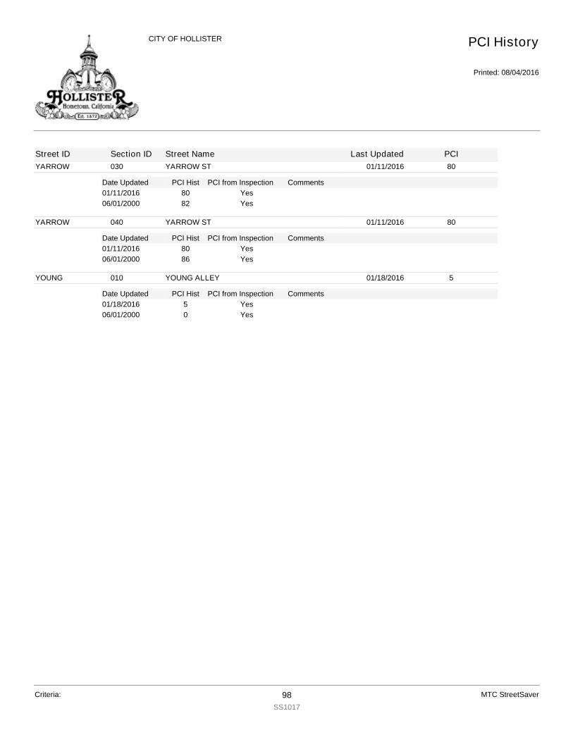
YARROW
Date Updated PCI Hist Comments
030 YARROW ST 01/11/2016 80
PCI from Inspection01/11/2016 80 Yes06/01/2000 82 Yes
YARROW
Date Updated PCI Hist Comments
040 YARROW ST 01/11/2016 80
PCI from Inspection01/11/2016 80 Yes06/01/2000 86 Yes
YOUNG
Date Updated PCI Hist Comments
010 YOUNG ALLEY 01/18/2016 5
PCI from Inspection01/18/2016 5 Yes06/01/2000 0 Yes
PCI History
Printed: 08/04/2016
CITY OF HOLLISTER
Street ID Section ID Street Name Last Updated PCI
Criteria: 98SS1017
MTC StreetSaver
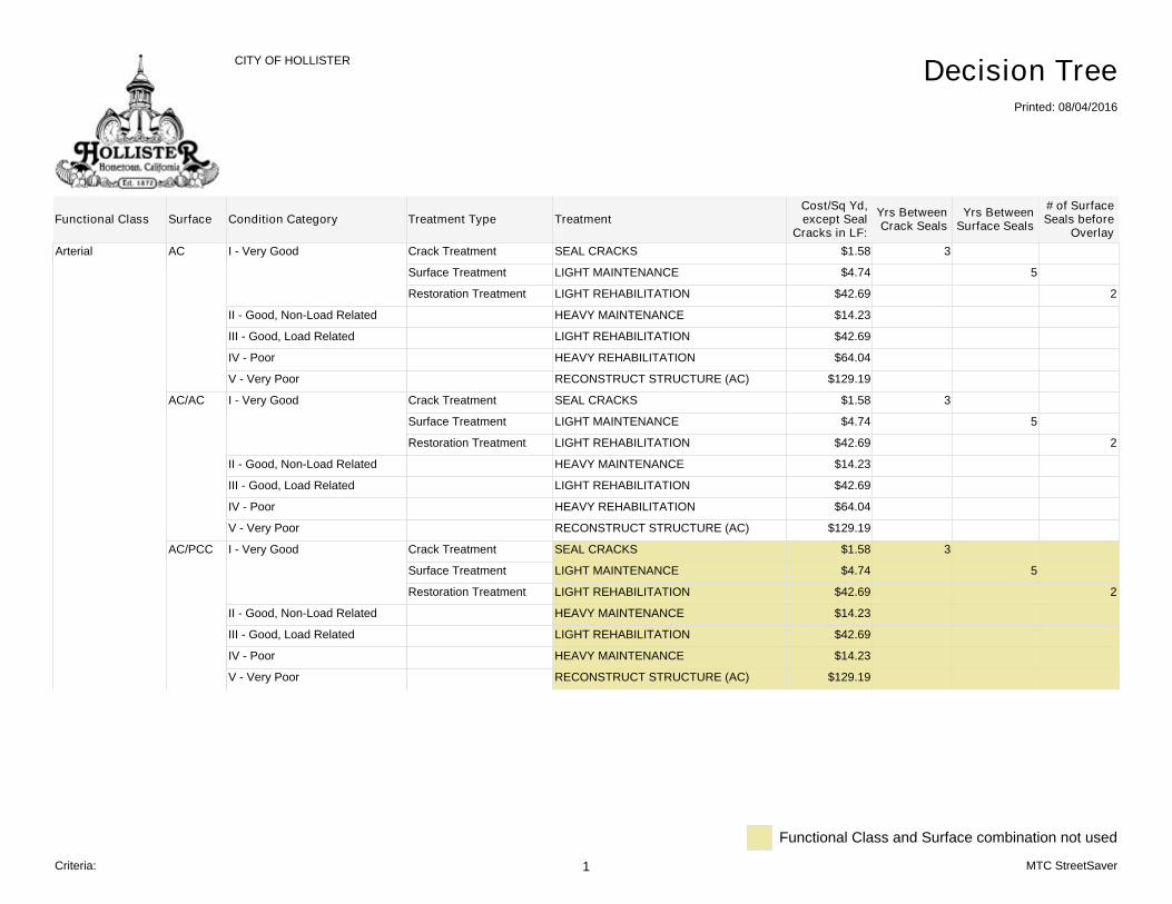
Arterial AC I - Very Good Crack Treatment SEAL CRACKS $1.58 3
Surface Treatment LIGHT MAINTENANCE $4.74 5
Restoration Treatment LIGHT REHABILITATION $42.69 2
II - Good, Non-Load Related HEAVY MAINTENANCE $14.23
III - Good, Load Related LIGHT REHABILITATION $42.69
IV - Poor HEAVY REHABILITATION $64.04
V - Very Poor RECONSTRUCT STRUCTURE (AC) $129.19
AC/AC I - Very Good Crack Treatment SEAL CRACKS $1.58 3
Surface Treatment LIGHT MAINTENANCE $4.74 5
Restoration Treatment LIGHT REHABILITATION $42.69 2
II - Good, Non-Load Related HEAVY MAINTENANCE $14.23
III - Good, Load Related LIGHT REHABILITATION $42.69
IV - Poor HEAVY REHABILITATION $64.04
V - Very Poor RECONSTRUCT STRUCTURE (AC) $129.19
AC/PCC I - Very Good Crack Treatment SEAL CRACKS $1.58 3
Surface Treatment LIGHT MAINTENANCE $4.74 5
Restoration Treatment LIGHT REHABILITATION $42.69 2
II - Good, Non-Load Related HEAVY MAINTENANCE $14.23
III - Good, Load Related LIGHT REHABILITATION $42.69
IV - Poor HEAVY MAINTENANCE $14.23
V - Very Poor RECONSTRUCT STRUCTURE (AC) $129.19
# of SurfaceSeals before
OverlayFunctional Class
CITY OF HOLLISTER
Printed: 08/04/2016
Decision Tree
Surface Condition Category Treatment Type Treatment Yrs BetweenCrack Seals
Yrs BetweenSurface Seals
Cost/Sq Yd,except Seal
Cracks in LF:
Functional Class and Surface combination not used
Criteria: 1 MTC StreetSaver
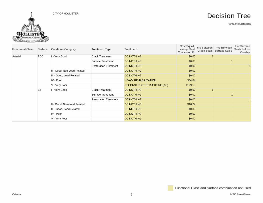
Arterial PCC I - Very Good Crack Treatment DO NOTHING $0.00 1
Surface Treatment DO NOTHING $0.00 1
Restoration Treatment DO NOTHING $0.00 1
II - Good, Non-Load Related DO NOTHING $0.00
III - Good, Load Related DO NOTHING $0.00
IV - Poor HEAVY REHABILITATION $64.04
V - Very Poor RECONSTRUCT STRUCTURE (AC) $129.19
ST I - Very Good Crack Treatment DO NOTHING $0.00 1
Surface Treatment DO NOTHING $0.00 1
Restoration Treatment DO NOTHING $0.00 1
II - Good, Non-Load Related DO NOTHING $16.24
III - Good, Load Related DO NOTHING $0.00
IV - Poor DO NOTHING $0.00
V - Very Poor DO NOTHING $0.00
# of SurfaceSeals before
OverlayFunctional Class
CITY OF HOLLISTER
Printed: 08/04/2016
Decision Tree
Surface Condition Category Treatment Type Treatment Yrs BetweenCrack Seals
Yrs BetweenSurface Seals
Cost/Sq Yd,except Seal
Cracks in LF:
Functional Class and Surface combination not used
Criteria: 2 MTC StreetSaver
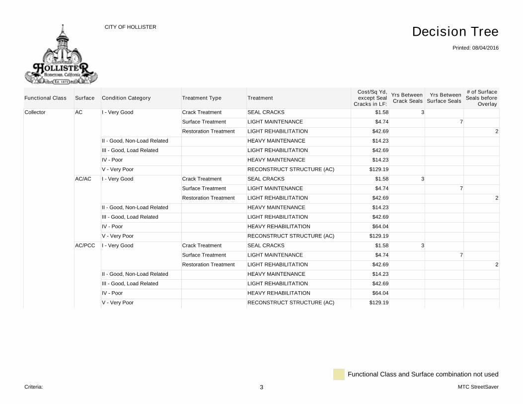
Collector AC I - Very Good Crack Treatment SEAL CRACKS $1.58 3
Surface Treatment LIGHT MAINTENANCE $4.74 7
Restoration Treatment LIGHT REHABILITATION $42.69 2
II - Good, Non-Load Related HEAVY MAINTENANCE $14.23
III - Good, Load Related LIGHT REHABILITATION $42.69
IV - Poor HEAVY MAINTENANCE $14.23
V - Very Poor RECONSTRUCT STRUCTURE (AC) $129.19
AC/AC I - Very Good Crack Treatment SEAL CRACKS $1.58 3
Surface Treatment LIGHT MAINTENANCE $4.74 7
Restoration Treatment LIGHT REHABILITATION $42.69 2
II - Good, Non-Load Related HEAVY MAINTENANCE $14.23
III - Good, Load Related LIGHT REHABILITATION $42.69
IV - Poor HEAVY REHABILITATION $64.04
V - Very Poor RECONSTRUCT STRUCTURE (AC) $129.19
AC/PCC I - Very Good Crack Treatment SEAL CRACKS $1.58 3
Surface Treatment LIGHT MAINTENANCE $4.74 7
Restoration Treatment LIGHT REHABILITATION $42.69 2
II - Good, Non-Load Related HEAVY MAINTENANCE $14.23
III - Good, Load Related LIGHT REHABILITATION $42.69
IV - Poor HEAVY REHABILITATION $64.04
V - Very Poor RECONSTRUCT STRUCTURE (AC) $129.19
# of SurfaceSeals before
OverlayFunctional Class
CITY OF HOLLISTER
Printed: 08/04/2016
Decision Tree
Surface Condition Category Treatment Type Treatment Yrs BetweenCrack Seals
Yrs BetweenSurface Seals
Cost/Sq Yd,except Seal
Cracks in LF:
Functional Class and Surface combination not used
Criteria: 3 MTC StreetSaver

Collector PCC I - Very Good Crack Treatment DO NOTHING $0.00 1
Surface Treatment DO NOTHING $0.00 1
Restoration Treatment DO NOTHING $0.00 1
II - Good, Non-Load Related DO NOTHING $0.00
III - Good, Load Related DO NOTHING $0.00
IV - Poor HEAVY MAINTENANCE $14.23
V - Very Poor RECONSTRUCT STRUCTURE (AC) $129.19
ST I - Very Good Crack Treatment DO NOTHING $0.00 1
Surface Treatment DO NOTHING $0.00 5
Restoration Treatment DO NOTHING $0.00 1
II - Good, Non-Load Related DO NOTHING $0.00
III - Good, Load Related DO NOTHING $0.00
IV - Poor DO NOTHING $0.00
V - Very Poor DO NOTHING $0.00
# of SurfaceSeals before
OverlayFunctional Class
CITY OF HOLLISTER
Printed: 08/04/2016
Decision Tree
Surface Condition Category Treatment Type Treatment Yrs BetweenCrack Seals
Yrs BetweenSurface Seals
Cost/Sq Yd,except Seal
Cracks in LF:
Functional Class and Surface combination not used
Criteria: 4 MTC StreetSaver

Residential/Local AC I - Very Good Crack Treatment SEAL CRACKS $1.58 3
Surface Treatment LIGHT MAINTENANCE $3.56 9
Restoration Treatment LIGHT REHABILITATION $32.73 2
II - Good, Non-Load Related HEAVY MAINTENANCE $14.23
III - Good, Load Related LIGHT REHABILITATION $32.73
IV - Poor HEAVY REHABILITATION $49.81
V - Very Poor RECONSTRUCT STRUCTURE (AC) $85.25
AC/AC I - Very Good Crack Treatment SEAL CRACKS $1.58 3
Surface Treatment LIGHT MAINTENANCE $3.56 9
Restoration Treatment LIGHT REHABILITATION $32.73 2
II - Good, Non-Load Related HEAVY MAINTENANCE $14.23
III - Good, Load Related LIGHT REHABILITATION $32.73
IV - Poor HEAVY REHABILITATION $49.81
V - Very Poor RECONSTRUCT STRUCTURE (AC) $85.25
AC/PCC I - Very Good Crack Treatment SEAL CRACKS $1.58 3
Surface Treatment LIGHT MAINTENANCE $3.56 9
Restoration Treatment LIGHT REHABILITATION $32.73 2
II - Good, Non-Load Related HEAVY MAINTENANCE $14.23
III - Good, Load Related LIGHT REHABILITATION $32.73
IV - Poor HEAVY REHABILITATION $49.81
V - Very Poor RECONSTRUCT STRUCTURE (AC) $85.25
# of SurfaceSeals before
OverlayFunctional Class
CITY OF HOLLISTER
Printed: 08/04/2016
Decision Tree
Surface Condition Category Treatment Type Treatment Yrs BetweenCrack Seals
Yrs BetweenSurface Seals
Cost/Sq Yd,except Seal
Cracks in LF:
Functional Class and Surface combination not used
Criteria: 5 MTC StreetSaver
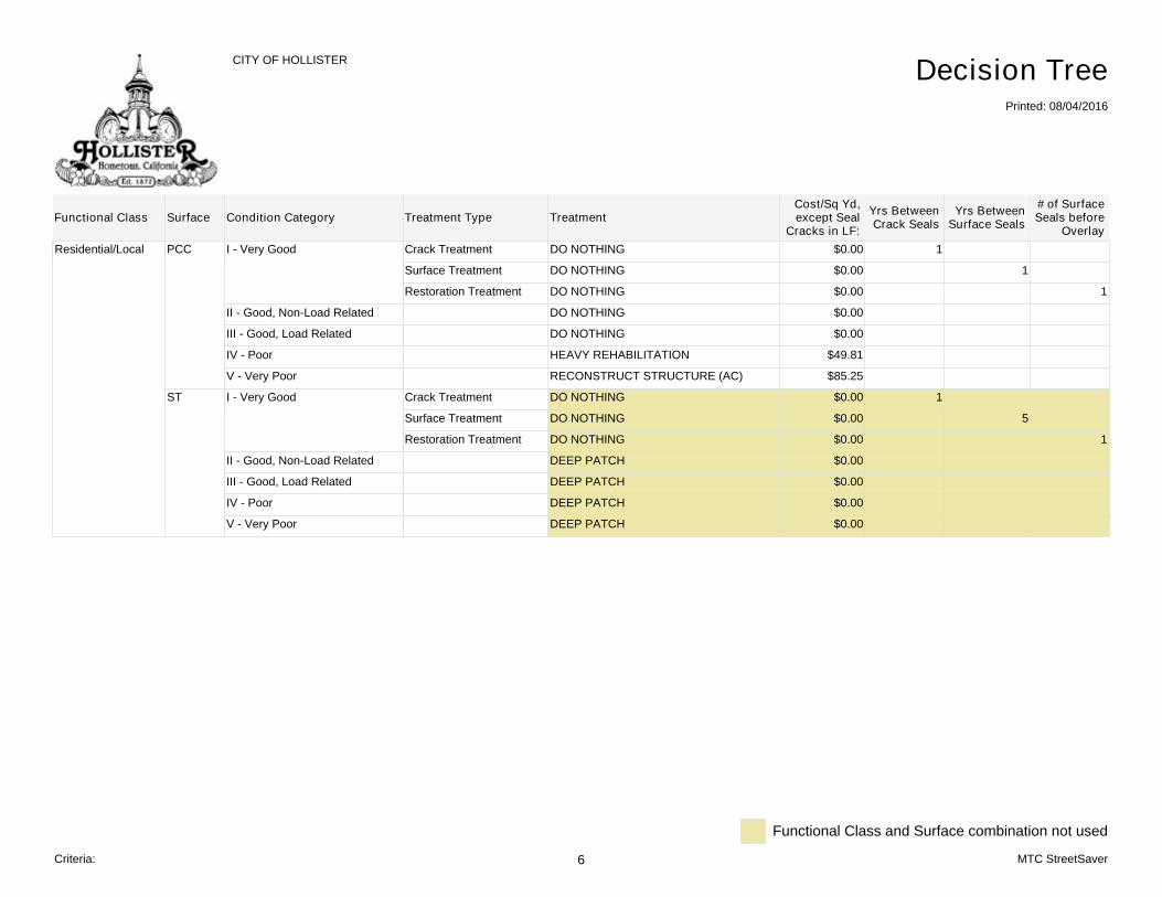
Residential/Local PCC I - Very Good Crack Treatment DO NOTHING $0.00 1
Surface Treatment DO NOTHING $0.00 1
Restoration Treatment DO NOTHING $0.00 1
II - Good, Non-Load Related DO NOTHING $0.00
III - Good, Load Related DO NOTHING $0.00
IV - Poor HEAVY REHABILITATION $49.81
V - Very Poor RECONSTRUCT STRUCTURE (AC) $85.25
ST I - Very Good Crack Treatment DO NOTHING $0.00 1
Surface Treatment DO NOTHING $0.00 5
Restoration Treatment DO NOTHING $0.00 1
II - Good, Non-Load Related DEEP PATCH $0.00
III - Good, Load Related DEEP PATCH $0.00
IV - Poor DEEP PATCH $0.00
V - Very Poor DEEP PATCH $0.00
# of SurfaceSeals before
OverlayFunctional Class
CITY OF HOLLISTER
Printed: 08/04/2016
Decision Tree
Surface Condition Category Treatment Type Treatment Yrs BetweenCrack Seals
Yrs BetweenSurface Seals
Cost/Sq Yd,except Seal
Cracks in LF:
Functional Class and Surface combination not used
Criteria: 6 MTC StreetSaver
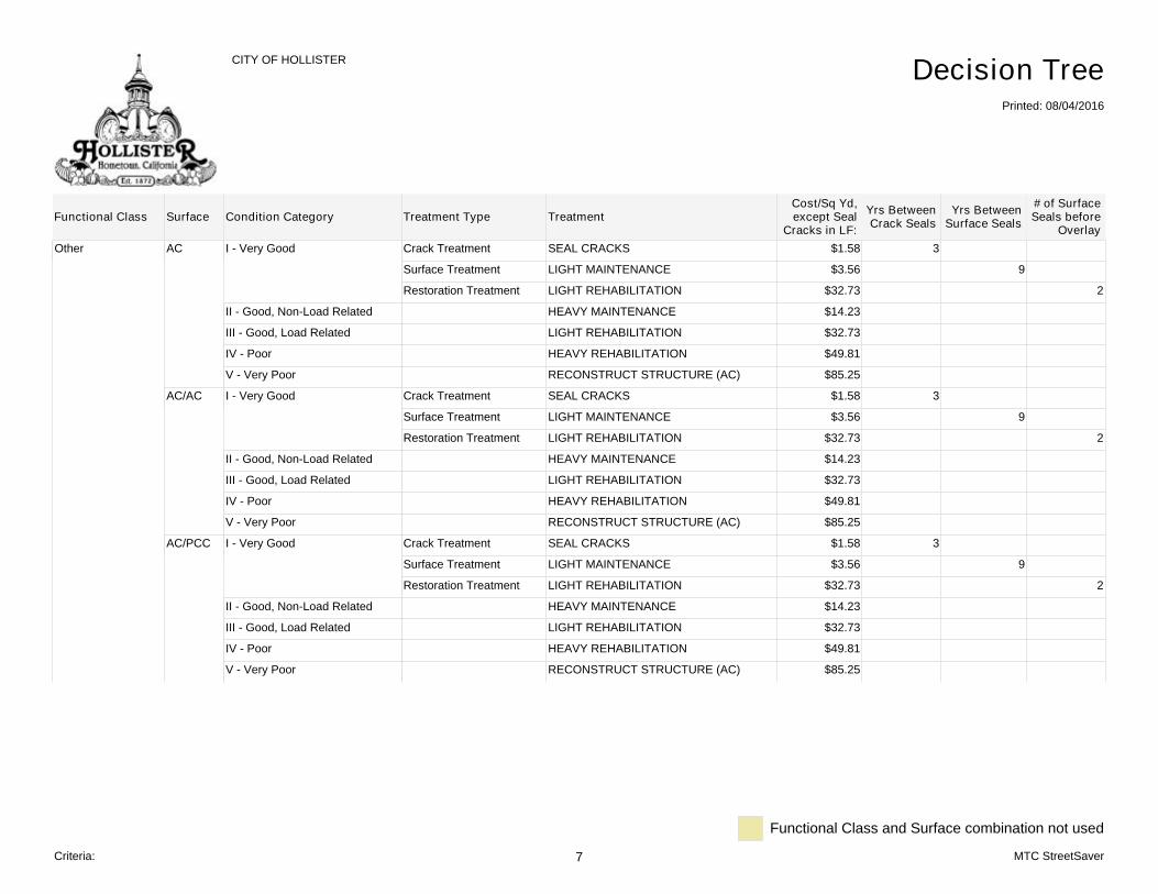
Other AC I - Very Good Crack Treatment SEAL CRACKS $1.58 3
Surface Treatment LIGHT MAINTENANCE $3.56 9
Restoration Treatment LIGHT REHABILITATION $32.73 2
II - Good, Non-Load Related HEAVY MAINTENANCE $14.23
III - Good, Load Related LIGHT REHABILITATION $32.73
IV - Poor HEAVY REHABILITATION $49.81
V - Very Poor RECONSTRUCT STRUCTURE (AC) $85.25
AC/AC I - Very Good Crack Treatment SEAL CRACKS $1.58 3
Surface Treatment LIGHT MAINTENANCE $3.56 9
Restoration Treatment LIGHT REHABILITATION $32.73 2
II - Good, Non-Load Related HEAVY MAINTENANCE $14.23
III - Good, Load Related LIGHT REHABILITATION $32.73
IV - Poor HEAVY REHABILITATION $49.81
V - Very Poor RECONSTRUCT STRUCTURE (AC) $85.25
AC/PCC I - Very Good Crack Treatment SEAL CRACKS $1.58 3
Surface Treatment LIGHT MAINTENANCE $3.56 9
Restoration Treatment LIGHT REHABILITATION $32.73 2
II - Good, Non-Load Related HEAVY MAINTENANCE $14.23
III - Good, Load Related LIGHT REHABILITATION $32.73
IV - Poor HEAVY REHABILITATION $49.81
V - Very Poor RECONSTRUCT STRUCTURE (AC) $85.25
# of SurfaceSeals before
OverlayFunctional Class
CITY OF HOLLISTER
Printed: 08/04/2016
Decision Tree
Surface Condition Category Treatment Type Treatment Yrs BetweenCrack Seals
Yrs BetweenSurface Seals
Cost/Sq Yd,except Seal
Cracks in LF:
Functional Class and Surface combination not used
Criteria: 7 MTC StreetSaver
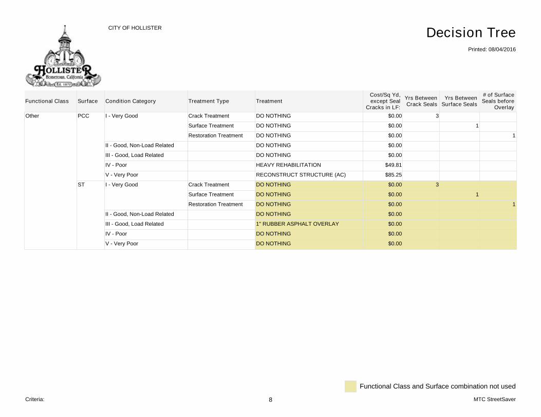
Other PCC I - Very Good Crack Treatment DO NOTHING $0.00 3
Surface Treatment DO NOTHING $0.00 1
Restoration Treatment DO NOTHING $0.00 1
II - Good, Non-Load Related DO NOTHING $0.00
III - Good, Load Related DO NOTHING $0.00
IV - Poor HEAVY REHABILITATION $49.81
V - Very Poor RECONSTRUCT STRUCTURE (AC) $85.25
ST I - Very Good Crack Treatment DO NOTHING $0.00 3
Surface Treatment DO NOTHING $0.00 1
Restoration Treatment DO NOTHING $0.00 1
II - Good, Non-Load Related DO NOTHING $0.00
III - Good, Load Related 1" RUBBER ASPHALT OVERLAY $0.00
IV - Poor DO NOTHING $0.00
V - Very Poor DO NOTHING $0.00
# of SurfaceSeals before
OverlayFunctional Class
CITY OF HOLLISTER
Printed: 08/04/2016
Decision Tree
Surface Condition Category Treatment Type Treatment Yrs BetweenCrack Seals
Yrs BetweenSurface Seals
Cost/Sq Yd,except Seal
Cracks in LF:
Functional Class and Surface combination not used
Criteria: 8 MTC StreetSaver
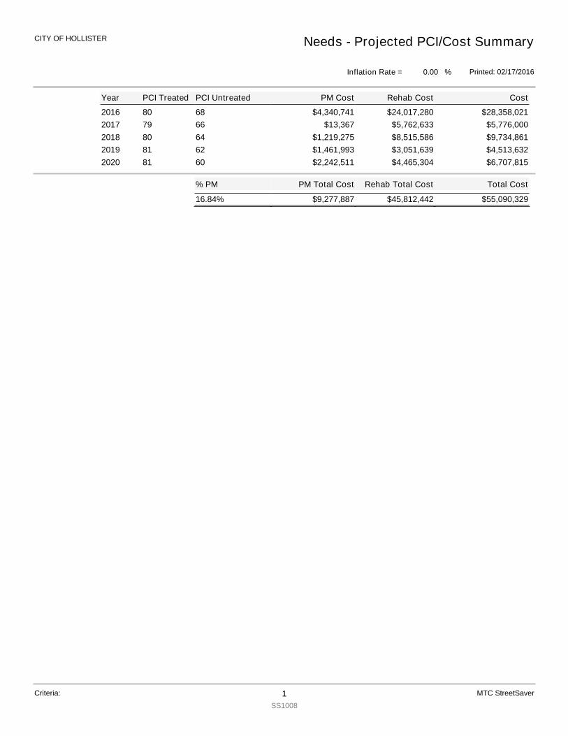
2016 80 68 $28,358,021$4,340,741 $24,017,2802017 79 66 $5,776,000$13,367 $5,762,6332018 80 64 $9,734,861$1,219,275 $8,515,5862019 81 62 $4,513,632$1,461,993 $3,051,6392020 81 60 $6,707,815$2,242,511 $4,465,304
Total Cost
$55,090,329
PM Total Cost
$9,277,887
% PM
16.84% $45,812,442
Rehab Total Cost
Year PCI Treated PCI Untreated Cost
Needs - Projected PCI/Cost Summary
Printed: 02/17/2016
CITY OF HOLLISTER
Inflation Rate = %0.00
PM Cost Rehab Cost
Criteria: 1SS1008
MTC StreetSaver
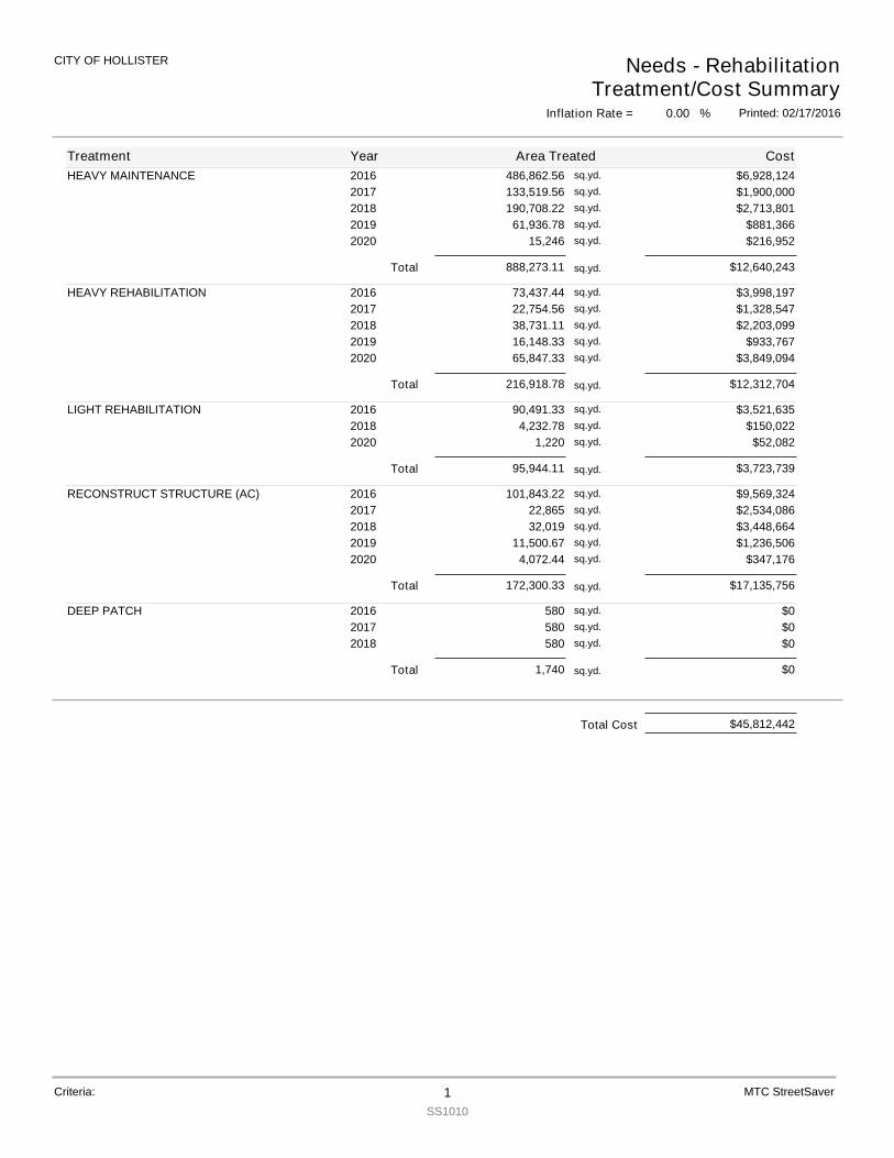
HEAVY MAINTENANCE 2016 486,862.56 $6,928,124sq.yd.
2017 133,519.56 $1,900,000sq.yd.
2018 190,708.22 $2,713,801sq.yd.
2019 61,936.78 $881,366sq.yd.
2020 15,246 $216,952sq.yd.
Total 888,273.11 $12,640,243sq.yd.
HEAVY REHABILITATION 2016 73,437.44 $3,998,197sq.yd.
2017 22,754.56 $1,328,547sq.yd.
2018 38,731.11 $2,203,099sq.yd.
2019 16,148.33 $933,767sq.yd.
2020 65,847.33 $3,849,094sq.yd.
Total 216,918.78 $12,312,704sq.yd.
LIGHT REHABILITATION 2016 90,491.33 $3,521,635sq.yd.
2018 4,232.78 $150,022sq.yd.
2020 1,220 $52,082sq.yd.
Total 95,944.11 $3,723,739sq.yd.
RECONSTRUCT STRUCTURE (AC) 2016 101,843.22 $9,569,324sq.yd.
2017 22,865 $2,534,086sq.yd.
2018 32,019 $3,448,664sq.yd.
2019 11,500.67 $1,236,506sq.yd.
2020 4,072.44 $347,176sq.yd.
Total 172,300.33 $17,135,756sq.yd.
DEEP PATCH 2016 580 $0sq.yd.
2017 580 $0sq.yd.
2018 580 $0sq.yd.
Total 1,740 $0sq.yd.
Treatment Year Area Treated Cost
Needs - RehabilitationTreatment/Cost Summary
Printed: 02/17/2016
CITY OF HOLLISTER
Inflation Rate = %0.00
Criteria: 1SS1010
MTC StreetSaver
$45,812,442Total Cost
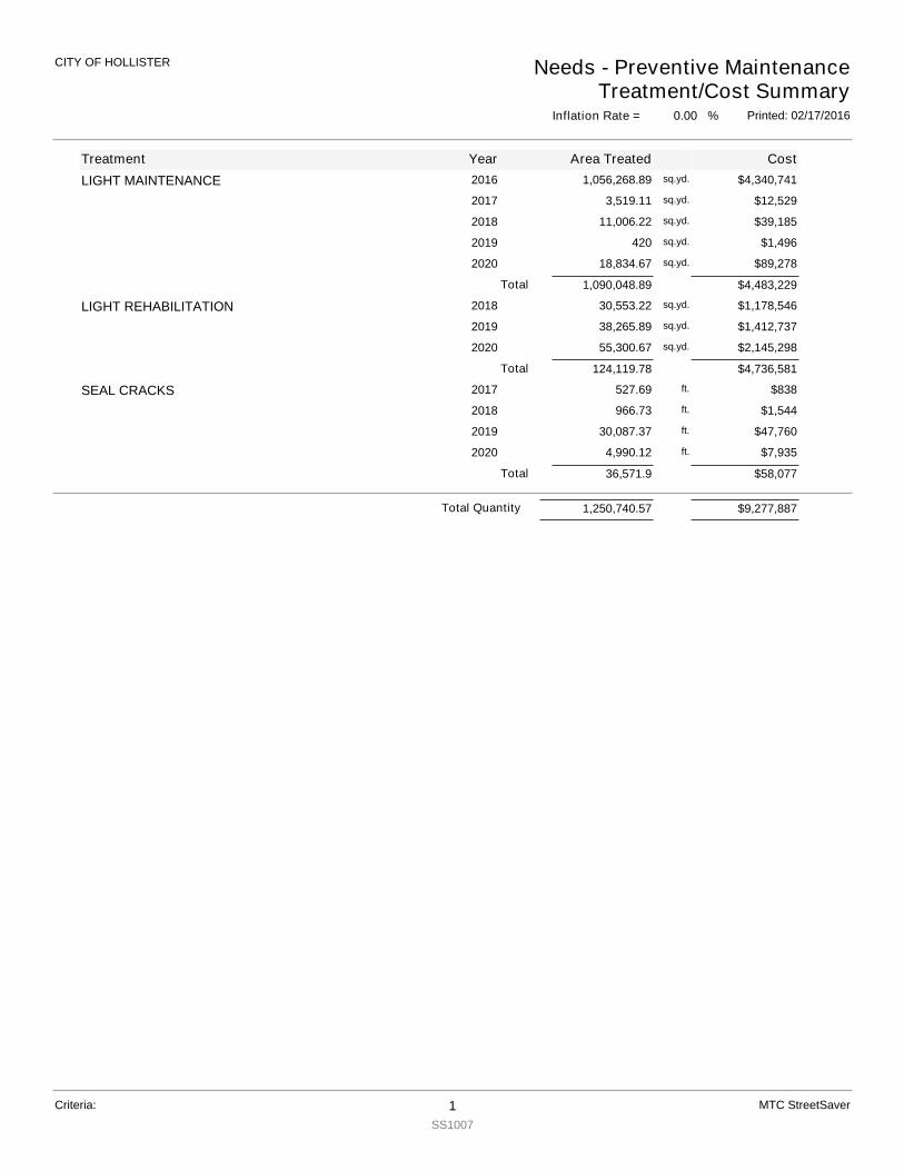
LIGHT MAINTENANCE 2016 $4,340,741sq.yd.1,056,268.89
2017 $12,529sq.yd.3,519.11
2018 $39,185sq.yd.11,006.22
2019 $1,496sq.yd.420
2020 $89,278sq.yd.18,834.67
Total 1,090,048.89 $4,483,229
LIGHT REHABILITATION 2018 $1,178,546sq.yd.30,553.22
2019 $1,412,737sq.yd.38,265.89
2020 $2,145,298sq.yd.55,300.67
Total 124,119.78 $4,736,581
SEAL CRACKS 2017 $838ft.527.69
2018 $1,544ft.966.73
2019 $47,760ft.30,087.37
2020 $7,935ft.4,990.12
Total 36,571.9 $58,077
Treatment
Inflation Rate = %0.00
CostArea TreatedYear
CITY OF HOLLISTER Needs - Preventive MaintenanceTreatment/Cost Summary
Printed: 02/17/2016
Criteria: 1SS1007
MTC StreetSaver
Total Quantity 1,250,740.57 $9,277,887
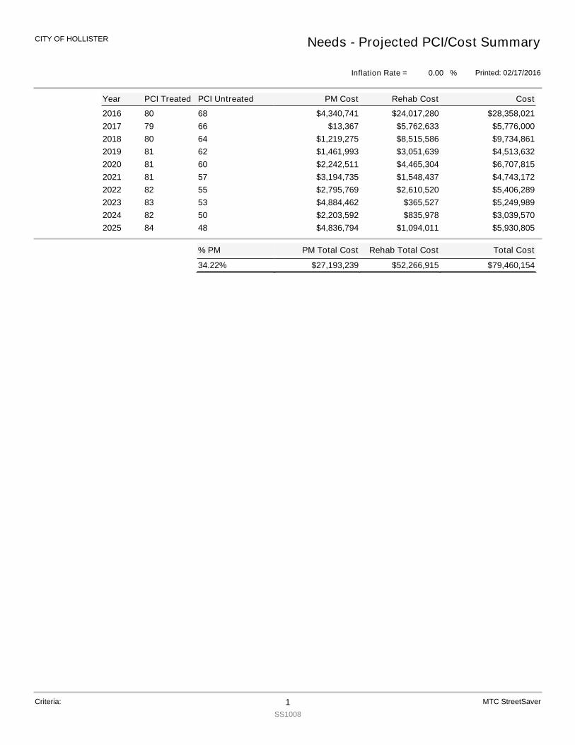
2016 80 68 $28,358,021$4,340,741 $24,017,2802017 79 66 $5,776,000$13,367 $5,762,6332018 80 64 $9,734,861$1,219,275 $8,515,5862019 81 62 $4,513,632$1,461,993 $3,051,6392020 81 60 $6,707,815$2,242,511 $4,465,3042021 81 57 $4,743,172$3,194,735 $1,548,4372022 82 55 $5,406,289$2,795,769 $2,610,5202023 83 53 $5,249,989$4,884,462 $365,5272024 82 50 $3,039,570$2,203,592 $835,9782025 84 48 $5,930,805$4,836,794 $1,094,011
Total Cost
$79,460,154
PM Total Cost
$27,193,239
% PM
34.22% $52,266,915
Rehab Total Cost
Year PCI Treated PCI Untreated Cost
Needs - Projected PCI/Cost Summary
Printed: 02/17/2016
CITY OF HOLLISTER
Inflation Rate = %0.00
PM Cost Rehab Cost
Criteria: 1SS1008
MTC StreetSaver
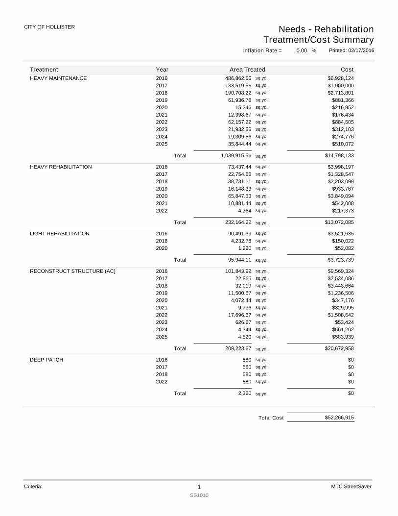
HEAVY MAINTENANCE 2016 486,862.56 $6,928,124sq.yd.
2017 133,519.56 $1,900,000sq.yd.
2018 190,708.22 $2,713,801sq.yd.
2019 61,936.78 $881,366sq.yd.
2020 15,246 $216,952sq.yd.
2021 12,398.67 $176,434sq.yd.
2022 62,157.22 $884,505sq.yd.
2023 21,932.56 $312,103sq.yd.
2024 19,309.56 $274,776sq.yd.
2025 35,844.44 $510,072sq.yd.
Total 1,039,915.56 $14,798,133sq.yd.
HEAVY REHABILITATION 2016 73,437.44 $3,998,197sq.yd.
2017 22,754.56 $1,328,547sq.yd.
2018 38,731.11 $2,203,099sq.yd.
2019 16,148.33 $933,767sq.yd.
2020 65,847.33 $3,849,094sq.yd.
2021 10,881.44 $542,008sq.yd.
2022 4,364 $217,373sq.yd.
Total 232,164.22 $13,072,085sq.yd.
LIGHT REHABILITATION 2016 90,491.33 $3,521,635sq.yd.
2018 4,232.78 $150,022sq.yd.
2020 1,220 $52,082sq.yd.
Total 95,944.11 $3,723,739sq.yd.
RECONSTRUCT STRUCTURE (AC) 2016 101,843.22 $9,569,324sq.yd.
2017 22,865 $2,534,086sq.yd.
2018 32,019 $3,448,664sq.yd.
2019 11,500.67 $1,236,506sq.yd.
2020 4,072.44 $347,176sq.yd.
2021 9,736 $829,995sq.yd.
2022 17,696.67 $1,508,642sq.yd.
2023 626.67 $53,424sq.yd.
2024 4,344 $561,202sq.yd.
2025 4,520 $583,939sq.yd.
Total 209,223.67 $20,672,958sq.yd.
DEEP PATCH 2016 580 $0sq.yd.
2017 580 $0sq.yd.
2018 580 $0sq.yd.
2022 580 $0sq.yd.
Total 2,320 $0sq.yd.
Treatment Year Area Treated Cost
Needs - RehabilitationTreatment/Cost Summary
Printed: 02/17/2016
CITY OF HOLLISTER
Inflation Rate = %0.00
Criteria: 1SS1010
MTC StreetSaver
$52,266,915Total Cost
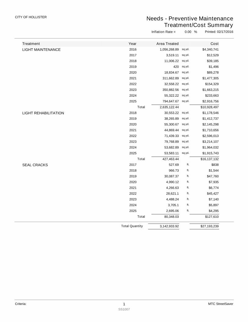
LIGHT MAINTENANCE 2016 $4,340,741sq.yd.1,056,268.89
2017 $12,529sq.yd.3,519.11
2018 $39,185sq.yd.11,006.22
2019 $1,496sq.yd.420
2020 $89,278sq.yd.18,834.67
2021 $1,477,305sq.yd.311,662.89
2022 $154,329sq.yd.32,558.22
2023 $1,663,215sq.yd.350,882.56
2024 $233,663sq.yd.55,322.22
2025 $2,916,756sq.yd.794,647.67
Total 2,635,122.44 $10,928,497
LIGHT REHABILITATION 2018 $1,178,546sq.yd.30,553.22
2019 $1,412,737sq.yd.38,265.89
2020 $2,145,298sq.yd.55,300.67
2021 $1,710,656sq.yd.44,869.44
2022 $2,596,013sq.yd.71,439.33
2023 $3,214,107sq.yd.79,768.89
2024 $1,964,032sq.yd.53,682.89
2025 $1,915,743sq.yd.53,583.11
Total 427,463.44 $16,137,132
SEAL CRACKS 2017 $838ft.527.69
2018 $1,544ft.966.73
2019 $47,760ft.30,087.37
2020 $7,935ft.4,990.12
2021 $6,774ft.4,266.63
2022 $45,427ft.28,621.1
2023 $7,140ft.4,488.24
2024 $5,897ft.3,705.1
2025 $4,295ft.2,695.06
Total 80,348.03 $127,610
Treatment
Inflation Rate = %0.00
CostArea TreatedYear
CITY OF HOLLISTER Needs - Preventive MaintenanceTreatment/Cost Summary
Printed: 02/17/2016
Criteria: 1SS1007
MTC StreetSaver
Total Quantity 3,142,933.92 $27,193,239
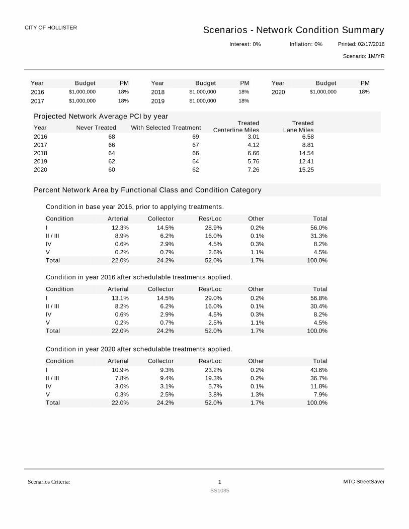
YearYearYear Budget PM Budget PM Budget PM2016 $1,000,000 18%
2017 $1,000,000 18%2018 $1,000,000 18%
2019 $1,000,000 18%2020 $1,000,000 18%
Projected Network Average PCI by yearNever TreatedYear With Selected Treatment
TreatedCenterline Miles
TreatedLane Miles
2016 6968 6.583.012017 6766 8.814.122018 6664 14.546.662019 6462 12.415.762020 6260 15.257.26
Percent Network Area by Functional Class and Condition Category
Condition
Condition in base year 2016, prior to applying treatments.
Arterial Collector Res/Loc Other TotalI 12.3% 14.5% 28.9% 0.2% 56.0%II / III 8.9% 6.2% 16.0% 0.1% 31.3%IV 0.6% 2.9% 4.5% 0.3% 8.2%V 0.2% 0.7% 2.6% 1.1% 4.5%Total 22.0% 24.2% 52.0% 1.7% 100.0%
Condition
Condition in year 2016 after schedulable treatments applied.
Arterial Collector Res/Loc Other TotalI 13.1% 14.5% 29.0% 0.2% 56.8%II / III 8.2% 6.2% 16.0% 0.1% 30.4%IV 0.6% 2.9% 4.5% 0.3% 8.2%V 0.2% 0.7% 2.5% 1.1% 4.5%Total 22.0% 24.2% 52.0% 1.7% 100.0%
Condition
Condition in year 2020 after schedulable treatments applied.
Arterial Collector Res/Loc Other TotalI 10.9% 9.3% 23.2% 0.2% 43.6%II / III 7.8% 9.4% 19.3% 0.2% 36.7%IV 3.0% 3.1% 5.7% 0.1% 11.8%V 0.3% 2.5% 3.8% 1.3% 7.9%Total 22.0% 24.2% 52.0% 1.7% 100.0%
Scenarios - Network Condition SummaryPrinted: 02/17/2016
CITY OF HOLLISTER
Scenario: 1M/YR
Interest: 0% Inflation: 0%
MTC StreetSaverScenarios Criteria: 1SS1035
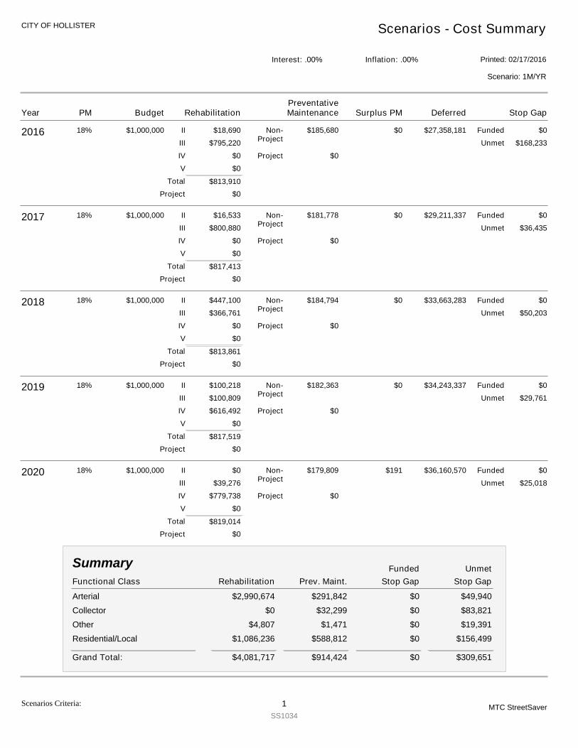
CITY OF HOLLISTER Scenarios - Cost Summary
Printed: 02/17/2016Interest: .00% Inflation: .00%
Scenario: 1M/YR
2016 $1,000,000
$813,910
$18,690
$795,220
$0
$0
$185,680 $0$27,358,181$0
$168,233
18%
$0
$0
II
III
IV
V
Non-Project
Project
Funded
Unmet
Project
Total
2017 $1,000,000
$817,413
$16,533
$800,880
$0
$0
$181,778 $0$29,211,337$0
$36,435
18%
$0
$0
II
III
IV
V
Non-Project
Project
Funded
Unmet
Project
Total
2018 $1,000,000
$813,861
$447,100
$366,761
$0
$0
$184,794 $0$33,663,283$0
$50,203
18%
$0
$0
II
III
IV
V
Non-Project
Project
Funded
Unmet
Project
Total
2019 $1,000,000
$817,519
$100,218
$100,809
$616,492
$0
$182,363 $0$34,243,337$0
$29,761
18%
$0
$0
II
III
IV
V
Non-Project
Project
Funded
Unmet
Project
Total
2020 $1,000,000
$819,014
$0
$39,276
$779,738
$0
$179,809 $0$36,160,570$191
$25,018
18%
$0
$0
II
III
IV
V
Non-Project
Project
Funded
Unmet
Project
Total
Functional Class Stop GapRehabilitation Prev. Maint.
Summary
Stop GapUnmetFunded
Arterial $2,990,674 $291,842 $0 $49,940Collector $0 $32,299 $0 $83,821Other $4,807 $1,471 $0 $19,391Residential/Local $1,086,236 $588,812 $0 $156,499
$4,081,717 $914,424 $0Grand Total: $309,651
Year Budget RehabilitationPM Deferred Stop GapSurplus PMPreventativeMaintenance
Scenarios Criteria: 1SS1034
MTC StreetSaver
Year Budget RehabilitationPM Deferred Stop GapSurplus PMPreventativeMaintenance
Scenarios Criteria: 2SS1034
MTC StreetSaver
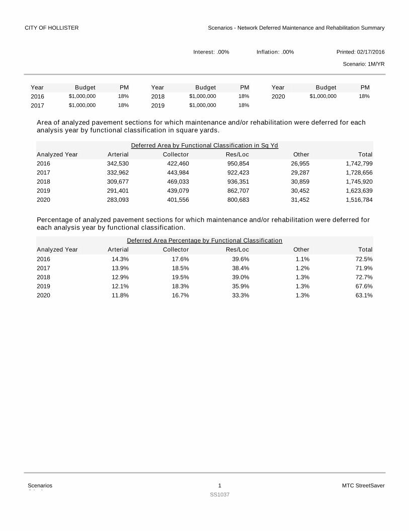
Area of analyzed pavement sections for which maintenance and/or rehabilitation were deferred for eachanalysis year by functional classification in square yards.
YearYearYear Budget PM Budget PM Budget PM2016 $1,000,000 18%
2017 $1,000,000 18%2018 $1,000,000 18%
2019 $1,000,000 18%2020 $1,000,000 18%
Arterial Collector Res/Loc Other TotalDeferred Area by Functional Classification in Sq Yd
Analyzed Year2016 342,530 422,460 950,854 26,955 1,742,7992017 332,962 443,984 922,423 29,287 1,728,6562018 309,677 469,033 936,351 30,859 1,745,9202019 291,401 439,079 862,707 30,452 1,623,6392020 283,093 401,556 800,683 31,452 1,516,784
Percentage of analyzed pavement sections for which maintenance and/or rehabilitation were deferred foreach analysis year by functional classification.
Arterial Collector Res/Loc Other TotalDeferred Area Percentage by Functional Classification
Analyzed Year2016 14.3% 17.6% 39.6% 1.1% 72.5%2017 13.9% 18.5% 38.4% 1.2% 71.9%2018 12.9% 19.5% 39.0% 1.3% 72.7%2019 12.1% 18.3% 35.9% 1.3% 67.6%2020 11.8% 16.7% 33.3% 1.3% 63.1%
CITY OF HOLLISTER Scenarios - Network Deferred Maintenance and Rehabilitation Summary
Printed: 02/17/2016Interest: .00% Inflation: .00%
Scenario: 1M/YR
ScenariosCriteria:
1SS1037
MTC StreetSaver
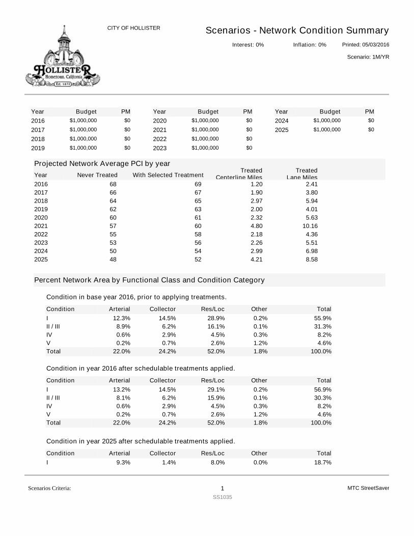
YearYearYear Budget PM Budget PM Budget PM2016 $1,000,000 $0
2017 $1,000,000 $0
2018 $1,000,000 $0
2019 $1,000,000 $0
2020 $1,000,000 $0
2021 $1,000,000 $0
2022 $1,000,000 $0
2023 $1,000,000 $0
2024 $1,000,000 $0
2025 $1,000,000 $0
Projected Network Average PCI by yearNever TreatedYear With Selected Treatment
TreatedCenterline Miles
TreatedLane Miles
2016 6968 2.411.202017 6766 3.801.902018 6564 5.942.972019 6362 4.012.002020 6160 5.632.322021 6057 10.164.802022 5855 4.362.182023 5653 5.512.262024 5450 6.982.992025 5248 8.584.21
Percent Network Area by Functional Class and Condition Category
Condition
Condition in base year 2016, prior to applying treatments.
Arterial Collector Res/Loc Other TotalI 12.3% 14.5% 28.9% 0.2% 55.9%II / III 8.9% 6.2% 16.1% 0.1% 31.3%IV 0.6% 2.9% 4.5% 0.3% 8.2%V 0.2% 0.7% 2.6% 1.2% 4.6%Total 22.0% 24.2% 52.0% 1.8% 100.0%
Condition
Condition in year 2016 after schedulable treatments applied.
Arterial Collector Res/Loc Other TotalI 13.2% 14.5% 29.1% 0.2% 56.9%II / III 8.1% 6.2% 15.9% 0.1% 30.3%IV 0.6% 2.9% 4.5% 0.3% 8.2%V 0.2% 0.7% 2.6% 1.2% 4.6%Total 22.0% 24.2% 52.0% 1.8% 100.0%
Condition
Condition in year 2025 after schedulable treatments applied.
Arterial Collector Res/Loc Other TotalI 9.3% 1.4% 8.0% 0.0% 18.7%
Scenarios - Network Condition SummaryPrinted: 05/03/2016
CITY OF HOLLISTER
Scenario: 1M/YR
Interest: 0% Inflation: 0%
MTC StreetSaverScenarios Criteria: 1SS1035
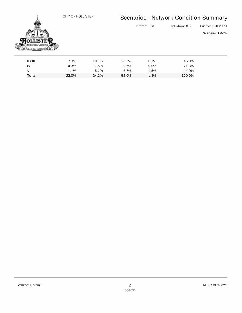
Scenarios - Network Condition SummaryPrinted: 05/03/2016
CITY OF HOLLISTER
Scenario: 1M/YR
Interest: 0% Inflation: 0%
II / III 7.3% 10.1% 28.3% 0.3% 46.0%IV 4.3% 7.5% 9.6% 0.0% 21.3%V 1.1% 5.2% 6.2% 1.5% 14.0%Total 22.0% 24.2% 52.0% 1.8% 100.0%
MTC StreetSaverScenarios Criteria: 2SS1035
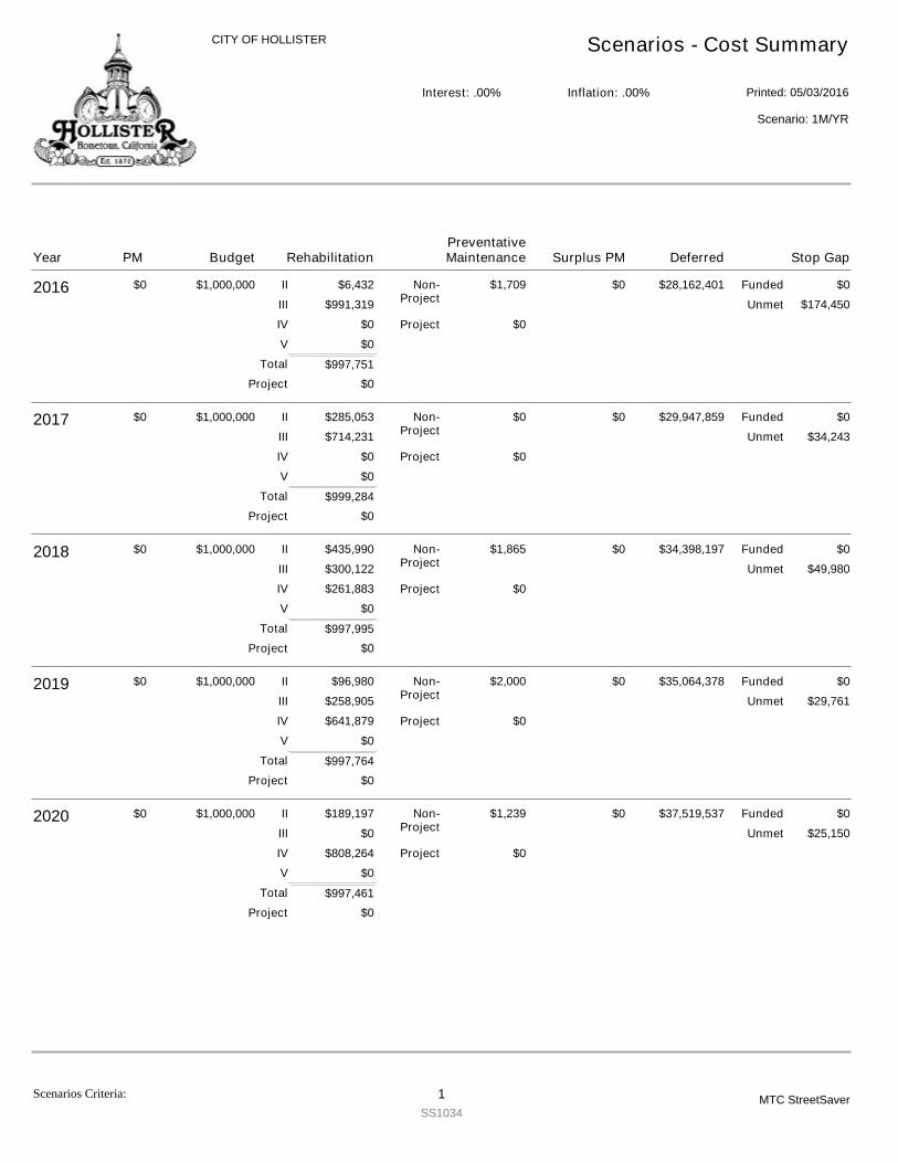
CITY OF HOLLISTER Scenarios - Cost Summary
Printed: 05/03/2016Interest: .00% Inflation: .00%
Scenario: 1M/YR
2016 $0 $1,000,000
$997,751
$6,432
$991,319
$0
$0
$1,709 $0$28,162,401$0
$174,450
$0
$0
II
III
IV
V
Non-Project
Project
Funded
Unmet
Project
Total
2017 $0 $1,000,000
$999,284
$285,053
$714,231
$0
$0
$0 $0$29,947,859$0
$34,243
$0
$0
II
III
IV
V
Non-Project
Project
Funded
Unmet
Project
Total
2018 $0 $1,000,000
$997,995
$435,990
$300,122
$261,883
$0
$1,865 $0$34,398,197$0
$49,980
$0
$0
II
III
IV
V
Non-Project
Project
Funded
Unmet
Project
Total
2019 $0 $1,000,000
$997,764
$96,980
$258,905
$641,879
$0
$2,000 $0$35,064,378$0
$29,761
$0
$0
II
III
IV
V
Non-Project
Project
Funded
Unmet
Project
Total
2020 $0 $1,000,000
$997,461
$189,197
$0
$808,264
$0
$1,239 $0$37,519,537$0
$25,150
$0
$0
II
III
IV
V
Non-Project
Project
Funded
Unmet
Project
Total
Year Budget RehabilitationPM Deferred Stop GapSurplus PMPreventativeMaintenance
Scenarios Criteria: 1SS1034
MTC StreetSaver
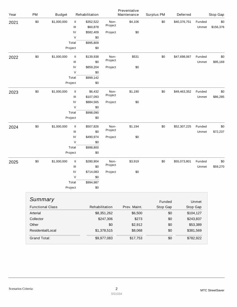
2021 $0 $1,000,000
$995,809
$352,522
$60,878
$582,409
$0
$4,106 $0$40,376,751$0
$156,376
$0
$0
II
III
IV
V
Non-Project
Project
Funded
Unmet
Project
Total
2022 $0 $1,000,000
$999,142
$139,938
$0
$859,204
$0
$531 $0$47,698,067$0
$95,169
$0
$0
II
III
IV
V
Non-Project
Project
Funded
Unmet
Project
Total
2023 $0 $1,000,000
$998,090
$6,432
$107,093
$884,565
$0
$1,190 $0$49,463,352$0
$86,285
$0
$0
II
III
IV
V
Non-Project
Project
Funded
Unmet
Project
Total
2024 $0 $1,000,000
$998,800
$507,826
$0
$490,974
$0
$1,194 $0$52,307,225$0
$72,237
$0
$0
II
III
IV
V
Non-Project
Project
Funded
Unmet
Project
Total
2025 $0 $1,000,000
$994,987
$280,904
$0
$714,083
$0
$3,919 $0$55,073,801$0
$59,270
$0
$0
II
III
IV
V
Non-Project
Project
Funded
Unmet
Project
Total
Functional Class Stop GapRehabilitation Prev. Maint.
Summary
Stop GapUnmetFunded
Arterial $8,351,262 $6,500 $0 $104,127Collector $247,306 $273 $0 $243,837Other $0 $2,912 $0 $53,389Residential/Local $1,378,515 $8,068 $0 $381,569
$9,977,083 $17,753 $0Grand Total: $782,922
Year Budget RehabilitationPM Deferred Stop GapSurplus PMPreventativeMaintenance
Scenarios Criteria: 2SS1034
MTC StreetSaver
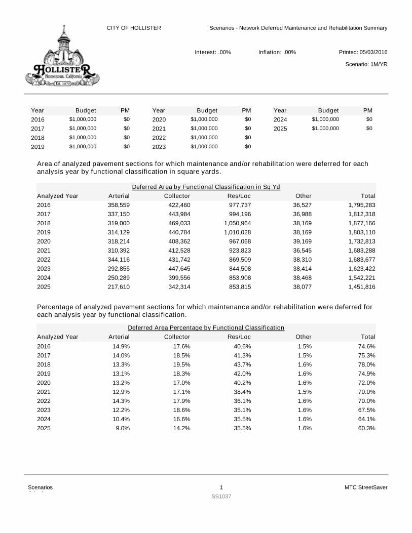
Area of analyzed pavement sections for which maintenance and/or rehabilitation were deferred for eachanalysis year by functional classification in square yards.
YearYearYear Budget PM Budget PM Budget PM2016 $1,000,000 $0
2017 $1,000,000 $0
2018 $1,000,000 $0
2019 $1,000,000 $0
2020 $1,000,000 $0
2021 $1,000,000 $0
2022 $1,000,000 $0
2023 $1,000,000 $0
2024 $1,000,000 $0
2025 $1,000,000 $0
Arterial Collector Res/Loc Other TotalDeferred Area by Functional Classification in Sq Yd
Analyzed Year2016 358,559 422,460 977,737 36,527 1,795,2832017 337,150 443,984 994,196 36,988 1,812,3182018 319,000 469,033 1,050,964 38,169 1,877,1662019 314,129 440,784 1,010,028 38,169 1,803,1102020 318,214 408,362 967,068 39,169 1,732,8132021 310,392 412,528 923,823 36,545 1,683,2882022 344,116 431,742 869,509 38,310 1,683,6772023 292,855 447,645 844,508 38,414 1,623,4222024 250,289 399,556 853,908 38,468 1,542,2212025 217,610 342,314 853,815 38,077 1,451,816
Percentage of analyzed pavement sections for which maintenance and/or rehabilitation were deferred foreach analysis year by functional classification.
Arterial Collector Res/Loc Other TotalDeferred Area Percentage by Functional Classification
Analyzed Year2016 14.9% 17.6% 40.6% 1.5% 74.6%2017 14.0% 18.5% 41.3% 1.5% 75.3%2018 13.3% 19.5% 43.7% 1.6% 78.0%2019 13.1% 18.3% 42.0% 1.6% 74.9%2020 13.2% 17.0% 40.2% 1.6% 72.0%2021 12.9% 17.1% 38.4% 1.5% 70.0%2022 14.3% 17.9% 36.1% 1.6% 70.0%2023 12.2% 18.6% 35.1% 1.6% 67.5%2024 10.4% 16.6% 35.5% 1.6% 64.1%2025 9.0% 14.2% 35.5% 1.6% 60.3%
CITY OF HOLLISTER Scenarios - Network Deferred Maintenance and Rehabilitation Summary
Printed: 05/03/2016Interest: .00% Inflation: .00%
Scenario: 1M/YR
ScenariosCriteria:
1SS1037
MTC StreetSaver
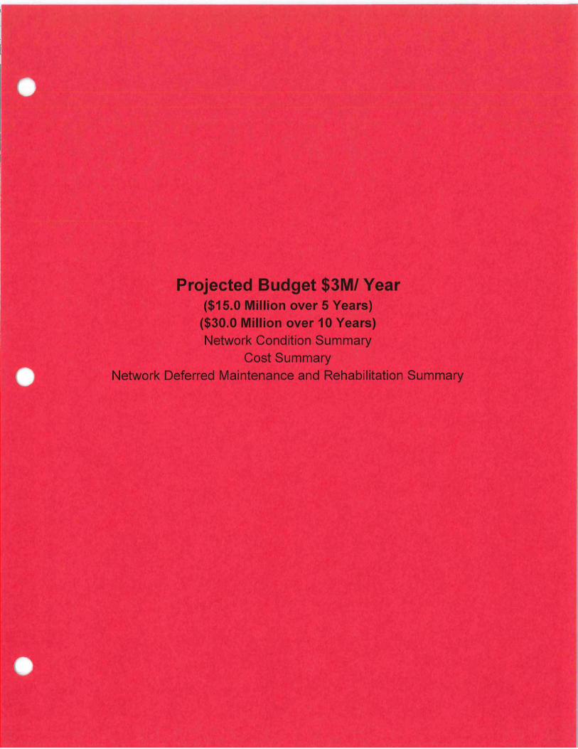
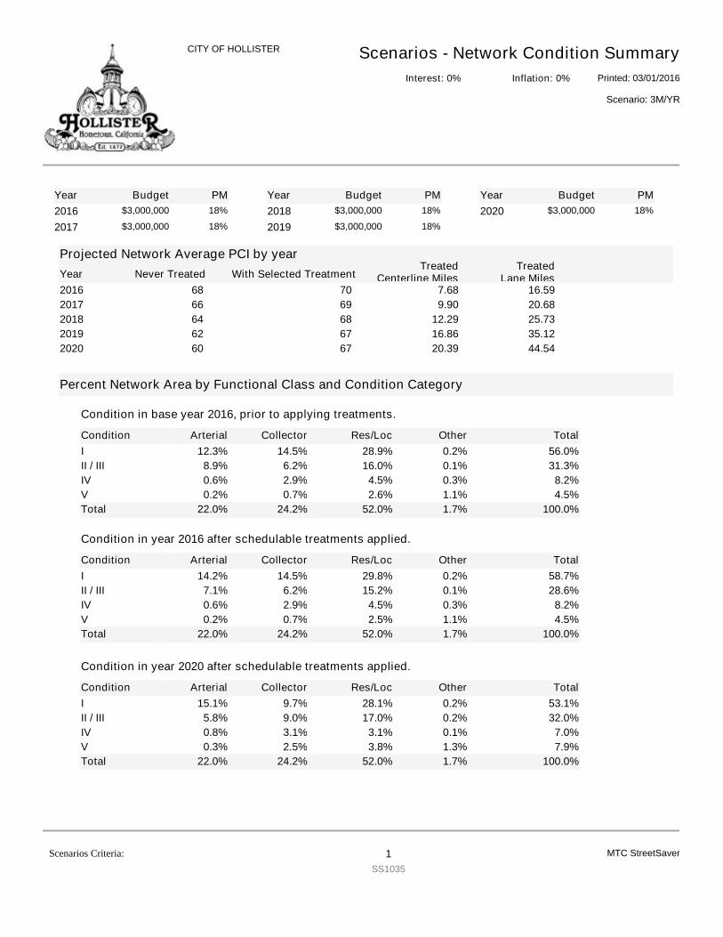
YearYearYear Budget PM Budget PM Budget PM2016 $3,000,000 18%
2017 $3,000,000 18%2018 $3,000,000 18%
2019 $3,000,000 18%2020 $3,000,000 18%
Projected Network Average PCI by yearNever TreatedYear With Selected Treatment
TreatedCenterline Miles
TreatedLane Miles
2016 7068 16.597.682017 6966 20.689.902018 6864 25.7312.292019 6762 35.1216.862020 6760 44.5420.39
Percent Network Area by Functional Class and Condition Category
Condition
Condition in base year 2016, prior to applying treatments.
Arterial Collector Res/Loc Other TotalI 12.3% 14.5% 28.9% 0.2% 56.0%II / III 8.9% 6.2% 16.0% 0.1% 31.3%IV 0.6% 2.9% 4.5% 0.3% 8.2%V 0.2% 0.7% 2.6% 1.1% 4.5%Total 22.0% 24.2% 52.0% 1.7% 100.0%
Condition
Condition in year 2016 after schedulable treatments applied.
Arterial Collector Res/Loc Other TotalI 14.2% 14.5% 29.8% 0.2% 58.7%II / III 7.1% 6.2% 15.2% 0.1% 28.6%IV 0.6% 2.9% 4.5% 0.3% 8.2%V 0.2% 0.7% 2.5% 1.1% 4.5%Total 22.0% 24.2% 52.0% 1.7% 100.0%
Condition
Condition in year 2020 after schedulable treatments applied.
Arterial Collector Res/Loc Other TotalI 15.1% 9.7% 28.1% 0.2% 53.1%II / III 5.8% 9.0% 17.0% 0.2% 32.0%IV 0.8% 3.1% 3.1% 0.1% 7.0%V 0.3% 2.5% 3.8% 1.3% 7.9%Total 22.0% 24.2% 52.0% 1.7% 100.0%
Scenarios - Network Condition SummaryPrinted: 03/01/2016
CITY OF HOLLISTER
Scenario: 3M/YR
Interest: 0% Inflation: 0%
MTC StreetSaverScenarios Criteria: 1SS1035
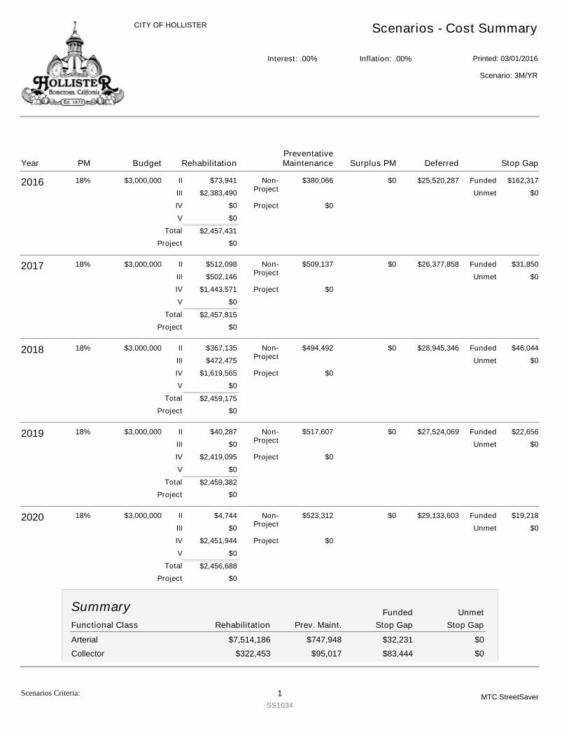
CITY OF HOLLISTER Scenarios - Cost Summary
Printed: 03/01/2016Interest: .00% Inflation: .00%
Scenario: 3M/YR
2016 $3,000,000
$2,457,431
$73,941
$2,383,490
$0
$0
$380,066 $162,317$25,520,287$0
$0
18%
$0
$0
II
III
IV
V
Non-Project
Project
Funded
Unmet
Project
Total
2017 $3,000,000
$2,457,815
$512,098
$502,146
$1,443,571
$0
$509,137 $31,850$26,377,858$0
$0
18%
$0
$0
II
III
IV
V
Non-Project
Project
Funded
Unmet
Project
Total
2018 $3,000,000
$2,459,175
$367,135
$472,475
$1,619,565
$0
$494,492 $46,044$28,945,346$0
$0
18%
$0
$0
II
III
IV
V
Non-Project
Project
Funded
Unmet
Project
Total
2019 $3,000,000
$2,459,382
$40,287
$0
$2,419,095
$0
$517,607 $22,656$27,524,069$0
$0
18%
$0
$0
II
III
IV
V
Non-Project
Project
Funded
Unmet
Project
Total
2020 $3,000,000
$2,456,688
$4,744
$0
$2,451,944
$0
$523,312 $19,218$29,133,603$0
$0
18%
$0
$0
II
III
IV
V
Non-Project
Project
Funded
Unmet
Project
Total
Functional Class Stop GapRehabilitation Prev. Maint.
Summary
Stop GapUnmetFunded
Arterial $7,514,186 $747,948 $32,231 $0Collector $322,453 $95,017 $83,444 $0
Year Budget RehabilitationPM Deferred Stop GapSurplus PMPreventativeMaintenance
Scenarios Criteria: 1SS1034
MTC StreetSaver
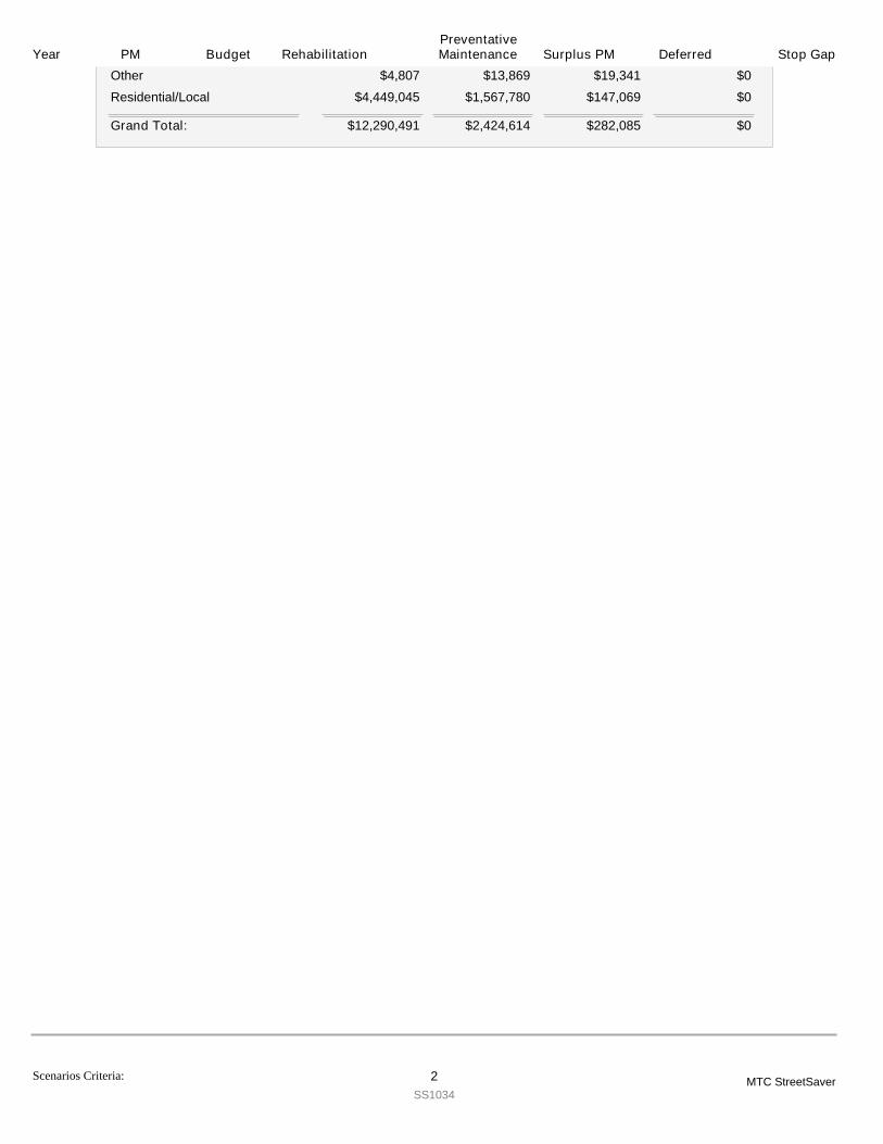
Year Budget RehabilitationPM Deferred Stop GapSurplus PMPreventativeMaintenance
Other $4,807 $13,869 $19,341 $0Residential/Local $4,449,045 $1,567,780 $147,069 $0
$12,290,491 $2,424,614 $282,085Grand Total: $0
Scenarios Criteria: 2SS1034
MTC StreetSaver
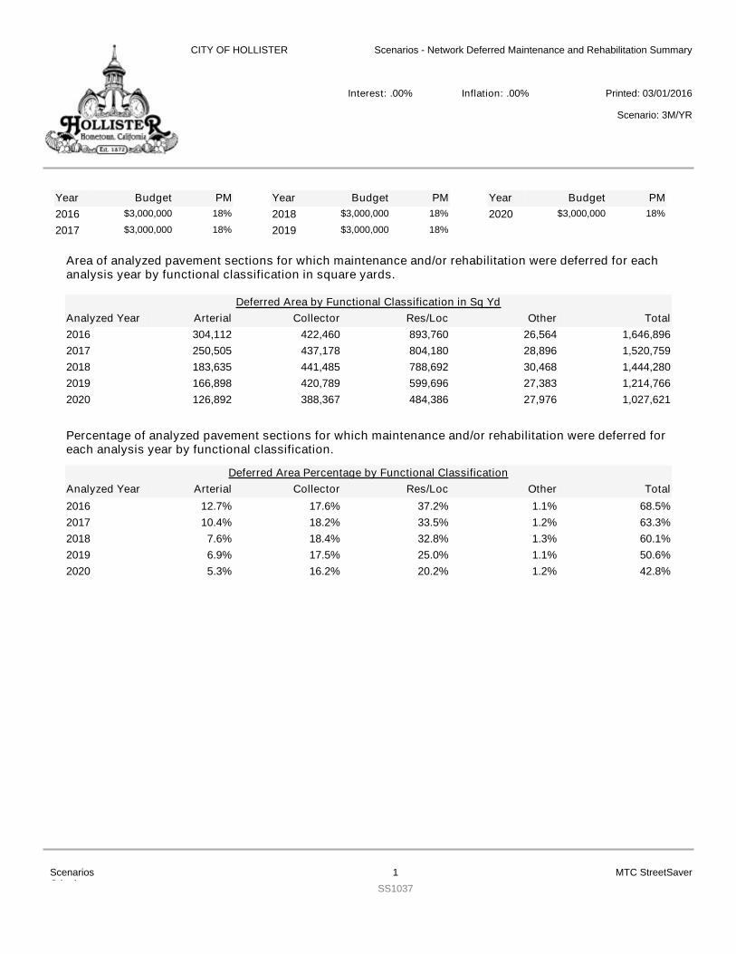
Area of analyzed pavement sections for which maintenance and/or rehabilitation were deferred for eachanalysis year by functional classification in square yards.
YearYearYear Budget PM Budget PM Budget PM2016 $3,000,000 18%
2017 $3,000,000 18%2018 $3,000,000 18%
2019 $3,000,000 18%2020 $3,000,000 18%
Arterial Collector Res/Loc Other TotalDeferred Area by Functional Classification in Sq Yd
Analyzed Year2016 304,112 422,460 893,760 26,564 1,646,8962017 250,505 437,178 804,180 28,896 1,520,7592018 183,635 441,485 788,692 30,468 1,444,2802019 166,898 420,789 599,696 27,383 1,214,7662020 126,892 388,367 484,386 27,976 1,027,621
Percentage of analyzed pavement sections for which maintenance and/or rehabilitation were deferred foreach analysis year by functional classification.
Arterial Collector Res/Loc Other TotalDeferred Area Percentage by Functional Classification
Analyzed Year2016 12.7% 17.6% 37.2% 1.1% 68.5%2017 10.4% 18.2% 33.5% 1.2% 63.3%2018 7.6% 18.4% 32.8% 1.3% 60.1%2019 6.9% 17.5% 25.0% 1.1% 50.6%2020 5.3% 16.2% 20.2% 1.2% 42.8%
CITY OF HOLLISTER Scenarios - Network Deferred Maintenance and Rehabilitation Summary
Printed: 03/01/2016Interest: .00% Inflation: .00%
Scenario: 3M/YR
ScenariosCriteria:
1SS1037
MTC StreetSaver
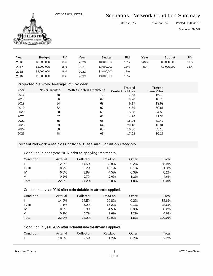
YearYearYear Budget PM Budget PM Budget PM2016 $3,000,000 18%
2017 $3,000,000 18%
2018 $3,000,000 18%
2019 $3,000,000 18%
2020 $3,000,000 18%
2021 $3,000,000 18%
2022 $3,000,000 18%
2023 $3,000,000 18%
2024 $3,000,000 18%
2025 $3,000,000 18%
Projected Network Average PCI by yearNever TreatedYear With Selected Treatment
TreatedCenterline Miles
TreatedLane Miles
2016 7068 16.197.482017 6966 18.739.202018 6864 18.939.172019 6762 30.6114.692020 6660 34.5815.982021 6557 31.3314.762022 6555 32.4715.062023 6453 43.8420.482024 6350 33.1316.562025 6348 36.2717.02
Percent Network Area by Functional Class and Condition Category
Condition
Condition in base year 2016, prior to applying treatments.
Arterial Collector Res/Loc Other TotalI 12.3% 14.5% 28.9% 0.2% 55.9%II / III 8.9% 6.2% 16.1% 0.1% 31.3%IV 0.6% 2.9% 4.5% 0.3% 8.2%V 0.2% 0.7% 2.6% 1.2% 4.6%Total 22.0% 24.2% 52.0% 1.8% 100.0%
Condition
Condition in year 2016 after schedulable treatments applied.
Arterial Collector Res/Loc Other TotalI 14.2% 14.5% 29.8% 0.2% 58.6%II / III 7.1% 6.2% 15.2% 0.1% 28.6%IV 0.6% 2.9% 4.5% 0.3% 8.2%V 0.2% 0.7% 2.6% 1.2% 4.6%Total 22.0% 24.2% 52.0% 1.8% 100.0%
Condition
Condition in year 2025 after schedulable treatments applied.
Arterial Collector Res/Loc Other TotalI 18.3% 2.5% 31.2% 0.2% 52.2%
Scenarios - Network Condition SummaryPrinted: 05/03/2016
CITY OF HOLLISTER
Scenario: 3M/YR
Interest: 0% Inflation: 0%
MTC StreetSaverScenarios Criteria: 1SS1035
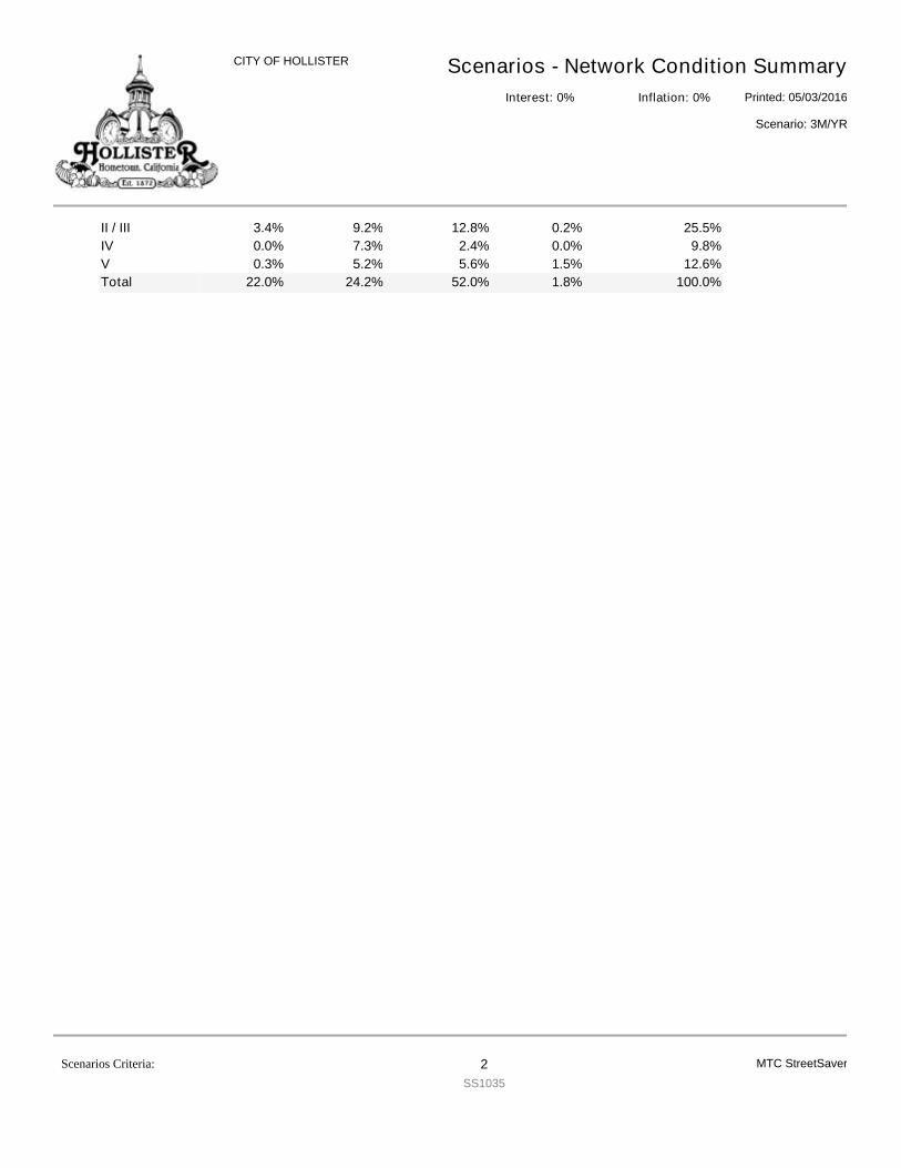
Scenarios - Network Condition SummaryPrinted: 05/03/2016
CITY OF HOLLISTER
Scenario: 3M/YR
Interest: 0% Inflation: 0%
II / III 3.4% 9.2% 12.8% 0.2% 25.5%IV 0.0% 7.3% 2.4% 0.0% 9.8%V 0.3% 5.2% 5.6% 1.5% 12.6%Total 22.0% 24.2% 52.0% 1.8% 100.0%
MTC StreetSaverScenarios Criteria: 2SS1035
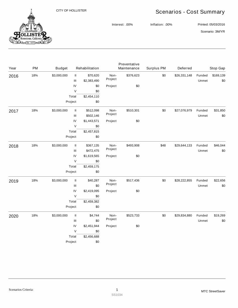
CITY OF HOLLISTER Scenarios - Cost Summary
Printed: 05/03/2016Interest: .00% Inflation: .00%
Scenario: 3M/YR
2016 $3,000,000
$2,454,110
$70,620
$2,383,490
$0
$0
$376,623 $169,139$26,331,148$0
$0
18%
$0
$0
II
III
IV
V
Non-Project
Project
Funded
Unmet
Project
Total
2017 $3,000,000
$2,457,815
$512,098
$502,146
$1,443,571
$0
$510,301 $31,850$27,076,979$0
$0
18%
$0
$0
II
III
IV
V
Non-Project
Project
Funded
Unmet
Project
Total
2018 $3,000,000
$2,459,175
$367,135
$472,475
$1,619,565
$0
$493,908 $46,044$29,644,133$48
$0
18%
$0
$0
II
III
IV
V
Non-Project
Project
Funded
Unmet
Project
Total
2019 $3,000,000
$2,459,382
$40,287
$0
$2,419,095
$0
$517,436 $22,656$28,222,855$0
$0
18%
$0
$0
II
III
IV
V
Non-Project
Project
Funded
Unmet
Project
Total
2020 $3,000,000
$2,456,688
$4,744
$0
$2,451,944
$0
$523,733 $19,269$29,834,880$0
$0
18%
$0
$0
II
III
IV
V
Non-Project
Project
Funded
Unmet
Project
Total
Year Budget RehabilitationPM Deferred Stop GapSurplus PMPreventativeMaintenance
Scenarios Criteria: 1SS1034
MTC StreetSaver
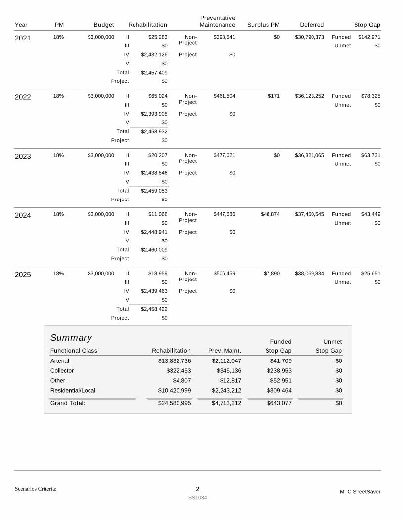
2021 $3,000,000
$2,457,409
$25,283
$0
$2,432,126
$0
$398,541 $142,971$30,790,373$0
$0
18%
$0
$0
II
III
IV
V
Non-Project
Project
Funded
Unmet
Project
Total
2022 $3,000,000
$2,458,932
$65,024
$0
$2,393,908
$0
$461,504 $78,325$36,123,252$171
$0
18%
$0
$0
II
III
IV
V
Non-Project
Project
Funded
Unmet
Project
Total
2023 $3,000,000
$2,459,053
$20,207
$0
$2,438,846
$0
$477,021 $63,721$36,321,065$0
$0
18%
$0
$0
II
III
IV
V
Non-Project
Project
Funded
Unmet
Project
Total
2024 $3,000,000
$2,460,009
$11,068
$0
$2,448,941
$0
$447,686 $43,449$37,450,545$48,874
$0
18%
$0
$0
II
III
IV
V
Non-Project
Project
Funded
Unmet
Project
Total
2025 $3,000,000
$2,458,422
$18,959
$0
$2,439,463
$0
$506,459 $25,651$38,069,834$7,890
$0
18%
$0
$0
II
III
IV
V
Non-Project
Project
Funded
Unmet
Project
Total
Functional Class Stop GapRehabilitation Prev. Maint.
Summary
Stop GapUnmetFunded
Arterial $13,832,736 $2,112,047 $41,709 $0Collector $322,453 $345,136 $238,953 $0Other $4,807 $12,817 $52,951 $0Residential/Local $10,420,999 $2,243,212 $309,464 $0
$24,580,995 $4,713,212 $643,077Grand Total: $0
Year Budget RehabilitationPM Deferred Stop GapSurplus PMPreventativeMaintenance
Scenarios Criteria: 2SS1034
MTC StreetSaver
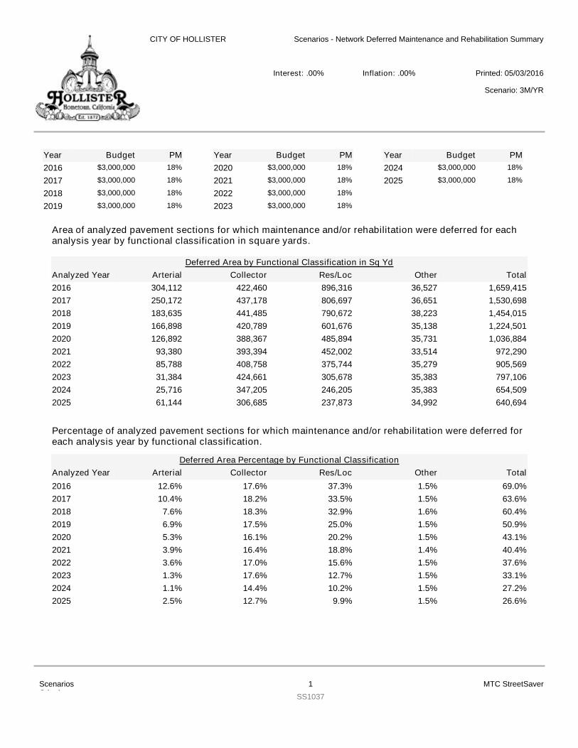
Area of analyzed pavement sections for which maintenance and/or rehabilitation were deferred for eachanalysis year by functional classification in square yards.
YearYearYear Budget PM Budget PM Budget PM2016 $3,000,000 18%
2017 $3,000,000 18%
2018 $3,000,000 18%
2019 $3,000,000 18%
2020 $3,000,000 18%
2021 $3,000,000 18%
2022 $3,000,000 18%
2023 $3,000,000 18%
2024 $3,000,000 18%
2025 $3,000,000 18%
Arterial Collector Res/Loc Other TotalDeferred Area by Functional Classification in Sq Yd
Analyzed Year2016 304,112 422,460 896,316 36,527 1,659,4152017 250,172 437,178 806,697 36,651 1,530,6982018 183,635 441,485 790,672 38,223 1,454,0152019 166,898 420,789 601,676 35,138 1,224,5012020 126,892 388,367 485,894 35,731 1,036,8842021 93,380 393,394 452,002 33,514 972,2902022 85,788 408,758 375,744 35,279 905,5692023 31,384 424,661 305,678 35,383 797,1062024 25,716 347,205 246,205 35,383 654,5092025 61,144 306,685 237,873 34,992 640,694
Percentage of analyzed pavement sections for which maintenance and/or rehabilitation were deferred foreach analysis year by functional classification.
Arterial Collector Res/Loc Other TotalDeferred Area Percentage by Functional Classification
Analyzed Year2016 12.6% 17.6% 37.3% 1.5% 69.0%2017 10.4% 18.2% 33.5% 1.5% 63.6%2018 7.6% 18.3% 32.9% 1.6% 60.4%2019 6.9% 17.5% 25.0% 1.5% 50.9%2020 5.3% 16.1% 20.2% 1.5% 43.1%2021 3.9% 16.4% 18.8% 1.4% 40.4%2022 3.6% 17.0% 15.6% 1.5% 37.6%2023 1.3% 17.6% 12.7% 1.5% 33.1%2024 1.1% 14.4% 10.2% 1.5% 27.2%2025 2.5% 12.7% 9.9% 1.5% 26.6%
CITY OF HOLLISTER Scenarios - Network Deferred Maintenance and Rehabilitation Summary
Printed: 05/03/2016Interest: .00% Inflation: .00%
Scenario: 3M/YR
ScenariosCriteria:
1SS1037
MTC StreetSaver
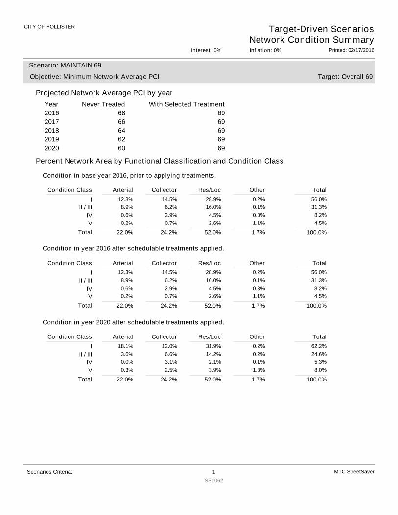
CITY OF HOLLISTER Target-Driven ScenariosNetwork Condition Summary
Printed: 02/17/2016Interest: 0% Inflation: 0%
Projected Network Average PCI by yearYear With Selected TreatmentNever Treated
Target: Overall 69
Scenario: MAINTAIN 69
Objective: Minimum Network Average PCI
2016 69682017 69662018 69642019 69622020 6960
Percent Network Area by Functional Classification and Condition Class
Condition in base year 2016, prior to applying treatments.
Condition Class Arterial Collector Res/Loc Other TotalI 12.3% 14.5% 28.9% 0.2% 56.0%
II / III 8.9% 6.2% 16.0% 0.1% 31.3%IV 0.6% 2.9% 4.5% 0.3% 8.2%V 0.2% 0.7% 2.6% 1.1% 4.5%
22.0%Total 24.2% 52.0% 1.7% 100.0%
Condition in year 2016 after schedulable treatments applied.
Condition Class Arterial Collector Res/Loc Other TotalI 12.3% 14.5% 28.9% 0.2% 56.0%
II / III 8.9% 6.2% 16.0% 0.1% 31.3%IV 0.6% 2.9% 4.5% 0.3% 8.2%V 0.2% 0.7% 2.6% 1.1% 4.5%
22.0%Total 24.2% 52.0% 1.7% 100.0%
Condition in year 2020 after schedulable treatments applied.
Condition Class Arterial Collector Res/Loc Other TotalI 18.1% 12.0% 31.9% 0.2% 62.2%
II / III 3.6% 6.6% 14.2% 0.2% 24.6%IV 0.0% 3.1% 2.1% 0.1% 5.3%V 0.3% 2.5% 3.9% 1.3% 8.0%
22.0%Total 24.2% 52.0% 1.7% 100.0%
MTC StreetSaverScenarios Criteria: 1SS1062
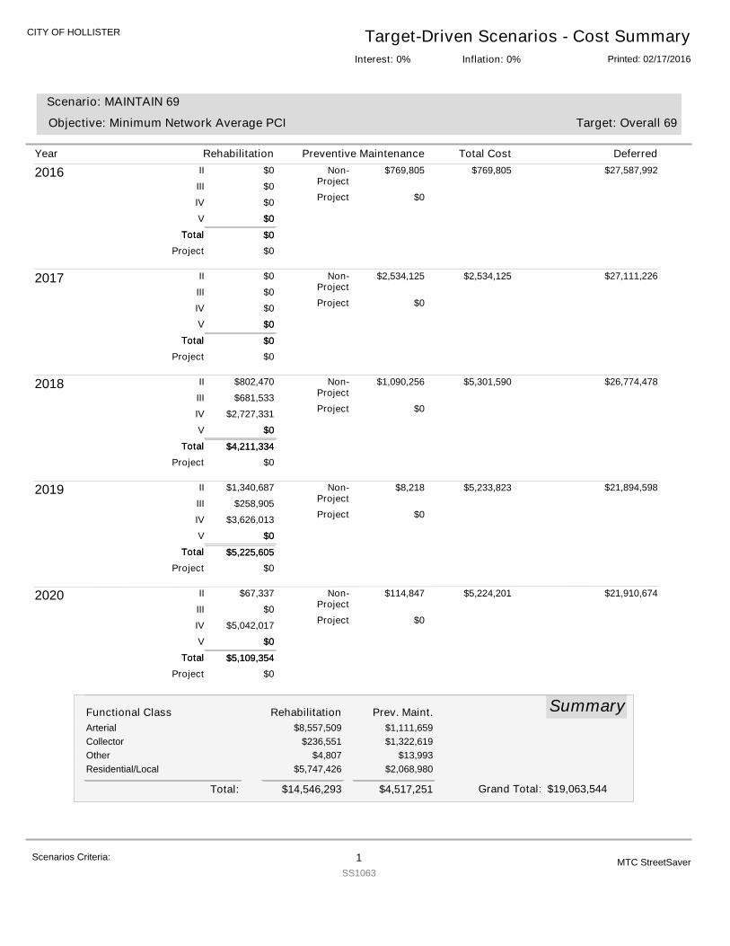
CITY OF HOLLISTER Target-Driven Scenarios - Cost SummaryPrinted: 02/17/2016Inflation: 0%Interest: 0%
Target: Overall 69
Scenario: MAINTAIN 69
Objective: Minimum Network Average PCI
2016
$0
$0
$0
$0
$0
$769,805
$0
$0
II
III
IV
V
Non-Project
Project
Project
Total $0Total
$0
$769,805 $27,587,992
2017
$0
$0
$0
$0
$0
$2,534,125
$0
$0
II
III
IV
V
Non-Project
Project
Project
Total $0Total
$0
$2,534,125 $27,111,226
2018
$4,211,334
$802,470
$681,533
$2,727,331
$0
$1,090,256
$0
$0
II
III
IV
V
Non-Project
Project
Project
Total $4,211,334Total
$0
$5,301,590 $26,774,478
2019
$5,225,605
$1,340,687
$258,905
$3,626,013
$0
$8,218
$0
$0
II
III
IV
V
Non-Project
Project
Project
Total $5,225,605Total
$0
$5,233,823 $21,894,598
2020
$5,109,354
$67,337
$0
$5,042,017
$0
$114,847
$0
$0
II
III
IV
V
Non-Project
Project
Project
Total $5,109,354Total
$0
$5,224,201 $21,910,674
SummaryFunctional Class Rehabilitation Prev. Maint.Arterial $8,557,509 $1,111,659Collector $236,551 $1,322,619Other $4,807 $13,993Residential/Local $5,747,426 $2,068,980
$14,546,293 $4,517,251Total: $19,063,544Grand Total:
Year Rehabilitation Preventive Maintenance Total Cost Deferred
Scenarios Criteria: 1SS1063
MTC StreetSaver
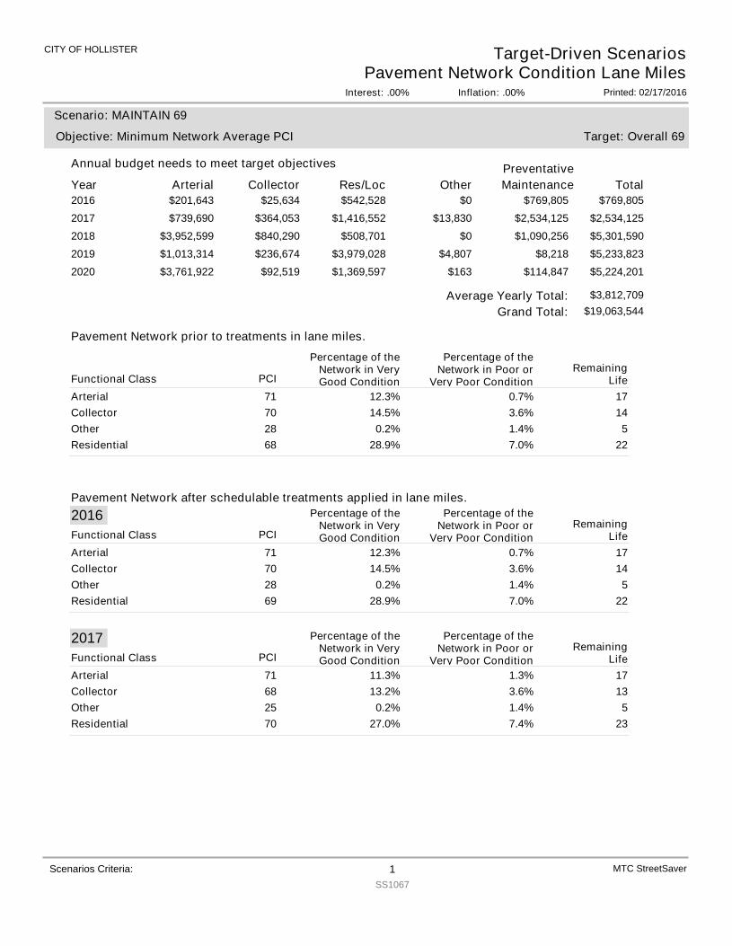
CITY OF HOLLISTER
Interest: .00%
Target-Driven ScenariosPavement Network Condition Lane Miles
Inflation: .00% Printed: 02/17/2016
Year Arterial
Annual budget needs to meet target objectives
Collector Res/Loc Other TotalPreventativeMaintenance
Target: Overall 69
Scenario: MAINTAIN 69
Objective: Minimum Network Average PCI
2016 $201,643 $25,634 $542,528 $0 $769,805$769,8052017 $739,690 $364,053 $1,416,552 $13,830 $2,534,125$2,534,1252018 $3,952,599 $840,290 $508,701 $0 $5,301,590$1,090,2562019 $1,013,314 $236,674 $3,979,028 $4,807 $5,233,823$8,2182020 $3,761,922 $92,519 $1,369,597 $163 $5,224,201$114,847
Scenarios Criteria: 1SS1067
MTC StreetSaver
Pavement Network prior to treatments in lane miles.
Pavement Network after schedulable treatments applied in lane miles.
$19,063,544Grand Total:Average Yearly Total: $3,812,709
PCI
Percentage of theNetwork in VeryGood Condition
Percentage of theNetwork in Poor or
Very Poor ConditionRemaining
LifeFunctional ClassArterial 71 12.3% 0.7% 17Collector 70 14.5% 3.6% 14Other 28 0.2% 1.4% 5Residential 68 28.9% 7.0% 22
2016PCI
Percentage of theNetwork in VeryGood Condition
Percentage of theNetwork in Poor or
Very Poor ConditionRemaining
LifeFunctional ClassArterial 71 12.3% 0.7% 17Collector 70 14.5% 3.6% 14Other 28 0.2% 1.4% 5Residential 69 28.9% 7.0% 22
2017PCI
Percentage of theNetwork in VeryGood Condition
Percentage of theNetwork in Poor or
Very Poor ConditionRemaining
LifeFunctional ClassArterial 71 11.3% 1.3% 17Collector 68 13.2% 3.6% 13Other 25 0.2% 1.4% 5Residential 70 27.0% 7.4% 23
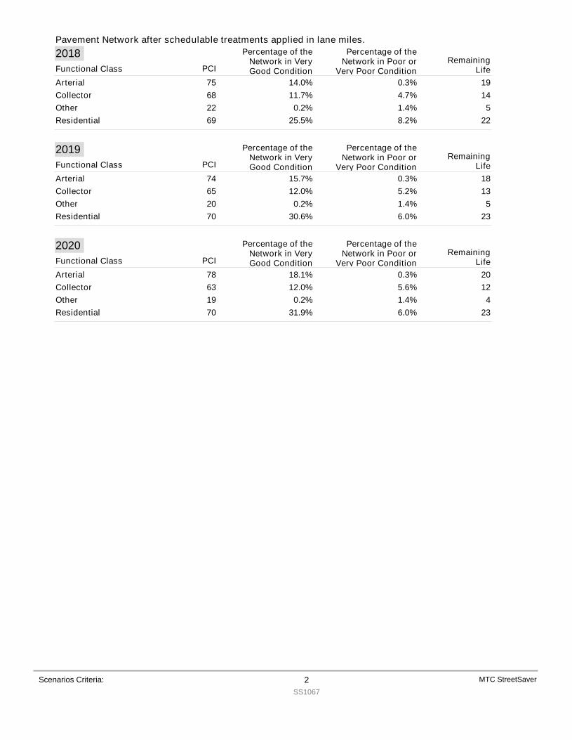
Pavement Network after schedulable treatments applied in lane miles.
Scenarios Criteria: 2SS1067
MTC StreetSaver
2018PCI
Percentage of theNetwork in VeryGood Condition
Percentage of theNetwork in Poor or
Very Poor ConditionRemaining
LifeFunctional ClassArterial 75 14.0% 0.3% 19Collector 68 11.7% 4.7% 14Other 22 0.2% 1.4% 5Residential 69 25.5% 8.2% 22
2019PCI
Percentage of theNetwork in VeryGood Condition
Percentage of theNetwork in Poor or
Very Poor ConditionRemaining
LifeFunctional ClassArterial 74 15.7% 0.3% 18Collector 65 12.0% 5.2% 13Other 20 0.2% 1.4% 5Residential 70 30.6% 6.0% 23
2020PCI
Percentage of theNetwork in VeryGood Condition
Percentage of theNetwork in Poor or
Very Poor ConditionRemaining
LifeFunctional ClassArterial 78 18.1% 0.3% 20Collector 63 12.0% 5.6% 12Other 19 0.2% 1.4% 4Residential 70 31.9% 6.0% 23
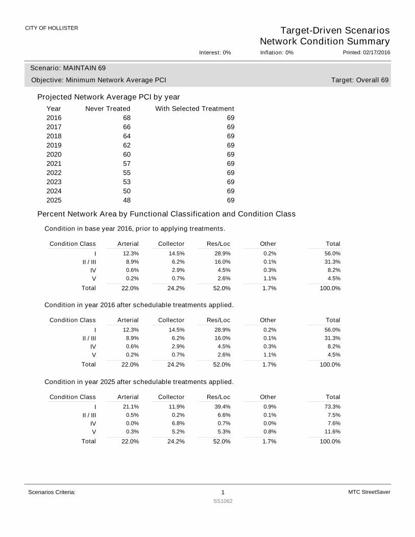
CITY OF HOLLISTER Target-Driven ScenariosNetwork Condition Summary
Printed: 02/17/2016Interest: 0% Inflation: 0%
Projected Network Average PCI by yearYear With Selected TreatmentNever Treated
Target: Overall 69
Scenario: MAINTAIN 69
Objective: Minimum Network Average PCI
2016 69682017 69662018 69642019 69622020 69602021 69572022 69552023 69532024 69502025 6948
Percent Network Area by Functional Classification and Condition Class
Condition in base year 2016, prior to applying treatments.
Condition Class Arterial Collector Res/Loc Other TotalI 12.3% 14.5% 28.9% 0.2% 56.0%
II / III 8.9% 6.2% 16.0% 0.1% 31.3%IV 0.6% 2.9% 4.5% 0.3% 8.2%V 0.2% 0.7% 2.6% 1.1% 4.5%
22.0%Total 24.2% 52.0% 1.7% 100.0%
Condition in year 2016 after schedulable treatments applied.
Condition Class Arterial Collector Res/Loc Other TotalI 12.3% 14.5% 28.9% 0.2% 56.0%
II / III 8.9% 6.2% 16.0% 0.1% 31.3%IV 0.6% 2.9% 4.5% 0.3% 8.2%V 0.2% 0.7% 2.6% 1.1% 4.5%
22.0%Total 24.2% 52.0% 1.7% 100.0%
Condition in year 2025 after schedulable treatments applied.
Condition Class Arterial Collector Res/Loc Other TotalI 21.1% 11.9% 39.4% 0.9% 73.3%
II / III 0.5% 0.2% 6.6% 0.1% 7.5%IV 0.0% 6.8% 0.7% 0.0% 7.6%V 0.3% 5.2% 5.3% 0.8% 11.6%
22.0%Total 24.2% 52.0% 1.7% 100.0%
MTC StreetSaverScenarios Criteria: 1SS1062
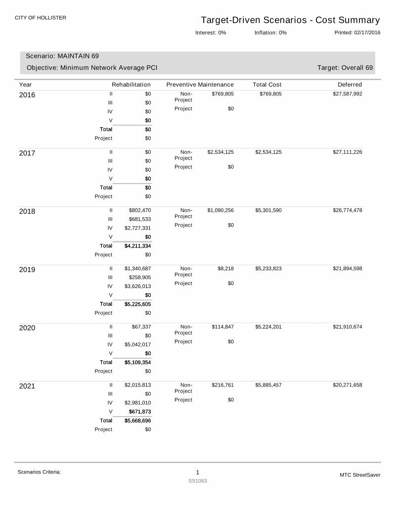
CITY OF HOLLISTER Target-Driven Scenarios - Cost SummaryPrinted: 02/17/2016Inflation: 0%Interest: 0%
Target: Overall 69
Scenario: MAINTAIN 69
Objective: Minimum Network Average PCI
2016
$0
$0
$0
$0
$0
$769,805
$0
$0
II
III
IV
V
Non-Project
Project
Project
Total $0Total
$0
$769,805 $27,587,992
2017
$0
$0
$0
$0
$0
$2,534,125
$0
$0
II
III
IV
V
Non-Project
Project
Project
Total $0Total
$0
$2,534,125 $27,111,226
2018
$4,211,334
$802,470
$681,533
$2,727,331
$0
$1,090,256
$0
$0
II
III
IV
V
Non-Project
Project
Project
Total $4,211,334Total
$0
$5,301,590 $26,774,478
2019
$5,225,605
$1,340,687
$258,905
$3,626,013
$0
$8,218
$0
$0
II
III
IV
V
Non-Project
Project
Project
Total $5,225,605Total
$0
$5,233,823 $21,894,598
2020
$5,109,354
$67,337
$0
$5,042,017
$0
$114,847
$0
$0
II
III
IV
V
Non-Project
Project
Project
Total $5,109,354Total
$0
$5,224,201 $21,910,674
2021
$5,668,696
$2,015,813
$0
$2,981,010
$671,873
$216,761
$0
$0
II
III
IV
V
Non-Project
Project
Project
Total $5,668,696Total
$671,873
$5,885,457 $20,271,658
Year Rehabilitation Preventive Maintenance Total Cost Deferred
Scenarios Criteria: 1SS1063
MTC StreetSaver
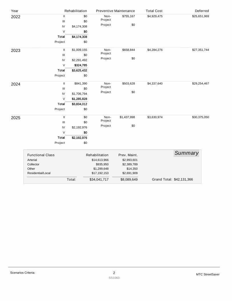
2022
$4,174,308
$0
$0
$4,174,308
$0
$755,167
$0
$0
II
III
IV
V
Non-Project
Project
Project
Total $4,174,308Total
$0
$4,929,475 $25,651,969
2023
$3,625,432
$1,009,155
$0
$2,291,492
$324,785
$658,844
$0
$0
II
III
IV
V
Non-Project
Project
Project
Total $3,625,432Total
$324,785
$4,284,276 $27,351,744
2024
$3,834,012
$841,390
$0
$1,706,794
$1,285,828
$503,628
$0
$0
II
III
IV
V
Non-Project
Project
Project
Total $3,834,012Total
$1,285,828
$4,337,640 $29,254,467
2025
$2,192,976
$0
$0
$2,192,976
$0
$1,437,998
$0
$0
II
III
IV
V
Non-Project
Project
Project
Total $2,192,976Total
$0
$3,630,974 $30,375,050
SummaryFunctional Class Rehabilitation Prev. Maint.Arterial $14,613,966 $2,993,601Collector $935,950 $2,389,789Other $1,299,648 $14,350Residential/Local $17,192,153 $2,691,909
$34,041,717 $8,089,649Total: $42,131,366Grand Total:
Year Rehabilitation Preventive Maintenance Total Cost Deferred
Scenarios Criteria: 2SS1063
MTC StreetSaver
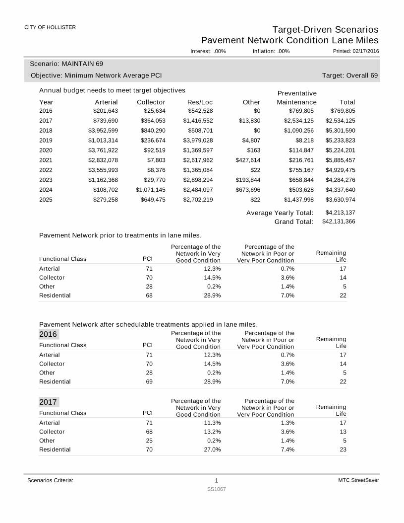
CITY OF HOLLISTER
Interest: .00%
Target-Driven ScenariosPavement Network Condition Lane Miles
Inflation: .00% Printed: 02/17/2016
Year Arterial
Annual budget needs to meet target objectives
Collector Res/Loc Other TotalPreventativeMaintenance
Target: Overall 69
Scenario: MAINTAIN 69
Objective: Minimum Network Average PCI
2016 $201,643 $25,634 $542,528 $0 $769,805$769,8052017 $739,690 $364,053 $1,416,552 $13,830 $2,534,125$2,534,1252018 $3,952,599 $840,290 $508,701 $0 $5,301,590$1,090,2562019 $1,013,314 $236,674 $3,979,028 $4,807 $5,233,823$8,2182020 $3,761,922 $92,519 $1,369,597 $163 $5,224,201$114,8472021 $2,832,078 $7,803 $2,617,962 $427,614 $5,885,457$216,7612022 $3,555,993 $8,376 $1,365,084 $22 $4,929,475$755,1672023 $1,162,368 $29,770 $2,898,294 $193,844 $4,284,276$658,8442024 $108,702 $1,071,145 $2,484,097 $673,696 $4,337,640$503,6282025 $279,258 $649,475 $2,702,219 $22 $3,630,974$1,437,998
Scenarios Criteria: 1SS1067
MTC StreetSaver
Pavement Network prior to treatments in lane miles.
Pavement Network after schedulable treatments applied in lane miles.
$42,131,366Grand Total:Average Yearly Total: $4,213,137
PCI
Percentage of theNetwork in VeryGood Condition
Percentage of theNetwork in Poor or
Very Poor ConditionRemaining
LifeFunctional ClassArterial 71 12.3% 0.7% 17Collector 70 14.5% 3.6% 14Other 28 0.2% 1.4% 5Residential 68 28.9% 7.0% 22
2016PCI
Percentage of theNetwork in VeryGood Condition
Percentage of theNetwork in Poor or
Very Poor ConditionRemaining
LifeFunctional ClassArterial 71 12.3% 0.7% 17Collector 70 14.5% 3.6% 14Other 28 0.2% 1.4% 5Residential 69 28.9% 7.0% 22
2017PCI
Percentage of theNetwork in VeryGood Condition
Percentage of theNetwork in Poor or
Very Poor ConditionRemaining
LifeFunctional ClassArterial 71 11.3% 1.3% 17Collector 68 13.2% 3.6% 13Other 25 0.2% 1.4% 5Residential 70 27.0% 7.4% 23
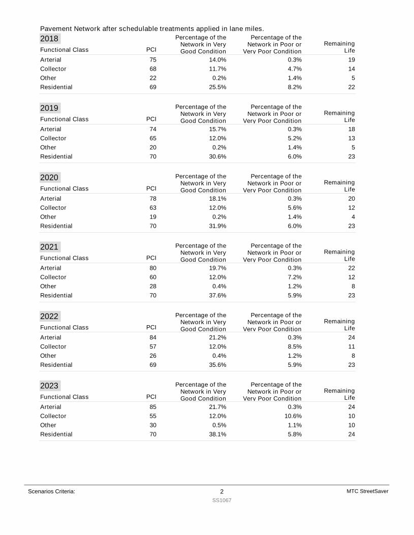
Pavement Network after schedulable treatments applied in lane miles.
Scenarios Criteria: 2SS1067
MTC StreetSaver
2018PCI
Percentage of theNetwork in VeryGood Condition
Percentage of theNetwork in Poor or
Very Poor ConditionRemaining
LifeFunctional ClassArterial 75 14.0% 0.3% 19Collector 68 11.7% 4.7% 14Other 22 0.2% 1.4% 5Residential 69 25.5% 8.2% 22
2019PCI
Percentage of theNetwork in VeryGood Condition
Percentage of theNetwork in Poor or
Very Poor ConditionRemaining
LifeFunctional ClassArterial 74 15.7% 0.3% 18Collector 65 12.0% 5.2% 13Other 20 0.2% 1.4% 5Residential 70 30.6% 6.0% 23
2020PCI
Percentage of theNetwork in VeryGood Condition
Percentage of theNetwork in Poor or
Very Poor ConditionRemaining
LifeFunctional ClassArterial 78 18.1% 0.3% 20Collector 63 12.0% 5.6% 12Other 19 0.2% 1.4% 4Residential 70 31.9% 6.0% 23
2021PCI
Percentage of theNetwork in VeryGood Condition
Percentage of theNetwork in Poor or
Very Poor ConditionRemaining
LifeFunctional ClassArterial 80 19.7% 0.3% 22Collector 60 12.0% 7.2% 12Other 28 0.4% 1.2% 8Residential 70 37.6% 5.9% 23
2022PCI
Percentage of theNetwork in VeryGood Condition
Percentage of theNetwork in Poor or
Very Poor ConditionRemaining
LifeFunctional ClassArterial 84 21.2% 0.3% 24Collector 57 12.0% 8.5% 11Other 26 0.4% 1.2% 8Residential 69 35.6% 5.9% 23
2023PCI
Percentage of theNetwork in VeryGood Condition
Percentage of theNetwork in Poor or
Very Poor ConditionRemaining
LifeFunctional ClassArterial 85 21.7% 0.3% 24Collector 55 12.0% 10.6% 10Other 30 0.5% 1.1% 10Residential 70 38.1% 5.8% 24
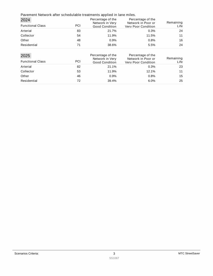
Pavement Network after schedulable treatments applied in lane miles.
Scenarios Criteria: 3SS1067
MTC StreetSaver
2024PCI
Percentage of theNetwork in VeryGood Condition
Percentage of theNetwork in Poor or
Very Poor ConditionRemaining
LifeFunctional ClassArterial 83 21.7% 0.3% 24Collector 54 11.9% 11.5% 11Other 48 0.9% 0.8% 16Residential 71 38.6% 5.5% 24
2025PCI
Percentage of theNetwork in VeryGood Condition
Percentage of theNetwork in Poor or
Very Poor ConditionRemaining
LifeFunctional ClassArterial 82 21.1% 0.3% 23Collector 53 11.9% 12.1% 11Other 46 0.9% 0.8% 15Residential 72 39.4% 6.0% 25
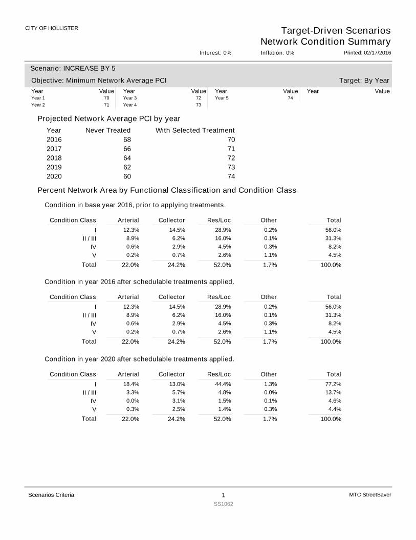
CITY OF HOLLISTER Target-Driven ScenariosNetwork Condition Summary
Printed: 02/17/2016Interest: 0% Inflation: 0%
Projected Network Average PCI by yearYear With Selected TreatmentNever Treated
Target: By Year
Scenario: INCREASE BY 5
Objective: Minimum Network Average PCIYear Value Year Value Year Value Year ValueYear 1 70Year 2 71
Year 3 72Year 4 73
Year 5 74
2016 70682017 71662018 72642019 73622020 7460
Percent Network Area by Functional Classification and Condition Class
Condition in base year 2016, prior to applying treatments.
Condition Class Arterial Collector Res/Loc Other TotalI 12.3% 14.5% 28.9% 0.2% 56.0%
II / III 8.9% 6.2% 16.0% 0.1% 31.3%IV 0.6% 2.9% 4.5% 0.3% 8.2%V 0.2% 0.7% 2.6% 1.1% 4.5%
22.0%Total 24.2% 52.0% 1.7% 100.0%
Condition in year 2016 after schedulable treatments applied.
Condition Class Arterial Collector Res/Loc Other TotalI 12.3% 14.5% 28.9% 0.2% 56.0%
II / III 8.9% 6.2% 16.0% 0.1% 31.3%IV 0.6% 2.9% 4.5% 0.3% 8.2%V 0.2% 0.7% 2.6% 1.1% 4.5%
22.0%Total 24.2% 52.0% 1.7% 100.0%
Condition in year 2020 after schedulable treatments applied.
Condition Class Arterial Collector Res/Loc Other TotalI 18.4% 13.0% 44.4% 1.3% 77.2%
II / III 3.3% 5.7% 4.8% 0.0% 13.7%IV 0.0% 3.1% 1.5% 0.1% 4.6%V 0.3% 2.5% 1.4% 0.3% 4.4%
22.0%Total 24.2% 52.0% 1.7% 100.0%
MTC StreetSaverScenarios Criteria: 1SS1062
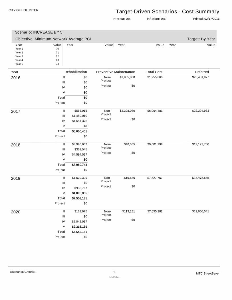
CITY OF HOLLISTER Target-Driven Scenarios - Cost SummaryPrinted: 02/17/2016Inflation: 0%Interest: 0%
Target: By Year
Scenario: INCREASE BY 5
Objective: Minimum Network Average PCIYear Value Year Value Year Value Year ValueYear 1 70Year 2 71Year 3 72Year 4 73Year 5 74
2016
$0
$0
$0
$0
$0
$1,955,860
$0
$0
II
III
IV
V
Non-Project
Project
Project
Total $0Total
$0
$1,955,860 $26,401,977
2017
$3,666,401
$556,015
$1,459,010
$1,651,376
$0
$2,398,080
$0
$0
II
III
IV
V
Non-Project
Project
Project
Total $3,666,401Total
$0
$6,064,481 $22,394,983
2018
$8,960,744
$3,996,662
$369,545
$4,594,537
$0
$40,555
$0
$0
II
III
IV
V
Non-Project
Project
Project
Total $8,960,744Total
$0
$9,001,299 $19,177,750
2019
$7,508,131
$1,679,309
$0
$933,767
$4,895,055
$19,636
$0
$0
II
III
IV
V
Non-Project
Project
Project
Total $7,508,131Total
$4,895,055
$7,527,767 $13,478,565
2020
$7,542,151
$181,975
$0
$5,042,017
$2,318,159
$113,131
$0
$0
II
III
IV
V
Non-Project
Project
Project
Total $7,542,151Total
$2,318,159
$7,655,282 $12,060,541
Year Rehabilitation Preventive Maintenance Total Cost Deferred
Scenarios Criteria: 1SS1063
MTC StreetSaver

Year Rehabilitation Preventive Maintenance Total Cost Deferred
SummaryFunctional Class Rehabilitation Prev. Maint.Arterial $8,809,041 $1,115,009Collector $860,815 $1,329,476Other $2,118,725 $13,991Residential/Local $15,888,846 $2,068,786
$27,677,427 $4,527,262Total: $32,204,689Grand Total:
Scenarios Criteria: 2SS1063
MTC StreetSaver
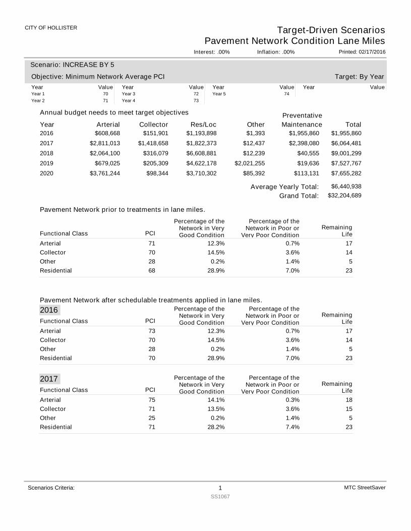
CITY OF HOLLISTER
Interest: .00%
Target-Driven ScenariosPavement Network Condition Lane Miles
Inflation: .00% Printed: 02/17/2016
Year Arterial
Annual budget needs to meet target objectives
Collector Res/Loc Other TotalPreventativeMaintenance
Target: By Year
Scenario: INCREASE BY 5
Objective: Minimum Network Average PCIYear Value Year Value Year Value Year ValueYear 1 70Year 2 71
Year 3 72Year 4 73
Year 5 74
2016 $608,668 $151,901 $1,193,898 $1,393 $1,955,860$1,955,8602017 $2,811,013 $1,418,658 $1,822,373 $12,437 $6,064,481$2,398,0802018 $2,064,100 $316,079 $6,608,881 $12,239 $9,001,299$40,5552019 $679,025 $205,309 $4,622,178 $2,021,255 $7,527,767$19,6362020 $3,761,244 $98,344 $3,710,302 $85,392 $7,655,282$113,131
Scenarios Criteria: 1SS1067
MTC StreetSaver
Pavement Network prior to treatments in lane miles.
Pavement Network after schedulable treatments applied in lane miles.
$32,204,689Grand Total:Average Yearly Total: $6,440,938
PCI
Percentage of theNetwork in VeryGood Condition
Percentage of theNetwork in Poor or
Very Poor ConditionRemaining
LifeFunctional ClassArterial 71 12.3% 0.7% 17Collector 70 14.5% 3.6% 14Other 28 0.2% 1.4% 5Residential 68 28.9% 7.0% 23
2016PCI
Percentage of theNetwork in VeryGood Condition
Percentage of theNetwork in Poor or
Very Poor ConditionRemaining
LifeFunctional ClassArterial 73 12.3% 0.7% 17Collector 70 14.5% 3.6% 14Other 28 0.2% 1.4% 5Residential 70 28.9% 7.0% 23
2017PCI
Percentage of theNetwork in VeryGood Condition
Percentage of theNetwork in Poor or
Very Poor ConditionRemaining
LifeFunctional ClassArterial 75 14.1% 0.3% 18Collector 71 13.5% 3.6% 15Other 25 0.2% 1.4% 5Residential 71 28.2% 7.4% 23
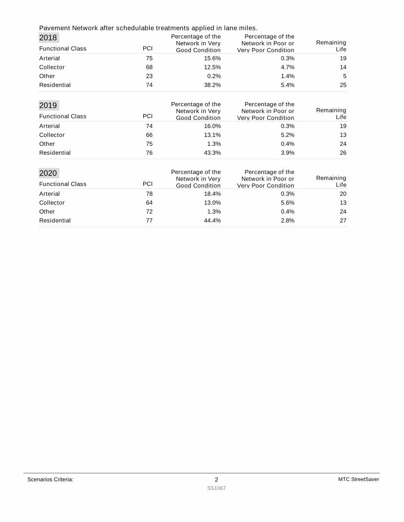
Pavement Network after schedulable treatments applied in lane miles.
Scenarios Criteria: 2SS1067
MTC StreetSaver
2018PCI
Percentage of theNetwork in VeryGood Condition
Percentage of theNetwork in Poor or
Very Poor ConditionRemaining
LifeFunctional ClassArterial 75 15.6% 0.3% 19Collector 68 12.5% 4.7% 14Other 23 0.2% 1.4% 5Residential 74 38.2% 5.4% 25
2019PCI
Percentage of theNetwork in VeryGood Condition
Percentage of theNetwork in Poor or
Very Poor ConditionRemaining
LifeFunctional ClassArterial 74 16.0% 0.3% 19Collector 66 13.1% 5.2% 13Other 75 1.3% 0.4% 24Residential 76 43.3% 3.9% 26
2020PCI
Percentage of theNetwork in VeryGood Condition
Percentage of theNetwork in Poor or
Very Poor ConditionRemaining
LifeFunctional ClassArterial 78 18.4% 0.3% 20Collector 64 13.0% 5.6% 13Other 72 1.3% 0.4% 24Residential 77 44.4% 2.8% 27
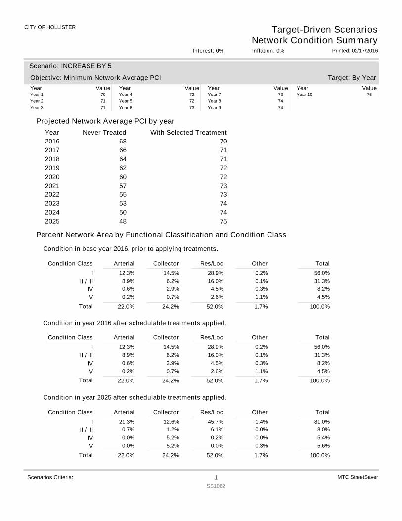
CITY OF HOLLISTER Target-Driven ScenariosNetwork Condition Summary
Printed: 02/17/2016Interest: 0% Inflation: 0%
Projected Network Average PCI by yearYear With Selected TreatmentNever Treated
Target: By Year
Scenario: INCREASE BY 5
Objective: Minimum Network Average PCIYear Value Year Value Year Value Year ValueYear 1 70Year 2 71Year 3 71
Year 4 72Year 5 72Year 6 73
Year 7 73Year 8 74Year 9 74
Year 10 75
2016 70682017 71662018 71642019 72622020 72602021 73572022 73552023 74532024 74502025 7548
Percent Network Area by Functional Classification and Condition Class
Condition in base year 2016, prior to applying treatments.
Condition Class Arterial Collector Res/Loc Other TotalI 12.3% 14.5% 28.9% 0.2% 56.0%
II / III 8.9% 6.2% 16.0% 0.1% 31.3%IV 0.6% 2.9% 4.5% 0.3% 8.2%V 0.2% 0.7% 2.6% 1.1% 4.5%
22.0%Total 24.2% 52.0% 1.7% 100.0%
Condition in year 2016 after schedulable treatments applied.
Condition Class Arterial Collector Res/Loc Other TotalI 12.3% 14.5% 28.9% 0.2% 56.0%
II / III 8.9% 6.2% 16.0% 0.1% 31.3%IV 0.6% 2.9% 4.5% 0.3% 8.2%V 0.2% 0.7% 2.6% 1.1% 4.5%
22.0%Total 24.2% 52.0% 1.7% 100.0%
Condition in year 2025 after schedulable treatments applied.
Condition Class Arterial Collector Res/Loc Other TotalI 21.3% 12.6% 45.7% 1.4% 81.0%
II / III 0.7% 1.2% 6.1% 0.0% 8.0%IV 0.0% 5.2% 0.2% 0.0% 5.4%V 0.0% 5.2% 0.0% 0.3% 5.6%
22.0%Total 24.2% 52.0% 1.7% 100.0%
MTC StreetSaverScenarios Criteria: 1SS1062
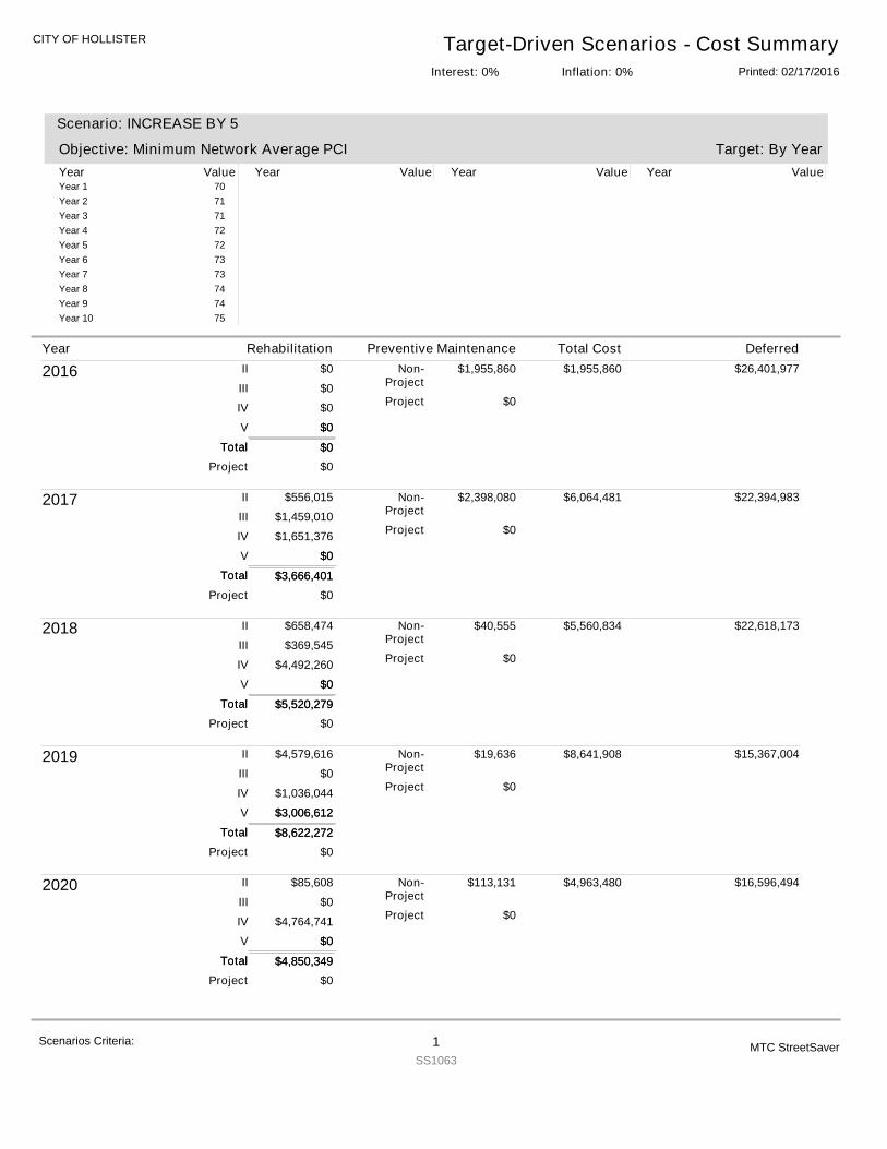
CITY OF HOLLISTER Target-Driven Scenarios - Cost SummaryPrinted: 02/17/2016Inflation: 0%Interest: 0%
Target: By Year
Scenario: INCREASE BY 5
Objective: Minimum Network Average PCIYear Value Year Value Year Value Year ValueYear 1 70Year 2 71Year 3 71Year 4 72Year 5 72Year 6 73Year 7 73Year 8 74Year 9 74Year 10 75
2016
$0
$0
$0
$0
$0
$1,955,860
$0
$0
II
III
IV
V
Non-Project
Project
Project
Total $0Total
$0
$1,955,860 $26,401,977
2017
$3,666,401
$556,015
$1,459,010
$1,651,376
$0
$2,398,080
$0
$0
II
III
IV
V
Non-Project
Project
Project
Total $3,666,401Total
$0
$6,064,481 $22,394,983
2018
$5,520,279
$658,474
$369,545
$4,492,260
$0
$40,555
$0
$0
II
III
IV
V
Non-Project
Project
Project
Total $5,520,279Total
$0
$5,560,834 $22,618,173
2019
$8,622,272
$4,579,616
$0
$1,036,044
$3,006,612
$19,636
$0
$0
II
III
IV
V
Non-Project
Project
Project
Total $8,622,272Total
$3,006,612
$8,641,908 $15,367,004
2020
$4,850,349
$85,608
$0
$4,764,741
$0
$113,131
$0
$0
II
III
IV
V
Non-Project
Project
Project
Total $4,850,349Total
$0
$4,963,480 $16,596,494
Year Rehabilitation Preventive Maintenance Total Cost Deferred
Scenarios Criteria: 1SS1063
MTC StreetSaver
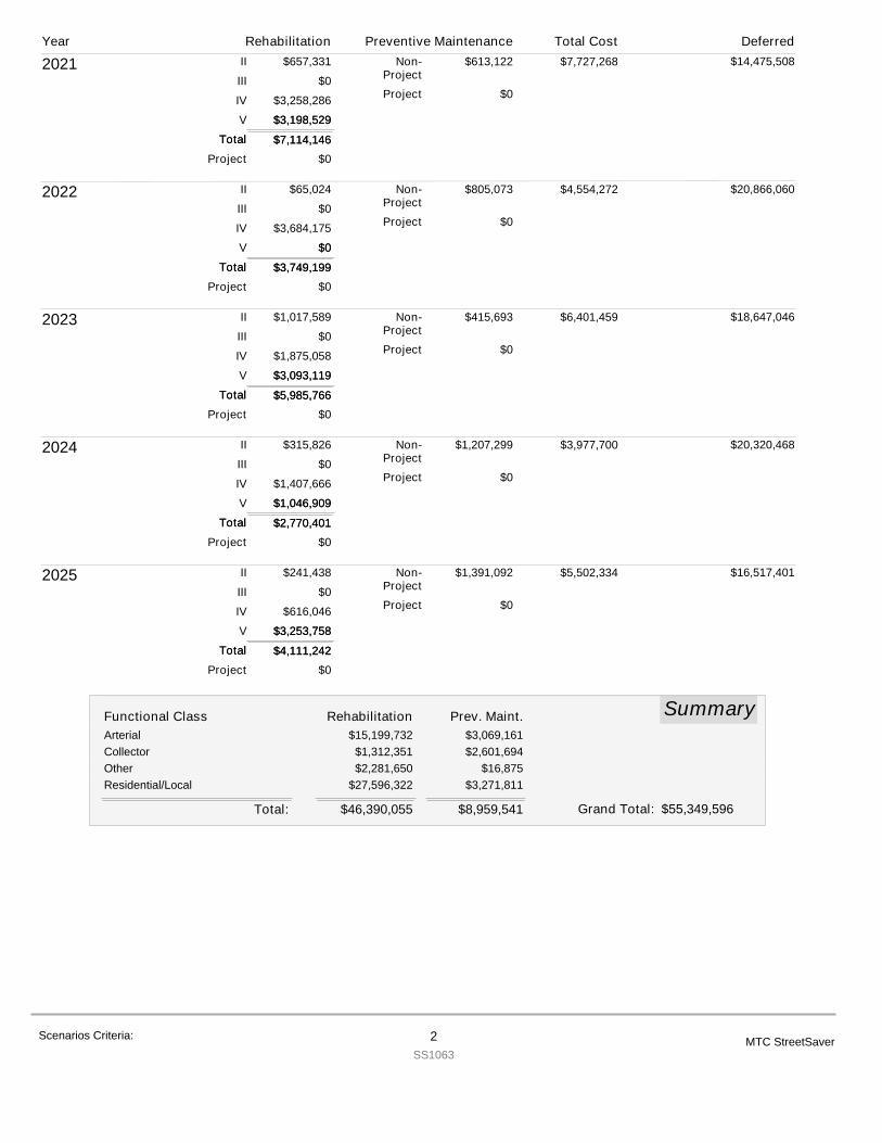
2021
$7,114,146
$657,331
$0
$3,258,286
$3,198,529
$613,122
$0
$0
II
III
IV
V
Non-Project
Project
Project
Total $7,114,146Total
$3,198,529
$7,727,268 $14,475,508
2022
$3,749,199
$65,024
$0
$3,684,175
$0
$805,073
$0
$0
II
III
IV
V
Non-Project
Project
Project
Total $3,749,199Total
$0
$4,554,272 $20,866,060
2023
$5,985,766
$1,017,589
$0
$1,875,058
$3,093,119
$415,693
$0
$0
II
III
IV
V
Non-Project
Project
Project
Total $5,985,766Total
$3,093,119
$6,401,459 $18,647,046
2024
$2,770,401
$315,826
$0
$1,407,666
$1,046,909
$1,207,299
$0
$0
II
III
IV
V
Non-Project
Project
Project
Total $2,770,401Total
$1,046,909
$3,977,700 $20,320,468
2025
$4,111,242
$241,438
$0
$616,046
$3,253,758
$1,391,092
$0
$0
II
III
IV
V
Non-Project
Project
Project
Total $4,111,242Total
$3,253,758
$5,502,334 $16,517,401
SummaryFunctional Class Rehabilitation Prev. Maint.Arterial $15,199,732 $3,069,161Collector $1,312,351 $2,601,694Other $2,281,650 $16,875Residential/Local $27,596,322 $3,271,811
$46,390,055 $8,959,541Total: $55,349,596Grand Total:
Year Rehabilitation Preventive Maintenance Total Cost Deferred
Scenarios Criteria: 2SS1063
MTC StreetSaver
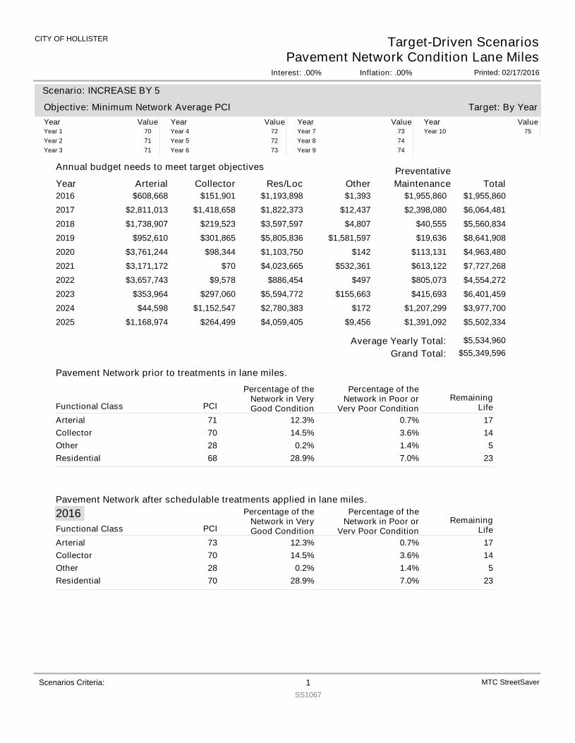
CITY OF HOLLISTER
Interest: .00%
Target-Driven ScenariosPavement Network Condition Lane Miles
Inflation: .00% Printed: 02/17/2016
Year Arterial
Annual budget needs to meet target objectives
Collector Res/Loc Other TotalPreventativeMaintenance
Target: By Year
Scenario: INCREASE BY 5
Objective: Minimum Network Average PCIYear Value Year Value Year Value Year ValueYear 1 70Year 2 71Year 3 71
Year 4 72Year 5 72Year 6 73
Year 7 73Year 8 74Year 9 74
Year 10 75
2016 $608,668 $151,901 $1,193,898 $1,393 $1,955,860$1,955,8602017 $2,811,013 $1,418,658 $1,822,373 $12,437 $6,064,481$2,398,0802018 $1,738,907 $219,523 $3,597,597 $4,807 $5,560,834$40,5552019 $952,610 $301,865 $5,805,836 $1,581,597 $8,641,908$19,6362020 $3,761,244 $98,344 $1,103,750 $142 $4,963,480$113,1312021 $3,171,172 $70 $4,023,665 $532,361 $7,727,268$613,1222022 $3,657,743 $9,578 $886,454 $497 $4,554,272$805,0732023 $353,964 $297,060 $5,594,772 $155,663 $6,401,459$415,6932024 $44,598 $1,152,547 $2,780,383 $172 $3,977,700$1,207,2992025 $1,168,974 $264,499 $4,059,405 $9,456 $5,502,334$1,391,092
Scenarios Criteria: 1SS1067
MTC StreetSaver
Pavement Network prior to treatments in lane miles.
Pavement Network after schedulable treatments applied in lane miles.
$55,349,596Grand Total:Average Yearly Total: $5,534,960
PCI
Percentage of theNetwork in VeryGood Condition
Percentage of theNetwork in Poor or
Very Poor ConditionRemaining
LifeFunctional ClassArterial 71 12.3% 0.7% 17Collector 70 14.5% 3.6% 14Other 28 0.2% 1.4% 5Residential 68 28.9% 7.0% 23
2016PCI
Percentage of theNetwork in VeryGood Condition
Percentage of theNetwork in Poor or
Very Poor ConditionRemaining
LifeFunctional ClassArterial 73 12.3% 0.7% 17Collector 70 14.5% 3.6% 14Other 28 0.2% 1.4% 5Residential 70 28.9% 7.0% 23
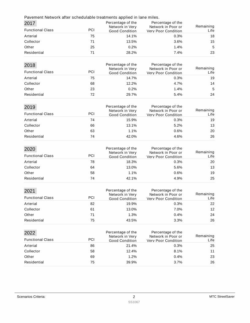
Pavement Network after schedulable treatments applied in lane miles.
Scenarios Criteria: 2SS1067
MTC StreetSaver
2017PCI
Percentage of theNetwork in VeryGood Condition
Percentage of theNetwork in Poor or
Very Poor ConditionRemaining
LifeFunctional ClassArterial 75 14.1% 0.3% 18Collector 71 13.5% 3.6% 15Other 25 0.2% 1.4% 5Residential 71 28.2% 7.4% 23
2018PCI
Percentage of theNetwork in VeryGood Condition
Percentage of theNetwork in Poor or
Very Poor ConditionRemaining
LifeFunctional ClassArterial 75 14.7% 0.3% 19Collector 68 12.2% 4.7% 14Other 23 0.2% 1.4% 5Residential 72 29.7% 5.4% 24
2019PCI
Percentage of theNetwork in VeryGood Condition
Percentage of theNetwork in Poor or
Very Poor ConditionRemaining
LifeFunctional ClassArterial 74 15.9% 0.3% 19Collector 66 13.1% 5.2% 13Other 63 1.1% 0.6% 20Residential 74 42.0% 4.6% 26
2020PCI
Percentage of theNetwork in VeryGood Condition
Percentage of theNetwork in Poor or
Very Poor ConditionRemaining
LifeFunctional ClassArterial 78 18.3% 0.3% 20Collector 64 13.0% 5.6% 13Other 58 1.1% 0.6% 19Residential 74 42.1% 4.9% 25
2021PCI
Percentage of theNetwork in VeryGood Condition
Percentage of theNetwork in Poor or
Very Poor ConditionRemaining
LifeFunctional ClassArterial 82 19.9% 0.3% 22Collector 61 13.0% 7.0% 12Other 71 1.3% 0.4% 24Residential 75 43.5% 3.3% 26
2022PCI
Percentage of theNetwork in VeryGood Condition
Percentage of theNetwork in Poor or
Very Poor ConditionRemaining
LifeFunctional ClassArterial 86 21.4% 0.3% 25Collector 58 12.4% 8.1% 11Other 69 1.2% 0.4% 23Residential 75 39.9% 3.7% 26
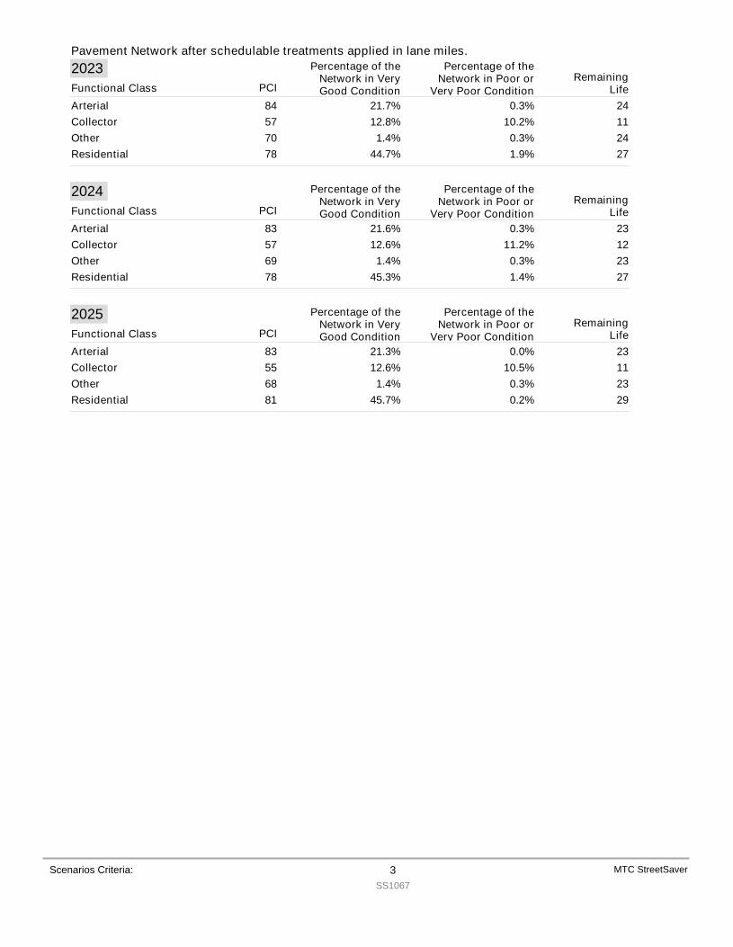
Pavement Network after schedulable treatments applied in lane miles.
Scenarios Criteria: 3SS1067
MTC StreetSaver
2023PCI
Percentage of theNetwork in VeryGood Condition
Percentage of theNetwork in Poor or
Very Poor ConditionRemaining
LifeFunctional ClassArterial 84 21.7% 0.3% 24Collector 57 12.8% 10.2% 11Other 70 1.4% 0.3% 24Residential 78 44.7% 1.9% 27
2024PCI
Percentage of theNetwork in VeryGood Condition
Percentage of theNetwork in Poor or
Very Poor ConditionRemaining
LifeFunctional ClassArterial 83 21.6% 0.3% 23Collector 57 12.6% 11.2% 12Other 69 1.4% 0.3% 23Residential 78 45.3% 1.4% 27
2025PCI
Percentage of theNetwork in VeryGood Condition
Percentage of theNetwork in Poor or
Very Poor ConditionRemaining
LifeFunctional ClassArterial 83 21.3% 0.0% 23Collector 55 12.6% 10.5% 11Other 68 1.4% 0.3% 23Residential 81 45.7% 0.2% 29
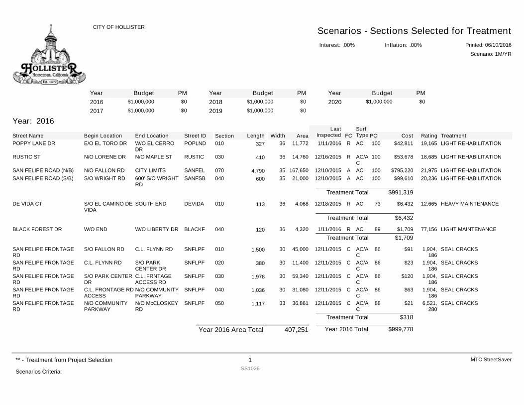
YearYearYear Budget PM Budget PM Budget PM2016 $1,000,000 $0
2017 $1,000,000 $02018 $1,000,000 $0
2019 $1,000,000 $02020 $1,000,000 $0
Year: 2016
Street Name Begin Location End Location Street ID Section FCSurfType Cost Rating TreatmentPCILength Width Area
LastInspected
POPPY LANE DR E/O EL TORO DR W/O EL CERRODR
POPLND 010 R AC $42,811 19,165 LIGHT REHABILITATION10011,77236327 1/11/2016
RUSTIC ST N/O LORENE DR N/O MAPLE ST RUSTIC 030 R AC/AC
$53,678 18,685 LIGHT REHABILITATION10014,76036410 12/16/2015
SAN FELIPE ROAD (N/B) N/O FALLON RD CITY LIMITS SANFEL 070 A AC $795,220 21,975 LIGHT REHABILITATION100167,650354,790 12/10/2015SAN FELIPE ROAD (S/B) S/O WRIGHT RD 600' S/O WRIGHT
RDSANFSB 040 A AC $99,610 20,236 LIGHT REHABILITATION10021,00035600 12/10/2015
$991,319Treatment Total
DE VIDA CT S/O EL CAMINO DEVIDA
SOUTH END DEVIDA 010 R AC $6,432 12,665 HEAVY MAINTENANCE734,06836113 12/18/2015
$6,432Treatment Total
BLACK FOREST DR W/O END W/O LIBERTY DR BLACKF 040 R AC $1,709 77,156 LIGHT MAINTENANCE894,32036120 1/11/2016$1,709Treatment Total
SAN FELIPE FRONTAGERD
S/O FALLON RD C.L. FLYNN RD SNFLPF 010 C AC/AC
$91 1,904,186
SEAL CRACKS8645,000301,500 12/11/2015
SAN FELIPE FRONTAGERD
C.L. FLYNN RD S/O PARKCENTER DR
SNFLPF 020 C AC/AC
$23 1,904,186
SEAL CRACKS8611,40030380 12/11/2015
SAN FELIPE FRONTAGERD
S/O PARK CENTERDR
C.L. FRNTAGEACCESS RD
SNFLPF 030 C AC/AC
$120 1,904,186
SEAL CRACKS8659,340301,978 12/11/2015
SAN FELIPE FRONTAGERD
C.L. FRONTAGE RDACCESS
N/O COMMUNITYPARKWAY
SNFLPF 040 C AC/AC
$63 1,904,186
SEAL CRACKS8631,080301,036 12/11/2015
SAN FELIPE FRONTAGERD
N/O COMMUNITYPARKWAY
N/O McCLOSKEYRD
SNFLPF 050 C AC/AC
$21 6,521,280
SEAL CRACKS8836,861331,117 12/11/2015
$318Treatment Total
$999,778Year 2016 TotalYear 2016 Area Total 407,251
Interest: .00%
CITY OF HOLLISTER Scenarios - Sections Selected for TreatmentInflation: .00% Printed: 06/10/2016
Scenario: 1M/YR
Scenarios Criteria:
** - Treatment from Project Selection 1SS1026
MTC StreetSaver
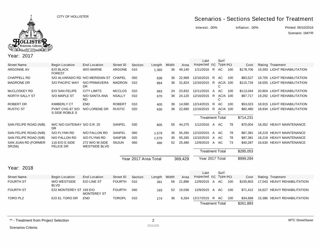
Year: 2017
Street Name Begin Location End Location Street ID Section FCSurfType Cost Rating TreatmentPCILength Width Area
LastInspected
ARGONNE AV E/O BLACKFOREST
W/O MARNE ARGONE 010 R AC $178,706 19,393 LIGHT REHABILITATION10049,140361,365 1/11/2016
CHAPPELL RD S/O ALVARADO RD N/O MERIDIAN ST CHAPEL 050 R AC $83,527 19,705 LIGHT REHABILITATION10022,96836638 12/16/2015MADRONE DR S/O PACIFIC WAY N/O PRIMAVERA
DRMADRON 010 R AC/A
C$115,734 18,555 LIGHT REHABILITATION10031,82436884 12/16/2015
McCLOSKEY RD E/O SAN FELIPE CITY LIMITS MCCLOS 010 A AC $113,044 20,804 LIGHT REHABILITATION10023,83224993 12/11/2015NORTH SALLY ST S/O MAPLE ST N/O SANTA ANA
RDNSALLY 010 R AC/A
C$87,717 19,292 LIGHT REHABILITATION10024,12036670 12/16/2015
ROBERT DR KIMBERLY CT END ROBERT 010 R AC $53,023 18,915 LIGHT REHABILITATION10014,58036405 12/14/2015RUSTIC ST PVMT CHG 87 S/O
S.SIDE ROBLE SN/O LORENE DR RUSTIC 020 R AC/A
C$82,480 18,934 LIGHT REHABILITATION10022,68036630 12/16/2015
$714,231Treatment Total
SAN FELIPE ROAD (N/B) W/C N/O GATEWAYDR
S/O S.R. 25 SANFEL 030 A AC $70,004 18,352 HEAVY MAINTENANCE7844,27555805 1/12/2016
SAN FELIPE ROAD (N/B) S/O FLYNN RD N/O FALLON RD SANFEL 060 A AC $87,381 18,219 HEAVY MAINTENANCE7855,265351,579 12/10/2015SAN FELIPE ROAD (S/B) N/O FALLON RD S/O FLYNN RD SANFSB 020 A AC $87,381 18,219 HEAVY MAINTENANCE7855,265351,579 12/10/2015SAN JUAN RD (FORMERSR156)
116 E/O E.SIDEFELICE DR
272 W/O W.SIDEWESTSIDE BLVD
SNJUN 060 A AC $40,287 16,630 HEAVY MAINTENANCE7325,48052490 12/9/2015
$285,053Treatment Total
$999,284Year 2017 TotalYear 2017 Area Total 369,429
Year: 2018
Street Name Begin Location End Location Street ID Section FCSurfType Cost Rating TreatmentPCILength Width Area
LastInspected
FOURTH ST W/O WESTSIDEBLVD
E/O LINE ST FOURTH 010 A AC $155,803 17,043 HEAVY REHABILITATION10021,89656391 12/9/2015
FOURTH ST E/O MONTEREY ST 193 E/OMONTEREY ST
FOURTH 040 A AC $71,412 16,627 HEAVY REHABILITATION10010,03652193 12/9/2015
TORO PLZ E/O EL TORO DR END TOROPL 010 R AC $34,668 15,386 HEAVY REHABILITATION1006,26436174 12/17/2015$261,883Treatment Total
Interest: .00%
CITY OF HOLLISTER Scenarios - Sections Selected for TreatmentInflation: .00% Printed: 06/10/2016
Scenario: 1M/YR
Scenarios Criteria:
** - Treatment from Project Selection 2SS1026
MTC StreetSaver
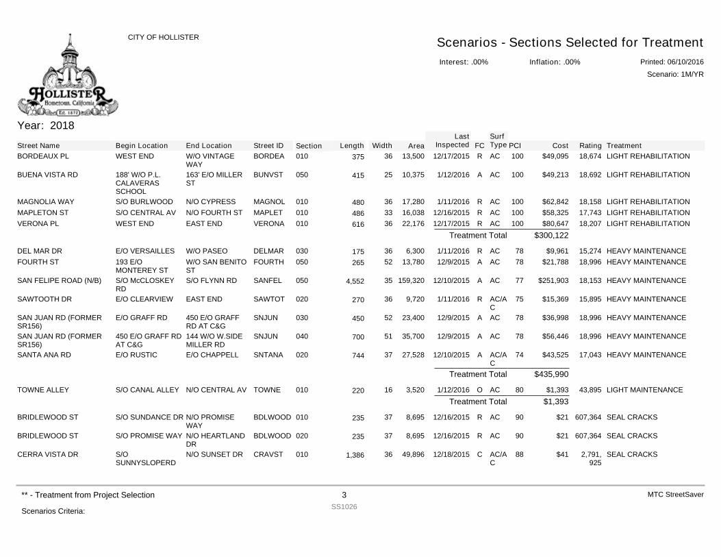
Year: 2018
Street Name Begin Location End Location Street ID Section FCSurfType Cost Rating TreatmentPCILength Width Area
LastInspected
BORDEAUX PL WEST END W/O VINTAGEWAY
BORDEA 010 R AC $49,095 18,674 LIGHT REHABILITATION10013,50036375 12/17/2015
BUENA VISTA RD 188' W/O P.L.CALAVERASSCHOOL
163' E/O MILLERST
BUNVST 050 A AC $49,213 18,692 LIGHT REHABILITATION10010,37525415 1/12/2016
MAGNOLIA WAY S/O BURLWOOD N/O CYPRESS MAGNOL 010 R AC $62,842 18,158 LIGHT REHABILITATION10017,28036480 1/11/2016MAPLETON ST S/O CENTRAL AV N/O FOURTH ST MAPLET 010 R AC $58,325 17,743 LIGHT REHABILITATION10016,03833486 12/16/2015VERONA PL WEST END EAST END VERONA 010 R AC $80,647 18,207 LIGHT REHABILITATION10022,17636616 12/17/2015
$300,122Treatment Total
DEL MAR DR E/O VERSAILLES W/O PASEO DELMAR 030 R AC $9,961 15,274 HEAVY MAINTENANCE786,30036175 1/11/2016FOURTH ST 193 E/O
MONTEREY STW/O SAN BENITOST
FOURTH 050 A AC $21,788 18,996 HEAVY MAINTENANCE7813,78052265 12/9/2015
SAN FELIPE ROAD (N/B) S/O McCLOSKEYRD
S/O FLYNN RD SANFEL 050 A AC $251,903 18,153 HEAVY MAINTENANCE77159,320354,552 12/10/2015
SAWTOOTH DR E/O CLEARVIEW EAST END SAWTOT 020 R AC/AC
$15,369 15,895 HEAVY MAINTENANCE759,72036270 1/11/2016
SAN JUAN RD (FORMERSR156)
E/O GRAFF RD 450 E/O GRAFFRD AT C&G
SNJUN 030 A AC $36,998 18,996 HEAVY MAINTENANCE7823,40052450 12/9/2015
SAN JUAN RD (FORMERSR156)
450 E/O GRAFF RDAT C&G
144 W/O W.SIDEMILLER RD
SNJUN 040 A AC $56,446 18,996 HEAVY MAINTENANCE7835,70051700 12/9/2015
SANTA ANA RD E/O RUSTIC E/O CHAPPELL SNTANA 020 A AC/AC
$43,525 17,043 HEAVY MAINTENANCE7427,52837744 12/10/2015
$435,990Treatment Total
TOWNE ALLEY S/O CANAL ALLEY N/O CENTRAL AV TOWNE 010 O AC $1,393 43,895 LIGHT MAINTENANCE803,52016220 1/12/2016$1,393Treatment Total
BRIDLEWOOD ST S/O SUNDANCE DR N/O PROMISEWAY
BDLWOOD 010 R AC $21 607,364 SEAL CRACKS908,69537235 12/16/2015
BRIDLEWOOD ST S/O PROMISE WAY N/O HEARTLANDDR
BDLWOOD 020 R AC $21 607,364 SEAL CRACKS908,69537235 12/16/2015
CERRA VISTA DR S/OSUNNYSLOPERD
N/O SUNSET DR CRAVST 010 C AC/AC
$41 2,791,925
SEAL CRACKS8849,896361,386 12/18/2015
Interest: .00%
CITY OF HOLLISTER Scenarios - Sections Selected for TreatmentInflation: .00% Printed: 06/10/2016
Scenario: 1M/YR
Scenarios Criteria:
** - Treatment from Project Selection 3SS1026
MTC StreetSaver
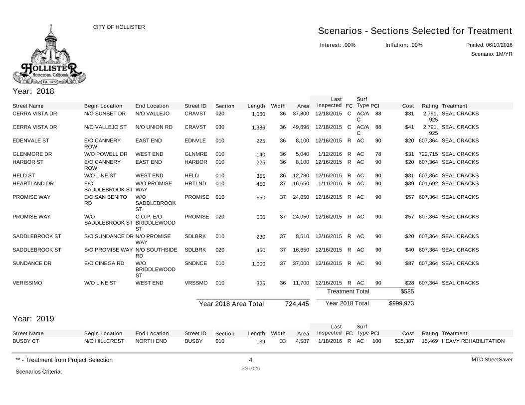
Year: 2018
Street Name Begin Location End Location Street ID Section FCSurfType Cost Rating TreatmentPCILength Width Area
LastInspected
CERRA VISTA DR N/O SUNSET DR N/O VALLEJO CRAVST 020 C AC/AC
$31 2,791,925
SEAL CRACKS8837,800361,050 12/18/2015
CERRA VISTA DR N/O VALLEJO ST N/O UNION RD CRAVST 030 C AC/AC
$41 2,791,925
SEAL CRACKS8849,896361,386 12/18/2015
EDENVALE ST E/O CANNERYROW
EAST END EDNVLE 010 R AC $20 607,364 SEAL CRACKS908,10036225 12/16/2015
GLENMORE DR W/O POWELL DR WEST END GLNMRE 010 R AC $31 722,715 SEAL CRACKS785,04036140 1/12/2016HARBOR ST E/O CANNERY
ROWEAST END HARBOR 010 R AC $20 607,364 SEAL CRACKS908,10036225 12/16/2015
HELD ST W/O LINE ST WEST END HELD 010 R AC $31 607,364 SEAL CRACKS9012,78036355 12/16/2015HEARTLAND DR E/O
SADDLEBROOK STW/O PROMISEWAY
HRTLND 010 R AC $39 601,692 SEAL CRACKS9016,65037450 1/11/2016
PROMISE WAY E/O SAN BENITORD
W/OSADDLEBROOKST
PROMISE 010 R AC $57 607,364 SEAL CRACKS9024,05037650 12/16/2015
PROMISE WAY W/OSADDLEBROOK ST
C.O.P. E/OBRIDDLEWOODST
PROMISE 020 R AC $57 607,364 SEAL CRACKS9024,05037650 12/16/2015
SADDLEBROOK ST S/O SUNDANCE DR N/O PROMISEWAY
SDLBRK 010 R AC $20 607,364 SEAL CRACKS908,51037230 12/16/2015
SADDLEBROOK ST S/O PROMISE WAY N/O SOUTHSIDERD
SDLBRK 020 R AC $40 607,364 SEAL CRACKS9016,65037450 12/16/2015
SUNDANCE DR E/O CINEGA RD W/OBRIDDLEWOODST
SNDNCE 010 R AC $87 607,364 SEAL CRACKS9037,000371,000 12/16/2015
VERISSIMO W/O LINE ST WEST END VRSSMO 010 R AC $28 607,364 SEAL CRACKS9011,70036325 12/16/2015$585Treatment Total
$999,973Year 2018 TotalYear 2018 Area Total 724,445
Year: 2019
Street Name Begin Location End Location Street ID Section FCSurfType Cost Rating TreatmentPCILength Width Area
LastInspected
BUSBY CT N/O HILLCREST NORTH END BUSBY 010 R AC $25,387 15,469 HEAVY REHABILITATION1004,58733139 1/18/2016
Interest: .00%
CITY OF HOLLISTER Scenarios - Sections Selected for TreatmentInflation: .00% Printed: 06/10/2016
Scenario: 1M/YR
Scenarios Criteria:
** - Treatment from Project Selection 4SS1026
MTC StreetSaver
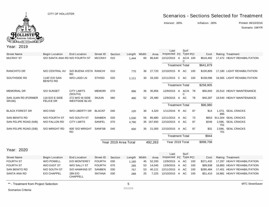
Year: 2019
Street Name Begin Location End Location Street ID Section FCSurfType Cost Rating TreatmentPCILength Width Area
LastInspected
McCRAY ST S/O SANTA ANA RD N/O FOURTH ST MCCRAY 010 A AC/AC
$616,492 17,472 HEAVY REHABILITATION10086,640601,444 12/12/2015
$641,879Treatment Total
RANCHITO DR N/O CENTRAL AV S/O BUENA VISTARD
RANCHI 010 R AC $100,809 17,180 LIGHT REHABILITATION10027,72036770 12/10/2015
SOUTHSIDE RD 1140' E/O SANBENITO RD
W/O LADD LN STHSID 020 C AC $158,096 16,565 LIGHT REHABILITATION10033,330301,111 12/11/2015
$258,905Treatment Total
MEMORIAL DR S/O SUNSET CITY LIMITS(SOUTH)
MEMORI 070 A AC/AC
$56,693 20,510 HEAVY MAINTENANCE7835,85636996 12/9/2015
SAN JUAN RD (FORMERSR156)
116 E/O E.SIDEFELICE DR
272 W/O W.SIDEWESTSIDE BLVD
SNJUN 060 A AC $40,287 19,540 HEAVY MAINTENANCE7825,48052490 12/9/2015
$96,980Treatment Total
BLACK FOREST DR W/O END W/O LIBERTY DR BLACKF 040 R AC $14 1,473,895
SEAL CRACKS874,32036120 1/11/2016
SAN BENITO RD N/O FOURTH ST N/O SOUTH ST SANBEN 020 A AC $653 911,504 SEAL CRACKS7385,680561,530 12/11/2015SAN FELIPE ROAD (N/B) N/O FALLON RD CITY LIMITS SANFEL 070 A AC $246 2,596,
701SEAL CRACKS87167,650354,790 12/10/2015
SAN FELIPE ROAD (S/B) S/O WRIGHT RD 600' S/O WRIGHTRD
SANFSB 040 A AC $31 2,596,701
SEAL CRACKS8721,00035600 12/10/2015
$944Treatment Total
$998,708Year 2019 TotalYear 2019 Area Total 492,263
Year: 2020
Street Name Begin Location End Location Street ID Section FCSurfType Cost Rating TreatmentPCILength Width Area
LastInspected
FOURTH ST W/O POWELL E/O MONTEREY FOURTH 030 A AC $371,432 17,297 HEAVY REHABILITATION10052,200451,160 12/9/2015FOURTH ST W/O EAST ST W/O SALLY ST FOURTH 070 A AC $99,938 16,883 HEAVY REHABILITATION10014,04553265 12/9/2015SAN BENITO RD N/O SOUTH ST S/O HAWKINS ST SANBEN 030 A AC $285,484 17,401 HEAVY REHABILITATION10040,12153757 12/11/2015SANTA ANA RD E/O CHAPPEL 289 E/O
CHAPPELLSNTANA 030 A AC $51,410 16,881 HEAVY REHABILITATION1007,22525289 12/10/2015
Interest: .00%
CITY OF HOLLISTER Scenarios - Sections Selected for TreatmentInflation: .00% Printed: 06/10/2016
Scenario: 1M/YR
Scenarios Criteria:
** - Treatment from Project Selection 5SS1026
MTC StreetSaver
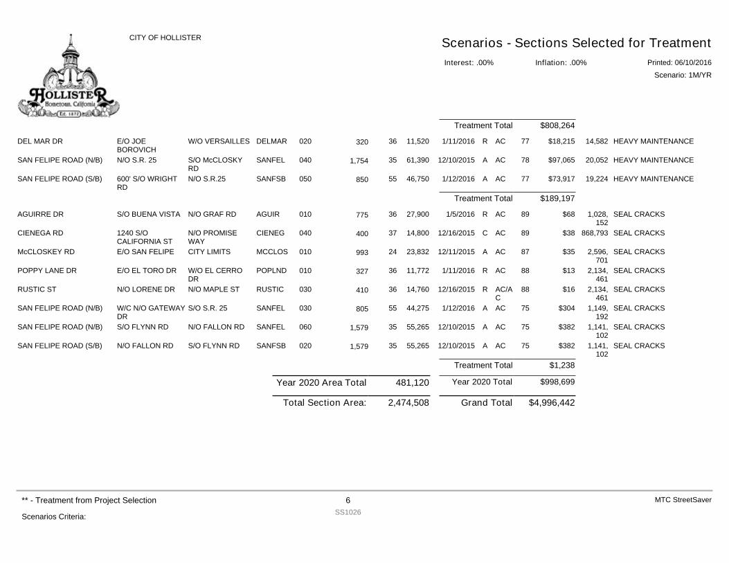
$808,264Treatment Total
DEL MAR DR E/O JOEBOROVICH
W/O VERSAILLES DELMAR 020 R AC $18,215 14,582 HEAVY MAINTENANCE7711,52036320 1/11/2016
SAN FELIPE ROAD (N/B) N/O S.R. 25 S/O McCLOSKYRD
SANFEL 040 A AC $97,065 20,052 HEAVY MAINTENANCE7861,390351,754 12/10/2015
SAN FELIPE ROAD (S/B) 600' S/O WRIGHTRD
N/O S.R.25 SANFSB 050 A AC $73,917 19,224 HEAVY MAINTENANCE7746,75055850 1/12/2016
$189,197Treatment Total
AGUIRRE DR S/O BUENA VISTA N/O GRAF RD AGUIR 010 R AC $68 1,028,152
SEAL CRACKS8927,90036775 1/5/2016
CIENEGA RD 1240 S/OCALIFORNIA ST
N/O PROMISEWAY
CIENEG 040 C AC $38 868,793 SEAL CRACKS8914,80037400 12/16/2015
McCLOSKEY RD E/O SAN FELIPE CITY LIMITS MCCLOS 010 A AC $35 2,596,701
SEAL CRACKS8723,83224993 12/11/2015
POPPY LANE DR E/O EL TORO DR W/O EL CERRODR
POPLND 010 R AC $13 2,134,461
SEAL CRACKS8811,77236327 1/11/2016
RUSTIC ST N/O LORENE DR N/O MAPLE ST RUSTIC 030 R AC/AC
$16 2,134,461
SEAL CRACKS8814,76036410 12/16/2015
SAN FELIPE ROAD (N/B) W/C N/O GATEWAYDR
S/O S.R. 25 SANFEL 030 A AC $304 1,149,192
SEAL CRACKS7544,27555805 1/12/2016
SAN FELIPE ROAD (N/B) S/O FLYNN RD N/O FALLON RD SANFEL 060 A AC $382 1,141,102
SEAL CRACKS7555,265351,579 12/10/2015
SAN FELIPE ROAD (S/B) N/O FALLON RD S/O FLYNN RD SANFSB 020 A AC $382 1,141,102
SEAL CRACKS7555,265351,579 12/10/2015
$1,238Treatment Total
$998,699Year 2020 TotalYear 2020 Area Total 481,120
$4,996,442Grand Total2,474,508Total Section Area:
Interest: .00%
CITY OF HOLLISTER Scenarios - Sections Selected for TreatmentInflation: .00% Printed: 06/10/2016
Scenario: 1M/YR
Scenarios Criteria:
** - Treatment from Project Selection 6SS1026
MTC StreetSaver
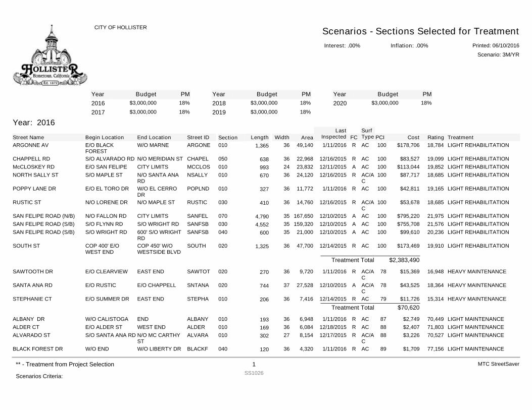
YearYearYear Budget PM Budget PM Budget PM2016 $3,000,000 18%
2017 $3,000,000 18%2018 $3,000,000 18%
2019 $3,000,000 18%2020 $3,000,000 18%
Year: 2016
Street Name Begin Location End Location Street ID Section FCSurfType Cost Rating TreatmentPCILength Width Area
LastInspected
ARGONNE AV E/O BLACKFOREST
W/O MARNE ARGONE 010 R AC $178,706 18,784 LIGHT REHABILITATION10049,140361,365 1/11/2016
CHAPPELL RD S/O ALVARADO RD N/O MERIDIAN ST CHAPEL 050 R AC $83,527 19,099 LIGHT REHABILITATION10022,96836638 12/16/2015McCLOSKEY RD E/O SAN FELIPE CITY LIMITS MCCLOS 010 A AC $113,044 19,852 LIGHT REHABILITATION10023,83224993 12/11/2015NORTH SALLY ST S/O MAPLE ST N/O SANTA ANA
RDNSALLY 010 R AC/A
C$87,717 18,685 LIGHT REHABILITATION10024,12036670 12/16/2015
POPPY LANE DR E/O EL TORO DR W/O EL CERRODR
POPLND 010 R AC $42,811 19,165 LIGHT REHABILITATION10011,77236327 1/11/2016
RUSTIC ST N/O LORENE DR N/O MAPLE ST RUSTIC 030 R AC/AC
$53,678 18,685 LIGHT REHABILITATION10014,76036410 12/16/2015
SAN FELIPE ROAD (N/B) N/O FALLON RD CITY LIMITS SANFEL 070 A AC $795,220 21,975 LIGHT REHABILITATION100167,650354,790 12/10/2015SAN FELIPE ROAD (S/B) S/O FLYNN RD S/O WRIGHT RD SANFSB 030 A AC $755,708 21,576 LIGHT REHABILITATION100159,320354,552 12/10/2015SAN FELIPE ROAD (S/B) S/O WRIGHT RD 600' S/O WRIGHT
RDSANFSB 040 A AC $99,610 20,236 LIGHT REHABILITATION10021,00035600 12/10/2015
SOUTH ST COP 400' E/OWEST END
COP 450' W/OWESTSIDE BLVD
SOUTH 020 R AC $173,469 19,910 LIGHT REHABILITATION10047,700361,325 12/14/2015
$2,383,490Treatment Total
SAWTOOTH DR E/O CLEARVIEW EAST END SAWTOT 020 R AC/AC
$15,369 16,948 HEAVY MAINTENANCE789,72036270 1/11/2016
SANTA ANA RD E/O RUSTIC E/O CHAPPELL SNTANA 020 A AC/AC
$43,525 18,364 HEAVY MAINTENANCE7827,52837744 12/10/2015
STEPHANIE CT E/O SUMMER DR EAST END STEPHA 010 R AC $11,726 15,314 HEAVY MAINTENANCE797,41636206 12/14/2015$70,620Treatment Total
ALBANY DR W/O CALISTOGA END ALBANY 010 R AC $2,749 70,449 LIGHT MAINTENANCE876,94836193 1/11/2016ALDER CT E/O ALDER ST WEST END ALDER 010 R AC $2,407 71,803 LIGHT MAINTENANCE886,08436169 12/18/2015ALVARADO ST S/O SANTA ANA RD N/O MC CARTHY
STALVARA 010 R AC/A
C$3,226 70,527 LIGHT MAINTENANCE888,15427302 12/17/2015
BLACK FOREST DR W/O END W/O LIBERTY DR BLACKF 040 R AC $1,709 77,156 LIGHT MAINTENANCE894,32036120 1/11/2016
Interest: .00%
CITY OF HOLLISTER Scenarios - Sections Selected for TreatmentInflation: .00% Printed: 06/10/2016
Scenario: 3M/YR
Scenarios Criteria:
** - Treatment from Project Selection 1SS1026
MTC StreetSaver
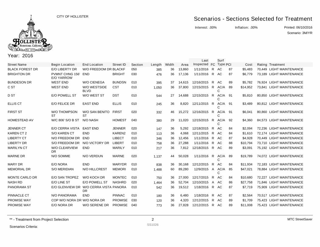
Year: 2016
Street Name Begin Location End Location Street ID Section FCSurfType Cost Rating TreatmentPCILength Width Area
LastInspected
BLACK FOREST DR E/O LIBERTY DR W/O FREEDOM DR BLACKF 050 R AC $5,483 70,449 LIGHT MAINTENANCE8713,86036385 1/11/2016BRIGHTON DR PVMNT CHNG 156'
E/O YARROWEND BRIGHT 030 R AC $6,779 73,189 LIGHT MAINTENANCE8717,13636476 1/11/2016
BUNDESON DR WEST END W/O CIENEGA BUNDSN 010 R AC $5,782 76,924 LIGHT MAINTENANCE8914,61537395 12/16/2015C ST WEST END W/O WESTSIDE
BLVDCST 010 R AC/A
C$14,952 73,841 LIGHT MAINTENANCE8937,800361,050 12/15/2015
D ST E/O POWELL ST W/O WEST ST DST 010 R AC/AC
$5,810 80,850 LIGHT MAINTENANCE9114,68827544 12/15/2015
ELLIS CT E/O FELICE DR EAST END ELLIS 010 R AC/AC
$3,489 80,812 LIGHT MAINTENANCE918,82036245 12/11/2015
FIRST ST W/O THOMPSONST
W/O SAN BENITOST
FIRST 020 R AC/AC
$6,041 80,860 LIGHT MAINTENANCE9115,27246332 12/16/2015
HOMESTEAD AV W/C 806' S/O B ST N/O NASH HOMEST 040 R AC/AC
$4,360 84,573 LIGHT MAINTENANCE9211,02029380 12/15/2015
JENNER CT E/O CERRA VISTA EAST END JENNER 020 R AC $2,094 72,236 LIGHT MAINTENANCE845,29236147 12/18/2015KAREN CT 2 S/O KAREN CT END KAREN2 010 R AC $1,610 72,174 LIGHT MAINTENANCE844,06836113 12/11/2015LIBERTY CT N/O FREEDOM DR END LIBECT 010 R AC $4,928 70,449 LIGHT MAINTENANCE8712,45636346 1/11/2016LIBERTY DR S/O FREEDOM DR N/O VICTORY DR LIBERT 010 R AC $10,794 73,710 LIGHT MAINTENANCE8827,28836758 1/11/2016MARILYN CT W/O CLEARVIEW
DREND MARILY 010 R AC $3,091 75,192 LIGHT MAINTENANCE897,81236217 12/18/2015
MARNE DR N/O SOMME N/O VERDUN MARNE 020 R AC/AC
$19,789 74,072 LIGHT MAINTENANCE8950,028441,137 1/11/2016
MARY DR E/O NORA END MARYDR 010 R AC $11,934 72,183 LIGHT MAINTENANCE8430,16836838 12/12/2015MEMORIAL DR S/O MERIDIAN N/O HILLCREST MEMORI 010 A AC/A
C$47,021 78,884 LIGHT MAINTENANCE8589,280601,488 12/9/2015
MONTE CARLO DR E/O SAN TROPEZ W/O KOCH DR MONTEC 010 R AC $10,680 72,227 LIGHT MAINTENANCE8427,00036750 12/17/2015NASH RD E/O LINE ST E/O POWELL ST NASHRD 020 A AC $27,758 71,846 LIGHT MAINTENANCE8652,704361,464 12/10/2015PANORAMA ST E/O GLENVIEW DR W/O CERRA VISTA
DRPANORA 010 R AC $7,719 75,909 LIGHT MAINTENANCE8719,51236542 1/18/2016
PINNACLE CT N/O PANORAMA END PINNAC 010 R AC $2,564 70,517 LIGHT MAINTENANCE876,48036180 1/18/2016PROMISE WAY COP W/O NORA DR W/O NORA DR PROMISE 030 R AC $1,709 75,423 LIGHT MAINTENANCE894,32036120 12/12/2015PROMISE WAY E/O NORA DR W/O SERENE DR PROMISE 040 R AC $11,008 75,423 LIGHT MAINTENANCE8927,82836773 12/12/2015
Interest: .00%
CITY OF HOLLISTER Scenarios - Sections Selected for TreatmentInflation: .00% Printed: 06/10/2016
Scenario: 3M/YR
Scenarios Criteria:
** - Treatment from Project Selection 2SS1026
MTC StreetSaver
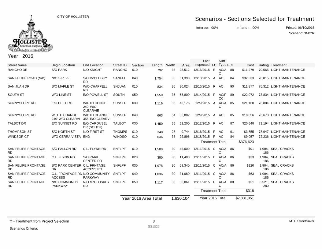
Year: 2016
Street Name Begin Location End Location Street ID Section FCSurfType Cost Rating TreatmentPCILength Width Area
LastInspected
RANCHO DR S/O PARK N/O KNIGHT RANCHO 010 R AC/AC
$11,279 70,565 LIGHT MAINTENANCE8828,51236792 12/16/2015
SAN FELIPE ROAD (N/B) N/O S.R. 25 S/O McCLOSKYRD
SANFEL 040 A AC $32,333 70,815 LIGHT MAINTENANCE8461,390351,754 12/10/2015
SAN JUAN DR S/O MAPLE ST W/O CHAPPELLRD
SNJUAN 010 R AC $11,877 75,312 LIGHT MAINTENANCE9030,02436834 12/16/2015
SOUTH ST W/O LINE ST E/O POWELL ST SOUTH 050 R AC/PCC
$22,072 73,834 LIGHT MAINTENANCE8955,800361,550 12/14/2015
SUNNYSLOPE RD E/O EL TORO WIDTH CHNGE240' W/OCLEARVIE
SUNSLP 030 A AC/AC
$21,160 78,884 LIGHT MAINTENANCE8540,176361,116 12/9/2015
SUNNYSLOPE RD WIDTH CHANGE240' W/O CLEARVI
WIDTH CHANGE355' E/O CLEARVI
SUNSLP 040 A AC $18,856 76,673 LIGHT MAINTENANCE8535,80254663 12/9/2015
TALBOT DR E/O SUNSET RD E/O CAROUSELDR (SOUTH)
TALBOT 030 R AC $20,648 71,194 LIGHT MAINTENANCE8752,200361,450 12/12/2015
THOMPSON ST S/O NORTH ST N/O FIRST ST THOMPS 010 R AC $3,855 78,947 LIGHT MAINTENANCE919,74428348 12/16/2015WINDSOR CT W/O CERRA VISTA END WINDSO 010 R AC $9,057 72,236 LIGHT MAINTENANCE8422,89636636 12/18/2015
$376,623Treatment Total
SAN FELIPE FRONTAGERD
S/O FALLON RD C.L. FLYNN RD SNFLPF 010 C AC/AC
$91 1,904,186
SEAL CRACKS8645,000301,500 12/11/2015
SAN FELIPE FRONTAGERD
C.L. FLYNN RD S/O PARKCENTER DR
SNFLPF 020 C AC/AC
$23 1,904,186
SEAL CRACKS8611,40030380 12/11/2015
SAN FELIPE FRONTAGERD
S/O PARK CENTERDR
C.L. FRNTAGEACCESS RD
SNFLPF 030 C AC/AC
$120 1,904,186
SEAL CRACKS8659,340301,978 12/11/2015
SAN FELIPE FRONTAGERD
C.L. FRONTAGE RDACCESS
N/O COMMUNITYPARKWAY
SNFLPF 040 C AC/AC
$63 1,904,186
SEAL CRACKS8631,080301,036 12/11/2015
SAN FELIPE FRONTAGERD
N/O COMMUNITYPARKWAY
N/O McCLOSKEYRD
SNFLPF 050 C AC/AC
$21 6,521,280
SEAL CRACKS8836,861331,117 12/11/2015
$318Treatment Total
$2,831,051Year 2016 TotalYear 2016 Area Total 1,630,104
Interest: .00%
CITY OF HOLLISTER Scenarios - Sections Selected for TreatmentInflation: .00% Printed: 06/10/2016
Scenario: 3M/YR
Scenarios Criteria:
** - Treatment from Project Selection 3SS1026
MTC StreetSaver
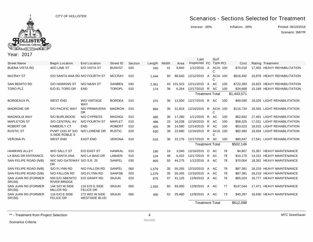
Year: 2017
Street Name Begin Location End Location Street ID Section FCSurfType Cost Rating TreatmentPCILength Width Area
LastInspected
BUENA VISTA RD W/O LINE ST E/O VISTA ST BUNVST 020 A AC/AC
$70,018 17,455 HEAVY REHABILITATION1009,84041240 1/12/2016
McCRAY ST S/O SANTA ANA RD N/O FOURTH ST MCCRAY 010 A AC/AC
$616,492 16,878 HEAVY REHABILITATION10086,640601,444 12/12/2015
SAN BENITO RD S/O HAWKINS ST N/O NASH ST SANBEN 040 A AC $722,393 16,823 HEAVY REHABILITATION100101,523432,361 12/11/2015TORO PLZ E/O EL TORO DR END TOROPL 010 R AC $34,668 15,169 HEAVY REHABILITATION1006,26436174 12/17/2015
$1,443,571Treatment Total
BORDEAUX PL WEST END W/O VINTAGEWAY
BORDEA 010 R AC $49,095 18,026 LIGHT REHABILITATION10013,50036375 12/17/2015
MADRONE DR S/O PACIFIC WAY N/O PRIMAVERADR
MADRON 010 R AC/AC
$115,734 18,555 LIGHT REHABILITATION10031,82436884 12/16/2015
MAGNOLIA WAY S/O BURLWOOD N/O CYPRESS MAGNOL 010 R AC $62,842 17,491 LIGHT REHABILITATION10017,28036480 1/11/2016MAPLETON ST S/O CENTRAL AV N/O FOURTH ST MAPLET 010 R AC $58,325 17,031 LIGHT REHABILITATION10016,03833486 12/16/2015ROBERT DR KIMBERLY CT END ROBERT 010 R AC $53,023 18,915 LIGHT REHABILITATION10014,58036405 12/14/2015RUSTIC ST PVMT CHG 87 S/O
S.SIDE ROBLE SN/O LORENE DR RUSTIC 020 R AC/A
C$82,480 18,934 LIGHT REHABILITATION10022,68036630 12/16/2015
VERONA PL WEST END EAST END VERONA 010 R AC $80,647 17,541 LIGHT REHABILITATION10022,17636616 12/17/2015$502,146Treatment Total
HAWKINS ALLEY W/O SALLY ST E/O EAST ST HAWKAL 010 O AC $4,807 15,367 HEAVY MAINTENANCE783,04016190 12/16/2015LA BAIG DR ENTRANCE S/O SANTA ANA N/O LA BAIG DR LABAEN 010 R AC $10,170 14,151 HEAVY MAINTENANCE786,43248134 12/17/2015SAN FELIPE ROAD (N/B) W/C N/O GATEWAY
DRS/O S.R. 25 SANFEL 030 A AC $70,004 18,352 HEAVY MAINTENANCE7844,27555805 1/12/2016
SAN FELIPE ROAD (N/B) S/O FLYNN RD N/O FALLON RD SANFEL 060 A AC $87,381 18,219 HEAVY MAINTENANCE7855,265351,579 12/10/2015SAN FELIPE ROAD (S/B) N/O FALLON RD S/O FLYNN RD SANFSB 020 A AC $87,381 18,219 HEAVY MAINTENANCE7855,265351,579 12/10/2015SAN JUAN RD (FORMERSR156)
500 E/O SBENITORIVER BRIDGE
E/O GRAFF RD SNJUN 020 A AC $65,024 16,777 HEAVY MAINTENANCE7641,12547875 12/9/2015
SAN JUAN RD (FORMERSR156)
144 S/O W.SIDEMILLER RD
116 E/O E.SIDEFELICE DR
SNJUN 050 A AC $147,044 17,471 HEAVY MAINTENANCE7793,000601,550 12/9/2015
SAN JUAN RD (FORMERSR156)
116 E/O E.SIDEFELICE DR
272 W/O W.SIDEWESTSIDE BLVD
SNJUN 060 A AC $40,287 16,630 HEAVY MAINTENANCE7325,48052490 12/9/2015
$512,098Treatment Total
Interest: .00%
CITY OF HOLLISTER Scenarios - Sections Selected for TreatmentInflation: .00% Printed: 06/10/2016
Scenario: 3M/YR
Scenarios Criteria:
** - Treatment from Project Selection 4SS1026
MTC StreetSaver
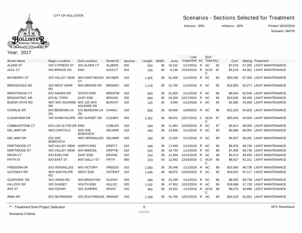
Year: 2017
Street Name Begin Location End Location Street ID Section FCSurfType Cost Rating TreatmentPCILength Width Area
LastInspected
ALDER ST S/O CYPRESS ST S/O ALDER CT ALDERS 020 R AC $7,576 67,355 LIGHT MAINTENANCE8219,15236532 1/11/2016AZUL CT N/O BRIDGE RD END AZULCT 010 R AC/A
C$3,219 64,301 LIGHT MAINTENANCE878,13636226 12/10/2015
BAYBERRY ST S/O VALLEY VIEW W/O DRIFTWOODCT
BAYBER 010 R AC $20,292 67,355 LIGHT MAINTENANCE8251,300361,425 1/11/2016
BRIDGEVALE RD S/O WEST GRAFRD
W/O BRIDGE RD BRDGEV 020 R AC $12,959 62,277 LIGHT MAINTENANCE8532,760281,170 1/12/2016
BRENTWOOD CT E/O SADIES DR SOUTH END BRENTW 010 R AC $8,544 62,546 LIGHT MAINTENANCE8621,60036600 1/11/2016BRIGANTINO DR E/O EL TORO EAST END BRIGAN 020 R AC $13,528 60,495 LIGHT MAINTENANCE8434,20036950 12/17/2015BUENA VISTA RD W/C W/O AGUIRRE
DRW/C 225 W/OAGUIRRE DR
BUNVST 100 A AC $1,580 44,959 LIGHT MAINTENANCE843,00025120 1/12/2016
CHARLIE DR E/O BERESINI LN(N)
E/O BERESINI LN(S)
CHARLI 010 R AC $12,104 64,655 LIGHT MAINTENANCE8630,60036850 12/9/2015
CLEARVIEW DR S/O SUNNYSLOPE N/O SUNSET DR CLEARV 050 C AC/AC
$25,634 64,500 LIGHT MAINTENANCE8748,672361,352 12/17/2015
COBBLESTONE CT E/O LOS ALTOS DR END COBLES 010 R AC $4,614 68,000 LIGHT MAINTENANCE8711,66436324 12/18/2015DEL MAR DR W/O CAPITOLA W/O JOE
BOROVICHDELMAR 010 R AC $5,696 65,091 LIGHT MAINTENANCE8014,40036400 1/11/2016
DEL MAR DR E/O JOEBOROVICH
W/O VERSAILLES DELMAR 020 R AC $4,557 65,091 LIGHT MAINTENANCE8011,52036320 1/11/2016
DRIFTWOOD CT N/O VALLEY VIEW NORTH END DRIFCT 010 R AC $6,978 69,736 LIGHT MAINTENANCE8617,64036490 1/11/2016DRIFTWOOD ST S/O VALLEY VIEW N/O MIMOSA DRIFTW 010 R AC $7,405 69,736 LIGHT MAINTENANCE8618,72036520 1/11/2016ERVIN CT E/O EVELYNS EAST END ERVINC 010 R AC $4,472 69,435 LIGHT MAINTENANCE8611,30436314 12/12/2015FIFTH ST E/O EAST ST W/O SALLY ST FIFTH 060 C AC/A
C$6,627 61,311 LIGHT MAINTENANCE8612,58254233 12/16/2015
FREEDOM DR E/O VERSAILLES N/O VICTORY FREEDO 010 R AC $15,565 69,736 LIGHT MAINTENANCE8639,348361,093 1/11/2016GATEWAY DR W/O SAN FELIPE
RDWEST END GATEWY 010 R AC $19,015 67,117 LIGHT MAINTENANCE8248,070461,045 12/16/2015
GLENVIEW DR S/O UNION RD N/O BRIGHTON GLENVI 020 R AC $8,402 69,736 LIGHT MAINTENANCE8621,24036590 1/11/2016HILLOCK DR S/O SUNSET SOUTH END HILLOC 020 R AC $18,968 67,729 LIGHT MAINTENANCE8447,952361,332 12/12/2015IRIS ST N/O CEDAR S/O JUNIPER IRISST 010 R AC/A
C$6,579 64,686 LIGHT MAINTENANCE8616,63236462 1/11/2016
IRMA DR E/O SEVRINSEN S/O SOUTHRIDGE IRMADR 010 R AC $16,519 62,661 LIGHT MAINTENANCE8041,760361,160 12/12/2015
Interest: .00%
CITY OF HOLLISTER Scenarios - Sections Selected for TreatmentInflation: .00% Printed: 06/10/2016
Scenario: 3M/YR
Scenarios Criteria:
** - Treatment from Project Selection 5SS1026
MTC StreetSaver
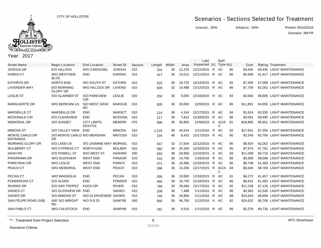
Year: 2017
Street Name Begin Location End Location Street ID Section FCSurfType Cost Rating TreatmentPCILength Width Area
LastInspected
JOSHUA DR E/O HILLOCK W/O CAROUSEL JOSHUA 010 R AC $4,500 69,435 LIGHT MAINTENANCE8611,37636316 12/12/2015KAREN CT W/O WESTSIDE
BLVDEND KARENC 010 R AC $5,939 61,417 LIGHT MAINTENANCE8015,01236417 12/11/2015
KATHRYN DR NORTH END N/O SOUTH ST KATHRN 010 R AC $7,405 67,099 LIGHT MAINTENANCE8218,72036520 12/14/2015LAVENDER WAY E/O MORNING
GLORY DRW/O HILLOCK DR LAVEND 010 R AC $7,709 62,262 LIGHT MAINTENANCE8619,48832609 12/12/2015
LESLIE ST S/O GLARNER ST S/O PARKVIEWCIR
LESLIE 020 R AC $3,560 58,805 LIGHT MAINTENANCE839,00036250 12/18/2015
MARGUERITE DR W/O BERESINI LN N/O WEST GRAFRD
MARGUE 010 R AC $11,891 64,655 LIGHT MAINTENANCE8630,06036835 12/9/2015
MARSEILLE CT MARSEILLE DR END MARSCT 010 R AC $1,624 63,335 LIGHT MAINTENANCE844,10436114 12/17/2015MCDONALD CIR E/O CLEARVIEW END MCDONA 010 R AC $3,091 69,495 LIGHT MAINTENANCE867,81236217 12/18/2015MEMORIAL DR S/O SUNSET CITY LIMITS
(SOUTH)MEMORI 070 A AC/A
C$18,885 66,651 LIGHT MAINTENANCE8135,85636996 12/9/2015
MIMOSA ST S/O VALLEY VIEW END MIMOSA 010 R AC $17,501 67,355 LIGHT MAINTENANCE8244,244361,229 1/11/2016MONTE CARLO DRENTRANCE
S/O MONTE CARLODR
N/O MERIDIAN MNTCEN 010 R AC $2,545 62,706 LIGHT MAINTENANCE806,43248134 12/17/2015
MORNING GLORY DR E/O LADD LN S/O JASMINE WAY MORNGL 010 R AC $6,924 62,262 LIGHT MAINTENANCE8617,50432547 12/12/2015MULBERRY CT N/O CYPRESS CT NORTH END MULBER 010 R AC $7,975 67,781 LIGHT MAINTENANCE8620,16036560 12/18/2015NASH RD E/O POWELL ST W/O WEST ST NASHRD 030 A AC $11,008 66,719 LIGHT MAINTENANCE8320,90038550 12/10/2015PANORAMA DR W/O GLENVIEW WEST END PANADR 010 R AC $5,839 68,099 LIGHT MAINTENANCE8614,76036410 1/18/2016PARKVIEW CIR W/O LESLIE WEST END PARKVI 010 R AC $6,708 61,483 LIGHT MAINTENANCE8016,95636471 12/18/2015PEACH CT W/O MEMORIAL WEST END PEACH 010 R AC/A
C$5,640 58,769 LIGHT MAINTENANCE8414,25636396 12/17/2015
PECAN CT W/O MAGNOLIA END PECAN 010 R AC $4,272 61,457 LIGHT MAINTENANCE8110,80036300 12/18/2015PONDEROSA CT E/O ALDER END PONDER 010 R AC $6,622 61,483 LIGHT MAINTENANCE8016,74036465 12/18/2015RIVIERA DR E/O SAN TROPEZ KOCH DR RIVIER 010 R AC $11,108 67,126 LIGHT MAINTENANCE8228,08036780 12/17/2015SADIES CT S/O GLENVIEW DR END SADIEC 010 R AC $2,962 62,546 LIGHT MAINTENANCE867,48836208 1/11/2016SADIES DR S/O MIMOSA ST N/O GLENVIEWDR SADIED 010 R AC $10,624 68,859 LIGHT MAINTENANCE8826,85636746 1/11/2016SAN FELIPE ROAD (S/B) 600' S/O WRIGHT
RDN/O S.R.25 SANFSB 050 A AC $24,622 65,706 LIGHT MAINTENANCE8246,75055850 1/12/2016
SAN PABLO CT W/O CALISTOGA END SANPAB 010 R AC $2,578 69,736 LIGHT MAINTENANCE866,51636181 1/11/2016
Interest: .00%
CITY OF HOLLISTER Scenarios - Sections Selected for TreatmentInflation: .00% Printed: 06/10/2016
Scenario: 3M/YR
Scenarios Criteria:
** - Treatment from Project Selection 6SS1026
MTC StreetSaver
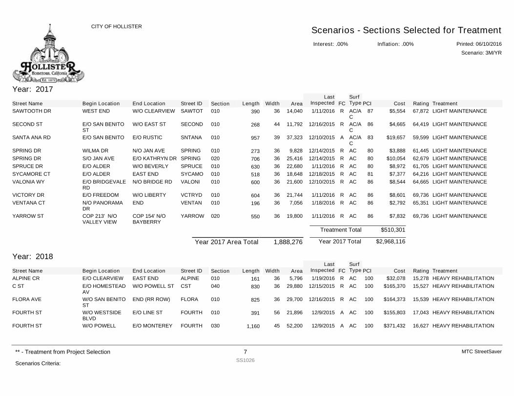
Year: 2017
Street Name Begin Location End Location Street ID Section FCSurfType Cost Rating TreatmentPCILength Width Area
LastInspected
SAWTOOTH DR WEST END W/O CLEARVIEW SAWTOT 010 R AC/AC
$5,554 67,872 LIGHT MAINTENANCE8714,04036390 1/11/2016
SECOND ST E/O SAN BENITOST
W/O EAST ST SECOND 010 R AC/AC
$4,665 64,419 LIGHT MAINTENANCE8611,79244268 12/16/2015
SANTA ANA RD E/O SAN BENITO E/O RUSTIC SNTANA 010 A AC/AC
$19,657 59,599 LIGHT MAINTENANCE8337,32339957 12/10/2015
SPRING DR WILMA DR N/O JAN AVE SPRING 010 R AC $3,888 61,445 LIGHT MAINTENANCE809,82836273 12/14/2015SPRING DR S/O JAN AVE E/O KATHRYN DR SPRING 020 R AC $10,054 62,679 LIGHT MAINTENANCE8025,41636706 12/14/2015SPRUCE DR E/O ALDER W/O BEVERLY SPRUCE 010 R AC $8,972 61,705 LIGHT MAINTENANCE8022,68036630 1/11/2016SYCAMORE CT E/O ALDER EAST END SYCAMO 010 R AC $7,377 64,216 LIGHT MAINTENANCE8118,64836518 12/18/2015VALONIA WY E/O BRIDGEVALE
RDN/O BRIDGE RD VALONI 010 R AC $8,544 64,665 LIGHT MAINTENANCE8621,60036600 12/10/2015
VICTORY DR E/O FREEDOM W/O LIBERTY VCTRYD 010 R AC $8,601 69,736 LIGHT MAINTENANCE8621,74436604 1/11/2016VENTANA CT N/O PANORAMA
DREND VENTAN 010 R AC $2,792 65,351 LIGHT MAINTENANCE867,05636196 1/18/2016
YARROW ST COP 213' N/OVALLEY VIEW
COP 154' N/OBAYBERRY
YARROW 020 R AC $7,832 69,736 LIGHT MAINTENANCE8619,80036550 1/11/2016
$510,301Treatment Total
$2,968,116Year 2017 TotalYear 2017 Area Total 1,888,276
Year: 2018
Street Name Begin Location End Location Street ID Section FCSurfType Cost Rating TreatmentPCILength Width Area
LastInspected
ALPINE CR E/O CLEARVIEW EAST END ALPINE 010 R AC $32,078 15,278 HEAVY REHABILITATION1005,79636161 1/19/2016C ST E/O HOMESTEAD
AVW/O POWELL ST CST 040 R AC $165,370 15,527 HEAVY REHABILITATION10029,88036830 12/15/2015
FLORA AVE W/O SAN BENITOST
END (RR ROW) FLORA 010 R AC $164,373 15,539 HEAVY REHABILITATION10029,70036825 12/16/2015
FOURTH ST W/O WESTSIDEBLVD
E/O LINE ST FOURTH 010 A AC $155,803 17,043 HEAVY REHABILITATION10021,89656391 12/9/2015
FOURTH ST W/O POWELL E/O MONTEREY FOURTH 030 A AC $371,432 16,627 HEAVY REHABILITATION10052,200451,160 12/9/2015
Interest: .00%
CITY OF HOLLISTER Scenarios - Sections Selected for TreatmentInflation: .00% Printed: 06/10/2016
Scenario: 3M/YR
Scenarios Criteria:
** - Treatment from Project Selection 7SS1026
MTC StreetSaver
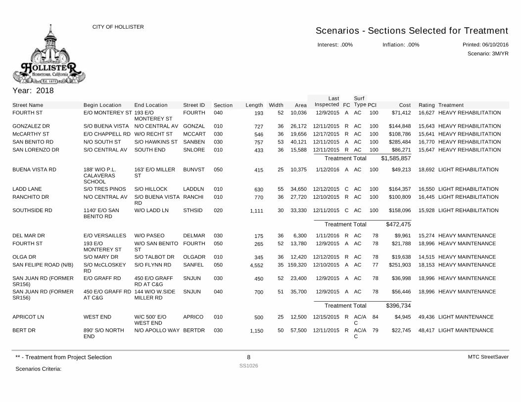
Year: 2018
Street Name Begin Location End Location Street ID Section FCSurfType Cost Rating TreatmentPCILength Width Area
LastInspected
FOURTH ST E/O MONTEREY ST 193 E/OMONTEREY ST
FOURTH 040 A AC $71,412 16,627 HEAVY REHABILITATION10010,03652193 12/9/2015
GONZALEZ DR S/O BUENA VISTA N/O CENTRAL AV GONZAL 010 R AC $144,848 15,643 HEAVY REHABILITATION10026,17236727 12/11/2015McCARTHY ST E/O CHAPPELL RD W/O RECHT ST MCCART 030 R AC $108,786 15,641 HEAVY REHABILITATION10019,65636546 12/17/2015SAN BENITO RD N/O SOUTH ST S/O HAWKINS ST SANBEN 030 A AC $285,484 16,770 HEAVY REHABILITATION10040,12153757 12/11/2015SAN LORENZO DR S/O CENTRAL AV SOUTH END SNLORE 010 R AC $86,271 15,647 HEAVY REHABILITATION10015,58836433 12/11/2015
$1,585,857Treatment Total
BUENA VISTA RD 188' W/O P.L.CALAVERASSCHOOL
163' E/O MILLERST
BUNVST 050 A AC $49,213 18,692 LIGHT REHABILITATION10010,37525415 1/12/2016
LADD LANE S/O TRES PINOS S/O HILLOCK LADDLN 010 C AC $164,357 16,550 LIGHT REHABILITATION10034,65055630 12/12/2015RANCHITO DR N/O CENTRAL AV S/O BUENA VISTA
RDRANCHI 010 R AC $100,809 16,445 LIGHT REHABILITATION10027,72036770 12/10/2015
SOUTHSIDE RD 1140' E/O SANBENITO RD
W/O LADD LN STHSID 020 C AC $158,096 15,928 LIGHT REHABILITATION10033,330301,111 12/11/2015
$472,475Treatment Total
DEL MAR DR E/O VERSAILLES W/O PASEO DELMAR 030 R AC $9,961 15,274 HEAVY MAINTENANCE786,30036175 1/11/2016FOURTH ST 193 E/O
MONTEREY STW/O SAN BENITOST
FOURTH 050 A AC $21,788 18,996 HEAVY MAINTENANCE7813,78052265 12/9/2015
OLGA DR S/O MARY DR S/O TALBOT DR OLGADR 010 R AC $19,638 14,515 HEAVY MAINTENANCE7812,42036345 12/12/2015SAN FELIPE ROAD (N/B) S/O McCLOSKEY
RDS/O FLYNN RD SANFEL 050 A AC $251,903 18,153 HEAVY MAINTENANCE77159,320354,552 12/10/2015
SAN JUAN RD (FORMERSR156)
E/O GRAFF RD 450 E/O GRAFFRD AT C&G
SNJUN 030 A AC $36,998 18,996 HEAVY MAINTENANCE7823,40052450 12/9/2015
SAN JUAN RD (FORMERSR156)
450 E/O GRAFF RDAT C&G
144 W/O W.SIDEMILLER RD
SNJUN 040 A AC $56,446 18,996 HEAVY MAINTENANCE7835,70051700 12/9/2015
$396,734Treatment Total
APRICOT LN WEST END W/C 500' E/OWEST END
APRICO 010 R AC/AC
$4,945 49,436 LIGHT MAINTENANCE8412,50025500 12/15/2015
BERT DR 890' S/O NORTHEND
N/O APOLLO WAY BERTDR 030 R AC/AC
$22,745 48,417 LIGHT MAINTENANCE7957,500501,150 12/11/2015
Interest: .00%
CITY OF HOLLISTER Scenarios - Sections Selected for TreatmentInflation: .00% Printed: 06/10/2016
Scenario: 3M/YR
Scenarios Criteria:
** - Treatment from Project Selection 8SS1026
MTC StreetSaver
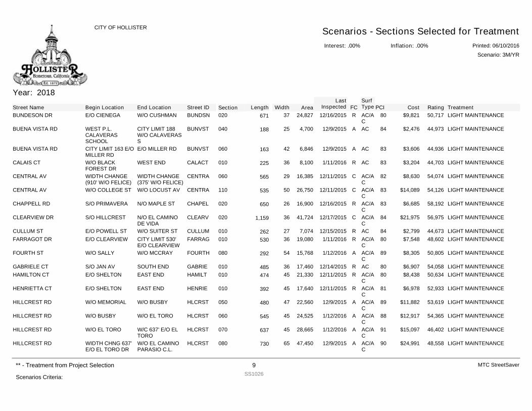
Year: 2018
Street Name Begin Location End Location Street ID Section FCSurfType Cost Rating TreatmentPCILength Width Area
LastInspected
BUNDESON DR E/O CIENEGA W/O CUSHMAN BUNDSN 020 R AC/AC
$9,821 50,717 LIGHT MAINTENANCE8024,82737671 12/16/2015
BUENA VISTA RD WEST P.L.CALAVERASSCHOOL
CITY LIMIT 188W/O CALAVERASS
BUNVST 040 A AC $2,476 44,973 LIGHT MAINTENANCE844,70025188 12/9/2015
BUENA VISTA RD CITY LIMIT 163 E/OMILLER RD
E/O MILLER RD BUNVST 060 A AC $3,606 44,936 LIGHT MAINTENANCE836,84642163 12/9/2015
CALAIS CT W/O BLACKFOREST DR
WEST END CALACT 010 R AC $3,204 44,703 LIGHT MAINTENANCE838,10036225 1/11/2016
CENTRAL AV WIDTH CHANGE(910' W/O FELICE)
WIDTH CHANGE(375' W/O FELICE)
CENTRA 060 C AC/AC
$8,630 54,074 LIGHT MAINTENANCE8216,38529565 12/11/2015
CENTRAL AV W/O COLLEGE ST W/O LOCUST AV CENTRA 110 C AC/AC
$14,089 54,126 LIGHT MAINTENANCE8326,75050535 12/11/2015
CHAPPELL RD S/O PRIMAVERA N/O MAPLE ST CHAPEL 020 R AC/AC
$6,685 58,192 LIGHT MAINTENANCE8316,90026650 12/16/2015
CLEARVIEW DR S/O HILLCREST N/O EL CAMINODE VIDA
CLEARV 020 C AC/AC
$21,975 56,975 LIGHT MAINTENANCE8441,724361,159 12/17/2015
CULLUM ST E/O POWELL ST W/O SUITER ST CULLUM 010 R AC $2,799 44,673 LIGHT MAINTENANCE847,07427262 12/15/2015FARRAGOT DR E/O CLEARVIEW CITY LIMIT 530'
E/O CLEARVIEWFARRAG 010 R AC/A
C$7,548 48,602 LIGHT MAINTENANCE8019,08036530 1/11/2016
FOURTH ST W/O SALLY W/O MCCRAY FOURTH 080 A AC/AC
$8,305 50,805 LIGHT MAINTENANCE8915,76854292 1/12/2016
GABRIELE CT S/O JAN AV SOUTH END GABRIE 010 R AC $6,907 54,058 LIGHT MAINTENANCE8017,46036485 12/14/2015HAMILTON CT E/O SHELTON EAST END HAMILT 010 R AC/A
C$8,438 50,634 LIGHT MAINTENANCE8021,33045474 12/11/2015
HENRIETTA CT E/O SHELTON EAST END HENRIE 010 R AC/AC
$6,978 52,933 LIGHT MAINTENANCE8117,64045392 12/11/2015
HILLCREST RD W/O MEMORIAL W/O BUSBY HLCRST 050 A AC/AC
$11,882 53,619 LIGHT MAINTENANCE8922,56047480 12/9/2015
HILLCREST RD W/O BUSBY W/O EL TORO HLCRST 060 A AC/AC
$12,917 54,365 LIGHT MAINTENANCE8824,52545545 1/12/2016
HILLCREST RD W/O EL TORO W/C 637' E/O ELTORO
HLCRST 070 A AC/AC
$15,097 46,402 LIGHT MAINTENANCE9128,66545637 1/12/2016
HILLCREST RD WIDTH CHNG 637'E/O EL TORO DR
W/O EL CAMINOPARASIO C.L.
HLCRST 080 A AC/AC
$24,991 48,558 LIGHT MAINTENANCE9047,45065730 12/9/2015
Interest: .00%
CITY OF HOLLISTER Scenarios - Sections Selected for TreatmentInflation: .00% Printed: 06/10/2016
Scenario: 3M/YR
Scenarios Criteria:
** - Treatment from Project Selection 9SS1026
MTC StreetSaver
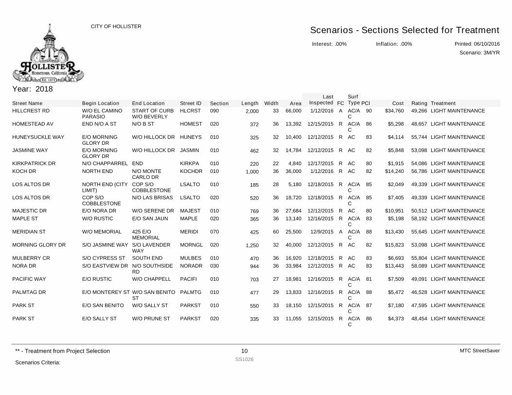
Year: 2018
Street Name Begin Location End Location Street ID Section FCSurfType Cost Rating TreatmentPCILength Width Area
LastInspected
HILLCREST RD W/O EL CAMINOPARASIO
START OF CURBW/O BEVERLY
HLCRST 090 A AC/AC
$34,760 49,266 LIGHT MAINTENANCE9066,000332,000 1/12/2016
HOMESTEAD AV END N/O A ST N/O B ST HOMEST 020 R AC/AC
$5,298 48,657 LIGHT MAINTENANCE8613,39236372 12/15/2015
HUNEYSUCKLE WAY E/O MORNINGGLORY DR
W/O HILLOCK DR HUNEYS 010 R AC $4,114 55,744 LIGHT MAINTENANCE8310,40032325 12/12/2015
JASMINE WAY E/O MORNINGGLORY DR
W/O HILLOCK DR JASMIN 010 R AC $5,848 53,098 LIGHT MAINTENANCE8214,78432462 12/12/2015
KIRKPATRICK DR N/O CHAPPARREL END KIRKPA 010 R AC $1,915 54,086 LIGHT MAINTENANCE804,84022220 12/17/2015KOCH DR NORTH END N/O MONTE
CARLO DRKOCHDR 010 R AC $14,240 56,786 LIGHT MAINTENANCE8236,000361,000 1/12/2016
LOS ALTOS DR NORTH END (CITYLIMIT)
COP S/OCOBBLESTONE
LSALTO 010 R AC/AC
$2,049 49,339 LIGHT MAINTENANCE855,18028185 12/18/2015
LOS ALTOS DR COP S/OCOBBLESTONE
N/O LAS BRISAS LSALTO 020 R AC/AC
$7,405 49,339 LIGHT MAINTENANCE8518,72036520 12/18/2015
MAJESTIC DR E/O NORA DR W/O SERENE DR MAJEST 010 R AC $10,951 50,512 LIGHT MAINTENANCE8027,68436769 12/12/2015MAPLE ST W/O RUSTIC E/O SAN JAUN MAPLE 020 R AC/A
C$5,198 58,192 LIGHT MAINTENANCE8313,14036365 12/16/2015
MERIDIAN ST W/O MEMORIAL 425 E/OMEMORIAL
MERIDI 070 A AC/AC
$13,430 55,645 LIGHT MAINTENANCE8825,50060425 12/9/2015
MORNING GLORY DR S/O JASMINE WAY S/O LAVENDERWAY
MORNGL 020 R AC $15,823 53,098 LIGHT MAINTENANCE8240,000321,250 12/12/2015
MULBERRY CR S/O CYPRESS ST SOUTH END MULBES 010 R AC $6,693 55,804 LIGHT MAINTENANCE8316,92036470 12/18/2015NORA DR S/O EASTVIEW DR N/O SOUTHSIDE
RDNORADR 030 R AC $13,443 58,089 LIGHT MAINTENANCE8333,98436944 12/12/2015
PACIFIC WAY E/O RUSTIC W/O CHAPPELL PACIFI 010 R AC/AC
$7,509 49,091 LIGHT MAINTENANCE8118,98127703 12/16/2015
PALMTAG DR E/O MONTEREY ST W/O SAN BENITOST
PALMTG 010 R AC/AC
$5,472 46,528 LIGHT MAINTENANCE8813,83329477 12/16/2015
PARK ST E/O SAN BENITO W/O SALLY ST PARKST 010 R AC/AC
$7,180 47,595 LIGHT MAINTENANCE8718,15033550 12/15/2015
PARK ST E/O SALLY ST W/O PRUNE ST PARKST 020 R AC/AC
$4,373 48,454 LIGHT MAINTENANCE8611,05533335 12/15/2015
Interest: .00%
CITY OF HOLLISTER Scenarios - Sections Selected for TreatmentInflation: .00% Printed: 06/10/2016
Scenario: 3M/YR
Scenarios Criteria:
** - Treatment from Project Selection 10SS1026
MTC StreetSaver
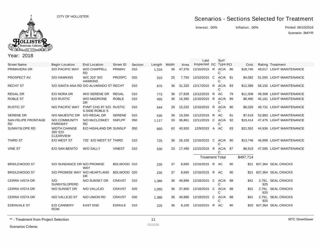
Year: 2018
Street Name Begin Location End Location Street ID Section FCSurfType Cost Rating TreatmentPCILength Width Area
LastInspected
PRIMAVERA DR S/O PACIFIC WAY W/O CHAPPELLRD
PRIMAV 010 R AC/AC
$18,740 49,017 LIGHT MAINTENANCE8647,376361,316 12/16/2015
PROSPECT AV S/O HAWKINS W/C 310' S/OHAWKINS
PROSPC 020 C AC/AC
$4,082 51,550 LIGHT MAINTENANCE817,75025310 12/10/2015
RECHT ST S/O SANTA ANA RD S/O ALVARADO ST RECHT 010 R AC/AC
$12,389 58,155 LIGHT MAINTENANCE8331,32036870 12/17/2015
REGAL DR E/O NORA DR W/O SERENE DR REGAL 010 R AC $11,008 48,308 LIGHT MAINTENANCE7927,82836773 12/12/2015ROBLE ST E/O RUSTIC W/O MADRONE
DRROBLE 010 R AC/A
C$6,480 45,181 LIGHT MAINTENANCE8916,38036455 12/16/2015
RUSTIC ST N/O PACIFIC WAY PVMT CHG 87 S/OS.SIDE ROBLE S
RUSTIC 010 R AC/AC
$6,026 48,731 LIGHT MAINTENANCE8015,23228544 12/16/2015
SERENE DR N/O MAJESTIC DR S/O REGAL DR SERENE 010 R AC $7,619 52,883 LIGHT MAINTENANCE8119,26036535 12/12/2015SAN FELIPE FRONTAGERD
N/O COMMUNITYPARKWAY
N/O McCLOSKEYRD
SNFLPF 050 C AC/AC
$19,414 47,475 LIGHT MAINTENANCE9236,861331,117 12/11/2015
SUNNYSLOPE RD WIDTH CHANGE355' E/OCLEARVIEW
E/O HIGHLAND DR SUNSLP 050 A AC $21,552 44,936 LIGHT MAINTENANCE8340,92062660 12/9/2015
THIRD ST E/O WEST ST 725' E/O WEST ST THIRD 010 C AC/AC
$13,746 46,999 LIGHT MAINTENANCE8026,10036725 12/16/2015
VINE ST E/O SAN BENITO W/O SALLY VINEST 010 R AC/AC
$6,919 47,595 LIGHT MAINTENANCE8717,49033530 12/15/2015
$497,714Treatment Total
BRIDLEWOOD ST S/O SUNDANCE DR N/O PROMISEWAY
BDLWOOD 010 R AC $21 607,364 SEAL CRACKS908,69537235 12/16/2015
BRIDLEWOOD ST S/O PROMISE WAY N/O HEARTLANDDR
BDLWOOD 020 R AC $21 607,364 SEAL CRACKS908,69537235 12/16/2015
CERRA VISTA DR S/OSUNNYSLOPERD
N/O SUNSET DR CRAVST 010 C AC/AC
$41 2,791,925
SEAL CRACKS8849,896361,386 12/18/2015
CERRA VISTA DR N/O SUNSET DR N/O VALLEJO CRAVST 020 C AC/AC
$31 2,791,925
SEAL CRACKS8837,800361,050 12/18/2015
CERRA VISTA DR N/O VALLEJO ST N/O UNION RD CRAVST 030 C AC/AC
$41 2,791,925
SEAL CRACKS8849,896361,386 12/18/2015
EDENVALE ST E/O CANNERYROW
EAST END EDNVLE 010 R AC $20 607,364 SEAL CRACKS908,10036225 12/16/2015
Interest: .00%
CITY OF HOLLISTER Scenarios - Sections Selected for TreatmentInflation: .00% Printed: 06/10/2016
Scenario: 3M/YR
Scenarios Criteria:
** - Treatment from Project Selection 11SS1026
MTC StreetSaver
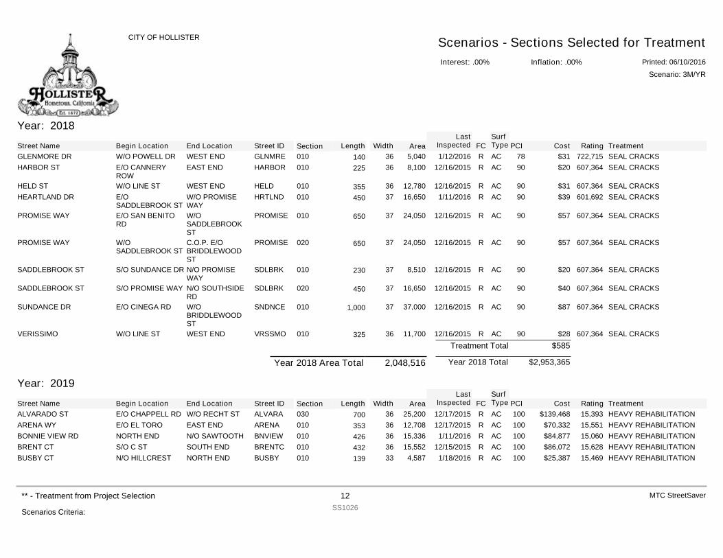
Year: 2018
Street Name Begin Location End Location Street ID Section FCSurfType Cost Rating TreatmentPCILength Width Area
LastInspected
GLENMORE DR W/O POWELL DR WEST END GLNMRE 010 R AC $31 722,715 SEAL CRACKS785,04036140 1/12/2016HARBOR ST E/O CANNERY
ROWEAST END HARBOR 010 R AC $20 607,364 SEAL CRACKS908,10036225 12/16/2015
HELD ST W/O LINE ST WEST END HELD 010 R AC $31 607,364 SEAL CRACKS9012,78036355 12/16/2015HEARTLAND DR E/O
SADDLEBROOK STW/O PROMISEWAY
HRTLND 010 R AC $39 601,692 SEAL CRACKS9016,65037450 1/11/2016
PROMISE WAY E/O SAN BENITORD
W/OSADDLEBROOKST
PROMISE 010 R AC $57 607,364 SEAL CRACKS9024,05037650 12/16/2015
PROMISE WAY W/OSADDLEBROOK ST
C.O.P. E/OBRIDDLEWOODST
PROMISE 020 R AC $57 607,364 SEAL CRACKS9024,05037650 12/16/2015
SADDLEBROOK ST S/O SUNDANCE DR N/O PROMISEWAY
SDLBRK 010 R AC $20 607,364 SEAL CRACKS908,51037230 12/16/2015
SADDLEBROOK ST S/O PROMISE WAY N/O SOUTHSIDERD
SDLBRK 020 R AC $40 607,364 SEAL CRACKS9016,65037450 12/16/2015
SUNDANCE DR E/O CINEGA RD W/OBRIDDLEWOODST
SNDNCE 010 R AC $87 607,364 SEAL CRACKS9037,000371,000 12/16/2015
VERISSIMO W/O LINE ST WEST END VRSSMO 010 R AC $28 607,364 SEAL CRACKS9011,70036325 12/16/2015$585Treatment Total
$2,953,365Year 2018 TotalYear 2018 Area Total 2,048,516
Year: 2019
Street Name Begin Location End Location Street ID Section FCSurfType Cost Rating TreatmentPCILength Width Area
LastInspected
ALVARADO ST E/O CHAPPELL RD W/O RECHT ST ALVARA 030 R AC $139,468 15,393 HEAVY REHABILITATION10025,20036700 12/17/2015ARENA WY E/O EL TORO EAST END ARENA 010 R AC $70,332 15,551 HEAVY REHABILITATION10012,70836353 12/17/2015BONNIE VIEW RD NORTH END N/O SAWTOOTH BNVIEW 010 R AC $84,877 15,060 HEAVY REHABILITATION10015,33636426 1/11/2016BRENT CT S/O C ST SOUTH END BRENTC 010 R AC $86,072 15,628 HEAVY REHABILITATION10015,55236432 12/15/2015BUSBY CT N/O HILLCREST NORTH END BUSBY 010 R AC $25,387 15,469 HEAVY REHABILITATION1004,58733139 1/18/2016
Interest: .00%
CITY OF HOLLISTER Scenarios - Sections Selected for TreatmentInflation: .00% Printed: 06/10/2016
Scenario: 3M/YR
Scenarios Criteria:
** - Treatment from Project Selection 12SS1026
MTC StreetSaver
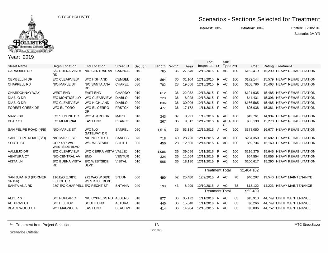
Year: 2019
Street Name Begin Location End Location Street ID Section FCSurfType Cost Rating TreatmentPCILength Width Area
LastInspected
CARNOBLE DR S/O BUENA VISTARD
N/O CENTRAL AV CARNOB 010 R AC $152,419 15,290 HEAVY REHABILITATION10027,54036765 12/10/2015
CEMBELLIN DR E/O CLEARVIEW W/O HGH;AND CEMBEL 010 R AC $172,144 15,579 HEAVY REHABILITATION10031,10436864 12/18/2015CHAPPELL RD N/O MAPLE ST N/O SANTA ANA
RDCHAPEL 030 R AC $108,786 15,463 HEAVY REHABILITATION10019,65628702 12/16/2015
CHARDONNAY WAY WEST END EAST END CHARDO 010 R AC $121,935 15,485 HEAVY REHABILITATION10022,03236612 12/17/2015DIABLO DR E/O MONTICELLO W/O CLEARVIEW DIABLO 010 R AC $44,431 15,396 HEAVY REHABILITATION1008,02836223 12/18/2015DIABLO DR E/O CLEARVIEW W/O HIGHLAND DIABLO 020 R AC $166,565 15,485 HEAVY REHABILITATION10030,09636836 12/18/2015FOREST CREEK DR W/O EL TORO W/O EL CERRO
DRFRSTCK 010 R AC $95,038 15,381 HEAVY REHABILITATION10017,17236477 1/11/2016
MARS DR E/O SKYLINE DR W/O ASTRO DR MARS 010 R AC $49,761 14,934 HEAVY REHABILITATION1008,99137243 1/19/2016PEAR CT E/O MEMORIAL EAST END PEARCT 010 R AC/A
C$53,198 15,278 HEAVY REHABILITATION1009,61236267 12/17/2015
SAN FELIPE ROAD (N/B) N/O MAPLE ST W/C N/OGATEWAY DR
SANFEL 020 A AC $378,050 16,677 HEAVY REHABILITATION10053,130351,518 12/16/2015
SAN FELIPE ROAD (S/B) N/O MAPLE ST N/O NORTH ST SANFSB 070 A AC $204,359 16,682 HEAVY REHABILITATION10028,72040718 12/11/2015SOUTH ST COP 450' W/O
WESTSIDE BLVDW/O WESTSIDE SOUTH 030 R AC $69,734 15,169 HEAVY REHABILITATION10012,60028450 12/14/2015
VALLEJO DR E/O CLEARVIEW W/O CERRA VISTA VALLEJ 010 R AC $216,375 15,645 HEAVY REHABILITATION10039,096361,086 1/11/2016VENTURA CT N/O CENTRAL AV END VENTUR 010 R AC $64,554 15,056 HEAVY REHABILITATION10011,66436324 12/11/2015VISTA LN S/O BUENA VISTA
RDE/O WESTSIDEBLVD
VISTAL 010 R AC $100,617 15,290 HEAVY REHABILITATION10018,18036505 12/11/2015
$2,404,102Treatment Total
SAN JUAN RD (FORMERSR156)
116 E/O E.SIDEFELICE DR
272 W/O W.SIDEWESTSIDE BLVD
SNJUN 060 A AC $40,287 19,540 HEAVY MAINTENANCE7825,48052490 12/9/2015
SANTA ANA RD 289' E/O CHAPPELL E/O RECHT ST SNTANA 040 A AC $13,122 14,223 HEAVY MAINTENANCE788,29943193 12/10/2015$53,409Treatment Total
ALDER ST S/O POPLAR CT N/O CYPRESS RD ALDERS 010 R AC $13,913 44,749 LIGHT MAINTENANCE8335,17236977 1/11/2016ALTURAS CT S/O HILLTOP SOUTH END ALTURA 010 R AC $6,266 44,749 LIGHT MAINTENANCE8315,84036440 1/11/2016BEACHWOOD CT W/O MAGNOLIA EAST END BEACHW 010 R AC $5,896 44,752 LIGHT MAINTENANCE8314,90436414 12/18/2015
Interest: .00%
CITY OF HOLLISTER Scenarios - Sections Selected for TreatmentInflation: .00% Printed: 06/10/2016
Scenario: 3M/YR
Scenarios Criteria:
** - Treatment from Project Selection 13SS1026
MTC StreetSaver
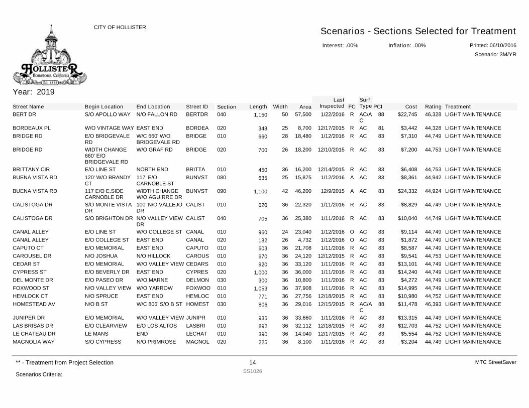
Year: 2019
Street Name Begin Location End Location Street ID Section FCSurfType Cost Rating TreatmentPCILength Width Area
LastInspected
BERT DR S/O APOLLO WAY N/O FALLON RD BERTDR 040 R AC/AC
$22,745 46,328 LIGHT MAINTENANCE8857,500501,150 1/22/2016
BORDEAUX PL W/O VINTAGE WAY EAST END BORDEA 020 R AC $3,442 44,328 LIGHT MAINTENANCE818,70025348 12/17/2015BRIDGE RD E/O BRIDGEVALE
RDW/C 660' W/OBRIDGEVALE RD
BRIDGE 010 R AC $7,310 44,749 LIGHT MAINTENANCE8318,48028660 1/12/2016
BRIDGE RD WIDTH CHANGE660' E/OBRIDGEVALE RD
W/O GRAF RD BRIDGE 020 R AC $7,200 44,753 LIGHT MAINTENANCE8318,20026700 12/10/2015
BRITTANY CIR E/O LINE ST NORTH END BRITTA 010 R AC $6,408 44,753 LIGHT MAINTENANCE8316,20036450 12/14/2015BUENA VISTA RD 120' W/O BRANDY
CT117' E/OCARNOBLE ST
BUNVST 080 A AC $8,361 44,942 LIGHT MAINTENANCE8315,87525635 1/12/2016
BUENA VISTA RD 117 E/O E.SIDECARNOBLE DR
WIDTH CHANGEW/O AGUIRRE DR
BUNVST 090 A AC $24,332 44,924 LIGHT MAINTENANCE8346,200421,100 12/9/2015
CALISTOGA DR S/O MONTE VISTADR
100' N/O VALLEJODR
CALIST 010 R AC $8,829 44,749 LIGHT MAINTENANCE8322,32036620 1/11/2016
CALISTOGA DR S/O BRIGHTON DR N/O VALLEY VIEWDR
CALIST 040 R AC $10,040 44,749 LIGHT MAINTENANCE8325,38036705 1/11/2016
CANAL ALLEY E/O LINE ST W/O COLLEGE ST CANAL 010 O AC $9,114 44,749 LIGHT MAINTENANCE8323,04024960 1/12/2016CANAL ALLEY E/O COLLEGE ST EAST END CANAL 020 O AC $1,872 44,749 LIGHT MAINTENANCE834,73226182 1/12/2016CAPUTO CT E/O MEMORIAL EAST END CAPUTO 010 R AC $8,587 44,749 LIGHT MAINTENANCE8321,70836603 1/11/2016CAROUSEL DR N/O JOSHUA N/O HILLOCK CAROUS 010 R AC $9,541 44,753 LIGHT MAINTENANCE8324,12036670 12/12/2015CEDAR ST E/O MEMORIAL W/O VALLEY VIEW CEDARS 010 R AC $13,101 44,749 LIGHT MAINTENANCE8333,12036920 1/11/2016CYPRESS ST E/O BEVERLY DR EAST END CYPRES 020 R AC $14,240 44,749 LIGHT MAINTENANCE8336,000361,000 1/11/2016DEL MONTE DR E/O PASEO DR W/O MARNE DELMON 030 R AC $4,272 44,749 LIGHT MAINTENANCE8310,80036300 1/11/2016FOXWOOD ST N/O VALLEY VIEW W/O YARROW FOXWOO 010 R AC $14,995 44,749 LIGHT MAINTENANCE8337,908361,053 1/11/2016HEMLOCK CT N/O SPRUCE EAST END HEMLOC 010 R AC $10,980 44,752 LIGHT MAINTENANCE8327,75636771 12/18/2015HOMESTEAD AV N/O B ST W/C 806' S/O B ST HOMEST 030 R AC/A
C$11,478 46,393 LIGHT MAINTENANCE8829,01636806 12/15/2015
JUNIPER DR E/O MEMORIAL W/O VALLEY VIEW JUNIPR 010 R AC $13,315 44,749 LIGHT MAINTENANCE8333,66036935 1/11/2016LAS BRISAS DR E/O CLEARVIEW E/O LOS ALTOS LASBRI 010 R AC $12,703 44,752 LIGHT MAINTENANCE8332,11236892 12/18/2015LE CHATEAU DR LE MANS END LECHAT 010 R AC $5,554 44,752 LIGHT MAINTENANCE8314,04036390 12/17/2015MAGNOLIA WAY S/O CYPRESS N/O PRIMROSE MAGNOL 020 R AC $3,204 44,749 LIGHT MAINTENANCE838,10036225 1/11/2016
Interest: .00%
CITY OF HOLLISTER Scenarios - Sections Selected for TreatmentInflation: .00% Printed: 06/10/2016
Scenario: 3M/YR
Scenarios Criteria:
** - Treatment from Project Selection 14SS1026
MTC StreetSaver
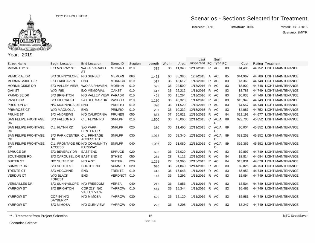
Year: 2019
Street Name Begin Location End Location Street ID Section FCSurfType Cost Rating TreatmentPCILength Width Area
LastInspected
McCARTHY ST E/O McCRAY ST W/O ALVARADOST
MCCART 010 R AC $4,486 44,752 LIGHT MAINTENANCE8311,34036315 12/17/2015
MEMORIAL DR S/O SUNNYSLOPE N/O SUNSET MEMORI 060 A AC $44,967 44,789 LIGHT MAINTENANCE8585,380601,423 12/9/2015MORNINGSIDE CIR E/O FAIRHAVEN END MORNCR 010 R AC $7,363 44,748 LIGHT MAINTENANCE8318,61236517 1/18/2016MORNINGSIDE DR E/O VALLEY VIEW W/O FAIRHAVEN MORNIN 010 R AC $8,900 44,748 LIGHT MAINTENANCE8322,50036625 1/18/2016OAK ST W/O IRIS E/O MEMORIAL OAKST 010 R AC $8,787 44,749 LIGHT MAINTENANCE8322,21236617 1/11/2016PARADISE DR S/O BRIGHTON N/O VALLEY VIEW PARADR 010 R AC $6,038 44,748 LIGHT MAINTENANCE8315,26436424 1/18/2016PASEO DR S/O HILLCREST S/O DEL MAR DR PASEOD 010 R AC $15,949 44,749 LIGHT MAINTENANCE8340,320361,120 1/11/2016PRESTON CT N/O MORNINGSIDE END PRESTO 010 R AC $4,557 44,748 LIGHT MAINTENANCE8311,52036320 1/18/2016PRIMROSE CT W/O MAGNOLIA END PRIMRO 010 R AC $4,087 44,752 LIGHT MAINTENANCE8310,33236287 12/18/2015PRUNE ST S/O ANDREWS N/O CALIFORNIA PRUNES 050 R AC $12,192 44,677 LIGHT MAINTENANCE8430,82137833 12/16/2015SAN FELIPE FRONTAGERD
S/O FALLON RD C.L. FLYNN RD SNFLPF 010 C AC/AC
$23,700 45,852 LIGHT MAINTENANCE8945,000301,500 12/11/2015
SAN FELIPE FRONTAGERD
C.L. FLYNN RD S/O PARKCENTER DR
SNFLPF 020 C AC/AC
$6,004 45,852 LIGHT MAINTENANCE8911,40030380 12/11/2015
SAN FELIPE FRONTAGERD
S/O PARK CENTERDR
C.L. FRNTAGEACCESS RD
SNFLPF 030 C AC/AC
$31,253 45,852 LIGHT MAINTENANCE8959,340301,978 12/11/2015
SAN FELIPE FRONTAGERD
C.L. FRONTAGE RDACCESS
N/O COMMUNITYPARKWAY
SNFLPF 040 C AC/AC
$16,369 45,852 LIGHT MAINTENANCE8931,080301,036 12/11/2015
SPRUCE DR E/O BEVERLY DR EAST END SPRUCE 020 R AC $9,897 44,749 LIGHT MAINTENANCE8325,02036695 1/11/2016SOUTHSIDE RD E/O CAROUSEL DR EAST END STHSID 050 R AC $2,814 44,684 LIGHT MAINTENANCE847,11228254 12/11/2015SUITER ST N/O SUITER ST N/O A ST SUITER 020 R AC $13,831 44,678 LIGHT MAINTENANCE8434,965271,295 12/15/2015SUMMER DR S/O SOUTH ST SOUTH END SUMMER 020 R AC $9,826 44,753 LIGHT MAINTENANCE8324,84036690 12/14/2015TRENTE CT S/O ARGONNE END TRENTE 010 R AC $5,953 44,749 LIGHT MAINTENANCE8315,04836418 1/11/2016VERDUN CT W/O BLACK
FORESTEND VERDNCT 010 R AC $2,094 44,749 LIGHT MAINTENANCE835,29236147 1/11/2016
VERSAILLES DR S/O SUNNYSLOPE N/O FREEDOM VERSAI 040 R AC $3,504 44,749 LIGHT MAINTENANCE838,85636246 1/11/2016YARROW ST S/O BRIGHTON COP 213' N/O
VALLEY VIEWYARROW 010 R AC $6,465 44,749 LIGHT MAINTENANCE8316,34436454 1/11/2016
YARROW ST COP 54' N/OBAYBERRY
N/O MIMOSA YARROW 030 R AC $5,981 44,749 LIGHT MAINTENANCE8315,12036420 1/11/2016
YARROW ST S/O MIMOSA N/O GLENVIEW YARROW 040 R AC $3,247 44,749 LIGHT MAINTENANCE838,20836228 1/11/2016
Interest: .00%
CITY OF HOLLISTER Scenarios - Sections Selected for TreatmentInflation: .00% Printed: 06/10/2016
Scenario: 3M/YR
Scenarios Criteria:
** - Treatment from Project Selection 15SS1026
MTC StreetSaver
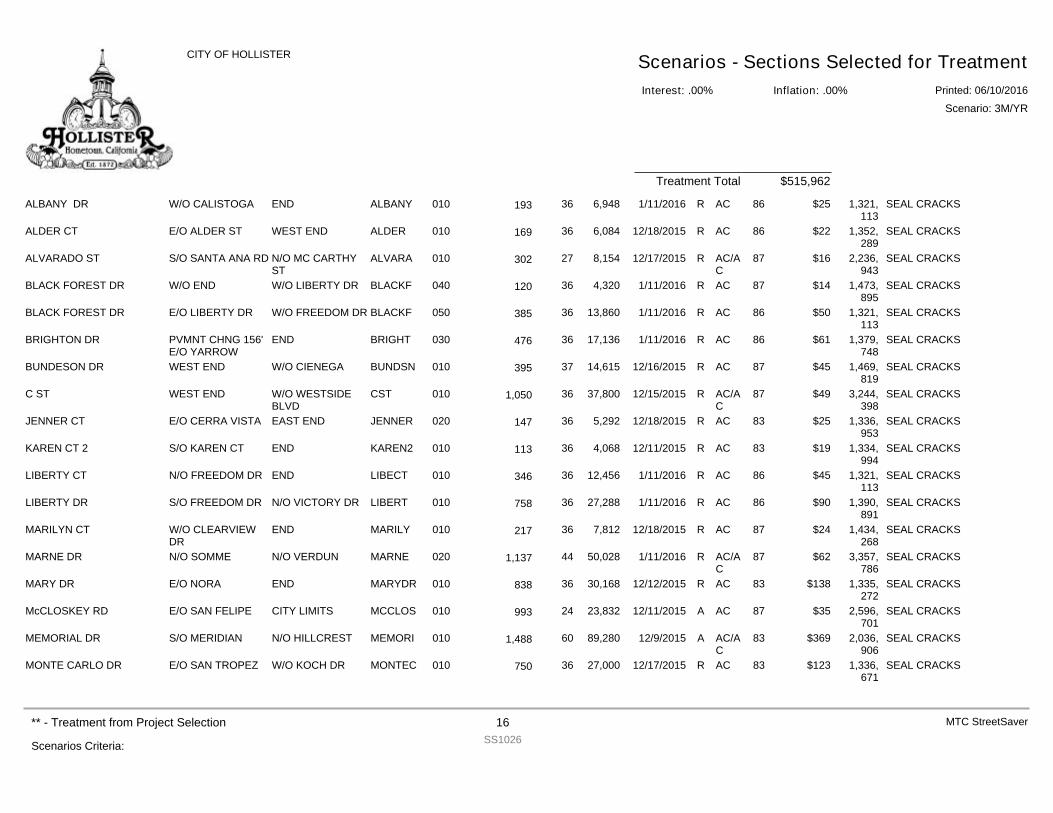
$515,962Treatment Total
ALBANY DR W/O CALISTOGA END ALBANY 010 R AC $25 1,321,113
SEAL CRACKS866,94836193 1/11/2016
ALDER CT E/O ALDER ST WEST END ALDER 010 R AC $22 1,352,289
SEAL CRACKS866,08436169 12/18/2015
ALVARADO ST S/O SANTA ANA RD N/O MC CARTHYST
ALVARA 010 R AC/AC
$16 2,236,943
SEAL CRACKS878,15427302 12/17/2015
BLACK FOREST DR W/O END W/O LIBERTY DR BLACKF 040 R AC $14 1,473,895
SEAL CRACKS874,32036120 1/11/2016
BLACK FOREST DR E/O LIBERTY DR W/O FREEDOM DR BLACKF 050 R AC $50 1,321,113
SEAL CRACKS8613,86036385 1/11/2016
BRIGHTON DR PVMNT CHNG 156'E/O YARROW
END BRIGHT 030 R AC $61 1,379,748
SEAL CRACKS8617,13636476 1/11/2016
BUNDESON DR WEST END W/O CIENEGA BUNDSN 010 R AC $45 1,469,819
SEAL CRACKS8714,61537395 12/16/2015
C ST WEST END W/O WESTSIDEBLVD
CST 010 R AC/AC
$49 3,244,398
SEAL CRACKS8737,800361,050 12/15/2015
JENNER CT E/O CERRA VISTA EAST END JENNER 020 R AC $25 1,336,953
SEAL CRACKS835,29236147 12/18/2015
KAREN CT 2 S/O KAREN CT END KAREN2 010 R AC $19 1,334,994
SEAL CRACKS834,06836113 12/11/2015
LIBERTY CT N/O FREEDOM DR END LIBECT 010 R AC $45 1,321,113
SEAL CRACKS8612,45636346 1/11/2016
LIBERTY DR S/O FREEDOM DR N/O VICTORY DR LIBERT 010 R AC $90 1,390,891
SEAL CRACKS8627,28836758 1/11/2016
MARILYN CT W/O CLEARVIEWDR
END MARILY 010 R AC $24 1,434,268
SEAL CRACKS877,81236217 12/18/2015
MARNE DR N/O SOMME N/O VERDUN MARNE 020 R AC/AC
$62 3,357,786
SEAL CRACKS8750,028441,137 1/11/2016
MARY DR E/O NORA END MARYDR 010 R AC $138 1,335,272
SEAL CRACKS8330,16836838 12/12/2015
McCLOSKEY RD E/O SAN FELIPE CITY LIMITS MCCLOS 010 A AC $35 2,596,701
SEAL CRACKS8723,83224993 12/11/2015
MEMORIAL DR S/O MERIDIAN N/O HILLCREST MEMORI 010 A AC/AC
$369 2,036,906
SEAL CRACKS8389,280601,488 12/9/2015
MONTE CARLO DR E/O SAN TROPEZ W/O KOCH DR MONTEC 010 R AC $123 1,336,671
SEAL CRACKS8327,00036750 12/17/2015
Interest: .00%
CITY OF HOLLISTER Scenarios - Sections Selected for TreatmentInflation: .00% Printed: 06/10/2016
Scenario: 3M/YR
Scenarios Criteria:
** - Treatment from Project Selection 16SS1026
MTC StreetSaver
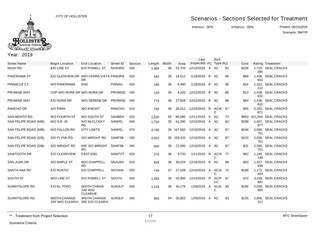
Year: 2019
Street Name Begin Location End Location Street ID Section FCSurfType Cost Rating TreatmentPCILength Width Area
LastInspected
NASH RD E/O LINE ST E/O POWELL ST NASHRD 020 A AC $228 1,719,390
SEAL CRACKS8352,704361,464 12/10/2015
PANORAMA ST E/O GLENVIEW DR W/O CERRA VISTADR
PANORA 010 R AC $69 1,436,602
SEAL CRACKS8619,51236542 1/18/2016
PINNACLE CT N/O PANORAMA END PINNAC 010 R AC $24 1,322,212
SEAL CRACKS866,48036180 1/18/2016
PROMISE WAY COP W/O NORA DR W/O NORA DR PROMISE 030 R AC $13 1,438,432
SEAL CRACKS884,32036120 12/12/2015
PROMISE WAY E/O NORA DR W/O SERENE DR PROMISE 040 R AC $83 1,438,432
SEAL CRACKS8827,82836773 12/12/2015
RANCHO DR S/O PARK N/O KNIGHT RANCHO 010 R AC/AC
$55 2,243,871
SEAL CRACKS8728,51236792 12/16/2015
SAN BENITO RD N/O FOURTH ST N/O SOUTH ST SANBEN 020 A AC $653 911,504 SEAL CRACKS7385,680561,530 12/11/2015SAN FELIPE ROAD (N/B) N/O S.R. 25 S/O McCLOSKY
RDSANFEL 040 A AC $298 1,657,
877SEAL CRACKS8261,390351,754 12/10/2015
SAN FELIPE ROAD (N/B) N/O FALLON RD CITY LIMITS SANFEL 070 A AC $246 2,596,701
SEAL CRACKS87167,650354,790 12/10/2015
SAN FELIPE ROAD (S/B) S/O FLYNN RD S/O WRIGHT RD SANFSB 030 A AC $233 2,596,701
SEAL CRACKS87159,320354,552 12/10/2015
SAN FELIPE ROAD (S/B) S/O WRIGHT RD 600' S/O WRIGHTRD
SANFSB 040 A AC $31 2,596,701
SEAL CRACKS8721,00035600 12/10/2015
SAWTOOTH DR E/O CLEARVIEW EAST END SAWTOT 020 R AC/AC
$63 1,166,148
SEAL CRACKS779,72036270 1/11/2016
SAN JUAN DR S/O MAPLE ST W/O CHAPPELLRD
SNJUAN 010 R AC $83 1,437,635
SEAL CRACKS8830,02436834 12/16/2015
SANTA ANA RD E/O RUSTIC E/O CHAPPELL SNTANA 020 A AC/AC
$189 1,172,683
SEAL CRACKS7527,52837744 12/10/2015
SOUTH ST W/O LINE ST E/O POWELL ST SOUTH 050 R AC/PCC
$72 3,239,891
SEAL CRACKS8755,800361,550 12/14/2015
SUNNYSLOPE RD E/O EL TORO WIDTH CHNGE240' W/OCLEARVIE
SUNSLP 030 A AC/AC
$166 2,036,906
SEAL CRACKS8340,176361,116 12/9/2015
SUNNYSLOPE RD WIDTH CHANGE240' W/O CLEARVI
WIDTH CHANGE355' E/O CLEARVI
SUNSLP 040 A AC $155 1,856,312
SEAL CRACKS8335,80254663 12/9/2015
Interest: .00%
CITY OF HOLLISTER Scenarios - Sections Selected for TreatmentInflation: .00% Printed: 06/10/2016
Scenario: 3M/YR
Scenarios Criteria:
** - Treatment from Project Selection 17SS1026
MTC StreetSaver
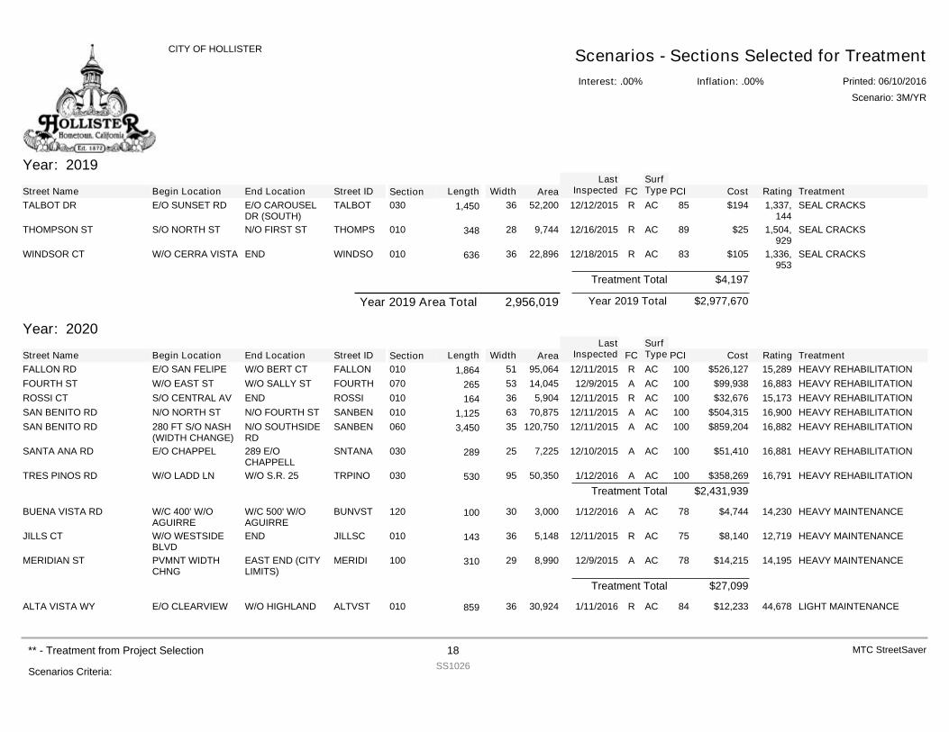
Year: 2019
Street Name Begin Location End Location Street ID Section FCSurfType Cost Rating TreatmentPCILength Width Area
LastInspected
TALBOT DR E/O SUNSET RD E/O CAROUSELDR (SOUTH)
TALBOT 030 R AC $194 1,337,144
SEAL CRACKS8552,200361,450 12/12/2015
THOMPSON ST S/O NORTH ST N/O FIRST ST THOMPS 010 R AC $25 1,504,929
SEAL CRACKS899,74428348 12/16/2015
WINDSOR CT W/O CERRA VISTA END WINDSO 010 R AC $105 1,336,953
SEAL CRACKS8322,89636636 12/18/2015
$4,197Treatment Total
$2,977,670Year 2019 TotalYear 2019 Area Total 2,956,019
Year: 2020
Street Name Begin Location End Location Street ID Section FCSurfType Cost Rating TreatmentPCILength Width Area
LastInspected
FALLON RD E/O SAN FELIPE W/O BERT CT FALLON 010 R AC $526,127 15,289 HEAVY REHABILITATION10095,064511,864 12/11/2015FOURTH ST W/O EAST ST W/O SALLY ST FOURTH 070 A AC $99,938 16,883 HEAVY REHABILITATION10014,04553265 12/9/2015ROSSI CT S/O CENTRAL AV END ROSSI 010 R AC $32,676 15,173 HEAVY REHABILITATION1005,90436164 12/11/2015SAN BENITO RD N/O NORTH ST N/O FOURTH ST SANBEN 010 A AC $504,315 16,900 HEAVY REHABILITATION10070,875631,125 12/11/2015SAN BENITO RD 280 FT S/O NASH
(WIDTH CHANGE)N/O SOUTHSIDERD
SANBEN 060 A AC $859,204 16,882 HEAVY REHABILITATION100120,750353,450 12/11/2015
SANTA ANA RD E/O CHAPPEL 289 E/OCHAPPELL
SNTANA 030 A AC $51,410 16,881 HEAVY REHABILITATION1007,22525289 12/10/2015
TRES PINOS RD W/O LADD LN W/O S.R. 25 TRPINO 030 A AC $358,269 16,791 HEAVY REHABILITATION10050,35095530 1/12/2016$2,431,939Treatment Total
BUENA VISTA RD W/C 400' W/OAGUIRRE
W/C 500' W/OAGUIRRE
BUNVST 120 A AC $4,744 14,230 HEAVY MAINTENANCE783,00030100 1/12/2016
JILLS CT W/O WESTSIDEBLVD
END JILLSC 010 R AC $8,140 12,719 HEAVY MAINTENANCE755,14836143 12/11/2015
MERIDIAN ST PVMNT WIDTHCHNG
EAST END (CITYLIMITS)
MERIDI 100 A AC $14,215 14,195 HEAVY MAINTENANCE788,99029310 12/9/2015
$27,099Treatment Total
ALTA VISTA WY E/O CLEARVIEW W/O HIGHLAND ALTVST 010 R AC $12,233 44,678 LIGHT MAINTENANCE8430,92436859 1/11/2016
Interest: .00%
CITY OF HOLLISTER Scenarios - Sections Selected for TreatmentInflation: .00% Printed: 06/10/2016
Scenario: 3M/YR
Scenarios Criteria:
** - Treatment from Project Selection 18SS1026
MTC StreetSaver
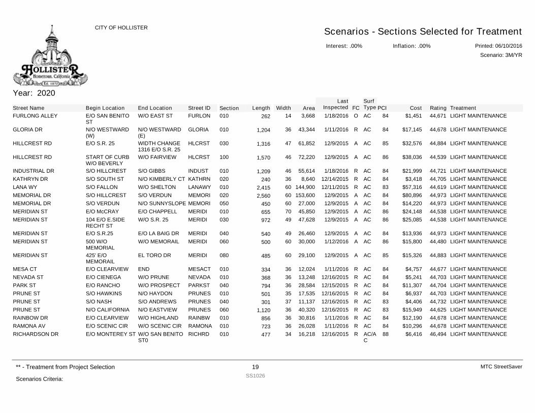
Year: 2020
Street Name Begin Location End Location Street ID Section FCSurfType Cost Rating TreatmentPCILength Width Area
LastInspected
FURLONG ALLEY E/O SAN BENITOST
W/O EAST ST FURLON 010 O AC $1,451 44,671 LIGHT MAINTENANCE843,66814262 1/18/2016
GLORIA DR N/O WESTWARD(W)
N/O WESTWARD(E)
GLORIA 010 R AC $17,145 44,678 LIGHT MAINTENANCE8443,344361,204 1/11/2016
HILLCREST RD E/O S.R. 25 WIDTH CHANGE1316 E/O S.R. 25
HLCRST 030 A AC $32,576 44,884 LIGHT MAINTENANCE8561,852471,316 12/9/2015
HILLCREST RD START OF CURBW/O BEVERLY
W/O FAIRVIEW HLCRST 100 A AC $38,036 44,539 LIGHT MAINTENANCE8672,220461,570 12/9/2015
INDUSTRIAL DR S/O HILLCREST S/O GIBBS INDUST 010 R AC $21,999 44,721 LIGHT MAINTENANCE8455,614461,209 1/18/2016KATHRYN DR S/O SOUTH ST N/O KIMBERLY CT KATHRN 020 R AC $3,418 44,705 LIGHT MAINTENANCE848,64036240 12/14/2015LANA WY S/O FALLON W/O SHELTON LANAWY 010 R AC $57,316 44,619 LIGHT MAINTENANCE83144,900602,415 12/11/2015MEMORIAL DR S/O HILLCREST S/O VERDUN MEMORI 020 A AC $80,896 44,973 LIGHT MAINTENANCE84153,600602,560 12/9/2015MEMORIAL DR S/O VERDUN N/O SUNNYSLOPE MEMORI 050 A AC $14,220 44,973 LIGHT MAINTENANCE8427,00060450 12/9/2015MERIDIAN ST E/O McCRAY E/O CHAPPELL MERIDI 010 A AC $24,148 44,538 LIGHT MAINTENANCE8645,85070655 12/9/2015MERIDIAN ST 104 E/O E.SIDE
RECHT STW/O S.R. 25 MERIDI 030 A AC $25,085 44,538 LIGHT MAINTENANCE8647,62849972 12/9/2015
MERIDIAN ST E/O S.R.25 E/O LA BAIG DR MERIDI 040 A AC $13,936 44,973 LIGHT MAINTENANCE8426,46049540 12/9/2015MERIDIAN ST 500 W/O
MEMORIALW/O MEMORAIL MERIDI 060 A AC $15,800 44,480 LIGHT MAINTENANCE8630,00060500 1/12/2016
MERIDIAN ST 425' E/OMEMORAIL
EL TORO DR MERIDI 080 A AC $15,326 44,883 LIGHT MAINTENANCE8529,10060485 12/9/2015
MESA CT E/O CLEARVIEW END MESACT 010 R AC $4,757 44,677 LIGHT MAINTENANCE8412,02436334 1/11/2016NEVADA ST E/O CIENEGA W/O PRUNE NEVADA 010 R AC $5,241 44,703 LIGHT MAINTENANCE8413,24836368 12/16/2015PARK ST E/O RANCHO W/O PROSPECT PARKST 040 R AC $11,307 44,704 LIGHT MAINTENANCE8428,58436794 12/15/2015PRUNE ST S/O HAWKINS N/O HAYDON PRUNES 010 R AC $6,937 44,703 LIGHT MAINTENANCE8417,53535501 12/16/2015PRUNE ST S/O NASH S/O ANDREWS PRUNES 040 R AC $4,406 44,732 LIGHT MAINTENANCE8311,13737301 12/16/2015PRUNE ST N/O CALIFORNIA N/O EASTVIEW PRUNES 060 R AC $15,949 44,625 LIGHT MAINTENANCE8340,320361,120 12/16/2015RAINBOW DR E/O CLEARVIEW W/O HIGHLAND RAINBW 010 R AC $12,190 44,678 LIGHT MAINTENANCE8430,81636856 1/11/2016RAMONA AV E/O SCENIC CIR W/O SCENIC CIR RAMONA 010 R AC $10,296 44,678 LIGHT MAINTENANCE8426,02836723 1/11/2016RICHARDSON DR E/O MONTEREY ST W/O SAN BENITO
ST0RICHRD 010 R AC/A
C$6,416 46,494 LIGHT MAINTENANCE8816,21834477 12/16/2015
Interest: .00%
CITY OF HOLLISTER Scenarios - Sections Selected for TreatmentInflation: .00% Printed: 06/10/2016
Scenario: 3M/YR
Scenarios Criteria:
** - Treatment from Project Selection 19SS1026
MTC StreetSaver
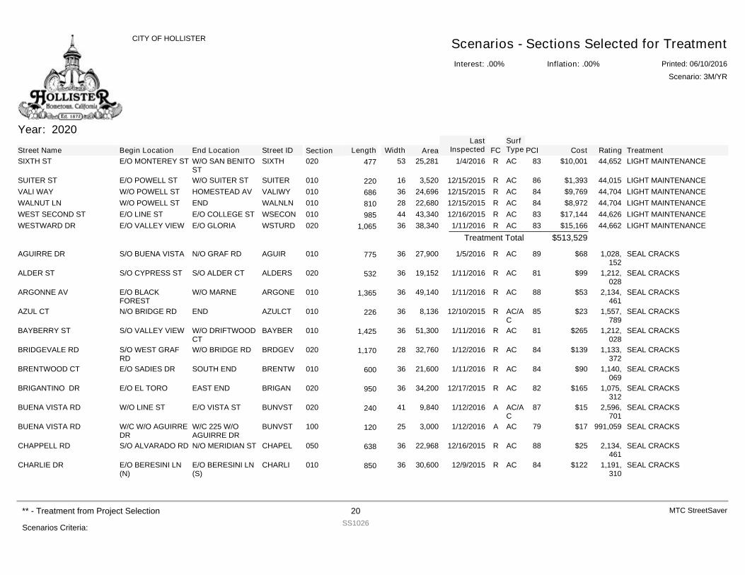
Year: 2020
Street Name Begin Location End Location Street ID Section FCSurfType Cost Rating TreatmentPCILength Width Area
LastInspected
SIXTH ST E/O MONTEREY ST W/O SAN BENITOST
SIXTH 020 R AC $10,001 44,652 LIGHT MAINTENANCE8325,28153477 1/4/2016
SUITER ST E/O POWELL ST W/O SUITER ST SUITER 010 R AC $1,393 44,015 LIGHT MAINTENANCE863,52016220 12/15/2015VALI WAY W/O POWELL ST HOMESTEAD AV VALIWY 010 R AC $9,769 44,704 LIGHT MAINTENANCE8424,69636686 12/15/2015WALNUT LN W/O POWELL ST END WALNLN 010 R AC $8,972 44,704 LIGHT MAINTENANCE8422,68028810 12/15/2015WEST SECOND ST E/O LINE ST E/O COLLEGE ST WSECON 010 R AC $17,144 44,626 LIGHT MAINTENANCE8343,34044985 12/16/2015WESTWARD DR E/O VALLEY VIEW E/O GLORIA WSTURD 020 R AC $15,166 44,662 LIGHT MAINTENANCE8338,340361,065 1/11/2016
$513,529Treatment Total
AGUIRRE DR S/O BUENA VISTA N/O GRAF RD AGUIR 010 R AC $68 1,028,152
SEAL CRACKS8927,90036775 1/5/2016
ALDER ST S/O CYPRESS ST S/O ALDER CT ALDERS 020 R AC $99 1,212,028
SEAL CRACKS8119,15236532 1/11/2016
ARGONNE AV E/O BLACKFOREST
W/O MARNE ARGONE 010 R AC $53 2,134,461
SEAL CRACKS8849,140361,365 1/11/2016
AZUL CT N/O BRIDGE RD END AZULCT 010 R AC/AC
$23 1,557,789
SEAL CRACKS858,13636226 12/10/2015
BAYBERRY ST S/O VALLEY VIEW W/O DRIFTWOODCT
BAYBER 010 R AC $265 1,212,028
SEAL CRACKS8151,300361,425 1/11/2016
BRIDGEVALE RD S/O WEST GRAFRD
W/O BRIDGE RD BRDGEV 020 R AC $139 1,133,372
SEAL CRACKS8432,760281,170 1/12/2016
BRENTWOOD CT E/O SADIES DR SOUTH END BRENTW 010 R AC $90 1,140,069
SEAL CRACKS8421,60036600 1/11/2016
BRIGANTINO DR E/O EL TORO EAST END BRIGAN 020 R AC $165 1,075,312
SEAL CRACKS8234,20036950 12/17/2015
BUENA VISTA RD W/O LINE ST E/O VISTA ST BUNVST 020 A AC/AC
$15 2,596,701
SEAL CRACKS879,84041240 1/12/2016
BUENA VISTA RD W/C W/O AGUIRREDR
W/C 225 W/OAGUIRRE DR
BUNVST 100 A AC $17 991,059 SEAL CRACKS793,00025120 1/12/2016
CHAPPELL RD S/O ALVARADO RD N/O MERIDIAN ST CHAPEL 050 R AC $25 2,134,461
SEAL CRACKS8822,96836638 12/16/2015
CHARLIE DR E/O BERESINI LN(N)
E/O BERESINI LN(S)
CHARLI 010 R AC $122 1,191,310
SEAL CRACKS8430,60036850 12/9/2015
Interest: .00%
CITY OF HOLLISTER Scenarios - Sections Selected for TreatmentInflation: .00% Printed: 06/10/2016
Scenario: 3M/YR
Scenarios Criteria:
** - Treatment from Project Selection 20SS1026
MTC StreetSaver
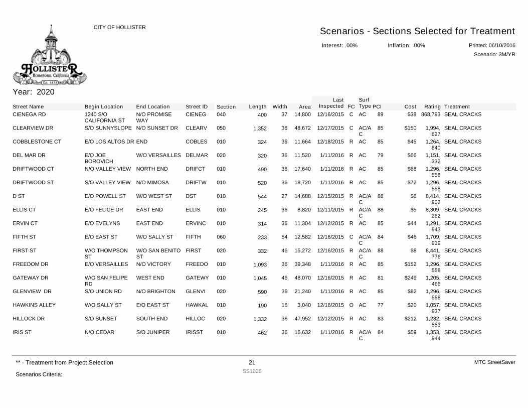
Year: 2020
Street Name Begin Location End Location Street ID Section FCSurfType Cost Rating TreatmentPCILength Width Area
LastInspected
CIENEGA RD 1240 S/OCALIFORNIA ST
N/O PROMISEWAY
CIENEG 040 C AC $38 868,793 SEAL CRACKS8914,80037400 12/16/2015
CLEARVIEW DR S/O SUNNYSLOPE N/O SUNSET DR CLEARV 050 C AC/AC
$150 1,994,627
SEAL CRACKS8548,672361,352 12/17/2015
COBBLESTONE CT E/O LOS ALTOS DR END COBLES 010 R AC $45 1,264,840
SEAL CRACKS8511,66436324 12/18/2015
DEL MAR DR E/O JOEBOROVICH
W/O VERSAILLES DELMAR 020 R AC $66 1,151,332
SEAL CRACKS7911,52036320 1/11/2016
DRIFTWOOD CT N/O VALLEY VIEW NORTH END DRIFCT 010 R AC $68 1,296,558
SEAL CRACKS8517,64036490 1/11/2016
DRIFTWOOD ST S/O VALLEY VIEW N/O MIMOSA DRIFTW 010 R AC $72 1,296,558
SEAL CRACKS8518,72036520 1/11/2016
D ST E/O POWELL ST W/O WEST ST DST 010 R AC/AC
$8 8,414,902
SEAL CRACKS8814,68827544 12/15/2015
ELLIS CT E/O FELICE DR EAST END ELLIS 010 R AC/AC
$5 8,309,262
SEAL CRACKS888,82036245 12/11/2015
ERVIN CT E/O EVELYNS EAST END ERVINC 010 R AC $44 1,291,943
SEAL CRACKS8511,30436314 12/12/2015
FIFTH ST E/O EAST ST W/O SALLY ST FIFTH 060 C AC/AC
$46 1,709,939
SEAL CRACKS8412,58254233 12/16/2015
FIRST ST W/O THOMPSONST
W/O SAN BENITOST
FIRST 020 R AC/AC
$8 8,441,776
SEAL CRACKS8815,27246332 12/16/2015
FREEDOM DR E/O VERSAILLES N/O VICTORY FREEDO 010 R AC $152 1,296,558
SEAL CRACKS8539,348361,093 1/11/2016
GATEWAY DR W/O SAN FELIPERD
WEST END GATEWY 010 R AC $249 1,205,466
SEAL CRACKS8148,070461,045 12/16/2015
GLENVIEW DR S/O UNION RD N/O BRIGHTON GLENVI 020 R AC $82 1,296,558
SEAL CRACKS8521,24036590 1/11/2016
HAWKINS ALLEY W/O SALLY ST E/O EAST ST HAWKAL 010 O AC $20 1,057,937
SEAL CRACKS773,04016190 12/16/2015
HILLOCK DR S/O SUNSET SOUTH END HILLOC 020 R AC $212 1,232,553
SEAL CRACKS8347,952361,332 12/12/2015
IRIS ST N/O CEDAR S/O JUNIPER IRISST 010 R AC/AC
$59 1,353,944
SEAL CRACKS8416,63236462 1/11/2016
Interest: .00%
CITY OF HOLLISTER Scenarios - Sections Selected for TreatmentInflation: .00% Printed: 06/10/2016
Scenario: 3M/YR
Scenarios Criteria:
** - Treatment from Project Selection 21SS1026
MTC StreetSaver
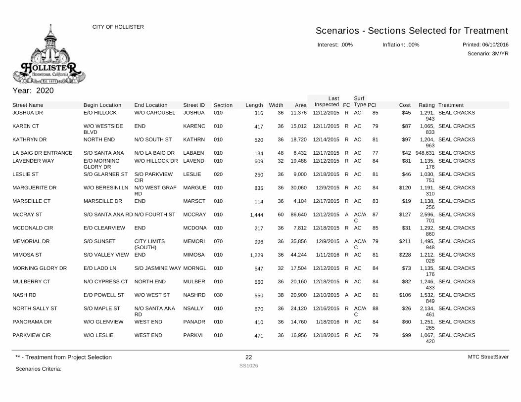
Year: 2020
Street Name Begin Location End Location Street ID Section FCSurfType Cost Rating TreatmentPCILength Width Area
LastInspected
JOSHUA DR E/O HILLOCK W/O CAROUSEL JOSHUA 010 R AC $45 1,291,943
SEAL CRACKS8511,37636316 12/12/2015
KAREN CT W/O WESTSIDEBLVD
END KARENC 010 R AC $87 1,065,833
SEAL CRACKS7915,01236417 12/11/2015
KATHRYN DR NORTH END N/O SOUTH ST KATHRN 010 R AC $97 1,204,963
SEAL CRACKS8118,72036520 12/14/2015
LA BAIG DR ENTRANCE S/O SANTA ANA N/O LA BAIG DR LABAEN 010 R AC $42 948,631 SEAL CRACKS776,43248134 12/17/2015LAVENDER WAY E/O MORNING
GLORY DRW/O HILLOCK DR LAVEND 010 R AC $81 1,135,
176SEAL CRACKS8419,48832609 12/12/2015
LESLIE ST S/O GLARNER ST S/O PARKVIEWCIR
LESLIE 020 R AC $46 1,030,751
SEAL CRACKS819,00036250 12/18/2015
MARGUERITE DR W/O BERESINI LN N/O WEST GRAFRD
MARGUE 010 R AC $120 1,191,310
SEAL CRACKS8430,06036835 12/9/2015
MARSEILLE CT MARSEILLE DR END MARSCT 010 R AC $19 1,138,256
SEAL CRACKS834,10436114 12/17/2015
McCRAY ST S/O SANTA ANA RD N/O FOURTH ST MCCRAY 010 A AC/AC
$127 2,596,701
SEAL CRACKS8786,640601,444 12/12/2015
MCDONALD CIR E/O CLEARVIEW END MCDONA 010 R AC $31 1,292,860
SEAL CRACKS857,81236217 12/18/2015
MEMORIAL DR S/O SUNSET CITY LIMITS(SOUTH)
MEMORI 070 A AC/AC
$211 1,495,948
SEAL CRACKS7935,85636996 12/9/2015
MIMOSA ST S/O VALLEY VIEW END MIMOSA 010 R AC $228 1,212,028
SEAL CRACKS8144,244361,229 1/11/2016
MORNING GLORY DR E/O LADD LN S/O JASMINE WAY MORNGL 010 R AC $73 1,135,176
SEAL CRACKS8417,50432547 12/12/2015
MULBERRY CT N/O CYPRESS CT NORTH END MULBER 010 R AC $82 1,246,433
SEAL CRACKS8420,16036560 12/18/2015
NASH RD E/O POWELL ST W/O WEST ST NASHRD 030 A AC $106 1,532,849
SEAL CRACKS8120,90038550 12/10/2015
NORTH SALLY ST S/O MAPLE ST N/O SANTA ANARD
NSALLY 010 R AC/AC
$26 2,134,461
SEAL CRACKS8824,12036670 12/16/2015
PANORAMA DR W/O GLENVIEW WEST END PANADR 010 R AC $60 1,251,265
SEAL CRACKS8414,76036410 1/18/2016
PARKVIEW CIR W/O LESLIE WEST END PARKVI 010 R AC $99 1,067,420
SEAL CRACKS7916,95636471 12/18/2015
Interest: .00%
CITY OF HOLLISTER Scenarios - Sections Selected for TreatmentInflation: .00% Printed: 06/10/2016
Scenario: 3M/YR
Scenarios Criteria:
** - Treatment from Project Selection 22SS1026
MTC StreetSaver
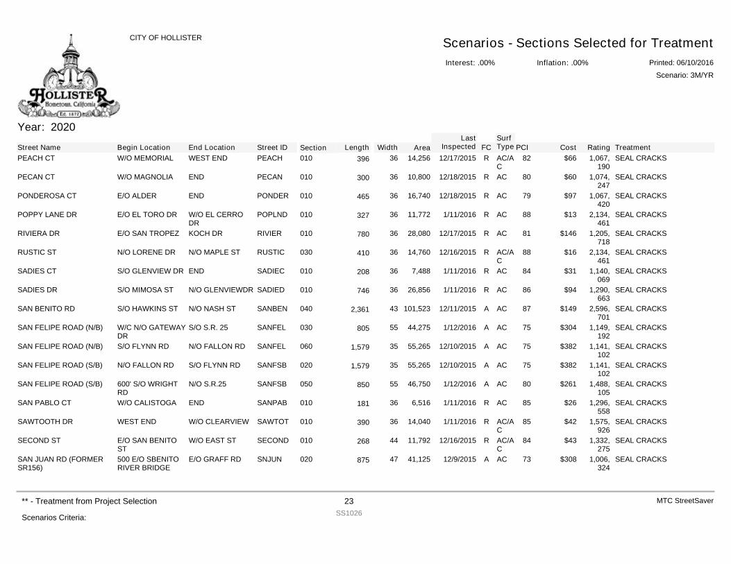
Year: 2020
Street Name Begin Location End Location Street ID Section FCSurfType Cost Rating TreatmentPCILength Width Area
LastInspected
PEACH CT W/O MEMORIAL WEST END PEACH 010 R AC/AC
$66 1,067,190
SEAL CRACKS8214,25636396 12/17/2015
PECAN CT W/O MAGNOLIA END PECAN 010 R AC $60 1,074,247
SEAL CRACKS8010,80036300 12/18/2015
PONDEROSA CT E/O ALDER END PONDER 010 R AC $97 1,067,420
SEAL CRACKS7916,74036465 12/18/2015
POPPY LANE DR E/O EL TORO DR W/O EL CERRODR
POPLND 010 R AC $13 2,134,461
SEAL CRACKS8811,77236327 1/11/2016
RIVIERA DR E/O SAN TROPEZ KOCH DR RIVIER 010 R AC $146 1,205,718
SEAL CRACKS8128,08036780 12/17/2015
RUSTIC ST N/O LORENE DR N/O MAPLE ST RUSTIC 030 R AC/AC
$16 2,134,461
SEAL CRACKS8814,76036410 12/16/2015
SADIES CT S/O GLENVIEW DR END SADIEC 010 R AC $31 1,140,069
SEAL CRACKS847,48836208 1/11/2016
SADIES DR S/O MIMOSA ST N/O GLENVIEWDR SADIED 010 R AC $94 1,290,663
SEAL CRACKS8626,85636746 1/11/2016
SAN BENITO RD S/O HAWKINS ST N/O NASH ST SANBEN 040 A AC $149 2,596,701
SEAL CRACKS87101,523432,361 12/11/2015
SAN FELIPE ROAD (N/B) W/C N/O GATEWAYDR
S/O S.R. 25 SANFEL 030 A AC $304 1,149,192
SEAL CRACKS7544,27555805 1/12/2016
SAN FELIPE ROAD (N/B) S/O FLYNN RD N/O FALLON RD SANFEL 060 A AC $382 1,141,102
SEAL CRACKS7555,265351,579 12/10/2015
SAN FELIPE ROAD (S/B) N/O FALLON RD S/O FLYNN RD SANFSB 020 A AC $382 1,141,102
SEAL CRACKS7555,265351,579 12/10/2015
SAN FELIPE ROAD (S/B) 600' S/O WRIGHTRD
N/O S.R.25 SANFSB 050 A AC $261 1,488,105
SEAL CRACKS8046,75055850 1/12/2016
SAN PABLO CT W/O CALISTOGA END SANPAB 010 R AC $26 1,296,558
SEAL CRACKS856,51636181 1/11/2016
SAWTOOTH DR WEST END W/O CLEARVIEW SAWTOT 010 R AC/AC
$42 1,575,926
SEAL CRACKS8514,04036390 1/11/2016
SECOND ST E/O SAN BENITOST
W/O EAST ST SECOND 010 R AC/AC
$43 1,332,275
SEAL CRACKS8411,79244268 12/16/2015
SAN JUAN RD (FORMERSR156)
500 E/O SBENITORIVER BRIDGE
E/O GRAFF RD SNJUN 020 A AC $308 1,006,324
SEAL CRACKS7341,12547875 12/9/2015
Interest: .00%
CITY OF HOLLISTER Scenarios - Sections Selected for TreatmentInflation: .00% Printed: 06/10/2016
Scenario: 3M/YR
Scenarios Criteria:
** - Treatment from Project Selection 23SS1026
MTC StreetSaver
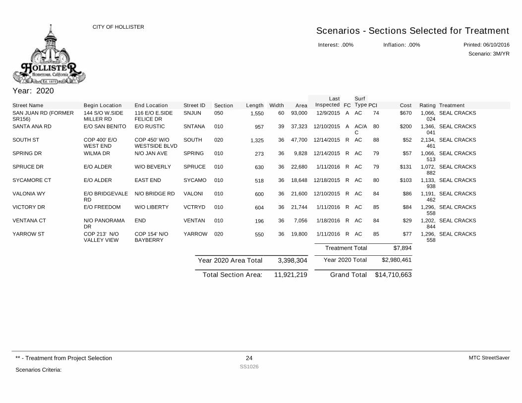
Year: 2020
Street Name Begin Location End Location Street ID Section FCSurfType Cost Rating TreatmentPCILength Width Area
LastInspected
SAN JUAN RD (FORMERSR156)
144 S/O W.SIDEMILLER RD
116 E/O E.SIDEFELICE DR
SNJUN 050 A AC $670 1,066,024
SEAL CRACKS7493,000601,550 12/9/2015
SANTA ANA RD E/O SAN BENITO E/O RUSTIC SNTANA 010 A AC/AC
$200 1,346,041
SEAL CRACKS8037,32339957 12/10/2015
SOUTH ST COP 400' E/OWEST END
COP 450' W/OWESTSIDE BLVD
SOUTH 020 R AC $52 2,134,461
SEAL CRACKS8847,700361,325 12/14/2015
SPRING DR WILMA DR N/O JAN AVE SPRING 010 R AC $57 1,066,513
SEAL CRACKS799,82836273 12/14/2015
SPRUCE DR E/O ALDER W/O BEVERLY SPRUCE 010 R AC $131 1,072,882
SEAL CRACKS7922,68036630 1/11/2016
SYCAMORE CT E/O ALDER EAST END SYCAMO 010 R AC $103 1,133,938
SEAL CRACKS8018,64836518 12/18/2015
VALONIA WY E/O BRIDGEVALERD
N/O BRIDGE RD VALONI 010 R AC $86 1,191,462
SEAL CRACKS8421,60036600 12/10/2015
VICTORY DR E/O FREEDOM W/O LIBERTY VCTRYD 010 R AC $84 1,296,558
SEAL CRACKS8521,74436604 1/11/2016
VENTANA CT N/O PANORAMADR
END VENTAN 010 R AC $29 1,202,844
SEAL CRACKS847,05636196 1/18/2016
YARROW ST COP 213' N/OVALLEY VIEW
COP 154' N/OBAYBERRY
YARROW 020 R AC $77 1,296,558
SEAL CRACKS8519,80036550 1/11/2016
$7,894Treatment Total
$2,980,461Year 2020 TotalYear 2020 Area Total 3,398,304
$14,710,663Grand Total11,921,219Total Section Area:
Interest: .00%
CITY OF HOLLISTER Scenarios - Sections Selected for TreatmentInflation: .00% Printed: 06/10/2016
Scenario: 3M/YR
Scenarios Criteria:
** - Treatment from Project Selection 24SS1026
MTC StreetSaver
DEFINITIONS
P a g e | 1
This section is intended to define important pavement design acronyms and terms used when discussing a Pavement Management System (PMS). GENERAL TERMS
PMS - Pavement Management System - A program to aid in tracking the condition of roads and a means to help quantify the cost of maintaining the roads in a given area.
TI - Traffic Index - Cars and light trucks have little impact on the pavement structure. Larger/Heavier trucks have very significant impacts on the pavement due to the high axle weights. The total EALs is converted into a design Traffic Index (TI). The design TI is the total number of EALs that the pavement will support before it begins to fail, regardless of the passage of time. Normally for a new pavement, the EALs over a 20_year period are used. For rehabilitation procedures such as overlays, 10 years is generally used.
PCI - Pavement Condition Index - A rating scale for the condition of a road segment. 100 represents no defects and recent major rehabilitation.
CRITICAL PCI - The PCI value at which the rate of loss increases with time, or the cost of applying a maintenance treatment increases significantly.
CLS / FC - Functional Classification is the process by which streets and highways are grouped into classes, or systems, according to the character of traffic service that they are intended to provide. There are three highway functional classifications: arterial, collector, and local roads. All streets and highways are grouped into one of these classes, depending on the character of the traffic. Arterials - provide the highest level of service at the greatest speed for the
longest uninterrupted distance, with some degree of access control. Collectors - provide a less highly developed level of service at a lower speed for
shorter distances by collecting traffic from local roads and connecting them with arterials.
Residential/Local - consists of all roads not defined as arterials or collectors and primarily provides access to land with little or no through movement.
Excerpted from the U.S. Department of Transportation, Federal Highway
Administration web site on “Functional Classification”.
EMULSION - A chemical added to water and asphalt that keeps the asphalt in a stable suspension in the water. AC - Asphaltic Concrete - A plant mixed asphalt binder (asphalt cement that is classified according to the Standard Specification for Performance Graded
P a g e | 2
Asphalt Binder) and aggregate (rocks) thoroughly mixed and compacted into a mass.
PCC - Portland Cement Concrete
OVERLAY - The placement of asphaltic concrete mix over an existing asphaltic concrete or portland cement concrete surface.
Light Overlay - would include any overlay of less than 2 inches of asphalt.
Heavy Overlay - is a thicker layer of asphalt and might include such items/operations as, but not limited to fabric, milling/grinding and reconstruction.
PREVENTIVE MAINTENANCE - Provides budget dollars for localized pavement repairs such as digouts and crack filling.
SLURRY SEAL - Includes a graded aggregate along with emulsion and water. Generally squeegeed and generally consists of two layers. REFLECTIVE CRACKING - Cracks that occur in new “thin” overlays that are identical to the cracks that were present in the existing pavement.
ALLIGATOR CRACKING - Alligator or fatigue cracking is a series of interconnecting cracks caused by fatigue failure of the asphalt concrete surface under repeated traffic loading. Cracking begins at the bottom of the asphalt surface (or stabilized base) where the stress and strain are highest under a wheel load. The cracks propagate to the surface initially as a series of parallel longitudinal cracks. After repeated traffic loading, the cracks connect, forming many sided, sharp-angled pieces that develop a pattern resembling chicken wire or the skin of an alligator. Alligator cracking occurs only in areas subjected to repeated traffic loading, such as wheel paths. (Pattern-type cracking that occurs over an entire area not subjected to loading is called “block cracking,” which is not a load-associated distress.)
BLOCK CRACKING - Block cracks are interconnected cracks that divide the pavement into approximately rectangular pieces. Block cracking is caused mainly by shrinkage of the asphalt concrete and daily temperature cycling (which results in daily stress/strain cycling). It is not load-associated. Block cracking usually indicates that the asphalt has hardened significantly. Block cracking normally occurs over a large portion of the pavement area, but sometimes will occur only in non-traffic areas. This type of distress differs from alligator cracking in that alligator cracks form smaller, many-sided pieces with sharp angles. Also, unlike block, alligator cracks are caused by repeated traffic loadings, and are therefore found only in traffic areas (i.e., wheel paths).
P a g e | 3
LONGITUDINAL / TRANSVERSE CRACKING - Longitudinal cracks are parallel to the pavement’s centerline or laydown direction. Transverse cracks extend across the pavement at approximately right angles to the pavement centerline or direction of laydown. These types of cracks are not usually load-associated. WEATHERING & RAVELING - Weathering and raveling is the wearing away of the pavement surface due to a loss of asphalt or tar and dislodged aggregate particles. These distresses indicate that either the asphalt binder has hardened appreciably or that a poor quality mixture is present. In addition, raveling may be caused by certain types of traffic, i.e., tracked vehicles. Softening of the surface and dislodging of the aggregates due to oil spillage are also included under raveling.
BUMPS & SAGS - Bumps are small, localized, upward displacements of the pavement surface. They are different from shoves in that shoves are caused by unstable pavement. Sags are small, abrupt, downward displacements of the pavement surface. If bumps appear in pattern perpendicular to traffic flow and are spaced at less than 3 m (10 ft), the distress is called corrugation. Distortion and displacement that occur over large areas of the pavement surface causing large and/or long dips in the pavement should be recorded at “swelling.”
RUTTING / SHOVING - A rut is a surface depression in the wheel paths. Pavement uplift may occur along the sides of the rut, but, in many instances, ruts are noticeable only after a rainfall when the paths are filled with water. Rutting stems from a permanent deformation in any of the pavement layers or subgrades, usually caused by consolidated or lateral movement of the materials due to traffic load.
Shoving is a permanent, longitudinal displacement of a localized area of the pavement surface caused by traffic loading. When traffic pushes against the pavement, it produces a short, abrupt wave in the pavement surface. This distress normally occurs only in unstable liquid asphalt mix (cutback or emulsion) pavements.
PATCHING & UTILITY CUTS - A patch is an area of pavement that has been replaced with new material to repair the existing pavement. A patch is considered a defect no matter how well it is performing (a patched area or adjacent area usually does not perform as well as an original pavement section). Generally, some roughness is associated with this distress. POTHOLES - Most often are structurally related distresses and should not be confused with raveling and weathering.
P a g e | 4
PAVEMENT PRESERVATION - Applying the Right Treatment to the Right Pavement at the Right Time using the Right Materials.
R-VALUE - A test to evaluate the base, subbase and subgrades of an area to be used in pavement designing for thickness of asphalt.
ESAL - The impact of trucks is measured in equivalent single 18,000 pound axle loads (EALs).
STREETSAVER DEFINITIONS
MANAGEMENT SECTION - This is used to maintain an inventory of all the roads and road sections in your jurisdiction.
EVENTS – This provides for viewing and maintaining of Events or changes that have been made on a management section. The Events that are included are: • Management Section Creation. • Results from Maintenance and Rehabilitation treatments that have been
applied to the Management Section. • Results from Visual Inspections of Management Sections. • Listing of changes/edits of information on a Management Section.
DETERIORATION CURVE - This provides a graphical representation of the current pavement condition index and the historical PCIs for each section of road in your jurisdiction.
MAINTENANCE/REHABILITATION - This is used to review the proposed maintenance, new maintenance, and rehabilitation for any road section in your jurisdiction.
BRANCH - Generally a road name or a road name with a direction of travel.
SECTION - Usually a branch or road is large and needs to be divided into smaller pieces to maintain. These smaller pieces are labeled as “sections” and designated with a number and a beginning and ending location. DISTRESSES - Defects found in asphalt concrete pavements or portland cement concrete. These defects degrade the condition of the road.
RATING - The rating is the weight cost - effectiveness ratio of the recommended treatment.
% OF ENVIRONMENT - The percentage of the pavement distress in a management section that is an environment related distress.
P a g e | 5
% LOAD RELATED - The percentage of the pavement distress in a management section that is load related distress (caused by excessive weight on the pavement surface). % OTHER - Is the percentage of the pavement section that is not a load related or environment related distress.
ACTIVE - Indicates whether or not the current record is active.
AREA - Contains the area of a section in square feet. This is automatically calculated using the values that are entered in the Length and Width fields. However, if the section is irregularly shaped the area can be entered by the user.
AREA ID - Is an optional, jurisdiction defined field to identify the area in which the section is located. For example, each neighborhood or subdivision, or each geographic type (mountain, valley, coast, etc.) in the jurisdiction may be assigned a letter of the alphabet.
BASE BUDGET - Provides an area for you to enter the dollar amount of your base budget.
BASE BUDGET INCREASE FACTOR - Stores the percent that the base budget will increase each year.
BASE PM SPLIT - Percent of the base budget that has been set aside for preventive maintenance. BEGINNING LOCATION - Identifies the point that defines the beginning of the section. This is generally the name of a cross road or other landmark. CONDITION - Column lists the condition levels (2-5) that require stop-gap treatments.
COST/ SQ YD - Indicates the cost per square yard of road for the suggested treatment.
CURRENT PCI - Calculated from either a visual inspection or a maintenance treatment.
DESCRIPTION - Displays a description of the item named in the previous column in a grid.
DISTRESS - Contains the type of distress present on a section of a road.
P a g e | 6
END LOCATION - Identifies the point that defines the end of the section. This is generally the name of a cross road or other landmark.
EVENT ACTIVE - Indicates whether an Event is currently part of the active history for the current Section.
EVENT PCI - The PCI after the selected Event occurred.
EVENT TRANSACTION TYPE - Includes: Creation, Inspection, Treatment, Split, Combine, Attribute Change and Core Data Change.
EVENT VALID - Indicates if an Event can be activated and made part of the valid events for the current section.
FUNDING SOURCE - Is an optional, jurisdiction defined field to identify the funding source for the section; an example might be G for general fund.
GENERAL CODE - Is an optional, jurisdiction defined field used to identify sections of pavement sharing common characteristics, i.e., drainage type.
INFLATION RATE - Is the inflation used throughout your jurisdiction. You may wish to consult your financial department with this value. INSPECTION AREA - Is the total area of the inspection unit.
INTEREST RATE - Contains the interest rate used throughout your jurisdiction.
LIFE EXTENSION - Is the number of years that a maintenance treatment extends the life of a pavement surface.
MAINTENANCE DATE - Displays the date the maintenance was completed.
MANAGEMENT UNIT - Relates a project to a management unit.
MILEPOSTS - Display the beginning and ending points of a management section.
NEW PCI - Stores the PCI value that was calculated after a treatment was applied.
NUMBER OF SURFACE SEALS BEFORE OVERLAY - Displays the recommended number of surface seals before the application of an overlay.
OLD PCI - Displays the pavement condition index before a treatment was applied.
P a g e | 7
OTHER - Displays the weighting factor applied to management sections with functional classes other than arterial, collector, and residential.
OVERLAY - Displays the overlay code that corresponds to an overlay procedure.
OVERLAY CODE - Is an identifier for the treatment type; use one of the six codes from the pop-up list that appears when this is activated.
PCI CAP - Stores the maximum PCI value that will be included in needs and scenario calculations. If a PCI value is larger than the PCI Cap value, it will not be included. PCI EFFECTIVENESS CUT-OFF - Contains the minimum PCI value used in calculating the area under the projected performance curve. That area is used in ranking sections needing work, and the area below the PCI Cut-Off value is not included in that area. It should generally be the lowest PCI value that defines the minimum acceptable condition for all of the pavement types and functional classification groupings.
PCI HIGH - LOW > 25 - Is marked if the difference between the high and low PCI values is greater than 25.
PCI HIGH VALUE - Is the maximum PCI value for an inspection unit used in the last PCI calculation for a management unit.
PCI LOW VALUE - Is the minimum PCI value for an inspection unit used in the last PCI calculation for a management unit.
PM% - Scenarios based on a yearly budget, this column stores the percent that has been set aside for preventive maintenance.
REPLACEMENT COST - Is the cost per square yard to install a new pavement surface.
RESIDENTIAL $ - Indicates the cost of a stop-gap treatment per square yard when applied to a road with a residential functional class and a given condition.
ROAD ID - Contains a two-character identifier that was assigned to the road. The combination of Road Number, Road Name, and Road ID must be unique for each road section.
ROAD NAME - Displays the name of the road that corresponds to the road number and road ID. The combination of Road Number, Road Name, and Road ID must be unique for each road section.
P a g e | 8
ROAD NUMBER - Contains the number that was assigned to a road. The combination of Road Number, Road Name, and Road ID must be unique for each road section.
SECTION ID - Is an identifier that is unique for each section of a given street. Note that the Street ID and the Section ID combined describe the individual section. Therefore, that combination must be unique. The same Section ID can be reused as long as it is used in conjunction with a different Street ID each time. SEGMENT LENGTH - Is the length in feet of the management section. SELECT MANAGEMENT SECTIONS - Allows you to calculate PCI values based on selected management sections. If this button is marked, the management sections that have had records updated since the last calculations are displayed in a grid. Select the management sections you want included in the calculations from this grid.
SPECIAL - Check box is marked if the displayed inspection unit is non-representative of a section as a whole.
SPECIAL UNIT - The information will either be Y or blank. Y is an indication that this inspection unit is in some way non-representative of the section as a whole, and would receive a different maintenance/rehabilitation treatment from the rest of the section.
STANDARD INSPECTION UNITS - Is the typical number of inspection units that would be used for a particular management section.
STOP-GAP APPLICATION INTERVAL - Indicates the number of years between the applications of stop-gap treatments.
STREET ID - Is an identifier that is unique for each street. The Street ID usually bears some similarity to the actual street name.
STREET NAME - Is the full name of the street including “Street”, “Way”, “Court” etc.
TREATMENT - Contains the type of treatment the road received or will receive.
TREATMENT COST - Is an optional field giving the cost in dollars and cents of the treatment.
UNIT OF MEASURE - Displays the units of measure used to measure an item.
P a g e | 9
UNIT PRICE - Displays the price paid for an inventory item. VISUAL PCI - Used to identify PCI calculations that have been determined based upon a visual inspection. If this check box is blank, then the PCI was extrapolated based upon the maintenance treatment that has been applied to a management section. WEIGHTING FACTORS - Section displays the weighting factors established by your jurisdiction for the functional classes.
YEAR OF MAINTENANCE - Stores the proposed year of a treatment.
YEARS BETWEEN CRACK SEALS - Displays the number of years between the application of crack seals for the functional class with a specific severity. YEARS BETWEEN SURFACE SEALS - Displays the recommended number of years that should come between surface seal application for the functional class with the indicated severity.
YEARS TO CALCULATE - Stores the number of years you want to include in the Budget Needs calculation. The number of years cannot be less than 5 or more than 20.
REPORT DEFINITIONS
ZONES - Geographical areas of the city defined by city staff to aid in the development of a maintenance plan for residential roads.
CL - Centerline Mile - a measuring of the length of a road regardless of the width of the road.
LM - Lane Mile - a measurement of the length of all the lanes for a given FC or area.
ACTION / TREATMENT - A proposed type of rehabilitation work that should be used on a given road segment, based on PCI, FC and engineering evaluation. ANNUAL BUDGET - The amount of money that is available each year to be used for pavement maintenance. These funds can come from various sources and can vary from year to year, although it is generally a fixed figure.
1
Pavement Assessment StudyCity of Hollister
Prepared by Pavement Engineering Inc.March 14, 2016
• Pavement 101• Pavement preservation• Pavement treatments• Assessment findings• Budget funding, limitations and impacts• Future pavement strategies
PRESENTATION GOALS
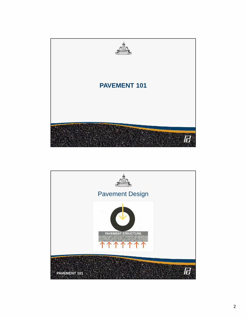
2
PAVEMENT 101
Pavement Design
PAVEMENT 101
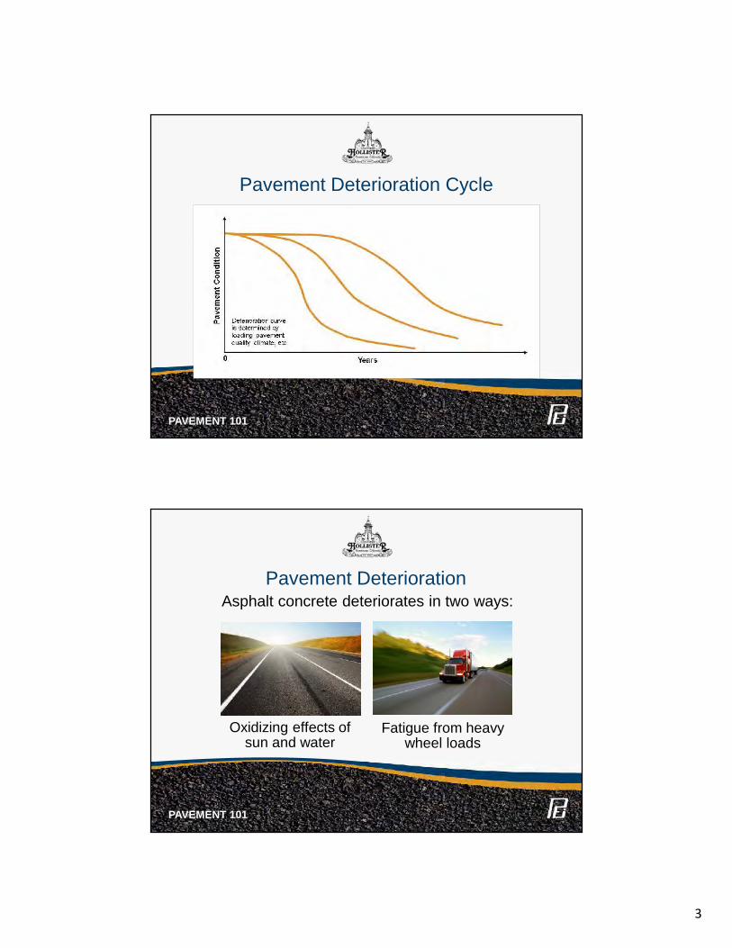
3
Pavement Deterioration Cycle
PAVEMENT 101
Asphalt concrete deteriorates in two ways:Pavement Deterioration
Oxidizing effects ofsun and water
Fatigue from heavywheel loads
PAVEMENT 101
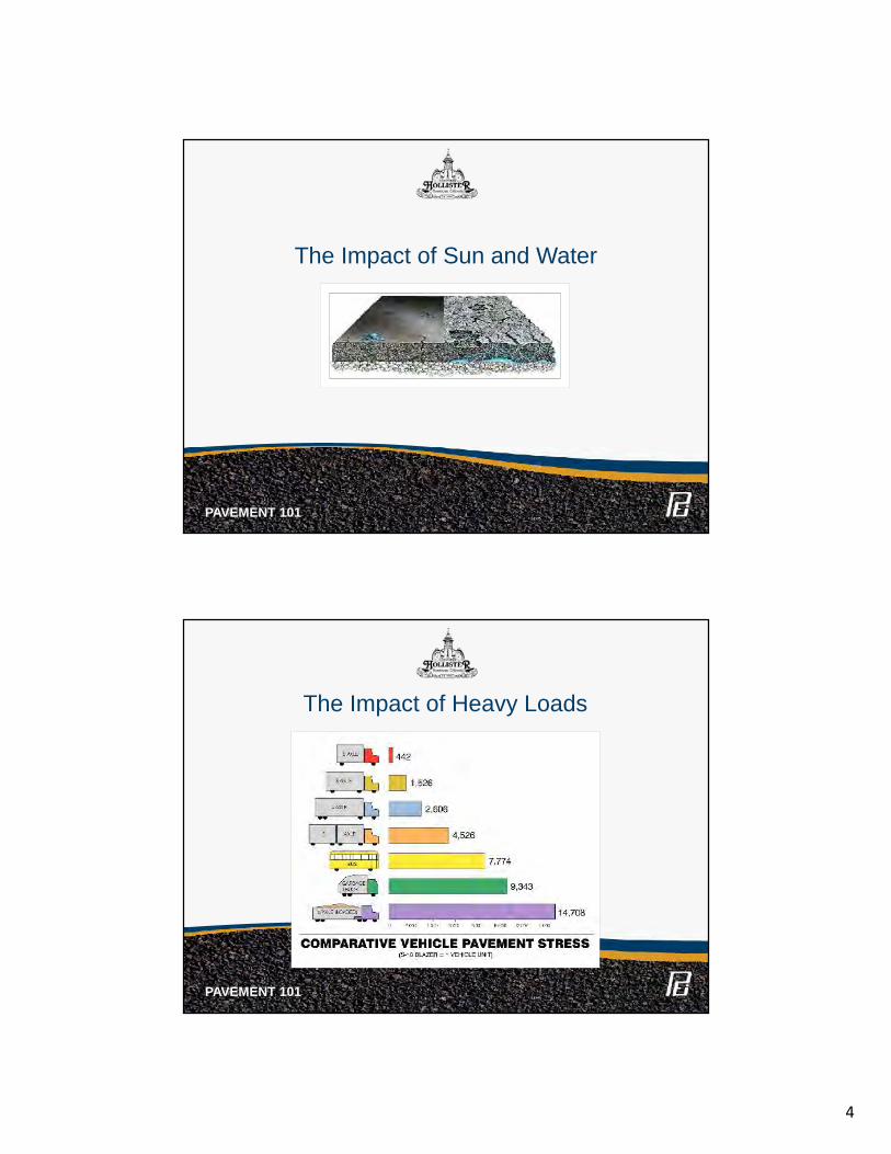
4
The Impact of Sun and Water
PAVEMENT 101
The Impact of Heavy Loads
PAVEMENT 101
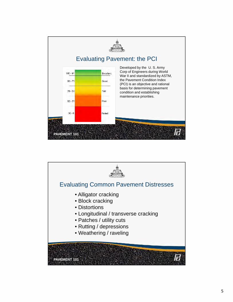
5
Evaluating Pavement: the PCI
PAVEMENT 101
Developed by the U. S. ArmyCorp of Engineers during WorldWar II and standardized by ASTM,the Pavement Condition Index(PCI) is an objective and rationalbasis for determining pavementcondition and establishingmaintenance priorities.
• Alligator cracking• Block cracking• Distortions• Longitudinal / transverse cracking• Patches / utility cuts• Rutting / depressions• Weathering / raveling
Evaluating Common Pavement Distresses
PAVEMENT 101
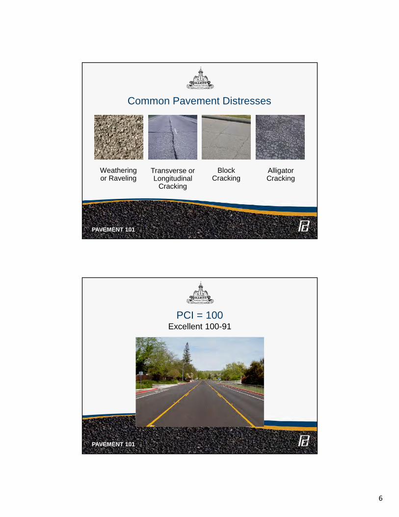
6
BlockCracking
AlligatorCracking
Transverse orLongitudinal
Cracking
Weatheringor Raveling
Common Pavement Distresses
PAVEMENT 101
PCI = 100Excellent 100-91
PAVEMENT 101
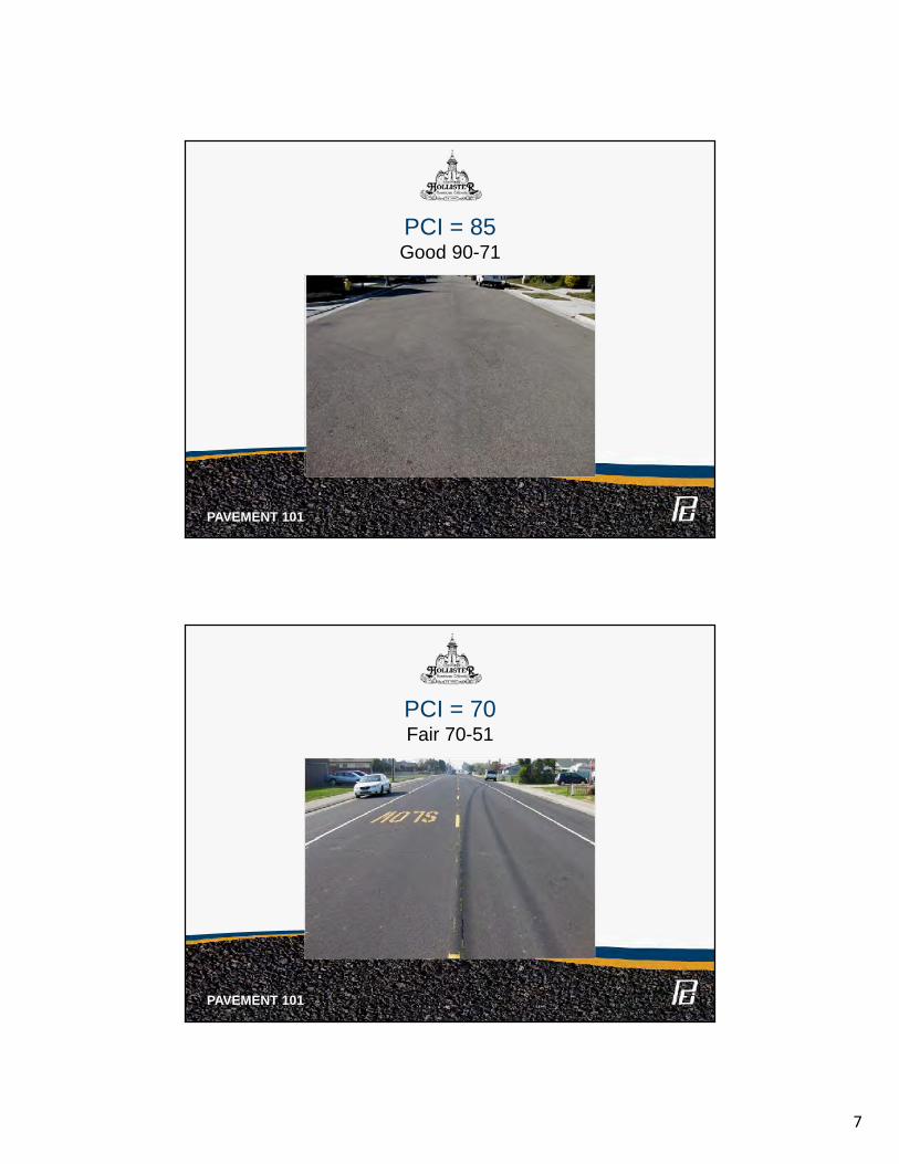
7
PCI = 85Good 90-71
PAVEMENT 101
PCI = 70Fair 70-51
PAVEMENT 101
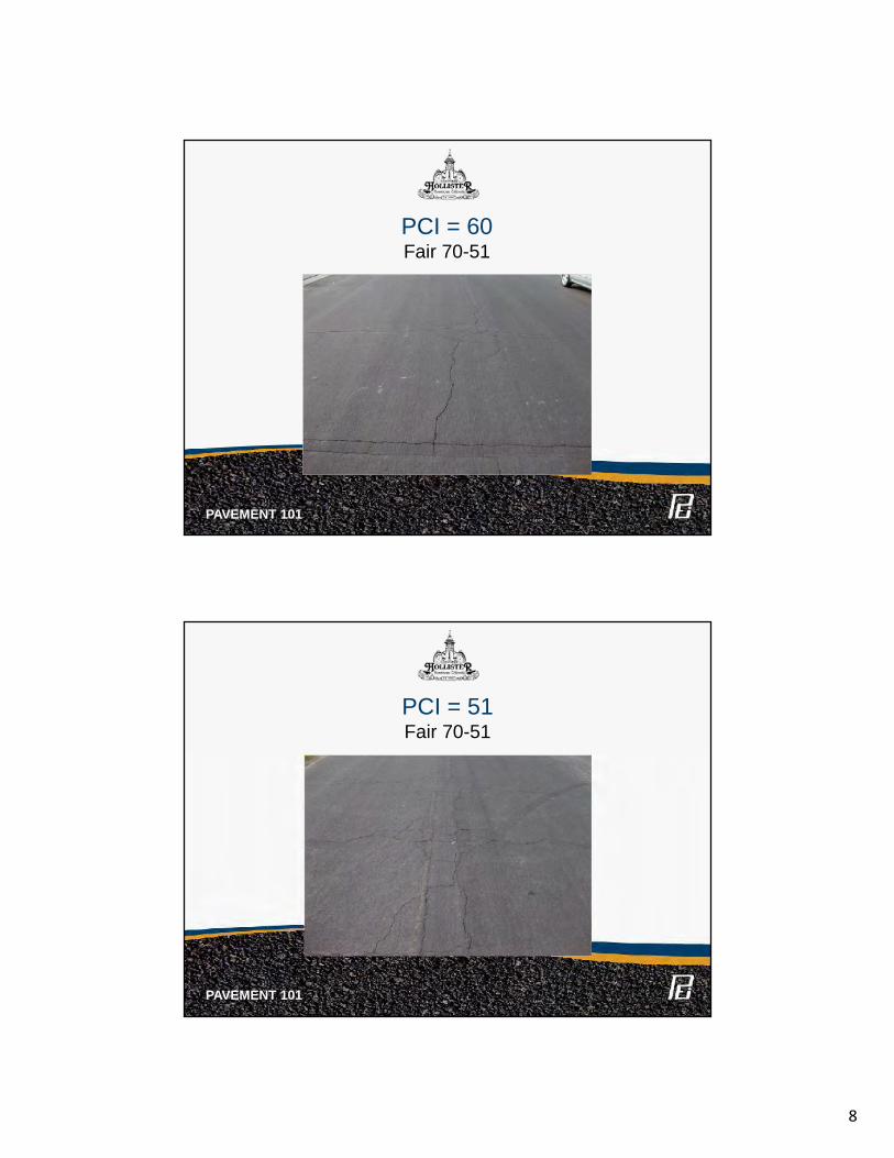
8
PCI = 60Fair 70-51
PAVEMENT 101
PAVEMENT 101
PCI = 51Fair 70-51
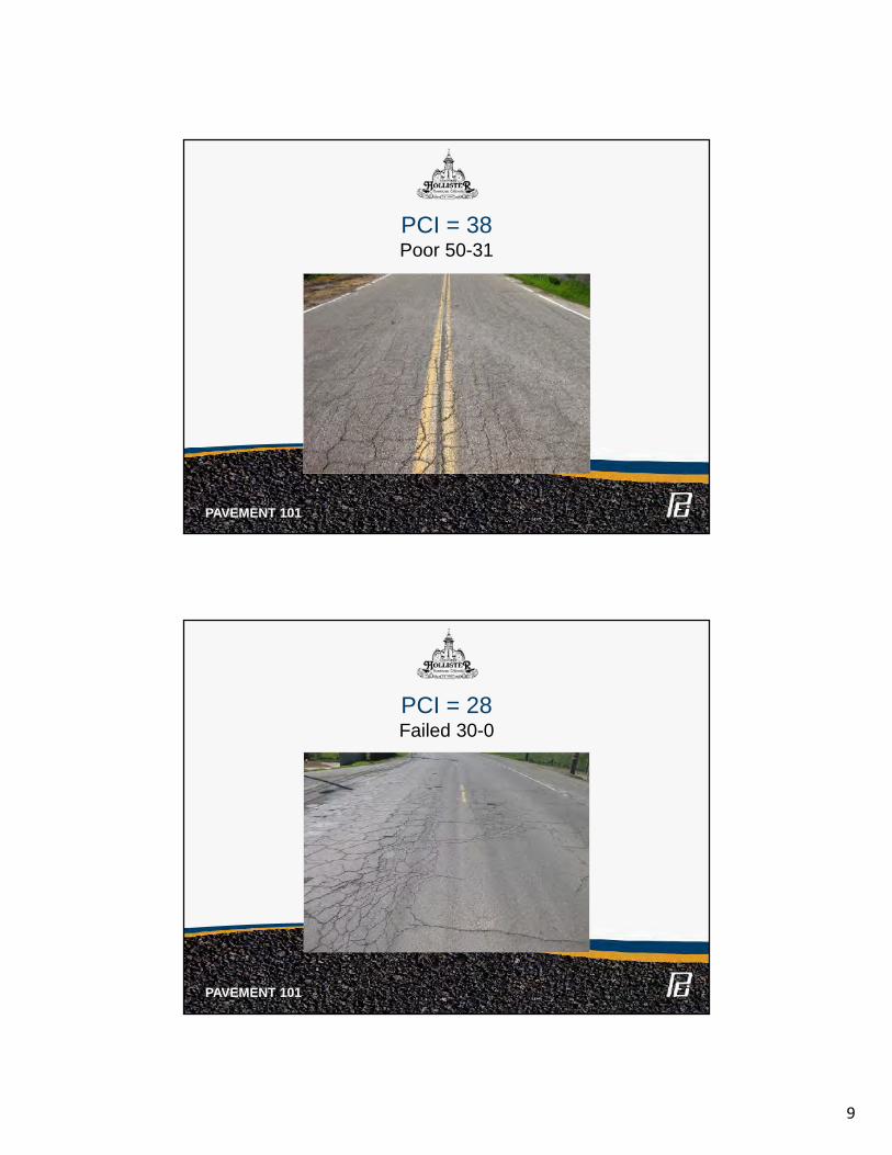
9
PCI = 38Poor 50-31
PAVEMENT 101
PCI = 28Failed 30-0
PAVEMENT 101
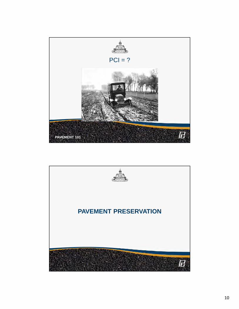
10
PCI = ?
PAVEMENT 101
PAVEMENT PRESERVATION
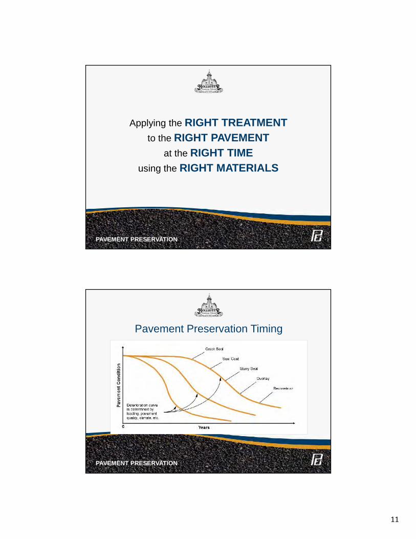
11
Applying the RIGHT TREATMENTto the RIGHT PAVEMENT
at the RIGHT TIMEusing the RIGHT MATERIALS
PAVEMENT PRESERVATION
Pavement Preservation Timing
PAVEMENT PRESERVATION
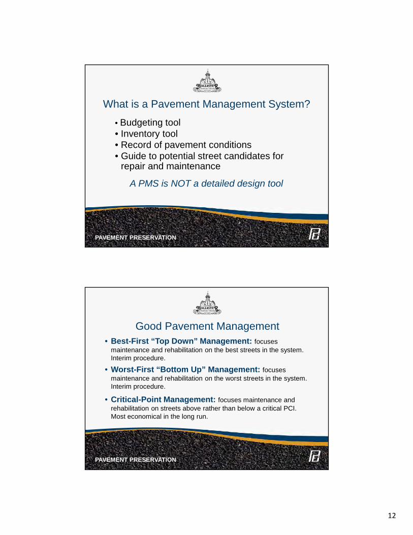
12
What is a Pavement Management System?
• Budgeting tool• Inventory tool• Record of pavement conditions• Guide to potential street candidates for
repair and maintenance
A PMS is NOT a detailed design tool
PAVEMENT PRESERVATION
PAVEMENT PRESERVATION
• Best-First “Top Down” Management: focusesmaintenance and rehabilitation on the best streets in the system.Interim procedure.
• Worst-First “Bottom Up” Management: focusesmaintenance and rehabilitation on the worst streets in the system.Interim procedure.
• Critical-Point Management: focuses maintenance andrehabilitation on streets above rather than below a critical PCI.Most economical in the long run.
Good Pavement Management
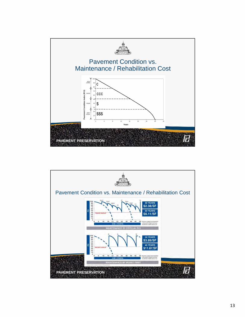
13
0
10
20
30
40
50
60
70
80
90
100
0 4 8 12 16 20 24 28 32
Years
¢
¢¢¢
$
$$$
Pav
emen
t Con
ditio
n In
dex
(PC
I)VERY
GOOD
GOOD
POOR
VERYPOOR
0
10
20
30
40
50
60
70
80
90
100
0 4 8 12 16 20 24 28 32
Years
¢
¢¢¢
$
$$$
Pav
emen
t Con
ditio
n In
dex
(PC
I)VERY
GOOD
GOOD
POOR
VERYPOOR
Pavement Condition vs.Maintenance / Rehabilitation Cost
PAVEMENT PRESERVATION
Pavement Condition vs. Maintenance / Rehabilitation Cost
PAVEMENT PRESERVATION
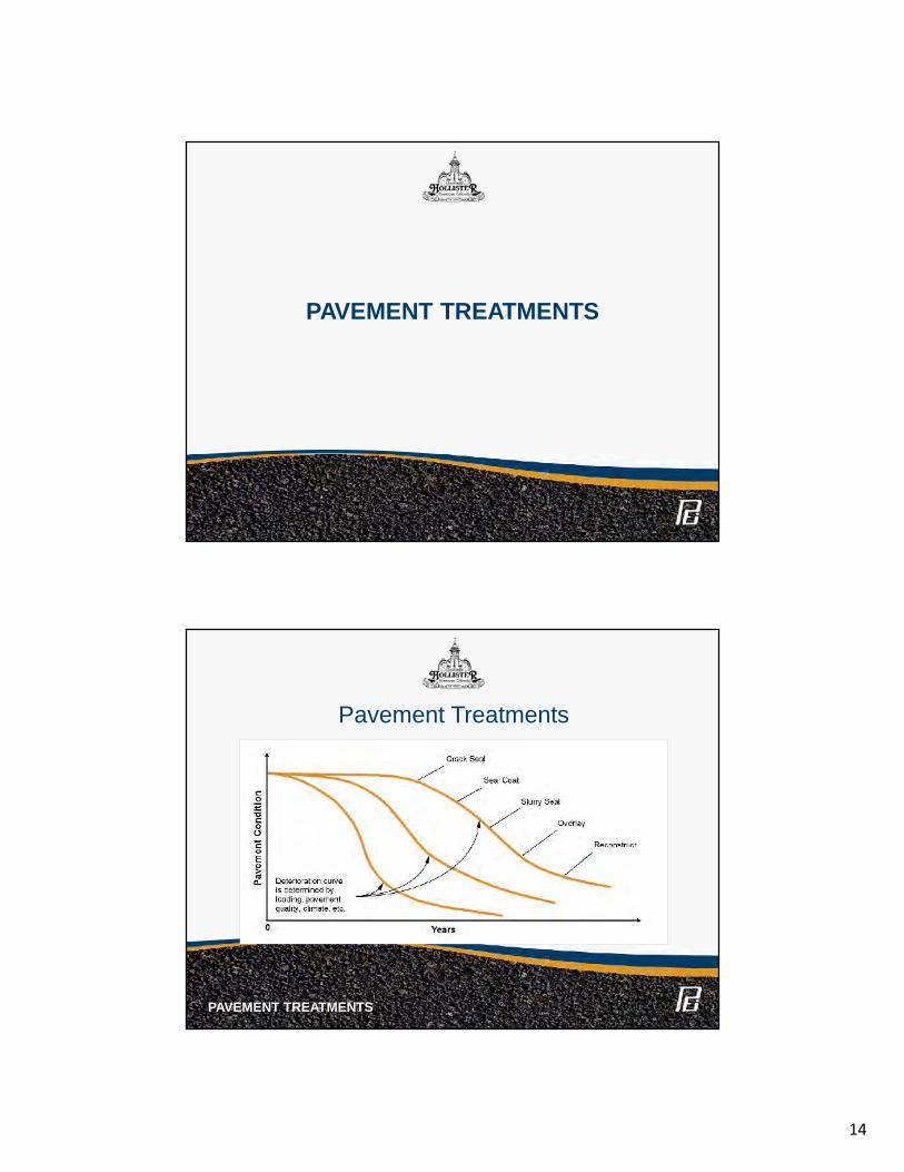
14
PAVEMENT TREATMENTS
Pavement Treatments
PAVEMENT TREATMENTS
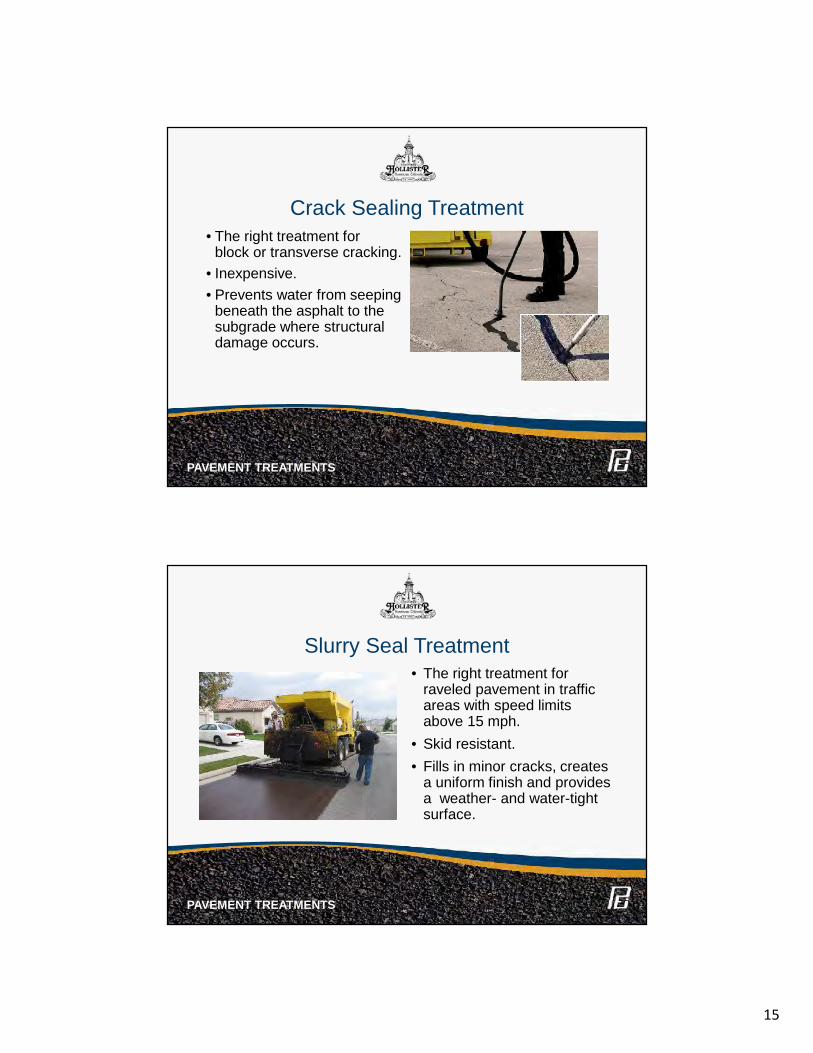
15
• The right treatment forblock or transverse cracking.
• Inexpensive.• Prevents water from seeping
beneath the asphalt to thesubgrade where structuraldamage occurs.
Crack Sealing Treatment
PAVEMENT TREATMENTS
Slurry Seal Treatment• The right treatment for
raveled pavement in trafficareas with speed limitsabove 15 mph.
• Skid resistant.• Fills in minor cracks, creates
a uniform finish and providesa weather- and water-tightsurface.
PAVEMENT TREATMENTS
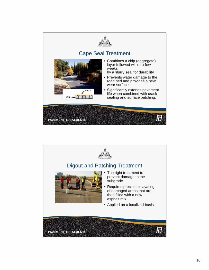
16
Cape Seal Treatment• Combines a chip (aggregate)
layer followed within a fewweeksby a slurry seal for durability.
• Prevents water damage to theroad bed and provides a newwear surface.
• Significantly extends pavementlife when combined with cracksealing and surface patching.
PAVEMENT TREATMENTS
• The right treatment toprevent damage to thesubgrade.
• Requires precise excavatingof damaged areas that arethen filled with a newasphalt mix.
• Applied on a localized basis.
Digout and Patching Treatment
PAVEMENT TREATMENTS
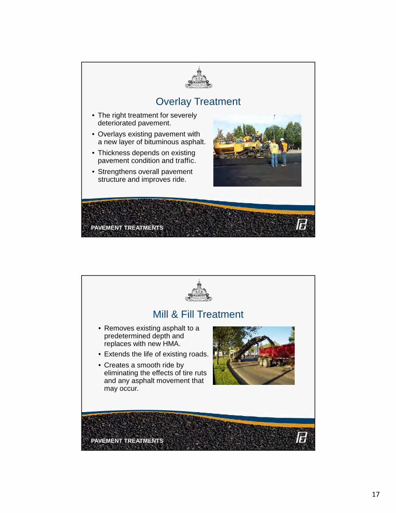
17
Overlay Treatment• The right treatment for severely
deteriorated pavement.• Overlays existing pavement with
a new layer of bituminous asphalt.• Thickness depends on existing
pavement condition and traffic.• Strengthens overall pavement
structure and improves ride.
PAVEMENT TREATMENTS
Mill & Fill Treatment• Removes existing asphalt to a
predetermined depth andreplaces with new HMA.
• Extends the life of existing roads.• Creates a smooth ride by
eliminating the effects of tire rutsand any asphalt movement thatmay occur.
PAVEMENT TREATMENTS
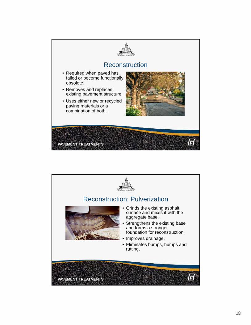
18
• Required when paved hasfailed or become functionallyobsolete.
• Removes and replacesexisting pavement structure.
• Uses either new or recycledpaving materials or acombination of both.
Reconstruction
PAVEMENT TREATMENTS
• Grinds the existing asphaltsurface and mixes it with theaggregate base.
• Strengthens the existing baseand forms a strongerfoundation for reconstruction.
• Improves drainage.• Eliminates bumps, humps and
rutting.
Reconstruction: Pulverization
PAVEMENT TREATMENTS
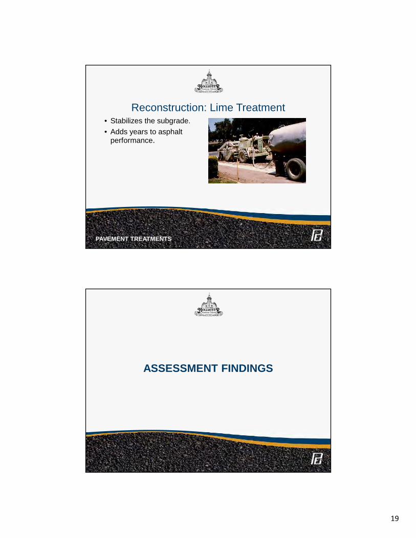
19
• Stabilizes the subgrade.• Adds years to asphalt
performance.
Reconstruction: Lime Treatment
PAVEMENT TREATMENTS
ASSESSMENT FINDINGS
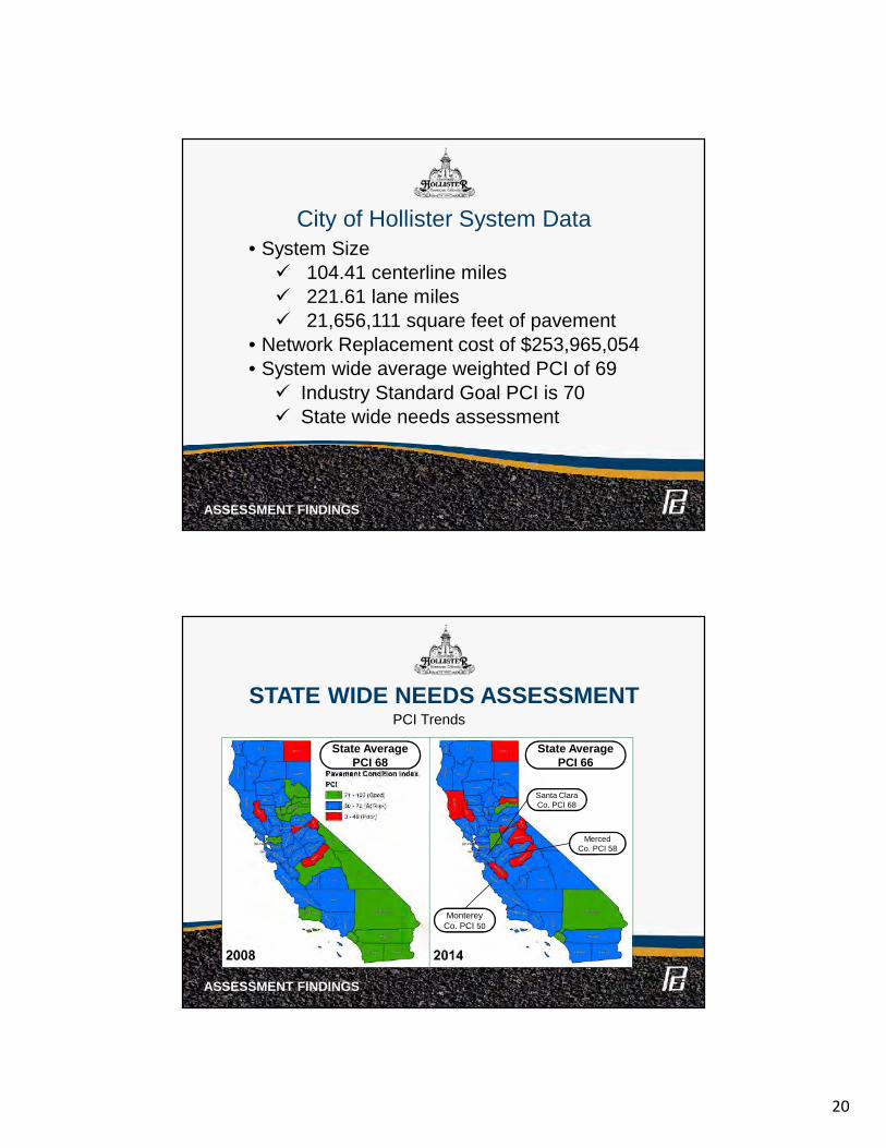
20
City of Hollister System Data• System Size 104.41 centerline miles 221.61 lane miles 21,656,111 square feet of pavement
• Network Replacement cost of $253,965,054• System wide average weighted PCI of 69 Industry Standard Goal PCI is 70 State wide needs assessment
ASSESSMENT FINDINGS
STATE WIDE NEEDS ASSESSMENT
ASSESSMENT FINDINGS
PCI Trends
MontereyCo. PCI 50
MercedCo. PCI 58
Santa ClaraCo. PCI 68
State AveragePCI 66
State AveragePCI 68
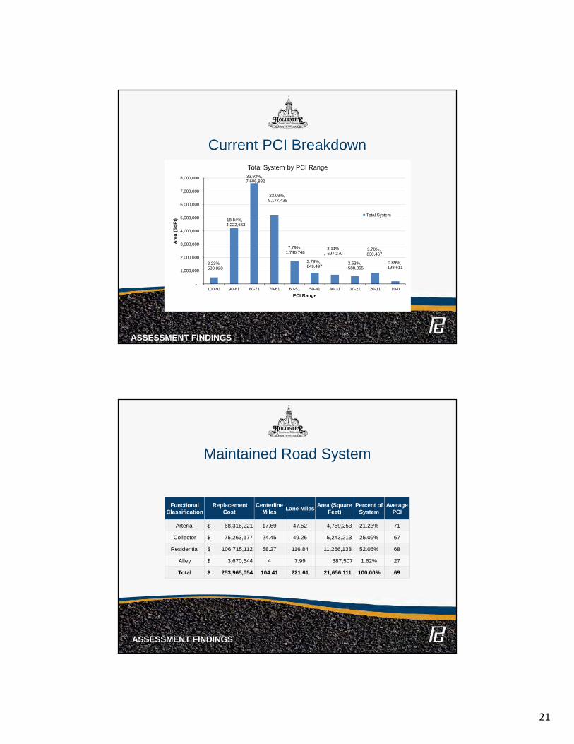
21
Current PCI Breakdown
ASSESSMENT FINDINGS
2.23%,500,028
18.84%,4,222,663
33.93%,7,606,882
23.09%,5,177,435
7.79%,1,746,748
3.79%,849,497
3.11%, 697,270
2.63%,588,865
3.70%,830,467
0.89%,198,611
-
1,000,000
2,000,000
3,000,000
4,000,000
5,000,000
6,000,000
7,000,000
8,000,000
100-91 90-81 80-71 70-61 60-51 50-41 40-31 30-21 20-11 10-0
Area
(SqF
t)
PCI Range
Total System by PCI Range
Total System
Maintained Road System
ASSESSMENT FINDINGS
FunctionalClassification
ReplacementCost
CenterlineMiles Lane Miles Area (Square
Feet)Percent of
SystemAverage
PCI
Arterial $ 68,316,221 17.69 47.52 4,759,253 21.23% 71
Collector $ 75,263,177 24.45 49.26 5,243,213 25.09% 67
Residential $ 106,715,112 58.27 116.84 11,266,138 52.06% 68
Alley $ 3,670,544 4 7.99 387,507 1.62% 27
Total $ 253,965,054 104.41 221.61 21,656,111 100.00% 69
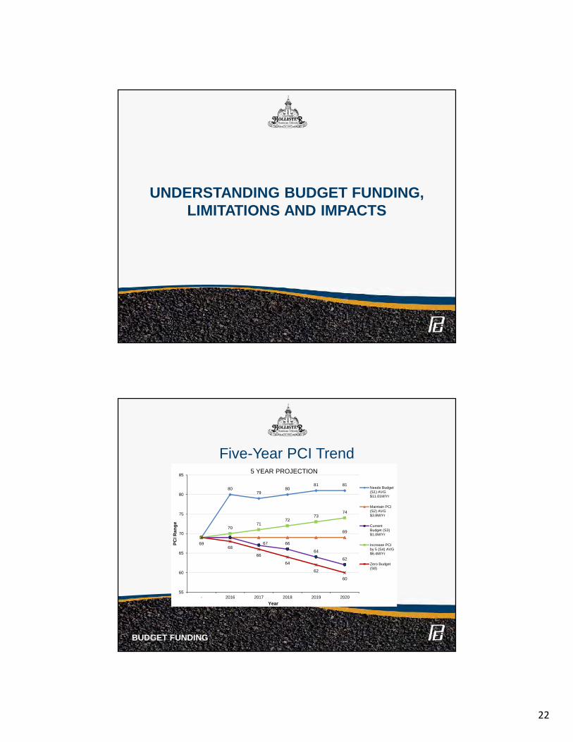
22
UNDERSTANDING BUDGET FUNDING,LIMITATIONS AND IMPACTS
Five-Year PCI Trend
BUDGET FUNDING
8079
8081 81
69
67 66
64
62
7071
7273
74
6968
66
64
62
60
55
60
65
70
75
80
85
- 2016 2017 2018 2019 2020
PCI R
ange
Year
5 YEAR PROJECTION
Needs Budget(S1) AVG$11.01M/Yr
Maintain PCI(S2) AVG$3.8M/Yr
CurrentBudget (S3)$1.0M/Yr
Increase PCIby 5 (S4) AVG$6.4M/Yr
Zero Budget(S8)
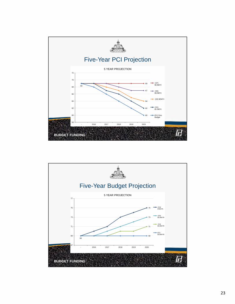
23
Five-Year PCI Projection
BUDGET FUNDING
69
67
64
69
62
60
58
60
62
64
66
68
70
72
- 2016 2017 2018 2019 2020
5 YEAR PROJECTION
(S7)$3.8M/Yr
(S5)$3.0M/Yr
(S3) $2M/Yr
(S1)$1.0M/Yr
(S1) ZeroBudget
Five-Year Budget Projection
BUDGET FUNDING
75
73
71
6969
67
69
71
73
75
77
- 2016 2017 2018 2019 2020
5 YEAR PROJECTION
(S3)$7M/YR
(S5)$5.9M/YR
(S3)$4.9M/YR
(S1)$3.8M/YR
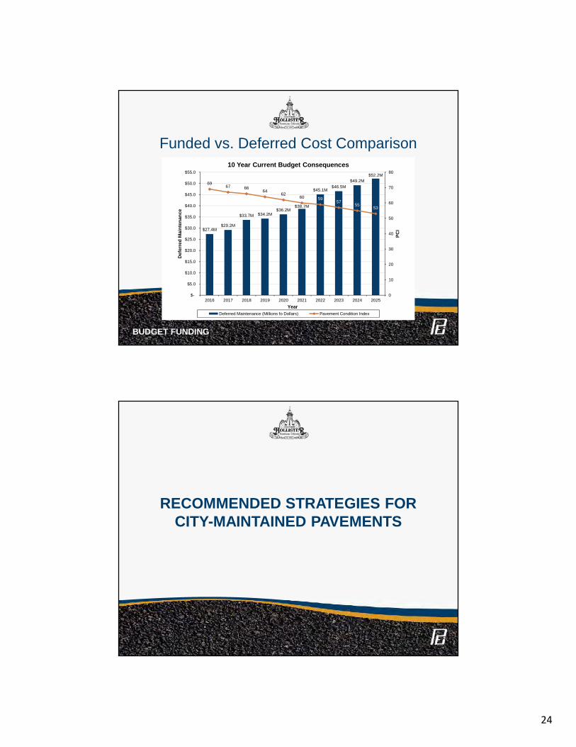
24
Funded vs. Deferred Cost Comparison
BUDGET FUNDING
$27.4M$29.2M
$33.7M $34.2M$36.2M
$38.7M
$45.1M$46.5M
$49.2M$52.2M
6967 66
6462
60 5957
5553
0
10
20
30
40
50
60
70
80
$-
$5.0
$10.0
$15.0
$20.0
$25.0
$30.0
$35.0
$40.0
$45.0
$50.0
$55.0
2016 2017 2018 2019 2020 2021 2022 2023 2024 2025
PCI
Def
erre
d M
aint
enan
ce
Year
10 Year Current Budget Consequences
Deferred Maintenance (Millions fo Dollars) Pavement Condition Index
RECOMMENDED STRATEGIES FORCITY-MAINTAINED PAVEMENTS
25
Recommendations
• Perform crack sealing• Expand pavement preservation treatments• Implement trench cut ordinance moratorium• Preserve critical assets• Establish a projected annual budget / five year plan• Leverage limited funds with grants• Value engineering
RECOMMENDATIONS
QUESTIONS?