passive seismic hvsr surveying for groundwater exploration ... · groundwater exploration using...
TRANSCRIPT
AEGC 2019: From Data to Discovery – Perth, Australia 1
Passive seismic HVSR surveying for groundwater exploration at the Chilalo Graphite Project, Tanzania Sharna Riley* Jayson Meyers John Sinnott Resource Potentials Resource Potentials Resource Potentials 34 Brisbane Street, Perth 34 Brisbane Street, Perth 34 Brisbane Street, Perth [email protected] [email protected] [email protected]
INTRODUCTION
Geophysical survey methods are widely used for groundwater resource mapping, and mapping subsurface hydrogeology to assist with determining the best location of water bores and help to provide preliminary volume estimations. This study presents an example passive seismic Horizontal to Vertical Spectral Ratio (HVSR) surveying to define paleochannel targets for direct drill targeting and defining groundwater resources and. A detailed passive seismic HVSR survey was completed at the Chilalo Graphite Project located in SE Tanzania to assist with a hydrological study that is part of a larger mine feasibility study. The main aim of the HVSR survey was to identify paleochannels that have the potential to host sizeable and
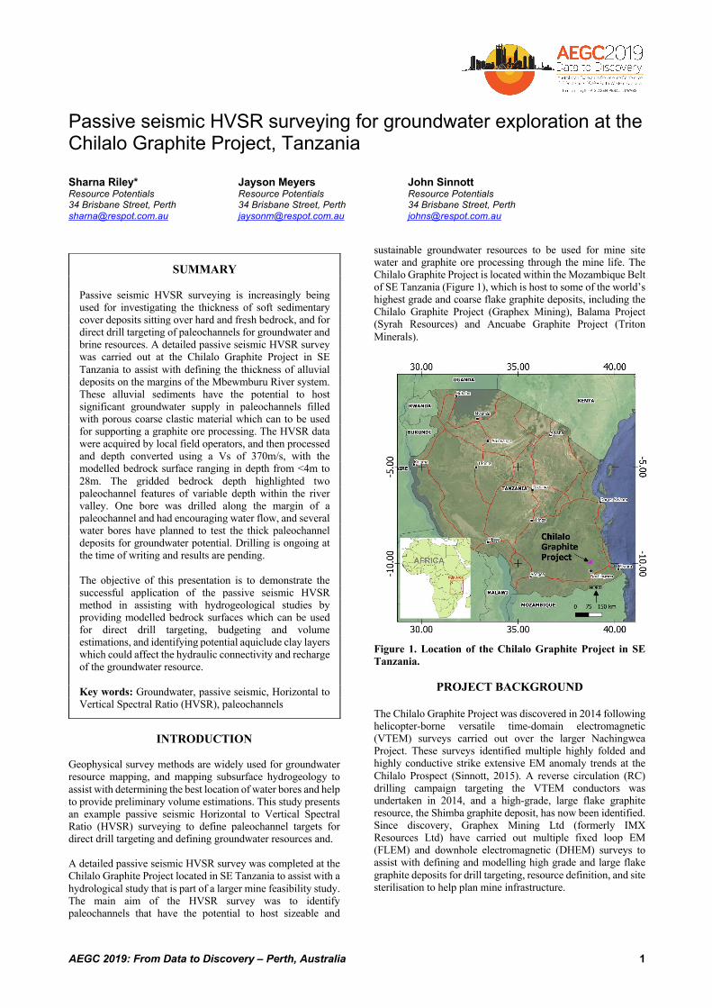
sustainable groundwater resources to be used for mine site water and graphite ore processing through the mine life. The Chilalo Graphite Project is located within the Mozambique Belt of SE Tanzania (Figure 1), which is host to some of the world’s highest grade and coarse flake graphite deposits, including the Chilalo Graphite Project (Graphex Mining), Balama Project (Syrah Resources) and Ancuabe Graphite Project (Triton Minerals).
Figure 1. Location of the Chilalo Graphite Project in SE Tanzania.
PROJECT BACKGROUND
The Chilalo Graphite Project was discovered in 2014 following helicopter-borne versatile time-domain electromagnetic (VTEM) surveys carried out over the larger Nachingwea Project. These surveys identified multiple highly folded and highly conductive strike extensive EM anomaly trends at the Chilalo Prospect (Sinnott, 2015). A reverse circulation (RC) drilling campaign targeting the VTEM conductors was undertaken in 2014, and a high-grade, large flake graphite resource, the Shimba graphite deposit, has now been identified. Since discovery, Graphex Mining Ltd (formerly IMX Resources Ltd) have carried out multiple fixed loop EM (FLEM) and downhole electromagnetic (DHEM) surveys to assist with defining and modelling high grade and large flake graphite deposits for drill targeting, resource definition, and site sterilisation to help plan mine infrastructure.
SUMMARY Passive seismic HVSR surveying is increasingly being used for investigating the thickness of soft sedimentary cover deposits sitting over hard and fresh bedrock, and for direct drill targeting of paleochannels for groundwater and brine resources. A detailed passive seismic HVSR survey was carried out at the Chilalo Graphite Project in SE Tanzania to assist with defining the thickness of alluvial deposits on the margins of the Mbewmburu River system. These alluvial sediments have the potential to host significant groundwater supply in paleochannels filled with porous coarse clastic material which can to be used for supporting a graphite ore processing. The HVSR data were acquired by local field operators, and then processed and depth converted using a Vs of 370m/s, with the modelled bedrock surface ranging in depth from <4m to 28m. The gridded bedrock depth highlighted two paleochannel features of variable depth within the river valley. One bore was drilled along the margin of a paleochannel and had encouraging water flow, and several water bores have planned to test the thick paleochannel deposits for groundwater potential. Drilling is ongoing at the time of writing and results are pending. The objective of this presentation is to demonstrate the successful application of the passive seismic HVSR method in assisting with hydrogeological studies by providing modelled bedrock surfaces which can be used for direct drill targeting, budgeting and volume estimations, and identifying potential aquiclude clay layers which could affect the hydraulic connectivity and recharge of the groundwater resource. Key words: Groundwater, passive seismic, Horizontal to Vertical Spectral Ratio (HVSR), paleochannels
Groundwater Exploration using Passive Seismic HVSR Method Riley, Meyers and Sinnott
AEGC 2019: From Data to Discovery – Perth, Australia 2
In 2016, Graphex Mining Ltd (ASX: GPX) completed a successful pre-feasibility study (which has since been updated in 2018 (Hoskins, 2018)), and the Chilalo prospect was renamed the Chilalo Graphite Project. As part of the 2016 pre-feasibility study, a hydrogeological investigation was carried out to determine the required water supply for mining and graphite ore processing. The results of this study suggested that the mine would require a constant water supply in excess of 19L/s (Burger, 2016), and therefore a sizeable and sustainable groundwater reserve is required close to the mining lease. Two potential viable groundwater reserves are identified in the project area; 1) alluvial river deposits over and surrounding the ephemeral Mbewmburu River system located just north of the mining lease area, and 2) fractured gneiss basement rock aquifers below and immediately surrounding the mining lease area. The alluvial river deposits were the more favourable groundwater target, due to the large surface catchment area that extends to the mountainous region in the west, and with numerous creeks and rivers from north and south feeding into the river system. Average yearly rainfall is 1000mm/a, with an expected recharge ranging as high as 20% over the river sediments (Burger, 2016). As a first pass assessment, the VTEM survey results, over and surrounding the Mbewmburu River, were reviewed, and multiple discrete conductive anomalies were identified as clay deposits on the sides of the river valley, with an electrically resistive zone down the centre likely representing fresh water saturated sand deposits. A small trial passive seismic HVSR survey was then carried out over and surrounding the conductive and resistive anomalies located on the southern side of the river valley to test the applicability of this method for identifying the thickness of soft sedimentary fluvial deposits over fresh and hard gneiss bedrock, and identify deeper paleochannels which may have significant groundwater potential. The trial passive seismic HVSR survey results were encouraging and identified an undulating sub-horizontal acoustic impedance contrast interpreted to represent the fluvial-bedrock interface, with a general increase in fluvial deposit thickness towards the north, near the modern river channel. Several test water bores were drilled along the passive seismic survey transects to the thickest alluvial deposits modelled by the trial passive seismic HVSR survey results. The water bore drilling program was carried out in the wet season, and therefore, the best proposed target locations were not tested due to access issues. Furthermore, at that time, an RC drill rig designed for mineral exploration was used, and the preliminary pumping test results were not considered to be very reliable. However, the preliminary results indicated that the water bores located closest to the thickest alluvial deposits identified by the passive seismic data recorded overall higher yields. The preliminary drilling results also suggested that a combined volume from multiple exploratory boreholes may be able to provide the required volume of groundwater, pending specific yield testing. Following on from the success of the trial passive seismic HVSR survey, a more detailed passive seismic HVSR survey was then carried out over a 5km strike extent of the Mbewmburu River valley, and located within 1km of proposed
mine infrastructure. The detailed passive seismic survey was designed to provide further information on the thickness of the fluvial deposits in 3D, and provide additional targets both upstream and downstream from a potential bore field close to the mine area.
PASSIVE SEISMIC HVSR METHOD
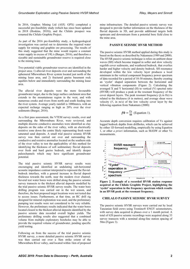
The passive seismic HVSR method applied during this study is based on the theory as described by Nakamura (1989 and 2000). The HVSR passive seismic technique is relies on ambient shear waves (SH) which become trapped in softer and slow velocity regolith cover sediments, and weathered bedrock, that overlies harder and higher velocity and density bedrock. SH resonance developed within the low velocity layer produces a local minimum in the vertical component frequency power spectrum of data recorded for a period of 10-30 minutes, thereby creating an ‘eyelet’ shaped separation between the horizontal and vertical vibration components (Figure 2). Calculating the averaged X and Y horizontal (H) to vertical (V) spectral ratio (HVSR) will produce a peak at the resonant frequency of the cover deposit layers. The peak resonant frequency (f0 in Hz) is related to the thickness (h in metres), and average shear wave velocity (Vs in m/s) of the low velocity cover layer by the following equation from Nakamura (2000):
𝒇𝟎 = 𝑽𝒔𝟒𝒉
(Equation 1).
Accurate depth conversion requires calibration of Vs against logged bedrock depths from drillholes, which can be achieved by either 1D forward modelling, empirically by using Equation 1, or other a priori information, such as MASW or other Vs measurments.
Figure 2. Example of a recorded HVSR station response acquired at the Chilalo Graphite Project, highlighting the ‘eyelet’ separation in the frequency spectrum which results in an HVSR peak at the resonant frequency.
CHILALO PASSIVE SEISMIC HVSR SURVEY
The passive seismic HVSR surveys were carried out by local Tanzanian field crews using Tromino® ENGY seismometers, with survey data acquired in phases over a 1 month period. A total of 620 passive seismic recordings were acquired along 33 survey transects with a nominal along-line station spacing of 50m (Figure 3).

Groundwater Exploration using Passive Seismic HVSR Method Riley, Meyers and Sinnott
AEGC 2019: From Data to Discovery – Perth, Australia 3
Figure 3. HVSR passive seismic survey stations acquired at the Chilalo Graphite Project, located north of the graphite mining lease, overlying a Shuttle Radar Topography Mission (SRTM) elevation image, and with the current river system highlighted as the blue dashed line. The raw HVSR data were assessed for location, data quality, noise levels and stuck receiver components during surveying. The resonant frequency HVSR response and manual removal of noisy time window on final data recordings were computed on a station-by-station basis, and window normalisation of HVSR resonant peak amplitudes was completed on each individual passive seismic recording to enhance the resonant HVSR response of layers between stations having different amplitudes along a survey line and generate more easily interpretable cross sections. Velocity analysis was completed by 1D forward modelling the geologically logged gneiss bedrock depth from the 6 exploratory water bores, and the observed HVSR resonant frequency (f0) from the closest passive seismic recordings, to compute an average shear wave velocity of 370m/s. This average shear wave velocity was used to convert data from each HVSR recording station from frequency response to depth in order to map out bedrock topography variations for all survey lines. Elevation information was obtained from NASA Shuttle Radar Topography Mission (SRTM) elevation data, and then normalised amplitude-depth cross-sections were generated for all survey lines (e.g. Figure 4).
Figure 4. Normalised HVSR amplitude cross-section 468,850 mE, looking west, showing the main acoustic impedance contrast (black dashed profile) representing the modelled bedrock depth. Each recording station resolved a clear HVSR peak response associated with bedrock. Shallow acoustic impedance interfaces were also resolved, and are interpreted to represent clay-silt or calcrete-silcrete layers.
PASSIVE SEISMIC HVSR SURVEY RESULTS
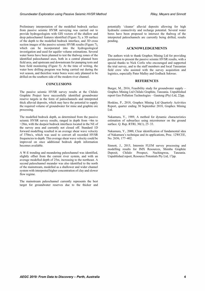
The passive seismic HVSR survey results identified a sub-horizontal bedrock acoustic impedance contrast layer on all survey lines, with the deeper responses relating to the fluvial-bedrock interface, sometimes forming the base of paleochannels, and shallower layer responses likely representing silt-clay layer or calcrete-silcrete layers within the fluvial deposit. The modelled depth to bedrock from surface ranges from <4m to 28m. The modelled bedrock surface depth was gridded, imaged and contoured, the bedrock depth maps highlight a W-E trending and flowing, meandering paleochannel system, with the interpreted thalweg axes offset from the modern river channels. Two main paleochannel axes occur in the centre of the survey area, with a narrow and straight channel in the south and a meandering channel in the north, with the confluence of the two paleochannel axes located in the eastern side of the passive seismic survey area, before this single channel swings to the north (Figure 5). The linear and narrow paleochannel in the south has an average modelled thalweg depth of 25m, which increases in depth to the NE where the deepest thalweg depth of >28m was modelled (Figure 5). There are very few shallow layers over the channel axis, the fill deposits are likely coarse clastic sediments. The northern paleochannel is wider and has a shallower average thalweg depth of 18m, and has shallow layering coincident the VTEM conductors, indicating clay layers deposited in a lower flow regime compared to the southern paleochannel (Figure 6). The single paleochannel that extends to the east is currently not closed off by passive seismic survey lines, which could not be completed to the north due to flooding of the river valley at the onset of the wet season (Figures 5 and 7). The passive seismic HVSR survey results show that the southern paleochannel is very linear, narrow and steep on the southern side, with an 8-10m offset identified in the bedrock interface (Figure 6). Towards the east, the northern side of the channel displays similar linear, steep and slightly offset HVSR responses. This suggests that the paleochannel may have been formed along a young fault, which was not detected in VTEM or aeromagnetic survey data sets, likely due to lack of contrasting physical properties.
Figure 6. Example of normalised HVSR amplitude cross-section 469,400 mE, looking west, showing two paleochannels, interpreted fault location (thick white dashed line), main acoustic impedance contrast (black profile), and shallower responses which are primarily identified over the northern paleochannel and weathered bedrock to the south.
Groundwater Exploration using Passive Seismic HVSR Method Riley, Meyers and Sinnott
AEGC 2019: From Data to Discovery – Perth, Australia 4
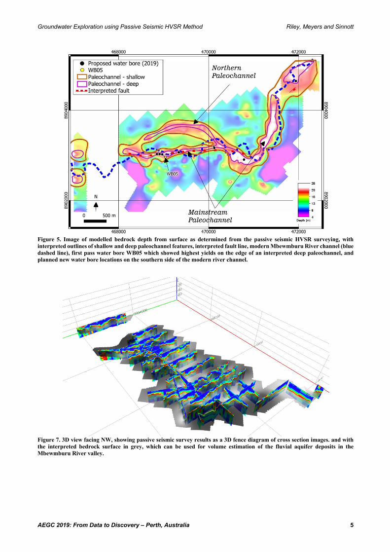
Preliminary interpretation of the modelled bedrock surface from passive seismic HVSR surveying was carried out to provide hydrogeologists with GIS vectors of the shallow and deep paleochannel features identified (Figure 5), a 3D surface of the depth to the modelled bedrock interface, and 3D cross section images of the passive seismic HVSR results (Figure 7), which can be incorporated into the hydrogeological investigation and used for aquifer volume estimations. Several water bores have been planned to test the thalweg zones of the identified paleochannel axes, both in a central planned bore field area, and upstream and downstream for pumping tests and bore field monitoring (Figure 5). At the time of writing, the water bore drilling program was being carried out during the wet season, and therefore water bores were only planned to be drilled on the southern side of the modern river channel.
CONCLUSIONS
The passive seismic HVSR survey results at the Chilalo Graphite Project have successfully identified groundwater reserve targets in the form of paleochannels and interpreted thick alluvial deposits, which may have the potential to supply the required volume of groundwater for mine and graphite ore processing. The modelled bedrock depth, as determined from the passive seismic HVSR survey results, ranged in depth from <4m to >28m, with the deepest bedrock interfaces located in the NE of the survey area and currently not closed off. Standard 1D forward modelling resulted in an average shear wave velocity of 370m/s, which was used to convert all recorded HVSR frequencies to depth. This average shear wave velocity could be improved on once additional bedrock depth information becomes available. A W-E trending and meandering paleochannel was identified, slightly offset from the current river system, and with an average modelled depth of 25m, increasing to the northeast. A second paleochannel meander was also identified to the north of the mainstream, modelled as a shallower and wider channel system with interpreted higher concentration of clay and slower flow regime. The mainstream paleochannel currently represents the best target for groundwater reserves due to the thicker and
potentially ‘cleaner’ alluvial deposits allowing for high hydraulic connectivity and recharge potential. Several water bores have been proposed to intersect the thalweg of the interpreted paleochannels are currently being drilled, results pending.
ACKNOWLEDGEMENTS The authors wish to thank Graphex Mining Ltd for providing permission to present the passive seismic HVSR results, with a special thanks to Nick Corlis who encouraged and supported the trial survey, and to the staff members and local Tanzanian field crew who assisted with the survey acquisition and logistics, especially Pater Malley and Godluck Sekwao.
REFERENCES Burger, M., 2016, Feasibility study for groundwater supply – Graphex Mining Ltd Chilalo Graphite, Tanzania. Unpublished report Geo Pollution Technologies – Gauteng (Pty) Ltd, 22pp. Hoskins, P., 2018, Graphex Mining Ltd Quarterly Activities Report, quarter ending 30 September 2018, Graphex Mining Ltd. Nakamura, Y., 1989, A method for dynamic characteristics estimation of subsurface using microtremor on the ground surface. Q. Rep. RTRI, 30(1), 25–33. Nakamura, Y., 2000, Clear identification of fundamental idea of Nakamura’s technique and its applications, Proc. 12WCEE, No. 2656, 177–402. Sinnott, J., 2015, Intermin FLEM survey processing and modelling results for IMX Resources, Shimba Graphite Deposit, Chilalo Prospect, Nachingwea, Tanzania. Unpublished report, Resource Potentials Pty Ltd, 17pp.
Groundwater Exploration using Passive Seismic HVSR Method Riley, Meyers and Sinnott
AEGC 2019: From Data to Discovery – Perth, Australia 5
Figure 5. Image of modelled bedrock depth from surface as determined from the passive seismic HVSR surveying, with interpreted outlines of shallow and deep paleochannel features, interpreted fault line, modern Mbewmburu River channel (blue dashed line), first pass water bore WB05 which showed highest yields on the edge of an interpreted deep paleochannel, and planned new water bore locations on the southern side of the modern river channel.
Figure 7. 3D view facing NW, showing passive seismic survey results as a 3D fence diagram of cross section images. and with the interpreted bedrock surface in grey, which can be used for volume estimation of the fluvial aquifer deposits in the Mbewmburu River valley.