passenger-centric intermodal traffic management...
TRANSCRIPT
Passenger-centric Intermodal Traffic Management involving Airports and Railways
Olaf Milbredt, Florian Rudolph, and Erik Grunewald German Aerospace Center (DLR), Lilienthalplatz 7, 38108 Braunschweig, Germany ABSTRACT The FAA envisioned seamless air traffic in its Destination2025 report. Developing such an air transportation system will require the conjunction of different transport modes. Whereas physical connections for intermodal transport are already in the focus of stakeholders at an airport, a conjunction on a management level is also desirable. Efficiency and predictability of operations could be increased, if the position of passengers within the operational chain at an airport was known in addition to the location of every aircraft. We present a Passenger Information System in the form of an app for smartphones. It provides passengers with real-time information such as estimated remaining time to reach the gate throughout the journey and allows stakeholders, such as airlines and airports, to make decisions based on passenger locations. We employ our virtual intermodal traffic management system to test the application with a realistic flight plan, airport terminal layout, and train schedule. Usability and acceptance of the smartphone app is tested in a survey covering functionality and user-friendliness. Keywords: Dynamic Passenger Information System, Intermodal Transport, Passenger Trajectory, Microscopic Simulation, Passenger-centric Disruption Management INTRODUCTION The FAA envisioned seamless air traffic in its Destination2025 report (see Federal Aviation Administration 2010). To develop an Air Transportation System (ATS) of this kind requires a conjunction of different modes in the form of physical connections, comprehensive management structures, and appropriate business models. Whereas physical connections are enhanced to meet the needs of seamless transport (e.g. the planned new intermodal terminal building at Orlando Airport) comprehensive management structures for a truly seamless travel experience need to be established. The project Next Generation Air Transportation System (NextGen, see Federal Aviation Administration 2014) is transforming the National Aviation System of the United States to track every user’s location. This results in an increased degree of capacity utilization and predictability. Airport operations can be aligned to use such such real-time information and provide new services to passengers via apps for smartphones. Airports already provide some apps with real-time data (e.g. Toronto airport, Los Angeles airport, Frankfurt airport, see Google Play-Store). The project NextGen focuses on the airside of the ATS, but a passenger experiences more than just the air travel itself. If a travel is defined from the door of origin to the door of destination, other transportation modes are part of the transportation chain. A Passenger Information System (PIS) should therefore cover every element of this chain. When applying this perspective, a PIS must be intermodal. PISs are commonly used within a particular mode of public transport, especially for bus, tram, and underground. In recent years, dissemination of information through signs at stations was enriched by websites and by apps for smartphones. The focus of PISs is not
restricted to local transportation; rail systems also provide their own apps for planning trips and getting real-time information about delays and track changes (in Germany: DB Navigator). Airports, however, use the systems to also make passengers more aware of the airport layout (e.g. gates, shops) in addition to the flight plan and possible delays (cf. Frankfurt airport). The possibility to search the flight plan for a specific flight individualizes the data, so it is not necessary to search through all the information on the sign. Static PISs solely based on schedules for the different transportation modes have been available for some time (e.g. Google Transit, 2005). Finding one’s way inside an airport is often assisted by apps provided by the specific airport (see the app for Frankfurt airport as an example). Furthermore, Google has launched indoor-navigation for major airports around the world. Transit passengers failing to find their way to the required gate is a big cause of flight delays (see Mueller and Chatterji 2002). There is also an EU project called SPENCER tackling the problem of finding the right gate (see “EU Project SPENCER” 2013). This project will see development of a robot to help passengers to the appropriate gate. The robot will be tested at Amsterdam's Schipol airport. The applications mentioned cover all parts of intermodal travel from door to door. Delays and departure times of buses, trams, trains, and flights are provided on a real-time basis. A passenger of the ATS is able to track his/her way through the airport to the appropriate gate by using the layout plans and/or indoor navigation. What is missing is information about the utilization of the airport infrastructure such as check-in and security check. If a passenger had arrived at the checkpoint 10 min later, the queue might have been dispersed. These data are the property of the airport and the security company and therefore can not be accessed by the public. In this paper we present such a smartphone app consisting of a PIS for intermodal transport providing real-time information on the utilization of the infrastructure combined with a forecast. The broad use of mobile devices and mobile internet makes it feasible for transport stakeholders to pass information about schedules and delays to passengers. The provision of status information is extended by real-time information on arrivals and real-time computation of the remaining time to reach the appropriate gate. Furthermore, we assess the user friendliness of our application with the help of surveys. Our approach proposes a win-win situation for passengers and stakeholders at the airport. The passengers are provided with real-time information covering ways, milestones of the journey, and infrastructure utilization and the stakeholders at the airport are aware of every milestone the passenger has passed. It is therefore possible to apply this knowledge in management decisions or to control the passenger flow by offering incentives for arriving earlier/later. Examples of management decisions may be staffing levels at checkpoints or delaying a flight, if a critical amount of passengers are not able to reach the gate in time, but would if they were given just a few more minutes. Our method fills the gap between the airside focus of NextGen and the real-time information which is already available for bus, tram, and rail. As for the ATS, knowing every user’s location results in more efficient management. Knowledge of every ATS passenger results in better performance of the overall Transportation System. Passenger comfort, punctuality, and predictability are appreciably increased. A key ingredient of our approach is a customer-centered view addressed by the so-called passenger trajectory. It consists of pairs of points in space and time, where the passenger passes a certain milestone of the journey. This data can be used to compute the remaining
time to the airport or even to a specific gate determining whether a passenger can be at the gate in time. RELATED WORK In this section we list a few works related to PIS and intermodal traffic management from the airport perspective. Passenger Information Systems Customer satisfaction is crucial for any transportation mode. Passengers can become very frustrated if information on disruptions are not provided by the transit agency (see e.g. Caulfield and O’Mahony 2007 and Papangelis et al. 2013). The provision of real-time data is seen as a particularly important service and is essential for assisting passengers en-route (cf. Garcia et al. 2012). Smartphones and mobile internet have become more important. Camacho, Foth, and Rakotonirainy 2013 describes a PIS for smartphones for public transportation. To provide a technology alone is not enough, the acceptance also needs to be considered. A technology acceptance model is presented by Davis 1989 and PIS from the Human Interface perspective is considered by Wirtz, Jakobs, and Beul 2010 and Wirtz and Jakobs 2013. A PIS for smartphones for intermodal transport was presented by Beul-Leusmann et al. 2014. The system was tested for usability in a field test. A PIS for intermodal transport including air transport needs to include indoor-navigation, since finding the right gate at an airport may be tricky. Rehrl, Bruntsch, and Mentz 2007 are aware of this problem and present an approach addressing this issue. Airport management with intermodal connection Our considerations of intermodal traffic management start with the management structures established in airport management. The collaborative approach Airport Collaborative Decision Making (A-CDM) is widely accepted for implementing airport management (cf. EUROCONTROL 2006, 2012). The definition of Key Performance Indicators (KPIs) within this concept was extended to include the landside of an airport by the concept called Total Airport Management (TAM, cf. EUROCONTROL and German Aerospace Center (DLR) 2006). The enhancement process was also described by Spies et al. 2008 while Helm et al. 2014 presents a further extension which adds passenger-related process information at an airport. A generic model of transport management based on A-CDM including components for a PIS is given by Ezzedine et al. 2006. In our approach we add the ability to control passenger flow. The possibility to control passenger flow within an airport terminal building by using priority rules similar to those used by airlines for product differentiation (first cabin class, business passengers, frequent flyers, cf. e. g. O’Connor 2001, was first described by Grunewald and Popa 2014. SIMULATION ENVIRONMENT In this section we describe the various parts of our software system which was used to test the PIS.
The impact on passenger behavior is tested with a software system developed in our institute. It includes a microscopic simulation of a terminal building at an imaginary airport called Generic International Airport (GIA) and mimics a broad range of quantities from which the KPIs introduced by A-CDM and TAM can be derived. On the other hand, values of parameters influencing the KPIs called Key Control Parameters (KCPs) are also recorded to make the state of the airport available. The microscopic simulation also covers the railway station used to access the airport to identify possible congestion arising from the layout of the station or the trains themselves. The microscopic simulation is combined with a flight plan and information from a Railway Management System. In a next step this combination (which is exclusively based on information exchange) is extended by a Management System. This system enables an airport operator to change the settings of the KCPs and thus the values of the KPIs as required. The connection to the Railway Management System makes it possible to manage settings at the airport based on changes at the railway system and vice versa. In previous works we considered the technical feasibility of an integrated traffic management incorporating airport management and railway management. The goal of such a system is to evaluate the possibility of adjusting operational parameters based on the overall situation as well as just exchanging information. Here, we assume overall intermodal traffic management to be operational and try to answer the question of how large the operational impact of a widely used passenger information app would be. In this work the focus is on the connection of airport management (both airside and landside) and railway management. Based on the model of a generic airport providing a wide spectrum of operationally important situations, the impact of the app is tested at various levels, from providing information, airport management, and on combined traffic management. Generic International Airport (GIA) The tests were performed using a model of an international airport called GIA. This airport has a volume of approximately 13.5 million passengers per year distributed over some 160,000 flight movements. These figures make this airport one of the 30 largest airports in Europe (cf. Rudolph et al. 2014). The reality substitution layer of our software system comprises a microscopic simulation of the GIA terminal building. To ensure that only information which is realistic is passed to the management layer, sensors form the link between the microscopic simulation and the management. They only provide information which could be gathered in reality. For example, it is possible to record the time stamp of a passenger passing a certain milestone of the journey, but it is not possible to ascertain the exact position at any time, in the microscopic simulation such data is known. Other information is blurred to reflect the fact that the exact information would not be accessible in reality. The queue at a control point can be estimated by registering the Bluetooth signals of smartphones, but not every passenger owns a smartphone with this capability, and it can be switched off. Thus, counting only gives a certain percentage of the passengers waiting. The simulation of the GIA terminal is complemented by a microscopic simulation of a railway station combined with the coaches themselves to mimic the way from station to gate and the process of de-boarding the coaches. The underlying flight plan and the schedule for the trains has a range of 24 h and comprise 216 flights together with a connection by train every
30 minutes. PETRA This is the passenger trajectory calculator tool. It receives information from the microscopic simulation and stores the passenger trajectory. This tool assigns a status to each passenger as follows:
• Passed Passengers who are labeled as “Passed” boarded their flight and the off-block time for their flight is in the past.
• OK The label “OK” describes passengers who are or will be at the gate in time • Late Passengers who are or will be at the gate less than 30 min before the off-block
time for their flight have the status “Late”. • Fail This label is reserved for passengers who failed or will most likely fail to reach
the gate in time. The status of a passenger depends on the time, at which I ask for the information. Even a passenger labeled as Fail can change to Passed, if the OBT of his/her flight is still in the future and the circumstances at the airport are appropriate. The calculation of the times for each passenger includes the forecast-mechanism of our software system. At each simulation step the trajectory of every passenger is re-calculated for all tasks still in the future using forecast data of infrastructure’s utilization and real-time updates of vehicles and planes. If a milestone or sensor is passed, the checkpoint and the respective time stamp are stored. To trigger our system’s forecast-mechanism with a realistic utilization of the infrastructure, a notion called generic passenger is introduced. The number of expected passengers and therefore the demand at the checkpoints at check-in and security check can be estimated based on the flight schedule. Prior days at an airport give rise to a specific passenger arrival distribution as well as an idea of the modal split. Generic passengers represent passengers for a specific flight which arrive with a similar distribution as in the past. The generic passenger is replaced by one real passenger if he/she arrives with equal flight number and further attributes like the booking class. Forecast Besides real-time information on flight delays, an estimate of the remaining time to reach the gate would be beneficial for passengers. Real-time information about flights yield the time at which a passenger is supposed to be at the gate, but without further information (e.g. the time needed to pass the security check) it is practically impossible to judge the time the passengers will actually show up. An overview of the operational situation at the airport is necessary to be able to provide reliable estimates for passengers at the airport, so an event-based network model was created to do this. A simulation using this model calculates the waiting time and processing time at checkpoints and provides the PETRA with this information. The parameters of the simulation are adjusted using the concept of generic passengers. Since these reflect the arrival distribution of passengers throughout the day, reliable estimates for the whole operational day are possible. The network model strictly divides the event logic from the airport layout so that it is possible to adapt the forecast model to other airports. Interactions between objects themselves is neglected in order to quickly obtain results. Since we are currently only looking for an
overview, such high granularity is not necessary. The current form of our tool is able to finish a 24-hour run in a few seconds. A user can therefore access current values of the estimate. Pax Radar An innovative tool called pax_radar was developed to visualize a large amount of airport operational information in a compact layout. pax_radar shows the current state of all planned departure flights and related passengers at an airport within the upcoming day of operations. The GUI layout is like a radar view where each segment represents one gate at the airport. Each circle represents one flight and the size of the circle correlates with the number of passengers booked for that flight. The segment in which a flight is placed on this radar display represents the gate for which the flight is planned. As time passes, the flights (circles) move in from the boundary toward the center of the radar view. If a gate change or a TOBT update occurs, the circle representing the flight moves from one segment to another, also connected by a line to a black dot representing the previous gate. The center point represents the present time. The inner circles of the radar display represent the more relevant time horizon of the last 1–2 hours and are stretched in order to provide higher differentiation. When clicking on a circle, detailed information is provided on the chosen flight. For a detailed explanation of pax_radar please confer Urban, Rudolph, and Helm 2012. SURVEY
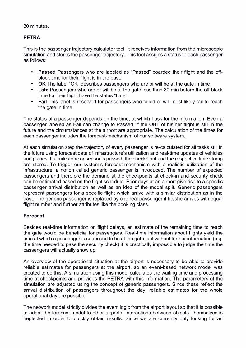
The presented survey deals with the usability evaluation of a prototype of a PIS, which emphasizes the intermodal transportation chain for passengers of the air transportationsystem. Passengers using the system are aware of their location with respect to time and space within the intermodal transportation chain. Evaluated application When a passenger books a flight, he receives a lot of information with specific deadlines which he himself is responsible for meeting in order to board the flight on time. optimode.app has the goal of supporting the user by making these time points visual and displaying them such that the passenger can always see his position in the chain of travel events. Figure 1 shows a full screenshot from the optimode.app. The display shows each deadline and associated information in green when everything is ok. Information is shown in orange when certain points are updated or could be cause for concern.
Figure 1: Screenshot from the optimode.app.
Red is used for warnings when the continuation of the journey is endangered. Sections and
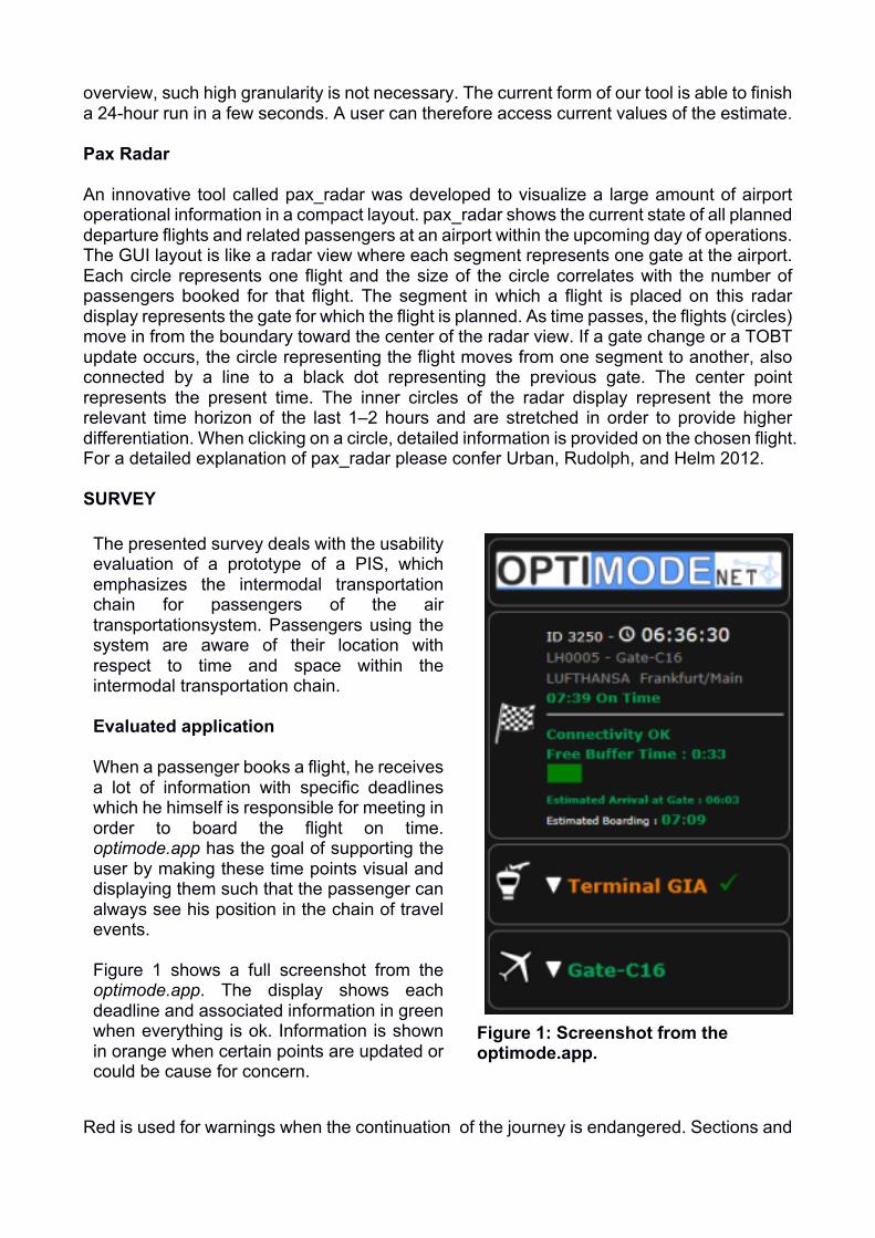
processes which the user has already passed through are marked with a tick. The optimode.app is divided up into four possible registers. The first shows information on the booked flight and for the destination function. The first line shows the user’s ID and the current “simulation” time followed in the next line by the chosen flight number and the gate. Complementing this is the flight information with the airline name and the destination airport in line 3, then the off-block time and the punctuality status in line 4. The dividing lines mark the transition from the flight data to the personal destination information. Firstly, the connectivity status is shown as a forecast value on the basis of the available data. The following “free buffer time” serves the user as a guideline value for the time currently still freely available to him. This time is given to make it possible for the user to efficiently plan the time he spends at the airport. This time is updated continuously throughout the travel chain. It keeps the user well-informed during the journey and thus improves the quality of the journey, reducing the level of uncertainty as the journey progresses. The “free buffer time” is depicted as a reducing progress bar in order to make the amount of time as visual as possible. The last values in this register state the time when the user is expected at the gate based on the currently available data, “Estimated Arrival at Gate”, and when he will board the plane through the gate, “Estimated Boarding”. These values only serve as a guideline, since it is not the plan to capture data on the passenger at the gate itself.
Figure 2: Registers of the optimode.app; a) Train register; b) Terminal register; c) Gate register.
The register which follows the destination function in the optimode.app (see Figure 2a) will only be shown when the passenger comes to the airport by train. It first shows the train number. If the user taps on this register, additional information is provided on this train. The register then shows the actual time that the train will leave the main train station in the urban metropole and the actual arrival time at the airport train station. The following register (see Figure 2b) provides the user with times at different checkpoints within the airport terminal. It first shows the name of the airport. If the user taps on this register, he receives additional information. Firstly, the user’s arrival at the airport terminal is displayed. After the first dividing line, the check-in process is depicted. “Arrival” marks the queuing at the check-in desk and the figure after the hourglass shows the forecast or actual processing time depending on whether the process has been completed or not. The times for the security process are shown in a similar manner after the second dividing line. If these process times start to take longer than anticipated, they are shown in the corresponding colors. The title takes on the coloration of the maximum values.
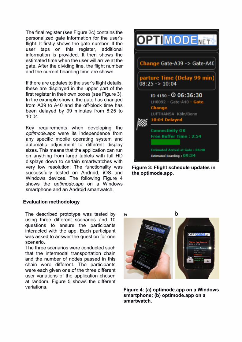
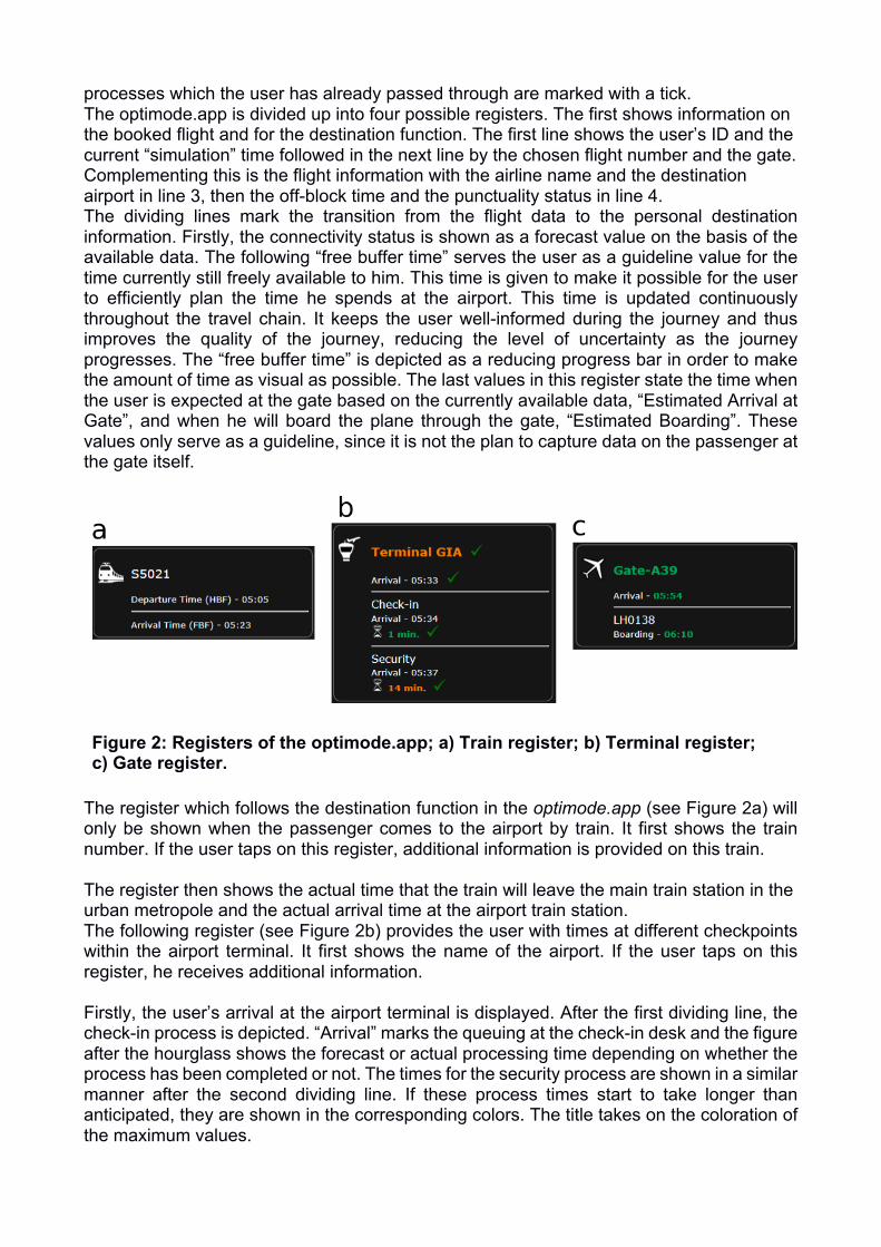
The final register (see Figure 2c) contains the personalized gate information for the user’s flight. It firstly shows the gate number. If the user taps on this register, additional information is provided. It then shows the estimated time when the user will arrive at the gate. After the dividing line, the flight number and the current boarding time are shown. If there are updates to the user’s flight details, these are displayed in the upper part of the first register in their own boxes (see Figure 3). In the example shown, the gate has changed from A39 to A40 and the off-block time has been delayed by 99 minutes from 8:25 to 10:04. Key requirements when developing the optimode.app were its independence from any specific mobile operating system and automatic adjustment to different display sizes. This means that the application can run on anything from large tablets with full HD displays down to certain smartwatches with very low resolution. The functionality was successfully tested on Android, iOS and Windows devices. The following Figure 4 shows the optimode.app on a Windows smartphone and an Android smartwatch.
Figure 3: Flight schedule updates in the optimode.app.
Evaluation methodology The described prototype was tested by using three different scenarios and 10 questions to ensure the participants interacted with the app. Each participant was asked to answer the question for one scenario. The three scenarios were conducted such that the intermodal transportation chain and the number of nodes passed in this chain were different. The participants were each given one of the three different user variations of the application chosen at random. Figure 5 shows the different variations.
Figure 4: (a) optimode.app on a Windows smartphone; (b) optimode.app on a smartwatch.
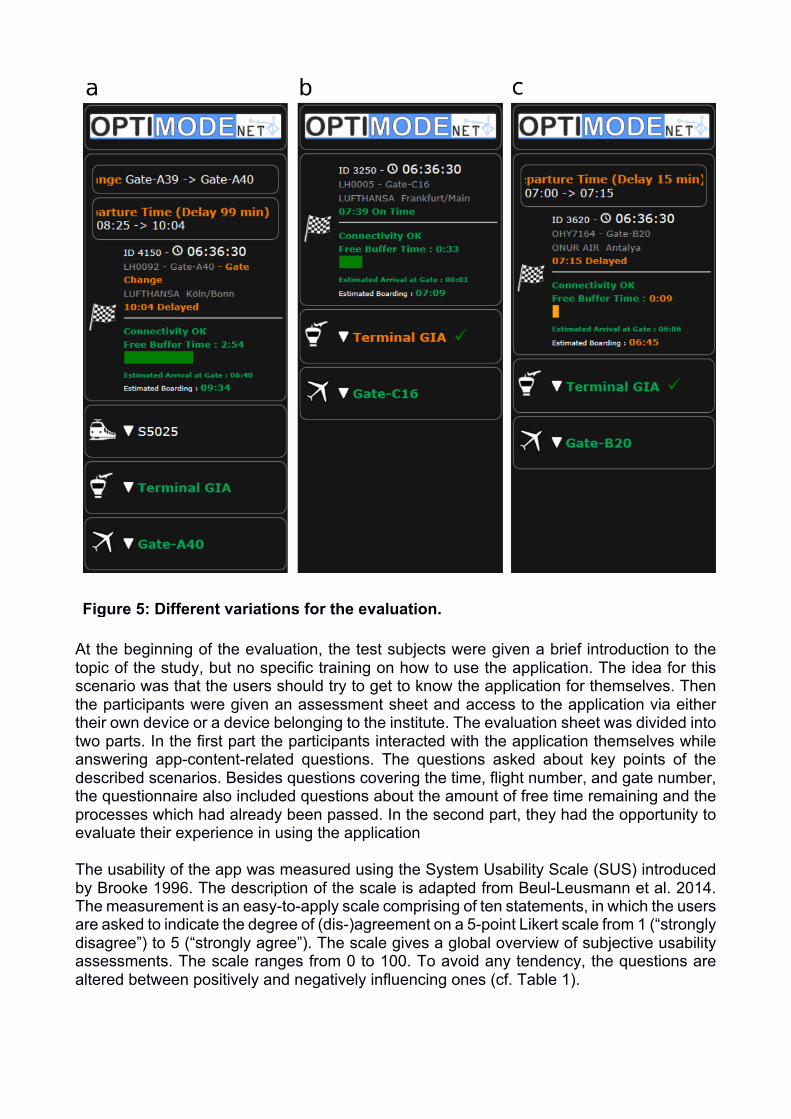
Figure 5: Different variations for the evaluation.
At the beginning of the evaluation, the test subjects were given a brief introduction to the topic of the study, but no specific training on how to use the application. The idea for this scenario was that the users should try to get to know the application for themselves. Then the participants were given an assessment sheet and access to the application via either their own device or a device belonging to the institute. The evaluation sheet was divided into two parts. In the first part the participants interacted with the application themselves while answering app-content-related questions. The questions asked about key points of the described scenarios. Besides questions covering the time, flight number, and gate number, the questionnaire also included questions about the amount of free time remaining and the processes which had already been passed. In the second part, they had the opportunity to evaluate their experience in using the application The usability of the app was measured using the System Usability Scale (SUS) introduced by Brooke 1996. The description of the scale is adapted from Beul-Leusmann et al. 2014. The measurement is an easy-to-apply scale comprising of ten statements, in which the users are asked to indicate the degree of (dis-)agreement on a 5-point Likert scale from 1 (“strongly disagree”) to 5 (“strongly agree”). The scale gives a global overview of subjective usability assessments. The scale ranges from 0 to 100. To avoid any tendency, the questions are altered between positively and negatively influencing ones (cf. Table 1).
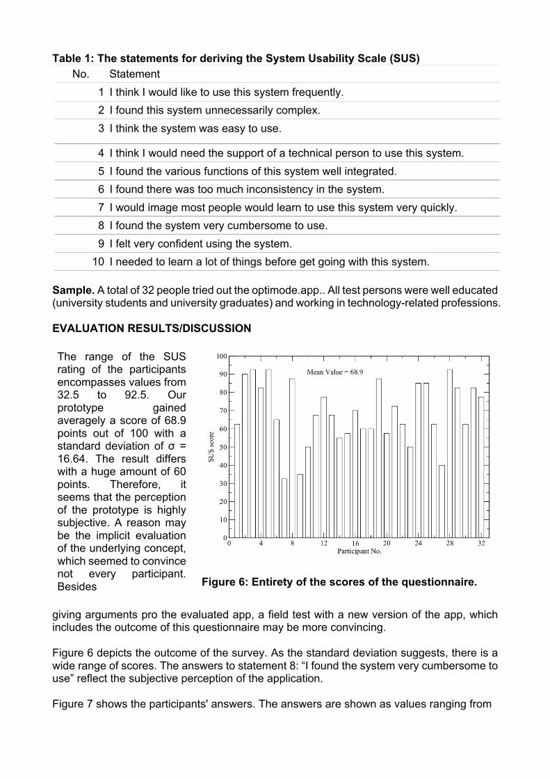
Table 1: The statements for deriving the System Usability Scale (SUS) No. Statement
1 I think I would like to use this system frequently. 2 I found this system unnecessarily complex. 3 I think the system was easy to use.
4 I think I would need the support of a technical person to use this system. 5 I found the various functions of this system well integrated. 6 I found there was too much inconsistency in the system. 7 I would image most people would learn to use this system very quickly. 8 I found the system very cumbersome to use. 9 I felt very confident using the system.
10 I needed to learn a lot of things before get going with this system. Sample. A total of 32 people tried out the optimode.app.. All test persons were well educated (university students and university graduates) and working in technology-related professions. EVALUATION RESULTS/DISCUSSION The range of the SUS rating of the participants encompasses values from 32.5 to 92.5. Our prototype gained averagely a score of 68.9 points out of 100 with a standard deviation of σ = 16.64. The result differs with a huge amount of 60 points. Therefore, it seems that the perception of the prototype is highly subjective. A reason may be the implicit evaluation of the underlying concept, which seemed to convince not every participant. Besides
Figure 6: Entirety of the scores of the questionnaire.
giving arguments pro the evaluated app, a field test with a new version of the app, which includes the outcome of this questionnaire may be more convincing. Figure 6 depicts the outcome of the survey. As the standard deviation suggests, there is a wide range of scores. The answers to statement 8: “I found the system very cumbersome to use” reflect the subjective perception of the application. Figure 7 shows the participants' answers. The answers are shown as values ranging from
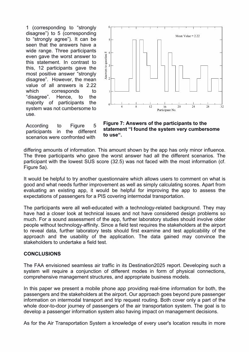
1 (corresponding to “strongly disagree”) to 5 (corresponding to “strongly agree”). It can be seen that the answers have a wide range. Three participants even gave the worst answer to this statement. In contrast to this, 12 participants gave the most positive answer “strongly disagree”. However, the mean value of all answers is 2.22 which corresponds to “disagree”. Hence, to the majority of participants the system was not cumbersome to use. According to Figure 5 participants in the different scenarios were confronted with
Figure 7: Answers of the participants to the
statement “I found the system very cumbersome to use“.
differing amounts of information. This amount shown by the app has only minor influence. The three participants who gave the worst answer had all the different scenarios. The participant with the lowest SUS score (32.5) was not faced with the most information (cf. Figure 5a). It would be helpful to try another questionnaire which allows users to comment on what is good and what needs further improvement as well as simply calculating scores. Apart from evaluating an existing app, it would be helpful for improving the app to assess the expectations of passengers for a PIS covering intermodal transportation. The participants were all well-educated with a technology-related background. They may have had a closer look at technical issues and not have considered design problems so much. For a sound assessment of the app, further laboratory studies should involve older people without technology-affinity. Since a field test requires the stakeholders at the airport to reveal data, further laboratory tests should first examine and test applicability of the approach and the usability of the application. The data gained may convince the stakeholders to undertake a field test. CONCLUSIONS The FAA envisioned seamless air traffic in its Destination2025 report. Developing such a system will require a conjunction of different modes in form of physical connections, comprehensive management structures, and appropriate business models. In this paper we present a mobile phone app providing real-time information for both, the passengers and the stakeholders at the airport. Our approach goes beyond pure passenger information on intermodal transport and trip request routing. Both cover only a part of the whole door-to-door journey of passengers of the air transportation system. The goal is to develop a passenger information system also having impact on management decisions. As for the Air Transportation System a knowledge of every user's location results in more
efficient management, the knowledge of every passenger of the Air Transportation Systems results in a better performance of the overall Transportation System. Passenger comfort, punctuality, and predictability are appreciably increased. Here, we try to answer the question, how large is the operational impact of a widely used passenger information app. The application is designed to run on a mobile phone or a smartwatch. It shows the flight booked, passed milestones of the journey, and the estimated arrival time at the gate. Colors of green, orange, and red indicate confirmed time stamps and information, updates and noticeable problems, and warnings if the continuation of the journey is at risk. A green check marks passed milestones of the journey so that a user is at any time aware of future tasks. Functionality such as displaying the remaining time for a passenger to reach the gate, and the overall user friendliness of our application were tested with the help of a survey. It was designed as a combination of the well established System Usability Scale for assessing industrial systems and questions on the information shown in the app to be answered by the test persons. The questionnaire was performed by 32 participants with an overall SUS score of 68.9. Such a score is quite good for a prototype without prior evaluation of the usability. A huge range of gained scores show high dependency on the subjective perception of the app. Besides a re-design of the user interface, a further survey covering comments on the app may necessary. Such survey would reveal the reason for the huge spreading of the scores. In future work we will employ our software system to simulate the impact of intermodal traffic management based on passenger behavior. A further enhancement would be combining it with layout data for a specific airport. As the EU project SPENCER suggests, finding the appropriate gate at an airport is an obstacle for passengers trying to reach their connections. ACKNOWLEDGEMENTS We thank our participants for spending time on our user test. Furthermore, we thank Dr. Nils Carstengerdes and Christian Werner for giving helpful suggestions and assistance. REFERENCES Beul-Leusmann, Shirley, Christian Samsel, Maximilian Wiederhold, Karl-Heinz Krempels, Eva-Maria Jakobs, and Martina Ziefle. 2014. “Usability Evaluation of Mobile Passenger Information Systems.” In Design, User Experience, and Usability. Theories, Methods, and Tools for Designing the User Experience, edited by Aaron Marcus, 8517:217–228. Lecture Notes in Computer Science. Springer International Publishing. Doi:10.1007/978-3-319-07668-3_22. Brooke, John. 1996. “SUS-A quick and dirty usability scale.” In Usability Evaluation In Industry, edited by P.W. Jordan, B. Thomas, I.L. McClelland, and B. Weerdmeester, 189–194. Camacho, Tiago, Marcus Foth, and Andry Rakotonirainy. 2013. “Pervasive technology and public transport: Opportunities Beyond Telematics.” IEEE Pervasive Computing 12 (1): 18–25. Caulfield, Brian, and Margaret O’Mahony. 2007. “An examination of the public transport information requirements of users.” Intelligent Transportation Systems, IEEE Transactions on 8 (1): 21–30.
Davis, Fred D. 1989. “Perceived usefulness, perceived ease of use, and user acceptance of information technology.” MIS quarterly: 319–340. “EU Project SPENCER.” 2013. April. http://spencer.eu/index.html. EUROCONTROL. 2006. Airport CDM Operational Concept, September. http://www.euro- cdm.org/library/cdm_ocd.pdf.. EUROCONTROL. 2012. Airport CDM Implementation — The Manual, v. 4, April. http://www.eurocontrol.int/sites/default/files/publication/files/2012-airport-cdm- manual-v4.pdf. EUROCONTROL and German Aerospace Center (DLR). 2006. Total Airport Management Operational Concept, October. http://www.bs.dlr.de/tam/Dokuments/TAM-OCD- public.pdf. Ezzedine, H., T. Bonte, C. Kolski, and C. Tahon. 2006. “Intermodal transportation system management : towards integration of traffic management system and users information system.” In Computational Engineering in Systems Applications, IMACS Multiconference on, 1:972–979. October. doi:10.1109/CESA.2006.4281790. Federal Aviation Administration. 2010. Destination 2025. https://www.faa.gov/about/plans_reports/media/Destination2025.pdf. Federal Aviation Administration. 2014. NextGen Implementation Plan, August. http://www. faa.gov/nextgen/library/media/NextGen_Implementation_Plan_2014.pdf. Garcia, C.R., S. Candela, J. Ginory, A. Quesada-Arencibia, and F. Alayon. 2012. “On Route Travel Assistant for Public Transport Based on Android Technology.” In Innovative Mobile and Internet Services in Ubiquitous Computing (IMIS), 2012 Sixth International Conference on, 840–845. July. doi:10.1109/IMIS.2012.103. Grunewald, Erik, and Andrei Popa. 2014. “Passenger Management by Prioritization.” In AUN2014: Airports in Urban Networks. April. Helm, Stefanie Michaela, Axel B. Claßen, Florian Rudolph, Christian Werner, and Beate Urban. 2014. “Integration of Landside Processes into the Concept of Total Airport Management.” Journal of Air Transport Studies 5(1): 55–73. Kalakou, Sofia, Voula Psaraki-Kalouptsidi, and Filipe Moura. 2015. “Future airport terminals: New technologies promise capacity gains.” Journal of Air Transport Management 42:203–212. Martin-Domingo, Luis, and Juan Carlos Martin. 2015. “Airport Surface Access and Mobile Apps.” Journal of Airline and Airport Management 5(1): 1–17. Mueller, Eric, and Gano Chatterji. 2002. “Analysis of Aircraft Arrival and Departure Delay Characteristics.” In AIAA’s Aircraft Technology, Integration, and Operations (ATIO) 2002 Technical Forum. American Institute of Aeronautics / Astronautics. doi:10.2514/6.2002-5866.
O’Connor, W.E. 2001. An Introduction to Airline Economics. ABC-Clioebook. Praeger. Papangelis, Konstantinos, Somayajulu Sripada, David Corsar, Nagendra Velaga, Peter Edwards, and JohnD. Nelson. 2013. “Developing a Real Time Passenger Information System for Rural Areas”. In Human Interface and the Management of Information. Information and Interaction for Health, Safety, Mobility and Complex Environments, edited by Sakae Yamamoto, 8017:153–162. Lecture Notes in Computer Science. Springer Berlin Heidelberg. Doi:10.1007/978-3-642-39215-3_19. Rehrl, Karl, Stefan Bruntsch, and Hans-Joachim Mentz. 2007. “Assisting Multimodal Travelers: Design and Prototypical Implementation of a Personal Travel Companion.” Trans. Intell. Transport. Sys. (Piscataway, NJ, USA) 8, no. 1 (March): 31–42. doi:10.1109/TITS.2006.890077. Rudolph, Florian, Erik Grunewald, Yves G ̈nther, and Florian Piekert. 2014. “Intermodal Augmented Scheduling.” In AUN-2014 ’Airports in Urban Networks’. April. Spies, G, F Piekert, A Marsden, R Suikat, Ch Meier, and P Eriksen. 2008. “Operational Concept for an Airport Operations Center to Enable Total Airport Management.” In Proceedings of ICAS. Urban, B., F. Rudolph, and S. Helm. 2012. “Development of an HMI to Monitor and Predict Passenger Progress in the Landside Process Chain for a Holistic Airport Management.” In German Aeronautics and Astronautics Convention, 10. – 12. September, Berlin, Germany. Wirtz, S., E.-M. Jakobs, and S. Beul. 2010. “Passenger information systems in media networks: Patterns, preferences, prototypes.” In Professional Communication Conference (IPCC), 2010 IEEE International, 131–137. July. doi:10.1109/IPCC.2010.5529825. Wirtz, Simone, and Eva-Maria Jakobs. 2013. “Improving User Experience for Passenger Information Systems. Prototypes and Reference Objects.” IEEE transactions on professional communication (New York, NY) 56(2): 120–137. doi:10.1109/TPC.2013.2257211.