overview of water and soil nutrient management...
TRANSCRIPT
WORKING PAPER 105
I n t e r n a t i o n a lWater ManagementI n s t i t u t eISBN: 92-9090-621-9
SM
IWMI is a Future Harvest Centersupported by the CGIAR
Postal AddressP O Box 2075ColomboSri Lanka
Location127, Sunil MawathaPelawattaBattaramullaSri Lanka
Telephone+94-11 2787404
Fax+94-11 2786854
Websitehttp://www.iwmi.org
I n t e r n a t i o n a lWater ManagementI n s t i t u t e
Overview of Water and SoilNutrient Managementunder Smallholder Rain-fedAgriculture in East Africa
Bancy Mbura Mati
Working Paper 105
Overview of Water and Soil Nutrient Managementunder Smallholder Rain-fed Agriculture in
East Africa
Bancy Mbura Mati
International Water Management Institute
ii
The author: Bancy Mbura Mati is a Professor of Soil and Water Engineering at the Jomo KenyattaUniversity of Agriculture and Technology (JKUAT) in Nairobi, Kenya. She has a long workingexperience in East Africa and has conducted several research and consultancy projects on Soiland Water Management and Geographic Information Systems (GIS). She has worked as aconsultant for IWMI on various projects and in 2003 was a “fellow” at IWMI under the ConsultativeGroup on Agricultural Research—International Fund for Agricultural Research (CGIAR-IFAR)program.
Mati, B. M. 2005. Overview of water and soil nutrient management under smallholder rain-fed agriculture in East Africa. Working Paper 105. Colombo, Sri Lanka: International WaterManagement Institute (IWMI).
/ rain-fed farming / soil management / soil fertility / food production / soil conservation /water conservation / rainwater harvesting /technology / terracing / tillage / cropping systems/ nongovernmental organizations / Agroforestry / irrigation systems / East Africa / Ethiopia/ Kenya / Tanzania /
ISBN 92-9090-621-9
Copyright © 2006, by IWMI. All rights reserved.
Please direct inquiries and comments to: [email protected]
IWMI receives its principal funding from 58 governments, private foundations and internationaland regional organizations known as the Consultative Group on International AgriculturalResearch (CGIAR). Support is also given by the Governments of Ghana, Pakistan, SouthAfrica, Sri Lanka and Thailand.
iii
Contents
List of Acronyms ................................................................................................................. v
Acknowledgments ................................................................................................................ ix
Foreword ............................................................................................................................... xi
Introduction ........................................................................................................................... 1
Soil and Water Conservation Technologies ......................................................................... 9
Water Harvesting Technologies ........................................................................................... 21
Soil Nutrient Management ................................................................................................... 43
Participatory Approaches in Water and Nutrient Management ......................................... 51
Literature Cited .................................................................................................................... 71


v
Acronyms relevant to all the countries
ACT African Conservation Tillage NetworkASAL Arid and Semi-Arid LandsAU African UnionCBO Community Based OrganizationCCD Conventions to Combat DesertificationCOMESA Common Market for Eastern and Southern AfricaDAP Diammonium PhosphateDDB Double Dug BedsDPT District Planning TeamsEAC East African CommunityECA Economic Commission for AfricaEPM Ecological Pest ManagementFAO Food and Agriculture OrganizationFEW Frontline Extension WorkerFI Farmer InnovatorGDP Gross Domestic ProductGFAR Global Forum on Agricultural ResearchGO Government OrganizationICRAF International Council for Research in AgroforestryIDS Institute of Development Studies (of the UK)IFAD International Fund for Agricultural DevelopmentIFOAM International Federation for the Organic Agriculture MovementIFPRI International Food Policy Research InstituteIGAD Inter-Governmental Authority on DevelopmentIIRR Institute of International Research and ReconstructionIPM Integrated Pest ManagementITK Indigenous Technology KnowledgeIWMI International Water Management InstituteLEISA Low External Input Sustainable AgricultureMENR Ministry of Environment and Natural ResourcesMoA Ministry of AgricultureNARS National Agricultural Research StationsNEP National Extension ProgramNGO Non-Governmental OrganizationNRM Natural Resource ManagementPFI Promoting Farmer InnovationPRA Participatory Rural AppraisalPRSP Poverty Reduction Strategy PaperPTD Participatory Technology DevelopmentRWH Rainwater Harvesting
vi
SCC Soil Conservation CommitteesSEARNET Southern and Eastern Africa Rainwater NetworkSIDA Swedish International Development AgencySIWI Stockholm International Water InstituteSPAAR Special Program for African Agricultural ResearchSSA Sub-Saharan AfricaSWC Soil and Water ConservationSWCP Soil and Water Conservation ProjectSWMNet Soil and Water Management NetworkT&V Training and VisitsUN United NationsUNDP United Nations Development ProgramWNCTs Water and Nutrient Conservation TechnologiesWOCAT World Overview of Conservation Approaches and Technologies
Acronyms relevant to Ethiopia
AAEO Assistant Agricultural Extension OfficerARDU Arssi Regional Development UnitCADU Chilalo Agricultural Development UnitCRDA Christian Relief and Development AssociationMPP Minimum Package ProgramNVCC National Villagization Coordination CommitteePA Peasant AssociationPADEP Peasant Agricultural Development ProgramPADETES Participatory Demonstration and Training Extension SystemPRUP Participatory Resource Use PlanningSG2000 Sasakawa Global 2000 ProjectWADU Wallamo Agricultural Development Unit
Acronyms relevant to Kenya
MoA&RD Ministry of Agriculture and Rural DevelopmentAFC Agricultural Finance CorporationALIN Arid Lands Information NetworkATIRI Agricultural Technology and Information Response InitiativeFFS Farmer Field SchoolsFSR Farming Systems ResearchHPI Heifer Project InternationalIPPM Integrated Production and Pest ManagementITDG Intermediate Technology Development GroupKARI Kenya Agricultural Research Institute
vii
KEFRI Kenya Forestry Research InstituteKENDAT Kenya Draught Animal TechnologyKIOF Kenya Institute of Organic FarmingKWFT Kenya Women Finance TrustLLP Local Level PlanningMDFP Meru Dryland Farming ProjectNALEP National Agricultural and Livestock Extension ProjectNSWCP National Soil and Water Conservation ProgramSFRRP Soil Fertility Recapitalisation and Replenishment Project
Acronyms relevant to Tanzania
ARI Agricultural Research InstituteCTP Cashew Training ProgramDONET Dodoma Environmental NetworkHADO Hifadhi Ardhi DodomaHIMA Hifadhi MazingiraISWCP Indigenous Soil and Water Conservation ProgramLAMP Land Management ProgramMVIWATA Mtandao wa Vikundi vya Wakulima TanzaniaREDESA Relief and Development Services AssociationSCAPA Soil Conservation and Agroforestry Project-ArushaSDPMA Smallholder Development Project for Marginal AreasSUA Sokoine University of AgricultureTIPDO Traditional Irrigation Development OrganizationVDC Village Development Councils

viii
ix
Acknowledgments
This paper is the product of a combination of original research by the author and baseline reviewsof published material covering a wide range of technologies and approaches in water and nutrientmanagement under smallholder rain-fed agriculture in East Africa, focusing on Ethiopia, Kenyaand Tanzania. The research work and preparation of this paper were supported by IWMI, and itsproduction and distribution has been made possible by the IWMI-IPTRID Partnership (LOA PRNo. 28920) supported by the Dutch Government. The author is grateful for this support and thanksall the people who contributed directly or indirectly to the contents of this paper. They include thefarmers who volunteered information and allowed their activities to be photographed—CharlesMburu, Kennedy Njenga, John Njoroge, Esther Kahangi, Paul Kimeu, Mary Okando, Rolf Winberg,Ake Barklund, Isaiah Sijali, Munene Mati, Kithinji Mutunga, Fabian Muya and Kipruto Cherogonyof Kenya; Nuhu Hatibu, Henry Mahoo, Filbert Rwehumbiza and Patrick Lameck of Tanzania;Habtamu Gassesse, Ephraim Alamelew, Abiye Astatke, Elias Eyasu, Azene Bekele and KidaneGeorgis of Ethiopia; Chris Reij and Will Critchley of the Netherlands to name a few. The authoris grateful to the Kenya Institute of Organic Farming (KIOF), SoS Sahel International, Meru DrylandFarming Project, Farm Africa, Agri-Service, World Vision, International Institute for RuralReconstruction, Nairobi (IIRR), Inades Formation, Kenya Rainwater Association, Water Action,Water Aid, Ethiopian Rainwater Harvesting Association, Kenya Agricultural Research Institute,Sokoine University of Agriculture, University of Dar es Salaam, Egerton University, The WorldBank, the Regional Land Management Unit and all other institutions including governmentdepartments, universities, local and international organizations based in Ethiopia, Kenya and Tanzania,who provided much valuable information and allowed the use of their libraries and databases. She(the author) thanks the Jomo Kenyatta University of Agriculture and Technology for the logisticalsupport extended during the data collection and report preparation. The financial and logisticalsupport of the International Water Management Institute (IWMI) for the data collection andpreparation of this volume is much appreciated by the author. She thanks the IWMI staff, inparticular, Douglas Merrey, Frits Penning de Vries, Hilmy Sally, Marna de Lange, Boubacar Barryand Phillipe Lempérière for their valued advice and support. Finally, the author thanks, very specially,her family for their unwavering support and encouragement as well as friends, relatives and well-wishers.
Note: All the figures in this paper have been drawn by Munene M. Mati (from sketches and photos).

x
xi
Foreword
The work that lies behind this Working Paper began, for Professor Mati, long before she beganworking with IWMI. But for IWMI, it also has a history of several years. During the years 2000-2001, as we built up our program and staff in Africa, we spent quite some time trying to identifywhat should be our main priorities in sub-Saharan Africa. By 2002 we realized that one veryimportant focus for IWMI’s work ought to be on water and land management in “rain-fed” aswell as “irrigated” agriculture; we called our incipient effort “intensifying rain-fed agriculture,” andfocused on such topics as rainwater harvesting, small individualized technologies such as bucketand drum drip kits and pedal pumps, and low-cost water storage. As part of our effort to understandwhat is already happening in this arena, we asked Professor Mati to work with us on this topicand among other things to provide an overview of experiences in East Africa based on her on-going and past experiences.
The first draft of this paper was produced in 2003. She continued to work on it, adding examples,illustrations, data from more recent experiences, and for the final version, added a section onparticipatory approaches to implementation and scaling up. She has patiently answered questionsfrom nonspecialists like me, and worked hard to finalize this document for wider dissemination.
I am sure that many people will find this overview a useful guide and menu. It is aimed atgovernment officials, NGOs, and donors who are supporting the implementation of improved low-cost water and land management practices by and with poor farmers. I want, therefore, to thankProfessor Mati for her work. I share Professor Mati’s belief that helping farmers adapt and makegood use of better but low-cost water and land management practices and technologies can havea high impact on poverty and food security in Africa.
As will be seen from her acknowledgments, many people have participated in various waysto make this Working Paper a reality. I do want to provide a special acknowledgment to theInternational Program for Technology and Research in Irrigation and Drainage (IPTRID). Thefinalization and publication of this Working Paper has been made possible by the IWMI-IPTRIDPartnership (LOA PR No. 28920), which is supported by the Government of the Netherlands.
Douglas J. MerreyPrincipal Scientist for Institutions and PoliciesSouthern Africa Regional Office, IWMIFebruary 2006
1
INTRODUCTION
Background
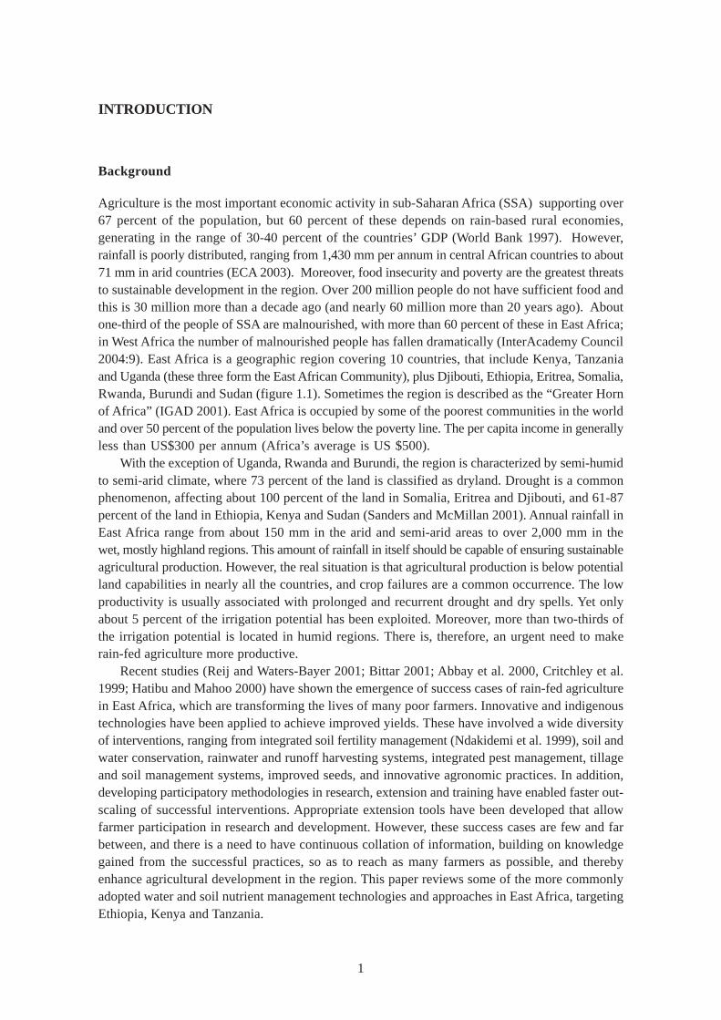
Agriculture is the most important economic activity in sub-Saharan Africa (SSA) supporting over67 percent of the population, but 60 percent of these depends on rain-based rural economies,generating in the range of 30-40 percent of the countries’ GDP (World Bank 1997). However,rainfall is poorly distributed, ranging from 1,430 mm per annum in central African countries to about71 mm in arid countries (ECA 2003). Moreover, food insecurity and poverty are the greatest threatsto sustainable development in the region. Over 200 million people do not have sufficient food andthis is 30 million more than a decade ago (and nearly 60 million more than 20 years ago). Aboutone-third of the people of SSA are malnourished, with more than 60 percent of these in East Africa;in West Africa the number of malnourished people has fallen dramatically (InterAcademy Council2004:9). East Africa is a geographic region covering 10 countries, that include Kenya, Tanzaniaand Uganda (these three form the East African Community), plus Djibouti, Ethiopia, Eritrea, Somalia,Rwanda, Burundi and Sudan (figure 1.1). Sometimes the region is described as the “Greater Hornof Africa” (IGAD 2001). East Africa is occupied by some of the poorest communities in the worldand over 50 percent of the population lives below the poverty line. The per capita income in generallyless than US$300 per annum (Africa’s average is US $500).
With the exception of Uganda, Rwanda and Burundi, the region is characterized by semi-humidto semi-arid climate, where 73 percent of the land is classified as dryland. Drought is a commonphenomenon, affecting about 100 percent of the land in Somalia, Eritrea and Djibouti, and 61-87percent of the land in Ethiopia, Kenya and Sudan (Sanders and McMillan 2001). Annual rainfall inEast Africa range from about 150 mm in the arid and semi-arid areas to over 2,000 mm in thewet, mostly highland regions. This amount of rainfall in itself should be capable of ensuring sustainableagricultural production. However, the real situation is that agricultural production is below potentialland capabilities in nearly all the countries, and crop failures are a common occurrence. The lowproductivity is usually associated with prolonged and recurrent drought and dry spells. Yet onlyabout 5 percent of the irrigation potential has been exploited. Moreover, more than two-thirds ofthe irrigation potential is located in humid regions. There is, therefore, an urgent need to makerain-fed agriculture more productive.
Recent studies (Reij and Waters-Bayer 2001; Bittar 2001; Abbay et al. 2000, Critchley et al.1999; Hatibu and Mahoo 2000) have shown the emergence of success cases of rain-fed agriculturein East Africa, which are transforming the lives of many poor farmers. Innovative and indigenoustechnologies have been applied to achieve improved yields. These have involved a wide diversityof interventions, ranging from integrated soil fertility management (Ndakidemi et al. 1999), soil andwater conservation, rainwater and runoff harvesting systems, integrated pest management, tillageand soil management systems, improved seeds, and innovative agronomic practices. In addition,developing participatory methodologies in research, extension and training have enabled faster out-scaling of successful interventions. Appropriate extension tools have been developed that allowfarmer participation in research and development. However, these success cases are few and farbetween, and there is a need to have continuous collation of information, building on knowledgegained from the successful practices, so as to reach as many farmers as possible, and therebyenhance agricultural development in the region. This paper reviews some of the more commonlyadopted water and soil nutrient management technologies and approaches in East Africa, targetingEthiopia, Kenya and Tanzania.
2
Figure 1.1. Africa—showing East Africa, Kenya, Ethiopia and Tanzania.
Ethiopia
General Background
Ethiopia lies between longitudes 33oE and 55oE and latitudes 3.5oN and 15oN, covering a land areaof 1.13 million km² (Appiah and Gates Jr. 1999). The country is bounded by Eritrea, Djibouti,Somalia, Kenya and the Sudan. The relief is dominated by Ethiopian highlands and thus the climateis quite variable across the country. The tropical zone receives less than 510 mm rain per annum,while the sub-tropical zone, which includes most of the highlands, receives 510 to 1,530 mm ofrain annually. In general, the main rainy season occurs between mid-June and September, followedby a dry season that may be interrupted by the short-rains season in February-March. Mean annualtemperatures range from about 27o C in the tropical zones to about 22oC in the cooler highlands.Population is estimated to be 70 million people, with an annual population growth rate of nearly 3percent. Per capita income in 2002 was US$90 per year (World Bank 2004; Awulachew et al.2005).
The physical features of Ethiopia include large areas of flat land and gently rolling hilly areasas well as steep and ragged hills and valleys. Altitudes range from slightly below sea level to morethan 4,000 m above sea level, and slopes can be as high as 60 percent in the highlands, makinglarge areas more prone to erosion. The Ethiopian highlands represent one of the most productiveparts of the country, but have suffered from extensive resource degradation. Since the 1970s,attempts to reverse degradation through soil conservation programs have been implemented.Although there have been successes, more often, the results have been disappointing (Holden andShiferaw 1999).
SudanEritrea
Djibouti
Ethiopia
SomaliaUgandaKenya
RwandaBurundi
Tanzania
3
The drylands of Ethiopia comprise about 70 percent of the total landmass and 45 percent ofthe arable land, including arid, dry semi-arid, moist semi-arid and parts of the sub-moist zone.However, these areas contribute only 10 percent of the total crop production. About half of thearable land is in the arid and semi-arid regions, and most rural people living in such areas dependon small-scale dryland agriculture. The drylands are characterized by a severely fragile naturalresource base. Soils are often coarse-textured, sandy, and inherently low in organic matter andwater-holding capacity, thereby making them easily susceptible to both wind and water erosion.As a result, crops can suffer from moisture stress and drought even during normal rainfall seasons.Farm productivity has declined substantially and farmers have found themselves sliding into poverty(Kidane 1999).
Agriculture and Food Production in Ethiopia
Settled agriculture in Ethiopia has a long history dating back to antiquity, and is the mainstay ofEthiopian economy. It contributes 57 percent of the GDP (Holden and Shiferaw 1999). Agricultureemploys about 85 percent of the population in Ethiopia and accounts for 90 percent of the nationalexport earnings. In the 1990s, the economic growth rate increased to 5 percent, as compared to1.6 percent in the 1980s. Major changes in economic policy since 1992 have provided a conduciveenvironment for development. These include reducing the role of government, encouragingprivatization, liberalizing markets and rationalizing exchange rate policies (FAO/WFP 2000).Between 1979/1980 and 1993/1994, food production (of crop and animal origin) grew annually bya mere 0.5 percent and food grain production by 0.44 percent. This is equivalent to an annual percapita domestic food availability decline of 2.55 and 2.7 percent, respectively.
Much of Ethiopia, especially the mountain valleys, has sufficient rainfall and good soil for cropproduction. However, population pressures are so extreme that farmlands are under continuouscultivation. Cereals occupy 82 percent of the cultivated areas, while pulses occupy 12 percent.The main crops are teff, maize, sorghum and barley. In addition, there are about 13 million cattle,12 million sheep, 10 million goats, 4.4 million equine and 1 million camels (Tegegne 2000). Generally,Shoa, Arssi and Gonder are the main food producing areas. Problematic areas include Wollo,Herarghe, Tigray, Bale, Sidano and Ganu Gofa (Gribnau 1993). Agriculture in Ethiopia is dominatedby approximately 7 million small-scale and resource-poor farmers, with average landholdings ofabout 1.5 ha in size. There are four major farming systems in Ethiopia (UNDP/ECA 1998):
• Cereal – oil – pulse – livestock farming system is found in the central highlands of Ethiopia,in the northern highlands of Tigray and also in the Amhara National Regional State. Thissystem has intense potential and is well developed, and in addition, the population is hardworking. The soil being enriched with rich alluvial, and if water is developed, productioncould be tripled or quadrupled.
• Cereal – livestock – hoe culture, where agricultural production does not have a long tradition,is in the western and southern regions of Ethiopia and the Southern National Regional Stateas well as in Gambella and Benshargul – Gumuz.
• Pastoral farming – is in all regional states, but dominant in Afar, Somali and Benshangul-Gumuz National Regional States. The area is vulnerable to drought, and there is a lack ofknowledge about modern technologies. There is also a scarcity of trained manpower inthe area.
4
• Coffee – maize – livestock – root crop enset farming system is represented by Oromiyaand Southern Nationals, Nationalist and Peoples’ Regional States. This system is in majorcash-crop areas with enset and maize being the major food crops. Enset, a banana-likeplant typical to Ethiopia and is usually grown in home gardens.
Among the reasons for poor agricultural development, there have been constraints associatedwith strategies such as (i) development and conservation of hillsides and communal lands, (ii) “foodfor work” based development, (iii) exclusion of farmers in the day-to-day development andconservation initiatives, (iv) disregard of indigenous development and conservation skills, (v) ruralland use and tenure policies, (vi) lack of knowledge about soil erosion, and (vii) institutional set upand continuity (Bekele-Tesemma 2001). These constraints have contributed to failures indevelopment projects. The failures can further be attributed to biophysical and sociopolitical factors.The use of modem agricultural inputs (fertilizer, selected seeds, agro-chemicals, and improved farmimplements) is limited. Moreover, environmental degradation is expanding at an alarming rate andthis trend is exacerbated by drought, which is considered as a major destructive process. Rapidhuman and animal population growth, coupled with limited arable and grazing land, has reducedthe carrying capacity of the environment (Ejigu 1999).
Other aspects have included changes in extension approaches, from the top – down approachesto conservation initiated after the 1973/1974 famine and the 1975 land reform, and establishmentof the Peasant Associations (PAs), which were instrumental in mobilizing labor and assignment oflocal responsibilities. Since the 1980s, food-for-work programs have mobilized 35 million person-days of labor for conservation in the highlands. However, the success rates were limited. Forinstance, of the trees planted, the survival rate was 60 to 70 percent. In addition, uniform soilconservation structures were constructed across different regions, which were later dismantledon 53 percent of farms and partly removed on 31 percent when coercion ceased (Holden andShiferaw 1999). Moreover, prospects for agricultural development in dry areas are largelymisunderstood. These areas are commonly called “low potential” rather than “low rainfall” areas.Besides livestock, arid and semi-arid lands (ASALs) are the sources of millets, sorghum, cotton,cowpeas, dolichos beans, pigeon peas, oranges, mangoes, grapes and passion fruits. Appropriatetechnology for these areas has been lacking —paradoxically, the future of the expansion of Ethiopia’sfood production is in these areas (Georgis 2002). In the Eastern Shoa Region of Ethiopia, the mostcommon water harvesting methods include: contour stone bunds, trapezoidal bunds, flood waterdiversion/spate irrigation (forced flood diversions), flood water farming systems (riverbed/bankutilization-no diversion), contour ridges/contour furrows and semi-circular bunds (Natea 2002).
Kenya
General Background
Kenya lies between longitudes 34oE and 42oE and latitudes 4.7oS and 5oN, covering an area of582,646 km². Kenya shares boundaries with Tanzania, Uganda, Ethiopia, Sudan, Somalia and theIndian Ocean. The country has a diverse topography, ranging from sea level to the high altitudepeaks of Mount (Mt.) Kenya at 5,199 meters above sea level, and other highlands. Climate isinfluenced by altitude, and annual rainfall amounts vary much across the country, from less than200 mm in the arid north to over 2,000 mm on the upper slopes of Mt. Kenya (Sombroek et al.1980). About 80 percent of the land in Kenya is classified as ASAL receiving 200 to 750 mm of
5
rainfall per year. The ASALs are hot and dry, where rainfall is erratic and unreliable, with seasonaldistribution that does not allow good crop harvests. Thus, ASALs are classified as unsuitable forcrop production (Jaetzold and Schmidt 1983). Kenya has a population of 28.7 million people, asper the 1999 population census (Republic of Kenya 1999). The annual population growth rate is 3percent. Per capita income in 2000 was US$350 per year (Republic of Kenya 2000; World Bank2002).
Agriculture and Food Production in Kenya
Agriculture is the major economic sector in Kenya, and is the main source of income for some 80percent of the population, of which 19 percent is in wage employment. It accounts for 52 percentof the national GDP, of which 25 percent is directly and 27 percent is indirectly through linkageswith manufacturing, distribution and other service-related sectors. Agriculture accounts for some40 percent of the total export earnings, 45 percent of the government revenue and 75 percent ofthe industrial raw materials (Republic of Kenya 2000; MoA&RD 2002). There are about 3 millionsmallholder farm-families in Kenya, of which 80 percent have less than 2 ha of cropland.Smallholders are responsible for 70 percent of the maize production, 65 percent of the coffee,over 50 percent of the tea, over 70 percent of beef and over 80 percent of milk and other crops(Republic of Kenya 1995). Despite this, some 2 million people in Kenya are considered to bechronically food insecure and the number increases to 5 million in the event of drought, even duringseasonal droughts. According to the World Bank (2002), approximately 42 percent of Kenyanslive below the poverty line. Furthermore, only about 20 percent of the land area in Kenya is suitablefor rain-fed agriculture.
Agricultural production and real expenditures in agriculture in Kenya declined at 1 percentthroughout the 1990s, while contribution of agriculture to the GDP was negative (MoA&RD 2000).However, the contribution of smallholder farmers was growing. Similarly, there was a decline inpublic support for research and extension, and as a result, maize yield increases fell to 0.3 percentin the 1985-1991 period (World Bank 1995; Hassan and Karanja 1997). However, the agriculturalsector has been recovering in recent years and in 2003, the sector grew by 1.5 percent (Republicof Kenya 2004). Over the years, population pressure and lack of growth in other sectors havecaused increasing pressure on natural resources, resulting in declining soil fertility, productivity andgeneral environmental degradation. Furthermore, the situation has been exacerbated by a weakcapital base, over-taxation of farm inputs, disorganized marketing system, drought, insecurity inthe rangeland areas, poor extension services, inadequate exploitation of some water resources andpoor functionality of supporting agricultural infrastructure such as cooperative societies. Theseconditions have raised concerns in Kenya and among her development partners, and led to theformulation of reforms as spelt out in the Poverty Reduction Strategy Paper (Republic of Kenya2001).
The Poverty Reduction Strategy Paper (PRSP) for the period 2001-2004 for Kenya outlinesmeasures necessary for poverty reduction, food security and economic growth (Republic of Kenya2001). Agriculture and rural development, in general, were identified as the key sectors to tacklepoverty reduction. Within the sector, priorities were ranked as: 1) crop development, rural water;2) livestock development; and 3) food security, lands and settlement management and fisheries(MoA&RD 2002). At the national level, strategies and approaches have been proposed, and someare being implemented in the current development plan. These include the following (MoA&RD2000; 2002):
6
• Documentation of successful technologies and approaches that have significantly contributedto food security;
• Building partnerships for agricultural and food security initiatives;
• Capacity building and sustainability;
• Undertake deliberate programs to expose farmers to technologies and information;
• Wider involvement of stakeholders;
• Develop strong farmer-extension-research linkages;
• Provision of an enabling environment for private sector participation in extension;
• Support value adding to agricultural produce and products;
• Address gender equity; and
• Develop modalities for up-scaling successful projects.
Tanzania
General Background
The United Republic of Tanzania is made up of mainland Tanganyika and the islands of Zanzibarand Pemba. The country covers a total land area of 945,087 km², of which Zanzibar and Pembaoccupy about 1,658 km² and 984 km², respectively. Tanzania lies between longitudes 30oE and40oE and latitudes 1oS and 12oS. It is bounded by Kenya, Uganda, Rwanda, Burundi, DemocraticRepublic of Congo, Zambia, Malawi, Mozambique and the Indian Ocean. The relief of mainlandTanzania is, generally, flat and low along the coast, but a plateau of average height of 1,200 mconstitutes the greater part of the country. Isolated mountain ranges rise in the northeast andsouthwest. The snow-peaked Mt. Kilimanjaro at 5,895 meters above sea level, which is the highestmountain in Africa, is located near the northeast border with Kenya. Other highlands include Mt.Meru (4,556 m), Pare Mts, Uluguru Mts and the southern highlands of Mbinga and Njombe. Alongthe coast are the narrow, low-lying islands of Zanzibar, Pemba and Mafia. More than 53,000 km²is covered by inland lakes, such as Lake Victoria in the north, and the Rift Valley lakes, Tanganyikaand Nyasa (Appiah and Gates Jr. 1999; URT 1994). The population of Tanzania is about 34 millionpeople, with an annual growth rate of 2.3 percent. The per capita income in 2000 was US$270per year, and the proportion of people living below the poverty line was 42 percent (World Bank2002).
Compared to Kenya and Ethiopia, Tanzania has a moderate climate. The climate is warm andtropical on the mainland coastal strip along the Indian Ocean, with temperatures averaging 27oCand annual rainfall varying from 750 to 1,400 mm. The inland plateau is hot and dry, with annualrainfall averaging as low as 500 mm. On the islands, where annual mean temperatures are in therange of 29o C, the excessive heat is tempered by the sea breeze throughout the year (Appiahand Gates Jr. 1999). Tanzania is a mineral-rich country, producing small amounts of diamonds,
7
gemstones, gold, salt phosphate, coal, gypsum and also kaolin and tin. There are reserves of nickel,soda ash, iron ore, uranium and natural gas. However, the mineral potential of Tanzania has notbeen fully exploited.
Agriculture and Food Production in Tanzania
Agriculture is Tanzania’s most important economic sector, providing food, income, fuel, shelter andemployment to the rural and urban population. It accounts for 70 percent of foreign exchange and80 percent of employment. Statistics show that 40 million ha of Tanzanian land is suitable foragricultural production, but only 6.3 million ha are under cultivation (URT 1997). One million hahave the potential for irrigation, but only 150,000 ha are actually under irrigation. This is indicativeof the reality of smallholder agriculture and the constrained technological base. Though most ofthe farming is for subsistence, growing food crops like maize, rice, beans, citrus, vegetables, rootcrops, and cash crops form an important economic component. The main cash crops include coffee,tea, cotton, sisal, tobacco, coconut, sugar, groundnuts and cashew nuts. Cloves are an importantcash crop in the islands of Pemba and Zanzibar.
Most crops and livestock are produced by small-scale farmers who use few capital inputs. Asa result, soil fertility is declining in most farming systems of the country. Due to liberalization ofthe economy, more produce is being marketed and processed thereby, accelerating depletion ofnatural soil fertility. These two conflicting trends reflect the major challenge for agricultural research,extension and development organizations (Ndakidemi et al. 1999). Some of the problems that haveplagued agriculture in Tanzania include the formulation of blanket recommendations, which aretoo general to be applicable in the case of individual farmers, and the unavailability of chemicalinputs in remote areas of the country. Since the liberalization of the Tanzanian economy in 1986,there have been policy changes that have contributed to renewed growth in the agricultural sector.The short-term measures have included liberalization of regional food trade, improvements in creditprovision to farmers, reduction of excessive taxation of agricultural production and marketing bylocal authorities, and increased budgetary support for agriculture (World Bank 2000). Othermacroeconomic reforms have included increased investment in research and extension,improvements in rural infrastructure and enhanced privatization of service provision.

8
9
SOIL AND WATER CONSERVATION TECHNOLOGIES
Water and soil nutrient management form a critical component of agricultural production. Waterand nutrient conservation technologies are dictated by the need for soil conservation on usuallyvery steep slopes while draining excess runoff safely, the need for water harvesting and conservationin the drier areas, the available technology, which is usually manual or draught animal, and labor.All three countries, Ethiopia, Kenya and Tanzania have a rich heritage of indigenous and innovativewater and nutrient conservation technologies, including irrigation and water harvesting systems thatdate back centuries (McCall 1994; Reij et al. 1996; Wolde-Aregay 1996; Thomas 1997; Critchleyat al. 1994; Mutunga et al. 2001; SIWI 2001).
The line between soil and water conservation (SWC) and rainwater harvesting (RWH)technologies for crop production is very thin. SWC can be described as activities that reduce waterlosses by runoff and evaporation, while maximizing in-soil moisture storage for crop production,but the same could be said of RWH. The two are differentiated by the fact that under soil andwater conservation, rainwater is conserved in-situ wherever it falls, whereas under waterharvesting, a deliberate effort is made to transfer runoff water from a “catchment” to the desiredarea or storage structure (Critchley and Siegert 1991). The important thing is that both systemscomplement each other, and under rain-fed agriculture in dry areas, both are necessary nearly allthe time. Various interventions in SWC are implemented by farmers throughout East Africa, andthey also form the foundation of many development projects with agriculture and land managementon their agendas (Reij et al. 1996; Lundgren 1993; Hurni and Tato 1992; WOCAT 1997). Indigenousand innovative technologies in SWC, RWH and soil nutrient management abound in East Africa(Mulengera 1998; Reij and Waters-Bayer 2001; Hamilton 1997), some of which have proved easierto replicate, especially those that are applicable over diverse biophysical conditions and have lowlabor requirements.
In Ethiopia, the more common methods of SWC, RWH and nutrient management include: levelcontour bunds, grass strips, cutoff drains, hill terracing and graded bench terraces, while waterharvesting is practiced in underground tanks, open pans and ponds, spate irrigation and in varioustillage systems (Wolde-Aregay 1996; Hurni and Tato 1992). In Kenya, the more common onesinclude: terracing, vegetative barriers, conservation tillage, runoff harvesting and innovativetechnologies that trap and retain soil, improve its fertility or facilitate soil-moisture conservationand storage— these take different forms and techniques (Thomas 1997; Critchley at al. 1994;Mutunga et al. 2001). In Tanzania, the main interventions have included the tapping of runoff fromroads, diversion of surface runoff from rocky areas, footpaths, conservation tillage, pitting systems,bunded basins, ridging, terracing and various types of runoff farming systems (McCall 1994; Reij etal. 1996; Zehnder et al. 1986; Hatibu and Mahoo 2000). They are described in the following section.
Terracing
Reducing slope steepness and/or length is also referred to as terracing. A terrace has been described(Critchley 2000) “as a unit consisting of a relatively steeply faced structure across the slope(referred to as a riser, bank, dyke, ridge, wall or embankment), that supports above it arelatively flat terrace bed (which may be either flat, or sloping backwards or forwards andmay slope laterally).” Thomas (1997) concisely describes a terrace as “a more or less changein slope profile with a reduction in gradient of the planted zone.” Terracing by excavatingditches, construction of earth and some stone bunds, and vegetative barriers are normally defined

10
as soil and water conservation (SWC) structures, and are primarily promoted to reduce soil erosion.On sloping lands, terracing is necessary for reducing overland flow rates thereby, contributing towater and nutrient conservation. Although terracing steep lands in East Africa has been anindigenous technology among some communities, new methods have been evolving over the yearsas the need to be innovative with ever-decreasing space for cultivation grows with the population,especially in the densely populated and erosion-prone highlands (Hurni 1993; Critchley 2000). Inparticular, from the 1970s, SIDA-supported soil conservation activities targeting high-potentialsteeplands of Ethiopia, Kenya and Tanzania (Lundgren and Taylor 1993; Wenner 1981; Thomas1997), along with other programs and projects have generated not only tangible benefits to farmers,but also a large body of knowledge. Design of soil conservation structures was of necessity peggedto the 1-meter vertical interval in Ethiopia and 1.8 m in Kenya regardless of the slope steepness.This was done to avoid complicated calculations, so that farmers could lay out the terraces bythemselves (Wolde-Aregay 1996; Thomas 1997). Some of the more common terracing technologiesused by smallholder farmers include contour bunds, “fanya juu” terraces, bench terraces, stonelines and vegetative barriers.
Grass Strips and Vegetative Buffers
Grass strips are the least costly and least labor-demanding soil conservation structures. Theycombine characteristics of both biological and structural measures. Grass strips are a popular andeasy way to terrace land, especially in areas with relatively good rainfall, where grass is used alsoas fodder. (Thomas 1997; Duveskog 2001). The grass is planted in dense strips, about 0.5 to 1 mwide, along the contour, at intervals equivalent to calculated terrace spacing. These lines createbarriers that minimize soil erosion and runoff, through a filtering process. Silt builds up in front ofthe strip, and with time, benches are formed. The spacing of the strips depends on the slope of theland. On gentle sloping land, the strips are made with a wide spacing (20-30 m), while on steepland the spacing is about 10 to 15m. The grass needs to be trimmed regularly, to prevent spreadingto the cropped area. The grass is cut and normally used as livestock fodder or as mulch. Manygrass varieties are used, such as napier, guinea and guatemala grass. The main drawback withgrass strips is that they harbor rodents and in dry areas, they may not survive the dry spells(Duveskog 2001). Grass strips have been widely used in Tanzania in the Kondoa area of Dodoma,also in Arusha, Iringa and Kilimanjaro regions (Christiansson et al. 1993; Critchley et al. 1999;Lameck [personal communication]; Thomas and Mati 1999). In Kenya, they are commonly foundin the highlands of Central and Rift valleys where there is good rainfall. In Ethiopia, they havebeen adopted in the highland areas (Wolde-Aregay 1996). Sometimes, natural vegetative stripsare left unploughed during land preparation leaving a living buffer strip, especially in dry areaswhere grass strips have a slim chance of survival (Wenner 1981).
Contour Bunds
Contour bunds are soil conservation structures that involve construction of an earthen bund byexcavating a channel and creating a small ridge on the downhill side. The difference from earthenbunds is in the fact that contour bunds are used for draining excess runoff from steep cultivatedslopes, while earthen bunds are used for runoff harvesting usually on relatively less steep lands.Thus contour bunds resemble narrow channel terraces, which in Kenya are referred to as “fanyachini” terraces. Contour bunds are used for prevention of flooding and are popular in the highland
11
areas of Ethiopia, usually designed with a standard 1 m vertical interval. The construction of thebunds received ample support in the 1980s through the food-for-work projects implemented by theWorld Food Program. The result was a dramatic transformation of crop farmlands and hills intoimpressive terraced landscapes. However, no attempt was made to adapt the measures to localconditions and to some of the traditional conservation measures, instead of being improved upon,were totally ignored and replaced by the new ones (Wolde-Aregay 1996; Lundgren and Taylor1993). In the high rainfall areas north of Shoa and Gojam, problems of waterlogging occur at times,but this problem can be avoided by making drainage ditches between terraces.
Trash Lines
Trash lines involve arranging the previous season’s crop residues or any other dead vegetativematerials in lines across the slope to form organic buffer strips along the contour (Thomas 1997;Hudson 1981). Making trash lines is a traditional technique in many parts of Kenya (Maher 1937,1938; Wenner 1981), though they are not as widely used as other bunding techniques. In the wetterareas where farm sizes are restricted, farmers prefer to feed crop residues to livestock, while inthe dry areas trash lines are associated with termite infestation. Trash lines have the advantage oflow labor requirement. They are to be found almost in all areas, but are particularly popular insemi-arid districts of Baringo, Tharaka, Mbeere and Mwingi.
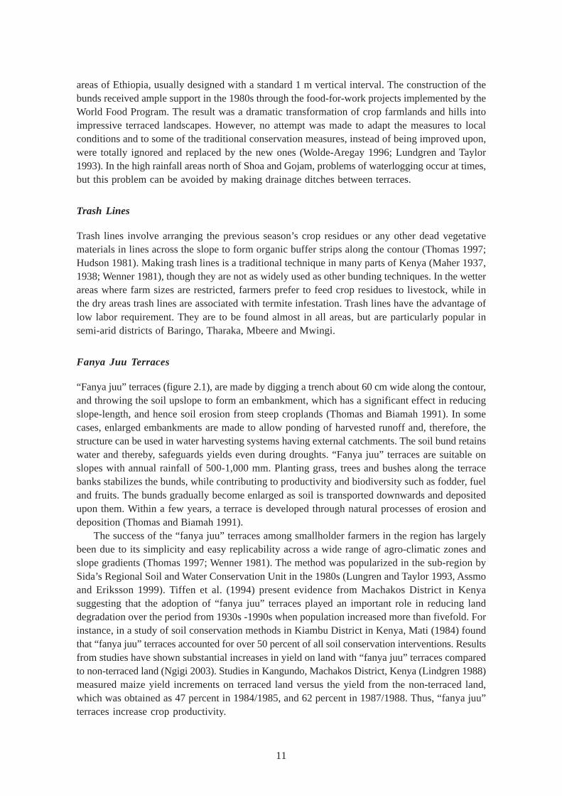
Fanya Juu Terraces
“Fanya juu” terraces (figure 2.1), are made by digging a trench about 60 cm wide along the contour,and throwing the soil upslope to form an embankment, which has a significant effect in reducingslope-length, and hence soil erosion from steep croplands (Thomas and Biamah 1991). In somecases, enlarged embankments are made to allow ponding of harvested runoff and, therefore, thestructure can be used in water harvesting systems having external catchments. The soil bund retainswater and thereby, safeguards yields even during droughts. “Fanya juu” terraces are suitable onslopes with annual rainfall of 500-1,000 mm. Planting grass, trees and bushes along the terracebanks stabilizes the bunds, while contributing to productivity and biodiversity such as fodder, fueland fruits. The bunds gradually become enlarged as soil is transported downwards and depositedupon them. Within a few years, a terrace is developed through natural processes of erosion anddeposition (Thomas and Biamah 1991).
The success of the “fanya juu” terraces among smallholder farmers in the region has largelybeen due to its simplicity and easy replicability across a wide range of agro-climatic zones andslope gradients (Thomas 1997; Wenner 1981). The method was popularized in the sub-region bySida’s Regional Soil and Water Conservation Unit in the 1980s (Lungren and Taylor 1993, Assmoand Eriksson 1999). Tiffen et al. (1994) present evidence from Machakos District in Kenyasuggesting that the adoption of “fanya juu” terraces played an important role in reducing landdegradation over the period from 1930s -1990s when population increased more than fivefold. Forinstance, in a study of soil conservation methods in Kiambu District in Kenya, Mati (1984) foundthat “fanya juu” terraces accounted for over 50 percent of all soil conservation interventions. Resultsfrom studies have shown substantial increases in yield on land with “fanya juu” terraces comparedto non-terraced land (Ngigi 2003). Studies in Kangundo, Machakos District, Kenya (Lindgren 1988)measured maize yield increments on terraced land versus the yield from the non-terraced land,which was obtained as 47 percent in 1984/1985, and 62 percent in 1987/1988. Thus, “fanya juu”terraces increase crop productivity.
12
Stone Lines
In semi-arid areas where stones are plentiful, they have been used to create bunds both as a soilconservation measure and for runoff harvesting (Duveskog 2001; Thomas 1997; Critchley et al.1992). Stones are arranged in lines across the slope to form a strong wall, and since the lines arepermeable, they slow down the runoff rate, filter it, and spread the water over the field, thusenhancing water infiltration and reducing soil erosion (Critchley and Siegert 1991). In East Africa,stone lines are commonly practiced in areas receiving 200-750 mm of annual rainfall, and are usuallyspaced about 15-30 m apart, with narrower spacing on steep slopes, and which can be reinforcedwith earth or crop residues to make them more stable (Duveskog 2001). In Kenya, there is evidencethat stone lines were used as a traditional soil conservation method in Baringo and Embu districtsin the 1930s (Maher 1938), and are presently practiced in many parts of the country where stonesare available, such as in Mbeere, Laikipia, Baringo, Mwingi, Kitui and Tharaka. In Wolloita, Ethiopia,stone lines, known locally as kella, are laid along the contour at regular intervals to stop soil erosionand are also constructed when fields are cleared. This method has been used for generations onthe stony, sloping land in the mid-altitude zones (Hilhorst and Muchena 2000). In Tanzania, stonelines are commonly used for erosion control and to create terraces for retaining irrigation water,for example, in the Pare Mountains, Dodoma and Arusha regions (Thomas and Mati 2000; Lundgrenand Taylor 1993).
Bench Terraces
Bench terraces are commonly made on steep slopes. Due to the high labor demand, they are usuallymade for high-value crops such as irrigated vegetables and coffee where the slopes are too steepfor alternative intermittent terracing. The benches are normally designed with vertical intervals
Figure 2.1. Illustration of a fanya juu terrace.
Field crops
Fruit tree
Channel 0.6 m
0.6 m
Grass
Embarkment

13
that may range from 1.2 m to 1.8 m (Thomas 1997). In East Africa, bench terraces are rarelyexcavated directly but instead, they are developed over time from other methods of terracing suchas stone lines, grass strips and trash lines or “fanya juu” terraces, so as to reduce labor and avoidhaving to move large volume of soil (Wenner 1981; Mati 1984; Thomas 1997). The objective is toachieve a level bench whose slope is zero. In the coffee growing areas, benches are made to fitone or two rows of trees, thereby achieving a closer spacing. During the colonial period in Kenya,in the 1950s, bench terracing used to be forced on local people, and after independence in 1963,many terraces were destroyed or neglected. After the soil conservation extension campaigns ofthe 1970s-1980s, bench terraces were adopted by farmers living on steep mountain slopes of Centraland Eastern Provinces, especially on farms where coffee was grown (Mati 1984; Thomas 1997).
In the drier areas, the need for water conservation has seen farmers “overdo” bench terracingso that they acquire a reverse-slope bench, meaning one with an intra-bench slope of about 2-3percent in the opposite direction (Thomas and Mati 1999). Such a bench terrace is sometimescombined with water harvesting from an external catchment, e.g., a road, to optimize the increasedstorage space. The larger capacity and, the fact, that water is ponded on the upper side ensurestability of the structure. Despite the high labor demand, reverse-bench terracing in the dry areasoffers a drought mitigation strategy. Reverse-bench terracing is treated as water harvestingstructures and is commonly found in Mwingi, Kitui, Machakos and Makueni districts.
Kainam Terraces
Kainam terraces are an indigenous technology prevalent in the hilly area southwest of LakeManyara, in Tanzania. It involves a system of intense and permanent cultivation of steep slopes inwhich terraces are made, protected by storm drains and then planted on ridges along the contour,carefully mulching and conserving moisture. Documentation on Kainam shows that the area remainswell conserved, feeding some 20,000 inhabitants (Lundgren and Taylor 1993). People live in ridgecommunities where land is communally controlled, and cooperate through “work parties” to maintainthe structures on the hillsides and drainage channels in the valleys. Livestock are not allowed tograze crop residues, which instead are dug into the fields. The soil is also enriched by manure andthe crops are carefully rotated. Fallowing is practiced, albeit with shorter intervals than in the olddays.
Conservation Tillage
The concept of conservation tillage, though not new, is gaining popularity in East Africa forsustainable crop production, especially in dry areas (Biamah et al. 2000; Jonsson et al. 2000). Afterseveral decades of soil and water conservation efforts in Africa, conservation tillage has beenrecognized as the missing link between biological methods of agroforestry, farm inputs andmechanical approaches such as terracing. The method tries to reduce labor in land preparationthrough tillage systems that promote soil fertility and soil water conservation. Conventionally, tillageis conducted to prepare a seed bed and also to control weeds. However, conventional tillage hasbeen found to destroy the structure of the soil and cause compaction. This has negative effects onsoil aeration, root development and water infiltration among other factors. More important, but lessnoticeable, is the destruction of soil microbiology by disturbance and turning over of soil, which isthen exposed to drastic atmospheric and climatic conditions (Kaumbutho 2000). Conservation tillage,therefore, takes care of this by applying four main principles: 1) zero or minimum soil turning,
14
2) permanent soil cover, 3) stubble mulch tillage, and 4) crop selection and rotations. An importantaspect of conservation tillage practice involves ripping the land with tined implements or sub-soilingthe land immediately after crops are harvested, to break the plough pans. Suitable equipmentincludes animal-drawn sub-soilers, rippers, “ridgers”, planters, and weeders (Biamah et al. 2000;Elwell et al. 2000).
Minimum Tillage
In its extreme form, minimum tillage includes zero tillage, and/or no-till subsystems where the landis planted by direct seed drilling without opening any furrows or pits. Old crop residues act as amulch and weeds are controlled using herbicides. In the dry areas of East Africa, zero tillage hasnot worked well due to poor infiltration (as soils are easily self-sealing) and costs of herbicidesbeing prohibitive. In Kenya, “no-till systems” used to be practiced mostly under large-scalemechanized wheat/barley systems, but smallholder farmers have recently started experimentingwith this system with good results, as in Machakos, Laikipia and Nyando districts. Minimum tillagealso takes the form of “spot tillage” (Thomas 1997). In this case, special tools or augers are usedto make small pits just for one or two seeds of grain over the old crop residues, and where theweeds are controlled with herbicides. In Arumeru District, Arusha Region of Tanzania, the diggingof small planting pits with hand-hoes has been quite efficient in concentrating surface water andplant nutrients as well as breaking hard plough pans. The technique is labor intensive, but simpleand is an efficient way of assuring a crop survival even when rainfall is inadequate and resourcessuch as fertilizers and manure are unavailable. Strip tillage involves cultiating the land in strips atthe position of the crop rows, leaving the rest of the land untilled, to generate runoff and reducelabor. It has successfully been practiced in Tanzania (Elwell et al. 2000). Where access to equipmentis possible, the operation can be advanced to simultaneously insert seeds (and even fertilizer) intothe soil while breaking the hard pan in the same single pass. Minimum tillage by plowing with a“magoye ripper,” which is adapted from Zambia has become popular among smallholder farmersin Kenya and Tanzania (Biamah et al. 2000; Lundgren and Taylor 1993). The subsoiler digs 25-30cm into the soil breaking the plough hard pan. It can also be used to make furrows about 80 cmapart. In Arusha Region, Tanzania, where annual rainfall ranges from 400 mm-1,200 mm, themagoye ripper was found to reduce labor and enhance crop yields in the dry years (IIRR1998).Manual subsoilers have also been developed by innovative farmers (Thomas and Mati 1999). Theequipment comprises a long hoe that can cut into about 30 cm of soil, which is made from old car-springs and therefore, is quite durable and cost-effective. The subsoiler is used once in 3 years, tobreak soil crusts developed from prolonged use of the mold-board plow.
Stubble Mulch Tillage
Stubble mulch tillage has been used as a water conservation technique in Kenya, especially in themechanized large-scale farms growing wheat and barley as found in Kitale and Timau in Kenya(Thomas 1997; Mati 1999). Normally, this involves chopping crop residues and spreading them onthe surface or incorporating them during tillage with tined implements such as the chisel plough.Stubble mulch tillage reduces labor and farm-power requirements, and, as such, it is cost-effective.Increased yields have been reported, especially in marginal areas. The system results in improvedand stable soil structure, with reduced direct impact of raindrops on bare soil, thus minimizing soil
15
erosion. Moisture retention capacity of the soil is also enhanced by the residues; hence crop survivalis better during dry spells or drought. In a study at Katumani Research Station in Machakos, Kenya,Okwach (2000) obtained results showing that mulch tillage effectively reduced runoff and soil lossthan that of the conventional tillage systems.
Ridging and Tied Ridges
Contour ridges (or contour furrows) involve making ridges along the contour at a spacing usuallyof some 1-2 m. In Kenya and Tanzania, ridging is normally done for crops such as potatoes,tobacco, groundnuts and even for maize (Assmo and Eriksson 1999). Ridging for maize involves“earthing” up the maize rows during the weeding process, albeit the maize is first planted on theflat. Plough planting is a commonly used practice in the Arusha Region (Hatibu et al. 2000). Ridgingsystems are mostly suited for areas with an annual rainfall ranging from 350 to 750 mm (Critchleyand Siegert 1991. Among farmer innovators of East Africa, ridging has emerged as one innovationthat has made a big difference in crop production (Kibwana 2000; Thomas and Mati 2000).
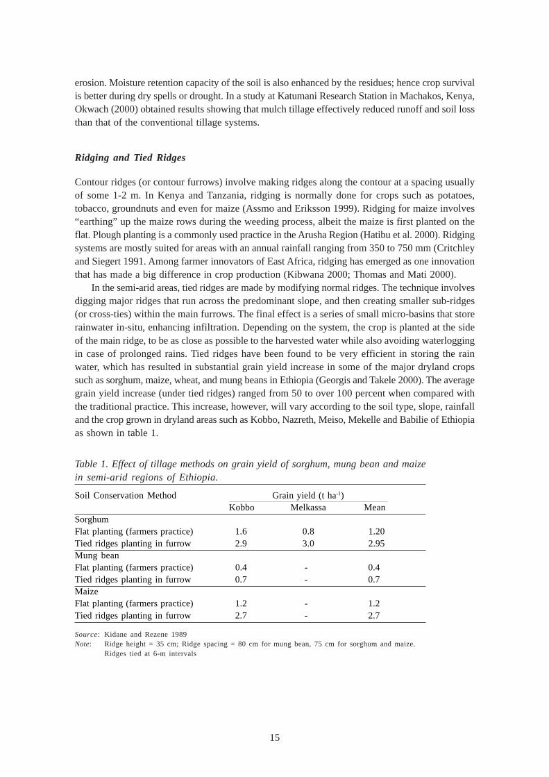
In the semi-arid areas, tied ridges are made by modifying normal ridges. The technique involvesdigging major ridges that run across the predominant slope, and then creating smaller sub-ridges(or cross-ties) within the main furrows. The final effect is a series of small micro-basins that storerainwater in-situ, enhancing infiltration. Depending on the system, the crop is planted at the sideof the main ridge, to be as close as possible to the harvested water while also avoiding waterloggingin case of prolonged rains. Tied ridges have been found to be very efficient in storing the rainwater, which has resulted in substantial grain yield increase in some of the major dryland cropssuch as sorghum, maize, wheat, and mung beans in Ethiopia (Georgis and Takele 2000). The averagegrain yield increase (under tied ridges) ranged from 50 to over 100 percent when compared withthe traditional practice. This increase, however, will vary according to the soil type, slope, rainfalland the crop grown in dryland areas such as Kobbo, Nazreth, Meiso, Mekelle and Babilie of Ethiopiaas shown in table 1.
Table 1. Effect of tillage methods on grain yield of sorghum, mung bean and maizein semi-arid regions of Ethiopia.
Soil Conservation Method Grain yield (t ha-1)Kobbo Melkassa Mean
SorghumFlat planting (farmers practice) 1.6 0.8 1.20Tied ridges planting in furrow 2.9 3.0 2.95Mung beanFlat planting (farmers practice) 0.4 - 0.4Tied ridges planting in furrow 0.7 - 0.7MaizeFlat planting (farmers practice) 1.2 - 1.2Tied ridges planting in furrow 2.7 - 2.7
Source: Kidane and Rezene 1989Note: Ridge height = 35 cm; Ridge spacing = 80 cm for mung bean, 75 cm for sorghum and maize.
Ridges tied at 6-m intervals
16
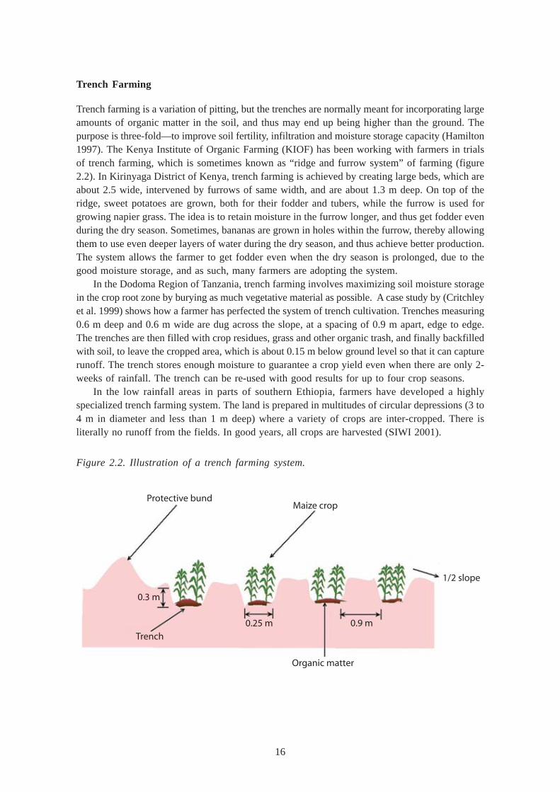
Trench Farming
Trench farming is a variation of pitting, but the trenches are normally meant for incorporating largeamounts of organic matter in the soil, and thus may end up being higher than the ground. Thepurpose is three-fold—to improve soil fertility, infiltration and moisture storage capacity (Hamilton1997). The Kenya Institute of Organic Farming (KIOF) has been working with farmers in trialsof trench farming, which is sometimes known as “ridge and furrow system” of farming (figure2.2). In Kirinyaga District of Kenya, trench farming is achieved by creating large beds, which areabout 2.5 wide, intervened by furrows of same width, and are about 1.3 m deep. On top of theridge, sweet potatoes are grown, both for their fodder and tubers, while the furrow is used forgrowing napier grass. The idea is to retain moisture in the furrow longer, and thus get fodder evenduring the dry season. Sometimes, bananas are grown in holes within the furrow, thereby allowingthem to use even deeper layers of water during the dry season, and thus achieve better production.The system allows the farmer to get fodder even when the dry season is prolonged, due to thegood moisture storage, and as such, many farmers are adopting the system.
In the Dodoma Region of Tanzania, trench farming involves maximizing soil moisture storagein the crop root zone by burying as much vegetative material as possible. A case study by (Critchleyet al. 1999) shows how a farmer has perfected the system of trench cultivation. Trenches measuring0.6 m deep and 0.6 m wide are dug across the slope, at a spacing of 0.9 m apart, edge to edge.The trenches are then filled with crop residues, grass and other organic trash, and finally backfilledwith soil, to leave the cropped area, which is about 0.15 m below ground level so that it can capturerunoff. The trench stores enough moisture to guarantee a crop yield even when there are only 2-weeks of rainfall. The trench can be re-used with good results for up to four crop seasons.
In the low rainfall areas in parts of southern Ethiopia, farmers have developed a highlyspecialized trench farming system. The land is prepared in multitudes of circular depressions (3 to4 m in diameter and less than 1 m deep) where a variety of crops are inter-cropped. There isliterally no runoff from the fields. In good years, all crops are harvested (SIWI 2001).
Figure 2.2. Illustration of a trench farming system.
Protective bundMaize crop
Trench
Organic matter
1/2 slope
0.9 m0.25 m
0.3 m
17
Silt Borrowing and Trapping
Soil borrowing from rich valleys to top-dress degraded areas has been used for rehabilitatingdegraded lands in Kenya and Tanzania. The Promoting Farmer Innovation (PFI) Project (Critchleyet al. 1999) identified several farmers in both countries who were using soil-harvesting techniquesto improve soil fertility and/or moisture retention properties (Mutunga et al. 2001; Critchley et al.1999). In Mwingi District, Kenya, two farmers, Kamuti Nthiga and Manzi Kavindu wereindependently trapping the silt fraction of the flood waters from seasonal rivers with amazing success,to build up a soil layer for growing sugarcane and fodder grass. In Dodoma, Peter Wilson andHosea Mhuma, invented a system in which they would ferry soil using wheelbarrows from nearbyhills to cover and reclaim eroded/gullied land, creating enough soil depth for irrigated high-valuevegetables (Thomas and Mati 1999).
Gully Control and Utilization
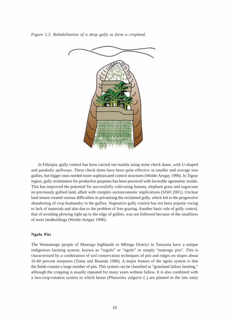
Gully erosion is a major problem in East Africa, and with the high costs associated with gullyrehabilitation, most gully control activities have, in the past, been implemented by the governmentor with external assistance. Moreover, most gullies lie on public land, e.g., grazing lands, footpathsand farm boundaries. As such, the responsibility for their rehabilitation is usually beyond the scopeof the individual. Studies in Kiambu District of Kenya (Mati 1984) showed that over 50 percent ofthe gullies emanate from road drainage. Thus in the early 1990s, soil conservation activities wereintroduced into road rehabilitation projects to protect land from damage caused by road drains (Mati1992). However, even then, the main aim was to drain away surface runoff, which was seen asa destructive problem. These perceptions were later changed in the early 2000s to embrace theconcept of water harvesting, even from gullies, for productive purposes. At last a gully could beviewed as an asset, and this was recorded in many parts of the country. Innovative farmers havebeen able to convert gullies into productive land in Mwingi, Makueni and Kitui districts. (Mburu2000; UNDP/UNSO 1999; Critchley et al. 1999). In one such case, farmer Mutembei Mwanikiof Mwingi reclaimed a gully with stone walls, well designed and complete with side spillways, andthus established level beds for cultivation of field crops through the gradual accumulation of sediment.He used stone check dams to trap sediments in the gully, in stages. Whenever a layer of silts builtup, he would increase the height over the existing stone check by about 0.3 m. At the deepestpoint, there was up to 3 meters of sediment accumulated. The total area reclaimed was around500 m2. The rehabilitated gully was supporting the cultivation of bananas and papaya as well asgreen maize. He was successful in obtaining a good yield from his crops, even as his neighbors’crops failed (figure 2.3).
Gully control activities have been undertaken in the Arusha Region of Tanzania (Assmo andEriksson 1994), where farmers have been innovative and successful in rehabilitating gullies on theirfarms and converting them to productive land. In Dodoma, farmer Raphael Chinolo and his wifecontrolled a gully system by planting bananas in deep pits (Critchley et al. 1999). They would filleach pit with 20 liters of manure before planting. The pits capture runoff, but to give extra controlof overland flow, they made terraces of earth bunds 0.6 m high, upon which they planted makarikarigrass for stability. This way, they were able to stop gully development, increase crop production,improve soil fertility, harvest runoff water and reduce soil erosion.
18
Figure 2.3. Rehabilitation of a deep gully to form a cropland.
In Ethiopia, gully control has been carried out mainly using stone check dams, with U-shapedand parabolic spillways. These check dams have been quite effective in smaller and average sizegullies, but bigger ones needed more sophisticated control structures (Wolde-Aregay 1996). In Tigrayregion, gully reclamation for productive purposes has been practiced with favorable agronomic results.This has improved the potential for successfully cultivating banana, elephant grass and sugarcaneon previously gullied land, albeit with complex socioeconomic implications (SIWI 2001). Unclearland tenure created various difficulties in privatizing the reclaimed gully, which led to the progressiveabandoning of crop husbandry in the gullies. Vegetative gully control has not been popular owingto lack of materials and also due to the problem of free grazing. Another basic rule of gully control,that of avoiding plowing right up to the edge of gullies, was not followed because of the smallnessof most landholdings (Wolde-Aregay 1996).
Ngolo Pits
The Wamatengo people of Matengo highlands in Mbinga District in Tanzania have a uniqueindigenous farming system, known as “ingolu” or “ngolo” or simply “matengo pits”. This ischaracterized by a combination of soil conservation techniques of pits and ridges on slopes about35-60 percent steepness (Temu and Bisanda 1996). A major feature of the ngolo system is thatthe fields contain a large number of pits. This system can be classified as “grassland fallow farming,”although the cropping is usually repeated for many years without fallow. It is also combined witha two-crop-rotation system in which beans (Phaseolus vulgaris L.) are planted in the late rainy
19
season of the first year and maize in the following year. As the ngolo farming system is repeatedin a 2-year cycle and as maize and beans are the two main food crops for the people of Matengohighlands, they need to own at least two fields. In the event of a decrease in the maize yield, thefield is fallowed for several years until it is fully covered with shrubs or tall grasses (Tarimo et al.1998). When a maize crop that has been grown under the ngolo system of farming was comparedwith a similar crop obtained through terracing methods (Edje and Samoka 1996), the yield fromthe ngolo system was found to be superior as shown in table 2.
Table 2. Maize yields (as % of highest) inngolo and other cultivation systems.
Cultivation systems Yield (%)
Ngolo 100
Flat cultivation 49
Constructed bench terraces 44
Ridges 43
Narrow-based contour banks 27
Formed bench terraces 22
Source: Edje and Semoka 1996
The ngolo system is also characterized by its land use in the early rainy season of the firstyear. In the month of March, the men cut the well-grown weeds in a system known as “ku-kyesa”,which requires cutting the weed as close to the ground as possible. The cut shoots are left for 2weeks to dry. The dry shoots are next gathered up into lines by a billhook. The lines stretch bothvertically and horizontally forming a grid of 1.5-2.0 m squares. The size of the square determinesthe density of the plant population. This task is called “ku-bonga,” and is done by men. The well-ordered lines become a basic design for the following work. The shoot bundles forming the linesare called “mabongi,” and all weeds growing on the field and maize stalk residues are used for it.Thereafter, the mabongi are covered with soil, forming ridges at most 20-30 cm wide and 10-20cm high. The size of the ridge affects the density of the plant population and the water-holdingcapacity of the pit. After finishing “ku-bonga” on a specified area, women cover “mabongi” withsmall amounts of topsoil in a square. Then they broadcast bean seeds on the small ridges andcover the seeds with soil. Throughout the next dry season a ngolo field is kept fallow, and at thebeginning of the rainy season, maize is planted on the ridges where beans had been grown. Theseeds are sown along the contour line. When maize reaches 20-30 cm in height, the weeds areremoved and the sediment at the bottom of the pits are dug up by a hoe and used to re-build the“mabongi.”

20
21
WATER HARVESTING TECHNOLOGIES
Interest in water harvesting is growing in East Africa, as more people are beginning to realize thatsurface runoff is a resource as important as the rain, and that it can be used for sustainable cropproduction and/or livestock watering. Consequently, there has been a major development in a diverserange of technologies in water harvesting and conservation. This has been attributed, in part, tothe transition from the imposed top-down rural development approaches to the more progressiveadoption of community-based participatory approaches (Lundgren 1993). These have probablyfavored the development of the diversified set of runoff farming techniques. Today, one can seethese techniques being used in various farming systems in the region. RWH systems are alsoapplicable over a wide range of conditions in areas where average annual rainfall is insufficient tomeet the crop water requirement, with seasonal rainfall being as low as 100 to 350 mm (Oweis etal. 2001; Critchley and Siegert 1991; SIWI 2000).
Innovations by progressive farmers seem common in the field of runoff farming (Mburu 2000;Kibwana 2001). Farmers observe the flow of surface water through their own watersheds, andbased on experimentation on trial and error basis, sophisticated runoff farming systems are developed(SIWI 2001). This can, for example, be the tapping of sheet flow from roads, diversion of sheetflow from rocky areas adjacent to the farmland, or diversion of surface runoff from footpaths.Runoff farming systems play an important role in small-scale farming practices, which is explainedby the fact that: (i) the techniques are easy to design, (ii) runoff volume is reasonably limited (sheetand rill runoff), which means that the farmer can control the inflow of water with little effort, and(iii) relatively simple methods and a significant volume of water can be added to crops during rainfallperiods.
Micro-catchment Systems
Micro-catchment systems are basins, pits, bunds and all other water harvesting systems that gettheir runoff from small areas. A portion of upslope land is allocated for runoff collection, which is“harvested” and directed to a cultivated area (cropped area) down slope. Micro-catchments arenormally within-field systems (Critchley and Siegert 1991; Hai 1998) since runoff comes from withinthe vicinity of the cropped area. The systems, generally, have a ratio of catchment to cultivatedarea ranging from 1:1 to 5:1. The Soil and Water Management Research Group at SokoineUniversity, Morogoro, Tanzania has carried out extensive research on what are known as “meskat”systems (SIWI 2001; Hatibu and Mahoo 2000). Their research, in a semi-arid area, suggests thatthe systems give significant yield increases on the runoff receiving proportions of the land, butthat farmers are not willing to adopt the system due to the significant amount of land they haveto give up for this purpose. There are many types of both micro-catchment and external catchmentsystems practiced in East Africa, such as semi-circular bunds, “negarims” (a newer micro-catchmentmethod of utilizing basins) and earth bunds.
22
Earthen Bunds
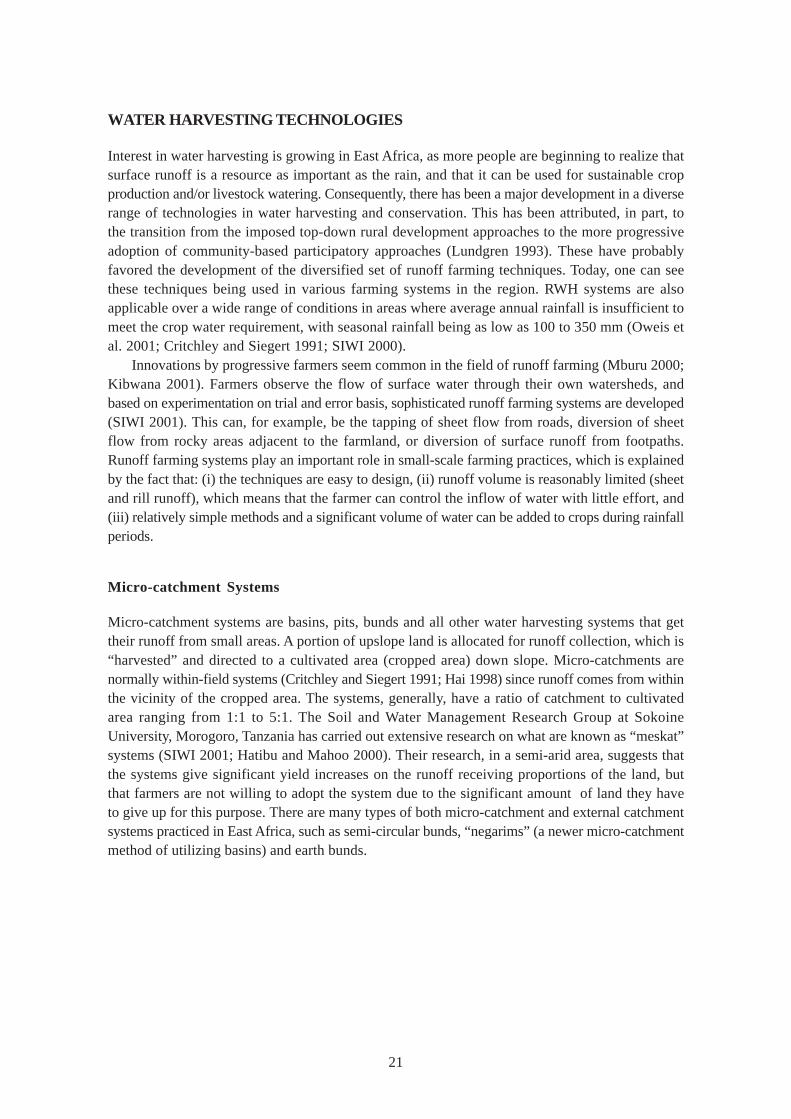
Earthen bunds are various forms of earth-shapings, which create run-on structures for pondingrunoff water. The most common are within-field runoff harvesting systems, which are increasinglygaining popularity among smallholder farmers in East Africa. This may be due to the fact thatfarm units are small, and sometimes have no opportunity for tapping an external catchment. Within-field systems also tend to require less mechanization, relying more on manual labor and animaldraught. In design, the soil bunds are aligned along the contour, with spillways at 20 m intervals tocontrol the application of surface water in each bund-section where the crop is cultivated. Bundsare set at 15-20 m intervals and the catchment to cultivated ratio ranges from 5:1 to 20:1 (Paceyand Cullis 1986). There should be a deliberate effort to distinguish bunds meant for within-fieldwater harvesting and those meant for conventional soil and water conservation (figure 3.1). Underthe runoff harvesting system, a “catchment” is maintained within the terrace to provide runoffthat will add to the natural rainfall, while under conventional bunding, the whole terrace is cultivated.
Figure 3.1. Contour bunds for field crops.
Trapezoidal Bunds
Trapezoidal bunds have an indigenous origin and are used by farmers in several arid and dry semi-arid environments in the Horn of Africa (Kenya, Somalia and Sudan). They are, generally,constructed by hand and used for subsistence cultivation. An example is one called the”teras”system, a widespread system of large earth bunds with straight walls, used to cultivate drought-tolerant crops, e.g., sorghum, in areas with a low annual rainfall of 150-300 mm (van Dijk and Reij1994). Trapezoidal bunds are large structures, sometimes over 100 m long along the contour withthe wing walls turned about 135 degrees facing upslope. The bunds are usually spaced about 20m apart, and overflow arrangements are made in a way that excess runoff from one bund canfind its way to the next. Field crops such as sorghum and millet are grown in the basins. Trapezoidalbasins of this nature utilize external catchment or runoff from beyond the immediate cropped area.
Diversion ditch
Contourbunds
Earth tie
Lateralbund
23
Examples of these have, as described by Critchley and Siegert (1991), been used to rehabilitatesemi-arid areas of Turkana and Baringo districts of Kenya. The main concern is whether trapezoidalbunds are socioeconomically viable depending on labor costs, and what equipment is used toconstruct them. Over the years, lack of mechanization and implements has seen their adoptiondecline in East Africa. Perhaps, with new advances in animal draught and other affordablemechanization technologies, renewed research into adaptable trapezoidal bunding is called for, asit is possible to treat large areas quite efficiently using this method.
Runoff from Hillsides and Rocks
Sometimes large rocky surfaces and hillsides are used as a source of runoff. This is channeledinto large basins, created by making large bunds around them (Critchley and Siegert 1991). Researchin Baringo District of Kenya (Imbira 1989) showed that due to the high runoff producingcharacteristics of the hillsides, rainfall storms of as little as 8 mm were able to initiate surfacerunoff. In field trials using runoff-harvesting system with a catchment size of one hectare, 48 percentof showers greater than 10 mm produced sufficient runoff to cause inflow into bunded basins.Field crops such as sorghum and millet could be grown in otherwise very arid conditions.
Semi-circular Bunds
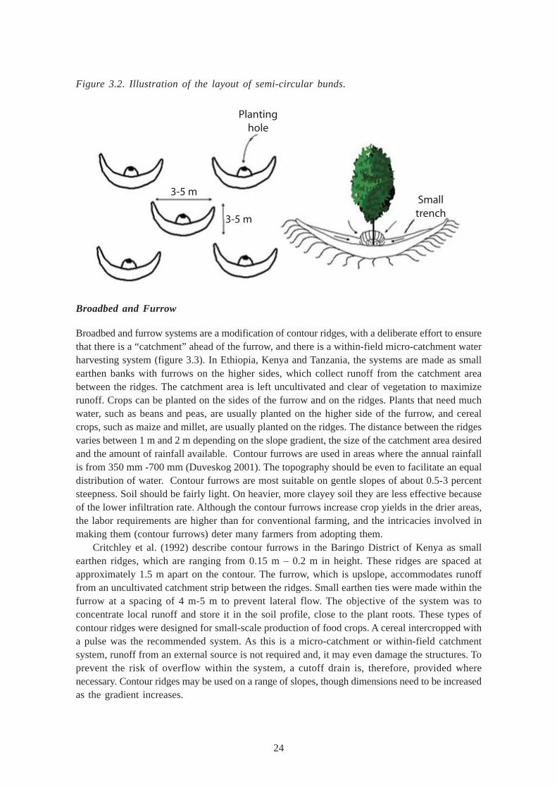
Semi-circular bunds (also known as demi-lunes or crescent-shaped bunds) are commonly made inthe semi-arid areas of Kenya, Ethiopia and Tanzania for runoff harvesting of young tree seedlings.The normal designs (Hai 1998; Critchley and Siegert 1991; Duveskog 2001) involve making earthbunds in the shape of a semi-circle with the tip of the bunds on the contour (figure 3.2). In BusiaDistrict of Kenya, semi-circular bunds are made by digging out holes along the contours. Thedimensions of the holes and the spacing of the contours are dictated by the type of crop or thefarming system. For common fruits, the holes are made with a radius of at least 0.6 m and adepth of 0.6 m. The sub-soil excavated from the pit is used to construct a semi-circular bund witha radius ranging from 3 m to 6 m on the lower side of the pit. The bund height is normally 0.25 m(Bittar 2001). The excavated planting pits are filled with a mixture of organic manure and topsoilto provide the required fertility and also to help retain the moisture. It is a common practice to findfarmers planting seasonal crops such as vegetables including beans, and other herbaceous cropsin the pits before the tree-crop develops a shady canopy. Semi-circular earth bunds are found inarid and semi-arid areas, where annual rainfall ranges from 200 mm to 275 mm, and land slopesare less than 2 percent steepness for both rangeland rehabilitation and annual crops (Thomas 1997).Sometimes, semi-circular bunds are made larger for rangeland rehabilitation and fodder production.When used for growing of trees, the runoff water is collected in an infiltration pit at the lowestpoint of the bund, where the tree-seedlings also are planted. The bunds are laid out in a staggeredarrangement so that the water which spills round the ends of the upper hill will be caught by thoselower down. The main problems associated with this type of bund are: 1) they are difficult toconstruct with animal draft; and 2) they require regular maintenance.
24
Figure 3.2. Illustration of the layout of semi-circular bunds.
Broadbed and Furrow
Broadbed and furrow systems are a modification of contour ridges, with a deliberate effort to ensurethat there is a “catchment” ahead of the furrow, and there is a within-field micro-catchment waterharvesting system (figure 3.3). In Ethiopia, Kenya and Tanzania, the systems are made as smallearthen banks with furrows on the higher sides, which collect runoff from the catchment areabetween the ridges. The catchment area is left uncultivated and clear of vegetation to maximizerunoff. Crops can be planted on the sides of the furrow and on the ridges. Plants that need muchwater, such as beans and peas, are usually planted on the higher side of the furrow, and cerealcrops, such as maize and millet, are usually planted on the ridges. The distance between the ridgesvaries between 1 m and 2 m depending on the slope gradient, the size of the catchment area desiredand the amount of rainfall available. Contour furrows are used in areas where the annual rainfallis from 350 mm -700 mm (Duveskog 2001). The topography should be even to facilitate an equaldistribution of water. Contour furrows are most suitable on gentle slopes of about 0.5-3 percentsteepness. Soil should be fairly light. On heavier, more clayey soil they are less effective becauseof the lower infiltration rate. Although the contour furrows increase crop yields in the drier areas,the labor requirements are higher than for conventional farming, and the intricacies involved inmaking them (contour furrows) deter many farmers from adopting them.
Critchley et al. (1992) describe contour furrows in the Baringo District of Kenya as smallearthen ridges, which are ranging from 0.15 m – 0.2 m in height. These ridges are spaced atapproximately 1.5 m apart on the contour. The furrow, which is upslope, accommodates runofffrom an uncultivated catchment strip between the ridges. Small earthen ties were made within thefurrow at a spacing of 4 m-5 m to prevent lateral flow. The objective of the system was toconcentrate local runoff and store it in the soil profile, close to the plant roots. These types ofcontour ridges were designed for small-scale production of food crops. A cereal intercropped witha pulse was the recommended system. As this is a micro-catchment or within-field catchmentsystem, runoff from an external source is not required and, it may even damage the structures. Toprevent the risk of overflow within the system, a cutoff drain is, therefore, provided wherenecessary. Contour ridges may be used on a range of slopes, though dimensions need to be increasedas the gradient increases.
Plantinghole
3-5 m
3-5 m
Smalltrench
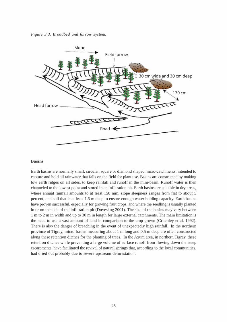
25
Figure 3.3. Broadbed and furrow system.
Basins
Earth basins are normally small, circular, square or diamond shaped micro-catchments, intended tocapture and hold all rainwater that falls on the field for plant use. Basins are constructed by makinglow earth ridges on all sides, to keep rainfall and runoff in the mini-basin. Runoff water is thenchanneled to the lowest point and stored in an infiltration pit. Earth basins are suitable in dry areas,where annual rainfall amounts to at least 150 mm, slope steepness ranges from flat to about 5percent, and soil that is at least 1.5 m deep to ensure enough water holding capacity. Earth basinshave proven successful, especially for growing fruit crops, and where the seedling is usually plantedin or on the side of the infiltration pit (Duveskog 2001). The size of the basins may vary between1 m to 2 m in width and up to 30 m in length for large external catchments. The main limitation isthe need to use a vast amount of land in comparison to the crop grown (Critchley et al. 1992).There is also the danger of breaching in the event of unexpectedly high rainfall. In the northernprovince of Tigray, micro-basins measuring about 1 m long and 0.5 m deep are often constructedalong these retention ditches for the planting of trees. In the Axum area, in northern Tigray, theseretention ditches while preventing a large volume of surface runoff from flowing down the steepescarpments, have facilitated the revival of natural springs that, according to the local communities,had dried out probably due to severe upstream deforestation.
Slope
Field furrow
30 cm wide and 30 cm deep
170 cm
Head furrow
Road
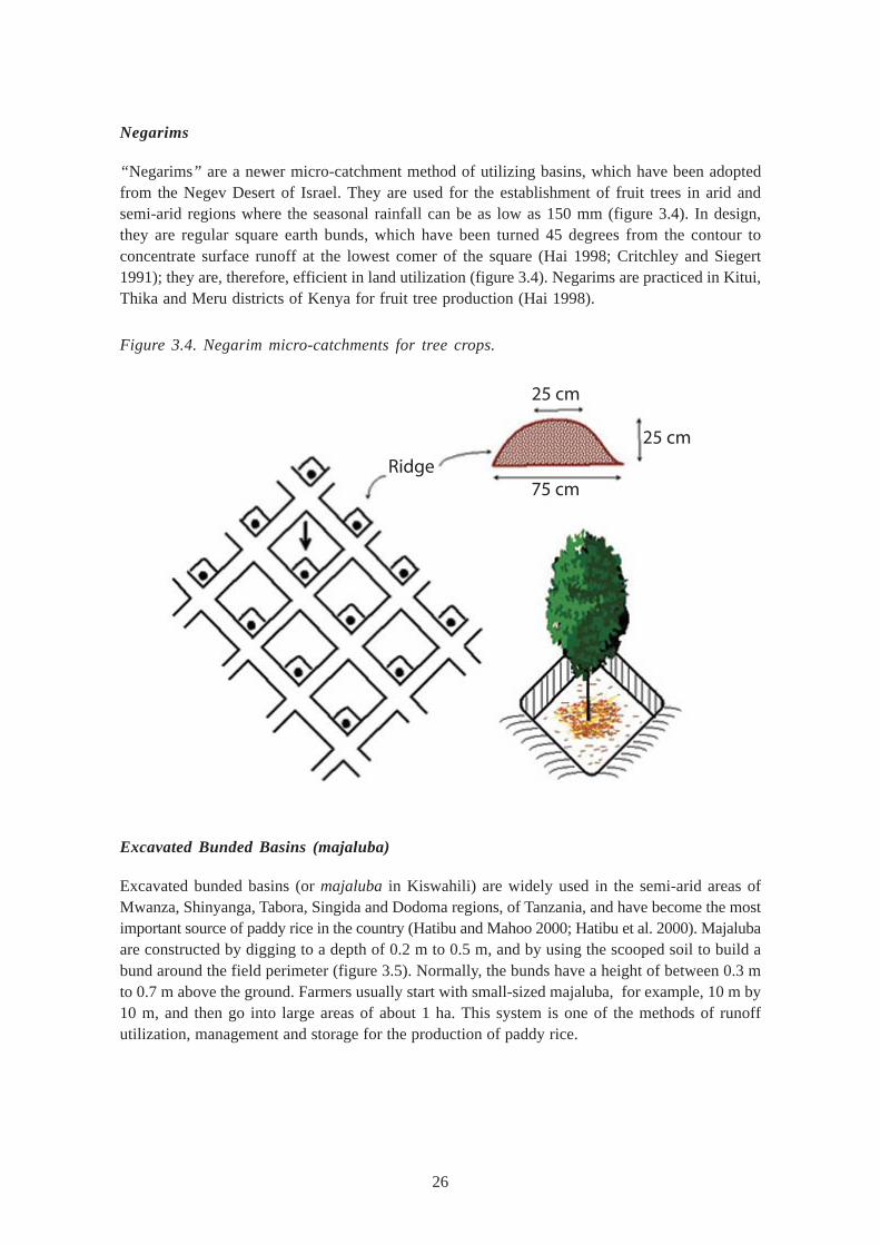
26
Negarims
“Negarims” are a newer micro-catchment method of utilizing basins, which have been adoptedfrom the Negev Desert of Israel. They are used for the establishment of fruit trees in arid andsemi-arid regions where the seasonal rainfall can be as low as 150 mm (figure 3.4). In design,they are regular square earth bunds, which have been turned 45 degrees from the contour toconcentrate surface runoff at the lowest comer of the square (Hai 1998; Critchley and Siegert1991); they are, therefore, efficient in land utilization (figure 3.4). Negarims are practiced in Kitui,Thika and Meru districts of Kenya for fruit tree production (Hai 1998).
Figure 3.4. Negarim micro-catchments for tree crops.
Excavated Bunded Basins (majaluba)
Excavated bunded basins (or majaluba in Kiswahili) are widely used in the semi-arid areas ofMwanza, Shinyanga, Tabora, Singida and Dodoma regions, of Tanzania, and have become the mostimportant source of paddy rice in the country (Hatibu and Mahoo 2000; Hatibu et al. 2000). Majalubaare constructed by digging to a depth of 0.2 m to 0.5 m, and by using the scooped soil to build abund around the field perimeter (figure 3.5). Normally, the bunds have a height of between 0.3 mto 0.7 m above the ground. Farmers usually start with small-sized majaluba, for example, 10 m by10 m, and then go into large areas of about 1 ha. This system is one of the methods of runoffutilization, management and storage for the production of paddy rice.
Ridge
25 cm
75 cm
25 cm

27
Figure 3.5. Excavated basins for road runoff harvesting.
Pitting Systems
Pitting (digging of holes of various sizes for growing crops) has been practiced as a method ofwater harvesting and conservation for both micro-catchment and external catchment systems. Pittingin East Africa has always been done for special crops such as bananas, coffee, tea and manydifferent types of fruit trees. However, pitting for field crops such as maize, millet and beans isstill viewed as novel. Pitting is done to store water and to build up soil fertility.
Zai Pits
The “zai” system has been adopted from the Sahel Region of West Africa (Critchley and Siegert1991; Reij et al. 1996) where it has been practiced for centuries. In Kenya, zai pits have beenexperimented with good results (Hai 1998). The zai utilizes shallow, wide pits that are about 0.6 min diameter and 0.3 m in depth, in which four to eight seeds of a cereal crop, e.g., maize, areplanted (figure 3.6). Manure is usually added into the pit to improve fertility. It works by acombination of water harvesting and conservation of both moisture and fertility in the pit. Therehave been some modifications of the zai system. At the Kenyan Agricultural Research Institute(KARl) at Katumani, in the Machakos District of Kenya, a locally adapted manual pitting systemhas been developed (also called the “katumani-pit”), which is similar to the small zai-pit. In theNjombe District of southern Tanzania (Malley et al. 1998), the pits are made bigger and deeper(at least 0.6 m deep), and a 20-litre volume of manure is added. Since the area receives an annualrainfall close to 1,000 mm, the farmers plant about 15-20 seeds of maize per pit and the yield ismore than double of those on conventional tilled land.
Basin for annualcrops or trees
Spillway
Road
Diversiondrain
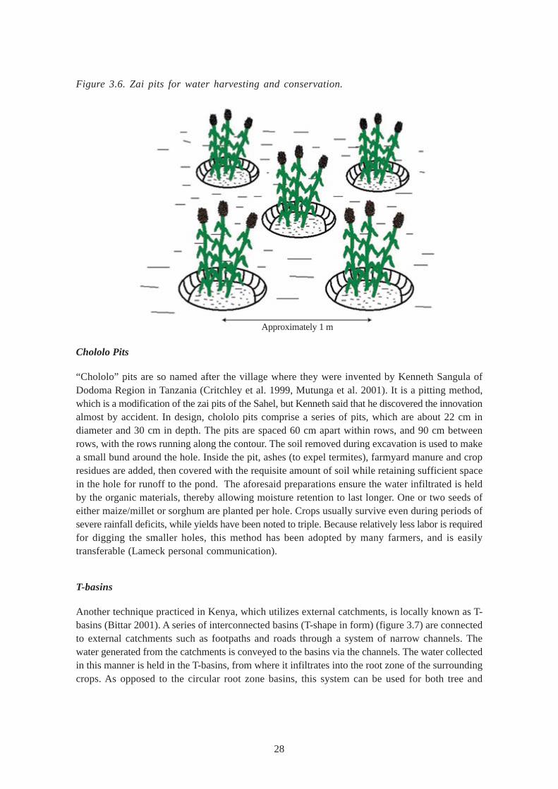
28
Chololo Pits
“Chololo” pits are so named after the village where they were invented by Kenneth Sangula ofDodoma Region in Tanzania (Critchley et al. 1999, Mutunga et al. 2001). It is a pitting method,which is a modification of the zai pits of the Sahel, but Kenneth said that he discovered the innovationalmost by accident. In design, chololo pits comprise a series of pits, which are about 22 cm indiameter and 30 cm in depth. The pits are spaced 60 cm apart within rows, and 90 cm betweenrows, with the rows running along the contour. The soil removed during excavation is used to makea small bund around the hole. Inside the pit, ashes (to expel termites), farmyard manure and cropresidues are added, then covered with the requisite amount of soil while retaining sufficient spacein the hole for runoff to the pond. The aforesaid preparations ensure the water infiltrated is heldby the organic materials, thereby allowing moisture retention to last longer. One or two seeds ofeither maize/millet or sorghum are planted per hole. Crops usually survive even during periods ofsevere rainfall deficits, while yields have been noted to triple. Because relatively less labor is requiredfor digging the smaller holes, this method has been adopted by many farmers, and is easilytransferable (Lameck personal communication).
T-basins
Another technique practiced in Kenya, which utilizes external catchments, is locally known as T-basins (Bittar 2001). A series of interconnected basins (T-shape in form) (figure 3.7) are connectedto external catchments such as footpaths and roads through a system of narrow channels. Thewater generated from the catchments is conveyed to the basins via the channels. The water collectedin this manner is held in the T-basins, from where it infiltrates into the root zone of the surroundingcrops. As opposed to the circular root zone basins, this system can be used for both tree and
Figure 3.6. Zai pits for water harvesting and conservation.
Approximately 1 m
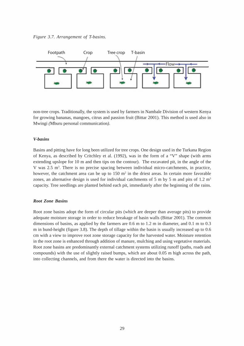
29
Figure 3.7. Arrangement of T-basins.
non-tree crops. Traditionally, the system is used by farmers in Nambale Division of western Kenyafor growing bananas, mangoes, citrus and passion fruit (Bittar 2001). This method is used also inMwingi (Mburu personal communication).
V-basins
Basins and pitting have for long been utilized for tree crops. One design used in the Turkana Regionof Kenya, as described by Critchley et al. (1992), was in the form of a “V” shape (with armsextending upslope for 10 m and then tips on the contour). The excavated pit, in the angle of theV was 2.5 m3. There is no precise spacing between individual micro-catchments, in practice,however, the catchment area can be up to 150 m2 in the driest areas. In certain more favorablezones, an alternative design is used for individual catchments of 5 m by 5 m and pits of 1.2 m3
capacity. Tree seedlings are planted behind each pit, immediately after the beginning of the rains.
Root Zone Basins
Root zone basins adopt the form of circular pits (which are deeper than average pits) to provideadequate moisture storage in order to reduce breakage of basin walls (Bittar 2001). The commondimensions of basins, as applied by the farmers are 0.6 m to 1.2 m in diameter, and 0.1 m to 0.3m in bund-height (figure 3.8). The depth of tillage within the basin is usually increased up to 0.6cm with a view to improve root zone storage capacity for the harvested water. Moisture retentionin the root zone is enhanced through addition of manure, mulching and using vegetative materials.Root zone basins are predominantly external catchment systems utilizing runoff (paths, roads andcompounds) with the use of slightly raised bumps, which are about 0.05 m high across the path,into collecting channels, and from there the water is directed into the basins.
Footpath Crop Tree crop T-basin
Flow
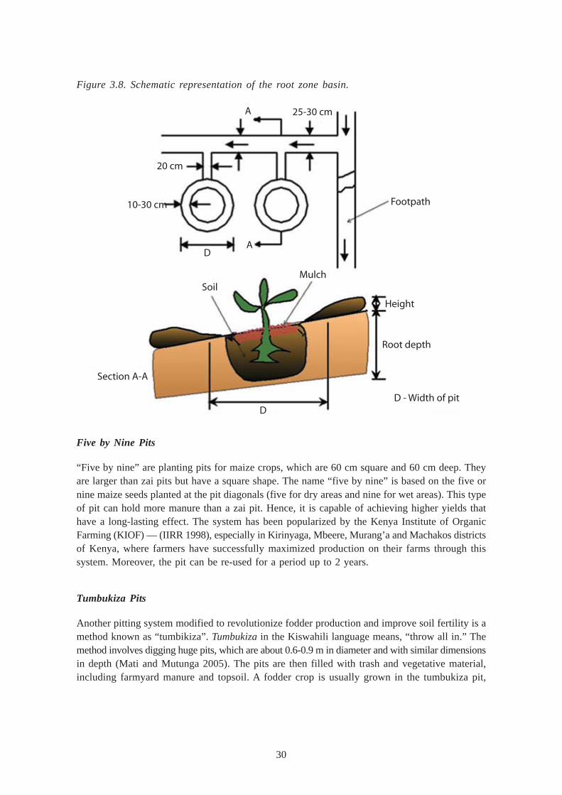
30
Figure 3.8. Schematic representation of the root zone basin.
Five by Nine Pits
“Five by nine” are planting pits for maize crops, which are 60 cm square and 60 cm deep. Theyare larger than zai pits but have a square shape. The name “five by nine” is based on the five ornine maize seeds planted at the pit diagonals (five for dry areas and nine for wet areas). This typeof pit can hold more manure than a zai pit. Hence, it is capable of achieving higher yields thathave a long-lasting effect. The system has been popularized by the Kenya Institute of OrganicFarming (KIOF) — (IIRR 1998), especially in Kirinyaga, Mbeere, Murang’a and Machakos districtsof Kenya, where farmers have successfully maximized production on their farms through thissystem. Moreover, the pit can be re-used for a period up to 2 years.
Tumbukiza Pits
Another pitting system modified to revolutionize fodder production and improve soil fertility is amethod known as “tumbikiza”. Tumbukiza in the Kiswahili language means, “throw all in.” Themethod involves digging huge pits, which are about 0.6-0.9 m in diameter and with similar dimensionsin depth (Mati and Mutunga 2005). The pits are then filled with trash and vegetative material,including farmyard manure and topsoil. A fodder crop is usually grown in the tumbukiza pit,
Section A-A
SoilMulch
Height
Root depth
D - Width of pitD
20 cm
10-30 cm
D
25-30 cmA
Footpath
A
31
preferably napier grass. In the Nyando District of Kenya, farmers apply one 20-litre jerrican ofwater per hole per day during the dry season. This amount of water is well retained by the vegetativematerial in the pit, enabling the napier grass to grow rapidly and thereby make it possible to haveone cutting per hole per day. Thus, a farmer with one cow needs 30 pits, which he/she waters atone jerrican a day to get enough fodder for the cow for the month. At the end of one cutting cycle(30 days), the fodder has grown enough to allow the next round of cutting (Mati and Mutunga2005). This method has been so popular that farmers have been adopting it all over the country.However, the high labor demand in excavating the pits has discouraged their adoption among thepoor.
Runoff Harvesting from Roads, Footpaths and Compounds
Runoff harvesting from roads, footpaths and compounds is a practice that is currently not so widelypracticed considering its potential replicability throughout the region, with the exception of Tanzania.The systems can be used for either (i) “blue” water or (ii) “green” water harvesting. Footpaths,dirt roads and compounds consist of compacted soil, often with heavy erosion crusts that producehigh volume of runoff. These are used to harvest runoff upstream for productive purposes. Inmany parts of East Africa, farmers have developed simple runoff farming techniques, where “sheetand rill” runoff generated from compacted surfaces such as roads, footpaths and householdcompounds is diverted either directly into cropped land or storage structures such as ponds.
Road runoff harvesting systems vary from simple diversion structures directing surface waterinto crop fields, to deep trenches with check-dams in order to enable both flood and subsurfaceirrigation (Thomas 1997; Hatibu et al. 2000). Where surface conditions permit, storage in panscan be quite cost-effective, as has been demonstrated by farmers of Lare in the Nakuru Districtof Kenya (Tuitoek et al. 2001). In a project where over 1,000 pans were dug to trap road runoff,the area was transformed from a food-aid recipient to a net exporter of food through this technology.In Tanzania, tapping road runoff for supplemental irrigation crops is widespread. (SIWI 2002). Inanother case at Adigudum in Tigray, Ethiopia, farmers improved a borrow site into a dam thatstores water for livestock use, thereby reducing the distance livestock have to walk to water,especially during the dry season (Haile et al. 2000).
One case study describes a method of road runoff harvesting developed by farmer MusyokaMuindi of Mwingi District, Kenya, which has become a standard design quoted in text books. Thesystem comprises an excavated main channel of about 300 m in length, which diverts road runofffrom the road to the farm. Once in the farm, the runoff is led first into a channel made across thepredominant slope, popularly known as “fanya chini” (rather like a diversion ditch). At the end ofthis channel, the water is diverted around a bend into a similar channel, this time, the flow being inthe opposite direction. This system is repeated throughout the farm resulting in a zigzag reticulatedflow (figure 3.9). At certain points, in specific channels, the farmer puts water control gates inorder to determine the direction of the flow. The channel dimensions are about 1.0 m deep and1.0 to 2.0 m wide, and with earthen embankments which are 1.5 m high and spaced at 18 m apart,making them somewhat larger than the average size. The vertical intervals between structuresare thus about 0.9 m. The embankments are stabilized with grass or sugarcane (Mutunga et al.2001).
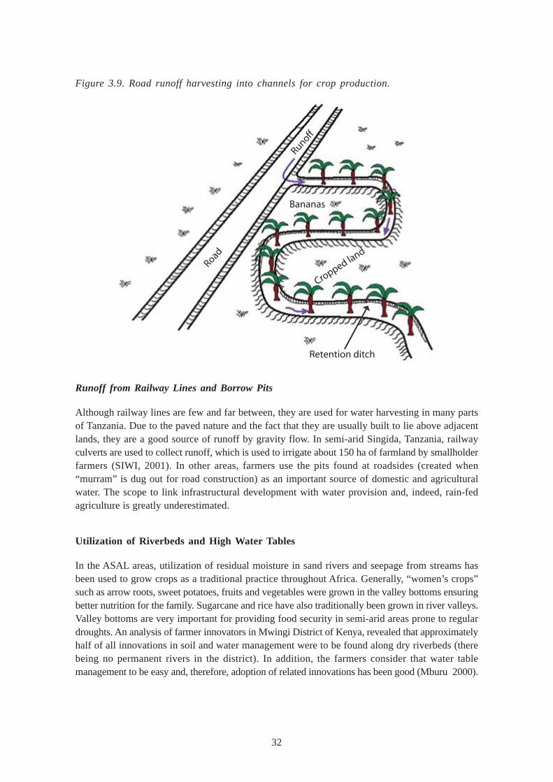
32
Figure 3.9. Road runoff harvesting into channels for crop production.
Runoff from Railway Lines and Borrow Pits
Although railway lines are few and far between, they are used for water harvesting in many partsof Tanzania. Due to the paved nature and the fact that they are usually built to lie above adjacentlands, they are a good source of runoff by gravity flow. In semi-arid Singida, Tanzania, railwayculverts are used to collect runoff, which is used to irrigate about 150 ha of farmland by smallholderfarmers (SIWI, 2001). In other areas, farmers use the pits found at roadsides (created when“murram” is dug out for road construction) as an important source of domestic and agriculturalwater. The scope to link infrastructural development with water provision and, indeed, rain-fedagriculture is greatly underestimated.
Utilization of Riverbeds and High Water Tables
In the ASAL areas, utilization of residual moisture in sand rivers and seepage from streams hasbeen used to grow crops as a traditional practice throughout Africa. Generally, “women’s crops”such as arrow roots, sweet potatoes, fruits and vegetables were grown in the valley bottoms ensuringbetter nutrition for the family. Sugarcane and rice have also traditionally been grown in river valleys.Valley bottoms are very important for providing food security in semi-arid areas prone to regulardroughts. An analysis of farmer innovators in Mwingi District of Kenya, revealed that approximatelyhalf of all innovations in soil and water management were to be found along dry riverbeds (therebeing no permanent rivers in the district). In addition, the farmers consider that water tablemanagement to be easy and, therefore, adoption of related innovations has been good (Mburu 2000).
Bananas
Cropped land
Road
Retention ditch
Runoff
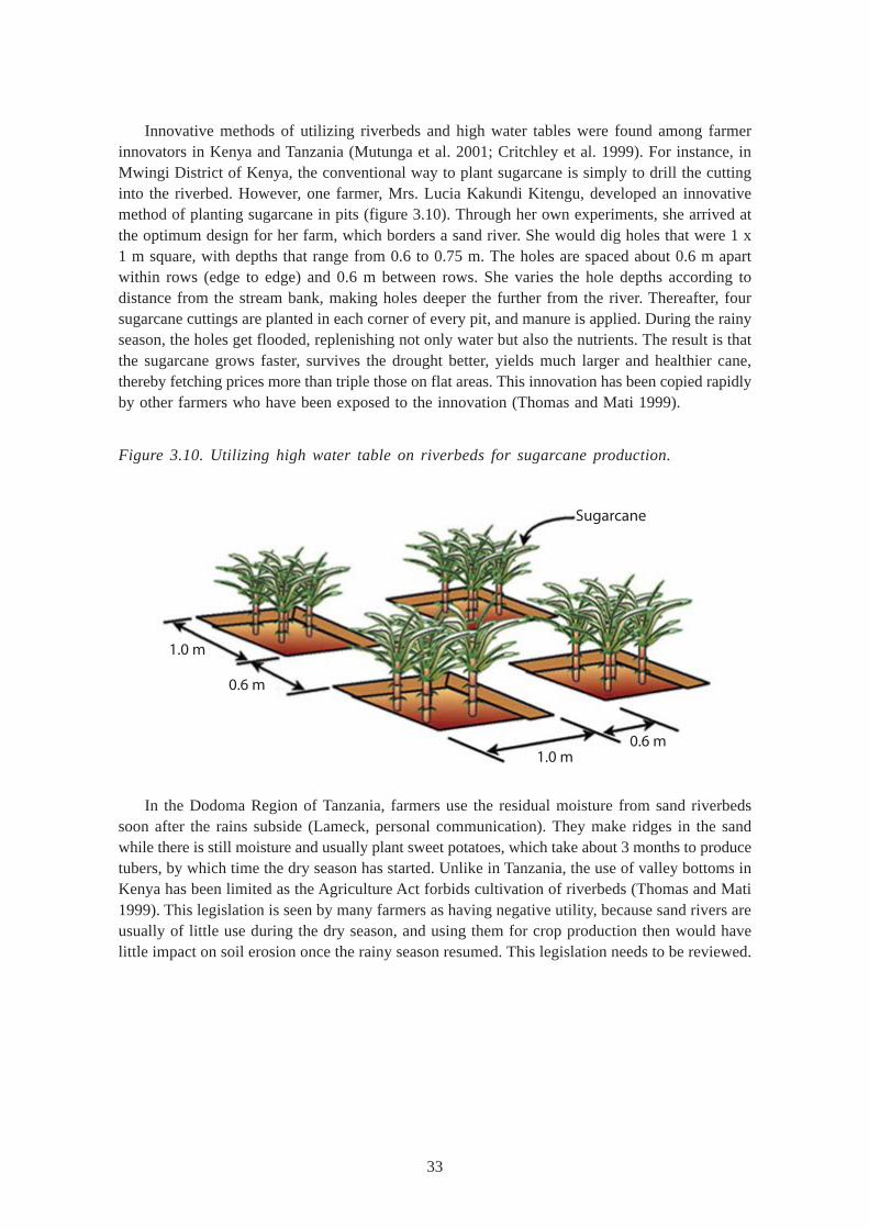
33
Innovative methods of utilizing riverbeds and high water tables were found among farmerinnovators in Kenya and Tanzania (Mutunga et al. 2001; Critchley et al. 1999). For instance, inMwingi District of Kenya, the conventional way to plant sugarcane is simply to drill the cuttinginto the riverbed. However, one farmer, Mrs. Lucia Kakundi Kitengu, developed an innovativemethod of planting sugarcane in pits (figure 3.10). Through her own experiments, she arrived atthe optimum design for her farm, which borders a sand river. She would dig holes that were 1 x1 m square, with depths that range from 0.6 to 0.75 m. The holes are spaced about 0.6 m apartwithin rows (edge to edge) and 0.6 m between rows. She varies the hole depths according todistance from the stream bank, making holes deeper the further from the river. Thereafter, foursugarcane cuttings are planted in each corner of every pit, and manure is applied. During the rainyseason, the holes get flooded, replenishing not only water but also the nutrients. The result is thatthe sugarcane grows faster, survives the drought better, yields much larger and healthier cane,thereby fetching prices more than triple those on flat areas. This innovation has been copied rapidlyby other farmers who have been exposed to the innovation (Thomas and Mati 1999).
1.0 m
0.6 m
1.0 m0.6 m
Sugarcane
Figure 3.10. Utilizing high water table on riverbeds for sugarcane production.
In the Dodoma Region of Tanzania, farmers use the residual moisture from sand riverbedssoon after the rains subside (Lameck, personal communication). They make ridges in the sandwhile there is still moisture and usually plant sweet potatoes, which take about 3 months to producetubers, by which time the dry season has started. Unlike in Tanzania, the use of valley bottoms inKenya has been limited as the Agriculture Act forbids cultivation of riverbeds (Thomas and Mati1999). This legislation is seen by many farmers as having negative utility, because sand rivers areusually of little use during the dry season, and using them for crop production then would havelittle impact on soil erosion once the rainy season resumed. This legislation needs to be reviewed.

34
Spate Irrigation
Floodwater diversion or spate irrigation techniques are those which force the water to leave itsnatural course, something it would not do without manipulation (Critchley et al. 1992). Spate irrigation,or diversion of flood flow from highlands into lowlands and “wadis”, has a long history in the Hornof Africa, and still forms the livelihood base for rural communities in arid parts of Eritrea and theupper rift valley in Ethiopia (SIWI 2001). Storm-floods are harvested from rainfall-rich highlands,and diverted into leveled basins in the arid lowlands. In Eritrea, the embankments conveying thestorm-water can be extremely large (5 m to 10 m high), and are built by shoveling the sandy soilusing animal traction. The maintenance of the embankments is very labor intensive, hence it iscarried out on a community scale (Negassi et al. 2000).
In the arid and semi-arid areas of Ethiopia, water is an important limiting factor to crop growth(Haile and Tsegaye 2002). Floodwater harvesting has helped convert dry valleys and flood plainsinto more productive lands, growing a variety of crops such as fruit trees, forage crops and cereals(Critchley et al. 1992). One case study done on agro-pastoral lands in Abaala showed that sorghumand maize are grown in an area receiving rainfall in the range of 300-550 mm/yr.-1 This amountof water is obtained annually by diverting rivers through the use of shrubs/trees, stone and soil.The farmers started producing crops following the 1983 to 1985 drought and the subsequent lossof livestock, and also with a view to supplement livestock production whenever there was goodrainfall or floods.
In Tanzania, spate irrigation is also practiced in the drought-prone regions of Dodoma, Singida,Tabora, Shinyanga, Arusha and Mwanza. The Smallholder Development Project for Marginal Areas(SDPMA) was an IFAD-funded project in Tanzania that became operational in 1990/1991 (Galletet al. 1996). The project aimed at improving household food security and incomes of smallholderfarmers. It involved smallholder irrigation development based on RWH, strengthening extensionservices, land survey and registration, and credit. In the first phase (1991-1997), the irrigationdevelopment component was designed to establish about 25-30 RWH irrigation-based schemes.About 4,000 ha of marginal lands were planned to be developed for 8,000 farm families (Gallet etal. 1996). The project was able to: 1) construct river diversions and flood protection works for 18schemes; 2) land leveling and demarcation of 0.5 ha plots for cultivation by individual farm families;and 3) construct access roads. As most of the schemes were being implemented in areas whereRWH for paddy production was common, the rate of adoption was high. It was noted that oneachievement of the program was the increase in the yield of rice in RWH systems (majaluba)from 1 to 4 t ha-1. However, most of the structures were damaged during the El-Nino rains of1997/1998. There are major lessons to be learned from what happened during El-Nino rains (Hatibuet al. 2000).
Spate diversion systems have also been practiced in Turkana District of Kenya with good results(Critchley et al. 1992). The diversion (water spreading) schemes consist of earthen embankmentsthat divert part of the flow of wadis into channels, leading the discharge to plains where bundsspread and impound the flow. Some of these schemes are for fodder, and some others are forcrops. While there is a considerable range, the schemes are generally expensive (approximatelyUS$ 1,000/ha) to construct and difficult to maintain due to the frequent bund breakages. Thedifferent characteristics of each site make engineering design particularly problematic.
35
Micro-irrigation
Micro-irrigation techniques are gaining popularity among small-scale farmers, especially those usingwater harvested in tanks and small pans. This is due to the need to make use of limited amountsof water and grow high-value crops or for tree establishment. The most common types of micro-irrigation include bucket drip kits, pitcher pots, bamboo sub-irrigation and bottle-feeding of youngtree seedlings.
Bucket Drip Kits
Bucket and drum drip kits are a fast-growing adaptation by smallholder farmers in East Africa,since their introduction to the market in the late 1990s. The most popular and also the cheapestare bucket drip kit systems, which consist two drip lines, each 15-30 m long with emitters spacedabout 0.1 to 0.3 m apart, and a 20-litre bucket for holding the water. Each drip line is connectedto a filter to remove any impurities that may clog the drip nozzles. The bucket is supported by astand, with the bottom of the bucket at least one meter above the planting surface. Such a drip kitrequires about 40-80 liters of water per day to irrigate about 100 to 200 plants. The most popularcrops are high-value vegetables such as tomatoes, cabbage and spinach. Studies by KARI haveshown that farmers earned about US$26 to US$40 per season from single bucket kits that costapproximately US$15 in Kenya (Sijali and Okumu 2002; Sijali 2001). However, farmers areconfronted with the problem of pests and chickens feeding on their crops, and this is mainly dueto such small gardens being the only green areas to be found during the dry season.
Pitcher Irrigation
Pitcher irrigation involves the use of unglazed clay pots, which are buried adjacent to the croproot zone. Such pots are made by women in the traditional way, but the clay is mixed with saw-dust to create porosity when the pot is fired during curing. The pot is filled with water and coveredwith a clay slab or polythene paper, to reduce evaporation losses. Water seeps slowly through theporous sides of the pot. The minute hairs of nearby plants pull the water out from the pots. Themethod encourages deeper rooting and reduced evaporation. The method is commonly used forfruit-tree crop production (Vulkasin et al. 1995).
A modification of the pitcher pot by the Kavilo Women’s Group of Machakos District, Kenyainvolves making clay pots that have small holes punched in the mold. The pot is placed aboveground between vegetable crops. The tiny holes can be closed using small sticks, and opened forirrigation when necessary. The advantage is that the farmer has control over the water application.However, there is a limitation of higher discharge rates and also evaporation as water is applied atthe soil surface.
36
Bottle-feeding of Young Tree Seedlings
Bottle-feeding tree seedlings is a water-saving technique for tree establishment in semi-arid areas,which have water scarcity. A bottle is filled with clean water and sealed with a top. A small holeis punched onto the bottle top. The bottle is then inserted into the soil at the tree root zone, ensuringthat it lies at an angle. It is a kind of modified drip irrigation in which water enters the soil as smalldroplets, lasting several days, after which the bottle is refilled. This way, water loss by evaporationis reduced to a minimum (Vukasin et al. 1995).
The method is suitable and has been applied in the establishment of forest trees and fruit treesin the dryland districts of Kenya such as Kitui, Machakos, Laikipia and Tharaka. In Budalangi,farmers bury the bottle under the soil to regulate the water temperature and have recorded anincrease in tree survival from about 20 percent to almost 100 percent (Bittar 2001). Their trialsindicated that white plastic bottles were the best since they do not have a big temperature variation.One liter of water can last for about 2 weeks before refilling. For most trees, this technique needonly be applied during the first 2 years of growth when the young tree has not developed a deeproot system to extract water from deep soil horizons (Bittar 2001). Using this technique, it hasbeen possible to grow trees in areas where rainfall is received only 2-3 months per a year and,therefore, tree growing without some form of water application is very difficult.
Bag Gardening
Bag gardening is an economical way to grow vegetables as it utilizes air space above the physicallimits of the farm, thereby maximizing production where land is a limited resource. The gardensare suitable for both rural and urban areas, including families living in flats. In addition, pests anddiseases are fewer and easier to control. In most rural households, bag gardens are used to growvegetables by utilizing kitchen wastewater, especially where water is really a scarce commodity(Njoroge 1997). Bag gardens come in many shapes and sizes, with the most common type beingthe utilization of old gunny bags, usually borrowed or bought at a very low price (US$0.10). Atypical garden (figure 3.11) is prepared utilizing a used 90 kg jute bag, especially those used inpackaging sugar or cereals. Holes are first punched about 2 cm in diameter and at a spacing of0.25 m-3.0 m starting about 0.15 m from the bottom. The bag is filled with soil that contains about20 percent well decomposed manure. A watering shaft is created in the soil by placing three postsat the centre of the bag, then packing the space in between with gravel and straw. This shaft actslike a vertical piped sub-irrigation conduit. The garden is watered and vegetable seedlings such askales, tomato and, spinach are planted through the holes as well as at the top of the bag, which isthen covered with mulch. Depending on bag size and crop type, a plant population of 20-50 ispossible. The bag garden is kept in the sunshine.
The advantages of a bag garden include intensive utilization of space and scarce water. Thereis almost no weed control, and damage from pests such as chicken and snails can be avoided byplacing the bag on a platform above the ground. Large insect pests can also be avoided by coveringthe bag with a net. Depending on management, vegetables can grow well for their entire life cycle,which lasts about one year or longer.
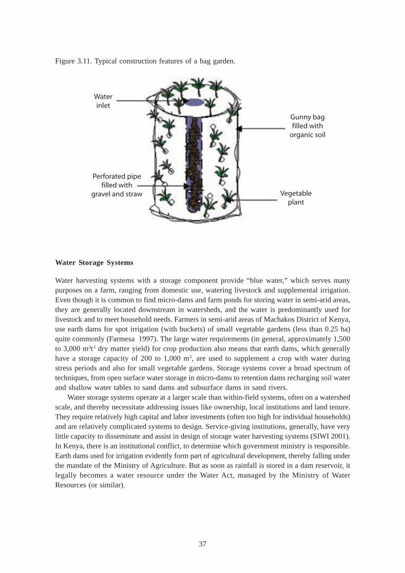
37
Water Storage Systems
Water harvesting systems with a storage component provide “blue water,” which serves manypurposes on a farm, ranging from domestic use, watering livestock and supplemental irrigation.Even though it is common to find micro-dams and farm ponds for storing water in semi-arid areas,they are generally located downstream in watersheds, and the water is predominantly used forlivestock and to meet household needs. Farmers in semi-arid areas of Machakos District of Kenya,use earth dams for spot irrigation (with buckets) of small vegetable gardens (less than 0.25 ha)quite commonly (Farmesa 1997). The large water requirements (in general, approximately 1,500to 3,000 m3t-l dry matter yield) for crop production also means that earth dams, which generallyhave a storage capacity of 200 to 1,000 m3, are used to supplement a crop with water duringstress periods and also for small vegetable gardens. Storage systems cover a broad spectrum oftechniques, from open surface water storage in micro-dams to retention dams recharging soil waterand shallow water tables to sand dams and subsurface dams in sand rivers.
Water storage systems operate at a larger scale than within-field systems, often on a watershedscale, and thereby necessitate addressing issues like ownership, local institutions and land tenure.They require relatively high capital and labor investments (often too high for individual households)and are relatively complicated systems to design. Service-giving institutions, generally, have verylittle capacity to disseminate and assist in design of storage water harvesting systems (SIWI 2001).In Kenya, there is an institutional conflict, to determine which government ministry is responsible.Earth dams used for irrigation evidently form part of agricultural development, thereby falling underthe mandate of the Ministry of Agriculture. But as soon as rainfall is stored in a dam reservoir, itlegally becomes a water resource under the Water Act, managed by the Ministry of WaterResources (or similar).
Figure 3.11. Typical construction features of a bag garden.
Gunny bagfilled with
organic soil
Vegetableplant
Waterinlet
Perforated pipefilled with
gravel and straw
38
Roof Catchment with Aboveground Tank
Rainwater harvesting from impervious roofs (clay tiles and galvanized iron roofs) is a popular methodadopted to secure water for domestic use, because it provides water at home, is affordable, easyto practice regardless of physical or climatic conditions and can be designed to suit differentconditions (available finances, roof area, family size etc.,). Since the structure is family owned,maintenance is usually very good and no water conflicts occur. Surface tanks may vary in sizefrom 1 m3 to more than 40 m3 for households and up to 100 m3 or more for schools and hospitals.The tank size is dependent on the rainfall regime and the demand. Areas with seasonal rainfallwill require larger tanks (25 m3 to 35 m3) and a roof probably exceeding 100 m2 would be requiredif total household demand is to be met throughout the dry period. Another benefit of surface tanks(compared to sub-surface tanks) is that water can be extracted easily through a tap just above thebase of the tank. If placing it on a stand or base elevates the tank, water can be piped by gravityto where it is required. In addition, construction of such water tanks makes use of locally availablematerials and local artisans, thus creating employment (Gould and Nissen-Peterssen 1999).
The main reason this technology has not been widely adopted is the relatively high costs involved(by local standards). On average, the per capita daily water requirement in rural areas is 20 liters.Using Kenyan estimates (Mati 2002), the cost of tank construction per capita is about US$150(equivalent to about US$0.07 per liter) — as a tank can last up to 30 years or more, the investmentis considered cost-effective. Another problem has been structural failure, especially of concretebuilt tanks. Though reasons for this vary, ranging from use of low cement, aggregate mixes, poorquality sand, bad workmanship, poor curing process during construction and generally poormanagement (e.g., some families drain the tank completely dry). However, when well constructedand maintained, surface tanks provide a durable and long-lasting source of clean water forhouseholds, schools and communities. Other than roofs, surface tanks can be constructed belowlarge rock catchments, especially for community water supplies. The water obtained is, generally,of a higher quality than from the conventional boreholes in the ASAL areas. Such tanks should beof a large enough capacity, and the community must be trained in how to manage the catchmentand share the water equitably (Mati 2002).
Underground Tanks
Underground tanks offer a cheaper alternative due to its lower construction costs compared tothose of surface tanks. They are, especially suited for homesteads having thatched roofs, traditionalstructures (e.g., Maasai manyattas) and other surfaces, including collection of runoff from pavedareas and roads. However, it is necessary to pump (lift) water, except where the ground gradientpermits and where gravity outlets are constructed (Cherogony 2000). Another problem is higherpossibility of contamination and sedimentation, although the latter can be reduced by providingadequate siltation basins. Perhaps the main problem is the lack of adequate expertise at villagelevel to design and construct underground tanks that do not pose a security risk and are functional.In Machakos District, improved designs of underground tanks (Nega and Kimeu 2002) have seenmore farmers adopt them for road runoff harvesting with good results. The underground tanks arepreferred in home compounds and are designed as spherical or cylindrical and constructed usingbricks. These small tanks (20 to 50 m3) permit irrigation of small kitchen vegetable gardens, andcan be quite cost-effective. In Machakos District, the cost of constructing a cylindrical tank (sausagetank) of 15 m3 capacity was found to be about Kenya Shillings 15,000 (US$190), equivalent toabout one shilling per liter of water harvested (Ngigi 2003). Rectangular and semi-circular plastic
39
lined tanks are also gaining popularity due to the ease of construction, and also the fact that theyare more affordable.
Birkas
In the Somali Region of Ethiopia, underground cisterns, locally known as “birkas,” are used forwater harvesting (Guleid 2002). Birkas are an indigenous technology and usually family-owned.They are rectangular underground tanks, lined with concrete on impermeable clay tile, mostly fordomestic water supplies. In recent years, the Ministry of Water Resources in Ethiopia has beenpromoting water harvesting through the excavation of underground tanks and pans (Nega and Kimeu2002). The tanks permit irrigation of small kitchen vegetable gardens (100 to 200 m) and animalwatering. The main problem is the heavy labor demand for excavating the pans and making tankfoundations. Also, there is the need to pump (lift) water except where the ground gradient permitsgravity outlets. There is also the higher possibility of contamination and sedimentation, althoughthe latter can be reduced by providing adequate siltation basins.
Excavated Pans and Ponds
Excavated pans are shallow depressions (1 m-3 m deep) constructed to collect and hold runoffwater from various surfaces including from hillsides, roads, rocky areas and open rangelands. Panshave been used for rainwater harvesting in many parts of East Africa, especially for livestockwatering. Excavated pans were made popular by “food-for work “programs in the drylands ofKenya and Ethiopia. The pans can be used to collect runoff from the home compound, wherehouses are grass-thatched or made of cow dung (manyatta) as shown in figure 3.12. When properlydesigned and with good sedimentation basins, the water collected can be used for livestock wateringor to supplement the irrigation of crops.
Figure 3.12. Water harvesting from a rural homestead into an earthen pan.
Sedimentationbasin
Waterpan
Earthbund
40
Problems associated with water pans are: 1) the relatively small capacities; 2) high siltationrates; 3) loss of water through seepage and, 4) high evaporation losses. In an assessment of waterresources of Isiolo District, Mati (2003), found that of the 12 operational pans in the district onlyone provided water throughout the year. In addition, there were high levels of water contaminationas most of the pans had not been fenced, which allowed livestock and humans to have direct accessto the water in the pans. To control seepage losses, plastic lining of underground tanks and panshas been gaining popularity (Cherogony 2000). However, the high cost of good-quality (dam-plastic)material and the necessity to make-to-measure in large factories in the capital, Nairobi, are majorconstraints for poor smallholder farmers. Cheaper methods such as clay grouting need to beencouraged, but the problem is usually finding good quality clay material.
Charco Dams
“Charco” dams are really small excavated pits or ponds, which are constructed at well-selectedsites on a relatively flat topography for livestock watering (Hatibu et al. 2000). The design is simpleand can be implemented at village level with minimum of engineering requirements. For highefficiency in water collection, the pond is situated at the lowest point of the topography. Theexcavation, achieving depths of 3 m, can be done by machinery or by hand. The right site may beselected using contour maps of the area or by observing where water collects naturally. Charcodams are commonly found in Shinyanga, Dodoma, Arusha, Tabora, Singida and Mwanza regionsof Tanzania.
Small Earthen Dams
When larger quantities of water are desired, earthen dams are preferred. An earthen dam isconstructed either on-stream or off-stream, where there is a source of large quantities of channelflow. The dam wall is normally 2 m to 5 m high and has a clay core and stone aprons and spillwaysto discharge excess runoff. Volume of water ranges from hundreds to tens of thousands of cubicmeters. Reservoirs with a water volume less than 5,000 m3 are usually called ponds. Due to thehigh costs of construction, earthen dams are usually constructed through donor-funded projects.For instance, in the Laikipia District of Kenya, the excavation of an earth dam 15,000 m3 costabout US$5,000 (Mati 2002). However, there have been cases of smallholder farmers diggingearthen dams manually in Mwingi District (Mburu 2000). Earth dams can provide adequate waterfor irrigation projects as well as for livestock watering. Low earthen dams, called “malambo”, arecommon in the Dodoma, Shinyanga and Pwani regions of Tanzania (Hatibu et al. 2000). It involvesdam construction to collect water from less than 20 km2 for a steep catchment to 70 km2 for flatcatchment. Some of these are medium-scale reservoirs used for urban or irrigation water supply.Sediment traps and delivery wells may help to improve water quality but, as with water from earthendams, it is usually not suitable for drinking without being subject to treatment.
Hafir Dams
“Hafir” dams are found in East Ethiopia (Guleid 2002). They are either natural or man-madedepressions, where runoff water collects, and is used by humans and livestock. Hafirs are, generally,
41
excavated reservoirs with a water volume ranging from 500-10,000 m3. Hafirs are located in naturaldepressions and the excavated soil is used to form banks around the reservoir to increase itscapacity. Bunds and improvements to the catchment apron may help to increase runoff into thereservoir, but seepage and evaporation are often high in the dry season. Hafirs differ from otherearthen dams as they are generally bigger in size, and also have good sedimentation basins. Althoughlivestock and people drink directly from earthen dams, in hafirs, watering areas are well allocated,the site is securely fenced and the reservoir is de-silted every season. High water turbidity andsedimentation problems are major drawbacks in eathen dams. And in the case of hafirs the majordrawback is the requirement of periodic cleaning to remove silt, which is not an easy task.
Sand and Subsurface Dams
In seasonal rivers in semi-arid areas of East Africa, river profiles usually comprise sand, hencethe term “sand river.” Sand rivers (“lugga”, “wadi”, and “khor”) are ephemeral water courses,which tend to be dry most of the year (Nissen-Peterssen 2000). However, they are subject toflooding during the rainy season. And during such times if a barrier is constructed across the riverthe water can be stored in the voids within the sand. The most convenient way to harvest waterin a sand river is by either sand or subsurface dams. Local materials for construction are usuallyavailable and the only extra cost is that of cement and labor. Local people are usually trained onhow to identify a suitable site and in the construction techniques. A case study in Machakos Districtshowed that a sand dam has been successfully used to supply the annual water requirements of acommunity of 3,000. For instance, subsurface dams in Machakos District of Kenya cost thecommunity about US$0.20-0.30 per m3 of water (Nissen-Peterssen 2000), but these costs are easilyrecoverable in the long run. The advantage with sand river storage is that it normally representsan upgrading of a traditional and, hence, socially acceptable water source. Because the water isstored under the sand it is protected from significant evaporation losses and is also less liable tobe contaminated. The construction of river intakes and hand-dug wells with hand pumps in theriver bank can further help to improve the quality of water.
Nissen-Peterssen (1996) distinguished between three types of subsurface dams: (i) sand dambuilt of masonry, (ii) subsurface dams built of stone masonry, and (iii) subsurface dams built ofclay. Therefore, where deep sand can be found, it is cost- effective to consider the possibility ofsubsurface sand dams for the storage of the harvested water. A sand dam is a wall constructedacross the stream to restrict surface flow. The height of the dam wall is increased by 0.3 m afterfloods have deposited sand to the level of the spillway. This allows sand to be trapped upstreamof the dam wall increasing the overall storage capacity of the riverbed. Sand dams are similar tosubsurface dams except that the top of the dam wall exceeds the level of the sandy riverbed. Asubsurface dam is where the wall embankment is below the ground. Compacted clay is sometimesused to create the embankment for a subsurface dam. Sometimes the structure is integrated witha drift for river crossing purposes, thereby costing much less. Subsurface and sand dams shouldbe built slowly in stages because if built too high, silt settles in the dam instead of sand. It shouldgo down to the impervious layer below the sand. The water in the sand dam can be reserved fora long time due to low evaporative losses.
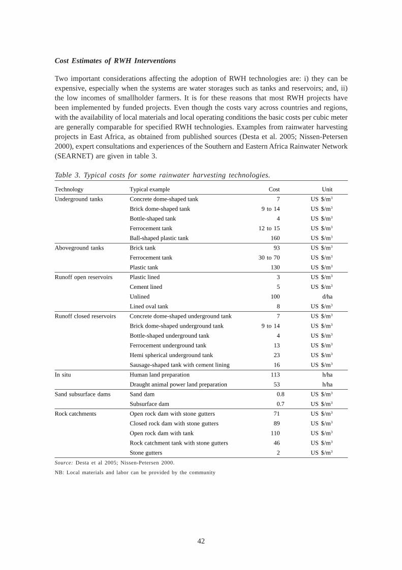
42
Cost Estimates of RWH Interventions
Two important considerations affecting the adoption of RWH technologies are: i) they can beexpensive, especially when the systems are water storages such as tanks and reservoirs; and, ii)the low incomes of smallholder farmers. It is for these reasons that most RWH projects havebeen implemented by funded projects. Even though the costs vary across countries and regions,with the availability of local materials and local operating conditions the basic costs per cubic meterare generally comparable for specified RWH technologies. Examples from rainwater harvestingprojects in East Africa, as obtained from published sources (Desta et al. 2005; Nissen-Petersen2000), expert consultations and experiences of the Southern and Eastern Africa Rainwater Network(SEARNET) are given in table 3.
Table 3. Typical costs for some rainwater harvesting technologies.
Technology Typical example Cost Unit
Underground tanks Concrete dome-shaped tank 7 US $/m3
Brick dome-shaped tank 9 to 14 US $/m3
Bottle-shaped tank 4 US $/m3
Ferrocement tank 12 to 15 US $/m3
Ball-shaped plastic tank 160 US $/m3
Aboveground tanks Brick tank 93 US $/m3
Ferrocement tank 30 to 70 US $/m3
Plastic tank 130 US $/m3
Runoff open reservoirs Plastic lined 3 US $/m3
Cement lined 5 US $/m3
Unlined 100 d/ha
Lined oval tank 8 US $/m3
Runoff closed reservoirs Concrete dome-shaped underground tank 7 US $/m3
Brick dome-shaped underground tank 9 to 14 US $/m3
Bottle-shaped underground tank 4 US $/m3
Ferrocement underground tank 13 US $/m3
Hemi spherical underground tank 23 US $/m3
Sausage-shaped tank with cement lining 16 US $/m3
In situ Human land preparation 113 h/ha
Draught animal power land preparation 53 h/ha
Sand subsurface dams Sand dam 0.8 US $/m3
Subsurface dam 0.7 US $/m3
Rock catchments Open rock dam with stone gutters 71 US $/m3
Closed rock dam with stone gutters 89 US $/m3
Open rock dam with tank 110 US $/m3
Rock catchment tank with stone gutters 46 US $/m3
Stone gutters 2 US $/m3
Source: Desta et al 2005; Nissen-Petersen 2000.
NB: Local materials and labor can be provided by the community
43
SOIL NUTRIENT MANAGEMENT
Soil Fertility Management
The declining per capita food production in East Africa is associated with declining soil fertility insmallholder farms. This is because nutrient capital is gradually depleted by crop harvest removal,leaching and soil erosion (IFPRI 1996). The use of crop residues by farmers as fodder, and noneor shorter fallow periods due to a shrinking land resource base, should be balanced by addition ofchemical fertilizers and organic manure, which most smallholder farmers in the region cannot afford.There is, therefore, a need to develop appropriate soil nutrient and cropping systems that minimizethe need for chemical fertilizers and also find ways to integrate livestock into the farming system.The focus of any soil fertility replenishment should be integrated nutrient management involvingthe application of leguminous mulches, agroforestry, composting as well as technologies that reducethe risks of acidification and salinization. Sanchez et al. (1997) suggest that soil fertility replenishmentshould be considered as an investment in natural resource capital. Studies by Murage et al. (2000)show that soil fertility depletion results from an imbalance between nutrient inputs, harvest removalsand other losses, and that it is reaching critical levels among smallholders in East Africa (withdepletion of soil organic matter being a contributory factor). For example, Smaling et al. (1993)estimate that 112, 2.5 and 70 kg ha-1 per year of nitrogen, phosphorus and potassium respectively,are lost from agricultural soil in Kenya. In many small-scale farms, crop residues are harvestedand fed to livestock, and very little is returned to the soil to replenish lost nutrients. The depletionof organic matter thus exacerbates this condition.
The concept of “poor” and “fertile” soil may mean different things to different communitiesand conditions. Soil fertility refers to the capacity of soil to produce crops by providing adequatesupply of nutrients in correct proportions, resulting in sustained high crop yields. In addition, a fertilesoil has good rooting depth, good aeration and good water holding capacity. It is also necessarythat there is a strong presence of soil organisms, e.g., earthworms, adequate amounts of organicmatter, the right pH balance and no adverse soil-borne pests and diseases (Landon 1991; Njoroge1994). Efficient farm management practices should result in greater stimulation of activities of soilorganisms, nutrient additions to the soil, minimal nutrient exports from the soil and optimal nutrientrecycling within the farming system (Landon 1991; Young 1976). Therefore, it should be possibleto say accurately whether a soil is fertile or not, based on well-defined criteria.
In the subhumid highlands of Kenya, soil fertility management among smallholder farmers isquite widespread. For instance, in Embu District, 99 percent of farmers use mineral fertilizers, 91percent use farmyard manure and 74 percent do crop rotations, while in Vihiga, western Kenya,75 percent use compost manure, 79 percent use green manure and cover crops, 91 percent usefarmyard manure and 93 percent use crop residues (Amudavi 2005). Other soil fertility-enhancinginterventions include improved fallows, biomass transfer and crop residues. In soil and watermanagement, technologies that improve soil fertility and productivity are as important as those thatreduce erosion and loss of water. These include practices such as residue mulching, contour tillageand tied ridging, minimum tillage, subsoiling, crop rotation, cover cropping, rotational grazing, contourripping and direct application of organic matter, farmyard manure and inorganic fertilizers.
44
Use of Mineral Fertilizers
The use of mineral fertilizers in East Africa, though not a traditional practice, has been catchingon quite well, albeit with low application rates. In Ethiopia, fertilizer use trials have been done withfarmer experimentation in Galessa and Meta Robi districts, in Welmera and Ilala Gojo areas nearHoletta (Sinebo et al. 2002; Agegnehu 2002; Aregu, et al. 2002) and in many other areas as wellfor wheat, pea, barley and teff. The response of crops to fertilizer has been good, showing greatotential for increasing crop production. However, the cost of fertilizers is beyond the reach of poorfarmers, nevertheless this practice has become popular among wealthier farmers. A study in 1995(Eyasu 2002) revealed that 78 percent of the farmers interviewed used mineral fertilizers andvirtually all the nonusers were poorer farmers. The major type of fertilizer used was DAP. Thequantity of fertilizer used depends on the socioeconomic level of the farmers, with richer farmersusing more fertilizers. Field trials on maize and sorghum with and without fertilizer application inthe semi-arid areas of eastern Ethiopia showed that a substantial yield increase occurred whenfertilizers were used along with water conservation practices. However, over 50 percent of theincrease in yield was attributed to water conservation (Eyasu 2002).
In Kenya, the use of mineral fertilizers has been common among smallholder farmers forcommercial crops such as coffee, tea and tobacco, but their use has been very low for food crops.The mean application rates are about 35kg ha-1 (World Bank 2003), which is below the basicrequirement for most types of soil. Although the application rates for cash crops are closer to therecommended level the application rates for food crops are way below the required level. Eventhough expensive, the use of inorganic fertilizers needs to be promoted, as many types of soil lackadequate levels of phosphorus and nitrogen. Mati and Mutunga (2005) observed that farmers werenot using fertilizers in Kusa, Nyando District of Kenya, partly because they were not availablelocally, and that the nearest shop where fertilizers could be obtained was over 40 km away. They(Mati and Mutunga 2005) recommended that farmers be trained in using fertilizers suitable to theirrequirements and the proper methods of application. It was also suggested that modalities be foundto bring fertilizers closer to the people through local shops, and packing them in small quantities toensure affordability. Most farmers know only of DAP, and as such, there is a need to educatethem on the differences and uses of various fertilizers, why application is necessary, appropriatetiming of application and the rates of application. In addition, farmer experimentation should beencouraged.
Use of Organic Manure
Levels of organic carbon have been shown to be the overriding factor affecting soil fertility. Murageet al. (2000) observed that among soil organic pools and fractions, total organic C was the mostsensitive soil quality indicator, suggesting that within a narrow range of soil it may serve as a suitableindicator of soil quality. Other studies in Kenya (Irungu et al. 1996; Kapkiyai et al. 1998) reportthat soil organic matter fractionation may offer insight into soil fertility changes and the sustainabilityof past management systems. The use of organic manure in Ethiopia is constrained by shortage oforganic materials such as crop straws and animal dung. Many smallholder farmers feed cropresidues to livestock and the manure is dried and used as fuel. Thus, nutrients are not returned tothe soil (soil mining) leading to declining soil fertility, reduced soil moisture retention and ultimatelypoor yields (Tefera et al. 2002). Owing to declining holding-size, farmers in many high potentialareas have resorted to continuous cultivation, thereby further exacerbating land degradation andpoor crop production.
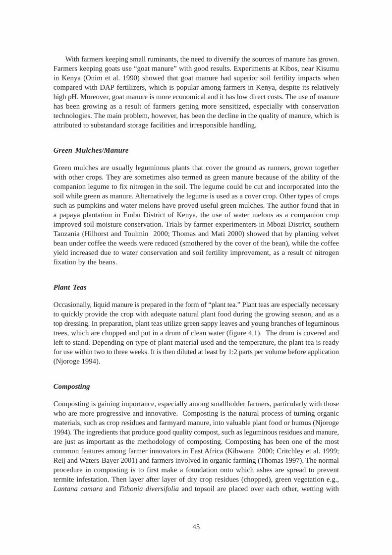
45
With farmers keeping small ruminants, the need to diversify the sources of manure has grown.Farmers keeping goats use “goat manure” with good results. Experiments at Kibos, near Kisumuin Kenya (Onim et al. 1990) showed that goat manure had superior soil fertility impacts whencompared with DAP fertilizers, which is popular among farmers in Kenya, despite its relativelyhigh pH. Moreover, goat manure is more economical and it has low direct costs. The use of manurehas been growing as a result of farmers getting more sensitized, especially with conservationtechnologies. The main problem, however, has been the decline in the quality of manure, which isattributed to substandard storage facilities and irresponsible handling.
Green Mulches/Manure
Green mulches are usually leguminous plants that cover the ground as runners, grown togetherwith other crops. They are sometimes also termed as green manure because of the ability of thecompanion legume to fix nitrogen in the soil. The legume could be cut and incorporated into thesoil while green as manure. Alternatively the legume is used as a cover crop. Other types of cropssuch as pumpkins and water melons have proved useful green mulches. The author found that ina papaya plantation in Embu District of Kenya, the use of water melons as a companion cropimproved soil moisture conservation. Trials by farmer experimenters in Mbozi District, southernTanzania (Hilhorst and Toulmin 2000; Thomas and Mati 2000) showed that by planting velvetbean under coffee the weeds were reduced (smothered by the cover of the bean), while the coffeeyield increased due to water conservation and soil fertility improvement, as a result of nitrogenfixation by the beans.
Plant Teas
Occasionally, liquid manure is prepared in the form of “plant tea.” Plant teas are especially necessaryto quickly provide the crop with adequate natural plant food during the growing season, and as atop dressing. In preparation, plant teas utilize green sappy leaves and young branches of leguminoustrees, which are chopped and put in a drum of clean water (figure 4.1). The drum is covered andleft to stand. Depending on type of plant material used and the temperature, the plant tea is readyfor use within two to three weeks. It is then diluted at least by 1:2 parts per volume before application(Njoroge 1994).
Composting
Composting is gaining importance, especially among smallholder farmers, particularly with thosewho are more progressive and innovative. Composting is the natural process of turning organicmaterials, such as crop residues and farmyard manure, into valuable plant food or humus (Njoroge1994). The ingredients that produce good quality compost, such as leguminous residues and manure,are just as important as the methodology of composting. Composting has been one of the mostcommon features among farmer innovators in East Africa (Kibwana 2000; Critchley et al. 1999;Reij and Waters-Bayer 2001) and farmers involved in organic farming (Thomas 1997). The normalprocedure in composting is to first make a foundation onto which ashes are spread to preventtermite infestation. Then layer after layer of dry crop residues (chopped), green vegetation e.g.,Lantana camara and Tithonia diversifolia and topsoil are placed over each other, wetting with
46
fresh water (non-chlorinated). The heap is then covered with soil and a stick driven into the middleto act as a thermometer. The compost is turned (and wetted) after around 22 days. In most partsof East Africa, the compost is ready for use within 45 days (Njoroge 1997).
Mapambano Compost Making
“Mapambano” compost making is an innovation by farmer, Ms Susanna Sylvesta of Dodoma,Tanzania (Mutunga and Critchley, 2001). She makes 15 tons of compost each year. The compostingsystem is based on locally available materials and pits of over 1 m deep and up to 3 m in diameter.Ash is spread at the bottom of the pit, and then a layer of grass is added, followed by alternatinglayers of crop residues, grass, tree leaves, sisal leaves, manure, bedding, animal urine and ash.Domestic wastewater is added to keep the mixture moist. The pit is filled (built above ground level)and topped off with a final layer of ash and a cap of grass. Wastewater and urine continue to beadded to keep it moist until it is fully decomposed. This takes about 3 months and produces a richcompost, which is applied to the maize crop at the rate of 1.5 t/ha/year. There were plans to packagethe compost for sale even in the export market (Lameck personal communication).
Compost Baskets
Another system of composting known as “compost baskets” is also common in various parts ofEast Africa (Hamilton 1997). The idea of a compost basket is to do in-situ composting in whichthe crop utilizes the compost as it decomposes, and thus is expected to last longer (figure 4.2).Compost baskets are woven from twigs and driven into the prepared beds at a spacing of 1 m asfollows: holes of at least 15 cm deep and 30 cm wide are dug along the centre line of the preparedbed at a spacing of about 1 m. Sticks of about 60 cm long are then driven into the ground around
Figure 4.1. Illustration of the preparation of plant tea.
Bag of manure
Water
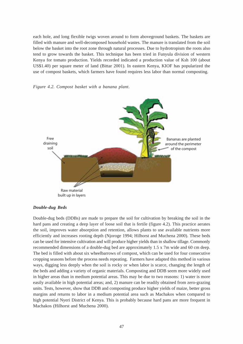
47
each hole, and long flexible twigs woven around to form aboveground baskets. The baskets arefilled with manure and well-decomposed household wastes. The manure is translated from the soilbelow the basket into the root zone through natural processes. Due to hydrotropism the roots alsotend to grow towards the basket. This technique has been tried in Funyula division of westernKenya for tomato production. Yields recorded indicated a production value of Ksh 100 (aboutUS$1.40) per square meter of land (Bittar 2001). In eastern Kenya, KIOF has popularized theuse of compost baskets, which farmers have found requires less labor than normal composting.
Figure 4.2. Compost basket with a banana plant.
Double-dug Beds
Double-dug beds (DDBs) are made to prepare the soil for cultivation by breaking the soil in thehard pans and creating a deep layer of loose soil that is fertile (figure 4.2). This practice aeratesthe soil, improves water absorption and retention, allows plants to use available nutrients moreefficiently and increases rooting depth (Njoroge 1994; Hilhorst and Muchena 2000). These bedscan be used for intensive cultivation and will produce higher yields than in shallow tillage. Commonlyrecommended dimensions of a double-dug bed are approximately 1.5 x 7m wide and 60 cm deep.The bed is filled with about six wheelbarrows of compost, which can be used for four consecutivecropping seasons before the process needs repeating. Farmers have adapted this method in variousways, digging less deeply when the soil is rocky or when labor is scarce, changing the length ofthe beds and adding a variety of organic materials. Composting and DDB seem more widely usedin higher areas than in medium potential areas. This may be due to two reasons: 1) water is moreeasily available in high potential areas; and, 2) manure can be readily obtained from zero-grazingunits. Tests, however, show that DDB and composting produce higher yields of maize, better grossmargins and returns to labor in a medium potential area such as Machakos when compared tohigh potential Nyeri District of Kenya. This is probably because hard pans are more frequent inMachakos (Hilhorst and Muchena 2000).
Bananas are plantedaround the perimeter
of the compost
Freedraining
soil
Raw materialbuilt up in layers
48
Double-dug beds have been promoted by NGOs since the late 1980s in Ethiopia, Tanzaniaand Kenya, where they are mainly used for cultivating high-value cash crops such as vegetables(Hamilton 1997). The construction technique involves preparing the garden beds by digging outthe topsoil and subsoil separately. The bottom of the trench is further tilled to improve infiltration.The topsoil is then mixed with organic manure and returned to the bed. Care is taken not to stepon the bed in order to avoid compaction. High-value crops are then grown on the beds with verygood results since the bed absorbs more water than in conventional tillage. Their adoption andsubsequent adaptation are closely linked to increased production of compost, which should be addedwhen the double-dug beds are prepared. As found in a survey, 22 percent of farmers who hadbeen trained in Low External Input Sustainable Agriculture farming technologies used double-dugbeds. (Thomas and Mati 2000).
Mulching
The objective of mulching is to conserve soil moisture, reduce runoff flows, evaporative lossesand wind erosion, prevent weed growth, enhance soil structure and control soil temperature. Mulchingin East Africa normally utilizes natural materials and involves covering the soil with cut grass, cropresidues, straw or other plant material. In East Africa, mulching is practiced by farmers in thewetter areas due to the availability of vegetative materials. Most smallholders do mulching onlyfor special crops such as tomato, cabbage and potatoes due to the shortage of crop residues.Depending on availability of residues, mulch densities range between 30 percent and 70 percent,based on availability of residues obtained from the previous season’s crop (Kibwana 2000; Mrumaand Temu 1999). The importance of mulches in reducing surface runoff, soil erosion and evaporationlosses cannot be overstated. In an experiment in the Laikipia District of Kenya, it was observedthat in the absence of mulch, 40-60 percent of the rain that fell was lost to evaporation, and thatif 40-50 percent of the ground was covered with mulch, surface runoff losses were reduced toalmost zero and evaporation losses halved (Liniger 1991). Crop yields were found to double ortriple and biomass to feed the livestock increased. In a participatory experiment with farmerinnovators in Mbozi District, Tanzania, the Indigenous Soil and Water Conservation Program(ISWCP)—(Kibwana 2000; Mruma and Temu 1999) tested the use of crop residues to mulch thecoffee crop grown in the marginal Mbozi District. The farmers found that coffee yield nearlydoubled under the mulched plots, a factor that was associated with soil moisture conservation.
Agroforestry
Agroforestry, though an indigenous intervention among many communities in East Africa, gainedits prominence in the 1980s after the establishment of the International Council for Research inAgroforestry (ICRAF, now called “World Agroforestry Center”), which set up office in Nairobiwith field activities in the region. In Kenya, Ethiopia and Tanzania, seedling production was takenup as a component within the SIDA-supported Soil and Water Conservation Project (SWCP) ofthe respective Ministries of Agriculture. The initial focus was on the nurseries, but from 1988,there was a shift towards a more holistic and supportive role in recognition of the need to work ina participatory manner with farmers. More emphasis was put on farmers’ training rather thanproduction of seedlings. Production of information material for extension staff, farmers and schoolsbecame an important component (Muturi 1999). Enthusiasm for farm forestry activities increased
49
in response to the prevailing political push and intensification of extension. A variety of institutionsbecame involved in seedling production. They included government ministries, nongovernmentalorganizations (NGOs), rural development projects, farmer groups and rural communities. By mid-1991 there were 4,161 documented tree seedling nurseries established by various institutions inKenya alone (Muturi 1999), while soil and water conservation projects in Ethiopia and Tanzaniaall had a strong agroforestry component (Lundgren and Taylor 1993; Assmo and Eriksson 1994).
A majority of the smallholder farmers practicing agroforestry prefer to grow multipurpose trees.They have realized that through agroforestry trees provide nutrient inputs to crops by capturingnutrients from atmospheric deposition, biological nitrogen fixation, tapping nutrients from deep inthe subsoil and storing them in the bio-mass (Sanchez et al. 1997). Trees also enhance nutrientcycling through conversion of soil organic matter into available nutrients (especially nitrogen andphosphorus). It is, therefore, possible to recycle nutrients through leaf-fall, root decay and greenmanure (Biamah and Rockström 2000). Agroforestry also benefits farmers directly through theprovision of poles for building, fruits for sale and consumption, fuel wood and fodder for livestock.The trees also prevent soil erosion, conserve soil water and improve soil fertility and the microclimate. The environmental benefits of trees include soil conservation, bio-diversity conservationand the conservation of terrestrial carbon.
Hedgerow Intercropping
Hedgerow intercropping or alley cropping was popularized by ICRAF in the 1980s, but adoptionby farmers has been poor. It involves growing leguminous tree shrubs in narrow strips across theslope, then the shrubs are lopped and the material used as a green mulch. Popular species includesesbania sesban, caliandra calothyrsus and leucena sp (Thomas 1997). Nitrogen fixation bythe hedge roots and its incorporation through pruning is supposed to replace the need for nitrogenfertilizers thus saving costs. However, competition for moisture between crop and hedges was amajor limitation factor in the dry areas. With the exception of the aforesaid problem, hedgerowintercropping can be quite effective in soil conservation as explained below.
ICRAF tested low hedgerows of Cassia siamea, a leguminous and nitrogen-fixing shrub, plantedon the contours to enable the development of natural formation of terraces on a 14 percent landslope at Katumani, Machakos (Lundgren and Taylor 1993). One night in April 1990, 52 mm ofrain fell in just 30 minutes on slopes that were already saturated. Fields with only crops lost morethan 34 tons of soil per hectare. , while fields with hedgerows lost, at most, 6 tons per hectare.Where maize and cowpeas were grown between hedgerows the produce was two to three timesthe harvests from fields with sole crops. (Lundgren and Taylor 1993).
Improved Fallows and Biomass Transfers
Improved fallows have been described (Sanchez 1999) as the deliberate planting of leguminoustree species with the primary purpose of fixing nitrogen as part of a crop fallow. Improved fallowshave been introduced more recently in the Lake Victoria region where agroforestry techniquesform a major focus on soil fertility initiatives, to enable the enrichment of a natural fallow withleguminous trees or shrubs (Place et al. 2005; Woomer et al. 2004). These shrubs include Sesbaniasesban, Crotalaria grahamiana and Tephrosia vogelii.
50
Another system, biomass transfer (Nair 1989) is the incorporation into the soil of leafy shrubs,which accumulate high concentration of nutrients in their leafy biomass and mineralize rapidly. Itis a form of cut and carry mulching, and shrubs such as Lantana camara and Tithonia diversifoliaare used in this system. In western Kenya, Tithonia diversifolia is the most commonly used biomassmaterial because it is readily available, easy to propagate and relatively richer in nutrients. Oneton of dry weight of Tithonia diversifolia leaves contains an average of 33 kg of nitrogen, 3.1 kgof phosphorous and 30.8 kg of potassium (Mureithi et al. 2002).
Low External-input Farming Systems
There are different synonyms used to describe low-input farming technologies which includeAlternative Agriculture, Low-Cost External Input Agriculture, Bio-Intensive Agriculture, SustainableAgriculture and “Permaculture” or LEISA (Low External Input Sustainable Agriculture). In itsmost extreme form, low-input agriculture is known as organic farming. Organic farming has beendefined (Njoroge 1994) as an agricultural system that promotes environmentally sound means ofproduction. Organic farming uses natural methods to keep the soil fertile and also keep crops andlivestock healthy. The approach keeps the land productive using materials found on the farm. Inconventional farming systems, much effort goes into to bringing chemical inputs and animal feedsfrom outside the farm, instead of making full use of what is found on the farm. For example,expensive inorganic fertilizers, sprays, vaccines and medicines are used. With the compaction ofsoil as a result of using heavy machinery more fertilizers and pesticides are required to increasethe yield. Owing to the inherent weaknesses of artificially-fed plants, new pests and diseases areemerging all the time and even others commonly found become resistant to pesticides, whilebeneficial soil organisms get killed. In contrast, the organic farmer puts effort into improving soilfertility through composting, proper cultivation, rotation of crops, mixed planting, growing trees, propercare of crops and animals and the natural control of pests and diseases. Because of the betternatural balance, agricultural products are healthier and fetch a much higher price than conventionallygrown crops and, in general, ensure good health and environmental safety all around. In East Africa,most farmer innovators practice a certain degree of low-external input agriculture, which isnecessary to reduce costs of production and the dependence on “imported” inputs and also to ensuresustainability of the ecosystem.
51
PARTICIPATORY APPROACHES IN WATER AND NUTRIENT MANAGEMENT
An approach is the essence of an agricultural research and extension program, comprising anorganizational structure, leadership, resources such as personnel, equipment and facilities, goalsand objectives as well as methods and techniques for implementation. It also has linkages withother organizations, the public as well as its clients, i.e., partners and/or collaborators (Ejigu 1999).It is argued that over the three decades ending in 1990, millions in foreign exchange have beenspent on research and extension approaches in Africa, aimed at promoting agricultural development.However, even this expenditure has been ineffective in stimulating growth and alleviating povertyand human suffering. The problem lies both with national policies and donor perceptions (Lele 1999).To promote research development in Africa, many initiatives have been introduced. For instance,the East Africa Framework for Action on Agricultural Research was developed (Kampen 1992),with a mandate to identify measures required to improve the performance and effectiveness ofagricultural research in the region. This resulted in the formation of the Special Program for AfricanAgricultural Research (SPAAR), which was able to get the support of national policymakers anddonors. In addition, obtaining the support of other institutions involved in technology generation anddissemination was important for the success of the measures identified in the framework for action.Even with such initiatives, agricultural research and extension approaches have been underutilizedin East Africa, for many reasons.
Towards Recognizing Farmer Knowledge
The East Africa region has seen many experimentations in agricultural and natural resourcemanagement involving technologies, policies, research and extension packages (McCall 1994;Tengberg et al. 1998; de Waal et al. 1997; Kiome and Stocking 1995; Critchley et al. 1994). Theanalyses of the successes and failures of rural extension approaches have revealed that transferof technology approaches which assumed a one-way stream of knowledge, from research toextension to farmer, have been ineffective (Schwartz and Kampen 1992). These approaches ignoredthe knowledge already existing in communities and failed to recognize the processes by whichfarmers learn and adopt new practices. Efforts to achieve a more systematic involvement ofresource poor farmers through public sector agricultural research organizations have been weak.This is due to the lack of internal motivation on the part of the scientific researchers, and alsobecause of the lack of external pressure from the farmers (Lacy 1996). Rarely do farmers demandresearch services from researchers. To bring about more effective functioning of the system, severalmodels have emerged that describe the relationship between scientists/researchers, extensioneducators, farmers and the informal sector. These have been described in different terms such ason-farm research, farming systems, agro-ecological research, rapid and participatory rural appraisal,farmer participatory methods and farmer field schools (Norman et al. 1994; Chambers et al. 1989;Haile and Lemma 2000; Duveskog 2001). The fact that farmers themselves can contribute towardsnew technologies in land husbandry and the role of indigenous technologies in soil and watermanagement as a way to improve farmer-researcher-extension linkages are being given morecredence (Reij and Waters-Bayer 2001; Bittar 2001; Abbay et al. 2000; Haile 2000; Critchley etal. 1999). Innovative and indigenous ways of achieving improved yields have involved a widediversity of interventions such as integrated soil fertility management, soil and water conservation,rainwater and runoff harvesting systems, integrated pest management, tillage and soil managementsystems, improved seeds, innovative agronomic practices and better ways of scaling-out successful
52
practices (Ndakidemi et al. 1999; Ochola et al. 2000; Wolde-Aregay 1996). However, these successcases are few and far between.
Indigenous Technologies and Knowledge
Indigenous knowledge has been defined (Mwale and Mruma 1999), as “a mixture of knowledgecreated endogenously within a society and knowledge acquired from outside, but observedand integrated within the society”. Therefore, indigenous knowledge is area-specific, originatesfrom farmers themselves and solves specific problems at a particular time (Scarborough et al.1997; Evers 1995). On the other hand, indigenous technologies and knowledge (ITK) is bestdescribed in terms of four categories (McCall 1994): (i) the vernacular technical knowledge heldby local people, (ii) specialized knowledge of certain skilled “Resource Persons,” (iii) the controllingknowledge held by dominant groups in society, and (iv) the social knowledge belonging to the group(village, clan, caste, tribes etc.,). Local knowledge is a resource because it may be the only thingthat the poorest people have a control of. It should reflect the capability and competence of thelocal community and put them on an equal footing with outsiders, and it is a resource needing littleinvestment for realization. Moreover, local knowledge is operational and measurable. ITK can beidentified and interpreted through: (i) rapid rural appraisals; (ii) participatory action research; (iii)field survey approaches, including interviews and field measurement; (iv) farming systems research,including agroforestry diagnostics and design; and, (v) gaming and similar techniques.
Participatory Technology Development (PTD)
Participatory Technology Development (PTD) has been seen as a more effective way to enhancefarmer-extension-researcher interaction. PTD refers to the collaboration between farmers,development agents and scientists in a manner that combines their knowledge and skills (vanVeldhuizen et al. 1997). One important component of PTD is farmer-led experimentation, to findbetter ways of using available resources to improve the well-being of families and communities.The purpose of supporting farmer experimentation is to strengthen farmers’ capacities to seek andtry out new ideas so that they are better able to experiment and adjust to changing conditions. Thepurpose is not to convince farmers to adopt a new technology, but rather to encourage them totest new possibilities and choose what is right for their circumstances or adapt the new ideas totheir conditions. The PTD approach is linked to the concepts and methods of sustainable forms ofagriculture that rely mainly on locally available resources and do not require major inputs fromoutside (Kibwana 2000). The PTD approach aims to identify and where possible improve or adaptthose technologies to meet the current needs. In promoting PTD, use of the subsidy mechanismsand genuine demonstration of technology are necessary to avoid promoting ideas that will be of nointerest to the farmers. It should have well-coordinated land-use planning, including farming systemapproaches, addressing the diversity of ground realities and avoiding straight-jacket formulae. It isimportant to make a good investment in infrastructure for scientific data collection to facilitatedecision-making on a more reliable scientific basis. Emphasis on development, maintenance andefficient management of community assets such as dams and community lands is important, but atthe same time the need to decentralize the process of decision-making with a view to empowerlocal communities should be also given due recognition. A coordinated action by all the stakeholdersin the farming sector, including the government is vital (Virman et al. 1995).
53
Scaling Up and Scaling Out
Technology transfer is nowadays seen to be not just bottom-up, or top-down, but rathercircumferential and indeed in all directions. Such terms as “scaling up,” “scaling down,” and “scalingout” have been used, sometimes interchangeably. The GFAR (1999) defined these terms in astakeholders’ forum, and discussed the principles and practices associated with each term. Forinstance, “scaling up” was defined (GFAR 1999) as the vertical movement of experience,knowledge, impact and effects higher up the levels in the organization of a sector or society. Thisimplies moving more stakeholder groups up the ladder from farmers to “extensionists” and NGOworkers to local officials to researchers to policymakers/ministers to donors. On the other hand,“scaling out” is a horizontal spread within a sector, particularly farmers. Both scaling up and scalingout implies adaptation, modification and improvement (not just replication) of particular technologiesand techniques, but more importantly principles and processes. “Scaling down” refers to thereplication of whole programs, not just principles or processes, by breaking them down into smallerprograms or projects to facilitate planning, implementation and accountability at lower levels. Itmay be viewed as decentralization or devolution and, therefore, one could equate these processeswith scaling out as well. The GFAR (1999) listed five dimensions of scaling up: (i) the institutional(vertical integration); (ii) the geographical/spatial (horizontal spread); (iii) the technological; (iv)the temporal; and (v) the economic or cost dimensions. In all, sustainability, “participation” and“capacity building” are common themes. In addition, there are three general strategies adopted byan implementing organization in dealing with the issue of scaling up relative to how it conceptualizesits project/program intervention: (i) spontaneous scaling up; (ii) scaling up after achieving initiallocal success; and (iii) inclusion of the scaling up plan right from the start of the project.
In terms of the approaches and principles that would guide an organization in implementing itsscaling up programs, the GFAR (1999) proposed eight general categories. These were: (i) actionresearch and learning; (ii) human relationship building; (iii) local capacity building and resourcemobilization; (iv) market development; (v) participation; (vi) policy change and development; (vii)strategic alliances; and (viii) training and extension. Although there is a wide range of tools,approaches and principles, the process of up-scaling remains a difficult task.
Cooper and Denning (1999) provide a model for scaling up agroforestry research and extension,as shown in figure 5.1. They indicate that sustainable development takes place within the contextof many external factors over which research and development partners may exert little influence,if any. Even so, when designing development initiatives, there is a need to be aware of the positiveand/or negative influences such factors can have, and plan accordingly. The following conditionsare necessary preconditions for scaling up/out:
i National and regional peace and security;
ii Good and transparent governance;
iii Demand for products and market access;
iv Sound national and global economies;
v Legislation in place covering intellectual property rights;
vi An active process of democratization;
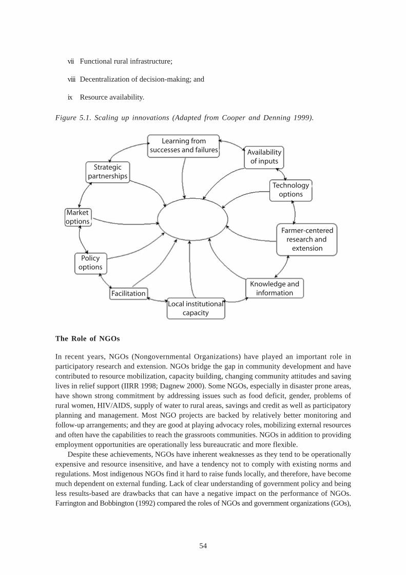
54
vii Functional rural infrastructure;
viii Decentralization of decision-making; and
ix Resource availability.
Figure 5.1. Scaling up innovations (Adapted from Cooper and Denning 1999).
The Role of NGOs
In recent years, NGOs (Nongovernmental Organizations) have played an important role inparticipatory research and extension. NGOs bridge the gap in community development and havecontributed to resource mobilization, capacity building, changing community attitudes and savinglives in relief support (IIRR 1998; Dagnew 2000). Some NGOs, especially in disaster prone areas,have shown strong commitment by addressing issues such as food deficit, gender, problems ofrural women, HIV/AIDS, supply of water to rural areas, savings and credit as well as participatoryplanning and management. Most NGO projects are backed by relatively better monitoring andfollow-up arrangements; and they are good at playing advocacy roles, mobilizing external resourcesand often have the capabilities to reach the grassroots communities. NGOs in addition to providingemployment opportunities are operationally less bureaucratic and more flexible.
Despite these achievements, NGOs have inherent weaknesses as they tend to be operationallyexpensive and resource insensitive, and have a tendency not to comply with existing norms andregulations. Most indigenous NGOs find it hard to raise funds locally, and therefore, have becomemuch dependent on external funding. Lack of clear understanding of government policy and beingless results-based are drawbacks that can have a negative impact on the performance of NGOs.Farrington and Bobbington (1992) compared the roles of NGOs and government organizations (GOs),
Learning fromsuccesses and failures
Local institutionalcapacity
Facilitation
Policyoptions
Marketoptions
Strategicpartnerships
Knowledge andinformation
Farmer-centeredresearch and
extension
Technologyoptions
Availabilityof inputs
55
and found that GOs and NGOs can complement each other in dealing with farmers. For instance,GO and NGO staff can jointly participate in training courses, especially in action-oriented methodssuch as PRAs, collaborative field trials and information exchange. In addition, GOs can cushionNGOs with budgetary allocations for some specific tasks, while NGOs can act as brokers betweenfarmers and research services and donors.
The list of NGOs that have been active in agricultural training, extension and/or research inEast Africa is long and, as such, only a sample is presented here. In Ethiopia they include:Agriservice, Action Aid, Farm Africa, Catholic Relief Services, World Vision, Water Action,Sasakawa 2000, IFOAM, Christian Relief and Development Association and CARE. In Tanzania,they include: Inades-Formation, TIPDO; Catholic Relief Services, Anglican Church, Habitat forHumanity, Relief and Development Services Association (REDESA), Centro Mondialita SviluppoReciproco, Water Aid, Dodoma Environmental Network (DONET), Agrisystems and Action-Aid.In Kenya, they include: Catholic Relief Services, Anglican Church of Kenya, Plan International,Action-Aid, Freedom From Hunger, CARE-Kenya, World Vision, Caritas, Approtech, ALIN, SoSSahel International (MDFP), KIOF, Africa-Now, Resource Projects Kenya, Ramati, Osienala andSACRED-Africa.
Farmer Organizations and Networks
Farmer organizations have played a leading role in the development of agriculture in East Africa.Cooperative societies have, more than any other farmer support institution, influenced agriculturalcommercialization among small-scale farmers (Dejene 1989). Cooperative societies are importantin relation to commodity marketing, supply of inputs, provision of credit and among other similarfunctions. The effectiveness of a cooperative society depends on its level of development. On theone hand there are the budding cooperative societies that do not have any fixed assets and, whosemembers are not aware of their rights, obligations and benefits accruing from membership, andthe society leadership has no business experience. On the other hand, there are the cooperativesocieties that are well developed, do not require external support, well managed, able to providecredit to their members, invest in agro-processing and venture into export-import business, (Muturi2001).
A network is any group of individuals and/or organizations that on a voluntary basis exchangeinformation or goods or implement joint activities and organize themselves in such a way that theindividual autonomy remains intact. Networks can have different forms and use different proceduresdepending on the specific situation. The networks structure is often light and not very formal. Manydevelopment projects are nowadays promoted and implemented through networks (Njoroge 1997;Hatibu et al. 2000). In East Africa, there is a proliferation of networks, especially in the field ofagriculture, for example, ACT, IFOAM, DONET, ALIN, SWMNET, SEARNET, MVIWATA,KENDAT, HIMA etc. There are several types of networks and different criteria on which atypology can be based, for instance: (I) the formal/centralized networks tend to have a strongsecretariat. Most of the communication is initiated by or passes through the secretariat; (ii) in themore informal/decentralized networks there is direct and systematic communication between thedifferent members of the networks. The center is a support service for any action carried out byits partners; and (iii) other typologies differentiate between scope of geographic coverage (local,national, regional and international), or by distinguishing the subject matter of the networks (e.g.,networks on Ecological Pest Management [EPM], on soil fertility, on PTD, on organic agricultureor on a whole range of aspects).
56
PTD Programs in Ethiopia
In Ethiopia, participatory methodologies in research and farmer outreach programs have alsodeveloped over the past few decades (Reij et al. 2001). The early years were fraught with researchand extension packages that failed to meet the expected development in agricultural production. Areview of the chronology of extension systems in Ethiopia over the last 50 years (UNDP/ECA1998) indicates many systems have been tried, and they are as follows:
• Provincial Rural Development Program (“Lemat”) initiated by Provincial fiats;
• Chilalo Agricultural Development Unit (CADU);
• Wallamo Agricultural Development Unit (WADU);
• Minimum Package Program (MPP);
• Community Development Program
• Peasant Agricultural Development Program (PADEP); and,
• Sasakawa 2000 Project.
The Provincial Rural Development Program (Lemat)
The Provincial Rural Development Program (Lemat) started in the 1950s. Governors of Provincescreated development committees known as Lemats. The basic objective was fund-raising for localdevelopment projects. Compulsory contributions of money and labor were levied on the local people,and the system had many problems.
Chilalo Agricultural Development Unit (CADU)
The Chilalo Agricultural Development Unit (CADU) approach was contained in a specialmemorandum of the planning commission “Comprehensive Rural Development Programs inEthiopia” in 1966. It is important to note that Tanzania was the first African country to adopt theComprehensive Rural Development Programs. However, these programs (e.g., the million-acreschemes) were not successful and were abandoned in the mid-sixties due to their exorbitant cost.CADU (1967-74) was one of the earliest examples of an integrated rural development project.The main activity was the distribution of inputs such as fertilizer, seeds and dissemination of improvedpractices (Dejene 1989). The government identified 24 administrative units (Awrajas) in highpotential areas for comprehensive rural development schemes. SIDA supported the Chilalo Awraja.It was a comprehensive project involving research, extension, credit, marketing, etc. The economicrate of return on investment was about 18 percent over the 10-13 year period.
After the Ethiopian revolution and the agrarian reforms of 1975, the CADU approach wasextended to cover the whole of Arssi Region, and the Arssi Regional Development Unit (ARDU)was created. Under ARDU, the model farmer approach was abandoned and CADU’s excessiveemphasis on improved technology was criticized. ARDU was organized into six departments of
57
which “Extension” was the principal department (Dejene 1989). This department worked closelyin the development of cooperative and nonformal education.
Wallamo Agricultural Development Unit (WADU)
This project was established in 1970, in the Wollamo (presently part of the Omo Zone, southernEthiopia), in the highlands of Soddo and Bolosso. It aimed to achieve economic and socialdevelopment and also enhance local participation in development. Large cash incentives rangingfrom 200 to 325 Ethiopian birr (equivalent in those days to US$100-163) per year were used toestablish 1,750 settler families and promote a shift from subsistence to cash crop agriculture andincrease government tax revenue. To a certain extent research on maize and wheat markets, andon credit facilities were done. The economic rate of return was 13 percent over a 20-year period.
The Minimum Package Program (MPP)
Here, the objective was to provide the minimum services needed by farmers all over the country.These included agricultural extension, credit, cooperative development and feeder roads. MPP wasestablished in 1970. The basic unit was the Minimum Package area, defined as within 75 km ofall-weather road, and containing at least 10,000 farmers. It was expected to cover half of thegeographic area and the entire agricultural population except those in nomadic areas. The economicrate of return was about 17 percent over a 20-year period.
The Military Socialist Programs (MSP)
The Military Socialist Programs were launched in 1975 by the Military Junta that abolished theMonarchy (the Dergue). These MSPs included an agrarian revolution, cooperatives, “villagization,”resettlement and state farms. The programs were meant to distribute “land to the tiller” and,therefore, organized the rural population into associations, cooperatives, villages and settlementschemes. It also converted ex-commercial farms into state farms. The revolution abolished theabsolute monarchical system and created a country of smallholder peasant farmers. The revolutionsoon overstepped its boundaries forcing people into cooperatives, villages and mass organizations.Production of crops by peasant-farmers was controlled and prices fixed. These programs werenot relevant to nomadic communities. Soon, the state farms, which were based on importedtechnologies and run by bureaucratic methods, became a drain on state resources.
Peasant Agricultural Development Programs (PADEP)
PADEP focused on accelerated agricultural development in high-potential areas of the Ethiopianhighlands. The general objectives were to increase food production, support production of cashcrops for export, conservation of resources and raise incomes and standards of living. PADEP ledto the present programs of agricultural extension based on decentralization of the Ministry ofAgriculture. Thus it created zonal departments and wereda (district) offices, which were directlyinvolved in the implementation of the various programs (UNDP/ECA 1998).
58
The Sasakawa Global 2000 Project (SG2000)
SG2000 is a part of the present agricultural extension in Ethiopia. The project is involved in research,extension and implementation of field programs. In 1993, the project had 161 demonstration plotsimplemented in 2 regions, involving maize and wheat. In 1994, the program grew tenfold and includedplots of sorghum and teff. In 1995, the program expanded to 3,211 plots (Quinones et al. 1996).SG2000 relies on services of the national extension system, and during peak work seasons extensionworkers are paid a lunch allowance. The project provides agricultural inputs on credit to participatingfarmers. They are requested to pay 25-50 percent of the cost of the inputs as a down paymentand to settle the balance at harvest time (Hilhorst and Toulmin 2000). Participating farmers alsoreceive intensive assistance from extension agents on the condition that they consent to the use oftheir plots for demonstration purposes. Extension agents administer the credit components.However, animal production, soil conservation and forestry seem to be ignored. There is also theproblem of monetary incentives creating conflicts among extension workers who are not involvedin the project.
When the SG2000 program started, the extension package was introduced to farmers whohad better resources and skills, and the ratio of extension workers to farmers was high. Underthese conditions, the package was very profitable, even though the improved seed and fertilizeraccounted for 50-80 percent of the total costs. Results were less favorable when the packagewas introduced to farmers working under marginal conditions (low, unpredictable rainfall and lessfertile soil). In these areas, local varieties outperformed the improved package in dry areas. Theexpansion of the package to poorer farmers in less favorable ago-ecological regions thus raisesserious challenges for the extension services a well as to the input supply and the banking sector(Hilhorst and Toulmin 2000).
Participatory Demonstration and Training Extension System (PADETES)
Participatory Demonstration and Training Extension System (PADETES), has been the nationalextension system of Ethiopia, and has so far been implemented satisfactorily. This system, whichhas been developed after a critical evaluation of the past extension approaches practiced in Ethiopia,accommodates present thinking in extension philosophy that involves research, education andextension as part of the knowledge system. In contrast with the past extension systems, wherethe focus was limited to either solely technology transfer or human resources development,PADETES puts equal emphasis on both human resource development and the transfer ofappropriate and proven technologies. According to the new system, execution of extension is entirelythe responsibility of the Regional Agricultural Bureaus, while the Federal Ministry of Agriculturehas the mandate to formulate and submit agricultural and related policies and, upon approval,coordinate and diffuse them through interregional development programs and/or projects, andprovide technical advice and training services to increase the technical competence of the extensionstaff of the Regional Agricultural Bureaus (Ejigu 1999).
59
The National Extension Program
The national extension program was designed to attain food self-sufficiency. The short to medium-term agricultural development strategy, in this regard, would focus on environmentally consciousintensification programs both in traditionally surplus producing as well as drought-prone areas andin nomadic pastoralists areas (Ejigu 1999). The program assisted small-scale farmers to improvetheir productivity through dissemination of research-generated information and technologies. Thoughit was limited to only seven regions and 35,000 farmers in the initial year, the program has nowexpanded to cover over 2.5 million farmers. In addition to increasing the size of farmers involvedin the program, a number of developmental packages have been designed and dispatched. Amongthese are packages on cereal crop production (moist zone and dryland) and packages on livestockproduction, high economic value crops, post-harvest technologies, agroforestry, soil conservationand beekeeping (Ejigu 1999).
Group Extension
Group extension has been promoted by NGOs, due to the advantage of working with smaller groups.In one such case, Action Aid-Ethiopia helped to form local savings-and-credit groups of 20-30members. They found that small groups function better and suffer from fewer internal conflictsthan village cooperatives (IIRR 1998). This is because the groups are smaller and more manageable,and their members have more in common than do the much larger village-wide cooperatives. Thegroups can focus on problems they feel are important, rather than those identified by outsiders.However, it was found that regular meetings and refresher workshops were necessary to maintainthe groups’ skills and enthusiasm. Action Aid provided the groups with advice on coffee cultivation.One or two farmers in each group volunteered to establish nurseries to produce coffee seedlingsof different varieties, which are resistant to the berry disease. The farmers were trained in nurserymanagement, coffee production and forestry activities, and were also provided with subsidized seeds.These “resource farmers” established nurseries on their own land and grew seedlings to plant orsell to their neighbors. In 1996, Ato Alemaye Adyeko, one of the resource farmers, sold coffeeseedlings worth birr 1,200 (US $175). In 1997, Action Aid began using the same approach tointroduce forest-tree seedlings. In the first year, five groups with a total of 50 farmers began raisingforest-tree seedlings (IIRR 1998).
Participatory Resource Use Planning (PRUP)
This is an extension system that was facilitated by Farm Africa-Ethiopia. It utilized committees atthree levels of participation (Assefa 2000):
i The Kanta—in Konjo culture forms the center of traditional authority and decision making,and the basis for community concession, consensus, mutual support system and organizationof labor and other development inputs. PRUPS starts at this level.
60
ii The Kebele – is the “lowest” government administrative unit. It has judicial and governmentfunctions and it collects taxes but does not decide on or allocate tax revenue. The Kebelecouncil also practices consultation with traditional elders. The Kebele is where projectinitiatives can be reviewed and authorized, and developed planning validated and costed.
iii The Wereda - Konso is one of the five Weredas reporting directly to the region. Its councilcan receive, consider, ratify, integrate and provide resources for Kebele developmentproposals. The Wereda council in consultation with line departments and traditional elderscoordinates, normalize, publishes and submits annually developed budget proposals to theregion.
One example is the participation of local people in PRUP in the area of Konso. It involved thefollowing steps:
Step 1 Training participants on the basics of planning.
Step 2 Planning Committees formed at Kanta and Kebele levels.
Step 3 Action plan formats filled out.
Step 4 The Kebele Committee prepared plan format of land use, soil type and plantdistribution maps on aerial plots. Maps of recent achievements and newly proposedones are made e.g., land use —fertile versus infertile land, private versus communalland, areas where animal diseases occur, tsetse fly zone and, also in degraded oreroded areas.
Villagization
“Villagization” is a process by which rural households are moved from scattered dwellings intovillages, as part of a government attempt to modernize rural life and agricultural production. Thefirst villagization process in Ethiopia was in 1977 — since then, over 12 million people have beenaffected until 1988. It affected most in Showa and Heraregha, while Tigray, Gamo Goffo and Wellowere the least affected (Lirenso 1990). Villagization had many negative impacts on food production,for instance, the National Villagization Coordination Committee (NVCC) in 1986 gave priority toareas growing food crops, while areas with cash crops were to be considered later. It becamedifficult to obey guidelines e.g., pay special attention to farmlands, pesticide, water resources, roadsetc., in site selection, whereas in reality these things were not found together in site selection.Other problems that came on were:
• Significant increases in distance between fields and new homes.
• Difficulty in carrying straw to livestock.
• Peasants being not able to grow vegetables and perennial crops like ensete and chat.
• Not having space to dry cow dung for fuel.
• Houses being too small (30x40m) with some families having ten members.
61
On the positive side, villagization helped strengthen security, control of bad trade, hold meetings,access to social amenities, shops, water, schools and facilitated re-aforestation.
Training and Visits (T&V) in Ethiopia
The T&V system was introduced in June 1983 in a pilot project in the Tiyo and Hetosa subdistrictsof the Arssi Region and the Ada and Lume subdistricts of the Shoa Region (Dejene 1989). Itexpanded into a third pilot project in the Shashemene and Arssi-Negelle subdistricts in the southernpart of Shoa. Approximately 80 front-line extension staff was involved in the project. The T&Vsystem was characterized by a systematic time-bound program of staff training and farm visits.Discipline, a concentration of efforts on agricultural problems, a single line of command, anddeliberate linkages with researchers, all assisted in improving the effectiveness of the extensionservices. The T&V pilot project was based on the assumption that the effective communicationof relevant messages is crucial to the adoption of new technology (Dejene 1989; Pickering 1989).
The organizational structure of the T&V system in Ethiopia was similar to that in other countries,except for the chain of command above the district level. The AAEO sent reports on extension inhis district directly to the head of the T&V pilot project unit in Addis Ababa, who had overallresponsibility for the T&V system. He made most of the decisions required at headquarters andbrought issues of major concern to the T&V Pilot Project Committee, which was chaired by thehead of the Department of Peasant Organization and Agricultural Development. In this way, thenormal regional structure for agriculture was bypassed and the extension chain of command wasclarified.
PTD Programs in Kenya
In Kenya, several extension packages have been tried such as the Training and Visits of the 1980s,Farming Systems Research, Catchment Approach Systems (Sherington 1997; Lacy 1996; Normanet al. 1994; Lewcock 1997; Gautam 2000), the PFI (Promoting Farmer Innovation)—(Critchley etal. 1999) and more recently, the National Agricultural and Livestock Extension Project (NALEP2001) and the Farmer Field Schools Approach (Duveskog 2001). Each of these approaches has,to an extent, propelled smallholder agriculture, albeit with some limitations. The more commonprograms are given below:
Training and Visits (T&V)
The Training and Visits (T & V) was an extension project funded by the World Bank as part ofthe National Extension Program (NEP), and was implemented in two phases, viz., NEP-I and NEP-II (Gautam 2000; Pickering 1989). T & V, implemented in 41 districts, was meant to replace thetraditional extension system (inherited from the colonial government), which had failed to improveproduction in smallholder farming as it was fraught with too much bureaucracy. Under T & V, theconcept of the model farmer was promoted. Under this concept the progressive farmers wereidentified and where research experiments and demonstration plots would be set up on their farmswas determined. The model farmer would receive regular visits from the frontline extension workers(FEWs), and field days held in his/her farm. It was hoped that visiting farmers would learn from
62
the model farmer and replicate the interventions seen. However, adoption rates were disappointingas the visiting farmers, for one reason or other, could not identify themselves with the model farmer.Gautam (2000) blames this failure on the fact that the FEWs were junior staff, not well trained,and they concentrated on progressive farmers, who represented 10 percent of all smallholderfarmers. Table 4 provides an analysis of the strengths and weaknesses of T &V in Kenya.
Local Level Planning (LLP)
Local Level Planning (LLP) was a participatory extension planning tool or process in which variousextension agencies working in a given area consult farmers regarding their problems, needs, prioritiesand aspirations. Subsequently, based on the input received, an extension basket of solutions forthat specific agro ecological zone is developed (Holding and Kareko 1997). The package, onceimplemented, is monitored and evaluated by both the farmers and the officers. The objective beingthe introduction of farm forestry to small-scale farmers. During implementation, several meetingsand farmer training workshops were held. The implementation followed these steps.
• Meeting of Ministry teams and farmers (MoA and MENR).
• Farmer selection, in which three farmers per group (four groups) were selected.
• Each group together with the officers visited the other three groups and interviewed farmers.
• A work-plan was developed including activities such as nursery establishment, beekeeping,poultry-keeping, collecting fuel wood, seed collection and planting of seedlings.
• Training of tree nursery management, beekeeping etc.
• A final review, which involved all participants.
Part of the LLP process was to guide farmers in finding local solutions to their problems.Farmers tend to provide solutions that more often than not, require external assistance. It was therole of the exercise to facilitate identification of such local solutions.
Table 4. An analysis of the strengths and weaknesses of T&V in Kenya.
Weak points Strong points
Very broad objectives Wide coverage
Strong top-down Coverage of all types of farmers
Target not specific Strong staff training
Weak farmer participation Development of professionalism at the district level
Low staff motivation Strong presence of FEWs
Weak monitoring and evaluation Procurement of transport equipment and office accommodation
Supply-driven messages
Donor dependent
Little flexibility
Little accountabilitySource: Gautam, 2000
63
Catchment Approach
The catchment approach to soil conservation was practiced in Kenya for 10 years from 1987-1997. It covered the planning and treatment of farms that were within a certain hydrologicallydefined watershed, ideally within a single financial year. But this did not necessarily cover thewhole watershed area. The program was planned to provide conservation structures even beyondindividual farms. The main emphasis was on farm-by-farm planning and implementation, and onon-farm conservation measures. The overemphasis on private as opposed to public land, and uponon-farm measures as opposed to off-farm measures limited wider community-based participationin this program. The extent and quality of involvement of the communities, through their SoilConservation Committees (SCCs) was relatively low. In spite of the large amount of work done inpropagating the ideals and tenets of the catchment-area approach, its success rates were gaugedas poor.
An evaluation of the Catchment Approach Program in Embu, Siaya and Nandi districts ofKenya obtained the following results (Admassie 1992):
i Absence of guidelines to direct the initial process of catchment boundaries led DistrictPlanning Teams (DPTs) to deal with it in a haphazard manner;
ii There was lack of uniformity in the way Land Treatment Plans were prepared in the threedistricts;
iii The staffing of the DPTs was also unequal;
iv Layout work was carried out by only Technical Assistants in two of the districts;
v The commonly used soil conservation measures were “fanya juu” terraces and napier grass-strips with cut-off-drains and infiltration ditches in Embu, and unplowed strips and napiergrass-strips in Nandi. In Siaya, a sort of experiment with all kinds of measures was carriedout on the few farms where soil conservation had been attempted;
vi The task of implementing the recommended measures was the responsibility of the individualfarmer in Nandi and Embu. In Siaya, the implementation of measures on the few farmstook place through community groups; and
vii In the successful catchments from Embu and Nandi, where active SCCs were in place,follow-up work (checking out proper implementation and where necessary ensuring thatcorrective work is done) proceeded smoothly.
The National Agricultural and Livestock Extension Program (NALEP)
The National Agricultural and Livestock Extension Program (NALEP) is the current participatoryextension system being implemented by the Ministry of Agriculture and Livestock Development inKenya (MoA&RD 2000). The project mainly focuses on poverty reduction and empowerment ofsmall-scale farmers by strengthening the capacity of extension staff to meet farmers’ needs.NALEP’s target has been to serve more than 300,000 farmers in 3 years in about 900 focal areas.
64
Most of the features of NALEP are based on experiences of the National Soil and WaterConservation Program (NSWCP) that came to an end in 2000, after being in operation for 26years since 1974. NALEP uses the “Shifting Focal Area Approach” which was borrowed fromthe Catchment Approach Program. As such, the project focused its effort in a given area over aspecified period of time. It has bottom-up stakeholder participation in decision-making, planningand implementation of activities as well as structured supervision, reporting, monitoring and evaluation(Baiya 2000).
The NALEP approach organizes farmers into common user groups to access a wider rangeof services than what was available in the former Catchment Approach. It caters for soil andwater conservation, water harvesting, beekeeping, livestock husbandry, agro-processing etc. First,the communities are mobilized through Participatory Rural Appraisals to involve them in projectidentification and drawing of action plans. A Focal Area Development Committee is democraticallyelected for each focal area. Those elected are sent for specific training. NALEP collaborates withresearch institutes such as KARI and ICRAF to facilitate better dissemination of research results(MoA&RD 2000).
Promoting Farmer Innovation (PFI)
Promoting Farmer Innovation (PFI) was a PTD project implemented in Kenya, Uganda andTanzania, as part of fulfilling Agenda 21 of the United Nations initiative on the Conventions toCombat Desertification (CCD). The basic objectives of PFI were to sustainably improve rurallivelihoods and improve ecosystem dynamics through the identification, verification, and diffusionof local innovations related to soil and water conservation, water harvesting and natural resourcemanagement (Critchley et al. 1999; Mburu 2000). To achieve its objectives, PFI embarked on aprogram to: (i) promote farmer-to-farmer exchange visits as a major tool for accelerating thediffusion and adoption of innovative and improved land management, water harvesting and soiland water conservation practices; (ii) build the capacity of supporting organizations to experimentand innovate; and (iii) promote a policy at national level incorporating the need to build on andimprove the innovative capacity of land users, and to use innovative farmers in the diffusion process,thus creating a more favorable environment for the rapid adoption of improved resource managementtechniques.
PFI adopted an approach based on the knowledge and experience that is latent within thecommunity and from recognizing the fact that farmers are better able to learn and adopt new ideaswhen they see them practiced by others who have similar resources of land, labor and capital.The methodology involved a ten-step PTD as follows (Critchley et al. 1999):
i Identification of farmer innovators (FIs) and innovations
ii Verification of innovations and recruitment of FIs
iii Characterization and analysis of FIs and innovations
iv Formation of clustered networks of FIs
v Set up monitoring and evaluation (M & E) systems
vi FI to FI networks visits
65
vii Study tours for FIs
viii FIs develop new techniques and experiments
ix Farmers visit FIs
x FIs as outside trainers
PFI started in 1998 and within a year, the methodology of farmer-to-farmer training was provingpopular (Thomas and Mati, 1999). Within 2 years, PFI had recruited 40 farmer innovators (FIs) inKenya, 60 in Tanzania and 25 in Uganda, obtaining an impressive catalogue of different SWC,RWH and NRM innovations. Farmer innovators had been trained and taken on exposure tours,which proved catalytic in encouraging farmers to innovate and adopt new ideas. Although therewere advantages in seeking out real innovations, the selection of FIs was too stringent, in notrecognizing conventional interventions even where good land management practices that combatdesertification were in place, whether they are truly innovative or not had been applied. Closercollaboration with research institutions and universities to enhance research activities in order toverify and improve the innovations also required attention. Otherwise, the PFI methodology rekindledinterest in farmer innovations in the region.
Farmer Field Schools
The Farmer Field School (FFS) is described as a “school without walls.” It is a participatory methodfor technology development and dissemination, which gives the farmer an opportunity to makeinformed decisions about farming practices through discovery-based learning (Okoth et al. 2002;Duveskog 2001). The school involves 25-30 farmers in a given locality and facilitates in findingsolutions to their problems. The main objective of FFS is to bring farmers together in a learningenvironment to undergo a participatory and practical season-long training pertaining to a particulartopic. The focus is on field observations, hands-on activities and season-long research. The emphasisis on empowering farmers to implement their own decisions in their own fields. Within this form oftraining, problems are seen as challenges and not as constraints, and participants learn also to identifyand tackle any problem they might encounter in the field.
In 1999, the FAO Global Facility launched an East African sub-regional pilot project for FarmerField Schools on Integrated Production and Pest Management (IPPM) in three districts in Kenya,three districts in Uganda and two distrcts in Tanzania (Okoth et al. 2002). In Kenya, 1,000 FFSgroups of 20 to 25 persons each were started. The FFSs worked on locally available sources ofnutrients, improved fallow, the use of Mucuna and green manure and compost making. They alsoworked on HIV/AIDS awareness and coping strategies. By 2002, about 250 extension workersand 34,000 farmers had been trained through FFS. The main constraints with FFS are: (i) changesin attitude takes time; (ii) many facilitators still have limited participatory skills; (iii) documentationneeds time; (iv) practical information for farmers is lacking; and (v) internal information flow hitches.Although the cost of training professionals in FFS is high, the overall approach is cheap and cost-effective as a result of farmer facilitators being basically volunteers.
66
Farming Systems Research (FSR)
Farming Systems Research (FSR) also known as On-farm Adaptive Research (Moris 1989;Norman and Douglas 1994; Norman et al. 1994) was aimed at identifying options for improvingthe well-being of rural households in specific local environments. It had four main characteristics(Upton 1987): (i) working on-farm with households/farmers; (ii) FSR was locale-specific, thus eachsubprogram related to a limited number of similar farms in a given locale; (iii) FSR was holisticand, therefore, concerned with the whole farming systems, and its interdependence rather thanwith individual elements (such as commodity programs); and (iv) FSR involved multidisciplinaryteams of researchers. In Kenya, FSR was implemented through KARI.
In essence, FSR used multidisciplinary investigative teams. It relied on rapid reconnaissancemethods for identification of interventions and stratified packages to suit different resource andmanagerial levels (Moris 1989). The problem was that FSR took on too many goals and, therefore,became very complex and thereby limiting its implementation. FSR worked on scientist-to-farmertransfer of technology modes and gave low priority to local knowledge. It demanded continualaccess to farmers’ fields as on-farm adaptive trials had to be carefully supervised. This became adrain on the resources beyond what research stations could accommodate. To cope, extensionagents were included in the on-farm trials. Direct two-way linkages between researchers and districtextension staff seemed to violate protocol at some levels. Moreover, the organization of FSR intounits located at specific research stations could not go together with the extension line of command.Another issue was how to coordinate FSR alongside the T & V extension, which was operationalthen (1980s). This was resolved through joint meetings and by 1985, the Ministry of Agriculturehad integrated FSR into its extension systems. Despite all these problems, FSR introduced thepractice of research with farmers, and its success lay in looking at the farm as a holistic unit,whose problems and solutions are integrated.
Agricultural Technology and Information Response Initiative (ATIRI)
Agricultural Technology and Information Response Initiative (ATIRI) is the current participatoryresearch program being implemented by KARI. The objectives of ATIRI are to improve farmers’ability to make demands on agricultural service providers and to enhance the effectiveness ofintermediary organizations and farmers’ groups in meeting the knowledge needs of their clientsand members (KARI 2001a). Unlike in previous research programs, where proposals weredeveloped by scientists, under the ATIRI approach, proposals are formulated by farmers’ groupsthrough their CBOs (Community-Based Organizations). However, the CBOs may seek assistancefrom approved intermediary organizations such as universities and NGOs.
Under ATIRI all activities focus on the identification, adaptation and promotion of newtechnologies and methods (new to the participating farmers) as well as preservation anddissemination of ITK (Indigenous Technology Knowledge). The major activities that are supportedby ATIRI include:
• Short-term nonacademic (hands-on) training to enhance the skills of staff working forintermediary institutions and farmers’ leaders.
• Activities that identify potentially replicable elements of ITK, and lessons learnt in technologytesting.
67
• “Pump-priming” supply of inputs, including basic seeds for multiplication and sale byfarmers’ groups, equipment or minor civil works for testing, which can be advanced eitheras matching grants dependent on cost sharing by CBO or as seed-funding for groupmanaged savings and loan institutions.
• Piloting of technologies and institutional arrangements when a substantial scale of operationis required to confirm their feasibility for wider replication.
• Preparation and dissemination of information materials and other networking activities.
• Monitoring, evaluating and reporting on experiences including preparation of publications,videos etc.
Another example of KARI’s research project is the SFRRP (Soil Fertility Recapitalization andReplenishment Project) implemented by ICRAF, KARI, KEFRI and NGOs in Maseno, near Kisumu(KARI 2001b). Farmers are encouraged to form village committees mainly for the purpose oftesting technologies developed by KARI and other research organizations. The committees electrepresentatives to serve on higher-level committees at sub-location and location levels that act aschannels for two-way communication between researchers, extension staff and farmers.
PTD Programs in Tanzania
In Tanzania, there have been trends towards participatory research and extension, with some goodresults such as the PFI methodology (Critchley et al. 1999) and the Indigenous Soil and WaterConservation Project (Reij et al. 2001). Like Ethiopia, Tanzania has undergone major policy changesfrom the socialist villagization programs of the 1970s to liberalized economy in the late 1980s (Lazaroet al. 2000). Thus there have been marked improvements in both agricultural and economic growth,positively affecting research and extension in the country (World Bank 2000). Some of the extensionprograms are given below.
The SCAPA Approach
The Soil Conservation and Agroforestry Project-Arusha (SCAPA), was an extension project inthe Arusha Region of Tanzania. It was meant to facilitate agriculture, forestry and animal husbandryexperts and extension workers to work together and develop integrated extension packages thatwould enhance conservation and production (Assmo and Erickson 1994). SCAPA utilized the“Catchment Approach” methodology and it reached 4,500 farm households. The project involvedthe following steps: (i) preparation and organization; (ii) identification of needs, beginning with smallgroups of 5-20 farmers who are committed; (iii) contact local leaders; (iv) survey the catchment;(v) initial meetings with farmers and stakeholders; (vi) selection of Soil Conservation Committees;(vii) training of local leaders and SCC members; (viii) planning of the activities; (ix) training andstudy tours for farmers; (x) implementation of field activities (i.e., soil conservation structures, treeplanting etc.,); and (xi) supervision and follow up.
68
The Land Management Program (LAMP)
The Land Management Program (LAMP) was a SIDA-supported district-based land husbandryprogram in northern Tanzania with “increased productivity in the use of natural resources in asustainable way” as its development objective. Having started in 1991, it n covered the semi-ariddistricts of Babati, Kiteto and Simanjiro in the Arusha Region, and two divisions of Singida RuralDistrict (Elwell et al. 2000). These districts are characterized by a bimodal rainfall pattern andmay be grouped as semi-arid. The average annual rainfall for Babati, Kiteto and Simanjiro districtsare 790 mm, 609 mm and 487 mm, respectively. Rainfall distribution is highly irregular. LAMPworked through mechanization of agricultural activities and conservation tillage. However,mechanization in Babati was above average and has been for over 30 years. Except for Singida,where hand-hoeing and ox-cultivation dominate, about 60 percent of the land was plowed by tractors,30 percent by oxen and 10 percent by hand (Elwell et al. 2000). Studies in Babati showed thatcrust pans developed on most farms. Deep tillage with tine implements was tried with very positiveresults, compared to conventional plowing (Hatibu et al. 2000).
LAMP operated as a funding agency rather than a conventional development project. TheBabati District Council was the implementing agency with technical support from Orgut, aconsultancy firm. The LAMP support was guided by the overall objective of increased productivityin the use of natural resources in a sustainable way. These included dryland farming techniqueswhich incorporates conservation tillage, soil fertility management (crop residues, farmyard manureand rock phosphate), post harvest practices, agroforestry and improved livestock management(Hatibu et al. 2000). A major limitation was inadequate rainfall (a common feature) in the SingidaRegion, which resulted in farmers being, at times, unable to cope with the effects of drought.
Hifadhi Ardhi Dodoma (HADO)
The Hifadhi Ardhi Dodoma (HADO) project was launched in 1973 by the Government of Tanzaniawith financial assistance from SIDA. HADO was implemented in three geographically separateareas in the Dodoma Region —the Kondoa Eroded Area in Kondoa District, Mpwapwa District,and from 1986, in Mvumi division of Dodoma rural district (Hatibu et al. 2000). The project usedmechanical methods such as graders and other machinery to construct soil bunds for gully control.However, the most radical aspect of the project was the forced movement of all livestock, especiallyfrom the Kondoa Eroded Area in 1979, to allow degraded lands to recover better. The project alsosupported reforestation and soil conservation programs. Thus, several hundred hectares of woodlotswere established centrally by the project. During the final years, the project concentrated more onsupplying seedlings from the project-operated nurseries. The project also facilitated extension,education and training.
An evaluation of HADO undertaken in 1995 by the Swedish International Development Agency(Sida) and the Ministry of Tourism and Natural Resources, provided examples of some interestingweaknesses (Hatibu et al. 2000):
i In the Dodoma Region, crop yields are reduced more by shortage of soil-moisture ratherthan by loss of soil. Hence, HADO should have had more emphasis on rainwatermanagement within the croplands rather than erosion control.
69
ii The objective and strategies of HADO were oriented towards land rather than the peoplein the project area.
iii The work on croplands was focused on water runoff disposal and addressed importantrainwater productivity aspects marginally.
iv Key extension messages were rather traditional, for example, improved seed and rowplanting. Soil-water management did not figure prominently among the messages.
v There was very little follow-up to determine the survival rate of thousands of seedlingsdistributed free to villages, schools, other institutions and individuals.
vi The emphasis on the “fanya chini” contour ridging was ineffective in controlling erosion.
vii Many of the gully control structures failed due to poor construction or maintenance, andgully development continued in many places.
viii The need to change the strategy from a narrow focus on erosion control to a broaderholistic land husbandry approach.
The HADO experience provides good lessons for planning land use and water resourcesprograms. One good lesson is that HADO suffered from lack of clear and integrated policy direction.As a result, what should have been a multisectoral and multidisciplinary project was dominated byonly one sector. There is no evidence of a thorough planning stage that took into consideration allthe alternatives and screened them vigorously. In planning land resources programs the emphasisshould be on enabling the people to manage soil, water and vegetation resources in ways thatenhance conservation while increasing productivity (Hatibu et al. 2000). Even with such limitations,the HADO project offers many lessons to guide planning of similar programs.
Indigenous Soil and Water Conservation Program (ISWCP)
The ISWCP (Indigenous Soil and Water Conservation Program) — (Kibwana 2000) developed aresearch methodology to identify and work with innovative farmers in Tanzania. It lists eight steps:(i) joint PTD workshop for researchers and “extensionists”; (ii) identifying and analyzing farmerinnovators and their innovations; (iii) training for farmer innovators; (iv) farmers learning fromfarmers viz., cross visits among farmer innovators; (v) follow-up on cross visits; (vi) developingthemes for joint experimentation; (vii) learning together viz., joint experimentation; and (viii) reflectionand planning. ISWCP worked very well to integrate experimentation by farmers, extension workersand researchers, which resulted in having high adoption rates among nonparticipating farmers.
Under the ISWCP approach, researchers and extension workers were trained in the use oftools for participatory learning, while farmers were trained on methodologies of experimentation(Mruma and Temu 1999; Mwale and Mruma 1999). ISWCP placed much emphasis on farmerknowledge and sought to empower and motivate them by sharing and learning in partnership withresearchers and extension workers. Training was a major component of ISWCP, which was followedby rapid surveys (in Njombe, Mbozi and Isangati districts) to identify innovative farmers. Theconcepts and methods of participatory technology development were explained and employed atthe workshops held with innovators. In the field, farmers set up experimental plots, which they

70
monitored in combination with researchers and “extensionists.” The results of experiments wereshared during farmer-to-farmer visits and in village workshops with the aid of extension workers(Kibwana 2000; Thomas and Mati 2000). ISWCP was one of the programs with a very strongPTD component, and in which farmer experimentation received serious commitment by farmersand high adoption rates among nonparticipating farmers.
Conclusion
This chapter has enumerated some of the approaches used in learning and technology transfer tosmallholder farmers in East Africa, especially on programs which had strong water and soil nutrientmanagement components. That these approaches are not exhaustive is in no doubt. What emergesis that no single approach can be said to have been truly successful, and subsequently, none wasa total failure either. However, even with all these different approaches such as PTD, participatoryapproaches, farmer research, the fact remains that smallholder farmers in East Africa are stilldisadvantaged in terms of competitiveness with other farmers in the world. Not to underrate thegains made, there have been substantial improvements in different localities where farmers havebenefited from interaction with researchers, extension workers and knowledge in general, and thesehave been well documented. Indeed this forms the focus of NEPAD’s CAADP, where it is hopedto learn from successes, and out-scale from them. But there is a need to learn from failures too.The shortcomings highlighted here help provide some painful lessons, which can be used by futuregenerations to achieve better results.
71
Literature Cited
Abbay, F.; Haile, M.; Waters-Bayer, A. 2000. Identifying farmer innovators in Tigray, Ethiopia. In FarmerInnovation in Land Husbandry, eds. H. Mitiku; A. Waters Bayer; M. Lemma; M. Hailu; G. B. Anenia; ,F.Abbay; Y. GebreMichael. Proceedings of Anglophone regional workshop, 6-11 February 2000. Mekelle,Tigray, Ethiopia. 11-14.
Admassie, Y. 1992. The Catchment Approach to Soil Conservation in Kenya. Report No. 6. RSCU, Sida,Nairobi.
Agegnehu, G.; Ghizaw, A.; Yirga, C. 2002. On-farm fertilizer trial on Faba bean and field pea around Holetta.In Towards Farmers’ Participatory Research: Attempts and Achievements in Central Highlands ofEthiopia. Ethiopian Agricultural Research Organization, Addis Ababa, 280-291.
Amudavi, D.M. 2005. The contribution of farmer group participation to improved natural resourcemanagement practices. USAID BASIS Policy Brief No. 7.
Appiah, K. A.; Gates Jr., H.L. 1999. Africana: The Encyclopedia of the African and African AmericanExperience. Perseus Books Group. NY.
Aregu, L.; Adnew, T.; Gusga, L. 2002. On-farm soil fertility management on tef. In Towards Farmers’Participatory Research: Attempts and Achievements in Central Highlands of Ethiopia. EthiopianAgricultural Research Organization, Addis Ababa, 292-301.
Assefa, Z. (ed) 2000. Experience sharing workshop on participatory land/resource use planning. SOS,Sahel. Addis Ababa.
Assmo, P.; Eriksson, A. 1999. Soil conservation in Arusha Region, Tanzania. Manual for Extension.Technical Handbook No. 7. RELMA, Nairobi.
Awulachew, S. B.; Merrey, D.J.; Kamara, A.B.; van Koppen, B.; Penning de Vries, F.; Boelee, E. with editorialassistance from G. Makombe. 2005. Experiences and Opportunities for Promoting Small-Scale/MicroIrrigation and Rainwater Harvesting for Food Security in Ethiopia. Working Paper 98. Colombo, SriLanka: International Water Management Institute.
Baiya, F. M. 2000. Focal Area Extension Planning. Field Guide Notes. National Agricultural and LivestockExtension Program. Ministry of Agriculture and Rural Development, Nairobi.
Bekele-Tesemma, 2001. Status and dynamics of natural resources on Ethiopia. In Food Security throughSustainable Land Use. Population, Environment and Rural Development Issues for SustainableLivelihood in Ethiopia, ed. T.Assefa. Proceedings of the Second National Workshop of NOVIB PartnersForum on Sustainable Land Use. NOVIB, Addis Ababa. 133-164.
Biamah, E.K.; Rockström, J. 2000. Development of sustainable conservation farming systems. InConservation Tillage for Dryland Farming. Technological Options and Experiences in Eastern andSouthern Africa, eds. E.K. Biamah; J. Rockström; G.E.Okwach. RELMA, Workshop Report No. 3: 27-35.
Biamah, E. K.; Rockström, J.; Mutuli, D.A. 2000. Transition to conservation tillage: Critical issues and optionsfor Kenya. In Conservation Tillage for Dryland Farming. Technological Options and Experiences inEastern and Southern Africa, eds. E.K.Biamah; J. Rockström; G.E. Okwach. RELMA, Workshop ReportNo.3: 36-39.
Bittar, O. J. 2001. Water conservation and harvesting – Busia experience. Water Conservation, Harvestingand Management (WCHM) in Busia District, Kenya – A minor field study. Soil and Water ConservationBranch, Ministry of Agriculture.
72
Cherogony, K. R. K. 2000. Trial on construction of underground rainwater harvesting tanks forsupplemental irrigation (unpublished).
Cooper, P. J. M.; Denning, G. L. 1999. Scaling up the impact of agroforestry research. Development series:Delivering on the promise of Agroforestry. International Centre for Research in Agroforestry. Nairobi.
Chambers, R.; Pacey, A.; Thrupp, L.A., eds. 1989. Farmer first. Farmer innovation and agricultural research.Intermediate Technology Publishers. London
Critchley, W.; Siegert, K. 1991. Water Harvesting. FAO, Rome.
Critchley, W.; Reij, C.; Seznec, A. 1992. Water Harvesting for Plant Production. Volume II: Case Studiesand Conclusions for sub-Saharan Africa. World Bank Technical Paper Number 157. Africa TechnicalDepartment series.
Critchley, W.R.S.; Reij, C.; Wilcocks, T.J. 1994. Indigenous soil and water conservation: A review of thestate of knowledge and prospects for building on traditions. Land Degradation and Rehabilitation, (5):293-314.
Critchley, W.; Cooke, R.; Jallow, T.; Njoroge, J.; Nyagah, V.; Saint-Firmin, E. 1999. Promoting farmerinnovation: Harnessing local environmental knowledge in East Africa. Workshop Report No. 2. UNDP-Office to Combat Desertification and Drought and RELMA, Nairobi.
Critchley, W.R.S. 2000. Groundtruthing. New perspective on soil erosion and conservation in the tropics.Academisch Proefschrift. Vrije Universiteit.
Dagnew, E. 2000. The role and contributions of NGOs in food security in Ethiopia. In 30 years in RuralDevelopment (1969-1999). Proceedings of the panel discussions on the role and contributions of NGOsin Rural Development in Ethiopia. Agri-Service, Addis Ababa, Ethiopia. 1-29.
Dejene, A. 1989 The design of T & V extension programs for small farmers in Ethiopia. In AgriculturalExtension in Africa, ed. N.Roberts. A World Bank Symposium. World Bank. Washington D.C.
Desta, L.; Carucci, V.; Wendem-Agenehu, A.; Abebe, Y. 2005. Community-based participatory watersheddevelopment: A guideline, part 1. Ministry of Agriculture and Rural Development, Addis Ababa, Ethiopia.
de Waal, D.; Chinjinga, F. R.; Johansson, L.; Kanju, F.T.; Nathaniels, N. 1997. Entry point into a village-based cassava breeding program. In Farmers’ research in practice lessons from the field, eds. L. vanVeldhuizen; A. Waters–Bayer; R. Ramireze; Johnson, D. A.; J.Thompson. Technical center for Agriculturaland Rural Cooperation. Wegeningen, the Netherlands. 83–88.
Duveskog, D. 2001. Water harvesting and soil moisture retention. A study guide for Farmer Field Schools.Ministry of Agriculture and Farmesa, Sida, Nairobi.
Edje, O. T.; Semoka, J. M. R. 1996. Traditional systems of soil fertility maintenance with special referenceto bean. Agronomy J. 512-535.
Ejigu, B. 1999. Extension policy and its implementation in relation to sustainable land use and food securityintervention. In Food security through sustainable land use policy, institutional land tenure andextension issues in Ethiopia, ed. T. Assefa. Proceedings of the 1st National Workshop. NOVIB partnersForum on sustainable land use. 249-253.
Elwell, H.; Brunner, E.; Mariki, W. 2000. Recommendations on the adoption of minimum and conservationtillage in Tanzanian. In Conservation Tillage for Dryland Farming. Technological Options andExperiences in Eastern and Southern Africa, eds. E.K. Biamah; J. Rockstrom; G.E. Okwach. RELMA,Workshop Report No.3, 87-95.
Evers, E. 1995. Supporting Local Natural Resource Management Institutions: Experience gained and guidingprinciples. In Social Aspects of Sustainable Dryland Management, ed. D. Stiles. Wiley, N.Y. 93-103.
73
Eyasu, E. 2002. Farmers’ perceptions of soil fertility change and management. SoS Sahel International andInstitute for Sustainable Development. Addis Ababa.
FAO/WFP. 2000. Crop and Food Supply Assessment Mission to Ethiopia, Rome, Italy.
Farmesa, 1997. Farming systems assessment of water harvesting in semi-arid areas of Eastern and RiftValley Provinces of Kenya. The African Centre for Climate Change and Environmental Studies andstrategies for Farmesa, Harare, Zimbabwe.
Farrington, J.; Bebbington, A. 1992. From research to innovation: Getting the most from interaction withNGOs in farming systems research and extension. IEED (International Institute for Environment andDevelopment). Gatekeeper series No. 43.
Gallet, L.A.G.; Rajabu, N.K.; Magila, M.J. 1995. Rural poverty alleviation: Experience of SDPMA. Paperpresented at a workshop on “Approaches to Rural Poverty Alleviation in SADC countries”. Cape Town,South Africa, January 31- February 3, 1996.
Gautam, M. 2000. Agricultural Extension: The Kenya Experience. An impact evaluation. World Bank.Washington D.C.
Georgis, K. W. 2002. Water Harvesting, the key to successful crop production and resource management inWater Stress Environments: Eastern African Experience. In Workshop on The Experiences of WaterHarvesting in Drylands of Ethiopia: Principals and Practices, eds. M. Haile; S.N. Merga. DrylandCoordination Group. DCG Report No.19, 55-64.
Georgis, K.; Takele, A. 2000. Conservation farming technologies for sustaining crop production in semi-aridareas of Ethiopia. In Conservation Tillage for Dryland Farming. Technological options and experiencesin Eastern and Southern Africa, eds. E.K. Biamah; J. Rockstrom; G.E. Okwach. RELMA, WorkshopReport No. 3, 142-147.
GFAR. 1999. Scale Up! Highlights of the Proceedings of the CGIAR NGO Committee Workshop on Scalingup Sustainable Agriculture Initiatives. Global Forum on Agricultural Research (GFAR), CGIAR, WorldBank, Washington D.C.
Gould, J.; Nissen-Peterssen, E. 1999. Rainwater Catchment Systems for Domestic Supply. Design,Construction and Implementation. Intermediate Technology Publications. UK.
Gribnau, C. 1993. Sustainable land use in Ethiopia and Eritrea. A necessity for small farmers. Ababa.
Guleid, A. A. 2002. Water-harvesting in the Somali National Regional State of Ethiopia. In Workshop on theExperiences of Water Harvesting in Drylands of Ethiopia: Principals and Practices, eds. M. Haile; S.N.Merga. Dryland Coordination Group. DCG Report No.19, 45-49.
Hai, M. T. 1998. Water Harvesting. An Illustrative Manual for Development of Microcatchment Techniquesfor Crop Production in Dry areas. RSCU. Nairobi.
Haile, M.; Waters-Bayer, A. Lemma, M.; Hailu, M.; Anenia, G.B.; Abay, F.; GebreMichael, Y. 2000. FarmerInnovation in Land Husbandry. Proceedings of Anglophone Regional Workshop (Feb 6-11. 2000) Mekelle,Tigray - Ethiopia.
Haile, M. 2000. Lobbying for policy change in Ethiopia In Farmer Innovation in Land Husbandry, eds. M.Haile; A. Waters-Bayer; M. Lemma; M., Hailu; G. B. Anenia; F. Abay; Y. GebreMichael. Proceedings ofAnglophone Regional Workshop (Feb 6-11, 2000) Mekelle, Tigray, Ethiopia. 98-101.
Haile, M.; Lemma, M. 2000. Analysis of innovators and innovations in Tigray. In Farmer Innovation inLand Husbandry, eds. M. Haile; A. Waters-Bayer; M. Lemma; M. Hailu; G. B. Anenia; F. Abay; Y.GebreMichael, Y. Proceedings of Anglophone Regional Workshop (Feb 6-11, 2000) Mekelle, Tigray -Ethiopia. 65-67.
74
Haile, M.; Abay, F.; Waters-Bayer, A. 2001. Joining Forces to discover and celebrate local innovation inland husbandry in Tigray, Ethiopia. In Farmer Innovation in Africa. A source of inspiration forAgricultural Development, eds. C. Reij; A. Waters-Bayer. London, U.K.: Earthscan. 58-73.
Haile, M.; Tsegaye, D. 2002. Water harvesting for crop production in semi-arid areas of North EasternEthiopia: A case study of floodwater diversion in Aba’ala agro-pastoral area: In Workshop on TheExperiences of Water Harvesting in Drylands of Ethiopia: Principals and Practices, eds. M. Haile; S.N.Merga. Dryland Coordination Group. DCG Report No.19: 89-99.
Haile, M.; Waters-Bayer, A.; Lemma, M.; Hailu, M.; Anenia, B. G.; Abay, F.; GebreMichael, Y, eds. 2000.Farmer Innovation in Land Husbandry. Proceedings of Anglophone Regional Workshop (Feb 6-11, 2000)Mekelle, Tigray - Ethiopia.
Hamilton, P. 1997. Goodbye to Hunger! The Adoption, Diffusion and Impact of Conservation FarmingPractices in Rural Kenya. Association for Better Land Husbandry, Report Number 12. Nairobi, Kenya.
Hassan, R.M.; Karanja, D. D. 1997. Increasing maize production in Kenya: Technology, institutions andpolicy. In Africa. Emerging maize revolution, eds. D. Byerlee; C.K. Eicher. Boulder, CO: Lynne RiennerPublishers Inc.
Hatibu, N.; Mahoo, H. F.; Kajiru, G. J. 2000. The role of RWH in agriculture and natural resources management:From mitigating droughts to preventing floods. In Rainwater Harvesting for Natural ResourcesManagement, eds. N. Hatibu; H.F. Mahoo. A planning guide for Tanzania. Technical Handbook No. 22.RELMA, Nairobi. 58-83.
Hatibu, N. and Mahoo, H. F, 2000. Rainwater Harvesting for natural Resources Management. A planningguide for Tanzania. Technical Handbook No. 22. RELMA, Nairobi.
Hilhorst, T.; Muchena, F.; eds. 2000. Nutrients on the move—Soil fertility dynamics in African farmingsystems. International Institute for Environment and Development. London.
Hilhorst, T.; Toulmin, C. 2000. Integrated soil fertility management. Policy and best practice document 7.Ministry of Foreign Affairs, The Hague, the Netherlands.
Holding, C.; Kareko, K. 1997. Participatory Planning and implementation. Experiences with farmers fromNyandarua District, Kenya, 1992-95. SIDA/RSCU, Technical Report No. 18. Nairobi.
Holden, S. T.; Shiferaw, B. 1999. Incentives for sustainable land management in the peasant agriculture inthe Ethiopian High lands. In Incentives in Soil Conservation: From Theory to Practice, eds. D.W.Sanders; P.C. Huszar; S. Sombat-Panit; T. Enters, T. 275–294.
Hurni, H.; Tato, K.; eds. 1992. Erosion, Conservation and Small-scale Farming., Missouri, USA:Geographisca Bernesia, Walsworth Publishing Company.
Hurni, H. 1993. Land degradation, famine and land resource scenarios in Ethiopia. In World Soil Erosionand Conservation, ed. D. Pimental. Cambridge University Press, 27-61.
IFPRI. 1996. Feeding the world, preventing poverty and protecting the earth: A 2020 vision. Washington,D.C. USA: Int. Food Policy Research Inst.
IGAD. 2001. Promotion of Crop Production in the Dry lands of IGAD region. Proceedings of a workshop,Oct. 29 - Nov.2, 2001. Nairobi, Kenya: Inter-Governmental Authority on Development.
Imbira, J. 1989. Runoff harvesting for crop production in semi-arid areas of Baringo. In Soil and waterconservation in Kenya, ed. D. B. Thomas, E K Biamah, A M Kilewe, L Lundgren and B O MochogeProceedings of the Third National Workshop, September 16-19, 1986. Nairobi, Kenya, 407-431.
IIRR. 1998. Sustainable Agriculture Extension Manual for Eastern and Southern Africa. Nairobi.International Institute for Rural Reconstruction.
75
Irungu, J. W.; Warren, G. P.; Sutherland, A. 1996. Soil fertility status in smallholder farms in the semi-aridareas of Tharaka Nithi District: Farmers’ assessment compared to laboratory analysis. KARI, 5th
Scientific Conference, Oct 30 - Nov 1, 1996, Nairobi.
Jaetzold, R.; Schmidt, H. 1983. Farm management handbook of Kenya. Vol. II/B. Central Kenya. Nairobi.Ministry of Agriculture.
Jonsson, L. O.; Singish, M. A.; Mbise, S. M. E. 2000. Dry land farming in Tanzania. Experiences from theLand Management Program. In Conservation Tillage for Dryland Farming. Technological Options andExperiences in Eastern and Southern Africa, eds. E.K. Biamah; J. Rockstrom; G.E. Okwach. RELMA,Workshop Report No. 3: 96-113.
Kampen, J. 1992. East Africa. In Agricultural Research in an era of adjustment. Policies, Institutions andProgress, ed. S.R. Tabor. Washington, D.C.: The World Bank. 133-146.
Kapkiyai, J. J.; Karanja, N. K.; Woomer, P.L.; Qureshi, J. N. 1998. Soil organic carbon fractions in a long-term experiment and the potential for their use as a diagnostic assay in highland farming systems inCentral Kenya. African Crop Sci. J. (6): 19-28.
KARI. 2001a. Working with partners to respond to farmers’ technology and information demands.Agricultural Technology and Information Response Initiative (ATIRI), ATIRI Manual, Nairobi. KenyaAgricultural Research Institute.
KARI. 2001b. Working with partners to respond to farmers’ technology and information demands.Agricultural Technology and Information Response Initiative (ATIRI), ATIRI Booklet. Nairobi. KenyaAgricultural Research Institute.
Kaumbutho, P. G. 2000. Overview of conservation tillage practices in Eastern and Southern Africa: The casefor Kenya. In Conservation Tillage for Dryland Farming. Technological Options and Experiences inEastern and Southern Africa, eds. E.K. Biamah; J. Rockstrom; G. E. Okwach. RELMA, Workshop ReportNo. 3. 1-26.
Kibwana, O.T. 2000. Farmer innovators and their innovations in land husbandry in Tanzania. In FarmerInnovation in Land Husbandry, eds. M. Haile; A. Waters-Bayer; M. Lemma; M. Hailu; G. B. Anenia; F.Abay; Y. GebreMichael. Proceedings of Anglophone Regional Workshop (Feb. 6-11, 2000) Mekelle, Tigray- Ethiopia. 53-58.
Kibwana, O.T. 2001. Forging Partnerships Between Farmers, Extension and Research in Tanzania. In FarmerInnovation in Africa. A source of inspiration for Agricultural Development, eds. C. Reij; A. Waters-Bayer, A. London: Earthscan. 51-57.
Kidane, G.; Rezene, F. 1989. Dryland research priorities to increase crop productivity. In Proceedings of the21st NCIC Workshop, April 10 – 12, Addis Ababa: Ethiopia. 57-64.
Kidane, G. 1999. Agronomic Techniques for Higher and Sustainable Crop Production in the Dryland Areasof Ethiopia: Food Security Perspective. In Food SecurityThrough Sustainable Land Use. Policy onInstitutional, Land Tenure, and Extension Issues in Ethiopia, ed. T. Assefa. Proceedings of the FirstNational Workshop of NOVIB Partners Forum on Sustainable Land Use. Addis Ababa, NOVIB. 99-115.
Kiome, R. M.; Stocking, M. 1995. Rationality of farmer perception of soil erosion. The effectiveness of soilconservation in semi-arid Kenya. Global Environmental Change 5 (4): 281-295.
Lacy, W.B. (1996) Research, extension and user partnerships: Models for collaboration and strategies forchange. Agriculture and Human Value 13 ( 2): 33-41.
Lameck, P. 1999. pers comm. PFI Coordinator Inades-Formation, Dodoma, Tanzania. Personal communications.
Landon, J. R. 1991. Booker Tropical Soil Manual. A handbook for soil survey and agricultural landevaluation in the tropics and subtropics. London: Longman.
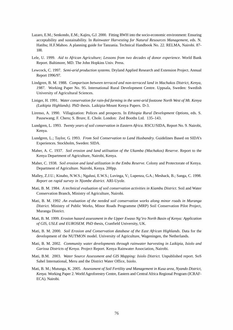
76
Lazaro, E.M.; Senkondo, E.M.; Kajiru, G.J. 2000. Fitting RWH into the socio-economic environment: Ensuringacceptability and sustainability. In Rainwater Harvesting for Natural Resources Management, eds. N.Hatibu; H.F.Mahoo. A planning guide for Tanzania. Technical Handbook No. 22. RELMA, Nairobi. 87-100.
Lele, U. 1999. Aid to African Agriculture; Lessons from two decades of donor experience. World BankReport. Baltimore, MD. The John Hopkins Univ. Press.
Lewcock, C. 1997. Semi-arid production systems. Dryland Applied Research and Extension Project. AnnualReport 1996/97.
Lindgren, B. M. 1988. Comparison between terraced and non-terraced land in Machakos District, Kenya,1987. Working Paper No. 95. International Rural Development Centre. Uppsala, Sweden: SwedishUniversity of Agricultural Sciences.
Liniger, H. 1991. Water conservation for rain-fed farming in the semi-arid footzone North West of Mt. Kenya(Laikipia Highlands). PhD thesis. Laikipia-Mount Kenya Papers. D-3.
Lirenso, A. 1990. Villagization: Polices and prospects. In Ethiopia Rural Development Options, eds. S.Pausewang; F. Cheru; S. Brure; E. Chole. London: Zed Booths Ltd. 135–143.
Lundgren, L. 1993. Twenty years of soil conservation in Eastern Africa. RSCU/SIDA, Report No. 9. Nairobi,Kenya.
Lundgren, L.; Taylor, G. 1993. From Soil Conservation to Land Husbandry. Guidelines Based on SIDA’sExperiences. Stockholm, Sweden: SIDA.
Maher, A. C. 1937. Soil erosion and land utilisation of the Ukamba (Machakos) Reserve. Report to theKenya Department of Agriculture, Nairobi, Kenya.
Maher, C. 1938. Soil erosion and land utilization in the Embu Reserve. Colony and Protectorate of Kenya.Department of Agriculture. Nairobi, Kenya. 200pp.
Malley, Z.J.U.; Kinabo, N.W.S.; Ngalusi, E.W.S.; Luvinga, V.; Lupenza, G.A.; Meshack, B.; Sanga, C. 1998.Report on rapid survey in Njombe district. ARI-Uyole.
Mati, B. M. 1984. A technical evaluation of soil conservation activities in Kiambu District. Soil and WaterConservation Branch, Ministry of Agriculture, Nairobi.
Mati, B. M. 1992 .An evaluation of the needed soil conservation works along minor roads in MurangaDistrict. Ministry of Public Works, Minor Roads Programme (MRP) Soil Conservation Pilot Project,Muranga District.
Mati, B. M. 1999. Erosion hazard assessment in the Upper Ewaso Ng’iro North Basin of Kenya: Applicationof GIS, USLE and EUROSEM. PhD thesis, Cranfield University, UK.
Mati, B. M. 2000. Soil Erosion and Conservation database of the East African Highlands. Data for thedevelopment of the NUTMON model. University of Agriculture, Wageningen, the Netherlands.
Mati, B. M. 2002. Community water developments through rainwater harvesting in Laikipia, Isiolo andGarissa Districts of Kenya. Project Report. Kenya Rainwater Association, Nairobi.
Mati, B.M. 2003. Water Source Assessment and GIS Mapping: Isiolo District. Unpublished report. SoSSahel International, Meru and the District Water Office, Isiolo.
Mati, B. M.; Mutunga, K. 2005. Assessment of Soil Fertility and Management in Kusa area, Nyando District,Kenya. Working Paper 2. World Agroforestry Centre, Eastern and Central Africa Regional Program (ICRAF-ECA). Nairobi.
77
Mburu, C. N. 2000. Farmer innovators in Kenya. In Farmer Innovation in Land Husbandry, eds. M. Haile;A. Waters-Bayer; M. Lemma; M. Hailu; G.B. Anenia; F. Abay; Y. GebreMichael. Proceedings ofAnglophone Regional Workshop (Feb 6-11. 2000) Mekelle, Tigray - Ethiopia. 68-70.
McCall, M.K., ed. 1994. Indigenous Technical Knowledge (ITK) in farming systems of Eastern Africa: ABibliography. Bibliographies in Technology and Social Charge series No. 9. Technology and Social ChargeProgram, Iowa State University Research Foundation.
MoA&RD. 2000. National Agricultural and Livestock Extension Program. Project Document. Ministry ofAgriculture and Rural Development. Nairobi.
MoA&RD. 2002. Special Program for Food Security in Kenya. A Concept Note. Consultative Meeting ofStakeholders, Ministry of Agriculture and Rural Development, Nairobi.
Moris, J. R. 1989. Extension under East African Field Conditions. In Agricultural extension in Africa, ed.N. Roberts. A World Bank Symposium. World Bank, Washington, D.C.: World Bank. 73-83.
Mruma, A. O.; Temu, A. E. M. 1999. Report on farmer experiment workshop at ADP. Ukwile, Mbozi, Tanzania.
Mulengera, M. K. 1998. Workshop for innovative farmers and researchers on traditional ways of soilconservation and land and water management, 10/10-15/10/1998. Ministry of Agriculture andCooperatives, Dar es salaam, Tanzania.
Murage, E. W.; Karanja, N. K.; Smithson, P. C.; Woomer, P. L. 2000. Diagnostic indicators of soil quality inproductive and non-productive smallholders’ fields of Kenya’s Central Highlands. Agriculture, Ecosystemsand Environment (79): 1-8.
Mureithi, J. G.; Gachene, C. K.; Muyekho, F. N.; Onyango, M.;, Mose, L.; Magenya, O. 2002. Participatorytechnology development for soil management by smallholders in Kenya. KARI legume Network project,Nairobi.
Mutunga, K.; Critchley, W.; Lameck, P.; Lwakuba, A.; Mburu, C. 2001. Farmers’ initiatives in landhusbandry. Promising technologies for the drier areas of East Africa. Technical Report No. 27. RELMA,Nairobi.
Muturi, S. N. 1999. Agroforestry Extension Manuals: A survey of their use in Kenya. Technical Report No.21. RELMA. Nairobi.
Muturi, S. N., ed. 2001. Marketing of smallholder produce. A synthesis of case studies in the highlands ofCentral Kenya. Technical Report No. 26. RELMA, Nairobi.
Mwale, A.; Mruma, A.O. 1999. Report on the PTD workshop for the extension staff of Traditional IrrigationProject (TIP). Arusha, Tanzania.
Nair, P. K. R. 1989. Agro-forestry systems in the tropics.
NALEP. 2001. The National Agricultural and Livestock Extension Program. Ministry of Agriculture andRural Development, Nairobi, Kenya.
Natea, S. 2002. The experience of CARE Ethiopia in rainwater harvesting systems for domestic consumption.In Workshop on The Experiences of Water Harvesting in Drylands of Ethiopia: Principals and Practices,eds. M. Haile; S.N. Merga. Dryland Coordination Group. DCG Report No.19:19-28.
Ndakidemi, P.; Piters, B. S.; Mollel, N. 1999. Integrated Soil Fertility Management in the Small-ScaleMechanized Mixed Farming System of Northern Tanzania. Northern Zone Publication Series. Field NoteNo.1. Arusha, Tanzania.
Nega, H.; Kimeu, P. M. 2002. Low-cost methods of rainwater storage. Results from field trials in Ethiopiaand Kenya. Technical Report No.28. RELMA, Nairobi.
78
Negassi, A.; Tengnas, B.; Bein, E.; Ghebru, K. 2000. Soil conservation in Eritrea. Some case studies.Technical Reort No. 23. Regional Land Management Unit, Nairobi
Ngigi, S. N. 2003. Rainwater harvesting for improved food security. Promising technologies in the GreaterHorn of Africa. Kenya Rainwater Association, Nairobi.
Nissen-Petersen, E. 2000. Water from sand rivers. A manual on site survey, design, construction andmaintenance of seven types of water structures in riverbeds. RELMA. Technical Handbook No. 23.Nairobi.
Nissen-Petersen, E. 1996. Groundwater dams in sand rivers. UNDO/UNHCHS (Habitat), Myanmar.
Njoroge, J. W. 1994. Field notes on organic farming. Kenya Institute of Organic Farming, Nairobi.
Njoroge, J. W. 1997. Training manual on organic farming in medium and high potential areas. A KenyaInstitute of Organic Farming Publication. Nairobi.
Norman, D. W.; Siebert, J. D.; Modiakogotla, E.; Worman, F. D. 1994. Farming systems research approach:A primer for eastern and southern Africa. F.S. Program, UNDP, Gaborone, Botswana: UNDP.
Norman, D.; Douglas, M. 1994. Farming Systems Development and Soil Conservation. FAO Farm SystemsManagement Series. Rome, Italy: FAO.
Ochola, W. O.; Muhia, R. N.; Mwarasomba, L. I. 2000. Culture, Traditions and Society. The Challenges toNatural Resource Management and Development. NS&WCB, MoA&RD, Nairobi.
Okoth, J. R.; Khisa, C.; Thomas, J. 2002. Towards a Holistic Farmer Field School Approach for East Africa.Leisa Magazine, October 2002. 18 (3): 11-19.
Okwach, G. E. 2000. Tillage and cover effects on runoff, erosion and soil characteristics in semi-arid MachakosDistrict of Kenya. In Conservation Tillage for Dryland Farming. Technological Options and Experiencesin Eastern and Southern Africa, eds. E.K. Biamah; J. Rockstrom; G.E. Okwach. G.E. RELMA, WorkshopReport No. 3. 114-130.
Onim, J. F. M.; Ochola. P.; Fitzhugh, P.; Oduor, H. A. 1990. Potential of goat manure as a valuable fertilizerfor small-scale farmers. In Proceedings of the Eighth Small Ruminants Scientific Workshop. SmallRuminants Collaborative Research, ILRAD, Nairobi. 157-170.
Oweis, T.; Prinz, P.; Hachum, A. 2001. Water harvesting. Indigenous knowledge for the future of the drierenvironments. International Centre for Agricultural Research in the Dry Areas (ICARDA). Aleppo, Syria.
Pacey, A.; Cullis, A. 1986. Rainwater harvesting:The collection of rainfall and runoff in rural areas. ITpublications. London, UK.
Pickering, D. 1989. Agricultural Extension and its Linkage with Agricultural Research. In Agriculturalextension in Africa, ed. N. Roberts. A World Bank Symposium. Washington, D.C.: The World Bank. 3-6.
Quinones, M.; Gebre, J. 1996. An Overview of the Sasakawa – Global 2000 Project in Ethiopia. In AchievingGreater Impact from Research Investments in Africa. Proceeding on the workshop— Developing AfricanAgriculture Achieving: Greater Impact from Research Investments, ed. S.A Breth. Addis Ababa, Sept. 26– 30, 1995. Mexico: Sasakawa African Association. 29-46.
Reij, C.; A. Waters-Bayer. 2001. Entering Research and Development in Land Husbandry Through FarmerInnovation. In Farmer Innovation in Africa. A Source of Inspiration for Agricultural Development, eds.C. Reij; A.Waters-Bayer. London, U.K.: Earthscan. 3-22.
Reij, C.; Scoones, I.; Toulmin, C., eds. 1996. Sustaining the soil. Indigenous soil and water conservation inAfrica. London, U.K.: Earthscan.
79
Reij, C.; Waters-Bayer, A., eds. 2001. Farmer innovation in Africa. A source of inspiration for agriculturaldevelopment. London, U.K.: Earthscan.
Republic of Kenya. 1995. Agricultural sector review, Ministry of Agriculture, Nairobi, Kenya: ASIPSecretariat, Kilimo House, Nairobi
Republic of Kenya. 1999. The 1999 Population and Housing Census. The Population Report. Central Bureauof Statistics, Ministry of Finance and Planning, Nairobi. Central Bureau of Statistics.
Republic of Kenya. 2000. Statistical Abstract. Central Bureau of Statistics, Ministry of Finance and Planning,Nairobi. Central Bureau of Statistics.
Republic of Kenya. 2001. Poverty Reduction Strategy Paper for the Period 2001-2002. Ministry of Financeand Planning, Nairobi.
Republic of Kenya. 2004. Economic Survey 2004. Central Bureau of Statistics. Ministry of Planning andNational Development. Nairobi. Central Bureau of Statistics.
Sanders, J. H.; Macmillan, D. 2001. Agricultural Technology for the Semi-arid African Horn. Vol. 1: RegionalSynthesis. IGAD/INTOSORMIL/USAID-REDSO. Djibouti.
Sanchez, P. A.; Buresh, R. J.; Leakey, R. R. B. 1997. Trees, Soils, and Food Security. Philos. Trans. R. Soc.London B 352:946-961.
Sanchez, P.A. 1999. Improved fallows come of age in the tropics. Agroforestry Systems 47 (1-3): 3-12.
Scarborough, V.; Killough, S.; Johnson, D.A.; Farrington, J., eds. 1997. Farmer–led extension, conceptsand practices, Intermediate Technology Publication Ltd. London, U.K.: Intermediate TechnologyPublication Ltd.
Schwartz, L. A.; Kampen, J. 1992. Agricultural Extension in East Africa. World Bank Technical Paper No.164. Washington, D.C.: The World Bank.
Sherington, M. A. 1997. Participatory research method – implementation, effectiveness and institutionalcontext. Agricultural Systems (Special Issue) 55 (2):196-216.
Sijali, I. V. 2001. Drip Irrigation. Options for Smallholder Farmers in Eastern and Southern Africa. TechnicalHandbook No. 24. RELMA.
Sijali, I. V.; Okumu, R. A.; 2002. New irrigation technologies. In The changing face of irrigation in Kenya.Opportunities for anticipating change in Eastern and Southern Africa, eds. H.G. Blank; C.M. Mutero;H. Murray-Rust. IWMI, Colombo, Sri Lanka. 55-71.
Sinebo, W.; Yirga, C.; Fessihaye, R. 2002. On-farm fertilizer trial on food barley in Wolmera Area. In TowardsFarmers’ Participatory Research: Attempts and Achievements in Central Highlands of Ethiopia.Ethiopian Agricultural Research Organization, Addis Ababa. Ethiopian Agricultural Research Organization.266-279.
SIWI. 2001. Water harvesting for upgrading of rain-fed agriculture. Problem analysis and research needs.Report II. Stockholm International Water Institute. Stockholm, Sweden: Stockholm International WaterInstitute.
Smaling, E. M. A., Stoorveogel, J.J. and Winmeijer, P.N. (1993) Calculating soil nutrient balances in Africaat different scales II. District scale. Fert. Res. 35,237-250.
Sombroek, W. G; Braun, H. M. H.; Van der Pouw, B. J. A. 1980. The explanatory soil map and agro-climaticzone map of Kenya. Report No. E.I. Kenya Soil Survey, Nairobi.
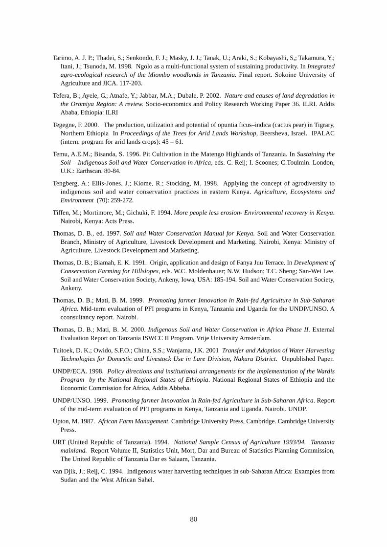
80
Tarimo, A. J. P.; Thadei, S.; Senkondo, F. J.; Masky, J. J.; Tanak, U.; Araki, S.; Kobayashi, S,; Takamura, Y.;Itani, J.; Tsunoda, M. 1998. Ngolo as a multi-functional system of sustaining productivity. In Integratedagro-ecological research of the Miombo woodlands in Tanzania. Final report. Sokoine University ofAgriculture and JICA. 117-203.
Tefera, B.; Ayele, G.; Atnafe, Y.; Jabbar, M.A.; Dubale, P. 2002. Nature and causes of land degradation inthe Oromiya Region: A review. Socio-economics and Policy Research Working Paper 36. ILRI. AddisAbaba, Ethiopia: ILRI
Tegegne, F. 2000. The production, utilization and potential of opuntia ficus–indica (cactus pear) in Tigrary,Northern Ethiopia In Proceedings of the Trees for Arid Lands Workshop, Beersheva, Israel. IPALAC(intern. program for arid lands crops): 45 – 61.
Temu, A.E.M.; Bisanda, S. 1996. Pit Cultivation in the Matengo Highlands of Tanzania. In Sustaining theSoil – Indigenous Soil and Water Conservation in Africa, eds. C. Reij; I. Scoones; C.Toulmin. London,U.K.: Earthscan. 80-84.
Tengberg, A.; Ellis-Jones, J.; Kiome, R.; Stocking, M. 1998. Applying the concept of agrodiversity toindigenous soil and water conservation practices in eastern Kenya. Agriculture, Ecosystems andEnvironment (70): 259-272.
Tiffen, M.; Mortimore, M.; Gichuki, F. 1994. More people less erosion- Environmental recovery in Kenya.Nairobi, Kenya: Acts Press.
Thomas, D. B., ed. 1997. Soil and Water Conservation Manual for Kenya. Soil and Water ConservationBranch, Ministry of Agriculture, Livestock Development and Marketing. Nairobi, Kenya: Ministry ofAgriculture, Livestock Development and Marketing.
Thomas, D. B.; Biamah, E. K. 1991. Origin, application and design of Fanya Juu Terrace. In Development ofConservation Farming for Hillslopes, eds. W.C. Moldenhauer; N.W. Hudson; T.C. Sheng; San-Wei Lee.Soil and Water Conservation Society, Ankeny, Iowa, USA: 185-194. Soil and Water Conservation Society,Ankeny.
Thomas, D. B.; Mati, B. M. 1999. Promoting farmer Innovation in Rain-fed Agriculture in Sub-SaharanAfrica. Mid-term evaluation of PFI programs in Kenya, Tanzania and Uganda for the UNDP/UNSO. Acconsultancy report. Nairobi.
Thomas, D. B.; Mati, B. M. 2000. Indigenous Soil and Water Conservation in Africa Phase II. ExternalEvaluation Report on Tanzania ISWCC II Program. Vrije University Amsterdam.
Tuitoek, D. K.; Owido, S.F.O.; China, S.S.; Wanjama, J.K. 2001 Transfer and Adoption of Water HarvestingTechnologies for Domestic and Livestock Use in Lare Division, Nakuru District. Unpublished Paper.
UNDP/ECA. 1998. Policy directions and institutional arrangements for the implementation of the WardisProgram by the National Regional States of Ethiopia. National Regional States of Ethiopia and theEconomic Commission for Africa, Addis Abbeba.
UNDP/UNSO. 1999. Promoting farmer Innovation in Rain-fed Agriculture in Sub-Saharan Africa. Reportof the mid-term evaluation of PFI programs in Kenya, Tanzania and Uganda. Nairobi. UNDP.
Upton, M. 1987. African Farm Management. Cambridge University Press, Cambridge. Cambridge UniversityPress.
URT (United Republic of Tanzania). 1994. National Sample Census of Agriculture 1993/94. Tanzaniamainland. Report Volume II, Statistics Unit, Mort, Dar and Bureau of Statistics Planning Commission,The United Republic of Tanzania Dar es Salaam, Tanzania.
van Djik, J.; Reij, C. 1994. Indigenous water harvesting techniques in sub-Saharan Africa: Examples fromSudan and the West African Sahel.
81
van Veldhuizen, L.; Waters-Bayer, A.; de Zeeuw, H. 1997. Developing technology with farmers: A trainer’sguide for participatory learning, Zed Books, London.
Virmin, S. M.; Katyal, J. C; Erwaran, H.; Abrol, I. P., eds. 1995. Stressed ecosystems and sustainableagriculture. SP Science Publishers Inc.
Vukasin, H. L.; Roos, L.; Spicer, N. H.O.; Davies, M. 1995. Production without destruction. A manual fortrainers and a reference book for those practicing natural or organic farming. Natural Farming Network,Zimbabwe.
Wenner, C. G. 1981. Soil Conservation in Kenya. Soil and Water Conservation Branch. Ministry of Agriculture,Nairobi.
WOCAT (World Overview of Conservation Approaches and Technologies).1997. WOCAT, World Overviewof Conservation Approaches and Technologies – A Program Overview. May 1997. Bern, Switzerland.
Wolde-Aregay, B. 1996. Twenty Years of Soil Conservation in Ethiopia. A Personal Overview. SIDA/RSCUTechnical Report No. 14. Nairobi.
Woomer, P.L.; Savala, C.E.N.; Mukwana, E. J. 2004. Best–Bet Comparison of Soil Fertility ManagementRecommendations in Western Kenya: Independent Testing by NGOs. Best-Bet Final Technical Report2003. SACRED, Africa.
World Bank. 1997. World Development Report, 1997. Washington, D.C.: The World Bank.
World Bank. 1995. Kenya: A Strategy for Agricultural Growth. World Bank/Agriculture and EnvironmentOperations Division, Country Dept. II, Africa Region. Washington, D.C.
World Bank. 2000. Agriculture in Tanzania Since 1986. Follower or Leader of Growth? Government ofthe United Republic of Tanzania and the World Bank. Washington, D.C.: The World Bank.
World Bank. 2002. The Little Data Book, 2002. International Bank for Reconstruction and Development.Washington, D.C.: The World Bank.
World Bank, 2003. Little Green data book. International Bank for Reconstruction and Development.Washington, D.C.: The World Bank.
World Bank. 2004. World Bank Indicators Database. http://www.worldbank.org/data/databytopic/GNIPC.pdf.Accessed March 29, 2005.
Young, A. 1976. Tropical Soils and Soil Survey. Cambridge University Press, Cambridge. CambridgeUniversity Press.

WORKING PAPER 105
I n t e r n a t i o n a lWater ManagementI n s t i t u t eISBN: 92-9090-621-9
SM
IWMI is a Future Harvest Centersupported by the CGIAR
Postal AddressP O Box 2075ColomboSri Lanka
Location127, Sunil MawathaPelawattaBattaramullaSri Lanka
Telephone+94-11 2787404
Fax+94-11 2786854
Websitehttp://www.iwmi.org
I n t e r n a t i o n a lWater ManagementI n s t i t u t e
Overview of Water and SoilNutrient ManagementUnder Smallholder Rain-fedAgriculture in East Africa
Bancy Mbura Mati