ottonwood river watershed - mrbdc.mnsu.edu · plum creek, lone tree creek, meadow creek and sleepy...
TRANSCRIPT

Minnesota River Basin 2010 Progress Report Cottonwood River Watershed
COTTONWOOD RIVER WATERSHED Located on the west side of the Minnesota River, the Cottonwood
River Watershed encompasses 1,310 square miles or drains approximately 840,200 acres. Originating on the Coteau des Prairies (an impressive morainal plateau and important drainage divide), the Cottonwood River flows eastward approximately 150 miles to the Minnesota River with a drop in elevation of about 750 feet. Nearly all wetlands have been drained by a highly efficient and interconnected artificial drainage system. Major tributaries of the Cottonwood River are Highwater/Dutch Charley Creek, Plum Creek, Lone Tree Creek, Meadow Creek and Sleepy Eye Creek. There are over 36,000 people living in the watershed that includes parts of Brown, Cottonwood, Lyon, Murray and Redwood counties. Cottonwood River at Flandrau State Park
1. Cottonwood River Restoration
Project 2. Conservation
Drainage
3. Vision for Conservation
6. Redwood SWCD – Wetland Restorations
7. Redwood SWCD – On-the-Road Meetings
4. Cottonwood Soil and Water Conservation District
5. Redwood Soil and Water Conservation District
The Cottonwood River is a translation of the Dakota name for cottonwood Waraju. The river was named from the abundance of this tree on its banks. Early French explorer Joseph Nicollet stated that the most important village of the Sisseton Dakota was on the its north bank near its junction with the Minnesota River. – Warren Upham, Minnesota Place Names – A geographical Encyclopedia
Page 90

Minnesota River Basin 2010 Progress Report Cottonwood River Watershed
1. Cottonwood River Restoration Project Initiated in 1997, the goals of the Cottonwood River Restoration Project was to achieve the highest water quality attainable for ecoregion streams; to have watershed residents take an active role in enhancing and protecting the Cottonwood River, and to develop the Cottonwood River as a major recreational resource within the Minnesota River Basin.
A diagnostic study recorded an average of 55.7 tons of suspended sediment per square mile at the mouth of the Cottonwood River near New Ulm. From 2000 to
mid-2009, a diverse selection of Best Management Practices were funded through this project: Ag Waste Systems (4), Pond/Small Dam Repair (12),
Grade Stabilization Structure (5), Grassed Waterway (44 – 50,798 feet), Drainage Water Management (1), Streambank & Shoreland Protection (7 – 2,385 feet), Terraces (17 total at 15,575 feet), Tile Intake Replacements (397), Water & Sediment Control Basins (31), and CSA (7).
During the project, RCRCA conducted numerous outreach events resulting in over 2,500 individual contacts. Outreach activities focused on school presentations, “Coffee on the Project” where staff met informally with watershed residents at local cafes to discuss water quality issues, canoe trips, golf day event, and radio interviews. 2. Conservation Drainage On Brian Hicks’ farm near Tracy in southwest Minnesota, a box extending more than ten feet into the ground and a large drainage pipe from nearby cropfield entering at the bottom of the structure is helping control excessive runoff
COTTONWOOD RIVER WATERSHED The joint-powers organization, Redwood-Cottonwood River Control Area (RCRCA) has been a major influence with studying and partnering with other groups and government agencies to improve water quality in this major watershed. The Cottonwood River Watershed also features a lot of innovative farmers and conservationists working on solutions to protect and restore rivers and other water bodies.
along with nutrients and sediment from entering the Cottonwood, the Minnesota, the Mississippi rivers and eventually contributing to the Gulf of Mexico’s ‘dead zone.’ By controlling the amount of water leaving his cropfield. Hick’s is able to hold back far more water than he releases especially in the summer months when the plants need the extra moisture. According to the University of Minnesota, monitoring the tile water flow, annual loads of nitrate and phosphate have seen significant reductions.
3. Vision for Conservation The conservation legacy of one man continues to be felt despite being gone for over a decade. Burton Tellefsen established grass buffer strips, created holding ponds for runoff and planted tens-of-thousands of trees to preserve surface water and water quality years before anyone began to see the value of conservation practices. He saw the value of keeping soil on the land and out of the water by planning native grass strips around ponds, ditches, and streams on his own without any subsides from the government.
To encourage others to engage in conservation efforts, Tellefsen set out thousands of trees in his front yard for their own plantings and had ordered 1 million trees from the Arbor Day Foundation. Tellefsen also experimented by digging a series of holding ponds on gullies set back from the Cottonwood River and used all sizes of rock for erosion control and wildlife habitat including on the Sleepy Eye Creek headwaters. In addition to all of the conservation practices, Tellefsen also created a series of four large rock monuments along the ridge of the Cottonwood River in perfect alignment from east to west. Page 91
An example of conservation drainage
Cottonwood River Golf Outing
Rock Monuments

Minnesota River Basin 2010 Progress Report Cottonwood River Watershed
4. Cottonwood Soil and Water Conservation District Portions of three major watersheds in the Minnesota River Basin – Cottonwood River, Middle Minnesota and Watonwan River – are found in Cottonwood County. The mission of the Cottonwood
5. Redwood Soil and Water Conservation District Established in 1953, the Redwood SWCD concentrates on promoting and installing Best Management Practices to reduce soil erosion from wind and water to positively
affect water quality. Redwood County sits in the middle portion of the Minnesota River Basin broke into three major watersheds: Redwood River, Cottonwood River and Middle Minnesota. The Redwood SWCD has concentrated some of its conservation efforts in the southwest portion of the county through conservation easements to provide cover on some of the most vulnerable areas. As one of five SWCD offices in the MN River Basin, the Redwood SWCD is part of the
Granite Rock Outcrop Easement Program, protecting 376 acres of land through a permanent easement. 6. Redwood SWCD – Wetland Restorations More than 4,000 acres of wetlands have been restored by Redwood SWCD utilizing programs like Reinvest in Minnesota (RIM) Reserve, Conservation Reserve Enhancement Program (CREP) and Farm Wetland Program. These restorations along with other grassland plantings have helped improve water quality and wildlife habitat throughout the county. 7. Redwood SWCD - On-the-Road Meetings Because the Redwood SWCD office is located in northern part of the county the staff held meetings in six of the 14 communities to inform more people about conservation and their programs. To draw interest to this “Taking the Office on the Road,” the SWCD office advertised through posters, news releases and radio programs. These meetings were deemed a high success with the staff meeting 53 individuals who would have not traveled all the way across the county to attend a SWCD meeting.
SWCD is “to help maintain
a better environment for future generations through programs and education” including the promotion of Best Management Practices (BMPs), educational programs for all ages, and technical assistance. Cottonwood SWCD staff CREP Easement near Mountain Lake
provides administrative and technical oversight for the Greater Blue Earth River Basin Alliance (GBERBA) which involves securing funding for BMPs and projects like the Nutrient Management Program. Cottonwood SWCD enrolled 3,317 acres of environmentally sensitive land into the Minnesota River Conservation Reserve Enhancement Program (CREP) under a total of 103 individual easements to help protect wildlife habitat and improve water quality. This SWCD office has also been a significant partner with the Cottonwood River Watershed Project including assisting with the installation of BMPs: three acres of waterways and two grade stabilizations in 2009. During the same year, one pond, one sediment basin and three alternative tile intakes were installed in the Watonwan River Watershed. They have also been involved in the Mountain Lake Project to improve water quality in Cottonwood County’s largest water body.
On the Road Meeting
Environmental education plays an important role in the mission of the Cottonwood SWCD. The staff is involved with the Fifth Grade Conservation Day, Sixth
Grade Environmental Fair and Women’s Day Conference. In 2010, participants learned about the benefits of trees. Other educational
Mountain Lake Public School Education Expo
efforts involve the Windom Farm & Home Show, Cottonwood County Fair and school presentations.
Page 92

Minnesota River Basin 2010 Progress Report Cottonwood River Watershed
Cottonwood River Watershed Conservation Practices and Land Use
FEEDLOT POLLUTION REDUCTION
1%
FILTER STRIP PROJECTS4%
GULLY STABILIZATION5%
NOT SPECIFIED0%
OTHER CALCULATED POLLUTION REDUCTION
7%
SHEET/RILL AND EPHEMERAL CONTROL
49%
STREAM/DITCH BANK STABILIZATION
0%
WELL SEALING27%
WIND EROSION7%
Cottonwood River Major Watershed
Conservation Practices In the late 1990s, the Redwood Cottonwood Rivers Control Area along with a diverse selection of partners began to concentrate on improving water quality through BMPS. The map above and pie chart to the right illustrates conservation practices in the Cottonwood River Watershed. The conservation practices data comes from the Board of Water and Soil Resources (BWSR) program compiles information on a county, watershed, and individual-project basis from 1997 to 2008. The number of conservation practices reflects only actual contract and not the acres. There are additional conservation practices installed in the Cottonwood River Watershed but not recorded in either LARS or eLINK.
Source: Minnesota Agricultural Statistics
Page 93

Minnesota River Basin 2010 Progress Report Cottonwood River Watershed
Cottonwood River Watershed Water Quality
Total Suspended Solids (TSS) The Redwood – Cottonwood Rivers Control Area (RCRCA) has been monitoring the Cottonwood River since 1997. Over the 2000 to 2008 monitoring seasons we have seen a steady downward trend in TSS levels (FWMC). Sampling done throughout the watershed continues to reflect a general reduction trend of Total Suspended Solids from 2000 to 2008 with 2004 being an exception to that trend. Overall, we believe conservation projects have helped to reduce sediment runoff from agricultural lands and stream bank stabilization projects have reduced stream bank sediment contributions.
Total Phosphorus (TP) Phosphorus levels are often correlated with sediment levels (TSS). The mass of Total Phosphorus (TP) values mirror that of TSS over this period, though the ratio of TP to TSS appears to have increased in the past 4 years. The trend for the FWMC for TP is very similar to that of the TSS as well. A downward trend in phosphorus concentration appears to have steadied in the Cottonwood River Watershed. Given the relationship between TSS and TP, we feel future reductions in TSS should result in a corresponding reduction in TP.
Nitrate-Nitrite (NO2-NO3) Nitrogen values have fluctuated from year to year, but there is an upward trend to the data. Increased planting of corn acres and the associated fertilizer inputs required for corn production could be contributing to this trend. The 2005 season saw no major spikes in flow, but a long time of consistently high water levels and correspondingly high levels of nitrogen until late June or early July. In 2006, there were some high water flow spikes, but also a sustained period of high water flows similar to 2005. This resulted in persistent high nitrogen sample results during the time that the majority of water flow was occurring. The low nitrogen test results later in the year were associated with minimal flow conditions and thus had little effect on annual FWMC for 2006.
Nitrates tend to trend in proportion to the volume of water in storm events in non-canopy periods of the sampling season. In other words, high rains generally bring high nitrates with lack of vegetation.
Page 94

Minnesota River Basin 2010 Progress Report Redwood River Watershed
REDWOOD RIVER WATERSHED
Originating from the imposing hills of the Prairie de Coteau (“Highland of the Prairies”) of western Minnesota, the Redwood River falls nearly 300 feet over a span of approximately fifteen miles. The Redwood River Watershed drains 705 square miles or 451,257 acres. A shallow drainage channel, the valley of the Redwood River is no more 25 to 50 feet deep above the City of Redwood Falls. A forty-foot dam at Redwood Falls impounds the river and then the Redwood River drops 100 feet in a succession of cascades and rapids before entering the broad flat Minnesota River floodplain. Coon Creek, Three Mile Creek, and Ramsey Creek are the main tributaries of the Redwood River. One of the unique natural features is the Ramsey Creek falls equal to the most remote waterfalls of northern Minnesota.
Ramsey Creek Falls
16. Green Corridor
Project Inc. 18. Green
Corridor Bus Tour
14. Waukon RIM
15. Tatanka Bluffs
17. MN River Waterway
Trail
1. Redwood River Watershed
Restoration Project
The Redwood River, which rises in the Coteau des Prairies, meanders along until it plunges over granite ledges into a spectacular heavily wooded gorge, flows down an irregular valley and moves between the banks of heavy soil to the Minnesota.- Wayne E. Webb and J.I. Swedberg, Redwood – The Story of a County
Page 95
2. RCRCA Top Accomplishments
3. RCRCA Information &
Communication Activities
4. RCRCA Area II Legislative
Meeting
5. Redwood River Water Trail
7. Community River Cleanup
8. Lyon SWCD – Livestock Facilities
9. Schwan Food
Company
10. Biggest Reducer Project
11. Lincoln/ Redwood
River Watershed Restoration
Project
12. Lake Benton
Rehabilitation & Reclamation
Project
13. City of Florence
Wastewater Treatment
6. Paddle the Redwood

Minnesota River Basin 2010 Progress Report Redwood River Watershed
2. RCRCA Top Accomplishments REDWOOD RIVER WATERSHED The Redwood-Cottonwood Rivers Control Area (RCRCA) works along with numerous partners including SWCDs, cities, nonprofit organizations and many others to install a wide range of Best Management Practices (BMPs). One of the most unique projects is the Green Corridor Project purchasing land along the Minnesota River to put in public access areas for people to use and enjoy the natural resources.
After twenty-five plus years of existence, the Redwood Cottonwood Rivers Control Area has been monitoring water quality since 1990 with the long-term trend analysis showing reduction of most pollutant concentrations during this time period. The organization has provided funds toward 880 different Best Management Practices (BMPs) with $1.7 million spent on cost-share since 1994 not including septic loan funds. RCRCA has operated as Joint Powers Organizational structure of government entity for 26 years. Four TMDL studies have been finished or in the process of being completed. Three diagnostic studies are finished or in the process of being completed.
1. Redwood River Watershed Restoration Project
In the mid 1980s, Redwood Cottonwood Rivers Control Area (RCRCA) took RCRCA has secured $13.6 million dollars
in funds for the Redwood River and Cottonwood River watersheds since 1994.
on the job of leading the effort to develop and implement a plan to help restore Lake Redwood. By 1994, RCRCA began to push the adoption of best management practices to reduce excessive levels of sediment and nutrients up to thirty percent. To help promote the installation of BMPs and highlight water quality problems, RCRCA undertook a comprehensive information and education program.
3. RCRCA Information and Communication Activities The objectives of this program was to provide watershed residents with knowledge of problems and solutions related to water quality; to supply information about priority watershed
“Coffee on the Project” radio broadcast
areas; to educate landowners about practices that will result in reduced nonpoint source pollution; and teach management skills needed by landowners to implement soil and water conservation
Best Management Practices funded by the Redwood Cottonwood Rivers Control Area as of 2009 include Agricultural Waste System (5), Critical Area Planting (4), Multi-purpose Dam (2), Sediment Basin (1), Clean Water Diversion (3), Pond/Small Dam Repair (4), Filter Strips (3 – 12 acres), Grade Stabilization Structure (2), Grassed Waterways (83 – 122,318 feet), Streambank & Shoreland Protection (14 – 3,539 feet), Water Control Structure (1), Terraces (2 – 3,660 feet), Tile Intake Replacements (15), Water & Sediment Control Basins (213), Wetland Restoration (1), and CSA (2).
practices. RCRCA accomplished these objectives by holding a Redwood River Clean Water Project Open House, conducting a storm drain stenciling project in several communities through coordinated efforts with local youth groups and developing newspaper inserts and newsletters featuring current information and available programs. The project also held a water quality campaign highlighting a different water-related topic called “Water Wednesday,” an annual event – “Coffee on the Project” - serving coffee and rolls at a variety of local cafes to visit informally with landowners about watershed concerns and put on an annual canoe trip on the Redwood River.
Environmental Education
Streambank Stabilization Project Page 96

Minnesota River Basin 2010 Progress Report Redwood River Watershed
Other projects included coordinating efforts with the Retired Senior Volunteer Program and MN Department of Transportation to plant native grasses and
wildflowers next to the Redwood River and a wayside rest area; They held a carp fishing contest to facilitate grassroots
interest in exploring options
5. Redwood River Water Trail Senator Dennis Fredrickson of New Ulm worked with the Minnesota Department of Natural Resources and Redwood Cottonwood Rivers Control Area (RCRCA) to establish a stretch of the Redwood River as an official state water trail. The official water trail starts in Marshall and ends at Redwood Lake in the City of Redwood Falls. RCRCA sponsors a canoe trip on a portion of the Redwood River to help people take advantage of the resource and high- light efforts to improve in the Redwood River Watershed. This is one of 30 plus water trails found in the state including others in the Minneota River Basin – the Cottonwood, Pomme de Terre, Chippewa, Watonwan, Blue Earth and the Minnesota rivers. 6. Paddle the Redwood On June 24, 2010, the Redwood Cottonwood Rivers Control Area (RCRCA) held a ribbon cutting ceremony for the Redwood River State Water Trail. A group of fifty plus people came out to hear Senator Dennis Fredrickson talk about how the efforts to improve water quality in the river impacts recreation usage and how it can fit into a larger tourism promotion. “The Minnesota River, its valley and all of its tributaries, like this one, are a tremendous resource to Minnesota and to those of us who live in this watershed,” Senator Fredrickson offered to the crowd of recreation users and river advocates. “There has been a new awakening as to what a wonderful asset this is
to fishing, for hunting, having trails and enjoying the river valley for its wildlife and vegetation.” After Senator Fredrickson cut
the ribbon with help from one of the youngest paddlers, the group made their way down the Redwood River in canoes and kayaks to Perks Park in Redwood Falls.
to enhance the lake’s recreational opportunities, and put up an informational display on the Redwood River Watershed at Camden State Park, and produced a Best Management Practices (BMP) booklet highlighting the producer’s conservation efforts. Finally, RCRCA set up displays at various community events including Farm Fest and the Redwood County Fair, conducted water quality radio interviews, produced four segments on the project for KARE 11 and collaborated with local schools to develop a water quality curriculum focusing on the Redwood River. 4. RCRCA – Area II Legislative Meeting On December 12, 2009, the Redwood-Cottonwood River Control Area and Area II jointly hosted their annual legislative meeting. Bruce Wilson and Jeff Strock of the University of Minnesota gave a presentation on 2-stage ditches and controlled drainage to more than 60 people including county commissioners and SWCD supervisors from the eight counties in the RCRCA watersheds. Local landowner and farmer Brian Hicks spoke about the positive aspects of using controlled drainage in his operation. In conjunction with this presentation, Jeff Strock reviewed data covering nutrient removal and crop yield benefits from the Hicks’ fields with an installed controlled drainage system.
Information Kiosk at Camden State Park
Paddling the Redwood River
RCRCA – Area II Legislative Meeting
Senator Fredrickson speaking at the Redwood River
Page 97
Minnesota River Basin 2010 Progress Report Redwood River Watershed
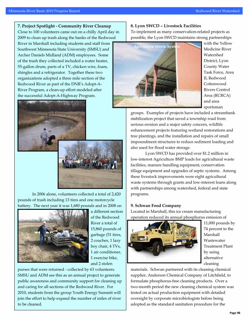
8. Lyon SWCD – Livestock Facilities To implement as many conservation-related projects as possible, the Lyon SWCD maintains strong partnerships
with the Yellow Medicine River Watershed District, Lyon County Water Task Force, Area II, Redwood Cottonwood Rivers Control Area (RCRCA) and area sportsman
groups. Examples of projects have included a streambank stabilization project that saved a township road from serious erosion and a major safety concern, wildlife enhancement projects featuring wetland restorations and tree plantings, and the installation and repairs of small impoundment structures to reduce sediment loading and also used for flood water storage.
Lyon SWCD has provided over $1.2 million in low-interest Agriculture BMP loads for agricultural waste facilities, manure handling equipment, conservation tillage equipment and upgrades of septic systems. Among these livestock improvements were eight agricultural waste systems through grants and low-interest loans along with partnerships among watershed, federal and state programs. 9. Schwan Food Company Located in Marshall, this ice cream manufacturing operation reduced its annual phosphorus emission of
11,000 pounds by 74 percent to the Marshall Wastewater Treatment Plant by using alternative cleaning
materials. Schwan partnered with its cleaning chemical supplier, Anderson Chemical Company of Litchfield, to formulate phosphorus-free cleaning products. Over a two-month period the new cleaning chemical system was tested on actual production equipment with detailed oversight by corporate microbiologists before being adopted as the standard sanitation procedure for the
7. Project Spotlight - Community River Cleanup Close to 100 volunteers came out on a chilly April day in 2009 to clean up trash along the banks of the Redwood River in Marshall including students and staff from Southwest Minnesota State University (SMSU) and Archer Daniels Midland (ADM) employees. Some of the trash they collected included a water heater, 55-gallon drum, parts of a TV, chicken wire, foam, shingles and a refrigerator. Together these two organizations adopted a three mile section of the Redwood River as part of the DNR’s Adopt-A- River Program, a clean-up effort modeled after the successful Adopt-A-Highway Program.
In 2006 alone, volunteers collected a total of 2,420 pounds of trash including 13 tires and one motorcycle battery. The next year it was 1,680 pounds and in 2008 on
a different section of the Redwood River a total of 15,860 pounds of garbage (51 tires, 2 couches, 1 lazy boy chair, 4 TVs, 1 air conditioner, 1 exercise bike, and 2 stolen
purses that were returned - collected by 63 volunteers. SMSU and ADM see this as an annual project to generate public awareness and community support for cleaning up and caring for all sections of the Redwood River. For 2010, students from the group Youth Energy Summit will join the effort to help expand the number of miles of river to be cleaned.
Agricultural Waste System
Page 98
Minnesota River Basin 2010 Progress Report Redwood River Watershed
plant. The system showed improved cleaning and sanitation performance with no net increase in combined chemical and labor cost. As a result of the phosphorus reduction, the Schwan Food Company received the Governor’s Award for Excellence in Waste and Pollution Prevention at the 2006 Air, Water and Waste Environmental Conference.
10. Biggest Reducer Project Members of the Youth Energy Summit (YES!) or the Marshall Renewable Energy Club visited families in the city to teach people about recycling tips on can and cannot be recycled. In addition, the high school students provided other information about energy conservation including unplugging chargers, turning off lights and using shorter extension cords because they all save money. YES! Members left behind brochures on CFL light bulbs, a Smart Strip, and Kill A Watt. The YES! group is also teaching Marshall Middle School students about wind energy through hands-on activities with a grant from East River Electric. 11. Lincoln/Redwood River Watershed Restoration Project From January of 2005 to February of 2009, the Redwood Cottonwood River Control Area (RCRCA) continued to
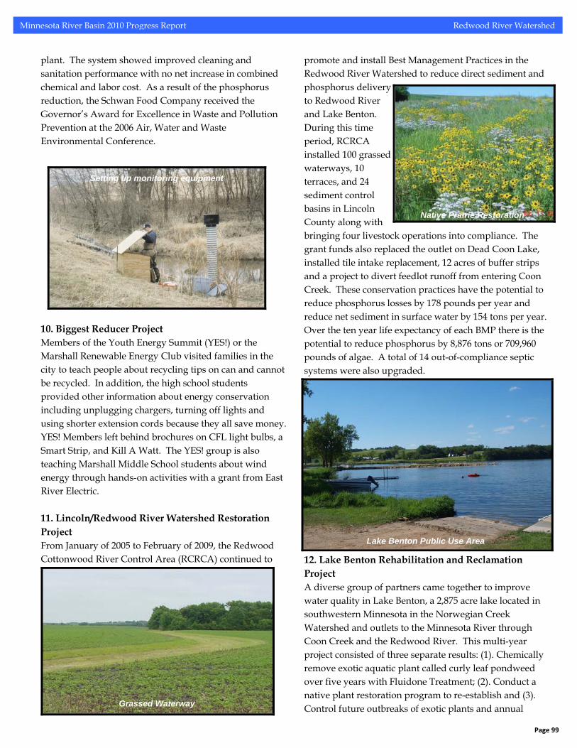
promote and install Best Management Practices in the Redwood River Watershed to reduce direct sediment and phosphorus delivery to Redwood River and Lake Benton. During this time period, RCRCA installed 100 grassed waterways, 10 terraces, and 24 sediment control basins in Lincoln County along with bringing four livestock operations into compliance. The grant funds also replaced the outlet on Dead Coon Lake, installed tile intake replacement, 12 acres of buffer strips and a project to divert feedlot runoff from entering Coon Creek. These conservation practices have the potential to reduce phosphorus losses by 178 pounds per year and reduce net sediment in surface water by 154 tons per year. Over the ten year life expectancy of each BMP there is the potential to reduce phosphorus by 8,876 tons or 709,960 pounds of algae. A total of 14 out-of-compliance septic systems were also upgraded. 12. Lake Benton Rehabilitation and Reclamation Project A diverse group of partners came together to improve water quality in Lake Benton, a 2,875 acre lake located in southwestern Minnesota in the Norwegian Creek Watershed and outlets to the Minnesota River through Coon Creek and the Redwood River. This multi-year project consisted of three separate results: (1). Chemically remove exotic aquatic plant called curly leaf pondweed over five years with Fluidone Treatment; (2). Conduct a native plant restoration program to re-establish and (3). Control future outbreaks of exotic plants and annual
Setting up monitoring equipment
Native Prairie Restoration
Lake Benton Public Use Area
Grassed Waterway
Page 99
Minnesota River Basin 2010 Progress Report Redwood River Watershed
application evaluations for public information. The partners were Lake Benton Lake Improvement District, Lincoln Co. Commissioners, Lincoln Co. Environmental Office, City of Lake Benton, Lincoln SWCD, Redwood-Cottonwood Rivers Control Area, MN DNR Fisheries and Eco-Services divisions, MPCA and NRCS. 14. City of Florence Wastewater Treatment In the fall of 2008, Florence crossed itself off the list of out-of-compliance wastewater systems through the assistance of Lyon County. Florence’s location in the Redwood River and Minnesota River watersheds made it a high priority for MPCA. Many of the homes had straight pipe systems which simply drain untreated sewage and can contaminate ground and surface water. The city was able to opt out of a more expensive central system and install individual treatment systems and drain fields because of large city lots and a low water table. Cost-share from the city and low interest loans provided by the county helped the residents pay for the systems without too much of financial burden.
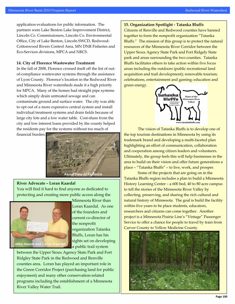
15. Organization Spotlight - Tatanka Bluffs Citizens of Renville and Redwood counties have banned together to form the nonprofit organization “Tatanka Bluffs.” The mission of this group is to protect the natural resources of the Minnesota River Corridor between the Upper Sioux Agency State Park and Fort Ridgely State park and areas surrounding the two counties. Tatanka Bluffs facilitates others to take action within five focus areas including the outdoors (public recreational land acquisition and trail development); renewable tourism; celebrations, entertainment and gaming; education and green energy. The vision of Tatanka Bluffs is to develop one of the top tourism destinations in Minnesota by using its trademark brand and developing a multi-faceted plan highlighting an effort of communication, collaboration and cooperation among citizen leaders and volunteers. Ultimately, the group feels this will help businesses in the area to build on their vision and offer future generations a place – “Tatanka Bluffs” – to live, work, and prosper. Some of the projects that are going on in the Tatanka Bluffs region includes a plan to build a Minnesota History Learning Center – a 600 bed, 40 to 80 acre campus to tell the stories of the Minnesota River Valley by collecting, preserving, and sharing the rich cultural and natural history of Minnesota. The goal is build the facility within five years to be place students, educators, researchers and citizens can come together. Another project is a Minnesota Prairie Line’s “Vintage” Passenger Service to offer a chance for people to travel by train from Carver County to Yellow Medicine County.
Aerial View of Florence
River Advocate – Loran Kaardal You will find it hard to find anyone as dedicated to protecting and creating more public access along the
Minnesota River than Loran Kaardal. As one of the founders and current co-director of the nonprofit organization Tatanka Bluffs, Loran has his sights set on developing
c trail system a publibetween the Upper Sioux Agency State Park and Fort Ridgley State Park in the Redwood and Renville counties area. Loran has played an important role in the Green Corridor Project (purchasing land for public enjoyment) and many other conservation-related programs including the establishment of a Minnesota River Valley Water Trail.
Mike Hewitt and Loran Kaardal
Page 100
Minnesota River Basin 2010 Progress Report Redwood River Watershed
16. Waukon RIM Waukon Rim was organized in the middle 1990’s by a saddle club, a snowmobile club, two sportsmen’s club, the Redwood County Pheasants Forever and Minnesota Deer
Hunters Association chapters. They acquired about 600 acres of conservation lands from owners, who were hesitant to enroll their
riparian properties in conservation programs if they had to continue maintaining these properties. These properties were managed as a shared public landscape that allowed fishing, hunting, trail riding and snowmobiling.
Properties included the 202 acre Kotval farm which straddled the Redwood River near Vesta. This property was donated to the DNR in 2005 as an addition to the Fox Vaug WMA. The 400 acres of the Mann’s Lake, Bollum and Parker farms are riparian areas along the Minnesota River near North Redwood. Two of these farms were donated to the DNR in 2009 and the final donation should occur in 2010.
These last donations did include trail corridors that are managed by the NDR Parks & Trails Division. The North Redwood Trail leads from the Redwood Valley Riders Saddle Club grounds to the Redwood River. The Dick Brown Recreational Trail encircles Mann’s Lake. These cumulative donations have created over $500,000 in critical habitat credits. The credits have been used to acquire riparian round outs along the Redwood River, for the acquisition of state managed properties. Waukon RIM initiated the paradigm of sharing a common landscape for multiple recreational opportunities and passed the baton forward to the Green Corridor Team.
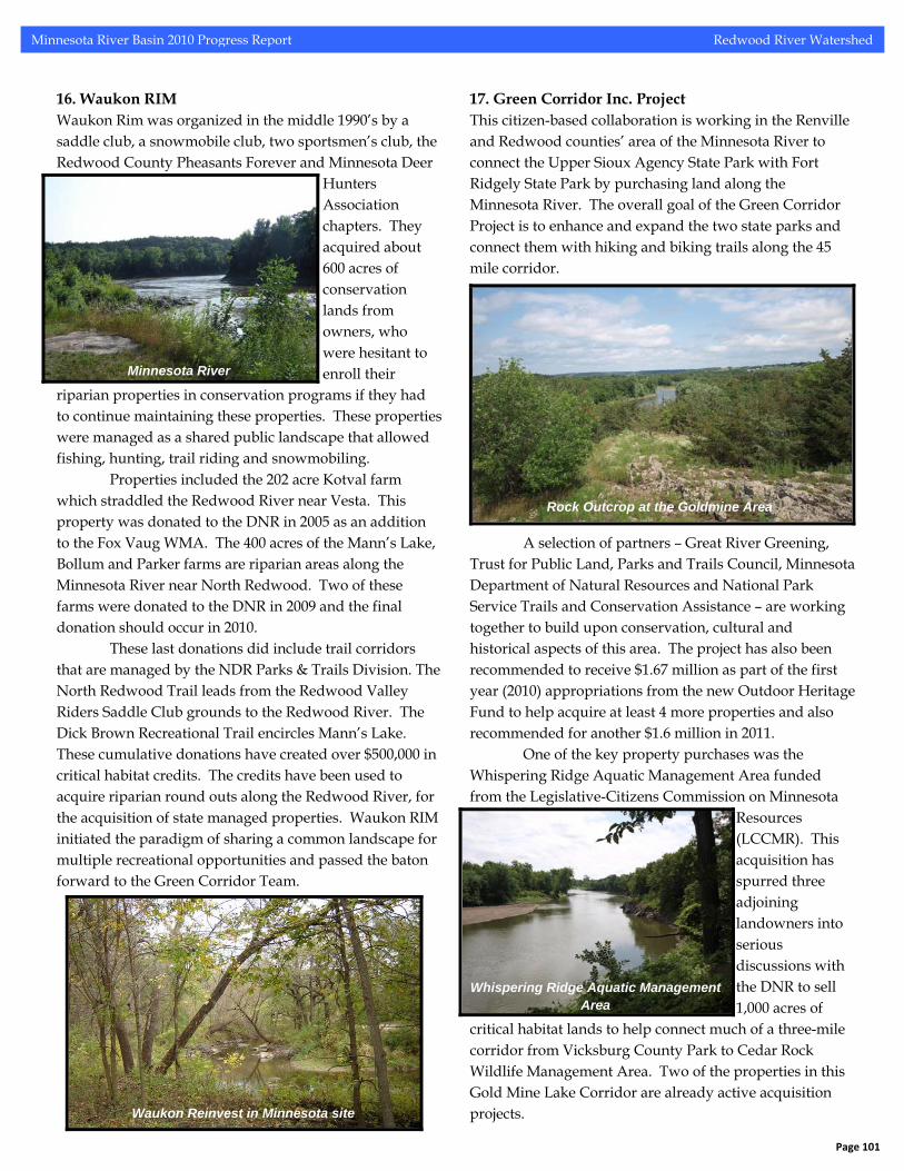
17. Green Corridor Inc. Project This citizen-based collaboration is working in the Renville and Redwood counties’ area of the Minnesota River to connect the Upper Sioux Agency State Park with Fort Ridgely State Park by purchasing land along the Minnesota River. The overall goal of the Green Corridor Project is to enhance and expand the two state parks and connect them with hiking and biking trails along the 45 mile corridor.
A selection of partners – Great River Greening, Trust for Public Land, Parks and Trails Council, Minnesota Department of Natural Resources and National Park Service Trails and Conservation Assistance – are working together to build upon conservation, cultural and historical aspects of this area. The project has also been recommended to receive $1.67 million as part of the first year (2010) appropriations from the new Outdoor Heritage Fund to help acquire at least 4 more properties and also recommended for another $1.6 million in 2011.
One of the key property purchases was the Whispering Ridge Aquatic Management Area funded from the Legislative-Citizens Commission on Minnesota
Resources (LCCMR). This acquisition has spurred three adjoining landowners into serious discussions with the DNR to sell
Minnesota River
Rock Outcrop at the Goldmine Area
1,000 acres of
critical habitat lands to help connect much of a three-mile corridor from Vicksburg County Park to Cedar Rock Wildlife Management Area. Two of the properties in this Gold Mine Lake Corridor are already active acquisition projects.
Whispering Ridge Aquatic Management
Area
Waukon Reinvest in Minnesota site
Page 101
Minnesota River Basin 2010 Progress Report Redwood River Watershed
To fund the land acquisitions, the Green Corridor Project received a $1 million grant from the LCCMR with the goal of purchasing 220 acres. The project was able to
buy 249 acres in the Green Corridor area: 7 acre Beaver Fall AMA, 182 acre Whispering Ridge AMA (contains significant rock outcroppings, river frontage
and a developed park area – a significant “connecting acquisition” to help fill in the gap between the east end of Vicksburg County Park and the west end of the Gold Mine Lake Area), 60 acres of wooded creek acquired at the Fort Ridgely State Horse Camp (expanded the existing 13 acre site), 30 acre Firle Woods (transferred to Fort Ridgely State Park), and 30 acre Belt Woods (added to Fort Ridgely State Park).
A number of partners assisted with the land acquisitions including the DNR and Redwood chapter of the National Wild Turkey Federation. The Green Corridor Project assisted the DNR with the 44 acre Brickyard AMA purchase (located at the old Morton Brickyard along the Minnesota River) and the Waukon Rim donations for a total of 304 acres (Bollum Farm and the Mann’s Lake Farm). Another tract of land is the 60 plus acre Parker Farm. 18. Green Corridor Mid-Minnesota River Watershed Water Trail As part of the effort to purchase land along the Minnesota River in Renville and Redwood Counties for public access,
the Green Corridor Project has also begun to partner with organizations like the Minnesota River National Scenic Byway Alliance and the Minnesota River
Watershed Alliance to develop a 45-mile waterway trail on the mainstem river. The effort is spearheaded by a variety of stakeholders, communities, citizens, and organizations
who share a common vision for creating and enhancing this waterway trail.
In August of 2009, the project received a technical grant from the National Park Service to develop a master plan. As a result of this plan, the project will help identify new resource infrastructures and improvements to existing infrastructure to provide better public access, safety improvements, camping and water/waste facilities. For their efforts the group received an award from the Mid America Trails and Greenways organization.
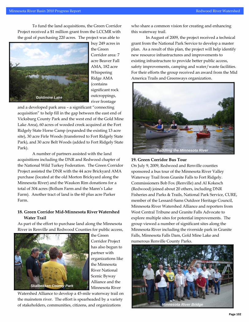
19. Green Corridor Bus Tour On July 9, 2009, Redwood and Renville counties sponsored a bus tour of the Minnesota River Valley Waterway Trail from Granite Falls to Fort Ridgely. Commissioners Bob Fox (Renville) and Al Kokesch (Redwood) joined about 20 others, including DNR Fisheries and Parks & Trails, National Park Service, CURE, member of the Lessard-Sams Outdoor Heritage Council, Minnesota River Watershed Alliance and reporters from West Central Tribune and Granite Falls Advocate to explore multiple sites for potential improvements. The group viewed a number of significant sites along the Minnesota River including the riverside park in Granite Falls, Minnesota Falls Dam, Gold Mine Lake and numerous Renville County Parks.
Goldmine Lake
Paddling the Minnesota River
Skalbekken County Park
Minnesota River Bridge
Page 102
Minnesota River Basin 2010 Progress Report Redwood River Watershed
Redwood River Watershed Conservation Practices and Land Use
FEEDLOT POLLUTION REDUCTION
1%
FILTER STRIP PROJECTS5%
GULLY STABILIZATION9%
NOT SPECIFIED1%
OTHER CALCULATED POLLUTION REDUCTION
14%
SHEET/RILL AND EPHEMERAL CONTROL
24%
STREAM/DITCH BANK STABILIZATION
3%
WELL SEALING36%
WIND EROSION7%
Redwood River Major Watershed
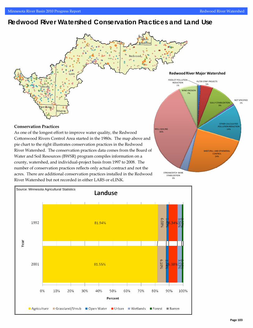
Conservation Practices As one of the longest effort to improve water quality, the Redwood Cottonwood Rivers Control Area started in the 1980s. The map above and pie chart to the right illustrates conservation practices in the Redwood River Watershed. The conservation practices data comes from the Board of Water and Soil Resources (BWSR) program compiles information on a county, watershed, and individual-project basis from 1997 to 2008. The number of conservation practices reflects only actual contract and not the acres. There are additional conservation practices installed in the Redwood River Watershed but not recorded in either LARS or eLINK.
Source: Minnesota Agricultural Statistics
Page 103
Minnesota River Basin 2010 Progress Report Redwood River Watershed
Redwood River Watershed Water Quality
Page 104
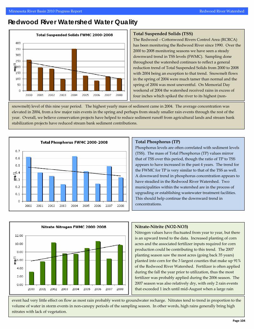
Total Suspended Solids (TSS) The Redwood – Cottonwood Rivers Control Area (RCRCA) has been monitoring the Redwood River since 1990. Over the 2000 to 2008 monitoring seasons we have seen a steady downward trend in TSS levels (FWMC). Sampling done throughout the watershed continues to reflect a general reduction trend of Total Suspended Solids from 2000 to 2008 with 2004 being an exception to that trend. Snowmelt flows in the spring of 2004 were much tamer than normal and the spring of 2004 was most uneventful. On Memorial Day weekend of 2004 the watershed received rains in excess of four inches which spiked the river to its highest (non-
snowmelt) level of this nine year period. The highest yearly mass of sediment came in 2004. The average concentration was elevated in 2004, from a few major rain events in the spring and perhaps from steady smaller rain events through the rest of the year. Overall, we believe conservation projects have helped to reduce sediment runoff from agricultural lands and stream bank stabilization projects have reduced stream bank sediment contributions.
Total Phosphorus (TP) Phosphorus levels are often correlated with sediment levels (TSS). The mass of Total Phosphorus (TP) values mirror that of TSS over this period, though the ratio of TP to TSS appears to have increased in the past 4 years. The trend for the FWMC for TP is very similar to that of the TSS as well. A downward trend in phosphorus concentration appears to have steadied in the Redwood River Watershed. Two municipalities within the watershed are in the process of upgrading or establishing wastewater treatment facilities. This should help continue the downward trend in concentrations.
Nitrate-Nitrite (NO2-NO3) Nitrogen values have fluctuated from year to year, but there is an upward trend to the data. Increased planting of corn acres and the associated fertilizer inputs required for corn production could be contributing to this trend. The 2007 planting season saw the most acres (going back 35 years) planted into corn for the 3 largest counties that make up 91% of the Redwood River Watershed. Fertilizer is often applied during the fall the year prior to utilization, thus the most fertilizer was probably applied during the 2006 season. The 2007 season was also relatively dry, with only 2 rain events that exceeded 1 inch until mid-August when a large rain
event had very little effect on flow as most rain probably went to groundwater recharge. Nitrates tend to trend in proportion to thevolume of water in storm events in non-canopy periods of the sampling season. In other words, high rains generally bring high nitrates with lack of vegetation.