orientations of khmer temples the indian circle · orientations of khmer temples & the indian...
TRANSCRIPT
147
Orientations of Khmer Temples &
the Indian Circle
2012 © Asger Mollerup [email protected] www.thai-isan-lao.com
Orientations of Khmer Temples and The Indian Circle were originally printed as appendixes in Ancient Khmer Sites in Eastern Thailand (White Lotus, 2012, ISBN: 9789744801814) and are hereby made available to the general public and may be quoted with proper references.
Orientations of Khmer Temples presents the author's GPS-based
field-research covering 325 ancient Khmer temples in Eastern and North-eastern Thailand - and also comment on the contemporary royal temples at Angkor.
The Indian Circle describes an ancient Vedic method of orientating temples cardinally, which is described in most of the Indian astronomical treasures, the Siddhantas, and could have been used among the Khmer master-builders as well. The description also describe other proposed methods and finally presents a simple, but very precise method of cardinal determination invented by the author during astronomical experiments in the Phu Phan mountains of NE-Thailand.
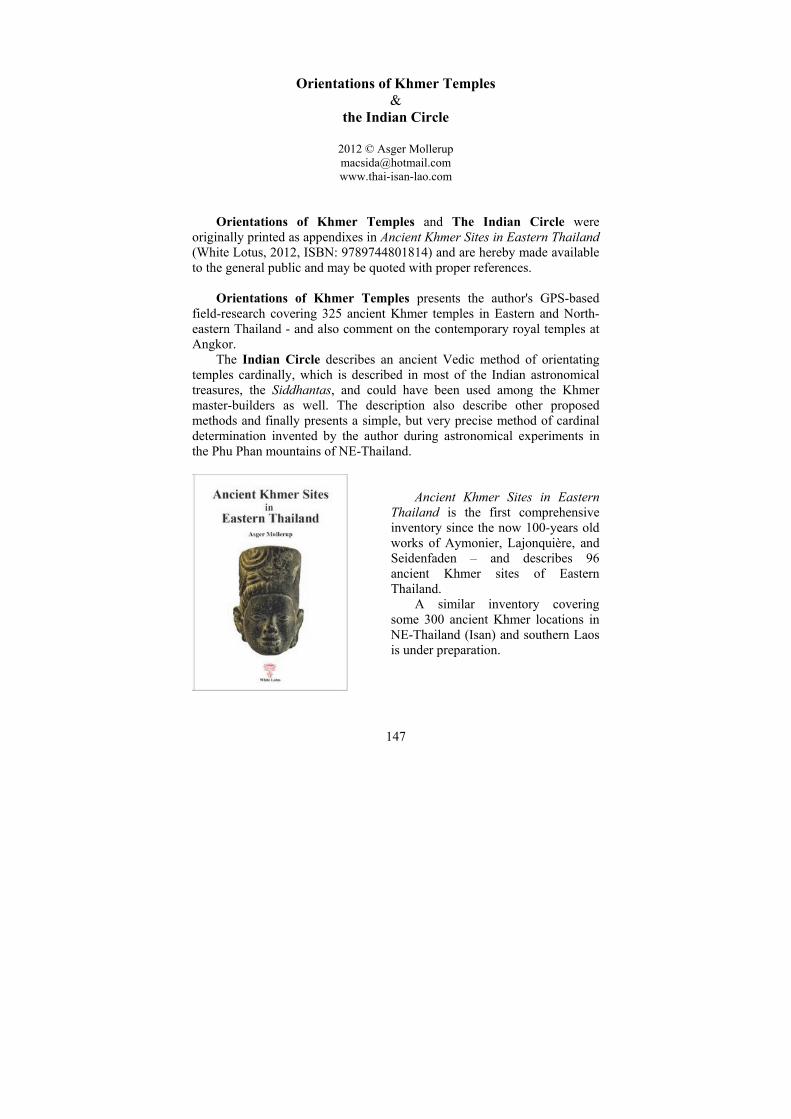
Ancient Khmer Sites in Eastern
Thailand is the first comprehensive inventory since the now 100-years old works of Aymonier, Lajonquière, and Seidenfaden – and describes 96 ancient Khmer sites of Eastern Thailand.
A similar inventory covering some 300 ancient Khmer locations in NE-Thailand (Isan) and southern Laos is under preparation.

Orientations of Khmer Temples and the Indian Circle
148
I: Orientations of Khmer temples: Eastern Thailand
The purpose of this field survey of Khmer temples in Thailand was to determine era, location, and orientation; the three key parameters in archaeo-astrological calculations.
The tools used to determine orientation were GPS, compass, satellite images and, best of all, direct observation of the sun, when it rises aligned with the structure of a given temple. At for example Prasat Sdok Kok Thom the sun rises visible through the gates on equinox.
Of 85 sanctuaries examined 26 were too ruined or the surroundings were too altered for an accurate orientation determination to be possible. Results from the remaining 59 sanctuaries are described below:
Nearly half the temples are orientated towards true east – the direction guarded by Indra1 (above right). The second largest group is orientated to the north-east – the direction guarded by Isana, an aspect of Shiva. The third group is orientated slightly to the south-east.
Above: The above results detailed in groups of 5 degrees.

Orientations of Khmer Temples and the Indian Circle
149
Conclusive remarks: 1. All temples in this survey are orientated to within ±25º of true east, which marks the sunrises at winter and summer solstice2. All these temples therefore have two days each year when the sun rises to cast its rays through the sanctuary gates. The four temples offering the most spectacular sunrises are Prasat Chong Sra Chaeng, Prasat Khao Lon, Prasat Khao Noi, and Prasat Sdok Kok Thom. 2. No temples are orientated towards the three other cardinal directions. 3. A small group of temples – all at Mueang Sri Mahosot – are orientated close to 65º, thereby facing the rising sun on the summer solstice. This atypical orientation is unseen in NE-Thailand and could be because the orientation of the ancient settlement itself is close to 65º and the sanctuaries follow this orientation. 4. Two temples in Eastern Thailand – Prasat Khao Lon and Prasat Sdok Kok Thom (below) – contain inscriptions recording the dates when the sanctuaries were consecrated. Neither consecration coincided with a sunrise aligned with the structure of the temple and visible through the doors. 5. The days of zenith passing of the sun are not coinciding with the days of consecration of Prasat Khao Lon and Prasat Sdok Kok Thom. 6. A final issue related to archaeo-astronomy is the moon’s northern- and southernmost rises (lunar-stices): No temples are orientated towards the lunar-stices3.
Prasat Sdok Kok Thom on equinox

Orientations of Khmer Temples and the Indian Circle
150
North-eastern Thailand: A similar orientation survey4 of Khmer temples conducted in NE-
Thailand (Isan) covering 229 Khmer sanctuaries gave the following results: Of the 74% measureable structures 38% are orientated to the east, 47% to the north-east, 12% to the south-east, and 3% to the other cardinal directions with the prime orientation being north-east5.
The Buddhist structures of Jayavarman VII show orientation pattern different from the Hindu temples, perhaps indicating that astronomy did not play the same crucial role as in Hinduism.
Bai Baek is the only sanctuary orientated towards the west, like Angkor
Wat6. It is located 3 km north of the Dangrek Mountains, 11 km west of the Ta Muean Pass and the orientation is app. 4º north of cardinal west.
Likewise, only one sanctuary in NE-Thailand is orientated towards the north like Preah Vihear7. This is Mueang Khaek, which is deviating 11º from cardinal north.
Yama, the god of death guards the south, and apparently no Hindu temples face true south8. Two temples, Phimai and Ta Muean Thom, are orientated towards south, or rather SSE, respectively app. 20º and 8º from cardinal south.
Among all the Khmer temples in Isan only three are orientated so that the sun does not penetrate their structures: Huai Khaen, Ta Pleng, and Samrong. All three are located along the Dharmasala Route app. 45 km south-east of Phimai. Their deviations from east are respectively app. 39º, 39º, and 30º north of cardinal east. Sunrise at winter solstice deviated at this latitude 24.5º north of cardinal east. The first two temples mentioned above are Mahayana Buddhist ‘fire-shrines’, dharmasalas. The 3rd, Prasat Samrong, may be a Suryavarman I ‘fire-shrine’. It shares a similar atypical orientation as Preah Khan Kampong Svay9: Towards northernmost moon-rise10.
Cardinal directions11

Orientations of Khmer Temples and the Indian Circle
151
Angkorian temples The royal temples and the barays of the Angkorian kings were apparently
attempted to be constructed aligned with the cardinal directions, but the ancient master-builders did not fully succeed in doing so.
The grid of the temples and the first major baray in the Roluos Group
were aligned perfectly against the rising sun at equinox witnessing the skills of the architect of Jayavarman III in mid 9th century.
The first state temple, the Bakheng, shows similar skills; but the eastern Baray – also by Yasovarman I – deviates app. 1.5º from true east, maybe due to later modifications during extensions by Rajendravarman.
The main orientation of the temples in the Ko Ker complex was for some other reason been chosen to be app. 14º north of true east12.
Pre Rup and Eastern Mebon of Rayendravarman II were probably both the work of his architect Kavindrarimayhana and are located nearly north-south of one another, separated only 1.3 km; but have different orientations. The state temple Pre Rup is orientated 1º north of true east and the Eastern Mebon nearly 4º. One degree could be considered as an acceptable construction error: but four degrees not. Eastern Mebon is located on an island in the huge Eastern Baray having the best conditions for determination of cardinal direction; but its north-south axis point exactly towards the central tower of Pre Rup and not true south.
The following Ta Keo is orientated towards true east, but the last two Hindu state temples, Baphoun and Angkor Wat, deviate 0.5º, which might be an acceptable construction error; but excludes them from being used as ‘astronomical tools’ for observing solar and lunar rises. Archaeo-astronomers can eventually claim embedded symbolic alignments, but not that their function was to observe equinoctial sunrises using the temple doors as a dioptra.
The last great emperor at Angkor is Jayavarman VII whose state temple is the Bayon in the center of the 3 by 3 km walled Angkor Thom and with his Northern Baray right north-east hereof – all orientated 1º–2º north of east.
Some of the major temples in ‘the provinces’ as Sdok Kok Thom, Si
Khoraphum, Kamphaeng Yai, and Ku Kona are all orientated precisely true east.

Orientations of Khmer Temples and the Indian Circle
152
II: The Indian Circle
The Sun generates all the earthly directions and controls the seasons 13
A short glimpse of the Angkor area, seen from birds-view, leaves no doubt that the prime orientation in this period was true east, and that the temple constructors were able to achieve cardinal alignments with high accuracy without the use of the compass, which in this period was not used outside China.
The significance of orientating the entrance of the abode of the gods towards east is stated in for example the Mayamata14, which also contains a chapter dealing with how to use a sanku (gnomon, ‘shadow-giver’) to construct east-west alignments.
The gnomon is described in most Indian treasures on astronomy in the Siddhantic period starting from app. 500 AD and the method is by the eleventh-century Arabic scholar and astronomer Al-Biruni called the Indian Circle.
Above: The author’s gnomon
The oldest description of the Indian Circle Method is found in the Katyayana Sulba-sutra15 (400-300 BC) giving instructions for construction of Vedic fire altars: Yano16 translates the Sanskrit text as follows:
‘Driving the gnomon into the leveled (ground), and drawing a circle
with the rope whose length is equal to the gnomon (length), one drives two pegs at (the intersections of) the two lines where the shadow of the tip of the gnomon falls . This is the east (-west) line.’
Re-written as (see photo above): Fasten a stick (gnomon) on a water
leveled surface and draw a circle with radius identical to the height of the gnomon. In the morning and in the afternoon and mark where the shadow of the sun crosses the circle: These two marks are orientated east-west.
North-south is perpendicular to the east-west line and similarly simple to construct. See graphic on next page.
Orientations of Khmer Temples and the Indian Circle
153
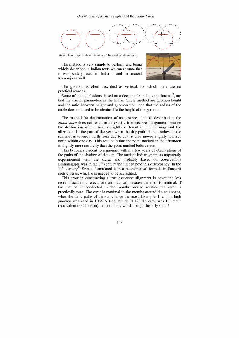
Above: Four steps in determination of the cardinal directions.
The method is very simple to perform and being
widely described in Indian texts we can assume that it was widely used in India – and in ancient Kambuja as well.
The gnomon is often described as vertical, for which there are no practical reasons.
Some of the conclusions, based on a decade of sundial experiments17, are that the crucial parameters in the Indian Circle method are gnomon height and the ratio between height and gnomon tip – and that the radius of the circle does not need to be identical to the height of the gnomon.
The method for determination of an east-west line as described in the Sulba-sutra does not result in an exactly true east-west alignment because the declination of the sun is slightly different in the morning and the afternoon: In the part of the year when the day-path of the shadow of the sun moves towards north from day to day, it also moves slightly towards north within one day. This results in that the point marked in the afternoon is slightly more northerly than the point marked before noon.
This becomes evident to a gnomist within a few years of observations of the paths of the shadow of the sun. The ancient Indian gnomists apparently experimented with the sanku and probably based on observations Brahmagupta was in the 7th century the first to note this discrepancy. In the 11th century18 Sripati formulated it in a mathematical formula in Sanskrit metric verse, which was needed to be accredited.
This error in constructing a true east-west alignment is never the less more of academic relevance than practical, because the error is minimal: If the method is conducted in the months around solstice the error is practically zero. The error is maximal in the months around the equinoxes, when the daily paths of the sun change the most. Example: If a 1 m. high gnomon was used in 1066 AD at latitude N 12º the error was 1.7 mm19 (equivalent to < 1 m/km) – or in simple words: Insignificantly small!

Orientations of Khmer Temples and the Indian Circle
154
The uncertainty when marking a point indicated by the shadow of the gnomon tip is much larger, due to the penumbra.
Right: Photo of shadow and its penumbra
one day after equinox. Five day-lines made by the shadow are indicated; the distance between is app. 6 mm.
A far more serious error can easily occur when extending an only 2 m
long line on the gnomon floor to a grid measuring kilometers. No ancient texts give advices on this practical problem, and neither is it mentioned in modern descriptions20 of the Indian Circle.
An alternative method for construction of cardinal alignments could be to base the grid on a north-south alignment derived from observations of the circumpolar stars21 as probably done by ancient Chinese astronomers.
Two other methods have been described by Pichard: One (too) simple method is to mark the shadow of the rising sun at equinox22 without considering that the rising sun casts no clear shadow until it has risen above the horizon being located app. 1º of from true east. The other and better proposal is to set up two vertical sticks aligned towards the rising sun at equinox. This method will only give accurate results if performed on a location where the altitude of the horizon is zero; for example at a sea-shore, or at the western end of an 8 km long reservoir or on a small mountain23.
It is not explained, how the performers of the two methods would know, when it was equinox.
Later in the same paper the utilization of the gnomon is described and
suggested as being the most likely tool used in ancient SE-Asia, because it is well described in Indian manuals on architecture24. Pichard erroneously emphasizes that the gnomon must be placed exactly vertical and also classifies the Indian Circle method as ‘more laborious and delicate’ than the more simple sunrise observation methods. He therefore suggests that the Vedic Circle might only have been used when constructing major foundations as for example the royal temples at Angkor where ‘the alignments are true east or only differ very weakly’ – and that ‘it appears that the loyalty to the directives given in the Indian architectural treaties faded out in the provinces of the empire, where the gnomon was likely not

Orientations of Khmer Temples and the Indian Circle
155
used, because almost all temples Khmer in current NE-Thailand differ from true east’25.
Pichard apparently never performed practical experiments with neither his two proposed ‘sun-rise methods’ nor the Indian Circle, the latter being so simple that my two gardeners at my sundial experiment can perform it; contrary to marking alignments towards the rising sun with vertical poles.
The statement, that most Khmer temples in NE-Thailand differ from true east is correct, but cannot be used as an argument for a significant absence of equinoctial orientations: 47% are orientated towards north-east and 38% towards east. Adding orientations of temples in Eastern Thailand, the distribution is equal (42% and 41º): The ancient architects outside Angkor were capable of laying out cardinal grids.
If they used a gnomon following the Vedic Circle method26 the error
should not exceed 0.5º - the diameter of the sun. If the deviation from true east is more than 1º the reason was either lack of professional skill, lack of concern, or a deliberate choice of another direction.
We don’t know which methods the ancient Khmer architects used when
setting up a cardinal grid for building temples and associated barays. They could have used the Indian Circle as described in manuals on architecture and preceding manuals on astronomy. The Indian tradition for cardinal grids dates back to the Harappan Era some app. 2000 BC.
Mankind has shown interest in cardinal grids framing religious structures throughout the world from Mesoamerica to China. The architects had developed indigenous methods, and ancient Khmer architects could as well have had their indigenous tradition. A modern ‘indigenous method’
The sundial experiment referred to on previous pages was performed on a
mountain top in the Phu Phan Mountain Range in Mukdahan Province, Thailand. The aim was by simple means as a gnomon, a plumb, water, and strings to get an idea about how pre-historic man could have determined the equinoxes and the solstices and constructed true cardinal grids.
Among the results was the ease of determining the equinox days and the solvable problems about determining the solstice days, when the sun, ‘Surya rests with the gods for 5 days’.
Next was the ease of constructing exact east-west alignments.
Orientations of Khmer Temples and the Indian Circle
156
The benefits of the experiences goes beyond archeo-astronomy: Having house construction as my professional background, I am now more capable of constructing roofs preventing the sun to enter the core-house, installing solar-panels and to orientate satellite dishes.
In the first phase I objected literature studies and before reading about the
Vedic Circle, I developed a simple method on how to achieve cardinal directions with an error margin less than 0.25º from true east by observations of the rising sun on equinox:
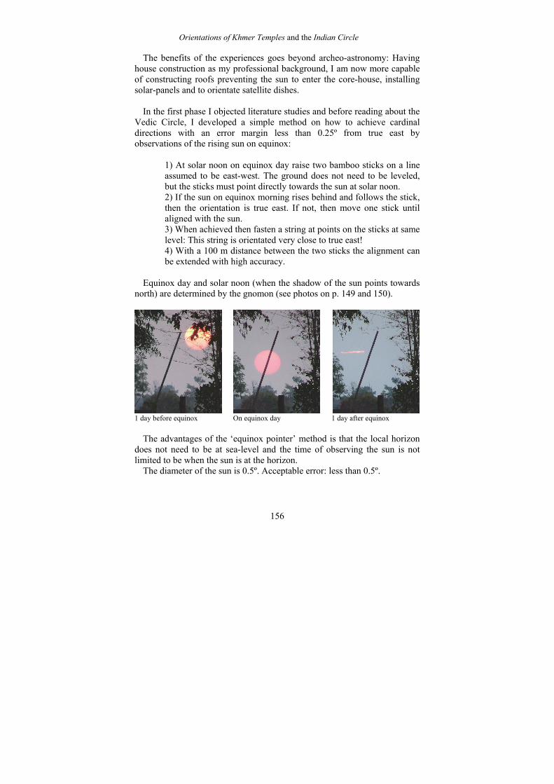
1) At solar noon on equinox day raise two bamboo sticks on a line
assumed to be east-west. The ground does not need to be leveled, but the sticks must point directly towards the sun at solar noon. 2) If the sun on equinox morning rises behind and follows the stick, then the orientation is true east. If not, then move one stick until aligned with the sun. 3) When achieved then fasten a string at points on the sticks at same level: This string is orientated very close to true east! 4) With a 100 m distance between the two sticks the alignment can be extended with high accuracy.
Equinox day and solar noon (when the shadow of the sun points towards
north) are determined by the gnomon (see photos on p. 149 and 150).
1 day before equinox On equinox day 1 day after equinox
The advantages of the ‘equinox pointer’ method is that the local horizon
does not need to be at sea-level and the time of observing the sun is not limited to be when the sun is at the horizon.
The diameter of the sun is 0.5º. Acceptable error: less than 0.5º.

Orientations of Khmer Temples and the Indian Circle
157
Literature: Billard, Roger: Dates des Inscriptions du Pays Khmer, document augmenté par J. C. Eade, Paris, 1885 (BEFEO 93, pgs. 395-428, Paris, 2006) Burges, Ebenezer: Surya-Siddhanta. A Textbook of Hindu Astronomy. India, 1858. (From: Journal of the American Oriental Society, Vol. 6, 1959-60. Page 141-498) Dagens, Bruno (ed. and tr.): Mayamata. An Indian Treasure on Housing Architecture and Iconography. Sitaram Bhartia Institute of Science and Research. New Delhi : Indira Gandhi National Centre for the Arts and Motilal Banarsidass Publishers, Delhi, 2000, c1994. Dumarcay, Jacques: Architecture and its models in South-East Asia /; translated and edited by Michael Smithies. Bangkok, 2003. Eade, J. C.: Computers vs Tables, Billard vs Golzio: Two New Date-Lists of the Inscriptions of Kamboja, Zeitschrift der Deutschen Morgenländischen Gesellschaft, vol. 158, no1, pp. 73-104, 2008. Golzio, Karl-Heinz: Chronologie der Inschriften Kambojas. Verifizierung und Umrechnung von Datumsangaben der Śaka-Ära, Weisbaden, 2006. Kramrisch, Stella: The Hindu Temple, 2 vol., University of Calcutta, 1946. Lavy, Paul: As in Heaven, So on Earth: The Politics of Vishnu, Shiva, and Harihara Images in Preangkorian Khmer Civilisation, in Journal of Southeast Asian Studies, 34 (1), pp 21-39. UK, 2003. Malville, J.M.: The Astronomical Gnomon. A Series of Interactive Experiments in Archaeastronomy, in African Cultural Astronomy, Curent Archaeoastronomy and Ethnoastronomy research in Africa, edited by Holbrook, J.C. and Medupe R.T. University of Nigeria Nsukka, Enuga State, Nigeria, 2008. Downloadable at: http://uploading.com/files/8W1004I2/1402066384.rar.html Mannika, Eleanor: Angkor Wat, Time, Space and Kingship, Honolulu, 1996.

Orientations of Khmer Temples and the Indian Circle
158
Mollerup, Asger: The Dharmasala Route from Angkor to Phimai – an ancient Route in Revival. 2004. http://www.sundial.thai-isan-lao.com/dharmasalaroute.html Mollerup, Asger: Solar-lunar events at Prasat Phanom Rung in Spring 2007, Mueang Boran Journal, vol. 39.3, Bangkok 2007: http://www.muangboranjournal.com/modules.php?name=Sections&op=viewarticle&artid=163 Mollerup, Asger: Orientation, Era and Location of Khmer temples in Isan. Un-published. 2008. Mollerup, Asger: Notes on the Gnomon, Un-published, 2010. Pierre Pichard: Note sur l’orientation des monuments en Asie du Sud-Est. Aséanie, vol. 23, Bangkok, 2009. Shukla, K.S. & Sen S. N (Ed.): History of Astronomy in India, Indian National Science Academy, New Delhi, 1985. Yano, M.: Knowledge of Astronomy in Sanskrit Texts of Architecture (Orientation methods in the Isanasivigurudevapaddhati), in Indo-Iranian Journal 29, pp. 17-29, 1986 Internet sources Carte Interactive des Sites Archeologiques Khmer (Khmer sites in SE-Asia): www.site-archeologique-khmer.org École française d'Extrême-Orient: www.efeo.fr Fine Arts Department Thailand: www.finearts.go.th Google Earth: www.earth.google.com Mahidol University Cultural Map Project: http://www.mapculture.org/ Persée: www.persee.fr Point Asia: www.pointasia.com Sirindhorn Anthropology Centre (SAC): Inscriptions in Thailand:
http://www2.sac.or.th/databases/jaruk/en/main.php Asger Mollerup: Prasat Sdok Kok Thom: http://www.sundial.thai-isan-lao.com/sdok-kok-thom.html

Orientations of Khmer Temples and the Indian Circle
159
Asger Mollerup: Prasat Sdok Kok Thom at Equinox - Notes on Astro-archaeology: http://www.sundial.thai-isan-lao.com/sdok-kok-thom-equinox.html Asger Mollerup: Prasat Sdok Kok Thom - Dating Inscription K.235: http://www.sundial.thai-isan-lao.com/sdok-kok-thom-date.html Asger Mollerup: Prasat Phu Phek - Not a Solar Calendar: http://www.sundial.thai-isan-lao.com/phu_phek.html Endnotes: (for quoting endnotes add 163 to the numbering below)
1 The Guardians of the Cardinal Directions, the dikpalas, counts Indra (E), Agni (SE), Niriti (SW), Kubera (W), Vayu (NW), Kubera (N), and Isana (SE). 2 The azimuth of the rising sun at solstice changes depending on era and latitude: At Mueang Sri Mahosot the rising sun (50% visible) would in AD 600 be at azimuth 65.475º (app. 24.5º from true east) and in 2010 at 65.664º; the difference being equivalent to 36 % of the diameter of the sun. These figures are calculated using modern astronomical parameters. It could be argued that an ancient constructor would not measure the angle of the rising sun in situ, but use the parameter as given in the Surya Siddhanta: 24.0º. The Surya Siddhanta is a manual on astronomy and the parameters has successfully been used to re-calculate the dates given in Khmer inscriptions (Eade, 2008). 3 Mannika (1996) proposes embedded lunar alignments in the structure of Angkor Wat; but as Angkor Wat is not orientated exactly true east, her conclusions should be regarded as ‘embedded symbolic alignments’; differing from ‘true alignments’: Angkor Wat could and cannot be used as an astronomical devise for exact observations of neither lunar nor solar rises. Angkor Wat is not a dioptra. 4 Mollerup, 2008: Orientation, Era and Location of Khmer temples in Isan. Un-published. 5 The results of both researches combined are: NE: 42%, E: 41 %, SE: 15%, other directions: 2%. Orientations towards east and north-east are equally represented. 6 Angkor Wat is orientated 0.5º from true west: 270.5º. Some nearly 30 temples in Cambodia are orientated towards west (CISARK); but the exact orientations are unknown. 7 The long ceremonial path of Preah Vihear is orientated 0.5º from cardinal north: 359.5º. Some 20 temples in Cambodia are orientated towards north (CISARK); but the exact orientations are unknown. 8 Two temples in Cambodia are orientated towards south (CISARK); but the exact orientations are unknown.
Orientations of Khmer Temples and the Indian Circle
160
9 The K.970 inscription is from the 10th century (CISARK), but the structure is older and the age not established. Jacques, 2007, p. 179, mentions an inscription from early 11th century. 10 Before the reader associate with Stonehenge, predictions of eclipses and start drawing lines on the map connecting these sites with Stonehenge in England and some pyramid in Mesoamerica, it should be taken into consideration that a pyramid temple, Preah Damrei, close to Preah Khan K.S. has its cruciform entrance platform orientated perpendicular to the main orientation of Preah Khan K.S.; azimuth = 330º. 11 Stone plate for depositing auspicious objects as jewels and gold-leafs during one of the ceremonies conducted during the construction faze. The location could have been in the base of a linga or in the top-spire of the temple. Provenance unknown; presently deposited at Prasat Sdok Kok Thom. 12 Jacques (2007, p. 110) gives an excellent presentation of the temples at Ko Ker. 13 Swarup, 1987, p. 2.1. Introduction, by Shukla, K. S., quoting the Aitareya Brahmana 2.7 14 Dagens, 1970: The Mayamata is an 11th century Sanskrit text from the Chola period in south India translated by Bruno Dagens. The treasure mainly deals with architecture and iconography. The gnomon is described in chapter 6: Orientation. 15 Sukla, 1985, pgs 1-3, A survey of Source materials, by K.V. Sarma: The Vedangas are ancillary sciences of the Veda, and two of the six are of significance to the history of astronomy. One is the Kalpa (ritual) consisting of practical manuals on the performance of Vedic sacrifices and household rituals, and contains sections called Sulba-sutras which, among other things, mention methods of orientation of sacrificial fire-altars for performance of fire-rituals, agnihota. 16 Yano, 1986, p. 18. 17 Mollerup, 2010, Notes on the Gnomon, Un-published. 18 Yano, 1986, p. 19. 19 My calculation 20 Kramrisch, 1946. Yano, 1986. Malville, 2008, Pichard, 2009. 21 Dr. Kate Spence, an Egyptologist at Cambridge University, has in an article in Nature, 16 November 2000, proposed that the ancient Egyptians might have used the circumpolar stars Kochab and Mirza for aligning the Great Pyramid at Giza in Egypt straight true north-south in the middle of the 3rd millennium BC. 22 Pichard, 2009, p. 16. 23 If high accuracy is the aim, then this method must be conducted over a period of 4-5 years for eliminating the error caused by the fact, that the sun rises only close to true east at equinox. 24 Pichard, 2009, p. 24. 25 Ibid, p. 27. My extracted translation from French. 26 Other indigenous methods could have been implemented.