organic carbon pools and genesis of alpine soils with...
TRANSCRIPT
© 2014 Regents of the University of Colorado JAMES G. BOCKHEIM AND JEFFREY S. MUNROE / 9871523-0430/10 $7.00
Arctic, Antarctic, and Alpine Research, Vol. 46, No. 4, 2014, pp. 987–1006
Organic carbon pools and genesis of alpine soils with permafrost: a review
James G. Bockheim*§ andJeffrey S. Munroe†*University of Wisconsin, Department of Soil Science, 1525 Observatory Drive, Madison, Wisconsin 53706-1299, U.S.A.†Geology Department, Middlebury College, McCardell Hall, 276 Bicentennial Way, Middlebury, Vermont 05753, U.S.A.§Corresponding author: [email protected]
DOI: http://dx.doi.org/10.1657/1938-4246-46.4.987
Introduction
Permafrost is defined as a condition whereby a material re-mains below 0 °C for two or more years in succession (van Ever-dingen, 1998). Mountain permafrost has received attention from the International Permafrost Association “Mapping and Modeling of Mountain Permafrost” working group. The first map of moun-tain permafrost and geocryological types was prepared by Gor-bunov (1978) from a review of the literature and his experience in the former Soviet Union. The most recent map of mountain permafrost was prepared by Haeberli et al. (1993), who revised Gorbunov’s map of mountain permafrost from a review of the literature in response to the concern of climate change impacts on mass wasting. Their map suggested that mountain permafrost occupies 4.88 million km2, which is nearly double that from the map of Gorbunov (1978).
Gruber (2012) derived a high-resolution estimate of glob-al permafrost distribution by country from a model based on mean annual air temperature (MAAT) and the combined effects of snow cover, exposure to solar radiation, and vegetation. Al-though the study did not distinguish between high-elevation and high-latitude permafrost, the areas for permafrost in mountain-ous countries at mid-latitudes were more comparable to the es-timates of Gorbunov (1978) than those of Haeberli et al. (1993), suggesting that the global distribution of mountain permafrost may be closer to Gorbunov’s estimates than those of Haeberli et al. (1993). However, Gruber’s (2012) estimates for the area of mountain permafrost in Mongolia (382,000 km2) are consider-ably less than those of Gorbunov (1.4 million km2) and Haeberli et al. (1993) (1.0 million km2).
Whereas permafrost covers 23 million km2 at the high lati-tudes, mountain permafrost covers an area from 2.5 million km2 (Gorbunov, 1978) to 4.9 million km2 (Haeberli et al., 1993) and may account for 14% of the permafrost worldwide. Nearly 70%
of the mountain permafrost occurs at the “Third Pole,” the high mountains of central Asia (Zhao et al., 2012).
The delineation of permafrost in mountain regions has been determined from drilling or road cut observations (Harris and Brown, 1982; Sharkhuu, 2003; Cheng, 2005; Wu et al., 2010; Mut-ter and Phillips, 2012); geophysical techniques such as electric-re-sistivity tomography (ERT), ground-penetrating radar (GPR), and shallow seismic refraction (SSR) (Leopold et al., 2010); as well as inferences from mean annual air temperatures (Péwé, 1983); periglacial features resulting from the presence of an active layer, such as active ice-cemented (lobate) rock glaciers or ice-cored mo-raines (Urdea, 1998; Fukui et al., 2007; Lilleøren and Etzelmüller, 2011; Alonso and Trombotto, 2012); basal temperature of snow (Lewkowicz and Ednie, 2004; Julián and Chueca, 2007; Ruiz and Trombotto, 2012; Bonnaventure and Lewkowicz, 2013); and mod-els based on climate, topography, and other factors (Harris, 1986; Burn, 1994; Gruber and Hoelzle, 2001; Janke, 2005; Etzelmüller et al., 2007; Allen et al., 2008; Etzelmüller and Frauenfelder, 2009; Arenson and Jakob, 2010; Boeckli et al., 2012; Janke et al., 2012; Zhao et al., 2012). Although permafrost tends to be sporadic in many mid-latitude mountain ranges, it can be discontinuous (i.e., covers 50–90% of ground) or even continuous (90%–100%) at the higher latitudes and in large mountain massifs such as the Qinghai-Tibet Plateau (QTP).
An examination of the topic “alpine soils” in the Web of Sci-ence reveals that interest in alpine soils has increased sharply from three papers per year during 1960 to 1990 to 230 publications per year during 2002 to 2012. High-mountain soils are globally impor-tant because they are critical sources of water, are centers of biodi-versity, and influence global atmospheric and cryospheric systems. Mountain soils with permafrost store large quantities of soil or-ganic carbon (SOC) (Wang et al., 2002; Garcia-Pausas et al., 2007; Ohtsuka et al., 2008; Baumann et al., 2009; Celi et al., 2010; Wu et al., 2010; Budge et al., 2011; Kabala and Zapart, 2012; Dörfer et
AbstractSoils with mountain permafrost occupy 3.5 million km2 worldwide, with 70% in cen-tral Asia. High-mountain environments have “warm” permafrost, with surface permafrost temperatures of –0.5 to –2 °C and deep active layers (2 to 8 m). From a global database of 41 sites and 312 pedons, alpine soils with permafrost are strongly acid (pH = 5.0 to 5.5), have intermediate cation-exchange capacities (20 to 25 cmol
c/kg) and base satura-
tion (44% to 85%), and commonly have an isotic mineral class. Soil organic carbon is concentrated in the upper 30 to 40 cm, with profile density averaging 15.2 ± 1.3 kg m–2 (range = <1.0 to 88.3 kg m–2), which is comparable to temperate grasslands (13 kg m–2) but substantially less than moist arctic tundra (32 kg m–2). Mountain soils with permafrost contain 66.3 Pg of soil organic carbon (SOC), which constitutes 4.5% of the global pool. In contrast, the SOC pool in the Arctic is 496 Pg (33% of the global pool). Alpine soils with deep active layers contrast strongly with high-latitude soils in areas of continuous permafrost. Permafrost in the upper 2 m induces cryoturbation in the profile, acts as a barrier to water movement, and generates cooler temperatures resulting in greater SOC levels. High-elevation and high-latitude soils are experiencing warming of air temperature and permafrost and a thickening of the active layer.
988 / ARCTIC, ANTARCTIC, AND ALPINE RESEARCH
al., 2013; Zollinger et al., 2013) and, therefore, may release large amounts of carbon dioxide in a warming scenario (e.g., Schuur et al., 2013).
The objectives of this study are to (1) update the calculation of the area of mountain permafrost from literature published since 1993 when the last mountain permafrost map was produced, (2) analyze data from mountain soils with permafrost worldwide, (3) determine the SOC contents of these soils, (4) evaluate the role of various soil-forming factors in pedogenesis of soils containing mountain permafrost, and (5) compare and contrast soils influ-enced by mountain permafrost with those affected by high-latitude permafrost.
In this study, we use the terms mountain and alpine inter-changeably with regard to soils underlain by permafrost, recog-nizing that mountain could be interpreted as any large landform in the form of a peak, with or without permafrost, and alpine refers to the area above treeline; however, permafrost may exist in forests at the upper limit of treeline, that is, in the subalpine life zone.
MethodsSTUDY AREA
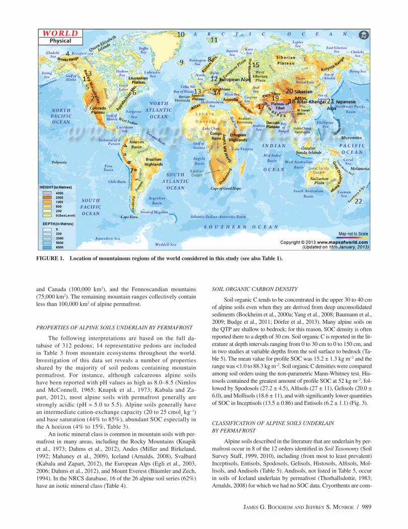
For purposes of this study, we have followed the protocol of Gorbunov (1978) in setting the elevation for mountain permafrost at an arbitrary threshold of 500 m so as to minimize the inclu-sion of high-latitude permafrost in our estimates. The study area includes the Brooks Range, Rocky Mountains, Coast Ranges, Cas-cade Range, Sierra Nevada, and Appalachian Mountains of North America; the Andes Mountains of South America; the mountains of Iceland, Greenland, Svalbard, and Fennoscandia; the Alps, Pyrenees, Carpathians, and Urals of Europe; the Caucasus, Him-alayan-Karakoram-Hindu Kush (Qinghai-Tibet Plateau), Pamir-Tien Shan-Djungar Alatau, the Khingai-Altai Mountains of cen-tral Asia; the Yablonoi-Sayan-Stanovai Mountains of Siberia; the Japanese Alps; and the Southern Alps of New Zealand (Fig. 1). We recognize that the existence of sporadic permafrost in many mountain environments makes area estimates and other interpreta-tions problematic.
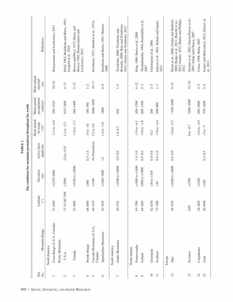
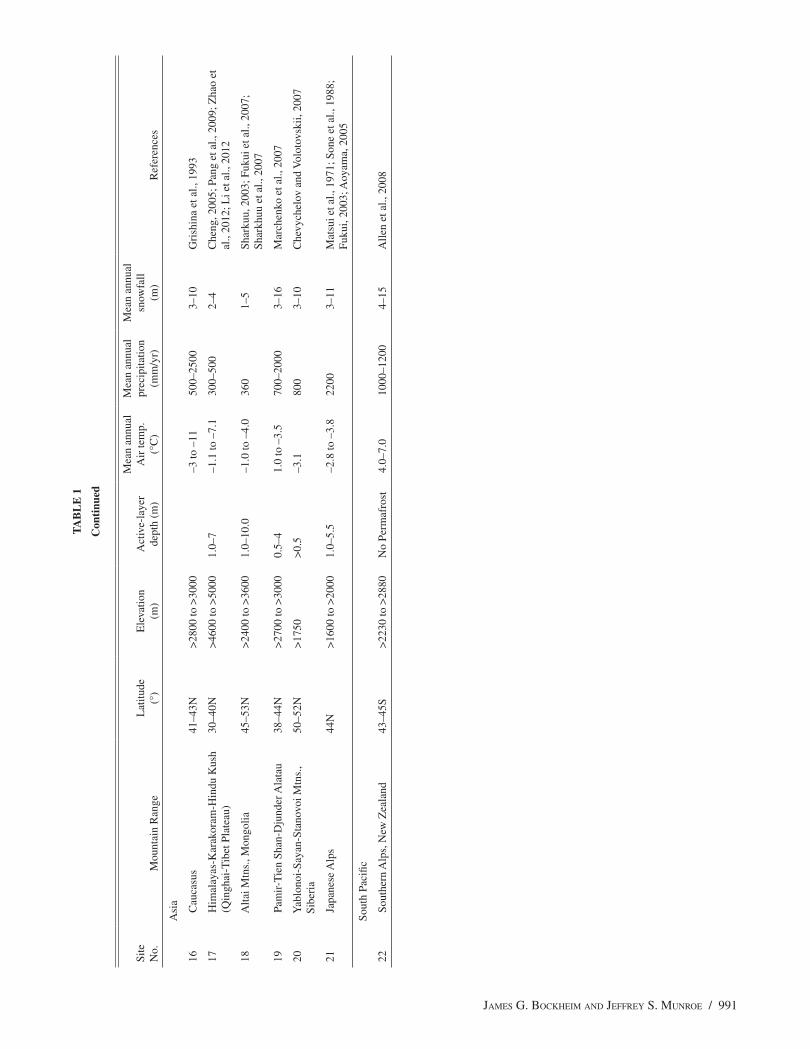
The elevation at which mountain permafrost is reported in the literature ranges from as low as 500 m (by the earlier defini-tion) in high-latitude environments such as Iceland, Greenland, Svalbard, and the subpolar portions of the Caucasus Mountains to >5000 m in the central Andes, Qinghai-Tibet Plateau (QTP), and tropical mountains (Table 1). The active-layer thickness ranges from >0.5 m in high-latitude mountain environments such as Ice-land or Greenland to more than 8 m in the Andes, European Alps, and Altai Mountains. Permafrost may exist in mountains where the mean annual air temperature (MAAT) is as warm as 1.4 °C, but a value of –3 °C or lower is more typical of areas containing mountain permafrost (Lewkowicz and Ednie, 2004; Etzelmüller et al., 2007; Gruber, 2012). At the other extreme, MAAT values as low as –10 °C have been recorded in mountains of Alaska, Fennoscandia, and the QTP (Table 1). The mean annual precipi-tation of areas with mountain permafrost ranges from 250 mm yr–1 for the Yukon Territory of Canada and parts of the central Asian mountains to over 2000 mm yr–1 in the European Alps, Japanese Alps, and the Southern Alps of New Zealand (Table 1). Annual snowfall ranges from a meter to more than 20 m, although wind redistribution can produce significant local differences in snow depth (Table 1).
DISTRIBUTION OF MOUNTAIN PERMAFROST
The distribution of mountain permafrost was determined from regional maps published since the Haeberli et al. (1993) map, in-cluding the circumarctic map of Brown et al. (1997) and maps of permafrost in the European Alps (Boeckli et al., 2012), Iceland (Et-zelmüller et al., 2007), Norway (Lilleøren and Etzelmüller, 2011), central Asia (Li and Chang, 1996; Marchenko et al., 2007; Zhao et al., 2012), and the Andes (Trombotto, 2000).
PROPERTIES OF ALPINE SOILS
Morphological and analytical data were obtained for soils of each mountain range containing permafrost from the published lit-erature. Our database was derived from 41 studies and included 312 pedons. Data were also obtained from the U.S. Department of Agriculture Natural Resources Conservation Service (NRCS), including Official Soil Descriptions (Soil Survey Division, 2013a), soil classification data (Soil Survey Division, 2013b), and soil characterization data (Soil Survey Division, 2013c).
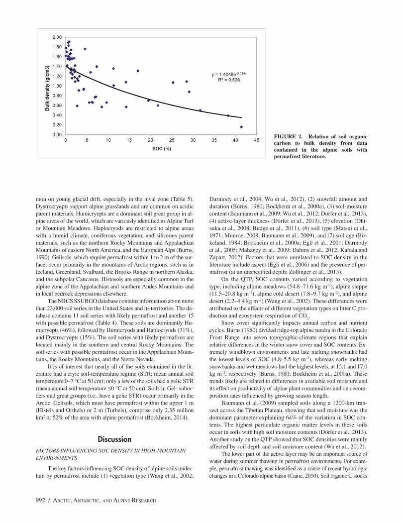
The profile density of SOC was obtained from the literature or was calculated from data in the literature. The data requirements included classification of soils by either Soil Taxonomy (ST) or the World Reference Base for Soil Resources (IUSS Working Group WRB, 2006), SOC or loss-on-ignition (LOI) values, the proportion of coarse fragments (>2 mm), and bulk density. In the database, bulk densities were reported for 19% of the soil horizons, coarse fragments for 43%; 55% of the soils were classified; and 100% of the horizons contained data for SOC or LOI. Where bulk density was not provided, we estimated it from an equation relating SOC or LOI adjusted to SOC to bulk density using the existing database (Fig. 2). It is of interest that this equation has a similar intercept and exponent as those developed for the alpine zone of Mount Mansfield, Vermont, by Munroe (2008).
For pedons where the proportion of coarse fragments was not provided, we used a default value of 45%, which constitutes the mean value from those studies reporting coarse fragments. Where soils had not been classified in ST or WRB, we classified them from existing data, including horizonation, base saturation, and SOC. We used established equations (e.g., Bockheim et al., 2000a) for estimating profile SOC pools.
An SOC budget for high-mountain areas was prepared by summing the product of mean SOC density for each mountain range and the estimated permafrost area of that range. The geo-morphology, soils, and climate-change effects in high-elevation en-vironments were compared to those of high-latitude environments from the literature.
ResultsWORLD DISTRIBUTION OF MOUNTAIN PERMAFROST
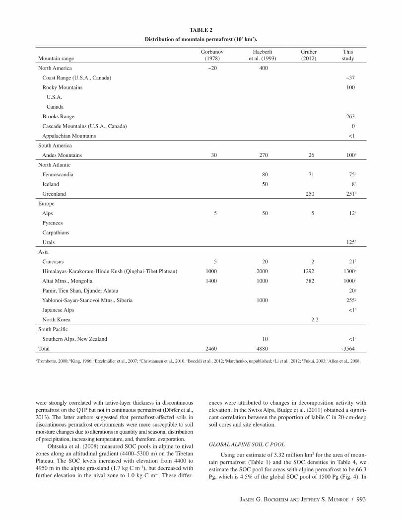
The total area of mountain permafrost was estimated to be 3.56 million km2 (Table 2), which is intermediate between those of Gorbunov (1978) at 2.46 million km2 and Haeberli et al. (1993) at 4.88 million km2 (Table 1). Our data suggest that the single largest region with alpine permafrost is the QTP, at 1.3 million km2, which constitutes 54% of the plateau. The next largest area of mountain permafrost is Khangai-Altai Mountains of Mongolia and Russia at 1.0 million km2, Alaska’s Brooks Range (263,000 km2), the Sibe-rian Mountains (255,000 km2), Greenland (251,000 km2), the Ural Mountains of Russia (125,000 km2), the Andes Mountains of South America (100,000 km2), the Rocky Mountains of the United States
JAMES G. BOCKHEIM AND JEFFREY S. MUNROE / 989
and Canada (100,000 km2), and the Fennoscandian mountains (75,000 km2). The remaining mountain ranges collectively contain less than 100,000 km2 of alpine permafrost.
PROPERTIES OF ALPINE SOILS UNDERLAIN BY PERMAFROST
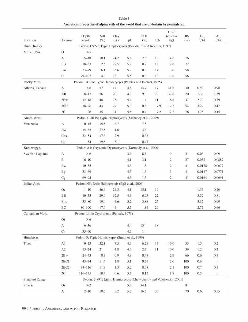
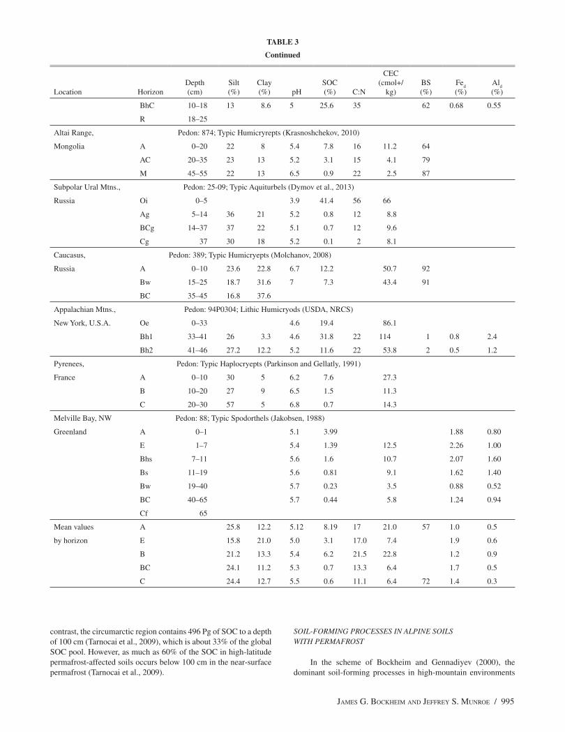
The following interpretations are based on the full da-tabase of 312 pedons; 14 representative pedons are included in Table 3 from mountain ecosystems throughout the world. Investigation of this data set reveals a number of properties shared by the majority of soil pedons containing mountain permafrost. For instance, although calcareous alpine soils have been reported with pH values as high as 8.0–8.5 (Nimlos and McConnell, 1965; Knapik et al., 1973; Kabala and Za-part, 2012), most alpine soils with permafrost generally are strongly acidic (pH = 5.0 to 5.5). Alpine soils generally have an intermediate cation-exchange capacity (20 to 25 cmol
c kg–1)
and base saturation (44% to 85%), abundant SOC especially in the A horizon (4% to 15%, Table 3).
An isotic mineral class is common in mountain soils with per-mafrost in many areas, including the Rocky Mountains (Knapik et al., 1973; Dahms et al., 2012), Andes (Miller and Birkeland, 1992; Mahaney et al., 2009), Iceland (Arnalds, 2008), Svalbard (Kabala and Zapart, 2012), the European Alps (Egli et al., 2003, 2006; Dahms et al., 2012), and Mount Everest (Bäumler and Zech, 1994). In the NRCS database, 16 of the 26 alpine soil series (62%) have an isotic mineral class (Table 4).
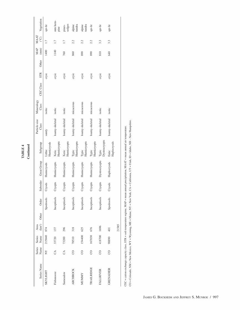
SOIL ORGANIC CARBON DENSITY
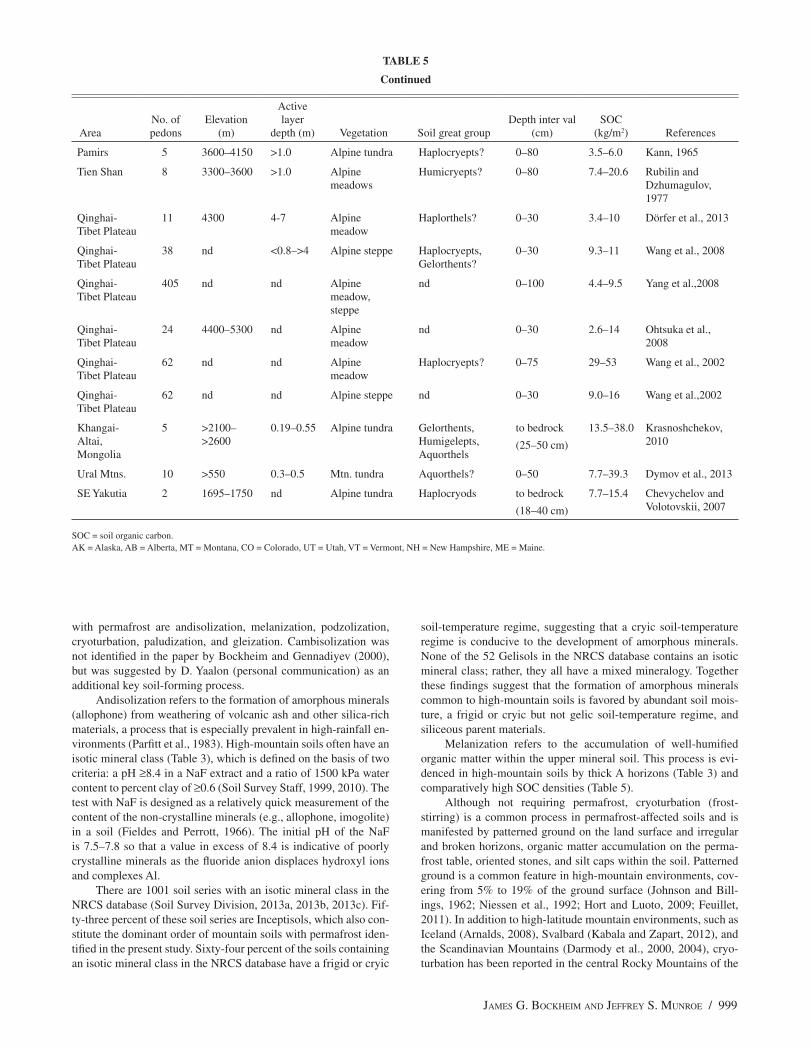
Soil organic C tends to be concentrated in the upper 30 to 40 cm of alpine soils even when they are derived from deep unconsolidated sediments (Bockheim et al., 2000a; Yang et al., 2008; Baumann et al., 2009; Budge et al., 2011; Dörfer et al., 2013). Many alpine soils on the QTP are shallow to bedrock; for this reason, SOC density is often reported there to a depth of 30 cm. Soil organic C is reported in the lit-erature at depth intervals ranging from 0 to 30 cm to 0 to 150 cm, and in two studies at variable depths from the soil surface to bedrock (Ta-ble 5). The mean value for profile SOC was 15.2 ± 1.3 kg m–2 and the range was <1.0 to 88.3 kg m–2. Soil organic C densities were compared among soil orders using the non-parametric Mann-Whitney test. His-tosols contained the greatest amount of profile SOC at 52 kg m–2, fol-lowed by Spodosols (27.2 ± 4.5), Alfisols (27 ± 11), Gelisols (20.0 ± 6.0), and Mollisols (18.6 ± 11), and with significantly lower quantities of SOC in Inceptisols (13.5 ± 0.86) and Entisols (6.2 ± 1.1) (Fig. 3).
CLASSIFICATION OF ALPINE SOILS UNDERLAIN BY PERMAFROST
Alpine soils described in the literature that are underlain by per-mafrost occur in 8 of the 12 orders identified in Soil Taxonomy (Soil Survey Staff, 1999, 2010), including (from most to least prevalent) Inceptisols, Entisols, Spodosols, Gelisols, Histosols, Alfisols, Mol-lisols, and Andisols (Table 5). Andisols, not listed in Table 5, occur in soils of Iceland underlain by permafrost (Thorhallsdottir, 1983; Arnalds, 2008) for which we had no SOC data. Cryorthents are com-
FIGURE 1. Location of mountainous regions of the world considered in this study (see also Table 1).
990 / ARCTIC, ANTARCTIC, AND ALPINE RESEARCH
TA
BL
E 1
Site
con
diti
ons
for
mou
ntai
n pe
rmaf
rost
thr
ough
out
the
wor
ld.
Site
N
o.M
ount
ain
Ran
geL
atitu
de
(°)
Ele
vatio
n (m
)A
ctiv
e-la
yer
dept
h (m
)
Mea
n an
nual
A
ir te
mp.
(°
C)
Mea
n an
nual
pr
ecip
itatio
n (m
m/y
r)
Mea
n an
nual
sn
owfa
ll (m
)R
efer
ence
s
Nor
th A
mer
ica
1
Coa
st R
ange
(U
.S.A
., C
anad
a)51
–64N
>12
30–2
000
–1.1
to –
6.0
250–
1525
10–2
4B
onna
venu
re a
nd L
ewko
wic
z, 2
013
R
ocky
Mou
ntai
ns
2
U
.S.A
.37
–51
60–7
0N>
3500
2.0
to >
5.0
1.1
to –
3.3
635–
1400
4–12
Péw
é, 1
983;
Boc
khei
m a
nd B
urns
, 199
1;
Leo
pold
et a
l., 2
010
3
C
anad
a51
–60N
>21
80 to
>30
00–1
.0 to
–1.
728
0–14
002–
12B
row
n an
d Pé
wé,
197
3; H
arri
s an
d B
row
n, 1
982;
Bon
nave
ntur
e an
d L
ewko
wic
z, 2
013
4
Bro
oks
Ran
ge68
–69N
>50
00.
3–1.
5–5
to –
1018
0–39
01–
2
5
Cas
cade
Mou
ntai
ns (
U.S
.A.,
Can
ada)
40–5
1N>
2100
No
Perm
afro
st3.
2 to
3.9
2000
–285
010
–17
Boc
khei
m, 1
972;
Sne
ddon
et a
l., 1
972a
6
App
alac
hian
Mou
ntai
ns42
–45N
>12
00–1
800
>2
1.4
to –
3.0
1800
6–8
Boc
khei
m a
nd B
urns
, 199
1; M
unro
e,
2008
Sout
h A
mer
ica
7
And
es M
ount
ains
20–5
7S>
1500
to >
5000
3.0–
9.0
1.4–
6.3
440
1–5
Tro
mbo
tto, 2
000;
Tro
mbo
tto a
nd
Bor
zatta
, 200
9; R
uiz
and
Tro
mbo
tto,
2012
; Alo
nso
and
Tro
mbo
tto, 2
012
Nor
th A
tlant
ic
8
Fenn
osca
ndia
63–7
0N>
1400
to >
1800
1.4–
3.0
–3.9
to –
6.1
450–
1200
4–12
Kin
g, 1
986;
Har
ris
et a
l., 2
008
9
Icel
and
64–6
6N>
800
to >
1000
0.5–
0.6
–3.0
to –
1.8
600–
1500
2–3
Tho
rhal
lsdo
ttir,
1984
; Etz
elm
ülle
r et
al.,
20
07
10
Gre
enla
nd62
–83N
>36
to >
165
0.4–
0.9
–9.2
200
2–3
Chr
istia
nsen
et a
l., 2
008
11
Sval
bard
77–7
8N>
300.
9–1.
0–3
.8 to
–4.
420
0–80
01–
3Is
akse
n et
al.,
200
1; K
abal
a an
d Z
apar
t, 20
12
Eur
ope
12
Alp
s44
–47N
>24
00 to
>30
000.
5–8.
0–3
.0 to
–5.
511
00–2
400
4–15
Har
ris
et a
l., 2
008;
Gru
ber
and
Hae
berl
i, 20
09; B
udge
et a
l., 2
011;
Boe
ckli
et a
l.,
2012
; Gru
ber,
2012
; Mut
ter
and
Phill
ips,
20
12
13
Pyre
nees
42N
>27
000
to –
0.7
1600
–200
012
–16
Serr
ano
et a
l., 2
001;
Gar
cia-
Paus
as e
t al.,
20
07; J
uliá
n an
d C
huec
a, 2
007
14
Car
path
ians
44–4
8N>
2100
–2.6
to –
4.0
850–
2000
2–9
Urd
ea, 1
998;
Ski
ba, 2
007
15
Ura
ls50
–60N
>55
0 0.
3–0.
5–3
to –
757
0–10
002–
4Iv
anov
and
Med
vede
va, 2
012;
Dym
ov e
t al
., 20
13
JAMES G. BOCKHEIM AND JEFFREY S. MUNROE / 991
Site
N
o.M
ount
ain
Ran
geL
atitu
de
(°)
Ele
vatio
n (m
)A
ctiv
e-la
yer
dept
h (m
)
Mea
n an
nual
A
ir te
mp.
(°
C)
Mea
n an
nual
pr
ecip
itatio
n (m
m/y
r)
Mea
n an
nual
sn
owfa
ll (m
)R
efer
ence
s
Asi
a
16
Cau
casu
s41
–43N
>28
00 to
>30
00–3
to –
1150
0–25
003–
10G
rish
ina
et a
l., 1
993
17
Him
alay
as-K
arak
oram
-Hin
du K
ush
(Qin
ghai
-Tib
et P
late
au)
30–4
0N>
4600
to >
5000
1.0–
7–1
.1 to
–7.
130
0–50
02–
4C
heng
, 200
5; P
ang
et a
l., 2
009;
Zha
o et
al
., 20
12; L
i et a
l., 2
012
18
Alta
i Mtn
s., M
ongo
lia45
–53N
>24
00 to
>36
001.
0–10
.0–1
.0 to
–4.
036
01–
5Sh
arku
u, 2
003;
Fuk
ui e
t al.,
200
7;
Shar
khuu
et a
l., 2
007
19
Pam
ir-T
ien
Shan
-Dju
nder
Ala
tau
38–4
4N>
2700
to >
3000
0.5–
41.
0 to
–3.
570
0–20
003–
16M
arch
enko
et a
l., 2
007
20
Yab
lono
i-Sa
yan-
Stan
ovoi
Mtn
s.,
Sibe
ria
50–5
2N>
1750
>0.
5–3
.180
03–
10C
hevy
chel
ov a
nd V
olot
ovsk
ii, 2
007
21
Japa
nese
Alp
s44
N>
1600
to >
2000
1.0–
5.5
–2.8
to –
3.8
2200
3–11
Mat
sui e
t al.,
197
1; S
one
et a
l., 1
988;
Fu
kui,
2003
; Aoy
ama,
200
5
Sout
h Pa
cific
22
Sout
hern
Alp
s, N
ew Z
eala
nd43
–45S
>22
30 to
>28
80N
o Pe
rmaf
rost
4.0–
7.0
1000
–120
04–
15A
llen
et a
l., 2
008
TA
BL
E 1
Con
tinu
ed
992 / ARCTIC, ANTARCTIC, AND ALPINE RESEARCH
mon on young glacial drift, especially in the nival zone (Table 5). Dystrocryepts support alpine grasslands and are common on acidic parent materials. Humicryepts are a dominant soil great group in al-pine areas of the world, which are variously identified as Alpine Turf or Mountain Meadows. Haplocryods are restricted to alpine areas with a humid climate, coniferous vegetation, and siliceous parent materials, such as the northern Rocky Mountains and Appalachian Mountains of eastern North America, and the European Alps (Burns, 1990). Gelisols, which require permafrost within 1 to 2 m of the sur-face, occur primarily in the mountains of Arctic regions, such as in Iceland, Greenland, Svalbard, the Brooks Range in northern Alaska, and the subpolar Caucasus. Histosols are especially common in the alpine zone of the Appalachian and southern Andes Mountains and in local bedrock depressions elsewhere.
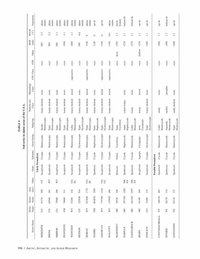
The NRCS SSURGO database contains information about more than 23,000 soil series in the United States and its territories. The da-tabase contains 11 soil series with likely permafrost and another 15 with possible permafrost (Table 4). These soils are dominantly Hu-micryepts (46%), followed by Humicryods and Haplocryods (31%), and Dystrocryepts (15%). The soil series with likely permafrost are located mainly in the southern and central Rocky Mountains. The soil series with possible permafrost occur in the Appalachian Moun-tains, the Rocky Mountains, and the Sierra Nevada.
It is of interest that nearly all of the soils examined in the lit-erature had a cryic soil-temperature regime (STR; mean annual soil temperature 0–7 °C at 50 cm); only a few of the soils had a gelic STR (mean annual soil temperature ≤0 °C at 50 cm). Soils in Gel- subor-ders and great groups (i.e., have a gelic STR) occur primarily in the Arctic. Gelisols, which must have permafrost within the upper 1 m (Histels and Orthels) or 2 m (Turbels), comprise only 2.35 million km2 or 52% of the area with alpine permafrost (Bockheim, 2014).
DiscussionFACTORS INFLUENCING SOC DENSITY IN HIGH-MOUNTAIN ENVIRONMENTS
The key factors influencing SOC density of alpine soils under-lain by permafrost include (1) vegetation type (Wang et al., 2002;
Darmody et al., 2004; Wu et al., 2012), (2) snowfall amount and duration (Burns, 1980; Bockheim et al., 2000a), (3) soil-moisture content (Baumann et al., 2009; Wu et al., 2012; Dörfer et al., 2013), (4) active-layer thickness (Dörfer et al., 2013), (5) elevation (Oht-suka et al., 2008; Budge et al., 2011), (6) soil type (Matsui et al., 1971; Munroe, 2008; Baumann et al., 2009), and (7) soil age (Bir-keland, 1984; Bockheim et al., 2000a; Egli et al., 2001; Darmody et al., 2005; Mahaney et al., 2009; Dahms et al., 2012; Kabala and Zapart, 2012). Factors that were unrelated to SOC density in the literature include aspect (Egli et al., 2006) and the presence of per-mafrost (at an unspecified depth; Zollinger et al., 2013).
On the QTP, SOC contents varied according to vegetation type, including alpine meadows (54.8–71.6 kg m–2), alpine steppe (11.5–20.8 kg m–2), alpine cold desert (7.8–9.7 kg m–2), and alpine desert (2.2–4.4 kg m–2) (Wang et al., 2002). These differences were attributed to the effects of different vegetation types on litter C pro-duction and ecosystem respiration of CO
2.
Snow cover significantly impacts annual carbon and nutrient cycles. Burns (1980) divided ridge-top alpine tundra in the Colorado Front Range into seven topographic-climate regions that explain relative differences in the winter snow cover and SOC contents. Ex-tremely windblown environments and late melting snowbanks had the lowest levels of SOC (4.8–5.5 kg m–2), whereas early melting snowbanks and wet meadows had the highest levels, at 15.1 and 17.0 kg m–2, respectively (Burns, 1980; Bockheim et al., 2000a). These trends likely are related to differences in available soil moisture and its effect on productivity of alpine plant communities and on decom-position rates influenced by growing season length.
Baumann et al. (2009) sampled soils along a 1200-km tran-sect across the Tibetan Plateau, showing that soil moisture was the dominant parameter explaining 64% of the variation in SOC con-tents. The highest particulate organic matter levels in these soils occur in soils with high soil moisture contents (Dörfer et al., 2013). Another study on the QTP showed that SOC densities were mainly affected by soil depth and soil-moisture content (Wu et al., 2012).
The lower part of the active layer may be an important source of water during summer thawing in permafrost environments. For exam-ple, permafrost thawing was identified as a cause of recent hydrologic changes in a Colorado alpine basin (Caine, 2010). Soil organic C stocks
FIGURE 2. Relation of soil organic carbon to bulk density from data contained in the alpine soils with permafrost literature.
JAMES G. BOCKHEIM AND JEFFREY S. MUNROE / 993
were strongly correlated with active-layer thickness in discontinuous permafrost on the QTP but not in continuous permafrost (Dörfer et al., 2013). The latter authors suggested that permafrost-affected soils in discontinuous permafrost environments were more susceptible to soil moisture changes due to alterations in quantity and seasonal distribution of precipitation, increasing temperature, and, therefore, evaporation.
Ohtsuka et al. (2008) measured SOC pools in alpine to nival zones along an altitudinal gradient (4400–5300 m) on the Tibetan Plateau. The SOC levels increased with elevation from 4400 to 4950 m in the alpine grassland (1.7 kg C m–2), but decreased with further elevation in the nival zone to 1.0 kg C m–2. These differ-
ences were attributed to changes in decomposition activity with elevation. In the Swiss Alps, Budge et al. (2011) obtained a signifi-cant correlation between the proportion of labile C in 20-cm-deep soil cores and site elevation.
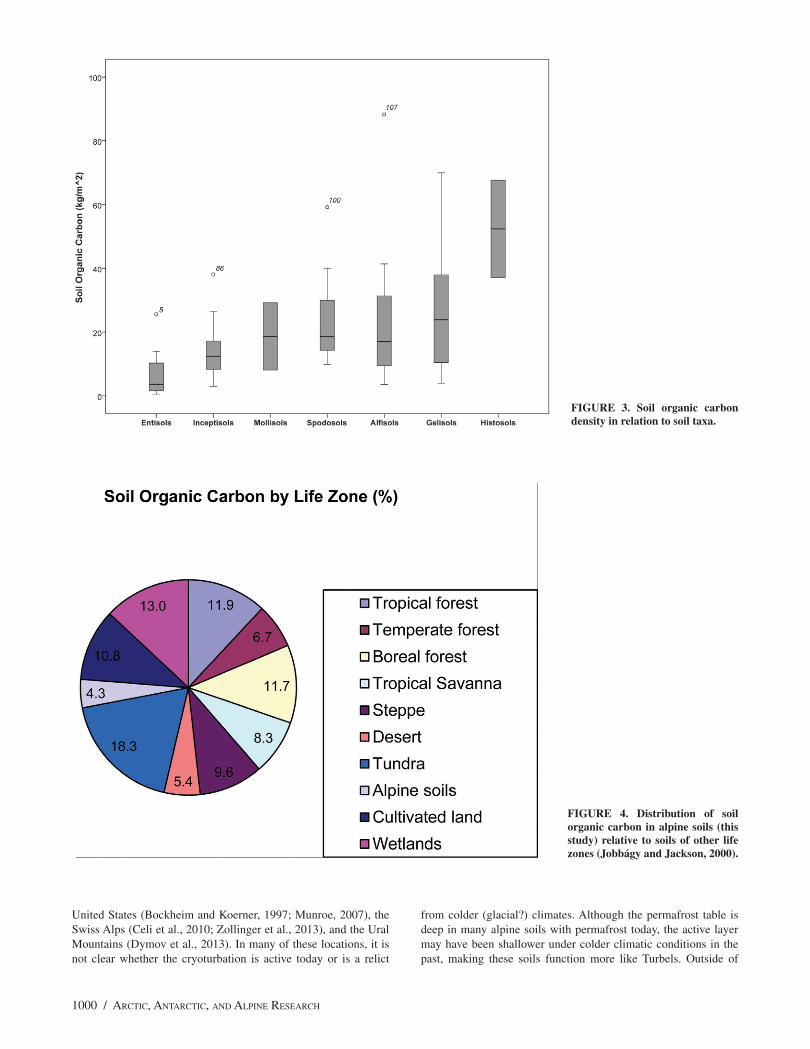
GLOBAL ALPINE SOIL C POOL
Using our estimate of 3.32 million km2 for the area of moun-tain permafrost (Table 1) and the SOC densities in Table 4, we estimate the SOC pool for areas with alpine permafrost to be 66.3 Pg, which is 4.5% of the global SOC pool of 1500 Pg (Fig. 4). In
TABLE 2
Distribution of mountain permafrost (103 km2).
Mountain rangeGorbunov
(1978)Haeberli
et al. (1993)Gruber (2012)
This study
North America ~20 400
Coast Range (U.S.A., Canada) ~37
Rocky Mountains 100
U.S.A.
Canada
Brooks Range 263
Cascade Mountains (U.S.A., Canada) 0
Appalachian Mountains <1
South America
Andes Mountains 30 270 26 100a
North Atlantic
Fennoscandia 80 71 75b
Iceland 50 8c
Greenland 250 251d
Europe
Alps 5 50 5 12e
Pyrenees
Carpathians
Urals 125f
Asia
Caucasus 5 20 2 21f
Himalayas-Karakoram-Hindu Kush (Qinghai-Tibet Plateau) 1000 2000 1292 1300g
Altai Mtns., Mongolia 1400 1000 382 1000i
Pamir, Tien Shan, Djunder Alatau 20g
Yablonoi-Sayan-Stanovoi Mtns., Siberia 1000 255g
Japanese Alps <1h
North Korea 2.2
South Pacific
Southern Alps, New Zealand 10 <1i
Total 2460 4880 ~3564
aTrombotto, 2000; bKing, 1986; cEtzelmüller et al., 2007; dChristiansen et al., 2010; eBoeckli et al., 2012; fMarchenko, unpublished; gLi et al., 2012; hFukui, 2003; iAllen et al., 2008.
994 / ARCTIC, ANTARCTIC, AND ALPINE RESEARCH
Table 3
Analytical properties of alpine soils of the world that are underlain by permafrost.
Location HorizonDepth (cm)
Silt (%)
Clay (%) pH
SOC (%) C:N
CEC (cmol+/
kg)BS (%)
Fed
(%)Al
d
(%)
Uinta, Rocky Pedon: U92-7; Typic Haplocryolls (Bockheim and Koerner, 1997)
Mtns., USA O 0–5
A 5–18 10.1 24.2 5.6 2.6 10 14.6 76
EB 18–33 2.6 29.5 5.9 0.9 12 7.6 72
Bw 33–79 6.1 33.6 5.7 0.3 14 3.6 58
C 79–107 4.3 28 5.5 0.3 13 3.6 56
Rocky Mtns., Pedon: P412A; Typic Haplocryepts (Pawluk and Brewer, 1975)
Alberta, Canada A 0–8 57 17 4.8 14.7 17 41.8 30 0.92 0.98
AB 8–12 56 20 4.9 9 20 32.6 20 1.36 1.59
2Bw 12–18 48 25 5.4 1.4 11 16.8 37 2.79 0.79
2BC 18–26 43 27 5.3 0.6 7.9 12.3 54 3.22 0.47
2C 26 35 31 5.6 0.4 7.2 12.2 76 3.75 0.45
Andes Mtns., Pedon: COR15; Typic Haplocryepts (Mahaney et al., 2009)
Venezuela A 0–15 15.5 6.7 7.8
Bw 15–32 17.5 4.6 3.6
Cox 32–54 17.3 2.9 0.33
Cu 54 19.5 3.1 0.41
Karkevagge, Pedon: A1; Oxyaquic Dystrocryepts (Darmody et al., 2000)
Swedish Lapland A 0–6 3.6 8.5 9 31 0.03 0.09
E 6–10 4.1 3.1 2 37 0.032 0.0887
Bw 10–33 4.3 1.5 2 41 0.0178 0.0677
Bg 33–69 4.3 1.6 3 41 0.0147 0.0771
Cg 69–95 4.3 1.5 2 41 0.0164 0.0691
Italian Alps Pedon: N5; Entic Haplocryods (Egli et al., 2006)
Oe 1–10 46.6 24.3 4.1 15.1 19 1.56 0.26
BE 10–35 29.0 12.5 4.6 6.93 22 3.32 0.81
Bhs 35–80 19.4 4.6 5.2 3.88 25 3.32 0.99
BC 80–100 17.0 4 5.3 1.84 20 2.72 0.66
Carpathian Mtns. Pedon: Lithic Cryorthents (Pelisek, 1973)
Oi 0–6
A 6–36 4.4 15 18
Cr 35–60 4.6 1
Himalayas, Pedon: 3; Typic Humicryepts (Smith et al., 1999)
Tibet A1 0–13 32.1 7.5 4.6 6.21 13 16.0 55 1.5 0.2
A2 13–24 21 4.8 4.6 2.7 11 10.0 39 1.2 0.2
2Bw 24–43 8.9 0.9 4.8 0.49 2.9 66 0.6 0.1
2BC1 43–74 11.5 1.8 5.1 0.29 2.0 100 0.6 tr
2BC2 74–116 11.9 1.3 5.2 0.38 2.1 100 0.7 0.1
2C 116–135 10.3 0.6 5.2 0.12 1.8 100 0.5 tr
Stanovoi Range, Pedon: 2-89T; Lithic Humicryepts (Chevychelov and Volotovskii, 2001)
Siberia Oi 0–2 5.3 54.1 81
A 2–10 10.5 5.2 5.2 16.6 35 70 0.63 0.55
JAMES G. BOCKHEIM AND JEFFREY S. MUNROE / 995
contrast, the circumarctic region contains 496 Pg of SOC to a depth of 100 cm (Tarnocai et al., 2009), which is about 33% of the global SOC pool. However, as much as 60% of the SOC in high-latitude permafrost-affected soils occurs below 100 cm in the near-surface permafrost (Tarnocai et al., 2009).
SOIL-FORMING PROCESSES IN ALPINE SOILS WITH PERMAFROST
In the scheme of Bockheim and Gennadiyev (2000), the dominant soil-forming processes in high-mountain environments
Location HorizonDepth (cm)
Silt (%)
Clay (%) pH
SOC (%) C:N
CEC (cmol+/
kg)BS (%)
Fed
(%)Al
d
(%)
BhC 10–18 13 8.6 5 25.6 35 62 0.68 0.55
R 18–25
Altai Range, Pedon: 874; Typic Humicryrepts (Krasnoshchekov, 2010)
Mongolia A 0–20 22 8 5.4 7.8 16 11.2 64
AC 20–35 23 13 5.2 3.1 15 4.1 79
M 45–55 22 13 6.5 0.9 22 2.5 87
Subpolar Ural Mtns., Pedon: 25-09; Typic Aquiturbels (Dymov et al., 2013)
Russia Oi 0–5 3.9 41.4 56 66
Ag 5–14 36 21 5.2 0.8 12 8.8
BCg 14–37 37 22 5.1 0.7 12 9.6
Cg 37 30 18 5.2 0.1 2 8.1
Caucasus, Pedon: 389; Typic Humicryepts (Molchanov, 2008)
Russia A 0–10 23.6 22.8 6.7 12.2 50.7 92
Bw 15–25 18.7 31.6 7 7.3 43.4 91
BC 35–45 16.8 37.6
Appalachian Mtns., Pedon: 94P0304; Lithic Humicryods (USDA, NRCS)
New York, U.S.A. Oe 0–33 4.6 19.4 86.1
Bh1 33–41 26 3.3 4.6 31.8 22 114 1 0.8 2.4
Bh2 41–46 27.2 12.2 5.2 11.6 22 53.8 2 0.5 1.2
Pyrenees, Pedon: Typic Haplocryepts (Parkinson and Gellatly, 1991)
France A 0–10 30 5 6.2 7.6 27.3
B 10–20 27 9 6.5 1.5 11.3
C 20–30 57 5 6.8 0.7 14.3
Melville Bay, NW Pedon: 88; Typic Spodorthels (Jakobsen, 1988)
Greenland A 0–1 5.1 3.99 1.88 0.80
E 1–7 5.4 1.39 12.5 2.26 1.00
Bhs 7–11 5.6 1.6 10.7 2.07 1.60
Bs 11–19 5.6 0.81 9.1 1.62 1.40
Bw 19–40 5.7 0.23 3.5 0.88 0.52
BC 40–65 5.7 0.44 5.8 1.24 0.94
Cf 65
Mean values A 25.8 12.2 5.12 8.19 17 21.0 57 1.0 0.5
by horizon E 15.8 21.0 5.0 3.1 17.0 7.4 1.9 0.6
B 21.2 13.3 5.4 6.2 21.5 22.8 1.2 0.9
BC 24.1 11.2 5.3 0.7 13.3 6.4 1.7 0.5
C 24.4 12.7 5.5 0.6 11.1 6.4 72 1.4 0.3
TABLE 3
Continued
996 / ARCTIC, ANTARCTIC, AND ALPINE RESEARCH
TA
BL
E 4
Soil
seri
es in
alp
ine
area
s of
the
U.S
.A.
Seri
es N
ame
Seri
es
Nam
eSe
ries
N
ame
Are
a (k
m2 )
Oth
er
Ord
erSu
bord
erG
reat
Gro
upSu
bgro
upPa
rtic
le-s
ize
Cla
ssM
iner
alog
y C
lass
CE
C C
lass
STR
Oth
erM
AP
(mm
)M
AA
T
(°C
)V
eget
atio
n
Lik
ely
Per
maf
rost
ME
RE
DIT
HC
O91
170
369
UT
Ince
ptis
ols
Cry
epts
Hum
icry
epts
Spod
ic
Hum
icry
epts
loam
y-sk
elet
alis
otic
cryi
c89
0-3
.3al
pine
tu
ndra
BR
OSS
CO
6454
026
1W
YIn
cept
isol
sC
ryep
tsH
umic
ryep
tsTy
pic
Hum
icry
epts
loam
y-sk
elet
alis
otic
cryi
c89
0-2
.2al
pine
tu
ndra
MIR
RO
RC
O75
980
308
WY
Ince
ptis
ols
Cry
epts
Hum
icry
epts
Typi
c H
umic
ryep
tslo
amy-
skel
etal
isot
iccr
yic
890
-1.1
alpi
ne
tund
ra
PEN
ITE
NT
EN
M76
800
311
Ince
ptis
ols
Cry
epts
Hum
icry
epts
Typi
c H
umic
ryep
tslo
amy-
skel
etal
isot
iccr
yic
1200
-1.1
alpi
ne
tund
ra
TE
EW
INO
TW
Y53
280
216
CO
, ID
Ince
ptis
ols
Cry
epts
Hum
icry
epts
Lith
ic
Hum
icry
epts
loam
y-sk
elet
alm
ixed
supe
ract
ive
cryi
c10
00-1
.1al
pine
tu
ndra
HE
NSO
NC
O22
5650
914
Ince
ptis
ols
Cry
epts
Dys
troc
ryep
tsTy
pic
Dys
troc
ryep
tslo
amy-
skel
etal
isot
iccr
yic
990
-0.6
alpi
ne
tund
ra
MO
RA
NW
Y42
7640
1732
CO
, ID
Ince
ptis
ols
Cry
epts
Hum
icry
epts
Typi
c H
umic
ryep
tslo
amy-
skel
etal
mix
edsu
pera
ctiv
ecr
yic
1140
0al
pine
tu
ndra
NA
MB
EN
M86
4830
3503
Spod
osol
sC
ryod
sH
aplo
cryo
dsE
ntic
H
aplo
cryo
dslo
amy-
skel
etal
isot
iccr
yic
1120
0sp
r-fir
LE
IGH
CA
NW
Y77
5700
3142
CO
, U
TIn
cept
isol
sC
ryep
tsD
ystr
ocry
epts
Typi
c D
ystr
ocry
epts
loam
y-sk
elet
alm
ixed
supe
ract
ive
cryi
c11
400
spr-
fir
WA
LC
OT
TW
Y11
9920
486
Ince
ptis
ols
Cry
epts
Hum
icry
epts
Typi
c H
umic
ryep
tslo
amy-
skel
etal
mix
edsu
pera
ctiv
ecr
yic
1140
0.6
alpi
ne
tund
ra
MA
HO
OSU
CM
E39
530
160
His
toso
lsFo
lists
Cry
ofol
ists
Typi
c C
ryof
olis
tscr
yic
dysi
c12
501.
1ba
l fir
krum
m
SUR
PLU
SM
E29
7150
1203
NH
, N
YSp
odos
ols
Cry
ods
Hap
locr
yods
Aqu
ic
Hap
locr
yods
coar
se-l
oam
yis
otic
cryi
c12
701.
1ba
lsam
fir
SAD
DL
EB
AC
KM
E64
1340
2597
NH
, N
YSp
odos
ols
Cry
ods
Hum
icry
ods
Lith
ic
Hum
icry
ods
loam
yis
otic
cryi
c12
701.
1ba
lsam
fir
BE
MIS
ME
9110
036
9In
cept
isol
sA
quep
tsC
ryaq
uept
sA
eric
C
ryaq
uept
slo
amy
mix
edcr
yic
shal
low
1270
1.1
spr-
fir
EN
DL
ICH
CO
3340
013
5In
cept
isol
sC
ryep
tsD
ystr
ocry
epts
Typi
c D
ystr
ocry
epts
loam
y-sk
elet
alis
otic
cryi
c12
001.
1sp
r-fir
Pos
sibl
e P
erm
afro
st
CO
UC
HSA
CH
RA
GA
NY
1001
1040
5Sp
odos
ols
Cry
ods
Hum
icry
ods
Lith
ic
Hum
icry
ods
sand
yis
otic
cryi
c14
001.
7sp
r-fir
EST
HE
RN
Y28
170
114
Spod
osol
sC
ryod
sH
umic
ryod
sA
quan
dic
Hum
icry
ods
med
ial
amor
phic
cryi
c14
001.
7ba
lsam
fir
SAN
TAN
ON
IN
Y83
110
337
Spod
osol
sC
ryod
sH
umic
ryod
sTy
pic
Hum
icry
ods
sand
y-sk
elet
alis
otic
cryi
c14
001.
7sp
r-fir
JAMES G. BOCKHEIM AND JEFFREY S. MUNROE / 997
Seri
es N
ame
Seri
es
Nam
eSe
ries
N
ame
Are
a (k
m2 )
Oth
er
Ord
erSu
bord
erG
reat
Gro
upSu
bgro
upPa
rtic
le-s
ize
Cla
ssM
iner
alog
y C
lass
CE
C C
lass
STR
Oth
erM
AP
(mm
)M
AA
T
(°C
)V
eget
atio
n
SKY
LIG
HT
NY
2158
4087
4Sp
odos
ols
Cry
ods
Hum
icry
ods
Lith
ic
Hum
icry
ods
sand
yis
otic
cryi
c14
001.
7sp
r-fir
Fish
snoo
zeC
A33
720
137
Ince
ptis
ols
Cry
epts
Hum
icry
epts
Xer
ic
Hum
icry
epts
loam
y-sk
elet
alis
otic
cryi
c11
401.
7m
tn h
em-
pine
Sum
eado
wC
A73
200
296
Ince
ptis
ols
Cry
epts
Hum
icry
epts
Xer
ic
Hum
icry
epts
loam
y-sk
elet
alis
otic
cryi
c76
01.
7pi
nes-
sedg
es
AR
CH
RO
CK
CO
7851
031
8In
cept
isol
sC
ryep
tsH
umic
ryep
tsTy
pic
Hum
icry
epts
loam
y-sk
elet
alm
icac
eous
cryi
c86
02.
2al
pine
tu
ndra
MU
MM
YC
O15
4400
625
Ince
ptis
ols
Cry
epts
Hum
icry
epts
Typi
c H
umic
ryep
tslo
amy-
skel
etal
mic
aceo
uscr
yic
890
2.2
alpi
ne
tund
ra
TR
AIL
RID
GE
CO
1670
3067
6In
cept
isol
sC
ryep
tsH
umic
ryep
tsTy
pic
Hum
icry
epts
loam
y-sk
elet
alm
icac
eous
cryi
c89
02.
2sp
r-fir
FAL
LR
IVE
RC
O41
8700
1696
Ince
ptis
ols
Cry
epts
Dys
troc
ryep
tsTy
pic
Dys
troc
ryep
tslo
amy-
skel
etal
isot
iccr
yic
810
3.3
spr-
fir
GR
EN
AD
IER
CO
9889
040
1Sp
odos
ols
Cry
ods
Hap
locr
yods
Ent
ic
Hap
locr
yods
loam
y-sk
elet
alis
otic
cryi
c64
03.
3sp
r-fir
21
585
CE
C =
cat
ion-
exch
ange
cap
acity
cla
ss, S
TR
= s
oil-
tem
pera
ture
reg
ime,
MA
P =
mea
n an
nual
pre
cipi
tatio
n, M
AA
T =
mea
n an
nual
air
tem
pera
ture
.
CO
= C
olor
ado,
NM
= N
ew M
exic
o, W
Y =
Wyo
min
g, M
E =
Mai
ne, N
Y =
New
Yor
k, C
A =
Cal
ifor
nia,
UT
= U
tah,
ID
= I
daho
, NH
– N
ew H
amps
hire
.
TA
BL
E 4
Con
tinu
ed
998 / ARCTIC, ANTARCTIC, AND ALPINE RESEARCH
TABLE 5
Soil organic carbon density in alpine soils underlain by permafrost.
AreaNo. of pedons
Elevation (m)
Active layer
depth (m) Vegetation Soil great groupDepth inter val
(cm)SOC
(kg/m2) References
Brooks Range, AK
3 >500 >0.6 Dry tundra Mollorthels, Umbrorthels
0–100 7.5–14.2 Bockheim et al., 1998
Rocky Mts., AB
4 2240–2969 nd Alpine turf Cryorthents, Haplocryepts, Humicryepts
0–50 6.6–14.8 Knapik et al., 1973
Rocky Mtns., AB
3 2550 >1.0 Alpine tundra Haplocryepts to bedrock
(26–45 cm)
6.9–8.4 Pawluk and Brewer, 1975
Rocky Mtns., MT
3 >3000 >1.0 Alpine tundra Humicryepts, Cryorthents, Cryaquepts
0–100 7.2–38.1 Nimlos and McConnell, 1965
Rocky Mtns., CO
6 >3500 1.5–2.0 Alpine tundra Haplocryepts, Dystrocryepts?
0–100 9.1–24.4 Retzer, 1974
Rocky Mtns., CO
8 >3500 >1.0 Alpine tundra Cryorthents, Dystrocryepts, Haplocryalfs
0–100 0.58–21.3 Birkeland et al., 1987
Rocky Mtns., UT
12 3518–3735 >2 Alpine tundra Dystrocryepts, Haplocryolls, Haplocryalfs, Argicryolls
0–100 Munroe, 2007
Rocky Mtns., UT
12 3385–3700 >2 Alpine tundra Haplocryalfs, Dystrocryepts, Cryorthents, Humicryepts, Haplocryolls
0–100 3.0–22.6 Bockheim and Koerner, 1997
Appalachian Mtns., VT
33 1337–1917 nd Alpine tundra Cryofolists, Cryorthents, Dystrocryepts
to bedrock
(23–50 cm)
11.3–37.0 Munroe, 2008
Appalachian Mtns., NH
8 >1500 >1.0 Alpine tundra Haplocryods, Dystrocryepts, Cryaquepts, Cryosaprists
0–100 18.6–67.6 Bliss, 1963
Appalachian Mtns., ME
2 1335 >1.0 Alpine tundra Haplocryods 0–100 28.4–31.6 Bliss and Woodwell, 1965
Venezuelan Andes
3 >1.0 Alpine tundra Dystrocryepts, Haplocryepts?
0–100 12.6–16.4 Mahaney et al., 2009
Peruvian Andes
6 ~4000 >1.0 Alpine tundra Haplocryalfs, Haplocryods, Cryorthents, Haplocryepts
0–>70 5.2–88.3 Miller and Birkeland, 1992
Storbreen, Norway
19 1300–1450 >1.0 Alpine foreland
Cryorthents 0–50 1.0–14.0 Darmody et al., 2005
Swiss Alps 3 2000–2050 >1.0 Alpine tundra Haplocryods 0–100 17.3–24.1 Egli et al., 2001
Swiss Alps 5 2285–2653 nd Alpine grassland
nd 0–30 5.5–10.2 Budge et al., 2011
Swiss Alps 11 2569–2695 nd Alpine grassland
Haplocryods? 0–30 6.1–13.2 Zollinger et al., 2013
Italian Alps 10 1200–2420 nd nd Humicryepts, Haplocryepts, Haplocryods
0–100 7–35 Egli et al., 2006
Pyrenees 35 1845–2900 nd Alpine grassland
nd to bedrock
(13–74 cm)
5.9–30 Garcia-Pausas et al., 2007
Pamirs 2 2580 >0.7 Alpine tundra Humicryepts? 0–100 11.3–14.6 Karavayeva, 1958
JAMES G. BOCKHEIM AND JEFFREY S. MUNROE / 999
with permafrost are andisolization, melanization, podzolization, cryoturbation, paludization, and gleization. Cambisolization was not identified in the paper by Bockheim and Gennadiyev (2000), but was suggested by D. Yaalon (personal communication) as an additional key soil-forming process.
Andisolization refers to the formation of amorphous minerals (allophone) from weathering of volcanic ash and other silica-rich materials, a process that is especially prevalent in high-rainfall en-vironments (Parfitt et al., 1983). High-mountain soils often have an isotic mineral class (Table 3), which is defined on the basis of two criteria: a pH ≥8.4 in a NaF extract and a ratio of 1500 kPa water content to percent clay of ≥0.6 (Soil Survey Staff, 1999, 2010). The test with NaF is designed as a relatively quick measurement of the content of the non-crystalline minerals (e.g., allophone, imogolite) in a soil (Fieldes and Perrott, 1966). The initial pH of the NaF is 7.5–7.8 so that a value in excess of 8.4 is indicative of poorly crystalline minerals as the fluoride anion displaces hydroxyl ions and complexes Al.
There are 1001 soil series with an isotic mineral class in the NRCS database (Soil Survey Division, 2013a, 2013b, 2013c). Fif-ty-three percent of these soil series are Inceptisols, which also con-stitute the dominant order of mountain soils with permafrost iden-tified in the present study. Sixty-four percent of the soils containing an isotic mineral class in the NRCS database have a frigid or cryic
soil-temperature regime, suggesting that a cryic soil-temperature regime is conducive to the development of amorphous minerals. None of the 52 Gelisols in the NRCS database contains an isotic mineral class; rather, they all have a mixed mineralogy. Together these findings suggest that the formation of amorphous minerals common to high-mountain soils is favored by abundant soil mois-ture, a frigid or cryic but not gelic soil-temperature regime, and siliceous parent materials.
Melanization refers to the accumulation of well-humified organic matter within the upper mineral soil. This process is evi-denced in high-mountain soils by thick A horizons (Table 3) and comparatively high SOC densities (Table 5).
Although not requiring permafrost, cryoturbation (frost-stirring) is a common process in permafrost-affected soils and is manifested by patterned ground on the land surface and irregular and broken horizons, organic matter accumulation on the perma-frost table, oriented stones, and silt caps within the soil. Patterned ground is a common feature in high-mountain environments, cov-ering from 5% to 19% of the ground surface (Johnson and Bill-ings, 1962; Niessen et al., 1992; Hort and Luoto, 2009; Feuillet, 2011). In addition to high-latitude mountain environments, such as Iceland (Arnalds, 2008), Svalbard (Kabala and Zapart, 2012), and the Scandinavian Mountains (Darmody et al., 2000, 2004), cryo-turbation has been reported in the central Rocky Mountains of the
AreaNo. of pedons
Elevation (m)
Active layer
depth (m) Vegetation Soil great groupDepth inter val
(cm)SOC
(kg/m2) References
Pamirs 5 3600–4150 >1.0 Alpine tundra Haplocryepts? 0–80 3.5–6.0 Kann, 1965
Tien Shan 8 3300–3600 >1.0 Alpine meadows
Humicryepts? 0–80 7.4–20.6 Rubilin and Dzhumagulov, 1977
Qinghai-Tibet Plateau
11 4300 4-7 Alpine meadow
Haplorthels? 0–30 3.4–10 Dörfer et al., 2013
Qinghai-Tibet Plateau
38 nd <0.8–>4 Alpine steppe Haplocryepts, Gelorthents?
0–30 9.3–11 Wang et al., 2008
Qinghai-Tibet Plateau
405 nd nd Alpine meadow, steppe
nd 0–100 4.4–9.5 Yang et al.,2008
Qinghai-Tibet Plateau
24 4400–5300 nd Alpine meadow
nd 0–30 2.6–14 Ohtsuka et al., 2008
Qinghai-Tibet Plateau
62 nd nd Alpine meadow
Haplocryepts? 0–75 29–53 Wang et al., 2002
Qinghai-Tibet Plateau
62 nd nd Alpine steppe nd 0–30 9.0–16 Wang et al.,2002
Khangai-Altai, Mongolia
5 >2100–>2600
0.19–0.55 Alpine tundra Gelorthents, Humigelepts, Aquorthels
to bedrock
(25–50 cm)
13.5–38.0 Krasnoshchekov, 2010
Ural Mtns. 10 >550 0.3–0.5 Mtn. tundra Aquorthels? 0–50 7.7–39.3 Dymov et al., 2013
SE Yakutia 2 1695–1750 nd Alpine tundra Haplocryods to bedrock
(18–40 cm)
7.7–15.4 Chevychelov and Volotovskii, 2007
SOC = soil organic carbon.AK = Alaska, AB = Alberta, MT = Montana, CO = Colorado, UT = Utah, VT = Vermont, NH = New Hampshire, ME = Maine.
TABLE 5
Continued
1000 / ARCTIC, ANTARCTIC, AND ALPINE RESEARCH
United States (Bockheim and Koerner, 1997; Munroe, 2007), the Swiss Alps (Celi et al., 2010; Zollinger et al., 2013), and the Ural Mountains (Dymov et al., 2013). In many of these locations, it is not clear whether the cryoturbation is active today or is a relict
from colder (glacial?) climates. Although the permafrost table is deep in many alpine soils with permafrost today, the active layer may have been shallower under colder climatic conditions in the past, making these soils function more like Turbels. Outside of
FIGURE 3. Soil organic carbon density in relation to soil taxa.
FIGURE 4. Distribution of soil organic carbon in alpine soils (this study) relative to soils of other life zones (Jobbágy and Jackson, 2000).
JAMES G. BOCKHEIM AND JEFFREY S. MUNROE / 1001
the areas noted above, we found only a few published reports of cryoturbation in high-mountain soils of central Asia or the Andes. Smith et al. (1999) reported hummocky, cryoturbated ground in moist depressions around 5000 m on the Qinghai Plateau, but no permafrost was observed within 2 m of the surface. In the Khangai Mountains of Mongolia, Krasnoshchekov (2010) attributed the lack of cryoturbation to the presence of dry permafrost.
Cambisolization leads to the formation of weakly developed Bw (cambic) horizons. This process is pervasive in mountain en-vironments with permafrost, as evidenced by the abundance of Inceptisols (Table 5). The abundance of Inceptisols in alpine re-gions may be due to the fact that many of these soils are young and pedogenesis is inhibited by slow rates of weathering and horizon formation. Küfmann (2008) suggested that many of the Incepti-sols (Cambisols) in alpine karst of the Northern Calcareous Alps of Germany are of eolian origin rather than from weathering in situ. However, this does not imply that Inceptisols in alpine areas worldwide are of similar origin.
Podzolization is a complex collection of processes that in-cludes eluviation of base cations, weathering transformation of Fe and Al compounds, mobilization of Fe and Al in surface horizons, and transport of these compounds to the spodic horizon as Fe and Al complexes with fulvic acids and other complex polyaromatic compounds. This process occurs in many high-mountain environ-ments throughout the world, particularly in subalpine areas with a humid climate, coniferous vegetation, and siliceous parent materi-als (Burns, 1990; Skiba, 2007).
Gleization refers to redoximorphic features such as mottling and gleying that result from aquic conditions; this occurs in most mountain ranges, especially in bedrock depressions.
Paludization refers to the accumulation of histic materials, but does not necessarily imply poor drainage conditions; it is a dominant process in the alpine zone of the Appalachian Mountains (Munroe, 2008). Many of these soils are classified as Cryofolists, which are saturated for less than 30 consecutive days per year and may store up to 60 kg m–2 of SOC.
The other soil-forming processes identified by Bockheim and Gennadiyev (2000) occur to a limited extent in high-mountain en-vironments, including alluviation, biological enrichment of bases, and calcification. Argillic horizons have been reported in the cen-tral Rocky Mountains of the United States (Burns, 1980; Bockheim and Koerner, 1997; Munroe, 2007). These features are common in pedons between 3400 and 3600 m in the Uinta Mountains of Utah; however, it is unclear whether they are forming under modern con-ditions or are relict from a previous milder soil climate (Bockheim and Koerner, 1997; Munroe, 2007).
Haplocryolls with high base levels are common in the cen-tral Rocky Mountains (Burns, 1980; Bockheim and Koerner, 1997; Munroe, 2007). Bockheim et al. (2000b) reported that base cycling is enhanced in alpine communities dominated by Acomastylis (Geum) rossii, as evidenced by large profile quantities and high tis-sue concentrations of Ca. Calcification has been reported in alpine soils in the northern Rocky Mountains (Nimlos and McConnell, 1965; Knapik et al., 1973), Svalbard (Kabala and Zapart, 2012), and in the semiarid mountains of central Asia (Kann, 1965).
COMPARISON OF ALPINE AND ARCTIC SOILS
A question that arises from this review: What role does per-mafrost occurring at depths of 2 to 8 m play in pedogenesis? To address this question, we compared soils in high-elevation (alpine) environment with those in high-latitude (arctic) environments, rec-
ognizing that active-layer thicknesses have changed during glacial-interglacial intervals. The area of high-elevation permafrost is con-siderably less than that of high-latitude permafrost (Table 6). The mean SOC density is also greater for arctic soils, and as a result the total SOC pools are larger for arctic regions. At the pedon scale, the depth-distribution of SOC in profiles from the arctic and al-pine regions varies significantly. In alpine regions with permafrost, SOC is concentrated in the upper 30 to 40 cm of the soil profile and decreases regularly with depth (Bockheim et al., 2000a; Baumann et al., 2009; Yang et al., 2008; Dörfer et al., 2013). In contrast, SOC in arctic soils is concentrated at the base of the active layer and in the transition zone between the active layer and near-surface permafrost, because of intensive cryoturbation accompanied by compaction (Bockheim et al., 2003).
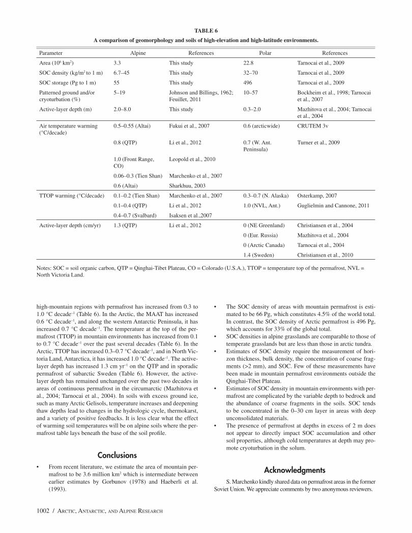
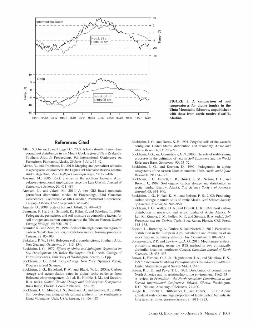
The thermal regime also varies in important ways between arctic and alpine permafrost soils. Most notably, alpine permafrost soils typically feature a deep active layer, which can be attributed to high summer temperatures and reduced volumes of ground ice (Pang et al., 2009). Figure 5 shows measured soil temperatures through a representative year at two depths in an alpine soil at 3,700 m in the Uinta Mountains of the central Rocky Mountains and a Gelisol in arctic Alaska. On the basis of a MAAT <0 °C, per-mafrost is likely present beneath this alpine soil profile, although the active layer is more than 100 cm thick. Similar conditions occur in the ultra-continental region of central Sakha, Russia, where the active-layer depth is in excess of 2 m despite a MAAT of –9 °C or lower (Lessovaia et al., 2013).
Both soil profiles in Figure 5 exhibit rapid warming in May; however, temperatures in the arctic soil fail to reach 5 °C during the summer, remaining close to 0 °C at a depth of 64 cm. In contrast, summer temperatures at nearly 1 m in the alpine soil profile are almost 5 °C warmer. Warmer summer temperatures are conducive to more rapid breakdown of organic matter, perhaps contributing to the reduced SOC density in alpine permafrost soils.
Temperatures in both profiles fall to ~0 °C by late September, but the arctic soil remains at this temperature longer (until early December) due to a zero-curtain effect involving the freezing of abundant soil moisture that cannot drain from the profile because of ice at depth. This moisture contributes to the formation of ice lenses and other massive ground ice features that promote cryo-turbation. As noted earlier, patterned ground produced by cryotur-bation has been reported for alpine soils with permafrost, but it is unclear to what extent cryoturbation is occurring in these soil profiles today. Although the active layer typically extends beneath the base of the pedon in these soils, cryoturbation may have been a more active process during colder climates of the Pleistocene when a shallower permafrost table, and (possibly) more significant ac-cumulations of massive ground ice, impeded subsurface drainage, enhancing volumetric changes associated with freeze/thaw cycles. Under modern conditions with a deep active layer and relatively warm summer temperatures in the solum, the presence of perma-frost at depths >2 m may still aid cryoturbation closer to the sur-face by promoting two-way freezing of the active layer. However, beyond this indirect effect, deep permafrost may contribute little to pedogenesis in alpine soils. It is of interest that alpine Gelisols appear to occur only where the MAAT is –5 °C or colder (Table 1).
CLIMATE WARMING IN ALPINE AND ARCTIC SOILS WITH PER-MAFROST
Both the high-mountain and high-latitude regions are expe-riencing major changes due to climate warming. The MAAT in
1002 / ARCTIC, ANTARCTIC, AND ALPINE RESEARCH
high-mountain regions with permafrost has increased from 0.3 to 1.0 °C decade–1 (Table 6). In the Arctic, the MAAT has increased 0.6 °C decade–1, and along the western Antarctic Peninsula, it has increased 0.7 °C decade–1. The temperature at the top of the per-mafrost (TTOP) in mountain environments has increased from 0.1 to 0.7 °C decade–1 over the past several decades (Table 6). In the Arctic, TTOP has increased 0.3–0.7 °C decade–1, and in North Vic-toria Land, Antarctica, it has increased 1.0 °C decade–1. The active-layer depth has increased 1.3 cm yr–1 on the QTP and in sporadic permafrost of subarctic Sweden (Table 6). However, the active-layer depth has remained unchanged over the past two decades in areas of continuous permafrost in the circumarctic (Mazhitova et al., 2004; Tarnocai et al., 2004). In soils with excess ground ice, such as many Arctic Gelisols, temperature increases and deepening thaw depths lead to changes in the hydrologic cycle, thermokarst, and a variety of positive feedbacks. It is less clear what the effect of warming soil temperatures will be on alpine soils where the per-mafrost table lays beneath the base of the soil profile.
ConclusionsFrom recent literature, we estimate the area of mountain per-mafrost to be 3.6 million km2 which is intermediate between earlier estimates by Gorbunov (1978) and Haeberli et al. (1993).
The SOC density of areas with mountain permafrost is esti-mated to be 66 Pg, which constitutes 4.5% of the world total. In contrast, the SOC density of Arctic permafrost is 496 Pg, which accounts for 33% of the global total.SOC densities in alpine grasslands are comparable to those of temperate grasslands but are less than those in arctic tundra.Estimates of SOC density require the measurement of hori-zon thickness, bulk density, the concentration of coarse frag-ments (>2 mm), and SOC. Few of these measurements have been made in mountain permafrost environments outside the Qinghai-Tibet Plateau.Estimates of SOC density in mountain environments with per-mafrost are complicated by the variable depth to bedrock and the abundance of coarse fragments in the soils. SOC tends to be concentrated in the 0–30 cm layer in areas with deep unconsolidated materials.The presence of permafrost at depths in excess of 2 m does not appear to directly impact SOC accumulation and other soil properties, although cold temperatures at depth may pro-mote cryoturbation in the solum.
AcknowledgmentsS. Marchenko kindly shared data on permafrost areas in the former
Soviet Union. We appreciate comments by two anonymous reviewers.
TABLE 6
A comparison of geomorphology and soils of high-elevation and high-latitude environments.
Parameter Alpine References Polar References
Area (106 km2) 3.3 This study 22.8 Tarnocai et al., 2009
SOC density (kg/m2 to 1 m) 6.7–45 This study 32–70 Tarnocai et al., 2009
SOC storage (Pg to 1 m) 55 This study 496 Tarnocai et al., 2009
Patterned ground and/or cryoturbation (%)
5–19 Johnson and Billings, 1962; Feuillet, 2011
10–57 Bockheim et al., 1998; Tarnocai et al., 2007
Active-layer depth (m) 2.0–8.0 This study 0.3–2.0 Mazhitova et al., 2004; Tarnocai et al., 2004
Air temperature warming (°C/decade)
0.5–0.55 (Altai) Fukui et al., 2007 0.6 (arcticwide) CRUTEM 3v
0.8 (QTP) Li et al., 2012 0.7 (W. Ant. Peninsula)
Turner et al., 2009
1.0 (Front Range, CO)
Leopold et al., 2010
0.06–0.3 (Tien Shan) Marchenko et al., 2007
0.6 (Altai) Sharkhuu, 2003
TTOP warming (°C/decade) 0.1–0.2 (Tien Shan) Marchenko et al., 2007 0.3–0.7 (N. Alaska) Osterkamp, 2007
0.1–0.4 (QTP) Li et al., 2012 1.0 (NVL, Ant.) Guglielmin and Cannone, 2011
0.4–0.7 (Svalbard) Isaksen et al.,2007
Active-layer depth (cm/yr) 1.3 (QTP) Li et al., 2012 0 (NE Greenland) Christiansen et al., 2004
0 (Eur. Russia) Mazhitova et al., 2004
0 (Arctic Canada) Tarnocai et al., 2004
1.4 (Sweden) Christiansen et al., 2010
Notes: SOC = soil organic carbon, QTP = Qinghai-Tibet Plateau, CO = Colorado (U.S.A.), TTOP = temperature top of the permafrost, NVL = North Victoria Land.
JAMES G. BOCKHEIM AND JEFFREY S. MUNROE / 1003
References CitedAllen, S., Owens, I., and Huggel, C., 2008: A first estimate of mountain
permafrost distribution in the Mount Cook region of New Zealand’s Southern Alps. In Proceedings, 9th International Conference on Permafrost, Fairbanks, Alaska, 29 June–3 July, 37–42.
Alonso, V., and Trombotto, D., 2012: Mapping and permafrost altitudes in a periglacial environment: the Laguna del Diamante Reserve (central Andes, Argentina). Zeitschrift für Geomorphologie, 57: 171–186.
Aoyama, M., 2005: Rock glaciers in the northern Japanese Alps: palaeoenvironmental implications since the Late Glacial. Journal of Quaternary Science, 20: 471–484.
Arenson, L., and Jakob, M., 2010: A new GIS based mountain permafrost distribution model. In Proceedings, 63rd Canadian Geotechnical Conference & 6th Canadian Permafrost Conference, Calgary, Alberta, 12–15 September, 452–458.
Arnalds, O., 2008: Soils of Iceland. Jökull, 58: 409–421.Baumann, F., He, J.-S., Schmidt, K., Kühn, P., and Scholten, T., 2009:
Pedogenesis, permafrost, and soil moisture as controlling factors for soil nitrogen and carbon contents across the Tibetan Plateau. Global Change Biology, 15: 3001–3017.
Bäumler, R., and Zech, W., 1994: Soils of the high mountain region of eastern Nepal: classification, distribution and soil forming processes. Catena, 22: 85–103.
Birkeland, P. W., 1984: Holocene soil chronofunctions, Southern Alps, New Zealand. Geoderma, 34: 115–134.
Bockheim, J. G., 1972: Effects of Alpine and Subalpine Vegetation on Soil Development, Mt. Baker, Washington. Ph.D. thesis, College of Forest Resources, University of Washington, Seattle, 171 pp.
Bockheim, J. G., 2014: Cryopedology. New York: Springer Verlag, Progress in Soil Science.
Bockheim, J. G., Birkeland, P. W., and Bland, W. L., 2000a: Carbon storage and accumulation rates in alpine soils: evidence from Holocene chronosequences. In Lal, R., Kimble, J. M., and Stewart, B. A. (eds.), Global Climate Change and Cold Regions Ecosystems. Boca Raton, Florida: Lewis Publishers, 185–196.
Bockheim, J. G., Munroe, J. S., Douglass, D., and Koerner, D., 2000b: Soil development along an elevational gradient in the southeastern Uinta Mountains, Utah, USA. Catena, 39: 169–185.
Bockheim, J. G., and Burns, S. F., 1991: Pergelic soils of the western contiguous United States: distribution and taxonomy. Arctic and Alpine Research, 23: 206–212.
Bockheim, J. G., and Gennadiyev, A. N., 2000: The role of soil-forming processes in the definition of taxa in Soil Taxonomy and the World Reference Base. Geoderma, 95: 53–72.
Bockheim, J. G., and Koerner, D., 1997: Pedogenesis in alpine ecosystems of the eastern Uinta Mountains, Utah. Arctic and Alpine Research, 29: 164–172.
Bockheim, J. G., Everett, L. R., Hinkel, K. M., Nelson, F. E., and Brown, J., 1999: Soil organic carbon storage and distribution in arctic tundra, Barrow, Alaska. Soil Science Society of America Journal, 63: 934–940.
Bockheim, J. G., Hinkel, K. M., and Nelson, F. E., 2003: Predicting carbon storage in tundra soils of arctic Alaska. Soil Science Society of America Journal, 67: 948–950.
Bockheim, J. G., Walker, D. A., and Everett, L. R., 1998: Soil carbon distribution in nonacidic and acidic tundra of Arctic Alaska. In Lal, R., Kimble, J. M., Follett, R. F., and Stewart, B. A. (eds.), Soil Processes and the Carbon Cycle. Boca Raton, Florida: CRC Press, 143–155.
Boeckli, L., Brenning, A., Gruber, S., and Noetzli, J., 2012: Permafrost distribution in the European Alps: calculation and evaluation of an index map and summary statistics. The Cryosphere, 6: 807–820.
Bonnaventure, P. P., and Lewkowicz, A. G., 2013: Mountain permafrost probability mapping using the BTS method in two climatically dissimilar locations, northwest Canada. Canadian Journal of Earth Sciences, 45: 433–455.
Brown, J., Ferrians, O. J., Jr., Heginbottom, J. A., and Melnikov, E. S., 1997: Circum-arctic Map of Permafrost and Ground-Ice Conditions. United States Geological Survey MAP CP-45.
Brown, R. J. E., and Pewe, T. L., 1973: Distribution of permafrost in North America and its relationship to the environment, 1962–73—A review. In Permafrost—the North American Contribution to the Second International Conference, Yakutsk, Siberia. Washington, D.C.: National Academy of Sciences, 71–100.
Budge, K., Leifeld, J., Hiltbrunner, E., and Fuhrer, J., 2011: Alpine grassland soils contain large proportion of labile carbon but indicate long turnover times. Biogeosciences, 8: 1911–1923.
FIGURE 5. A comparison of soil temperatures for alpine tundra in the Uinta Mountains (Munroe, unpublished) with those from arctic tundra (IvotUk, Alaska).
1004 / ARCTIC, ANTARCTIC, AND ALPINE RESEARCH
Burn, C. R., 1994: Permafrost, tectonics, and past and future regional climate change, Yukon and adjacent Northwest Territories. Canadian Journal of Earth Sciences, 31: 182–191.
Burns, S. F., 1980: Alpine Soil Distribution and Development, Indian Peaks, Colorado Front Range. Ph.D. thesis, Department of Geological Sciences, University of Colorado, Boulder (Dissertation Abstract 81-13948).
Burns, S. F., 1990: Alpine Spodosols: Cryaquods, Cryohumods, Cryorthods, and Placaquods above treeline. In Kimble, J. M., and Yeck, R. D. (eds.), Proceedings of the Fifth International Correlation Meeting (ISCOM): Characterization, Classification, and Utilization of Spodosols. Lincoln, Nebraska: USDA Soil Conservation Service, 46–62.
Caine, N., 2010: Recent hydrologic change in a Colorado alpine basin: an indicator of permafrost thaw? Annals of Glaciology, 51: 130–134.
Celi, L., Rosso, F., Freppaz, M., Agnelli, A., and Zanini, E., 2010: Soil organic matter characteristics in sporadic permafrost-affected environment (Creux du Van, Switzerland). Arctic, Antarctic, and Alpine Research, 42: 1–8.
Cheng, G. D., 2005: Permafrost studies in the Qinghai-Tibet Plateau for road construction. Journal of Cold Regions Engineering, 19: 19–29.
Chevychelov, A. P., and Volotovskii, K. A., 2001: Soils of alpine and subalpine vertical zones of the Tokinskii Stanovik Ridge. Eurasian Soil Science, 34: 704–709.
Christiansen, H. H., 2004: Meteorological control on interannual spatial and temporal variations in snow cover and ground thawing in two northeast Greenlandic Circumpolar-Active-layer-Monitoring (CALM) sites. Permafrost and Periglacial Processes, 15: 155–169.
Christiansen, H. H., Sigsgaard, C., Humlum, O., Rasch, M., and Hansen, B. U., 2008: Permafrost and periglacial geomorphology at Zackenberg. Advances in Ecological Research, 40: 151–174.
Christiansen, H. H., Etzelmuller, B., Isaksen, K., Juliussen, H., Farbrot, H., Humlum, O., Johansson, M., Ingeman-Nielsen, T., Kristensen, L., Hjort, J., Holmlund, P., Sannel, A. B. K., Sigsgaard, C., Åkerman, H. J., Foged, N., Blikra, L. H., Pernosky, M. A., and Ødegård, R. S., 2010: The thermal state of permafrost in the Nordic area during the International Polar year 2007–2009. Permafrost and Periglacial Processes, 21: 156–181.
Dahms, D., Favilli, F., Krebs, R., and Egli, M., 2012: Soil weathering and accumulation rates of oxalate-extractable phases derived from alpine chronosequences of up to 1 Ma in age. Geomorphology, 151-152: 99–113.
Darmody, R. G., Thorn, C. E., Dixon, J. C., and Schlyter, P., 2000: Soils and landscapes of Kärkevagge, Swedish Lapland. Soil Science Society of America Journal, 64: 1455–1466.
Darmody, R. G., Thorn, C. E., Schlyter, P., and Dixon, J. C., 2004: Relationship of vegetation distribution to soil properties in Kärkevagge, Swedish Lapland. Arctic, Antarctic, and Alpine Research, 36: 21–32.
Darmody, R. G., Allen, C. E., and Thorn, C. E., 2005: Soil topochronosequences at Storbreen, Jotunheimen, Norway. Soil Science Society of America Journal, 69: 1275–1287.
Dörfer, C., Kühn, P., Baumann, F., He, J.-S., and Scholten, T., 2013: Soil organic carbon pools and stocks in permafrost-affected soils on the Tibetan Plateau. PloS One, 8: e57024. http://dx.doi.org/10.1371/journal.pone.0057024.
Dymov, A. A., Zhangurov, E. V., and Startsev, V. V., 2013: Soils of the northern part of the subpolar Urals: Morphology, physicochemical properties, and carbon and nitrogen pools. Eurasian Soil Science, 46: 459–467.
Egli, M., Fitze, P., and Mirabella, A., 2001: Weathering and evolution of soils formed on granitic, glacial deposits: results from chronosequences of Swiss alpine environments. Catena, 45: 19–47.
Egli, M., Mirabella, A., Sartori, G., and Fitze, P., 2003: Weathering rates as a function of climate: results from a climosequence of the Val Genova (Trentino, Italian Alps). Geoderma, 111: 99–121.
Egli, M., Mirabella, A., Sartori, G., Zanelli, R., and Bischof, S., 2006: Effect of north and south exposure on weathering rates and clay mineral formation in alpine soils. Catena, 67: 155–174.
Etzelmüller, B., and Frauenfelder, R., 2009: Factors controlling the distribution of mountain permafrost in the Northern Hemisphere and their influence on sediment transfer. Arctic, Antarctic, and Alpine Research, 41: 48–58.
Etzelmüller, B., Farbrot, H., Gudmundsson, A., Humlum, O., Tveito, O. E., and Björnsson, H., 2007: The regional distribution of mountain permafrost in Iceland. Permafrost and Periglacial Processes, 18: 185–199.
Feuillet, T., 2011: Statistical analyses of active patterned ground occurrence in the Taillon Massif (Pyrénées, France/Spain). Permafrost and Periglacial Processes, 22: 228–238.
Fieldes, M., and Perrott, K. W., 1966: The nature of allophone in soils. III. Rapid field and laboratory test for allophone. New Zealand Journal of Science, 90: 623–629.
Fukui, K., 2003: Permafrost and surface movement of an active protalus rampart in the Kuranosuke Cirque, the northern Japanese Alps. In Phillips, M., Springer, S., and Arenson, L. (eds.), Permafrost. Lisse, Netherlands: Swets & Zeitlinger, 265–270.
Fukui, K., Fujii, Y., Mikhailov, N., Ostanin, O., and Iwahana, G., 2007: The lower limit of mountain permafrost in the Russian Altai Mountains. Permafrost and Periglacial Processes, 18: 129–136.
Garcia-Pausas, J., Casals, P., Camarero, L., Huguet, C., Sebastià, M.-T., Thompson, R., and Romanyà, J., 2007: Soil organic carbon storage in mountain grasslands of the Pyrenees: effects of climate and topography. Biogeochemistry, 82: 279–289.
Gorbunov, A. P., 1978: Permafrost investigations in high-mountain regions. Arctic and Alpine Research, 10: 283–294.
Grishina, L. A., Onipchenko, V. G., Makarov, M. I., and Vanyasin, V. A., 1993: Changes in properties of mountain-meadow alpine soils of the northwestern Caucasus under different ecological conditions. Eurasian Soil Science, 25: 5–12.
Gruber, S., 2012: Derivation and analysis of a high-resolution estimate of global permafrost zonation. The Cryosphere, 6: 221–233.
Gruber, S., and Hoelzle, M., 2001: Statistical modelling of mountain permafrost distribution: local calibration and incorporation of remote sensed data. Permafrost and Periglacial Processes, 12: 69–77.
Guglielmin, M., and Cannone, N., 2011: A permafrost warming in a cooling Antarctica? Climatic Change, 111:177–195. http://dx.doi.org/10.1007s10584-011-0137-2.
Haeberli, W., Guodong, C., Gorbunov, A. P., and Harris, S. A., 1993: Mountain permafrost and climate change. Permafrost and Periglacial Processes, 4: 165–174.
Harris, C., Arenson, L. U., Christiansen, H. H., Etzelmüller, B., Frauenfelder, R., Gruber, S., Haeberli, W., Hauck, C., Hölzle, M., Humlum, O., Isaksen, K., Kääb, A., Kern-Lütschg, M. A., Lehning, M., Matsuoka, N., Murton, J. B., Nötzli, J., Phillips, M., Ross, N., Seppälä, M., Springman, S. M., and Vonder Mühll, D., 2009: Permafrost and climate in Europe: monitoring and modeling thermal, geomorphological and geotechnical responses. Earth-Science Reviews, 92: 117–171.
Harris, S. A., 1986: Permafrost distribution, zonation and stability along the eastern ranges of the Cordillera of North America. Arctic, 39: 29–38.
Harris, S. A., and Brown, R. J. E., 1982: Permafrost distribution along the Rocky Mountains in Alberta. In Proceedings of the Fourth Canadian Permafrost Conference. Ottawa: National Research Council of Canada, 59–67.
Hort, J., and Luoto, M., 2009: Interaction of geomorphic and ecologic features across altitudinal zones in a subarctic landscape. Geomorphology, 112: 324–333.
Isaksen, K., Holmlund, P., Sollid, J. L., and Harris, C., 2001: Three deep alpine-permafrost boreholes in Svalbard and Scandinavia. Permafrost and Periglacial Processes, 12: 13–25.
Ivanov, M. N., and Medvedeva, E. V., 2012: Polar Urals and periglacial geomorphology TICOP Excursion Guidebook. Tyumen, Russia: Pechatnik.
IUSS Working Group WRB, 2006. World Reference Base for Soil Resources. Rome: FAO, World Soil Resources Report Number 103.
Jakobsen, B. H., 1988: Soil formation on the Peninsula Tugtuligssuaq, Melville Bay, North West Greenland. Danish Journal of Geography, 88: 86–93.
JAMES G. BOCKHEIM AND JEFFREY S. MUNROE / 1005
Janke, J. R., 2005: The occurrence of alpine permafrost in the Front Range of Colorado. Geomorphology, 67: 375–389.
Janke, J. R., Williams, M. W., and Evans, A., Jr., 2012: A comparison of permafrost prediction models along a section of Trail Ridge Road, Rocky Mountain National Park, Colorado, USA. Geomorphology, 138: 111–120.
Jobbágy, E. G., and Jackson, R. B., 2000: The vertical distribution of soil organic carbon and its relation to climate and vegetation. Ecological Applications, 10: 423–436.
Johnson, P. L., and Billings, W. D., 1962: The alpine vegetation of the Beartooth Plateau in relation to cryopedogenic processes and patterns. Ecological Monographs, 32: 105–135.
Julián, A., and Chueca, J., 2007: Permafrost distribution from BTS measurements (Sierra de Telera, central Pyrenees, Spain): Assessing the importance of solar radiation in a mid-level shaded mountainous area. Permafrost and Periglacial Processes, 18: 137–149.
Kann, L. A., 1965: High-mountain soils of the western Pamirs. Soviet Soil Science, 9: 1028–1036.
Kabala, C., and Zapart, J., 2012: Initial soil development and carbon accumulation on moraines of the rapidly retreating Werenskiold Glacier, SW Spitsbergen, Svalbard archipelago. Geoderma, 175–176: 9–20.
Karavayeva, N. A., 1958: High-mountain soils of the eastern Sayans. Soviet Soil Science, 4: 397–401.
King, L., 1986: Zonation and ecology of high mountain permafrost in Scandinavia. Geografiska Annaler, 68A: 131–139.
Knapik, L. J., Scotter, G. W., and Pettapiece, W. W., 1973: Alpine soil and plant community relationships of the Sunshine Area, Banff National Park. Arctic and Alpine Research, 5: A161–A170.
Krasnoshchekov, Y. N., 2010: Soils and the soil cover of mountainous tundra and forest landscapes in the central Khangai of Mongolia. Eurasian Soil Science, 43: 117–126.
Küfmann, C., 2008: Are Cambisols in alpine karst autochthonous or eolian in origin? Arctic, Antarctic, and Alpine Research, 40: 506–518.
Leopold, M., Voelkel, J., Dethier, D., Williams, M., and Caine, N., 2010: Mountain permafrost—a valid archive to study climate change? Examples from the Rocky Mountains Front Range of Colorado, USA. Nova Acta Leopoldina, 112: 281–289.
Lessovaia, S. N., Goryachkin, S. V., Desyatkin, R. V., and Okoneshnikova, M. V., 2013: Pedoweathering and mineralogical change in Cryosols in an ultra-continental climate (central Yakutia, Russia). Acta Geodynamica et Geomaterialia, 10: 465–473.
Lewkowicz, A. G., and Ednie, M., 2004: Probability mapping of mountain permafrost using the BTS method, Wolf Creek, Yukon Territory, Canada. Permafrost and Periglacial Processes, 15: 67–80.
Li, S. D., and Chang, G. D., 1996: Map of frozen ground on Qinghai-Xizang Plateau. Lanzhou, China: Gansu Culture Press.
Li, R., Zhao, L., Ding, Y.-J., Wu, T.-H., Xiao, Y., Du, E., Liu, G.-Y., and Qiao, Y.-P., 2012: Temporal and spatial variations of the active layer along the Qinghai-Tibet Highway in a permafrost region. Chinese Science Bulletin, 57: 4609–4616.
Lilleøren, K. S., and Etzelmüller, B., 2011: A regional inventory of rock glaciers and ice-cored moraines in Norway. Geografiska Annaler, 93A: 175–191.
Mahaney, W. C., Kalm, V., Kapran, B., Milner, M. W., and Hancock, R. G. V., 2009: A soil chronosequence in Late Glacial and Neoglacial moraines, Humboldt Glacier, northwestern Venezuelan Andes. Geomorphology, 109: 236–245.
Marchenko, S. S., Gorbunov, A. P., and Romanovsky, V. E., 2007: Permafrost warming in the Tien Shan Mountains, central Asia. Global and Planetary Change, 56: 311–327.
Matsui, T., Kondo, N., and Yano, Y., 1971: A clay mineralogical aspect of the vertical zonality on the Japan South Alps. Soil Science and Plant Nutrition, 17: 199–209.
Mazhitova, G., Malkova, G., Chestnykh, O., and Zamolodchikov, D., 2004: Active-layer spatial and temporal variability at European Russian Circumpolar-Active-Layer-Monitoring (CALM) sites. Permafrost and Periglacial Processes, 15: 123–139.
Miller, D. C., and Birkeland, P. W., 1992: Soil catena variation along an alpine climatic transect, northern Peruvian Andes. Geoderma, 55: 211–223.
Molchanov, E. N., 2008: Mountainous meadow Chernozem-like soils of high mountains in the North Caucasus region. Eurasian Soil Science, 41: 1268–1281.
Munroe, J. S., 2007: Properties of alpine soils associated with well-developed sorted polygons in the Uinta Mountains, Utah, U.S.A. Arctic, Antarctic, and Alpine Research, 39: 578–591.
Munroe, J. S., 2008: Alpine soils on Mount Mansfield, Vermont, USA: pedology, history, and intraregional comparison. Soil Science Society of America Journal, 72: 524–533.
Munroe, J. S., and Bockheim, J. G., 2001: Soil development in low-arctic tundra of the northern Brooks Range, Alaska, U.S.A. Arctic, Antarctic, and Alpine Research, 33: 78–87.
Mutter, E. Z., and Phillips, M., 2012: Active layer characteristics at ten borehole sites in alpine permafrost terrain, Switzerland. Permafrost and Periglacial Processes, 23: 138–151.
Niessen, A., van Horssen, P., and Koster, E. A., 1992: Altitudinal zonation of selected geomorphological phenomena in an alpine periglacial area (Abisko, northern Sweden). Geografiska Annaler, 74A: 183–196.
Nimlos, T. J., and McConnell, R. C., 1965: Alpine soils in Montana. Soil Science, 99: 310–321.
Ohtsuka, T., Hirota, M., Zhang, X., Shimono, A., Senga, Y., Du, M., Yonemura, S., Kawashima, S., and Tang, Y., 2008: Soil organic carbon pools in alpine to nival zones along an altitudinal gradient (4400–5300 m) on the Tibetan Plateau. Polar Science, 2: 277–285.
Osterkamp, T. E., 2007: Characteristics of the recent warming of permafrost in Alaska. Journal of Geophysical Research: Earth Surface, 112: F02S02, http://dx.doi.org/10.1029/2006JF000578.
Pang, Q., Cheng, G., Li, S., and Zhang, W., 2009: Active layer thickness calculation over the Qinghai-Tibet Plateau. Cold Regions Science and Technology, 57: 23–28.
Parfitt, R. L., Russell, M., and Orbell, G. E., 1983: Weathering sequence of soils from volcanic ash involving allophone and halloysite, New Zealand. Geoderma, 29: 41–57.
Parkinson, R. J., and Gellatly, A. F., 1991: Soil formation on Holocene moraines in the Cirque de Troumouse, Pyrenees. Pirineos, 138: 69–82.
Pawluk, S., and Brewer, R., 1975: Micromorphological, mineralogical, and chemical characteristics of some alpine soils and their genetic implications. Canadian Journal of Soil Science, 55: 415–437.
Pelí ek, J., 1973: Vertical soil zonality in the Carpathians of Czechoslovakia. Geoderma, 9: 193–211.
Péwé, T. L., 1983: Alpine permafrost in the contiguous United States: a review. Arctic and Alpine Research, 15: 145–156.
Pfeiffer, M., Mascayano, C., and Aburto, F., 2010: Soils of Chilean Patagonia in glacial and periglacial environments. Eurasian Soil Science, 43: 1430–1438.
Retzer, J., 1974: Alpine soils. In Ives, J. D., and Barry, R. G. (eds.), Arctic and Alpine Environments. London: Methuen, 771–802.
Rubilin, Y. V., and Dzhumagulov, M., 1977: Humus and its composition in some subalpine and alpine soils of Kirghizia. Eurasian Soil Science, 6: 264–272.
Ruiz, L., and Trombotto, D., 2012: Mountain permafrost distribution in the Andes of Chubut (Argentina) based on a statistical model. In Proceedings, Tenth International Conference on Permafrost (TICOP), Salekhard, Russia, 365–370.
Schuur, E. A. G., Abbott, B. W., Bowden, W. B., Brovkin, V., Camill, P., Canadell, J. G., Chanton, J. P., Chapin III, F. S., Christensen, T. R., Ciais, P., Crosby, B. T., Czimczik, C. I., Grosse, G., Harden, J., Hayes, D. J., Hugelius, G., Jastrow, J. D., Jones, J. B., Kleinen, T., Koven, C. D., Krinner, G., Kuhry, P., Lawrence, D. M., McGuire, A. D., Natali, S. M., O’Donnell, J. A., Ping, C. L., Riley, W. J., Rinke, A., Romanovsky, V. E., Sannel, A. B. K., Schädel, C., Schaefer, K., Sky, J., Subin, Z. M., Tarnocai, C., Turetsky, M. R., Waldrop, M. P., Walter Anthony, K. M., Wickland, K. P., Wilson, C. J., and Zimov, S. A., 2013: Expert assessment of vulnerability of permafrost carbon to climate change. Climatic Change, 119: 359–374.
1006 / ARCTIC, ANTARCTIC, AND ALPINE RESEARCH
Serrano, E., Agudo, R., Delaloye, R., and González-Trueba, J. J., 2001: Permafrost distribution in the Posets massif, central Pyrenees. Norwegian Journal of Geography, 55: 245–252.
Sharkhuu, N., 2003: Recent changes in the permafrost of Mongolia. In Phillips, M., Springman, S., and Arenson, L. (eds.), Permafrost. Lisse: Swets & Zeitlinger, 1029–1034.
Sharkhuu, A., Sharkhuu, N., Etzelmüller, B., Heggem, E. S. F., Nelson, F. E., Shiklomanov, N. I., Goulder, C. E., and Brown, J., 2007: Permafrost monitoring in the Hovsgol mountain region, Mongolia. Journal of Geophysical Research–Earth Surface, 112: http://dx.doi.org/10.1029/2006/F000543.
Skiba, M., 2007: Clay mineral formation during podzolization in an alpine environment of the Tatra Mountains, Poland. Clays and Clay Minerals, 55: 618–634.
Smith, C. A. S, Clark, M., Broll, G., Ping, C. L., Kimble, J. M., and Luo, G., 1999: Characterization of selected soils from the Lhasa region of Qinghai-Xizang Plateau, SW China. Permafrost and Periglacial Processes, 10: 211–222.
Sneddon, J. I., Lavkulich, L. M., and Farstad, L., 1972: The morphology and genesis of some alpine soils in British Columbia, Canada: I. Morphology, classification, and genesis. Soil Science Society of America Proceedings, 36: 101–104.
Soil Survey Division, 2013a: Soil Classification Database. USDA—Natural Resources Conservation Service, available online at http://soils.usda.gov/technical/classification/scfile/index.html.
Soil Survey Division, 2013b: Official Soil Series Descriptions. USDA—Natural Resources Conservation Service, available online at http://soils.usda.gov/technical/classification/osd/index.html.
Soil Survey Division, 2013c: Soil Laboratory Data. USDA—Natural Resources Conservation Service, available online at http://ncsslabdatamart.sc.egov.usda.gov.
Soil Survey Staff, 1999: Soil Taxonomy: A Basic System of Soil Classification for Making and Interpreting Soil Surveys. Second edition. Washington, D.C.: U.S. Government Printing Office, United States Department of Agriculture, Natural Resources Conservation Service, Agricultural Handbook Number 436.
Soil Survey Staff, 2010: Keys to Soil Taxonomy. 11th edition. Lincoln, Nebraska: United States Department of Agriculture, Natural Resources Conservation Service, National Soil Survey Center.
Sone, T., Takahashi, N., and Fukuda, M., 1988: Alpine permafrost occurrence at Mt. Taisetsu, central Hokkaido, in northern Japan. In Proceedings of the Fifth International Conference on Permafrost. Trondheim, Norway: Tapir Publishers, 253–258.
Tarnocai, C., Nixon, F. M., and Kutny, L., 2004: Circumpolar-Active-Layer-Monitoring (CALM) sites in the Mackenzie Valley, northwestern Canada. Permafrost and Periglacial Processes, 15: 141–153.
Tarnocai, C., Canadell, J. G., Schuur, E. A. G., Kuhry, P., Mazhitova, G., and Zimov, S., 2009: Soil organic carbon pools in the northern circumpolar permafrost region. Global Biogeochemical Cycles, 23: http://dx.doi.org/10.1029/2008GB003327.
Thorhallsdottir, T. E., 1983: The ecology of permafrost areas in central Iceland and the potential effects of impoundment. In Proceedings of the Fourth International Conference on Permafrost, Fairbanks, Alaska. Washington, D.C.: National Academy of Sciences Press, 1251–1256.
Tonkin, P. J., and Basher, L. R., 2001: Soil chronosequences in subalpine superhumid Cropp Basin, western Southern Alps, New
Zealand. New Zealand Journal of Geology and Geophysics, 44: 37–45.
Trombotto, D., 2000: Survey of cryogenic processes, periglacial forms and permafrost conditions in South America. Revista do Instituto Geológico, São Paulo, 21: 33–55.
Trombotto, D., and Borzotta, E., 2009: Indicators of present global warming through changes in active-layer thickness, estimation of thermal diffusivity and geomorphological observations in the Morenas Coloradas rockglacier, central Andes of Mendoza, Argentina. Cold Regions Science and Technology, 55: 321–330.
Turner, J., Bindschadler, R. A., Convey, P., Di Prisco, G., Fahrbach, E., Gutt, J., Hodgson, D. A., Mayewski, P. A., and Summerhayes, C. P., 2009: Antarctic Climate Change and the Environment. Cambridge, UK: Scientific Committee on Antarctic Research.
Ugolini, F. C., and Tedrow, J. C. F., 1963: Soils of the Brooks Range: 3. Rendzina of the Arctic. Soil Science, 96: 121–127.
Ugolini, F. C., Tedrow, J. C. F., and Grant, C. L., 1963: Soils of the northern Brooks Range, Alaska: 2. Soils derived from black shale. Soil Science, 95: 115–123.
Urdea, P., 1998: Rock glaciers and permafrost reconstruction in the southern Carpathian Mountains, Romania. In Proceedings, Seventh International Conference on Permafrost, Yellowknife, Canada. Collection Nordicana, 55: 1063–1069.
Van Everdingen, R. (ed.), 1998: Multi-language glossary of permafrost and related ground-ice terms. Boulder, Colorado: National Snow and Ice Data Center.
Van Ryswyk, A. L., and Okazaki, R., 1979: Genesis and classification of modal subalpine and alpine soil pedons of south-central British Columbia, Canada. Arctic and Alpine Research, 11: 53–67.
Wang, G., Li, Y., Wang, Y., and Wu, Q., 2008: Effects of permafrost thawing on vegetation and soil carbon pool losses on the Qinghai-Tibet Plateau, China. Geoderma, 143: 143–152.
Wang, G., Qian, J., Cheng, G., and Lai, Y., 2002: Soil organic carbon pool of grassland soils on the Qinghai-Tibetan Plateau and its global implication. The Science of the Total Environment, 291: 207–217.
Wu, Q., Zhang, T., and Liu, Y., 2010: Permafrost temperatures and thickness on the Qinghai-Tibet Plateau. Global and Planetary Change, 72: 32–38.
Wu, X., Zhao, L., Chen, M., Fang, H., Yue, G., Chen, J., Pang, Q., Wang, Z., and Ding, Y., 2012: Soil organic carbon and its relationship to vegetation communities and soil properties across permafrost areas of the central western Qinghai-Tibet Plateau, China. Permafrost and Periglacial Processes, 23: 162–169.
Yang, Y., Fang, J., Ji, C., Ma, W., Su, S., and Tang, Z., 2008: Soil inorganic carbon stock in the Tibetan alpine grasslands. Global Biogeochemical Cycles, 24: GB4022, http://dx.doi.org/10.1029/2010GB003804.
Zhao, S., Cheng, W., Shou, C., Chen, X., and Chen, J., 2012: Simulation of decadal alpine permafrost distributions in the Qilian Mountains over the past 50 years by using logistic regression model. Cold Regions Science and Technology, 73: 32–40.
Zollinger, B., Alewell, C., Kneisel, C., Meusburger, K., Gärtner, H., Brandová, D., Ivy-Ochs, S., Schmidt, M. W. I., and Egli, M., 2013: Effect of permafrost on the formation of soil organic carbon pools and their physical-chemical properties in the eastern Swiss Alps. Catena, 110: 70–85.
MS accepted June 2014