ordinance no. 016-17 an of the city of port … · mwd, in order to allow alternative site design...
TRANSCRIPT
ORDINANCE NO. 016-17
AN ORDINANCE OF THE CITY OF PORT ORCHARD, WASHINGTON, CREATING A NEW R8-MWD ZONE; AMENDING POMC CHAPTERS 16.13, 16.30 AND 16.40; PROVIDING FOR SEVERABILITY AND CORRECTIONS; AND ESTABLISHING AN EFFECTIVE DATE.
WHEREAS, the City of Port Orchard wishes to establish a new zone designation of R8- MWD, in order to allow alternative site design and development standards for certain properties that are currently zoned R8; and
WHEREAS, revisions to Chapters 16.13, 16.30 and 16.40 POMC have been proposed in order to define and provide development standards for the R8-MWD zone; and
WHEREAS, on April 4, 2017 the City Planning Commission held a duly-noticed public hearing, at which no comments were received, and recommended approval of the proposed revisions to Chapters 16.13,16.30 and 16.40 POMC to the City Council; and
WHEREAS, on April 18, 2017, the City Council reviewed the proposed revisions to Chapters 16.13, 16.30 and 16.40 POMC at its work-study meeting, and determined that these revisions are appropriate to establish the necessary standards for the new R8-MWD zone; now, therefore,
THE CITY COUNCIL OF THE CITY OF PORT ORCHARD, WASHINGTON, DO ORDAINAS FOLLOWS:
SECTION 1, The City Council adopts all of the "Whereas" Sections of this ordinance as findings in support of this ordinance.
SECTION 2. Chapter 16.13 POMC is hereby amended to read as follows; all other provisions of this chapter shall remain unchanged and in full force and effect:
Chapter 16.13 ZONING DISTRICTS
Sections:
16.13.100 Zoning districts - Purpose.
Greenbelt zone (Gb).Gb zone - Permitted uses.
16.13.11016.13.111
Gb zone - Conditional uses.16.13.112
Ordinance No. 016-17 Page 2 of 72
Gb zone - Lot area.16.13.113
Gb zone - Lot coverage.16.13.114
Gb zone-Yards.16.13.115
Gb zone - Building height.16.13.116
Residential zone low density single-family detached (R4.5).16.13.120
R4.5 zone - Permitted uses.16.13.121
R4.5 zone - Conditional uses.16.13.122
16.13.123 R4.5 zone - Lot area.
16.13.124 R4.5 zone - Lot coverage.
R4.5 zone-Yards.16.13.125
R4.5 zone - Building height.16.13.126
Residential zone medium density single-family detached/attached (R8 and R8-16.13.130MWD).
R8 and R8-MWD zones - Permitted uses.16.13.131
R8 and R8-MWD zones - Conditional uses.16.13.132
R8 and R8-MWD zones - Lot area.16.13.133
R8 and R8-MWD zones - Lot coverage. R8 and R8-MWD zones - Yards.
16.13.13416.13.135
R8 and R8-MWD zones - Building height.16.13.136
Residential zone medium-high density single-family attached and multifamily (R12)16.13.137
16.13.138 R12 zone - Permitted uses.
R12 zone - Conditional uses.16.13.139
16.13.140 R12 zone - Lot area.
Ordinance No. 016-17 Page 3 of 72
16.13.141 R12 zone - Lot coverage.
R12 zone - Yards.16.13.142
R12 zone - Building height.16.13.143
Residential zone - Single-/multiple-family detached/attached (R20).16.13.144
R20 zone - Permitted uses.16.13.145
R20 zone - Conditional uses.16.13.146
16.13.147 R20 zone - Lot area.
16.13.148 R20 zone - Lot coverage.
R20 zone - Yards.16.13.149
R20 zone - Building height.16.13.150
Commercial retail and office (Co) zone.16.13.151
Co zone - Permitted uses.16.13.152
Co zone - Conditional uses.16.13.153
16.13.154 Co zone - Lot area.
16.13.155 Co zone - Lot coverage.
Co zone-Yards.16.13.156
Co zone - Building height.16.13.157
Employment industrial and office (Eo) zone. Eo zone - Permitted uses.
16.13.15816.13.159
Eo zone - Conditional uses.16.13.160
16.13.161 Eo zone - Lot area.
16.13.162 Eo zone - Lot coverage.
Ordinance No. 016-17 Page 4 of 72
Eo zone-Yards.16.13.163
Eo zone - Building height.16.13.164
Mixed use-Commercial, employment, and residential (Mxd) zone.16.13.165
Mxd zone - Permitted uses.16.13.166
Mxd zone - Conditional uses.16.13.167
Mxd zone - Lot area.16.13.168
Mxd zone - Lot coverage.16.13.169
Mxd zone - Yards.16.13.170
Mxd zone - Building height.16.13.171
Community facilities (Cf) zone.16.13.172
Cf zone - Permitted uses.16.13.173
Cf zone - Conditional uses.16.13.174
Cf zone - Lot area.16.13.175
Cf zone - Lot coverage.16.13.176
Cf zone-Yards.16.13.177
Cf zone - Building height.16.13.178
Planned residential developments16.13.179 (-PRD).16.13.180 PRD - Permitted uses.
PRD - Minimum lot area.16.13.181
PRD - Platting requirements.16.13.182
PRD - Criteria for approval.16.13.183
Business professional I and II (BP-I and BP-II) zones.16.13.184
Ordinance No. 016-17 Page 5 of 72
BP-I and BP-II zones - Permitted uses.16.13.185
BP-I and BP-II zones-Conditional uses.16.13.186
BP-I and BP-II zones - Lot area.16.13.187
BP-I and BP-II zones - Lot coverage.16.13.188
BP-I and BP-II zones - Yards.16.13.189
BP-I and BP-II zones - Building height.16.13.190
16.13.100 Zoning districts - Purpose.The purpose statements for each zoning district set forth in the following sections shall be used to guide the application of the zones and designations to all lands. They shall guide interpretation and application of land use regulations within the zones and designations, and any changes to the range of permitted uses within each zone through amendments to this title.
16.13.110 Greenbelt zone (Gb).(1) Purpose. It is the purpose of the greenbelt zone to preserve and protect natural areas that are unique in character, and ensure that natural systems will be maintained.
(2) This purpose will be accomplished by:
(a) Providing for conservation, wildlife habitat, open space, parks, recreational areas, trails, greenways, and similar urban separators on lands that are suitable for this purpose.
(b) Within the greenbelt system, allowing only those accessory and complementary uses that are compatible with the preservation of natural systems.
(3) This zone is appropriate where lands acquired or proposed to be acquired or set aside for public park and recreation use by the comprehensive plan and for other semi-publicly or privately owned lands that are dedicated, reserved or otherwise set aside for greenbelt purposes including those of a commercial orientation that should be reserved for long-term protection.
16.13.111 Gb zone - Permitted uses.The following are permitted uses in a greenbelt (Gb) zone:
(1) Permitted uses are those as shown on land use Tables 16.30.030 through 16.30.100.
(2) Accessory buildings or structures in accordance with the provisions of POMC 16.08.006 through 16.08.012.
Ordinance No. 016-17 Page 6 of 72
(3) Signs in accordance with the provisions of Chapter 16.65 POMC.
16.13.112 Gb zone - Conditional uses.Conditional uses are those shown on land use Tables 16.30.030 through 16.30.100 and associated development standards as identified in Chapter 16.40 POMC.
16.13.113 Gb zone - Lot area.Lot area is as described in Table 16.40.025, Densities and Dimensions.
16.13.114 Gb zone - Lot coverage.Lot coverage is as described in Table 16.40.025, Densities and Dimensions.
16.13.115 Gb zone - Yards.Yard requirements are as described in Table 16.40.025, Densities and Dimensions.
16.13.116 Gb zone - Building height.Building height is as described in Table 16.40.025, Densities and Dimensions.
16.13.120 Residential zone low density single-family detached (R4.5).(1) Purpose. The primary purpose of the low density single-family detached residential zone (R4.5), up to 4.5 units/net useable acre, is to:
(a) Provide for an urban residential environment that is consistent with the traditional image of the Port Orchard area; and
(b) Implement comprehensive plan goals and policies for housing quality, diversity, and affordability, and to efficiently use residential land, public services, and energy.
(2) These purposes are accomplished by:
(a) Providing for a mix of predominantly single-family detached housing types including zero lot line and housing arrangements with a variety of densities and sizes in locations appropriate for urban densities.
(b) Allowing only those accessory and complementary nonresidential uses that are compatible with single-family residential communities.
(3) This zone is appropriate where:
(a) Designated by the comprehensive plan when such areas are served at the time of development by adequate public sewers, water supply, roads, and other needed public facilities and services as defined in the concurrency management system.
Ordinance No. 016-17 Page 7 of 72
(b) Surrounding lands have already been developed for lower intensity single-family detached housing types and offer greenbelt, recreation, and pedestrian services most supportive of lower density living arrangements.
16.13.121 R4.5 zone - Permitted uses.(1) Permitted uses are those as shown on land use Tables 16.30.030 through 16.30.100.
(2) Accessory buildings or structures in accordance with the provisions of POMC 16.08.006 through 16.08.012.
(3) Signs in accordance with the provisions of Chapter 16.65 POMC.
16.13.122 R4.5 zone - Conditional uses.Conditional uses are those shown on land use Tables 16.30.030 through 16.30.100 and associated development standards as identified in Chapter 16.40 POMC.
16.13.123 R4.5 zone - Lot area.Lot area is as described in Table 16.40.025, Densities and Dimensions.
16.13.124 R4.5 zone - Lot coverage.Lot coverage is as described in Table 16.40.025, Densities and Dimensions.
16.13.125 R4.5 zone-Yards.Yard requirements are as described in Table 16.40.025, Densities and Dimensions.
16.13.126 R4.5 zone - Building height.Building height is as described in Table 16.40.025, Densities and Dimensions.
16.13.130 Residential zone medium density single-family detached/attached (R8 and R8-MWD). (1) Purpose. The purpose of the medium density single-family detached/attached residential zones (R8 and R8-MWD - up to 8.0 units/net useable acre) is to:
(a) Define areas that allow a moderate dwelling unit density - particularly in locations that are well served by the arterial circulation system and community facilities in general;
(b) Implement comprehensive plan goals and policies for housing quality, diversity, and affordability; and
(c) Efficiently use residential land, public services, and energy.
(d) Maintain consistent common development standards at street block level while recognizing the presence of master planned communities and the City's history of annexing areas which have been developed under county regulations.
Ordinance No. 016-17 Page 8 of 72
(2) These purposes are accomplished by:
(a) Providing for a mix of single-family detached including lot line and village detached housing arrangements, and attached housing types including duplex or twins, patio house, atrium house, weak and strong link town or row house, with a variety of densities and sizes in locations appropriate for urban densities.
(b) Allowing only those accessory and complementary nonresidential uses that are compatible with medium density single-family residential communities.
(3) These zones are appropriate where:
(a) Designated by the comprehensive plan when such areas are served at the time of development by adequate public sewers, water supply, roads, and other needed public facilities and services as defined in the concurrency management system.
(b) Surrounding lands have already been developed for moderate intensity single-family or multifamily housing types but abut more intensely developed commercial, office, employment or other nonresidential land uses - and offer greenbelt, recreation, pedestrian, and transit services most supportive of medium density living arrangements.
16.13.131 R8 and R8-MWD zones - Permitted uses.The following are permitted uses in the R8 and R8-MWD single-family detached/attached residential zone:
(1) Permitted uses are those as shown on land use Tables 16.30.030 through 16.30.100.
(2) Accessory buildings or structures in accordance with the provisions of POMC 16.08.006 through 16.08.012.
(3) Signs in accordance with the provisions of Chapter 16.65 POMC.
16.13.132 R8 and R8-MWD zones - Conditional uses.Conditional uses are those shown on land use Tables 16.30.030 through 16.30.100 and associated development standards as identified in Chapter 16.40 POMC.
16.13.133 R8 and R8-MWD zones - Lot area.Lot area is as described in Table 16.40.025, Densities and Dimensions.
16.13.134 R8 and R8-MWD zones - Lot coverage.Lot coverage is as described in Table 16.40.025, Densities and Dimensions.
16.13.135 R8 and R8-MWD zones - Yards.
Ordinance No. 016-17 Page 9 of 72
Yard requirements are as described in Table 16.40.025, Densities and Dimensions.
16.13.136 R8 and R8-MWD zones - Building height.Building height is as described in Table 16.40.025, Densities and Dimensions.
16.13.137 Residential zone medium-high density single-family attached and multifamily (R12).
(1) Purpose. The purpose of the medium-high density single-family attached and multifamily residential zone (R12 - up to 12.0 units/net useable acre) is to:
(a) Define areas that allow medium-high density residential use - particularly in locations that are well served by the arterial circulation system and community facilities in general;
(b) Implement comprehensive plan goals and policies for housing quality, diversity, and affordability; andi
(c) Efficiently use residential land, public services, and energy.
(2) These purposes are accomplished by:
(a) Providing for a mix of single-family attached housing types including duplex or twins, patio house, atrium house, weak and strong link town or row house and multiplex attached housing products with a variety of densities and sizes in locations appropriate for medium-high urban densities.
(b) Allowing only those accessory and complementary nonresidential uses that are compatible with medium-high density single-family attached and multifamily residential communities.
(3) This zone is appropriate where:
(a) Designated by the comprehensive plan when such areas are served at the time of development by adequate public sewers, water supply, roads, and other needed public facilities and services as defined in the concurrency management system.
(b) Surrounding lands have already been developed for medium intensity single-family or multifamily housing types that abut more intensely developed residential, commercial, office, employment or other nonresidential land uses - and offer greenbelt, recreation, pedestrian, and transit services most supportive of medium-high density living arrangements.
16.13.138 R12 zone - Permitted uses.The following are permitted uses in the R12 single-family attached and multifamily residential zone:
Ordinance No. 016-17 Page 10 of 72
(1) Permitted uses are those as shown on land use Tables 16.30.030 through 16.30.100.
(2) Accessory buildings or structures in accordance with the provisions of POMC 16.08.006 through 16.08.012.
(3) Signs in accordance with the provisions of Chapter 16.65 POMC.
16.13.139 R12 zone - Conditional uses.Conditional uses are those shown on land use Tables 16.30.030 through 16.30.100 and associated development standards as identified in Chapter 16.40 POMC.
16.13.140 R12 zone - Lot area.Lot area is as described in Table 16.40.025, Densities and Dimensions.
16.13.141 R12 zone - Lot coverage.Lot coverage is as described in Table 16.40.025, Densities and Dimensions.
16.13.142 R12 zone - Yards.Yard requirements are as described in Table 16.40.025, Densities and Dimensions.
16.13.143 R12 zone - Building height.Building height is as described in Table 16.40.025, Densities and Dimensions.
16.13.144 Residential zone high density single-/multiple-family attached (R20).(1) Purpose. The purpose of the residential high density single-/multiple-family attached zone (R20 - up to 20.0 units/net useable acre) is to:
(a) Allow high density residential development in urban locations where public services and facilities are most available;
(b) Implement comprehensive plan goals and policies for housing quality, diversity, and affordability; and
(c) Efficiently use residential land, public services, and energy.
(2) These purposes are accomplished by:
(a) Providing for a mix of higher density single-/multiple-family attached housing products including clustered village housing types, weak and strong link townhouse and multiplex, garden apartments, and multifamily apartment buildings with a variety of densities and sizes in locations appropriate for urban densities.
(b) Allowing only those accessory and complementary nonresidential uses that are compatible
Ordinance No. 016-17 Page 11 of 72
with multiple-family residential communities.
(3) This zone is appropriate where:
(a) Designated by the comprehensive plan when such areas are served at the time of development by adequate public sewers, water supply, roads, and other needed public facilities and services as defined in the concurrency management system.
(b) Surrounding lands have been developed for medium-high density residential dwellings, or commercial, business, employment, public facility or other nonresidential but higher intensity activities - and offer greenbelt, recreation, pedestrian, and transit services most supportive of higher density living arrangements.
16.13.145 R20 zone - Permitted uses.The following are permitted uses in the residential high density single-/multiple-family attached zone (R20):
(1) Permitted uses are those as shown on land use Tables 16.30.030 through 16.30.100.
(2) Accessory buildings or structures in accordance with the provisions of POMC 16.08.006 through 16.08.012.
(3) Signs in accordance with the provisions of Chapter 16.65 POMC.
16.13.146 R20 zone - Conditional uses.Conditional uses are those shown on land use Tables 16.30.030 through 16.30.100 and associated development standards as identified in Chapter 16.40 POMC.
16.13.147 R20 zone - Lot area.Lot area is as described in Table 16.40.025, Densities and Dimensions.
16.13.148 R20 zone - Lot coverage.Lot coverage is as described in Table 16.40.025, Densities and Dimensions.
16.13.149 R20 zone - Yards.Yard requirements are as described in Table 16.40.025, Densities and Dimensions.
16.13.150 R20 zone - Building height.Building height is as described in Table 16.40.025, Densities and Dimensions.
16.13.151 Commercial retail and office (Co) zone.(1) Purpose. The purpose of the commercial retail and office (Co) zone is to provide for the broadest mix of retail, service, office, and commercial recreation/cultural uses serving the Port
Ordinance No. 016-17 Page 12 of 72
Orchard and surrounding market areas and offering significant employment opportunities. (2) These purposes are accomplished by:
(a) Providing for office uses as well as a wider range of the retail, professional, governmental, and personal services than are found in neighborhood and community business areas.
(b) Encouraging planned developments that incorporate aesthetic as well as functional concerns.
(3) This zone is appropriate where:
(a) Designated by the comprehensive plan when such areas are served by adequate public sewers, water supply, roads, and other needed public facilities and services as defined in the concurrency management system.
(b) Areas are provided convenient, visible, and safe access by vehicle, transit, bicycle, and pedestrian circulation systems located on minor and major arterial roads.
16.13.152 Co zone - Permitted uses.The following are permitted uses in the commercial retail and office (Co) zone:
(1) Permitted uses are those as shown on land use Tables 16.30.030 through 16.30.100.
(2) Accessory buildings or structures in accordance with the provisions of POMC 16.08.006 through 16.08.012.
(3) Signs in accordance with the provisions of Chapter 16.65 POMC.
16.13.153 Co zone - Conditional uses.Conditional uses are those shown on land use Tables 16.30.030 through 16.30.100 and associated development standards as identified in Chapter 16.40 POMC.
16.13.154 Co zone - Lot area.Lot area is as described in Table 16.40.025, Densities and Dimensions.
16.13.155 Co zone - Lot coverage.Lot coverage is as described in Table 16.40.025, Densities and Dimensions.
16.13.156 Co zone - Yards.Yard requirements are as described in Table 16.40.025, Densities and Dimensions.
16.13.157 Co zone - Building height.Building height is as described in Table 16.40.025, Densities and Dimensions.
Ordinance No. 016-17 Page 13 of 72
16.13.158 Employment industrial and office (Eo) zone.(1) Purpose. The purpose of the employment industrial and office zone (Eo) is:
(a) To provide for the location and grouping of industrial and related enterprises and activities involving manufacturing, assembly, fabrication, processing, bulk handling and storage, research facilities, warehousing, and heavy trucking;(b) Provide land for those types of professional, research, business, service, and similar uses which are based in office structures and which require separate sites or developments from other more commercial and retail activities; and
(c) Protect the land base for economic development and employment opportunities.
(2) These purposes are accomplished by:
(a) Allowing for a wide range of industrial and manufacturing uses including more intensive building patterns and floor area ratios.
(b) Establishing appropriate development standards and public review procedures for industrial activities with the greatest potential for adverse impacts.
(c) Limiting residential, commercial, and other uses to that necessary for the convenience of industrial or dedicated office activities.
(d) Allowing for on-site convenient daily retail and personal services for employees.
(3) This zone is appropriate where:
(a) Land designated on the comprehensive plan is served at the time of development by adequate public sewer, water supply, roads, and other needed public facilities and services as defined in the concurrency management system.
(b) This zone must be provided convenient and safe access by vehicle, transit, bicycle, and pedestrian circulation systems located on minor and major arterial roads.
16.13.159 Eo zone - Permitted uses.The following are permitted uses in the employment industrial and office zone (Eo):
(1) Permitted uses are those as shown on land use Tables 16.30.030 through 16.30.100.
(2) Accessory buildings or structures in accordance with the provisions of POMC 16.08.006 through 16.08.012.
(3) Signs in accordance with the provisions of Chapter 16.65 POMC.
Ordinance No. 016-17 Page 14 of 72
16.13.160 Eo zone - Conditional uses.Conditional uses are those shown on land use Tables 16.30.030 through 16.30.100 and associated development standards as identified in Chapter 16.40 POMC.
16.13.161 Eo zone - Lot area.Lot area is as described in Table 16.40.025, Densities and Dimensions.
16.13.162 Eo zone - Lot coverage.Lot coverage is as described in Table 16.40.025, Densities and Dimensions.
16.13.163 Eo zone - Yards.Yard requirements are as described in Table 16.40.025, Densities and Dimensions.
16.13.164 Eo zone - Building height.Building height is as described in Table 16.40.025, Densities and Dimensions.
16.13.165 Mixed use - Commercial, employment, and residential (Mxd) zone. (1) Purpose. The purpose of the mixed use (Mxd) zone is to:
(a) Provide a permissive and alternative zoning procedure for innovative, pedestrian oriented mixed use site and building developments or physical design proposals that are capable of providing substantial value to the community over conventional zone districting; and
(b) Implement comprehensive plan goals and policies for housing diversity, affordability, and to efficiently use land, public services, and energy. The mixed use district may vary the height, use, organization, design, intensity, size or other feature of the proposed development, but shall not vary from the environmental, market, community impact, infrastructure, design, and other objectives of this title and the comprehensive plan.
(2) These purposes are accomplished by:
(a) Providing for the broadest mix of retail, commercial, business, personal services, office, light industrial, recreational, public facilities, and residential uses in master planned site developments within the same property, building complex, and/or structure.
(b) Conditionally controlling the location, design or inclusion of commercial uses with outdoor storage or auto-related activities that are not appropriate to or may adversely impact a residential use or pedestrian oriented development.
(c) Conditionally controlling the location, design, or inclusion of light industrial uses with outdoor storage, traffic and parking, noise or other physical or operational characteristics that are not appropriate to or may adversely impact a residential use or pedestrian oriented development.

Ordinance No. 016-17 Page 15 of 72
(d) Requiring unique consideration, disposition, control, and approval.
(3) This zone may be appropriate:
(a) Within the downtown and waterfront areas where designated by the comprehensive plan when such areas include historic features, access principal pedestrian walkway corridors, incorporate ground floor commercial and office uses, retain a pedestrian scale, and create a compact site and building development.
(b) On large, contiguous parcels along Bay Street, Bethel Avenue, Mile Hill Drive, SR- 160/Sedgwick Road, and near SR-16 where designated by the comprehensive plan when such areas can be master planned and developed to create compact, cohesive site and building developments that integrate residential use and access to retail and employment areas in identifiable and desirable urban design concepts.
(c) In areas served at the time of development by adequate public sewer, water supply, roads, and other needed public facilities and services as defined in the concurrency management system.
(d) In areas that provide convenient and safe access by pedestrian, bicycle, transit, and vehicle circulation systems located on or accessible from minor and major arterial roads.
16.13.166 Mxd zone - Permitted uses.The following are permitted uses in the mixed use, commercial, employment, and residential (Mxd) zone:
(1) Permitted uses are those as shown on land use Tables 16.30.030 through 16.30.100.
(2) Accessory buildings or structures in accordance with the provisions of POMC 16.08.006 through 16.08.012.
(3) Signs in accordance with the provisions of Chapter 16.65 POMC.
16.13.167 Mxd zone - Conditional uses.Conditional uses are those shown on land use Tables 16.30.030 through 16.30.100 and associated development standards as identified in Chapter 16.40 POMC.
16.13.168 Mxd zone - Lot area.Lot area is as described in Table 16.40.025, Densities and Dimensions.
16.13.169 Mxd zone - Lot coverage.Lot coverage is as described in Table 16.40.025, Densities and Dimensions.
Ordinance No. 016-17 Page 16 of 72
16.13.170 Mxd zone-Yards.Yard requirements are as described in Table 16.40.025, Densities and Dimensions.
16.13.171 Mxd zone - Building height.Building height is as described in Table 16.40.025, Densities and Dimensions.
16.13.172 Community facilities (Cf) zone.(1) Purpose. The purpose of the community facilities zone is to:
(a) Specifically separate and control those public, semi-public, institutional, and private properties, facilities, and services that prime and make feasible centers of urban use. It is also the purpose of this zone to coordinate these uses to the extent that they are serving to prime the same direction, magnitude, orientation, and form of urban growth and avoid waste, inefficiency, or contradiction;
(b) Maximize the known efficiencies of investment, land, site or facility sharing which are possible and desirable when infrastructure is specifically allocated space within the community;
(c) Resolve contradictions or disagreements that could arise between the various agencies or parties responsible for each infrastructure element and the specific public objectives for which they are accountable;
(d) Identify, protect, provide for, and ensure the harmonious relationship, scale, extent, provisions, character, location, and surrounding environs of public, semipublic or commercial use of lands and structures for open space, park, and recreational activities;
(e) Provide for and protect the buffer zones, access, and land use relationships which are often unique between infrastructure and other urban uses such that neither use intrudes upon the other.
(2) These purposes are accomplished by:
(a) Designating the public use as a specific zone subject to the comprehensive plan making process and public forums intended for this purpose;
(b) Designating the public, semipublic or commercial use as a specific zone subject to the comprehensive plan making process and public forums intended for this purpose;
(c) Excluding residential, commercial, office, industrial or other land uses that may cause conflicts with or be adversely affected by the principal public activities, uses or structures contained within this zone.
(3) This zone is appropriate where:
Ordinance No. 016-17 Page 17 of 72
(a) Designated by the comprehensive plan when the areas are served at the time of development by adequate public sewer, water supply, roads, and other needed public facilities and services as defined in the concurrency management system;
(b) Provided convenient and safe access by pedestrian, bicycle, transit, and vehicle circulation systems located on or accessible from minor and major arterial roads.
16.13.173 Cf zone - Permitted uses.The following are permitted uses in the community facilities zone:
(1) Permitted uses are those as shown on land use Tables 16.30.030 through 16.30.100.
(2) Accessory buildings or structures in accordance with the provisions of POMC 16.08.006 through 16.08.012.
(3) Signs in accordance with the provisions of Chapter 16.65 POMC.
16.13.174 Cf zone - Conditional uses.Conditional uses are those shown on land use Tables 16.30.030 through 16.30.100 and associated development standards as identified in Chapter 16.40 POMC.
16.13.175 Cf zone - Lot area.Lot area is as described in Table 16.40.025, Densities and Dimensions.
16.13.176 Cf zone - Lot coverage.Lot coverage is as described in Table 16.40.025, Densities and Dimensions.
16.13.177 Cf zone - Yards.Yard requirements are as described in Table 16.40.025, Densities and Dimensions.
16.13.178 Cf zone - Building height.Building height is as described in Table 16.40.025, Densities and Dimensions.
16.13.179 Planned residential developments (-PRD).(1) Purpose. The purpose of planned residential development (PRD) is to:
(a) Provide for site design flexibility and thus permit more creative and imaginative projects, or innovative projects that are otherwise beneficial to the community, than generally possible under conventional zoning regulations;
Ordinance No. 016-17 Page 18 of 72
(b) Preserve unique or sensitive physical features, such as steep slopes, views, retention of natural vegetation and to provide more open space and recreational amenities than would be available under conventional land development practices; and
(c) To promote more economical and efficient use of land and a unified design concept for residential development or mixed use/residential development.
(2) Allowable Districts. PRD, denoted by (-prd) after the zone's map symbol, may be permitted in the following zoning districts consistent with the development and design standards of this zoning code: greenbelt, residential 4.5,8,8-MWD, 12, and 20, and mixed use. However, no dwelling units may be transferred to a less intensive zone.
16.13.180 PRD - Permitted uses.(1) Single-family detached dwellings in the Gb, R4.5, R8, R12, and Mxd zones;
(2) Single-family attached and multifamily dwellings in the R12, R20, and Mxd zones; and
(3) All permitted uses as of right in the underlying zones including accessory uses and uses that may be allowed by conditional use permits or special use permits, subject to the requirements in that section of the code.
16.13.181 PRD - Minimum lot area.Parcels proposed for the PRD designation must meet minimum lot requirements as follows:
Greenbelt
Two acres
Residential 4.5,8,8-MWD, 12, and 20
One acre
Mixed use
One-half acre
16.13.182 PRD - Platting requirements.When any parcel of land within a PRD is intended for sale or individual ownership, the platting requirements of the Port Orchard subdivision ordinance and applicable state laws pertaining to subdivisions shall be followed. Applications for plat approval must be submitted and processed concurrently with the application for planned residential development approval.
Ordinance No. 016-17 Page 19 of 72
16.13.183 PRD - Criteria for approval.(1) Planned residential developments may be proposed by the applicant to permit a residential development which otherwise could not be granted. Such a development must meet strict conditions and be a benefit to the surrounding neighborhood and community at large.
(2) The applicant must specifically demonstrate why the PRD is needed by addressing the following criteria in the application:
(a) Project will benefit the community more than if the project complied with the underlying zone standards, guidelines, and policies;
(b) All proposed residential and other land uses are presented through detailed site plans, lot layouts, and building elevations;
(c) Project will preserve unique or sensitive physical features such as steep slopes and views, and retain natural vegetation;
(d) Project will provide more open space and recreational amenities than would be available under conventional land development practices;
(e) Project uses creative design techniques to promote an uncluttered appearance such as a variety of lot sizes, parking at the rear of sites and the provision of alleys;
(f) Demonstrate the project benefit to the surrounding neighborhood and community at large;
(g) Specify the phasing of the development; and
(h) Provide public facility sites or improvements, such as road improvements, utilities, parks, or open space.
16.13.184 Business professional I and II (BP-I and BP-II) zones.(1) Purpose. The purpose of the business professional (BP-I and BP-II) zones differs from general commercial designations in that business professional limits the amount, size and type of retail uses. This designation is intended to support major employment centers such as Harrison Hospital and surrounding hospital/medical district and the Kitsap County administration campus, while serving as a transition with adjacent residential neighborhoods.
(2) These purposes are accomplished by:
(a) Providing for office uses as well as a wider range of the retail, professional, governmental, and personal services than are found in neighborhood and community business areas.
Ordinance No. 016-17 Page 20 of 72
(b) Encouraging planned developments that incorporate aesthetic as well as functional concerns.
(3) These zones are appropriate where:
(a) Designated by the comprehensive plan when such areas are served by adequate public sewers, water supply, roads, and other needed public facilities and services as defined in the concurrency management system.
(b) Areas are provided convenient, visible, and safe access by vehicle, transit, bicycle, and pedestrian circulation systems located on minor and major arterial roads.
(c) Appropriate where traffic management is required.
16.13.185 BP-I and BP-II zones - Permitted uses.The following are permitted uses in the business professional retail and office (BP-I and BP-II) zones:
(1) Permitted uses are those as shown on land use Tables 16.30.030 through 16.30.100.
(2) Accessory buildings or structures in accordance with the provisions of POMC 16.08.006 through 16.08.012.
(3) Signs in accordance with the provisions of Chapter 16.65 POMC.
16.13.186 BP-I and BP-II zones - Conditional uses.Conditional uses are those shown on land use Tables 16.30.030 through 16.30.100 and associated development standards as identified in Chapter 16.40 POMC.
16.13.187 BP-I and BP-II zones - Lot area.Lot area is as described in Table 16.40.025, Densities and Dimensions.
16.13.188 BP-I and BP-II zones - Lot coverage.Lot coverage is as described in Table 16.40.025, Densities and Dimensions.
16.13.189 BP-I and BP-II zones-Yards.Yard requirements are as described in Table 16.40.025, Densities and Dimensions.
16.13.190 BP-I and BP-II zones - Building height.Building height is as described in Table 16.40.025, Densities and Dimensions.
Ordinance No. 016-17 Page 21 of 72
SECTION 3. Chapter 16.30 POMC is hereby amended to read as follows; all other provisions of this chapter shall remain unchanged and in full force and effect (new text in underline, deleted text in strikeout):
Chapter 16.30GENERAL LAND USE REQUIREMENTS - TABLES
Sections:16.30.010 Establishment of uses.
16.30.020 Interpretation of land use tables.
16.30.030 Table 16.30.030 - Government/ business services land uses.
16.30.040 Table 16.30.040 - General services land uses.
16.30.050 Table 16.30.050 - Manufacturing land uses.
16.30.060 Table 16.30.060 - Recreational/cultural land uses.
16.30.070 Table 16.30.070 - Regional land uses.
16.30.080 Table 16.30.080 - Residential land uses.
16.30.090 Table 16.30.090 - Resource land uses.
16.30.100 Table 16.30.100 - Retail land uses.
16.30.010 Establishment of uses.
The use of a property is defined by the activity for which the building or lot is intended,
designed, occupied, or maintained. The use is considered permanently established when that
use will or has been in continuous operation for a period exceeding 60 days. A use which will
operate for less than 60 days is considered a temporary use, and subject to the requirements of
this title. All applicable requirements of this title, or other applicable state or federal
requirements, shall govern a use located within the Port Orchard incorporated area.
16.30.020 Interpretation of land use tables.
The land use tables in this chapter determine whether a specific use is allowed in a zone
district. The zone district is located on the column and the specific use is located on the row of
these tables.
(1) If no symbol appears in the box at the intersection of the column and the row, the use is not allowed in that district, except for certain temporary uses.
Ordinance No. 016-17 Page 22 of 72
(2) If the letter "P" appears in the box at the intersection of the column and the row, the use is allowed in that district subject to the review procedures and general requirements specified in this title.
(3) If the letter "C" appears in the box at the intersection of the column and the row, the use is
allowed subject to the conditional use review procedures and general requirements specified in
this title.
(4) If a number appears in the box at the intersection of the column and the row, the use may
be allowed subject to the appropriate review process indicated above, the general
requirements of this title, and the specific conditions indicated in the development condition
with the corresponding number immediately following the land use table.
(5) If more than one letter-number combination appears in the box at the intersection of the
column and the row, the use is allowed in that zone subject to different sets of limitations or
conditions depending on the review process indicated by the letter, the general requirements
of this title, and the specific conditions indicated in the development condition with the
corresponding number immediately following the table.
(6) All applicable requirements shall govern a use whether or not they are cross-referenced in a
section.
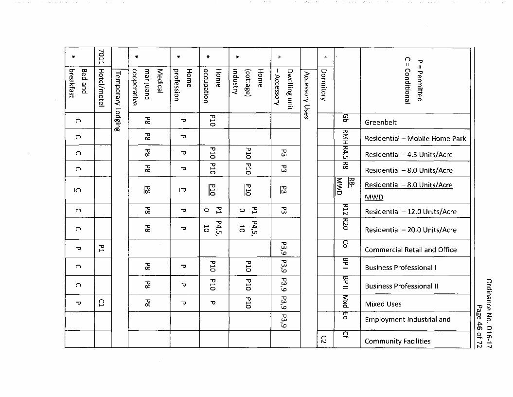
16.30.030 Table 16.30.030 - Government/business services land uses.*
IDU3 CO nNJ NJ NJ* ~U* * * *NJ N) II-1^ IIO ~aoS' Z!
S: 3oT •< QJ "O
QJ QTQ Ca. § 2:° ?0 ^
1 !0) CO n QJ QJ "O O QJ "D"D fD
=3 ^CL 3 3.' O-■ DV
3- g i:<‘ 0 o'
c 111: O o'
2. oQ.c o- c3D+ o'fD fD O 5' 3
3 fD-< -< fD ■< -<■<
Co' CDcn3 CLQJO3o' <fD CD
-u 3 crn GreenbeltNJ 3fD
DO3■D
n Residential - Mobile Home ParkCON) IfD3
DOO'"O fDn Residential-4.5 Units/AcreNJ cn10
DO-o n 00 Residential - 8.0 Units/AcreN)
DO00 Residential - 8.0 Units/Acre$ 1"O inNJ a MWD
50i-i"O NJn Residential - 12.0 Units/AcreNJ
20“O NJn Residential - 20.0 Units/AcreNJ O
no-o n o Commercial Retail and OfficeNJ
CP"O “D Business Professional I“O “ONJ
CD O"D “D Business Professional II~u "DNJ CL3Q.CL)Mixed Usesn n XNJ D
"p sQJ ^
00 7fD
mo Employment Industrial and
Dffirp_______________________n"O ■D -o -u O
NJCO On I-'Q CTlCommunity Facilities■o -o ■o TD-o -o TD ■o i*^1 I—1 NJ
nh*NJ** * Ln liH* I IIn§ ?
11=r $qj zr
ST £■ 3 5j< O QJ
q- o nS 3 o I Iin co 3 <TO g= n a)n> o =s _2 c o_ £— □. nin
fD fD CL5. =* Q_ QJ ^n> " ftQ. 3
Q- O QJ -ifD jr- 3 fDK CL =r
3 —■u 3o' o fD T3 tn OQ_ <fD fD 33 O fDCo c 3Q.03 CDCTQ 3 a> Q.n 03c cfD 0)
3 ofD D"i/i GreenbeltCOfD 50
Residential - Mobile Home Parko' xfDm DO
4^Residential-4.5 Units/AcreLn
DO00 Residential - 8.0 Units/Acre
IS DO00 Residential - 8.0 Units/Acre£ i
loMWD
DO
n M Residential - 12.0 Units/AcreLn
DOn nj
Residential - 20.0 Units/AcreoLn
noo -onr> Commercial Retail and Office4^ LO
00-o Business Professional I
00 o~D "O "O ~o Business Professional IIu> COCO Q_3Q_
"D QJMixed Usesn xCO 3“O O qj fD
0Q 2 * O
mo Employment Industrial and
Offirp_______________________“O “O "O~D TJ
NJ • 4^ On° 9NJ ^
Community Facilities
-t* -P^n■P* ■F* NJ NJ* -D-Pi NJ NJ II IINJ l-i O
§ ?
i I<f> -o q. q <
K 3 “ SfD o 42 033 ^ nTO °
a &2 opon qj CD r-t-i. 1' §n 3 w?
S3. O q -o -no 3 2, g a*3 § «■ §■ 3
« 8 »3 « T3 -nOQ g 5 QJ
fD £- 3
I SrlO
3 s00 00 oT3fD fD fD fDO 33q Q.sd_3 fD q. S£.
cr Greenbelt30
Residential - Mobile Home Parkx30-Pi
Residential-4.5 Units/Acrecn
3000 Residential - 8.0 Units/Acre
3000 Residential - 8.0 Units/Acre§ I
o MWD30
NJ Residential -12.0 Units/Acre
30NJ Residential - 20.0 Units/Acreono■o T>
Commercial Retail and Officeu> 00
00-o Business Professional I
00 O~V ~u Business Professional IIUJ Q_OL
TD "D QJMixed UsesX00U) 3-o QQJ PD
TO 2 fD g-NJ • cn O
2.Sh—i
NJ ^
mO Employment Industrial and
Dffirp____________________-o■o -o -u00
n-o Community Facilities00
-"sj'Vj*vj nUU ■C*Ln Ln UJ “O* * 00l-i IIUiNJ h-> IINJ
ni s 11
ro “ » >QJ ^ Cin Q- fD —• 3 O
r+ 3Si. o
> (1) o ?-3 C _.
fD c m inTO CD Q a) -a
o cj_ O" CD^ C fD< S'!. 3o' 3 CDs s sin
in O nDJCL 4? oc in C
o<CD 3o'o 3o fD CL%■ 3 OS E S
o 8 3 3fD“D3 CDi—h3 o' «/> ro £ oSL 3TO
ST fDcO 3O'fDCD CL3Cf.cr. 3 33 3 O'<< fD
CDex GreenbeltXI
2 Residential - Mobile Home Parkxx
Residential-4.5 Units/AcreLnXI00 Residential - 8.0 Units/Acre
x00 Residential -8.0 Units/Acre£ I
a MWDxI—1NJn Residential -12.0 Units/Acre
xNJn Residential - 20.0 Units/Acreo
nox “U “O-Q O T3 "O Commercial Retail and Office(JU OJ
03"O “O“O Business Professional In -o I—i U)O
oo OxX X X Business Professional IIn xuo LU CLoCL 3
“U OJMixed Usesn -o “O XUJ 3
“o 0 ju fD
era ^« oNJ * CTt O
mO Employment Industrial andDffirp_______________________
“O “U "O "U “O “O “O
D MOCommunity Facilities"D I
I—*NJ
2o 00
n<£>* * * "OCD 4^ IIU) IIn8 ?I I-
r+ 3 f? Si -oo ucf 3 ~02 o !?
C QJ £U QJ (~)in OfD O
(D X _ ft) Q- 73 3 fC fD& < £
fD fDzr Q)
X fDCD-g fl) -O fDOTO fD_ T3Oin1: C QJ
35‘ 3 O)fD 0)in Q. <■a 5' g era g_S -i 73 ■<=r 3 ^</>Ln 3
» 30) o o3z oa. 3 fD•a 3■a o'c fD Q.CD 3"3 era 0)o 33. 33 O7T
_Q
aCCT
Greenbeltn>3fD DO3in Residential - Mobile Home Parkxr+
DOin
Residential-4.5 Units/Acre3 Ln»
DOo 00 Residential - 8.0 Units/AcreODOzr 00 Residential - 8.0 Units/AcreCD £ 'ID oT3
MWD1:s DO
h-»z NJ Residential -12.0 Units/Acre0>
r+QJ03
NJO Residential - 20.0 Units/Acreof?
nD_TJ O“O "DO Commercial Retail and Officecr> u>SL
03-Q "O Business Professional IE.33 oo O"O "O
"O Business Professional II0) I-*3 CLNJ Oy> Q.
T> -o ■O O)Mixed UsesoCD
cx> X(JO 3
S£: “U Q qj fo
00 7fu g-NJ * O
mO Employment Industrial and
Dffirp_______________________
0Q "Oo n “O “O “O UJ<5
nID Q O)-o Community Facilities5 -o -o Ivj V—1 NJ *vl
fD
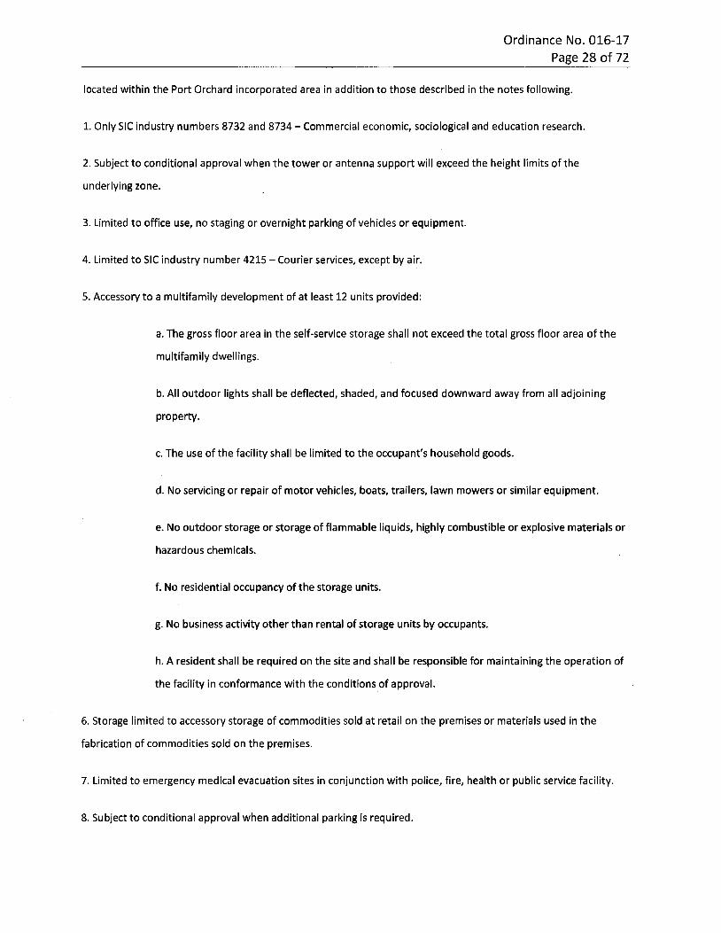
Ordinance No. 016-17 Page 28 of 72
located within the Port Orchard incorporated area in addition to those described in the notes following.
1. Only SIC industry numbers 8732 and 8734 - Commercial economic, sociological and education research.
2. Subject to conditional approval when the tower or antenna support will exceed the height limits of the
underlying zone.
3. Limited to office use, no staging or overnight parking of vehicles or equipment.
4. Limited to SIC industry number 4215 - Courier services, except by air.
5. Accessory to a multifamily development of at least 12 units provided:
a. The gross floor area in the self-service storage shall not exceed the total gross floor area of the
multifamily dwellings.
b. All outdoor lights shall be deflected, shaded, and focused downward away from all adjoining
property.
c. The use of the facility shall be limited to the occupant's household goods.
d. No servicing or repair of motor vehicles, boats, trailers, lawn mowers or similar equipment.
e. No outdoor storage or storage of flammable liquids, highly combustible or explosive materials or
hazardous chemicals.
f. No residential occupancy of the storage units.
g. No business activity other than rental of storage units by occupants.
h. A resident shall be required on the site and shall be responsible for maintaining the operation of
the facility in conformance with the conditions of approval.
6. Storage limited to accessory storage of commodities sold at retail on the premises or materials used in the
fabrication of commodities sold on the premises.
7. Limited to emergency medical evacuation sites in conjunction with police, fire, health or public service facility.
8. Subject to conditional approval when additional parking is required.
Ordinance No. 016-17 Page 29 of 72
9. A conditional use permit is required if proposed within the downtown overlay district, or if a parking structure is
proposed.
;10. Permitted uses within SIC code are subject to provisions identified below:
a. SIC codes 7311 through 7313, 7319, 7323, 7336, 7338, 7371 through 7376, and 7379 are
permitted uses, limited to office, desktop design, and desktop graphic work. All other activities
must be off site. No on-site retail sales.
b. SIC codes 7322, 7363 and 7383 are limited to office activities only.
■
11. Allowed only as an accessory use to a principal use or a permitted conditional use.i
12. Limited to nondestructive testing.
* Code reviser's note: This table has been editorially amended to delete uses that should have been
deleted with the amendments of Ord. 027-16, per the city's intent.
16.30.040 Table 16.30.040 - General services land uses.
OlP P.yp 01 PIOl u u TS
U tfc< <E u u £O<< < toO £ £ T3X £ £ £ .275£c c COco ±5COc .2£ £ 3 c £ m=3X .2 .2P = Permitted
C = Conditional.a_Q o o D
o r=o i/io COto
“O+-»Orsj uto2 Ol c0000 rH PM O) CD 03CC UL.o oTo c >■1075 To 01 aOlO.
■— .2 Q..2 .2 u±L in E+= c•M4-»Ol m mio Xc c c £ £ £ O) 3mSi >CD CD01 Ol CD CD01 01 E EoT3£ X .E2 2 S £T3 5 5 010) E EQ.£ '5'55 ><Ol ioCO 10 m mm Eo 3 OCD 01 01 01 CD 3CD 219 O0£ 00OC 0C CC. CC CC 00 UJ
R8- MxGb CfRMH R12 R20 Co BP IR4.5 R8 BP II Eo
dMWD
Personal Services
General personal
servicesP P7 P C
72
"J ■vj ^1-vl ^1CT1 CT1 NJ NJ NJUl On ** * *NJ CTl I-*U) 00 cn1X5 00n "O> > <fD q 2 nS ° 22 3" -nO c QJ 3
C Q_ 3 c
O OfD fDft fDc c QJ IIft ft 1 s T3 O) QJ 3.
33 n■< 3c.c "DfDOo (Dn Oa3 2 a.in ftfD fDfDfD_ 3.3 QJ3 3 3 3O fD fDQJ 33 crn 3. fD QJ
57 57 Q.fD 3qO O QJfDQJ QJ Q> -3i Ed\ cr. 333 C■2 fD ft3?< <fDfD O' O3 3 32. cfD fDOO o fD3a CfQ3fD Q) Q.Cc QJ in QJT3q (Doo 3in fD OO 57T3 ft2o QJ 33 n E/TfDft
"O GreenbeltcrDO
■u Residential - Mobile Homeon IDO
-o 4^n Residential -4.5 Units/Acreon onDO■o n oo Residential - 8.0 Units/AcreUl
DO00 Residential - 8.0 Units/Acre$ ■TO inon a MWD
DO-a i-»n Residential -12.0 Units/Acreon NJ
DO"O NJn Residential - 20.0 Units/Acreon o
n"O o"Oo O'* _pN> r>“O “D ~o “O Commercial Retail and Office00
no -o Business Professional IonQ00no no cLCD ^ Business Professional II3QJCL 3nnn ~U "O Mixed UsesX n“O CDQJ
m qp z“D O Employment Industrial and“O 4^ O“U “O "O “D “U “O TJU) • O O
CDQ O"O CD”Dn CD 4^"O “D “O Community Facilities iU)
NJ
oo oooo 0000o o ooo o o* * * *00 h* U)■vj CD CT1<!dn -Dm XS’ ^ Zcn O cn CO3"3 m X 7* IIC fDCLro ofDfD fD fDO II3?CfD G. QJa: fD 3 ■DCo G.a>QJ 35 3 nl/> 353 n‘ D“o_ ~uo qjn o “S’ ■g 3 OQ_ QJ5' o ^
s 3 TO3-’ rDQJ 2.3 CD(D rD3" fD3" O 3d\ cP o- 35 d
Q_ 3 QJ l/> IQJST CO“Oo rDQJ o fDrDQJ3 QJQJ 3C^3 CL o Cf.fD 33 ^9 §
o£nco fD Q) o'O CL fD 3 fDQ QJo'fD 3 2. Q.C 3 fD QJqT fDin in CL3“ in fD3" o' 0. 300 oT00 fD 003" 33" in O' O'
CDn n Greenbeltcr
DOResidential - Mobile Home
xDO
n n Residential-4.5 Units/AcrecnDOoon n Residential - 8.0 Units/Acre
IS DO00 Residential -8.0 Units/AcreI ilo in o MWD
DOn n Residential - 12.0 Units/AcreNJ
DONJn n n n Residential - 20.0 Units/Acreono“On“O "O “O “O Commercial Retail and OfficeNJ
CD"O-o “O “D Business Professional I~o ~o
OCD"O Q_Business Professional II"O "O ~o "O “O
3QJQ_ S 3-D Mixed Uses“O “D "O “O X nNJ “U rDQJ
CTQ 2mO rDEmployment Industrial and oo "O"OCO •l-> o
n Q CD■on~a ■o ■o ■o -o ■o Community Facilities iNJ h-kNJ
Ordinance No. 016-17 Page 32 of 72
(U<u Ol.yb0)cu T3ai ob St< < cu uE O< << too J3 J3 roT3X 2J? J? Tocc c </>ns(U roc .2c c 3 3 "toc c3 33 3 .2 .2P = Permitted
C = Conditional
.±3O o 3roO o (/)l/> (/)*0 o T3 "Go<N </) £QJ0000 0)CN (D (00c U_I I I I I I o p c >CO.2roro <u<u ±;o. CLro .2 .2 2±£ u co £+3+3 +3 +3 C4-> 4-><U COCO
CO 3C cc c c 5Z <U 3co >■X2 QJ a>aj 0)cu cu ai cu E E°TJC Q c .E2 5 5 2 2 ■a a>a* £E Q.£ "55lo *CU coco co co coco £ oo<u cu 3 3CU CD a> <u 2a uoc CtL C£ 0C oc qc m oo UJ
R8- MxCfGb EoRMH R4.5 R8 R12 R20 Co BP I BP II
dIMWD
school
* Vocational school C PC c c cSpecialized
instruction school
P8,PC C C C C P P
* 10
School district
support facilityCC c c P9 PC C
*
8221-C
College/university2
Note: All applicable requirements of this title, or other applicable state or federal requirements, shall govern a use
located within the Port Orchard incorporated area in addition to those described in the notes following.
1. Except SIC industry group number 7534 - Tire retreading; see manufacturing table, POMC 16.30.050.
2. Except SIC industry group number 835 - Daycare and 836 - Residential care; see residential land use table,
POMC 16.30.080.
3. Only as an accessory to a cemetery.
4. No burning of refuse or dead animals is allowed.
5. If less than or equal to six children, the use is permitted. Otherwise a conditional use permit is required.
6. No kennel operations allowed.
Ordinance No. 016-17 Page 33 of 72
7. Only the following are permitted:
a. SIC 7221, 7231, 7241 except cosmetology schools;
b. Babysitting bureaus (office use only);
c. Blood pressure testing, coin operated;
d. Debt counseling or adjustment services;
e. Diet workshops;
f. Genealogical investigation services;
g. Scalp treatment facility;
h. Quilting for individuals.
8. Limited to 6,000 sq. ft.
9. Administrative support only, no student instruction.
10. Indoor education or training only, no training equipment to be located outside.
16.30.050 Table 16.30.050 - Manufacturing land uses.*
Ordinance No. 016-17 Page 34 of 72
0101 01.2bbCD 0101 T3O) b b b it< <E c< < O< 03o £ £x ■a£ ££ CDcc c •z infO_QJ (13C ec .2X tncc5 X 3X .2 .2P = Permitted oq Z303O o o| CO
toCOCO -aLD
u+JO<N2 od I cCL)00 (N O) CU 03C = Conditional a: LL.I I I P P c >■in.2ro o>(D ±:.2 .2 ro .2 ro CL Q_+£ o in E+= +3 c(D inin
inin Xc c c cc 01 zs>•-Q 01 01 01 01 01 0101 01 E EO■Oc oT3 C c2 2 2 2"D 0101 E EQ.£ 'In 'to’in *01 in m inin E0) 01 01 01 o oO) 01 Z3 32 5CD cc 0c cc cc cc u u00 00 CQ UJ
R4. R8- BP BP MxGb CfRMH R8 R12 R20 Co Eo
d5 MWD I II
Food processing and
kindred productsP2, P2
Cl Cl P220 4 ,4
* Marijuana processing P
2082/5 Winery/brewery C C C PC
Textile mill products22 C
Apparel and other
textile productsC PC
23
Wood products except
furnitureC3 PC3
24
Furniture and fixtures25 P4 P4 P
Paper and allied
productsC
26
Printing and publishing PC C C C C P P5 P P
27 5
Chemicals and allied
productsC
28
Petroleum refining and
related productsC
29
Ordinance No. 016-17 Page 35 of 72
01P cuu01 01 01 T3CU uuo b b it< <E c< < O< roo ££x ■o£ £ £ _ro
rocc c I/)ro isaj roc c C .Si3 3 C c to5 3 3 =5 .2 .2P = Permitted
C = Conditional£o o 3roO o o to
tototo
T3ooCM _c0)00 00 tH (N o 01 recd Li.I I I I PP c >•toro <v cu.5 O- CLro .2 .2 .2 .2 P±: to E c+j 4-> 4-1 4-> 4->01 to
tototo 3c c cc c c OJ 3-Q >•QJ CUCU CU 0) CU cu 01 E Eo-ac Q .£C2 2 2 2 2 cu0) E £Q.$ '5! .25cu toto to to toto to Eo O01 0) CD CU 3 3a> a;2 2CD Ucd cd Cd cd cd cd u □o co LU
R8-R4. BP BP MxGb CfRMH R8 R12 R20 Co Eo
d5 MWD II
Rubber and
miscellaneous plasticsC
30
Leather and leather
goodsP4 P4 C
31
Stone, clay, glass and
concrete productsP4 P4 P
32
Primary metal
industriesC
33
Fabricated metal
productsP P
34
Industrial and
commercial machineryP
35
Heavy machinery and
equipmentP
351-56
Computer and office
equipmentC C P
357
Electronic and other
electric equipmentC C P
36
Railroad equipment374 C
Ordinance No. 016-17 Page 36 of 72
01Ol 01
u .yb0101 O) TJ0) b b b st< <£ c< O< < roO £X TJ£ .2rocc c ro ±50) rocc C .23 c c c/l5 3 3 .2 .2P = Permitted ,-yq o 3roO o COto
COtoo “OLO
uorsj2 c0)00 00 <NtH (D <D fOC = Conditional Q£ LLI P P Cto.2 cuCD ±Lro CL.2 ro .21 .2 ro Q-+i u CO E*43 cCD toCO
COto =3c c cc c c 0) 3>•-Q 01 0)OJ 0) 0101 0) cu £ £oT3C Q .£ c.T3 5 2 T3 2 01aj £ Q. £§ •5;'5 2£O) 10to to1n to to Ecu 0) 0) o 3 3 o01 OJ OJ2<4> 00 00 00 00 00 00 0 CQ 00 uLU
R4. R8- BP BP MxGb CfR8RMH R12 R20 Co Eo
d5 MWD I
Guided missile and
space vehicle partsP
376
Miscellaneous
transportation vehiclesP
379
Measuring and
controlling instrumentsPP P
38
Miscellaneous light
manufacturingC4 PC4
39
Motor vehicle and
bicycle manufacturingPC4 C4
*
Aircraft, ship and boat
buildingC4 C4 P
*
Tire retreading7534 C
Movieproduction/distribution
CC C6 C P
781-82 6
Note: All applicable requirements of this title, or other applicable state or federal requirements, shall govern a use
located within the Port Orchard incorporated area in addition to those described in the notes following.
Ordinance No. 016-17 Page 37 of 72
1. Limited to agricultural products grown on site, provided structures and areas used for processing shall maintain
a minimum distance of 75 feet from property lines adjoining residential zones.
2. Except slaughterhouses.
3. Limited to uses found in SIC industry groups 2434 - Wood kitchen cabinets and 2431 - Millwork (excluding
planing mills).
4. Permitted if within enclosed buildings and as an accessory use to retail sales.
5. Permitted uses within SIC codes are subject to provisions listed below:
a. Limited to office activities only. No on-site commercial printing permitted.
6. Permitted uses within SIC code are subject to provisions listed below:
a. SIC code 7819 is limited to office use only.
b. SIC codes 7812, 7822,7829, 7832, 7833 and 7841 are not permitted uses. Other SIC codes under
the 78 general category, if not specifically identified in 6a above, are not permitted uses.
* Code reviser's note: This table has been editorially amended to restore uses that were inadvertently
omitted from Ord. 027-16, per the city's intent.
16.30.060 Table 16.30.060 - Recreational/cultural land uses.
UJ 00 NJ 00UD ** * * * *UD UJ UJNJ O "OII II< 73QJ n2■a -u a “U3 > n> n"Oro3 zt rD 3QJ QJa> "Da> 01O QJ QJ o3 3"id rD n 3s I rD< c 12. 5-Q. 3O nQJ QJ_COa- 3E d
c rDCO "C[D_ 3ca> a)a> COrD rD era QJO QJ QJrD3 i=r.3" EQJ 33\T33 oo' CP oo3 Q_ro QJ OQ_ 3 rD
QJ Q_cQJ m 3fD3 3 5" ^03. 3 3O QJ3cr3. ro< Q_C no rp01QJ m n>3 CD Oon 5" croi n"O Greenbelt3-UJ
3QJ3 30
n3 2 Residential - Mobile Homen■oNJfD3
30-fc-n-o Residential-4.5 Units/AcreLn3000r> Residential - 8.0 Units/Acre■D
12 3000 Residential - 8.0 Units/Acre$ i
lol"oo MWD
30l-»o Residential -12.0 Units/Acre-D NJ
O 30Cl"O NJ Residential - 20.0 Units/AcrenTl -o on n nT3 -o Commercial Retail and OfficeUJ UJ
00-o
n-U Business Professional I00 O"On~u Business Professional II o.
2 QJ"O "On n Xn n“O Mixed Uses 3UJ UJ Q. O“OroQJm ora zo Employment Industrial and
nffiro_______________________________
(D on-o ~u UJ •00 oI—‘on cnn-d -o ■u In nr> n■o -o Community Facilities M NJ ^
UJ UJ NJ h->
00 00 Nl Nl4^ N> # i£>* * * UD* *LOM <£> (ju O "O
ild? I LO3 w o“ § o
> sr g >G. 3 g-5 S ~
>QJ 3 0 o COX. CPn n3 3 33 O3 2. 2.CX "D3C SZ oo $3 CDQJin 003“?t C 33 —i3
Q.CD fD Q_in fD3 src CL3. c*. ininfD fDC 3fD 3. E3 QJ 3 G.in 003 3 G.QJin in <00 o33 ocfD 3+3 3 fP3 Q_ 3 fDO"3 ■<00 CL3 QJ3fD 3003 00fD fD
fD
Ocr Greenbelt33
-a•o Residential - Mobile Homecn cn X33
33 33Residential - 4.5 Units/Acreun Ln
un:x>"D "O 00 Residential - 8.0 Units/Acrecn cn
3300 Residential - 8.0 Units/AcreI i“O “U
Ln Ln OMWD
73-Q “UResidential -12.0 Units/Acrecn cn NJ
O DOcn 33 cn -a D NJ Residential - 20.0 Units/Acre
oon33 -o "O -o Tl Commercial Retail and OfficeCP-on n Business Professional I00 O-on n Business Professional II 3.2 QJ
“O "D ■a Xo Mixed Uses 3CL O“O mQJm qp zO Employment Industrial and
nffiro_______________________
fDr> on nr> n 33U) CJJID oI-*on cn33 33 In n33 33~U 33 Community Facilities "si l-k NJ ^
4^
Ordinance No. 016-17 Page 40 of 72
<uP .2p a) O) ■o0) u ubb it<<E o cO<< < <0o £ ro-oX ££ £ 75cc •c coro3> roc .2c C =J «c c3 3 3 3 O .2—P = Permitted
C = Conditional
o o 3roooo COq io
CO -oO<N co2 £0)*=t 00 00 fsl (U at rocc u.I I I P Pro c >co
ro atCL) aCL CL..2 .2 ■2 •2 •2 o±L co £+3 C4->0) IOco
COco 3c c c cc c 3ai-Q >a> 0)0) at 0) a> ai a) £ O 01 £a .9 £
■ac Q c2 c5 S 3 T3 T3 <U0) £$ ’15 •5i"io'io .acu io CO CO CO £ * LU C
O OCD CL) 0) 30) 0) CD 35 20£ u ucc cc cc cc CO COcc
R2R8-Gb CfBP II MxdRMH R4.5 R8 R12 Co BP I Eo
0IMWD
Arboretum842 CC C P C PP
ConferenceC P P C P
* center
Church,
synagogue,temple
C C C C C CC C P P P
866
Note: All applicable requirements of this title, or other applicable state or federal requirements, shall govern a use
located within the Port Orchard incorporated area in addition to those described in the notes following.
1. Lighting for structures and fields shall be shielded and directed away from residential areas.
2. Recreational vehicle parks are subject to the following conditions and limitations:
a. The maximum length of stay of any unit shall not exceed 180 days unless otherwise stipulated;
and
b. The minimum distance between recreational vehicle pads shall be not less than 10 feet; and
c. Sewage shall be disposed in a system approved by the Kitsap County health department.
3. Adult entertainment facilities shall be prohibited within 600 feet of any residential zones, schools, licensed
daycare centers, public parks, community centers, public libraries or churches that conduct religious or educational
classes for minors.
Ordinance No. 016-17 Page 41 of 72
4. Lighting shall be shielded and directed away from residential areas.
5. Only as an accessory to an historic site or building.
6. Only of a limited outdoor nature such as an interpretive assembly or amphitheater.
16.30.070 Table 16.30.070 - Regional land uses.*
* * * * * * * *o “U
s’ s s9: 3 £7+ 3 O•< 3 ^
Elf=: rr+ -r•< 3 c
S 1 f =f IP5- s:
ft> “O £ 3 c Sf ^ “ 5l=t 7T
IIm iiQJ 30qjnQ. ro3 "OD" O3 TOfD 0) n>3" 3" rt-' 3+ D ^9: 3n n Oo3 QJ3 •< <Ln <L ro_c 3Q_ TO QJ QJ:zr. n3 QJQJ ET ro
9: SS' -<
§ E=T n
fDO Oo fD O5 fto 3o' CDfD 3 fDQJ 2. CD(/) CLro QJ3 fD 3OO' o ■<n Q.<3 O. c:o infDinO n n GreenbeltO"
DO
n n n Residential - Mobile Home ParkDO
n n n Residential -4.5 Units/Acre(_nDO00n n o Residential - 8.0 Units/Acre
IS DO00 Residential - 8,0 Units/AcreIin in in o MWD
DOn n n l-> Residential -12.0 Units/AcreNJ
O DOn n n NJ Residential - 20.0 Units/Acrenon n n Commercial Retail and Office03TD
Business Professional I03 o-o a.Business Professional II
3QJCL3n n n Mixed UsesX "o 55
qj 03era 2fD g-43* • NJ O
mO Employment Industrial andn n n n n
Office o CDn i
n n n n n n n n NJCommunity Facilities
* * * * * * * * * * *r> “U
=2. H >m 5 £ S’ 3 9: ff3+ —■
m 3(D0)n QJs- 3n> 33 3I ft nQJ O ^QJ8 J?
< era fl) *<
IT C3 3
s » I IT3Q_ D 53O Q_ 3Q_ Q_OO £■
r-t «“►
LO2. c o zi?c 3 §ro $
3 a. *< 3n3 fDera i si i “ —%S2 ° < fD
~oD“ T5 CTO' SL 3 $
3o
3" 3 QJ3?C QJ C tq_ OQJ i—t*£L<LCO to rosr ? 3ro
QJ■<
cr o.CLcr QJT3QJ G.QJ3 QJ Q.QJ o oQJ in 3 in roft 3 3ro ro 3VO. era■<i
CDGreenbeltcr
33S Residential - Mobile Home Parki334^
Residential -4.5 Units/Acrecn30oo Residential - 8.0 Units/Acre
IS 3300 Residential - 8.0 Units/AcreI I
o MWD33I—1 Residential -12.0 Units/AcreNJ
O 33NJ Residential - 20.0 Units/Acrenon 33n Commercial Retail and OfficeNJ
03"O
Business Professional I03 O33
a.Business Professional II3QJQ_ Sn 33 3n Mixed UsesXNJ -U O oj ft>
era 7 m omO Employment Industrial and
Office-on n o n o33 JN •UJ
U) oI—1o CDn in n n n33 n 33 33 NJ 33 n33 O t—^
NJ -vjCommunity Facilities
Ordinance No. 016-17 Page 44 of 72
TOOJ<U CDCLUbbo 01 0101 Pbb b s=< <E c< < < O roO &X "O£ £ rocc C P toCOro_QJ COc c C 3 => .SiccP = Permitted 15 3 3 3 .2 .2 ±cq o Z3roO o o to
tototo
Pu(N O 01 cC = Conditional 00 00 tH (N 0) 0) rooc LLI I I I I +->O P c >coTO
ro CD01 .tc.5 ■2 CLro ro ro Q.±c V co Epp •p ■p c01 toto
toto 3c c c c c c QJ 3-Q >OJOJ 01 0) OJ OJ OJCD E EO O)
Q. .2E St m O
pc Q c £ZP 2 p 5 p 5 0)O) £ E5 •55’55 "55 .*OJ to to CO co O0) O) OJ OJ OJ OJ O 33OC OC OC OC OC OC U 00 uCO
R8- R2 MxGb CfRMH R4.5 R8 R12 Co BP IIBP I Eo
d0MWD
Racetrack7948 C
* Fairground C
Zoo/wildlife
exhibit
CCl
8422 1
Note: All applicable requirements of this title, or other applicable state or federal requirements, shall govern a use
located within the Port Orchard incorporated area in addition to those described in the notes following.
1. Except arboretum; see recreational/cultural land use table, POMC 16.30.060.
2. Limited to drop box facilities.
3. All processing and storage of material shall be within enclosed buildings and excluding yard waste processing.
4. Bus storage only.
* This table has been editorially amended to restore uses that were inadvertently omitted from Ord.
027-16, per the city's intent.
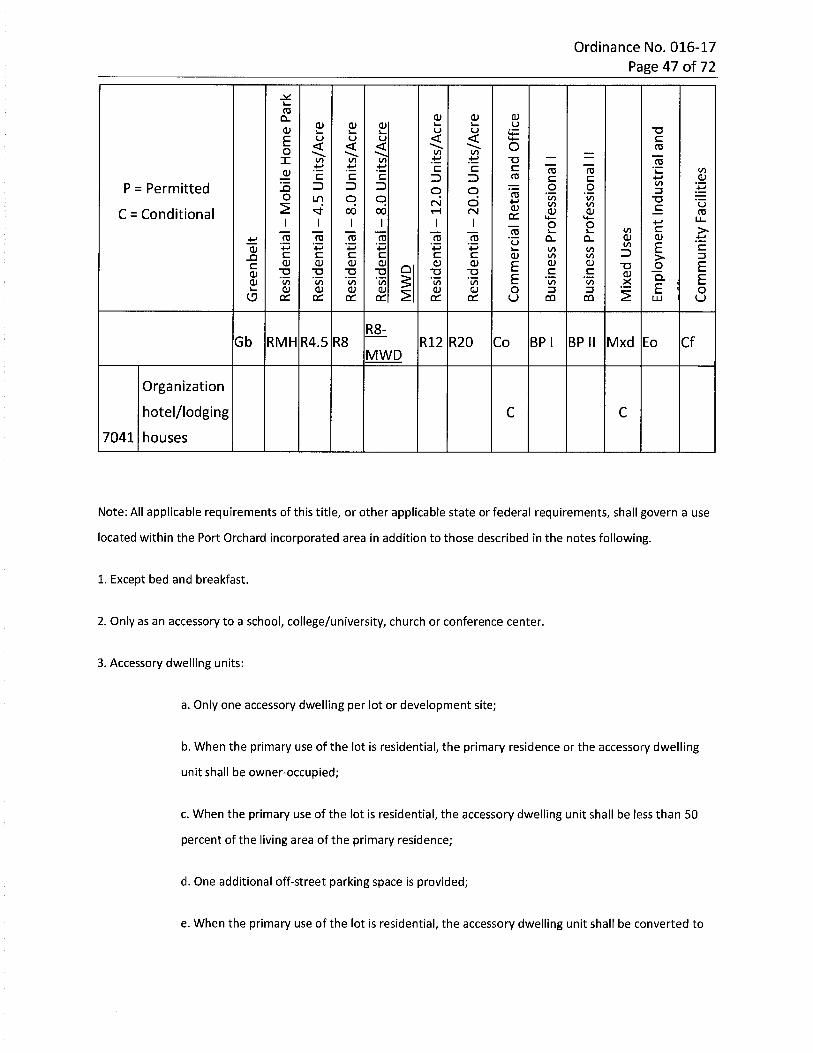
16.30.080 Table 16.30.080 - Residential land uses.*
* * * * * * * * n “Oii iinoT fD o3 'a n2. 2. 73 QJ l/l 5£QJ Q_ I/)» 5'5J qq_
3- ?fD -h
I TD 2 2 ■aCD Ototo
fD r+ oQJo 3 fD-i Ocr
c $3 33fD to *n c £U QTQ 3S’ o EQ.QJ O
in 13O' CLOl/) fDD+ C o3 fDfD fD E3"
m ElT-< fD -a EA,fD 3fD cr fDc Q. Q. oI 3cr. 3 O QJ QJO 3"DO3 3 <PQ. CTOcr. 3 3n oj QJ ofDD+ Q.QJM c3DO -<■<fDn -< -< 3CL3 fD
D+fD3 in On cr■o GreenbeltfDto
50
2-o Residential - Mobile Home ParkDO£=■n -a Residential-4.5 Units/AcreCnDO00n ■o TJ ■o Residential-8.0 Units/Acre
12 DO00 Residential-8.0 Units/Acre$ i
in |-o |TD lx> a MWDDOl-tn Residential - 12.0 Units/AcreTJ -o -D ■DNJ
DONJ■o Onn Residential - 20.0 Units/AcreTD TD -D cn
non nn Commercial Retail and Office00-on -u Business Professional I00
O~un -u Business Professional II Q_3
5 QJ3n nn “O “O X Mixed Uses oCL ■o fDQJ
m m -z.o fDEmployment Industrial and on■&> •
cn oi-»n Q cnn n n n Community Facilities i
NJ 'vl
-Jo* * * * * * * n -ai-> II ii
I O > $
r>8 3^ p xcr oo x ■a x x o3 -oo > ofD nO OO CL O OC S Brt It
o a>0)fDfD fD o oo nQ_ 33 3■O —. Q- n3 2.co oS’ c05 3 Q. 3o£D fDO T3 fDfDfD Ec■o toto fD3 inin05 TO o-'3 QJ 305 3 O)o ininQ. OOfD5' TO Oin 33 o'cr. 3 fDO OQJ 3 C a.< 053■<fD_ < 3ID
ad+ inO fD CDa. -o in■ao qs. cr"D I-1 Greenbelt00 o3TO >0
-an -a Residential - Mobile Home Park00xdo"D -o-u ■on T) Residential -4.5 Units/Acrei—* I—i00 wo o ondo"D -D■D ■a 00o Residential - 8.0 Units/Acre-a i-ioo 00o o
2 ZB00 Residential - 8.0 Units/AcreI'D I noTO -Din |-o i-1 i-»00 oo oo o MWD
DO“U -o -o -ao Residential -12.0 Units/Acren o■ooo 0Oi—* NJ
DO-o -o hoi—* ■£*O '
l—4 -f^° Inno o Residential - 20.0 Units/Acren -ooo on
o■Qo-o 00 Commercial Retail and Office-a I—1
CD“O“O "U “O~U LO Business Professional In “D00 o o <£>
CD“O Q~u ~D~D UJ Business Professional IIn “D I—4 !—k00 CLO O <£>3QJ"O“DO "O OJ 3X Mixed Uses”D-o "O l-k00h-k nQ_o ~oCO fDQJ
m op 2“D o fDEmployment Industrial and o00£» •iX)CT5 OI—1n o cnn Community Facilities iro i—iNJ ^
Ordinance No. 016-17 Page 47 of 72
ro 0)a> CDCL.yu bCD 0) CDCD -a
u b b < <E c< < < O roo £ £X T3£ .2cc c V)03 03 ■fcCD 03C c C .23 3 sc c ins 3 3 3P = Permitted .2 .2 *co o 303O o o i/iCO
COCO
T3U+jOfM2 CCD00 00C = Conditional cH rvj CD CD 03OC U_I I I I I P P c >-co.2 CDCD .t!.2 03
'4=03 .2 .2 .2 Q. Q.*± u co E*3 C+J +->CD co
COCOCO 3C C C C c c CD 3XI >■
CDCD CD CDCD CD CD CD E E2c T3Q C cT3 2 2 2 ■a T3 CDCD E EQ.5 '5!'I7> *CD co co COECD CD CD OCD CD CD 3 3 Oe? cc cc cc cc cc cc o CQ CO uLLI
R8-Gb Mxd CfRMH R4.5 R8 R12 R20 Co BP I BP II Eo
MWD
Organizationhotel/lodging
housesC C
7041
Note: All applicable requirements of this title, or other applicable state or federal requirements, shall govern a use
located within the Port Orchard incorporated area in addition to those described in the notes following.
1. Except bed and breakfast.
2. Only as an accessory to a school, college/university, church or conference center.
3. Accessory dwelling units:
a. Only one accessory dwelling per lot or development site;
b. When the primary use of the lot is residential, the primary residence or the accessory dwelling
unit shall be owner-occupied;
c. When the primary use of the lot is residential, the accessory dwelling unit shall be less than 50
percent of the living area of the primary residence;
d. One additional off-street parking space is provided;
e. When the primary use of the lot is residential, the accessory dwelling unit shall be converted to
Ordinance No. 016-17 Page 48 of 72
another permitted use or shall be removed if at least one of the units ceases to be owner-
occupied; and
f. Within the commercial retail and office, business professional I and II, and employment industrial
and office zones, an accessory dwelling unit is allowed for the purpose of housing a resident
manager, caretaker, or security personnel for the commercial, office or industrial use(s) on the site.
4. No customers are allowed on site.
5. In the R20 zone, home (cottage) industry and home occupation are allowed in single-family detached homes
only.
6. Permitted with approval of a planned residential development.
7. Permitted as part of mixed use development with approval of a conditional use permit (maximum R-20 density).
8. Medical marijuana cooperative:
a. Only as an accessory use located within a residential dwelling unit;
b. The cooperative shall be registered with the state Liquor and Cannabis Board and all members
shall be registered in the state medical marijuana authorization database and hold valid
recognition cards;
c. The cooperative shall obtain and maintain a city business license according to Chapter 5.12
POMC;
d. The cooperative shall operate in accordance with all requirements of Chapter 69.51A RCW.
9. Within the downtown overlay district or the mixed use zone, an accessory dwelling unit shall be located on or
above the second floor of the building in which it is located. Stand-alone accessory dwelling units are not allowed
in the downtown overlay district or the mixed use zone.
10. Shall comply with the requirements of Chapter 16.38 POMC.
* Code reviser's note: This table has been editorially amended to restore uses unintentionally omitted
from Ord. 027-16, per the intent of the city.
cdo o o00* * noo NJ HJTOl-l oII II on■o CD3 ° aj -ig. s 3 Ic & fP 5.n <s>
3 ij* qjSi 5 E!U g TO
SS CDCL fD
>n q ?- cdS o) -iT3 < <(n fD <
ft =‘
Tl
s ? 1 I
1X5OO TO Oo cu3fD CL J2. fD —In3ft ft ft § 3 QJcft 5'5' TO
c 033“-2 I=F33 oTOO 3§ S C fD3 (?fD C 3. «/>3 Sj
nj 3
O) QJTO TO Q.OlfD3 35L fD CDfDCL Q_Q. inin in (joOCDTO TOTO TO n cr oGreenbelt''j CD IDO00
IResidential - Mobile Home Park 00x fDinOO Oon n Residential-4.5 Units/Acre cU1 Cn 3fDOO
n 00n n Residential - 8.0 Units/Acre QJUi 13Q_
? 50^ *00 cResidential - 8.0 Units/Acre inOin in ■ fDOl inIdMWD •#
oonn n Residential -12.0 Units/Acreun NJ50NJ Residential - 20.0 Units/Acreono-o Commercial Retail and OfficeNJ
00TO
Business Professional I
ooTO oBusiness Professional II a.32 QJ"O
Mixed Uses 3XNJQ_ -o J2
QJ fD0Q 7 fD f:
mo Employment Industrial andTO •D ONJ
ID On££:
n h->o CDCommunity Facilities i
•Vl h-> NJ
NJ NJ toI—4to u> I—4 vj* NJOU1 NJ U> nu> “Oih-4 II IIcr q -o >pr cu ono s g. ■§-v ^ TO V
nfD ?X £=>.^ 3ai fDn ->r+ QJ
IS- ££ S ro =h 3 fD
>i 73 _£» fD°L £
£ I s ■a x Z! -a(D O
I *3 ?fD -<
X2 (/) roo t/)QJ I 313 23 3"C (D3 ='i. OQ
fD qj QJ03O3 3 cr.3CfD 5' 03 o' oa. zrPfto3 fD0q 3 3 C $QJ Q_crq QJCL zf?fS3 P =:(/>Q_ 3" £
HK CT>“O “U fD O""O GreenbeltH4
do03S3 Residential - Mobile Home Park03 xcrqfD 33
3n Residential-4.5 Units/Acreu> fD 033*■* DO
00Residential - 8.0 Units/Acre
IS DO00 Residential - 8.0 Units/AcreI i
a MWD
Residential -12.0 Units/AcreNJDONJ Residential - 20.0 Units/Acreonoo Commercial Retail and Office■>
oo-o
Business Professional I00-o O
Business Professional II Q.3
s QJn Mixed Uses 3X-o OQJ
CTQ 2 fD 7C
CLmo Employment Industrial andno n oU1
o or^££\n S.?Community Facilities~u
VI I—4 NJ vj
Ordinance No. 016-17 Page 51 of 72
ro CL)0) <uQ. .yb bqj 0) T3<U b st< < cE u u< < < O COo 2 3 ToTJX 2 re rec 'Cc c m.2roc =1 13 3 toccP = Permitted
C = Conditional15 3 3 => .2.2 .a3o o CPo </)<S)
to“Oo o oCM Uto2 £cu"vf 0) CL)00 00 rorH CM CC LLI I I 4->I PP c >in.2re d)cu ±±CLa..2 .2 ro .2 .2*C u Ein+3 '■P C*-> mCL) mm 3 3C C C c c c. CL) m >JO 0)CL)0) 0) Ecu cu cu cu OE T3c Q .2c2 5 5 S T3 T3 CUCU EaE ? LU C
E5 .*10cu CO CO CO co o33CU cu cu ocu cu cu 22 uCQCOQC CC QC OC OC UCC
R8-Mxd CfGb BP II EoBP IRMH R4.5 R8 R12 R20 Co
MWD
Resource Accessory Uses
Resource
Caccessory* uses
Note: All applicable requirements of this title, or other applicable state or federal requirements, shall govern a use
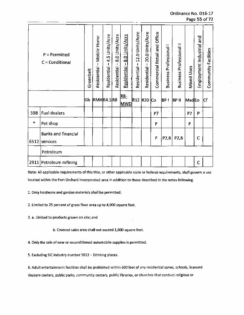
located within the Port Orchard incorporated area in addition to those described in the notes following.
1. May be further subject to the provisions of the shoreline management program.
2. Only forest research conducted within an enclosed building.
3. Only within an approved enclosed or contained facility subject to appropriate county and state requirements.
4. Only artisan type activities, such as pottery or glass blowing, which are a secondary or accessory use to a retail
activity.
5. As a secondary or accessory use to a residential activity without retail sales, where larger than 200 square feet.
6. May be further subject to the provisions of EPA and DOE in regard to the use of fertilizers, pesticides, and other
chemicals.
7. May be further subject to the provisions of EPA and DOE in regard to the buffering of streams, wetlands, and
other freshwater corridors.

Un cnNJ* vj OJof-i
CD o33 o *“Oc fD Oo IIoTs cr no o"O Oo>o 3nT3 Q_ro cri. i fDCTQ oroO)3"n fDO inm ns'J -v.M "^ gns I?? i:fD <n—. r+3 QJS 23 fDr+ 3"O QJ—h i/i
3O E3" EQ.3OS O cn3. c 3 fDfD USCLin QJ5 in OfDQJQJ in l-1m ofD in OI
DOG) fDGreenbeltO’ 51"73
Residential - Mobile Home QT3X Q_33 3- cr
a 8u fD
C-P* Residential-4.5 Units/Acre COU1 ro G. 3
cn
* aDO00 Residential - 8.0 Units/Acre *
O
11? EResidential - 8.0 Units/Acreo QJ
3DOnsResidential -12.0 Units/Acre 3NJ Q.fD33 Q_fSJ Residential - 20.0 Units/Acre r+o3n onOO“O Commercial Retail and Office OfD
□3 5“DBusiness Professional I fD
cnC O035'-o cL
Business Professional II fD 5'3 QJ3O'
-u O£U fD 00 2 ro
~o gMixed UsesXQ.m OoO"O T3 Employment Industrial and cn3 NJ O
a?|-k
ro
sn fDQ_Community Facilities
Lnun LnLn Ln LnLn LnLn* * * * *cn -F*oo 4^ uuLn
> >CD > ^ G> Q. V) < a03 CDm -n m ~n nc QJ "Oo o QJ oca> O 0) 3aq■a cqj fDCD Q ilOnr. 3.o2. 3 QJ CLa> fD Xin~a T3 iiCT.fD fDO m o CL fD3 in nnQJ 01o TOinin
in TDinTO CQ. O3in 2 in QJD -<rr fDc o 2.■< QJ
3 C J=TfD 33.QJ < ■aft i3 ofD3' QJ T3 C CL 3fD3 TO fD fD?D ‘O O3t/> EoCL 3“ 0)3QJ EfD 3 3tn CLtq_ o 33 ■c toQ_ OQ. 3 *2 Co 3CD D 3 0)QJ Q.
O Q- tn3. t/> QJ n3 QJ3O(D3“ OfD tofDs: CLin ■ao 3in fDin3 3 QJTO
m QJfDurin
CDn Greenbeltcr(JO
DOResidential - Mobile Home
xDOn -p* Residential-4.5 Units/Acre(JOuiDOoo Residential - 8.0 Units/Acre
l<: DO00 Residential - 8.0 Units/Acre§ i
aDO
Residential -12.0 Units/AcreNJ
DONJ Residential - 20.0 Units/Acreono■o “O"O o~u “D "D T> “D "O Commercial Retail and Office-P*<T>
00-o Business Professional I
o03CL“O“O
Business Professional IIto 3QJ3
2 n"O"O fDo n n“O ~o “O "O “O Mixed Uses QJX4^TO 2CL fD Om■o -o o Ln-o "O■o ■o -o Employment Industrial andNJ NJ00 oQn
Community FacilitiesNJ
Ln LnLnLD KD LO* * * * * * *UJ M
> era < 03 tO ET >to CD (“J 3 wo a*. A>^3 _Q Q_
□□ c. O “D no 3" "O3 occ Q__QQ_ OlQ.o3 ° K-T3 fD_
flj Con c iifD C r><7T 3.3 era n7TfD P" c fDO O Eo -DlO3 c otoft ft 3§ § IC lOora fDfD fD
to 3CD to3 fDQ7 3CD3 OqT (O O
33 to Q_3eraCD o33" Q. Od\ CD 5fD fD 3 fDQ_ fDO era fD o o
o c
tofDcf CD O fD to to 3C 3to Oto 3 n3 toto 3 fD
CD Q-CDCD O CDfD fD toQ_3 to IX
■o ^33to toQ_ 3Q. W
—13" fDTJ QJ 3■< 3CL
CDGreenbeltcr
33Residential - Mobile Home
73& Residential - 4.5 Units/AcreLn7300 Residential - 8.0 Units/Acre
11? Residential - 8.0 Units/Acrea
73
Residential -12.0 Units/AcreM
73M Residential - 20.0 Units/Acreon-o o-o -o Lnn -d ■a 73 ■o ■o Commercial Retail and OfficeCD 00
cdera■a
Business Professional IOCD a.~o Business Professional II 3CD3n“D"O fDn o “O "O "O “D Mixed Uses tuXcn era -z.Q.
fD omn o Ln • -P* O
n Employment Industrial and73 NJI-1Qn CD
I-D Community FacilitiesNJ vj
Ordinance No. 016-17 Page 55 of 72
P 0)P .2CD 01 CDCD CJ u ■ab b b st< <E £< < < o caO £X ■a£ £ a TO
c£ i/>ro roCD c £ C ro3 3 .Si£ to£2 3 3 3 .2 .2P = Permitted
C = Conditional
±Lo o Z5reo qin q COCO to
(/)"OOrsi u£CD00 00 rH (N CD CD COCC u_II I I I I p O £ >l/l.2 i_
re re a>0)CO CO ■2 •2 Cl. Cl.±i u+3+3 +3 +3 io E £CD tol/l
1/1l/l 3£ £ £ E £ £ CD ZJJO >CD CD a) CD CD CD CD CDE Eo£ "O-a2 2 TJ s £ £5CD CDE Ea.aiCD *l/l l/l to to to ECD cd CD CD CD 0) O OZJ 3<5 ccac oc oo ce oc u Um oo LU
|R8-Gb R8RMH R4.5 CfR12 R20 MxdCo BP I BP II Eo
iMWDl
Fuel dealers598 P7 P7 P
* Pet shop P P
Banks and financial
servicesP2,8 P2,8 CP
6512
Petroleum
2911 Petroleum refining C
Note: All applicable requirements of this title, or other applicable state or federal requirements, shall govern a use
located within the Port Orchard incorporated area in addition to those described in the notes following.
1. Only hardware and garden materials shall be permitted.
2. Limited to 25 percent of gross floor area up to 4,000 square feet.
3. a. Limited to products grown on site; and
b. Covered sales area shall not exceed 1,000 square feet.
4. Only the sale of new or reconditioned automobile supplies is permitted.
5. Excluding SIC industry number 5813 - Drinking places.
6. Adult entertainment facilities shall be prohibited within 600 feet of any residential zones, schools, licensed
daycare centers, public parks, community centers, public libraries, or churches that conduct religious or
Ordinance No. 016-17 Page 56 of 72
educational classes for minors.
7. Limited to office use.
8. No drive-through permitted.
9. Limited to a maximum of 2,000 sq. ft. and no franchise outlets. Drive-through not permitted.
* Code reviser's note: This table has been editorially amended to restore uses unintentionally omitted
from Ord. 027-16, per the intent of the city.
SECTION 4. Chapter 16.40 POMC is hereby amended to read as follows; all other provisions of this chapter shall remain unchanged and in full force and effect (new text in underline, deleted text in strikeout):
Chapter 16.40DEVELOPMENT STANDARDS - DENSITY AND DIMENSIONS
Sections:
16.40.010 Purpose.
Interpretation of table.
Densities and dimensions.
Measurement methods.
Calculations - Minimum and maximum density.
Calculations - Net useable site area.
Calculations - Allowable dwelling units.
Density credits.
Lot area - Reduction prohibited.
Setbacks - Modifications.
Setbacks - Regional utility corridors.
Setbacks-Alleys.
Setbacks - Adjoining half-street rights-of-way.
Setbacks - Projections allowed.
Heights - Exceptions to limits.
16.40.020
16.40.025
16.40.030
16.40.035
16.40.040
16.40.050
16.40.060
16.40.070
16.40.080
16.40.090
16.40.100
16.40.110
16.40.120
16.40.130
Ordinance No. 016-17 Page 57 of 72
16.40.010 Purpose.
The purpose of this chapter is to establish basic dimensional standards for development in
relation to residential density, as well as specific rules for general application. These standards
and rules are established to provide flexibility in project design, provide solar access, and
maintain privacy between adjacent uses.
16.40.020 Interpretation of table.
(1) The table in POMC 16.40.025 contains general density and dimension standards for the
various zones within the city, as well as limitations specific to a particular zone(s). Additional
rules, exceptions, and methodologies relating to density and dimension are set forth in this
chapter.
(2) The densities and dimensions table in POMC 16.40.025 is arranged in a matrix format.
Development standards are listed down the left side of the table, and the zones are listed at the
top. The matrix cells contain the minimum dimensional requirements of the zone. The
parenthetical numbers in the matrix identify specific requirements applicable to a specific use
or zone. A blank box indicates that the standard does not apply in that situation. If more than
one standard appears in a cell, each standard will be subject to any applicable parenthetical
footnote following the standard. See Table 16.40.025, Densities and Dimensions.
16.40.025 Densities and dimensions.
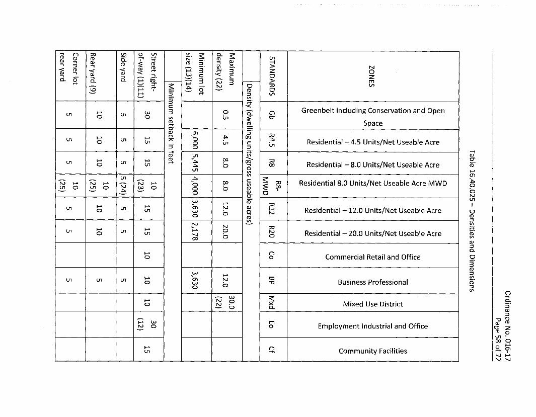
n o onrvi z?
3 30 CL
r- =ro fD fDCLCD CDCD CD 33CDCD >3 INICDCD-< fD 3-< 23< a—* OCD CD <CD oj c o2. 2Q- O
ca. 3 >I—* 00CL N 3 mi-*3" 30 Of)OM-P* OH> V O<X> fDl-> 3 CO3
to3 3+■<CGreenbelt including Conservation and Open
Space3 o CDoo CLLn uiO O cr§U1infD fD
crQJ 3 73n OQO 4*Ln 7TLn Residential-4.5 Units/Net Useable Acreo Ln o cui Ln3 O 3CDfD Ln in(D 3“00 73V-* OQLn Ln Residential - 8.0 Units/Net Useable Acre fD"O on 00O OLn h-kin
in CDLn
c Residential 8.0 Units/Net Useable Acre MWDo° 30NJ NJ NJ h-k UJ o
o in £ “ ONJLn O Ln o fDOO
o-p* QJo a NJcr LnfD"UJ h-k 73h-k O) NJ QJLn Ln Residential - 12.0 Units/Net Useable Acreh-ko Ln OqUJ O NJO fDfD 3inNJ NJ 73 JCT.Oh-kLn Ln NJ Residential - 20.0 Units/Net Useable Acreo on fD"4 oO to00CD3CL
n Commercial Retail and Office oo o3fD
00 33I-100(T> NJun onon Business Professionalo o-ooo o 33O in PUJ
NJ dh-k o Mixed Use DistrictXo NJ 3O Q_QJ3n“O fDh-k u>
NJ Om QJEmployment Industrial and Officeo era 2fD oon
oo Oi—1qM o cnCommunity FacilitiesLn'vj h-k NJ
CO QJ I-O m=2 ro 3cr " q-8 I 8
2 3 2-6 g
QJ ft) —■S i. p"K ° 3
m 3 -nO o 33. 3 2= 3 3
(TO in Qjnj 51 &
S 3 ?3 E. O </>5-Q-3
<ra § qj nS =■ £:
■—• QJ QJ— n
> NJO
oO)■a >-a mft) ro QJfD 73 cnm a s E 5inQ. OU1 roQJ co=5*.
3c Greenbelt including Conservation and Open
Space
00 h-> 3 ocn cn crSR SR 8.roncn 73O
cn cn Residential -4.5 Units/Net Useable Acre<SR SR ro cn3TO QJNJ ro Z73cn cn Residential - 8.0 Units/Net Useable Acre00 roSR SR 3T3
cnfD3N) Nl ■t*Residential 8.0 Units/Net Useable Acre MWD73cn cn O£ “roSR SR 3 Oo NJQ cn
00i-' 73 ICn cn 3 Residential - 12.0 Units/Net Useable Acre oSR SR ro Mr+ fD3C52.to00 fD Cf.Ul Ul Residential - 20.0 Units/Net Useable AcreCD NJ fD
cr o tofD CD
3QJQ_00I—* q OUi ui Ui Ui Commercial Retail and Office 2fD Otn 3ro3CO S£.cn 00Cn Cn cn Business ProfessionalSR o“OSR 3tn otDun Q_un Ul ui Mixed Use DistrictX 3Q. QJ
3“o QQJ fD
0Q ^fl> o cn • CO oa £
i—^ NJ 'vj
00NJ mcn cn cn Employment Industrial and OfficeooSR SR
CDCn NJ ncn cn Community FacilitiesSR oSR
Q. T3 <
^ J ?a S s-1 § |I—4 <
£ 3QJ 0) 2 X 3
< 5' Q-fD d QJCL C -lCL
z CL O oo m- < o-1 r+ fD <r+ "l <=■ n ST =£. 7 ^ °Q_ I
£ g D.w CD 3
l/l—HQJ >CL CL N
no Z ou zai ai>$ ■&Q 3 -a mro fD fD zb on3 CL OQ QJ CT1 C/lU1 x.
3c Greenbelt including Conservation and Open
Space3 CDOJNJ
(jn U) crcrcK
50nj UJ 3h-4 -C* Residential -4.5 Units/Net Useable AcreUJ eraui ui3“fD
O)ora crujNJ I—4 503" Residential - 8.0 Units/Net Useable Acre ro'-j <J1 00 003
<T>2 4^ro Residential 8.0 Units/Net Useable Acre MWDZBOJ fD Of “LU
oo NJUl
50 INJ U>MResidential - 12.0 Units/Net Useable AcreUl OJ aNJ
fD3
50NJ UJh-4 NJ Residential - 20.0 Units/Net Useable Acrecn OJ fDo l/lCD3CLNJ NJ 00 Oon Commercial Retail and Office 5•'j 00 oaS3ro3
onNJ NJ 00 CXIBusiness Professionalasvj vj oOJ “o
3(/> o
LnNJ NJ OJ Q_Mixed Use DistrictX-vj OJQ_ QJ
3■a QQJ m
crq 2 ro
NJ NJ oo mon Employment Industrial and Office■vi ooo as ocn •o oon QNJ NJ 00 n cnCommunity Facilitiesa?^4 •vj 00
-vl h-“ NJ

> CD CTQ Q_ o rj< (D “ S' < oS S 2 =? 5 sc fL 5 n 5T 3 <T> ^ ■< O
3 S i I l |£ !=? =>■ n qT 2.3 S !£. 7 ■< oM 2. g- 1 £
CDcoQJ
jcn •<"P J500 -I
-I> Nz oo zfD
€ >to fD mNO 50 co3 3oo co
Greenbelt including Conservation and Open
SpaceaCO CO
vo VO cr
XIco co Residential -4.5 Units/Net Useable AcreVO VO
cnQJ2co co Residential - 8.0 Units/Net Useable AcreVO VO 00 fD
cnResidential 8.0 Units/Net Useable Acre MWDXJ
£ ~ ooo NJcn
x: ICO COResidential - 12.0 Units/Net Useable AcreVO VO oISO
fD3
73 cr.UJ oj NJ Residential - 20.0 Units/Net Useable Acrevo vo fDO cnO)3CLCO co n Commercial Retail and Office 9.VO VO o3fD3!£!.co co 00
Business ProfessionalCD VO OTD3trt O
co co CLMixed Use DistrictXvo vo CL
0)3
-o OQJ0Q 7 fD ^
UJ UJ m Employment Industrial and Officeovo voocn
I-1 o
° 7CO CO o Community Facilitiesvo CD
03 CO 00 CL O OQJ ° QJ < O^ 5 2 £ ? IS ^ 5 o sr =53 «fl. " ■< O
Q-
03 ^ OQ
x ^ S | §£ £ =r £ n 5T 300 -i tn qj <-!■
fD —■ -o'
a. o o coID H> ININJ z ol—4•< oo z£ CL >€n> fDin in mNJ
ro I fD DO CO3 3oo Qco
Greenbelt including Conservation and Open
SpaceoUJ NJ
KD cr
U) NJ 4^ Residential - 4.5 Units/Net Useable AcreUl
O)Sco NJ DO Residential - 8.0 Units/Net Useable AcreCD nJ 00 fD
CD2 •I*Residential 8.0 Units/Net Useable Acre MWDDO
poo N)cn
DOco NJ Residential -12.0 Units/Net Useable Acrei—*CD Nj oNJfD3
DO 3.CO NJ N) Residential - 20.0 Units/Net Useable AcreCD (DNj O inQJ3CLCO nNJ
Commercial Retail and Office oCD Nl o3fD3
CJJ NJ 03Business ProfessionalCD oNj -D
3<si O
co NJ CLMixed Use DistrictX<x> 5*CL O)
3“O n Q) ^
OQ 2ro oUJ NJ m Employment Industrial and OfficeoCD Nl
cd • NJ oS.SCO NJ n Community FacilitiesCD Nl"vj t-* NJ vj
Ordinance No. 016-17 Page 63 of 72
Table 16.40.025 - Densities and Dimensions
aC
5 QJCDCD CDCDQ. bb U2o < <<< a>CD-a o2.2 b CDC 11_Q-Q .2-QCD < CDCO OCDCD itCDC CDCDCD 75 V)</!I/I■% O TJV) i/) .233 4-Jc c3 3 "OCD £.2 CDCD ■Z.CD cCD> CD to</>CO oCDCD (O CD .22Z3CD 2 2 CDCD J=aCO u.CD lO co CD4->c iff l/liff oU CD +-■ CD >3O co CDzZONES co .t;Q. T5U CCQ. CC 333 cc3300 1/5 +2 coco 3To TJOO.£ o £CD CDO coCNI c *TO *3" 00 E3 CD<~\l 'KCDII E oo l E 3U O>co.£ oo.2.2 75 £CD .275 +3 ’£3±i o Q.C c c c aCD +3 ECD CD CDCD-Q C5 LLl2 -J3C CDco co coCD -a coCD CDCD CD a>wCC CC CC CC(D
cc
R8-CfMxdGb BP EoR8 R12 R20 CoSTANDARDS R4.5
MWD
(17)(18)(21)
Downtownoverlay
district2727 27 27 2727 27 27 2727
(20)(21)
1. Measured from the existing edge of a street right-of-way. Applies to front yards, corner lots, and through lots.
2. From side or rear site or property boundary line. May be zero feet minimum within the mixed use district in the
downtown area as allowed by the International Building Code (IBC).
3. May be zero lot line if structures meet IBC fire code and emergency access.
4. Useable acreage covered by buildings, roads, parking lots, and other built improvements. Mixed use
developments within the downtown district may achieve 95 percent site coverage. Mixed use outside of
downtown shall be no more than 85 percent site coverage.
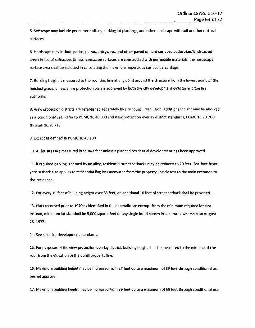
Ordinance No. 016-17 Page 64 of 72
5. Softscape may include perimeter buffers, parking lot plantings, and other landscape with soil or other natural
surfaces.
6. Hardscape may include patios, plazas, entryways, and other paved or hard surfaced pedestrian/landscaped
areas in lieu of softscape. Unless hardscape surfaces are constructed with permeable materials, the hardscape
surface area shall be included in calculating the maximum impervious surface percentage.
7. Building height is measured to the roof drip line at any point around the structure from the lowest point of the
finished grade, unless a fire protection plan is approved by both the city development director and the fire
authority.
8. View protection districts are established separately by city council resolution. Additional height may be allowed
as a conditional use. Refer to POMC 16.40.030 and view protection overlay district standards, POMC 16.20.700
through 16.20.713.
9. Except as defined in POMC 16.40.100.
10. All lot sizes are measured in square feet unless a planned residential development has been approved.
11. If required parking is served by an alley, residential street setbacks may be reduced to 10 feet. Ten-foot front
yard setback also applies to residential flag lots measured from the property line closest to the main entrance to
the residence.
12. For every 10 feet of building height over 33 feet, an additional 10 feet of street setback shall be provided.
13. Plats recorded prior to 1910 as identified in the appendix are exempt from the minimum required lot size.
Instead, minimum lot size shall be 5,000 square feet or any single lot of record in separate ownership on August
28,1972.
14. See small lot development standards.
15. For purposes of the view protection overlay district, building height shall be measured to the mid-line of the
roof from the elevation of the uphill property line.
16. Maximum building height may be increased from 27 feet up to a maximum of 39 feet through conditional use
permit approval.
17. Maximum building height may be increased from 39 feet up to a maximum of 55 feet through conditional use
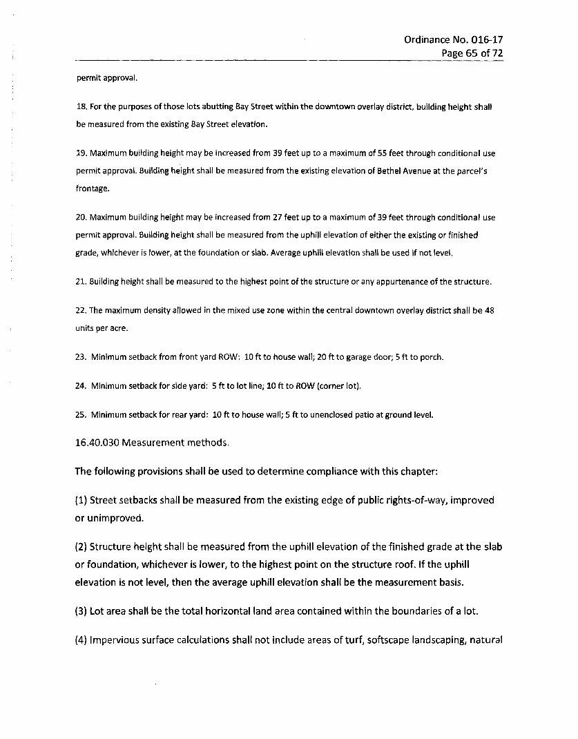
Ordinance No. 016-17 Page 65 of 72
permit approval.
18. For the purposes of those lots abutting Bay Street within the downtown overlay district, building height shall
be measured from the existing Bay Street elevation.
19. Maximum building height may be increased from 39 feet up to a maximum of 55 feet through conditional use
permit approval. Building height shall be measured from the existing elevation of Bethel Avenue at the parcel's
frontage.
20. Maximum building height may be increased from 27 feet up to a maximum of 39 feet through conditional use
permit approval. Building height shall be measured from the uphill elevation of either the existing or finished
grade, whichever is lower, at the foundation or slab. Average uphill elevation shall be used if not level.
21. Building height shall be measured to the highest point of the structure or any appurtenance of the structure.
22. The maximum density allowed in the mixed use zone within the central downtown overlay district shall be 48
units per acre.
23. Minimum setback from front yard ROW: 10 ft to house wall; 20 ft to garage door; 5 ft to porch.
24. Minimum setback for side yard: 5 ft to lot line; 10 ft to ROW (corner lot).
25. Minimum setback for rear yard: 10 ft to house wall; 5 ft to unenclosed patio at ground level.
16.40.030 Measurement methods.
The following provisions shall be used to determine compliance with this chapter;
(1) Street setbacks shall be measured from the existing edge of public rights-of-way, improved
or unimproved.
(2) Structure height shall be measured from the uphill elevation of the finished grade at the slab
or foundation, whichever is lower, to the highest point on the structure roof. If the uphill
elevation is not level, then the average uphill elevation shall be the measurement basis.
(3) Lot area shall be the total horizontal land area contained within the boundaries of a lot.
(4) Impervious surface calculations shall not include areas of turf, softscape landscaping, natural
Ordinance No. 016-17 Page 66 of 72
vegetation, or surface water retention/detention facilities
16.40.035 Calculations - Minimum and maximum density.
(1) The minimum density shall be calculated by multiplying the development's subject site net
useable site area, as calculated pursuant to POMC 16.40.040, by the minimum number of
dwelling units required in the applicable zoning district.
(2) The maximum density shall be calculated by multiplying the development's subject site net
useable site area, as calculated pursuant to POMC 16.40.040, by the maximum number of
dwelling units allowed in the applicable zoning district.
(3) The units associated with assisted living, congregate care, nursing home, residential care
facilities and the like, that rely on shared cooking/dining facilities, will not be counted for
purposes of the minimum/maximum density calculation. Independent dwelling units (i.e.,
containing a bed, bathroom, and a kitchen with a sink, stove, and refrigerator) in such group
living residential uses, however, shall be counted as individual dwelling units in the density
calculation. The density for nonindependent dwelling units shall not be transferred to another
portion of the development.
16.40.040 Calculations - Net useable site area.
The net useable site area is the development subject site's total (gross) site area minus areas
for public rights-of-way, private road easements, designated critical areas and buffer
protection, and stormwater management facilities; but not including parks and public or private
recreation facilities dedicated or created as an integral part of the development.
16.40.050 Calculations - Allowable dwelling units.
Permitted number of units shall be determined as follows:
(1) The maximum allowed number of dwelling units shall be computed by multiplying the net
useable site area by the applicable residential density.
(2) When calculations result in a fraction, the fraction shall be rounded to the nearest whole
number as follows:
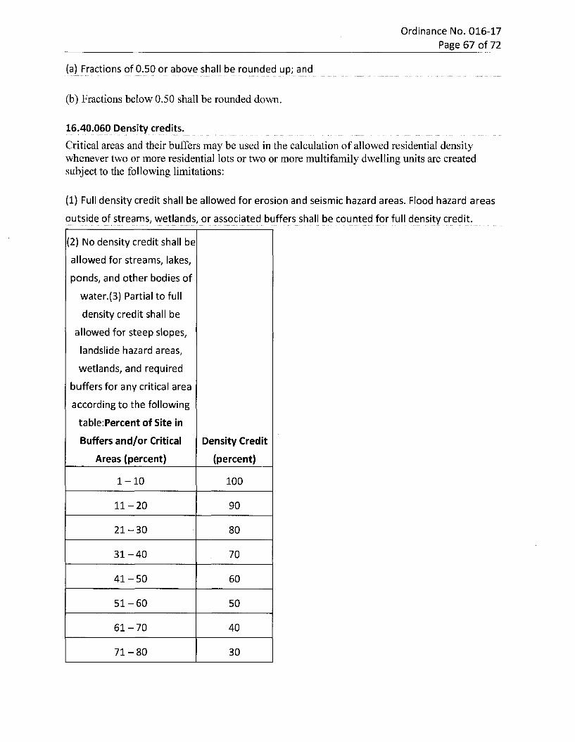
Ordinance No. 016-17 Page 67 of 72
(a) Fractions of 0.50 or above shall be rounded up; and
(b) Fractions below 0.50 shall be rounded down.
16.40.060 Density credits.Critical areas and their buffers may be used in the calculation of allowed residential density whenever two or more residential lots or two or more multifamily dwelling units are created subject to the following limitations:
(1) Full density credit shall be allowed for erosion and seismic hazard areas. Flood hazard areas
outside of streams, wetlands, or associated buffers shall be counted for full density credit.
(2) No density credit shall be
allowed for streams, lakes,
ponds, and other bodies of
water.(3) Partial to full
density credit shall be
allowed for steep slopes,
landslide hazard areas,
wetlands, and required
buffers for any critical area
according to the following
table:Percent of Site in
Buffers and/or Critical
Areas (percent)Density Credit
(percent)
1-10 100
11-20 90
21-30 80
31-40 70
41-50 60
51-60 50
61-70 40
71-80 30
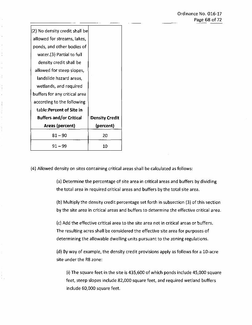
Ordinance No. 016-17 Page 68 of 72
(2) No density credit shall be
allowed for streams, lakes,
ponds, and other bodies of
water.(3) Partial to full
density credit shall be
allowed for steep slopes,
landslide hazard areas,
wetlands, and required
buffers for any critical area
according to the following
table:Percent of Site in
Buffers and/or Critical Areas (percent)
Density Credit (percent)
81-90 20
91-99 10
(4) Allowed density on sites containing critical areas shall be calculated as follows:
(a) Determine the percentage of site area in critical areas and buffers by dividing
the total area in required critical areas and buffers by the total site area.
(b) Multiply the density credit percentage set forth in subsection (3) of this section
by the site area in critical areas and buffers to determine the effective critical area.
(c) Add the effective critical area to the site area not in critical areas or buffers.
The resulting acres shall be considered the effective site area for purposes of
determining the allowable dwelling units pursuant to the zoning regulations.
(d) By way of example, the density credit provisions apply as follows for a 10-acre
site under the R8 zone:
(i) The square feet in the site is 435,600 of which ponds include 45,000 square
feet, steep slopes include 82,000 square feet, and required wetland buffers
include 60,000 square feet.
Ordinance No. 016-17 Page 69 of 72
(ii) Divide the total amount of critical areas and buffers (187,000 square feet)
by the total site (435,600 square feet) equal to 42.9 percent.
(iii) Apply the density credit from the chart (equal to a 60 percent density
credit where the amount of site in a critical area is between 4l and 50
percent).
(iv) Multiply the steep slopes and required buffers only (142,000 square feet
since no credit is received for ponds) by the density credit of 60 percent equal
to 85,200 square feet.
(v) Add the unconstrained site area (248,600 square feet) plus the critical
area density credit (85,200 square feet) to create the effective site area for
density calculations (333,800 square feet).
(vi) Divide the total effective site area by 43,560 square feet to determine
acreage (333,800 square feet/43,560 square feet/acre equals 7.6 acres) and
multiply by the density allowed in the R8 zone (7.6 acres multiplied by eight
dwelling units/acre) equals 60.8 which is rounded up to 61 dwelling units
maximum (note that the maximum density may be reduced by other
provisions of this code).
(5) The density transfer can be utilized only within the development proposal site. The applicant
may cluster and configure the site's development to accommodate the transfer of density but
cannot change the type of uses or housing products allowed within the zone proper.
16.40.070 Lot area - Reduction prohibited.
Any portion of a lot that was required to calculate and ensure compliance with the standards
and regulations of this chapter shall not be subsequently subdivided or segregated from such
lot.
16.40.080 Setbacks - Modifications.
The following setback modifications are permitted:
(1) When the common property line of two lots is covered by a building(s), the setbacks
Ordinance No. 016-17 Page 70 of 72
required by this chapter shall not apply along the common property lines.
(2) When a lot is located between lots with structures having nonconforming street setbacks,
the required street setback for such middle lot may be the average of the two nonconforming
setbacks or 60 percent of the required street setback, whichever results in the greater street
setback.
16.40.090 Setbacks - Regional utility corridors.
(1) In subdivisions and short subdivisions, areas used as regional utility corridors as identified in
this code shall be contained in separate tracts.
(2) In other types of land development permits, easements shall be used to delineate such
corridors.
(3) All buildings shall maintain a minimum distance of five feet from property or easement lines
delineating the boundary of regional utility corridors, except for utility structures necessary to
the operation of the utility corridor and/or as required by the Department of Health
16.40.100 Setbacks - Alleys.
(1) Structures may be built no closer than 15 feet from the center line of an abutting alley.
(2) Vehicle access points from garages, carports or fenced parking areas shall be set back a
minimum of 10 feet from the alley property line to provide a driving surface.
16.40.110 Setbacks - Adjoining half-street rights-of-way.
In addition to providing the standard street setback, a lot adjoining a half-street right-of-way or
designated arterial shall provide an additional width of street setback sufficient to
accommodate construction of the future planned right-of-way.
16.40.120 Setbacks - Projections allowed.
Projections complying with the adopted International Building Code may extend into the
required setbacks as follows:
(1) On ground and upper floor uses in all districts and on upper floor uses only in the mixed use
Ordinance No. 016-17 Page 71 of 72
district (Mxd) in the downtown area - fireplace structures, bay or garden windows, enclosed
stair landings, closets, or similar structures may project into any setback, provided such
projections are:
(a) Limited to two per facade;
(b) Not wider than seven feet; and
(c) Not more than 24 inches into an interior setback or 24 inches into a street setback.
(2) Uncovered porches and decks which exceed 18 inches above the finished grade may project:
(a) Twenty-four inches into interior setbacks; and
(b) Six feet into the street setback except where the allowable setback is zero feet as in the
mixed use district within the downtown area.
(3) Uncovered porches and decks not exceeding 18 inches above the finished grade may project
to the property line.
(4) Roof eaves, including any part of a roof structure whether unsupported or supported by
diagonal bracing to the building, must be more than seven feet above finished grade and may
not project more than:
(a) Twenty-four inches into an interior setback including within a zero lot line development; or
(b) Twenty-four inches into a street setback except where the allowable setback is zero feet as
in the mixed use district within the downtown area.
(5) Fences with a height of six feet or less may project into any setback; provided, that the sight
distance requirements are maintained along street corridors.
16.40.130 Heights - Exceptions to limits.
The following structures may be erected above the height limits:
(1) Roof structures housing or screening the following: elevators, fire access stairways, tanks,
ventilating fans, fire or parapet walls, skylights, or similar equipment required for building
operation and maintenance; and
Ordinance No. 016-17 Page 72 of 72
(2) Flagpoles, chimneys, smokestacks, church steeples, clock towers, communication
transmission structures, utility line towers and poles, and similar structures.
SECTION 5. Severability. If any section, sentence, clause or phrase of this Ordinance should be held to be unconstitutional or unlawful by a court of competent jurisdiction, such invalidity or unconstitutionality shall not affect the validity or constitutionality of any other section, sentence, clause or phrase of this Ordinance.
SECTION 6. Corrections. Upon the approval of the city attorney, the city clerk and/or code publisher is authorized to make any necessary technical corrections to this ordinance, including but not limited to the correction of scrivener's/clerical errors, references, ordinance numbering, section/subsection numbers, and any reference thereto.
SECTION 7. Publication. A summary of this ordinance in the form of the ordinance title may be published in lieu of publishing the ordinance in its entirety.
SECTION 8. Effective Date. This Ordinance shall take effect and be in full force and effect five (5) days after publication, as provided by law.
PASSED by the City Council of the City of Port Orchard, APPROVED by the Mayor and attested by the City Clerk in authentication of such passage this 25th day of April 2017.
Robert Putaansuu, Mayor
SPONSOR;ST:
Scott Diener, CouncilmemberBrandy Rinearson, CMC, City Clerk
l i SEAL : 1APPROVED AS TO FORM:
nJp^rron Cates, City Attorney
May 5, 2017 May 10, 2017
PUBLISHED: EFFECTIVE DATE:
NOTICE OF CITY OF PORT ORCHARD ORDINANCE
The following is a summary of an Ordinance approved by the Port Orchard City Council at their regular Council meeting held April 25, 2017.
ORDINANCE NO. 015-17
AN ORDINANCE OF THE CITY OF PORT ORCHARD, WASHINGTON, AMENDING PORT ORCHARD MUNICPAL CODE CHAPTER 5.94 (SPECIAL EVENTS) TO INCLUDE POLICIES ON CITY STREET AND STATE HIGHWAY CLOSURES; PROVIDING FOR SEVERABILITY AND PUBLICATION; AND SETTING AN EFFECTIVE DATE.
Copies of Ordinance No. 015-17 are available for review at the office of the City Clerk of the City of Port Orchard. Upon written request a statement of the full text of the Ordinance will be mailed to any interested person without charge. Thirty days after publication, copies of Ordinance No. 015-17 will be provided at a nominal charge. City of Port Orchard Brandy Rinearson City Clerk Published: Friday, May 5, 2017