opportunities and challenges for sustainable water resources management in tanzania
TRANSCRIPT

154
Voices from the South
Geographical Journal
Vol. 174 No. 2, pp. 149–175, 2008© 2008 The Author(s). Journal compilation © 2008 The Royal Geographical Society
need to mount environmental campaigns and masseducation to sensitise the population on how tocare for and nurture the environment that supportsall our lives. People should be made aware of theeconomic value of the goods and services theyobtain from the environment, as well as the naturalcapacity of the environment that should not beexceeded.
The
National Environmental Policy
is a compre-hensive attempt to guide the conservation andmanagement of natural resources and the environmentin Tanzania. The impact of its implementation hasnever been assessed and, until recently, there wasno legal instrument to give effect to its implementation.Now there is such an environmental law, but there
is also economic transformation, globalisation andclimate change which need to be taken into accountin the review and updating of the environmentalpolicy.
References
Envirowise
2005
How to write an environmental policy
(http://www.envirowise.gov.uk/page) Accessed 13 April 2008
Government of Tanzania
1997
National Environmental Policy
Vice President’s Office, Dar es Salaam
Government of Tanzania
2004
Environmental Management Act(No. 20)
Government Printer, Dar es Salaam
Selman P
2000
Environmental planning
2nd ed Sage Publications,London
Opportunities and challenges for sustainable water resources management in Tanzania
SHADRACK MWAKALILA
Department of Geography, University of Dar es Salaam, PO Box 35049, Dar es Salaam, TanzaniaE-mail: [email protected]
This paper was accepted for publication in April 2008
Introduction
T
he current national interest in the GreatRuaha Basin in southwest Tanzania (Figure 1)has been driven by major concerns over
water availability generally in Tanzania. In particular,water shortages at Mtera hydroelectric power plantshave resulted in national power shortages since1992. In the Ruaha National Park, which coversover 30% of the basin, the Great Ruaha River hasdried up during every dry season since 1993, withthe dry period tending to start earlier and lastlonger. This has had severe impacts on the wildlife,especially the aquatic fauna, and so threatens thetourist potential of the park. Within the GreatRuaha Basin itself, there has also been concern overrising conflicts over water availability for irrigation,as well as over access to water for livestock. Thispaper seeks to address opportunities, challenges andviable interventions for sustainable water resourcesmanagement for the entire Great Ruaha Basinupstream of Mtera Reservoir, and draws on a number
of sources, including DANIDA (1995), Kikula
et al.
(1996), Mwakalila (2005), and Kadigi (2005).
Research methodology
A combination of data collection methods was usedin this study. A desk study of secondary informationand data from different project documents andother existing literature from previous studies wascarried out. Fieldwork was conducted in the studyarea to assess the hydrological characteristics of theGreat Ruaha Basin, the irrigation systems, agriculturalpractices, farming systems, geographical characteristicsand the size (magnitude) of the study area. Duringthe fieldwork, information from the district, division,ward and village levels was collected to give aninsight on the status of various water demand anduses, including irrigation systems, agriculturalpractices, constraints and opportunities in the differentstudy villages. Participant observation, consultationof key informants and group discussions were usedas tools for information gathering.

Voices from the South
155
Geographical Journal
Vol. 174 No. 2, pp. 149–175, 2008© 2008 The Author(s). Journal compilation © 2008 The Royal Geographical Society
Opportunities in the Great Ruaha Basin
The seasonally flooded woodland communities ofthe Great Ruaha Basin are dominated by
Acaciaseyal
,
Acacia tortilis
and
Acacia kirkii
, which aretypical of areas that are water-logged, or wheredrainage is seasonal. Fish populations have declineddramatically, with a much lower residual populationsurviving over the dry season in the remaining pools.The bird fauna, and some species of aquatic inverte-brates such as many insects, are able to migrate toother permanent wetlands, and recolonise the
mbuga
during the wet season.The Great Ruaha River flows through the Ruaha
National Park and forms an important source of
water, particularly in the dry season, for wildlife.Under natural conditions, the river is normally peren-nial, with flows lasting all the way through thedry season. This provides habitat for hippopotami,fish and other aquatic life, and aestheticwildlife viewing conditions which are importantfactors affecting the attractiveness of the parkfor tourists.
As well as its high biodiversity, the Ruaha Basinalso has agricultural potential. Irrigated rice producedfrom the Usangu Plains accounts for about 14% ofthe total domestic rice production of Tanzania,ranging between 60 000 and 80 000 tonnes, valued atUS$16 million, and providing some 30 000 house-holds with an estimated income of US$3 per day
Figure 1 Location map of the Great Ruaha Basin in Tanzania

156
Voices from the South
Geographical Journal
Vol. 174 No. 2, pp. 149–175, 2008© 2008 The Author(s). Journal compilation © 2008 The Royal Geographical Society
stretched over the year. This income is vital forlifting many people out of poverty in this area, andis central to supporting a total population of750 000 people in the region. This productionextracts some 576 mm
3
of water, giving a value ofUS$0.027 per cubic meter extracted.
The Mtera and Kidatu hydropower plants contributeover 80% of the power supply of Tanzania. TheMtera Dam is the largest dam in the country interms of height, crest length and concrete volume.Its impounded reservoir is also the largest artificiallake in Tanzania. Mtera Power Station, with aninstalled capacity of 80 MW, is the second largestpowerhouse in Tanzania after Kidatu (204 MW).
Key challenges in the Great Ruaha Basin
Water use conflicts
From farmers’ perceptions, it was observed thatwater shortages are the single biggest bottleneckfor crop production for a number of reasons, suchas many water users, drought and destruction ofwater sources (Figure 2).
Water demand for hydropower generation
Mtera and Kidatu dams are located on the GreatRuaha River, downstream of the Ruaha NationalPark. They require both inflows and the carefulmanagement of releases and reservoir water levelsin order to provide an optimum supply of electricity.As indicated in Table 1, the full supply level (FSL)at Mtera reservoir is +698.50 m above sea level(m.a.s.l.) and the minimum supply level (deadstorage level) (MSL) is +690.00 m.a.s.l. The waterlevels in the 1991–2000 period went down veryclose to the dead storage level. This resulted inserious rationing in the electricity supply in thecountry. In the year 2004, the observed minimumwater level of 690.5 m.a.s.l. (i.e. only 0.5 m aboveMSL) occurred in February. In December 2005, the
level reached the MSL. In January 2006, the waterlevels went down to 689.5 m.a.s.l., and since thenTanzania has been facing serious power rationing.In September 2006, the situation was even worsein power rationing; in most areas of the country,the power supply was only available for two days(Saturday and Sunday) per week.
Rice irrigation and dry season abstraction in the Usangu Plains
For the perennial rivers flowing from the highcatchment, upstream of any irrigation abstractions,the flow at the end of the dry season is low anddecreasing slowly with time. At the start of the wetseason, the first light rainfall showers in the highcatchment are absorbed by the dry soils, but oncethe rain starts in earnest, the flows in the rivers risequickly, soon reaching rates comparable to thosemid-way through the dry season. In recent years,there has been a tendency for rice irrigators to starttheir cultivation earlier and earlier in order to gainfrom the higher prices for their product in themarket. This means that all, rather than most, ofthe early wet season rising flows are diverted. Thiscauses longer delays before the river downstreamstarts to rise.
After the main rice crop has been harvested, aminority of farmers practice dry season irrigationof vegetables, such as beans and tomatoes. Thesecrops are normally planted in fields close to thetop end of the wet season irrigation schemes,where the supply of water from the river is morereliable when flows are low. However, abstractionremains high during the dry season; between 10cumecs in a dry year and 16 cumecs in an averageyear. This water is used for purposes other thanirrigating crops such as growing vegetables andfruit trees, giving water to livestock and makingbricks.
Figure 2 Root causes of water use conflicts
Table 1 Summary of Mtera-Kidatu Reservoir system’s details
ParameterMtera
ReservoirKidatu
Reservoir
Live storage (MCM) 3200 125Spillway capacity (m3/s) 4000 6000Generating capacity (MW) 80 200Turbine discharge capacity (m3/s) 96 140Full supply level (m.a.s.l.) 698.5 450.0Dead storage level (m.a.sl.) 690.0 433.0Catchment area (km2) 68 000 80 000
Voices from the South
157
Geographical Journal
Vol. 174 No. 2, pp. 149–175, 2008© 2008 The Author(s). Journal compilation © 2008 The Royal Geographical Society
Changes in the perennial swamp of the Eastern Wetland
The Eastern Wetland (Ihefu Swamp) consists of anenclosed area full of alluvial deposits (Figure 1).Two main perennial rivers, together with severalephemeral ones, flow into the wetland, with asingle outflow at N’Giriama to the north. The EasternWetland slopes gently between the southwesternupstream end at Nyaluhanga and the outlet sill atN’Giriama, with a total drop of 3.6 m over adistance of 50 km along the main channel. Theseconditions allow for an unstable hydraulic regimeaffected by deposition and erosion, with muchevidence of previous river channels, now longsince abandoned, and changes in size, volume andlocation of open water lagoons in the perennialswamp. These changes to river channels are not allnatural, as fishermen and livestock herders workingin the wetland have played a part in both openingand closing off smaller channels at different timesfor their own benefit.
Water allocation procedures
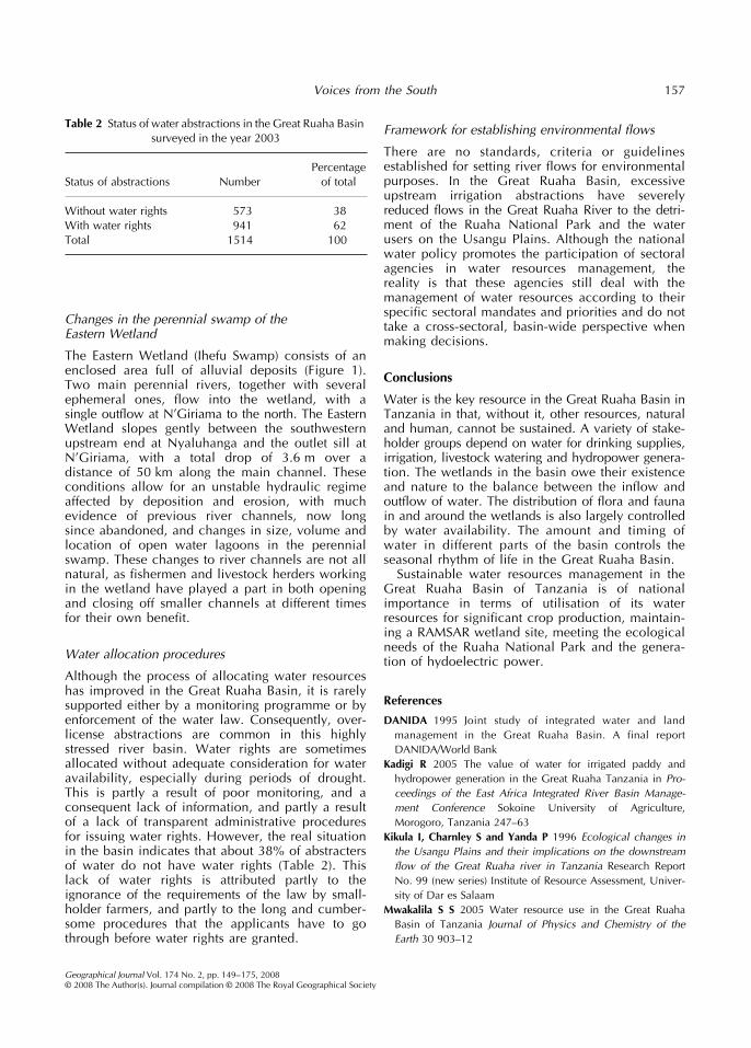
Although the process of allocating water resourceshas improved in the Great Ruaha Basin, it is rarelysupported either by a monitoring programme or byenforcement of the water law. Consequently, over-license abstractions are common in this highlystressed river basin. Water rights are sometimesallocated without adequate consideration for wateravailability, especially during periods of drought.This is partly a result of poor monitoring, and aconsequent lack of information, and partly a resultof a lack of transparent administrative proceduresfor issuing water rights. However, the real situationin the basin indicates that about 38% of abstractersof water do not have water rights (Table 2). Thislack of water rights is attributed partly to theignorance of the requirements of the law by small-holder farmers, and partly to the long and cumber-some procedures that the applicants have to gothrough before water rights are granted.
Framework for establishing environmental flows
There are no standards, criteria or guidelinesestablished for setting river flows for environmentalpurposes. In the Great Ruaha Basin, excessiveupstream irrigation abstractions have severelyreduced flows in the Great Ruaha River to the detri-ment of the Ruaha National Park and the waterusers on the Usangu Plains. Although the nationalwater policy promotes the participation of sectoralagencies in water resources management, thereality is that these agencies still deal with themanagement of water resources according to theirspecific sectoral mandates and priorities and do nottake a cross-sectoral, basin-wide perspective whenmaking decisions.
Conclusions
Water is the key resource in the Great Ruaha Basin inTanzania in that, without it, other resources, naturaland human, cannot be sustained. A variety of stake-holder groups depend on water for drinking supplies,irrigation, livestock watering and hydropower genera-tion. The wetlands in the basin owe their existenceand nature to the balance between the inflow andoutflow of water. The distribution of flora and faunain and around the wetlands is also largely controlledby water availability. The amount and timing ofwater in different parts of the basin controls theseasonal rhythm of life in the Great Ruaha Basin.
Sustainable water resources management in theGreat Ruaha Basin of Tanzania is of nationalimportance in terms of utilisation of its waterresources for significant crop production, maintain-ing a RAMSAR wetland site, meeting the ecologicalneeds of the Ruaha National Park and the genera-tion of hydoelectric power.
References
DANIDA 1995 Joint study of integrated water and landmanagement in the Great Ruaha Basin. A final reportDANIDA/World Bank
Kadigi R 2005 The value of water for irrigated paddy andhydropower generation in the Great Ruaha Tanzania in Pro-ceedings of the East Africa Integrated River Basin Manage-ment Conference Sokoine University of Agriculture,Morogoro, Tanzania 247–63
Kikula I, Charnley S and Yanda P 1996 Ecological changes inthe Usangu Plains and their implications on the downstreamflow of the Great Ruaha river in Tanzania Research ReportNo. 99 (new series) Institute of Resource Assessment, Univer-sity of Dar es Salaam
Mwakalila S S 2005 Water resource use in the Great RuahaBasin of Tanzania Journal of Physics and Chemistry of theEarth 30 903–12
Table 2 Status of water abstractions in the Great Ruaha Basin surveyed in the year 2003
Status of abstractions NumberPercentage
of total
Without water rights 573 38With water rights 941 62Total 1514 100