onshore energy security initiative planning progress ... · onshore energy security initiative...
TRANSCRIPT

Onshore Energy Security Initiative Planning Progress, March 2007
Dr James JohnsonChief, Onshore Energy & Minerals Division
Presented to AMEC, Perth, March 2007
Australian Government
Geoscience Australia

Ministerial Statement to Parliament on Energy Initiatives
14 August, 2006
“ The Government will also commit an additional $58.9 million over five years to identify on-shore energy sources such as petroleum and geothermal energy.”
The Hon John Howard MP

Onshore Energy Security Breakdown of $ per financial year.
06/07 $7.4M07/08 $14.8M08/09 $14.8M09/10 $12.7M10/11 $9.2M
TOTAL $58.9M

Provide geoscientific data to lower exploration risk and stimulate investment in exploration
Commodities• Petroleum• Uranium• Geothermal • ThoriumTools• Seismic• MT• AEM• Radiometrics• Magnetics• Geochemistry• Drilling
To gain new insights into Australia’s potential in diverse energy commodities:
Uranium deposits & occurrences(background: basins & cratons)

Approach
• Scope acquisition programs• Consult with State and Territory
Geological Surveys• Consult with Industry • Refine and Implement
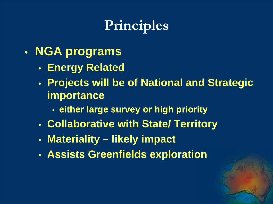
Principles
• NGA programs• Energy Related• Projects will be of National and Strategic
importance• either large survey or high priority
• Collaborative with State/ Territory• Materiality – likely impact• Assists Greenfields exploration

Focus of Presentation
• Will address each of the energy themes• National Projects
• AWAGS • Geochemical Baselines
• Targeted regional projects• Mineral Energy Program - Uranium • Geothermal Energy Program• Onshore Petroleum Program

Radiometrics - The Problem
AYR
HAY
CUE
BEGA
SALE
EDEL
URAL
EULO
RYAN
DARU
BYRO
COBB
BURNIE
MAER
AJANA
COEN
GOVE
PERTH
MANN
WEBB
FINKE
COOK
GILES
ROMA
YAMPI
KIMBA
BOIGU
WEIPA
NEALE
DALBY
WARRI
LUCAS
EUCLA
SCOTT
SURAT
NUYTS
LOUTH
ALROY
WELLS
OLARY
GYMPIE
DERBY
COLAC
HYDEN
BURRA
SYDNEY
TAMBO
WALSH
RASON
DUBBO
COBAR
OUYEN
COLLIE
FROME
GASON
WYOLA
LENNIS
MASON
MOREE
BOULIA
PENOLA
MONTO
WANNA
WYLOO
YARRIE
MUNRO
BOWEN
MOORA
TANAMI
CAIRNS
BELELEWILUNA
TALBOT
BULLEN
LINCOLN
WILSON
RUDALL
QUILPIE
BARLEE
ALBANY
INGHAM
MORRIS
MINILYA
HELENA
OATLANDS
WINTON
DARWIN
WAIGEN
JUNDAH
CULVER
PELLEW
BULLOO
JUBILEE
COPLEY
FORBES
YANREY
MADLEY
SAHARA
BARKER
YARDEA
ASHTON
ROBERT
URISINO
BARTON
ONSLOW
RANKEN
OOLDEA
GALILEE
PENDER
MACKAY
DOBBYN
BOURKE
YALGOO
RUNTON
FOWLER
IPSWICHVERNON
MANUKA
MANARA
MARREE
NYNGAN
QUOBBA
COLLIER
LINDSAY
MANILLAMADURA
COOPER
MCDILLS
EDMUND
TAROOM
JERICHO
BROOME
MENZIES
FOG BAY
DUMMER
TRAINOR
BROWNE
MILDURA
YARINGA
IVANHOE
NEWMAN
PYRAMID
DAMPIER
ROY HILL
STANLEYBENTLEY
MURGOO
NINGHAN
CORNISH
MAURICE
ABMINGA
BENDIGO
ADAVALE
YOUANMI
RODINGA
NOORINA
ELKEDRA
ZANTHUS
WARRINA
JACKSON
ALBERGA
KING ISLAND
DORRIGO
FORREST
HERBERTBETOOTA
NARETHA
INNISFAIL
ALCOOTA
KULGERA
WHYALLA
HASTINGS
WALGETT
AUGUSTA
BARNATO
NABBERU
EMERALD
MACLEAN
EVERARD
ELLISTON
INVERELL GRAFTON
DUKETON
TORRENS
DUCHESS
WIDE BAY
HENBURY
LEONORA
WARWICK
WINTINNA
AURUKUN
HOLROYD
GUNANYA
PINJARRA
MALCOLM
MITCHELL
PERCIVAL
ADELAIDE
CORRIGIN
HUCKITTA
EDJUDINA
RENMARK
SEEMORE
NYMAGEE
KURNALPI
BILLILUNA
MINIGWAL
DONGARA
MAITLAND
YOWALGA
CHILDARA
BRISBANE
BOOLIGAL
PEAK HILL
BLACKALL
MANDORA
CROYDON
WYANDRA
HORSHAM
LIMBUNYA
MCKINLAY
CORDILLO
ANKETELL
BALLARAT
LAUNCESTON
MOSSMAN
MANEROO
HAMILTON
LARRIMAH
NARRABRI
KINGSTON
BEDOURIE
CHOWILLA
TABLETOP
TANGORIN
ORROROO
DUARINGA
MENINDEE
GAIRDNER
NINGALOO
LAWN HILL
BARALABA
KINGSCOTE
TOOMPINE
ENNGONIA
PINNAROO
WAVE HILL
LISSADELL
BATHURST
HAY RIVER
LAVERTON
CAPE ARID
SWAN HILL
DRYSDALE
BEETALOO
HOMEBOIN
RED RIVER
PORTLAND
CHARNLEY
HILL RIVER
NAPPERBY
BARROLKA
QUEENSTOWN
RICHMOND
ATHERTON
MILINGIMBI
TARCOOLA
DELAMERE
WINDORAH
MOUNT ISA
WILCANNIA
CANBERRA
LAGRANGE
TICKALARA
EBAGOOLA
LAKE EYRE
CLERMONT
BUCHANAN
AUVERGNE
URAPUNGA
GOULBURN
GALBRAITH
LOONGANA
NULLAGINE
WATERLOO
MACKUNDA
KATHERINE
PERENJORI
NOONAERA
DENILIQUIN
BIRKSGATE
SHARK BAY
ULLADULLA
MACHATTIE
NORSEMAN
ST ARNAUD
WARRAGUL
GILBERTON
SINGLETON
BURNABBIE
DALHOUSIE
JERILDERIE
BIRDSVILLE
EROMANGA
COOMPANABENCUBBIN
TAMWORTHGILGANDRA
WOORAMEL
PLUMRIDGE
ST GEORGE
BOORABBIN
CHINCHILLA
THROSSELL
HALE RIVER
BALRANALD
COOKTOWN
URANDANGI
POONCARIE
EINASLEIGH
IRWIN INLET
RAWLINSON
KINGOONYA
PINE CREEK
SIR SAMUEL
BUSSELTON
MILPARINKA
WESTWOOD
NARROMINE
CUNDEELEE
NULLARBOR
HANN RIVER
STRZELECKI
ESPERANCE
GERALDTON
SANDSTONE
EDDYSTONE
NEWCASTLE
CROSSLAND
ANGLEDOOL
TALLARINGA
NOOLYEANA
BIRRINDUDU
FREW RIVER
INNAMINCKA
GLENGARRY
BALLADONIA
ROBERTSON
STANSMORE
PEMBERTON
CLONCURRY
GLENBURGH
PORT KEATS
BUNDABERG
LONGREACH
MELBOURNEBAIRNSDALE
CAPE SCOTT
MACDONALD
WALHALLOW
PARACHILNA
KIRKALOCKA
SPRINGVALE
MALLACOOTA
NEWDEGATE
HUGHENDEN
TOBERMORY
ROEBOURNE
LANSDOWNE
TOWNSVILLE
MARBLE BAR
SANDY CAPE
JULIA CREEK
KALGOORLIE
TANUMBIRINI
BURKETOWN
CONNEMARA
ANDAMOOKA
MILLUNGERA
CARGELLIGO
YANTABULLA
DEAL ISLAND
NORMANTON
WARBURTON
CURNAMONA
ANA BRANCH
PROSERPINE
AYERS ROCK
BREMER BAY
PERCY ISLES
BILLA KALINA
WOODROFFE
ORFORD BAY
CAMOOWEAL
ARNHEM BAY
SPRINGSURE
AUGATHELLA
BROKEN HILL
NARACOORTE
FLINDERS ISLAND
TANAMI EAST
MOUNT THEO
CALLABONNACURDIMURKA
DONORS HILL
YARRALOOLA
CHARLEVILLE
DIRRANBANDI
CANTERBURY
ROPER RIVER
CUNNAMULLA
MORNINGTON
MUTTABURRA
WHITE CLIFFS
AVON DOWNS
OODNADATTA
STREAKY BAY
GOONDIWINDI
DIXON RANGE
NARRANDERA
QUEENSCLIFF
WANGARATTA
DUMBLEYUNG
LAKE MACKAY
MUNDUBBERA
TUREE CREEK
NOONKANBAH
TALLANGATTA
MOUNT LIEBIG
DALY WATERS
ST LAWRENCE
BONNEY WELL
COBHAM LAKE
MOUNT PEAKE
POOLOWANNA
JUNCTION BAY
TWEED HEADS
COOBER PEDY
CLARKE RIVER
THE GRANITES
WOLLONGONG
LANDER RIVER
MOUNT BRUCE
GEORGETOWN
PORT CLINTON
BLUE MUD BAY
WINNING POOLHERON ISLAND
MOUNT YOUNG
JARDINE RIVER
KELLERBERRIN
ALICE SPRINGS
CALVERT HILLS
MOUNT RENNIE
PANDIE PANDIE
CAPE MELVILLE
LONDONDERRY
LAKE AMADEUS
PORT HEDLAND
MCLARTY HILLS
ROCKHAMPTON
PORT AUGUSTA
MOUNT EVELYN
COOTAMUNDRA
WAGGA WAGGA
TRUANT ISLAND
MEDUSA BANKS
TORRES STRAIT
PORT LANGDON
CAPE BEATRICE
BLOODS RANGE
MARYBOROUGH
MOUNT BARKER
BEDOUT ISLAND
GLENORMISTON
LENNARD RIVER
HELEN SPRINGSMOUNT RAMSAY
JOANNA SPRING
MURLOOCOPPIE
MOUNT WHELAN
MOUNT DOREEN
THARGOMINDAH
CAMDEN SOUNDPRINCE REGENT
BARROW CREEK
MOUNT COOLON
RAVENSTHORPE
ILLOGWA CREEK
MOUNT PHILLIPS
LAKE JOHNSTON
BROWSE ISLAND
BARROW ISLAND
TENNANT CREEK
KOPPERAMANNA
DURHAM DOWNS
WESTMORELAND
RUTLAND PLAINS
GORDON DOWNS
WIDGIEMOOLTHA
HERMANNSBURG
COFFS HARBOUR
ROBINSON RIVER
KENNEDY RANGE
MELVILLE ISLANDWESSEL ISLANDS
BAUHINIA DOWNS
BALFOUR DOWNS
MOUNT EGERTON
CAPE WEYMOUTH
SANDOVER RIVER
ALLIGATOR RIVER
CAMBRIDGE GULF
HIGHLAND ROCKS
MOUNT MARUMBA
WINNECKE CREEK
MOUNT SOLITAIRE
ROBINSON RANGE
CAPE VAN DIEMEN
HODGSON DOWNS
BATHURST ISLAND
MONDRAIN ISLAND
PATERSON RANGE
BRIGHTON DOWNS
MOUNT ELIZABETH
SOUTHERN CROSS
BRUNETTE DOWNS
MOUNT ANDERSON
MONTAGUE SOUND FERGUSSON RIVER
MOUNT DRUMMOND
CHARTERS TOWERS
MOUNT BANNERMAN
SOUTH LAKE WOODS
COBOURG PENINSULA
GREEN SWAMP WELL
NEWCASTLE WATERS
PETERMANN RANGES
HOUTMAN ABROLHOS
VICTORIA RIVER DOWNS
SIMPSON DESERT SOUTH
SIMPSON DESERT NORTH
108°E 114°E
120°E
120°E
126°E
126°E
132°E
132°E 138°E
138°E
144°E
144°E
150°E
150°E
156°E
40°S40°S
36°S36°S
32°S32°S
28°S28°S
24°S24°S
20°S20°S
16°S16°S
12°S12°S
8°S8°S
108°E
114°E
156°E
8°S
44°S 44°S
8°S
1:10,000,000
Murray Richardson20 June 2006
200 0 200 400 600 800 1,000
Kilometers
Sub-standard data
> 3200m line spacing
3000m - 3200m line spacing
usually 1500m - 1600m line spacing
At June 2006Appropriate standard data
<= 500m line spacing
2006/07 Acquisition by States

National Radiometrics Datum

AWAGS Project Timing
Project Scoping Sept 2006Call for Tenders Sept 2006Evaluation of Tenders Nov 2006Survey Commences Feb 2007Survey Completed May 2008Databases upgraded Nov 2008

Science Drivers
• Radiometrics• Uranium and Thorium Exploration• Heat Flow Studies – Geothermal• Radiation Risk Mapping• Geological Mapping @ surface - regolith,
• Magnetics• Lower crustal studies – structure,
composition & thermal regime• Petroleum resources –modelling
sedimentary basins• Accurate Regional Field for magnetic
modelling• Crustal accretion & evolution,

~1600 catchments (>1200 km2)~1 site/5000 km2
Baseline Geochemistry Survey

Mineral Energy ProgramUranium - Initiative
• Deposit Types• What are the potential unifying themes
• IOCG-U deposits • eg Olympic Dam
• Unconformity related deposits• Proterozoic
• Arnhem Land, Paterson
• Palaeo-channel deposits• Post-Permian systems
• Close to hot granites

Seismic and MT - Crustal Structure& Petroleum Potential
Moho
S 50 km V:H=1
partly ?mafic reflector
Olympic Dam
Palaeoproterozoic units
Archaean crust? Proterozoic crust?
Wirrda WellHiltaba graniteGRV
Olympic Dam above suture
IOCG-U plays

Uranium deposits & occurrences
U-rich iron oxide Cu-Au (IOCG) & basin-related U
Unconformity-related U; sandstone-hosted U, Calcrete U
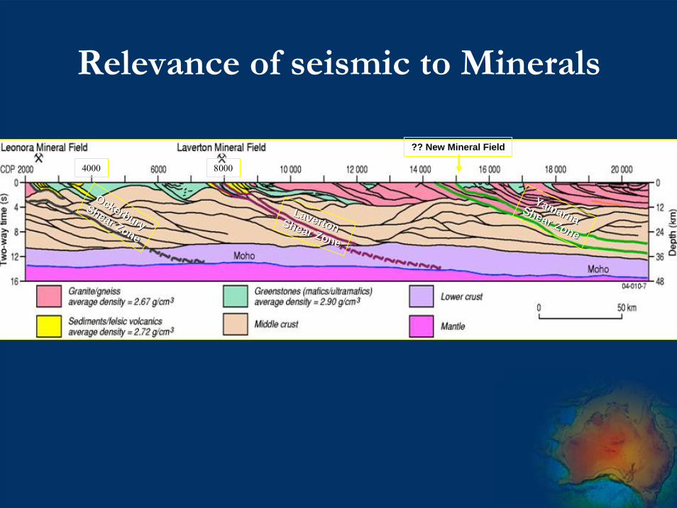
Relevance of seismic to Minerals
4000 8000
Ockerbury
OckerburyShear Zone
Shear Zone
YamarnaYamarna
Shear Zone
Shear Zone
LavertonLavertonShear Zone
Shear Zone
?? New Mineral Field

Reconstruction of Basin Shape and Sediment Architecture
PaleoproterozoicNorthern Australia
U- Fluid Reservoirs/Aquifer
Unconformity-related

Seismic
• Reprocessing of (GA) Deep Crustal and key industry petroleum data
• Energy Related Minerals & Geothermal• Crustal architecture
• Controls on IOCG-U deposits• Location of HHP Granites• Basin architecture for U-fluid sandstone
reservoirs

Seismic acquisition by Year of OESP
2006/07
2007/08
2008/09
2009/10
Base map: Surface geology

Region D
Region B
Region A
Region C
Geothermal ELs and applications;
Geology base from PIRSA
;
SA Seismic proposal overview(high priority corridors for seismic acquisition shown in yellow)
SA Seismic proposal overview(high priority corridors for seismic acquisition shown in yellow)

Objectives of new seismic (1)
IOCG-U mineralising systems:• What distinguishes architecture of U-rich
from U-poor IOCG systems?• Can we trace the crustal boundary &
“bland zone” beneath OD to NW and to SE?
• Is architecture of Benagerie Ridge in Curnamona Province similar to OD area?

Objectives of new seismic (2)
• Unconformity and other basin U systems:• Is Cariewerloo Basin (Pandurra Fm)
prospective for unconformity U? Need to know geometry of basin.
• What is architecture of pre-syn-GRV basins (Corunna Cong., Blue Range Beds?)
• Geometry of upper crustal faults in Mt Painter-Beverly 4 Mile area?

Products - Uranium
• Seismic data, sections and interpretation• 2D maps showing predicted “high
potential” areas; regional and national scale
• 3D maps of crustal structure for IOCG(U)s, & basin architecture for unconformity U, & paleo-channels for sandstone U
• GIS of U prospective areas, with U mineral systems criteria contained
• Reports on U potential in all areas new data acquired
• Publications on new regional synthesis

AEM program• Map and define using surveys with 1-5 km
wide line spacing• depth to basement, • major paleochannel systems • graphitic rocks in basement and reductants
in potential sandstone (U) reservoirs
• Map palaeochannel systems and possible graphitic rocks in more detail in proximity to provinces with hot granites (~1km line spacing)
Geoscience Australia

Potential AEM projects – U
Pine Creek
Mt Isa
Frome
EyrePeninsula
Paterson
NorthYilgarn
SE Yilgarn
Ngalia-Amadeus
Birrindudu-Tanami
Gascoyne
Uranium potential by province
Unknown or no potential
Low
Low to moderate
Moderate
Moderate to high
High
1/ Paterson2/ Frome3/ Pine Creek4/ Birrindudu/Tanami5/ Eyre Peninsula6/ Mt Isa7/ Nth Yilgarn
GascoyneWestmorelandAmadeus-NgaliaSth Yilgarn

Paterson Airborne EM Survey
RUDALL
SAHARA
ANKETELL
TABLETOP
YARRIE
RUNTONGUNANYA
JOANNA SPRING
NULLAGINE PATERSON RANGE
MUNRO
BALFOUR DOWNS
ROBERTSON
MANDORA MCLARTY HILLS
URAL
DUMMER
PERCIVAL
MORRIS
CROSSLAND
5
4
6
3
2a
2b
1
Telfer
Kintyre
121°30'E
121°30'E 123°E
123°E
124°30'E
124°30'E
23°S 23°S
22°S 22°S
21°S 21°S
20°S 20°S
0 50 km
GDA 1994 MGA Zone 51proposed AEM surveyknown Coolbro Sandstone outcropsinferred Coolbro SandstoneRudall National Park Area # Line
SpacingLine kms
1 0.5 436
2a 1 4,825
2b 1 3,353
3 1 3,462
4 2 4,418
6 2 3,827
5 2 8,888
4
1
2a
3
2b
5
6

SA Projects workshopped with PIRSA
1/ Frome Embayment-Murray Basin
2/Eyre Peninsula

Frome embaymentProposed AEM acquisition
33°S
32°S
31°S
30°S
Frome- palaeochannel deposits in Eyre Fm (eg. Honeymoon)- palaeochannel deposits in Namba Fm (eg. Beverley)- roll front / groundwater fracture controlled deposits (eg. Beverley 4 Mile)- North Frome- South Frome- Murray Basin- Total
7,231 km2
17,789 km2
2,582 km2
27,602 km2
Palaeochannels (PIRSA)
Proposed AEM surveyCurrent Fugro surveys
!( Uranium occurrences
!(
!(
!(
!(
!(
!(!( !(!(
!(
!(!(
!(
!(
!(
!(!( !(
!( !(
!(!(!( !(!(
!(!(
!(
!(
!(
!(!(
!(
!(!(
!(!(
!(
!(!(!(!(
!(
!(
!(!(
!(
!(
!(
!(
!(!(!(!(!(!( !(
Beverley
Honeymo
138°E 139°30'E 141
33°S
32°S
31°S
30°S
North Frome
SouthFrome
MurrayBasin
BackdropGamma-ray data

Geothermal Project
• Geothermal Power• Map of HHP Granites from OZCHEM• Geophysical models for volumes• Thermal conductivities for sediment
blankets• Prospectivity maps
• Geothermal for cities

Geothermal Project
Source map• Granites attributed
• Show High Heat Producing Granites and • Predict which buried granites are HHP; tools -
chemistry, inversion modelling, seismic• High U & Th sediments• Compile attributes of
sedimentary basins, including depth, thermal conductivities, porosity/permeability
Proterozoic

Geothermal Project – heat mapExisting heat flow coverage <150 points

Onshore Petroleum Program
• Aims & Objectives: • Make a significant and material difference
• Focus on greenfield regions with high potential and known source rocks
• Basin framework studies to place known producing plays in a whole of basin and crustal context
• What are the critical datasets that will make a difference?
• What are the fundamental impediments to exploration in these areas?

Onshore Petroleum
• Continent-wide assessment of potential basins and prioritisation
• Sub-salt plays • Kidson sub basin, Canning Basin, WA
• Basin framework and crustal architecture studies –• Pedirka, Warburton, Eromanga and Cooper
Basins, SA, Qld, NT• Middle Cambrian Source
• Lander Trough, NT


Acquisition Stages for a Potential Petroleum Program in Greenfields Regions (WA and
NT/Qld/SA border)
• Magnetics • Acquire magnetics in areas of > 1,500m line
spacing • Interpretation of magnetics
• Seismic• Line location based on integrated studies
including airborne magnetic interpretations• Interpret seismic to confirm structures and basin
architecture • Focussed seismic acquisition program• Potential for targeted stratigraphic drilling
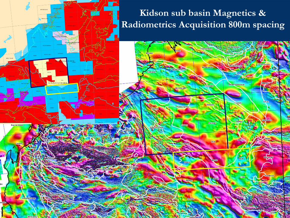
Kidson sub basin Magnetics & Radiometrics Acquisition 800m spacing
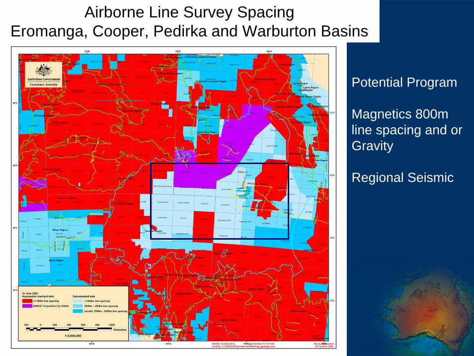
Airborne Line Survey SpacingEromanga, Cooper, Pedirka and Warburton Basins
Potential Program
Magnetics 800m line spacing and or Gravity
Regional Seismic

Questions