Öncel akademİ: İstanbul depremİ
TRANSCRIPT

Tectonophysics 478 (2009) 135–142
Contents lists available at ScienceDirect
Tectonophysics
j ourna l homepage: www.e lsev ie r.com/ locate / tecto
Spatial correlation of the aeromagnetic anomalies and seismogenic faults in theMarmara region, NW Turkey
A. Ateş a,⁎, A. Büyüksaraç b, F. Bilim b, Ö. Bektaş a, Ç. Şendur a, G. Komanovalı a
a Ankara University, Faculty of Engineering, Department of Geophysical Engineering, 06100 Besevler, Ankara, Turkeyb Cumhuriyet University, Faculty of Engineering, Department of Geophysical Engineering, 58140 Sivas, Turkey
⁎ Corresponding author. Tel.: +90 312 2033366; fax:E-mail address: [email protected] (A. Ateş).
0040-1951/$ – see front matter © 2008 Elsevier B.V. Adoi:10.1016/j.tecto.2008.09.025
a b s t r a c t
a r t i c l e i n f oArticle history:
Previous investigations into Received 25 December 2007Received in revised form 15 August 2008Accepted 17 September 2008Available online 24 September 2008Keywords:Marmara regionAeromagnetic anomaliesEarthquake potentialMain fault zone
the deep structure of the Marmara Sea region revealed an existence of a rigidbarrier located at the centre of the Marmara Sea. Thus, the North Anatolian Fault (NAF) was divided into threesegments to the west of this barrier. Seismological records of two 5 year periods (1998–2002 and 2003–2007)indicate a decrease of seismic activity on and around this barrier. It was previously shown if the faultmovementreaches to magma its fractures are filled with magmatic material causing magnetic anomalies. In this study,advance processing methods are utilized to observe the spatial correlation between the aeromagneticanomalies and the faults of the Marmara region. These are the reduction to the pole transformation (RTP) andsecond vertical derivative (SVD) methods. In particular, SVD map shows alignments which can be correlatedwith the faults. These faults are theNorthernBoundary, Yalova, Armutlu, Imrali and Edincik faults. Length of theNorthern Boundary Fault (NBF) is about 50–60 km. Thus, this fault would not produce strong earthquakes. TheEdincik Fault extends fromeast to thewest and bends throughWSW. The length of this fault in connectionwiththe Imrali, Armutlu and Yalova faults in the east exceeds 300 km and named the Main Fault Zone (MFZ) by theauthors of this study. These faults as awholemay produce strong earthquakes. Some seismic gaps are observedalong with the Imrali and Edincik faults from the earthquake distribution records of two 5 year periods (1998–2002 and 2003–2007). As a conclusion, there are high-potentials of strong earthquake occurrences in theseregions.
© 2008 Elsevier B.V. All rights reserved.
1. Introduction
The Marmara region is located in NW of Turkey. The NorthAnatolian Fault (NAF) is an approximately 1600 km long, right lateralfault creating strong earthquakes and it extends from the easternTurkey to the Marmara Sea in a zone along North Anatolia. In the past,it produced a sequence of earthquakes with magnitudes greater than7.0. The NAF reachedMarmara Sea as a major fault in the late Pliocene.Previous studies (Ates et al., 2003, 2008) show that the western partof the NAF is divided into three parts in the Marmara Sea. A generalillustration of the faults on land in the region is given in Fig. 1 aftersimplification from Saroglu et al. (1992).
Crustal structure of the eastern Marmara region was determinedby applying the receiver function method by Zor et al. (2006). Theaverage crustal thickness and S-wave velocity for the whole regionwere found 31±2 km and 3.64±0.15 km s−1, respectively. Crustalthickening was also observed fromwest (29–32 km) to the east (34–35 km) along the North Anatolian Fault Zone (NAFZ). In the eastern
+90 312 2120071.
ll rights reserved.
Marmara region high heat flow (101±11 mWm−2) was observedwithin the average crustal thickness (Ilkışık, 1995).
Alpar and Yaltirak (2002) investigated characteristic features ofthe NAF in the eastern Marmara region and its tectonic evolution.Small scale fault segments of the NAF inMarmara regionwere evolvedaround a fault defined by them as the major fault under a regime ofdextral shear. Secondary faults developed with a low-angle obliqueslip to the major fault were also products of dextral shear. These faultsabsorbed the deformation at the western end of the ruptured zoneduring the Izmit Earthquake (August 17th, 1999), causing themigration of stress failure westward.
There are many investigations on the tectonic structure andmechanism of the NAF. The Anatolian Block has been moving to thewest along the NAFZ for the last 5.7 million years according to Barka(1992) and the last 3.7 million years according to Yaltirak et al.(2000). McClusky et al. (2000) estimated the rate of the lateraldisplacement (Slip rate is ranging from 17 to 24 mm/year) along theNAFZ from geodetic measurements along the E–W direction in theMarmara Sea region. Among these works, three of them (Ates et al.,2003; Oncel and Wilson, 2006; Ates et al., 2008) described aresistive region on the northern branch of the NAF. This resistiveregion was defined as a barrier and named the Central Ridge Horst

Fig. 1. Active fault map of the NW Turkey, modified from Saroglu et al. (1992). S-GF: Saros–Gazikoy Fault, EtF: Etili Fault, C-BFZ: Can-Biga Fault Zone, Y-GF: Yenice–Gonen Fault, SF:Sarikoy Fault, EF: Edincik Fault, MF: Manyas Fault, UF: Ulubat Fault, NAF: North Anatolian Fault, AFl: Almacik Flake, ML: Manyas Lake, AL: Apolyan Lake, IL: Iznik Lake.
136 A. Ateş et al. / Tectonophysics 478 (2009) 135–142
(CRH) by Ates et al. (2003, 2008). In this paper, reduction to the poletransformation (RTP) and second vertical derivative (SVD) methodswere performed on the aeromagnetic anomalies to investigate if any
Fig. 2. Aeromagnetic anomaly map of the NW Turkey modified from Ates et al. (2003). Confurther investigations as explained in the text. NMMA: North Marmara Magnetic Anomaly.
spatial correlation with the faults of the region exists. SVD mapshows an indication of a major fault extending along Yalova,Armutlu, Imrali and Edincik Faults. The Etili Fault is located to
tour interval is 70 nT. Box shows the Marmara Sea region and this area are subjected toAA' is the aeromagnetic anomaly profile.

Fig. 3. 2.5-Dimensional magnetic model along profile AA' shown in Fig. 2. Susceptibility of the magnetised body is taken 0.00315 cgs (SI) as described by Ates et al. (2008).
137A. Ateş et al. / Tectonophysics 478 (2009) 135–142
projection of these faults in the SW corner of the region. Total lengthof these faults in complementary form exceeds 300 km and exhibitsearthquake hazard in connection with the seismological records ofthis region. This fault zone is named the Major Fault Zone (MFZ) ofthe NAF by the authors of this study.
Fig. 4. Reduction to the pole transformation of the aeromagnetic anomalies in the area illudirections. CRH: Central Ridge Horst, PI: Prince Islands, IA: Imrali Island.
2. Aeromagnetic data and interpretation
Residual aeromagnetic data of the region were obtained from theGeneral Directorate ofMineral Research and Exploration of Turkey (MTA).Anomaly map of the study area was published previously by Ates et al.
strated by the box in Fig. 2. Solid and broken arrows show possible fault propagation

Fig. 5. Image of the second vertical derivative of the aeromagnetic anomalies shown by the box in Fig. 2. NBF: Northern Boundary Fault, MFZ: Main Fault Zone.
Fig. 6. Earthquake distribution map of the region for the period between 1998 and 2002. Circle size shows the magnitude of the earthquake. CRH is the Central Ridge Horst defined inthe text as a resistive barrier. MFZ: Main Fault Zone, WTF: West Transform Fault, CTF: Cinarcik Transform Fault, NBF: Northern Boundary Fault, SBF: Southern Boundary Fault, EF:Edincik Fault, YF: Yalova Fault, IF: Imrali Fault, MF: Manyas Fault, UF: Ulubat Fault, AF: Armutlu Fault, GM: Gemlik Fault, KP: Kapidag Peninsula, AL: Apolyan Lake, ML:Manyas Lake, IL:Iznik Lake.
138 A. Ateş et al. / Tectonophysics 478 (2009) 135–142
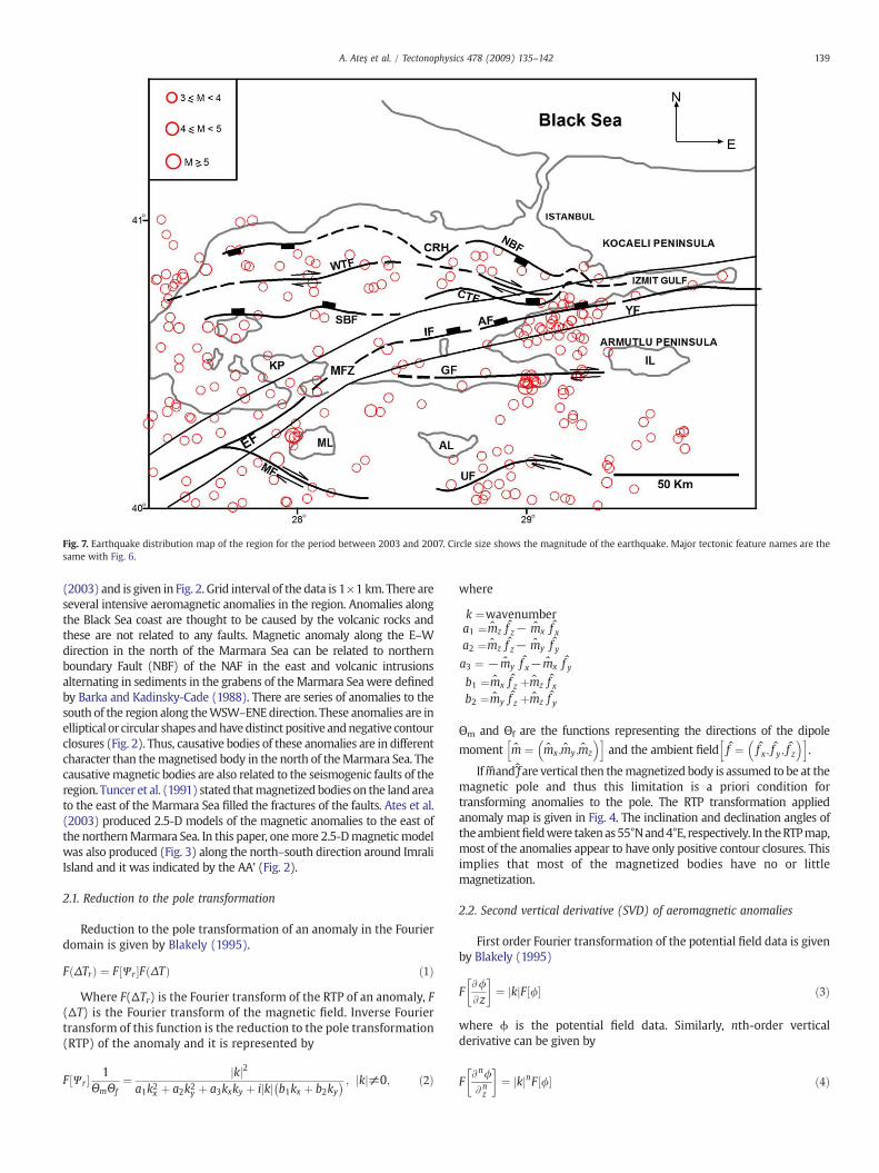
Fig. 7. Earthquake distribution map of the region for the period between 2003 and 2007. Circle size shows the magnitude of the earthquake. Major tectonic feature names are thesame with Fig. 6.
139A. Ateş et al. / Tectonophysics 478 (2009) 135–142
(2003) and is given in Fig. 2. Grid interval of the data is 1×1 km. There areseveral intensive aeromagnetic anomalies in the region. Anomalies alongthe Black Sea coast are thought to be caused by the volcanic rocks andthese are not related to any faults. Magnetic anomaly along the E–Wdirection in the north of the Marmara Sea can be related to northernboundary Fault (NBF) of the NAF in the east and volcanic intrusionsalternating in sediments in the grabens of the Marmara Seawere definedby Barka and Kadinsky-Cade (1988). There are series of anomalies to thesouth of the region along theWSW–ENEdirection. These anomalies are inelliptical or circular shapes andhavedistinct positive andnegative contourclosures (Fig. 2). Thus, causative bodies of these anomalies are in differentcharacter than themagnetised body in the north of theMarmara Sea. Thecausativemagnetic bodies are also related to the seismogenic faults of theregion. Tuncer et al. (1991) stated thatmagnetized bodies on the land areato the east of the Marmara Sea filled the fractures of the faults. Ates et al.(2003) produced 2.5-D models of the magnetic anomalies to the east ofthe northernMarmara Sea. In this paper, onemore 2.5-Dmagnetic modelwas also produced (Fig. 3) along the north–south direction around ImraliIsland and it was indicated by the AA' (Fig. 2).
2.1. Reduction to the pole transformation
Reduction to the pole transformation of an anomaly in the Fourierdomain is given by Blakely (1995).
F ΔTrð Þ ¼ F Wr½ �F ΔTð Þ ð1Þ
Where F(ΔTr) is the Fourier transform of the RTP of an anomaly, F(ΔT) is the Fourier transform of the magnetic field. Inverse Fouriertransform of this function is the reduction to the pole transformation(RTP) of the anomaly and it is represented by
F Wr½ � 1ΘmΘf
¼ jkj2a1k2x þ a2k2y þ a3kxky þ ijkj b1kx þ b2ky
� � ; jkj≠0; ð2Þ
where
k ¼wavenumbera1 ¼m̂z f̂ z− m̂x f̂ xa2 ¼m̂z f̂ z− m̂y f̂ ya3 ¼ − m̂y f̂ x− m̂x f̂ yb1 ¼m̂x f̂ z þm̂z f̂ xb2 ¼m̂y f̂ z þm̂z f̂ y
Θm and Θf are the functions representing the directions of the dipole
moment m̂ ¼ m̂x;m̂y;m̂z
� �h iand the ambient field f̂ ¼ f̂ x; f̂ y; f̂ z
� �h i.
If m̂̂and f̂̂are vertical then themagnetized body is assumed to be at themagnetic pole and thus this limitation is a priori condition fortransforming anomalies to the pole. The RTP transformation appliedanomaly map is given in Fig. 4. The inclination and declination angles oftheambientfieldwere takenas55°Nand4°E, respectively. In theRTPmap,most of the anomalies appear to have only positive contour closures. Thisimplies that most of the magnetized bodies have no or littlemagnetization.
2.2. Second vertical derivative (SVD) of aeromagnetic anomalies
First order Fourier transformation of the potential field data is givenby Blakely (1995)
FA/Az
� �¼ jkjF /½ � ð3Þ
where ϕ is the potential field data. Similarly, nth-order verticalderivative can be given by
FAn/Anz
� �¼ jkjnF /½ � ð4Þ

Fig. 8. Magnitude–Frequency histograms, (a) The period between 1998 and 2002, (b) The period between 2003 and 2007.
140 A. Ateş et al. / Tectonophysics 478 (2009) 135–142
Inverse Fourier transform of this function with n=2 is the secondvertical derivative (SVD). The second vertical derivative map isillustrated in Fig. 5.
3. Seismogenic faults
Major faults of the region can be seen in Fig. 1. These are from eastto the west; Yalova, Armutlu, Imrali, Saros–Gazikoy, Etili, Can-Biga,Yenice–Gonen, Sarikoy, Ulubat, Edincik andManyas faults. Most of thefaults have normal components except the Cinarcik and WesternTransform faults seen in and around the Marmara Sea (Figs. 6 and 7).
3.1. Earthquake distribution
Seismological recordswere separated into two periods; first periodis between 1998 and 2002, second period is between 2003 and 2007.They have good correlations with the existing faults in the region(Fig. 1). Earthquake data were obtained from General Directorate ofDisaster Affairs of Turkey. Themagnitude type is Md. A decrease of theearthquake quantities (Figs. 6 and 7) can be observed on and aroundthe barrier named as the Central Ridge Horst (CRH) by Ates et al.(2003). The number of earthquake occurrences was decreased by thetime. In the first 5 years between 1998 and 2002, the number ofearthquakes was 312. In the second 5 years between 2003 and 2007,the number of earthquakes was 244. Especially, number of earth-quakes in the range 4≤Mb5 decreased from 43 to 4 in the secondperiod. However, the number of M≥5 stayed in constant as 3 for thetwo periods. On the other hand, the number of the range 3≤Mb4 alsodecreased from 265 to 237 in the second period. Magnitude–frequency histograms of these two periods are shown in Fig. 8.
Oncel and Wilson (2006) similarly described a resistive zonearound the same region. A seismic quiescence can be observed alongthe Imrali and Edincik faults in the earthquake distribution mapsgiven in Figs. 6 and 7. Number of earthquakes increased in thewesternMarmara region in the last period. This can be interpreted that theseismic activity has been increasing more than the eastern Marmara
region. This situation is consistent with the characteristics of theNAFZ.
4. Correlation of the aeromagnetic anomalies with faults
Second vertical derivate (SVD) map (Fig. 5) of the aeromagneticanomalies in the area is bounded by a rectangle in Fig. 2 and exhibitssimilar alignments consistent with the active faults. These faults arethe Northern Boundary, Yalova, Armutlu, Imrali, Edincik and EtiliFaults. Length of the Northern Boundary Fault (NBF) is about 50–60 km. Thus, this fault can not produce strong earthquakes than theother faults mentioned above. Edincik and Etili Faults are situatedalong the SW projection of the Imrali and Armutlu faults and bendstowards WSW. In this paper, these faults are named the Main FaultZone (MFZ) initially. The length of MFZ exceeds 300 km and thesefaults may produce strong earthquakes. There is an E–W elongatedstrike-slip fault parallel to the Bay of Gemlik towards the KapidagPeninsula (Figs. 6 and 7). This fault is also named the Gemlik Fault(GF) for the first time by the authors of this study.
5. Discussion and conclusions
The Marmara Sea and its earthquake potential is importantbecause of its proximity to the city of Istanbul. Westernmost part ofthe North Anatolian Fault (NAF) bifurcates into three parts in the IzmitBay and passes trough the region. Despite a lot of research, the nature,structural complexity and movement of the NAF have not beenresolved properly and people living in Istanbul and its surroundingsare worried about an impending strong earthquake since thedevastating Izmit Earthquake in August 17th, 1999.
It was shown by Tuncer et al. (1991) that magnetized bodiescausing anomalies have good correlation with the faults in this area.They suggested that the fractures of the faults were filled withmagmatic material depending on where the fault movement reachesto magma. 2.5-D models in the east of the Marmara Sea showed anexistence of similar correlation with the magnetized bodies and

Fig. 9. Tectonic lineaments are overlain by the second vertical derivative of the anomalies given in Fig. 6. Minimum contour value is −0.00013. Maximum contour value is 0.00012.Regions shown by dashed lines are defined as the fault zones. NBF: Northern Boundary Fault. MFZ: Main Fault Zone.
141A. Ateş et al. / Tectonophysics 478 (2009) 135–142
seismogenic faults. In this paper, one more additional magnetic modelwas constructed to show the correlation along the profile AA' in Fig. 2.Magnetic model in Fig. 3 shows a magnetized body with its top on thesurface to down to a depth nearly 15 km. Reduction to the pole (RTP)map (Fig. 4) displays interesting anomalies which can be correlatedwith the active faults of the region. Direction of the faults were tried tobe followed by arrows. Second vertical derivative (SVD) map of theaeromagnetic anomalies (Fig. 5) shows lineaments which can becorrelated with faults of the region. Two interesting lineaments areoutstanding. One of them is in the north and along with the NorthernBoundary Fault (NBF) and Cinarcik Transform Fault (CTF). The lengthof this lineament is about 50–60 km (Fig. 9). Its continuation to thewest suddenly stops. It is interesting to observe from the earthquakedistributionmaps for two 5 year periods (1998–2002 and 2003–2007)that there is a seismic quiescence to the west (Figs. 6 and 7). Thisseismically quiescent region coincides with the absence of anylineaments in this region that was previously defined as the CentralRidge Horst (CRH) by Ates et al. (2003, 2008). Seismic quiescence andabsence of any lineament are not fortuitous in this region, because arigid barrier restricts the fault movement in this area (Ates et al., 2003,2008). Another, similar barrier also exists on the onshore to the east ofthe Marmara Sea known as the Almacik Flake (AFl). The NorthAnatolian Fault (NAF) was divided into two parts because of thisstructure (Fig. 1). Palaeomagnetic studies showed that the AlmacikFlake (AFl) was rotated relatively in clockwise directionwhen Anatoliawas rotating in counter clockwise direction (Saribudak et al., 1990;Michel et al., 1995).
The other interesting lineament exists in south. The Edincik Faultextends from east to west and bends towards WSW. Imrali, Armutluand Yalova faults lie along the eastern projection of the Edincik fault(Fig. 1). Saros–Gazikoy, Etili, Can-Biga, Yenice–Gonen and Sarikoyfaults are situated at the SW projection of these faults (Fig. 1). Total
length of these faults exceeds 300 km. We suggest that these faults inthe south constitute the Main Fault Zone (MFZ). Seismic gaps can beobserved around the cross point of the Imrali and Edincik faults on theearthquake distribution maps. Thus, these regions should be con-sidered as the places bearing high-potential for strong earthquakeoccurrences. In Fig. 9 active fault zones are illustrated with the help ofthe second vertical derivative of anomalies. As observed in Fig. 9 theMFZ is located in the south. We suggest that future investigationsshould be concentrated onto this zone.
Acknowledgements
We thank Dr. A. De Santis and the other three reviewers forcritically reviewing this manuscript and suggesting many helpfulcomments. We also thank to Editor Dr. Kumar Hemant of NASA for hisdelicate handling of this paper.
References
Alpar, B., Yaltirak, C., 2002. Characteristic features of the North Anatolian Fault in theeastern Marmara region and its tectonic evolution. Mar. Geol. 190, 329–350.
Ates, A., Kayıran, T., Sincer, I., 2003. Structural interpretation of the Marmara Region,NW Turkey from aeromagnetic, seismic and gravity data. Tectonophysics 367,41–99.
Ates, A., Bilim, F., Buyuksarac, A., Bektas, O., 2008. A tectonic interpretation of theMarmara Sea, NW Turkey from geophysical data. Earth Planets Space 60, 169–177.
Barka, A.A., 1992. The North Anatolian fault. Ann. Tecton. 6, 174–195.Barka, A.A., Kadinsky-Cade, K., 1988. Strike-slip fault geometry in Turkey and its
influence on earthquake activity. Tectonics 7, 663–684.Blakely, R.J., 1995. Potential theory in gravity and magnetic applications. Cambridge
University Press, UK, p. 441.Ilkışık, O.M., 1995. Regional heat flow in western Anatolia using silica temperature
estimates from thermal springs. Tectonophysics 244, 175–184.McClusky, S., Balassanian, S., Barka, A., Demir, C., Ergintav, S., Georgiev, I., Gurkan, O.,
Hamburger, M., Hurst, K., Kahle, H., Kastens, K., Kekelidze, G., King, R., Kotzev, V.,Lenk, O., Mahmoud, S., Mishin, A., Nadariya, M., Ouzounis, A., Paradissis, D., Peter, Y.,

142 A. Ateş et al. / Tectonophysics 478 (2009) 135–142
Prilepin, M., Reilinger, R., Sanli, I., Seeger, H., Teableb, A., Toksoz, M.N., Veis, G., 2000.Global positioning system constraints on plate kinematics and dynamics in theEastern Mediterranean and Caucasus. J. Geophys. Res. 105, 5695–5719.
Michel, G.W., Waldhör, M., Neugebauer, J., Appel, E., 1995. Sequential rotation ofstretching axes, and block rotations: a structural and paleomagnetic study along theNorth Anatolian Fault. Tectonophysics 243, 97–118.
Oncel, A.O., Wilson, T., 2006. Evaluation of earthquake potential along the NorthAnatolian Fault Zone in the Marmara Sea using comparisons of GPS strain andseismotectonic parameters. Tectonophysics 418, 205–218.
Saribudak, M., Sanver, M., Sengor, A.M.C., Gorur, N., 1990. Paleomagnetic evidence forsubstantial rotation of the Almacik flakewithin the North Anatolian Fault Zone, NWTurkey. Geophys. J. Int. 102, 563–568.
Saroglu, F., Emre, O., Kuscu, I., 1992. 1/1,000,000 active fault map of Turkey. GeneralDirectorate of Mineral Research and Exploration of Turkey, Ankara.
Tuncer, M.K., Oshiman, N., Baris, S., Kamaci, Z., Kaya, M.A., Isikara, A.M., Honkura, Y.,1991. Further evidence for anomalous magnetic structure along the active fault inwestern Turkey. J. Geomag. Geoelectr. 43, 937–950.
Yaltirak, C., Sakinc, M., Oktay, F.Y., 2000. Westward propagation of the North Anatolianfault into the northern Aegean: timing and kinematics–comment and reply.Geology 28, 187–189.
Zor, E., Ozalaybey, S., Gurbuz, C., 2006. The crustal structure of the eastern Marmararegion, Turkey by teleseismic receiver functions. Geophys. J. Int. 167, 213–222.