oahu storm water management program...
TRANSCRIPT
Oahu Storm Water Management Program Plan
State of Hawaii Department of TransportationHighways Division
March 2007
Oahu Storm Water Management Program Plan
Table of Contents i March 2007
Table of Contents
Table of Contents ............................................................................................................ i
List of Figures............................................................................................................... vii
List of Tables............................................................................................................... viii
Acronyms and Abbreviations ........................................................................................ ix
Definitions of Key Terms............................................................................................. xiii
CHAPTER 1 Introduction ............................................................................................. 1-1 1.1 Background ..................................................................................................................................1-1
1.1.1 Clean Water Act Legislation................................................................................................1-1 1.1.2 Previous Oahu MS4 NPDES Permitting ..............................................................................1-2 1.1.3 2003 Oahu Storm Water Management Program Plan ........................................................1-2
1.2 Oahu MS4 NPDES Permit and Consent Decree ..........................................................................1-3 1.3 Purpose of Plan.............................................................................................................................1-3 1.4 Plan Organization..........................................................................................................................1-4
PART I PROGRAM ADMINISTRATION
CHAPTER 2 Program Organization.............................................................................. 2-1 2.1 Legal Authority ..............................................................................................................................2-1 2.2 Organization of Oahu SWMP ........................................................................................................2-1
2.2.1 Background.........................................................................................................................2-1 2.2.2 Current Structure.................................................................................................................2-4 2.2.3 Future Structure...................................................................................................................2-7
2.3 Coordination with the City and County of Honolulu......................................................................2-7 2.4 Enforcement Policy .......................................................................................................................2-8 2.5 Financial and Organizational Resources......................................................................................2-8
CHAPTER 3 Asset Management System..................................................................... 3-1 3.1 System Development ....................................................................................................................3-1 3.2 Oahu MS4 Mapping......................................................................................................................3-3 3.3 AMS Support to Individual Programs ...........................................................................................3-4
3.3.1 Public Education and Outreach..........................................................................................3-4 3.3.1.1 Data Requirements & Analysis..................................................................................3-4 3.3.1.2 Reporting Support .....................................................................................................3-4
3.3.2 Illicit Discharge Detection and Elimination .........................................................................3-5 3.3.2.1 Data Requirements & Analysis..................................................................................3-5 3.3.2.2 Reporting Support .....................................................................................................3-6
3.3.3 Construction Site Runoff Control Program..........................................................................3-6 3.3.3.1 Data Requirements & Analysis..................................................................................3-6 3.3.3.2 Reporting Support .....................................................................................................3-6
3.3.4 New Development and Significant Redevelopment BMP Program....................................3-6 3.3.4.1 Data Requirements & Analysis..................................................................................3-7 3.3.4.2 Reporting Support .....................................................................................................3-7
3.3.5 Pollution Prevention and Good Housekeeping Program ....................................................3-8 3.3.5.1 Data Requirements & Analysis..................................................................................3-8 3.3.5.2 Reporting Support ...................................................................................................3-10
3.3.6 Industrial and Commercial Activities Discharge Management Program .........................3-10
Oahu Storm Water Management Program Plan
Table of Contents ii March 2007
3.3.6.1 Data Requirements & Analysis................................................................................3-11 3.3.6.2 Reporting Support ...................................................................................................3-12
3.3.7 Water Quality Monitoring and Waste Load Allocations ....................................................3-12 3.3.7.1 Data Requirements and Analysis............................................................................3-12 3.3.7.2 Reporting Support ...................................................................................................3-13
PART II PROGRAM DESIGN
CHAPTER 4 Public Education and Outreach............................................................... 4-1 4.1 Training Program ..........................................................................................................................4-1 4.2 Public Outreach ............................................................................................................................4-2
4.2.1 Media Outreach ..................................................................................................................4-3 4.2.1.1 Radio and Television Public Service Announcements .............................................4-3 4.2.1.2 Print Advertisements .................................................................................................4-3 4.2.1.3 Brochures ..................................................................................................................4-4 4.2.1.4 Collateral Materials....................................................................................................4-4 4.2.1.5 Public Website...........................................................................................................4-5
4.2.2 Educational Outreach .........................................................................................................4-5 4.2.2.1 School Visitations ......................................................................................................4-5 4.2.2.2 Science Fair Awards .................................................................................................4-5 4.2.2.3 Special Event Participation........................................................................................4-5 4.2.2.4 Informational Meetings ..............................................................................................4-6
4.2.3 Program Outreach...............................................................................................................4-6 4.2.3.1 Household Toxins Awareness Program....................................................................4-7 4.2.3.2 Adopt-A-Stream Program..........................................................................................4-7 4.2.3.3 Adopt-A-Highway ......................................................................................................4-9
4.2.4 Implementation....................................................................................................................4-9 4.2.4.1 Annual Survey ...........................................................................................................4-9 4.2.4.2 Schedule....................................................................................................................4-9
4.3 Organizational Structure ...............................................................................................................4-9
CHAPTER 5 Public Involvement and Participation ..................................................... 5-1 5.1 Public Review of Oahu SWMP Plan ..............................................................................................5-1 5.2 Other Public Involvement Activities ..............................................................................................5-1
CHAPTER 6 Illicit Discharge Detection and Elimination ............................................ 6-1 6.1 Permitting (Licensing) of Oahu MS4 Connections .......................................................................6-2 6.2 Identification and Inspection of Illicit Discharges and Illegal Connections .................................6-3
6.2.1 Follow-Up Investigations.....................................................................................................6-4 6.2.2 Response to Public Complaints..........................................................................................6-5 6.2.3 Oahu MS4 Outfalls Screening.............................................................................................6-5
6.3 Tracking and Reporting ................................................................................................................6-6 6.4 Spill Prevention and Response.....................................................................................................6-6 6.5 Toxins Awareness .........................................................................................................................6-7 6.6 Training .........................................................................................................................................6-7 6.7 Organizational Structure ...............................................................................................................6-8
CHAPTER 7 Construction Site Runoff Control ............................................................ 7-1 7.1 NPDES Review and Approval Process.........................................................................................7-2 7.2 Construction BMP Field Manual ...................................................................................................7-3 7.3 Specifications, Provisions and Notes ...........................................................................................7-4 7.4 Inspections....................................................................................................................................7-4
7.4.1 Initial Construction BMP Inspections ..................................................................................7-5 7.4.2 Periodic Inspections and Enforcement...............................................................................7-5
Oahu Storm Water Management Program Plan
Table of Contents iii March 2007
7.5 Training .........................................................................................................................................7-7 7.6 Organizational Structure ...............................................................................................................7-9
CHAPTER 8 Post-Construction Storm Water Management in New Development and Redevelopment............................................................................................................ 8-1
8.1 Permanent BMP Criteria and Design References ........................................................................8-2 8.1.1 Unified Criteria ....................................................................................................................8-2 8.1.2 Permanent BMP Manual......................................................................................................8-2 8.1.3 Permanent BMP Checklist...................................................................................................8-3
8.2 Permanent BMP Consideration in Project Life Cycle ...................................................................8-3 8.2.1 Planning...............................................................................................................................8-3 8.2.2 Design .................................................................................................................................8-3 8.2.3 Construction ........................................................................................................................8-4 8.2.4 Operations and Maintenance .............................................................................................8-4
8.3 Retrofit Feasibility Study................................................................................................................8-5 8.4 Training .........................................................................................................................................8-5 8.5 Organizational Structure ...............................................................................................................8-7
CHAPTER 9 Pollution Prevention and Good Housekeeping........................................ 9-1 9.1 Debris Control BMP Program........................................................................................................9-1
9.1.1 Street Sweeping and Storm Drain Cleaning .......................................................................9-1 9.1.1.1 Street Sweeping ........................................................................................................9-2 9.1.1.2 Storm Drain Cleaning ................................................................................................9-9
9.1.2 Management System ........................................................................................................9-11 9.1.3 Informational Placards ......................................................................................................9-11 9.1.4 Training..............................................................................................................................9-13 9.1.5 Organizational Structure ...................................................................................................9-14
9.2 Chemical Applications BMP Program ........................................................................................9-16 9.2.1 Application of Chemicals ..................................................................................................9-16 9.2.2 Training..............................................................................................................................9-16 9.2.3 Non-Chemical Solutions....................................................................................................9-18 9.2.4 Organizational Structure ...................................................................................................9-18
9.3 Erosion Control BMP Program ....................................................................................................9-21 9.3.1 Erosion and Sediment Control BMPs................................................................................9-21 9.3.2 Identification of Erosional Areas .......................................................................................9-22
9.3.2.1 High Priority Erosional Areas...................................................................................9-22 9.3.2.2 Islandwide Erosional Areas.....................................................................................9-28
9.3.3 Remediation Measures .....................................................................................................9-34 9.3.3.1 High Priority Erosional Areas...................................................................................9-34 9.3.3.2 Islandwide Erosional Areas.....................................................................................9-37 9.3.3.3 Funding and Schedule ............................................................................................9-37
9.3.4 Identification of Erosion Potential at Storm Drain Outfalls ................................................9-40 9.3.4.1 Field Operations ......................................................................................................9-41 9.3.4.2 Quantitative Criteria.................................................................................................9-41 9.3.4.3 Analysis and Results ...............................................................................................9-42 9.3.4.4 Remediation Measures............................................................................................9-42
9.3.5 Training..............................................................................................................................9-45 9.3.6 Organizational Structure ...................................................................................................9-46
9.4 Maintenance Facilities BMP Program.........................................................................................9-48 9.4.1 Baseyard Conditions, Drainage Characteristics and Potential Pollutants........................9-48
9.4.1.1 H-3 Tunnel Facility...................................................................................................9-50 9.4.1.2 Hauula Baseyard.....................................................................................................9-52 9.4.1.3 Kakoi Street Baseyard.............................................................................................9-54 9.4.1.4 Keehi Viaduct Baseyard..........................................................................................9-57
Oahu Storm Water Management Program Plan
Table of Contents iv March 2007
9.4.1.5 Pearl City Baseyard.................................................................................................9-59 9.4.1.6 Wahiawa Baseyard..................................................................................................9-61 9.4.1.7 Waianae Baseyard ..................................................................................................9-63 9.4.1.8 Windward Baseyard ................................................................................................9-65
9.4.2 Storm Water Pollution Control Plans .................................................................................9-67 9.4.2.1 Best Management Practices ...................................................................................9-68 9.4.2.2 Inspections, Plan Reviews and BMP Revisions ......................................................9-69 9.4.2.3 Spill Prevention and Response ...............................................................................9-70
9.4.3 Maintenance Activities BMP Manual.................................................................................9-71 9.4.4 Training..............................................................................................................................9-71 9.4.5 Dewatering Facilities .........................................................................................................9-72
9.4.5.1 Dewatering Method .................................................................................................9-72 9.4.5.2 Proposed Sites ........................................................................................................9-73 9.4.5.3 Project Development Process.................................................................................9-76 9.4.5.4 Alternative Dewatering ............................................................................................9-76
9.4.6 Organizational Structure ...................................................................................................9-77 9.5 Storm Water Pollution Control for Flood Control Projects ...........................................................9-79
CHAPTER 10 Industrial and Commercial Activities Discharge Management .......... 10-1 10.1 Database Inventories...............................................................................................................10-1 10.2 Inspections of Industrial and Commercial Facilities................................................................10-3
10.2.1 Permitted Dischargers ...................................................................................................10-3 10.2.2 Industrial and Commercial Areas ..................................................................................10-3
10.3 Enforcement.............................................................................................................................10-5 10.4 Training ....................................................................................................................................10-5 10.5 Organizational Structure..........................................................................................................10-6
CHAPTER 11 Water Quality Monitoring and Waste Load Allocations ...................... 11-1 11.1 Annual Monitoring Plan............................................................................................................11-1 11.2 Waste Load Allocations ...........................................................................................................11-2
11.2.1 Implementation Plan ......................................................................................................11-2 11.2.2 Monitoring Plan ..............................................................................................................11-3
11.3 Other Waste Load Allocations .................................................................................................11-3 11.4 Organizational Structure..........................................................................................................11-3
PART III PROGRAM EVALUATION
CHAPTER 12 Monitoring Program Effectiveness ...................................................... 12-1 12.1 Objectives and Quantitative Standards...................................................................................12-1
12.1.1 Public Education and Outreach Program......................................................................12-1 12.1.2 Illicit Discharge Detection and Elimination Program .....................................................12-2 12.1.3 Construction Site Runoff Control Program.....................................................................12-2 12.1.4 Post-Construction Storm Water Management for New Development and Significant
Redevelopment .................................................................................................................12-3 12.1.5 Pollution Prevention and Good Housekeeping..............................................................12-4
12.1.5.1 Debris Control BMP Program..............................................................................12-4 12.1.5.2 Chemical Applications BMP Program ................................................................12-5 12.1.5.3 Erosion Control BMP Program ............................................................................12-5 12.1.5.4 Maintenance Facilities BMP Program.................................................................12-6 12.1.5.5 Storm Water Pollution Control for Flood Control Projects ...................................12-6
12.1.6 Industrial and Commercial Discharge Management Program......................................12-6 12.2 Adaptive Management ............................................................................................................12-7
Oahu Storm Water Management Program Plan
Table of Contents v March 2007
CHAPTER 13 Documenting Program Effectiveness.................................................. 13-1 13.1 Progress Reports .....................................................................................................................13-1 13.2 Changes to the Oahu Storm Water Management Program Plan ............................................13-1
Appendices
A A.1 Oahu MS4 NPDES Permit A.2 Consent Decree
B B.1 Enforcement Policy
C C.1 Public Education and Training Plan
D D.1 Application and Permit for a Private Storm Drain Connection to the State of Hawaii Highways Division Storm Drain System (Oahu District) D.2 Application and Permit to Discharge to the State of Hawaii Highways Division Storm Drain System (Oahu District) D.3 MS4 Site Investigation Sheet (SIS) D.4 Outfall Field Screening Plan
E E.1 Permit to Perform Work Upon State Highways E.2 Site-Specific Best Management Practices (BMP) Plan Review Guidelines E.3 Water Pollution and Erosion Control Notes E.4 Hawaii Standard Specifications for Road and Bridge Construction (2005) (Subsection 107.13 and Section 209) E.5 National Pollutant Discharge Elimination System (NPDES) Requirements for Permit Projects Within State Highway Right-of-Way Notes E.6 Construction Best Management Practices Field Manual E.7 Site-Specific Best Management Practice Plan, Inspection and Maintenance Report Form E.8 Independent (Third Party) Inspection Checklist E.9 Construction and Maintenance Activities Best Management Practice (BMP) Training Handbook
F F.1 Permanent BMP Criteria F.2 Storm Water Permanent Best Management Practices Manual F.3 Permanent BMP Checklist and Project Record F.4 Retrofit Feasibility Study Scope
G G.1 Daily Sweeping Log
H H.1 Chemical Applications Training Plan
I I.1 Plan for the Completion of the 10 Erosion Control Projects I.2 Islandwide Assessment of Erosional Areas on the Island of Oahu I.3 Draft Islandwide Assessment of Erosion Potential at Storm Drain Outfalls
J J.1 H3 Tunnel Facility Storm Water Pollution Control Plan J.2 Hauula Baseyard Storm Water Pollution Control Plan J.3 Kakoi Street Baseyard Storm Water Pollution Control Plan J.4 Keehi Viaduct Baseyard Storm Water Pollution Control Plan J.5 Pearl City Baseyard Storm Water Pollution Control Plan J.6 Wahiawa Baseyard Storm Water Pollution Control Plan
Oahu Storm Water Management Program Plan
Table of Contents vi March 2007
J.7 Waianae Baseyard Storm Water Pollution Control Plan J.8 Windward Baseyard Storm Water Pollution Control Plan J.9 List of Baseyard Contact Persons J.10 Maintenance Activities Best Management Practices Field Manual J.11 H3 Tunnel Facility Storm Water Pollution Control Plan-Users Guide J.12 Hauula Baseyard Storm Water Pollution Control Plan-Users Guide J.13 Kakoi Street Baseyard Storm Water Pollution Control Plan-Users Guide J.14 Keehi Viaduct Baseyard Storm Water Pollution Control Plan-Users Guide J.15 Pearl City Baseyard Storm Water Pollution Control Plan-Users Guide J.16 Wahiawa Baseyard Storm Water Pollution Control Plan-Users Guide J.17 Waianae Baseyard Storm Water Pollution Control Plan-Users Guide J.18 Windward Baseyard Storm Water Pollution Control Plan-Users Guide
K K.1 Punahou Pump Station Inspection Checklist and Cleaning Log
L L.1 Industrial/Commercial Site Investigation Sheet L.2 Prioritized Areas for Industrial and Commercial Facility and Activity Inspections Plan L.3 Industrial and Commercial Facilities Inspection Training Plan
M M.1 Annual Storm Water Monitoring Program Plan 2006-2007 M.2 Implementation Plan and Monitoring Plan for Ala Wai Canal Waste Load Allocation M.3 Implementation Plan and Monitoring Plan for Kawa Stream Waste Load Allocation M.4 Implementation Plan and Monitoring Plan for Waimanalo Stream Waste Load Allocation

Oahu Storm Water Management Program Plan
Table of Contents vii March 2007
List of Figures
2-1 Highways Division Organizational Structure.................................................................................2-2 2-2 Highways Division Storm Water Management Program Organizational Structure ......................2-5 2-3 Storm Water Management Program Cost (2006-2009) ..............................................................2-10 3-1 Sample Business Process Flow Chart ..........................................................................................3-2 4-1 Watersheds of the Adopt-a-Stream Program ...............................................................................4-8 6-1 Highways Division Storm Water Management Program Organizational Structure -
Illicit Discharge Detection and Elimination Program ....................................................................6-9 7-1 Highways Division Storm Water Management Program Organizational Structure -
Construction Site Runoff Control Program..................................................................................7-11 8-1 Highways Division Storm Water Management Program Organizational Structure -
Post-Construction Storm Water Management in New Development and Redevelopment..........8-9 9-1 Highway Route Categories for Street Sweeping – Islandwide.....................................................9-3 9-2 Highway Route Categories for Street Sweeping – Kaena Point-Central Oahu ............................9-4 9-3 Highway Route Categories for Street Sweeping – Ewa-Aiea .......................................................9-5 9-4 Highway Route Categories for Street Sweeping – Pearl Harbor-Airport-Kalihi............................9-6 9-5 Highway Route Categories for Street Sweeping – East Honolulu-Kailua.....................................9-7 9-6 Storm Drain Inlet Informational Placard ......................................................................................9-12 9-7 Highways Division Storm Water Management Program Organizational Structure -
Debris Control BMP Program......................................................................................................9-15 9-8 Highways Division Storm Water Management Program Organizational Structure -
Chemical Applications BMP Program ........................................................................................9-20 9-9 High Priority Areas on Interstate Route H-2................................................................................9-23 9-10 High Priority Areas on Kamehameha Highway ..........................................................................9-24 9-11 High Priority Areas on Kunia Road .............................................................................................9-25 9-12 Islandwide High Priority Erosional Sites in Windward Oahu ......................................................9-32 9-13 Islandwide High Priority Erosional Sites in Central Oahu ...........................................................9-33 9-14 High Priority Outfalls ...................................................................................................................9-44 9-15 Highways Division Storm Water Management Program Organizational Structure -
Erosion Control BMP Program ....................................................................................................9-47 9-16 Highways Division Baseyards and Maintenance Facilities ........................................................9-49 9-17 H-3 Freeway Tunnels Facilities ...................................................................................................9-51 9-18 Hauula Baseyard ........................................................................................................................9-53 9-19 Kakoi Street Baseyard ................................................................................................................9-55 9-20 Keehi Viaduct Baseyard .............................................................................................................9-58 9-21 Pearl City Baseyard ....................................................................................................................9-60 9-22 Wahiawa Baseyard .....................................................................................................................9-62 9-23 Waianae Baseyard......................................................................................................................9-64 9-24 Windward Baseyard....................................................................................................................9-66 9-25 Proposed Layout of Pearl City Baseyard Dewatering Facility ....................................................9-74 9-26 Proposed Layout of Waianae Baseyard Dewatering Facility .....................................................9-75 9-27 Highways Division Storm Water Management Program Organizational Structure -
Maintenance Facilities BMP Program.........................................................................................9-78 9-28 Punahou Street Pump Station .....................................................................................................9-80 10-1 Highways Division Storm Water Management Program Organizational Structure -
Industrial and Commercial Activities Discharge Management ..................................................10-7 11-1 Highways Division Storm Water Management Program Organizational Structure -
Water Quality Monitoring.............................................................................................................11-5
Oahu Storm Water Management Program Plan
Table of Contents viii March 2007
List of Tables
3-1 Sample Dataset and Data Field Descriptions...............................................................................3-3 4-1 Public Outreach Schedule............................................................................................................4-9 9-1 Categorization for Street Sweeping Schedule of All State Highways on Oahu............................9-8 9-1 Categorization for Street Sweeping Schedule of All State Highways on Oahu (continued) ........9-9 9-2 High Priority Erosional Areas that Require Installation of Remediation Measures.....................9-26 9-3 Islandwide Top 20 High Priority Sites that Require Installation of Remediation Measures........9-30 9-4 Summary of Selected Remediation Measures for the High Priority Areas .................................9-35 9-5 Summary of Selected Remediation Measures for the Islandwide High Priority Areas ..............9-37 9-6 Islandwide Top 25 High Priority Outfalls that Require Installation of
Remediation Measures (Draft) ....................................................................................................9-43 10-1 Inspection Quota for the Industrial and Commercial Discharge Management Program...........10-4
Oahu Storm Water Management Program Plan
Table of Contents ix March 2007
Acronyms and Abbreviations
ADPW Army Directorate of Public Works
AMS Asset Management System
BMP Best Management Practice
CFR Code of Federal Regulations
City City and County of Honolulu
CWA Clean Water Act
DDC City & County of Honolulu Department of Design and Construction
DDU State of Hawaii, Department of Transportation, Highways Division, Oahu District, Maintenance Section, Drainage Discharge Unit
DLNR State of Hawaii Department of Land and Natural Resources
DPP City & County of Honolulu Department of Planning and Permitting
EA Environmental Assessment
EIS Environmental Impact Statement
EISPN Environmental Impact Statement Preparation Notice
ENV City & County of Honolulu Department of Environmental Services
FONSI Finding of No Significant Impact
FSHM fill material, soil amendment, hydro-mulch, & erosion control matting
FSHMI fill material, soil amendment, hydro-mulch, erosion control matting & irrigation
GIS geographic information system
GPS global positioning system
HAR Hawaii Administrative Rules
HAZMAT hazardous material
HDOH State of Hawaii Department of Health
HDOT Airports State of Hawaii Department of Transportation, Airports Division
HDOT Harbors State of Hawaii Department of Transportation, Harbors Division
HDOT Highways State of Hawaii Department of Transportation, Highways Division
HDOT State of Hawaii Department of Transportation
HFD City & County of Honolulu Fire Department
Oahu Storm Water Management Program Plan
Table of Contents x March 2007
HWY-DD HDOT Highways Division, Design Branch, Design Section
HWY-DH HDOT Highways Division, Design Branch, Hydraulic Design Section
HWY-DS HDOT Highways Division, Design Branch, Technical Design Section
HWY-LR HDOT Highways Division, Materials Testing and Research Branch
HWY-OC HDOT Highways Division, Oahu District, Construction Section
HWY-OM HDOT Highways Division, Oahu District, Maintenance Section
HWY-OT HDOT Highways Division, Oahu District, Tunnels Section
HWY-P HDOT Highways Division, Planning Branch
HWY-T HDOT Highways Division, Traffic Branch
MOU Memorandum of Understanding
MP mile post (or mile marker)
MS4 Municipal Separate Storm Sewer System
MSERW mechanically stabilized earth retaining wall
NGPC Notice of General Permit Coverage
NPDES National Pollutant Discharge Elimination System
Oahu SWMP Oahu Storm Water Management Program
Oahu SWMP Plan Oahu Storm Water Management Program Plan
PSA public service announcement
SC shotcrete
SEP Supplemental Environmental Project
SF silt fence and hydraulically-applied flexible erosion control blanket or gypsum binder
SH silt fence and hydro-mulch
SHP silt fence, hydro-mulch, and polymer emulsion
SIC standard industrial classification
SSWMP Statewide Storm Water Management Program
SWMP Storm Water Management Program
SWMPP Storm Water Management Program Plan
SWPCP Storm Water Pollution Control Plan
TMDL total maximum daily load
Oahu Storm Water Management Program Plan
Table of Contents xi March 2007
TMK Tax Map Key
TOC Traffic Operations Center
U.S.C. United States Code
USACE United States Army Corps of Engineers
USEPA United States Environmental Protection Agency
USGS United States Geological Survey
UST underground storage tank
WLA waste load allocation
WQLS water quality limited segment
Oahu Storm Water Management Program Plan
Table of Contents xii March 2007
THIS PAGE INTENTIONALLY LEFT BLANK.
Oahu Storm Water Management Program Plan
Table of Contents xiii March 2007
Definitions of Key Terms
303(d) List – Under Section 303(d) of the Clean Water Act, states are required to compile a list of impaired waters that fail to meet any of their applicable water quality standards or cannot support their designated or existing uses. This list, called a “303(d) list” is submitted to Congress every two years, and states are required to develop a Total Maximum Daily Load (TMDL) for each pollutant causing impairment for water bodies on the list.
Best Management Practices (BMP) – According to 40 CFR § 122.2, schedules of activities, prohibitions of practices, maintenance procedures, and other management practices to prevent or reduce the pollution of 'waters of the United States’. BMPs also include treatment requirements, operating procedures, and practices to control plant site runoff, spillage or leaks, sludge or waste disposal, or drainage from raw material storage.
Clean Water Act (CWA) – The Clean Water Act is an act passed by the U.S. Congress to control water pollution. It was formerly referred to as the Federal Water Pollution Control Act of 1972 or Federal Water Pollution Control Act Amendments of 1972 (Public Law 92-500), 33 U.S.C. 1251 et seq., as amended by Public Law 96-483, Public Law 97-117, and Public Laws 95-217, 97-117, 97-440, and 100-04.
Code of Federal Regulations (CFR) – The document that codifies all rules of the executive departments and agencies of the federal government. It is divided into fifty volumes, known as titles. Title 40 of the CFR (referenced as 40 CFR) lists all environmental regulations.
Connection Permit – A permit issued by HDOT Highways for physical connections into its Oahu MS4.
Contract Project – A construction project, which is designed either by HDOT Highways personnel or by engineering consultant firms, and is contracted to a private contractor.
Construction BMPs – BMPs to address a short-term storm water contamination threat during construction. They are removed at the conclusion of a construction phase or project.
Critical Deficiency – Deficiencies that pose an immediate threat for the discharge of pollutants to the storm drain system, surface waters, or State waters. Critical deficiencies include, but are not limited to, the following examples:
1. Any observed discharge, or evidence of discharge, of untreated storm water or non-storm water to the storm drain system, surface waters, or State waters generated by the construction activity;
2. Absence of linear barriers and/or perimeter controls required by the BMP Plan; 3. There are identified storm drain inlets, surface waters, or State waters within or adjacent
to the project site in close proximity to disturbed soil areas without control measures in place that pose an immediate threat of untreated storm water discharges;
4. Work in an active stream channel or other surface water body without proper implementation of required BMPs; and
Oahu Storm Water Management Program Plan
Table of Contents xiv March 2007
5. Presence of any spilled oil or hazardous materials near to unprotected storm drain inlets, surface waters, or State waters.
Detention Device – Facilities designed to collect and temporarily detain a portion of the storm water runoff for a specified period of time and to permit settlement of particulate pollutants.
Discharge – Any liquid, semi-solid or solid substance that is released into and from the Oahu MS4.
Discharge Permit – A permit issued by HDOT Highways for discharges during construction into its Oahu MS4.
Drainage Area – That portion of the surface area from which storm water runoff flows to a given location. With respect to a highway, this location may be either a culvert, the farthest point of a channel, or an inlet to a roadway drainage system.
Encroachment – Occupancy of HDOT Highways right-of-way by non-project structures or object of any kind or character; also, the activities of other parties within the HDOT Highways right-of-way.
Encroachment Project – A construction project undertaken by a non-HDOT entity (i.e., third party) within the HDOT Highways right-of-way and requires the issuance by HDOT Highways of a Permit to Perform Work upon State Highways.
Erosion – The wearing away of land surface, primarily by wind or water. Erosion occurs naturally as a result of weather or runoff but can be intensified by clearing, grading, or excavation of the land surface.
Erosion Control – Stabilizing a disturbed or exposed surface area in order to prevent soil particles from being detached and causing sediment accumulation in nearby surface waters.
Good Housekeeping – A common practice related to the storage, use, or cleanup of materials performed in a manner that minimizes the discharge of pollutants.
Herbicides – Chemical compounds that are used to control weeds.
Illegal Connection – Any connection to the Oahu MS4 that is not permitted by a drain connection permit from HDOT Highways.
Illicit Discharge – Any discharge that is not composed entirely of storm water, except the following types of discharges provided that they do not contain pollutants in amounts that will cause or contribute to a violation of an applicable water quality standard:
• Water line flushing; • Landscape irrigation; • Diverted stream flows;
Oahu Storm Water Management Program Plan
Table of Contents xv March 2007
• Rising ground waters; • Uncontaminated ground water infiltration (as defined in 40 CFR §35.2005(20)); • Uncontaminated pumped ground water; • Discharges from potable water sources and foundation drains; • Air conditioning condensate; • Irrigation water; • Springs; • Water from crawl space pumps and footing drains; • Lawn watering runoff; • Water from individual residential car washing; • Water from charity car washes; • Flows from riparian habitats and wetlands; • Dechlorinated swimming pool discharges; • Exterior building wash water (water only); • Residual street wash water (water only), including wash water from sidewalks, plazas,
and driveways, but excluding parking lots; and • Discharges or flows from fire fighting activities.
In-House Project – A construction project that is performed by HDOT Highways personnel. These projects are typically small and maintenance related.
Initial Inspection – Inspections conducted on projects that require NPDES coverage, to verify that the construction BMPs identified in the site-specific BMP plan are properly installed and in the correct locations prior to the commencement of ground-disturbing activity.
Maintenance Activities – Routine activities that may require cutting, clearing, grading, or excavation to maintain original line and grade, hydraulic capacity, or original purpose of the facility.
Maintenance Projects – Projects that are performed by outside contractors and are overseen by Oahu District’s Maintenance Section (HWY-OM). These projects are typically highway maintenance-related.
Major Deficiency – Deficiencies that are significant problems which could result in the discharge of pollutants to the storm drain system, surface waters, or State waters. Major deficiencies include, but are not limited to, the following examples:
1. No BMP plan or NPDES permit (if required); 2. Linear barriers and/or perimeter controls in areas tributary to a water body or drain inlet
that are installed as required by the BMP plan, but are not functional, such as silt fences that are not anchored properly, have collapsed, or been driven over or overwhelmed by accumulated sediment;
3. Hazardous materials or waste is stored within a project without containment or implementation of BMPs;
4. Oil, fuel, or brake or transmission fluid spills covering more than one square yard and/or are adjacent to protected storm drain inlets, surface waters, or State waters;
5. Any discharge of sediment or other deleterious material resulting from dewatering operations conducted without implementation of required BMPs for dewatering;
Oahu Storm Water Management Program Plan
Table of Contents xvi March 2007
6. Sediment tracking more than 50 feet from project ingress/egress location(s); 7. Expansion of the active disturbed soil area limit without written approval; 8. Soil stabilization and sediment controls are not installed in accordance with applicable
site-specific BMP Plan; 9. Sediment controls are installed in accordance with the BMP Plan, but there is a large
unstabilized disturbed soil area with insufficient controls down gradient to prevent the discharge of untreated storm water to the storm drain system, surface waters, or State waters if a rain event generates runoff; and
10. Dust from project site visibly blowing off the site and into storm drain conveyances or adjacent surface water bodies.
Master Consultant – The consultant procured by HDOT Highways in order to provide various functions in support of the requirements of the Consent Decree and the Oahu MS4 NPDES Permit.
Minor Deficiency – Deficiencies that do not pose a threat of discharge of untreated storm water or pollutants to the storm drain system, surface waters, or State waters, but are not in strict conformance with the SWMPP or BMP Plan. Minor deficiencies include, but are not limited to, the following examples:
1. BMP Plan does not reflect current operations and an amendment is recommended; 2. BMPs are not deficient, but are not consistent with the BMP plan; 3. Linear barriers and/or perimeter controls are installed as required by the BMP plan, but
require minor maintenance, such as a silt fence which is not anchored properly throughout the entire length or an inlet protection device with some accumulated silt;
4. Expansion of the active disturbed soil area limit without written authorization or sediment controls are installed as required by the BMP plan, but not properly maintained;
5. Site inspections by project staff are not being conducted at the required frequencies; 6. Non-storm water or waste management BMPs that are improperly maintained; 7. Oil, fuel, or brake or transmission fluid spills covering less than one square yard and not
adjacent to storm drain inlets, surface waters, or State waters; 8. Evidence of active wind erosion on unstabilized slopes/stock piles; 9. Minor tracking less than 50 feet from project ingress/egress locations; and 10. Major deficiencies which are corrected prior to the inspector leaving the site.
Municipal Separate Storm Sewer System (MS4) – A conveyance or system of conveyances (including roads with drainage systems, municipal streets, catch basins, curbs, gutters, ditches, manmade channels, or storm drains) owned by a state, city, town, or other public body, that is designed or used for collecting or conveying storm water, that is not a combined sewer, and that is not part of a publicly owned treatment works [40 CFR 122.26(b)(8)].
National Pollutant Discharge Elimination System (NPDES) – The national program for issuing, modifying, revoking and reissuing, terminating, monitoring and enforcing permits, and imposing and enforcing pretreatment requirements, under Sections 307, 318, 402, and 405 of the CWA.
Oahu Storm Water Management Program Plan
Table of Contents xvii March 2007
Non-point Source Pollutants – Pollutants that come from many different sources. Unlike pollution from industrial and sewage treatment plants, non-point source pollution is caused by rainfall or snowmelt moving over and through the ground. As the runoff moves, it picks up and carries away natural and human-made pollutants, finally depositing them into lakes, rivers, wetlands, coastal waters, and even underground sources of drinking water. These pollutants include:
• Excess fertilizers, herbicides, and insecticides from agricultural lands and residential areas;
• Oil, grease, and toxic chemicals from urban runoff and energy production; • Sediment from improperly managed construction sites, crop and forest lands, and
eroding stream banks; • Salt from irrigation practices and acid drainage from abandoned mines; • Bacteria and nutrients from livestock, pet wastes, and faulty septic systems; and • Atmospheric deposition and hydromodification.
Notice of Intent (NOI) – Form completed and signed by a construction site operator or an industrial facility operator notifying the State of Hawaii Department of Health (HDOH) that the operator will comply with an applicable NPDES general permit.
Nutrients – Any substance assimilated by living things that promotes growth. The term is generally applied to nitrogen and phosphorus in wastewater, but is also applied to other essential and trace elements.
Oahu MS4 NPDES Permit – An Individual NPDES permit issued by HDOH to HDOT Highways for discharges from the HDOT Highways large municipal separate storm sewer system on Oahu and designated as Permit No. HI0021245 and reissued as No. HIS000001.
Outfall – Refers to the discharge point of a municipal storm sewer system to a conveyance ditch or natural stream channel.
Performance Measures – Quantitative indicators of how well (or poorly) a program meets a specific objective.
Permanent BMPs – Storm water BMPs designed to be installed and remain in place as part of the project features to provide long-term storm water quality or quantity control.
Periodic Inspections – Inspections of a contract, in-house, maintenance, or encroachment project’s construction BMPs by an independent inspector who is not involved in overseeing other aspects of the projects construction.
Point Source Pollution – Point source pollution is when sources of pollution can be traced to a single point into the receiving water. Point Sources account for over 60 percent of the water pollution in the U.S. today. Industry and domestic sewage treatment plants play a major role in point source pollution. Industrial and domestic waste water and discharges include oils, greases, metals, chemicals, nutrients and sediments.
Oahu Storm Water Management Program Plan
Table of Contents xviii March 2007
Sanitary Sewer – Pipes that carry only domestic waste water, not storm water.
Sediment – Organic or inorganic material that is carried by or is suspended in water and that settles out to form deposits in the storm drain system or receiving waters.
Sediment Load – Sediment particles maintained in the water column by turbulence and carried with the flow of water.
Service Contractor – The contractor or contractors procured by HDOT Highways in order to provide various services in support of the requirements of the Oahu MS4 NPDES Permit.
Site Specific BMP Plan – A plan for controlling pollutants in storm water discharges from sites that meets the requirements of the General Construction Activities Storm Water Permit and Section V of the Consent Decree.
Soil Stabilization – Erosion control measures used to minimize erosion.
Spill – An accidental dumping or spilling of a potential pollutant onto the ground or into a waterway.
State Waters – All waters, fresh, brackish, or salt, around and within the State, including, but not limited to, coastal waters, streams, rivers, drainage ditches, ponds, reservoirs, canals, ground waters, and lakes.
Storm Water – Storm water runoff, and surface runoff and drainage.
Construction BMPs – BMPs that address a short-term storm water contamination threat during construction. They are removed at the conclusion of a construction phase or project.
Total Maximum Daily Load (TMDL) – A TMDL establishes the maximum amount of an impairing substance or stressor that a water body can assimilate and still meet Water Quality Standards (WQSs) and allocates that load among pollution contributors. TMDLs are also a tool for implementing State water quality standards. They are based on the relationship between pollution sources and in-stream water quality conditions. A TMDL addresses a single pollutant or stressor for each water body.
Waste Load Allocation – The maximum quantity of pollutants each discharger of waste is allowed to release into a particular waterway as set by an authority. Discharge limits are usually required individually for each specific water quality criterion.
Water Quality Standards (WQSs) – State adopted and USEPA-approved ambient standards for water bodies. The standards prescribe the use of water body and establish the water quality criteria that must be met to protect water bodies.
Watershed – The area of land that catches rain and snow and drains or seeps into a receiving water such as marsh, stream, river, lake or ocean.
Oahu Storm Water Management Program Plan
Chapter 1 1-1 March 2007 Introduction
CHAPTER 1 INTRODUCTION
This document presents the programs and activities that the State of Hawaii Department of Transportation, Highways Division (HDOT Highways) will implement to reduce, to the maximum extent practicable, the amount of storm water containing pollutants entering and discharging from the HDOT Highways municipal separate storm sewer system on Oahu (Oahu MS4). Storm water collected in the Oahu MS4 is discharged into State waters, which include streams and the ocean. Because storm water runoff often contains pollutants, such as oil, debris and sediments, storm water discharges from the Oahu MS4 can affect the quality of State waters.
To address storm water pollution associated with operating the Oahu MS4 and highway baseyards and maintenance facilities statewide, HDOT Highways implemented the Oahu Storm Water Management Program (Oahu SWMP), which is part of its larger Statewide Storm Water Management Program (SSWMP). A majority of the programs and resources associated with the SSWMP is devoted to Oahu, which has the only “large municipal separate storm sewer system” in the State owned by the HDOT Highways as defined in Code of Federal Regulations (CFR), Title 40, Section 122.26(b)(4). The Oahu MS4 is subject to the permit requirements of the National Pollutant Discharge Elimination System (NPDES) program for storm water discharges. Oahu has the largest overall highway system among all of the islands, including having the most HDOT Highways baseyards, maintenance equipment, vehicles and personnel. Since Oahu is the most populated island, and undertakes the most construction activities, Oahu poses the greatest potential among all islands to cause degradation of water quality to receiving State waters, which warrants preparation of this document, Storm Water Management Program Plan for the Oahu District (Oahu SWMP Plan).
1.1 Background
1.1.1 Clean Water Act Legislation
The federal regulations on storm water discharges stem from the 1977 Clean Water Act (CWA) (33 United States Code 1251 et. seq.), as amended in 1987, which established a two-phase regulatory program. Phase I was put into effect through storm water regulations promulgated by the U.S. Environmental Protection Agency (USEPA) in November 1990 (40 CFR 122.26). Phase I required NPDES storm water permits for a large number of priority sources, including industrial sites, construction areas that disturbed greater than five acres, and MS4s serving populations over 100,000, which are considered large separate storm sewer systems. The Phase I MS4 regulations generally require MS4s to reduce discharges of pollutants to the maximum extent practicable and to prohibit illicit discharges into the MS4. The Phase II regulations (40 CFR 122.33) published in December 1999 expanded the program to include small MS4s, which serve populations less than 100,000, construction sites between one to five acres, and previously exempted industrial activities associated with municipalities.
Oahu Storm Water Management Program Plan
Chapter 1 1-2 March 2007 Introduction
1.1.2 Previous Oahu MS4 NPDES Permitting
Pursuant to Phase I of the NPDES program and Chapter 342D of the Hawaii Revised Statutes (HRS), the State of Hawaii Department of Health (HDOH) issued the first ever individual MS4 NPDES Permit to the HDOT Highways on August 8, 1994 that was effective from September 7, 1994 through September 6, 1999. This permit established discharge limitations, effluent limitations and reporting requirements.
HDOT Highways applied for the next MS4 NPDES Permit in November 1999, and was issued a permit (permit No. HI 0021245) that was effective from July 20, 2000 through September 8, 2004. The next re-application for NPDES permit coverage was submitted in December 2003. HDOH was unable to complete the processing of the re-application before the existing permit would have expired, and therefore, HDOH administratively extended coverage of the permit until a new permit could be processed.
During the evaluation of the application, HDOH found that HDOT Highways was not in full compliance with the terms and conditions of permit No. HI 0021245. In particular, it found that HDOT Highways did not satisfactorily implement the Storm Water Management Program Plan, Oahu District (December 2003) (2003 Oahu SWMP Plan). This resulted in the USEPA and HDOH issuing a Consent Decree upon HDOT Highways on January 30, 2006 (also see Section 1.2).
A draft Oahu MS4 NPDES Permit (No. HI S000001) was released by HDOH for a 30-day public review starting from January 13, 2006. The final permit was signed by the HDOH Director on February 28, 2006 and became effective on March 31, 2006, and will expire at midnight, September 8, 2009.
1.1.3 2003 Oahu Storm Water Management Program Plan
The purpose of the 2003 Oahu SWMP Plan was to consolidate descriptions of various components of the HDOT Highways SWMP, including its public education program as it pertains to preventing storm water pollution, into a single unified document for management purposes. The document consisted of sections for the following programs that relate to the SWMP under the administration of HDOT Highways:
• Debris control; • Construction activities; • Chemical applications; • Erosion control; • Maintenance facilities; • Storm water pollution control for flood control projects; • New development and significant redevelopment; • Inventory of industrial discharges; • Illicit discharges/illegal connections; and • Annual storm water monitoring.
The sections provided for construction activities and the new development and significant redevelopment programs included manuals that provided descriptions of best management
Oahu Storm Water Management Program Plan
Chapter 1 1-3 March 2007 Introduction
practices (BMPs). BMPs include, but are not necessarily limited to, physical treatments, operating procedures or practices, prohibition of practices, maintenance procedures, or other management activities to control site runoff pollution, spillage, leaks, sludge or waste disposal, and drainage from raw material storage. Construction BMPs are generally temporary, and are removed shortly after the construction or construction activity that required the BMP has ended. BMPs for new development/significant redevelopment are generally permanent, and are designed to treat storm water runoff during the operation of the roadway facility.
1.2 Oahu MS4 NPDES Permit and Consent Decree
As noted in Section 1.1.2, HDOH issued an individual Oahu MS4 NPDES Permit (No. HI S000001) to HDOT Highways in February 2006 that became effective on March 31, 2006. The permit will expire at midnight, September 8, 2009. Appendix A.1 contains a copy of the Oahu MS4 NPDES Permit (Authorization to Discharge under the National Pollutant Discharge Elimination System). In accordance with the CWA, 40 CFR 122.26, HRS Chapter 342D, and Chapters 11-54 and 11-55 of the Hawaii Administrative Rules (HAR), HDOH authorized HDOT Highways to discharge storm water runoff and certain non-storm water discharges from the outfalls of the Oahu MS4 into State waters in and around the Island of Oahu. However, these discharges are subject to HDOH Standard NPDES Permit Conditions, general requirements, monitoring requirements and other stipulations specified in the permit.
The Consent Decree that is noted in Section 1.1.2 was the result of a complaint by the USEPA alleging that HDOT Highways violated provisions of the CWA, including the conditions and limitations of the previous Oahu MS4 NPDES Permit (No. HI S0021245) and the NPDES permit for the Honolulu International Airport (No. HI 00214440). The HDOH joined USEPA in the complaint. The U.S. District Court for the District of Hawaii found that the parties (USEPA, HDOH and HDOT) negotiated in “good faith” to avoid litigation, and that the “Consent Decree is fair, reasonable, and in the public interest.” The Consent Decree was signed by the parties in September 2005. In the Consent Decree, HDOT agreed to “fully comply with the all requirements of the Clean Water Act, as well as the terms and conditions of all applicable NPDES Permits.” In addition, HDOT agreed to comply with additional requirements stipulated in the Consent Decree. Appendix A.2 contains a copy of the Consent Decree.
1.3 Purpose of Plan
The purpose of the Oahu SWMP Plan is to establish a manageable and comprehensive program that encompasses all HDOT Highways activities and functional units that have a relationship with the Oahu MS4. Both the Oahu MS4 NPDES Permit and the Consent Decree stipulated preparation of the Oahu SWMP Plan.
The Oahu MS4 NPDES Permit required that HDOT Highways:
Develop, implement, and enforce a Storm Water Management Program Plan designed to address the requirements of this permit and limit, to the MEP [maximum extent practicable], the discharge of pollutants to and from its MS4 to protect water quality and to satisfy the appropriate water quality requirements of the [Clean Water] Act.
Oahu Storm Water Management Program Plan
Chapter 1 1-4 March 2007 Introduction
The permit required that the Oahu SWMP Plan include: • BMPs, including the underlying rationale, to be implemented for each of the program
components; • Measurable standards and milestones for each program, including their underlying
rationale, and interim measures to aid in determining level of effort and effectiveness of each program component;
• Name or position title and affiliation of the person(s) responsible for implementation or coordination of each program component; and
• Monitoring plan to determine effectiveness of Waste Load Allocation (WLA) controls and of the overall storm water program.
The Consent Decree required that HDOT Highways “revise and submit for approval its Oahu District Storm Water Management Program Plan,” which must incorporate the requirements specified in the Consent Decree. Upon its submittal, HDOT Highways is required to “fully and completely implement all parts of the revised SWMPP,” which will supersede the 2003 Oahu SWMP Plan.
The completion of this document is intended to foster and implement the following elements within HDOT Highways or within its Oahu SWMP:
• An agency culture where HDOT Highways personnel, consultants and contractors have a shared commitment to address and reduce pollutant loading of storm water runoff entering the Oahu MS4 and receiving State waters;
• Definitive points of contact, and areas of responsibility; • Full use of technology and computerized systems to collect, store, analyze and report
data; • Clearly defined steps to manage, implement and administer aspects of the program; • Availability of comprehensive BMP information; • A system of checks and balances, with auditing for compliance; • Quality control procedures; • Consistent and periodic training; • Commitment to fully funding all program components; • Effective communication both within the Oahu SWMP and with the other agencies and
the general public; • A program adaptable to changing circumstances; and • A model for quality environmental stewardship.
HDOT Highways prepared the Oahu SWMP Plan in August 2006 and a draft in January 2007. The August 2006 version was completed in compliance with the Consent Decree (see Section 1.1.3). The January 2007 version was completed in compliance with the Oahu MS4 NPDES Permit requirement that the Oahu SWMP Plan be available for public review and comment.
1.4 Plan Organization
This document is organized into three major parts: (I) Program Administration; (II) Program Design; and (III) Program Evaluation.
Part I, Program Administration, includes Chapters Two and Three.
Oahu Storm Water Management Program Plan
Chapter 1 1-5 March 2007 Introduction
Chapter Two begins by describing HDOT Highways’ legal authority and responsibility for implementing the Oahu SWMP. Next, a general description of the existing organizational structure of Oahu SWMP is provided. This structure includes HDOT Highways staff, but also staff of the “master consultant” and service contractors procured by HDOT Highways to provide for various functions to support development and implementation of the SSWMP, including the Oahu SWMP. More detailed information about specific roles and responsibilities will be provided in the descriptions of the individual programs provided in Part II. Finally, Chapter Two summarizes the fiscal and organizational resources needed to implement the Oahu SWMP over the next four years.
Chapter Three contains a description of the Asset Management System (AMS), which will provide computer-aided processes and solutions to almost all facets of the Oahu SWMP. The AMS involves programming and includes geographic information system (GIS) capabilities, to expedite technical analyses of collected data for administrative and management purposes. Chapter Three also describes the informational (databases), analytical and reporting support the AMS will provide to the programs described in Part II. Briefly, Chapter Three will also describe how users will interface with the database and programming of the AMS.
Part II, Program Design, provides detailed descriptions of the required components of the Oahu SWMP as specified in the Oahu MS4 NPDES Permit and Consent Decree.
Chapter Four covers the Public Education and Outreach Program (Public Education Program). This program consists of two basic components: training and public education. The training component administers the training needed for other programs of the Oahu SWMP. This chapter summarizes the training programs, but more detailed information about training is provided in the descriptions of individual programs provided throughout Part II. The second part of Chapter Four addresses the need to inform the public about how their daily activities can have profound effects to the quality of State waters. The elements and activities of existing and upcoming Oahu SWMP public outreach activities are provided in this chapter.
The Public Involvement Program, as described in Chapter Five, will ensure that the general public is provided an opportunity to review and comment on the development of the Oahu SWMP, such as development of this document.
Chapter Six, Illicit Discharge Detection and Elimination Program (Illicit Discharge Program), describes the component of the Oahu SWMP that prevents, detects and removes illicit discharges and illegal connections into the Oahu MS4 from properties located adjacent to HDOT Highways rights-of-way. The program consists of investigations of parcels suspected of illicit discharges or illegal connections identified through public complaints, follow-up investigations of a survey conducted in the year 2000, and field screening of Oahu MS4 outfalls.
The Construction Site Runoff Control Program (Construction Program) is described in Chapter Seven. The purpose of this program is to ensure that all construction projects initiated, approved or permitted by HDOT Highways have received NPDES approval from HDOH, if applicable, and include plans for site-specific construction BMPs, if appropriate. The elements of the program include a plan review and approval process, and an inspection program to ensure that construction BMPs are properly installed and maintained. To assist in the
Oahu Storm Water Management Program Plan
Chapter 1 1-6 March 2007 Introduction
implementation of these elements, the Construction Best Management Practices Field Manual and Hawaii Standard Specifications for Road and Bridge Construction (2005) and applicable Special Provisions were updated.
Chapter Eight, Post-Construction Storm Water Management in New Development and Redevelopment Program (Post-Construction SWM Program) institutes procedures for new development and significant redevelopment projects so that permanent BMPs are considered and included, as necessary. Criteria, a manual, and other materials were developed to assist project planners, managers, developers, consultants and permit reviewers in determining whether permanent BMPs should be included in projects. Also, a permanent BMP review process was initiated for projects in the design stage. Chapter Eight also provides the scope for a retrofit feasibility study that will explore how to improve the quality of Oahu MS4 discharges that empty into 303(d) water bodies, which are defined as water bodies having beneficial uses but are impaired by one or more pollutants.
Chapter Nine covers five component programs under the Pollution Prevention and Good Housekeeping Program: debris control, BMP for chemical applications, BMP for erosion control, BMP for maintenance facilities, and pollution control for flood control projects.
The first section in Chapter Nine describes the Debris Control BMP Program, which provides the framework to manage HDOT Highways personnel and service contractors that sweep highways and clean the Oahu MS4. The program includes BMP procedures for conducting inspections and cleaning of all appropriate facilities, such as streets and storm drains, as well as a management system supported by and integrated with the AMS to collect and analyze information relating to sweeping and cleaning activities, which will also assist in scheduling and reporting requirements.
The Chemical Applications BMP Program, the second section in Chapter Nine, is designed to reduce the contribution of pollutants from the use of fertilizers, herbicides and pesticides within highway rights-of-ways and landscaped areas, as well as in other HDOT Highways facilities, such as baseyards. The program introduces BMPs that address the application, storage, and disposal of these chemicals, and is directed towards HDOT Highways personnel and landscape contractors (maintenance and construction) who use these chemicals.
The function of the Erosion Control BMP Program, the third section in Chapter Nine, is to identify erosional areas within highway rights-of-way based on water quality concerns, and to implement erosion control projects to address these areas. To meet this objective, this section contains a summary of specific erosion control measures that will address the initial ten high priority erosional areas identified for this program. In the long term, this program will continue to identify and prioritize other erosional areas throughout the island of Oahu, field screen Oahu MS4 outfalls that cause erosion, as well as develop erosion control measures to address these areas.
HDOT Highways operates the eight vehicle baseyards on Oahu, which are also used to store materials needed for routine maintenance. The fourth section in Chapter Nine describes the Maintenance Facilities BMP Program, which largely consists of preparing and implementing Storm Water Pollution Control Plans (SWPCP) for the baseyards. In addition, the program will include development of a Maintenance Facility BMP Manual. Finally, this section provides the
Oahu Storm Water Management Program Plan
Chapter 1 1-7 March 2007 Introduction
status of HDOT Highways’ plan to develop two dewatering facilities on Oahu, which will be used to dry materials and debris removed from the Oahu MS4 prior to proper disposal.
The storm water pump station located on the H-1 Freeway near the Punahou Street overpass is the only flood control facility on Oahu owned and operated by HDOT Highways. A flood control program was developed, as described in the fifth section of Chapter Nine, for this pump station to assist HDOT Highways personnel who have responsibility for its maintenance. The program largely consists of inspection and maintenance activities.
Chapter Ten describes the Industrial and Commercial Activities Discharge Management Program, which is designed to address pollutant discharges into the Oahu MS4 originating from industrial and commercial areas, which may be sources of pollutants that enter the Oahu MS4. The program involves a management system using the tools provided by the AMS, which includes GIS databases of industrial and commercial facilities and activities that discharge directly or indirectly into the Oahu MS4. The management system will be used to identify industrial and commercial areas for priority inspections.
The final chapter of Part II provides a status of the annual monitoring efforts conducted by United States Geological Survey (USGS) for the HDOT Highways in order to assess the characteristics of highway runoff and evaluate potential impact to stream water quality. Chapter Eleven also describes an upcoming monitoring program to be used to assess the Oahu MS4’s relative contribution to nutrient loads and other water quality waste loads. This information will be used to assist in the implementation of Waste Load Allocations (WLA) designated to HDOT Highways for the Ala Wai Canal, Kawa Stream, Waimanalo Stream and other watersheds.
Part III, Program Evaluation, consists of Chapters Eleven and Twelve.
Chapter Twelve, Monitoring Program Effectiveness, contains the plan to assess the effectiveness of the Oahu SWMP. It consists of program objectives, and for each objective, benchmarks or standards (performance measures) were developed and will be used to measure the progress of individual programs. The objectives and performance measures provided in Chapter Twelve will provide the basis of reporting that is described in Chapter Thirteen.
Chapter Thirteen, Documenting Program Effectiveness, describes how the results and achievements of all elements of the Oahu SWMP will be reported to the HDOH, the NPDES permitting agency. This chapter will provide brief descriptions of the reporting procedures and activities, including schedules and the proposed content of Mid-Year and End-of-Year reports.
Oahu Storm Water Management Program Plan
Chapter 1 1-8 March 2007 Introduction
THIS PAGE LEFT INTENTIONALLY BLANK.
PART I
PROGRAM ADMINISTRATION
Oahu Storm Water Management Program Plan Part I: Program Administration
Chapter 2 2-1 March 2007 Program Organization
CHAPTER 2 PROGRAM ORGANIZATION
This chapter describes the overall management and administration of the SSWMP, particularly for those programs and activities in the Oahu District, or what will be referred to in this document as the Oahu Storm Water Management Program (Oahu SWMP).
2.1 Legal Authority
Upon receipt of past and present Oahu MS4 NPDES Permits (see Sections 1.1.2 and 1.2), the CWA, HRS Chapter 342D, and HAR Chapters 11-54 and 11-55 provide HDOT Highways with the legal authority to implement and administer the Oahu SWMP. As owner of the Oahu MS4, HDOT Highways has the legal responsibility to reduce the discharge of pollutants from entering receiving State waters.
2.2 Organization of Oahu SWMP
This section describes the present and future organizational structure of the Oahu SWMP within HDOT Highways.
2.2.1 Background
The organizational structure of HDOT Highways is shown in Figure 2-1. HDOT Highways is one of three divisions of the State of Hawaii Department of Transportation. The others are Harbors Division and Airports Division. Each division is led by an administrator under the HDOT Director and Deputy Director. Under the HDOT Highways Administrator there are six branches and four districts that have different responsibilities for the planning, design, construction, operation and maintenance of the statewide highway network, which includes the storm water drainage systems, such as the Oahu MS4, and ancillary facilities, such as baseyards. The six branches are:
• Planning Branch – responsibilities include long-term planning of the State Highway System, including the project development process (i.e., conceptual engineering and State and federal environmental review process);
• Design Branch – responsibilities include managing or conducting the design of highways and other projects undertaken by HDOT Highways, and providing technical design services to other branches and district offices;
• Right-of-Way Branch – responsibilities include securing the rights-of-way, easements and other real property interests needed for the highway network, and preparation of relocation agreements with utility agencies;
• Materials Testing and Research Branch – responsibilities include materials testing, research and development, soil engineering, pavement design, and providing technical services that involve water quality, noise and air pollution;
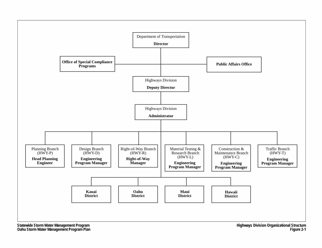
Statewide Storm Water Management ProgramOahu Storm Water Management Program Plan
Highways Division Organizational StructureFigure 2-1
Department of Transportation
Director
Highways Division
Administrator
Highways Division
Deputy Director
Planning Branch(HWY-P)
Public Affairs OfficeOffice of Special CompliancePrograms
Head PlanningEngineer
Design Branch(HWY-D)
EngineeringProgram Manager Engineering
Program Manager
Right-of-Way Branch(HWY-R)
Right-of-WayManager
Material Testing &Research Branch
(HWY-L)
Construction &Maintenance Branch
(HWY-C)Engineering
Program Manager
KauaiDistrict
MauiDistrict
OahuDistrict
HawaiiDistrict
Traffic Branch(HWY-T)
EngineeringProgram Manager
Oahu Storm Water Management Program Plan Part I: Program Administration
Chapter 2 2-3 March 2007 Program Organization
• Construction and Maintenance Branch – responsibilities include providing review and management services on statewide highway construction and maintenance programs, review of maintenance procedures and practices, and review and consolidation of district construction and maintenance budgets; and
• Traffic Branch – responsibilities include preparation of traffic design plans, managing the safety improvement and traffic systems management programs, and reviewing environmental documentation and application for permits.
The four districts are: • Oahu District, • Kauai District, • Maui District (includes the Islands of Maui, Molokai and Lanai), and • Hawaii District (Big Island).
The Oahu District is responsible for performing field inspections and field engineering of all Oahu highway construction projects, and the maintenance, alteration and repair of existing Oahu roadways and related structures. The Kauai, Maui and Hawaii Districts are responsible for the design, supervision of construction and maintenance of the State Highway System for their respective islands.
Some of the branches and districts listed above, or more precisely, the sections and units within some of these entities, currently have responsibilities under the Oahu SWMP. In addition, the current organizational structure of the Oahu SWMP includes staff of the “master consultant”, procured by HDOT Highways to provide services for the various functional areas of the SSWMP, as well as supporting the development and implementation of the Oahu SWMP.
To meet the requirements of previous Oahu MS4 permits, the Oahu SWMP was integrated within the formal organizational structure of HDOT Highways. Prior to the addition of the master consultant, responsibilities for managing and implementing the various functional areas of the Oahu SWMP were shared by the Oahu District, Design Branch, Material Testing and Research Branch, and the Construction and Maintenance Branch.
The Oahu District is responsible for the construction and maintenance of the highway network on Oahu, including the Oahu MS4, and therefore, was and continues to be heavily involved in Oahu SWMP activities and responsibilities. The sections within the Oahu District that have primary Oahu SWMP responsibilities include the Maintenance Section (HWY-OM), the Construction Section (HWY-OC), and the Tunnels Operation Section (HWY-OT). HWY-OC is responsible for construction activities within the highway rights-of-way on Oahu, including the construction activities that may add to or modify the Oahu MS4. HWY-OT is responsible for the operation and maintenance of Oahu’s tunnels, as well as other facilities, such as the Interstate H-1 Punahou Pump Station, that have storm water drainage implications.
HWY-OM is responsible for the maintenance, repair, and minor improvements of roadways, structures, landscaping, and appurtenant facilities associated with State highways on Oahu. Within HWY-OM, the Drainage Discharge Unit (DDU) was created in November 2000 to manage the Oahu SWMP. Its primary responsibility was to ensure that HDOT Highways was in compliance with the terms and conditions of the Oahu MS4 NPDES Permit. The unit was headed by a full-time Civil Engineer V, and in January 2005 was joined by a Civil Engineer III, a
Oahu Storm Water Management Program Plan Part I: Program Administration
Chapter 2 2-4 March 2007 Program Organization
Highway Construction Inspector III and a Highway Construction Inspector II. In addition to coordinating the Oahu SWMP, the DDU was also responsible for:
• Investigating complaints and potential violations regarding Oahu MS4; • Initiating enforcement actions, as needed; • Administering the drain connection and discharge permits to the Oahu MS4; • Providing in-house engineering and advisory services regarding discharges to the
Oahu MS4; • Performing construction plan review relative to discharges to the Oahu MS4; • Overseeing the storm drain inlet placard program; and • Preparing or coordinating the preparation of reports and other deliverables required by
the Oahu MS4 NPDES Permit.
In August 2004, an MS4 Task Force was established within HWY-O to support the DDU by taking over the administrative responsibility of compliance with the terms and conditions of the Oahu MS4 NPDES Permit. The unit was formed by volunteers from HWY-OC who were administratively assigned to the unit, and was headed by a Civil Engineer VI and supported by two Civil Engineer III positions, one Construction Inspector IV, and a clerk. In September 2005, DDU staff, although organizationally under HWY-OM, operationally began to report to the MS4 Task Force manager, which resulted in the formation of a consolidated group to manage the Oahu SWMP.
2.2.2 Current Structure
Figure 2-2 shows the current organizational structure of the Oahu SWMP within HDOT Highways that became effective in December 2005 with the addition of the master consultant. This structure is anticipated to be in place until at least September 8, 2009 when the current Oahu MS4 NPDES Permit expires. The figure shows the branches, sections, units and sub-units that are assigned specific responsibilities for managing or implementing various elements of the Oahu SWMP.
The MS4 Task Force/DDU group provides the overall management of the Oahu SWMP. The unit is involved in planning, organizing, directing and coordinating the functions and activities required to achieve the goals and objectives of Oahu SWMP. Other management responsibilities of the MS4 Task Force/DDU include:
• Preparing all reports required by the Oahu MS4 NPDES Permit; • Hosting monthly meetings with designated contacts to discuss implementation and
evaluation of the Oahu SWMP. • Coordinating and maintaining records, such as sign-in sheets for team meetings and
other data needed for the Oahu SWMP; • Participating in public information and education programs that address storm water
pollution, which may affect the Oahu MS4; and • Performing interagency coordination with City and County of Honolulu (City) and State
agencies.
The MS4 Task Force/DDU also manages the contract of the master consultant hired to provide program management and other services to assist HDOT Highways in complying with the terms and conditions of the Oahu MS4 NPDES Permit and the Consent Decree.
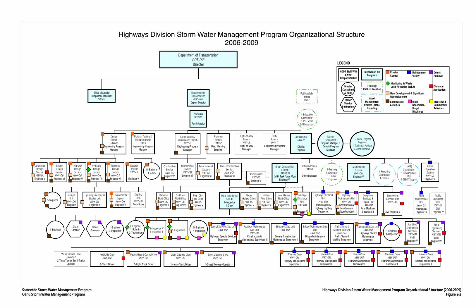
Statewide Storm Water Management Program Oahu Storm Water Management Program
Department of Transportation DOT-DIR Director
Department of Transportation
DEP-HWY Deputy Director
Public Affairs Office DIR-P
Office of Special Compliance Programs
DIR-CZ
Highways Division
Administrator
Right-of-Way Branch HWY-R
Right-of-Way Manager
Oahu District HWY-O
District
Engineer
Traffic Branch HWY-T
Engineering Program Manager
Office Services HWY-O
Office Manager
Urban Construction Section
HWY-OCU (MS4 Task Force Mgr)
Engineer VI
Traffic Operations
Unit HWY-OT
Civil Engineer IV
Design Branch HWY-D
Engineering Program Manager
Highway Design Section HWY-DD
Engineer VI
Technical Design Section HWY-DS
Engineer VI
Construction & Maintenance Branch
HWY-C Engineering Program
Manager
Maintenance Section
HWY-CM Engineer VI
Construction Section HWY-CC
Engineer VI
Rural Construction Section
HWY-OCR Engineer VI
Wahiawa Crew HWY-OM
Highway Maintenance Supervisor I
Leeward Crew HWY-OM
Highway Maintenance Supervisor II
Hauula Crew HWY-OM
Highway Maintenance Supervisor I
Windward Crew HWY-OM
Highway Maintenance Supervisor II
Honolulu Crew HWY-OM
Highway Maintenance Supervisor II
Special Services Sub Unit HWY-OM
Highways Special Services
Supervisor
Bridge Maintenance Sub Unit
HWY-OM Bridge Maintenance
Supervisor II
Structures Sub Unit HWY-OM
General Construction
Maintenance Supervisor I
Roadway Maintenance Sub Unit HWY-OM
Construction & Maintenance Supervisor III
Equipment Services & Repair Unit HWY-OM
Auto Mechanic Supervisor II
Water Tankers Crew HWY-OM
2-Truck Tractor Semi-Trailer Operator
Street Cleaning Crew HWY-OM
4-Street Sweeper Operator
Drain Cleaning Crew HWY-OM
1-Heavy Truck Driver
Debris Hazard Control Crew HWY-OM
3-Light Truck Driver
Herbicide Crew HWY-OM
2-Truck Driver
1-Reporting Coordinator 1-Planner
1-AMS Coordinator
1-Development Mgr
4-GIS/IT Support
1-Training Coordinator 1-Trainer
1-Engineer
1-Education Coordinator 1-PR Expert
2-PR Assistant
Material Testing & Research Branch
HWY-L Engineering Program
Manager
Pearl City Field Office
HWY-OC Engineer V
Kaneohe Field Office
HWY-OC Engineer V
Salt Lake Field Office
HWY-OC Engineer V
Administrator HWY-OC
Engineer V
MS4 Task Force 2-CE III
1-Inspector 1-Clerk
Street Sweeper
Drain Cleaner
1-Engineer 9-Inspector
Landscaping Sub Unit HWY-OM
Highways District Maintenance Supervisor
Traffic Signs & Marking Sub Unit
HWY-OM Traffic Signs &
Marking Supervisor
1-Engineer 1-Inspector
Drafting Unit
HWY-DH Technician
Environmental Support HWY-DH
Engineer V
3-Engineer
Research Program HWY-LR
Engineer VI
5-Engineer 1-CADD
Highways Electrical Unit
HWY-OM Traffic Signal &
Highway Lighting Supervisor
Master Consultant
Program Manager & Deputy Program
Manager
1-Senior Program Engineer
1-Technical Advisor 3-Administrative
Facilities Engineering
Services HWY-OM
Civil Engineer V
5-Engineer 4-Inspector
Highways Division Storm Water Management Program Organizational Structure (2006-2009) Figure 2-2
1-Engineer 1-Inspector IV 1-Inspector III
2-Engineer 1-Scientist
2-Technician
Erosion Control
Debris Removal
Maintenance Facility
New Development & Significant Redevelopment
Chemical Application
Construction Activities
Illicit Connection/Illegal Discharge
Industrial & Commercial Activities
Involved in All Programs
Asset Management
System (AMS)/ Reporting
Training/ Public Education
Master Consultant
& Subs
HDOT Staff With SWMP
Responsibilities
SWMP Service
Contractors
Monitoring & Waste Load Allocation (WLA)
LEGEND
Highways Division Storm Water Management Program Organizational Structure 2006-2009
Landscape Design Section HWY-DL
Engineer V
Tunnel Operation Section HWY-OT
Engineer V
Plant Maintenance
Unit HWY-OT
Mechanical Engineer IV
Engineering Services Unit
HWY-OM
Civil Engineer V
Field Engineering
Services HWY-OM
Civil Engineer V
Maintenance Section
HWY-OM Engineer VI
Bridge Design Section HWY-DB
Engineer VI
Hydraulic Design Section HWY-DH
Engineer VI
1-Engineer III
Drainage Discharge
Unit HWY-OM
Engineer V
Planning Branch HWY-P
Head Planning Engineer
Environmental Section HWY-CE
Engineer VI
Design Unit
HWY-DH Engineer
Hydrology & Special Studies Unit
HWY-DH Engineer V
Upper Halawa Office
HWY-OC Engineer V
Kilihau Field Office
HWY-OC Engineer V
Lower Halawa Field Office
HWY-OC Engineer V
Highways Maintenance Unit
HWY-OM Construction & Maintenance
Superintendent
Oahu Storm Water Management Program Plan Part I: Program Administration
Chapter 2 2-6 March 2007 Program Organization
The master consultant’s contract was executed on November 8, 2005 and official Notice to Proceed was issued on December 7, 2005. The contract is for three years with a possible one year extension, and is funded from the Oahu District’s Operations and Maintenance budget. Master consultant and sub-consultant personnel are involved in almost all facets of the Oahu SWMP, and therefore, the following positions are committed to the program:
• Full-time program manager; • Full-time deputy program manager; • Full-time program execution engineer; • Full-time field office administrator; • Three full-time engineers and planners; • Eight full-time inspectors; and • Engineers (civil and geotechnical), planners, environmental, information technology and
public information specialists, landscape architects, and topographic surveyors available on demand.
In addition to the master consultant and its sub-consultants, HDOT Highways is utilizing service contractors to perform certain maintenance-related tasks under the Debris Control BMP Program (see Section 9.1 for additional information).
As shown in Figure 2-2, other HDOT Highways branches, sections, units and sub-units have primary Oahu SWMP responsibilities. Specific roles and responsibilities among the MS4 Task Force/DDU, the master consultant and other HDOT Highways branches are described in detail in each of the program descriptions in Part II, Program Design. The information provided in Part II also includes designated contacts, and descriptions of position roles and responsibilities within the organizational structure.
Monthly Oahu SWMP status meetings are held with the MS4 Task Force/DDU and the master consultant to discuss various Consent Decree and MS4 NPDES Permit issues and to review the master schedule. In addition, monthly meetings are held with the HDOT Director and Deputy Director for HDOT Highways to provide briefings on the status the Oahu SWMP. Also, meetings are held with the HDOT Highways Administrator, the MS4 Task Force manager, various HDOT Highways staff with primary Oahu SWMP responsibilities, and the master consultant’s management group.
In addition to the regularly scheduled meetings, frequent meetings are held between HDOT Highways and the master consultant to discuss and coordinate issues relating to individual functional areas of the Oahu SWMP. It is typical for the staff of the HDOT MS4 Task Force/DDU and the master consultant to communicate daily to discuss details of various program elements. Frequent coordination efforts also occur between the designated HDOT Highways Oahu SWMP task leaders and their master consultant counterparts.
As mentioned above, the current HDOT Highways SWMP organization depicted in Figure 2-2 is anticipated to be in place until at least September 8, 2009 when the current Oahu MS4 NPDES Permit expires. Since the Consent Decree was entered on January 30, 2006, significant program efforts to date have been focused on meeting the numerous deadlines and submittals to HDOH and USEPA mandated by the Consent Decree, as well as by the Oahu MS4 NPDES
Oahu Storm Water Management Program Plan Part I: Program Administration
Chapter 2 2-7 March 2007 Program Organization
Permit that became effective on March 31, 2006 (see Section 1.2). At the same time, development of a comprehensive Oahu SWMP is a major effort that will require ongoing adjustments during the first year of the master consultant’s contract. After the first year, the subsequent three years will be focused on implementation of the program.
2.2.3 Future Structure
In order to assess the technical expertise and staffing levels necessary to effectively manage and implement the Oahu SWMP for the duration of the Oahu MS4 NPDES Permit, the current HDOT Highways structure with assistance from the master consultant’s staff will primarily become the basis for estimating personnel requirements for a future Oahu SWMP organization. Initial assessments of staff requirements for the Oahu SWMP are currently on-going. Assessments of the needs of each of the Oahu SWMP components or programs will be made to identify various issues, such as present organizational and technological capabilities, the nature of technical and field work, duties and management responsibilities of staff, skill level requirements, the number of personnel and equipment required, and functional relationships between Oahu SWMP component programs.
2.3 Coordination with the City and County of Honolulu
The Oahu SWMP activities include maintaining open communication with City agencies, such as the Storm Water Quality Branch of the Department of Environmental Services (ENV), and the Department of Design and Construction (DDC). The primary purpose of these communication activities will be to exchange information regarding specific incidents or commercial activities that are of concern to the City’s storm water pollution prevention efforts.
The Oahu MS4 NPDES Permit states that HDOT Highways “may fulfill portions of [the Public Education Program] requirement by cooperating with the [City] storm water public education program.” In addition, coordinating with the City’s program will promote some consistency between the City and State’s programs. Specific HDOT Highways/City coordination efforts include:
• Continuation of semi-annual coordination meetings to discuss their respective Oahu MS4 NPDES Permits and efforts to reduce pollutants;
• Continuation of their joint effort in producing an instructional video about construction BMPs for construction staff in which the City is developing the video and HDOT Highways contributes to funding the production;
• Attendance of City personnel in training sessions organized by the Oahu SWMP, such as the Construction Activities BMP training session in December 2005, and an Erosion and Sediment Control Compliance Assistance Workshop in April 2006; and
• Partnering with the City on certain public education activities, including: − Movie theater slides; − Adopt-A-Stream Program; and − Development of public education materials such as the Backyard Conservation
Booklet.
Oahu Storm Water Management Program Plan Part I: Program Administration
Chapter 2 2-8 March 2007 Program Organization
2.4 Enforcement Policy
Adherence to the requirements of the Oahu SWMP involves many others besides HDOT Highways and master consultant personnel. Since the Oahu MS4 NPDES Permit requires HDOT to “develop, implement and enforce a Storm Water Management Program Plan . . . [underscore provided]”, compliance with the Oahu SWMP is also required of non-Oahu SWMP entities, such as contractors hired to work on HDOT Highways projects, utility companies conducting work within HDOT Highways rights-of-way, and landowners or businesses holding permits for connections or discharges into the Oahu MS4 or whose properties indirectly discharge storm water runoff into the Oahu MS4. Because the activities of these entities have the potential to cause storm water pollution to enter into the Oahu MS4 and/or surface waters, and since HDOT Highways has oversight over their activities that can cause storm water pollution through the programs described in Part II of the Oahu SWMP Plan, an enforcement policy was developed for situations where such activities are in violation of the Clean Water Act, the promulgations of storm water regulations by the USEPA, and HRS Chapter 342D, Water Pollution, and/or the Oahu MS4 NPDES Permit or other NPDES general or individual permit.
The enforcement policy, which is provided in Appendix B.1, includes protocols and documentation standards and requirements. The protocols are triggered by the identification of a violation that cannot immediately be addressed by the offending party or where the offending party refuses to address the violation. Once triggered, the enforcement policy is sequentially escalating and contains the following elements as required by the Oahu MS4 NPDES Permit:
• Issuance of written documentation to the offending party (for those facilities that are inspected as part of the Industrial Discharge Program) within two weeks of identifying the storm water deficiency, including copies of all field notes, correspondence, photographs and sampling results, if applicable;
• A timeline for correcting deficiencies; and • Provisions for re-inspection and potential punitive actions, if necessary.
In the event that the HDOT Highways exhausts all available sanctions and cannot bring the offending party into compliance with local ordinances and/or the Oahu MS4 NPDES Permit, or otherwise deems the facility or actions of the offending party has an immediate and significant threat to water quality, the HDOT Highways will provide oral notification to HDOH within one week of such determination to be followed by providing copies of all inspection checklists, notes, photographs and related correspondence within two weeks of the determination.
2.5 Financial and Organizational Resources
HDOT Highways has committed significant financial, personnel, and equipment resources to fulfill the requirements of the Oahu MS4 NPDES Permit and Consent Decree, and to implement the Oahu SWMP. HDOT Highways’ funding plan extends into future years further demonstrating its commitment to the development of a comprehensive Oahu SWMP that will improve the water quality discharges from its Oahu MS4. The Oahu SWMP’s present and future expenditures are graphically shown in Figure 2-3, and are described in general below:
Oahu Storm Water Management Program Plan Part I: Program Administration
Chapter 2 2-9 March 2007 Program Organization
• Expenditures have been made to fund the efforts of the Debris Control BMP Program service contractors for street sweeping and storm drain inspection. This program will be budgeted indefinitely. Requests for increasing the street sweeping budget and for future pipe repair projects may be made.
• Labor and maintenance costs of HWY-OM in performing its various Oahu SWMP responsibilities are now part of its budget.
• Labor and other expenditures incurred by HWY-OC, including its MS4 Task Force/DDU, are now part of its budget.
• Labor and other expenditures by other HDOT Highways branches in executing their responsibilities as required by the Oahu SWMP are now part of their budgets.
• Construction contracts under the Erosion Control BMP Program (see Section 9.3) were budgeted and additional funds were requested for fiscal year 2008. Additional funds for the remediation and implementation of temporary erosion control BMPs at outfalls may be requested for in future years of the program.
• Other Oahu SWMP costs include requested expenditures for dewatering facilities, storm water quality monitoring efforts, including those conducted by USGS, and expenditures for the Environmental Management System Program.
• Funding amounts have been budgeted for the master consultant’s contract for fiscal years 2006 and 2007. Requests will be made to fund the master consultant’s contract for fiscal years 2008 and 2009.
In addition to the SWMP costs depicted in Figure 2-3, implementation of the Post-Construction SWM Program will incur costs for procuring additional right-of-way required for permanent BMPs, and their related design and construction costs.
HWY-O’s Operations and Maintenance (O&M) funds are the primary source of funding for the Oahu SWMP. The O&M funds come from the State Highway Fund revenues, which are generated from fuel taxes, motor vehicle weight taxes, rental motor vehicle and tour vehicle surcharge taxes, and vehicle registration fees. Presently, the Oahu SWMP will not generate any income because no fees are levied for connections or discharges to the Oahu MS4.
The process for requesting funding for the Oahu SWMP through the State budget is summarized as follows:
1. Budget proposals are prepared by the Oahu District Engineer and the various branch managers within the HDOT Highways for submittal to the Highways Division Administrator by April.
2. After review and revision by the Highways Division Administrator, the Highways Division budget proposal is submitted to the HDOT Director by August.
3. After review and revision by the HDOT Director’s office, the Highways Division budget proposal is submitted to the Department of Budget and Finance by September as a component of the total HDOT budget proposal.
4. After review and revision by the Department of Budget and Finance, the HDOT budget is incorporated into the entire State budget proposal and is submitted to the State Legislature by January. Legislative revisions and approval typically occur by May for implementation in the fiscal year beginning July 1.
Funding requests may be denied at any point throughout this process.
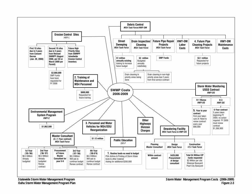
Statewide Storm Water Management Program Oahu Storm Water Management Program Plan
Erosion Control Sites HWY-L
First 10 sites due in 2 years from Consent Decree (Jan. 30, 2008)
Second 10 sites due in 2 years from Revised SWMPP (August 2008, per CD or March 2009 per Permit)
$2,000,000 SMP Funds have been requested for FY 2008
Future High Priority Sites from SWMPP Islandwide Erosion Control Inventory
Environmental Management System Program
HWY-C
$1,062,500
Master Consultant (3+1-Year contract)
MS4 Task Force
1st Year (‘05-’06)
$6.3 Million Already budgeted
2nd Year (‘06-’07)
$6.3 Million Already budgeted Renew contract
3rd Year (‘07-’08)
$6.3 Million Will ask to continue budget Renew contract
4th Year (‘08-0’9)
$6.3 Million Will ask to continue budget Renew contract
Procurement of Future Master
Consultant for year 5-9
Public Education DIR-P
1. Routine funds-no need to budget PSA Airtime & Printing of Storm Water book & other material Asking for additional $200,000
Dewatering Facility MS4 Task Force & HWY-DS
Planning Master Consultant
Design MS4 Task Force
$420,000 Procurement
of design consultant
Construction MS4 Task Force
Total $4 Million CIP -funds requested $2 Million per site: Waianae Baseyard Pearl City Baseyard
Within contract amount
Storm Water Monitoring USGS Contract
HWY-DS
H-1 Manoa HWY-DS
5. Year to year contract First year taken care of; Need to renew contract every year $90,000
5-Year contract 5 years taken beginning FY 2005; no action required FY 2009 must renew contract $1,366,900
H-3 HWY-DS
Storm Water Management Program Costs (2006-2009) Figure 2-3
Other Highways Division Charges
SWMP Costs 2006-2009
3. Personnel and Motor Vehicles for MS4/DDU
Reorganization
$1.12 million
SMP Funds
Street Sweeping
MS4 Task Force
$1 million annually existing Asking to increase future budget
Drain Inspection/Cleaning
MS4 Task Force
$3 million Budgeted annually indefinitely
Drain cleaning in priority areas being done
Drain cleaning in non-high priority areas due 2 years from first service contract
Future Pipe Repair Projects
MS4 Task Force
Debris Control MS4 Task Force/HWY-OM
HWY-OM Labor Costs
HWY-OM Maintenance
Costs
4. Future Pipe Cleaning Projects
MS4 Task Force
$3.1 million Requested for future projects
2. Training of Maintenance and MS4 Personnel
$600,000 Requested for future training
Oahu Storm Water Management Program Plan Part I: Program Administration
Chapter 2 2-11 March 2007 Program Organization
THIS PAGE INTENTIONALLY LEFT BLANK.

Oahu Storm Water Management Program Plan Part I: Program Administration
Chapter 3 3-1 March 2007 Asset Management System
CHAPTER 3 ASSET MANAGEMENT SYSTEM
The Oahu SWMP includes a comprehensive Asset Management System (AMS) that will provide program staff with tools for the efficient and effective management of information generated by the components of the program. The AMS will house and organize vast amounts of data, and provide the means to analyze this data through computerized processes and solutions. Much of the data will exist as geographic information system (GIS) databases or GIS layers, which allow for spatial analyses. In general, the AMS will provide the following support to the Oahu SWMP:
• An information repository capable of real time tracking of program activities; • Analytical and management tools; • Reporting support for each individual program; and • Mapping of the Oahu District’s storm drain system and storm water related
infrastructure.
Most of the programs described in Part II will be supported by an AMS module. An AMS module includes a set of computerized tools (toolsets) that would assist program managers or users in accessing or analyzing program-specific information for various purposes. These toolsets, to be defined through coordination with program managers, will result in developing business process diagrams, detailed data schematics, and diagrams depicting information connectivity. These diagrams and schematics will act as blueprints in developing each module by illustrating the information flows and processes that will be facilitated by the AMS. Figure 3-1 shows a simplified template for the development of business processes. Procedures for updating information and data used in the programs will be included in individual program modules.
3.1 System Development
During the initial planning phases of the AMS, a data development matrix was prepared, which listed the types of data needed for each program described in Part II. The data development matrix forms the backbone of the AMS system because it contains all the required files and attributes that will characterize the various components of the Oahu SWMP. Currently, the data development matrix contains over 50 types of data requirements, and the data or databases in the matrix are divided into the following three categories:
• Essential requirements – Data or databases explicitly required by either the Consent Decree or Oahu MS4 NPDES Permit;
• Critical requirements – Data or databases that are not specifically identified in the Consent Decree or Oahu MS4 NPDES Permit, but are nevertheless critical for the program to meet the requirements; and
• Connectivity requirements – Data or databases used to prioritize certain tasks, such as inspections, erosion control projects and street sweeping schedules, which require that they be linked and integrated (e.g., street sweeping scheduling require connectivity of information between the location of 303(d) water bodies and street sweeping routes).
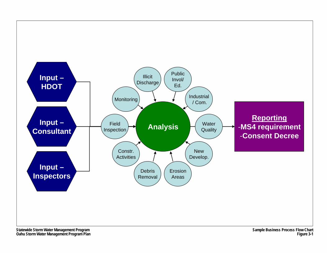
AnalysisInput –Consultant
Input –Inspectors
Input –HDOT
Reporting-MS4 requirement-Consent Decree
FieldInspection
Monitoring
Constr.Activities
DebrisRemoval
PublicInvol/Ed.
IllicitDischarge
Industrial/ Com.
NewDevelop.
WaterQuality
ErosionAreas
Statewide Storm Water Management ProgramOahu Storm Water Management Program Plan
Sample Business Process Flow ChartFigure 3-1

Oahu Storm Water Management Program Plan Part I: Program Administration
Chapter 3 3-3 March 2007 Asset Management System
Each required database or dataset contains a number of fields, also referred to as attributes that help describe an individual data entry or data record. Table 3-1 provides sample dataset and data field/attribute descriptions.
Table 3-1 Sample Dataset and Data Field Descriptions
Sample Dataset Sample Fields or Attributes
Data file Attribute 1 Attribute 2
Outfalls Culvert size Culvert type
Street Sweeping Route Name Sweeping Date Amount of Debris Collected
The data development matrix is designed to be flexible, able to expand as each of the Oahu SWMP programs evolve over time.
3.2 Oahu MS4 Mapping
An important dataset of the AMS is a comprehensive, computerized (GIS) mapping of HDOT Highways’ storm drain system (Oahu MS4), including storm drain inlets, outfalls, manholes, pipes, and open channels. The drainage features are identified through a combination of HDOT CADD files, as-built information, and field verifications. Each storm drain feature is being digitized, and assigned individual attributes and network connectivity. The inventory of the storm drain network will be used in conjunction with other pertinent and readily available information available in GIS, such as highway and roadway networks, land uses, topographic or contour maps, streams, watersheds, and aerial photography, to build toolkits for individual modules. In addition, some individual Oahu SWMP Plan programs require development of additional GIS inventory datasets, which is currently underway.
The initial base for the desktop solution became operational in early January 2006. Development of AMS modules will be prioritized based on whether they are “critical”; “essential” or have “connectivity” requirements as discussed in Section 3.1. Those requirements stated within the Consent Decree or Oahu MS4 NPDES Permit will be completed in accordance with their stipulated deadlines. The remainder of this chapter describes how the AMS will be utilized by the staff of the Oahu SWMP. In particular, this chapter will explain:
• AMS analytical, management and reporting tools that will be available to support the programs described in Part II;
• User interface with the AMS; and • Description of software and hardware requirements.
Oahu Storm Water Management Program Plan Part I: Program Administration
Chapter 3 3-4 March 2007 Asset Management System
3.3 AMS Support to Individual Programs
This section summarizes how the AMS will support the individual programs of the Oahu SWMP, which are described in greater detail in Part II. For each program, the AMS will provide the following information:
• Data Requirements & Analysis: For each program, the AMS will facilitate collection and analyses of data obtained through program activities and other sources. The analysis of the integrated data from various modules will result in water quality based recommendations.
• Reporting: Production of data summaries and tabular information about activities and accomplishments of each program to support the reporting requirements specified by the Oahu MS4 NPDES Permit, as well as to evaluate program effectiveness based on specified performance measures (see Chapters Twelve and Thirteen).
3.3.1 Public Education and Outreach
Under the Public Education and Outreach Program (Public Education Program), as described in Chapter Four, activities will be planned and implemented to increase public awareness about storm water pollution issues.
3.3.1.1 Data Requirements & Analysis
The AMS will provide the following support to the Public Education and Outreach Program:
1. Adopt-A-Stream Program (see Section 4.2.3.2): Providing an Adopt-A-Stream database where stream cleaning activities are tracked.
2. Public Website (see Section 4.2.1.5): Mapping capabilities, including information about the location and water quality data for water bodies throughout Oahu, that allow the public to view places of interest within their community, and view them in relation to watersheds or impaired streams.
3. General Support: Identifying targeted groups, such as property owners, schools, public office buildings, and other parcel owners that are located in priority watersheds or located near impaired streams and watersheds, using the GIS and parcel data that could be used to invite people to participate in the Adopt-A-Stream program, other clean up events and school outreach activities, as well as notifying them about public meetings and special events, sending them informational brochures or to solicit their input about certain programs of the Oahu SWMP Plan.
3.3.1.2 Reporting Support
For each reporting period, the AMS will provide tabular summaries about public reports of potential illicit discharge and illegal connections (also see Section 3.3.2.2).
Oahu Storm Water Management Program Plan Part I: Program Administration
Chapter 3 3-5 March 2007 Asset Management System
3.3.2 Illicit Discharge Detection and Elimination
The purpose of the Illicit Discharge Program, as described in Chapter Five, is to prevent, detect and remove illicit discharges and illegal connections into the Oahu MS4 from properties located adjacent to HDOT Highways rights-of-way.
3.3.2.1 Data Requirements & Analysis
The AMS will provide the following support to the Illicit Discharge Program:
1. Permitting (Licensing) of Oahu MS4 Connections (see Section 6.1): Providing databases of Oahu MS4 connection and discharge permit holders, which will be used to help schedule inspections of industrial and commercial properties or facilities (also see Section 3.3.6)
2. Investigations of parcels suspected of illicit discharges or illegal connections to the Oahu MS4 (see Section 6.2): a. Mapping of the estimated location of the suspected illicit discharge or illegal
connection, in addition to other pertinent data such as aerial imagery, drainage area, land use, soil information, topography, and land ownership;
b. Providing the location of all associated Oahu MS4 outfalls or flow paths by which the suspected illicit discharge or illegal connection could enter or affect State waters; and
c. Providing a database of potential illicit discharges or illegal connections, identified by tax map key (TMK), which includes fields on why cases were added to the database (e.g., follow-up investigations, public complaints, or outfall screening) tracking status of investigations, follow-up activities and resolution of cases (e.g., case closed because no discharge was found or case referred to enforcement actions).
3. Follow-Up Investigations (see Section 6.2.1): Storing the list of parcels identified in the Storm Water Questionnaire Survey of Parcels Adjacent to Highway Rights-of-Way (December 2000) (2000 Questionnaire Survey), and based on priority (Scheduling and tracking of investigations of these parcels will be conducted through the illicit discharges or illegal connections database).
4. Response to Public Complaints (see Section 6.2.2): Logging of incoming public complaints or reports of potential illicit discharges or illegal connections.
5. Oahu MS4 Outfall Field Screening (see Section 6.2.3) by: a. Providing the locations of all major and minor outfalls using the GIS database of the
Oahu MS4; and b. Prioritizing inspection areas utilizing land use and water quality data, such as the
locations of 303(d) listed water bodies vis-à-vis the locations of major/minor outfalls.
Oahu Storm Water Management Program Plan Part I: Program Administration
Chapter 3 3-6 March 2007 Asset Management System
3.3.2.2 Reporting Support
For each reporting period, the AMS will produce the following information for the Illicit Discharge Program in summary and tabular formats:
• New Oahu MS4 connection and discharge permits; • Completed investigations of possible illicit discharges or illegal connections stemming
from the 2000 Questionnaire Survey, public complaints or reports and outfall screening, including the results of such investigations (e.g., case closed, warning letters, enforcement actions, remedial measures, etc.);
• Public complaints or reports of possible illicit discharges or illegal connections; and • Outfall screening activities (numbers, locations, etc.).
3.3.3 Construction Site Runoff Control Program
The Construction Program, as described in Chapter Seven, ensures that all construction projects initiated, approved or permitted by HDOT Highways, have received NPDES approval from HDOH, if applicable, and include plans for site-specific construction BMPs, if appropriate.
3.3.3.1 Data Requirements & Analysis
The AMS will provide the following support to the Construction Program:
2. Inspections (see Section 7.4): a. Maintaining a database of all active construction (contract, in-house, maintenance
and encroachment) projects for inspection; and b. Providing user interface for inspectors to record initial and periodic inspection
activities of construction BMPs.
Initial program components will be tracked using a series of spreadsheets. As the AMS develops, these spreadsheets will be incorporated into the AMS databases.
3.3.3.2 Reporting Support
For each reporting period, the AMS will produce the following information for the Construction Program in summary and tabular formats:
• Contract, in-house, maintenance and encroachment projects, which require NPDES coverage, that underwent initial construction BMP inspections; and
• Contract, in-house, maintenance and encroachment projects that underwent at least one periodic inspection during the reporting period.
3.3.4 New Development and Significant Redevelopment BMP Program
The Post-Construction Storm Water Management in New Development and Significant Redevelopment Program (Post-Construction SWM Program), as described in Chapter Eight, involves the review of new development and significant redevelopment projects so that they
Oahu Storm Water Management Program Plan Part I: Program Administration
Chapter 3 3-7 March 2007 Asset Management System
include permanent BMPs, if appropriate, as well as evaluating what improvements can be made to the Oahu MS4 to improve the quality of storm water discharges that empty into 303(d) water bodies.
3.3.4.1 Data Requirements & Analysis
The AMS will provide the following support to Post-Construction SWM Program:
1. Design Review (see Section 8.2.2): Providing user interface and database for program staff to record the status of contract and encroachment projects undergoing plan or construction documents reviews to verify that all applicable projects include appropriate permanent BMPs if required based on the Unified Criteria (see Section 8.1.1) and Permanent BMP Manual and Specifications (see Section 8.1.2); and
2. Operations and Maintenance (see Section 8.2.4): a. Providing a permanent BMP database with GIS capabilities, which will include the
following information: i. Project name, ii. Owner, iii. Location, iv. Project construction start date / end date, v. Type and number of source control BMPs, vi. Type and number of treatment control BMPs, vii. Latitude/longitude coordinates of controls using GPS and NAD 83 datum, viii. Photographs of controls, ix. Operation and maintenance requirements, including frequency, and x. Frequency of inspections; and
b. Providing GIS mapping to help inspectors locate the permanent BMPs and information of any previous problems that have occurred at any site.
3. Retrofit Feasibility Study (see Section 8.3): Providing the following spatial and other information to assist the feasibility study: a. Roadway network; b. Oahu MS4 drainage areas; c. 303(d) listed streams, beaches and bays for sediment, turbidity and trash; d. Permanent BMP types and locations; e. Monitoring data locations and results; f. Storm drain network including inlets, pipes and outfalls; g. Contours; h. Soils and land use data; and i. Results of inspection data.
3.3.4.2 Reporting Support
For each reporting period, the AMS will summarize and produce tabular information about contract and encroachment projects that were reviewed for required permanent BMPs, and the results of the review (i.e., require or not require permanent BMPs).
Oahu Storm Water Management Program Plan Part I: Program Administration
Chapter 3 3-8 March 2007 Asset Management System
3.3.5 Pollution Prevention and Good Housekeeping Program
The Pollution Prevention and Good Housekeeping Program, as described in Chapter Nine, consists of four sub-programs with AMS connections: Debris Control BMP Program, Erosion Control BMP Program, Maintenance Facilities BMP Program, and Storm Water Pollution Control for Flood Control Projects. The Debris Control BMP Program provides the framework to manage HDOT Highways personnel and service contractors that sweep highways and clean the Oahu MS4. The function of the Erosion Control BMP Program is to identify erosional areas within highway rights-of-way based on water quality concerns, and to implement erosion control projects to address these areas. The Maintenance Facilities BMP Program largely consists of preparing and implementing Storm Water Pollution Control Plans (SWPCP) for the baseyards. The final sub-program provides assistance to HDOT Highways personnel who have responsibility for maintaining the storm water pump station at the H-1 Freeway Punahou Street overpass.
3.3.5.1 Data Requirements & Analysis
The AMS will provide the following support to the Pollution Prevention and Good Housekeeping Program:
Debris Control BMP Program
1. Street Sweeping and Storm Drain Cleaning (see Section 9.1.1): a. Providing a street sweeping database; b. Providing a storm drain cleaning database, which is linked to the overall Oahu MS4
database (see Section 3.2); c. Periodically prioritizing street sweeping and storm drain inspection schedules
based on collected data (e.g., cubic yards of debris removed or cleaned) and water quality information (e.g., location of drainage infrastructure in relation to 303(d) water bodies); and
d. Maintaining a database of vehicles and equipment used for street sweeping and storm drain cleaning, which includes information of the different types of equipment used and where they are stored.
Oahu Storm Water Management Program Plan Part I: Program Administration
Chapter 3 3-9 March 2007 Asset Management System
2. Management System (see Section 9.1.2): a. As noted in Section 3.2, a complete inventory of the Oahu MS4,including the tools to
update the system as new features are added; and b. A process to verify mapping accuracy of the storm drain features by inspectors
during regularly scheduled inspections using their GPS/PDA units.
3. Informational Placards (See Section 9.1.3): a. Developing a list of storm drain inlets for priority installation of placards based on
proximity to industrial and commercial land uses and other factors; and b. Interfacing with GIS database of the Oahu MS4 (see Section 3.2) to include fields
about the number and location of informational placards.
Erosion Control BMP Program
1. Identification of Erosional Areas (see Section 9.3.2): a. Providing a GIS database of the erosional areas identified in the Islandwide
Assessment; and b. Assisting program staff through spatial analysis of erosional areas in relation to
303(d) water bodies and other geographic information (e.g., Oahu MS4, contours, etc.).
2. Remediation Measures (see Section 9.3.3): Providing a GIS database of implemented remediation measures, first at the high priority erosion areas and then at the next high priority areas identified in the Islandwide Assessment.
3. Erosion Potential at Storm Drain Outfalls (see Section 9.3.4): a. As noted above under AMS support of the Debris Control Program, verifying the
outfall location information through inspections, and inputting the following information collected by inspectors: i. Outfall size, type and general condition, ii. Presence and type of velocity dissipation measures, if any; iii. Drainage area and its general condition (i.e., level of erosion), iv. Visual assessments of water flowing from outfall, v. Quality of outfall runoff, vi. Pollution near or in proximity to outfall area, vii. Photographs of outfall and surrounding area, and viii. GPS coordinates of outfall location;
b. Assisting program staff in the evaluation of erosion potential at outfalls by providing the following information in addition to the information above collected by inspectors: i. Locations of 303(d) (with sediment listed as pollutant) water bodies in relation to
outfalls, ii. Distance between outfalls and receiving waters (distance from outfall to the
“blue-line” stream / waterway), iii. Classification of receiving water bodies, iv. Steepness (slope), types of soils and erosion potential at outfall drainage areas,
and
Oahu Storm Water Management Program Plan Part I: Program Administration
Chapter 3 3-10 March 2007 Asset Management System
v. Availability of space (within HDOT right-of-way) for installing velocity dissipators or other BMPs, such as stilling basins or forebays.
Maintenance Facilities BMP Program
1. Storm Water Pollution Control Plans (see Section 9.4.2): a. Storing the latest versions of the Storm Water Pollution Control Plans (SWPCP) for
each baseyard; b. Providing storage for the results of quarterly inspections of baseyards; and c. Maintaining a database of equipment used for maintenance within the baseyards,
which includes information of the different types of equipment used, and where they are stored.
2. Dewatering Facilities (see Section 9.4.5): Providing mapping of the locations of the dewatering facilities.
3.3.5.2 Reporting Support
For each reporting period, the AMS will produce the following information for the Pollution Prevention and Good Housekeeping Program in summary (e.g., aggregate) and tabular formats:
Debris Control BMP Program: • Highway sweeping activities, including:
− Dates (including adherence to schedules) in which specific highway segments (by mileposts) were swept, and
− Amount of debris removed during street sweeping events; • Storm drain cleaning activities, including:
− Dates (including adherence to schedules) in which specific storm drain structures (e.g., inlet catch basins, pipes and open ditches or trenches) were inspected and cleaned, and
− Amount of debris removed during storm drain cleaning events; and • Placard installations.
Maintenance Facilities BMP Program: quarterly baseyard site inspections.
Storm Water Pollution Control for Flood Control Projects Program: Monthly inspection and maintenance activities at the Punahou Pump Station.
3.3.6 Industrial and Commercial Activities Discharge Management Program
The Industrial and Commercial Activities Discharge Program (Industrial Discharge Program), as described in Chapter Ten, is designed to address pollutant discharges into the Oahu MS4 originating from industrial and commercial areas.
Oahu Storm Water Management Program Plan Part I: Program Administration
Chapter 3 3-11 March 2007 Asset Management System
3.3.6.1 Data Requirements & Analysis
The AMS will provide the following support to the Industrial Discharge Program:
1. Database Inventories (see Section 10.1): Providing a database of industrial and commercial facilities and activities that are indirectly discharging into the Oahu MS4 of the types described in Section 10.1, and will include the following characteristics: a. Created from:
i. Findings from the 2000 Questionnaire Survey, ii. Available information about zoning, facility activities, land use, and parcel
ownership from the City and the State, iii. Collection of new information obtained during field activities, and iv. Readily available intra-agency informational databases; and
b. Fields will include: i. Priority area, ii. Facility name, iii. Street address, iv. TMK, v. Nature of business or activity, vi. SIC code(s) that best reflect the facility product(s) or service(s), vii. Principal storm water contact, and viii. Receiving state water; and
c. Inspection information repository.
2. Inspections of Industrial and Commercial Facilities (see Section 10.2): a. Scheduling and tracking inspections of industrial and commercial facilities holding
connection permits; b. Prioritizing or ranking industrial and commercial facilities or dischargers that do not
have direct connections to the Oahu MS4 for inspections using the following information: i. Number of industrial and commercial facilities in a particular area, ii. Density of industrial and commercial facilities, iii. Previous storm water violations in the area, iv. Water quality impairments, and v. Distance to 303(d) listed streams or water bodies;
c. Scheduling and tracking inspections of industrial and commercial facilities or dischargers that do not have direct connections based on whether or not such facilities have or require NPDES coverage;
d. Producing inspection reports and tracking correspondence with HDOH, which would receive the reports within two months of the inspection, and other parties, such as facilities found to be in violation; and
e. Maintaining electronic records, in addition to paper records, of all inspection activities.
3. Enforcement (see Section 2.4 and 10.3): As noted above, tracking enforcement correspondence with violators, and scheduling and tracking follow-up activities (e.g., inspections of remediation measures).
Oahu Storm Water Management Program Plan Part I: Program Administration
Chapter 3 3-12 March 2007 Asset Management System
3.3.6.2 Reporting Support
For each reporting period, the AMS will produce the following information for the Industrial Discharge Program in summary and tabular formats:
• Completed investigations of industrial and commercial facilities holding connection permits, including the results of such investigations (e.g., case closed, warning letters, enforcement actions, remedial measures); and
• Completed investigations of industrial and commercial facilities indirectly discharging into the Oahu MS4, including the results of such investigations.
3.3.7 Water Quality Monitoring and Waste Load Allocations
The Water Quality Monitoring and Waste Load Allocations program, as described in Chapter Eleven, will be used to assess the Oahu MS4’s relative contribution to nutrient loads and other water quality waste loads, which will assist in the implementation of Waste Load Allocations (WLA) designated to HDOT Highways for the Ala Wai Canal, Kawa Stream, Waimanalo Stream and other watersheds.
3.3.7.1 Data Requirements and Analysis
The AMS will provide the following support to the Water Quality Monitoring program:
1. Annual Monitoring Plan (see Section 11.1): a. The ability to assess Oahu MS4 outfalls as identified in the implementation plan
described above; b. Ability to characterize major outfalls drainage areas; c. Assist in developing the monitoring approach for each monitoring station; and d. Assist in selecting water quality monitoring locations.
2. Waste Load Allocations (see Section 11.2): a. Provide the ability to identify the locations of Oahu MS4 outfalls within each WLA
watershed covered in this program (Ala Wai Canal, Kawa Stream and Waimanalo Stream);
b. Provide land use and hydrological information associated with each major Oahu MS4 outfall within the program’s WLA watersheds;
c. Provide mapping and other information to assist program staff in conducting watershed reconnaissance;
d. Assist in identifying HDOT Highways activities within the watershed relating to waste loads, which are being tracked in other programs of the Oahu SWMP (e.g., street sweeping data); and
e. Assist in identifying and evaluating load reduction best management practices (BMPs) from permanent BMPs, which are inventoried and tracked in the Post-Construction SWM Program.
Oahu Storm Water Management Program Plan Part I: Program Administration
Chapter 3 3-13 March 2007 Asset Management System
3.3.7.2 Reporting Support
For each reporting period, the AMS will produce the following information for the Water Quality Monitoring Program in summary and tabular formats:
• Results of water quality monitoring of the Halawa Stream watershed; and • Results of water quality monitoring of the Ala Wai Canal, Kawa Stream and Waimanalo
Stream watersheds.
Oahu Storm Water Management Program Plan Part I: Program Administration
Chapter 3 3-14 March 2007 Asset Management System
THIS PAGE INTENTIONALLY LEFT BLANK.

PART II
PROGRAM DESIGN
Oahu Storm Water Management Program Plan Part II: Program Design
Chapter 4 4-1 March 2007 Public Education and Outreach
CHAPTER 4 PUBLIC EDUCATION AND OUTREACH
The Public Education and Outreach Program (Public Education Program) consists of two basic components: training for HDOT Highways and other personnel responsible for some aspect of the Oahu SWMP and public outreach.
The training component administers the training programs needed for the various programs of the Oahu SWMP described throughout Part II. These training sessions serve to not only train HDOT Highways employees and contractors on how they can implement BMPs, but more importantly, these sessions will educate them on storm water management and environmental concerns. Understanding why it is important to implement BMPs will give them a sense of purpose relating to storm water management and may lead to behavioral changes.
The public outreach component addresses the need to inform the general public about how their daily activities can have profound effects to the quality of State waters.
4.1 Training Program
The training component of the Public Education Program includes the types of training activities that are needed for the following programs of the Oahu SWMP Plan:
• Illicit Discharge Detection and Elimination - provides instruction to field inspectors and others involved in this program on the methods used to detect and report illicit discharges and illegal connections from properties adjacent to or near HDOT Highways rights-of-way;
• Construction Site Runoff Control - provides instruction to parties involved in HDOT Highways construction activities (e.g., HDOT Highways personnel, consultants, contractors) regarding the information contained in the Construction Activities Best Management Practices Field Manual (Construction BMP Manual);
• Post-Construction Storm Water Management in New Development and Significant Redevelopment - provides instruction to those planning, designing and reviewing projects regarding the information provided in the Permanent Best Management Practices Manual (Permanent BMP Manual);
• Pollution Prevention and Good Housekeeping: − Debris Control BMP - provides instruction to those responsible for inspecting and
conducting the sweeping of roadways and cleaning of drainage structures, − Chemical Applications BMP - provides instruction to those responsible for applying
fertilizers, pesticides, and herbicides on HDOT Highways rights-of-way, − Erosion Control BMP - provides instruction to HDOT Highways maintenance
personnel on the installation and implementation of temporary erosion control BMPs, and
− Maintenance Facilities BMP - provides instruction to those who operate and maintain Oahu District baseyards and other maintenance facilities on pollution prevention and good housekeeping practices; and
• Industrial and Commercial Activities Discharge Management - provides instruction to field inspectors on the methods to detect and report illicit discharges from industrial
Oahu Storm Water Management Program Plan Part II: Program Design
Chapter 4 4-2 March 2007 Public Education and Outreach
and commercial properties subject to storm water runoff that discharge into the Oahu MS4.
A Public Education and Training Plan, which is provided in Appendix C.1, includes descriptions of the training programs listed above. Sections 6.6, 7.5, 8.4, 9.1.4, 9.2.2, 9.3.5, 9.4.4 and 10.4 also provide more information about these training activities, including the following information:
• Training recipients (i.e., who is being trained) • Qualifications of the trainer; • Training methods; • Topic areas:
− Review of applicable program objectives and performance measures, − Selection and implementation of appropriate BMPs, and − Review of appropriate storm water regulations and permits (including the terms of
the Consent Decree); and • Training schedule.
In general, the training programs are directed to those involved in implementing the Oahu SWMP and those having to comply with its provisions and requirements. These recipients include HDOT Highways employees, consultants involved in the planning, design and construction management of HDOT Highways projects, construction contractors, those seeking to work on HDOT Highways projects, and service contractors hired to maintain the highway system, including the Oahu MS4. Consultants and contractors responsible for implementing any Oahu SWMP activity will receive training equivalent to that provided to HDOT Highways personnel in all applicable areas.
The status of training activities will be described in Mid-Year and End-of-Year reports (see Chapter Thirteen). The reports will list the number of training sessions for each program, and include the names and affiliation of training recipients for each session.
4.2 Public Outreach
The public outreach component of the Public Education and Training is essential in gaining public support for the objectives of the Oahu SWMP. The Public Education and Training Plan (see Appendix C.1) describes the elements of the public outreach, which combines a mix of strategies, techniques, and informational campaigns that target the general public as well as certain audiences, such as school children and native Hawaiian groups. The central message to the public would be how pollutants carried by storm water can cause the environmental degradation of State waters, which includes streams, beaches and ocean, and how the public can help to prevent or reduce this source pollution.
The message and topics will be communicated to the public. HDOT Highways will: • Continue expanding and partnering with successful public volunteer programs that not
only directly reduce pollution and clean-up the environment, but also educate the public;
• Work with major retailers to educate the public on the proper use and disposal of household toxins, such as motor oil, pesticides, herbicides, and fertilizers;
Oahu Storm Water Management Program Plan Part II: Program Design
Chapter 4 4-3 March 2007 Public Education and Outreach
• Develop public service announcements that use commercial radio, television and/or print media;
• Establish a program website that may be used to provide useful storm water and water pollution information to the general public, and provide the means for the public to report potential illicit discharges or illegal connections;
• Reach out to Oahu schools through special educational workbooks; • Take advantage of special events to convey the clean water message to the general
public and partner with agencies and neighborhood, civic and environmental organizations that are interested in clean water issues; and
• Conduct a survey of Oahu residents to measure both behavior and knowledge relating to storm water.
This public outreach component of the Public Education Plan may not encompass all outreach activities that may occur during the duration of the Oahu MS4 NPDES Permit. As the program matures, additional opportunities may arise and be integrated into the program.
4.2.1 Media Outreach
4.2.1.1 Radio and Television Public Service Announcements
Public Service Announcements (PSAs) that broadcast via radio and television can reach a large segment of the population. The City ENV has developed many successful PSAs and movie trailers as part of their education and outreach efforts. HDOT Highways will explore partnering with the City ENV as new PSAs are developed, extending the reach of the message wherever possible.
By the third year of the permit, HDOT Highways will develop its own PSAs, but will also seek to partner with the City ENV. Strategically launching a flight of HDOT Highways’ PSAs will allow a message to be spread over a longer period of time. Using a combination of paid and free time on both radio and television ensures the best possible rates and times for HDOT Highways’ PSAs.
4.2.1.2 Print Advertisements
Printed advertisements attract a different and more specific population than radio and television. The print PSAs will be used to announce special events (e.g., Earth Day) or to recognize people who have made a significant effort to reduce pollutions in our streams and ocean waters. For example, the PSAs may be used to recognize Hawaii State Science Fair Award winners. In general, the two major dailies, the Honolulu Advertiser and the Honolulu Star Bulletin, would be used for those print PSAs that are targeted to a more general audience.
Community or alternative newspapers or publications will be used for printed PSAs that target specific populations, such as those living in certain neighborhoods. They include, but not necessarily are limited to:
• Mid-Week; • Ka Nupepa;
Oahu Storm Water Management Program Plan Part II: Program Design
Chapter 4 4-4 March 2007 Public Education and Outreach
• Leeward Current; • North Shore News; • Na Lono Kula (News for Schools); • Ka Wai Ola (Office of Hawaiian Affairs); • Hawaii Army Weekly (Schofield Barracks); • Hawaii Navy News (Pearl Harbor Naval Base); • Hickam Kukini (Hickam Air Force Base); • The Honolulu Weekly; and • The Downtown Planet.
In addition, PSAs will be placed in foreign language newspapers or publications in order to reach those who do not have access to major radio, television or printed media due to language barriers.
Other forms of printed media that may be good outlets for PSAs include: • TheBus advertisement placards, which could be used for specific messages, such as
asking riders not to litter or leave cigarette butts at bus stops; • Large (i.e., 30”x40”) posters that can be placed in private places, such as in offices,
workplaces, construction sites, and retail stores where a large numbers people may be able see them; and
• Movie trailers, which the City uses for its PSAs (In the past, HDOT has co-sponsored these types of ads with the City).
4.2.1.3 Brochures
Brochures will be used in conjunction with other outreach activities (e.g., special events), and when used with PSAs, can augment the program message. To date, HDOT Highways has coordinated with other agencies in producing the Backyard Conservation Brochure that provides information about residential conservation techniques and recommendations. The brochure was developed by the City, and was co-sponsored by HDOT Highways, who has been coordinating with other agencies to distribute the brochure. Home Depot and City Mill agreed to distribute the brochure, and the brochure is also being distributed at special events (see Section 4.2.2.3), and is also part of the household toxins awareness component (see Section 4.2.3.1).
Beginning in the second year of the permit, specific brochures, which will all have consistent branding (e.g., SSWMP logo, etc.), may be developed and distributed.
4.2.1.4 Collateral Materials
Collateral materials featuring the SSWMP logo and other symbols, pictures, and/or phrases that represent the program will be used as “leave behinds” during special events and informational meetings (see Sections 4.2.2.3 and 4.2.2.4). Items, such as refrigerator magnets, key chains, and zipper pulls, have been shown to have success in maintaining awareness about various types of programs.
Oahu Storm Water Management Program Plan Part II: Program Design
Chapter 4 4-5 March 2007 Public Education and Outreach
4.2.1.5 Public Website
The Internet is a powerful means to disseminate information. Using the domain name “StormWaterHawaii.com”, the following information and services will be provided through the public website:
• General water pollution information for the public, including a hotline telephone number for reporting illicit discharges or illegal connections;
• Information about training activities for HDOT Highways employees and other personnel;
• Web links to organizations that have adopted watersheds; and • Links to agency websites, such as the HDOH and USEPA websites, that contain
information about water pollution.
4.2.2 Educational Outreach
4.2.2.1 School Visitations
The first two years of the permit will be used to develop relationships with Oahu elementary schools whose teachers have shown an interest in storm water pollution. These schools will be asked to participate in a “Stick it to Storm Water” workbook, targeted for grades one to four that features a mascot and interactive activities to show children how they can help prevent storm water pollution. The workbook will also include a “Name Our Mascot” contest.
HDOT Highways recognizes that Hawaii schools are under tremendous pressure to meet No Child Left Behind requirements. Therefore, HDOT Highways will work with HDOE curriculum development specialists to devise messages that address grade level standards to make visits and brochures helpful in meeting the standards.
4.2.2.2 Science Fair Awards
Science Fairs are held in schools throughout Hawaii. HDOT Highways will provide awards to students with outstanding science fair projects focusing on clean water. The award categories may include such topics as:
• Water testing and measurement; • Storm water management; • Ahupua‘a management; and • Effects of clean versus dirty water.
HDOT Highways will attempt to promote storm water awareness to encourage students to consider storm water pollution as their science topics.
4.2.2.3 Special Event Participation
Events that relate to storm water are held throughout the year. HDOT Highways will keep a list of upcoming storm water and clean water related events, and will plan to participate in at least

Oahu Storm Water Management Program Plan Part II: Program Design
Chapter 4 4-6 March 2007 Public Education and Outreach
two per year for either a presentation, or to hand out program materials. HDOT Highways has already participated in the following events in partnership with the City:
• Discover Moiliili Day • Windward Ahupua’a Make A Difference Day • Makiki Stream Make A Difference Day • Pouhala Marsh Make A Difference Day • Nanakuli Make A Difference Day
Because the following events occur annually, HDOT Highways will participate in as many of these as possible to build relationships with the sponsoring organization or agency:
• Children and Youth Day, which is held at the State Capitol; • Keiki Fest held by Straub Clinic and at Bishop Museum; • Malama i ke Kai, a festival held by Punana Leo o Kawaiaha‘o that encourages people to
care for the ocean; • Kokua Concert held by Friends of Jack Johnson associated with Earth Day activities; • Discover Moiliili Day held by the Ala Wai Watershed Association; • Schofield Barracks Fourth of July event; and • Made in Hawaii Show.
4.2.2.4 Informational Meetings
The HDOT Director or his staff plans to take advantage of opportunities to speak about the Oahu SWMP to City neighborhood boards. Also, HDOT Highways will also actively pursue partnerships with agencies and organizations that have a stake in or have responsibilities to keep Hawaii’s waters clean, such as:
• City ENV; • Honolulu Board of Water Supply; • University of Hawaii; • Ala Wai Watershed Association; and • Bishop Museum.
During the third and fourth years of the permit, meetings will be pursued with other community groups to educate them about storm water issues and the Oahu SWMP, such as:
• Hawai‘i Water Environment Association; • Malama Hawaii; • Sierra Club; • The Outdoor Circle; • Waikiki Rotary, Environmental Committee; • Waikiki Business Association; and • Hawaii Chamber of Commerce Environmental Committee.
4.2.3 Program Outreach
While media and education outreach programs are effective in disseminating information, the activities described in this section will provide an opportunity for constant exposure to the program message.
Oahu Storm Water Management Program Plan Part II: Program Design
Chapter 4 4-7 March 2007 Public Education and Outreach
4.2.3.1 Household Toxins Awareness Program
The Household Toxins Awareness Program is meant to provide information for the proper management, disposal and recycling of used oil, vehicle fluids, toxic materials, and other household hazardous wastes, such as fertilizers, herbicides and pesticides. The program may develop or use existing brochures about the safe use and disposal of household toxins, including identifying how and where people may dispose of hazardous wastes (e.g., the location of collection sites). The brochures will be based on USEPA information, but tailored for a local audience.
Once brochures are developed, HDOT Highways plans to work with stores and other retailers, such as Home Depot and City Mill, to have them carry the brochures, and to pass out the brochures whenever someone purchases the following household toxins:
• Paints; • Pesticides; • Fertilizers; • Herbicides; • Motor oil and materials used for changing motor oil; and • Car washing detergents or polishes.
If successful, the program may be expanded to other retailers who sell one or more of the above products, such as automotive parts and supply stores.
4.2.3.2 Adopt-A-Stream Program
HDOT Highways may continue to support the City’s Adopt-A-Stream program. In the past, this support involved providing supplies for clean-up events, such as gloves and trash bags, as well as manpower. HDOT Highways is further pursuing this partnership with the City and other organizations interested in cleaning Oahu’s streams, such as the Ala Wai Watershed Association who has been actively cleaning and re-planting streams in the Ala Wai Watershed for the past eight years.
HDOT Highways does not plan to “re-invent the wheel” in its partnership with the City’s Adopt-A-Stream program. Instead, HDOT Highways could use the same or similar approaches as the City and the Ala Wai Watershed Association in targeting efforts on the following watersheds (see Figure 4-1):
• Ala Wai, which includes tributary Makiki, Manoa and Palolo Streams; • Kawa Stream in Kaneohe; • Kaelepulu Stream in Kailua; and • Waimanalo Stream in Waimanalo.
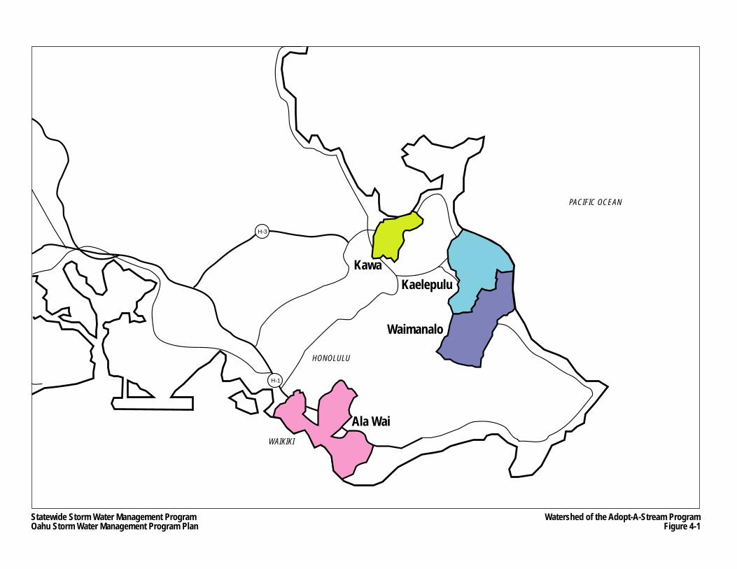
WAIKIKI
HONOLULU
PACIFIC OCEAN
H-3
H-1
Ala Wai
Kaelepulu
Waimanalo
Kawa
Statewide Storm Water Management ProgramOahu Storm Water Management Program Plan
Watershed of the Adopt-A-Stream ProgramFigure 4-1
Oahu Storm Water Management Program Plan Part II: Program Design
Chapter 4 4-9 March 2007 Public Education and Outreach
4.2.3.3 Adopt-A-Highway
The ongoing Adopt-A-Highway program, which is administered by HDOT Highways, has been successful in reduce littering and illegal dumping on State highways. The program solicits businesses and other organizations to volunteer to help clean debris and materials from highway right-of-way that they “adopt.” Currently on Oahu, approximately 50 active groups are participating in the program. Not only do those who volunteer become more aware about the detrimental effects of highway littering and debris, but the general public may also become more aware of the same effects by observing the signage and the volunteers.
4.2.4 Implementation
4.2.4.1 Annual Survey
A survey will be conducted each year of the permit to evaluate whether or not public outreach activities are making any progress in increasing public awareness and knowledge about environmentally responsible practices relating to storm water and pollution. Survey results will be compared with previous surveys.
HDOT Highways is currently working with the City ENV to jointly develop and implement a survey that addresses both the City ENV’s and HDOT Highways’ public outreach activities.
4.2.4.2 Schedule
The public outreach schedule is provided on Table 4-1. It shows public outreach activities completed in the past and anticipated for each fiscal year during the life of the Oahu MS4 NPDES Permit. As noted in Section 1.2, the permit became effective on March 31, 2006, which is the reason year 1 was set between July 2005 and June 2006.
4.3 Organizational Structure
The MS4 Task Leader oversees the development of the various components of the Public Education Program. The head of the HDOT Highways Office of Public Affairs is the liaison between the HDOT Director and the master consultant. The MS4 Task Force/DDU administers the informational placard program, and HWY-OM’s Permits Civil Engineer V, oversees the Adopt-A-Highway program.
The master consultant will be responsible for implementing the training programs described throughout Part II. The master consultant will also be responsible for first developing the details of the public outreach and education plan, and next, implementing its components, such as publishing and distributing brochures and arranging to broadcast PSAs. Throughout the development and implementation of the training and public outreach elements of the Public Education Program, the master consultant will coordinate closely with the Office of Public Affairs, the Oahu District Engineer and the MS4 Task Force manager.
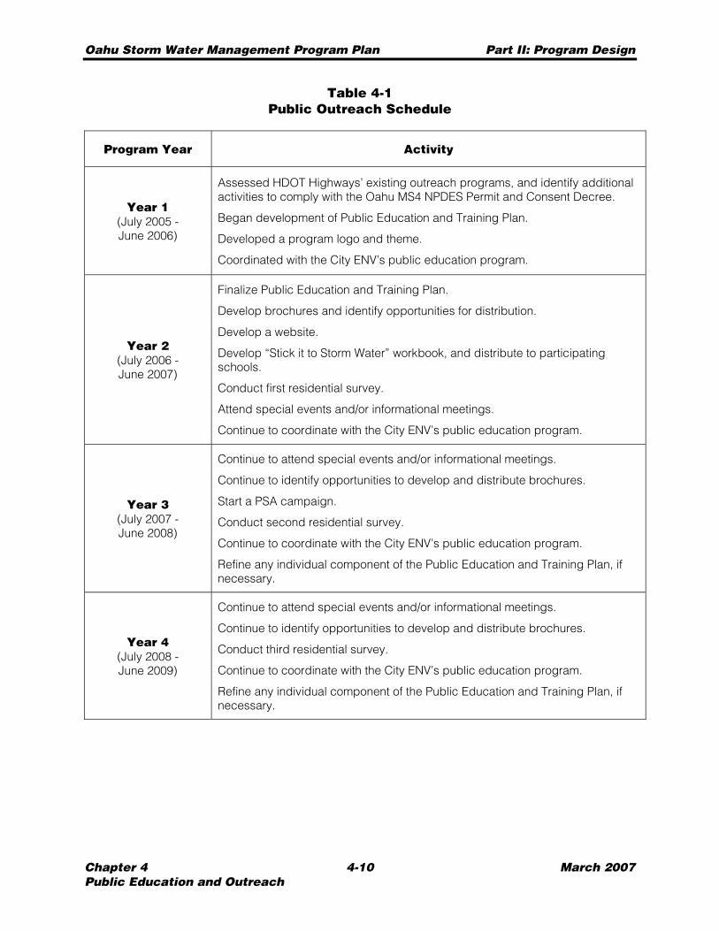
Oahu Storm Water Management Program Plan Part II: Program Design
Chapter 4 4-10 March 2007 Public Education and Outreach
Table 4-1 Public Outreach Schedule
Program Year Activity
Year 1 (July 2005 - June 2006)
Assessed HDOT Highways’ existing outreach programs, and identify additional activities to comply with the Oahu MS4 NPDES Permit and Consent Decree.
Began development of Public Education and Training Plan.
Developed a program logo and theme.
Coordinated with the City ENV’s public education program.
Year 2 (July 2006 - June 2007)
Finalize Public Education and Training Plan.
Develop brochures and identify opportunities for distribution.
Develop a website.
Develop “Stick it to Storm Water” workbook, and distribute to participating schools.
Conduct first residential survey.
Attend special events and/or informational meetings.
Continue to coordinate with the City ENV’s public education program.
Year 3 (July 2007 - June 2008)
Continue to attend special events and/or informational meetings.
Continue to identify opportunities to develop and distribute brochures.
Start a PSA campaign.
Conduct second residential survey.
Continue to coordinate with the City ENV’s public education program.
Refine any individual component of the Public Education and Training Plan, if necessary.
Year 4 (July 2008 - June 2009)
Continue to attend special events and/or informational meetings.
Continue to identify opportunities to develop and distribute brochures.
Conduct third residential survey.
Continue to coordinate with the City ENV’s public education program.
Refine any individual component of the Public Education and Training Plan, if necessary.
Oahu Storm Water Management Program Plan Part II: Program Design
Chapter 5 5-1 March 2007 Public Involvement and Participation
CHAPTER 5 PUBLIC INVOLVEMENT AND PARTICIPATION
HDOT Highways will ensure that the general public is provided an opportunity to review and comment on the Oahu SWMP Plan, during both program development and long-term implementation.
5.1 Public Review of Oahu SWMP Plan
Following completion of the January 2007 version of the Oahu SWMP Plan (see Section 1.3), this document was made available in the storm water program website, and various public locations, pursuant to HDOT Highways public involvement policies. In addition, a public meeting was held on January 18, 2007 at Washington Intermediate School to solicit comments about the plan or any element of the program. The meeting was conducted as an “open house” where several HDOT Highways and master consultant personnel manned stations for each of the programs described in Part II of this document.
5.2 Other Public Involvement Activities
In addition to the storm water website, many of the activities of the Public Education Program provide opportunities for the public to provide input to HDOT Highways regarding the Oahu SWMP, general storm water management, and other concerns they may have. These opportunities include, but are not necessarily limited to:
• Providing comment sheets to the public at each outreach event; • Having a representative from HDOT Highways present at Adopt-A-Stream and other
watershed events to answer questions and collect questions and comments from the participants;
• Advertising the HDOT Highways environmental hotline number and public website on brochures;
• Open-ended questions on the residential surveys to allow input; and • Specific school projects to solicit comments from parents and teachers.
Also, a citizen advisory committee could be organized to solicit on-going input from the public regarding specific storm water-related topics, and to assist in educating the public though the Public Education Program. This committee would be well educated in the subject of water quality and should be able to provide meaningful input.
Oahu Storm Water Management Program Plan Part II: Program Design
Chapter 5 5-2 March 2007 Public Involvement and Participation
THIS PAGE INTENTIONALLY LEFT BLANK.
Oahu Storm Water Management Program Plan Part II: Program Design
Chapter 6 6-1 March 2007 Illicit Discharge Detection and Elimination
CHAPTER 6 ILLICIT DISCHARGE DETECTION AND ELIMINATION
The objectives of the Illicit Discharge Detection and Elimination Program (Illicit Discharge Program) are to detect and prevent illicit discharges into the Oahu MS4 and to remove illegal connections to the Oahu MS4. In addition to maintaining the existing program that administers permitting or licensing of private drain connections into or discharges to the Oahu MS4, the Illicit Discharge Program conducts investigations of parcels suspected of illicit discharges or illegal connections identified through:
• Follow-up investigations of a survey conducted in the year 2000; • Public complaints or reports about potential illicit discharges or illegal connections; and • Field screening of Oahu MS4 outfalls.
The Illicit Discharge Program also includes: • Using the tools provided by the AMS, which includes a GIS databases of connection
permit properties and illicit discharges; • Preventing and responding better to hazardous spills, including wastewater spills,
within Oahu highway rights-of-way; • Informing the public about the proper use and disposal of household toxins; and • Training program so that those involved in this program have the necessary knowledge
and skills to conduct investigations of illicit discharges.
An “illicit discharge” is any discharge that is not composed entirely of storm water, with the exception of the following types of discharges (provided that they do not contain pollutants in amounts that will cause or contribute to a violation of an applicable water quality standard):
• Water line flushing; • Landscape irrigation; • Diverted stream flows; • Rising ground waters; • Uncontaminated ground water infiltration (as defined in 40 CFR §35.2005(20)); • Uncontaminated pumped ground water; • Discharges from potable water sources and foundation drains; • Air conditioning condensate; • Irrigation water; • Springs; • Water from crawl space pumps and footing drains; • Lawn watering runoff; • Water from individual residential car washing; • Water from charity car washes; • Flows from riparian habitats and wetlands; • De-chlorinated swimming pool discharges; • Exterior building wash water (water only); • Residual street wash water (water only), including wash water from sidewalks, plazas,
and driveways, but excluding parking lots; and • Discharges or flows from fire fighting activities.
Oahu Storm Water Management Program Plan Part II: Program Design
Chapter 6 6-2 March 2007 Illicit Discharge Detection and Elimination
An “illegal connection” is a connection to the Oahu MS4 without a drain connection permit issued by HDOT Highways. This chapter will serve as a reference for members of the Oahu SWMP team who have responsibilities associated with the detection and elimination of illicit discharges to the Oahu MS4.
6.1 Permitting (Licensing) of Oahu MS4 Connections
Since 1994, HDOT Highways has administered a permitting program for any individual, business (commercial or industrial), or agency that wishes to establish a permanent physical connection to the Oahu MS4 (connection permit) and/or discharge its storm water runoff into the Oahu MS4 (discharge permit). The permitting program is currently administered by HWY-OM/DDU. Under the Illicit Discharge Program, HDOT Highways will continue this regulatory program, and maintain a database of all permitted connections to the MS4.
A request for a physical connection to the Oahu MS4 is made by submitting a completed Application and Permit for A Private Storm Drain Connection to the State of Hawaii Highways Division Storm Drain System (Oahu District) (See Appendix D.1). For each connection, the applicant is required to submit information on the connection location, size, type of discharge, and flow rate, as well as a drainage report. In addition, the applicant is required to indicate whether their property or facility generates storm water associated with an “industrial” activity. Similarly, a discharge permit would be required for a construction project where storm water runoff would drain to the Oahu MS4. The owner or applicant would be required to submit a completed Application and Permit To Discharge to the State of Hawaii Highways Division Storm Drain System (Oahu District) (see Appendix D.2), and is required to indicate the type and location of discharge, its flow rate, area of disturbance, and submit a plan with BMPs shown.
During the application process, applicants for both the connection permit and discharge permit are required to disclose whether or not the subject facility, activity or property has an NPDES permit. If the property does not have an NPDES permit, but the MS4 Task Force/DDU finds that the property is engaged in an activity that should be covered by the NPDES program based on the information contained in the application, the applicant will be notified of the legal requirements to obtain NPDES coverage. The applicant will not be granted an Oahu MS4 connection or discharge permit until he or she has secured NPDES coverage from the HDOH. In addition, connection permit applicants may be required to provide permanent BMPs if the Oahu MS4 connection also includes the creation of at least one acre new permanent impervious surface within the property (see Chapter Eight).
Since July 2000, discharge permit holders have been required to notify HDOT Highways when the discharge to the Oahu MS4 ceases. Also, connection permit holders are required to notify HDOT Highways of changes in activities at the facilities or change of ownership.
Owners of properties associated with certain types of industrial activities are required by 40 CFR 122.26(c) to monitor storm water discharges that leave their property, regardless of whether the activity or facility directly or indirectly discharges into the Oahu MS4. For those holding connection or discharge permits, they are required receipt to report monitoring results to HDOH.
Oahu Storm Water Management Program Plan Part II: Program Design
Chapter 6 6-3 March 2007 Illicit Discharge Detection and Elimination
6.2 Identification and Inspection of Illicit Discharges and Illegal Connections
This section describes the procedures that will be used to identify, investigate, and respond to possible illicit discharges and illegal connections to the Oahu District’s MS4. These procedures would include specific time deadlines for responding to identified discharges, and would be coordinated with the Industrial and Commercial Activities Discharge Management Program (see Chapter Ten).
The identification and investigation of potential illicit discharges and illegal connections would be triggered by the following:
• Follow-up investigations of parcels identified from the Storm Water Questionnaire Survey of Parcels Adjacent to Highway Rights-of-Way (December 2000) (2000 Questionnaire Survey),
• Public reporting or complaints, and • Field screening of major and minor outfalls.
During an inspection of a property or facility suspected of illicit discharges or illegal connections, the inspector shall record observations on an Oahu MS4 Site Investigation Sheet (see Appendix D.3). However, in the future, inspectors may use electronic forms contained in hand-held GPS/PDA units that have been enabled with a personal digital assistant (PDA) to record observations. The GPS/PDA units will be capable of “plug-in” uploading of information into the AMS, eliminating the need for inspectors or other personnel to physically input the data. Investigations for non-storm water discharges will be conducted during dry weather. The general procedures for conducting illicit discharge or illegal connection investigations are as follows. The inspector shall:
1. Obtain plans of the relevant drainage facilities within HDOT Highways right-of-way (i.e., location of all associated Oahu MS4 outfalls or flow paths by which the suspected illicit discharge or illegal connection could enter of affect State waters) using the AMS prior to conducting the site investigation.
2. Confirm the location of the reported or suspected illicit discharge or illegal connection to the Oahu MS4, if any.
3. Record the location, size, depth, and orientation of any illicit discharge or illegal connection.
4. Record any unusual colors, stains, or odors observed from any illicit discharge or illegal connection.
5. Assess the likely source of any illegal connection and the point of entry into the right-of-way based on the connection’s configuration and alignment.
6. Record the location of any stains or other evidence proving the direction of flow into the MS4 system for any surface discharges.
7. Photograph the location of any discharge or connection at or along the suspected point of entry into the right-of-way. Include photographs of any surface stains and of all adjacent properties. Note and record the frame numbers of the film, the time and location of the photograph, and other pertinent information for future reference.
8. Prepare a neat, accurate sketch of the relevant aspects of the site and the potential illegal connection or flow path of the illicit discharge.
9. Record the date and time of the investigation and complete the checklist or GPS data inputs as fully as possible.
Oahu Storm Water Management Program Plan Part II: Program Design
Chapter 6 6-4 March 2007 Illicit Discharge Detection and Elimination
10. Use the AMS to determine the location of the Oahu MS4 outfall, or flow path by which flow from the suspected illicit discharge or illegal connection would enter State waters. This and all other information and findings of suspected illicit dischargers or illegal connections would be reported to the MS4 Task Force/DDU manager, who shall then make a determination of the legality of the discharge or connection and select the appropriate follow-up action, which may include the following: − Sending the property owner a letter, with an attached application for a connection or
discharge permit, requiring the owner to complete and return the application; − Sending a letter to the property owner requesting additional information regarding
the discharge or connection; − Scheduling a site meeting with the property owner to obtain additional information
regarding the illicit discharge or illegal connection; and − Sending a warning letter to the property owner advising the owner to remove the
illegal connection or eliminate the illicit discharge by a specified date or face an enforcement action (see Section 2.4).
For those parcels or activities where no illicit discharge or illegal connection was identified, the inspector would then document that the parcel or activity has:
• No physical connection with the Oahu MS4, or • No discharges other than overland storm water sheet flow through non-industrial
activities.
Inspection reports shall be submitted to HDOH within two months of the inspection date, and records of all inspections shall be maintained for a minimum of five years.
If HDOT Highways later grants a connection or discharge permit to a parcel used for industrial or commercial activities that had been subject to an investigation, this parcel would then undergo regular inspections as described in Section 10.2.1.
As noted above, the investigations of illicit discharges and illegal connections would be triggered from the results of the 2000 Questionnaire Survey, reports or complaints from the public, and outfall screening. Each of these triggers is described below in the Sections 6.2.1 through 6.2.3.
6.2.1 Follow-Up Investigations
A survey of property owners in areas zoned for industrial, commercial, and high-density residential was conducted in the year 2000 and the results of this survey were reported in the 2000 Questionnaire Survey. The survey resulted in HDOT Highways assigning priority levels ranging from 1 to 30 to those parcels whose owners responded to the survey. The follow-up investigations will involve these parcels to determine whether they have illegal connections or illicit discharges. The order of the follow-up investigations will be conducted in the following manner:
1. Tier 1 parcels, which were assigned priorities 1 to 4 based on the results of the 2000 Questionnaire Survey, will be investigated first and will be completed within 18 months of the effective date of the Oahu MS4 NPDES Permit;
Oahu Storm Water Management Program Plan Part II: Program Design
Chapter 6 6-5 March 2007 Illicit Discharge Detection and Elimination
2. Tier 2 parcels, which were assigned priorities 5 to16 based on the results of the Questionnaire Survey, will be investigated after completing investigations of all the Tier 1 parcels and will be completed within three years of the effective date of the Oahu MS4 NPDES Permit; and
3. Tier 3 parcels, which were assigned priorities 17-30 based on the results of the 2000 Questionnaire Survey, will be investigated last, and like the Tier 2 parcels, the investigations will be completed within three years of the effective date of the Oahu MS4 NPDES Permit.
6.2.2 Response to Public Complaints
Information from the general public is an important source for identifying illicit discharges or illegal connections. Currently, public complaints are received either through referral from the City ENV and the HDOH or through the Oahu District complaint line. HDOT Highways maintains a database of complaints about potential illegal connections and illicit discharges. Complaints are prioritized based on perceived urgency and addressed by staff as soon as practicable. A new telephone hotline will be established to provide the public with the means to report potential illicit discharges or illegal connections. The hotline will be advertised in the public website, and possibly in public service announcements (see Section 4.2.1).
Records from the website public complaint database and recordings from the hotline will be transferred to the illicit discharge/illegal connection investigation database (see Section 3.3.2). The current system will be integrated into the new database.
The complaint investigation database will include a number of fields to map and track the progress of potential investigations, such as the TMK of the offending parcel, information about each suspected improper discharge, the nature of the investigation of that discharge, follow-up activities, and the resolution of each investigation. The database will also contain a field requiring the program to research whether the offending property (i.e., the property where the potential illicit discharge or illegal connection may be located) has NPDES permit coverage. If the property or facility has such coverage, HDOH will be informed about the complaint and the potential violation. Upon receipt of confirmation from HDOH that they will address the complaint, the record of the complaint will be closed by logging that the complaint has been referred to HDOH.
Once the complaint database has been updated to reflect the newest records from the website and hotline and that the offending property does not have NPDES permit coverage, investigations will be scheduled based on the potential seriousness of the complaint, and other workload responsibilities of the inspectors.
6.2.3 Oahu MS4 Outfalls Screening
Oahu MS4 outfalls will be field screened for illicit discharges. Any sign of an illicit discharge at an outfall may be an indication that one or more parcels or even the roadways along the drainage system of the outfall are causing an illicit discharge.
Oahu Storm Water Management Program Plan Part II: Program Design
Chapter 6 6-6 March 2007 Illicit Discharge Detection and Elimination
As noted in Section 9.3.4, all outfalls with a minimum diameter of 36 inches were inspected specifically to check for erosion and erosion potential below the outfalls. In addition, inspectors collected data regarding the presence of pollutants, a sign of illicit discharges. According to the Outfall Field Screening Plan (see Appendix D.4), the entire inventory of outfalls (approximately 1500) was prioritized based on whether or not they are located in watersheds assigned Waste Load Allocations (WLA) (see Section 11.2) or high priority watersheds(as defined in Appendix A of the Consent Decree). The over 700 outfalls located in these watersheds will be screened or inspected once every calendar year. The remaining outfalls, which are located outside of these watersheds, will be screened once every three years.
The procedures for finding and reporting illicit discharges identified at Oahu MS4 outfalls are similar to other inspection procedures. Data gathered from the outfall screenings will be reviewed by master consultant staff on a regular basis. Any reported illicit discharge will be referred to the MS4 Task Force/DDU, which may likely trigger site investigations of one or more nearby parcels.
6.3 Tracking and Reporting
The existing list of permitted Oahu MS4 connections and discharges along with the illicit discharge database will be integrated into the AMS, as described in Section 3.3.2. The database includes fields that identify the permit holder, permit number, location of the property, tax map key, type of discharge and Oahu MS4 connection, and records of inspection or investigation, among other pertinent information. All new permits will be recorded into the database. The illicit discharge/illegal connection database will also contain information regarding illicit connections, illegal discharges, and spills including the type of discharge, responsible party, response by HDOT Highways, and resolution of the discharge to the MS4. The records in this database will be partially created by compiling public complaints collected through the hotline (see Section 4.2.1.5), GIS analysis, and field inspections.
6.4 Spill Prevention and Response
The infiltration of wastewater effluent from surrounding properties is a potential pollutant that could enter the Oahu MS4. To address this issue, HDOT Highways shall continue to support other State and City, and federal agencies to prevent entry of spills into the Oahu MS4 and contamination of surface water, ground water, and soil to the maximum extent practicable.
The Honolulu Fire Department (HFD) is normally the lead agency for emergency response to spills on all non-military lands of Oahu. In the event of a spill or overflow from a municipal wastewater facility, the City is responsible for immediately responding to the clean-up and repair to the system. If requested, HDOT Highways would assist the HFD and City with spill response for spills within HDOT Highways rights-of-way. HDOT Highways would notify HDOH of any municipal wastewater spills or overflows from private laterals and failing septic systems that discharges into the Oahu MS4.
Oahu Storm Water Management Program Plan Part II: Program Design
Chapter 6 6-7 March 2007 Illicit Discharge Detection and Elimination
6.5 Toxins Awareness
The Illicit Discharge Program includes a public outreach component described in Section 4.2.3.1, which notes that brochures about the safe use and proper disposal of household toxins would be made available at major hardware stores and other retailers to distribute whenever someone purchases certain household toxins.
6.6 Training
Training is an important element of the Illicit Discharge Program because it ensures that personnel responsible for conducting inspections or managing the program’s system are knowledgeable in the process of detecting and eliminating illicit discharges or illegal connections. The HDOT Highways MS4 Task Force has been working on the training element of the Illicit Discharge Program since the year 2000. The current details of the training regimen are as follows:
Training Recipients
Training will be required of any current new inspector responsible for carrying out any element of the Illicit Discharge Program, including any additional inspection staff contracted by the State or through the master consultant contract. This includes, but is not necessarily limited to, inspectors responsible for duties specified in Section 6.2.
Training Method
Training will be conducted through a formalized “on-the-job” method.
Trainer Qualifications
The managers and/or supervisors conducting training will have the following qualifications: • Awareness of HDOT Highways activities, policies and procedures; and • Knowledgeable in identifying and eliminating illegal connection, illicit discharges and
spills to the Oahu MS4.
Topics
The following topics of the training will include: • Information and awareness of the Oahu MS4 NPDES Permit, and the overall Oahu
SWMP; • Informing staff that they serve an important role in protecting the water quality in the
State; • Environmental background and regulatory requirements; • Highway responsibilities for storm water management; • Identifying and eliminating illegal connection, illicit discharges and spills to the Oahu
MS4; and • Inspection and enforcement techniques.
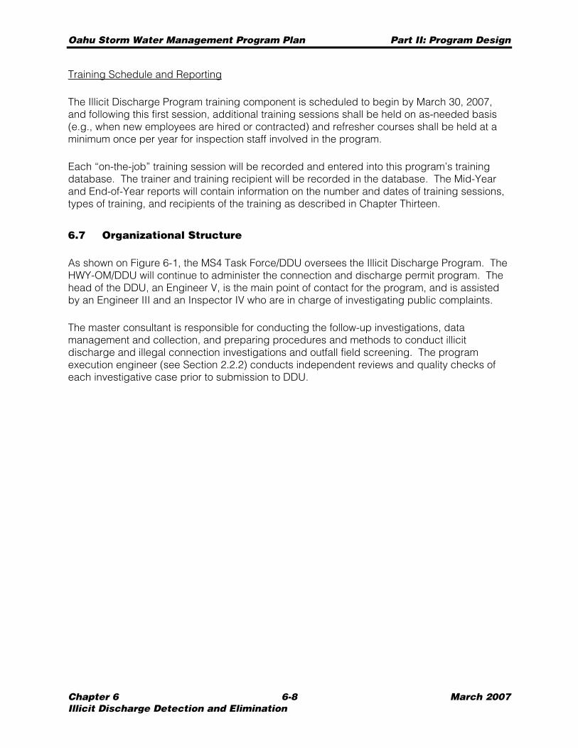
Oahu Storm Water Management Program Plan Part II: Program Design
Chapter 6 6-8 March 2007 Illicit Discharge Detection and Elimination
Training Schedule and Reporting
The Illicit Discharge Program training component is scheduled to begin by March 30, 2007, and following this first session, additional training sessions shall be held on as-needed basis (e.g., when new employees are hired or contracted) and refresher courses shall be held at a minimum once per year for inspection staff involved in the program.
Each “on-the-job” training session will be recorded and entered into this program’s training database. The trainer and training recipient will be recorded in the database. The Mid-Year and End-of-Year reports will contain information on the number and dates of training sessions, types of training, and recipients of the training as described in Chapter Thirteen.
6.7 Organizational Structure
As shown on Figure 6-1, the MS4 Task Force/DDU oversees the Illicit Discharge Program. The HWY-OM/DDU will continue to administer the connection and discharge permit program. The head of the DDU, an Engineer V, is the main point of contact for the program, and is assisted by an Engineer III and an Inspector IV who are in charge of investigating public complaints.
The master consultant is responsible for conducting the follow-up investigations, data management and collection, and preparing procedures and methods to conduct illicit discharge and illegal connection investigations and outfall field screening. The program execution engineer (see Section 2.2.2) conducts independent reviews and quality checks of each investigative case prior to submission to DDU.
Statewide Storm Water Management Program Oahu Storm Water Management Program
Department of Transportation DOT-DIR Director
Department of Transportation
DEP-HWY Deputy Director
Public Affairs Office DIR-P
Office of Special Compliance Programs
DIR-CZ
Highways Division
Administrator
Planning Branch HWY-P
Head Planning Engineer
Right-of-Way Branch HWY-R
Right-of-Way Manager
Oahu District HWY-O
District
Engineer
Traffic Branch HWY-T
Engineering Program Manager
Office Services HWY-O
Office Manager
Urban Construction Section
HWY-OCU (MS4 Task Force Mgr)
Engineer VI
Traffic Operations
Unit HWY-OT
Civil Engineer IV
Design Branch HWY-D
Engineering Program Manager
Highway Design Section HWY-DD
Engineer VI
Technical Design Section HWY-DS
Engineer VI
Construction & Maintenance Branch
HWY-C Engineering Program
Manager
Maintenance Section
HWY-CM Engineer VI
Environmental Section HWY-CE
Engineer VI
Construction Section HWY-CC
Engineer VI
Rural Construction Section
HWY-OCR Engineer VI
Wahiawa Crew HWY-OM
Highway Maintenance Supervisor I
Leeward Crew HWY-OM
Highway Maintenance Supervisor II
Hauula Crew HWY-OM
Highway Maintenance Supervisor I
Windward Crew HWY-OM
Highway Maintenance Supervisor II
Honolulu Crew HWY-OM
Highway Maintenance Supervisor II
Special Services Sub Unit HWY-OM
Highways Special Services
Supervisor
Bridge Maintenance Sub Unit
HWY-OM Bridge Maintenance
Supervisor II
Structures Sub Unit HWY-OM
General Construction
Maintenance Supervisor I
Roadway Maintenance Sub Unit HWY-OM
Construction & Maintenance Supervisor III
Equipment Services & Repair Unit HWY-OM
Auto Mechanic Supervisor II
Water Tankers Crew HWY-OM
2-Truck Tractor Semi-Trailer Operator
Street Cleaning Crew HWY-OM
4-Street Sweeper Operator
Drain Cleaning Crew HWY-OM
1-Heavy Truck Driver
Debris Hazard Control Crew HWY-OM
3-Light Truck Driver
Herbicide Crew HWY-OM
2-Truck Driver
1-Reporting Coordinator 1-Planner
1-AMS Coordinator
1-Development Mgr
4-GIS/IT Support
1-Training Coordinator 1-Trainer
1-Engineer
1-Education Coordinator 1-PR Expert
2-PR Assistant
Material Testing & Research Branch
HWY-L Engineering Program
Manager
Highways Maintenance Unit
HWY-OM Construction & Maintenance
Superintendent
Pearl City Field Office
HWY-OC Engineer V
Kaneohe Field Office
HWY-OC Engineer V
Salt Lake Field Office
HWY-OC Engineer V
Administrator HWY-OC
Engineer V
MS4 Task Force 2-CE III
1-Inspector 1-Clerk
Lower Halawa Field Office
HWY-OC Engineer V
Kilihau Field Office
HWY-OC Engineer V
Upper Halawa Office
HWY-OC Engineer V
Street Sweeper
Drain Cleaner
1-Engineer 9-Inspector
Landscaping Sub Unit HWY-OM
Highways District Maintenance Supervisor
Traffic Signs & Marking Sub Unit
HWY-OM Traffic Signs &
Marking Supervisor
1-Engineer 1-Inspector
Hydrology & Special Studies Unit
HWY-DH Engineer V
Drafting Unit
HWY-DH Technician
Design Unit
HWY-DH Engineer V
Environmental Support HWY-DH
Engineer V
3-Engineer
Research Program HWY-LR
Engineer VI
5-Engineer 1-CADD
Highways Electrical Unit
HWY-OM Traffic Signal &
Highway Lighting Supervisor
Master Consultant
Program Manager & Deputy Program
Manager
1-Senior Program Engineer
1-Technical Advisor 3-Administrative
Facilities Engineering
Services HWY-OM
Civil Engineer V
5-Engineer 4-Inspector
Highways Division Storm Water Management Program Organizational Structure - Illicit Discharge Detection and Elimination Program (2006-2009) Figure 6-1
1-Engineer 1-Inspector IV 1-Inspector III
2-Engineer 1-Scientist
2-Technician
SWMP Service
Contractors
Highways Division Storm Water Management Program Organizational Structure - Illicit Discharge Detection and Elimination Program 2006-2009
Landscape Design Section HWY-DL
Engineer V
Tunnel Operation Section HWY-OT
Engineer V
Plant Maintenance
Unit HWY-OT
Mechanical Engineer IV
Engineering Services Unit
HWY-OM
Civil Engineer V
Field Engineering
Services HWY-OM
Civil Engineer V
Maintenance Section
HWY-OM Engineer VI
Bridge Design Section HWY-DB
Engineer VI
Hydraulic Design Section HWY-DH
Engineer VI
1-Engineer III
Drainage Discharge
Unit HWY-OM
Engineer V
Involved in All Programs
Asset Management System (AMS)/Reporting
Training/Public Education
Master Consultant
& Subs
HDOT Staff With SWMP Responsibilities
LEGEND
HDOT Staff With Illicit Discharge Detection and Elimination Program
Responsibilities
Oahu Storm Water Management Program Plan Part II: Program Design
Chapter 7 7-1 March 2007 Construction Site Runoff Control
CHAPTER 7 CONSTRUCTION SITE RUNOFF CONTROL
The objective of the Construction Site Runoff Control Program (Construction Program) is to ensure that no construction will be allowed to commence or proceed on any contract, in-house, maintenance, or encroachment project until it has been verified that the project has NPDES coverage, if applicable. In addition, the Construction Program includes the review and inspection of site specific BMPs for projects that require NPDES coverage.
The construction program covers four primary types of construction projects: contract, in-house, maintenance, and encroachment projects.
Contract projects are construction projects that use outside contractors through a competitive bid process. The plans, specifications and estimates (PS&E) of contract projects are prepared by either HDOT Highways personnel or engineering consultants. The construction of contract projects is managed by HWY-OC. Contract projects can vary in complexity and size from simple resurfacing to construction of new freeways.
In-house construction projects are those projects that are performed by HDOT Highways Oahu District’s Maintenance Section (HWY-OM). These projects are typically small and maintenance-related. Some maintenance projects are performed by outside contractors and are overseen by HWY-OM.
Encroachment construction projects are non-HDOT Highways construction activities (activities conducted by others) that include work within the HDOT Highway rights-of-way and/or require permits or approvals from HDOT Highways. Examples of HDOT Highways permits include the Permit to Perform Work Upon State Highways (Appendix E.1), as well as connection and discharge permits described in Section 6.1. Encroachment projects typically include the following:
• Construction of temporary or permanent vehicular access to the highway rights-of-way; • Construction of a connection to the Oahu MS4, which also requires a connection permit
(see Section 6.1); • Construction that will result in discharges into the Oahu MS4, which also requires a
discharge permit (see Section 6.1); and • Installation or repair work of utility lines or connections within highway rights-of-way.
The Construction Program includes the following elements: • NPDES review and approval process, which also includes review of site-specific
construction BMP plans; • Development of a Construction BMP Field Manual, and construction specifications and
notes relating to storm water discharges during construction; • An inspection program to ensure that construction BMPs are properly installed for
contract, in-house, maintenance, and encroachment permit projects; and • A program to provide annual training on elements of the Construction Program to HDOT
Highways staff with construction responsibilities.
Oahu Storm Water Management Program Plan Part II: Program Design
Chapter 7 7-2 March 2007 Construction Site Runoff Control
7.1 NPDES Review and Approval Process
As required by the Clean Water Act (see Section 1.1.1), any individual, agency, business or organization, including HDOT Highways, is required to obtain NPDES coverage for construction activities that disturb one (1) acre or more of land area, or result in the discharge of dewatering or hydrotesting fluids into State waters. HDOH administers the NPDES Program for the State, and requires submittal to HDOH of a Notice of Intent (NOI) to obtain a Notice of General Permit Coverage (NGPC), or an individual permit application includes a site-specific BMP plan that complies with State and federal standards.
Under the Construction Program’s NPDES review and approval process, no applicable contract, in-house, maintenance, or encroachment project will be allowed to proceed to construction unless the project sponsor or representative (e.g., an HDOT Highways project manager or contractors hired by HDOT Highways) provides proof that the project has received from HDOH a NGPC, or other applicable NPDES Permit (e.g., individual NPDES Permit, NGPC authorizing discharges associated with dewatering or hydrotesting, etc.). The following procedures will be used to verify that applicable projects have NPDES coverage:
• For contract, in-house, and maintenance projects, HDOT Highways project managers will be instructed to use a construction BMP checklist during PS&E development (or the environmental review process) to verify whether or not their projects require NPDES coverage, regardless of whether the design is done by HDOT Highways personnel or by engineering consultants.
• For encroachment projects, the applicant must provide proof that a NOI or NPDES permit application was submitted and approved by HDOH before the application can be processed. For example, the Permit to Perform Work Upon State Highways (see Appendix E.1) requires that the applicant disclose NPDES applicability. The connection and discharge permit applications also have similar provisions.
The NPDES applications (including the NOI) ensure that project designs include site-specific BMP plans, or that the contractor provides appropriate site-specific BMP plans. Therefore, the Construction Program will also include review and approval of site-specific BMP plans if the project requires NPDES coverage. The review and approval process will be conducted in the following manner:
• For contract, in-house, and maintenance projects, HDOT Highways project managers direct staff, engineering consultants, or contractors shall prepare the site-specific BMP plan. Site-specific BMP plans are reviewed and approved by HWY-O prior to submission to HDOH.
• For encroachment projects, the applicable permit applications are being revised to require the applicant provide a site-specific BMP plan if the project requires NPDES coverage. The applicant will be required to possess the latest version of the City’s Best Management Practices Manual for Construction Sites in Honolulu (City BMP Manual), until the HDOT Highways manual is available (see Section 7.2), as well as the Rules for Soil Erosion Standards and Guidelines.
The Site-Specific Best Management Practices (BMP) Plan Review Guidelines (Checklist) (see Appendix E.2) will be used as a guide in developing and reviewing site-specific BMP plans. It will be made available to HDOT Highways staff, engineering consultants, contractors and encroachment project applicants on-line once the public website is available (see Section
Oahu Storm Water Management Program Plan Part II: Program Design
Chapter 7 7-3 March 2007 Construction Site Runoff Control
4.2.1.5). In general, the size, scope and type of project are important considerations that factor into the level of detail required for developing a site-specific BMP plan. Common elements of a site-specific BMP plan include:
• Identify potential pollutants that could affect the quality of storm water, dewatering effluent, or hydrotesting discharges from the construction site;
• BMPs that will need to be implemented during construction, including their precise locations, to control the quality of storm water runoff from construction activities, or discharges from hydrotesting or dewatering activities;
• Construction notes addressing erosion control and storm water pollution prevention requirements, which become part of the construction contract documents; and
• Copy of Water Pollution and Erosion Control Notes (see Appendix E.3).
The review of site-specific BMP plans involves determining whether the construction BMPs identified in the plan are appropriate and reasonable for the specific project. The review will verify that the site-specific BMP plan fully meets the requirements of:
• The following HDOT Highways publications (see Section 7.3): − Water Pollution and Erosion Control Notes (see Appendix E.3); − Hawaii 2005 Standard Specifications for Road and Bridge Construction (2005)
including Subsection 107.13 and Section 209 (see Appendix E.4); and − National Pollutant Discharge Elimination System Requirements (NPDES) for Permit
Projects Within State Highway Right-of-Way Notes (see Appendix E.5); and − Construction Best Management Practices Field Manual (see Section 7.2);
• Stipulations contained in General Construction Activities Storm Water NPDES Permit, or any other applicable requirements of the Hawaii NPDES permit program where applicable; and
• Checklist described above.
7.2 Construction BMP Field Manual
HDOT Highways has prepared a Construction Best Management Practices Field Manual (September 2006) (Construction BMP Field Manual), and was submitted to HDOH for approval. A copy is provided in Appendix E.6. The purpose of the manual is to provide guidance on the installation and maintenance of BMPs that address construction activities. The manual includes all BMPs listed in the Construction BMP Program Plan component of the December 2003 Oahu SWMP Plan and all BMPs contained and described in the City BMP Manual. It does not include an exhaustive list of all possible BMPs.
The BMPs contained in the Construction BMP Field Manual focus on site management; erosion control and stabilization; and sediment control and containment. Site management includes preventative measures to control potential pollutants at their source. Erosion control and stabilization are used on disturbed or exposed soil to protect it from erosion due to wind, rain, or runoff. Sediment control and containment are used to intercept and detain sediment-laden runoff prior to off-site discharge.
Each BMP identified in the manual contains the following information: • General description; • Applications;
Oahu Storm Water Management Program Plan Part II: Program Design
Chapter 7 7-4 March 2007 Construction Site Runoff Control
• Installation and implementation requirements; • Limitations; and • Maintenance and inspections.
To aid in the selection of appropriate BMPs during construction, the manual contains a Site-Specific Best Management Practices (BMP) Plan Review Guidelines Checklist. BMP selection is determined by an evaluation of existing site conditions of the project area.
Prior to the completion of this manual, HDOT Highways provided copies of the City BMP Manual to its field staff and made copies available to contractors involved in HDOT Highways construction projects. Due to distribution of this Oahu SWMP Plan and other distribution activities, copies of the Construction BMP Field Manual will be provided to all HDOT Highways staff involved in contract, in-house, maintenance, encroachment, or construction and erosion control projects. It would also be available on-line in the public website (see Section 4.2.1.5), thus making it accessible to private consultants and contractors.
7.3 Specifications, Provisions and Notes
HDOT Highways revised its Standard Specifications in 2005, following the guidelines of the current editions of the City BMP Manual in developing, installing and maintaining BMPs for projects, and following the City and County of Honolulu’s Rules for Soil Erosion Standards and Guidelines. As noted above, the 2005 Standard Specifications is one of the documents that will be used to evaluate site-specific BMP plans prepared for contract, in-house, maintenance, and encroachment construction projects on Oahu if the project requires NPDES permit coverage.
The Water Pollution and Erosion Control Notes (Pollution Notes), and the NPDES Requirements for Permit Projects within State Highway Right-of-Way Notes (NPDES Notes) have been revised to specify that the use of the City BMP Manual is required for all contract, in-house, maintenance, and encroachment construction projects on Oahu. These notes will be revised to specify the Construction BMP Field Manual when it is approved by HDOH (see Section 7.2).
Copies of the 2005 Standard Specifications, Subsection 107.13 and Section 209, Water Pollution and Erosion Control Notes and NPDES Requirements for Permit Projects within State Right-of-Way Notes are provided in Appendix E.3. In addition, copies of these documents will be provided to all HDOT Highways staff involved in contract, in-house, maintenance, and encroachment projects. These documents will be placed on-line once the public website is developed (see Section 4.2.1.5). HDOT Highways staff managing contract projects shall emphasize the importance of storm water pollution prevention to contractors during pre-construction or other project meetings.
7.4 Inspections
This section describes the procedures for inspections of contract, in-house, maintenance, and encroachment project sites to verify and document whether the construction BMPs have been
Oahu Storm Water Management Program Plan Part II: Program Design
Chapter 7 7-5 March 2007 Construction Site Runoff Control
installed properly. Two types of inspections will be conducted under the Construction Program:
• Initial inspections will be conducted on projects that require NPDES coverage, to verify that the construction BMPs identified in the site-specific BMP plan are properly installed and in the correct locations prior to the commencement of ground-disturbing activity; and
• Periodic inspections to monitor the construction BMPs of all construction projects, regardless of whether they require NPDES coverage, to ensure that their construction BMPs are working properly throughout the life of the construction period.
A list of active construction projects and inspection data will be maintained in the AMS system (see Section 3.3.3).
7.4.1 Initial Construction BMP Inspections
For contract, in-house, maintenance, and encroachment projects that require NPDES coverage, a qualified engineer or inspector will inspect the construction BMPs to verify that they were installed in accordance with the approved site-specific BMP plan prior to approving the initiation of ground-disturbing activities that the BMPs are designed to address. The initial inspections are conducted by HDOT Highways staff. The following general procedures for conducting the initial inspections at construction sites are provided below:
1. The individual responsible for the construction activity shall provide the HDOT project manager or inspector (for encroachment projects) advance notice as to when the installation of the construction BMPs is anticipated to be completed.
2. Prior to the inspection, the inspector shall review and become familiar with the project’s site-specific BMP plan. Depending on the size of the project, more than one inspector may be used.
3. Prior to the initiation of any ground disturbing activities, the inspector shall inspect the site(s) to determine whether the construction BMPs identified in the site-specific BMP plan have been properly installed in the correct locations..
4. The inspector shall then document or record whether or not the construction BMPs as specified in the site-specific BMP plan were properly installed using a standardized inspection form (see Appendix E.7).
5. If the inspector finds that the BMPs are properly installed in accordance with the site-specific BMP plans, ground-disturbing activities can proceed.
6. If the inspector finds that the BMPs are not properly installed in accordance with the site-specific BMP plans, ground-disturbing activities will not be allowed to start, and the inspector will re-schedule another inspection to allow the construction activity contact person to fix the problem.
If the site-specific BMP plan specifies that construction BMPs are to be installed in phases, the start of each phase will be treated as an initial inspection.
7.4.2 Periodic Inspections and Enforcement
Both NPDES and non-NPDES projects will be subject to periodic inspections of BMPs. HDOT Highways requires that construction projects, regardless of whether they require NPDES
Oahu Storm Water Management Program Plan Part II: Program Design
Chapter 7 7-6 March 2007 Construction Site Runoff Control
coverage, include construction BMPs. Unlike the initial inspections, which are conducted by HDOT Highways staff, the objective of the periodic inspections is to have an independent (third party) inspector who is tasked to only inspect the projects BMPs. Therefore, the periodic inspections will be conducted by personnel not involved in other aspects of construction for the subject project. Initially, the inspections will be conducted by the master consultant.
Notwithstanding the requirements of an NGPC or other NPDES permit, if applicable, the schedule for periodic inspections of contract, in-house, and maintenance projects is as follows:
• After the initial inspection of a project (for projects that require NPDES coverage) that results in the approval of ground-disturbing activities, the project’s construction BMPs will be inspected at least monthly.
• For projects that do not require NPDES coverage, the project’s construction BMPs will also be inspected at least monthly.
• If the inspector finds no critical or major deficiencies or less than six minor deficiencies with no more than three minor deficiencies per month during three successive monthly inspections, the frequency of inspections will drop to quarterly (four times a year). Definitions of critical, major and minor deficiencies are provided in the Definition of Key Terms in the Table of Contents.
• If an inspection identifies at least one critical or major deficiency, or a total of three or more minor deficiencies, the inspection frequency will immediately return to no less than monthly.
Notwithstanding the requirements of an NGPC or other NPDES permit, if applicable, an encroachment project will be subject to a periodic inspection at least once during the life of the project. For any project of the types listed below, the site will be inspected at least annually if the duration of construction is longer than one year:
• Housing or commercial development improvements that include a large roadway and utility improvements or any grading within HDOT Highways rights-of-way;
• Utility main installation, such as water lines, sewer lines, and underground electrical lines within HDOT Highways rights-of-way;
• Landscaping and irrigation installation (e.g. median beautification projects) within HDOT rights-of-way; and
• Drain line connections to the Oahu MS4.
The inspectors will use a checklist, which is provided in Appendix E.8. Inspectors will immediately inform the contractor or project contact person if any illicit discharge, deficiency, or violations of the NGPC or other NPDES permit is found so that the problem can be corrected or addressed in accordance with the following time frames:
• Any illicit discharge or critical deficiency must be corrected or addressed before the close of business on the day of the inspection at which the deficiency was identified.
• Any major deficiency must be corrected or addressed no later than five business days after the inspection at which the deficiency was identified or before the next forecasted precipitation, whichever is sooner.
• Any minor deficiency must also be corrected or addressed before the next forecasted precipitation or within five business days, whichever is sooner.
The inspector will report illicit discharges or deficiencies to the MS4 Task Force manager who will, if applicable, inform HDOH.
Oahu Storm Water Management Program Plan Part II: Program Design
Chapter 7 7-7 March 2007 Construction Site Runoff Control
If the inspector finds non-compliance with any of these requirements, the inspector will refer the case to HWY-OC if the project is conducted through a contract or to HWY-OM if the project is an in-house, maintenance, or encroachment project. After reviewing the information and reports from the inspector, HWY-OC or HWY-OM have the capability to start proceedings to suspend construction, including suspending or revoking street usage or the permits obtained from Oahu District for encroachment projects in accordance with the Enforcement Policy described in Section 2.4.
The AMS will be used for scheduling inspections, while assuring that regulatory requirements are met (see Section 3.3.3). It will also be used to track inspections and findings for each active construction project. Once fully operational, the AMS will assist the inspection teams by providing inspection histories and verifying the inspection frequency for each project.
7.5 Training
The Construction Program’s training component focuses on providing instruction about the proper installation and maintenance of approved construction BMPs, and on the NPDES program administered by the HDOH for storm water discharges at construction sites, and discharges resulting from dewatering and hydrotesting. The Construction Program training was implemented in December 2005, and initially used the City BMP Manual, a Construction and Maintenance Activities Best Management Practice (BMP) Training Handbook (see Appendix E.9). A video of the Construction Program training was made and could be shown to staff who were not able to attend the annual training sessions, and to new employees. In addition to the training regimen described below, all inspectors working under the Construction Program will receive formalized on-the-job training.
Training Recipients
The training will be made available to the following HDOT Highways personnel: • Designers and project managers of construction projects; • Construction engineers and construction inspectors; • Maintenance staff; • Plan reviewers; • Inspectors; and • Other HDOT Highways personnel with the following responsibilities:
− Erosion and Sediment Control, − Material Delivery and Storage, − Waste Management, − Spill Prevention and Control, − Vehicle Equipment Maintenance, − Paving Operations, − Structure Construction and Painting, and − BMP installation.
Oahu Storm Water Management Program Plan Part II: Program Design
Chapter 7 7-8 March 2007 Construction Site Runoff Control
Training Method
The method of training will involve both PowerPoint presentations and handout materials, which include the following documents:
• Presentation’s PowerPoint slides that allow for the taking of notes; • Construction BMP Field Manual (City BMP Manual was distributed in the interim); and • Descriptions of sample construction BMPs.
Trainer Qualifications
The trainer must meet the following qualifications: • Professional experience in designing, installing, and/or inspecting erosion and
sediment control BMPs; • Knowledge of the effectiveness of various construction BMPs under local weather
conditions; and • Knowledge of the Oahu MS4 NPDES Permit requirements and related regulatory
requirements.
Topics
Topics will include the following: • Environmental background and regulatory requirements, particularly the Clean Water
Act and the NPDES permit program; • Information and awareness of the Oahu MS4 NPDES Permit, and the overall Oahu
SWMP; • Informing staff that they serve an important role in protecting the water quality in the
State; • Responsibilities of HDOT Highways regarding storm water management and erosion
and sediment control at construction sites; • Typical, common of preferred BMPs related to:
− HDOT Highways operation and maintenance activities, and − HDOT Highways or third-party construction activities;
• Erosion and sediment control practices; and • Inspection and monitoring requirements, procedures and methods.
Training Schedule and Reporting
Training will be held annually. The Mid-Year and End-of-Year Reports (See Chapter Thirteen) will contain information on the number and dates of training sessions, types of training, and recipients of the training.
Additional Training Activities
Prior to the issuance of a Notice to Proceed for any contract construction project, a pre-construction meeting with the project's prime contractor will be held during which the requirements of the NGPC or other NPDES permit, if any, will be discussed, as well as discussion of the 2005 Standard Specifications, Pollution Notes and NPDES Notes.
Oahu Storm Water Management Program Plan Part II: Program Design
Chapter 7 7-9 March 2007 Construction Site Runoff Control
7.6 Organizational Structure
As shown on Figure 7-1, the Construction Program is overseen by HWY-O. HWY-OC manages the construction of contract projects, and performs NPDES verifications and review of site-specific BMP plans. HWY-OM performs the work for the construction of in-house projects and oversees the construction of maintenance projects. HWY-OM performs the NPDES verifications and review of site-specific BMP Plans for these projects. HWY-OM also oversees encroachment projects, and is therefore responsible for verifying NPDES applicability and reviewing site-specific BMP plans, if applicable, for these types of projects.
The initial inspections of contract projects will be conducted by HWY-OC personnel. HWY-OM personnel will be responsible for conducting the initial inspections of in-house, maintenance and encroachment projects.
The master consultant will conduct periodic inspections of contract, in-house, maintenance, and encroachment projects. The master consultant is also assisting HDOT Highways in developing the construction BMP checklist, the Construction BMP Field Manual, coordinating with HWY-OC and HWY-OM regarding the documentation of construction BMP inspections, and construction BMP training.
Oahu Storm Water Management Program Plan Part II: Program Design
Chapter 7 7-10 March 2007 Construction Site Runoff Control
THIS PAGE INTENTIONALLY LEFT BLANK.
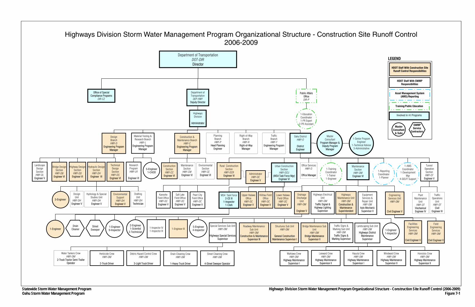
Statewide Storm Water Management Program Oahu Storm Water Management Program
Department of Transportation DOT-DIR Director
Department of Transportation
DEP-HWY Deputy Director
Public Affairs Office DIR-P
Office of Special Compliance Programs
DIR-CZ
Highways Division
Administrator
Planning Branch HWY-P
Head Planning Engineer
Right-of-Way Branch HWY-R
Right-of-Way Manager
Oahu District HWY-O
District
Engineer
Traffic Branch HWY-T
Engineering Program Manager
Office Services HWY-O
Office Manager
Urban Construction Section
HWY-OCU (MS4 Task Force Mgr)
Engineer VI
Traffic Operations
Unit HWY-OT
Civil Engineer IV
Design Branch HWY-D
Engineering Program Manager
Highway Design Section HWY-DD
Engineer VI
Technical Design Section HWY-DS
Engineer VI
Construction & Maintenance Branch
HWY-C Engineering Program
Manager
Maintenance Section
HWY-CM Engineer VI
Environmental Section HWY-CE
Engineer VI
Construction Section HWY-CC
Engineer VI
Rural Construction Section
HWY-OCR Engineer VI
Wahiawa Crew HWY-OM
Highway Maintenance Supervisor I
Leeward Crew HWY-OM
Highway Maintenance Supervisor II
Hauula Crew HWY-OM
Highway Maintenance Supervisor I
Windward Crew HWY-OM
Highway Maintenance Supervisor II
Honolulu Crew HWY-OM
Highway Maintenance Supervisor II
Special Services Sub Unit HWY-OM
Highways Special Services
Supervisor
Bridge Maintenance Sub Unit
HWY-OM Bridge Maintenance
Supervisor II
Structures Sub Unit HWY-OM
General Construction
Maintenance Supervisor I
Roadway Maintenance Sub Unit HWY-OM
Construction & Maintenance Supervisor III
Equipment Services & Repair Unit HWY-OM
Auto Mechanic Supervisor II
Water Tankers Crew HWY-OM
2-Truck Tractor Semi-Trailer Operator
Street Cleaning Crew HWY-OM
4-Street Sweeper Operator
Drain Cleaning Crew HWY-OM
1-Heavy Truck Driver
Debris Hazard Control Crew HWY-OM
3-Light Truck Driver
Herbicide Crew HWY-OM
2-Truck Driver
1-Reporting Coordinator 1-Planner
1-AMS Coordinator
1-Development Mgr
4-GIS/IT Support
1-Training Coordinator 1-Trainer
1-Engineer
1-Education Coordinator 1-PR Expert
2-PR Assistant
Material Testing & Research Branch
HWY-L Engineering Program
Manager
Highways Maintenance Unit
HWY-OM Construction & Maintenance
Superintendent
Pearl City Field Office
HWY-OC Engineer V
Kaneohe Field Office
HWY-OC Engineer V
Salt Lake Field Office
HWY-OC Engineer V
Administrator HWY-OC
Engineer V
MS4 Task Force 2-CE III
1-Inspector 1-Clerk
Lower Halawa Field Office
HWY-OC Engineer V
Kilihau Field Office
HWY-OC Engineer V
Upper Halawa Office
HWY-OC Engineer V
Street Sweeper
Drain Cleaner
1-Engineer 9-Inspector
Landscaping Sub Unit HWY-OM
Highways District Maintenance Supervisor
Traffic Signs & Marking Sub Unit
HWY-OM Traffic Signs &
Marking Supervisor
1-Engineer 1-Inspector
Hydrology & Special Studies Unit
HWY-DH Engineer V
Drafting Unit
HWY-DH Technician
Design Unit
HWY-DH Engineer V
Environmental Support HWY-DH
Engineer V
3-Engineer
Research Program HWY-LR
Engineer VI
5-Engineer 1-CADD
Highways Electrical Unit
HWY-OM Traffic Signal &
Highway Lighting Supervisor
Master Consultant
Program Manager & Deputy Program
Manager
1-Senior Program Engineer
1-Technical Advisor 3-Administrative
Facilities Engineering
Services HWY-OM
Civil Engineer V
5-Engineer 4-Inspector
Highways Division Storm Water Management Program Organizational Structure - Construction Site Runoff Control (2006-2009) Figure 7-1
1-Engineer 1-Inspector IV 1-Inspector III
2-Engineer 1-Scientist
2-Technician
SWMP Service
Contractors
Highways Division Storm Water Management Program Organizational Structure - Construction Site Runoff Control 2006-2009
Landscape Design Section HWY-DL
Engineer V
Tunnel Operation Section HWY-OT
Engineer V
Plant Maintenance
Unit HWY-OT
Mechanical Engineer IV
Engineering Services Unit
HWY-OM
Civil Engineer V
Field Engineering
Services HWY-OM
Civil Engineer V
Maintenance Section
HWY-OM Engineer VI
Bridge Design Section HWY-DB
Engineer VI
Hydraulic Design Section HWY-DH
Engineer VI
1-Engineer III
Drainage Discharge
Unit HWY-OM
Engineer V
Involved in All Programs
Asset Management System (AMS)/Reporting
Training/Public Education
Master Consultant
& Subs
HDOT Staff With SWMP Responsibilities
LEGEND
HDOT Staff With Construction Site Runoff Control Responsibilities
Oahu Storm Water Management Program Plan Part II: Program Design
Chapter 8 8-1 March 2007 Post-Construction Storm Water Management
CHAPTER 8 POST-CONSTRUCTION STORM WATER
MANAGEMENT IN NEW DEVELOPMENT AND REDEVELOPMENT
The Post-Construction Storm Water Management in New Development and Redevelopment Program (Post-Construction SWM Program) will institute procedures to incorporate the installation of appropriate permanent BMPs for certain new development and significant redevelopment projects that HDOT Highways undertakes (e.g., contract projects), as well as certain types of encroachment projects. Permanent BMPs are designed to be installed and remain in place as part of a project to provide for long-term storm water quality or quantity control. New development and significant redevelopment projects include but are not necessarily limited to new roadways and roadway and intersection improvements or modifications, such as widening.
The Post-Construction SWM Program is complementary to the Construction Program in that permanent BMPs could sometimes be incorporated in a site-specific construction BMP plan, and therefore, be used to prevent the discharge of pollutants during construction and after the project is completed.
Specific elements of the Post-Construction SWM Program include: • Criteria (“unified criteria”) to determine when permanent BMPs must be included in a
project; • Permanent BMP Manual and specifications; • Instituting permanent BMP considerations throughout the life-cycles of both HDOT
Highways and encroachment projects, which include: − Using the unified criteria during both the planning and design phases of projects,
and having the criteria available to sponsors of encroachment projects, − Using a checklist and a manual to assist applicable projects (contract and
encroachment) in selecting appropriate permanent BMPs, − Design review and approval process for contract and encroachment projects to
ensure that permanent BMPs are included in the design, if required, and − Permanent BMP database incorporated into the AMS to track the location, type, and
frequencies of inspections and maintenance activities; • Retrofit feasibility study to determine the locations for retrofitting and improving sections
of the Oahu MS4 that are discharging to waters listed pursuant to CWA Section 303(d) for sediment, siltation, turbidity and/or trash; and
• Supporting a training program and outreach materials so that people involved in HDOT Highways-related new developments or significant redevelopments (e.g., HDOT and utility company personnel, design consultants, contractors, etc.) are familiar with permanent BMP criteria, methods, specifications, and permitting requirements.
Oahu Storm Water Management Program Plan Part II: Program Design
Chapter 8 8-2 March 2007 Post-Construction Storm Water Management
8.1 Permanent BMP Criteria and Design References
8.1.1 Unified Criteria
The permanent BMP criteria or “unified criteria” are meant to assist project managers, design engineers, construction engineers, plan reviewers, construction contractors and others involved with new development or significant redevelopment projects in determining when permanent BMPs should be included in a project’s planning or design to address storm water impacts and pollutants of concern.
The permanent BMP criteria, which are provided in Appendix F.1, consider the water quality impacts from the post-construction condition of the project, among other factors. The criteria specify that projects that generate at least one acre of new permanent impervious surface include permanent BMPs. Special conditions may apply, as determined by HDOT Highways, regardless of whether a project introduces at least one acre of new impervious surface. For instance, if a project’s storm water runoff drains into sensitive receiving waters, Class I inland waters, Class AA marine waters, and/or selected 303(d) list water bodies, permanent BMPs would likely be required. Also, HDOT Highways may grant an exemption and or variance to certain types of projects, such as underground utilities or projects that return an area to pre-development runoff conditions.
8.1.2 Permanent BMP Manual
HDOT Highways completed a Storm Water Permanent Best Management Practices Manual (February 2007) (Permanent BMP Manual) (see Appendix F.2). Permanent BMPs are designed to manage and treat storm water runoff prior to discharge from Oahu MS4 outfalls. The permanent BMP options include the following categories:
• Vegetated swales: dry swales and wet swales; • Infiltration facilities: infiltration trenches; infiltration basins and bio-retentions; • Storm water wetlands: shallow wetlands, extended detention wetlands and pocket/pond
wetlands; • Storm water ponds: wet ponds, extended detention ponds and multi-pond system; • Filtering systems: sand filters, and organic filters; and • Proprietary hydrodynamic type devices
Selection of the appropriate BMPs for a particular project should be site specific and applicable to site conditions. No single BMP would be able to achieve pollutant reduction for every given situation. Each BMP described in the manual has its advantages and disadvantages. Therefore, the designer or project/design manager should consider the benefits, costs, pollutant removal efficiency, aesthetical acceptability, and other pertinent factors when selecting BMPs for individual projects.
Copies of the Permanent BMP Manual will be provided to all HDOT Highways staff involved in new development or significant redevelopment projects, such as project managers, design engineers, construction engineers, and plan reviewers. It would also be available on-line in the public website (see Section 4.2.1.5), which will also make it available to private consultants and contractors.
Oahu Storm Water Management Program Plan Part II: Program Design
Chapter 8 8-3 March 2007 Post-Construction Storm Water Management
8.1.3 Permanent BMP Checklist
Completion of the Permanent BMP Checklist, which is provided in Appendix F.3, ensures that HDOT Highways project/design managers (or design consultants) and encroachment project applicants consider permanent BMPs as part of their projects. As noted in Section 8.2, the checklist shall be completed for all contract and encroachment projects regardless of whether the project requires permanent BMPs.
8.2 Permanent BMP Consideration in Project Life Cycle
The Post-Construction SWM Program will provide support to new development and significant redevelopment projects conducted by HDOT Highways during each of the following four major stages, which represent the entire life cycle of a project: planning; design; construction; and operations and maintenance. The elements of the program support are described below.
8.2.1 Planning
The planning (or project development) phase typically starts by HDOT Highways preparing a project definition report, which includes identifying the project site, a general statement of the purpose and need, and a brief description of the proposal. If HDOT Highways chooses to proceed with the project following completion of the report, conceptual engineering is prepared, and the project would likely undergo environmental review in accordance with HRS Chapter 343. If federal funds are planned for construction of the project, the environmental review process must also be in compliance with the National Environmental Policy Act.
During the environmental review process, project sponsors are required to assess the potential environmental impacts of the project. Because one of the potential impacts of highway projects is pollutant runoff affecting nearby water bodies, especially if the project proposes to introduce a substantial amount of new impervious surfaces, an evaluation of whether permanent BMPs should be included as part of the project to avoid or minimize adverse impacts is appropriate. Using the support provided under the Post-Construction SWM Program, HDOT Highways personnel (and by extension, planning and engineering consultants, if any) shall determine if their projects require permanent BMPs. If so, they shall include permanent BMPs in their conceptual plans, including its impact on preliminary cost estimates, right-of-way requirements and other environmental resources. The Permanent BMP Manual (see Section 8.1.2) provides additional information about program support during the planning phase of a project, and can also be used as a resource to identify conceptual BMP plans or solutions.
8.2.2 Design
For contract projects, construction documents (i.e., plans, specifications and estimates or PS&E) are prepared during the design stage, typically by design consultants (see Chapter Seven). The design stage also involves HDOT Highways obtaining right-of-way through fee simple acquisition, and acquiring construction and environmental permits (e.g., NPDES).
Oahu Storm Water Management Program Plan Part II: Program Design
Chapter 8 8-4 March 2007 Post-Construction Storm Water Management
Using the unified criteria (see Section 8.1.1), project/design managers (and by extension, design consultants) shall determine if permanent BMPs are required for contract projects, if not already determined during the planning stage. If permanent BMPs are required, the Permanent BMP Manual can be used for guidance on selecting the appropriate BMP. All relevant information in the bid documents, including PS&E for the BMPs, shall be submitted to HDOT Highways Division Design Branch, Hydraulic Design Section (HWY-DH) for review of the permanent BMPs, as part of HDOT Highways’ normal plan review process. Regardless of whether the contract project requires permanent BMPs, the project/design manager or design consultant shall complete the permanent BMP checklist along with the other documents and forward them to HWY-DH (see Section 8.1.3). The contract project shall not proceed to the bidding process without first receiving the appropriate permanent BMP approval and documentation from HWY-DH. The Permanent BMP Manual (see Section 8.1.2) provides additional information about program support during the design phase of a project.
Encroachment projects, such as those projects that require a connection or discharge permit or other HDOT Highways permit, shall be reviewed by HWY-DH during the permit review process to check whether or not the project requires permanent BMPs. Applicants will be able to obtain the unified criteria, permanent BMP checklist and Permanent BMP Manual by request or through the public website (see Section 4.2.1.5). If an encroachment project requires permanent BMPs, HWY-DH will also review the BMPs construction documents for appropriateness to the project. The encroachment project will not receive an HDOT Highways’ approval or permit without first receiving the appropriate permanent BMP approval and documentation from HWY-DH.
In addition to checking whether or not the permanent BMPs are appropriate for a contract or encroachment project, the HWY-OM reviews shall also check the documents for appropriate future maintenance requirements.
8.2.3 Construction
Construction of contract and encroachment projects is overseen by HWY-OC and HWY-OM, respectively. They shall be responsible for checking and inspecting that permanent BMPs, if any, are constructed in accordance with approved PS&E, the same as other elements of a project.
8.2.4 Operations and Maintenance
Maintenance of permanent BMPs will depend on their types and sizes. Depending on the BMP constructed, regular inspections, monitoring, repairs, and/or retrofits may be required. The Post-Construction SWM Program includes a management system as part of the AMS to ensure that permanent BMPs are subject to consistent inspections and maintenance (see Section 3.3.4). The system will include a database of all permanent BMPs. For each permanent BMP, the database will include information about its type and location, as well as its inspection and maintenance requirements (permanent BMPs in HDOT Highways rights-of-way only).
All permanent BMPs installed as part of a new development or significant redevelopment by either HDOT Highways or non-HDOT Highways entity will be maintained by HWY-OM
Oahu Storm Water Management Program Plan Part II: Program Design
Chapter 8 8-5 March 2007 Post-Construction Storm Water Management
personnel, unless the permanent BMP is not in the HDOT Highways rights-of-way. Conducting inspections and performing maintenance of the permanent BMPs installed as part of this program will be under the pollution prevention/good housekeeping program, but will be coordinated through the management system described in this section.
8.3 Retrofit Feasibility Study
As part of the Oahu MS4 NPDES Permit requirements, HDOT Highways will complete a feasibility study for retrofitting the existing Oahu MS4 discharges to receiving waters listed pursuant to CWA Section 303(d) for sediment, siltation, turbidity, and/or trash. The retrofits may include water quality BMPs to meet State Water Quality Standards.
A detailed scope has been developed for the feasibility study (see Appendix F.4). A final feasibility study will be completed within three (3) years of the effective date of the Oahu MS4 NPDES Permit, which became effective on March 31, 2006.
The AMS will provide essential tools that will be used to analyze the following types of data layers:
• 303(d) listed watersheds, stream, beaches and bays; • Topography; • Storm drain network; • Outfalls; • Permanent BMPs; • State highway routes and right of way; • Land use; • Soils data; • Zoning information; • Water quality monitoring data; and • Aerial photography.
The goal of the AMS analysis will be to identify potential locations for maximum water quality enhancement.
8.4 Training
The training element of the Post-Construction Storm Water Management Program will cover the Permanent BMP Manual. Instruction will include application of the BMP criteria as well as providing instruction about selecting appropriate permanent BMPs. The training was started in January 2006 and will expand in 2007 to include training that will cover the Permanent BMP Manual.
Oahu Storm Water Management Program Plan Part II: Program Design
Chapter 8 8-6 March 2007 Post-Construction Storm Water Management
Training Recipients
Training will be made available to the following personnel: • Contractors who perform design work for the State DOT; and • HDOT Highways personnel with project design and construction storm water
responsibilities, including design engineers, construction engineers, and plan review staff.
Training Method
The method of training will involve both PowerPoint presentations and handout materials, which include the following documents:
• Presentation’s PowerPoint slides that allow for the taking of notes; • Permanent BMP Manual; and • Descriptions of sample permanent BMPs.
Trainer Qualifications
The trainer must meet the following qualifications: • Professional experience in designing, installing, and/or inspecting permanent BMPs;
and • Knowledge of the effectiveness of various permanent BMPs in local climate and
geological conditions.
Topics
Topics will include the following: • Environmental background and regulatory requirements, particularly the Clean Water
Act and the NPDES permit program; • Information and awareness of the Oahu MS4 NPDES, and the overall Oahu SWMP; • Informing staff that they serve an important role in protecting the water quality in the
State; • Responsibilities of HDOT Highways regarding storm water management and erosion
and sediment control at construction sites; • Permanent BMP Criteria; • Instructions on how to fill out the Permanent BMP Checklist; and • All types of permanent BMPs covered in the Permanent BMP Manual.
Training Schedule and Reporting
Training will be held annually. The Mid-Year and End-of-Year Reports (See Chapter Thirteen) will contain information on the number and dates of training sessions, types of training, and recipients of the training.
Oahu Storm Water Management Program Plan Part II: Program Design
Chapter 8 8-7 March 2007 Post-Construction Storm Water Management
Additional Training Activities
The training regimen includes the provision of education and outreach material to those parties who apply for HDOT Highways encroachment or Oahu MS4 discharge or connection permit. This group includes developers, engineers, architects, consultants, construction contractors, excavators, and property owners, on the selection, design, installation, operation and maintenance of storm water treatment controls. The outreach materials include:
• Simplified flowcharts for thresholds triggering permits and requirements; • List of required permits, implementing agencies, fees, overviews, timelines; and • Brief discussion of potential environmental impacts associated with storm water runoff.
8.5 Organizational Structure
As shown on Figure 8-1, the Post-Construction SWM Program is overseen by HWY-DH. Within the Hydraulic Section, an Engineer V assists in the review of projects that require permanent BMPs, including encroachment projects. In addition, the HDOT Highways Design Branch, Design Section (HWY-DD) provides design services for contract projects prepared by in-house staff and incorporates permanent BMPs in their designs.
Contract projects that are prepared by consultants during project development or planning are overseen by HDOT Highways Planning Branch (HWY-P), the Design Branch Technical Design Section (HWY-DS), or the Design Branch Design Section (HWY-DD). HWY-P, HWY-DS, and HWY-DD, inform their consultants that the permanent BMP criteria need to be considered during the environmental evaluation and design processes. These HDOT Highways design sections also have the responsibility to ensure that the in-house staff and consultants are aware of the other permanent BMP materials, and are familiar with appropriate permanent BMP designs. During construction, HWY-OC is responsible for checking that permanent BMPs are constructed in accordance with approved plans. HWY-OM is responsible for maintaining the permanent BMPs, ensuring that they are working as intended.
As described in Section 7.6, HWY-OM oversees encroachment projects, and is therefore, responsible for notifying applicants about the permanent BMP criteria, and making sure that the criteria are applied to the encroachment projects. If necessary, HWY-OM will check if permanent BMPs are included in the project. The permanent BMP plans will be reviewed by HWY-DH, as noted above. HWY-OM is also responsible for checking that permanent BMPs of encroachment projects are constructed in accordance with approved plans.
The master consultant staff has assisted or will assist HWY-DH in developing the permanent BMP criteria, the Permanent BMP Manual, the retrofit feasibility study, other related materials, and the training program.
Oahu Storm Water Management Program Plan Part II: Program Design
Chapter 8 8-8 March 2007 Post-Construction Storm Water Management
THIS PAGE INTENTIONALLY LEFT BLANK.
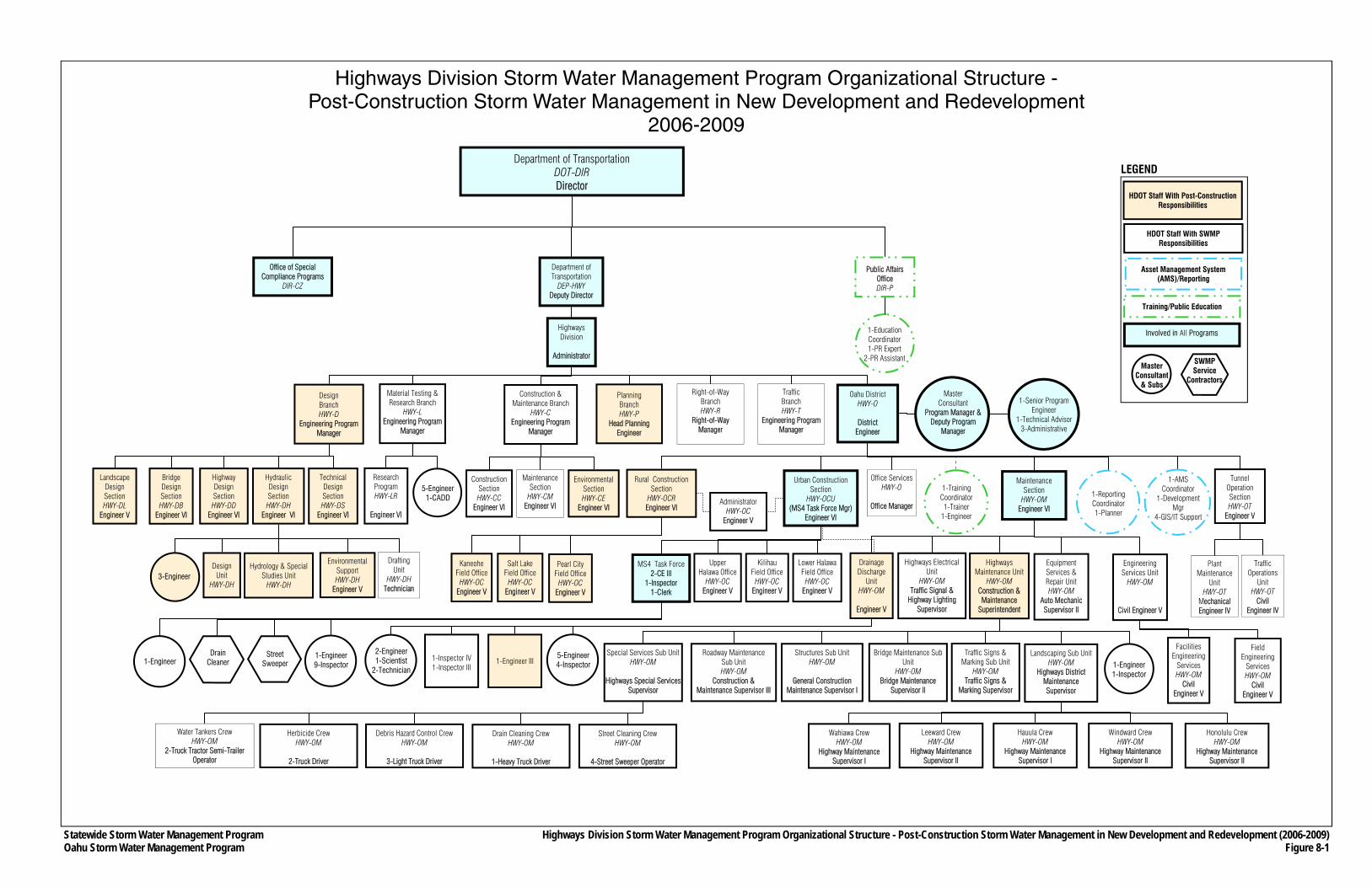
Statewide Storm Water Management Program Oahu Storm Water Management Program
Highways Division Storm Water Management Program Organizational Structure - Post-Construction Storm Water Management in New Development and Redevelopment
2006-2009
Department of Transportation DOT-DIR Director
Department of Transportation
DEP-HWY Deputy Director
Public Affairs Office DIR-P
Office of Special Compliance Programs
DIR-CZ
Highways Division
Administrator
Planning Branch HWY-P
Head Planning Engineer
Right-of-Way Branch HWY-R
Right-of-Way Manager
Oahu District HWY-O
District
Engineer
Traffic Branch HWY-T
Engineering Program Manager
Office Services HWY-O
Office Manager
Urban Construction Section
HWY-OCU (MS4 Task Force Mgr)
Engineer VI
Traffic Operations
Unit HWY-OT
Civil Engineer IV
Design Branch HWY-D
Engineering Program Manager
Highway Design Section HWY-DD
Engineer VI
Technical Design Section HWY-DS
Engineer VI
Construction & Maintenance Branch
HWY-C Engineering Program
Manager
Maintenance Section
HWY-CM Engineer VI
Environmental Section HWY-CE
Engineer VI
Construction Section HWY-CC
Engineer VI
Rural Construction Section
HWY-OCR Engineer VI
Wahiawa Crew HWY-OM
Highway Maintenance Supervisor I
Leeward Crew HWY-OM
Highway Maintenance Supervisor II
Hauula Crew HWY-OM
Highway Maintenance Supervisor I
Windward Crew HWY-OM
Highway Maintenance Supervisor II
Honolulu Crew HWY-OM
Highway Maintenance Supervisor II
Special Services Sub Unit HWY-OM
Highways Special Services
Supervisor
Bridge Maintenance Sub Unit
HWY-OM Bridge Maintenance
Supervisor II
Structures Sub Unit HWY-OM
General Construction
Maintenance Supervisor I
Roadway Maintenance Sub Unit HWY-OM
Construction & Maintenance Supervisor III
Equipment Services & Repair Unit HWY-OM
Auto Mechanic Supervisor II
Water Tankers Crew HWY-OM
2-Truck Tractor Semi-Trailer Operator
Street Cleaning Crew HWY-OM
4-Street Sweeper Operator
Drain Cleaning Crew HWY-OM
1-Heavy Truck Driver
Debris Hazard Control Crew HWY-OM
3-Light Truck Driver
Herbicide Crew HWY-OM
2-Truck Driver
1-Reporting Coordinator 1-Planner
1-AMS Coordinator
1-Development Mgr
4-GIS/IT Support
1-Training Coordinator 1-Trainer
1-Engineer
1-Education Coordinator 1-PR Expert
2-PR Assistant
Material Testing & Research Branch
HWY-L Engineering Program
Manager
Highways Maintenance Unit
HWY-OM Construction & Maintenance
Superintendent
Pearl City Field Office
HWY-OC Engineer V
Kaneohe Field Office
HWY-OC Engineer V
Salt Lake Field Office
HWY-OC Engineer V
Administrator HWY-OC
Engineer V
MS4 Task Force 2-CE III
1-Inspector 1-Clerk
Lower Halawa Field Office
HWY-OC Engineer V
Kilihau Field Office
HWY-OC Engineer V
Upper Halawa Office
HWY-OC Engineer V
Street Sweeper
Drain Cleaner
1-Engineer 9-Inspector
Landscaping Sub Unit HWY-OM
Highways District Maintenance Supervisor
Traffic Signs & Marking Sub Unit
HWY-OM Traffic Signs &
Marking Supervisor
1-Engineer 1-Inspector
Hydrology & Special Studies Unit
HWY-DH
Drafting Unit
HWY-DH Technician
Design Unit
HWY-DH
Environmental Support HWY-DH
Engineer V
3-Engineer
Research Program HWY-LR
Engineer VI
5-Engineer 1-CADD
Highways Electrical Unit
HWY-OM Traffic Signal &
Highway Lighting Supervisor
Master Consultant
Program Manager & Deputy Program
Manager
1-Senior Program Engineer
1-Technical Advisor 3-Administrative
Facilities Engineering
Services HWY-OM
Civil Engineer V
5-Engineer 4-Inspector
Highways Division Storm Water Management Program Organizational Structure - Post-Construction Storm Water Management in New Development and Redevelopment (2006-2009) Figure 8-1
1-Engineer 1-Inspector IV 1-Inspector III
2-Engineer 1-Scientist
2-Technician
SWMP Service
Contractors
Landscape Design Section HWY-DL
Engineer V
Tunnel Operation Section HWY-OT
Engineer V
Plant Maintenance
Unit HWY-OT
Mechanical Engineer IV
Engineering Services Unit
HWY-OM
Civil Engineer V
Field Engineering
Services HWY-OM
Civil Engineer V
Maintenance Section
HWY-OM Engineer VI
Bridge Design Section HWY-DB
Engineer VI
Hydraulic Design Section HWY-DH
Engineer VI
1-Engineer III
Drainage Discharge
Unit HWY-OM
Engineer V
Involved in All Programs
Asset Management System (AMS)/Reporting
Training/Public Education
Master Consultant
& Subs
HDOT Staff With SWMP Responsibilities
LEGEND
HDOT Staff With Post-Construction Responsibilities
Oahu Storm Water Management Program Plan Part II: Program Design
Chapter 9 9-1 March 2007 Pollution Prevention and Good Housekeeping
CHAPTER 9 POLLUTION PREVENTION AND GOOD
HOUSEKEEPING
The overall Pollution Prevention and Good Housekeeping Program (Pollution Prevention Program) consists of the following sub-programs, described in Sections 9.1 through 9.5:
• Debris Control BMP Program; • Chemical Applications BMP Program; • Erosion Control BMP Program; • Maintenance Facilities BMP Program; and • Storm Water Pollution Control for Flood Control Projects.
9.1 Debris Control BMP Program
Public use of Oahu highways cause the accumulation of litter, debris, sediment, heavy metals, and other matter within the rights-of-way, which may enter the Oahu MS4 during storm events. The Debris Control BMP Program (Debris Program) provides the framework for which potential pollutants (e.g., debris, soil, and organic materials) within HDOT Highways rights-of-way and in the Oahu MS4 will be managed. The program covers all highways and State owned roadways on Oahu, including their storm drain systems. It includes BMP procedures for conducting inspections and cleaning of all appropriate facilities, as well as an information system supported by and integrated with the AMS to collect and analyze data relating to sweeping and cleaning activities. The AMS will provide collected data that will be used for scheduling and reporting requirements. The program includes coordination with the Public Education Program (see Chapter Four), and training for those personnel responsible for inspecting and conducting the sweeping of roadways and cleaning of drainage structures.
9.1.1 Street Sweeping and Storm Drain Cleaning
HDOT Highways employs a number of measures to ensure that polluting materials do not impede the conveyance capacities of storm water drainage facilities and that their pollutant impacts to receiving waters are reduced to the maximum extent practicable. Such measures include street sweeping and litter removal using industry-standard sweeping vehicles, and clearing of debris and other materials that accumulate in drainage structures, such as catch basins, through mechanical (e.g., vacuuming) or manual means. Timely removal of debris from streets and storm drainage structures prevents storm water from flushing pollutant material into receiving surface waters.
This section describes the procedures for conducting street sweeping and storm drain cleaning. HDOT Highways Oahu District Maintenance Section (HWY-OM) is responsible for removing any litter, debris, sediment or other matter that accumulate within Oahu’s highway rights-of-way, including the Oahu MS4. Removing such material, sediment and debris ensures that storm water drainage is unimpeded and that potential pollutants to receiving waters are reduced to the maximum extent practicable. Polluting material typically found on roadways, which could enter the Oahu MS4 include:
Oahu Storm Water Management Program Plan Part II: Program Design
Chapter 9 9-2 March 2007 Pollution Prevention and Good Housekeeping
• Material from illegal dumping; • Runoff from construction activities within and adjacent to Highways rights-of-way; • Litter from motorists and pedestrians; • Debris from vehicles; • Loose paving materials and aggregate from cracked pavements and potholes; • Vegetative debris; and • Sediment accumulation.
Service contractors conduct much of the street sweeping and storm drain cleaning on Oahu. Debris Program personnel, who presently are part of the master consultant’s staff, conduct inspections of these activities. However, HWY-OM personnel conduct their own inspections and street sweeping on the Interstate Routes H-1, H-2 and H-3.
9.1.1.1 Street Sweeping
Currently, all highway segments on Oahu are divided into two lists, designated A and B, as shown on Figures 9-1 through 9-5 and listed in Table 9-1. “A” list segments will be swept at least once every five weeks while “B” list segments will be swept at least once every 15 weeks. Highway segments assigned to the “A” list generally carry higher volumes of traffic than “B” list segments, and often receive higher accumulation of roadway debris. Figures 9-1 through 9-5 show those “A” segments within high priority watersheds and those that are not.
Street sweeping service contractors are able to schedule their sweeping activities within the constraints provided under the “A” and “B” lists. Service contractors coordinate their schedules with the inspectors.
An inspector will accompany the service contractor during a sweeping activity, and will collect certain information, recording it on inspection forms (see Appendix G.1). The information collected by the inspector includes the location of swept areas (i.e., name of highway, and mile post to mile post) and the amount of debris collected. The inspector is required to enter the information into the street sweeping database of the AMS (see Section 3.3.5). Unlike other inspection programs, there are no plans at this time to convert the data collection/entry process using GPS/PDA units.
Every March (i.e., March 2008, March 2009, etc.), street sweeping data collected up to that period will be analyzed using the AMS, which may result in a re-categorization of highway segments as listed on Table 9-1. For instance, some “B” list segments may be re-categorized as “A” list, which will require that these segments be swept at least once every five weeks. Any changes to the categories provided in Table 9-1 will be based on material accumulation rates, potential impacts to the quality of State waters, and other criteria. Prior to conducting the analysis, debris accumulation thresholds will be established to determine when more frequent (i.e., five week cycles) sweeping should be conducted. If the categorization were changed, it will be submitted to HDOH for review Future service contracts will be modified to reflect the new sweeping schedule.
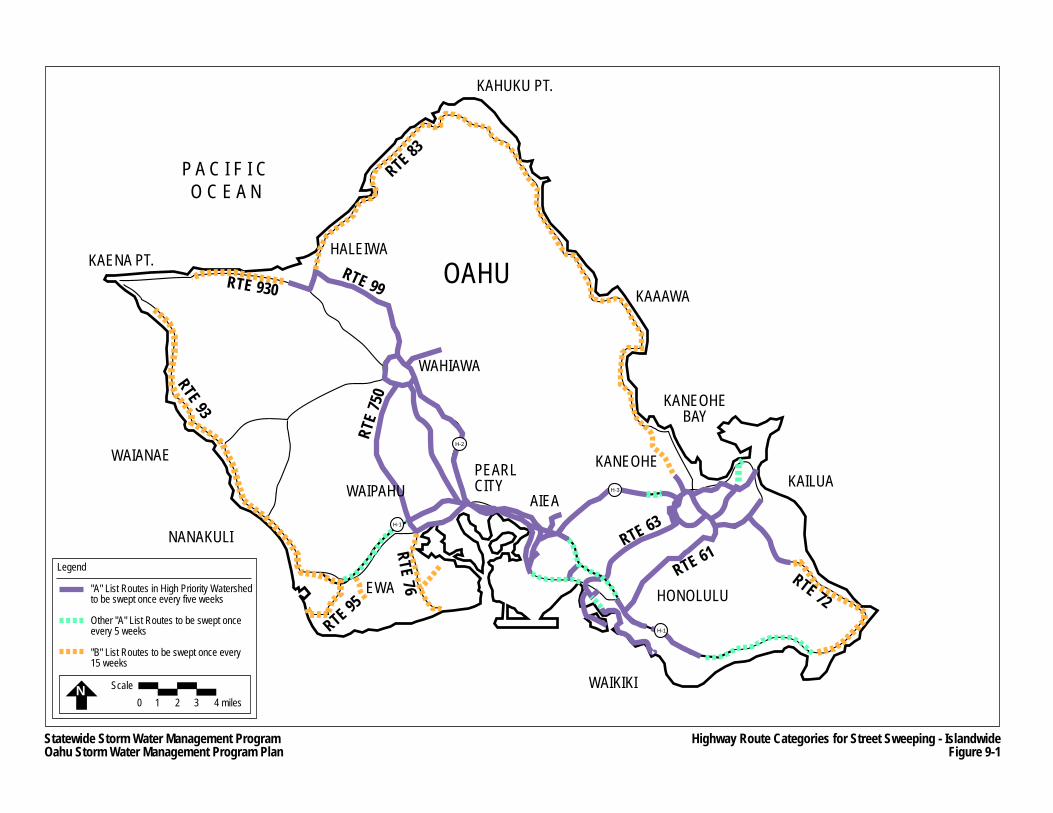
KAENA PT.
WAIANAE
HALEIWA
WAHIAWA
WAIPAHU AIEA
PEARL CITY
KAHUKU PT.
KAAAWA
EWA
WAIKIKI
KANEOHE
HONOLULU
KAILUA
KANEOHEBAY
P A C I F I C O C E A N
OAHU
RTE 93
RTE 930
RTE
750
RTE 63
RTE 61RTE 72
RTE 76RTE 95
RTE 99
RTE 83
NANAKULI
H-3
H-1
H-2
H-1
Statewide Storm Water Management ProgramOahu Storm Water Management Program Plan
Highway Route Categories for Street Sweeping - IslandwideFigure 9-1
Legend
"A" List Routes in High Priority Watershedto be swept once every five weeks
Other "A" List Routes to be swept onceevery 5 weeks
"B" List Routes to be swept once every 15 weeks
N Scale0 1 2 3 4 miles
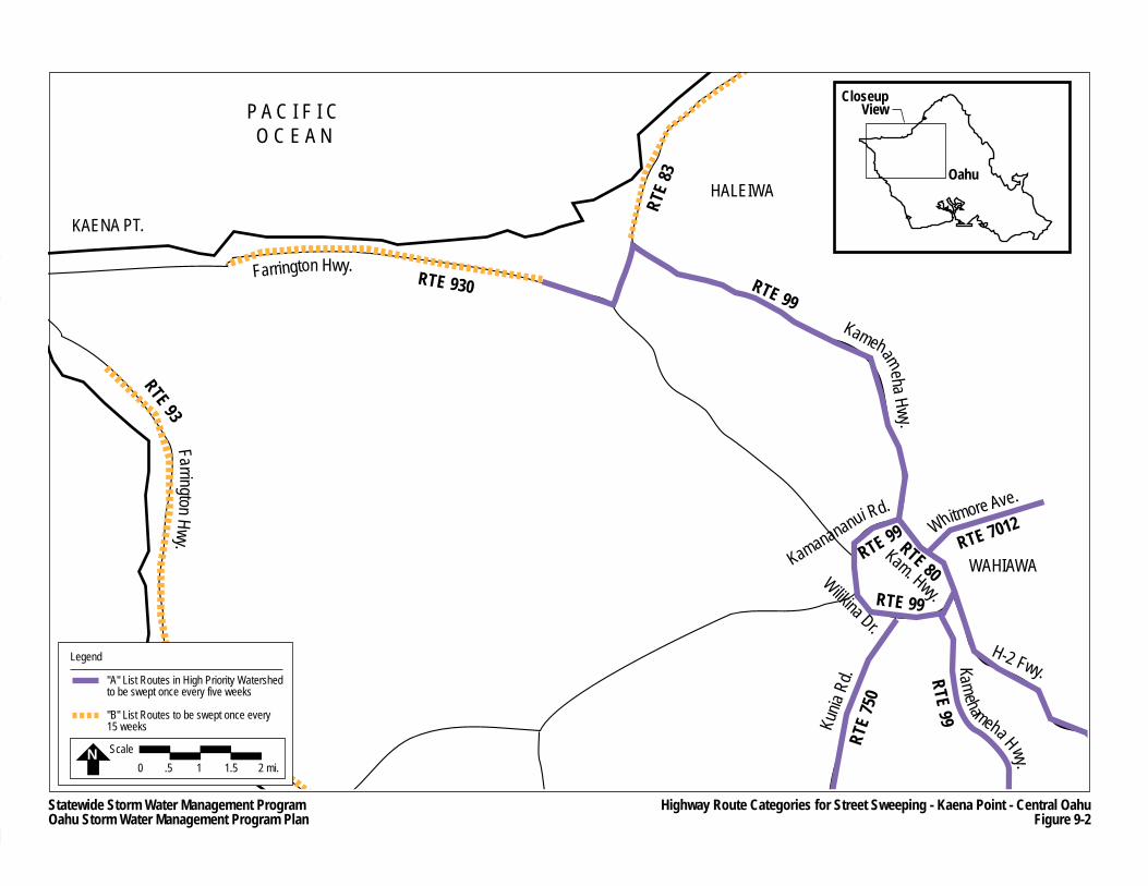
KAENA PT.
WAIANAE
HALEIWA
WAHIAWA
P A C I F I C O C E A N
RTE 930
RTE
750
RTE 99
RTE 99
RTE 7012
RTE 99
RTE 99
RTE 93
Farrington Hwy.
RTE
83
Farrin gton Hwy.
Kamehameha Hwy.
Kamanananui Rd.Whitmore Ave.
Kunia
Rd.
Kamehameha H wy.
H-2 Fwy.
Wilikina Dr.
RTE 80Kam. Hwy.
H-2
CloseupView
Oahu
Statewide Storm Water Management ProgramOahu Storm Water Management Program Plan
Highway Route Categories for Street Sweeping - Kaena Point - Central OahuFigure 9-2
Legend
"A" List Routes in High Priority Watershedto be swept once every five weeks
"B" List Routes to be swept once every 15 weeks
N Scale0 .5 1 1.5 2 mi.
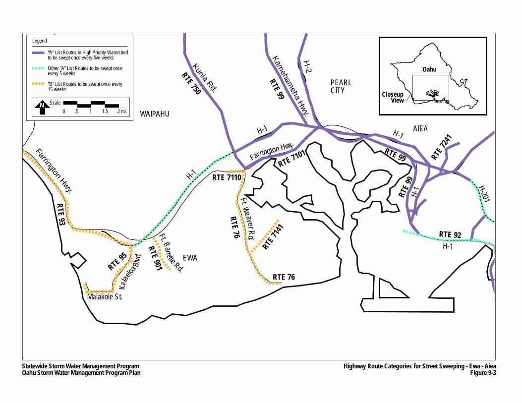
RTE 7110
WAIPAHU
AIEA
PEARL CITY
EWA
WA
K
RTE 9
RTE 76
RTE 71
41RTE 95
RTE 93
K
meha H wy.
RTE 901
Kalae
loa Bl
vd.
Ft. Barrette Rd.
Malakole St.
RTE 750
RTE 99
Kunia Rd.
Kameham
eha Hwy.
RTE 7101 RTE 99 RTE 72
41
RTE 9
9
RTE 92
Farrington Hwy.
Ft. Weaver Rd.
RTE 76
H-1
H-201H-1
H-1
H-2
H-1
H-1
Farrington Hwy.
CloseupView
Oahu
Statewide Storm Water Management ProgramOahu Storm Water Management Program Plan
Highway Route Categories for Street Sweeping - Ewa - AieaFigure 9-3
N Scale0 .5 1 1.5 2 mi.
Legend
"A" List Routes in High Priority Watershedto be swept once every five weeks
Other "A" List Routes to be swept onceevery 5 weeks
"B" List Routes to be swept once every 15 weeks
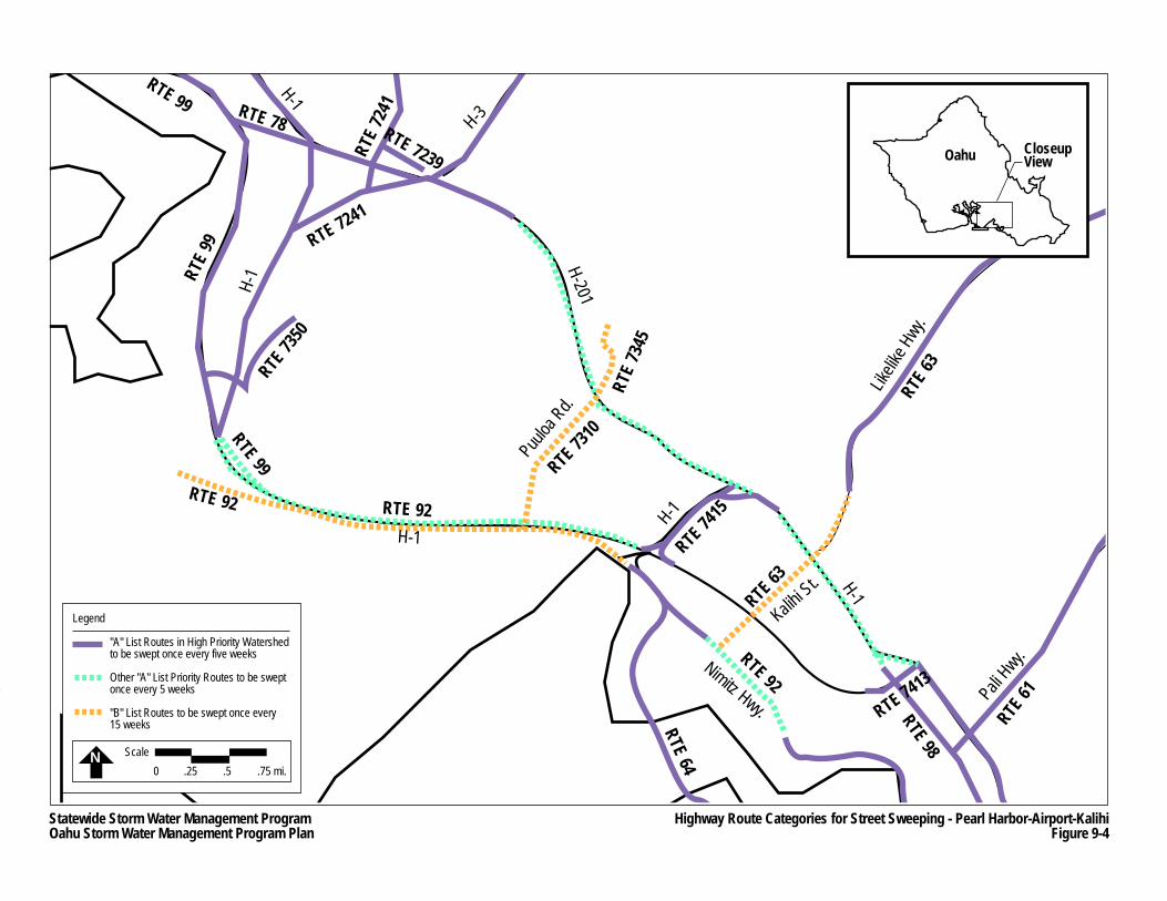
RTE 63
RTE 99 RTE 78
RTE 7
241
RTE 7239RT
E 99
RTE 73
50
RTE 99
RTE 92
RTE 7241
RTE 92RTE 64
RTE 92RTE 7413
RTE 98
RTE 61
RTE 63
RTE 7310
RTE
7345
H-1
H-201H-1
H-1
H-3
1
Puuloa
Rd.
RTE 7415H-1
H-1
Pali Hwy.Nimitz Hwy.
Likelik
e Hwy
.
Kalihi St.
CloseupViewOahu
Statewide Storm Water Management ProgramOahu Storm Water Management Program Plan
Highway Route Categories for Street Sweeping - Pearl Harbor-Airport-KalihiFigure 9-4
N Scale0 .25 .5 .75 mi.
Legend
"A" List Routes in High Priority Watershedto be swept once every five weeks
Other "A" List Priority Routes to be swept once every 5 weeks
"B" List Routes to be swept once every 15 weeks
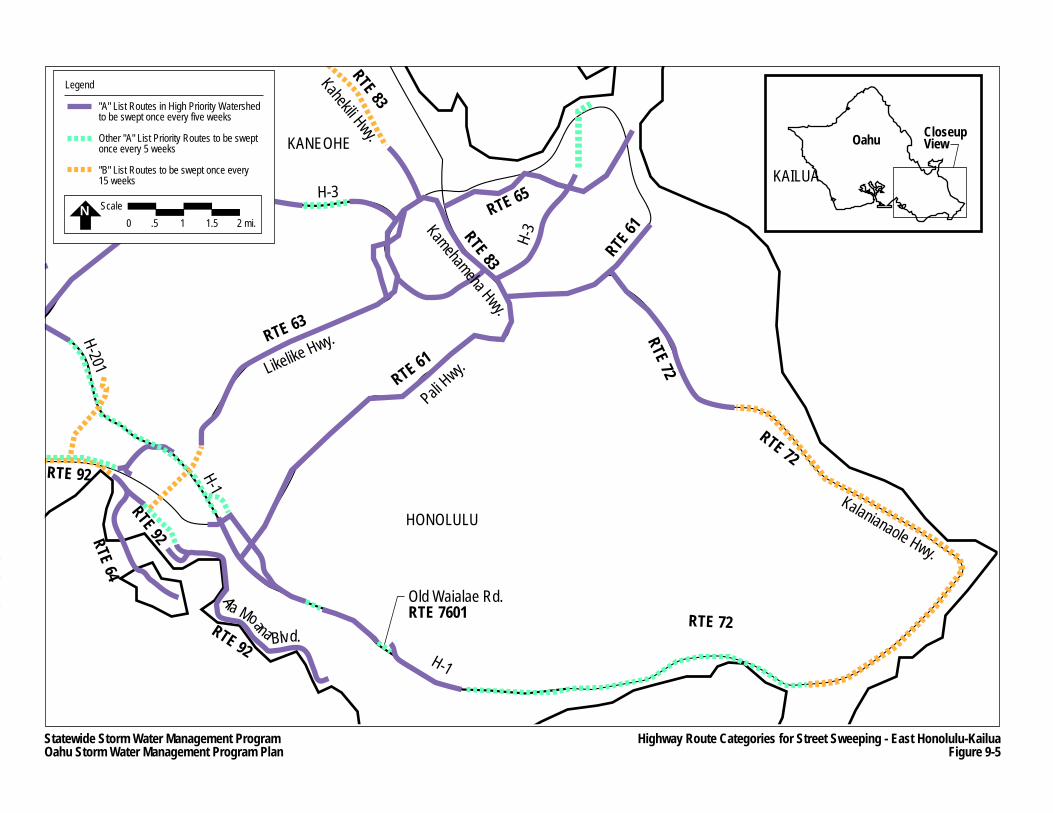
WAIKIKI
KANEOHE
HONOLULU
Likelike Hwy.
H-3
H-3
Pali Hwy.
KAILUA
RTE 63
Kahekili Hwy.RTE 83
Kamehameha Hwy.
RTE 83
RTE 65
RTE 61
RTE 72RTE 61
RTE 72
RTE 72
RTE 72
41
RTE 92
RTE 64RTE 92
RTE 92
H-1
H-201
H-1
H-1
Ala Moana Blvd.
Kalanianaole Hwy.
Old Waialae Rd.RTE 7601
H-3
CloseupViewOahu
Statewide Storm Water Management ProgramOahu Storm Water Management Program Plan
Highway Route Categories for Street Sweeping - East Honolulu-KailuaFigure 9-5
N Scale0 .5 1 1.5 2 mi.
Legend
"A" List Routes in High Priority Watershedto be swept once every five weeks
Other "A" List Priority Routes to be swept once every 5 weeks
"B" List Routes to be swept once every 15 weeks
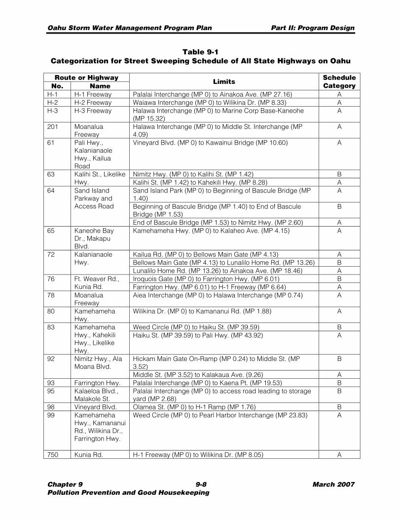
Oahu Storm Water Management Program Plan Part II: Program Design
Chapter 9 9-8 March 2007 Pollution Prevention and Good Housekeeping
Table 9-1 Categorization for Street Sweeping Schedule of All State Highways on Oahu
Route or Highway No. Name
Limits ScheduleCategory
H-1 H-1 Freeway Palalai Interchange (MP 0) to Ainakoa Ave. (MP 27.16) A H-2 H-2 Freeway Waiawa Interchange (MP 0) to Wilikina Dr. (MP 8.33) A H-3 H-3 Freeway Halawa Interchange (MP 0) to Marine Corp Base-Kaneohe
(MP 15.32) A
201 Moanalua Freeway
Halawa Interchange (MP 0) to Middle St. Interchange (MP 4.09)
A
61 Pali Hwy., Kalanianaole Hwy., Kailua Road
Vineyard Blvd. (MP 0) to Kawainui Bridge (MP 10.60) A
Nimitz Hwy. (MP 0) to Kalihi St. (MP 1.42) B 63 Kalihi St., Likelike Hwy. Kalihi St. (MP 1.42) to Kahekili Hwy. (MP 8.28) A
Sand Island Park (MP 0) to Beginning of Bascule Bridge (MP 1.40)
A
Beginning of Bascule Bridge (MP 1.40) to End of Bascule Bridge (MP 1.53)
B
64 Sand Island Parkway and Access Road
End of Bascule Bridge (MP 1.53) to Nimitz Hwy. (MP 2.60) A 65 Kaneohe Bay
Dr., Makapu Blvd.
Kamehameha Hwy. (MP 0) to Kalaheo Ave. (MP 4.15) A
Kailua Rd. (MP 0) to Bellows Main Gate (MP 4.13) A Bellows Main Gate (MP 4.13) to Lunalilo Home Rd. (MP 13.26) B
72 Kalanianaole Hwy.
Lunalilo Home Rd. (MP 13.26) to Ainakoa Ave. (MP 18.46) A Iroquois Gate (MP 0) to Farrington Hwy. (MP 6.01) B 76 Ft. Weaver Rd.,
Kunia Rd. Farrington Hwy. (MP 6.01) to H-1 Freeway (MP 6.64) A 78 Moanalua
Freeway Aiea Interchange (MP 0) to Halawa Interchange (MP 0.74) A
80 Kamehameha Hwy.
Wilikina Dr. (MP 0) to Kamananui Rd. (MP 1.88) A
Weed Circle (MP 0) to Haiku St. (MP 39.59) B 83 Kamehameha Hwy., Kahekili Hwy., Likelike Hwy.
Haiku St. (MP 39.59) to Pali Hwy. (MP 43.92) A
Hickam Main Gate On-Ramp (MP 0.24) to Middle St. (MP 3.52)
B 92 Nimitz Hwy., Ala Moana Blvd.
Middle St. (MP 3.52) to Kalakaua Ave. (9.26) A 93 Farrington Hwy. Palalai Interchange (MP 0) to Kaena Pt. (MP 19.53) B 95 Kalaeloa Blvd.,
Malakole St. Palalai Interchange (MP 0) to access road leading to storage yard (MP 2.68)
B
98 Vineyard Blvd. Olamea St. (MP 0) to H-1 Ramp (MP 1.76) B 99 Kamehameha
Hwy., Kamananui Rd., Wilikina Dr., Farrington Hwy.
Weed Circle (MP 0) to Pearl Harbor Interchange (MP 23.83) A
750 Kunia Rd. H-1 Freeway (MP 0) to Wilikina Dr. (MP 8.05) A
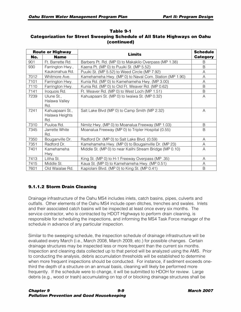
Oahu Storm Water Management Program Plan Part II: Program Design
Chapter 9 9-9 March 2007 Pollution Prevention and Good Housekeeping
Table 9-1 Categorization for Street Sweeping Schedule of All State Highways on Oahu
(continued)
Route or Highway No. Name
Limits ScheduleCategory
901 Ft. Barrette Rd. Barbers Pt. Rd. (MP 0) to Makakilo Overpass (MP 1.38) B Kaena Pt. (MP 0) to Puuiki St. (MP 5.52) B 930 Farrington Hwy.,
Kaukonahua Rd. Puuiki St. (MP 5.52) to Weed Circle (MP 7.92) A 7012 Whitmore Ave. Kamehameha Hwy. (MP 0) to Naval Com. Station (MP 1.90) A 7101 Farrington Hwy. Kunia Rd. (MP 0) to Kamehameha Hwy. (MP 3.00) A 7110 Farrington Hwy. Kunia Rd. (MP 0) to Old Ft. Weaver Rd. (MP 0.62) B 7141 Iroquois Rd. Ft. Weaver Rd. (MP 0) to West Loch (MP 1.51) B 7239 Ulune St.,
Halawa Valley Rd.
Kahuapaani St. (MP 0) to Iwaiwa St. (MP 0.32) A
7241 Kahuapaani St., Halawa Heights Rd.
Salt Lake Blvd (MP 0) to Camp Smith (MP 2.32) A
7310 Puuloa Rd. Nimitz Hwy. (MP 0) to Moanalua Freeway (MP 1.03) B 7345 Jarrette White
Rd. Moanalua Freeway (MP 0) to Tripler Hospital (0.55) B
7350 Bouganville Dr. Radford Dr. (MP 0) to Salt Lake Blvd. (0.59) A 7351 Radford Dr. Kamehameha Hwy. (MP 0) to Bougainville Dr. (MP 23) A 7401 Kamehameha
Hwy. Middle St. (MP 0) to near Kalihi Stream Bridge (MP 0.10) A
7413 Liliha St. King St. (MP 0) to H-1 Freeway Overpass (MP .35) A 7415 Middle St. Kaua St. (MP 0) to Kamehameha Hwy. (MP 0.51) A 7601 Old Waialae Rd. Kapiolani Blvd. (MP 0) to King St. (MP 0.41) B
9.1.1.2 Storm Drain Cleaning
Drainage infrastructure of the Oahu MS4 includes inlets, catch basins, pipes, culverts and outfalls. Other elements of the Oahu MS4 include open ditches, trenches and swales. Inlets and their associated catch basins will be inspected at least once every six months. The service contractor, who is contracted by HDOT Highways to perform drain cleaning, is responsible for scheduling the inspections, and informing the MS4 Task Force manager of the schedule in advance of any particular inspection.
Similar to the sweeping schedule, the inspection schedule of drainage infrastructure will be evaluated every March (i.e., March 2008, March 2009, etc.) for possible changes. Certain drainage structures may be inspected less or more frequent than the current six months. Inspection and cleaning data collected up to that period will be analyzed using the AMS. Prior to conducting the analysis, debris accumulation thresholds will be established to determine when more frequent inspections should be conducted. For instance, if sediment exceeds one-third the depth of a structure on an annual basis, cleaning will likely be performed more frequently. If the schedule were to change, it will be submitted to HDOH for review. Large debris (e.g., wood or trash) accumulating on top of or blocking drainage structures shall be
Oahu Storm Water Management Program Plan Part II: Program Design
Chapter 9 9-10 March 2007 Pollution Prevention and Good Housekeeping
removed promptly. Future service contracts would be modified if cleaning and/or inspection schedules were to change.
Inspections and cleaning of catch basins have been initiated. During an inspection of catch basins, the inspector will determine whether cleaning is required based on established debris accumulation thresholds (i.e., the depth of deposited sediment and debris is one-third the depth from the invert of the structure to the invert of the lowest pipe or opening into or out of the structure). An inventory of other drainage structures (pipes, culverts, ditches and swales) is being developed (see Sections 3.2 and 9.1.2), which would be used to establish appropriate thresholds and the terms and specifications of future service contracts.
If the drainage structure or element requires cleaning, as determined by the inspector, the service contractor will be responsible for conducting the cleaning. The inspector will enter the inspection data into a handheld GPS/PDA unit that has been configured to reflect the inspection forms. As noted in Section 3.3.5, the GPS/PDA units will be capable of direct uploading of information into the AMS, eliminating the need for inspectors or other personnel to physically re-enter data into the system.
The cleaning of a drainage structure or element will be conducted in the following manner: • Cleaning will not be performed during inclement weather; • At catch basins:
− Litter and other debris are removed from around the drain inlet and vegetation, if any, are to be cleared within ten feet of the inlet, if possible,
− Deposited sediment and debris are removed by using either vacuum equipment/truck or by hand tools, and
− Removed sediments and debris are dried to an appropriate moisture level before transport to and disposal at an approved landfill (also see Section 9.4.5).
• Pipes will be cleaned using the appropriate methods taking into account pipe sizes and locations, but generally conducted in the following manner: − Litter and other debris are removed from the pipe entrance or outfall, − Deposited sediment is removed from the pipe using jetting, augers, cables, hand
tools or a combination of methods, − Loosened materials are confined downstream of the clog and removed with vacuum
equipment, and − Removed sediments and debris are dried to an appropriate moisture level before
transport to and disposal at an approved landfill (also see Section 9.4.5). • At ditches, swales or other open-air drainage structure:
− Litter and other debris are removed from around the drainage structure and vegetation, if any, is cleared within ten feet of the structure, if possible,
− Deposited sediment and debris are removed by using either vacuum equipment/truck, excavating equipment or by hand tools, and
− Removed sediments and debris are dried to an appropriate moisture level before transport to and disposal at an approved landfill (also see Section 9.4.5).
Cleaning activities shall be observed by an inspector who will record the amount of material removed from the drainage structure using a handheld GPS/PDA unit. The GPS/PDA units will be configured to log drain inspection data, and will be synchronized (e.g., direct uploading capabilities) with the AMS Drain Cleaning database.
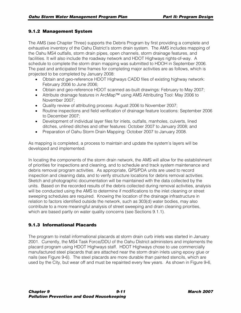
Oahu Storm Water Management Program Plan Part II: Program Design
Chapter 9 9-11 March 2007 Pollution Prevention and Good Housekeeping
9.1.2 Management System
The AMS (see Chapter Three) supports the Debris Program by first providing a complete and exhaustive inventory of the Oahu District’s storm drain system. The AMS includes mapping of the Oahu MS4 outfalls, storm drain pipes, open channels, storm drainage features, and facilities. It will also include the roadway network and HDOT Highways rights-of-way. A schedule to complete the storm drain mapping was submitted to HDOH in September 2006. The past and anticipated time frames for completing major activities are as follows, which is projected to be completed by January 2008:
• Obtain and geo-reference HDOT Highways CADD files of existing highway network: February 2006 to June 2006;
• Obtain and geo-reference HDOT scanned as-built drawings: February to May 2007; • Attribute drainage features in ArcMap™ using AMS Attributing Tool: May 2006 to
November 2007; • Quality review of attributing process: August 2006 to November 2007; • Routine inspections and field verification of drainage feature locations: September 2006
to December 2007; • Development of individual layer files for inlets, outfalls, manholes, culverts, lined
ditches, unlined ditches and other features: October 2007 to January 2008; and • Preparation of Oahu Storm Drain Mapping: October 2007 to January 2008.
As mapping is completed, a process to maintain and update the system’s layers will be developed and implemented.
In locating the components of the storm drain network, the AMS will allow for the establishment of priorities for inspections and cleaning, and to schedule and track system maintenance and debris removal program activities. As appropriate, GPS/PDA units are used to record inspection and cleaning data, and to verify structure locations for debris removal activities. Sketch and photographic documentation will be maintained with the data collected by the units. Based on the recorded results of the debris collected during removal activities, analysis will be conducted using the AMS to determine if modifications to the inlet cleaning or street sweeping schedules are required. Knowing the location of the drainage infrastructure in relation to factors identified outside the network, such as 303(d) water bodies, may also contribute to a more meaningful analysis of street sweeping and drain cleaning priorities, which are based partly on water quality concerns (see Sections 9.1.1).
9.1.3 Informational Placards
The program to install informational placards at storm drain curb inlets was started in January 2001. Currently, the MS4 Task Force/DDU of the Oahu District administers and implements the placard program using HDOT Highways staff. HDOT Highways chose to use commercially manufactured steel placards that are attached near the storm drain inlets using epoxy glue or nails (see Figure 9-6). The steel placards are more durable than painted stencils, which are used by the City, but wear off and must be repainted every few years. As shown in Figure 9-6,
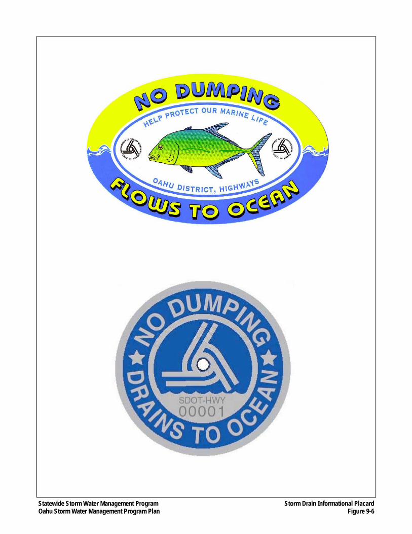
Statewide Storm Water Management Program Oahu Storm Water Management Program Plan
Storm Drain Informational Placard Figure 9-6
Oahu Storm Water Management Program Plan Part II: Program Design
Chapter 9 9-13 March 2007 Pollution Prevention and Good Housekeeping
the placards would contain messages that inform the public in an easy to understand manner that any material dumped into a storm drain would find its way to the ocean where it could have a polluting effect.
HDOT Highways plans to install at least 75 placards annually. The schedule is to install placards in locations that are used for industrial and / or commercial purposes and areas with high volumes of pedestrian traffic. The maintenance of existing placards will occur after placards have been installed on all State Highway routes
As described in Section 3.3.5.1, the Informational Placard program may use the AMS to help identify potential roadways and schedule installation of the placards once the program matures and more sophisticated methods for tracking installations are developed.
Once the AMS system is set up to record placard information, inspectors conducting routine storm drain inspections (see Section 9.1.1.2) will also check the condition of placards, if any, and record this information on their GPS/PDA units. Because all information from the inspections is inputted into the AMS, the placard program coordinator will be able to periodically check the status of placards, and schedule repairs or replacements based on the availability of HWY-OM maintenance staff.
9.1.4 Training
The training element for the Debris Program will include instruction about the BMPs used for the sweeping of roadways and cleaning of drainage structures, covering such subjects as inspection methods, criteria for sweeping and cleaning of roadways and storm drain structures, and how to record the pertinent observations or data.
Training Recipients
Training will be made available to any person responsible for carrying out any element of the Debris Program, including all staff contracted by the State or through the master consultant contract. These persons include, but not necessarily limited to, inspectors responsible for duties specified in Sections 9.1.1, and clerks or managers responsible for maintaining databases and records and coordinating with service contractors. Personnel employed by the service contractors who perform duties under this program will also be required to receive training.
Training Method
The method of training will involve both PowerPoint presentations and handout materials, which include the following documents:
• Presentation’s PowerPoint slides that allow for the taking of notes; and • Descriptions of Debris Program BMPs.
Oahu Storm Water Management Program Plan Part II: Program Design
Chapter 9 9-14 March 2007 Pollution Prevention and Good Housekeeping
Training on the operation of equipment specific to the Debris Program will be conducted by the supervisor responsible for the specific function to which the training applies. Such training includes situations where a new employee begins work or when new equipment is acquired.
Trainer Qualifications
The trainer must meet the following qualifications: • Experienced in the operation of sweeping and debris removal equipment; and • Understanding of various sweeping and debris removal BMPs specific to HDOT
Highways requirements.
Topics
Topics will include the following: • Environmental background and regulatory requirements, particularly the Clean Water
Act and the NPDES permit program; • Information and awareness of the Oahu MS4 NPDES Permit, and the overall Oahu
SWMP; • Informing staff that they serve an important role in protecting the water quality in the
State; • Responsibilities of HDOT Highways regarding storm water management; • Operation of sweeping and debris removal equipment; and • Proper collection and disposal techniques for street sweeping and drain cleaning.
Training Schedule and Reporting
Training will be held on an as-needed basis. Formal “classroom” type of training may be combined with other training conducted under other programs of the Pollution Prevention Program and the Construction Programs.
The Mid-Year and End-of-Year Reports (See Chapter Thirteen) will contain information on the number and dates of training sessions, types of training, and recipients of the training.
9.1.5 Organizational Structure
As shown on Figure 9-7, the Debris Program is overseen by HWY-OM. HWY-OM personnel perform street sweeping on Interstate Routes H-1, H-2 and H-3, and conduct storm drain cleaning on an as-needed basis. The MS4 Task Force assists HWY-OM by administering the service contractors performing street sweeping on highways not covered by HWY-OM personnel and service contractors who conduct storm drain cleaning.
The master consultant provides the street sweeping and storm drain cleaning inspectors who oversee and record the activities of the service contractors.
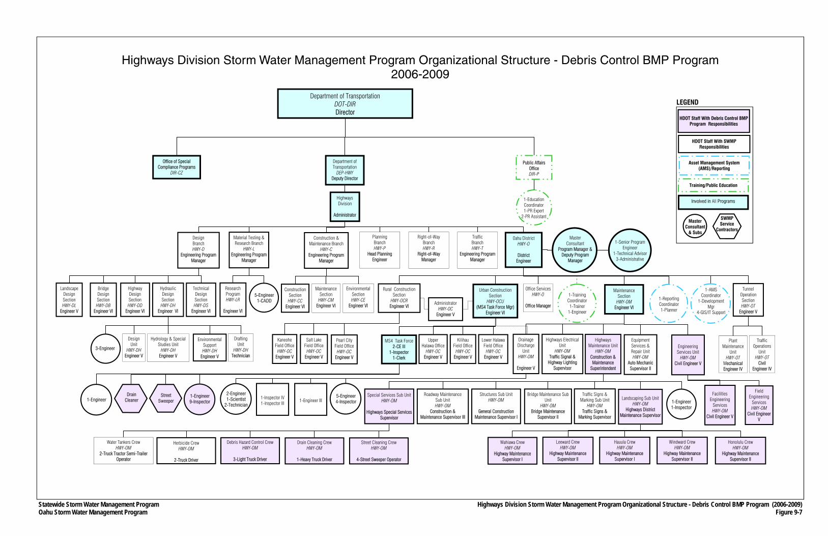
Statewide Storm Water Management Program Oahu Storm Water Management Program
Department of Transportation DOT-DIR Director
Department of Transportation
DEP-HWY Deputy Director
Public Affairs Office DIR-P
Office of Special Compliance Programs
DIR-CZ
Highways Division
Administrator
Planning Branch HWY-P
Head Planning Engineer
Right-of-Way Branch HWY-R
Right-of-Way Manager
Oahu District HWY-O
District
Engineer
Traffic Branch HWY-T
Engineering Program Manager
Office Services HWY-O
Office Manager
Urban Construction Section
HWY-OCU (MS4 Task Force Mgr)
Engineer VI
Traffic Operations
Unit HWY-OT
Civil Engineer IV
Design Branch HWY-D
Engineering Program Manager
Highway Design Section HWY-DD
Engineer VI
Technical Design Section HWY-DS
Engineer VI
Construction & Maintenance Branch
HWY-C Engineering Program
Manager
Maintenance Section
HWY-CM Engineer VI
Environmental Section HWY-CE
Engineer VI
Construction Section HWY-CC
Engineer VI
Rural Construction Section
HWY-OCR Engineer VI
Wahiawa Crew HWY-OM
Highway Maintenance Supervisor I
Leeward Crew HWY-OM
Highway Maintenance Supervisor II
Hauula Crew HWY-OM
Highway Maintenance Supervisor I
Windward Crew HWY-OM
Highway Maintenance Supervisor II
Honolulu Crew HWY-OM
Highway Maintenance Supervisor II
Special Services Sub Unit HWY-OM
Highways Special Services
Supervisor
Bridge Maintenance Sub Unit
HWY-OM Bridge Maintenance
Supervisor II
Structures Sub Unit HWY-OM
General Construction
Maintenance Supervisor I
Roadway Maintenance Sub Unit HWY-OM
Construction & Maintenance Supervisor III
Equipment Services & Repair Unit HWY-OM
Auto Mechanic Supervisor II
Water Tankers Crew HWY-OM
2-Truck Tractor Semi-Trailer Operator
Street Cleaning Crew HWY-OM
4-Street Sweeper Operator
Drain Cleaning Crew HWY-OM
1-Heavy Truck Driver
Debris Hazard Control Crew HWY-OM
3-Light Truck Driver
Herbicide Crew HWY-OM
2-Truck Driver
1-Reporting Coordinator 1-Planner
1-AMS Coordinator
1-Development Mgr
4-GIS/IT Support
1-Training Coordinator 1-Trainer
1-Engineer
1-Education Coordinator 1-PR Expert
2-PR Assistant
Material Testing & Research Branch
HWY-L Engineering Program
Manager
Highways Maintenance Unit
HWY-OM Construction & Maintenance
Superintendent
Pearl City Field Office
HWY-OC Engineer V
Kaneohe Field Office
HWY-OC Engineer V
Salt Lake Field Office
HWY-OC Engineer V
Administrator HWY-OC
Engineer V
MS4 Task Force 2-CE III
1-Inspector 1-Clerk
Lower Halawa Field Office
HWY-OC Engineer V
Kilihau Field Office
HWY-OC Engineer V
Upper Halawa Office
HWY-OC Engineer V
Street Sweeper
Drain Cleaner
1-Engineer 9-Inspector
Landscaping Sub Unit HWY-OM
Highways District Maintenance Supervisor
Traffic Signs & Marking Sub Unit
HWY-OM Traffic Signs &
Marking Supervisor
1-Engineer 1-Inspector
Hydrology & Special Studies Unit
HWY-DH Engineer V
Drafting Unit
HWY-DH Technician
Design Unit
HWY-DH Engineer V
Environmental Support HWY-DH
Engineer V
3-Engineer
Research Program HWY-LR
Engineer VI
5-Engineer 1-CADD
Highways Electrical Unit
HWY-OM Traffic Signal &
Highway Lighting Supervisor
Master Consultant
Program Manager & Deputy Program
Manager
1-Senior Program Engineer
1-Technical Advisor 3-Administrative
Facilities Engineering
Services HWY-OM
Civil Engineer V
5-Engineer 4-Inspector
Highways Division Storm Water Management Program Organizational Structure - Debris Control BMP Program (2006-2009) Figure 9-7
1-Engineer 1-Inspector IV 1-Inspector III
2-Engineer 1-Scientist
2-Technician
SWMP Service
Contractors
Highways Division Storm Water Management Program Organizational Structure - Debris Control BMP Program 2006-2009
Landscape Design Section HWY-DL
Engineer V
Tunnel Operation Section HWY-OT
Engineer V
Plant Maintenance
Unit HWY-OT
Mechanical Engineer IV
Engineering Services Unit
HWY-OM Civil Engineer V
Field Engineering
Services HWY-OM
Civil Engineer V
Maintenance Section
HWY-OM Engineer VI
Bridge Design Section HWY-DB
Engineer VI
Hydraulic Design Section HWY-DH
Engineer VI
1-Engineer III
Drainage Discharge
Unit HWY-OM
Engineer V
Involved in All Programs
Asset Management System (AMS)/Reporting
Training/Public Education
Master Consultant
& Subs
HDOT Staff With SWMP Responsibilities
LEGEND
HDOT Staff With Debris Control BMP Program Responsibilities
Oahu Storm Water Management Program Plan Part II: Program Design
Chapter 9 9-16 March 2007 Pollution Prevention and Good Housekeeping
9.2 Chemical Applications BMP Program
Construction and maintenance of landscaped areas within HDOT Highways rights-of-way requires physical care, such as mowing and pruning, along with application of chemicals to provide nutrients and to control weedy plants. Control of weedy plants is accomplished by the use of herbicides. HDOT Highways has no routine pest control measures. Therefore, HWY-OM personnel do not regularly apply pesticides to control insect pests or vector control (traps and/or application of poisons) to control rodents. However, landscape maintenance service contractors have used pesticides at spot locations to address specific problems, such as preventing pests from killing or damaging trees or other vegetation.
The Chemical Applications BMP Program (Chemical Program) is designed to reduce the contribution of pollutants from the use of herbicides and pesticides on HDOT Highways rights-of-way, landscaped areas, and maintenance and baseyard facilities. The Chemical Program covers the BMPs that address the application, storage, and disposal of these chemicals, and consists of:
• Ensuring that HWY-OM personnel and contractors properly use fertilizers and herbicides when maintaining HDOT Highways rights-of-way through proper training and educational activities; and
• Executing integrated pest management measures that rely on non-chemical solutions and/or use of native vegetation.
The objective of the Chemical Program is to minimize pollutant loading in storm water from the application of fertilizers, herbicides and pesticides within HDOT Highways rights-of-way. This program applies to HWY-OM personnel and HDOT Highways landscape contractors who must follow the procedures and BMPs described in this section.
9.2.1 Application of Chemicals
Unwanted vegetation growth is controlled by manual weeding and the use of herbicides. HWY-OM personnel and licensed service contractors use only brand-name herbicides that include Roundup®, a systemic contact weed killer, and Oust®, a pre-emergent agent. Both are biodegradable. These herbicides are applied to large areas by the HWY-OM Special Services Unit, service contractors and landscape crews using a spray truck and/or 2-1/2-gallon hand sprayers. Personnel applying herbicides are required to wear protective clothing and accessories and follow all manufacturers’ application guidelines.
Landscape service contractors use brand-name pesticides, and are required to wear protective clothing and accessories and follow all manufacturers’ application guidelines. HDOT Highways personnel do not apply pesticides.
9.2.2 Training
No HDOT Highways employee or landscape service contractor may apply chemical fertilizers, herbicides or pesticides unless they have received training under this program.
Oahu Storm Water Management Program Plan Part II: Program Design
Chapter 9 9-17 March 2007 Pollution Prevention and Good Housekeeping
Training in the use of chemicals will cover the following two categories of BMPs: 1. General Vegetation Management 2. Herbicide and Pesticide Management
Each of these BMPs is described in detail in the Chemical Applications Training Plan (March 2006), which was prepared for HDOT Highways and is provided in Appendix H.1.
General vegetation management is a BMP that applies to routine landscape maintenance. The training will consist of instructing landscape maintenance personnel that handle or have responsibility for using fertilizers and herbicides about good housekeeping procedures, such as cleaning and maintaining equipment; properly storing and disposing of chemicals; and general procedures for applying herbicides.
Training for the herbicide and pesticide management BMP started in February 2006. Training includes the proper handling and application procedures to prevent contamination of storm water runoff. Also, the training for this BMP includes instruction about adjusting irrigation systems to suit site conditions and avoiding conveyance of chemically contaminated runoff to down-slope areas where it can enter the Oahu MS4 or directly into receiving waters.
Training Recipients
Training will be made available to all personnel, including supervisors, employed by HDOT Highways staff or service contractors (e.g., landscaping construction and maintenance contractors) involved in the use, storage, management, and application of herbicides and pesticides. No person will be allowed to apply herbicides or pesticides within HDOT Highways rights-of-way or its other properties unless the applier has first received the training described herein.
Training Method
Unit and service contractor supervisors will undergo classroom training. A video of the training was produced, and can be used in lieu of live training for new employees, or for those employees who missed the previous training sessions or for those who want a refresher. The following training materials will be provided to training recipients:
• A copy of the Chemical Applications Training Plan; • Hands-on training materials; and • Training outline and documentation materials/forms.
Both HDOT Highways and service contractor landscape personnel will be trained by supervisors who underwent the classroom training (toolbox training).
Trainer Qualifications
The trainer must have professional experience in the handling and application of chemicals used for landscaping.

Oahu Storm Water Management Program Plan Part II: Program Design
Chapter 9 9-18 March 2007 Pollution Prevention and Good Housekeeping
HDOT Maintenance Supervisors who have attended a training session held by a qualified trainer are considered qualified to hold on-the-job training sessions for new employees or employees who were not able to attend a formal training session.
Topics
Topics will include the following: • Information and awareness of the Oahu MS4 NPDES Permit, and the overall Oahu
SWMP; • Informing staff that they serve an important role in protecting the water quality in the
State; • Providing an awareness and understanding how landscaping chemicals can harm
water quality; • General vegetation management BMP; • Fertilizer, herbicide and pesticide management BMPs, which includes logging usage
and disposal of expired chemicals of; • Conducting training of others; and • Conducting site inspections.
Training Schedule and Reporting
Training of unit and service contract supervisors will be held annually. HDOT Highways maintenance landscape and service contract personnel will be trained by supervisors annually.
The Mid-Year and End-of-Year Reports (See Chapter Thirteen) will contain information on the number and dates of training sessions, types of training, and recipients of the training.
9.2.3 Non-Chemical Solutions
In order to develop sustainable and durable landscapes with an Hawaiian sense of place, HDOT Highways is developing a Statewide Sustainable Landscape Master Plan, which is scheduled to be completed by the end of 2009. The objective of the plan is to develop a list of plants that can be used in highway landscaped areas that have a lifespan of 15-plus years, are durable, and where their natural form is preferred. These plants would require little or no maintenance (e.g., little or no application of fertilizers and herbicides), no irrigation, are cost effective, and reflect Hawaii's sense of place. Native species meeting these criteria will be prioritized in the list, which will be categorized by annual rainfall and typical locations. Once completed, the plan will be distributed to HWY-OM and HDOT Highways design managers, and be made available to landscape architects working on HDOT Highways projects.
9.2.4 Organizational Structure
As shown on Figure 9-8, the Chemical Program is overseen by HWY-OM. Its Special Services Sub Unit and Landscaping Sub Units apply herbicides. HWY-OM personnel also provide the chemical applications training described in Section 9.2.2.
Oahu Storm Water Management Program Plan Part II: Program Design
Chapter 9 9-19 March 2007 Pollution Prevention and Good Housekeeping
THIS PAGE INTENTIONALLY LEFT BLANK.
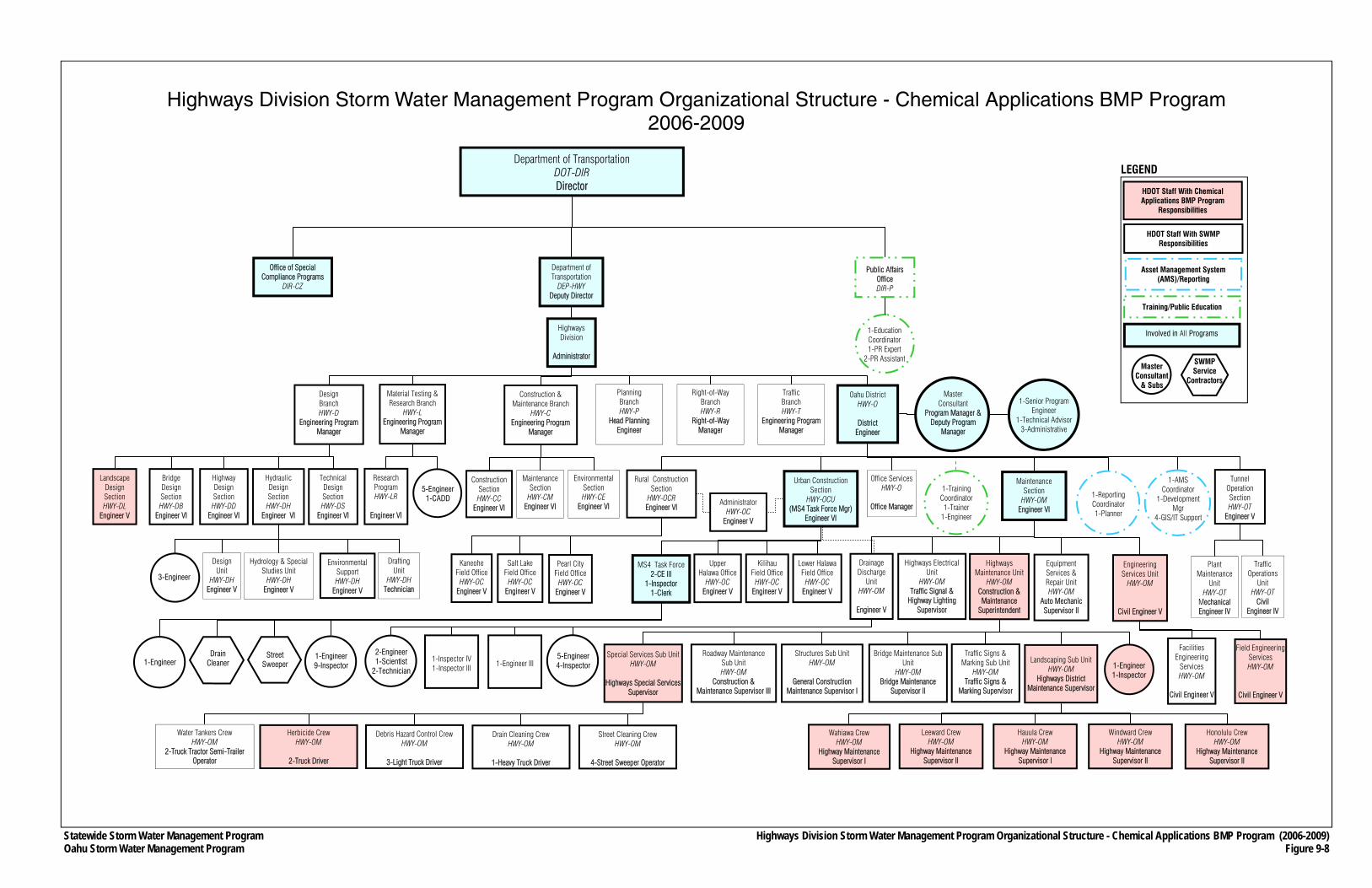
Statewide Storm Water Management Program Oahu Storm Water Management Program
Department of Transportation DOT-DIR Director
Department of Transportation
DEP-HWY Deputy Director
Public Affairs Office DIR-P
Office of Special Compliance Programs
DIR-CZ
Highways Division
Administrator
Planning Branch HWY-P
Head Planning Engineer
Right-of-Way Branch HWY-R
Right-of-Way Manager
Oahu District HWY-O
District
Engineer
Traffic Branch HWY-T
Engineering Program Manager
Office Services HWY-O
Office Manager
Urban Construction Section
HWY-OCU (MS4 Task Force Mgr)
Engineer VI
Traffic Operations
Unit HWY-OT
Civil Engineer IV
Design Branch HWY-D
Engineering Program Manager
Highway Design Section HWY-DD
Engineer VI
Technical Design Section HWY-DS
Engineer VI
Construction & Maintenance Branch
HWY-C Engineering Program
Manager
Maintenance Section
HWY-CM Engineer VI
Environmental Section HWY-CE
Engineer VI
Construction Section HWY-CC
Engineer VI
Rural Construction Section
HWY-OCR Engineer VI
Wahiawa Crew HWY-OM
Highway Maintenance Supervisor I
Leeward Crew HWY-OM
Highway Maintenance Supervisor II
Hauula Crew HWY-OM
Highway Maintenance Supervisor I
Windward Crew HWY-OM
Highway Maintenance Supervisor II
Honolulu Crew HWY-OM
Highway Maintenance Supervisor II
Special Services Sub Unit HWY-OM
Highways Special Services
Supervisor
Bridge Maintenance Sub Unit
HWY-OM Bridge Maintenance
Supervisor II
Structures Sub Unit HWY-OM
General Construction
Maintenance Supervisor I
Roadway Maintenance Sub Unit HWY-OM
Construction & Maintenance Supervisor III
Equipment Services & Repair Unit HWY-OM
Auto Mechanic Supervisor II
Water Tankers Crew HWY-OM
2-Truck Tractor Semi-Trailer Operator
Street Cleaning Crew HWY-OM
4-Street Sweeper Operator
Drain Cleaning Crew HWY-OM
1-Heavy Truck Driver
Debris Hazard Control Crew HWY-OM
3-Light Truck Driver
Herbicide Crew HWY-OM
2-Truck Driver
1-Reporting Coordinator 1-Planner
1-AMS Coordinator
1-Development Mgr
4-GIS/IT Support
1-Training Coordinator 1-Trainer
1-Engineer
1-Education Coordinator 1-PR Expert
2-PR Assistant
Material Testing & Research Branch
HWY-L Engineering Program
Manager
Highways Maintenance Unit
HWY-OM Construction & Maintenance
Superintendent
Pearl City Field Office
HWY-OC Engineer V
Kaneohe Field Office
HWY-OC Engineer V
Salt Lake Field Office
HWY-OC Engineer V
Administrator HWY-OC
Engineer V
MS4 Task Force 2-CE III
1-Inspector 1-Clerk
Lower Halawa Field Office
HWY-OC Engineer V
Kilihau Field Office
HWY-OC Engineer V
Upper Halawa Office
HWY-OC Engineer V
Street Sweeper
Drain Cleaner
1-Engineer 9-Inspector
Landscaping Sub Unit HWY-OM
Highways District Maintenance Supervisor
Traffic Signs & Marking Sub Unit
HWY-OM Traffic Signs &
Marking Supervisor
1-Engineer 1-Inspector
Hydrology & Special Studies Unit
HWY-DH Engineer V
Drafting Unit
HWY-DH Technician
Design Unit
HWY-DH Engineer V
Environmental Support HWY-DH
Engineer V
3-Engineer
Research Program HWY-LR
Engineer VI
5-Engineer 1-CADD
Highways Electrical Unit
HWY-OM Traffic Signal &
Highway Lighting Supervisor
Master Consultant
Program Manager & Deputy Program
Manager
1-Senior Program Engineer
1-Technical Advisor 3-Administrative
Facilities Engineering
Services HWY-OM
Civil Engineer V
5-Engineer 4-Inspector
Highways Division Storm Water Management Program Organizational Structure - Chemical Applications BMP Program (2006-2009) Figure 9-8
1-Engineer 1-Inspector IV 1-Inspector III
2-Engineer 1-Scientist
2-Technician
SWMP Service
Contractors
Highways Division Storm Water Management Program Organizational Structure - Chemical Applications BMP Program 2006-2009
Landscape Design Section HWY-DL
Engineer V
Tunnel Operation Section HWY-OT
Engineer V
Plant Maintenance
Unit HWY-OT
Mechanical Engineer IV
Engineering Services Unit
HWY-OM
Civil Engineer V
Field Engineering Services HWY-OM
Civil Engineer V
Maintenance Section
HWY-OM Engineer VI
Bridge Design Section HWY-DB
Engineer VI
Hydraulic Design Section HWY-DH
Engineer VI
1-Engineer III
Drainage Discharge
Unit HWY-OM
Engineer V
Involved in All Programs
Asset Management System (AMS)/Reporting
Training/Public Education
Master Consultant
& Subs
HDOT Staff With SWMP Responsibilities
LEGEND
HDOT Staff With Chemical Applications BMP Program
Responsibilities
Oahu Storm Water Management Program Plan Part II: Program Design
Chapter 9 9-21 March 2007 Pollution Prevention and Good Housekeeping
9.3 Erosion Control BMP Program
The objective of the Erosion Control BMP Program (Erosion Program) is to reduce soil erosion from roadside areas within HDOT Highways rights-of-way on Oahu, which include existing soil erosion problems that are not associated with current or planned construction projects. Water quality impacts due to erosion include adverse effects to plant, animal, and aquatic life; transport of pollutants, such as nutrients and heavy metals that attach to soil particles; and decreased capacities of waterways and drainage systems due to sedimentation (deposition of erodable soil particles), which increases the potential for flooding.
The function of the Erosion Program is to identify and implement erosion control projects based on water quality concerns while continuing to address high profile public safety projects. The Erosion Program includes:
• Modification of the list of approved erosion and sediment control BMPs to include at a minimum those contained in the City BMP Manual;
• Identification and implementation of site-specific erosion control remediation measures for 10 high priority erosional areas (i.e. initial ten (FY06) erosion sites) agreed upon between HDOT Highways, HDOH and USEPA;
• Identification of erosional areas island wide on Oahu; • Prioritization of islandwide erosional areas on Oahu based upon water quality impacts
as a high priority; • Design projects in order to construct, in the prioritized order, erosion control measures
at the islandwide erosional areas ; • Construction of erosion control measures at islandwide erosional areas; • Maintenance of erosion control measures constructed at the islandwide erosional
areas; • Identification of erosion at storm drain outfalls that require velocity dissipators or other
BMPs; and • Periodic training of HDOT Highways personnel responsible for managing and
conducting the installation and maintenance of erosion control BMPs.
9.3.1 Erosion and Sediment Control BMPs
HDOT Highways’ list of approved erosion and sediment control BMPs will be expanded to include all of the BMPs contained in the City BMP Manual. In addition, the following erosion and sediment control BMPs were added to Chapter 2, Erosion Control and Stabilization and Chapter 3, Sediment Control and Containment, of the Construction BMP Field Manual, which was submitted to HDOT in September 2006. These additional erosion and sediment control BMPs were presented during the recent Supplemental Environmental Project (SEP) training sessions held in 2006 and early 2007.
Erosion Control and Stabilization Methods 1. Construction Road Stabilization; 2. Stabilized Construction Entrance; 3. Temporary Stream Crossing; 4. Flared Culvert End Sections; 5. Seeding and Planting;
Oahu Storm Water Management Program Plan Part II: Program Design
Chapter 9 9-22 March 2007 Pollution Prevention and Good Housekeeping
6. Mulching; 7. Geotextiles and Mats; 8. Run-on Diversion; and 9. Slope Roughening, Terracing, and Rounding.
Sediment Control and Containment Methods 1. Silt Fence or Filter Fabric Fence; 2. Storm Drain Inlet Protection; 3. Rip-Rap and Gabion Inflow Protection; 4. Outfall Protection and Velocity Dissipation Devices; 5. Vegetated Filter Strips and Buffers; 6. Earth Dike; 7. Temporary Drains and Swales; 8. Compost Filter Berm; 9. Check Dams; 10. Level Spreader; 11. Slope Drains and Subsurface Drains; 12. Top and Toe of Slope Diversion Ditches and Berms; 13. Sandbag Barrier; 14. Brush or Rock Filter; 15. Sediment Trap; and 16. Sediment Basin.
These additional erosion and sediment control BMPs were presented during the recent Supplemental Environmental Project (SEP) training sessions held in 2006 and early 2007.
9.3.2 Identification of Erosional Areas
The identification of two types of erosional areas (high priority and islandwide), based on their water quality impacts, is described in this section.
9.3.2.1 High Priority Erosional Areas
Ten high priority erosional areas, as shown on Figures 9-9, 9-10 and 9-11 and listed on Table 9-2, were agreed upon during HDOT Highways’ negotiations with HDOH and USEPA. These ten areas are also referred to as initial ten (FY06) erosion sites.
To address the ten high priority erosional areas identified in Table 9-2, a report was prepared that identified site-specific erosion control remediation measures for each of these sites. A copy of the report, Plan for the Completion of the 10 Erosion Control Projects (July 2006) (Erosion Control Plan), was submitted to HDOH and USEPA in late July 2006. A copy of the Erosion Control Plan is provided in Appendix I.1.
Brief descriptions of the ten high priority sites are provided in this section. More detailed descriptions of these sites are provided in the Erosion Control Plan.
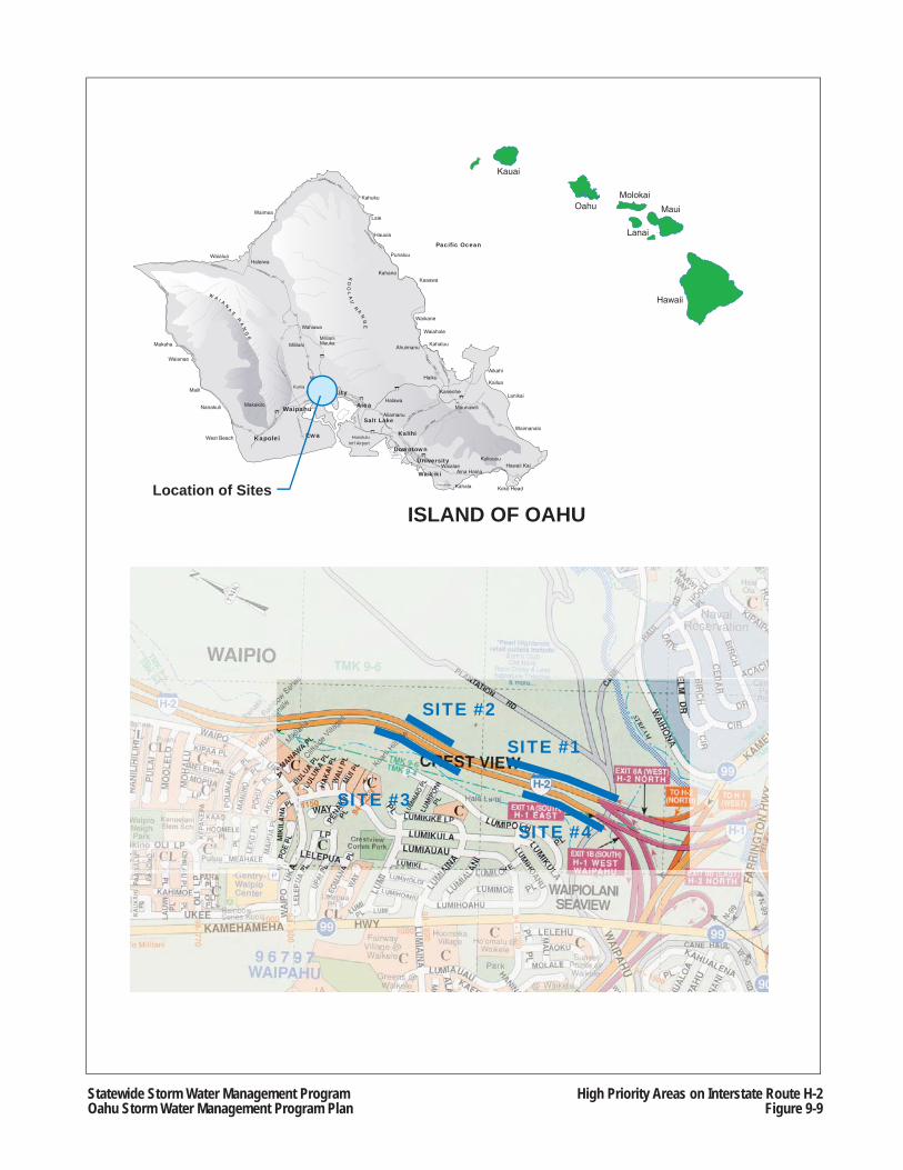
OahuMolokai
Lanai
Maui
Hawaii
Kauai
WaialuaHaleiwa
Waimea
Ewa
Koko HeadDiamond Head
Waikiki
Kahuku
Hauula
Laie
Punaluu
Kaaawa
Kaneohe
Kahaluu
Waiahole
Waikane
Wahiawa
Maili
Makaha Mililani
Pearl City
Waianae
Nanakuli Waipahu
WaipioKailua
Waimanalo
Aiea
Kahana
Ahuimanu
Haiku
Maunawili
Aikahi
Lanikai
Kahala
KuliououHawaii Kai
Aina Haina
Downtown
Kalihi
UniversityWaialae
Sand
Island
Aliamanu
Halawa
Salt Lake
Kunia
MililaniMauka
Makakilo
W A I A
N
A
E R
AN
GE
KO
OL
AU
R
A
NG
E
West Beach
Pacific Ocean
HonoluluInt'l Airport
Kapolei
KAMEHAMEHA HWY
KAMEHAMEHA HW
Y
KAMEH
AMEH
A HWY
KA
HEKILI HW
Y
LIKE
LIKE HWY
PALI
HWY
KALANIANAOLE
KALANIANAOLE
ALA MOANA BLVD
KAPIOLANI BLVD
S KING
LUNALILO FWY
PENS
ACO
LAPI
IKO
I
S BERETANIA
VINEYARD BLVD
LUNALILO FWY
NIM
ITZ
N KING
FORT BISHOP
NIMITZ HWY
PUNCHBO
WL
PUNA
HOU
LUNALILO
FWY
SAND ISLAND ACC
ESS RD
KAM HWY
MOAN
ALUA FWY
PU
ULO
A R
D
NIMITZ HWY
KAM
EHAM
EHA H
WY
KAMEHAMEHA HWY
MOANALUA RD
MOANALU
A RD
WAI
MAN
O H
OM
E R
D
FARRINGTON HWY
KAM
EHAM
EHA HWY
KUNIA RD
FOR
T WEAVER
RD
KALA
ELOA B
LVD
FARRIN
GTON
HW
YFARRINGTON HWY
FARRINGTON HWY
FARRINGTON
FARRINGTON KAMEHAMEHA HWY
H-3
83
83
830
83
61
63
72
H-3
72
92
H-1
H-1
78
H-199
90
H-1
H-1
99
H-2
76
93
750
93
99
80
99
99
750
830
930
930
83
83
SITE #4
SITE #1
SITE #2
SITE #3
ISLAND OF OAHULocation of Sites
Statewide Storm Water Management ProgramOahu Storm Water Management Program Plan
High Priority Areas on Interstate Route H-2Figure 9-9
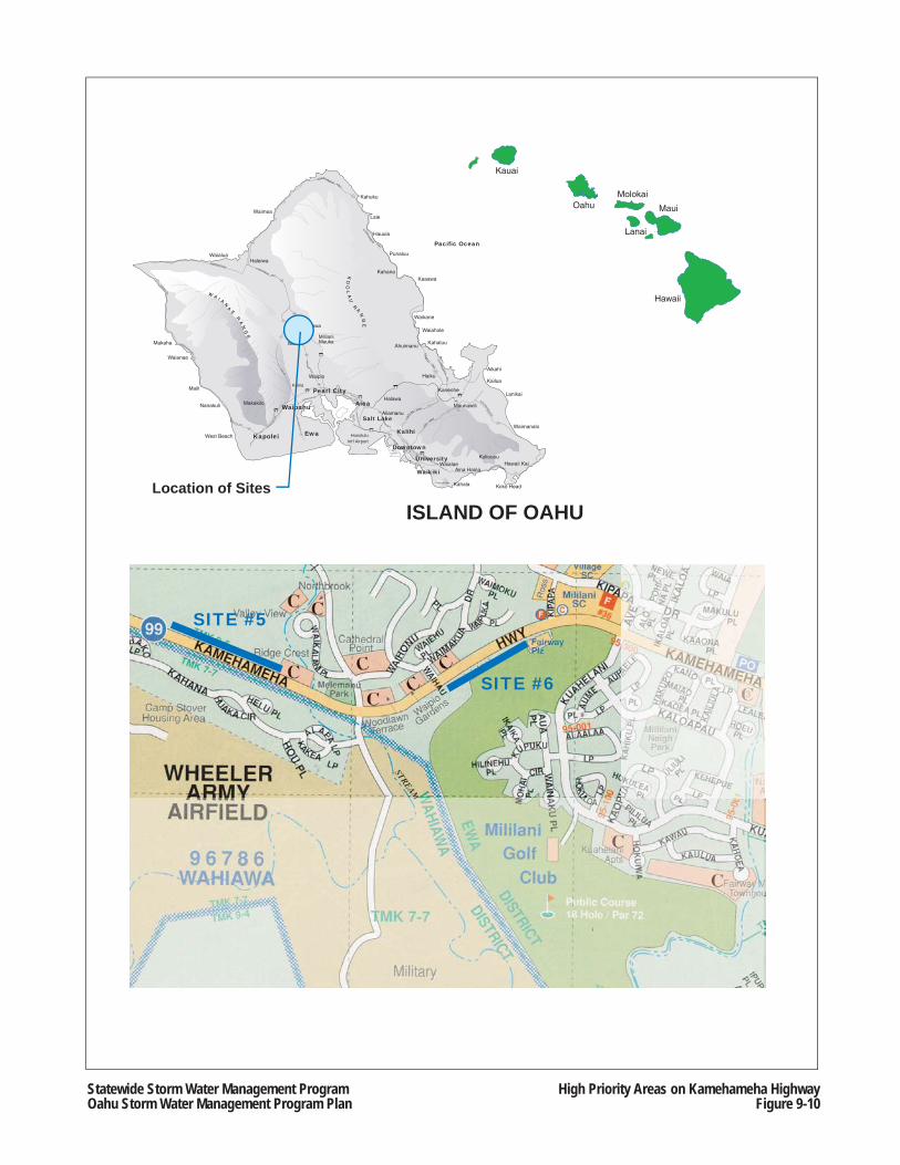
OahuMolokai
Lanai
Maui
Hawaii
Kauai
WaialuaHaleiwa
Waimea
Ewa
Koko HeadDiamond Head
Waikiki
Kahuku
Hauula
Laie
Punaluu
Kaaawa
Kaneohe
Kahaluu
Waiahole
Waikane
Wahiawa
Maili
Makaha Mililani
Pearl City
Waianae
Nanakuli Waipahu
WaipioKailua
Waimanalo
Aiea
Kahana
Ahuimanu
Haiku
Maunawili
Aikahi
Lanikai
Kahala
KuliououHawaii Kai
Aina Haina
Downtown
Kalihi
UniversityWaialae
Sand
Island
Aliamanu
Halawa
Salt Lake
Kunia
MililaniMauka
Makakilo
W A I A
N
A
E R
AN
GE
KO
OL
AU
R
A
NG
E
West Beach
Pacific Ocean
HonoluluInt'l Airport
Kapolei
KAMEHAMEHA HWY
KAMEHAMEHA HW
Y
KAMEH
AMEH
A HWY
KA
HEKILI HW
Y
LIKE
LIKE HWY
PALI
HWY
KALANIANAOLE
KALANIANAOLE
ALA MOANA BLVD
KAPIOLANI BLVD
S KING
LUNALILO FWY
PENS
ACO
LAPI
IKO
I
S BERETANIA
VINEYARD BLVD
LUNALILO FWY
NIM
ITZ
N KING
FORT BISHOP
NIMITZ HWY
PUNCHBO
WL
PUNA
HOU
LUNALILO
FWY
SAND ISLAND ACC
ESS RD
KAM HWY
MOAN
ALUA FWY
PU
ULO
A R
D
NIMITZ HWY
KAM
EHAM
EHA H
WY
KAMEHAMEHA HWY
MOANALUA RD
MOANALU
A RD
WAI
MAN
O H
OM
E R
D
FARRINGTON HWY
KAM
EHAM
EHA HWY
KUNIA RD
FOR
T WEAVER
RD
KALA
ELOA B
LVD
FARRIN
GTON
HW
YFARRINGTON HWY
FARRINGTON HWY
FARRINGTON
FARRINGTON KAMEHAMEHA HWY
H-3
83
83
830
83
61
63
72
H-3
72
92
H-1
H-1
78
H-199
90
H-1
H-1
99
H-2
76
93
750
93
99
80
99
99
750
830
930
930
83
83
SITE #5
SITE #6
ISLAND OF OAHULocation of Sites
Statewide Storm Water Management ProgramOahu Storm Water Management Program Plan
High Priority Areas on Kamehameha HighwayFigure 9-10
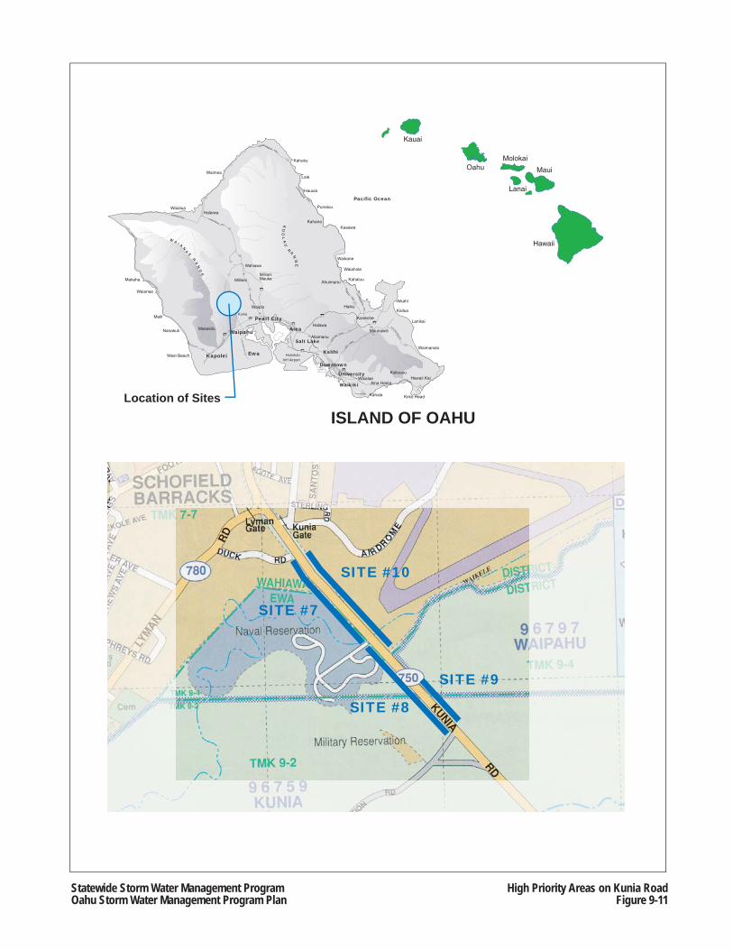
OahuMolokai
Lanai
Maui
Hawaii
Kauai
WaialuaHaleiwa
Waimea
Ewa
Koko HeadDiamond Head
Waikiki
Kahuku
Hauula
Laie
Punaluu
Kaaawa
Kaneohe
Kahaluu
Waiahole
Waikane
Wahiawa
Maili
Makaha Mililani
Pearl City
Waianae
Nanakuli Waipahu
WaipioKailua
Waimanalo
Aiea
Kahana
Ahuimanu
Haiku
Maunawili
Aikahi
Lanikai
Kahala
KuliououHawaii Kai
Aina Haina
Downtown
Kalihi
UniversityWaialae
Sand
Island
Aliamanu
Halawa
Salt Lake
Kunia
MililaniMauka
Makakilo
W A I A
N
A
E R
AN
GE
KO
OL
AU
R
A
NG
E
West Beach
Pacific Ocean
HonoluluInt'l Airport
Kapolei
KAMEHAMEHA HWY
KAMEHAMEHA HW
Y
KAMEH
AMEH
A HWY
KA
HEKILI HW
Y
LIKE
LIKE HWY
PALI
HWY
KALANIANAOLE
KALANIANAOLE
ALA MOANA BLVD
KAPIOLANI BLVD
S KING
LUNALILO FWY
PENS
ACO
LAPI
IKO
I
S BERETANIA
VINEYARD BLVD
LUNALILO FWY
NIM
ITZ
N KING
FORT BISHOP
NIMITZ HWY
PUNCHBO
WL
PUNA
HOU
LUNALILO
FWY
SAND ISLAND ACC
ESS RD
KAM HWY
MOAN
ALUA FWY
PU
ULO
A R
D
NIMITZ HWY
KAM
EHAM
EHA H
WY
KAMEHAMEHA HWY
MOANALUA RD
MOANALU
A RD
WAI
MAN
O H
OM
E R
D
FARRINGTON HWY
KAM
EHAM
EHA HWY
KUNIA RD
FOR
T WEAVER
RD
KALA
ELOA B
LVD
FARRIN
GTON
HW
YFARRINGTON HWY
FARRINGTON HWY
FARRINGTON
FARRINGTON KAMEHAMEHA HWY
H-3
83
83
830
83
61
63
72
H-3
72
92
H-1
H-1
78
H-199
90
H-1
H-1
99
H-2
76
93
750
93
99
80
99
99
750
830
930
930
83
83
SITE #10
ISLAND OF OAHULocation of Sites
SITE #7
SITE #9
SITE #8
Statewide Storm Water Management ProgramOahu Storm Water Management Program Plan
High Priority Areas on Kunia RoadFigure 9-11
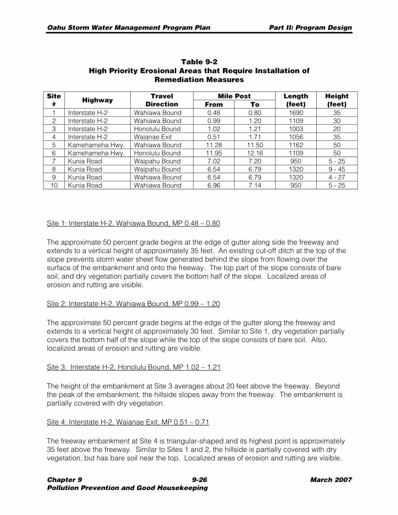
Oahu Storm Water Management Program Plan Part II: Program Design
Chapter 9 9-26 March 2007 Pollution Prevention and Good Housekeeping
Table 9-2 High Priority Erosional Areas that Require Installation of
Remediation Measures
Mile Post Site # Highway Travel
Direction From To Length (feet)
Height (feet)
1 Interstate H-2 Wahiawa Bound 0.48 0.80 1690 35 2 Interstate H-2 Wahiawa Bound 0.99 1.20 1109 30 3 Interstate H-2 Honolulu Bound 1.02 1.21 1003 20 4 Interstate H-2 Waianae Exit 0.51 1.71 1056 35 5 Kamehameha Hwy. Wahiawa Bound 11.28 11.50 1162 50 6 Kamehameha Hwy. Honolulu Bound 11.95 12.16 1109 50 7 Kunia Road Waipahu Bound 7.02 7.20 950 5 - 25 8 Kunia Road Waipahu Bound 6.54 6.79 1320 9 - 45 9 Kunia Road Wahiawa Bound 6.54 6.79 1320 4 - 27 10 Kunia Road Wahiawa Bound 6.96 7.14 950 5 - 25
Site 1: Interstate H-2, Wahiawa Bound, MP 0.48 – 0.80
The approximate 50 percent grade begins at the edge of gutter along side the freeway and extends to a vertical height of approximately 35 feet. An existing cut-off ditch at the top of the slope prevents storm water sheet flow generated behind the slope from flowing over the surface of the embankment and onto the freeway. The top part of the slope consists of bare soil, and dry vegetation partially covers the bottom half of the slope. Localized areas of erosion and rutting are visible.
Site 2: Interstate H-2, Wahiawa Bound, MP 0.99 – 1.20
The approximate 50 percent grade begins at the edge of the gutter along the freeway and extends to a vertical height of approximately 30 feet. Similar to Site 1, dry vegetation partially covers the bottom half of the slope while the top of the slope consists of bare soil. Also, localized areas of erosion and rutting are visible.
Site 3: Interstate H-2, Honolulu Bound, MP 1.02 – 1.21
The height of the embankment at Site 3 averages about 20 feet above the freeway. Beyond the peak of the embankment, the hillside slopes away from the freeway. The embankment is partially covered with dry vegetation.
Site 4: Interstate H-2, Waianae Exit, MP 0.51 – 0.71
The freeway embankment at Site 4 is triangular-shaped and its highest point is approximately 35 feet above the freeway. Similar to Sites 1 and 2, the hillside is partially covered with dry vegetation, but has bare soil near the top. Localized areas of erosion and rutting are visible.
Oahu Storm Water Management Program Plan Part II: Program Design
Chapter 9 9-27 March 2007 Pollution Prevention and Good Housekeeping
Similar to Site 1, a cut-off ditch is located at the top of slope, which prevents storm water sheet flow generated behind the slope from flowing over the surface of the embankment and onto the freeway.
Site 5: Kamehameha Highway, Wahiawa Bound, MP 11.28 – 11.50
The embankment along the highway has a grade of approximately 67 percent or steeper, beginning at the edge of the gutter and extending to a height of approximately 50 feet. Erosion is visible near the top of the hillside where a top lip is forming and the slope surface is irregular. Utility poles were erected along the top of slope. Near the bottom of the hillside, vegetation is sporadic with some small trees.
Site 6: Kamehameha Highway, Honolulu Bound,MP 11.95 – 12.16
Similar to Site 5, the embankment along the highway has a grade of approximately 67 percent or steeper, beginning at the edge of the gutter and extending to a height of approximately 50 feet. The hillside consists of bare soil with the exception of small clusters of trees. The surface of the embankment is irregular and a lip is forming at the top of slope where thicker grass-type vegetation is visible.
Sites 7: Kunia Road, Waipahu Bound, MP 7.02 – 7.20
The hillside at Site 7 has a grade of approximately 67 percent or steeper, beginning at the edge of the highway pavement. The embankment varies in height from five to 25 feet, and appears highly weathered based on the irregularity of the surface and the exposed tree roots caused by erosion. The highest point of the embankment supports no vegetation, and other parts have minimal vegetation.
Site 8: Kunia Road, Waipahu Bound, MP 6.54 – 6.79
The hillside at Site 8 has a grade of approximately 67 percent or steeper, beginning at the edge of the highway pavement. The embankment varies in height from nine to 45 feet, and appears highly weathered based on the irregularity of the surface and the exposed tree roots caused by erosion. The embankment supports some vegetative growth.
Site 9: Kunia Road, Wahiawa Bound, MP 6.54 – 6.79
The hillside at Site 9 has a grade of approximately 67 percent or steeper, beginning at the edge of the highway pavement. The embankment varies in height from four to 27 feet, and appears highly weathered based on the irregularity of the surface and the exposed tree roots caused by erosion. Similar to Site 8, the embankment at Site 9 supports some vegetative growth. In addition, there are utility poles along the slope adjacent to the roadway.
Oahu Storm Water Management Program Plan Part II: Program Design
Chapter 9 9-28 March 2007 Pollution Prevention and Good Housekeeping
Site 10: Kunia Road, Wahiawa Bound, MP 6.96 – 7.14
The hillside at Site 10 has a grade of approximately 67 percent or steeper, beginning at the edge of the highway pavement. The embankment varies in height from five to 25 feet, and appears highly weathered based on the irregularity of the surface and the exposed tree roots caused by erosion. The embankment supports minimal vegetation, and is used for utility poles that run parallel to the highway.
9.3.2.2 Islandwide Erosional Areas
The Erosion Program includes the identification and prioritization of existing roadside areas within HDOT Highways rights-of-way on Oahu that exhibit soil erosion problems not associated with current or planned construction projects. The following methodology was used to derive a prioritized listing of islandwide erosional areas:
1. Perform field operations; 2. Perform soil loss calculations; and 3. Develop quantitative criteria for evaluating islandwide erosion.
A detailed description of the methodology is provided in the draft report, Islandwide Assessment of Erosional Areas on the Island of Oahu (March 2007) (Islandwide Assessment) (see Appendix I.2).
Field Operations
The field operations consisted of identifying and documenting potential erosional areas within the HDOT Highways’ Right-of-Way. The following activities were conducted between May and September 2006:
• Visual inspections of all areas along State highways by a crew of two to three persons using sub-meter GPS/PDA units to locate the extent of an erosional area, if identified; and
• Collect the following information about an erosional area: − Approximate length, − Approximate width, − Approximate slope (measurements taken via SmartLevel®, where feasible), − Percent of vegetative cover, − Type of vegetative cover, − Type of erosion, and − Photographs.
Sheetwash was identified as the most common form of erosion. Numerous areas were also observed to exhibit rilling. Gullying and mass movement were much less common. For this task, sheetwash was identified as areas of uniform soil removal with no clearly defined flow paths; rilling was identified as surface flows which result in rills less than 12 inches in depth; gullying was identified as an advanced stage of rill erosion with concentrated water flows forming scour channels greater than 12 inches in depth. Mass movement was used to identify areas of landslides or rockfalls.
Oahu Storm Water Management Program Plan Part II: Program Design
Chapter 9 9-29 March 2007 Pollution Prevention and Good Housekeeping
Georeferenced aerial photographs and City GIS data layers were used to supplement the field operations where necessary. The limits of erosional areas were refined based on this information where the extent of erosion was not completely visible from the roadway. Aerial photographs were also used to identify potential erosional areas along roadway embankments, which are often not readily visible from the driver’s perspective due to drop-offs along the roadside.
Future updates of the Islandwide Assessment will include potential erosional areas along roadway embankments and man-made disturbances within North Halawa Valley. Roadway embankment areas constitute those locations that are not readily visible from a driver’s perspective due to drop-offs along the roadside.
Soil Loss Calculations
The Universal Soil Loss Equation (USLE) was used for the soil loss calculations. The USLE predicts long term average annual rate of soil losses based on rainfall patterns, soil type, topography, ground cover vegetation, and management practices. The USLE provides a reasonable estimate for sheet and rill erosion but is less accurate when applied to gullying. It is not accurate in predicting soil loss due to mass movement because landslides occur as an short time span incident, rather than a gradual process. However, the USLE is still considered applicable because the flattened bare slope would be subject to the other forms of erosion. Therefore, in order to provide a uniform basis of comparison for predicting future soil loss, the USLE was applied to all sites, regardless of the type of observed erosion. In the future, the method of determining soil loss will be re-evaluated, which may result in using more refined methods of calculating soil losses.
Quantitative Criteria
Islandwide high priority sites were identified among the erosional areas by using the USLE equation, and other factors, including the erosion area, watershed priority and water classification. The ranking criteria (erosional value) are based on the following equation: Erosion Value = (USLE) x (erosion area) x (watershed factor) x (water classification factor).
Each watershed was categorized into one the following four classifications to determine the watershed factors: critical; high priority; CWA Section 303(d); and all others.
Critical watersheds were assigned Waste load Allocations (WLA) (see Section 11.2), and include Kawa, Waimanalo, Ala Wai, Kawainui, and Kaelepulu. Erosional areas in critical watersheds were assigned the largest weight factor of 4.
High priority watersheds are defined in the Consent Decree (see Section 1.2), and include Aiea, Halawa, Kalauao, Kalihi, Kaneohe, Kapakahi, Kaukonahua, Keaahala, Kawainui, Keaahala, Kiikii, Nuuanu, Paukauila, Poamoho, Waiawa, Waikele, Waimalu, Waimanalo, and Waipio. Erosional areas in high priority watersheds were assigned a weight factor of 3.
Watersheds containing USEPA’s Section 303(d) list of impaired waters based on turbidity or total suspended solids: Anahulu, Hanauma, Helemano, Honouliuli, Kaaawa, Kahaluu, Kahaluu Segment, Kahawainui, Kapalama, Kaupuni, Kawaiiki, Kawailoa, Koko Crater, Makaha,

Oahu Storm Water Management Program Plan Part II: Program Design
Chapter 9 9-30 March 2007 Pollution Prevention and Good Housekeeping
Makaiwa, Moanalua, and Opaeula. Erosional areas in 303(d) watersheds were assigned a weight factor of 2.
Erosional areas located in the remaining watersheds were assigned a weight factor of 1.
For the water classification factors, erosional areas that drain into Class A waters were assigned a weight factor of 1, and erosional areas that drain into Class AA waters were assigned a weight factor of 1.2, or 20% greater. Watersheds that outfall into Class AA waters include: Manini, Kaluakauila, Anahulu, Loko Ea, Kahana, Hakipuu, Waikane, Waianu, Waiahole, Kaalaea, Haiamoa, Waihee, Kahaluu, Ahuimanu, Kahaluu segment, Heeia, Keaahala, Kaneohe, Kawa, Puu Hawaiiloa, and Makapuu. Erosional areas within the remaining watersheds were assumed to outfall into Class A waters.
Analysis and Results
A total of 934 erosional areas were identified between May and September 2006. Each site was evaluated for erosion potential and ranked according to the calculated erosion value. Based on this analysis, a list of the top 20 islandwide erosional areas was compiled (see Table 9-3). As shown in Figures 9-12 and 9-13, these high priority sites are clustered within the Windward (12 sites) and Central Oahu areas (8 sites). Critical watersheds and Class AA waters are prevalent in the Windward area, and all of the high priority sites in Windward Oahu exhibit nearly vertical faces, some exceeding 40 feet in height. The remainder of the islandwide high priority sites (8 of 20) is located in Central Oahu. The sites in Central Oahu also exhibit steep conditions.
Additional information about the top-ranked 20 sites as provided in Table 9-3, as well as a comprehensive list of all islandwide erosional areas evaluated in the study as of September 2006, are included in the Islandwide Assessment in Appendix I.2.
Limitations
The findings presented in the Islandwide Assessment are based upon information obtained from visual field inspections conducted during May and September 2006. The degree of erosive conditions is subject to change subsequent to the date of the field survey. The nature and extent of these variations may not be evident until subsequent field visits, at which time, a re-evaluation of the site may be required.
The “Soil Loss” values as shown in Table 9-3 are used as the basis of prioritization of the erosional sites. These values are not to be considered the actual soil loss rates for these sites. In the future, prioritization of erosional sites will be re-evaluated, which may include the use of more refined methods of calculating soil losses.
No threshold value was established for determining “significant” water quality impacts. However, in the future, the total number of erosional sites may be reduced based upon the application of allowable soil loss rates.
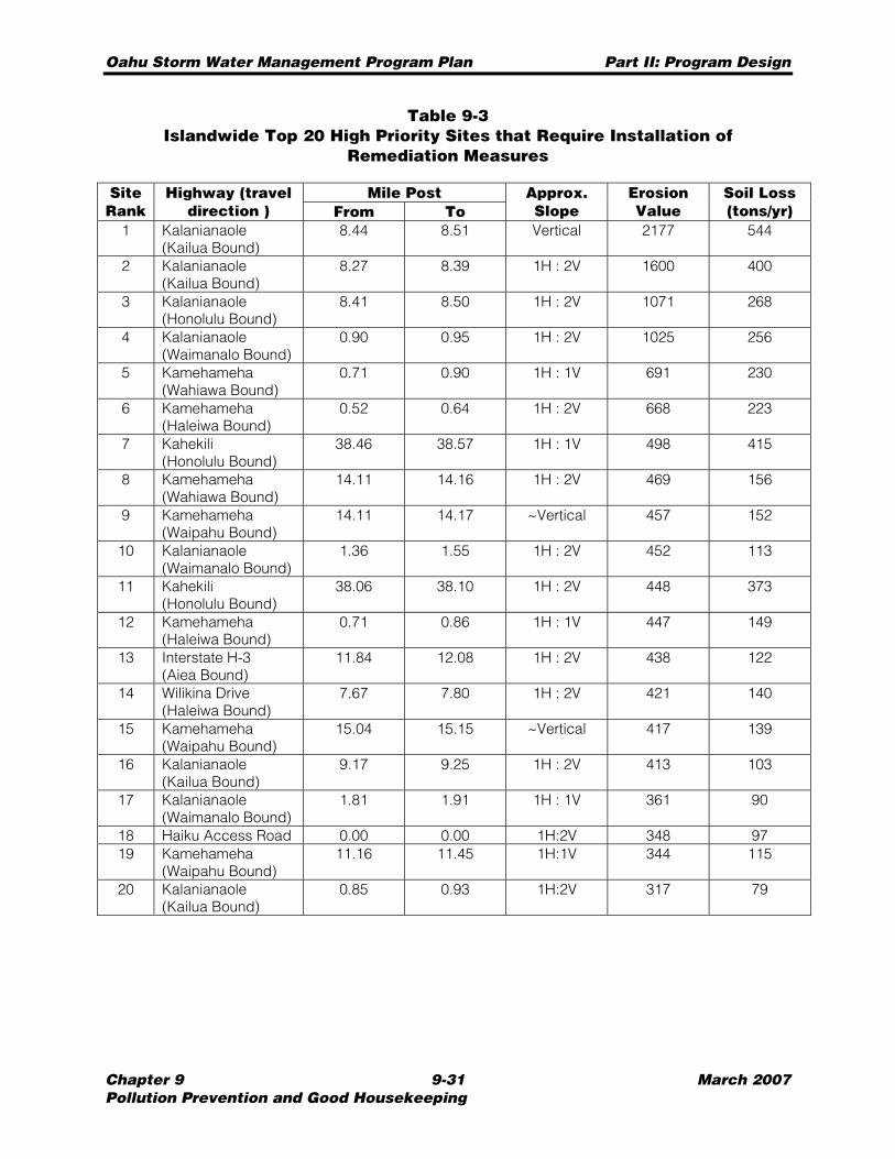
Oahu Storm Water Management Program Plan Part II: Program Design
Chapter 9 9-31 March 2007 Pollution Prevention and Good Housekeeping
Table 9-3 Islandwide Top 20 High Priority Sites that Require Installation of
Remediation Measures
Mile Post Site Rank
Highway (travel direction ) From To
Approx. Slope
Erosion Value
Soil Loss (tons/yr)
1 Kalanianaole (Kailua Bound)
8.44 8.51 Vertical 2177 544
2 Kalanianaole (Kailua Bound)
8.27 8.39 1H : 2V 1600 400
3 Kalanianaole (Honolulu Bound)
8.41 8.50 1H : 2V 1071 268
4 Kalanianaole (Waimanalo Bound)
0.90 0.95 1H : 2V 1025 256
5 Kamehameha (Wahiawa Bound)
0.71 0.90 1H : 1V 691 230
6 Kamehameha (Haleiwa Bound)
0.52 0.64 1H : 2V 668 223
7 Kahekili (Honolulu Bound)
38.46 38.57 1H : 1V 498 415
8 Kamehameha (Wahiawa Bound)
14.11 14.16 1H : 2V 469 156
9 Kamehameha (Waipahu Bound)
14.11 14.17 ~Vertical 457 152
10 Kalanianaole (Waimanalo Bound)
1.36 1.55 1H : 2V 452 113
11 Kahekili (Honolulu Bound)
38.06 38.10 1H : 2V 448 373
12 Kamehameha (Haleiwa Bound)
0.71 0.86 1H : 1V 447 149
13 Interstate H-3 (Aiea Bound)
11.84 12.08 1H : 2V 438 122
14 Wilikina Drive (Haleiwa Bound)
7.67 7.80 1H : 2V 421 140
15 Kamehameha (Waipahu Bound)
15.04 15.15 ~Vertical 417 139
16 Kalanianaole (Kailua Bound)
9.17 9.25 1H : 2V 413 103
17 Kalanianaole (Waimanalo Bound)
1.81 1.91 1H : 1V 361 90
18 Haiku Access Road 0.00 0.00 1H:2V 348 97 19 Kamehameha
(Waipahu Bound) 11.16 11.45 1H:1V 344 115
20 Kalanianaole (Kailua Bound)
0.85 0.93 1H:2V 317 79
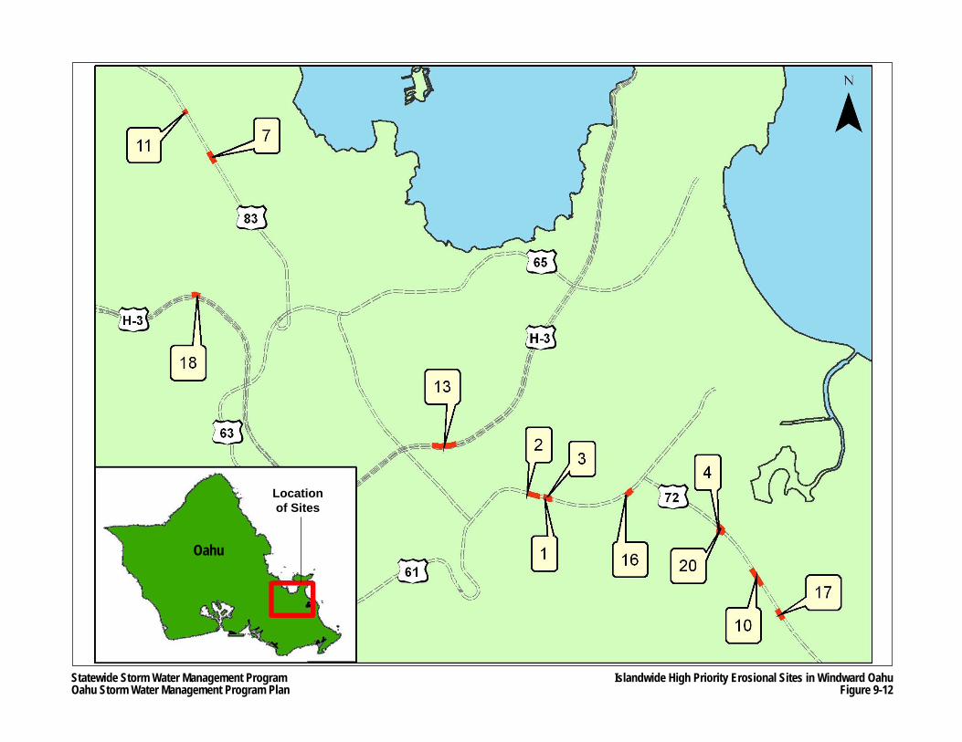
Statewide Storm Water Management ProgramOahu Storm Water Management Program Plan
Islandwide High Priority Erosional Sites in Windward OahuFigure 9-12
Locationof Sites
Oahu
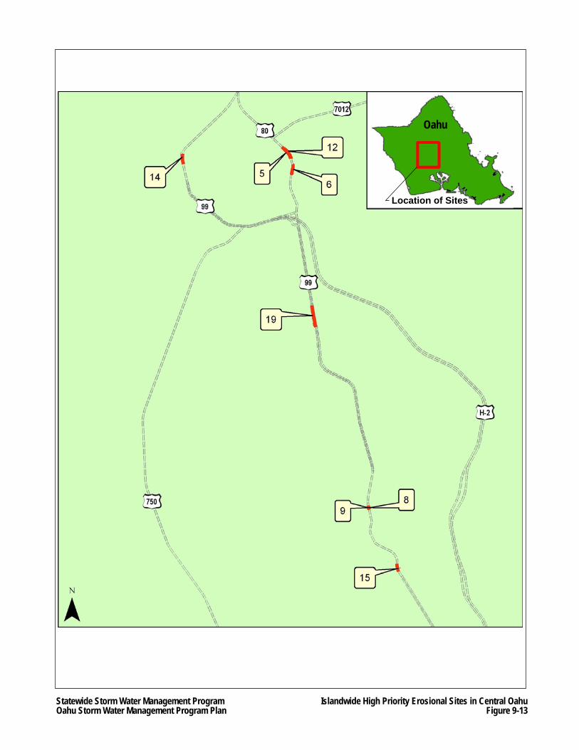
Statewide Storm Water Management ProgramOahu Storm Water Management Program Plan
Islandwide High Priority Erosional Sites in Central OahuFigure 9-13
Oahu
Location of Sites
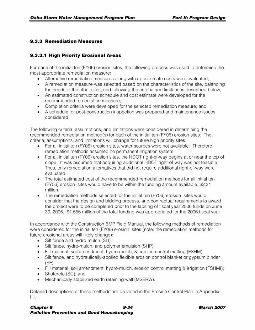
Oahu Storm Water Management Program Plan Part II: Program Design
Chapter 9 9-34 March 2007 Pollution Prevention and Good Housekeeping
9.3.3 Remediation Measures
9.3.3.1 High Priority Erosional Areas
For each of the initial ten (FY06) erosion sites, the following process was used to determine the most appropriate remediation measure:
• Alternative remediation measures along with approximate costs were evaluated; • A remediation measure was selected based on the characteristics of the site, balancing
the needs of the other sites, and following the criteria and limitations described below; • An estimated construction schedule and cost estimate were developed for the
recommended remediation measure; • Completion criteria were developed for the selected remediation measure; and • A schedule for post-construction inspection was prepared and maintenance issues
considered.
The following criteria, assumptions, and limitations were considered in determining the recommended remediation method(s) for each of the initial ten (FY06) erosion sites. The criteria, assumptions, and limitations will change for future high priority sites:
• For all initial ten (FY06) erosion sites, water sources were not available. Therefore, remediation methods assumed no permanent irrigation system.
• For all initial ten (FY06) erosion sites, the HDOT right-of-way begins at or near the top of slope. It was assumed that acquiring additional HDOT right-of-way was not feasible. Thus, only remediation alternatives that did not require additional right-of-way were evaluated.
• The total estimated cost of the recommended remediation methods for all initial ten (FY06) erosion sites would have to be within the funding amount available, $2.31 million.
• The remediation methods selected for the initial ten (FY06) erosion sites would consider that the design and bidding process, and contractual requirements to award the project were to be completed prior to the lapsing of fiscal year 2006 funds on June 30, 2006. $1.555 million of the total funding was appropriated for the 2006 fiscal year.
In accordance with the Construction BMP Field Manual, the following methods of remediation were considered for the initial ten (FY06) erosion sites (note: the remediation methods for future erosional areas will likely change):
• Silt fence and hydro-mulch (SH); • Silt fence, hydro-mulch, and polymer emulsion (SHP); • Fill material, soil amendment, hydro-mulch, & erosion control matting (FSHM); • Silt fence, and hydraulically-applied flexible erosion control blanket or gypsum binder
(SF); • Fill material, soil amendment, hydro-mulch, erosion control matting & irrigation (FSHMI); • Shotcrete (SC); and • Mechanically stabilized earth retaining wall (MSERW).
Detailed descriptions of these methods are provided in the Erosion Control Plan in Appendix I.1.
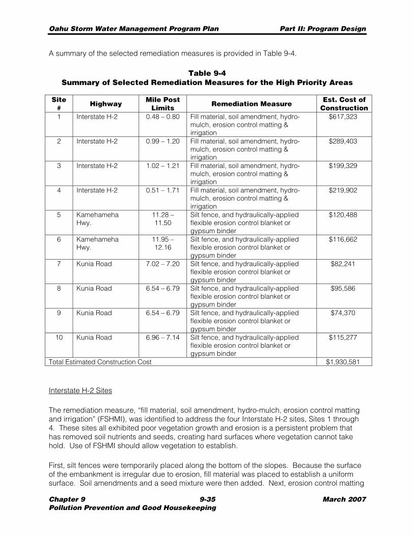
Oahu Storm Water Management Program Plan Part II: Program Design
Chapter 9 9-35 March 2007 Pollution Prevention and Good Housekeeping
A summary of the selected remediation measures is provided in Table 9-4.
Table 9-4 Summary of Selected Remediation Measures for the High Priority Areas
Site # Highway Mile Post
Limits Remediation Measure Est. Cost of Construction
1 Interstate H-2 0.48 – 0.80 Fill material, soil amendment, hydro-mulch, erosion control matting & irrigation
$617,323
2 Interstate H-2 0.99 – 1.20 Fill material, soil amendment, hydro-mulch, erosion control matting & irrigation
$289,403
3 Interstate H-2 1.02 – 1.21 Fill material, soil amendment, hydro-mulch, erosion control matting & irrigation
$199,329
4 Interstate H-2 0.51 – 1.71 Fill material, soil amendment, hydro-mulch, erosion control matting & irrigation
$219,902
5 Kamehameha Hwy.
11.28 – 11.50
Silt fence, and hydraulically-applied flexible erosion control blanket or gypsum binder
$120,488
6 Kamehameha Hwy.
11.95 – 12.16
Silt fence, and hydraulically-applied flexible erosion control blanket or gypsum binder
$116,662
7 Kunia Road 7.02 – 7.20 Silt fence, and hydraulically-applied flexible erosion control blanket or gypsum binder
$82,241
8 Kunia Road 6.54 – 6.79 Silt fence, and hydraulically-applied flexible erosion control blanket or gypsum binder
$95,586
9 Kunia Road 6.54 – 6.79 Silt fence, and hydraulically-applied flexible erosion control blanket or gypsum binder
$74,370
10 Kunia Road 6.96 – 7.14 Silt fence, and hydraulically-applied flexible erosion control blanket or gypsum binder
$115,277
Total Estimated Construction Cost $1,930,581
Interstate H-2 Sites
The remediation measure, “fill material, soil amendment, hydro-mulch, erosion control matting and irrigation” (FSHMI), was identified to address the four Interstate H-2 sites, Sites 1 through 4. These sites all exhibited poor vegetation growth and erosion is a persistent problem that has removed soil nutrients and seeds, creating hard surfaces where vegetation cannot take hold. Use of FSHMI should allow vegetation to establish.
First, silt fences were temporarily placed along the bottom of the slopes. Because the surface of the embankment is irregular due to erosion, fill material was placed to establish a uniform surface. Soil amendments and a seed mixture were then added. Next, erosion control matting
Oahu Storm Water Management Program Plan Part II: Program Design
Chapter 9 9-36 March 2007 Pollution Prevention and Good Housekeeping
was placed over the slope for protection against erosion, and temporary irrigation was provided. The matting and irrigation was used to establish the vegetation, and over time, the dominant plant species of the areas should take over and help reduce erosion.
Construction and planting is estimated to take approximately 160 working days. After initial planting, the contractor must maintain the vegetation for an additional nine months. Long term maintenance, which will be performed by HWY-OM staff or service contractors, would involve cutting grass, watering, and removing and replacing diseased vegetation.
Kamehameha Highway and Kunia Road Sites
The remediation measure, “silt fence, and hydraulically-applied flexible erosion control blanket or gypsum binder” (SF), was selected for the two Kamehameha Highway sites, Sites 5 and 6, and the four Kunia Road sites, Sites 7 through 10. These sites generally cannot support vegetation. Erosion is a persistent problem, which has removed soil nutrients and seeds, creating areas with hard surfaces where vegetation cannot take hold. In some locations erosion has formed an overhanging lip near the top of slope. Because the surfaces of these areas are both uneven and very steep, the types of remediation measures that could be utilized are limited. For instance, the steep slopes do not allow for placement of fill material to establish a uniform surface so that traditional erosion control matting could be utilized. In addition, flattening the slope is not an option due to close proximity to the highways and limited right-of-way.
SF initially required the erection of silt fences along the bottom of the slopes, and the removal of any overhanging areas and/or loose soils. Any existing vegetation is left in place. Next, hydraulically-applied flexible erosion control blankets with seeds were placed over the barren slope. Gypsum binder mulch with seeds was installed as an alternative to the blankets. Both the blankets and the mulch allow vegetation to propagate and take hold. Unlike the erosion control matting used for the FSHMI, the blankets and mulch do not require a uniform surface. During the first year, it is anticipated that several re-applications of the permeable blanket or gypsum binder mulch may be required to touch-up certain areas.
Construction and planting is estimated to take approximately 160 working days. Similar to the requirements of FSHMI, the contractor must maintain the vegetation for an additional nine months after the initial planting. Long term maintenance, which will be performed by HWY-OM staff or service contractors, involves cutting grass, replacing the silt fence where damaged, and removing all silt accumulated along the fence as required.
In the long term, or if future erosion and water quality issues arise, additional right-of-way would be needed if flattening the slopes is considered. Other options include more expensive structural remediation methods, such as mechanically stabilized earth retaining walls (MSERW), soil anchors, or shotcrete (SC).
Oahu Storm Water Management Program Plan Part II: Program Design
Chapter 9 9-37 March 2007 Pollution Prevention and Good Housekeeping
9.3.3.2 Islandwide Erosional Areas
Remediation will continue in the future for the sites shown in Table 9-3 beginning with the highest ranked (i.e. smallest numeric value in “Site Rank” column) sites utilizing a remediation process similar to the process described in Section 9.3.3.1 High Priority Erosional Areas.
Erosional area remediation program elements include: • Identification of erosional areas; • Prioritization of erosional areas based upon water quality concerns; • Request implementation funding for erosional areas; • Erosion control measure projects design; • Erosion control measure projects construction, and • Erosion control measure maintenance.
Appendix C of the Islandwide Assessment (see Appendix I.2) contains the current prioritized list of erosional areas on the island of Oahu. The list of permanent erosion control improvement projects will be based upon this prioritized listing in descending order of erosion value. Table 9-5 shows the priority of the Top 20 Islandwide Erosional Areas selected for future remediation.
For cost estimating purposes, it was assumed that all twenty top-ranked islandwide sites would be treated with either a hydraulically-applied flexible erosion control blanket or hydro-mulch with gypsum binder. These applications include soil amendments, fertilizer, and a seed mixture. The advantage of this application is that it can be applied to an irregular slope face without extensive preparation such as re-grading or cutting the existing slope face. This measure is a low-cost alternative and does not include a permanent irrigation system. Therefore, upon completion of a more detailed site analysis (such as geotechnical and agronomical investigations), a remediation measure of higher cost may be recommended, as appropriate. It was further assumed that a temporary silt fence would be constructed along the bottom of the eroded slope for retention of on-site soil.
9.3.3.3 Funding and Schedule
Initial Ten (FY06) Erosion Sites
HDOT Highways budgeted $2.31 million for fiscal year 2006 to construct erosion control measures at the ten erosion sites listed in Appendix D of the Consent Decree. The contract for the construction of erosion control measures at these 10 sites was advertised in May 2006. The bid proposals were opened in June 2006. The successful bid price was approximately $1.93 million. The construction of erosion control measures for these initial ten (FY06) sites will be completed by the January 30, 2008 completion date as specified by the Consent Decree. Table 9-4 shows the bid prices for the estimated cost of construction for the initial ten (FY06) erosion sites.
The winning contractor is expected to complete the work as specified in the PS&E within 160 working days after notice-to-proceed. Long-term maintenance may be conducted by HWY-OM staff, or more likely, by a service contractor. For a period of one year after construction, the initial ten (FY06) erosion sites will be inspected on a monthly basis to check for erosion
Oahu Storm Water Management Program Plan Part II: Program Design
Chapter 9 9-38 March 2007 Pollution Prevention and Good Housekeeping
and other water quality problems. Inspections during the second year after construction will be done on a quarterly basis. HWY-OM or a service contractor would be responsible for making minor repairs. If, however, major remedial work were required, HDOT Highways would address the problem in the following manner:
• Minor repairs by HDOT Highways maintenance personnel; • Repairs estimated to cost less than $25,000 by a contractor hired through a purchase
order; and • Repairs estimated to cost greater than $25,000 will require a formal contract.
At the end of the two-year maintenance period, HDOT Highways will evaluate whether maintenance requirements of the initial ten (FY06) erosion sites can be accommodated by HWY-OM personnel who perform routine maintenance on Interstate H-2, Kamehameha Highway and Kunia Road.
The initial ten (FY06) erosion sites as defined in the Consent Decree, Appendix D are currently under construction at the time of the writing of this report (March 2007). The construction of the erosion control measures for these initial ten (FY06) erosion sites will be completed by the January 30, 2008 completion date as specified by Consent Decree. Discussion of the initial ten (FY06) erosion sites can be found in Appendix I.1.
Islandwide Erosional Areas
The prioritized projects list as shown in Appendix C of the Islandwide Assessment will be revised periodically. Funding for the implementation of the projects will be requested. In fiscal year 2007, the design of mitigation measures for the next grouping of erosional areas as defined in the Oahu MS4 NPDES Permit is proceeding from the highest ranked site in a descending order. The ten highest priority sites or up to a maximum of $1.5 million construction budget will be used to select the next sites for erosion control mitigation work. The construction of the mitigation measures for the fiscal year 2007 erosional areas will be completed within two (2) years of the revised MS4 SWMPP submittal (i.e. end of March 2009) in accordance with the Oahu MS4 NPDES Permit.
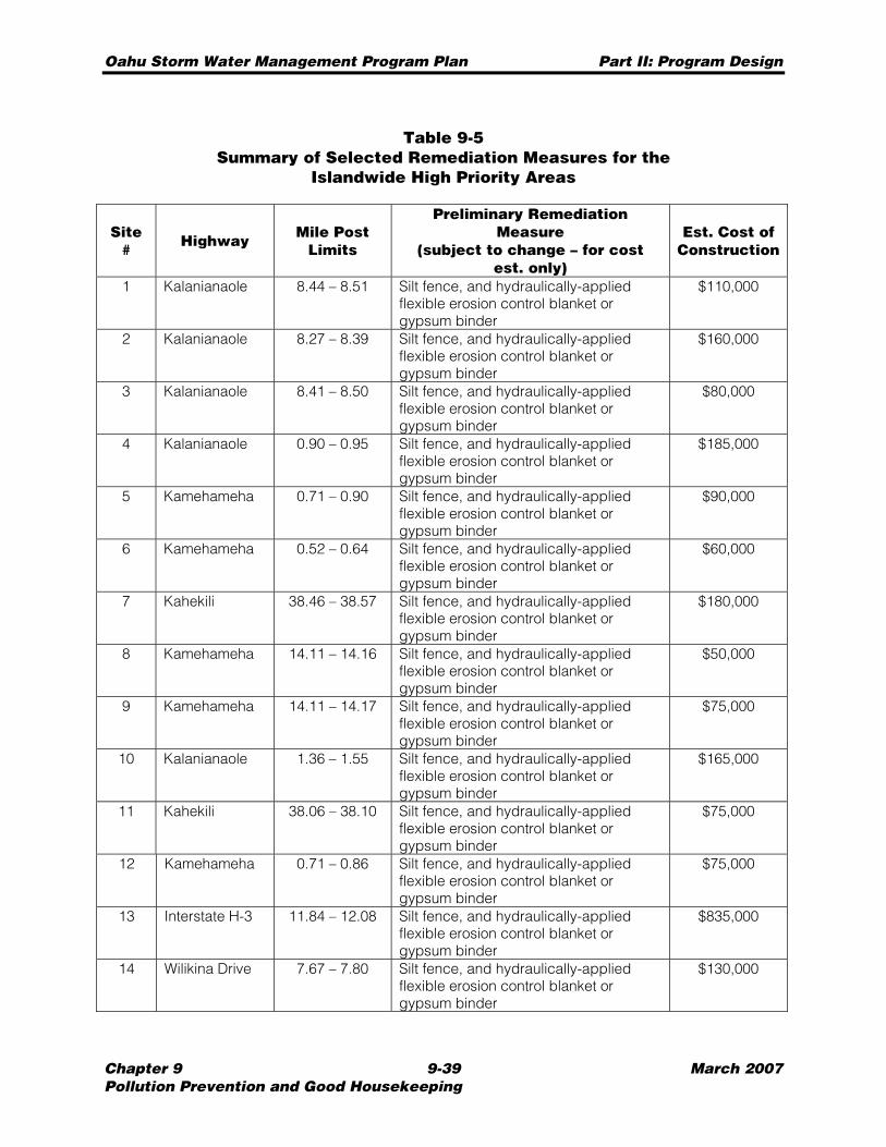
Oahu Storm Water Management Program Plan Part II: Program Design
Chapter 9 9-39 March 2007 Pollution Prevention and Good Housekeeping
Table 9-5 Summary of Selected Remediation Measures for the
Islandwide High Priority Areas
Site # Highway Mile Post
Limits
Preliminary Remediation Measure
(subject to change – for cost est. only)
Est. Cost of Construction
1 Kalanianaole 8.44 – 8.51 Silt fence, and hydraulically-applied flexible erosion control blanket or gypsum binder
$110,000
2 Kalanianaole 8.27 – 8.39 Silt fence, and hydraulically-applied flexible erosion control blanket or gypsum binder
$160,000
3 Kalanianaole 8.41 – 8.50 Silt fence, and hydraulically-applied flexible erosion control blanket or gypsum binder
$80,000
4 Kalanianaole 0.90 – 0.95 Silt fence, and hydraulically-applied flexible erosion control blanket or gypsum binder
$185,000
5 Kamehameha 0.71 – 0.90 Silt fence, and hydraulically-applied flexible erosion control blanket or gypsum binder
$90,000
6 Kamehameha 0.52 – 0.64 Silt fence, and hydraulically-applied flexible erosion control blanket or gypsum binder
$60,000
7 Kahekili 38.46 – 38.57 Silt fence, and hydraulically-applied flexible erosion control blanket or gypsum binder
$180,000
8 Kamehameha 14.11 – 14.16 Silt fence, and hydraulically-applied flexible erosion control blanket or gypsum binder
$50,000
9 Kamehameha 14.11 – 14.17 Silt fence, and hydraulically-applied flexible erosion control blanket or gypsum binder
$75,000
10 Kalanianaole 1.36 – 1.55 Silt fence, and hydraulically-applied flexible erosion control blanket or gypsum binder
$165,000
11 Kahekili 38.06 – 38.10 Silt fence, and hydraulically-applied flexible erosion control blanket or gypsum binder
$75,000
12 Kamehameha 0.71 – 0.86 Silt fence, and hydraulically-applied flexible erosion control blanket or gypsum binder
$75,000
13 Interstate H-3 11.84 – 12.08 Silt fence, and hydraulically-applied flexible erosion control blanket or gypsum binder
$835,000
14 Wilikina Drive 7.67 – 7.80 Silt fence, and hydraulically-applied flexible erosion control blanket or gypsum binder
$130,000
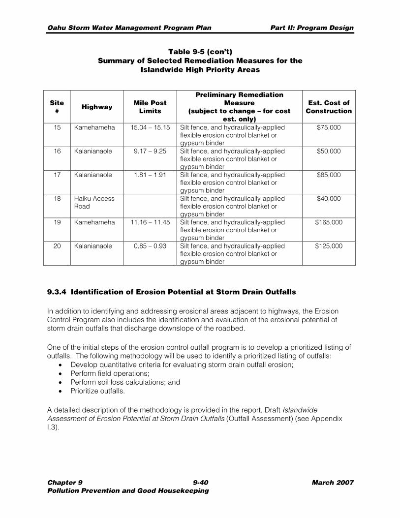
Oahu Storm Water Management Program Plan Part II: Program Design
Chapter 9 9-40 March 2007 Pollution Prevention and Good Housekeeping
Table 9-5 (con’t) Summary of Selected Remediation Measures for the
Islandwide High Priority Areas
Site #
Highway Mile Post Limits
Preliminary Remediation Measure
(subject to change – for cost est. only)
Est. Cost of Construction
15 Kamehameha 15.04 – 15.15 Silt fence, and hydraulically-applied flexible erosion control blanket or gypsum binder
$75,000
16 Kalanianaole 9.17 – 9.25 Silt fence, and hydraulically-applied flexible erosion control blanket or gypsum binder
$50,000
17 Kalanianaole 1.81 – 1.91 Silt fence, and hydraulically-applied flexible erosion control blanket or gypsum binder
$85,000
18 Haiku Access Road
Silt fence, and hydraulically-applied flexible erosion control blanket or gypsum binder
$40,000
19 Kamehameha 11.16 – 11.45 Silt fence, and hydraulically-applied flexible erosion control blanket or gypsum binder
$165,000
20 Kalanianaole 0.85 – 0.93 Silt fence, and hydraulically-applied flexible erosion control blanket or gypsum binder
$125,000
9.3.4 Identification of Erosion Potential at Storm Drain Outfalls
In addition to identifying and addressing erosional areas adjacent to highways, the Erosion Control Program also includes the identification and evaluation of the erosional potential of storm drain outfalls that discharge downslope of the roadbed.
One of the initial steps of the erosion control outfall program is to develop a prioritized listing of outfalls. The following methodology will be used to identify a prioritized listing of outfalls:
• Develop quantitative criteria for evaluating storm drain outfall erosion; • Perform field operations; • Perform soil loss calculations; and • Prioritize outfalls.
A detailed description of the methodology is provided in the report, Draft Islandwide Assessment of Erosion Potential at Storm Drain Outfalls (Outfall Assessment) (see Appendix I.3).

Oahu Storm Water Management Program Plan Part II: Program Design
Chapter 9 9-41 March 2007 Pollution Prevention and Good Housekeeping
9.3.4.1 Field Operations
Between August 2005 and October 2006, field inspections of major outfalls, which are defined as pipes with minimum inside diameters of 36-inches or greater, was completed (also see Section 6.2.3). At each outfall, inspectors checked for or recorded the following information, some of which using sub-meter GPS/PDA units:
• GPS coordinates • Outfall size and type; • Condition of outfall; • Condition of outfall area; • Condition of outfall runoff; • Water flowing from outfall; • Pollution around outfall area; • Photographs, and • Sketch of culvert/pipe configuration.
9.3.4.2 Quantitative Criteria
High priority sites were selected using a combination of factors, including the observed erosion condition, watershed priority, receiving water body classification, overland flow distance to receiving water bodies, culvert size, and soil conditions (erodibility) at the outfall location. The ranking of sites (erosion values) is based on the following equation: Erosion Value = (erosion condition factor) x (watershed factor) x (water classification factor) x (distance to receiving water factor) x (culvert size factor) x (soil erodibility factor)
Erosion conditions, which were evaluated by the inspectors, were divided into the following four categories:
• Outfall areas observed to exhibit heavy or severe erosion were assigned a weight factor of 5;
• Outfall areas showing evidence of mild or moderate erosion were assigned a weight factor of 2;
• Light erosion was assigned a weight factor of 1; and • Areas where erosion was not evident was assigned a weight factor of zero.
The watershed and water classification factors and weighting are the same used for the islandwide erosional areas analysis (see Section 9.3.2.2).
The analysis considered the distance between an outfall and its receiving water body to account for sediment that may settle prior to reaching the final discharge location. Receiving water bodies were identified from USGS quad maps, the State’s streams GIS file (darstreams.shp), and the City’s water body shapefile (watbod.shp). Flow distances through pipes and lined channels were not included in the distance calculations because it was assumed that 100 percent sediment transfer would occur through these conduits. For outfalls near the shoreline, the distance between the outfall and any visible sandy beach (from aerial photos) was used.
Oahu Storm Water Management Program Plan Part II: Program Design
Chapter 9 9-42 March 2007 Pollution Prevention and Good Housekeeping
Outfall culvert sizes also determined the prioritization of sites. Culverts with inside diameters less than 36-inches were considered minor outfalls and were assigned a weight factor of 1. Outfalls with inside diameters of 36-inches or greater were considered major outfalls and were assigned a weight factor of 2. Multiple barrel culverts less than 36-inches in diameter with an aggregate pipe cross sectional area greater than a single 36-inch diameter culvert were classified as major outfalls for analytical purposes. The implications of this factor are that large drainage areas, which are served by large outfalls, were given higher weightings.
The soil type in the vicinity of each outfall location was obtained from the City’s GIS. A corresponding “K” value was assigned to each soil type based on Natural Resources Conservation Service publications. The values ranged between 0.02 and 0.28. The erodibility factor quantifies the susceptibility of soil detachment by water and is commonly used to predict long-term average soil loss. A soil erodibility factor of zero was assigned for outfalls that exit directly into a concrete channel or other lined ditch.
9.3.4.3 Analysis and Results
A total of 1,189 outfalls were identified as of October 31, 2006. Each site was evaluated for erosion potential and ranked according to the calculated erosion value. Based on this analysis, a list of the top 25 islandwide erosional areas was compiled (see Table 9-6). As illustrated in Figure 9-14, these high priority outfall locations are scattered across the island. Individual reports for each site, as well as a comprehensive list of all outfalls evaluated as of October 31, 2006, are provided in Draft Outfall Assessment (see Appendix I.3). It should be noted that this ranking is subject to change pending more comprehensive, site-specific engineering analyses.
9.3.4.4 Remediation Measures
An outfall remediation program consisting of the following elements will be submitted and implemented in accordance with the requirements contained in the Oahu MS4 NPDES Permit:
• Identification of MS4 outfalls; • Prioritization of MS4 outfalls based upon water quality concerns; • Request implementation funding for outfalls; • Outfall erosion control measure project design; • Outfall erosion control measure construction, and • Outfall erosion control measure maintenance.
Outfall assessments will continue over the next year, which will result in the completion of a final Outfall Assessment by March 30, 2008.
Outfall sites with observed erosional conditions will require the installation of velocity dissipators or other BMP measures to reduce the risk of continued erosion. A PS&E process similar to that used for the high priority erosional areas (see Section 9.3.3.1) may be used to develop remediation methods for the prioritized outfalls. Details about implementation of BMPs, such as annual funding and design and construction schedules, have not been determined, but will be included in the March 30, 2008 final assessment.
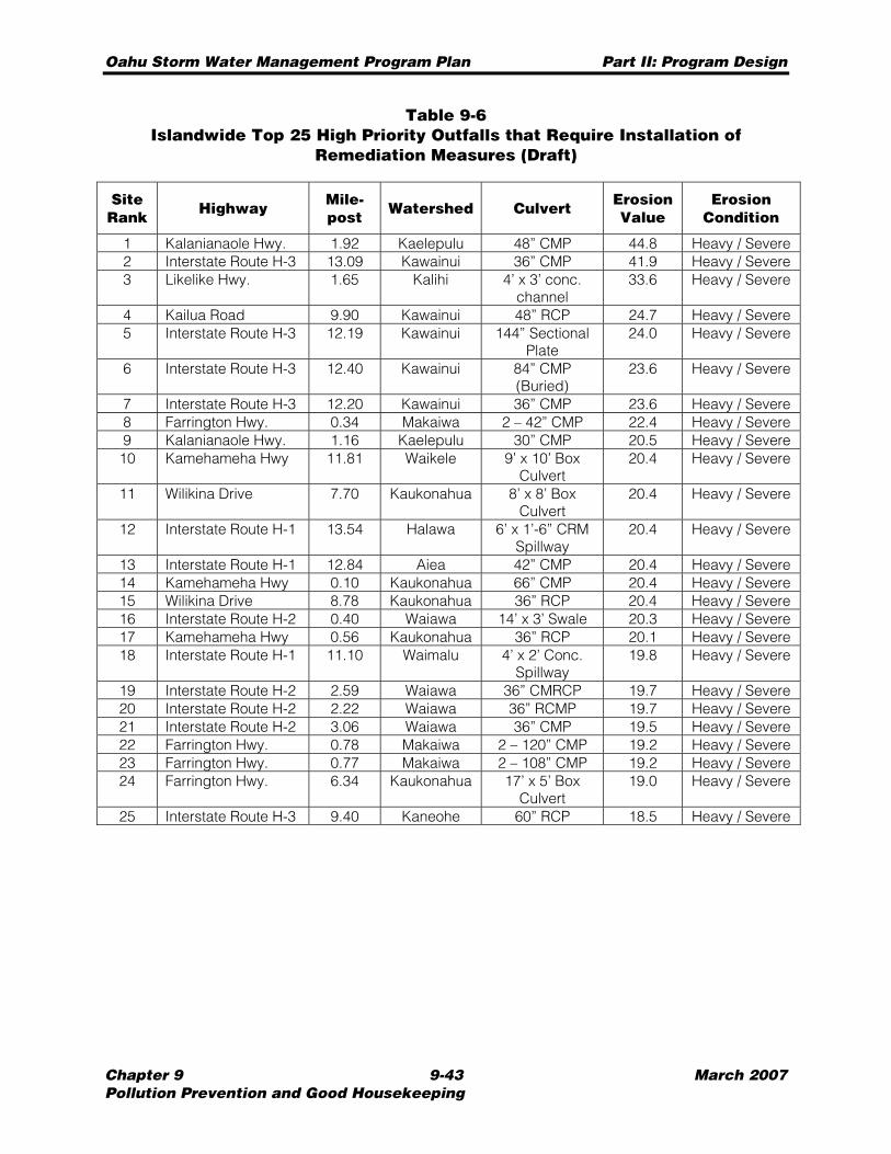
Oahu Storm Water Management Program Plan Part II: Program Design
Chapter 9 9-43 March 2007 Pollution Prevention and Good Housekeeping
Table 9-6 Islandwide Top 25 High Priority Outfalls that Require Installation of
Remediation Measures (Draft)
Site Rank
Highway Mile-post
Watershed Culvert Erosion Value
Erosion Condition
1 Kalanianaole Hwy. 1.92 Kaelepulu 48” CMP 44.8 Heavy / Severe 2 Interstate Route H-3 13.09 Kawainui 36” CMP 41.9 Heavy / Severe 3 Likelike Hwy. 1.65 Kalihi 4’ x 3’ conc.
channel 33.6 Heavy / Severe
4 Kailua Road 9.90 Kawainui 48” RCP 24.7 Heavy / Severe 5 Interstate Route H-3 12.19 Kawainui 144” Sectional
Plate 24.0 Heavy / Severe
6 Interstate Route H-3 12.40 Kawainui 84” CMP (Buried)
23.6 Heavy / Severe
7 Interstate Route H-3 12.20 Kawainui 36” CMP 23.6 Heavy / Severe 8 Farrington Hwy. 0.34 Makaiwa 2 – 42” CMP 22.4 Heavy / Severe 9 Kalanianaole Hwy. 1.16 Kaelepulu 30” CMP 20.5 Heavy / Severe 10 Kamehameha Hwy 11.81 Waikele 9’ x 10’ Box
Culvert 20.4 Heavy / Severe
11 Wilikina Drive 7.70 Kaukonahua 8’ x 8’ Box Culvert
20.4 Heavy / Severe
12 Interstate Route H-1 13.54 Halawa 6’ x 1’-6” CRM Spillway
20.4 Heavy / Severe
13 Interstate Route H-1 12.84 Aiea 42” CMP 20.4 Heavy / Severe 14 Kamehameha Hwy 0.10 Kaukonahua 66” CMP 20.4 Heavy / Severe 15 Wilikina Drive 8.78 Kaukonahua 36” RCP 20.4 Heavy / Severe 16 Interstate Route H-2 0.40 Waiawa 14’ x 3’ Swale 20.3 Heavy / Severe 17 Kamehameha Hwy 0.56 Kaukonahua 36” RCP 20.1 Heavy / Severe 18 Interstate Route H-1 11.10 Waimalu 4’ x 2’ Conc.
Spillway 19.8 Heavy / Severe
19 Interstate Route H-2 2.59 Waiawa 36” CMRCP 19.7 Heavy / Severe 20 Interstate Route H-2 2.22 Waiawa 36” RCMP 19.7 Heavy / Severe 21 Interstate Route H-2 3.06 Waiawa 36” CMP 19.5 Heavy / Severe 22 Farrington Hwy. 0.78 Makaiwa 2 – 120” CMP 19.2 Heavy / Severe 23 Farrington Hwy. 0.77 Makaiwa 2 – 108” CMP 19.2 Heavy / Severe 24 Farrington Hwy. 6.34 Kaukonahua 17’ x 5’ Box
Culvert 19.0 Heavy / Severe
25 Interstate Route H-3 9.40 Kaneohe 60” RCP 18.5 Heavy / Severe
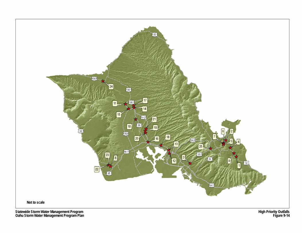
Not to scale
LOCATION PLAN
Statewide Storm Water Management ProgramOahu Storm Water Management Program Plan
High Priority OutfallsFigure 9-14
Oahu Storm Water Management Program Plan Part II: Program Design
Chapter 9 9-45 March 2007 Pollution Prevention and Good Housekeeping
9.3.5 Training
The training element of the Erosion Program will cover the installation and maintenance of erosion control BMPs for non-construction HDOT projects. Instruction will include implementation of erosion control BMPs, as well as providing instruction about the selection of appropriate erosion control BMPs. The erosion control training program is intended to be provided on a periodic basis, but will be coordinated with other training programs described in the Oahu SWMP.
Training Recipients
Training will be made available to the following personnel: • HDOT Highways personnel responsible for managing and conducting the installation
and maintenance of erosion control BMPs; • Contractors who perform design work for the State DOT; and • HDOT Highways plan reviewers, designers, and project managers.
Training Method
The method of training will involve both PowerPoint presentations and handout materials, which include the following documents:
• Presentation’s PowerPoint slides that allow for the taking of notes; • Construction BMP Field Manual; and • Descriptions of sample BMPs similar to those presented in the SEP training sessions.
Trainer Qualifications
The trainer must meet the following qualifications: • Professional experience in designing, installing, and/or inspecting erosion control
BMPs; and • Knowledge of the effectiveness of various erosion control BMPs in local climate and
geological conditions.
Topics
Topics will include the following: • Environmental background and regulatory requirements, particularly the Clean Water
Act and the NPDES permit program; • Information and awareness of the Oahu MS4 NPDES Permit, and the overall Oahu
SWMP; • Informing staff that they serve an important role in protecting the water quality in the
State; • Responsibilities of HDOT Highways regarding storm water management and erosion
and sediment control at non-construction sites; • Erosion control BMPs; and
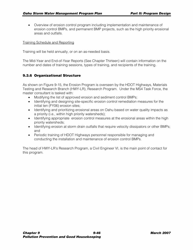
Oahu Storm Water Management Program Plan Part II: Program Design
Chapter 9 9-46 March 2007 Pollution Prevention and Good Housekeeping
• Overview of erosion control program including implementation and maintenance of erosion control BMPs, and permanent BMP projects, such as the high priority erosional areas and outfalls.
Training Schedule and Reporting
Training will be held annually, or on an as-needed basis.
The Mid-Year and End-of-Year Reports (See Chapter Thirteen) will contain information on the number and dates of training sessions, types of training, and recipients of the training.
9.3.6 Organizational Structure
As shown on Figure 9-15, the Erosion Program is overseen by the HDOT Highways, Materials Testing and Research Branch (HWY-LR), Research Program. Under the MS4 Task Force, the master consultant is tasked with:
• Modifying the list of approved erosion and sediment control BMPs; • Identifying and designing site-specific erosion control remediation measures for the
initial ten (FY06) erosion sites; • Identifying and prioritizing erosional areas on Oahu based on water quality impacts as
a priority (i.e., within high priority watersheds); • Identifying appropriate erosion control measures at the erosional areas within the high
priority watersheds; • Identifying erosion at storm drain outfalls that require velocity dissipators or other BMPs;
and • Periodic training of HDOT Highways personnel responsible for managing and
conducting the installation and maintenance of erosion control BMPs.
The head of HWY-LR’s Research Program, a Civil Engineer VI, is the main point of contact for this program.
Statewide Storm Water Management Program Oahu Storm Water Management Program
Department of Transportation DOT-DIR Director
Department of Transportation
DEP-HWY Deputy Director
Public Affairs Office DIR-P
Office of Special Compliance Programs
DIR-CZ
Highways Division
Administrator
Planning Branch HWY-P
Head Planning Engineer
Right-of-Way Branch HWY-R
Right-of-Way Manager
Oahu District HWY-O
District
Engineer
Traffic Branch HWY-T
Engineering Program Manager
Office Services HWY-O
Office Manager
Urban Construction Section
HWY-OCU (MS4 Task Force Mgr)
Engineer VI
Traffic Operations
Unit HWY-OT
Civil Engineer IV
Design Branch HWY-D
Engineering Program Manager
Highway Design Section HWY-DD
Engineer VI
Technical Design Section HWY-DS
Engineer VI
Construction & Maintenance Branch
HWY-C Engineering Program
Manager
Maintenance Section
HWY-CM Engineer VI
Environmental Section HWY-CE
Engineer VI
Construction Section HWY-CC
Engineer VI
Rural Construction Section
HWY-OCR Engineer VI
Wahiawa Crew HWY-OM
Highway Maintenance Supervisor I
Leeward Crew HWY-OM
Highway Maintenance Supervisor II
Hauula Crew HWY-OM
Highway Maintenance Supervisor I
Windward Crew HWY-OM
Highway Maintenance Supervisor II
Honolulu Crew HWY-OM
Highway Maintenance Supervisor II
Special Services Sub Unit HWY-OM
Highways Special Services
Supervisor
Bridge Maintenance Sub Unit
HWY-OM Bridge Maintenance
Supervisor II
Structures Sub Unit HWY-OM
General Construction
Maintenance Supervisor I
Roadway Maintenance Sub Unit HWY-OM
Construction & Maintenance Supervisor III
Equipment Services & Repair Unit HWY-OM
Auto Mechanic Supervisor II
Water Tankers Crew HWY-OM
2-Truck Tractor Semi-Trailer Operator
Street Cleaning Crew HWY-OM
4-Street Sweeper Operator
Drain Cleaning Crew HWY-OM
1-Heavy Truck Driver
Debris Hazard Control Crew HWY-OM
3-Light Truck Driver
Herbicide Crew HWY-OM
2-Truck Driver
1-Reporting Coordinator 1-Planner
1-AMS Coordinator
1-Development Mgr
4-GIS/IT Support
1-Training Coordinator 1-Trainer
1-Engineer
1-Education Coordinator 1-PR Expert
2-PR Assistant
Material Testing & Research Branch
HWY-L Engineering Program
Manager
Highways Maintenance Unit
HWY-OM Construction & Maintenance
Superintendent
Pearl City Field Office
HWY-OC Engineer V
Kaneohe Field Office
HWY-OC Engineer V
Salt Lake Field Office
HWY-OC Engineer V
Administrator HWY-OC
Engineer V
MS4 Task Force 2-CE III
1-Inspector 1-Clerk
Lower Halawa Field Office
HWY-OC Engineer V
Kilihau Field Office
HWY-OC Engineer V
Upper Halawa Office
HWY-OC Engineer V
Street Sweeper
Drain Cleaner
1-Engineer 9-Inspector
Landscaping Sub Unit HWY-OM
Highways District Maintenance Supervisor
Traffic Signs & Marking Sub Unit
HWY-OM Traffic Signs &
Marking Supervisor
1-Engineer 1-Inspector
Hydrology & Special Studies Unit
HWY-DH Engineer V
Drafting Unit
HWY-DH Technician
Design Unit
HWY-DH Engineer V
Environmental Support HWY-DH
Engineer V
3-Engineer
Research Program HWY-LR
Engineer VI
5-Engineer 1-CADD
Highways Electrical Unit
HWY-OM Traffic Signal &
Highway Lighting Supervisor
Master Consultant
Program Manager & Deputy Program
Manager
1-Senior Program Engineer
1-Technical Advisor 3-Administrative
Facilities Engineering
Services HWY-OM
Civil Engineer V
5-Engineer 4-Inspector
Highways Division Storm Water Management Program Organizational Structure - Erosion Control BMP Program (2006-2009) Figure 9-15
1-Engineer 1-Inspector IV 1-Inspector III
2-Engineer 1-Scientist
2-Technician
SWMP Service
Contractors
Highways Division Storm Water Management Program Organizational Structure - Erosion Control BMP Program 2006-2009
Landscape Design Section HWY-DL
Engineer V
Tunnel Operation Section HWY-OT
Engineer V
Plant Maintenance
Unit HWY-OT
Mechanical Engineer IV
Engineering Services Unit
HWY-OM
Civil Engineer V
Field Engineering
Services HWY-OM
Civil Engineer V
Maintenance Section
HWY-OM Engineer VI
Bridge Design Section HWY-DB
Engineer VI
Hydraulic Design Section HWY-DH
Engineer VI
1-Engineer III
Drainage Discharge
Unit HWY-OM
Engineer V
Involved in All Programs
Asset Management System (AMS)/Reporting
Training/Public Education
Master Consultant
& Subs
HDOT Staff With SWMP Responsibilities
LEGEND
HDOT Staff With Erosion Control Responsibilities
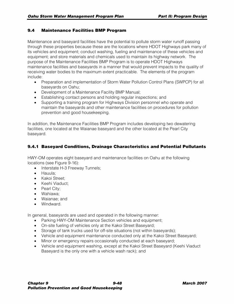
Oahu Storm Water Management Program Plan Part II: Program Design
Chapter 9 9-48 March 2007 Pollution Prevention and Good Housekeeping
9.4 Maintenance Facilities BMP Program
Maintenance and baseyard facilities have the potential to pollute storm water runoff passing through these properties because these are the locations where HDOT Highways park many of its vehicles and equipment; conduct washing, fueling and maintenance of these vehicles and equipment; and store materials and chemicals used to maintain its highway network. The purpose of the Maintenance Facilities BMP Program is to operate HDOT Highways maintenance facilities and baseyards in a manner that would prevent impacts to the quality of receiving water bodies to the maximum extent practicable. The elements of the program include:
• Preparation and implementation of Storm Water Pollution Control Plans (SWPCP) for all baseyards on Oahu;
• Development of a Maintenance Facility BMP Manual; • Establishing contact persons and holding regular inspections; and • Supporting a training program for Highways Division personnel who operate and
maintain the baseyards and other maintenance facilities on procedures for pollution prevention and good housekeeping.
In addition, the Maintenance Facilities BMP Program includes developing two dewatering facilities, one located at the Waianae baseyard and the other located at the Pearl City baseyard.
9.4.1 Baseyard Conditions, Drainage Characteristics and Potential Pollutants
HWY-OM operates eight baseyard and maintenance facilities on Oahu at the following locations (see Figure 9-16):
• Interstate H-3 Freeway Tunnels; • Hauula; • Kakoi Street; • Keehi Viaduct; • Pearl City; • Wahiawa; • Waianae; and • Windward.
In general, baseyards are used and operated in the following manner: • Parking HWY-OM Maintenance Section vehicles and equipment; • On-site fueling of vehicles only at the Kakoi Street Baseyard; • Storage of tank trucks used for off-site situations (not within baseyards); • Vehicle and equipment maintenance conducted only at the Kakoi Street Baseyard; • Minor or emergency repairs occasionally conducted at each baseyard; • Vehicle and equipment washing, except at the Kakoi Street Baseyard (Keehi Viaduct
Baseyard is the only one with a vehicle wash rack); and
KAENA PT.
WAIANAE
HALEIWA
WAHIAWA
WAIPAHUAIEA
PEARL CITY
KAHUKU PT.
KAAAWA
EWA
WAIKIKI
KANEOHE
HONOLULU
KAILUA
KANEOHEBAY
P A C I F I C O C E A N
OAHU
NANAKULI
H-3
H-1
H-2
H-1
MAPUNAPUNA
HAUULA
WaianaeBaseyard
WahiawaBaseyard
Hauula Baseyard
WindwardBaseyard
Pearl CityBaseyard
Kakoi St.Baseyard
Keehi ViaductBaseyard
H-3 Freeway Tunnels Facilities
Statewide Storm Water Management ProgramOahu Storm Water Management Program Plan
Highways Division Baseyards and Maintenance FacilitiesFigure 9-16
N Scale0 1 2 3 4 miles
Source:
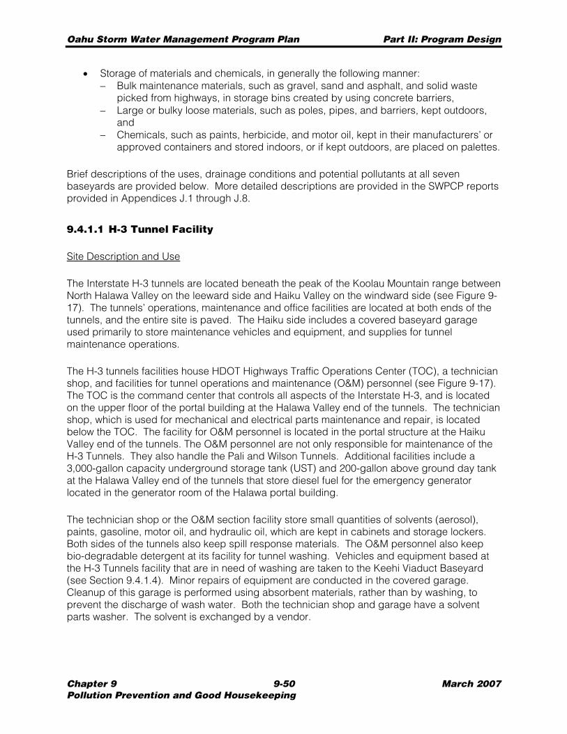
Oahu Storm Water Management Program Plan Part II: Program Design
Chapter 9 9-50 March 2007 Pollution Prevention and Good Housekeeping
• Storage of materials and chemicals, in generally the following manner: − Bulk maintenance materials, such as gravel, sand and asphalt, and solid waste
picked from highways, in storage bins created by using concrete barriers, − Large or bulky loose materials, such as poles, pipes, and barriers, kept outdoors,
and − Chemicals, such as paints, herbicide, and motor oil, kept in their manufacturers’ or
approved containers and stored indoors, or if kept outdoors, are placed on palettes.
Brief descriptions of the uses, drainage conditions and potential pollutants at all seven baseyards are provided below. More detailed descriptions are provided in the SWPCP reports provided in Appendices J.1 through J.8.
9.4.1.1 H-3 Tunnel Facility
Site Description and Use
The Interstate H-3 tunnels are located beneath the peak of the Koolau Mountain range between North Halawa Valley on the leeward side and Haiku Valley on the windward side (see Figure 9-17). The tunnels’ operations, maintenance and office facilities are located at both ends of the tunnels, and the entire site is paved. The Haiku side includes a covered baseyard garage used primarily to store maintenance vehicles and equipment, and supplies for tunnel maintenance operations.
The H-3 tunnels facilities house HDOT Highways Traffic Operations Center (TOC), a technician shop, and facilities for tunnel operations and maintenance (O&M) personnel (see Figure 9-17). The TOC is the command center that controls all aspects of the Interstate H-3, and is located on the upper floor of the portal building at the Halawa Valley end of the tunnels. The technician shop, which is used for mechanical and electrical parts maintenance and repair, is located below the TOC. The facility for O&M personnel is located in the portal structure at the Haiku Valley end of the tunnels. The O&M personnel are not only responsible for maintenance of the H-3 Tunnels. They also handle the Pali and Wilson Tunnels. Additional facilities include a 3,000-gallon capacity underground storage tank (UST) and 200-gallon above ground day tank at the Halawa Valley end of the tunnels that store diesel fuel for the emergency generator located in the generator room of the Halawa portal building.
The technician shop or the O&M section facility store small quantities of solvents (aerosol), paints, gasoline, motor oil, and hydraulic oil, which are kept in cabinets and storage lockers. Both sides of the tunnels also keep spill response materials. The O&M personnel also keep bio-degradable detergent at its facility for tunnel washing. Vehicles and equipment based at the H-3 Tunnels facility that are in need of washing are taken to the Keehi Viaduct Baseyard (see Section 9.4.1.4). Minor repairs of equipment are conducted in the covered garage. Cleanup of this garage is performed using absorbent materials, rather than by washing, to prevent the discharge of wash water. Both the technician shop and garage have a solvent parts washer. The solvent is exchanged by a vendor.
LOCATION PLAN
Not to scale
Statewide Storm Water Management ProgramOahu Storm Water Management Program Plan
H-3 Freeway Tunnels FacilitiesFigure 9-17
Oahu Storm Water Management Program Plan Part II: Program Design
Chapter 9 9-52 March 2007 Pollution Prevention and Good Housekeeping
Drainage Characateristics
The tunnel facilities have no storm drain inlets. Within the tunnels, continuous slotted drains that run along both the right and left edges of both tunnels collect runoff into either one of two 40,000-gallon USTs located on each side of the tunnel. The water collected in the tunnels is primarily wash water generated from tunnel and facility washing. The water levels in the USTs are checked and tested as needed based on rainfall and other events. If appropriate, the water is normally reused for irrigation. Storm water runoff at the Haiku Valley end of the tunnels sheet flows to grassy areas beneath the Interstate Route H-3 viaduct. On the Halawa Valley end, storm water runoff sheet flows to the H-3 roadway drainage system, where it empties into North Halawa Stream approximately two miles downstream on the tunnel portals.
The nearest water body on the Halawa Valley end of the tunnels is the North Halawa Stream, which borders the northern portion of the facility. The stream is a tributary of Halawa Stream, which empties into Pearl Harbor’s East Loch. The nearest water body on the Haiku Valley end of the tunnels is Heeia Stream, which is located approximately 1,000 feet south of the portals. The stream empties into the Heeia Pond.
Potential Pollutants
The predominant activities at the H-3 tunnels facility include parking, limited maintenance and fueling of vehicles and equipment, storage of limited quantities of chemicals, and limited electrical and mechanical parts maintenance and repair. Potential pollutants derived from these activities include various petroleum products, traces of heavy metals (cadmium, chromium and lead), and solid waste debris. A detailed list of potential pollutant sources is provided in the SWPCP for the Interstate Route H-3 Tunnels (see Appendix J.1).
9.4.1.2 Hauula Baseyard
Site Description and Use
The Hauula Baseyard is located along Hauula Homestead Road in the Koolualoa District of Oahu (see Figure 9-18). The baseyard is entirely paved except for landscaped and gravel strips along the perimeter of the property. A garage/storage structure and a small office are the only buildings on the site.
The Landscaping Unit uses the baseyard to park vehicles, maintenance equipment, and a 50-gallon capacity diesel fuel tank truck. The unit also uses cabinets in the garage/storage structure to store small quantities of herbicide, gasoline, motor oil, and 2-cycle oil. Storage bins constructed of concrete masonry units are used to store raw materials, such as sand and gravel.
Vehicle and equipment washing is conducted on the concrete pavement area at the southwest corner of the baseyard. The wash water flows into the landscaped area along the western border of the site and does not flow off-site or into any storm drain or natural waterway.
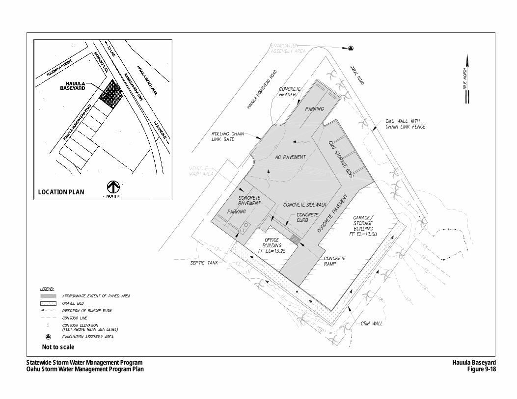
Statewide Storm Water Management ProgramOahu Storm Water Management Program Plan
Hauula BaseyardFigure 9-18
LOCATION PLAN
Not to scale
Oahu Storm Water Management Program Plan Part II: Program Design
Chapter 9 9-54 March 2007 Pollution Prevention and Good Housekeeping
Occasional minor repairs or maintenance of equipment is conducted in the garage/storage structure. Absorbent materials are used for cleanup after repairs and maintenance rather than by washing, which prevent the discharge of wash water from the site. Only equipment is allowed to be fueled on-site. Vehicles are not allowed to be fueled within the baseyard.
Drainage Characteristics
Because the baseyard has no storm drain inlets, storm water runoff sheet flows towards the driveway and discharges into Hauula Homestead Road right-of-way. The roadway has no storm drain collection system, and therefore, its runoff generally percolates into the ground along its coral covered shoulders. The baseyard is approximately 60 feet from the beach.
Potential Pollutants
The predominant activities at the Hauula Baseyard include parking, minor or limited vehicle and equipment maintenance, limited fueling, and storage of limited quantities of chemicals. Potential pollutants derived from these activities include various petroleum products, traces of heavy metals, and solid waste debris. A detailed list of potential pollutant sources is provided in the SWPCP for the Hauula Baseyard (see Appendix J.2).
9.4.1.3 Kakoi Street Baseyard
Site Description and Use
The Kakoi Street Baseyard is located in Mapunapuna, an industrial and warehouse district in Honolulu (see Figure 9-19). Except for limited landscaped areas, the entire site is paved. The baseyard is the only HDOT Highways Oahu facility where routine vehicle and equipment maintenance and repairs are conducted, and the only one with permanent fueling facilities. As shown on Figure 9-19, the baseyard contains the following buildings and facilities:
• HWY-OM administration building; • Fuel pump station; • 8,000- to 10,000-gallon USTs, one holding gasoline and the other holding diesel fuel; • 600-gallon capacity used oil UST; • A shop building; • A warehouse (Building A); • Two motor pools, which consists of Building B for heavy vehicles and Building C for
light vehicles; and • Office trailers and other small storage areas.
The Kakoi Street Baseyard is used to store vehicles, equipment and materials to support HWY-OM Maintenance Section operations. Brief descriptions on how certain HWY-OM units and subunits use the Kakoi Street Baseyard are provided below.
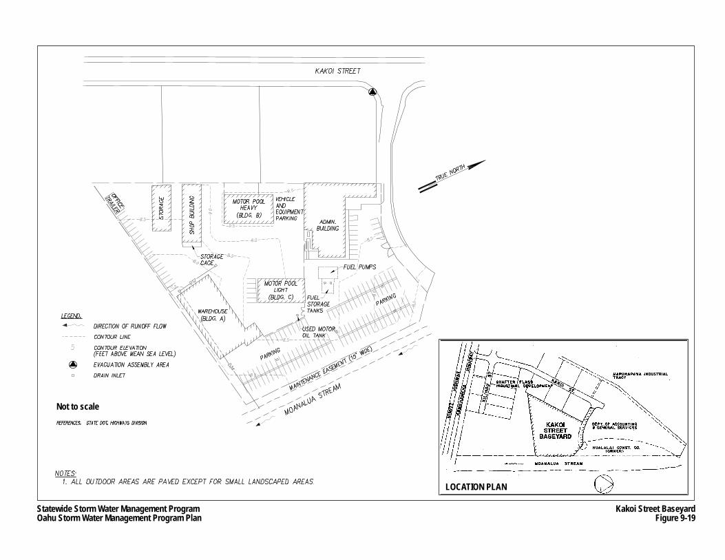
Statewide Storm Water Management ProgramOahu Storm Water Management Program Plan
Kakoi Street BaseyardFigure 9-19
Not to scale
LOCATION PLAN
Oahu Storm Water Management Program Plan Part II: Program Design
Chapter 9 9-56 March 2007 Pollution Prevention and Good Housekeeping
The Bridge Maintenance Subunit uses Building A to store a small boat, flammable liquid paints, aerosols, adhesives, paints, and solvents. The unit also parks three crew trucks, a bobcat, and a truck carrying a 50-gallon capacity diesel fuel tank.
The Traffic Signs and Marking Subunit stores fabricated signs along the southwestern corner of Building B. The subunit also uses the shop building and small storage warehouse located in the southwestern portion of the property to make signs, store painting equipment, store traffic paint and traffic paint equipment, and store chemicals associated with painting (paints, adhesives, aerosols, mineral spirits, etc.).
The Landscaping Subunit utilizes a storage room in Building A to house handheld landscaping equipment and small quantities of chemicals, such as 2-cycle oil, herbicide, pesticide, and gasoline. The subunit also parks some of its vehicles and equipment along the southwestern boundary of the property, and occasionally parks a 300-gallon capacity pesticide tank truck in this area.
The Structures Subunit stores its concrete mixers, tampers, generators, vehicles, and gasoline held in small containers in a storage room in Building A, which contains a flammable storage locker to house the gasoline. The subunit also stores compressed gas cylinders and other dry materials on the side of the shop building.
Other activities at the baseyard include: • Welding within the shop building, which requires storage of small quantities of aerosols
and lubricants in a flammable storage locker in the building; • Maintenance and repair of small equipment, such as lawn mowers and chain saws, in
the small engine room in Building B, which also contains flammable storage locker holding miscellaneous lubricants, aerosols, and solvents;
• Repair and maintenance of vehicles and equipment greater than 15,000 gross vehicle weight (GVW) in Building B, which is also used to store various chemicals associated with automotive repair, such as petroleum lubricants, solvent cleaners, brake fluid, and antifreeze; and
• Repair and maintenance of vehicles and equipment less than 15,000 GVW in Building C, which is also used to store various chemicals associated with automotive repair.
The heavy and light repair and maintenance areas have drains designed to capture any wash water, which leads to oil/water separators.
Drainage Characteristics
The majority of the site is sloped towards the paved area in the southern portion of the property towards two storm drain inlets located near the northwest and southwest corners of Building A (see Figure 9-19). Two additional storm drain inlets in the northeast parking collect storm water runoff from the eastern portion of the site. All four storm drain inlets connect to a drain pipe that discharges into the Moanalua Stream, located along the eastern boundary of the site, which empties into the Keehi Lagoon.
Oahu Storm Water Management Program Plan Part II: Program Design
Chapter 9 9-57 March 2007 Pollution Prevention and Good Housekeeping
Potential Pollutants
The predominant activities at the Kakoi Street Baseyard include parking, maintenance and fueling of vehicles and equipment, and on-site storage of limited quantities of chemicals. The maintenance and repairing of vehicles, or even parked vehicles, may cause minor leaks (drips) of various petroleum products, such as oils and lubricants. Storage of chemicals may leave traces of heavy metals (cadmium, chromium and lead), herbicides, and solid waste debris. A detailed list of potential pollutant sources is provided in the SWPCP for the Kakoi Street Baseyard (see Appendix J.3).
9.4.1.4 Keehi Viaduct Baseyard
Site Description and Use
The Keehi Viaduct Baseyard is located underneath the Interstate H-1 Freeway Airport Viaduct near Keehi Interchange (see Figure 9-20). The baseyard is triangular-shaped and bordered on the mauka and makai sides by the Ewa bound and Diamond Head bound lanes of Nimitz Highway, respectively. Moanalua Stream demarcates the site’s east boundary, and an unnamed canal runs through the middle of the baseyard, draining into Moanalua Stream. The canal is surrounded by berms to prevent storm water runoff from directly emptying into the canal.
As shown on Figure 9-20, the baseyard contains the following buildings and facilities: • Office trailers; • Vehicle parking area near the baseyard entrance; • Vehicle wash rack; and • Various storage areas and bins.
Brief descriptions on how certain HWY-OM units and subunits use the Keehi Viaduct Baseyard are provided below.
The Special Services Subunit uses the baseyard to park their trucks and vehicles, and to store sweeper, green and solid waste, abandoned vehicles, and assorted debris, such as car batteries and tires, cleaned or picked up from highway rights-of-way until they can be transported to a landfill, recycling facility, or other appropriate disposal facility. These materials are stored on the southeast corner of the baseyard. The subunit is also responsible for operating and maintaining the wash rack. The wash rack is designed to collect, treat, and recycle wash water for vehicle washing.
The Roadway Paving Subunit uses the southeast corner of the baseyard to store asphalt emulsion in a 1,000-gallon capacity tack oil spray truck, and bulk materials in bins, such as cold asphalt mix (petroleum based), crushed rock and sand. Hazardous materials are stored on secondary containment pallets.
The Highway Electrical Unit uses the area on the western-most portion of the baseyard to store small quantities of lubricants, solvents and paints. The chemicals are stored either in storage containers or are placed adjacent to the storage containers beneath the freeway overhang.
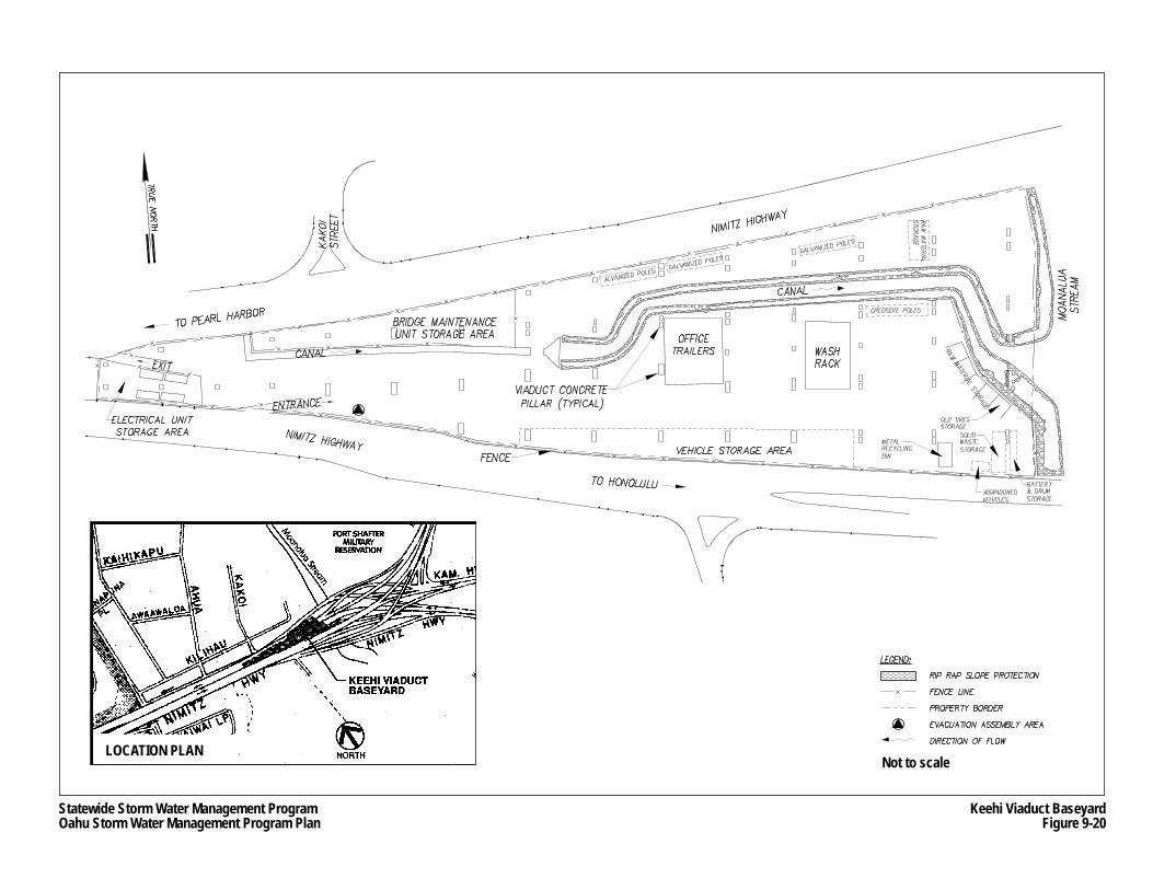
Statewide Storm Water Management ProgramOahu Storm Water Management Program Plan
Keehi Viaduct BaseyardFigure 9-20
Not to scaleLOCATION PLAN
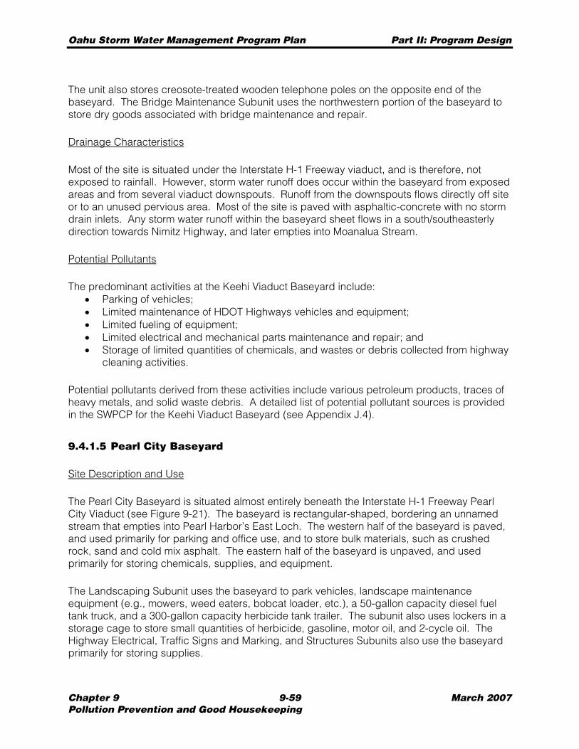
Oahu Storm Water Management Program Plan Part II: Program Design
Chapter 9 9-59 March 2007 Pollution Prevention and Good Housekeeping
The unit also stores creosote-treated wooden telephone poles on the opposite end of the baseyard. The Bridge Maintenance Subunit uses the northwestern portion of the baseyard to store dry goods associated with bridge maintenance and repair.
Drainage Characteristics
Most of the site is situated under the Interstate H-1 Freeway viaduct, and is therefore, not exposed to rainfall. However, storm water runoff does occur within the baseyard from exposed areas and from several viaduct downspouts. Runoff from the downspouts flows directly off site or to an unused pervious area. Most of the site is paved with asphaltic-concrete with no storm drain inlets. Any storm water runoff within the baseyard sheet flows in a south/southeasterly direction towards Nimitz Highway, and later empties into Moanalua Stream.
Potential Pollutants
The predominant activities at the Keehi Viaduct Baseyard include: • Parking of vehicles; • Limited maintenance of HDOT Highways vehicles and equipment; • Limited fueling of equipment; • Limited electrical and mechanical parts maintenance and repair; and • Storage of limited quantities of chemicals, and wastes or debris collected from highway
cleaning activities.
Potential pollutants derived from these activities include various petroleum products, traces of heavy metals, and solid waste debris. A detailed list of potential pollutant sources is provided in the SWPCP for the Keehi Viaduct Baseyard (see Appendix J.4).
9.4.1.5 Pearl City Baseyard
Site Description and Use
The Pearl City Baseyard is situated almost entirely beneath the Interstate H-1 Freeway Pearl City Viaduct (see Figure 9-21). The baseyard is rectangular-shaped, bordering an unnamed stream that empties into Pearl Harbor’s East Loch. The western half of the baseyard is paved, and used primarily for parking and office use, and to store bulk materials, such as crushed rock, sand and cold mix asphalt. The eastern half of the baseyard is unpaved, and used primarily for storing chemicals, supplies, and equipment.
The Landscaping Subunit uses the baseyard to park vehicles, landscape maintenance equipment (e.g., mowers, weed eaters, bobcat loader, etc.), a 50-gallon capacity diesel fuel tank truck, and a 300-gallon capacity herbicide tank trailer. The subunit also uses lockers in a storage cage to store small quantities of herbicide, gasoline, motor oil, and 2-cycle oil. The Highway Electrical, Traffic Signs and Marking, and Structures Subunits also use the baseyard primarily for storing supplies.
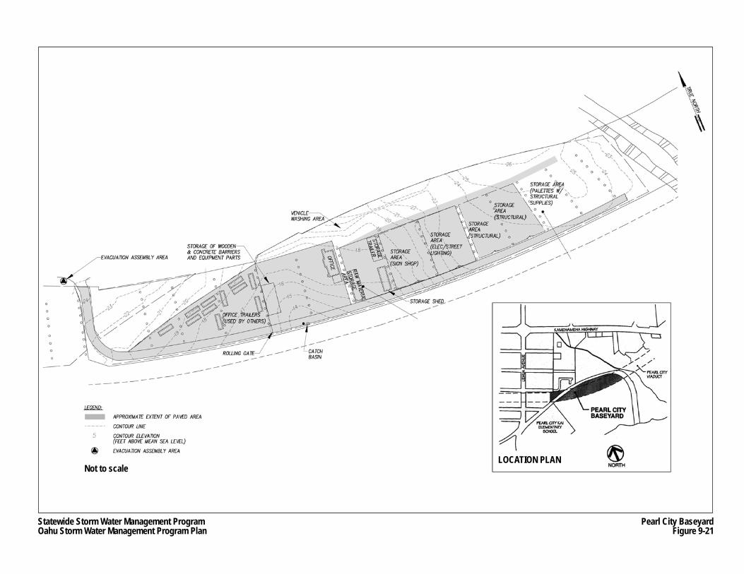
Not to scaleLOCATION PLAN
Statewide Storm Water Management ProgramOahu Storm Water Management Program Plan
Pearl City BaseyardFigure 9-21
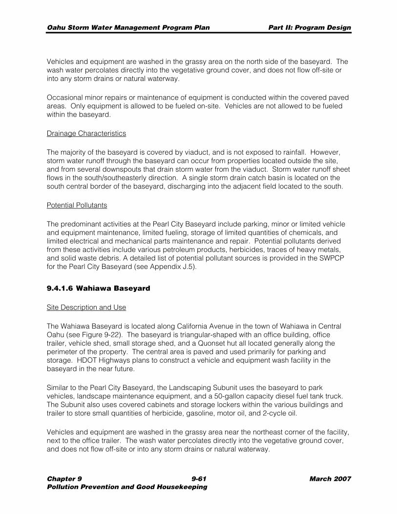
Oahu Storm Water Management Program Plan Part II: Program Design
Chapter 9 9-61 March 2007 Pollution Prevention and Good Housekeeping
Vehicles and equipment are washed in the grassy area on the north side of the baseyard. The wash water percolates directly into the vegetative ground cover, and does not flow off-site or into any storm drains or natural waterway.
Occasional minor repairs or maintenance of equipment is conducted within the covered paved areas. Only equipment is allowed to be fueled on-site. Vehicles are not allowed to be fueled within the baseyard.
Drainage Characteristics
The majority of the baseyard is covered by viaduct, and is not exposed to rainfall. However, storm water runoff through the baseyard can occur from properties located outside the site, and from several downspouts that drain storm water from the viaduct. Storm water runoff sheet flows in the south/southeasterly direction. A single storm drain catch basin is located on the south central border of the baseyard, discharging into the adjacent field located to the south.
Potential Pollutants
The predominant activities at the Pearl City Baseyard include parking, minor or limited vehicle and equipment maintenance, limited fueling, storage of limited quantities of chemicals, and limited electrical and mechanical parts maintenance and repair. Potential pollutants derived from these activities include various petroleum products, herbicides, traces of heavy metals, and solid waste debris. A detailed list of potential pollutant sources is provided in the SWPCP for the Pearl City Baseyard (see Appendix J.5).
9.4.1.6 Wahiawa Baseyard
Site Description and Use
The Wahiawa Baseyard is located along California Avenue in the town of Wahiawa in Central Oahu (see Figure 9-22). The baseyard is triangular-shaped with an office building, office trailer, vehicle shed, small storage shed, and a Quonset hut all located generally along the perimeter of the property. The central area is paved and used primarily for parking and storage. HDOT Highways plans to construct a vehicle and equipment wash facility in the baseyard in the near future.
Similar to the Pearl City Baseyard, the Landscaping Subunit uses the baseyard to park vehicles, landscape maintenance equipment, and a 50-gallon capacity diesel fuel tank truck. The Subunit also uses covered cabinets and storage lockers within the various buildings and trailer to store small quantities of herbicide, gasoline, motor oil, and 2-cycle oil.
Vehicles and equipment are washed in the grassy area near the northeast corner of the facility, next to the office trailer. The wash water percolates directly into the vegetative ground cover, and does not flow off-site or into any storm drains or natural waterway.
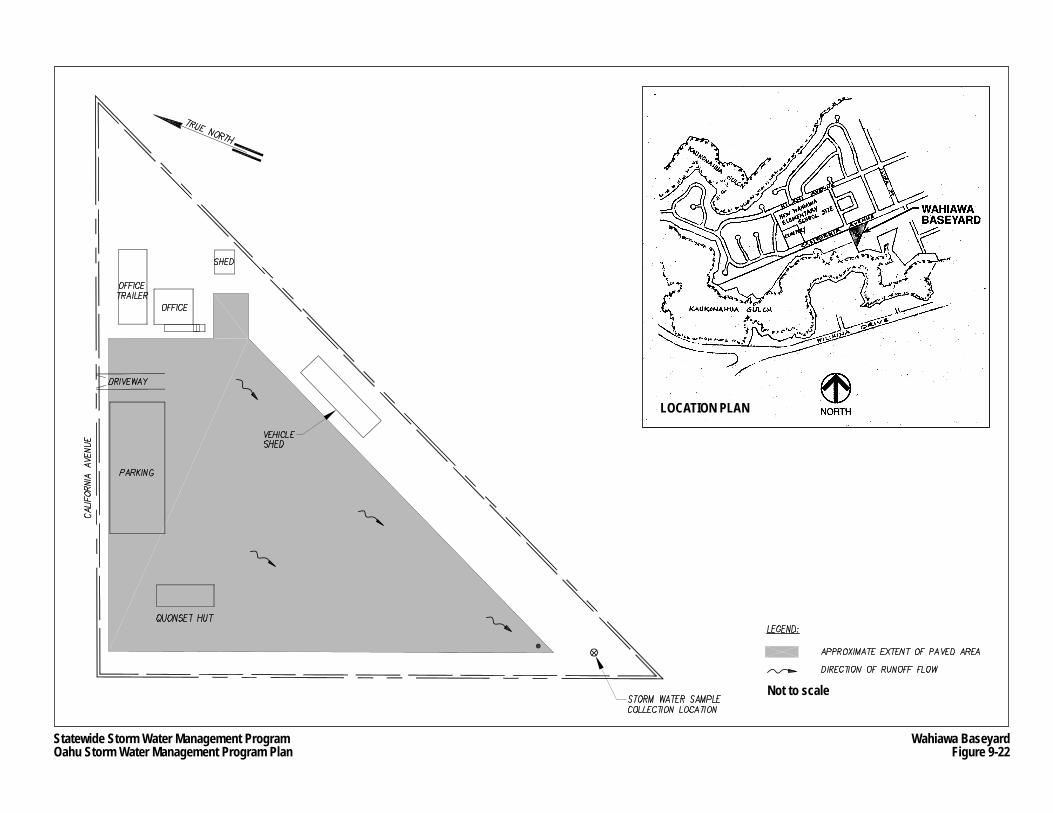
Statewide Storm Water Management ProgramOahu Storm Water Management Program Plan
Wahiawa BaseyardFigure 9-22
Not to scale
LOCATION PLAN
Oahu Storm Water Management Program Plan Part II: Program Design
Chapter 9 9-63 March 2007 Pollution Prevention and Good Housekeeping
Occasional minor repairs or maintenance of equipment is conducted either in the vehicle shed or the adjacent Quonset hut. Cleanup after maintenance is conducted using absorbent materials rather than by water washing to prevent the discharge of wash water from the site. Only equipment is allowed to be fueled on-site. Vehicles are not allowed to be fueled within the baseyard.
Drainage Characteristics
Although much of the baseyard is paved, it has no storm drain inlets. Storm water runoff sheet flows in a southwesterly direction to grassy or landscaped areas on the southwest corner of the baseyard where it infiltrates into the ground. Extreme storm water flows may empty into Kaukonahua Gulch located immediately to the south of the baseyard. The nearest water body is the south fork of Kaukonahua Stream, which is located approximately 500 feet to the south of the facility. The stream empties into Wahiawa Reservoir.
Potential Pollutants
The predominant activities at the Wahiawa Baseyard include parking, minor or limited vehicle and equipment maintenance, limited fueling, and storage of limited quantities of chemicals. Potential pollutants derived from these activities include various petroleum products, herbicides, traces of heavy metals, and solid waste debris. A detailed list of potential pollutant sources is provided in the SWPCP for the Wahiawa Baseyard (see Appendix J.6).
9.4.1.7 Waianae Baseyard
Site Description and Use
The Waianae Baseyard is located along Farrington Highway in Waianae, Oahu (see Figure 9-23). Less than half the property is paved, but this paved area contains a mobile trailer office, a vehicle shed, shipping containers and parking spaces. The mauka side of the property or the area on the far end from Farrington Highway is unpaved, and covered with grass and weeds.
The baseyard is used primarily to store equipment and supplies. The Landscaping Unit parks vehicles, landscape maintenance equipment, and a 50-gallon capacity diesel fuel tank truck in the baseyard. The subunit also uses storage lockers in the vehicle shed to store small quantities of herbicide, gasoline, motor oil, and 2-cycle oil. Vehicle and equipment washing is conducted in the grassy area near the northwest boundary of the baseyard. The wash water percolates directly into the vegetative ground cover, and does not flow off-site or into any storm drains or natural waterway.
Occasional minor repairs or maintenance of equipment is conducted under cover in the vehicle shed. Cleanup after repairs and maintenance is performed using absorbent materials rather than by washing to prevent the discharge of wash water from the site. Only equipment is allowed to be fueled on-site. Vehicles are not allowed to be fueled within the baseyard.
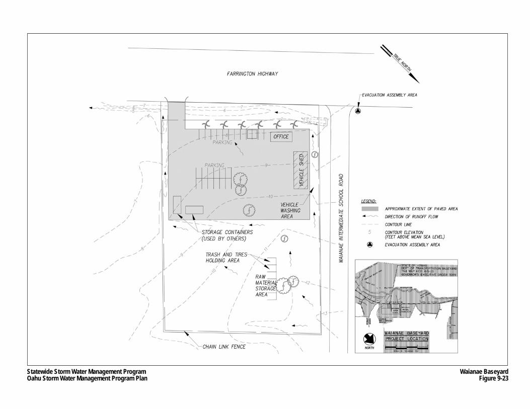
Statewide Storm Water Management ProgramOahu Storm Water Management Program Plan
Waianae BaseyardFigure 9-23
Oahu Storm Water Management Program Plan Part II: Program Design
Chapter 9 9-65 March 2007 Pollution Prevention and Good Housekeeping
The unpaved half of the facility is used primarily for storage, but much of this area remains vacant or unused. Storage bins made from concrete barriers are used to store trash (in plastic garbage bags), tires, sand, gravel and cold asphalt mix. Trash and tires are kept at the baseyard on a temporary basis until they can be transported to the Keehi Baseyard for later disposal. The unpaved area is also used for storing concrete pillars, drain structures, pipes, and barriers from previous nearby construction projects. HDOT Highways plans to use a portion of the unpaved section of the baseyard to construct a dewatering facility (see Section 9.4.5).
HDOT Highways allows other State agencies to use the baseyard. State Department of Education employees use some of the parking along the Farrington Highway frontage. HDOT Harbors uses one of the shipping containers to store a jet ski.
Drainage Characteristics
An asphalt/grass gutter between the paved and unpaved areas directs storm water runoff into a vegetative swale between Farrington Highway and the makai boundary of the baseyard. The vegetative swale leads to a storm drain inlet located approximately 100-feet southeast of the facility. Because the baseyard has no storm drain inlets, all runoff percolates into the ground, or sheet flows in a southerly direction into the gutter and vegetative swale, eventually discharging into the off-site storm drain inlet, which leads to Kawiwi Drainage Canal and eventually into coastal waters.
Potential Pollutants
The predominant activities at the Waianae Baseyard include parking, minor or limited vehicle and equipment maintenance, limited fueling, and storage of limited quantities of chemicals, bulk materials and debris. Potential pollutants derived from these activities include various petroleum products, traces of heavy metals, and solid waste debris. A detailed list of potential pollutant sources is provided in the SWPCP for the Waianae Baseyard (see Appendix J.7).
9.4.1.8 Windward Baseyard
Site Description and Use
The Windward Baseyard is located near Likelike and Kahekili Highways in the Koolaupoko District of Oahu (see Figure 9-24). The baseyard is mostly paved, with landscaped areas along the southern, eastern, and western edges. The only structures on the site are an administration building, vehicle shed and office trailer.
The baseyard is used to park landscape maintenance vehicles and equipment (mowers, weed eaters, and a chipper), a 50-gallon capacity diesel fuel tank truck, and a 100-gallon capacity herbicide tank trailer. Traffic barricades used for construction projects are also kept at the baseyard. Small quantities of herbicide, gasoline, motor oil, and 2-cycle oil are stored in storage lockers in the vehicle shed. Spill response materials are also kept in the vehicle shed.
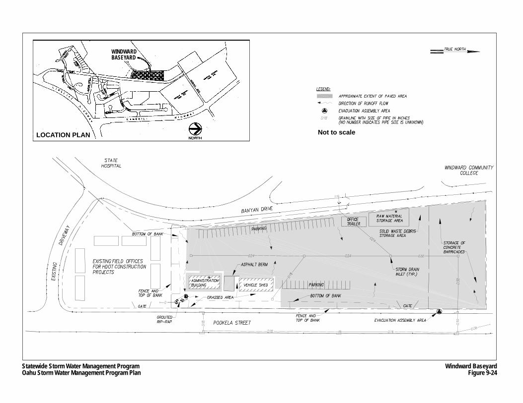
Statewide Storm Water Management ProgramOahu Storm Water Management Program Plan
Windward BaseyardFigure 9-24
LOCATION PLAN Not to scale
WINDWARDBASEYARD
Oahu Storm Water Management Program Plan Part II: Program Design
Chapter 9 9-67 March 2007 Pollution Prevention and Good Housekeeping
Bulk materials, such as crushed rock, sand, and cold mix asphalt, are stored in a designated area on the west end of the property.
Vehicles and equipment are washed only on the paved and bermed area, which is located adjacent to the southern end of the vehicle shed. Wash water is contained within the bermed asphalt for natural evaporation. The wash water is prevented from flowing off-site or into any storm drains or natural waterways.
Occasional minor repairs or maintenance of equipment is conducted in the vehicle shed. Cleanup after repairs and maintenance is performed using absorbent materials rather than by washing to prevent the discharge of wash water from the site. Only equipment is allowed to be fueled. Vehicles are not allowed to be fueled within the baseyard.
Drainage Characteristics
The site is sloped towards the center of the property where four storm drain inlets are located. A single storm drain inlet is in the grassy swale near the eastern boundary. The drain inlets are interconnected by pipe, and discharges to the storm drain system in Pookela Street (see Figure 9-24). The baseyard property also collects storm water from the driveway to the nearby State Hospital via an outfall at the southeast corner behind the administration building. This storm water sheet flows to the inlet in the grassy swale. The nearest water body is the Kupunahala Stream, located approximately 1,300 feet to the east of the facility across Kahekili Highway.
Potential Pollutants
The predominant activities at the Windward Baseyard include parking, minor or limited vehicle and equipment maintenance, limited fueling, and storage of limited quantities of chemicals and bulk materials. Potential pollutants derived from these activities include various petroleum products and traces of heavy metals and solid waste debris. A detailed list of potential pollutant sources is provided in the SWPCP for the Windward Baseyard (see Appendix J.8).
9.4.2 Storm Water Pollution Control Plans
Pollution control measures, which include BMPs, are provided in the SWPCP of each baseyard (see Appendices J.1 through J.8). Each baseyard will receive a copy of the SWPCP, as well as any other relevant documents. For example, the Maintenance Activities BMP Field Manual (see Section 9.4.3) was provided to the baseyard maintenance personnel.
Every person who uses a baseyard will be responsible for preventing pollution. However, individuals were identified at each baseyard to oversee the baseyard’s overall pollution control practices (see Appendix J.9). Some baseyards have multiple pollution control contacts because these baseyards contain multiple units or subunits. In most cases, these persons are unit or sub-unit supervisors. The pollution control contacts will receive extensive training on all BMPs identified in this section, and will be responsible for conducting periodic inspection of
Oahu Storm Water Management Program Plan Part II: Program Design
Chapter 9 9-68 March 2007 Pollution Prevention and Good Housekeeping
activities that may cause pollution, and suggesting improvements to the baseyard’s BMPs. In addition to the pollution control contacts, an HDOT Highways staff person was identified, who will have the primary responsibility of ensuring pollution control consistency among all the baseyards. This person will also provide assistance and oversight to the baseyard contacts regarding BMPs, and will conduct independent inspections of all baseyards at least four times a year.
9.4.2.1 Best Management Practices
The most cost-effective method to reduce or eliminate baseyard-generated pollutants from entering storm water runoff is to use BMPs that prevent pollution. However, in situations where a pollutant release or spill does occur, the implementation of response procedures can preclude the discharge of the release from contaminating storm water runoff and ultimately to surface water bodies. The following BMPs will be followed at all eight baseyards:
• Good housekeeping practices; • Vehicle and equipment washing, maintenance and repair; • Vehicle and equipment fueling; • Material storage; • Spill response; and • Hazardous waste management.
These BMPs were adopted from the BMPs contained in 2003 Oahu SWMP Plan and the City BMP Manual, and are described in each of the eight SWPCPs that are provided in Appendices J.1 through J.8. The Maintenance Activities BMP Field Manual includes these BMPs. The purpose of the baseyard BMPs are provided below.
Good Housekeeping Practices BMP
HWY-OM personnel handle materials and products on a daily basis that if not used, stored or disposed of properly have the potential to contaminant storm water runoff. Good housekeeping practices maintain a clean, safe, and orderly working environment, which reduces the likelihood of accidental spills of pollutants caused by mishandling of equipment. Good housekeeping practices have the additional benefit of maintaining a safe working environment.
Vehicle and Equipment Washing, Maintenance and Repair BMP
The routine maintenance of vehicles and equipment at baseyards is unavoidable. In addition to vehicle and equipment washing, maintenance and repairs include fluid removal and replacement, and engine and parts cleaning, repair and replacement. The BMP for vehicle and equipment washing, maintenance and repair is intended to reduce the likelihood that pollutants produced from activities do not enter storm water runoff.
Oahu Storm Water Management Program Plan Part II: Program Design
Chapter 9 9-69 March 2007 Pollution Prevention and Good Housekeeping
Vehicle and Equipment Fueling BMP
During fueling of vehicles and equipment, there is the potential for leaked or spilled fuel to contaminate storm water. The procedures outlined in this BMP are intended to prevent fuel spills and leaks during fueling.
Material Storage BMP
As described throughout Section 9.4.1, a variety of materials and products are stored or kept at the baseyards. If they are not stored properly, such as being exposed to rain, leaks are possible, which may adversely affect quality of storm water runoff. This BMP specifies how materials and chemicals are to be stored in the baseyard.
Spill Response BMP
Accidental releases or spills may lead to contamination of storm water runoff if such spills are not handled or are improperly handled. The guidelines provided in this BMP are intended to address large or uncontrolled spills and should be followed by all employees stationed or present in the baseyard.
Hazardous Waste Management BMP
Among the products stored at baseyards are chemicals, such as paints, solvents, petroleum products, herbicides, and batteries, which become hazardous waste upon disposal. This BMP provides guidelines for handling and disposing of hazardous materials. Improperly using or disposing of hazardous materials has the potential to contaminate storm water runoff passing through a baseyard.
9.4.2.2 Inspections, Plan Reviews and BMP Revisions
As noted above, quarterly inspections of baseyards will be performed to ensure that BMPs identified are consistently followed. The coordinator will assess all functions of the baseyard, and if deficiencies are noted, the coordinator will suggest solutions. A standardized inspection form, which is provided in each baseyard SWPCP in Appendices J.1 through J.8, will be used, and records of all inspections will be maintained in the AMS.
Any proposed changes to facilities, on-site activities, and materials stored on-site, will be reviewed by the program coordinator who will assess whether the BMPs that were in place would still be effective under the proposed changes. If necessary, revisions to the BMPs may be made by the program coordinator if they do not achieve the general objectives of controlling pollutants in storm water discharges and/or one or more baseyards is found to be in violation of applicable State regulations or the Oahu MS4 NPDES Permit. Plan review and revisions will take no longer than 30 days to be completed. All personnel at the facility will be informed during staff meetings of any changes made to the BMPs, and will be trained on new or modified procedures, if necessary.
Oahu Storm Water Management Program Plan Part II: Program Design
Chapter 9 9-70 March 2007 Pollution Prevention and Good Housekeeping
9.4.2.3 Spill Prevention and Response
The prevention of spills will largely be accomplished by following the guidelines and procedures of the BMPs on housekeeping, washing and maintenance, fueling, material storage, and handling hazardous materials. In addition, all baseyard personnel will be trained in spill prevention and response (see Section 9.4.4). However, despite the diligence of baseyard personnel in following the BMPs and having proper training, accidental spills may still occur.
Clean up of small spills of oil (less than 25 gallons) can usually be handled without disrupting baseyard operations provided that the spill can be cleaned within 72 hours using absorbent materials or other acceptable practice, and does not threaten ground or surface waters. Daily inspections of the baseyard by the pollution control contact and other baseyard personnel will identify small spills, which must be addressed immediately (e.g., start the clean up).
In the event of a large or uncontrolled release, the pollution control contact will act as the emergency coordinator until relieved by the appropriate HDOT Highways personnel. As noted in Section 6.4, the HFD is the lead agency for emergency response to hazardous spills on all non-military lands of Oahu. HDOT Highways is responsible for assisting the HFD in responding to spills within its rights-of-way and properties. Once the emergency is stabilized, managing the response to the spill may be turned over to HDOH.
Below are the steps to be taken in the event of large or uncontrolled release. More detailed information for each of the steps is provided in the SWPCPs in Appendices J.1 through J.8
Step 1: Stop work by shutting down pumps, equipment, and nearby gas valves and tanks, and have personnel move away from the affected area.
Step 2: The pollution control contact will assess the situation, such as determining the nature of the release and checking for any injuries.
Step 3: The contact will call the appropriate authorities (e.g., H3 Tunnel Control Center and emergency responders).
Step 4: The contact will control the scene by: − Keeping non-essential employees away from the spill, and removing any injured
person from the scene. − Assessing whether on-site personnel should stay and contain the spill or wait for the
HFD to handle the release. The assessment will be based on whether the release is hazardous, has the potential for fire or explosions, has the potential for migration to surface water, and many other factors. However, the contact will never subject themselves or other HDOT Highways personnel to any unreasonable risk of illness or injury.
− If the decision is made to control the spill, the personnel will don appropriate personal protective equipment; locate, stop, and contain the source of the release; and confine the further migration of the release. A spill response contractor will then be called to the scene for cleanup and removal of accumulated product resulting from the release.
All spills, leaks and other discharges, including hazardous substances, will be documented using a spill response documentation form, which is provided in each of the SWPCPs in
Oahu Storm Water Management Program Plan Part II: Program Design
Chapter 9 9-71 March 2007 Pollution Prevention and Good Housekeeping
Appendices J.1 to J.8. In addition to keeping the forms, all spill incidents will be recorded into the AMS.
9.4.3 Maintenance Activities BMP Manual
The Maintenance Activities Best Management Practices Field Manual (see Appendix J.10) (Maintenance Facility BMP Manual) includes a written set of BMPs described in Section 9.4.2 that address normal or typical activities that occur at baseyards, as well as including BMPs to be used in emergency situations, such as spills. The format of the Maintenance Facility BMP Manual is intended to be “field friendly”, and easily understandable. Copies of the manual were distributed to maintenance field staff.
9.4.4 Training
The training element of the Maintenance Facilities BMP Program focuses on the BMPs that prevent pollution and maintain good housekeeping practices used within baseyards and other maintenance facilities. The instructions will include how to use the SWPCPs and how to control storm water pollution at the baseyard by using appropriate BMPs. The training program started in February 2006.
Training Recipients
Training will be required of all HDOT Highways maintenance personnel stationed at the baseyards, which includes supervisors and clerical personnel as appropriate.
Training Method
Training will be held on-site at each baseyard, and involve “hands-on” demonstrations. A SWPCP users guide for the applicable baseyard will be provided to employees (see Appendices J.11 through J.18). The user guides are similar to the SWPCPs, but more field-friendly. New employees will be trained under the training regimen described herein as part of their orientation. Hands-on training materials will be provided to training recipients.
Trainer Qualifications
The trainer must have a thorough understanding of the BMPs described in Section 9.4.2, and have professional experience with the operation and functions of baseyards or similar types of maintenance and storage facilities. HDOT Maintenance Supervisors who have attended training sessions held by a qualified trainer are considered qualified to hold on-the-job training sessions for new employees or employees who were not able to attend a formal training session.
Oahu Storm Water Management Program Plan Part II: Program Design
Chapter 9 9-72 March 2007 Pollution Prevention and Good Housekeeping
Topics
Topics will include the following: • Information and awareness of the Oahu MS4 NPDES Permit, which also applies to
baseyards, and the overall Oahu SWMP; • Informing staff that they serve an important role in protecting the water quality in the
State; • Identifying potential sources of pollution within baseyards, including the difference
between routine and non-routine runoff and their sources; • All BMPs described in Section 9.4.2; • Conducting site inspections; • Spill reporting and documentation; and • How to conduct site inspections within baseyards.
Training Schedule and Reporting
Training will be held annually. The Mid-Year and End-of-Year Reports (See Chapter Thirteen) will contain information on the number and dates of training sessions, types of training, and recipients of the training.
9.4.5 Dewatering Facilities
The Debris Control Program (see Section 9.1.1.2) requires that sediments and debris removed from the Oahu MS4 (e.g., catch basins, pipes, etc.) be dried to an appropriate moisture level before transport to and disposal at an approved landfill. To address this requirement, HDOT Highways plans to initially construct dewatering facilities at its Pearl City and Waianae Baseyards. Once operational, service contractors who clean the Oahu MS4 storm drains will use these facilities. The two dewatering facilities will be able to process the expected quantity of material removed from the Oahu MS4.
9.4.5.1 Dewatering Method
A dewatering facility will include the following elements: • Settling basins; • Filter beds; • Collection and transport pipes; • Oil interceptor pit; and • Post-dewatering debris or dry storage area.
A settling basin is a concrete-lined area where saturated debris removed from the Oahu MS4 is dumped. The settling basins will be constructed partially below grade, and will be accessible by truck ramps. Vehicles transporting debris will dump their loads directly into the settling basins using the truck ramp, and the sediment, trash and debris will be allowed to settle.
A filter bed is where the water from the debris undergoes primary filtering before disposal into the municipal sewer system. Like the settling basins, the filter beds will be constructed
Oahu Storm Water Management Program Plan Part II: Program Design
Chapter 9 9-73 March 2007 Pollution Prevention and Good Housekeeping
partially below grade, and accessible by truck ramps. As the heavier debris drop or settle to the bottom of the settling basin, the water, which still contains some sediment, is allowed to flow into the filter beds through openings between the settling basin and drying bed. The rate in which the water is allowed to flow into the filter beds is controlled by stop logs or boards placed within the gaps.
The bottom of the filter bed contains a granular filter of multiple layers. A system of collection drain pipes will be placed below the filter to capture the water. From these pipes, the water will be directed to an oil separator pit, which will be used to remove any oily particles. The water will then be transported via pipe to the nearest municipal sewer manhole for eventual treatment at a municipal wastewater treatment plant.
The remaining materials in the settling basin and the filter beds will be transported to a municipal landfill for disposal. On-site temporary storage areas will be provided for material that cannot immediately be transported to a landfill due to manpower shortages, mechanical breakdowns, or for efficiency reasons.
Standardized dimensions will be used for the settling basins, filter beds and dry storage areas. The capacity of a single settling basin will be approximately 150 cubic yards or 30,000 gallons.
The proposed dewatering method described above is the same method used by the City at its dewatering facilities located in Ahuimanu and Sand Island.
9.4.5.2 Proposed Sites
HDOT Highways chose the Pearl City and Waianae Baseyards as sites for dewatering facilities because both properties have sufficient and suitable open areas to accommodate the facilities. These baseyards are used to park or store vehicles, equipment and materials needed for highway maintenance. Other properties owned by HDOT Highways were evaluated, but none of them have excess area available that can accommodate a dewatering facility, they may be committed for other HDOT Highways activities, or may be leased to other entities.
To meet near term anticipated needs of the Debris Control Program, HDOT Highways proposes to construct a total of six settling basins and their associated filter beds divided between both baseyards. With a more centralized location, the Pearl City facility will likely be required to treat about twice the amount of debris as the Waianae facility. Therefore, the Pearl City facility will hold four of the six settling basins, and be twice as large as the Waianae facility.
The Pearl City baseyard dewatering facility is planned to be constructed between three sets of piers on the east side of the property (see Figure 9-25). Because the facility will be completely covered by the Pearl City Viaduct, it will not require a roof to prevent the drying debris from being saturated by rainwater. The area in between the settling basins, filter beds and storage areas will be paved to handle the truck and vehicle traffic associated with the operation of the facility.
The Waianae Baseyard dewatering facility is planned to be constructed within the paved area of the baseyard near Farrington Highway (see Figure 9-26). This location would require the
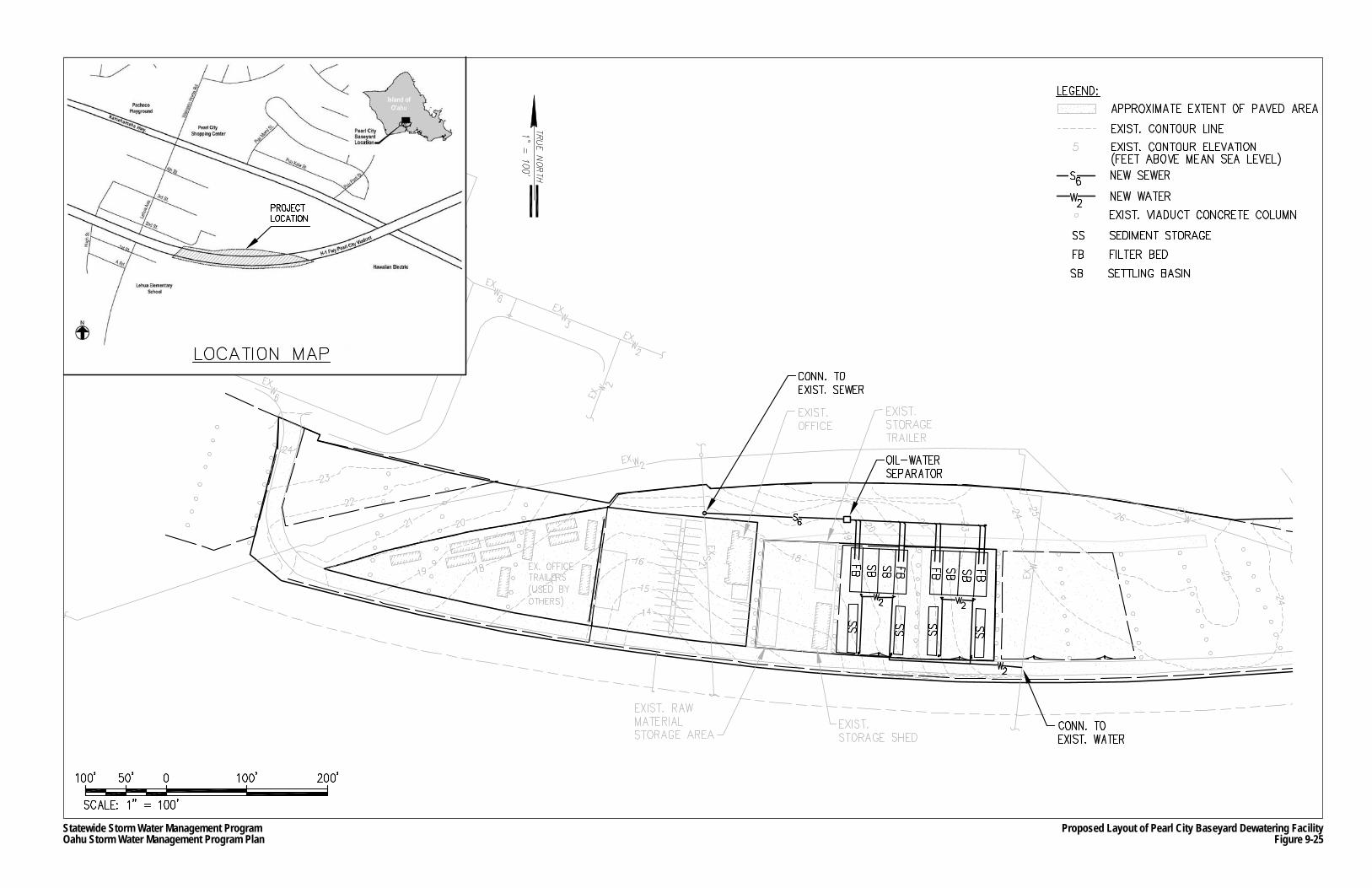
Statewide Storm Water Management ProgramOahu Storm Water Management Program Plan
Proposed Layout of Pearl City Baseyard Dewatering FacilityFigure 9-25
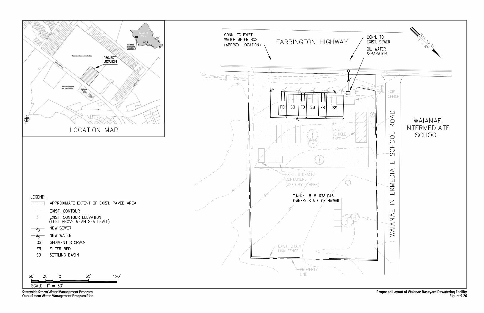
Statewide Storm Water Management ProgramOahu Storm Water Management Program Plan
Proposed Layout of Waianae Baseyard Dewatering FacilityFigure 9-26
Oahu Storm Water Management Program Plan Part II: Program Design
Chapter 9 9-76 March 2007 Pollution Prevention and Good Housekeeping
displacement of the trailer office. Unlike the proposed Pearl City Baseyard facility, the Waianae dewatering facility will require a roof to prevent the drying debris from being saturated by rainwater.
9.4.5.3 Project Development Process
In accordance with HAR Section 11-200-8(a), construction of the Pearl City and Waianae dewatering facilities would not be exempted from environmental review as provided in HRS Chapter 343. However, such a facility is highly unlikely to cause a “significant” impact as defined in HAR Section 11-200-12(b). Therefore, an Environmental Assessment (EA), which will presumably lead to a Finding of No Significant Impact by HDOT, would be the appropriate environmental document. The dewatering facilities are not anticipated to cause significant environmental impacts because the project sites are located within existing baseyards and the dewatering process is largely benign. A dewatering facility is consistent and compatible with the functions of a baseyard.
HDOT Highways publicly released a Draft EA for the proposed Pearl City dewatering facility on March 8, 2007. HDOT Highways originally planned to prepare a single EA for both sites. However, it was later determined, after consulting with the State Historic Preservation Division, that the Waianae Baseyard site may contain native Hawaiian burial sites. Although this information did not change the original plan, the environmental review process for the Waianae Baseyard site would have to include compliance with HRS Chapter 6E (Historic Preservation). This would have forced unnecessary delay to the Pearl City Baseyard site’s environmental review process. Therefore, HDOT Highways decided to use a separate environmental review process for each site. The results of archaeological work at the Waianae Baseyard site may cause a modification to the plan shown on Figure 9-26, or HDOT Highways may choose to drop the site if impacts to burial sites cannot be avoided.
The environmental review process for the Pearl City site is scheduled to be completed by late spring. Final design is tentatively scheduled to begin in early summer, and is expected to take approximately six months to complete. Construction of the dewatering facility at the Pearl City Baseyard may begin as soon as the summer 2008. A project development schedule for the Waianae Baseyard site is pending.
9.4.5.4 Alternative Dewatering
Currently, the service contractors are responsible for addressing the proper disposal of debris removed from the Oahu MS4. They may either make provisions within their own facilities to air dry the material in order to separate the water from the debris, or they may contract the services of a private dewatering facility. If HDOT Highways is unable to secure development of at least one dewatering facility, the current terms with the service contractors will remain in place.
Oahu Storm Water Management Program Plan Part II: Program Design
Chapter 9 9-77 March 2007 Pollution Prevention and Good Housekeeping
9.4.6 Organizational Structure
As shown on Figure 9-27, the Maintenance Facility BMP Program is overseen by HWY-OM. The maintenance supervisors at each baseyard facility are in charge of ensuring that the procedures outlined in their respective SWPCPs are followed. The supervisors are also responsible for training baseyard personnel on the provisions of the SWPCPs and appropriate BMPs for the nature of their work. An HWY-OT Civil Engineer V is responsible for the operations of the tunnel operation center.
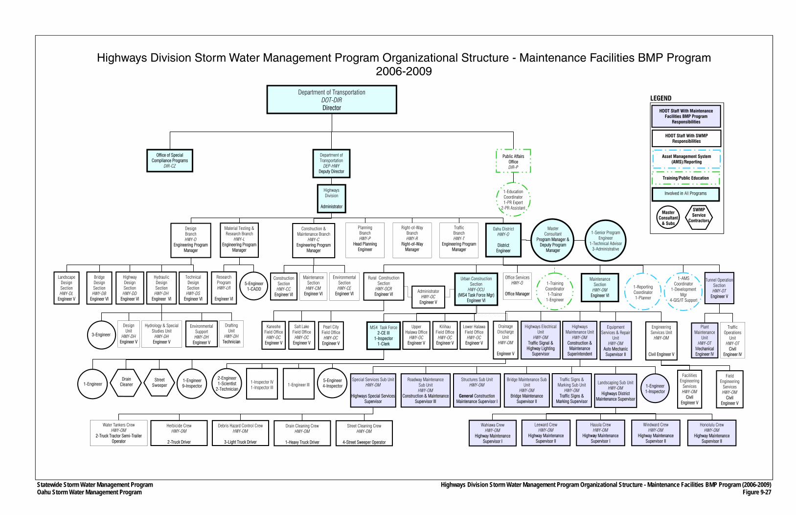
Statewide Storm Water Management Program Oahu Storm Water Management Program
Department of Transportation DOT-DIR Director
Department of Transportation
DEP-HWY Deputy Director
Public Affairs Office DIR-P
Office of Special Compliance Programs
DIR-CZ
Highways Division
Administrator
Planning Branch HWY-P
Head Planning Engineer
Right-of-Way Branch HWY-R
Right-of-Way Manager
Oahu District HWY-O
District
Engineer
Traffic Branch HWY-T
Engineering Program Manager
Office Services HWY-O
Office Manager
Urban Construction Section
HWY-OCU (MS4 Task Force Mgr)
Engineer VI
Traffic Operations
Unit HWY-OT
Civil Engineer IV
Design Branch HWY-D
Engineering Program Manager
Highway Design Section HWY-DD
Engineer VI
Technical Design Section HWY-DS
Engineer VI
Construction & Maintenance Branch
HWY-C Engineering Program
Manager
Maintenance Section
HWY-CM Engineer VI
Environmental Section HWY-CE
Engineer VI
Construction Section HWY-CC
Engineer VI
Rural Construction Section
HWY-OCR Engineer VI
Wahiawa Crew HWY-OM
Highway Maintenance Supervisor I
Leeward Crew HWY-OM
Highway Maintenance Supervisor II
Hauula Crew HWY-OM
Highway Maintenance Supervisor I
Windward Crew HWY-OM
Highway Maintenance Supervisor II
Honolulu Crew HWY-OM
Highway Maintenance Supervisor II
Special Services Sub Unit HWY-OM
Highways Special Services
Supervisor
Bridge Maintenance Sub Unit
HWY-OM Bridge Maintenance
Supervisor II
Structures Sub Unit HWY-OM
General Construction
Maintenance Supervisor I
Roadway Maintenance Sub Unit HWY-OM
Construction & Maintenance Supervisor III
Equipment Services & Repair
Unit HWY-OM
Auto Mechanic Supervisor II
Water Tankers Crew HWY-OM
2-Truck Tractor Semi-Trailer Operator
Street Cleaning Crew HWY-OM
4-Street Sweeper Operator
Drain Cleaning Crew HWY-OM
1-Heavy Truck Driver
Debris Hazard Control Crew HWY-OM
3-Light Truck Driver
Herbicide Crew HWY-OM
2-Truck Driver
1-Reporting Coordinator 1-Planner
1-AMS Coordinator
1-Development Mgr
4-GIS/IT Support
1-Training Coordinator 1-Trainer
1-Engineer
1-Education Coordinator 1-PR Expert
2-PR Assistant
Material Testing & Research Branch
HWY-L Engineering Program
Manager
Highways Maintenance Unit
HWY-OM Construction & Maintenance
Superintendent
Pearl City Field Office
HWY-OC Engineer V
Kaneohe Field Office
HWY-OC Engineer V
Salt Lake Field Office
HWY-OC Engineer V
Administrator HWY-OC
Engineer V
MS4 Task Force 2-CE III
1-Inspector 1-Clerk
Lower Halawa Field Office
HWY-OC Engineer V
Kilihau Field Office
HWY-OC Engineer V
Upper Halawa Office
HWY-OC Engineer V
Street Sweeper
Drain Cleaner
1-Engineer 9-Inspector
Landscaping Sub Unit HWY-OM
Highways District Maintenance Supervisor
Traffic Signs & Marking Sub Unit
HWY-OM Traffic Signs &
Marking Supervisor
1-Engineer 1-Inspector
Hydrology & Special Studies Unit
HWY-DH Engineer V
Drafting Unit
HWY-DH Technician
Design Unit
HWY-DH Engineer V
Environmental Support HWY-DH
Engineer V
3-Engineer
Research Program HWY-LR
Engineer VI
5-Engineer 1-CADD
Highways Electrical Unit
HWY-OM Traffic Signal &
Highway Lighting Supervisor
Master Consultant
Program Manager & Deputy Program
Manager
1-Senior Program Engineer
1-Technical Advisor 3-Administrative
Facilities Engineering
Services HWY-OM
Civil Engineer V
5-Engineer 4-Inspector
Highways Division Storm Water Management Program Organizational Structure - Maintenance Facilities BMP Program (2006-2009) Figure 9-27
1-Engineer 1-Inspector IV 1-Inspector III
2-Engineer 1-Scientist
2-Technician
SWMP Service
Contractors
Highways Division Storm Water Management Program Organizational Structure - Maintenance Facilities BMP Program 2006-2009
Landscape Design Section HWY-DL
Engineer V
Tunnel Operation Section HWY-OT
Engineer V
Plant Maintenance
Unit HWY-OT
Mechanical Engineer IV
Engineering Services Unit
HWY-OM
Civil Engineer V
Field Engineering
Services HWY-OM
Civil Engineer V
Maintenance Section
HWY-OM Engineer VI
Bridge Design Section HWY-DB
Engineer VI
Hydraulic Design Section HWY-DH
Engineer VI
1-Engineer III
Drainage Discharge
Unit HWY-OM
Engineer V
Involved in All Programs
Asset Management System (AMS)/Reporting
Training/Public Education
Master Consultant
& Subs
HDOT Staff With SWMP Responsibilities
LEGEND
HDOT Staff With Maintenance Facilities BMP Program
Responsibilities
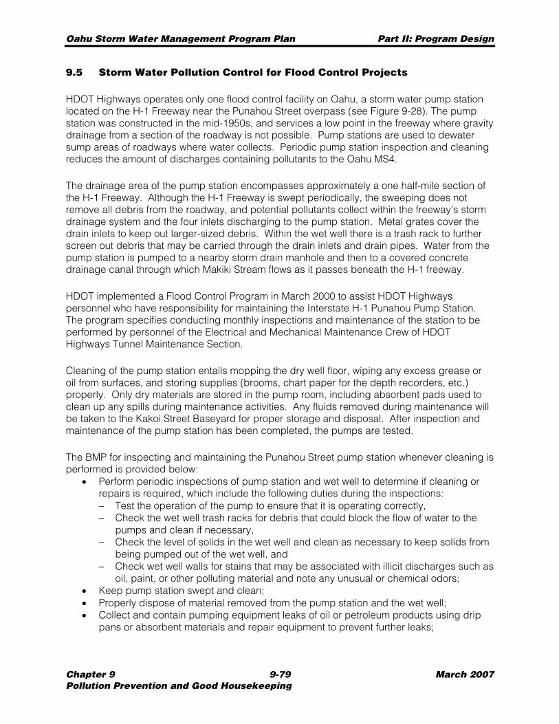
Oahu Storm Water Management Program Plan Part II: Program Design
Chapter 9 9-79 March 2007 Pollution Prevention and Good Housekeeping
9.5 Storm Water Pollution Control for Flood Control Projects
HDOT Highways operates only one flood control facility on Oahu, a storm water pump station located on the H-1 Freeway near the Punahou Street overpass (see Figure 9-28). The pump station was constructed in the mid-1950s, and services a low point in the freeway where gravity drainage from a section of the roadway is not possible. Pump stations are used to dewater sump areas of roadways where water collects. Periodic pump station inspection and cleaning reduces the amount of discharges containing pollutants to the Oahu MS4.
The drainage area of the pump station encompasses approximately a one half-mile section of the H-1 Freeway. Although the H-1 Freeway is swept periodically, the sweeping does not remove all debris from the roadway, and potential pollutants collect within the freeway’s storm drainage system and the four inlets discharging to the pump station. Metal grates cover the drain inlets to keep out larger-sized debris. Within the wet well there is a trash rack to further screen out debris that may be carried through the drain inlets and drain pipes. Water from the pump station is pumped to a nearby storm drain manhole and then to a covered concrete drainage canal through which Makiki Stream flows as it passes beneath the H-1 freeway.
HDOT implemented a Flood Control Program in March 2000 to assist HDOT Highways personnel who have responsibility for maintaining the Interstate H-1 Punahou Pump Station. The program specifies conducting monthly inspections and maintenance of the station to be performed by personnel of the Electrical and Mechanical Maintenance Crew of HDOT Highways Tunnel Maintenance Section.
Cleaning of the pump station entails mopping the dry well floor, wiping any excess grease or oil from surfaces, and storing supplies (brooms, chart paper for the depth recorders, etc.) properly. Only dry materials are stored in the pump room, including absorbent pads used to clean up any spills during maintenance activities. Any fluids removed during maintenance will be taken to the Kakoi Street Baseyard for proper storage and disposal. After inspection and maintenance of the pump station has been completed, the pumps are tested.
The BMP for inspecting and maintaining the Punahou Street pump station whenever cleaning is performed is provided below:
• Perform periodic inspections of pump station and wet well to determine if cleaning or repairs is required, which include the following duties during the inspections: − Test the operation of the pump to ensure that it is operating correctly, − Check the wet well trash racks for debris that could block the flow of water to the
pumps and clean if necessary, − Check the level of solids in the wet well and clean as necessary to keep solids from
being pumped out of the wet well, and − Check wet well walls for stains that may be associated with illicit discharges such as
oil, paint, or other polluting material and note any unusual or chemical odors; • Keep pump station swept and clean; • Properly dispose of material removed from the pump station and the wet well; • Collect and contain pumping equipment leaks of oil or petroleum products using drip
pans or absorbent materials and repair equipment to prevent further leaks;
Statewide Storm Water Management ProgramOahu Storm Water Management Program Plan
Punahou Pump StationFigure 9-28
PumpDischarge
Pipes
PumpStation
24" GravityStorm Drain Drain Inlets
Storm Drain Manhole
Oahu Storm Water Management Program Plan Part II: Program Design
Chapter 9 9-81 March 2007 Pollution Prevention and Good Housekeeping
• During maintenance and repair of the pump station, remove all waste oil, and place it in an approved container, and not storing or leaving waste oil at the pump station; and
• Maintain an accurate log of pump station inspections and cleanings (see Appendix K.1).
Oahu Storm Water Management Program Plan Part II: Program Design
Chapter 9 9-82 March 2007 Pollution Prevention and Good Housekeeping
THIS PAGE INTENTIONALLY LEFT BLANK.
Oahu Storm Water Management Program Plan Part II: Program Design
Chapter 10 10-1 March 2007 Industrial Discharge Management
CHAPTER 10 INDUSTRIAL AND COMMERCIAL ACTIVITIES
DISCHARGE MANAGEMENT
Storm water flowing from industrial and commercial areas may be a significant source of pollutants that enter the Oahu MS4. Therefore, the Industrial and Commercial Discharge Management Program (Industrial Discharge Program) is designed to reduce, to the maximum extent practicable, the discharge of pollutants from industrial and commercial facilities and activities that discharge into the Oahu MS4.
This program is related to the Illicit Discharge Program (see Chapter Six) because industrial and commercial facilities activities are susceptible to causing illicit discharges. An element of the Industrial Discharge Program takes a proactive approach in reducing illicit discharges by identifying industrial and commercial areas that drain into the Oahu MS4 for priority inspections.
The Industrial Discharge Program consists of: • Developing a comprehensive GIS database as part of the AMS to track industrial and
commercial facilities and activities whose storm water runoff discharges directly or indirectly into the Oahu MS4;
• Conducting inspections or investigations of industrial and commercial facilities and parcels; and
• Supporting a training program so that those involved in this program have the necessary knowledge and skills to conduct investigations.
10.1 Database Inventories
To better track, gauge, and reduce the amount of pollutants from industrial and commercial facilities that discharge into the Oahu MS4, a GIS database is under development that will include industrial and commercial facilities indirectly discharging into the Oahu MS4 (see Section 3.3.6). As described in Chapter Three, the AMS will contain this database and production tools to produce maps to support the program.
The types of facilities and activities contained in the industrial database include: • Municipal landfills (open and closed); • Hazardous waste recovery, treatment, storage and disposal facilities; • Facilities subject to Section 313 of the Emergency Planning and Community Right-to-
Know Act, 42 U.S.C. 11023; • Facilities from follow-up investigations of the industrial facilities identified in the 2000
Questionnaire Survey; • Facilities subject to General Industrial Storm Water permit coverage or any other
applicable NPDES permit coverage which are adjacent to the DOT-Highways right-of-way or discharge to the Oahu MS4; and
• Any other industrial facility that either HDOT Highways or HDOH determines is contributing a substantial pollutant loading to the Oahu MS4.
Oahu Storm Water Management Program Plan Part II: Program Design
Chapter 10 10-2 March 2007 Industrial Discharge Management
The type of information collected for each industrial facility or activity in the database is provided in Section 3.3.6.1.
The types of facilities and activities contained in commercial database include: • Retail gasoline outlets; • Retail automotive services, including repair facilities; • Restaurants; and • Any other commercial facility that either HDOT Highways or HDOH determines is
contributing pollutants to the Oahu MS4, which may cause or contribute to an exceedance of State water quality standards.
The type of information collected for each commercial facility or activity in the database is provided in Section 3.3.6.1.
The initial listing of the industrial and commercial inventory was generated using the following readily available sources:
• City’s Land Use database; • USEPA’s Envirofacts Datawarehouse; and • Oahu Yellow Pages.
The City’s land use database has an exhaustive listing of parcels that contain industrial and commercial facilities. Each record contains information about the parcel’s predominant activity (“activity code”), and the function of any physical facility on the property (“facility code”). A selection process was performed using each of these fields to determine whether certain parcels should be listed on the initial inventories. After removing duplicates, and obtaining TMK and ownership information, approximately 24,000 records were identified.
The USEPA Envirofacts Datawarehouse allows users to search multiple databases or systems at the same time, using various environmental criteria. The query search included the following types of sites:
• Reported hazardous waste activities; • Listed on USEPA’s Superfund; • Considered large quantity generators of hazardous waste; and • Hold permits to discharge into waters of the United States.
Each query was limited to Oahu’s geographic boundaries. The queries produced addresses and other information used to locate and map the sites. A little over 2,000 records were identified.
Upon consultation with the State Department of Business Economic Development and Tourism, it was determined that the “Yellow Pages” has the most up to date listing of gas stations, automotive service stations, and restaurants on the island. Using keyword searches, such as “restaurants”; “gas stations”; and “automotive service stations”, etc. within Oahu’s geographic boundaries, a long list of businesses was obtained. To ensure that the search was comprehensive, large gas or automotive retailers and restaurants were verified from other sources, such as company websites and the “White Pages”. Facility addresses were then used to locate and map the facilities.
Oahu Storm Water Management Program Plan Part II: Program Design
Chapter 10 10-3 March 2007 Industrial Discharge Management
10.2 Inspections of Industrial and Commercial Facilities
The major element of the Industrial Discharge Program is the inspection or investigation of industrial and commercial facilities to reduce the amount of illicit discharges coming from these sources to the maximum extent practicable. The inspections would be conducted at the following types of industrial and commercial facilities and parcels:
• Holding connection permits as described in Section 6.1, and • Located in areas considered for priority inspections based on the potential for illicit
discharges and impacts to water quality (e.g., location vis-à-vis 303(d) water bodies).
In general, investigations conducted as described in this section would be conducted in the same manner as the investigations under the Illicit Discharge Program (see Section 6.2).
10.2.1 Permitted Dischargers
All industrial and commercial facilities holding connection permits would be subject to inspections at least once every five years to check whether their Oahu MS4 connections are consistent with the terms of their permits. Residential connection permit holders would not be subject to these inspections.
The AMS will be used to schedule inspections of permit holder properties or facilities (see Section 3.3.2.1). The owner of the property from which the connection originates is generally considered the owner of the connection, and would, therefore, be the responsible party for any illegal connection or connection beyond the terms of the permit.
During the inspection, the inspector will check that permitted dischargers are in compliance with local ordinances and the terms of the permit, and if not, follow-up action as described in Section 6.2 will be taken.
10.2.2 Industrial and Commercial Areas
The AMS was used to identify and rank industrial and commercial facilities or dischargers according to the relative risk that the discharge may be contaminated with pollutants, and how this might affect the quality of storm water runoff entering the Oahu MS4. This process included the identification of gas stations, restaurants, facilities with previous storm water violations, handlers of hazardous waste, and other types of parcels or land uses that could affect water quality.
Based on the information collected and analyzed using the AMS, priority areas were identified for inspections, and included in the Prioritized Areas for Industrial and Commercial Facility and Activity Inspections Plan (see Appendix L.2). Prior to developing a prioritized list of parcels, the following types of sites or facilities were screened from the list:
• Owned by the federal, State and City governments; • Listed in the 2000 Questionnaire Survey roster (see Section 6.2.1); and • Not directly adjacent to HDOT Highways rights-of-way.
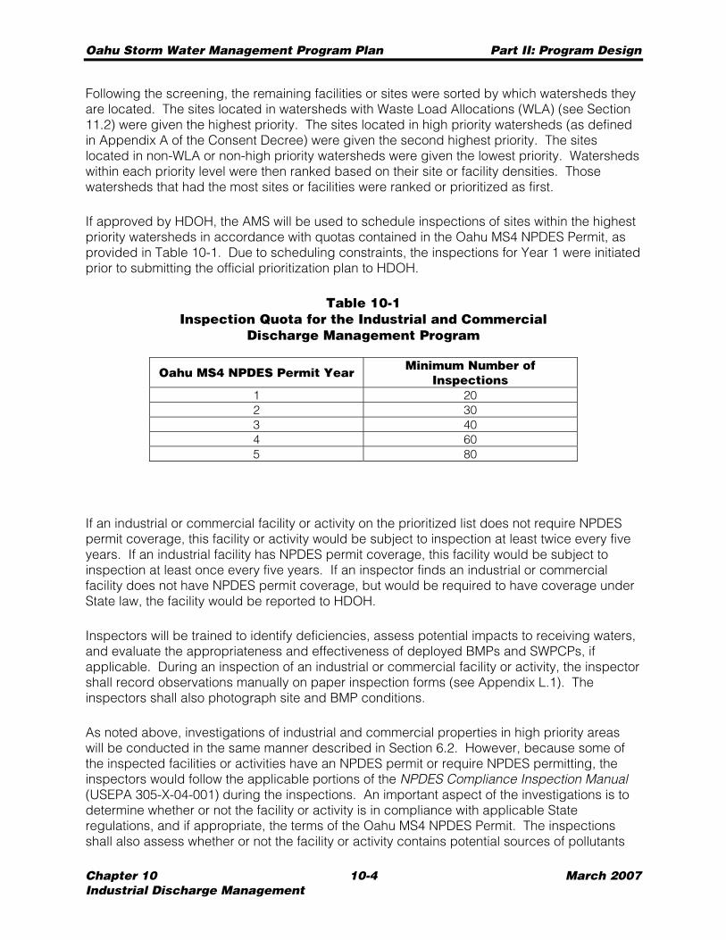
Oahu Storm Water Management Program Plan Part II: Program Design
Chapter 10 10-4 March 2007 Industrial Discharge Management
Following the screening, the remaining facilities or sites were sorted by which watersheds they are located. The sites located in watersheds with Waste Load Allocations (WLA) (see Section 11.2) were given the highest priority. The sites located in high priority watersheds (as defined in Appendix A of the Consent Decree) were given the second highest priority. The sites located in non-WLA or non-high priority watersheds were given the lowest priority. Watersheds within each priority level were then ranked based on their site or facility densities. Those watersheds that had the most sites or facilities were ranked or prioritized as first.
If approved by HDOH, the AMS will be used to schedule inspections of sites within the highest priority watersheds in accordance with quotas contained in the Oahu MS4 NPDES Permit, as provided in Table 10-1. Due to scheduling constraints, the inspections for Year 1 were initiated prior to submitting the official prioritization plan to HDOH.
Table 10-1 Inspection Quota for the Industrial and Commercial
Discharge Management Program
Oahu MS4 NPDES Permit Year Minimum Number of Inspections
1 20 2 30 3 40 4 60 5 80
If an industrial or commercial facility or activity on the prioritized list does not require NPDES permit coverage, this facility or activity would be subject to inspection at least twice every five years. If an industrial facility has NPDES permit coverage, this facility would be subject to inspection at least once every five years. If an inspector finds an industrial or commercial facility does not have NPDES permit coverage, but would be required to have coverage under State law, the facility would be reported to HDOH.
Inspectors will be trained to identify deficiencies, assess potential impacts to receiving waters, and evaluate the appropriateness and effectiveness of deployed BMPs and SWPCPs, if applicable. During an inspection of an industrial or commercial facility or activity, the inspector shall record observations manually on paper inspection forms (see Appendix L.1). The inspectors shall also photograph site and BMP conditions.
As noted above, investigations of industrial and commercial properties in high priority areas will be conducted in the same manner described in Section 6.2. However, because some of the inspected facilities or activities have an NPDES permit or require NPDES permitting, the inspectors would follow the applicable portions of the NPDES Compliance Inspection Manual (USEPA 305-X-04-001) during the inspections. An important aspect of the investigations is to determine whether or not the facility or activity is in compliance with applicable State regulations, and if appropriate, the terms of the Oahu MS4 NPDES Permit. The inspections shall also assess whether or not the facility or activity contains potential sources of pollutants
Oahu Storm Water Management Program Plan Part II: Program Design
Chapter 10 10-5 March 2007 Industrial Discharge Management
that threaten contamination of storm water and receiving waters. If such sources are identified, the inspector will check whether or not the facility or activity has implemented BMPs that are in compliance with State regulations, and if appropriate, the terms of the Oahu MS4 NPDES Permit.
Inspection reports shall be submitted to HDOH within two months of the inspection date, and records of all inspections shall be maintained for a minimum of five years.
10.3 Enforcement
As noted in Section 2.4, industrial and commercial facilities subject to inspections under the Industrial Discharge Program shall also be subject to the enforcement policy if storm water deficiencies are uncovered during inspections.
10.4 Training
As indicated in the Industrial and Commercial Facilities Inspection Training Plan (see Appendix L.3), the training program will be implemented as the program progresses. Training under the Industrial Discharge Program is similar to the training under the Illicit Discharge Program because both programs require inspections of parcels that contribute to the storm water runoff entering the Oahu MS4. Both programs’ training elements focus on detecting and eliminating illicit discharges. The details of the Industrial Discharge Program training regimen are as follows:
Training Recipients
Training will be required of current or new inspector responsible for carrying out any element of the Industrial Discharge Program, including additional inspectors contracted by the State or through the master consultant contract.
Training Method
Training shall be conducted through a formalized “on-the-job” method. Applicable sections of the NPDES Compliance Inspection Manual – EPA 300-B-94-014 dated September 1994 will be used as the basis for training.
Trainer Qualifications
The managers and supervisors conducting the training will have the following qualifications: • Awareness of HDOT Highways activities, policies and procedures; • Understanding of federal and State laws pertaining to industrial and commercial storm
water discharges; and • Knowledgeable in identifying and eliminating illegal connection, illicit discharges and
spills to the Oahu MS4. • Understanding of applicable sections of the EPA NPDES Compliance Training
Inspection Manual
Oahu Storm Water Management Program Plan Part II: Program Design
Chapter 10 10-6 March 2007 Industrial Discharge Management
Topics
The following topics of the training will include: • Information and awareness of the Oahu MS4 NPDES Permit, and the overall Oahu
SWMP; • Informing staff that they serve an important role in protecting the water quality in the
State; • Identifying and eliminating illegal discharges that may flow into the Oahu MS4; • Types of facilities covered by the NPDES general permit for industrial storm water, and
other applicable NPDES permit; • BMPs and other control measures for industrial and commercial facilities to control
storm water pollution; and • Inspection and enforcement techniques. • Understanding of the use of applicable sections of the EPA NPDES Compliance
Inspection Manual
Training Schedule and Reporting
Training will be held on as-needed basis (i.e., when new inspectors are hired or contracted). Refresher courses will be held at a minimum once per year for inspection staff involved in the program.
Each “on-the-job” training session will be recorded and entered into this program’s training database. The trainer and training recipient will be recorded in the database. The mid-year and end-of-year reports will contain information on the number and dates of training sessions, types of training, and recipients of the training as described in Chapter Thirteen.
10.5 Organizational Structure
As shown in Figure 10-1, the Industrial Discharge Program is overseen by the MS4 Task Force/DDU. The head of the DDU, an Engineer V, is the main point of contact for this program, and is assisted by an Engineer III and Inspector IV who would provide inspection assistance to the master consultant.
The master consultant provides services to conduct the industrial and commercial inspections and investigations; data management and collection; and preparing procedures and methods to conduct the investigations. The program execution engineer (see Section 2.2.2) conducts independent reviews and quality checks of each investigative case prior to submission to DDU.
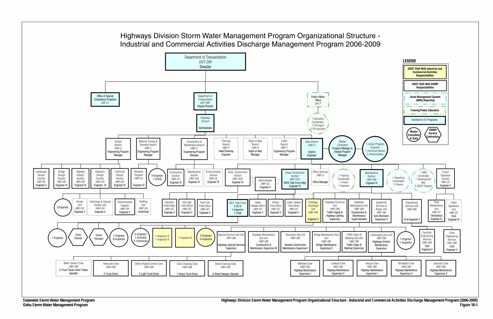
Statewide Storm Water Management Program Oahu Storm Water Management Program
Department of Transportation DOT-DIR Director
Department of Transportation
DEP-HWY Deputy Director
Public Affairs Office DIR-P
Office of Special Compliance Programs
DIR-CZ
Highways Division
Administrator
Planning Branch HWY-P
Head Planning Engineer
Right-of-Way Branch HWY-R
Right-of-Way Manager
Oahu District HWY-O
District
Engineer
Traffic Branch HWY-T
Engineering Program Manager
Office Services HWY-O
Office Manager
Urban Construction Section
HWY-OCU (MS4 Task Force Mgr)
Engineer VI
Traffic Operations
Unit HWY-OT
Civil Engineer IV
Design Branch HWY-D
Engineering Program Manager
Highway Design Section HWY-DD
Engineer VI
Technical Design Section HWY-DS
Engineer VI
Construction & Maintenance Branch
HWY-C Engineering Program
Manager
Maintenance Section
HWY-CM Engineer VI
Environmental Section HWY-CE
Engineer VI
Construction Section HWY-CC
Engineer VI
Rural Construction Section
HWY-OCR Engineer VI
Wahiawa Crew HWY-OM
Highway Maintenance Supervisor I
Leeward Crew HWY-OM
Highway Maintenance Supervisor II
Hauula Crew HWY-OM
Highway Maintenance Supervisor I
Windward Crew HWY-OM
Highway Maintenance Supervisor II
Honolulu Crew HWY-OM
Highway Maintenance Supervisor II
Special Services Sub Unit HWY-OM
Highways Special Services
Supervisor
Bridge Maintenance Sub Unit
HWY-OM Bridge Maintenance
Supervisor II
Structures Sub Unit HWY-OM
General Construction
Maintenance Supervisor I
Roadway Maintenance Sub Unit HWY-OM
Construction & Maintenance Supervisor III
Equipment Services & Repair Unit HWY-OM
Auto Mechanic Supervisor II
Water Tankers Crew HWY-OM
2-Truck Tractor Semi-Trailer Operator
Street Cleaning Crew HWY-OM
4-Street Sweeper Operator
Drain Cleaning Crew HWY-OM
1-Heavy Truck Driver
Debris Hazard Control Crew HWY-OM
3-Light Truck Driver
Herbicide Crew HWY-OM
2-Truck Driver
1-Reporting Coordinator 1-Planner
1-AMS Coordinator
1-Development Mgr
4-GIS/IT Support
1-Training Coordinator 1-Trainer
1-Engineer
1-Education Coordinator 1-PR Expert
2-PR Assistant
Material Testing & Research Branch
HWY-L Engineering Program
Manager
Highways Maintenance Unit
HWY-OM Construction & Maintenance
Superintendent
Pearl City Field Office
HWY-OC Engineer V
Kaneohe Field Office
HWY-OC Engineer V
Salt Lake Field Office
HWY-OC Engineer V
Administrator HWY-OC
Engineer V
MS4 Task Force 2-CE III
1-Inspector 1-Clerk
Lower Halawa Field Office
HWY-OC Engineer V
Kilihau Field Office
HWY-OC Engineer V
Upper Halawa Office
HWY-OC Engineer V
Street Sweeper
Drain Cleaner
1-Engineer 9-Inspector
Landscaping Sub Unit HWY-OM
Highways District Maintenance Supervisor
Traffic Signs & Marking Sub Unit
HWY-OM Traffic Signs &
Marking Supervisor
1-Engineer 1-Inspector
Hydrology & Special Studies Unit
HWY-DH Engineer V
Drafting Unit
HWY-DH Technician
Design Unit
HWY-DH Engineer V
Environmental Support HWY-DH
Engineer V
3-Engineer
Research Program HWY-LR
Engineer VI
5-Engineer 1-CADD
Highways Electrical Unit
HWY-OM Traffic Signal &
Highway Lighting Supervisor
Master Consultant
Program Manager & Deputy Program
Manager
1-Senior Program Engineer
1-Technical Advisor 3-Administrative
Facilities Engineering
Services HWY-OM
Civil Engineer V
5-Engineer 4-Inspector
Highways Division Storm Water Management Program Organizational Structure - Industrial and Commercial Activities Discharge Management Program (2006-2009) Figure 10-1
1-Engineer 1-Inspector IV 1-Inspector III
2-Engineer 1-Scientist
2-Technician
SWMP Service
Contractors
Highways Division Storm Water Management Program Organizational Structure - Industrial and Commercial Activities Discharge Management Program 2006-2009
Landscape Design Section HWY-DL
Engineer V
Tunnel Operation Section HWY-OT
Engineer V
Plant Maintenance
Unit HWY-OT
Mechanical Engineer IV
Engineering Services Unit
HWY-OM
Civil Engineer V
Field Engineering
Services HWY-OM
Civil Engineer V
Maintenance Section
HWY-OM Engineer VI
Bridge Design Section HWY-DB
Engineer VI
Hydraulic Design Section HWY-DH
Engineer VI
1-Engineer III
Drainage Discharge
Unit HWY-OM
Engineer V
Involved in All Programs
Asset Management System (AMS)/Reporting
Training/Public Education
Master Consultant
& Subs
HDOT Staff With SWMP Responsibilities
LEGEND
HDOT Staff With Industrial and Commercial Activities
Responsibilities

Oahu Storm Water Management Program Plan Part II: Program Design
Chapter 11 11-1 March 2007 Water Quality Monitoring
CHAPTER 11 WATER QUALITY MONITORING AND WASTE LOAD
ALLOCATIONS
In compliance with the Oahu MS4 NPDES Permit requirements, HDOT Highways will implement a comprehensive program that will continue past annual monitoring efforts conducted by United States Geological Survey (USGS) under a HDOT Highways contract, and establish additional water quality monitoring stations to better assess HDOT Highways Oahu MS4’s relative contribution to nutrient loads and other water quality waste loads.
The primary purpose of the monitoring by the USGS is to help HDOT Highways assess the characteristics of highway runoff and evaluate the potential impacts of the runoff to stream water quality. Future monitoring stations will primarily assist in the implementation of Waste Load Allocations (WLA) assigned to HDOT Highways for Ala Wai Canal, Kawa Stream, and Waimanalo Stream.
11.1 Annual Monitoring Plan
As required by the Oahu MS4 NPDES Permit, HDOT Highways shall submit an annual monitoring plan to HDOH by June 1st of each year of the Oahu MS4 NPDES Permit for review and approval. The annual monitoring plan is implemented over the coming State fiscal year. The scope of this annual monitoring plan includes the following items:
1. Written narrative of the proposed monitoring plan’s objectives and description of activities;
2. Written documentation of the following: a. Type, frequency, and location of where data is gathered to determine levels of
pollution in non-storm water discharges to the Oahu MS4, b. Characteristics (timing, duration, intensity, total rainfall) of the storm event(s), c. Parameters for measured pollutant loads, and d. Range of discharge volumes to be monitored, as well as the timing, frequency, and
duration at which they are identified; 3. Written documentation of the analytical methods; 4. Written documentation of the Quality Assurance/Quality Control procedures; and 5. Estimated budget to be implemented over the coming fiscal year.
HDOT Highways storm water monitoring program was originally established in the Halawa Stream watershed as part of the Interstate Route H-3 project. The program is conducted by USGS under a contract with the HDOT. Since 1983, USGS performed water quality monitoring in the watershed with primary emphasis on North Halawa Stream. The monitoring program focused mostly on suspended sediments, collecting data before, during, and after the construction. Because the Interstate Route H-3 dominates land uses in much of the watershed, the monitoring provides an opportunity to collect information and isolate typical highway pollutant contributions that affect water quality. In addition, North Halawa Stream is an important tributary to the Pearl Harbor Estuary, and collecting information about the watershed may result in improving and preventing further degradation of the estuary’s water quality, an important State goal. Furthermore, lower portions of the watershed contain a variety
Oahu Storm Water Management Program Plan Part II: Program Design
Chapter 11 11-2 March 2007 Water Quality Monitoring
of land uses that include light industrial, residential, and commercial activities. The watershed is therefore fairly representative of other watersheds on Oahu, particularly on the southern part of the island, which are typically undeveloped in their upper reaches and urbanized in their lower reaches. For instance, the Halawa Stream watershed monitoring program complements the City’s storm water monitoring program, which focuses on the Ala Wai Canal watershed. Both the Halawa Stream and Ala Wai Canal watersheds contain highly urbanized areas of a wide variety of land uses, are located in the relatively arid southern part of Oahu, and discharge into important inland water bodies prior to entering open coastal waters.
The USEPA prepared the report, Revisions to Total Maximum Daily Loads (TMDL) for the Ala Wai Canal – Island of Oahu, Hawaii – Total Nitrogen Total Phosphorus (June 2002), hereinafter referred to as the Ala Wai Canal TMDL Report. This document assigned quantitative reductions of total nitrogen and total phosphorus discharges to HDOT Highways and other potential nutrient sources within the watershed. The USGS was contracted to install and operate a storm water monitoring station in a storm drain that conveys runoff from the H-1 Freeway to Manoa Stream in order to characterize HDOT Highways’ storm water discharges into the Ala Wai Canal watershed. Monitoring was initiated at this station in fiscal year 2005-2006 and will be continued during fiscal year 2006-2007.
The current annual monitoring plan for Halawa and Manoa Streams for fiscal year 2006-2007 is provided in the Appendix M.1.
11.2 Waste Load Allocations
In conjunction with USEPA, HDOH developed the waste load reduction goals based on the TMDLs established for Ala Wai Canal, Kawa Stream, and Waimanalo Stream (see Figure 4-1), and included the WLAs assigned to HDOT Highways in the Oahu MS4 NPDES Permit. The permit stipulated that HDOT Highways work jointly with the City and propose an implementation and monitoring plan for these three water bodies. In response, HDOT Highways prepared implementation and monitoring plans for each of the above watersheds (see Appendices M.2, M.3 and M.4).
11.2.1 Implementation Plan
The WLA Implementation Plans identifies specific HDOT Highways activities targeted to reduce total nitrogen and total phosphorus discharges in the Ala Wai Canal, Kawa Stream, and Waimanalo Stream watersheds as necessary to comply with their WLAs. The plans include the following work items:
• Review of HDOH WLA/TMDL documents and specific requirements for each WLA; • Identify HDOT Highways Oahu MS4 outfalls within the WLA watershed, using the AMS; • Provide land use and hydrological analyses for each major Oahu MS4 outfall, using
AMS; • Watershed reconnaissance; • Identify HDOT Highways activities within the watersheds that contribute to waste loads; • Identify and evaluate load reduction best management practices; and • Evaluate WLA compliance approach and strategies.
Oahu Storm Water Management Program Plan Part II: Program Design
Chapter 11 11-3 March 2007 Water Quality Monitoring
11.2.2 Monitoring Plan
The WLA Monitoring Plans specified the water quality monitoring and activity tracking necessary to demonstrate efforts to comply with the urban source WLAs assigned to HDOT Highways. The plans include the following major work items:
• Assess Oahu MS4 outfalls as identified in the implementation plan described above; • Characterize major outfalls drainage areas; • Evaluate HDOT Highways’ waste load reduction strategies and opportunities within
each WLA watershed; • Select water quality monitoring locations; • Develop monitoring approach (i.e., type, frequency, parameters, analytical method); • Configure each of the monitoring stations; and • Prepare monitoring schedule for implementation.
11.3 Other Waste Load Allocations
In addition to the WLA Implementation and Monitoring Plans for the Ala Wai Canal, Kawa Stream, and Waimanalo Stream watersheds, HDOH will identify one additional WLA per year for the life of the Oahu MS4 NPDES Permit, starting from March 2007. For each additional WLA identified, implementation and monitoring plans shall be prepared by HDOT. The scopes of these plans would be similar to what is described in Section 11.2.
11.4 Organizational Structure
As shown on Figure 11-1, the Water Quality Monitoring and Waste Load Allocation Program is overseen by the MS4 Task Force/DDU. Under the direction of the head of DDU, a Civil Engineer V, the master consultant will develop the annual monitoring plan, and the WLA Implementation and Monitoring Plans. The USGS is also involved in this program through a separate contract with HDOT Highways to conduct in-stream monitoring of Halawa Stream and an outfall monitoring at Manoa Stream.
Oahu Storm Water Management Program Plan Part II: Program Design
Chapter 11 11-4 March 2007 Water Quality Monitoring
THIS PAGE INTENTIONALLY LEFT BLANK.
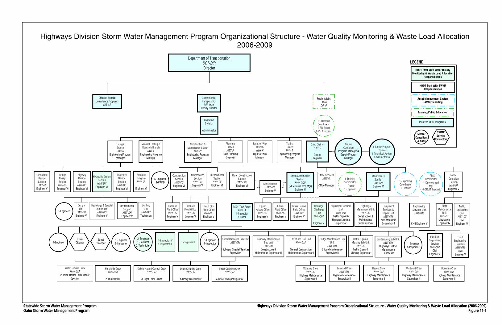
Statewide Storm Water Management Program Oahu Storm Water Management Program
Department of Transportation DOT-DIR Director
Department of Transportation
DEP-HWY Deputy Director
Public Affairs Office DIR-P
Office of Special Compliance Programs
DIR-CZ
Highways Division
Administrator
Planning Branch HWY-P
Head Planning Engineer
Right-of-Way Branch HWY-R
Right-of-Way Manager
Oahu District HWY-O
District
Engineer
Traffic Branch HWY-T
Engineering Program Manager
Office Services HWY-O
Office Manager
Urban Construction Section
HWY-OCU (MS4 Task Force Mgr)
Engineer VI
Traffic Operations
Unit HWY-OT
Civil Engineer IV
Design Branch HWY-D
Engineering Program Manager
Highway Design Section HWY-DD
Engineer VI
Technical Design Section HWY-DS
Engineer VI
Construction & Maintenance Branch
HWY-C Engineering Program
Manager
Maintenance Section
HWY-CM Engineer VI
Environmental Section HWY-CE
Engineer VI
Construction Section HWY-CC
Engineer VI
Rural Construction Section
HWY-OCR Engineer VI
Wahiawa Crew HWY-OM
Highway Maintenance Supervisor I
Leeward Crew HWY-OM
Highway Maintenance Supervisor II
Hauula Crew HWY-OM
Highway Maintenance Supervisor I
Windward Crew HWY-OM
Highway Maintenance Supervisor II
Honolulu Crew HWY-OM
Highway Maintenance Supervisor II
Special Services Sub Unit HWY-OM
Highways Special Services
Supervisor
Bridge Maintenance Sub Unit
HWY-OM Bridge Maintenance
Supervisor II
Structures Sub Unit HWY-OM
General Construction
Maintenance Supervisor I
Roadway Maintenance Sub Unit HWY-OM
Construction & Maintenance Supervisor III
Equipment Services & Repair Unit HWY-OM
Auto Mechanic Supervisor II
Water Tankers Crew HWY-OM
2-Truck Tractor Semi-Trailer Operator
Street Cleaning Crew HWY-OM
4-Street Sweeper Operator
Drain Cleaning Crew HWY-OM
1-Heavy Truck Driver
Debris Hazard Control Crew HWY-OM
3-Light Truck Driver
Herbicide Crew HWY-OM
2-Truck Driver
1-Reporting Coordinator 1-Planner
1-AMS Coordinator
1-Development Mgr
4-GIS/IT Support
1-Training Coordinator 1-Trainer
1-Engineer
1-Education Coordinator 1-PR Expert
2-PR Assistant
Material Testing & Research Branch
HWY-L Engineering Program
Manager
Highways Maintenance Unit
HWY-OM Construction & Maintenance
Superintendent
Pearl City Field Office
HWY-OC Engineer V
Kaneohe Field Office
HWY-OC Engineer V
Salt Lake Field Office
HWY-OC Engineer V
Administrator HWY-OC
Engineer V
MS4 Task Force 2-CE III
1-Inspector 1-Clerk
Lower Halawa Field Office
HWY-OC Engineer V
Kilihau Field Office
HWY-OC Engineer V
Upper Halawa Office
HWY-OC Engineer V
Street Sweeper
Drain Cleaner
1-Engineer 9-Inspector
Landscaping Sub Unit HWY-OM
Highways District Maintenance Supervisor
Traffic Signs & Marking Sub Unit
HWY-OM Traffic Signs &
Marking Supervisor
1-Engineer 1-Inspector
Hydrology & Special Studies Unit
HWY-DH Engineer V
Drafting Unit
HWY-DH Technician
Design Unit
HWY-DH Engineer V
Environmental Support HWY-DH
Engineer V
3-Engineer
Research Program HWY-LR
Engineer VI
5-Engineer 1-CADD
Highways Electrical Unit
HWY-OM Traffic Signal &
Highway Lighting Supervisor
Master Consultant
Program Manager & Deputy Program
Manager
1-Senior Program Engineer
1-Technical Advisor 3-Administrative
Facilities Engineering
Services HWY-OM
Civil Engineer V
5-Engineer 4-Inspector
Highways Division Storm Water Management Program Organizational Structure - Water Quality Monitoring & Waste Load Allocation (2006-2009) Figure 11-1
1-Engineer 1-Inspector IV 1-Inspector III
2-Engineer 1-Scientist
2-Technician
SWMP Service
Contractors
Highways Division Storm Water Management Program Organizational Structure - Water Quality Monitoring & Waste Load Allocation 2006-2009
Landscape Design Section HWY-DL
Engineer V
Tunnel Operation Section HWY-OT
Engineer V
Plant Maintenance
Unit HWY-OT
Mechanical Engineer IV
Engineering Services Unit
HWY-OM
Civil Engineer V
Field Engineering
Services HWY-OM
Civil Engineer V
Maintenance Section
HWY-OM Engineer VI
Bridge Design Section HWY-DB
Engineer VI
Hydraulic Design Section HWY-DH
Engineer VI
1-Engineer III
Drainage Discharge
Unit HWY-OM
Engineer V
Involved in All Programs
Asset Management System (AMS)/Reporting
Training/Public Education
Master Consultant
& Subs
HDOT Staff With SWMP Responsibilities
LEGEND
HDOT Staff With Water Quality Monitoring & Waste Load Allocation
Responsibilities

PART III
PROGRAM EVALUATION
Oahu Storm Water Management Program Plan Part III: Program Evaluation
Chapter 12 12-1 March 2007 Monitoring Program Effectiveness
CHAPTER 12 MONITORING PROGRAM EFFECTIVENESS
This chapter contains the plan in which HDOT Highways will use to assess the effectiveness of the Oahu SWMP. The plan consists of program objectives, and for each objective, benchmarks or standards (performance measures) were developed and will be used to measure progress of the programs.
12.1 Objectives and Quantitative Standards
Evaluative objectives and performance measures are provided below for all Oahu SWMP programs with the exception of the Public Involvement and Water Quality Monitoring Programs, which are described in Chapters Five and Eleven, respectively. Assessments of program effectiveness using these performance measures will be conducted semi-annually and will be reported in Mid-Year and End-of-Year reports. The AMS (see Chapter Three) will be instrumental in conducting program evaluations because of its ability to receive, store and analyze information.
12.1.1 Public Education and Outreach Program
Objective 1. All appropriate HDOT Highways personnel, consultants, service contractors, and persons affiliated with the Oahu SWMP on behalf of HDOT Highways or those who work within HDOT Highways right-of-way will understand the overall objectives of the Oahu SWMP and will be properly trained for storm water pollution control.
Performance Measure 1A. The training programs of the Oahu SWMP will be held in accordance with specified schedules of the programs (see Sections 6.6, 7.5, 8.4, 9.1.4, 9.2.2, 9.3.5, 9.4.4, and 10.4).
Objective 2. The general public, including persons affiliated with industrial facilities covered by the NPDES program, will be made aware of HDOT Highways’ storm water management and pollution control programs, and understand that littering of highways and other actions that result in oil or chemicals being discharged into the Oahu MS4 or other storm water systems are detrimental to the quality of the State’s water resources.
Performance Measure 2A. The Oahu SWMP Public Education Plan (see Section 4.2) completed by March 30, 2007 (This measure was achieved).
Performance Measure 2B. With the first year serving as the base, the annual public surveys (see Section 4.2.4.1) will show an increase in the public’s understanding and awareness about the causes of and remedies for water pollution.
Oahu Storm Water Management Program Plan Part III: Program Evaluation
Chapter 12 12-2 March 2007 Monitoring Program Effectiveness
12.1.2 Illicit Discharge Detection and Elimination Program
Objective 1. HDOT Highways will detect and identify possible illicit discharges and illegal connections to the Oahu MS4.
Performance Measure 1A. Provide the public with the means to report illicit discharges (see Section 6.2.2) by March 30, 2007 (This measure was achieved).
Performance Measure 1B. The follow-up investigations will be completed in accordance with the schedules provided in Section 6.2.1.
Performance Measure 1C. Public complaints about possible illicit discharges or illegal connections investigated or resolved (case closed without on-site investigation) in accordance with specified response time procedures of the program.
Performance Measure 1D. The procedures plan for field screening major and minor outfalls (see Section 6.2.3) for improper discharges completed by March 30, 2007 (This measure was achieved).
Objective 2. HDOT Highways will eliminate known illicit discharges and illegal connections.
Performance Measure 2A. Investigate observed, suspected, or reported illicit discharges in accordance with specified response time procedures of the program.
Performance Measure 2B. Illicit discharges or illegal connections discovered by investigators brought into compliance in accordance with specified procedures of the program.
Objective 3. HDOT will respond to spills into the Oahu MS4 and prevent spills to the maximum extent practicable.
Performance Measure 3A. An Oahu SWMP Spill Prevention and Response Plan (see Section 6.4) completed by March 30, 2007 (This measure was achieved).
Performance Measure 3B. The procedures specified in the Spill Prevention and Response Plan are followed when an incident occurs.
12.1.3 Construction Site Runoff Control Program
Objective 1. HDOT Highways and its contractors will use effective BMPs and techniques that are suitable for the State of Hawaii in controlling storm water pollution runoff from construction projects to the maximum extent practicable.
Oahu Storm Water Management Program Plan Part III: Program Evaluation
Chapter 12 12-3 March 2007 Monitoring Program Effectiveness
Performance Measure 1A. Inclusion of BMPs, as specified in the Oahu MS4 NPDES Permit, in the Construction BMP Field Manual (see Section 7.2) (This measure was achieved).
Objective 2. Construction of any contract, in-house, maintenance, or encroachment projects, as well as projects outside of HDOT Highways right-of-way that require a connection or discharge permit, will meet the applicable requirements of the Construction Site Runoff Control program.
Performance Measure 2A. Contract, in-house, maintenance, and encroachment construction projects reviewed to determine whether they require an NPDES permit.
Performance Measure 2B. Contract, in-house, maintenance, and encroachment construction projects that require an NPDES permit include construction BMP plans prior to the start of the construction.
Performance Measure 2C. Construction BMPs of contract, in-house, maintenance, and encroachment construction projects that require an NPDES permit inspected prior to approving ground-disturbing activities.
Performance Measure 2D. Construction BMPs of contract, in-house, maintenance, and encroachment construction projects, regardless of whether they require an NPDES permit, inspected periodically by an independent inspector in accordance with schedules specified in the program.
12.1.4 Post-Construction Storm Water Management for New Development and Significant Redevelopment
Objective 1. HDOT Highways and its contractors will use effective permanent BMPs and techniques that are suitable for the State of Hawaii for applicable new development and significant re-development projects.
Performance Measure 1A. A unified rule (see Section 8.1.1), which specifies criteria of when permanent BMPs are to be included in a project to address storm water pollution concerns, completed by March 6, 2006 (This measure was achieved).
Performance Measure 1B. A Permanent BMP Manual (see Section 8.1.2), which included additional BMPs as specified in the Oahu MS4 NPDES Permit, completed by March 30, 2007 (This measure was achieved).
Objective 2. HDOT Highways and its contractors will consider permanent BMPs in every phase of a new development or significant redevelopment project, including planning, design, construction and maintenance.
Performance Measure 2A. Contract, in-house, maintenance, and encroachment construction projects that would create at least one acre of new permanent impervious
Oahu Storm Water Management Program Plan Part III: Program Evaluation
Chapter 12 12-4 March 2007 Monitoring Program Effectiveness
surfaces receive proper HDOT Highways review, and if applicable, approved plans for permanent BMPs included prior to issuance of task orders, bidding or approval of projects.
Performance Measure 2B. A BMP operation, maintenance and inspection database (see Section 8.2), which tracks both public and private activities or projects that discharge into the Oahu MS4 beginning in the plan review stage, developed by March 30, 2008.
Objective 3. HDOT Highways will address existing highways without permanent BMPs by establishing a framework for evaluating the quality of storm water runoff generated from these areas.
Performance Measure 3A. Detailed scope of the feasibility study (see Section 8.3) completed by March 30, 2007 (This measure is achieved).
Performance Measure 3B. A Final Retrofit Feasibility Study for the existing Oahu MS4 completed by March 30, 2009.
Performance Measure 3C. Design, construct and maintain appropriate permanent BMPs within the existing Oahu MS4 as identified in the Final Retrofit Feasibility Study.
12.1.5 Pollution Prevention and Good Housekeeping
As stated in Chapter 9, the overall Pollution Prevention and Good Housekeeping Program consists of the following sub-programs:
• Debris Control BMP Program; • Chemical Applications BMP Program; • Erosion Control BMP Program; • Maintenance Facilities BMP Program; and • Storm Water Pollution Control for Flood Control Projects
Objectives and Quantitative Standards for each sub-program are provided in Sections 12.1.5.1 through 12.1.5.5.
12.1.5.1 Debris Control BMP Program
Objective 1. HDOT Highways’ major debris control programs, such as its street sweeping and drain cleaning activities, will be conducted systematically based on material accumulation rates and the effects on water quality.
Performance Measure 1A. Street sweeping and storm drain inspections conducted in accordance with program schedules.
Performance Measure 1B. A comprehensive AMS (see Chapter Three and Section 9.1.2) completed by January 30, 2008.
Oahu Storm Water Management Program Plan Part III: Program Evaluation
Chapter 12 12-5 March 2007 Monitoring Program Effectiveness
Performance Measure 1C. Re-evaluation of street sweeping and storm drain inspection schedules on an annual basis (i.e., every March).
Objective 2. HDOT Highways will maintain the public education component of the Debris Program, and the Informational Placard Program. This program helps promote public awareness of storm water issues, and therefore reduces the amount of debris into the Oahu MS4 to the maximum extent practicable.
Performance Measure 2A. The procedures for the installation, inspection, and maintenance of the storm drain placards (see Section 9.1.3) completed by March 30, 2007 (This measure was achieved).
Performance Measure 2B. Installation, inspection and maintenance of storm drain placards in accordance with specified procedures of the program.
12.1.5.2 Chemical Applications BMP Program
Objective 1. HDOT Highways personnel and contractors working within HDOT Highways rights-of-way and other HDOT Highways properties will properly apply fertilizers and herbicides (e.g., per manufacturer instructions) and use only when necessary.
Performance Measure 1A. The training for the Chemical Program will be held in accordance with specified schedules of the program (see Section 9.2.2).
12.1.5.3 Erosion Control BMP Program
Objective 1 HDOT Highways will systematically implement erosion control projects and improvements within its rights-of-way to reduce the pollutant amounts of sediment, siltation and turbidity in the receiving State waters.
Performance Measure 1A. Design and installation of erosion control measures for the initial ten (fiscal year 2006) high priority sites completed by the end of January 2008.
Performance Measure 1B. Islandwide Assessment of Erosional Areas on the Island of Oahu (see Section 9.3.2.2) completed by March 30, 2007 (This measure was achieved).
Performance Measure 1C. For fiscal year 2007, design of the second ten high priority sites or spend a maximum $1.5 million for the installation of erosion control measures by March 30, 2009.
Objective 2. HDOT Highways will implement projects to reduce pollutant amounts of sediment, siltation and turbidity in receiving State waters at major storm drain outfalls.
Oahu Storm Water Management Program Plan Part III: Program Evaluation
Chapter 12 12-6 March 2007 Monitoring Program Effectiveness
Performance Measure 2A. Islandwide Assessment of Erosion Potential at Storm Drain Outfalls (see Section 9.3.4) completed by March 30, 2008.
12.1.5.4 Maintenance Facilities BMP Program
Objective 1. The operation and use of HDOT Highways baseyards will follow the appropriate site-specific BMP plan.
Performance Measure 1A. Site-specific SWPCPs for all baseyards on Oahu (see Section 9.4.2) completed by September 25, 2006 (This measure was achieved).
Performance Measure 1B. Independent inspections of all baseyards on Oahu by a trained individual at a minimum quarterly basis.
Objective 2. HDOT Highways will properly dispose of the debris and waste generated through Oahu MS4 cleaning activities (under Debris Control BMPs program).
Performance Measure 2A. A Dewatering Plan (see Section 9.4.5) completed by March 30, 2007 (This measure was achieved).
Performance Measure 2B. Construction of dewatering facilities or implementation of alternative as identified in the Dewatering Plan.
12.1.5.5 Storm Water Pollution Control for Flood Control Projects
Objective 1. HDOT Highways will inspect and clean the Interstate H-1 Punahou Pump Station in accordance with its BMP.
Performance Measure 1A. Conduct standardized operating activities.
12.1.6 Industrial and Commercial Discharge Management Program
Objective 1. HDOT Highways will reduce the pollutant contributions from industrial and commercial facilities and activities that discharge directly or indirectly into the Oahu MS4 to the maximum extent practicable.
Performance Measure 1A. A GIS inventory of industrial and commercial facilities and activities that drain directly or indirectly to the HDOT Oahu MS4 (see Section 10.1) completed by March 30, 2009.
Performance Measure 1B. Inspection of industrial and commercial properties holding connection permits in accordance with the schedule in Section 10.2.1.
Oahu Storm Water Management Program Plan Part III: Program Evaluation
Chapter 12 12-7 March 2007 Monitoring Program Effectiveness
Performance Measure 1C. Identify prioritized areas containing industrial and commercial facilities and activities for inspections (see Section 10.2.2) by March 30, 2007 (This measure was achieved).
Performance Measure 1D. Inspection of industrial and commercial facilities in prioritized areas in accordance with the schedule in Section 10.2.2.
Performance Measure 1E. An enforcement policy (see Section 2.4), which can be applied to industrial and commercial facilities and activities if required, completed by September 25, 2006 (This measure was achieved).
12.2 Adaptive Management
Assessment of the Oahu SWMP’s effectiveness in improving water quality will take a number of years to fully develop, requiring regular tracking and compilation of data for each program component. The first year of the Oahu MS4 NPDES Permit will be used to establish baseline information and analyses of trends to allow for the improvements to the Oahu SWMP, as appropriate.
As data is compiled, initial assumptions regarding BMP efficiencies and effectiveness will either be substantiated or invalidated. The goal of the ongoing process is to achieve incremental improvement through the evaluation of collected information, allowing for an iterative process of understanding the extent that water quality is being improved by the various Oahu SWMP activities. The relationships between the Oahu SWMP programs and environmental outcomes will be better established by this iterative review process.
Program output (e.g., how many individuals have been trained, how many miles of roadway have been swept, how many cubic yards of debris were collected, the number of permanent BMPs installed, etc.) will be used to assess whether meaningful outcome objectives are being met. Outcome objectives are meeting goals or objectives that will lead to significant improvement to water quality by addressing the root causes of the problems. For example, quantifying the number of training sessions and trainees will be a program output. However, the corresponding desired outcome is whether or not these training activities resulted in improved performance as a result of increased knowledge and a change in attitudes about storm water pollution prevention. Identifying such desired outcomes will provide guidance in establishing the content of programs toward more meaningful results.
Resource constraints will require prioritization of Oahu SWMP activities so that efforts can be focused on program elements where water quality improvements can be achieved cost-effectively. However, while prioritization may result in decisions and choices made in the selection of which BMP activities to emphasize, complying with Consent Decree and Oahu MS4 NPDES Permit requirements will ultimately govern.
Oahu Storm Water Management Program Plan Part III: Program Evaluation
Chapter 12 12-8 March 2007 Monitoring Program Effectiveness
THIS PAGE INTENTIONALLY LEFT BLANK.
Oahu Storm Water Management Program Plan Part III: Program Evaluation
Chapter 13 13-1 March 2007 Documenting Program Effectiveness
CHAPTER 13 DOCUMENTING PROGRAM EFFECTIVENESS
In order to monitor program effectiveness, adequate documentation is necessary. The Consent Decree and MS4 NPDES Permit both require documentation of progress on current activities. Reporting requirements are described in Section 13.1. Similarly, additions, modifications, or revisions to the Oahu SWMP itself must also be documented. Procedures for major and minor changes to the Oahu SWMP are described in Section 13.2.
13.1 Progress Reports
The status, progress and evaluation of the Oahu SWMP will be documented through Mid-Year and End-of-Year reports that are to be submitted to the HDOH during the duration of the Oahu MS4 NPDES Permit. The Mid-Year reports document activities for the period from July 1 to December 31 and are due to HDOH on March 31 of each year. The End-of-Year reports document activities for the period covered by the Mid-Year report plus the period from January 1 to June 30 and are due on October 31 of each year.
All future reports will include the following types of information or descriptions: 1. Oahu MS4 NPDES Permit and Consent Decree requirements, USEPA or HDOH orders
for compliance, and other commitments set forth in the Oahu SWMP Plan; 2. Activities that occurred during the reporting period including, where applicable,
progress accomplished toward meeting specific goals and performance measures, as specified in Chapter Twelve. If requirements are not fully met, a detailed explanation as to why HDOT Highways did not meet its commitments for the reporting period will be provided.
3. Specific future activities planned for the next reporting period to be undertaken during the next reporting period toward accomplishing specific goals and performance measures provided in Chapter Twelve.
4. Status of resources used during the reporting period, and an estimate of the resources over and above those required in the current reporting period that will be required in the next reporting period.
Due to the heavy emphasis on quantitative information and performance measures, the AMS will be integral in reporting information due to its ability to process information. Chapter Three contains a description of the AMS, including how it will be used for reporting purposes. The analytical capabilities of the AMS will also be used to calculate outcomes to evaluate project performance based on the objectives and Performance Measures provided in Chapter Twelve.
13.2 Changes to the Oahu Storm Water Management Program Plan
During the life of the Oahu MS4 NPDES Permit, additions, modifications, or revisions will be made to the Oahu SWMP Plan due to receipt or development of new information, changing conditions or the incorporation of more effective approaches to pollutant control. All changes to the Oahu SWMP Plan will be documented in amendments to the plan. Minor changes may
Oahu Storm Water Management Program Plan Part III: Program Evaluation
Chapter 13 13-2 March 2007 Documenting Program Effectiveness
be bundled within a single amendment. However, a major change, such as completion of the retrofit feasibility study (see Section 8.3), would require its own amendment.
If the amendment causes or implies a major reduction in the overall scope and/or level of effort of the Oahu SWMP, such a change would be made for cause and be in compliance with 40 CFR 122.62 and 40 CFR Part 124. The justification for the change must be supported by data or information contained in the most current or recent end-of-year report. A written report citing the data and information from the End-of-Year report and containing the proposed change or amendment would be submitted to HDOH 30 days prior to the initiation date of the modification.
The amendments would be provided to all parties who received a copy of Oahu SWMP Plan, and would be posted on the public website described in Section 4.2.1.5.