nutrient dynamics—wind and water erosion at the village scale in the sahel
TRANSCRIPT
land degradation & development
Land Degrad. Develop. 18: 578–588 (2007)
Published online 28 March 2007 in Wiley InterScience (www.interscience.wiley.com) DOI: 10.1002/ldr.800
NUTRIENT DYNAMICS—WIND AND WATER EROSIONAT THE VILLAGE SCALE IN THE SAHEL
S. M. VISSER* AND G. STERK
Department of Environmental Sciences, Erosion & Soil and Water Conservation Group, Wageningen University, Droevendaalsesteeg 4,6708PA Wageningen, The Netherlands
Received 2 March 2006; Revised 12 January 2007; Accepted 16 January 2007
ABSTRACT
The loss of nutrients by wind erosion is generally attributed to losses by suspension, since suspension selectively removes thefinest particles. However, because the main mass of sediment is moved by saltation during an event, the main mass of nutrients isalso moved by saltation. Nutrient losses from one field during one wind erosion event can be as high as 73 per cent of the N and100 per cent of the P needs for crop production.
Vegetated areas have a higher dust deposition because of the filtering effect of the vegetation and the reduction of drag forcescausing a higher deposition. This refutes the general assumption that deposition of suspended dust is homogeneous for a largerarea. In the Sahel, two types of dust can be distinguished, the Harmattan dust is richer in nutrients and regarded as a real input ofnutrients. The convectional storm dust has a nutrient content comparable with the nutrient content of the dust fraction of thetopsoil and can’t be regarded as input of nutrients.
From research on nutrient losses by water erosion at the plot scale, it is concluded that nutrient erosion by water can causeserious losses of nutrients. But at the village scale, the losses are considerably smaller than at the plot scale.
Measurement and subsequent nutrient budget analyses around the village Dangade in Burkina Faso indicated that this area isespecially vulnerable for wind erosion by saltation transport. This demonstrates that in the Sahelian environment, the effect ofwind erosion at the village scale can’t be ignored. Copyright # 2007 John Wiley & Sons, Ltd.
key words: nutrient erosion; scale; wind and water erosion; Burkina Faso
INTRODUCTION
Since the late 1980s, model studies based on nutrient budgets form an increasingly important source of evidence on
soil degradation and about the effects of farmers’ management of soil fertility in the Sahel (Pol, 1992; Smaling,
1993; Stocking, 1996; Stoorvogel and Smaling, 1990). Stoorvogel and Smaling (1990) gave figures for nutrient
losses in Burkina Faso, estimating annual losses in the order of 10, 14 and 2 kg ha�1 for potassium (K), nitrogen (N)
and phosphor (P) respectively. Of these losses 43 per cent (K), 41 per cent (N) and 42 per cent (P) are attributed to
soil erosion, which is therefore the main loss term in the budget.
The view of ever degrading soils in West-Africa was recently challenged. Soil productivity has not decreased
over the last 50 years, as soil erosion is not the only controlling parameter, and measurements on soil erosion have
largely been carried out on experimental sites and not on farmers’ fields. Such experimental results can’t be used for
extrapolation to the watershed level or to the region or country level (Mazzucato and Niemeijer, 2000; Stocking,
1996). Experimental plot level data tend to overestimate erosion because they do not take into account the fact that
at watershed level, both erosion and deposition occurs. Even within a single field distinct areas with either erosion
or deposition occur (Stocking, 1996; Visser et al., 2005b).
* Correspondence to: S. M. Visser, Department of Environmental Sciences, Erosion & Soil and Water Conservation Group, WageningenUniversity, Droevendaalsesteeg 4, 6708 PA Wageningen, The Netherlands.E-mail: [email protected]
Copyright # 2007 John Wiley & Sons, Ltd.
NUTRIENT DYNAMICS BY WIND AND WATER EROSION 579
In the Sahelian zone with a mean annual rainfall between 200 mm in the North and 600 mm in the South, the
effect of wind-blown sediment transport is often overlooked. Smaling (1993) incorporated nutrient inputs through
atmospheric deposition but considered as output only water erosion. Bielders et al. (2002), Sterk, (1997) and Visser
et al. (2005c) showed that wind-blown sediment transport causes considerable soil and nutrient losses, which are
some times larger than by water erosion (Visser et al. 2005a) and should not be overlooked. Rajot et al. (2002)
performed wind and water erosion measurements for two small catchments in northern Burkina Faso. Their results
emphasise the necessity to take into account both wind and water erosion processes to assess the actual land
degradation in the Sahel. Furthermore, Rajot et al. (2002) and Karambiri et al. (2003) have shown that the surface
characteristics determine mainly the pattern of erosion and deposition of sediment in a small-scale catchment. This
emphasises the need for more research on wind and water erosion at a larger (i.e. catchment or village) scale. In the
more humid Sudan zone, wind erosion is less important.
Smaling (1993) notes that his nutrient budgets are only slightly negative for the semi-arid countries in West
Africa because the poor soils allow only low nutrient losses. Where the soil is deep and poor in fertility, topsoil may
not always be more fertile than the subsoil and productivity does not decrease much as a result of soil erosion.
Therefore the erosion component of nutrient balances needs to be critically reviewed. In this paper, the dynamics
of nutrients under influence of wind and water at village scale in the Sahel are studied based on a literature review
and on a previous study on modelling nutrient fluxes as affected by wind and water erosion (Visser et al., 2005c).
The results of this study will be applied to part of the area belonging to the village Dangade in northern
Burkina Faso.
EFFECTS OF WIND EROSION ON NUTRIENT FLUXES
Wind-blown sediment transport easily crosses topographic boundaries. Since in the Sahel, the mean direction of an
erosive wind can change for successive events, source material, soil erodibility and spatial distribution of
non-erodible roughness elements determine the spatial patterns of erosion and deposition.
In wind erosion, three modes of sediment transport can be distinguished: creep, saltation and suspension
(Bagnold, 1941). Particles transported in creep are set in motion by the bombardment of saltating grains, but are
sufficiently large to always keep in contact with the soil surface. Creep is considered not to result in significant
nutrient losses because creep mainly transports coarse sand, which is poor in nutrients. Furthermore, transport
distances by creep are small, varying from centimetres to several metres. Saltating particles mostly bounce just over
the soil surface and eventually reaches heights until 2 m. They can be transported from several to a few hundred
metres (Allen, 1994). Suspended dust may travel up to thousands of kilometres (Allen, 1994; Herrmann et al., 1996;
Sterk et al., 1996). As the finest particles contain relatively larger proportions of topsoil nutrients and organic
matter, the loss can be large (Leys and McTainsh, 1994; Zobeck and Fryrear, 1986). However, Sterk et al. (1996)
showed that although suspended sediments are generally more enriched in nutrients, the main mass of nutrients is
transported by saltation because saltating particles often consist of aggregates of finer particles, which are
nutrient-rich.
Nutrient Losses by Saltation
Sterk et al. (1996) calculated a nutrient budget based on incoming and outgoing nutrient fluxes in a pearl millet field
in Niger for two wind erosion events. These events lead to a total of 39 kg eroded sediment ha�1 from the field. The
losses were 3 per cent (K), 3 per cent (C), 3 per cent (N) and 3 per cent (P) of the 10 cm topsoil.
Bielders et al. (2002) measured in traditionally farmers-managed land in western Niger saltation and nutrient
fluxes in a transect over a millet field into the adjacent fallow and calculated total loss or gain of nutrients. Total
nutrient content in the sediment samples generally declined with distance into the field and rose with distance into
the fallow. This was probably due to higher nutrient contents of the soil from which the incoming sediment eroded;
a relatively large addition of nutrient poor sediments over the field and finally the rapid deposition of the sand-sized
material in the fallow. They stated that in absolute terms, nutrient losses are low, but for one event measured,
nutrient losses at the field represent between 3 per cent (K) and 17 per cent (P) of the nutrients taken up by an
Copyright # 2007 John Wiley & Sons, Ltd. LAND DEGRADATION & DEVELOPMENT, 18: 578–588 (2007)
DOI: 10.1002/ldr
580 S. M. VISSER AND G. STERK
average millet crop. Most of these nutrients were deposited in the adjacent fallow. They found that nutrient losses
by saltation are considerable, but they often remain in the system when the sediment is trapped by vegetation or
other obstacles (Bielders et al., 2002).
Visser et al. (2005c) measured nutrient fluxes in three geomorphic units in northern Burkina Faso; a cultivated
field in a valley, a cultivated field on an ancient dune and a site in a degraded area. A wind erosion model with
nutrient modules was used to predict total nutrient erosion or deposition for three events at three research sites. The
valley site, with a good vegetation cover had a net deposition of sediment and nutrients. The less vegetated sites
showed alternatively net erosion or deposition, depending on the availability of sediments and the mean wind
direction. The field at the dune site lost during one wind erosion event 73 per cent of the N and 100 per cent of the P
needed for crop growth.
From these three studies, it may be concluded that soil losses apply only for a limited part of the field and that
despite net erosion at the field scale, areas with deposition may occur within the field. The associated nutrient
losses, though low in absolute terms, are large in comparison with the nutrient content of the top soil (Sterk et al.,
1996) and in comparison with the average annual uptake of a millet crop (Bielders et al., 2002; Visser et al., 2005c).
Sterk et al. (2004) tried to link spatial patterns of erosion and deposition of saltation sized particles of one wind
erosion season with the spatial variability in pearl millets yields in Niger. They assumed that the loss of nutrients in
erosion areas would result in a lower fertility and thus in lower yields and vice versa for deposition areas. A
correlation analysis showed no significant relationship between millet yield and erosion/deposition patterns. This
result proves that although relatively large amounts of nutrients can be lost during one wind erosion event, this does
not directly affect crop yield. Apparently, the effect of changes in soil fertility related to erosion and deposition of
saltation-sized particles may accumulate over a period of several years before it affects crop yield.
Nutrient Losses by Suspension
Generally, suspended dust is richer in nutrients than the coarser saltation material owing to a higher percentage of
clay and silt (Zobeck and Fryrear, 1986). Dust deposition is variable from season to season. Rajot (2001) measured
during a 3-year monitoring in southwest Niger, broad peaks in deposition fluxes related to the continuous strong
winds, which might last for several days during the Harmattan season. These peaks are in the order of 1–1�5 g
dust m�2 d�1. Apart from these peaks, the average deposition during the Harmattan season (October through
March) is also large (approximately 0�1 g dust m�2 d�1). During the early rainy season, high peaks in deposition
fluxes (approximately 3–4�5 g dust m�2 d�1) were measured related to local erosion events such as the short
duration dust storms typically occurring just before a convective rain. Considering only the dust particles <20mm,
Rajot (2001) calculated a total average deposition of 1�0 t dust ha�1 yr�1 of which 51 per cent is contributed by the
Harmattan winds and 49 per cent by the convective events during the rainy season. When considering all trapped
mass (also particles >20mm), a total average dust deposition of 1�4 t ha�1 yr�1 was calculated, of which 42 per cent
was contributed by the Harmattan winds and 58 per cent by the convective events.
The dust that is deposed during the Harmattan season should be regarded as real input from remote sources (the
Sahara desert). The dust deposed during the early rainy season origins from local sources, is deflated in front of
convective rainfall events and is partly deposed with the rainfall that immediately follows the deflation event
(Herrmann et al., 1994). It is important to notice that during the early rainy period, actually, a net loss of dust occurs,
which is clear from the high dust concentrations measured above the Atlantic Ocean following a Sahelian
convective storm (Prospero, 1999).
Highest dust emission fluxes generally occur during the convective dust storms (Nickling and Gillies, 1993),
though some emission occurs also during the Harmattan season. Rajot et al. (1994) measured dust emission in
southwest Niger, where during only 1 week vertical dust emission fluxes ranged from 6�0� 10�10 to 2�0� 10�7 kg
dust m�2 s�1. Total dust emission from this research site during 1 week was 2�0� 10�3 t ha�1. Despite these
emission values, it remains uncertain how much of this dust is actually lost from a certain area during the passage of
a convective storm, since part of this deflated dust is deposed again (Sterk, 2003).
Herrmann et al. (1994) measured element contents of the Harmattan dust, the convective storm dust and the
potential dust fraction of the soil (Table I). The high P content of the potential dust fraction of the topsoil is most
Copyright # 2007 John Wiley & Sons, Ltd. LAND DEGRADATION & DEVELOPMENT, 18: 578–588 (2007)
DOI: 10.1002/ldr
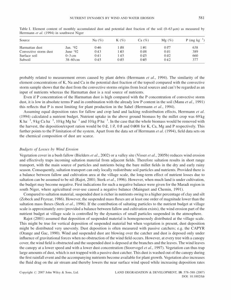
Table I. Element content of monthly accumulated dust and potential dust fraction of the soil (0–63mm) as measured byHerrmann et al. (1994) in southwest Niger
Source Na (%) K (%) Ca (%) Mg (%) P (mg kg�1)
Harmattan dust Jan. ‘92 0�46 1�58 1�91 0�77 638Convective storm dust June ‘92 0�13 1�03 0�38 0�31 389Surface soil 0–3 cm 0�11 1�15 0�25 0�32 660Subsoil 38–60 cm 0�15 0�55 0�05 0�12 377
NUTRIENT DYNAMICS BY WIND AND WATER EROSION 581
probably related to measurement errors caused by plant debris (Herrmann et al., 1994). The similarity of the
element concentrations of K, Na and Ca in the potential dust fraction of the topsoil compared with the convective
storm sample shows that the dust from the convective storms origins from local sources and can’t be regarded as an
input of nutrients whereas the Harmattan dust is a real source of nutrients.
Even if P concentration of the Harmattan dust is high compared with the P concentration of convective storm
dust, it is low in absolute terms P and in combination with the already low P content in the soil (Manu et al., 1991)
this reflects that P is most limiting for plant production in the Sahel (Herrmann et al., 1994).
Assuming equal deposition rates for fallow and crop land and lacking redistribution effects, Herrmann et al.
(1994) calculated a nutrient budget. Nutrient uptake in the above ground biomass by the millet crop was 69 kg
K ha�1, 9 kg Ca ha�1, 10 kg Mg ha�1 and 10 kg P ha�1. In the case that the whole biomass would be removed with
the harvest, the deposition/export ration would be 0�2, 1�7, 0�5 and 0�008 for K, Ca, Mg and P respectively. This
further points to the P limitation of the system. Apart from the data set of Herrmann et al. (1994), field data sets on
the chemical composition of dust are scarce.
Budgets of Losses by Wind Erosion
Vegetation cover in a bush fallow (Bielders et al., 2002) or a valley site (Visser et al., 2005b) reduces wind erosion
and effectively traps incoming saltation material from adjacent fields. Therefore saltation results in short range
transport, with the main source of particles and nutrients being the bare millet fields in the dry and early rainy
season. Consequently, saltation transport can only locally redistribute soil particles and nutrients. Provided there is
a balance between fallow and cultivation area at the village scale, the long-term effect of nutrient losses due to
saltation can be assumed to be nil (Rajot, 2001; Sterk et al., 1996). However, when much land is under cultivation,
the budget may become negative. First indications for such a negative balance were given for the Maradi region in
south Niger, where agricultural over-use caused a negative balance (Mainguet and Chemin, 1991).
Compared to saltation material, suspended dust is richer in nutrients owing to a higher percentage of clay and silt
(Zobeck and Fryrear, 1986). However, the suspended mass fluxes are at least one order of magnitude lower than the
saltation mass fluxes (Sterk et al., 1996). If the contribution of saltating particles to the nutrient budget at village
scale is approximately zero (provided a balance between fallow and cultivation exists), the wind erosion part of the
nutrient budget at village scale is controlled by the dynamics of small particles suspended in the atmosphere.
Rajot (2001) assumed that deposition of suspended material is homogeneously distributed at the village scale.
This might be true for vertical deposition of suspended material but when vegetation is present, dust deposition
might be distributed very unevenly. Dust deposition is often measured with passive catchers; e.g. the CAPYR
(Orange and Gac, 1990). Wind and suspended dust are blowing over the catcher and dust is deposed only under
influence of gravitational forces when no obstruction of the wind field occurs. However, at every tree with a canopy
cover, the wind field is obstructed and the suspended dust is deposed at the branches and the leaves. The wind leaves
the canopy at a lower speed and with a lower dust concentration (Stoorvogel et al., 1997). Vegetation can thus trap
large amounts of dust, which is not trapped with a passive dust catcher. This dust is washed out of the canopy during
the first rainfall event and the accompanying nutrients become available for plant growth. Vegetation also increases
the fluid drag on the air stream and thereby lowers the near surface wind speed while increasing deposition rates
Copyright # 2007 John Wiley & Sons, Ltd. LAND DEGRADATION & DEVELOPMENT, 18: 578–588 (2007)
DOI: 10.1002/ldr
582 S. M. VISSER AND G. STERK
(McGowan and Ledgard, 2005). Furthermore, vegetation reduces the wind velocity gradient above the canopy so
that the friction velocity can fall below the threshold for re-suspension of settling dust grains (Tsoar and Pye, 1987).
McGowan and Ledgard (2005) showed after a 2-year study at tree plantations near lake Tekepa, New Zealand, that
dust deposition in vegetated areas is significantly enhanced; 199�86 kg ha�1 2 years in vegetated areas versus
108�04 kg ha�1 2 years in the bare control area.
From the above, we can conclude that dust deposition during the Harmattan, measured with the conventional
passive dust catchers, under-estimates total dust deposition and that in areas with vegetation dust deposition may
not be as homogeneously distributed as is assumed by Drees et al. (1993), Herrmann et al. (1994) and Rajot (2001).
NUTRIENT FLUXES UNDER THE INFLUENCE OF WATER EROSION
Water erosion at the village scale can be divided into three main processes: splash erosion, sheet erosion and rill or
gully erosion. The direction of sediment transport by water is mainly determined by topography. What happens to
the soil particles detached from the surface by rain splash and the impact of splash erosion is dependent on the slope
gradient and surface characteristics. With a 25 degree slope, 95 per cent of the detached material is transported
down slope. However, uphill wind can cause a net uphill transport of sediment even up to 7 m (Erpul et al., 2002),
but in case of sheet flow, those particles will immediately be transported down hill again. Once detached by splash
erosion, particles are generally transported further down-slope by sheet flow.
Sheet flow, a thin, uniform layer of water that flows over the soil surface, has a limited transport capacity.
Generally, only the finest particles containing most nutrients are transported by sheet flow. However, transport
capacity of sheet flow can be increased by (wind driven) raindrops falling in the flow, increasing the turbulence of
the flow (Guy et al., 1987). Erosion by sheet flow largely depends on the characteristics of the surface, including
particle size, degree of particle cohesion and the nature of the vegetation cover.
In water, large particles are transported rolling or sliding in constant contact with the soil surface. The higher the
stream power, the larger particles that can be transported depending on the roughness of the streambed. Nutrient
contents in rolling or sliding particles are generally very low to zero. Nutrient contents of saltating particles in water
are smaller than nutrient contents of saltating particles in wind since in water most aggregates, which contain most
nutrients, will fall apart and the sediment will be further transported in suspension. Sediment in suspension carries
the finest particles, and so most nutrients, over large distances (up to thousands of kilometres).
Nutrient Losses by Water Erosion
Stoorvogel and Smaling (1990) used an enrichment ratio (ER) of 2�0 for N, P and K to calculate the contribution of
water erosion to the nutrient budget for West Africa. Due to the large scale, they were working on, they needed to
incorporate this simplification. However, work at the plot scale shows that the ERs are variable for the different
nutrients and vary for rainfall events of different intensity (Cogle et al., 2002, Visser et al., 2005c). Zougmore
(2003) found a wide range in ER values for his runoff plots at Saria, Burkina Faso. ER for C ranged from 3 to 7, for
N from 4 to 10, for P from 2 to 4�7 and for K from 1 to 3. He showed that a positive relation between annual losses of
C, N, P and K and total soil loss exists. However, ERs decrease with increasing erosion (Veldkamp, 1994). As
pointed out by Lal (1998), sheet erosion selectively exports clay, silt, nutrients and soil organic matter from the
topsoil. This selectivity is particularly high on gentle slopes, as are often found in Sahelian Africa, when runoff and
erosion rates are low (Roose and Barthes, 2001). Visser et al. (2005a) measured soil losses of three geomorphic
units in the Katchari catchment in northern Burkina Faso at the plot scale, applied a water erosion model at field
scale and showed that measured soil losses at plot scale are larger than the soil losses at field scale; for one event
even by a factor of 10.
Furthermore, Visser et al. (2005a) showed that formation of pools in fields significantly reduced runoff discharge
from the field and causes resettlement of the eroded sediments. At the scale of a field, water erosion was limited (in
comparison with wind erosion) and caused merely a redistribution of sediments over the field.
So instead of directly using results from runoff plots in a nutrient budget analysis, which might lead to large
overestimations of the erosion component of the nutrient budget, the topography of the area should be taken into
Copyright # 2007 John Wiley & Sons, Ltd. LAND DEGRADATION & DEVELOPMENT, 18: 578–588 (2007)
DOI: 10.1002/ldr
NUTRIENT DYNAMICS BY WIND AND WATER EROSION 583
account and the dynamics of erosion and deposition of sediments and nutrient transport by water at the village scale
should be examined.
Clearly, not much data on nutrient losses by water erosion in the Sahel is available at the larger scale (either
hillslope or catchment). New observations at these scales could improve models and knowledge of the nutrient
balance rate the village scale.
NUTRIENT EROSION AT THE VILLAGE SCALE
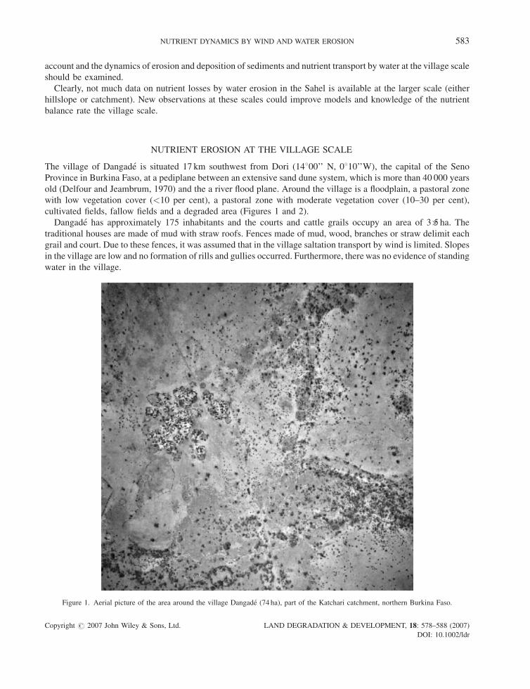
The village of Dangade is situated 17 km southwest from Dori (14800’’ N, 0810’’W), the capital of the Seno
Province in Burkina Faso, at a pediplane between an extensive sand dune system, which is more than 40 000 years
old (Delfour and Jeambrum, 1970) and the a river flood plane. Around the village is a floodplain, a pastoral zone
with low vegetation cover (<10 per cent), a pastoral zone with moderate vegetation cover (10–30 per cent),
cultivated fields, fallow fields and a degraded area (Figures 1 and 2).
Dangade has approximately 175 inhabitants and the courts and cattle grails occupy an area of 3�5 ha. The
traditional houses are made of mud with straw roofs. Fences made of mud, wood, branches or straw delimit each
grail and court. Due to these fences, it was assumed that in the village saltation transport by wind is limited. Slopes
in the village are low and no formation of rills and gullies occurred. Furthermore, there was no evidence of standing
water in the village.
Figure 1. Aerial picture of the area around the village Dangade (74 ha), part of the Katchari catchment, northern Burkina Faso.
Copyright # 2007 John Wiley & Sons, Ltd. LAND DEGRADATION & DEVELOPMENT, 18: 578–588 (2007)
DOI: 10.1002/ldr
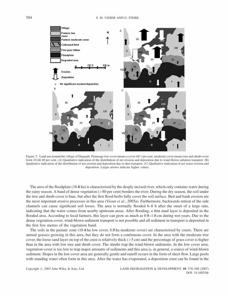
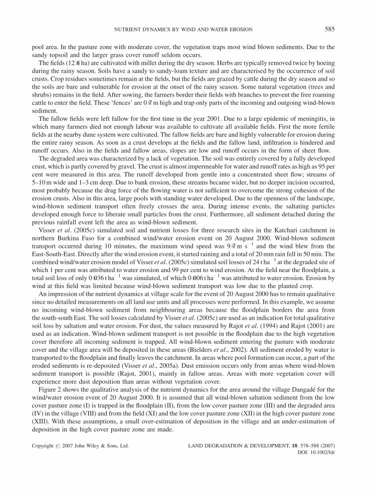
Figure 2. Land use around the village of Dangade. Pasturage low cover means a cover till 1 per cent, moderate cover means tree and shrub coverfrom 10 till 40 per cent. (A) Qualitative indication of the distribution of net erosion and deposition due to wind-blown saltation transport. (B)Qualitative indication of the distribution of net erosion and deposition due to dust transport. (C) Qualitative indication of net water erosion and
deposition. Larger arrows indicate higher values.
584 S. M. VISSER AND G. STERK
The area of the floodplain (16�8 ha) is characterised by the deeply incised river, which only contains water during
the rainy season. A band of dense vegetation (>80 per cent) borders the river. During the dry season, the soil under
the tree and shrub cover is bare, but after the first flood herbs fully cover the soil surface. Bed and bank erosion are
the most important erosive processes in this area (Visser et al., 2005a). Furthermore, backwards retreat of the side
channels can cause significant soil losses. The area is normally flooded 6–8 h after the onset of a large rain,
indicating that the water comes from nearby upstream areas. After flooding, a thin mud layer is deposited in the
flooded area. According to local farmers, this layer can grow as much as 0�5–1�5 cm during wet years. Due to the
dense vegetation cover, wind-blown sediment transport is not possible and all sediment in transport is deposited in
the first few metres of the vegetation band.
The soils in the pasture zone (18�4 ha low cover, 6�5 ha moderate cover) are characterised by crusts. There are
annual grasses growing in this area, but they do not form a continuous cover. In the area with the moderate tree
cover, the loose sand layer on top of the crust is relatively thick (>5 cm) and the percentage of grass cover is higher
than in the area with low tree and shrub cover. The shrubs trap the wind-blown sediments. In the low cover area,
vegetation cover is too low to trap major amounts of sediments and this area is, in general, a source of wind-blown
sediment. Slopes in the low cover area are generally gentle and runoff occurs in the form of sheet flow. Large pools
with standing water often form in this area. After the water has evaporated, a deposition crust can be found in the
Copyright # 2007 John Wiley & Sons, Ltd. LAND DEGRADATION & DEVELOPMENT, 18: 578–588 (2007)
DOI: 10.1002/ldr
NUTRIENT DYNAMICS BY WIND AND WATER EROSION 585
pool area. In the pasture zone with moderate cover, the vegetation traps most wind blown sediments. Due to the
sandy topsoil and the larger grass cover runoff seldom occurs.
The fields (12�8 ha) are cultivated with millet during the dry season. Herbs are typically removed twice by hoeing
during the rainy season. Soils have a sandy to sandy-loam texture and are characterised by the occurrence of soil
crusts. Crop residues sometimes remain at the fields, but the fields are grazed by cattle during the dry season and so
the soils are bare and vulnerable for erosion at the onset of the rainy season. Some natural vegetation (trees and
shrubs) remains in the field. After sowing, the farmers border their fields with branches to prevent the free roaming
cattle to enter the field. These ‘fences’ are 0�7 m high and trap only parts of the incoming and outgoing wind-blown
sediment.
The fallow fields were left fallow for the first time in the year 2001. Due to a large epidemic of meningitis, in
which many farmers died not enough labour was available to cultivate all available fields. First the more fertile
fields at the nearby dune system were cultivated. The fallow fields are bare and highly vulnerable for erosion during
the entire rainy season. As soon as a crust develops at the fields and the fallow land, infiltration is hindered and
runoff occurs. Also in the fields and fallow areas, slopes are low and runoff occurs in the form of sheet flow.
The degraded area was characterized by a lack of vegetation. The soil was entirely covered by a fully developed
crust, which is partly covered by gravel. The crust is almost impermeable for water and runoff rates as high as 95 per
cent were measured in this area. The runoff developed from gentle into a concentrated sheet flow; streams of
5–10 m wide and 1–3 cm deep. Due to bank erosion, these streams became wider, but no deeper incision occurred,
most probably because the drag force of the flowing water is not sufficient to overcome the strong cohesion of the
erosion crusts. Also in this area, large pools with standing water developed. Due to the openness of the landscape,
wind-blown sediment transport often freely crosses the area. During intense events, the saltating particles
developed enough force to liberate small particles from the crust. Furthermore, all sediment detached during the
previous rainfall event left the area as wind-blown sediment.
Visser et al. (2005c) simulated soil and nutrient losses for three research sites in the Katchari catchment in
northern Burkina Faso for a combined wind/water erosion event on 20 August 2000. Wind-blown sediment
transport occurred during 10 minutes, the maximum wind speed was 9�7 m s�1 and the wind blew from the
East-South-East. Directly after the wind erosion event, it started raining and a total of 20 mm rain fell in 50 min. The
combined wind/water erosion model of Visser et al. (2005c) simulated soil losses of 24 t ha�1 at the degraded site of
which 1 per cent was attributed to water erosion and 99 per cent to wind erosion. At the field near the floodplain, a
total soil loss of only 0�036 t ha�1 was simulated, of which 0�006 t ha�1 was attributed to water erosion. Erosion by
wind at this field was limited because wind-blown sediment transport was low due to the planted crop.
An impression of the nutrient dynamics at village scale for the event of 20 August 2000 has to remain qualitative
since no detailed measurements on all land use units and all processes were performed. In this example, we assume
no incoming wind-blown sediment from neighbouring areas because the floodplain borders the area from
the south-south East. The soil losses calculated by Visser et al. (2005c) are used as an indication for total qualitative
soil loss by saltation and water erosion. For dust, the values measured by Rajot et al. (1994) and Rajot (2001) are
used as an indication. Wind-blown sediment transport is not possible in the floodplain due to the high vegetation
cover therefore all incoming sediment is trapped. All wind-blown sediment entering the pasture with moderate
cover and the village area will be deposited in these areas (Bielders et al., 2002). All sediment eroded by water is
transported to the floodplain and finally leaves the catchment. In areas where pool formation can occur, a part of the
eroded sediments is re-deposited (Visser et al., 2005a). Dust emission occurs only from areas where wind-blown
sediment transport is possible (Rajot, 2001), mainly in fallow areas. Areas with more vegetation cover will
experience more dust deposition than areas without vegetation cover.
Figure 2 shows the qualitative analysis of the nutrient dynamics for the area around the village Dangade for the
wind/water erosion event of 20 August 2000. It is assumed that all wind-blown saltation sediment from the low
cover pasture zone (I) is trapped in the floodplain (II), from the low cover pasture zone (III) and the degraded area
(IV) in the village (VIII) and from the field (XI) and the low cover pasture zone (XII) in the high cover pasture zone
(XIII). With these assumptions, a small over-estimation of deposition in the village and an under-estimation of
deposition in the high cover pasture zone are made.
Copyright # 2007 John Wiley & Sons, Ltd. LAND DEGRADATION & DEVELOPMENT, 18: 578–588 (2007)
DOI: 10.1002/ldr
586 S. M. VISSER AND G. STERK
Saltation transport by wind causes the largest soil losses (Figure 3). However, a part of these sediments are
trapped again by other units. Wind from East-South-East is relatively positive for this specific area, the saltating
sediment is trapped in areas, which can be taken under cultivation in the future. However, the prevailing wind
direction for wind erosion events in the Sahel is northeast. With a northeastern wind, most saltating material and its
attached nutrients are trapped in the floodplain area. Though the nutrients do not actually leave the area, they can be
considered as lost for the cultivated area since the flood plain can’t be cultivated due to temporary flooding.
Comparing the arrows for deposition with those for erosion of saltation transport (Figure 3A), it is clear that in
this 74 ha area, there is no balance between fallow area and fields. The negative balance is mainly caused by the
presence of the large degraded area and the first year fallow area. These areas may cause large soil losses. To restore
the balance, trees and bushes need to be planted in the degraded area and the fallow fields need a mulch cover or a
cover crop.
In comparison with the soil and nutrient losses by wind erosion, the losses by water erosion are small (Figure 3C).
However, it should be noted that with each rainfall, nutrients are lost from the area by water erosion, whereas with
wind erosion the direction of sediment transport is important in determining whether the nutrients are forever or
only temporary lost from the area. So on the longer time scale, nutrient losses by water erosion might become more
important than nutrient losses by wind erosion.
The role of dust deposition in this nutrient balance is very small (Figure 3B), but may be under estimated for the
area with a higher vegetation cover.
From this study for only one event it becomes clear that the effect of saltation transport should not be overlooked
at the scale of a village. Due to the fact that most nutrient balances ignore the effect of saltation transport, these
balances can’t be applied at village scale in the Sahelian environment.
CONCLUSIONS
The two modes of transport of wind-eroded sediment, saltation and suspension, have different consequences for
soil productivity in the Sahel. At the local scale, saltation moves the bulk of sediments and nutrients over short
distances, from bare unprotected soils towards areas with sufficient vegetation or mulch cover. In the source areas,
soil productivity declines, whereas in the sink areas, soil productivity increases. Provided a good balance between
fields and fallow areas, the net long-term effect of saltation transport on village scale can be assumed zero. But
when the balance between field and fallow is lost, saltation transport during one event can result in tremendous soil
and nutrient losses.
The suspended material can be divided in two types; the Harmattan dust and the convectional storm dust. When
fine nutrient rich particles are taken in suspension, parts of this suspended material is re-deposed and parts may be
transported over thousands of kilometres, exporting the nutrients to other parts of the world.
Due to the general low slopes, sheet erosion is the most important process of water erosion. Sheet erosion
selectively exports clay, silt, nutrients and soil organic matter from the topsoil and this selectivity is highest on
gentle slopes. Therefore, sheet erosion, though limited in total amount, should not be under-estimated. Especially at
the longer time scale, it might contribute considerably to the total nutrient losses at the village scale. Though at
village scale, the losses are considerably smaller due to re-deposition, yearly nutrient losses can be considerable.
Furthermore, nutrients transported by water are always directed in a down-slope direction and can’t be transported
upslope again as is possible with wind erosion. Therefore nutrients lost by water erosion are forever lost for the
upslope area.
Most of the studies on wind and/or water erosion in the Sahel are based on a rather limited data sets in terms of
number of events studied; number of processes taken into account and analysis of nutrients. To completely
understand the nutrient dynamics by wind and water erosion at village scale in the Sahel, more field experiments
and measurements are necessary, in particular at the larger scales (i.e. village scale).
Based on the conclusions from the literature review, a qualitative indication of the nutrient dynamics during a
combined wind/water erosion event for the area around the village Dangade in northern Burkina Faso is given. This
analysis gives a good impression of the impact of the different process on the erosion component of the nutrient
Copyright # 2007 John Wiley & Sons, Ltd. LAND DEGRADATION & DEVELOPMENT, 18: 578–588 (2007)
DOI: 10.1002/ldr
NUTRIENT DYNAMICS BY WIND AND WATER EROSION 587
balance. The area around the village Dangade is especially vulnerable for saltation transport and the role of water
erosion and dust deposition is negligible.
This indicates that the effect of saltation transport can’t be ignored when calculating the erosion component of
the nutrient balance at village scale in a Sahelian environment. With the fast growing populations of the Sahelian
countries more land will be stripped from its natural vegetation and taken into cultivation. This will result in more
villages with a negative nutrient balance and longer saltation distances. At this point, saltation transport should also
be included into nutrient balances at district scale.
references
Allen JRL. 1994. Fundamental properties of fluids and their relation to sediment transport processes. In Sediment Transport and DepositionalProcesses, Pye K (ed.). Blackwell Scientific Publications: Oxford; 25–60.
Bagnold RA. 1941. The Physics of Blown Sand and Desert Dunes. Methuen: London.Bielders CL, Rajot JL, Amadou M. 2002. Transport of soil and nutrients by wind in bush fallow land and traditionally managed cultivated fields
in the Sahel. Geoderma 109: 19–39.Cocle AL, Rao KPC, Yule DF, Smith GB, Srinivasan ST, Jangawad L. 2002. Soil management for Alfisols in the semi-arid tropics: erosion,
enrichment ratios and runoff. Soil Use and Management 18: 10–17.Delfour J, Jeambrum M. 1970. Notice explicative de la carte geologique au 1/200000 (Oudalan). Bureau de recherches Geologique et Minieres.Drees LR, Manu A, Wilding LP. 1993. Characteristics of aeolian dust in Niger and its’ agricultural impact. LandDegradation&Development 59:
213–233.Erpul G, Norton LD, Gabriels D. 2002. Raindrop-induced and wind-driven soil particle transport. Catena 47: 227–243.Guy BT, Dickinson WT, Rudra RP. 1987. The roles of rainfall and runoff in sediment transport capacity of interrill flow. Transactions of ASAE 30:
1378–1387.Herrmann L, Stahr K, Sivakumar MVK. 1994. Dust deposition on soils of Southwest Niger. In Buerkert A, Allison BE, Von Oppen M (eds).
Proceedings of the International Symposium of University of Hohenheim, Germany 5–7 December 1994 Wind Erosion in West Africa: TheProblem and its Control. Weikersheim; 35–47.
Karambiri H, Ribolzi O, Delhoume JP, Ducloux J, Coudrain-Ribstein A, Casenave A. 2003. Importance of soil surface characteristics on watererosion in a small grazed Sahelian catchment. Hydrological Processes 17: 1495–1507.
Lal R. 1998. Soil erosion impact on agricultural productivity and environmental quality. Critical Review of Plant Science 17: 319–464.Leys JF, McTainsh G. 1994. Soil loss and nutrient decline by wind erosion-cause for concern.Australian Journal for Soil andWater Conservation
7: 30–35.Mainguet M, Chemin MC. 1991. Wind degradation on the sandy soils of Mali and Niger and its part in desertification. Acta Mech (Suppl) 2:
113–130.Manu A, Bationo A, Geiger SC. 1991. Fertility status of selected millet producing soils of West-Africa with emphasis on phosphorus. Soil
Science 152: 315–320.Mazzucato V, Niemeijer D. 2000. Rethinking soil and water conservation in a changing society, environmental sciences, erosion soil and water
conservation Group, Wageningen University and Research Centre, 380.McGowan H, Ledgard N. 2005. Enhanced dust deposition by trees recently established on degraded rangeland. Journal of the Royal Society of
New Zealand 35: 269–277.Nickling WG, Gillies JA. 1993. Dust emission and transport in Mali, West-Africa. Sedimentology 40: 859–868.Orange D, Gac JY. 1990. Bilan geochimique des apports atmospheriques en domains sahelien et soudano-guineen d’Afrique de l’Ouest (Bassins
superieurs du Senegal et de la Gambie) Geodynamique 5: 51–65.Prospero JM. 1999. Long-range transport of mineral dust in the global atmosphere: impact of African dust on the environment of the southeastern
United States. Proceedings of the National Academy of Sciences of the USA 96: 3396–3403.Rajot JL. 2001. Wind blown sediment mass transport of Sahelian village land units in Niger. Bulletin de la Societe Geologique de France 172:
523–531.Rajot JL, Sabre M, Gomes L. 1994. Measurement of vertical fluxes of soil-derived dust during wind erosion events in a Sahelian region (Niger).
In Von Oppen M (ed.). Proceedings of the International Symposium Wind Erosion in West-Africa: The Problem and Its Control. Hohemhein:Germany; 49–56.
Rajot JL, Ribolzi O, Thiebaux JP. 2002. Simultaneous quantification of wind and water erosion within grazing Sahelian watersheds (BurkinaFaso-West Africa) In Proceedings of the 12th International Soil Conservation Organization (ISCO) Conference, May 2002, Beijing China.vol. II: 616–620.
Roose E, Barthes B. 2001. Organic matter management for soil conservation and productivity restoration in Africa: a contribution fromfrancophone research. Nutrient Cycling in Agro-Ecosystems 61: 159–170.
Smaling EMA. 1993. An agro-ecological framework for integrated nutrient management with special reference to Kenya, WageningenAgricultural University, 250.
Sterk G. 1997. Wind erosion in the Sahelian zone of Niger: processes, models and control techniques. Department of Erosion and Soil & WaterConservation, Wageningen University: Wageningen, 151.
Sterk G. 2003. Causes, consequences and control of wind erosion in Sahelian Africa: a review. Land Degradation & Development 14: 95–108.Sterk G, Herrmann L, Bationo A. 1996. Wind-blown nutrient transport and soil productivity changes in Southwest Niger. Land Degradation &
Development 7: 325–335.
Copyright # 2007 John Wiley & Sons, Ltd. LAND DEGRADATION & DEVELOPMENT, 18: 578–588 (2007)
DOI: 10.1002/ldr
588 S. M. VISSER AND G. STERK
Sterk G, Stein A, Stroosnijder L. 2004. Wind effects on spatial variability in pearl millet yields in the Sahel. Soil & Tillage Research 76: 25–37.Stocking M. 1996. Soil erosion: breaking new ground. Leach M, Mearns R (eds). The Lie of the Land: Challenging Received Wisdom in AfricanEnvironmental Change. James Currey/International African Institute, 140–154.
Stoorvogel JJ, Smaling EMA. 1990. Assessment of soil nutrient depletion in Sub-Saharan Africa 1983–2000, Report 28, Winand Staring Centre:Wageningen.
Stoorvogel JJ, van Breman N, Janssen BH. 1997. The nutrient input by Harmattan dust in a forest ecosystem in Cote d’Ivoire. Biochemistry 37:145–147.
Tsoar H, Pye K. 1987. Dust transport and the question of desert loess formation. Sedimentology 34: 139–153.van der Pol F. 1992. Soil mining: an unseen contributor to farm income in southern Mali. Bulletin no. 325, Royal Tropical Institute: Amsterdam.Veldkamp WJ. 1994. Evaluation de la tolerance de l’erosion des sols. Cas de Mali-Sud, 57 pp.Visser SM, Sterk G, Karssenberg D. 2005a. Modelling water erosion in the Sahel; application of a physical model on a gentle sloping area. EarthSurface Processes and Landforms 30: 1547–1566.
Visser SM, Sterk G, Karssenberg D. 2005b. Wind erosion modelling in a Sahelian environment. Journal of Environmental Modelling andSoftware 20: 69–84.
Visser SM, Stroosnijder L, Chardon W. 2005c. Modelling nutrient losses by wind and water erosion. Catena 63: 1–22.Zobeck TM, Fryrear DW. 1986. Chemical and physical characteristics of wind-blown sediment. II Chemical characteristics and total soil nutrient
discharge. Transactions of ASAE 29: 1037–1041.Zougmore RB. 2003. Integrated water and nutrient management for sorghum production in semi-arid Burkina Faso. Doctoral thesis,
Environmental Sciences, erosion and Soil & Water Conservation Group., Wageningen-UR, Wageningen, 205 pp.
Copyright # 2007 John Wiley & Sons, Ltd. LAND DEGRADATION & DEVELOPMENT, 18: 578–588 (2007)
DOI: 10.1002/ldr