north west fisheries report 2002 - connecting … · since october 1, 2002 the old...
TRANSCRIPT
I www.environment-agency.gov.uk
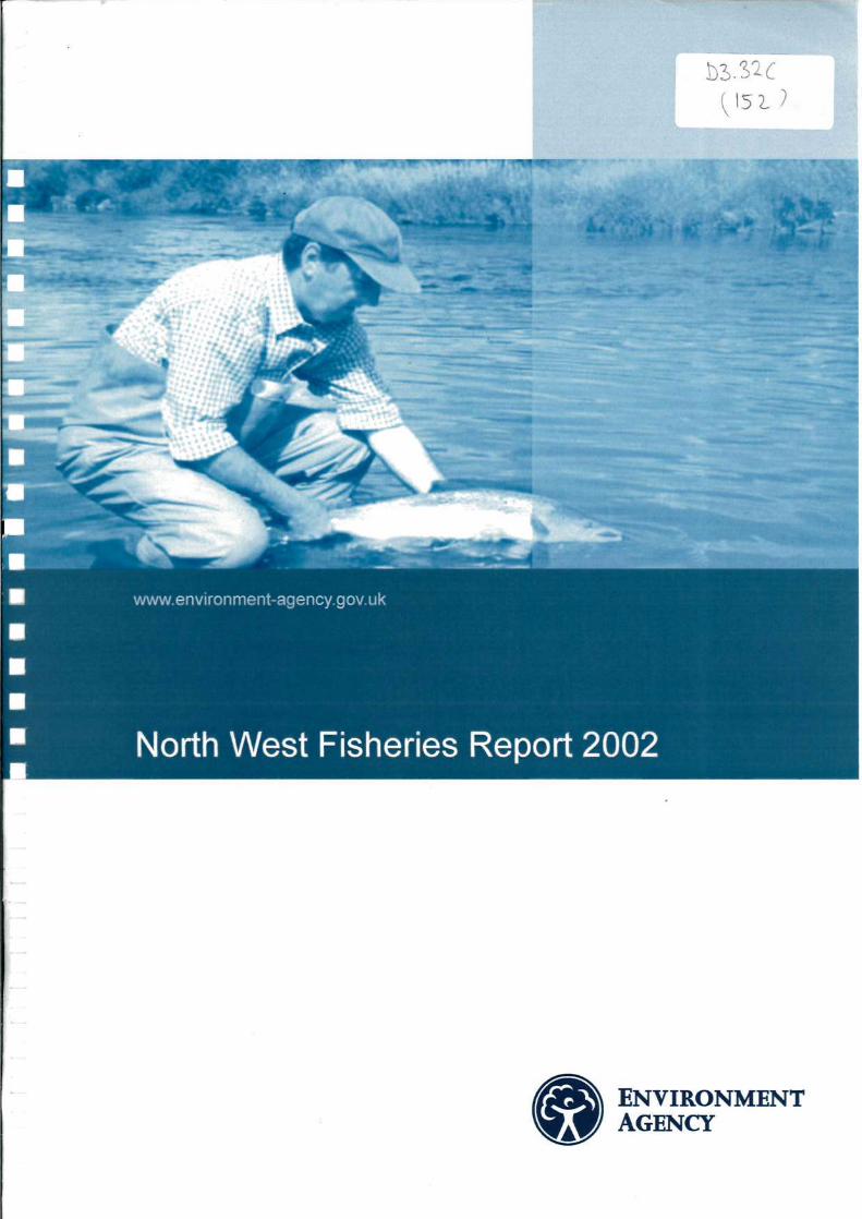
• North West Fisheries Report 2002
© Environment Agency
All rights reserved. No part of this document may be reproduced, stored in a retrieval system, or transmitted in any form or by any other means, electronic, mechanical, photocopying, recording or otherwise, without the prior permission of the Environment Agency.
Published by:
Environment Agency Richard Fairclough House Knutsford Road Warrington WA4 1HG
Tel: 01925 653999 Fax: 01925 415961
ISBN: 1844322076
NORTH WEST FISHERIES REPORT 2002
Contents Page
Note on organisational changes 2
North West Region Fisheries and Recreation staff 3
Regional Fisheries Ecology, Recreation Advisory Committee 5
Consultative association contacts 6
Introduction 7
North Area Annual Report for 2002
Team report: South-West Cumbria 8
Team report: Eden 12
Team report: West Cumbria 14
Projects 15
Central Area Annual Report for 2002
Team reports 17
Projects 20
Survey reports 28
South Area annual report for 2002
Team reports 34
Survey reports 39
Projects 42
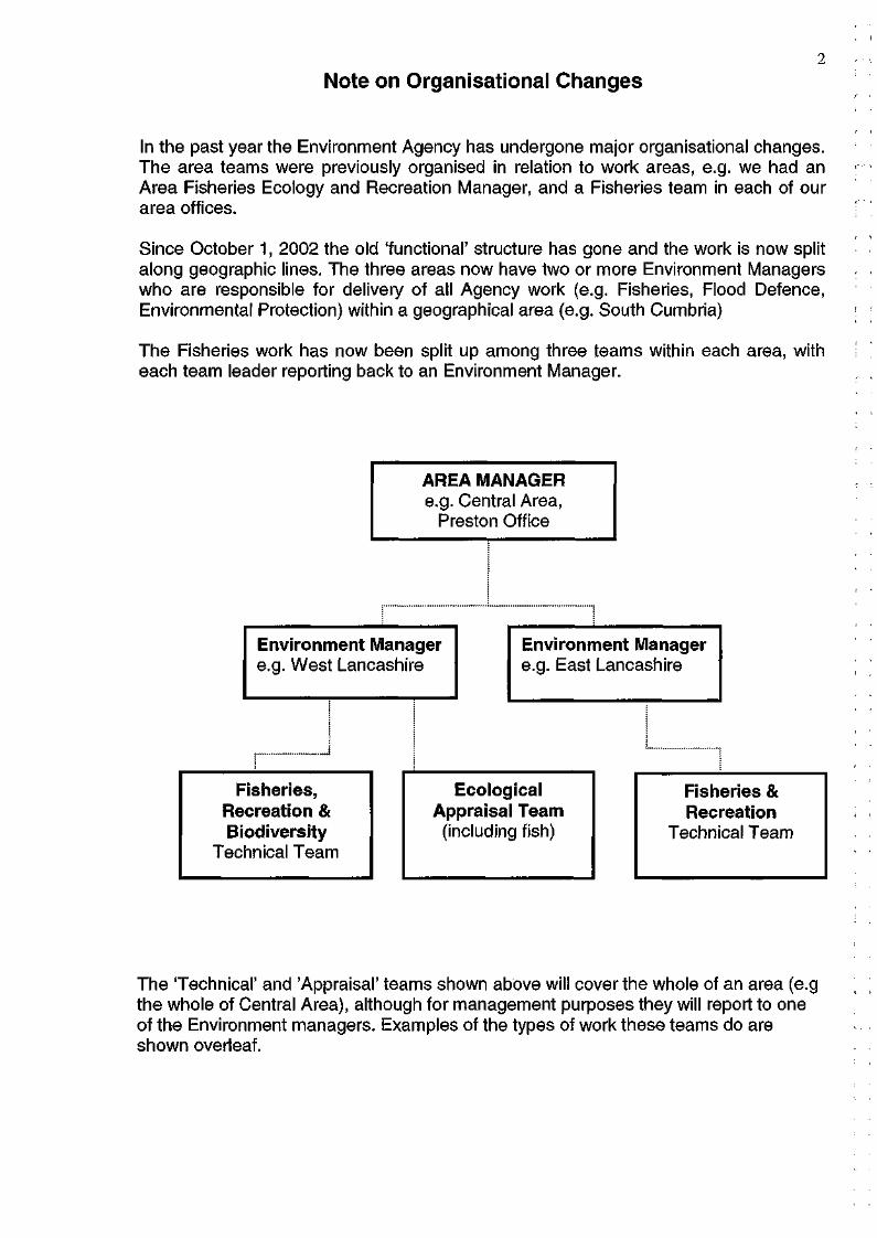
Note on Organisational Changes
In the past year the Environment Agency has undergone major organisational changes. The area teams were previously organised in relation to work areas, e.g. we had an Area Fisheries Ecology and Recreation Manager, and a Fisheries team in each of our area offices.
Since October 1, 2002 the old 'functional' structure has gone and the work is now split along geographic lines. The three areas now have two or more Environment Managers who are responsible for delivery of all Agency work (e.g. Fisheries, Flood Defence, Environmental Protection) within a geographical area (e.g. South Cumbria)
The Fisheries work has now been split up among three teams within each area, with each team leader reporting back to an Environment Manager.
The 'Technical' and 'Appraisal' teams shown above will cover the whole of an area (e.g the whole of Central Area), although for management purposes they will report to one of the Environment managers. Examples of the types of work these teams do are shown overleaf.
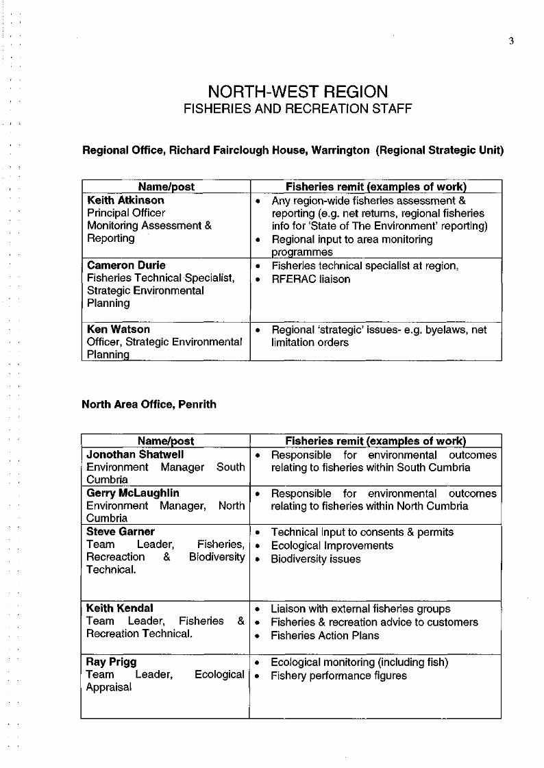
NORTH-WEST REGION FISHERIES AND RECREATION STAFF
Regional Office, Richard Fairclough House, Warrington (Regional Strategic Unit)
North Area Office, Penrith
3
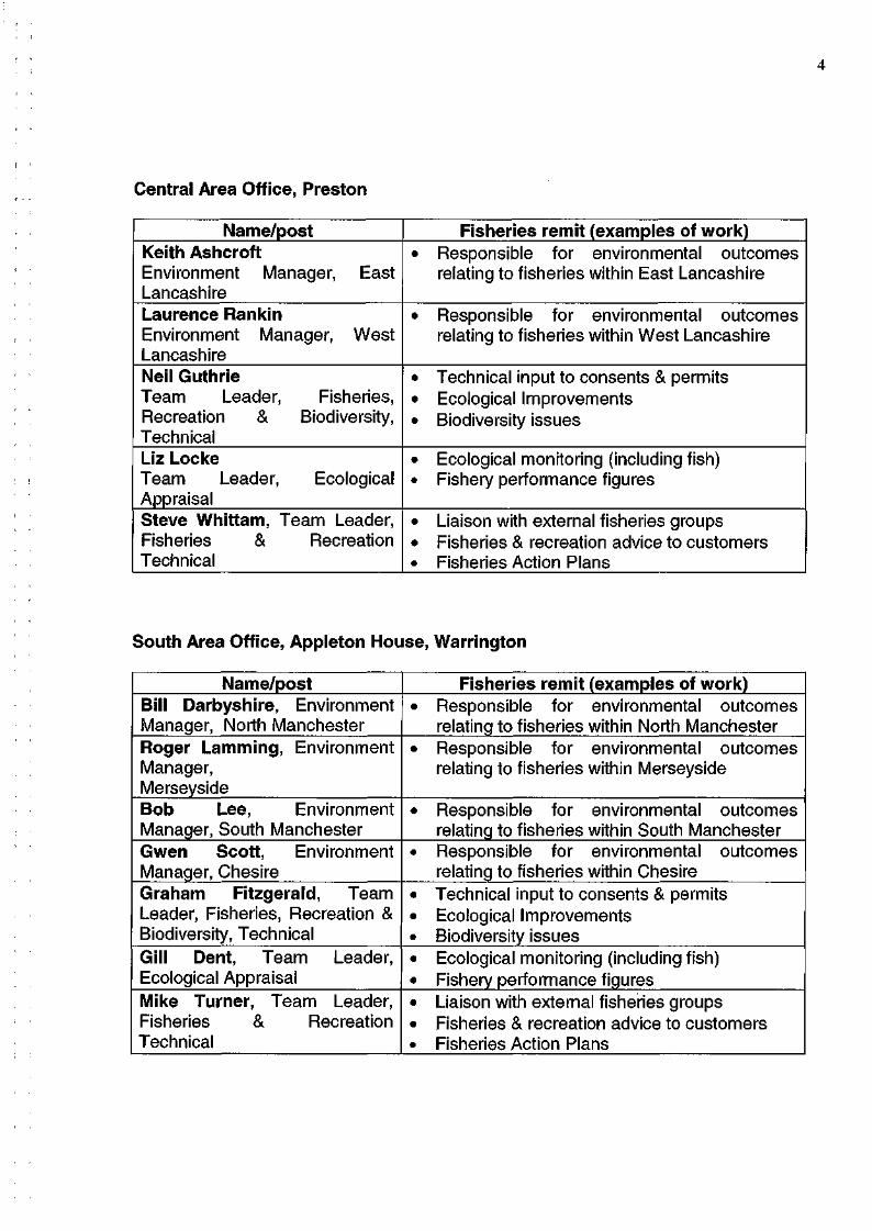
Central Area Office, Preston
South Area Office, Appleton House, Warrington
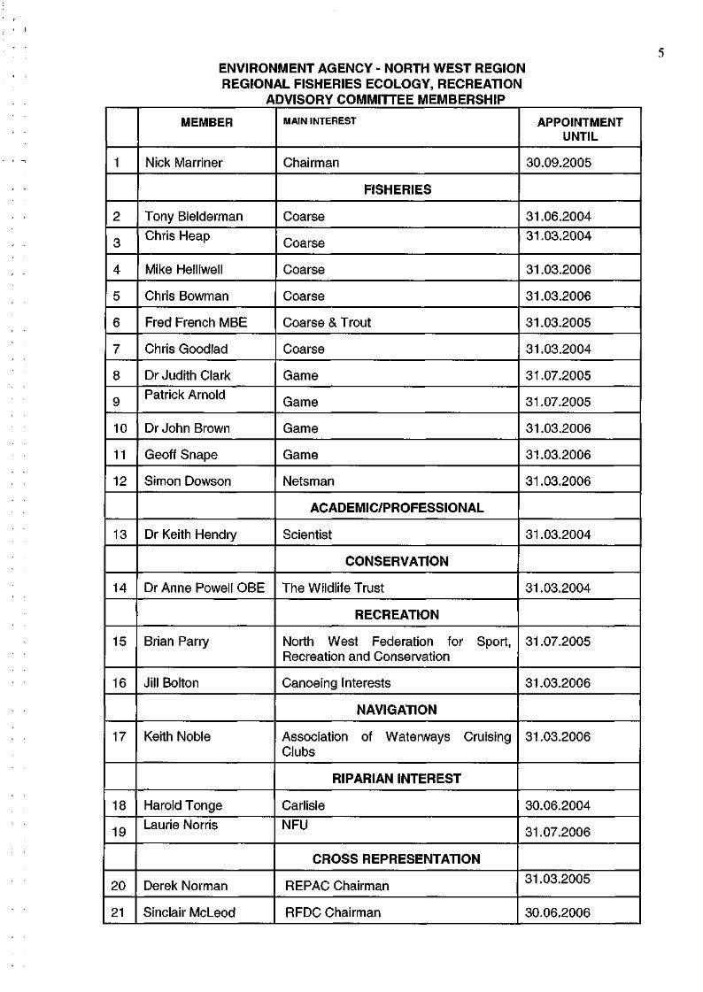
ENVIRONMENT AGENCY - NORTH WEST REGION REGIONAL FISHERIES ECOLOGY, RECREATION
ADVISORY COMMITTEE MEMBERSHIP
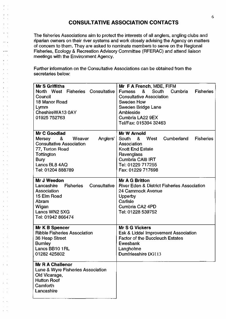
6 CONSULTATIVE ASSOCIATION CONTACTS
The fisheries Associations aim to protect the interests of all anglers, angling clubs and riparian owners on their river systems and work closely advising the Agency on matters of concern to them. They are asked to nominate members to serve on the Regional Fisheries, Ecology & Recreation Advisory Committee (RFERAC) and attend liaison meetings with the Environment Agency.
Further information on the Consultative Associations can be obtained from the secretaries below:
INTRODUCTION 7
This report highlights the good work done by the Environment Agency and its partners for fisheries in our region during 2002. The year was characterised by big changes to the way the Agency works. These changes will help put our organisation in a better position to cope with future regulatory demands in the face of increasing financial constraints.
The Environment Agency's fisheries service is funded in the main by a mixture of rod license income and 'grant-in-aid'. The latter has followed a trend of cutbacks since the mid 1990's and we are increasingly reliant on rod license income to fund fisheries work. The good news is that license income has increased again in 2002 as a result of high profile promotional campaigns and targeted enforcement in areas of high evasion. In recent years we have managed to use some of this money to fund urban fisheries development, creating new opportunities for anglers in and around our main population centres.
As well as improvement work for 'coarse' fisheries, we are also aiming to protect and improve salmonid fisheries with a mixture of enforcement, regulation and habitat improvement.
The Regional Fisheries Report has four main aims:
• To inform the Agency's customers of developments within the Agency • To inform the Agency's customers of the work carried out by the Agency • To publish information on the performance of fisheries and the fisheries
teams • To act as a source of information for future reference
The report could not have been written without the contributions from the area fisheries staff who have provided articles and photographs to help illustrate the important work they have done during the year.
We hope that you find this report interesting and informative.
8
NORTH AREA
Annual Report for 2002
TEAM REPORT: SW CUMBRIA
Migratory Fish Movements
The first rod caught salmon was recorded from the River Ehen on 16 May from The
Avenues' stretch during a moderate spate in early May. On the River Ehen the first sea
trout was captured on 11 June with some anglers catching five or six fish in a single
session. A small run of grilse in the five to six pound weight range also entered the river
at the same time. An eleven-pound sea trout was captured on fly from the river Esk in
early June, together with an eleven-pound fish from the River Irt.
Forty smelt were captured in the River Ehen by one angler during July on the Egremont
Anglers water. Most of these fish were returned. A thirteen-pound salmon was captured
on the River Irt at the beginning of July.
Larger salmon were recorded from the river Ehen in August with Wath Brow and
Ennerdale Angling Association reporting fish of seventeen and twenty pound
respectively.
During September a good run of salmon entered the River Ehen with forty salmon and
sea trout captured during the middle of the month after a small spate.
Late October brought good runs of salmon on the River Esk in Eskdale. One angler
captured eight salmon out of two named holes on the Prince Albert water, near to Forge
Bridge. Seven other fish were returned on the same day.
Generally speaking 2002 was a good year for angling with small to moderate spates
facilitating the free passage of migratory fish in to the rivers, whilst at the same time
providing excellent conditions for angling.
Enforcement
Significant poaching activity kept Southwest (SW) Cumbria Fisheries Officers very busy
during October.
On 22 October 2002 Enforcement officers from the Southwest and North Cumbria
teams apprehended two men trying to sell sixty-four salmon and one sea trout. Agency
staff worked closely with the Keswick police force in a well-organised operation. The
Agencies legal department is still dealing with this case.
Riparian owners and catchment residents reported numerous other incidents. This
included the use of lamps and gaffs to take fish. This continues to be a popular method
of taking fish in this area particularly in the Upper Calder and Croasdale Beck.
Fish Eating Birds
Numbers of sawbills continue to increase on all our main river systems. Twenty-two
birds were sighted in the Upper River Ehen in September.
Otters
An otter was sighted at the Keekle Ehen confluence in June and another at Ennerdale
village in September.
Redd Counting
First indications are that 2002 was a very good year for spawning as indicated by the
numbers of redds counted.
Cinderdale, an important spawning tributary of the River Irt seems to produce more
salmon and seatrout redds every year. One reason for this is the excellent habitat
improvement works carried out by one of our Technical Officers, Mike Bell. Mike has
worked closely with the National Trust volunteer force to carry out improvements in
order to maximise survival of juvenile salmon and seatrout in Cinderdale. The Agency
plans to expand this type of work on all the rivers systems in south-west Cumbria in the
next five years. Co-operation and collaboration with angling clubs and riparian
landowners plays a crucial role in making this process a success.
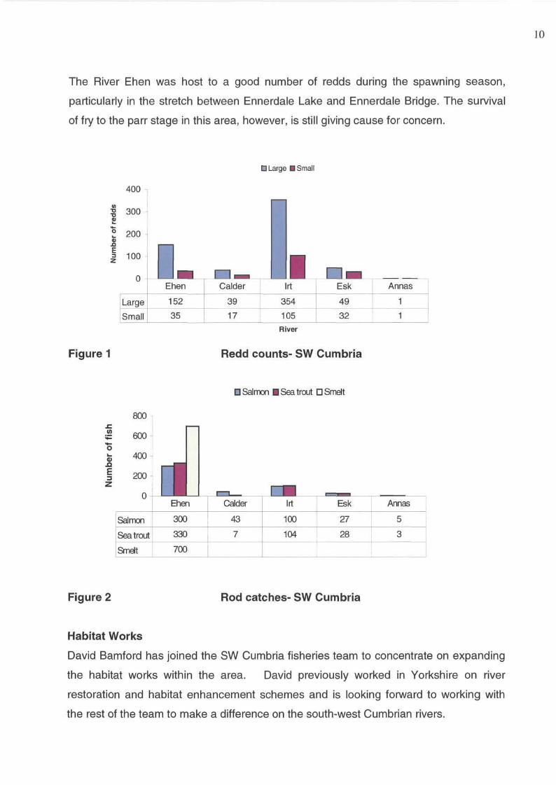
10
The River Ehen was host to a good number of redds during the spawning season,
particularly in the stretch between Ennerdale Lake and Ennerdale Bridge. The survival
of fry to the parr stage in this area, however, is still giving cause for concern.
Habitat Works
David Bamford has joined the SW Cumbria fisheries team to concentrate on expanding
the habitat works within the area. David previously worked in Yorkshire on river
restoration and habitat enhancement schemes and is looking forward to working with
the rest of the team to make a difference on the south-west Cumbrian rivers.
11
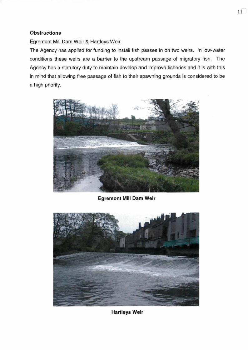
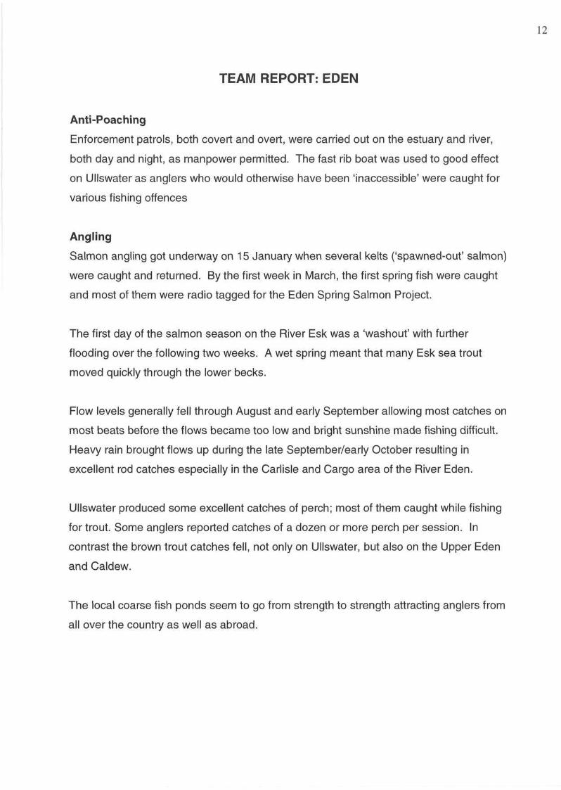
Obstructions
Egremont Mill Dam Weir & Hartleys Weir
The Agency has applied for funding to install fish passes in on two weirs. In low-water
conditions these weirs are a barrier to the upstream passage of migratory fish. The
Agency has a statutory duty to maintain develop and improve fisheries and it is with this
in mind that allowing free passage of fish to their spawning grounds is considered to be
a high priority.
Egremont Mill Dam Weir
Hartleys Weir
TEAM REPORT: EDEN
Anti-Poaching
Enforcement patrols, both covert and overt, were carried out on the estuary and river,
both day and night, as manpower permitted. The fast rib boat was used to good effect
on Ullswater as anglers who would otherwise have been 'inaccessible' were caught for
various fishing offences
Angling
Salmon angling got underway on 15 January when several kelts ('spawned-out' salmon)
were caught and returned. By the first week in March, the first spring fish were caught
and most of them were radio tagged for the Eden Spring Salmon Project.
The first day of the salmon season on the River Esk was a 'washout' with further
flooding over the following two weeks. A wet spring meant that many Esk sea trout
moved quickly through the lower becks.
Flow levels generally fell through August and early September allowing most catches on
most beats before the flows became too low and bright sunshine made fishing difficult.
Heavy rain brought flows up during the late September/early October resulting in
excellent rod catches especially in the Carlisle and Cargo area of the River Eden.
Ullswater produced some excellent catches of perch; most of them caught while fishing
for trout. Some anglers reported catches of a dozen or more perch per session. In
contrast the brown trout catches fell, not only on Ullswater, but also on the Upper Eden
and Caldew.
The local coarse fish ponds seem to go from strength to strength attracting anglers from
all over the country as well as abroad.
Radio Tracking
The Spring Salmon Radio Tagging and Tracking Project' took up a considerable portion
of the Eden team's resource. A total of ninety fish were tagged and tracked to spawning
areas during late 2002 and early 2003. In addition tags were recovered from spawning
fatalities and kelts. Notable results included: a radio tag recovered from a dead kelt in
the River Ur at Kippford, in South West Scotland; and a tag recovered from an Eden
fatality, near Carlisle, which had been tagged in 2001.
Electro-Fishing
Electro-fishing started in July. Sites on the Esk and Eden and showed good numbers of
juveniles. The collection of samples for genetic profiling of salmon on the Eden
catchment was completed and we now await results from this study.
Trapping
The trapping of adult fish continues on the River Caldew at Denton Holme with the first
salmon caught on the 17 June. Totals for year were 1319 salmon, 81 sea trout and 117
brown trout.
The trapping of salmon smolts on the River Lowther as they migrated to the sea finished
with a total of 4125 by the end of June, with 800 caught in just one day.
Fish Counter
The total for the year was 8643 fish recorded at Corby Counter on the River Eden with
the biggest run of the year in October with 2238 fish counted. This is 1369 fish more
than 2001 and 1310 more than for 2000.
13
14
TEAM REPORT: WEST CUMBRIA
The River Derwent was badly affected by algae coming from Bassenthwaite Lake. This
combined with profuse water crowfoot growth made angling conditions very difficult.
There is a feeling among anglers that the Derwent is suffering from nutrient enrichment
Salmon catches for 'Castle Fisheries', (Workington and Cockermouth Anglers) for the
year showed a drop on the previous year (down from 828 to 735 fish). Despite the
decline in catches, salmon appeared to be relatively abundant in the river. Anglers
blamed the algae for the decline and suggested that if angling conditions had been
more favourable, the total catch could have been much higher.
Again this year Fisheries staff collected salmon brood stock from the Glenderamackin,
for Keswick Anglers. Twenty thousand ova were laid down in the Keswick Hatchery. It
is hoped to plant the reared stock as 'fed-fry' in May 2003.
Illegal fishing increased in 2002. Low river levels during the first three weeks of October
caused salmon to pool up in the lower Derwent. This made it easy for poachers and a
number of people were apprehended and nets and fish were seized. Reports have been
submitted and prosecutions are pending.
In October two men were arrested in a joint police operation at Keswick. Sixty-four
salmon and one sea trout were seized. Prosecution is pending. In addition information
from a reliable source indicated that in three nights in October, one hundred and fifty
salmon were taken in nets from the Derwent.
PROJECTS
Leven catchment habitat improvement projects to help boost salmonid
recruitment.
Various habitat improvement projects have been taking place throughout the Leven
catchment to try and address the recent decline in the salmonid population.
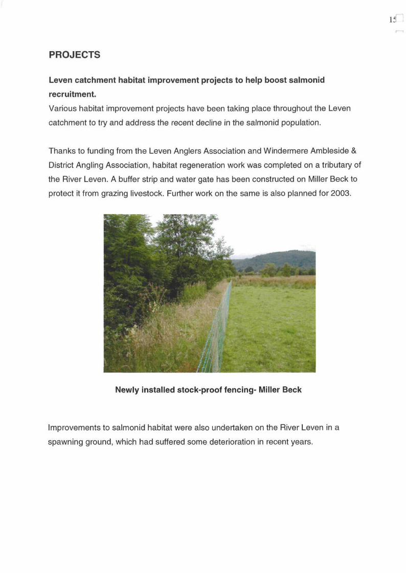
Thanks to funding from the Leven Anglers Association and Windermere Ambleside &
District Angling Association, habitat regeneration work was completed on a tributary of
the River Leven. A buffer strip and water gate has been constructed on Miller Beck to
protect it from grazing livestock. Further work on the same is also planned for 2003.
Newly installed stock-proof fencing- Miller Beck
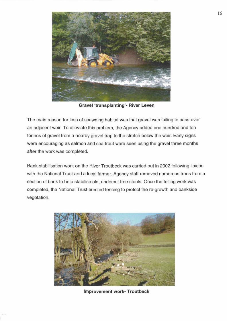
Improvements to salmonid habitat were also undertaken on the River Leven in a
spawning ground, which had suffered some deterioration in recent years.
15
16
Gravel 'transplanting'- River Leven
The main reason for loss of spawning habitat was that gravel was failing to pass-over
an adjacent weir. To alleviate this problem, the Agency added one hundred and ten
tonnes of gravel from a nearby gravel trap to the stretch below the weir. Early signs
were encouraging as salmon and sea trout were seen using the gravel three months
after the work was completed.
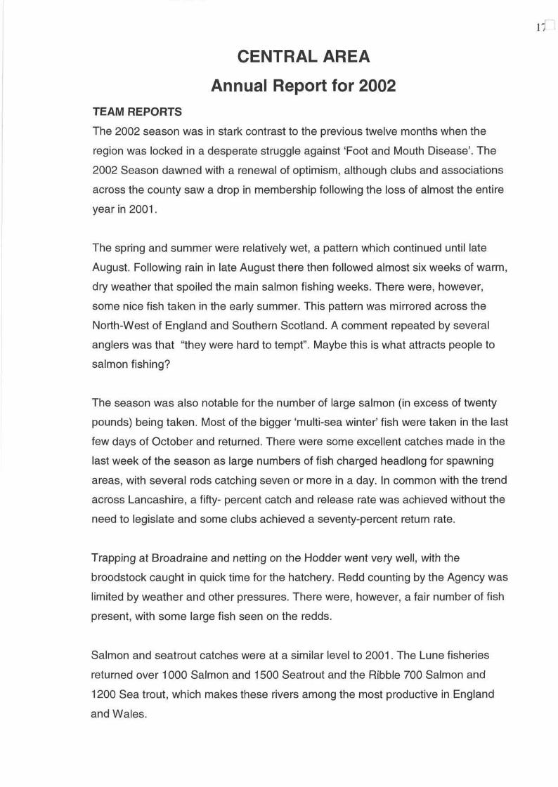
Bank stabilisation work on the River Troutbeck was carried out in 2002 following liaison
with the National Trust and a local farmer. Agency staff removed numerous trees from a
section of bank to help stabilise old, undercut tree stools. Once the felling work was
completed, the National Trust erected fencing to protect the re-growth and bankside
vegetation.
Improvement work- Troutbeck
CENTRAL AREA
Annual Report for 2002 TEAM REPORTS
The 2002 season was in stark contrast to the previous twelve months when the
region was locked in a desperate struggle against 'Foot and Mouth Disease'. The
2002 Season dawned with a renewal of optimism, although clubs and associations
across the county saw a drop in membership following the loss of almost the entire
year in 2001.
The spring and summer were relatively wet, a pattern which continued until late
August. Following rain in late August there then followed almost six weeks of warm,
dry weather that spoiled the main salmon fishing weeks. There were, however,
some nice fish taken in the early summer. This pattern was mirrored across the
North-West of England and Southern Scotland. A comment repeated by several
anglers was that "they were hard to tempt". Maybe this is what attracts people to
salmon fishing?
The season was also notable for the number of large salmon (in excess of twenty
pounds) being taken. Most of the bigger 'multi-sea winter' fish were taken in the last
few days of October and returned. There were some excellent catches made in the
last week of the season as large numbers of fish charged headlong for spawning
areas, with several rods catching seven or more in a day. In common with the trend
across Lancashire, a fifty- percent catch and release rate was achieved without the
need to legislate and some clubs achieved a seventy-percent return rate.
Trapping at Broadraine and netting on the Hodder went very well, with the
broodstock caught in quick time for the hatchery. Redd counting by the Agency was
limited by weather and other pressures. There were, however, a fair number of fish
present, with some large fish seen on the redds.
Salmon and seatrout catches were at a similar level to 2001. The Lune fisheries
returned over 1000 Salmon and 1500 Seatrout and the Ribble 700 Salmon and
1200 Sea trout, which makes these rivers among the most productive in England
and Wales.
17
18
There is a feeling that the Environment Agency has turned a corner although there
are challenges to tackle. Environment Agency 'Local Contributions' targets include
the Ribble and Lune 'spawning escapement targets' which need to be met by 2008.
We have many excellent initiatives underway, all working towards achieving a
common goal. The Lune, Ribble Hodder and Yarrow habitat groups continue to
deliver riparian habitat improvements, improving riverbank cover and buffering run
off, particularly in the upland areas. The speed of waterside regeneration achieved
by preventing sheep and cattle from getting to the river's edge has been remarkable!
The only thing preventing more work being done is guaranteed finance and people's
time. In common with most voluntary groups the bulk of work falls upon very few
people, and without their hard work progress would be limited by the amount of
Agency resource available.
Similar issues affect the hatchery groups, which are generally run by enthusiastic
volunteers. Although hatchery groups use efficient and globally recognised
techniques, the rearing of migratory salmonids is an expensive task and they
therefore face a constant struggle for funding. The future viability of hatchery
operations depends on more involvement and help from the angling fraternity.
In Central Area there is a confidence that if the Agency can pool resources with
those of other organisations/bodies in tandem with new ways of working, it can
achieve its fisheries targets. New European legislation (e.g. the Water Framework
Directive) will also shape future fisheries policy and should help target effective
improvements to the quality and quantity of our waters and habitats.
From an Agency perspective we have gone through a major reorganisation, to
enable us to respond to new duties and changing priorities. It is now time to
challenge the traditional view of the Agency's 'fisheries service' and decide how to
make the best use of increasingly stretched resources.
Central Area has made much progress already, liaising regularly with groups such
as the 'Lune and Wyre Fisheries Association', The 'Ribble Fisheries Association'
and 'Friends of the river Yarrow' (FRY). We are pleased to note that these
organisations are also open to change and are looking to change the way they
represent anglers and their interests.
If we can put aside preconceived ideas and look at new ways of working, we can, for
example, be confident that rivers will meet their salmon spawning targets and that
the once famous Ribble coarse fishery will improve. In addition anglers and
conservationists will hopefully feel that they have had a major part to play in
achieving these goals.
Enforcement
During the year the Central Area team checked over two thousand-rod licences and
approximately three percent of anglers were found to be fishing without a licence
and most of these offences were detected on still waters. There were also a number
of close season offences on Central Area rivers. Over forty incidents of 'illegal'
fishing were either reported or detected and for the first time in recent years there
was a noticeable increase in illegal activity, particularly on the Ribble. The middle
reaches seem to attract the most offenders especially during September with one
net recovered containing salmon and two others reported. When low water
conditions coincide with good numbers of fish then illegal activities increase.
We must all continue to be vigilant and report any incidents of illegal fishing
immediately, by using the Environment Agency Emergency Hotline Number 0800
807060.
Leyland Fish Farm
The farm has continued to develop during 2002. The farm received a visit from a fish
farm industry magazine editor, who was impressed with the facilities and, in
particular, the standards set. The farm produces chub, dace and roach for the five
year 'Central Area Stocking Plan' (for rivers), which we are currently two thirds of the
way through. The quality of the dace and chub, in particular, was a testament to the
site team who are constantly striving to improve standards and regularly work with
their 'sister' site at Calverton to share best practice.
19
As a result of an excellent spawning season we were able to offer a small surplus of
dace to the Agency's North-East region for rehabilitation work. We are confident thai
Leyland will continue to grow and produce fish of high quality for years to come.
PROJECTS
Recreation
The reorganisation of the Environment Agency in October 2002 saw the introduction
of a new post to the Technical Fisheries team, a designated Recreation Officer for
Central Area. This post provides a greater resource for delivering recreational
initiatives on a local scale and along with two identical posts in the other areas,
supersedes the old regional recreation role.
To date our officer has initiated a review of all of the Agency-owned sites in Central
Area, which have recreational value (nineteen sites). This process will take
approximately one year to complete, although works schedules have already been
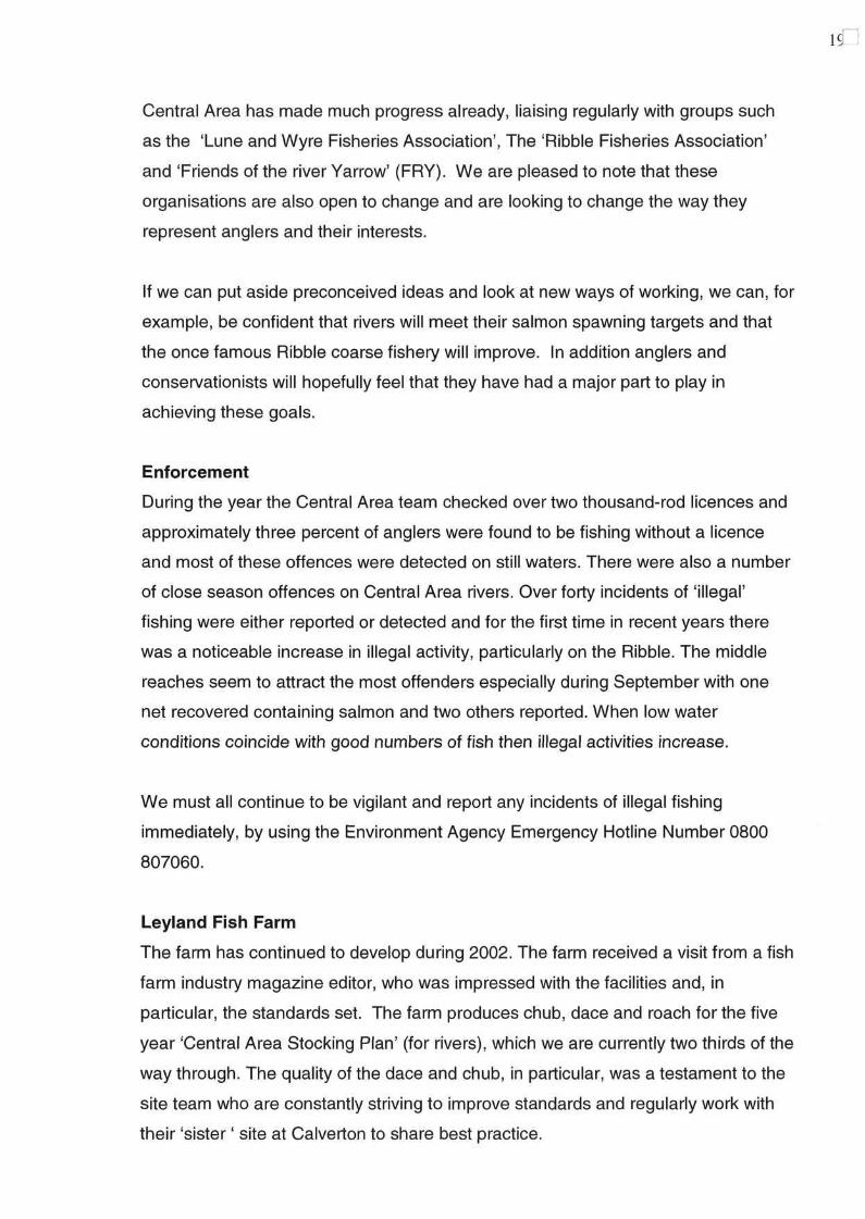
proposed for some sites as a result of the review. In March 2002, essential works
were carried out to address the access problems on the Agency fishery on the River
Ribble at Mitton. A new set of steps, footpaths and revetments were installed to
open up access to the whole of the beat, which was in a poor state of repair. These
access improvements benefit not only anglers who use the fishery, but also walkers,
who can now enjoy safe passage through picturesque surroundings of the Ribble
valley, down to Calder Foot.
New footpaths- River Ribble
20
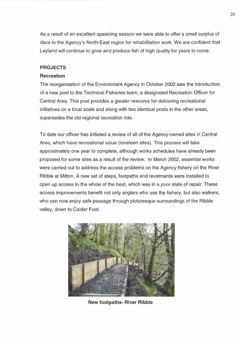
Coaching young anglers
Angling Participation
The Central Area team initiated a number of angling participation projects in 2002.
Projects ranged from improvements to the coaching infrastructure in the Area,
fishery access improvements, providing equipment and support to existing groups
through to organising introductory sessions across the Area.
Particular successes were observed with the Agency's support to the 'West
Lancashire Recreational Activity Pursuit (RAP) Scheme'. The 'RAP Scheme' is a
multi-agency partnership, providing activities for young people from the
Skelmersdale area in the school holidays. Agency officers organised and hosted
four introductory angling days during the 2002 summer break. These days were
extremely well attended, and formed the basis of a growing partnership. Through the
extra rod licence-funding project in October 2002, the Agency supplied 'RAP
Scheme' with a grant to supply ten complete sets of fishing tackle, plus resources
and time at suitable venues to strengthen the project and ensure its continuation. An
urban fishery development project is looking to develop a new fishery in the same
area to meet the demand for such facilities in this part of Lancashire.
In preparation for a series of introductory and coaching events planned in 2003/04,
venue access and fishery improvements have been commissioned on the Lancaster
21
Canal at Preston, in a joint partnership with British Waterways. Preston City Council
is also finalising plans to compete the rejuvenation of Haslem Park Lake, for the
purpose of increasing public access angling opportunities in Preston.
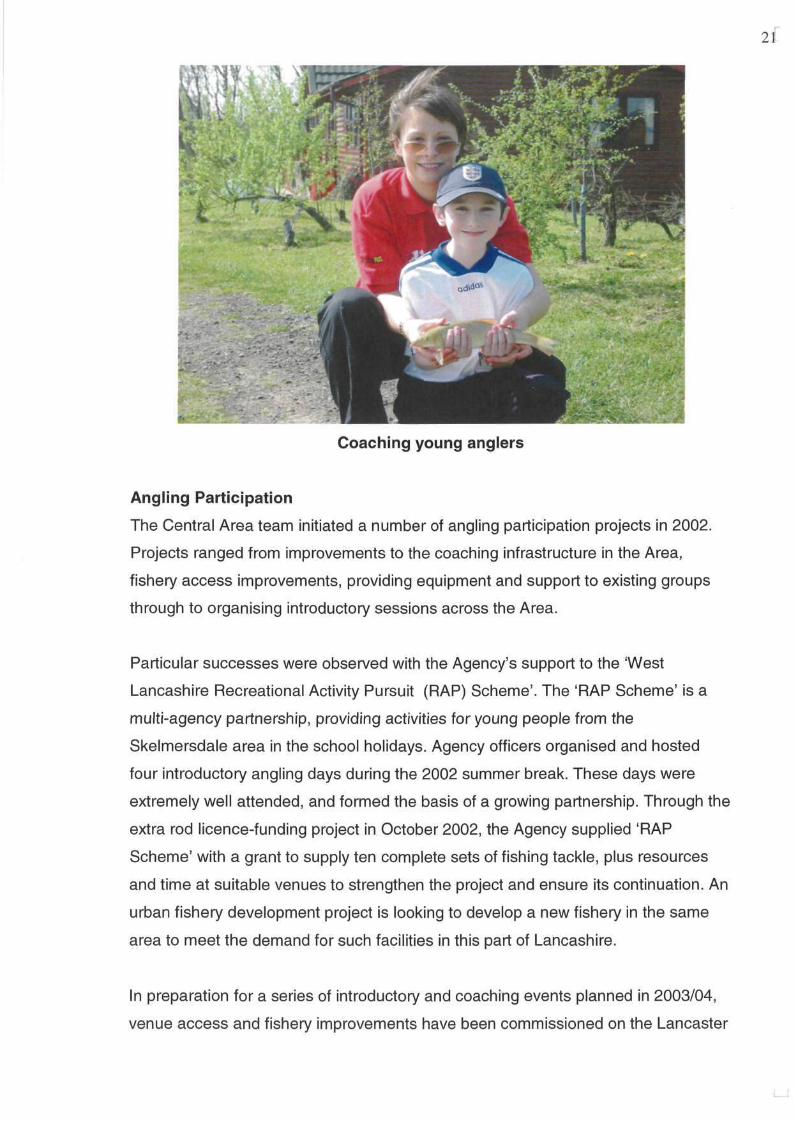
Other projects completed in 2002 included the purchase of ten complete sets of
fishing tackle for use by the Agency and for loan to youth and community groups for
use at introductory days and coaching sessions. Nine newly qualified angling
coaches have been paid for in Central Area in 2002, and Agency-supported events
staged in Blackburn, Skelmersdale, Fleetwood, Garstang and Tebay.
Angling coaching session
Ribble Habitat Work
2002-2003 saw the continuation of the habitat work undertaken on the Ribble
catchment by the Environment Agency (EA) and the Yorkshire Dales Millennium
Trust (YDMT). Fisheries Officers and Project officers worked hard to ensure four
sites were completed using 'year two' monies from the three-year program. As in
previous years, the Ribble Catchment Conservation Trust (RCCT) contributed to the
schemes by signing ten-year flood damage agreements and assisting with tree
planting where applicable.
22
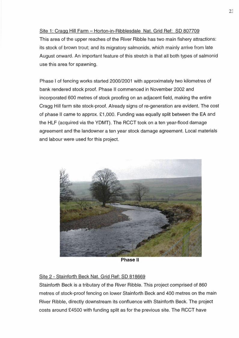
Site 1: Craqg Hill Farm - Horton-in-Ribblesdale Nat. Grid Ref: SD 807709
This area of the upper reaches of the River Ribble has two main fishery attractions:
its stock of brown trout; and its migratory salmonids, which mainly arrive from late
August onward. An important feature of this stretch is that all both types of salmonid
use this area for spawning.
Phase I of fencing works started 2000/2001 with approximately two kilometres of
bank rendered stock proof. Phase II commenced in November 2002 and
incorporated 600 metres of stock proofing on an adjacent field, making the entire
Cragg Hill farm site stock-proof. Already signs of re-generation are evident. The cost
of phase II came to approx. £1,000. Funding was equally split between the EA and
the HLF (acquired via the YDMT). The RCCT took on a ten year-flood damage
agreement and the landowner a ten year stock damage agreement. Local materials
and labour were used for this project.
Site 2 - Stainforth Beck Nat. Grid Ref: SD 818669
Stainforth Beck is a tributary of the River Ribble. This project comprised of 860
metres of stock-proof fencing on lower Stainforth Beck and 400 metres on the main
River Ribble, directly downstream its confluence with Stainforth Beck. The project
costs around £4500 with funding split as for the previous site. The RCCT have
23
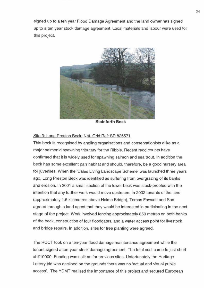
signed up to a ten year Flood Damage Agreement and the land owner has signed
up to a ten year stock damage agreement. Local materials and labour were used for
this project.
Stainforth Beck
Site 3: Long Preston Beck, Nat. Grid Ref: SD 826571
This beck is recognised by angling organisations and conservationists alike as a
major salmonid spawning tributary for the Ribble. Recent redd counts have
confirmed that it is widely used for spawning salmon and sea trout. In addition the
beck has some excellent parr habitat and should, therefore, be a good nursery area
for juveniles. When the 'Dales Living Landscape Scheme' was launched three years
ago, Long Preston Beck was identified as suffering from overgrazing of its banks
and erosion. In 2001 a small section of the lower beck was stock-proofed with the
intention that any further work would move upstream. In 2002 tenants of the land
(approximately 1.5 kilometres above Holme Bridge), Tomas Fawcett and Son
agreed through a land agent that they would be interested in participating in the next
stage of the project. Work involved fencing approximately 850 metres on both banks
of the beck, construction of four floodgates, and a water access point for livestock
and bridge repairs. In addition, sites for tree planting were agreed.
The RCCT took on a ten-year flood damage maintenance agreement while the
tenant signed a ten-year stock damage agreement. The total cost came to just short
of £10000. Funding was split as for previous sites. Unfortunately the Heritage
Lottery bid was declined on the grounds there was no 'actual and visual public
access'. The YDMT realised the importance of this project and secured European
24
funding for the remaining fifty percent. Work commenced in February 2003 and was
completed in late February 2003. Local materials and labour were used for this
project.
Site 4: Davidsons - New houses Farm - Horton-in-Ribblesdale
& Lamberts - Selside
This project comprised of over 2.6 kilometres of stock proofing on the River Ribble
above Horton-in-Ribblesdale, North Yorkshire. This section above Stainforth Force
is reputed to have the most prolific salmon spawning ground on the Ribble.
Furthermore, the area has good parr habitat and the works should improve the
juvenile holding capacity of the area. The work totalled over £16000, with funding
split as for previous sites. The RCCT signed a ten-year flood damage agreement
and the landowners signed a ten-year stock damage agreement. The Agency also
worked with the resident angling and installed access stiles for fisherman. Local
materials and labour were used for this project.
Lune Habitat Works
In 2002 further works were completed under the 'Dales Living Landscape Scheme'.
The Agency matched funding for projects totalling over £22000 with YDMT on
important Lune tributaries.
The 'Dee to Clough Project' saw 3900 metres of buffer zone created which should
help improve habitat for in what is an important spawning and nursery area for
salmonids. There have been recent reductions in the number of juveniles and
returning adults in this area so hopefully these improvements should help increase
migratory returns.
Keld Beck is the most productive spawning stream on the Dee catchment and is
home to juvenile migratory salmonids, and brown trout. Over the previous three
years a number of habitat Improvement projects were completed in this catchment,
so when the stream disappeared down a limestone pothole there was some
concern. The problem was solved when a contractor installed a concrete 'plug' in
the hole, diverting the stream back to its previous course. The project cost around
£3000 and was funded by the Agency. There were also significant works carried out
by and in conjunction with the Lune Habitat Group. We have grant-aided this group
for the last two years, although they have been able to secure significant additional
25
funding from other sources. This successful partnership has delivered several
projects in the Lune valley during 2002, in addition to those mentioned above.
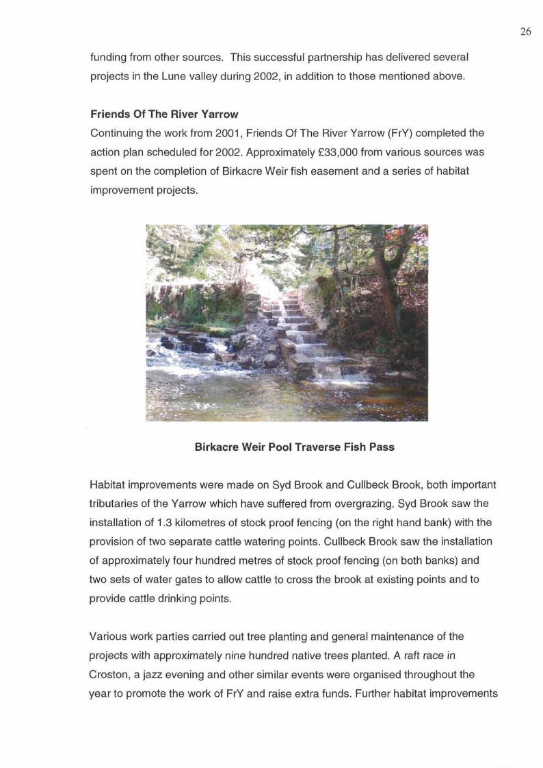
Friends Of The River Yarrow
Continuing the work from 2001, Friends Of The River Yarrow (FrY) completed the
action plan scheduled for 2002. Approximately £33,000 from various sources was
spent on the completion of Birkacre Weir fish easement and a series of habitat
improvement projects.
Birkacre Weir Pool Traverse Fish Pass
Habitat improvements were made on Syd Brook and Cullbeck Brook, both important
tributaries of the Yarrow which have suffered from overgrazing. Syd Brook saw the
installation of 1.3 kilometres of stock proof fencing (on the right hand bank) with the
provision of two separate cattle watering points. Cullbeck Brook saw the installation
of approximately four hundred metres of stock proof fencing (on both banks) and
two sets of water gates to allow cattle to cross the brook at existing points and to
provide cattle drinking points.
Various work parties carried out tree planting and general maintenance of the
projects with approximately nine hundred native trees planted. A raft race in
Croston, a jazz evening and other similar events were organised throughout the
year to promote the work of FrY and raise extra funds. Further habitat improvements
26
as set out in FrY's action plan for 2003 are under negotiation with landowners and
should be completed over the summer-autumn of 2003.
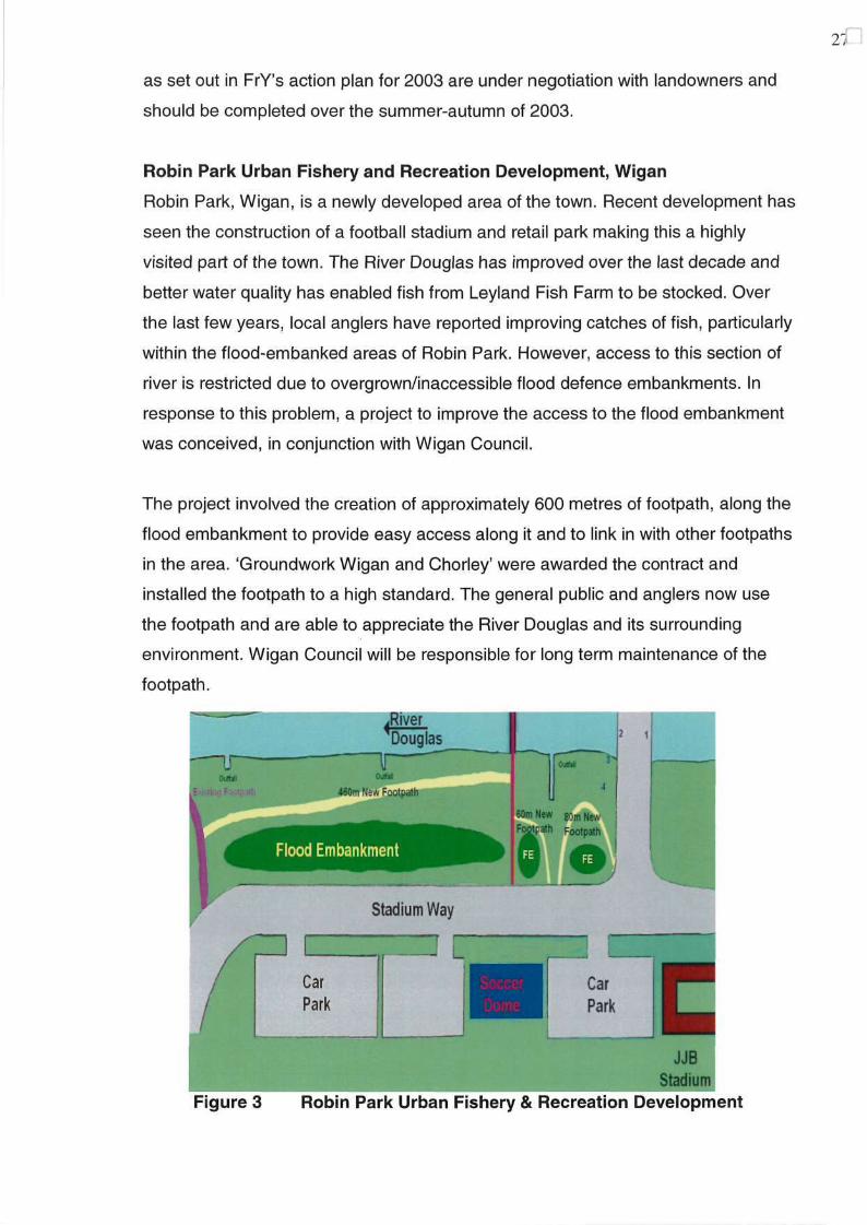
Robin Park Urban Fishery and Recreation Development, Wigan
Robin Park, Wigan, is a newly developed area of the town. Recent development has
seen the construction of a football stadium and retail park making this a highly
visited part of the town. The River Douglas has improved over the last decade and
better water quality has enabled fish from Leyland Fish Farm to be stocked. Over
the last few years, local anglers have reported improving catches of fish, particularly
within the flood-embanked areas of Robin Park. However, access to this section of
river is restricted due to overgrown/inaccessible flood defence embankments. In
response to this problem, a project to improve the access to the flood embankment
was conceived, in conjunction with Wigan Council.
The project involved the creation of approximately 600 metres of footpath, along the
flood embankment to provide easy access along it and to link in with other footpaths
in the area. 'Groundwork Wigan and Chorley' were awarded the contract and
installed the footpath to a high standard. The general public and anglers now use
the footpath and are able to appreciate the River Douglas and its surrounding
environment. Wigan Council will be responsible for long term maintenance of the
footpath.
27
28
River Lostock Habitat Improvement Scheme
A project to improve the habitat on the banks of an overgrazed section of the River
Lostock was conceived in 2001 but due to the 'Foot and Mouth' outbreak, this
project could not be completed. Funding of £3,000 from increased rod license sales
was secured to complete this project in 2002. The River Lostock supports some of
the best coarse fish populations in the North-West due to its predominantly good
water and habitat quality quality. However, there are sections that are adversely
affected by industrial and agricultural practices. This aim of this project was to
improve around 180 metres of river, upstream of Fowler Lane Bridge, Farington, a
section, that was heavily overgrazed, and lacking in habitat diversity. The project
design utilised stock proof fencing on either bank of the river and the creation of a
cattle crossing and watering point. The stock proof fencing was installed along the
bank tops along with a pair of water gates to provide a ten metre wide cattle
crossing and watering point. This project will:
• protect and ultimately enhance waterside habitat;
• educe erosion and wash-in of sediment; and
• provide an enhanced angling facility, providing landowner permission is
obtained beforehand.
SURVEY REPORTS
Central Area's 2002 monitoring programme concentrated on the River Lune.
However, as a result of the 'National Monitoring Review', a selection of sites are to
be surveyed each year to examine annual changes. A summary of results for these
sites will be reported in the 2003 annual report, when a comparison can be made
between year classes.
Summary of the River Lune Survey 2002
Overview
The River Lune rises on Ravenstonedale Common in Cumbria, at an altitude of 540
metres. Initially the river flows west towards the town of Tebay before meeting the
Irish Sea, to the south west of Lancaster, around 105 kilometres later. The
catchment is relatively undeveloped and land use is dominated by grazing pasture
and meadowland. The predominantly agricultural land-use can give rise to diffuse
pollution caused by activities such as 'muck-spreading', artificial fertiliser application,
pesticide use and disposal of sheep dip. Livestock also contribute to physical
degradation of riverbanks.
Survey Results
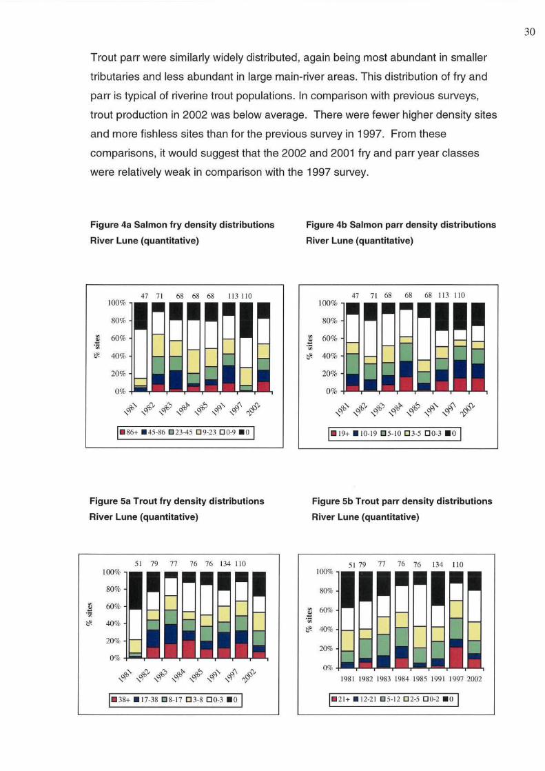
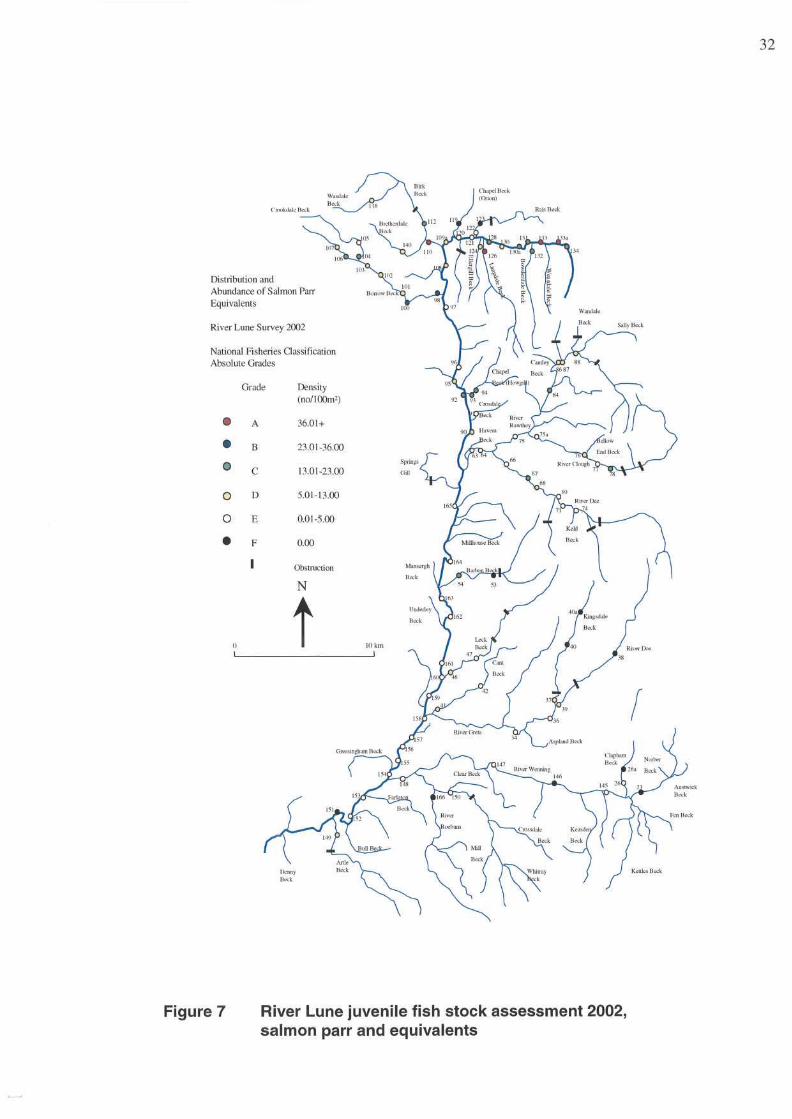
A total of ninety-four sites were electrofished on the main River Lune and its
tributaries. Seventy-four of these sites had been sampled in the last survey in 1997.
More main river sites were surveyed in 2002 than in 1997. A total of eight species
were recorded with salmon and trout the most abundant in the survey. The results
are shown in terms of salmon and trout parr equivalents (the number of fry caught
are converted into parr and then added to the parr catch).
Salmon fry production in the 2002 survey was relatively high when compared to
1997 which returned the lowest figures since 1981. Salmon fry were found
throughout accessible areas of the catchment at relatively high densities. Areas of
particularly high salmon fry production included Birk Beck, the upper Lune above
Tebay, Chapel (Howgill) Beck and 'Site 67' on the River Dee. This suggests that the
2002-year class is relatively strong, and the returns of grilse in 2005 and two sea-
winter salmon in 2006 should reflect this with good numbers of returning salmon.
Salmon parr production was relatively high in 2002, although the proportion of
accessible sites from which parr were absent was still relatively high compared to
previous surveys. However, the proportions of higher densities recorded in 2002
were very similar to the previous best results for salmon parr, recorded in the 1984
and 1997. This shows that the 2001-year class is the most abundant year class
reported for the last seven surveys. The most productive areas in the Lune
catchment are Borrow Beck, Chapel (Howgill) Beck, the upper rivers Rawthey and
Clough and the upper main river Lune above Tebay. Most of the Wenning system
and River Dee are unproductive for parr.
Trout fry were found throughout the catchment, although densities were below
average in comparison with previous surveys. Fry densities were typically highest in
the smaller tributaries and in the upper reaches of larger streams. In contrast larger
streams, including the main River Lune, tended to support only very low (if not
absent) densities of trout fry. The most productive areas are the upper main river
Lune above Tebay, and the upper reaches of the Rawthey catchment. In contrast
the river Wenning and Leek Beck have very low densities of trout fry.
29
30
Trout parr were similarly widely distributed, again being most abundant in smaller
tributaries and less abundant in large main-river areas. This distribution of fry and
parr is typical of riverine trout populations. In comparison with previous surveys,
trout production in 2002 was below average. There were fewer higher density sites
and more fishless sites than for the previous survey in 1997. From these
comparisons, it would suggest that the 2002 and 2001 fry and parr year classes
were relatively weak in comparison with the 1997 survey.
Figure 4a Salmon fry density distributions
River Lune (quantitative)
Figure 4b Salmon parr density distributions
River Lune (quantitative)
Figure 5a Trout fry density distributions
River Lune (quantitative)
Figure 5b Trout parr density distributions
River Lune (quantitative)
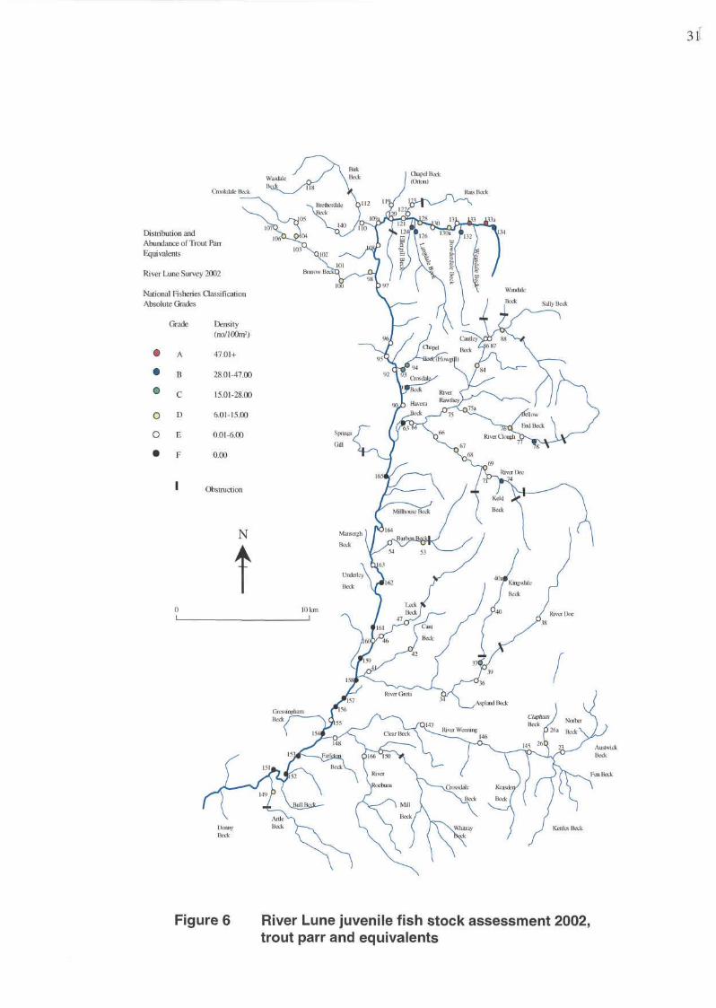
Figure 6 River Lune juvenile fish stock assessment 2002, trout parr and equivalents
31
32
Figure 7 River Lune juvenile fish stock assessment 2002, salmon parr and equivalents
Hatchery work- Rivers Lune and Hodder
The Agency has supported the Hodder Trust and the Lune Hatchery Group during
2002 in the form of technical assistance, expertise, use of Agency facilities and staff
time. Both groups are rearing Salmon from the Hodder and Lune to autumn parr and
pre-smolt stages. During 2002 a more advanced Canadian incubation system was
introduced, which ensures alevins (first stage after egg hatching) emerge at 50f.
This means it is much easier to determine when first feeding is likely to start.
A number of smolt release ponds were created and these have proved successful in
acclimatising young salmon to the local water conditions prior to release into the
wild: another step forward for salmon rearing in the North-West.
Micro tagging was carried out in the region to monitor the effectiveness of the
'Hodder Propagation Scheme'. Considerable effort was needed, initially, in order to
assemble the equipment and to ensure the kit was in working order. Seven
thousand salmon smolts of differing sizes (ideally 4-6") were micro-tagged from
Dunsop Fish Farm in February 2003 and released into the River Hodder. The aim
of annual microtagging is to gain information on the marine and freshwater survival
of the hatchery reared fish over a number of years. It is likely that we will tag further
batches over the next 2 years. We hope to report the success of the 'rotary screw
smolt trap' in next year's report.
33
34
SOUTH AREA
Annual Report for 2002
TEAM REPORTS
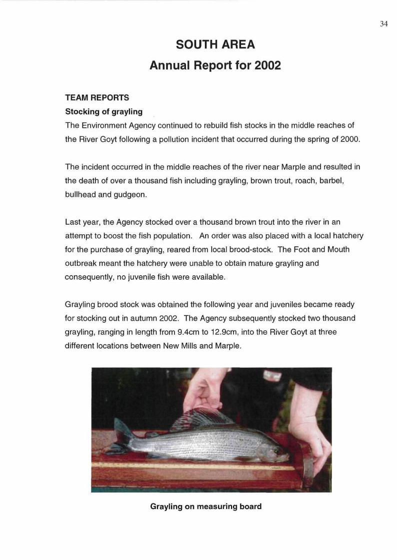
Stocking of grayling
The Environment Agency continued to rebuild fish stocks in the middle reaches of
the River Goyt following a pollution incident that occurred during the spring of 2000.
The incident occurred in the middle reaches of the river near Marple and resulted in
the death of over a thousand fish including grayling, brown trout, roach, barbel,
bullhead and gudgeon.
Last year, the Agency stocked over a thousand brown trout into the river in an
attempt to boost the fish population. An order was also placed with a local hatchery
for the purchase of grayling, reared from local brood-stock. The Foot and Mouth
outbreak meant the hatchery were unable to obtain mature grayling and
consequently, no juvenile fish were available.
Grayling brood stock was obtained the following year and juveniles became ready
for stocking out in autumn 2002. The Agency subsequently stocked two thousand
grayling, ranging in length from 9.4cm to 12.9cm, into the River Goyt at three
different locations between New Mills and Marple.
Grayling on measuring board
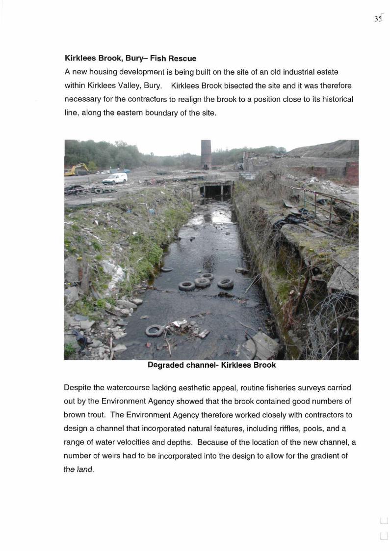
Kirklees Brook, Bury- Fish Rescue
A new housing development is being built on the site of an old industrial estate
within Kirklees Valley, Bury. Kirklees Brook bisected the site and it was therefore
necessary for the contractors to realign the brook to a position close to its historical
line, along the eastern boundary of the site.
Degraded channel- Kirklees Brook
Despite the watercourse lacking aesthetic appeal, routine fisheries surveys carried
out by the Environment Agency showed that the brook contained good numbers of
brown trout. The Environment Agency therefore worked closely with contractors to
design a channel that incorporated natural features, including riffles, pools, and a
range of water velocities and depths. Because of the location of the new channel, a
number of weirs had to be incorporated into the design to allow for the gradient of
the land.
35
36
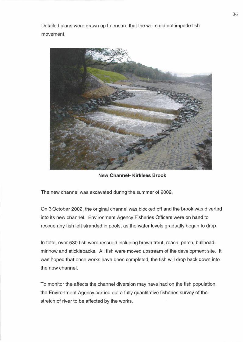
Detailed plans were drawn up to ensure that the weirs did not impede fish
movement.
New Channel- Kirklees Brook
The new channel was excavated during the summer of 2002.
On 3 October 2002, the original channel was blocked off and the brook was diverted
into its new channel. Environment Agency Fisheries Officers were on hand to
rescue any fish left stranded in pools, as the water levels gradually began to drop.
In total, over 530 fish were rescued including brown trout, roach, perch, bullhead,
minnow and sticklebacks. All fish were moved upstream of the development site. It
was hoped that once works have been completed, the fish will drop back down into
the new channel.
To monitor the affects the channel diversion may have had on the fish population,
the Environment Agency carried out a fully quantitative fisheries survey of the
stretch of river to be affected by the works.
This survey was carried out in September 2002, prior to any works taking place. A
similar survey will be carried out at the same time next year in the new channel. A
comparison of the fisheries results pre and post river diversion will then be made.
Results will be used to assist with future management and design issues.
The Bollin/Dean Fisheries Action Plan
The Fisheries Action Plan for the River Bollin and River Dean continued to make
progress throughout 2002. Funding was secured for two projects, which are now
nearing completion, and the results of an angler census carried out by Liverpool
University student, Spencer Kite, were presented to FAP group members.
The Agency commissioned APEM Ltd. to undertake a walkover survey of salmonid
(brown/sea trout and salmon) habitat on the Upper and Middle reaches of the River
Bollin and the River Dean. The results will provide baseline information relating to
the extent and status of salmonid habitat within selected reaches. Much of this
information will also be relevant to coarse fish.
Data will be mapped onto a geographical information system (GIS) which can be
updated or modified as our knowledge of the catchment grows. The sort of
information that has been collected so far includes spawning, fry and parr habitat
availability, obstacles to fish movement, channel characteristics and macrophyte
cover. An extensive library of site specific photographs, linked to the GIS system,
will supplement the physical data.
The use of GIS allows large amounts of information to be stored electronically as
layers that can be superimposed onto base maps. Each layer can be viewed
individually or combined e.g. you could look at the availability of salmonid spawning
habitat in relation to the extent of bank erosion or macrophyte cover. A rapid visual
assessment of the catchment or specific sites can therefore be made and potential
problems identified and investigated further.
Once the project has been received from the contractors, information held by the
Agency will be added to provide a comprehensive representation of the catchment.
37
38
It should then be possible to consider the distribution of fish in relation to water
quality, obstructions and other habitat features.
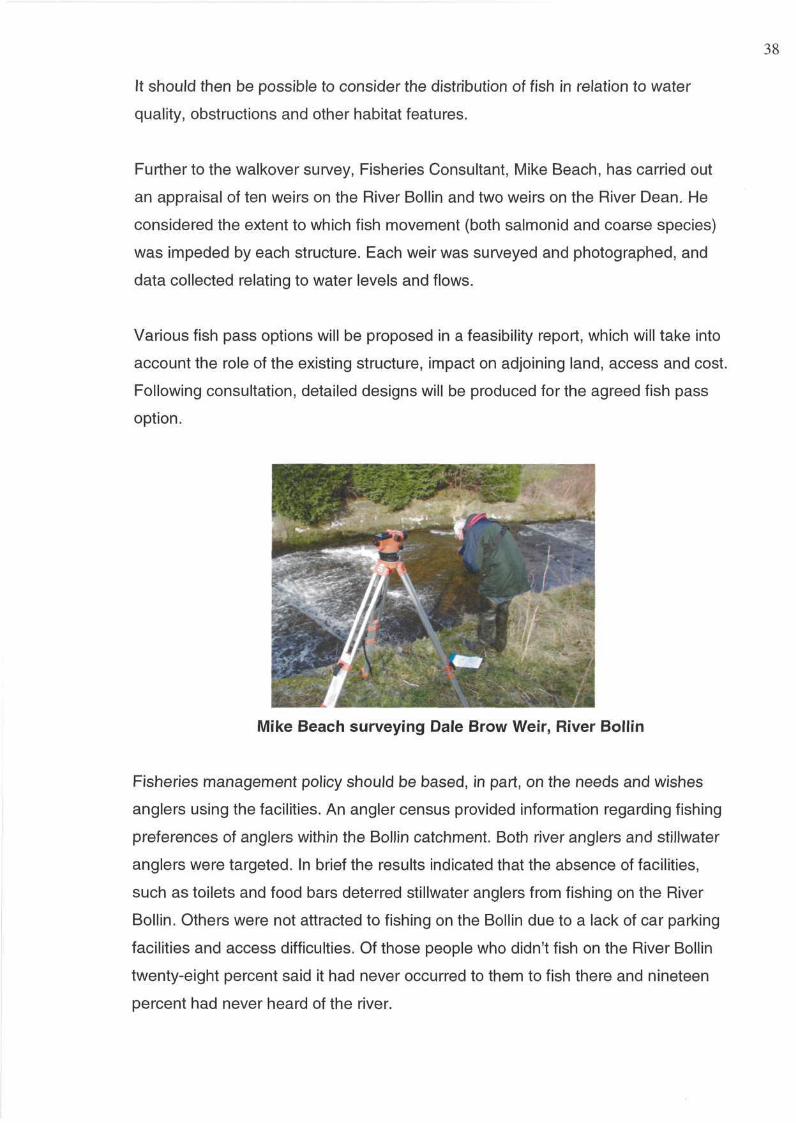
Further to the walkover survey, Fisheries Consultant, Mike Beach, has carried out
an appraisal of ten weirs on the River Bollin and two weirs on the River Dean. He
considered the extent to which fish movement (both salmonid and coarse species)
was impeded by each structure. Each weir was surveyed and photographed, and
data collected relating to water levels and flows.
Various fish pass options will be proposed in a feasibility report, which will take into
account the role of the existing structure, impact on adjoining land, access and cost.
Following consultation, detailed designs will be produced for the agreed fish pass
option.
Mike Beach surveying Dale Brow Weir, River Bollin
Fisheries management policy should be based, in part, on the needs and wishes
anglers using the facilities. An angler census provided information regarding fishing
preferences of anglers within the Bollin catchment. Both river anglers and Stillwater
anglers were targeted. In brief the results indicated that the absence of facilities,
such as toilets and food bars deterred Stillwater anglers from fishing on the River
Bollin. Others were not attracted to fishing on the Bollin due to a lack of car parking
facilities and access difficulties. Of those people who didn't fish on the River Bollin
twenty-eight percent said it had never occurred to them to fish there and nineteen
percent had never heard of the river.
This information will help the FAP group focus on the development and promotion of
the Bollin as a high quality fishery.
SURVEY REPORTS
The Return of Salmon to the River Mersey
The River Mersey was once a prolific fishery with records dating back to the Twelfth
and Fourteenth Century recalling its importance to the local economy. In the
Seventeenth and Eighteenth Century salmon (Salmo salarL.) and trout (Salmo
trutta L) were so numerous that they supplied markets as far away as London, along
with smelt (Osmerus eperlanus), sturgeon (Acipenser sp.), eels (Anguilla anguilla)
and lamprey (Lampetra sp.). By the early Nineteenth Century salmon were still
abundant and were sold locally for as little as two pence per pound. However as a
consequence of the 'Industrial Revolution', increased urbanisation and major
changes in land drainage, water quality in the Mersey declined and with it its fishery.
By the mid-Twentirth Century the Mersey had the reputation of being one of the
most polluted rivers in Europe and practically fish-less.
Within the past twenty years, however, considerable efforts have been made by the
Environment Agency and its predecessors, United Utilities, local industries and the
Mersey Basin Campaign to improve water quality within the Mersey catchment. As a
result of these efforts the River Mersey won the accolade of 'Best River Clean-Up' in
1999 at the 'World River Restoration Conference' in Brisbane, Australia..
It had been suspected for some time that migratory salmonids were returning to the
Mersey catchment. Local anglers had reported catching sea trout (Salmo trutta trutta
L) in the Warrington stretch of the River Mersey. Video footage taken by
Environment Agency Fisheries Officer, Katherine Causer in 1999 and 2000 showed
large salmonid fish attempting to negotiate the weir at Heatley on the River Bollin.
Attempts to catch these fish failed due to difficult river conditions.
In order to confirm their identity it was absolutely necessary to capture these fish.
With the help and co-operation of the Manchester Ship Canal Company the fish
pass at Woolston Weir was modified to enable fish to be trapped.
In November 2001 the trap was set and for the first time in half a century salmon
were caught in the River Mersey. Results of the scale analysis (Table 1) showed
39
that two of these fish were grilse having spent two years in freshwater and one year
at sea before returning to spawn. The other fish had only spent one year in
freshwater before migrating to sea where it had spent two years. These multi-sea
winter fish are not often seen these days and usually run in the spring giving rise to
the term 'spring salmon'.
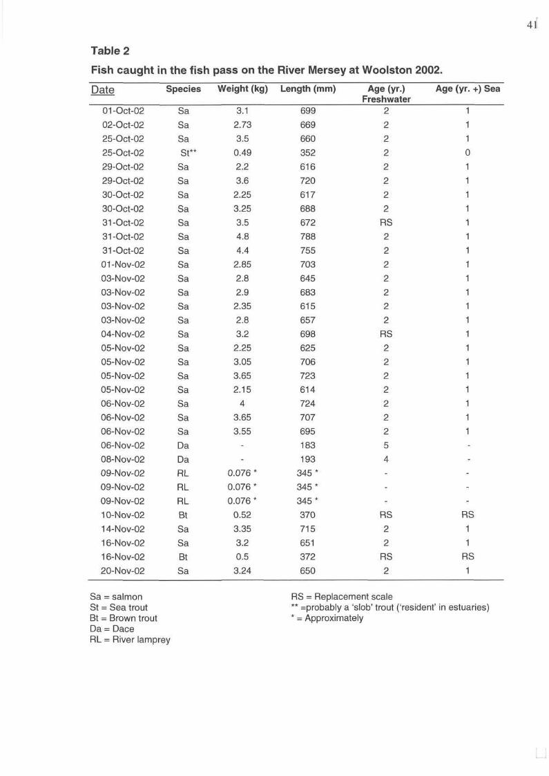
In September 2002, with reports from local anglers of sea trout being caught in the
Mersey at Warrington, it was decided to re-instate the trap at Woolston. On 1
October Fisheries Officers were delighted to catch their first salmon of 2002.
By the 22 November, twenty-six salmon ranging in size from 61cm to 79cm and
weighing from two to five kilos had been caught (Table 2). Other species captured
included sea trout, brown trout (Salmo trutta fario L.), dace (Leuciscus leuciscus)
and river lamprey {Lampetra fluviatilis L) (see Table 2).
Analysis showed that the salmon were all grilse (fish returning within one year of
migrating to the sea) (Table 2). It is possible that these fish were heading for the
River Dee and had somehow lost their bearings but we cannot completely rule out
that that they may have been 'Mersey fish'. Further research is planned for next year
when Ecological Appraisal Officers intend to radio track returning fish.
Results of this year's trapping have surpassed all of our expectations and are
evidence of the major improvements in water quality that have been achieved. We
can now see the fruits of our labour with salmon once again returning to the Mersey.
Table 1
Fish caught in the fish pass on the River Mersey at Woolston 2001.
40
41
Measuring a salmon/taking fish scales for age analysis
PROJECTS
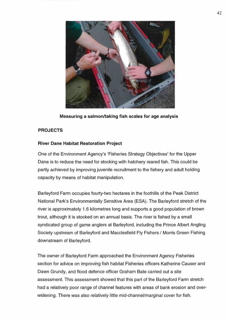
River Dane Habitat Restoration Project
One of the Environment Agency's 'Fisheries Strategy Objectives' for the Upper
Dane is to reduce the need for stocking with hatchery reared fish. This could be
partly achieved by improving juvenile recruitment to the fishery and adult holding
capacity by means of habitat manipulation.
Barleyford Farm occupies fourty-two hectares in the foothills of the Peak District
National Park's Environmentally Sensitive Area (ESA). The Barleyford stretch of the
river is approximately 1.6 kilometres long and supports a good population of brown
trout, although it is stocked on an annual basis. The river is fished by a small
syndicated group of game anglers at Barleyford, including the Prince Albert Angling
Society upstream of Barleyford and Macclesfield Fly Fishers/ Morris Green Fishing
downstream of Barleyford.
The owner of Barleyford Farm approached the Environment Agency Fisheries
section for advice on improving fish habitat Fisheries officers Katherine Causer and
Dawn Grundy, and flood defence officer Graham Bate carried out a site
assessment. This assessment showed that this part of the Barleyford Farm stretch
had a relatively poor range of channel features with areas of bank erosion and over-
widening. There was also relatively little mid-channel/marginal cover for fish.
42
Following consultation with the landowner, a programme of habitat enhancement
was planned for late summer 2002 and spring 2003. Funding was provided by the
Environment Agency, DEFRA and the landowner. The aim was to increase the
variety of fish habitat. This would be achieved by:
• boulder placement within the channel;
• selective coppicing of bank-side trees;
• placement of fencing in the most erosion prone sections; and
• minor repairs to be carried out to the poached banks by in filling with cobbles
deposited as shoal material.
Coppicing of trees should promote root growth making them less prone to being up
rooted during floods and allow an under-storey of grasses and herbaceous plants to
develop, further reducing erosion and improving the diversity of riparian habitats.
Prior to any work taking place an assessment of fish stocks in the location of
Barleyford was made. Two species of fish were caught, brown trout (Salmo trutta)
and bullhead (Cottus gobio). The sampled brown trout were aged between one plus
and three plus years and showed regular growth.
At the site with limited channel/bank habitat diversity the brown trout density was
estimated to be 3.3 fish per 100 square metres (± 0.5). At the upstream control the
brown trout density was estimated to be 1.4 fish per 100 square metres (± 0.3).
However, the upstream control had a greater weight of fish per given area, (despite
having a lower density of fish) with 379.6 grams per 100 square metres (± 78.2)
compared to 330.3 grams per 100 square metres (± 52.4) at the habitat restoration
site. This is a reflection of the larger sizes of fish caught at the upstream control site.
The results from the fisheries surveys were also used to classify using the National
Fisheries Classification Scheme (NFCS). The density of brown trout (>0+), in
stretches of the River Dane at Barleyford were classified as 'fair' using this scheme.
The Barleyford stretch was also classified as fair when compared to sites of similar
width and gradient in the NFCS database.
43
Data from the fishery surveys has provided baseline information against which
future results can be compared.. The fishery survey results indicated that there was
scope for improvement, especially with regard to larger fish, often highly prized by
anglers. It is hoped that the habitat improvements will provide a more varied and
favourable environment for fish. In order to ascertain the success of this project,
further monitoring will be carried out during the summer of 2003.
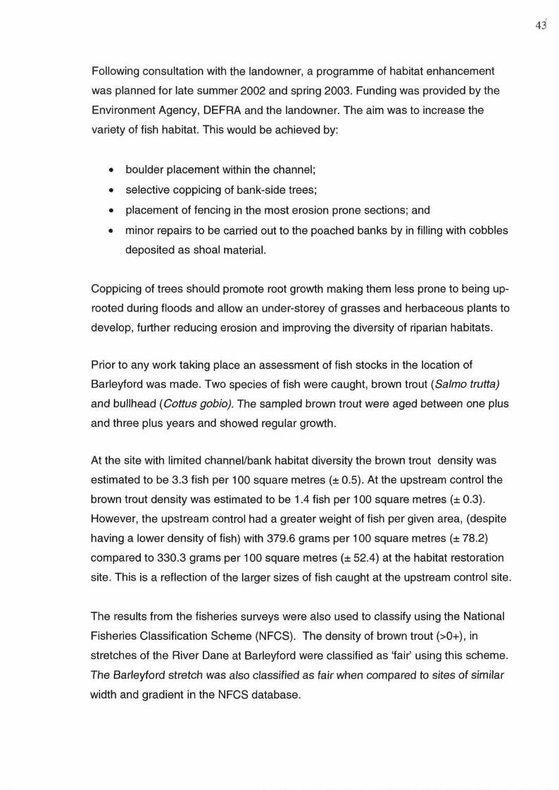
Habitat Restoration site before boulder placement
44
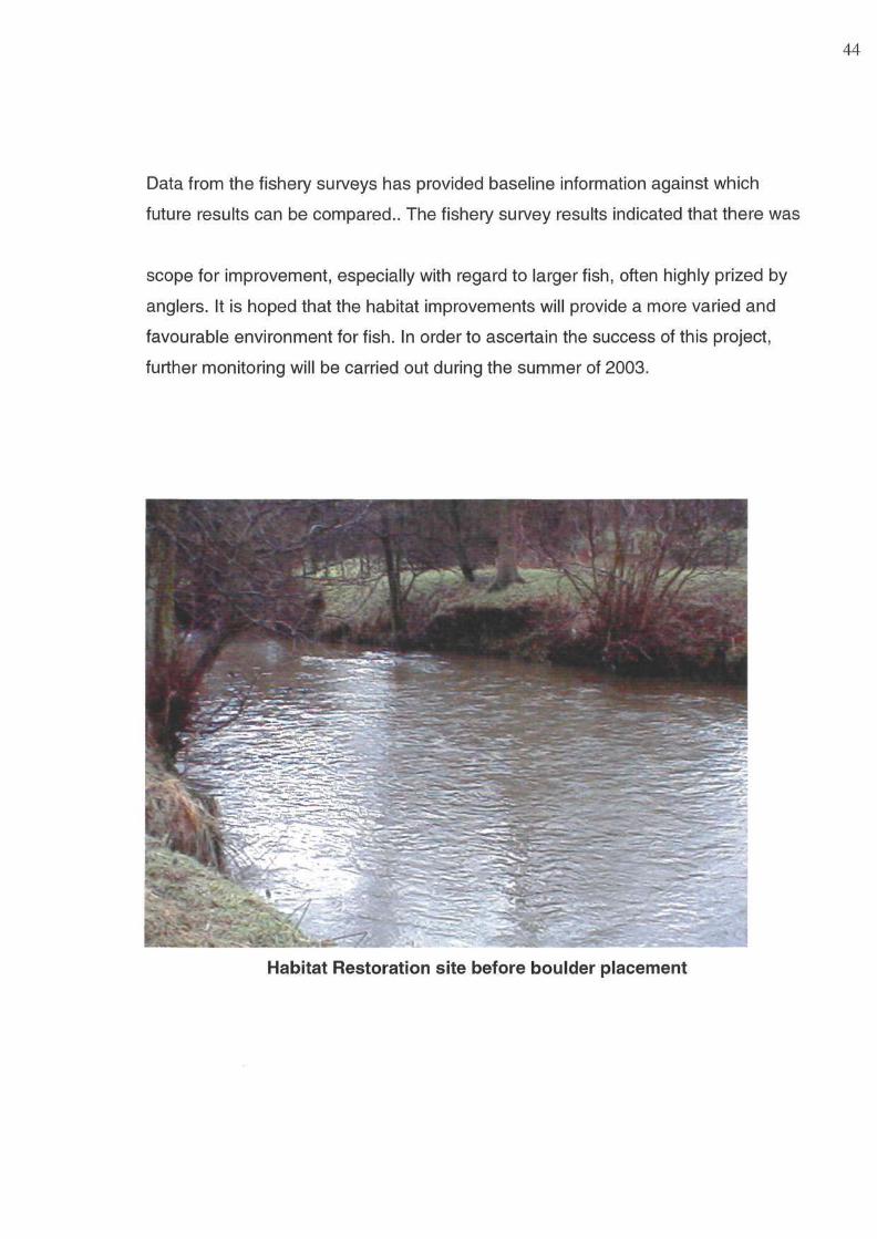
Habitat Restoration site after boulder placement
A new angling facility in Warrington - Stanners Pool
A new angling facility, known as Stanners Pool, has been created near Sankey
Brook, Dallam, as mitigation for the loss of nearby Shakeys Pit. Funding for the
project came from Henry Boot, contractors and the Environment Agency who
worked in partnership with Warrington Borough Council and the local rangers. A
new angling club, 'Dallam and District Community Angling Group', will help manage
the day ticket water, with advice from the Council.
The Environment Agency Fisheries section advised on the design of the pond and
ensured that features were of maximum benefit to fish, invertebrates (fish food) and
anglers were incorporated. A variety of habitats were created during excavation,
including marginal shelves for plants, deep areas of water for shelter and shallower
areas that warm up quickly and are ideal spawning and feeding sites. Excavation
of the pond took place in autumn 2001.
45
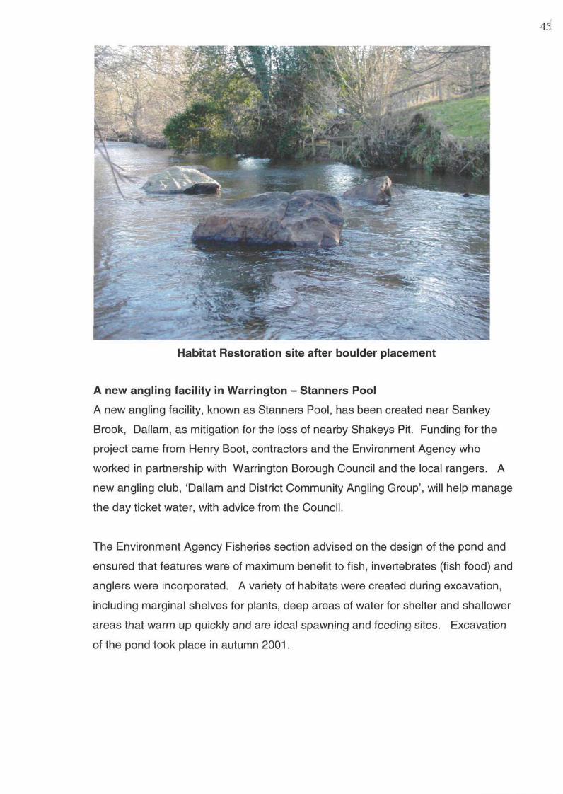
Excavation of Stanner's Pool
Spoil from the site was used to landscape the area whilst a small marsh at the
northern end of the pool was excavated to improve habitat diversity.
Angling platforms, including those for disabled anglers and 'family' pegs were then
erected and access routes were also constructed. In May 2002, a planting day,
organised by Sankey Valley Rangers, took place. A variety of floating, emergent
and submerged plants were chosen, together with marginal plants for the waters-
edge. All the plants have started to grow and should be well established by mid-
2003.
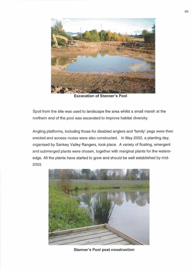
Stanner's Pool post construction
46

Educational interpretation boards have been erected adjacent to the footpaths,
showing pictures and giving brief descriptions of species likely to be encountered in
and around the pond.
In December 2002, the water was stocked by the Agency with approximately three
thousand mixed coarse fish including bream, roach and perch. A few specimen
bream were included together with some large perch (over 1lb in weight).
47
48
APPENDIX
DECLARED MIGRATORY SALMONID CATCHES 2002
Salmon rod catches in NW Region, 2002
Sea trout rod catches in NW Region, 2002
49
DECLARED ROD AND LINE CATCHES (FROM LICENCE RETURNS) 1982-2002
Regional trends- total declared catch 1982-2002 (dashed line indicates ten year average)
50
DECLARED SALMON ROD CATCHES 1982-2002 AND TEN YEAR AVERAGE
DECLARED SALMON ROD CATCHES 1982-2002 AND TEN YEAR AVERAGE 51
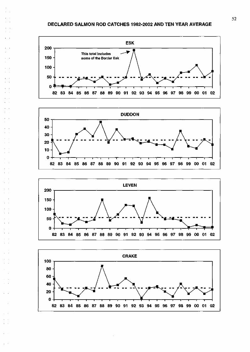
52 DECLARED SALMON ROD CATCHES 1982-2002 AND TEN YEAR AVERAGE
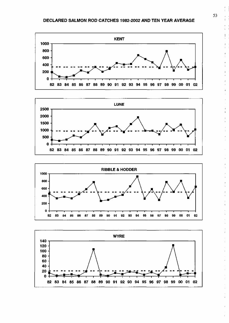
53 DECLARED SALMON ROD CATCHES 1982-2002 AND TEN YEAR AVERAGE
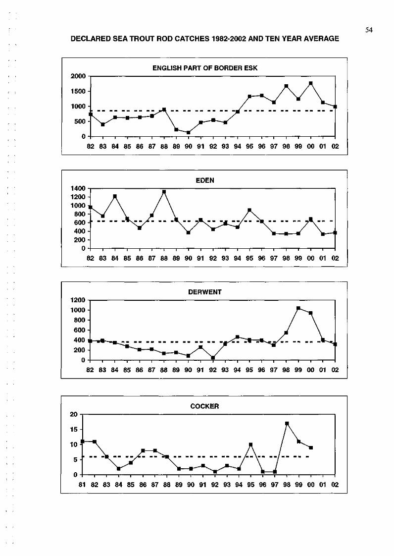
54 DECLARED SEA TROUT ROD CATCHES 1982-2002 AND TEN YEAR AVERAGE
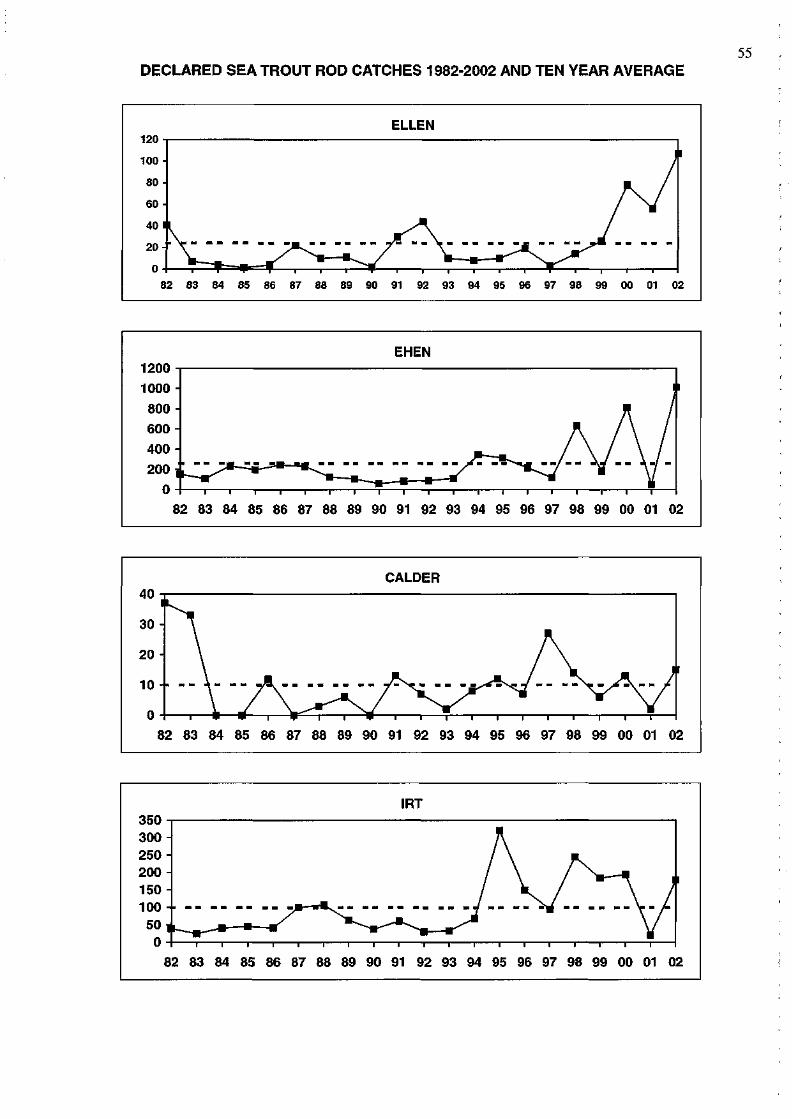
DECLARED SEA TROUT ROD CATCHES 1982-2002 AND TEN YEAR AVERAGE 55
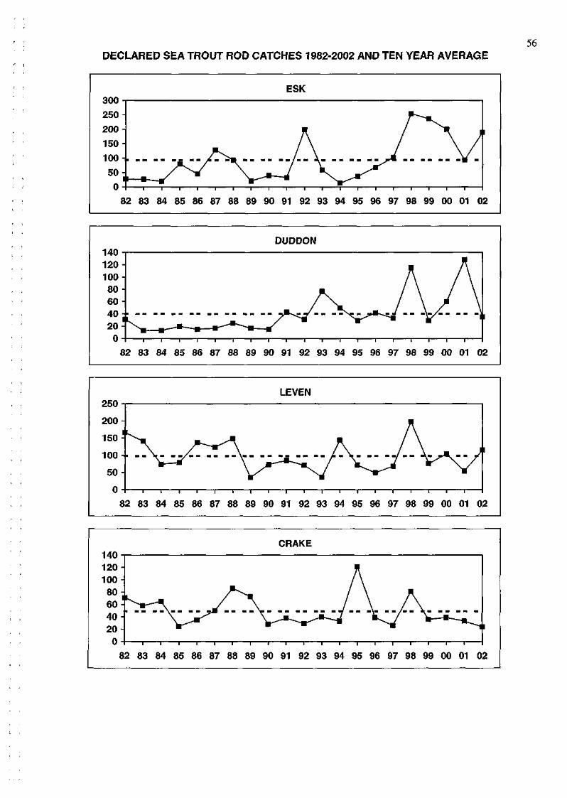
56 DECLARED SEA TROUT ROD CATCHES 1982-2002 AND TEN YEAR AVERAGE
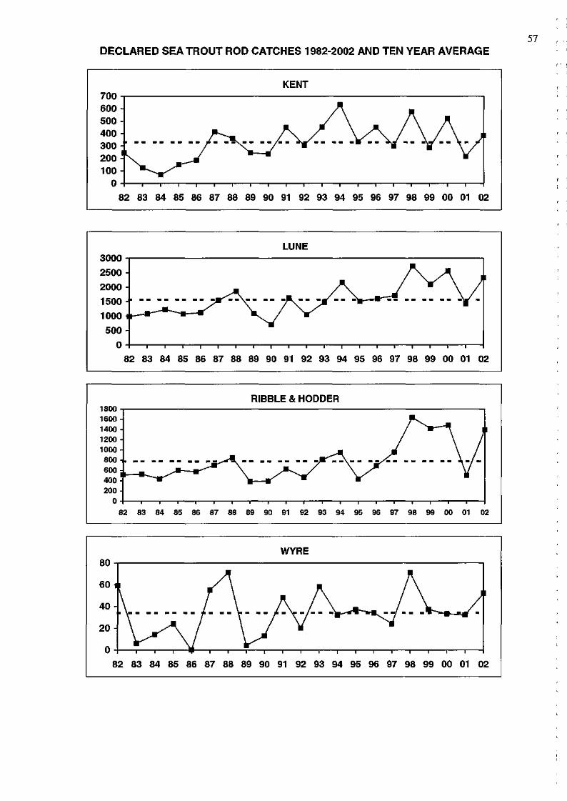
DECLARED SEA TROUT ROD CATCHES 1982-2002 AND TEN YEAR AVERAGE 57
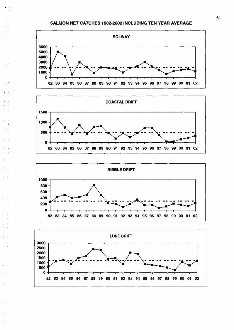
58 SALMON NET CATCHES 1982-2002 INCLUDING TEN YEAR AVERAGE
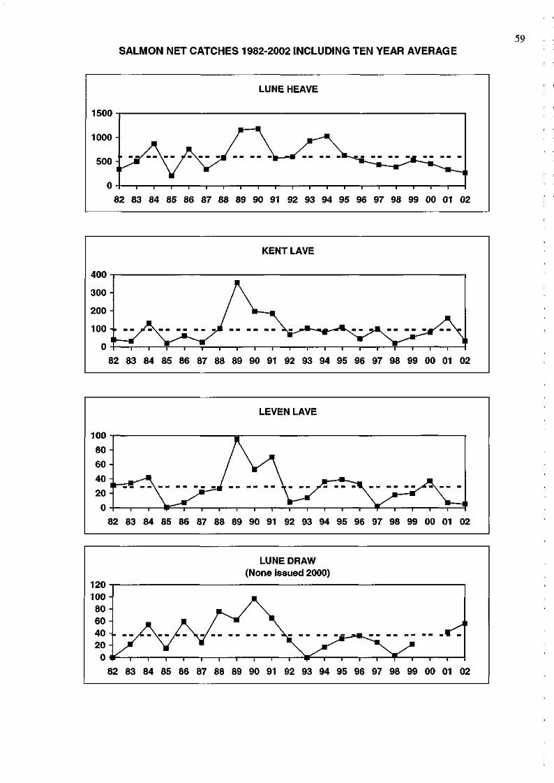
SALMON NET CATCHES 1982-2002 INCLUDING TEN YEAR AVERAGE 59
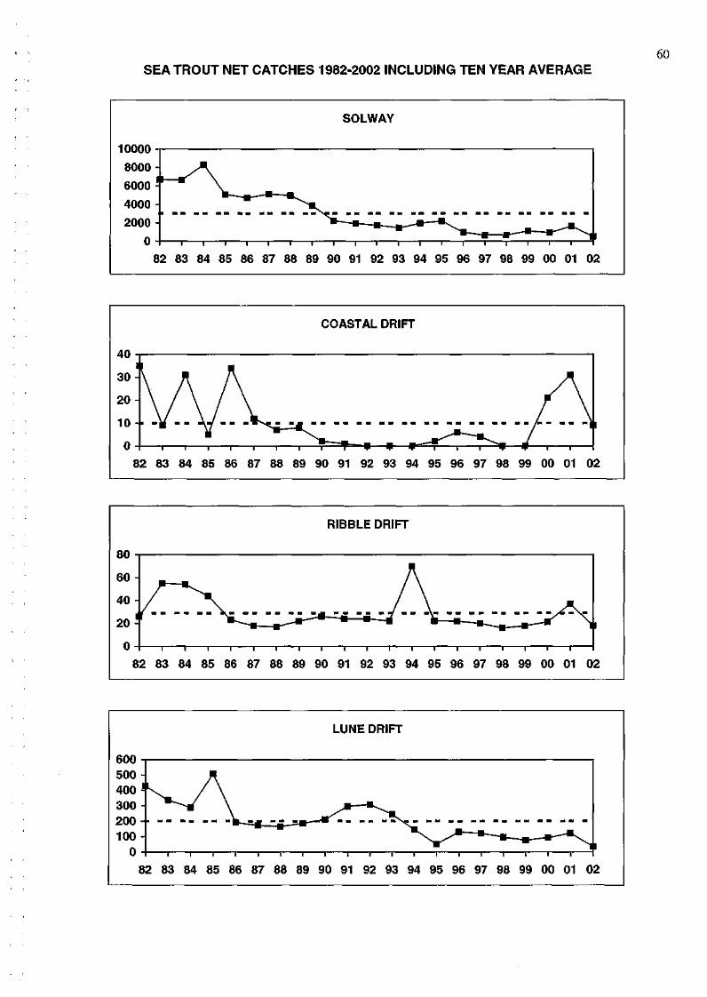
60 SEA TROUT NET CATCHES 1982-2002 INCLUDING TEN YEAR AVERAGE
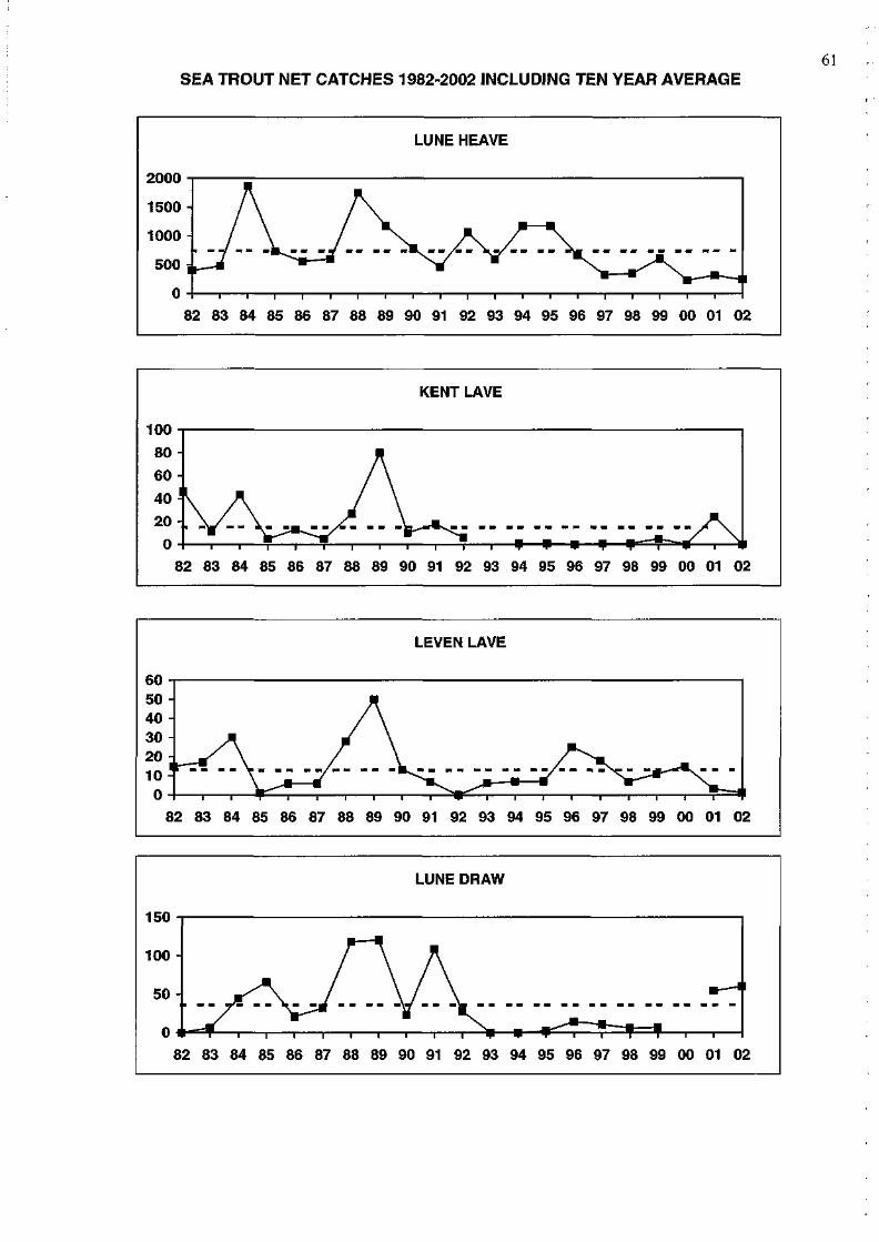
61 SEA TROUT NET CATCHES 1982-2002 INCLUDING TEN YEAR AVERAGE
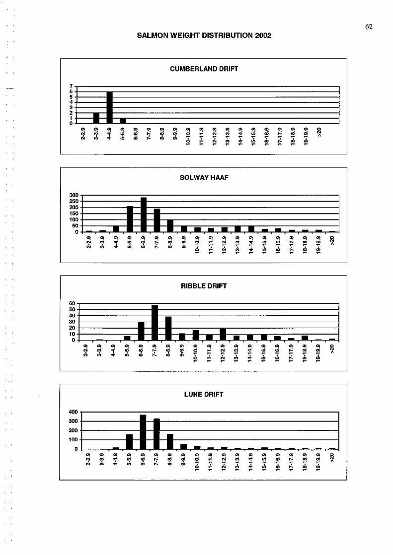
62 SALMON WEIGHT DISTRIBUTION 2002
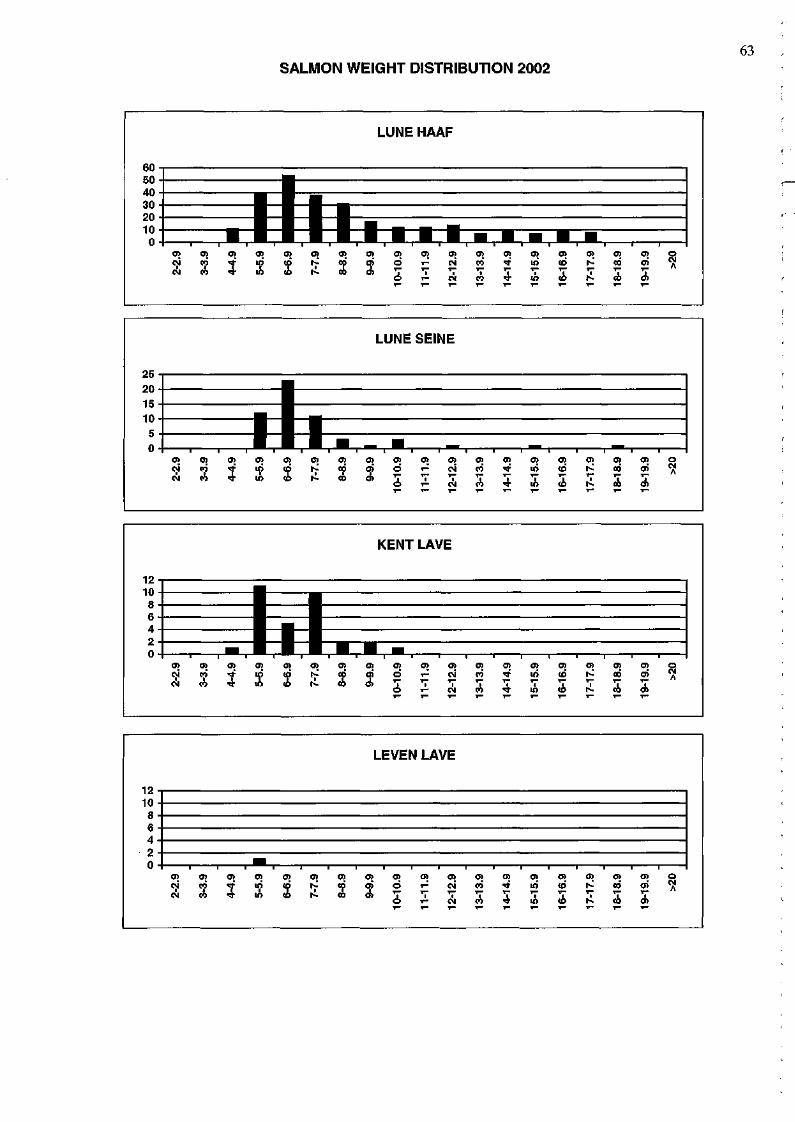
63 SALMON WEIGHT DISTRIBUTION 2002
64
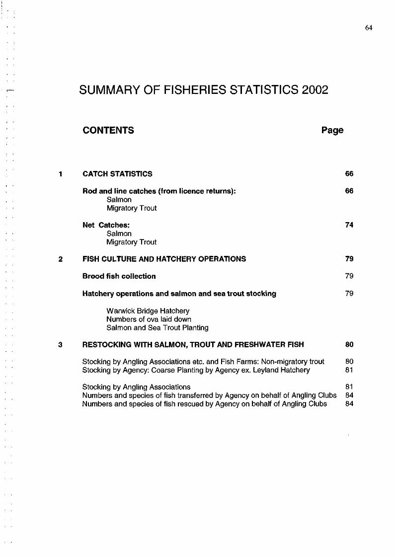
SUMMARY OF FISHERIES STATISTICS 2002
CONTENTS Page
1 CATCH STATISTICS 66
Rod and line catches (from licence returns): 66 Salmon Migratory Trout
Net Catches: 74 Salmon Migratory Trout
2 FISH CULTURE AND HATCHERY OPERATIONS 79
Brood fish collection 79
Hatchery operations and salmon and sea trout stocking 79
Warwick Bridge Hatchery Numbers of ova laid down Salmon and Sea Trout Planting
3 RESTOCKING WITH SALMON, TROUT AND FRESHWATER FISH 80
Stocking by Angling Associations etc. and Fish Farms: Non-migratory trout 80 Stocking by Agency: Coarse Planting by Agency ex. Leyland Hatchery 81
Stocking by Angling Associations 81 Numbers and species of fish transferred by Agency on behalf of Angling Clubs 84 Numbers and species of fish rescued by Agency on behalf of Angling Clubs 84
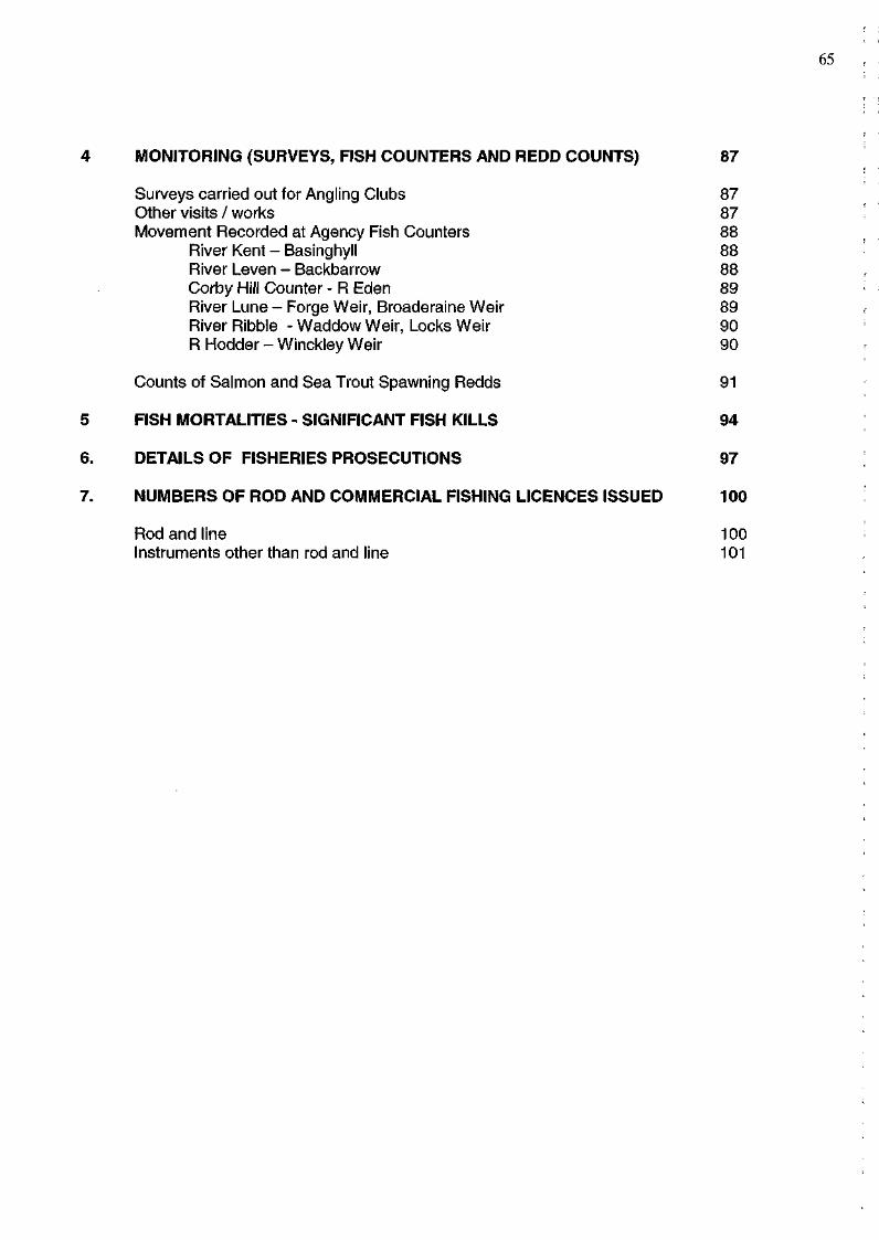
4 MONITORING (SURVEYS, FISH COUNTERS AND REDD COUNTS) 87
Surveys carried out for Angling Clubs 87 Other visits / works 87 Movement Recorded at Agency Fish Counters 88
River Kent - Basinghyll 88 River Leven - Backbarrow 88 Corby Hill Counter - R Eden 89 River Lune - Forge Weir, Broaderaine Weir 89 River Ribble - Waddow Weir, Locks Weir 90 R Hodder - Winckley Weir 90
Counts of Salmon and Sea Trout Spawning Redds 91
5 FISH MORTALITIES - SIGNIFICANT FISH KILLS 94
6. DETAILS OF FISHERIES PROSECUTIONS 97
7. NUMBERS OF ROD AND COMMERCIAL FISHING LICENCES ISSUED 100
Rod and line Instruments other than rod and line
100 101
65
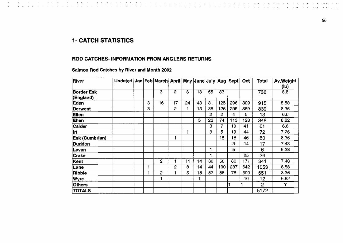
1-CATCH STATISTICS
ROD CATCHES- INFORMATION FROM ANGLERS RETURNS
Salmon Rod Catches by River and Month 2002
66
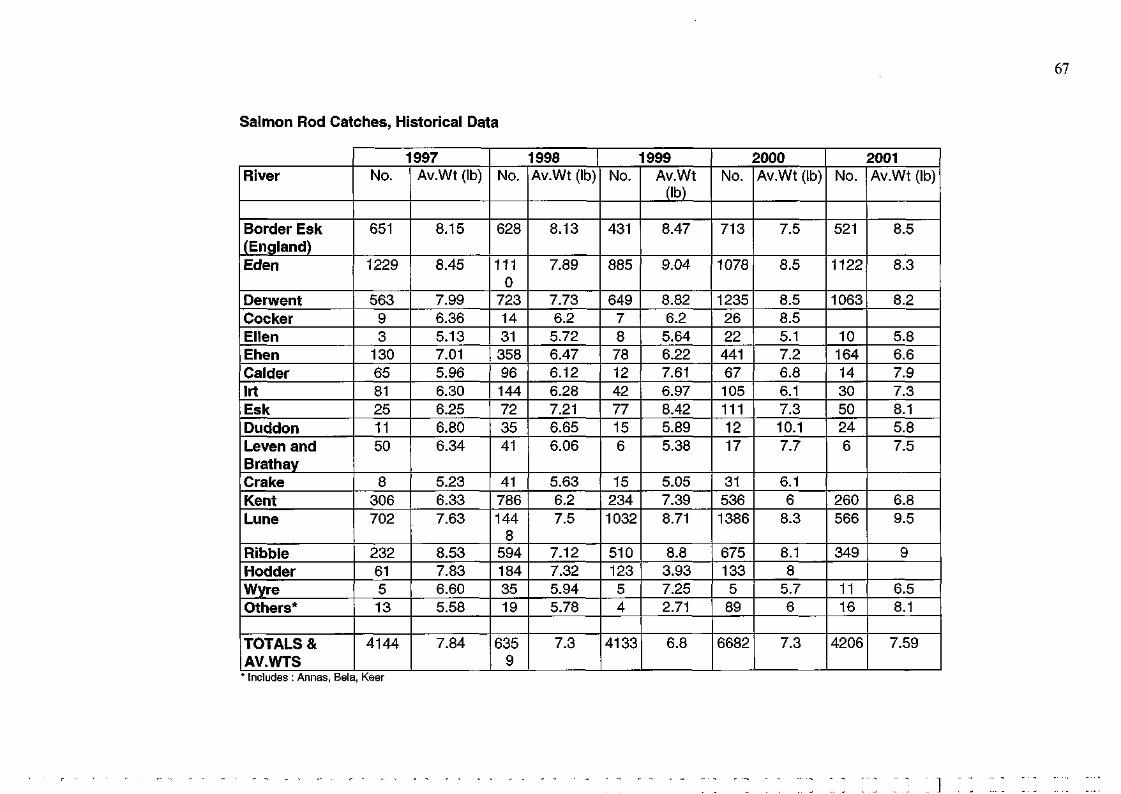
Salmon Rod Catches, Historical Data
67
68
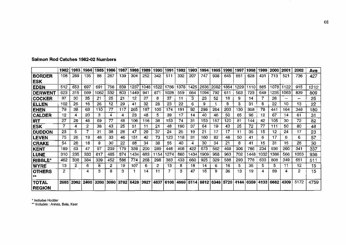
Salmon Rod Catches 1982-02 Numbers
* Includes Hodder ** Includes : Annas, Bela, Keer
* Includes Hodder ** Includes : Annas, Bela, Keer
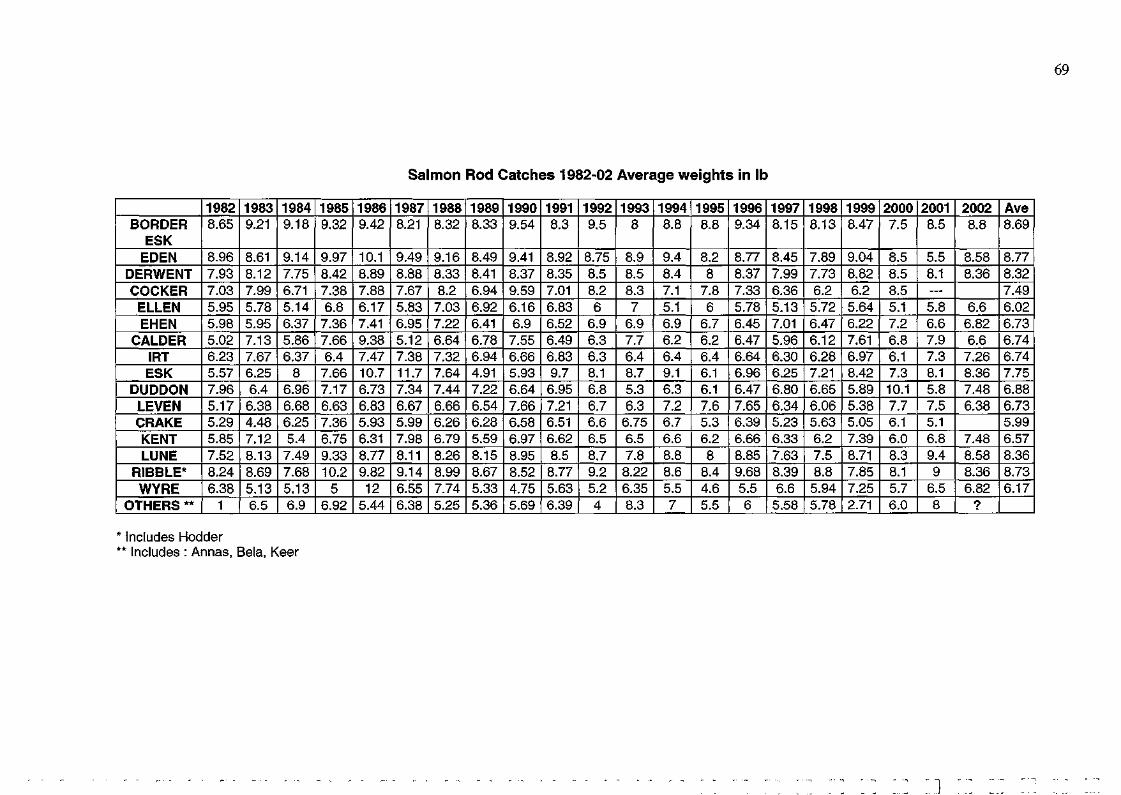
Salmon Rod Catches 1982-02 Average weights in lb
69
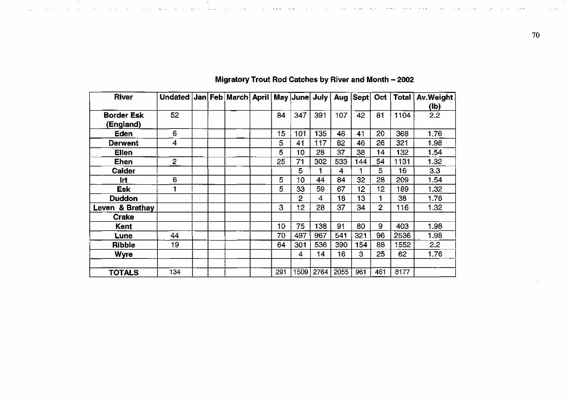
Migratory Trout Rod Catches by River and Month - 2002
70
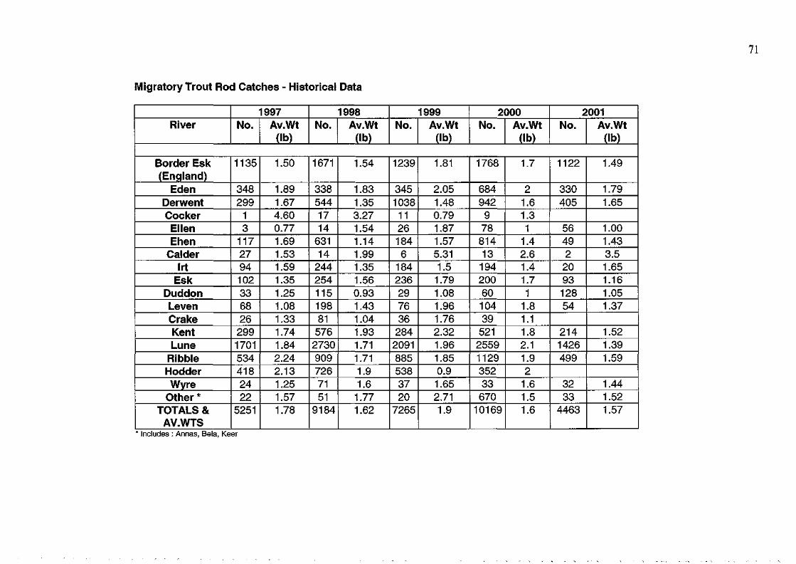
Migratory Trout Rod Catches - Historical Data
71
Migratory trout rod catches 1982 - 02 Numbers
72
* Includes Hodder ** Includes : Annas, Bela, Keer
73
Migratory trout rod catches 1982 - 02 Average weights in lb
* Includes Hodder * Includes : Annas,
CATCHES BY NETS/FIXED ENGINES
Salmon catches by river/district and month - 2002
* None issued 2002
Net Salmon Catches - Historical Data
* no licences issued
75
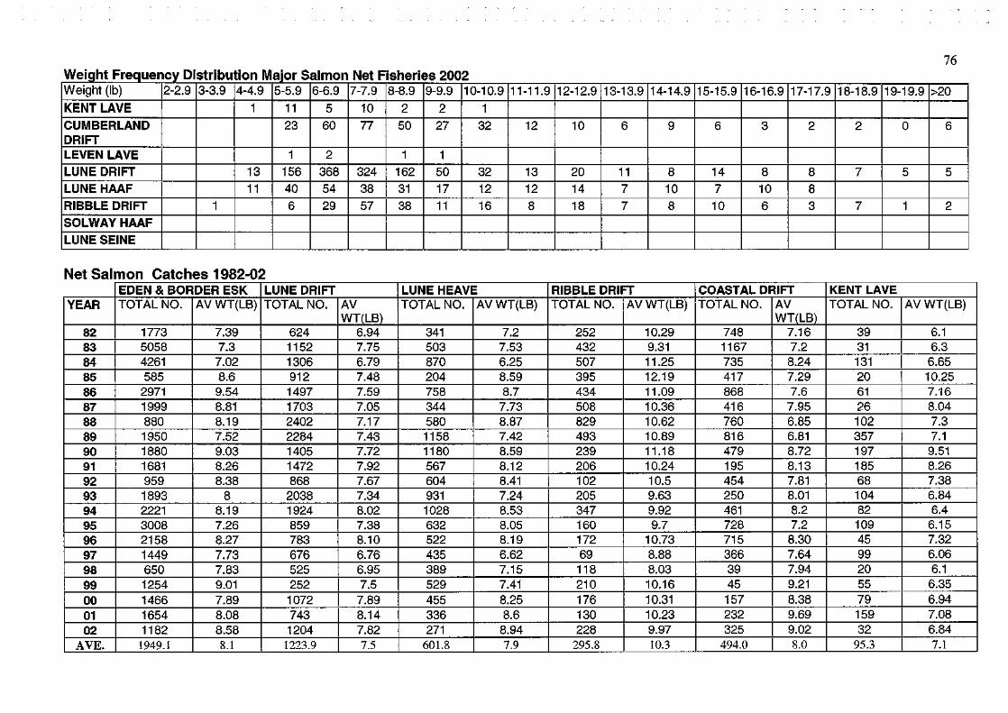
Net Salmon Catches 1982-02
76
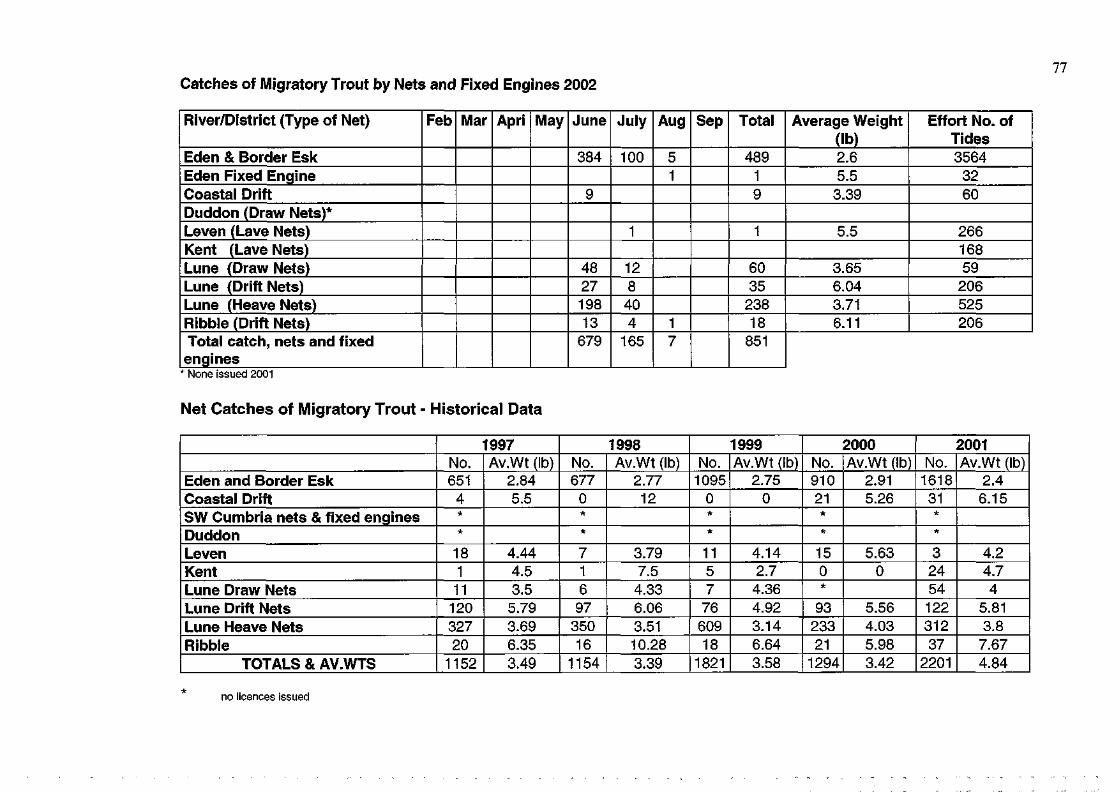
77 Catches of Migratory Trout by Nets and Fixed Engines 2002
River/District (Type of Net)
Eden & Border Esk Eden Fixed Engine Coastal Drift Duddon (Draw Nets)* Leven (Lave Nets) Kent (Lave Nets) Lune (Draw Nets) Lune (Drift Nets) Lune (Heave Nets) Ribble (Drift Nets) Total catch, nets and fixed engines
Feb Mar Apri May June
384
9
48 27 198 13
679
July
100
1
12 8
40 4
165
Aug
5 1
1 7
Sep Total
489 1 9
1
60 35
238 18
851
Average Weight (lb) 2.6 5.5 3.39
5.5
3.65 6.04 3.71 6.11
Effort No. of Tides 3564
32 60
266 168 59
206 525 206
* None issued 2001
Net Catches of Migratory Trout - Historical Data
Eden and Border Esk Coastal Drift SW Cumbria nets & fixed engines Duddon Leven Kent Lune Draw Nets Lune Drift Nets Lune Heave Nets Ribble
TOTALS & AV.WTS
1997 No. 651 4 * *
18 1 11
120 327 20
1152
Av.Wt (lb) 2.84 5.5
4.44 4.5 3.5 5.79 3.69 6.35 3.49
1998 No. 677
0 * * 7 1 6 97
350 16
1154
Av.Wt (lb) 2.77 12
3.79 7.5
4.33 6.06 3.51 10.28 3.39
1999 No.
1095 0 * *
11 5 7
76 609 18
1821
Av.Wt (lb) 2.75
0
4.14 2.7 4.36 4.92 3.14 6.64 3.58
2000 No. 910 21 * *
15 0 *
93 233 21
1294
Av.Wt (lb) 2.91 5.26
5.63 0
5.56 4.03 5.98 3.42
2001 No.
1618 31 * * 3
24 54 122 312 37
2201
Av.Wt (lb) 2.4 6.15
4.2 4.7 4
5.81 3.8
7.67 4.84
no licences issued
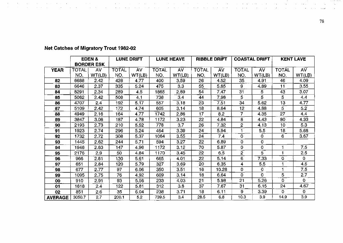
Net Catches of Migratory Trout 1982-02
82 83 84 85 86 87 88 89 90 91 92 93 94 95 96 97 98 99 00 01 02
AVERAGE
6688 6646 8291 5062 4707 5109 4949 3847 2193 1923 1732 1445 1946 2176 966 651 677 1095 910 1618 851 3050.7
2.42 2.37 2.34 2.42 2.4 2.42 2.16 3.08 2.73 2.74 2.72 2.62 2.63 2.9 2.81
2.84
2.77
2.75
2.91
2.4 2.6 2.7
428 335 289 508 192 172 164 187 210 296 308 244 147 50 130 120 97 76 93 122 35
200.1
4.77
5.24
4.5 4.1 5.17
4.74
4.77
4.78
5.52
5.24
5.37
5.71
4.96
4.84
5.61
5.79
6.06
4.92
5.56
5.81
6.04 5.2
400 475 1865
738 557 605 1742
1172
778 464 1064
594 1172
1170
665 327 350 609 233 312 238 739.5
3.59
3.3 2.89
3.4 3.18
3.14
2.86
3.23
3.7 3.39
3.55
3.27
3.12
3.45
4.01
3.69
3.51
3.14
4.03
3.8 3.71 3.4
26 55 54 44 23 18 17 22 26 24 24 22 70 22 22 20 16 18 21 37 18 28.5
4.52
5.85
7.47
7.98
7.51
8.64
8.2 4.84
7.32
5.94
7.4 6.89
5.87
6.5 5.14
6.35
10.28
6.64
5.98
7.67
6.11 6.8
35 9 31 5 34 12 7 8 2 1 0 0 0 2 6 4 0 0 21 31 9
10.3
4.91
4.89
5 5
5.62
4.88
4.35
4.43
4.13
5.5 0 0 0 5
7.33
5.5 0 0
5.26
6.15
3.39 3.9
46 11 43 5 13 5 27 80 10 18 6
1 1 0 1 1 5 0 24 0
14.9
4.09
3.55
3.07
4.4 4.77
5.2 4.4 4.33
5.3 5.68
3.67
7.5 2.5 0 4.5 7.5 2.7 0
4.67
0 3.9
EDEN& I LUNE DRIFT I LUNE HEAVE I RIBBLE DRIFT I COASTAL DRIFT I KENT LAVE BORDER ESK
YEAR TOTAL I AV TOTAL I AV TOTAL I AV TOTAL I AV TOTAL I AV TOTAL I AV NO. WT(LB) NO. WT(LB) NO. WT(LB) NO. WT(LB) NO. WT(LB) NO. WT(LB)

2 FISH CULTURE AND HATCHERY OPERATIONS
BROOD FISH COLLECTION
WATERS Lowther
SALMON Male 3
Female 3
SEATROUT Male Female
HATCHERY OPERATIONS & SALMON/SEA TROUT STOCKING
Warwick Bridge Hatchery
Numbers of ova laid down Species Salmon
No. of Ova 23000
Source Lowther
Salmon and seatrout planting River
Lowther
Ova
7
Fed Fry Salmon 16
Fed Fry Sea Trout
0+ parr Salmon
1 + parr Salmon
Salmon smolts
80
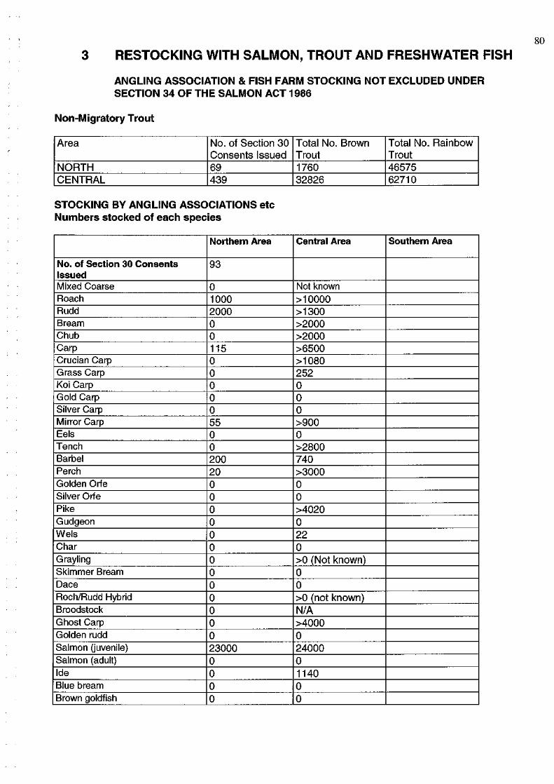
3 RESTOCKING WITH SALMON, TROUT AND FRESHWATER FISH
ANGLING ASSOCIATION & FISH FARM STOCKING NOT EXCLUDED UNDER SECTION 34 OF THE SALMON ACT 1986
Non-Migratory Trout
Area
NORTH CENTRAL
No. of Section 30 Consents Issued 69 439
Total No. Brown Trout 1760 32826
Total No. Rainbow Trout 46575 62710
STOCKING BY ANGLING ASSOCIATIONS etc Numbers stocked of each species
No. of Section 30 Consents Issued Mixed Coarse Roach Rudd Bream Chub Carp Crucian Carp Grass Carp Koi Carp Gold Carp Silver Carp Mirror Carp Eels Tench Barbel Perch Golden Orfe Silver Orfe Pike Gudgeon Wels Char Grayling Skimmer Bream Dace Roch/Rudd Hybrid Broodstock Ghost Carp Golden rudd Salmon (juvenile) Salmon (adult) Ide Blue bream Brown goldfish
Northern Area
93
0 1000 2000 0 0 115 0 0 0 0 0 55 0 0 200 20 0 0 0 0 0 0 0 0 0 0 0 0 0 23000 0 0 0 0
Central Area
Not known >10000 >1300 >2000 >2000 >6500 >1080 252 0 0 0 >900 0 >2800 740 >3000 0 0 >4020 0 22 0 >0 (Not known) 0 0 >0 (not known) N/A >4000 0 24000 0 1140 0 0
Southern Area
STOCKING/TRANSFERS/RESCUES CARRIED OUT BY THE ENVIRONMENT AGENCY
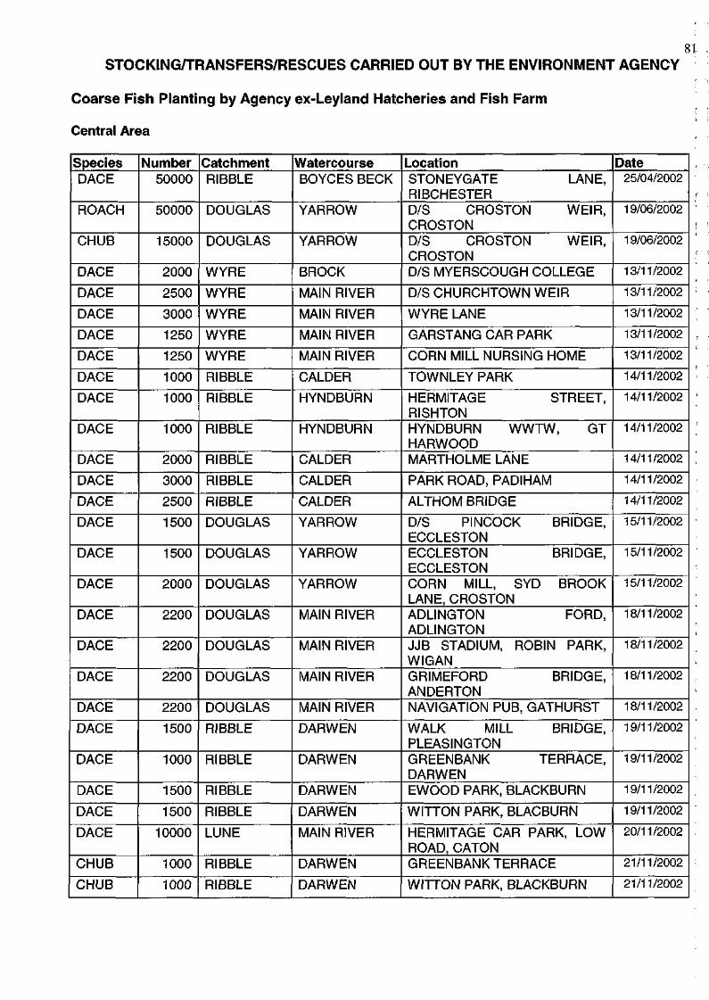
Coarse Fish Planting by Agency ex-Leyland Hatcheries and Fish Farm
Central Area
Species DACE
ROACH
CHUB
DACE
DACE
DACE
DACE
DACE
DACE
DACE
DACE
DACE
DACE
DACE
DACE
DACE
DACE
DACE
DACE
DACE
DACE
DACE
DACE
DACE
DACE
DACE
CHUB
CHUB
Number 50000
50000
15000
2000
2500
3000
1250
1250
1000
1000
1000
2000
3000
2500
1500
1500
2000
2200
2200
2200
2200
1500
1000
1500
1500
10000
1000
1000
Catchment RIBBLE
DOUGLAS
DOUGLAS
WYRE
WYRE
WYRE
WYRE
WYRE
RIBBLE
RIBBLE
RIBBLE
RIBBLE
RIBBLE
RIBBLE
DOUGLAS
DOUGLAS
DOUGLAS
DOUGLAS
DOUGLAS
DOUGLAS
DOUGLAS
RIBBLE
RIBBLE
RIBBLE
RIBBLE
LUNE
RIBBLE
RIBBLE
Watercourse BOYCES BECK
YARROW
YARROW
BROCK
MAIN RIVER
MAIN RIVER
MAIN RIVER
MAIN RIVER
CALDER
HYNDBURN
HYNDBURN
CALDER
CALDER
CALDER
YARROW
YARROW
YARROW
MAIN RIVER
MAIN RIVER
MAIN RIVER
MAIN RIVER
DARWEN
DARWEN
DARWEN
DARWEN
MAIN RIVER
DARWEN
DARWEN
Location STONEYGATE LANE, RIBCHESTER D/S CROSTON WEIR, CROSTON D/S CROSTON WEIR, CROSTON D/S MYERSCOUGH COLLEGE
D/S CHURCHTOWN WEIR
WYRE LANE
GARSTANG CAR PARK
CORN MILL NURSING HOME
TOWNLEY PARK
HERMITAGE STREET, RISHTON HYNDBURN WWTW, GT HARWOOD MARTHOLME LANE
PARK ROAD, PADIHAM
ALTHOM BRIDGE
D/S PINCOCK BRIDGE, ECCLESTON ECCLESTON BRIDGE, ECCLESTON CORN MILL, SYD BROOK LANE, CROSTON ADLINGTON FORD, ADLINGTON JJB STADIUM, ROBIN PARK, WIGAN GRIMEFORD BRIDGE, ANDERTON NAVIGATION PUB, GATHURST
WALK MILL BRIDGE, PLEASINGTON GREENBANK TERRACE, DARWEN EWOOD PARK, BLACKBURN
WITTON PARK, BLACBURN
HERMITAGE CAR PARK, LOW ROAD, CATON GREENBANKTERRACE
WITTON PARK, BLACKBURN
Date 25/04/2002
19/06/2002
19/06/2002
13/11/2002
13/11/2002
13/11/2002
13/11/2002
13/11/2002
14/11/2002
14/11/2002
14/11/2002
14/11/2002
14/11/2002
14/11/2002
15/11/2002
15/11/2002
15/11/2002
18/11/2002
18/11/2002
18/11/2002
18/11/2002
19/11/2002
19/11/2002
19/11/2002
19/11/2002
20/11/2002
21/11/2002
21/11/2002
82
Species CHUB
CHUB
Number Catchment 1000
1000
RIBBLE
RIBBLE
Watercourse DARWEN
DARWEN
Location BUTLERS BRIDGE, PLEASINGTON PARK, BLACKBURN WALK MILL BRIDGE, PLEASINGTON
Date 21/11/2002
21/11/2002
DACE
CHUB CHUB
CHUB CHUB
CHUB CHUB
CHUB CHUB CHUB CHUB CHUB CHUB CHUB
CHUB
CHUB CHUB CHUB ROACH ROACH
ROACH ROACH
ROACH DACE DACE CHUB CHUB
CHUB
CHUB
2500
1000 2000
2000 1000
2000 1000
2000 2500 3000 2000 1250 1250 5000
3000
2000 1000 800
1000 1500
500 1000
3500 10000 4000 4000 6000
2500
2500
RIBBLE
RIBBLE RIBBLE
RIBBLE RIBBLE
RIBBLE RIBBLE
RIBBLE WYRE WYRE WYRE WYRE WYRE DOUGLAS
DOUGLAS
DOUGLAS DOUGLAS DOUGLAS ALT ALT
ALT ALT
ALT LUNE RIBBLE DOUGLAS DOUGLAS
DOUGLAS
DOUGLAS
BOYCES BECK
DARWEN CALDER
CALDER HYNDBURN
CALDER HYNDBURN
CALDER MAIN RIVER MAIN RIVER BROCK MAIN RIVER MAIN RIVER YARROW
MAIN RIVER
TAWD SYD BROOK ELLER BROOK SANDY BROOK DOWNHOLLAN D BROOK BLACK BROOK BARTON BROOK MAIN RIVER MAIN RIVER BOYCES BECK YARROW YARROW
MAIN RIVER
MAIN RIVER
BOYCES BECK FOOT, RIBCHESTE EWOOD PARK, BLACKBURN ALTHOM BRIDGE
TOWNLEY PARK HERMITAGE STREET, RISHTON MARTHOLME LANE HYNDBURN WWTW, GT HARWOOD PARK STREET, PADIHAM D/S CHURCHTOWN WEIR WYRE LANE D/S MYERSCOUGH COLLEGE CORN MILL NURSING HOME GARSTANG CAR PARK D/S PINCOCK BRIDGE, EUXTON JJB STADIUM, ROBIN PARK, WIGAN SPENCER BRIDGE GRAPE LANE WHAM BRIDGE POOL HEY LANE NEW CAUSEWAY
JACKMERE LANE STATION ROAD
BULL BRIDGE, AINTREE CATON GUAGING WEIR RIBCHESTER ARMS PLYMOUTH BRIDGE, COPPULL D/S PINCOCK BRIDGE, EUXTON GRIMEFORD BRIDGE, HORWICH ADLINGTON FORD, ADLINGTON
21/11/2002
21/11/2002 22/11/2002
22/11/2002 22/11/2002
22/11/2002 22/11/2002
22/11/2002 25/11/2002 25/11/2002 25/11/2002 25/11/2002 25/11/2002 27/11/2002
29/11/2002
29/11/2002 29/11/2002 29/11/2002 05/12/2002 05/12/2002
05/12/2002 05/12/2002
05/12/2002 13/12/2002 16/12/2002 17/12/2002 17/12/2002
18/12/2002
18/12/2002
South Area Species ROACH
CHUB
Number 500
250
Catchment MERSEY
MERSEY
Watercourse TAME
TAME
Location MEADOW LANE, HAUGHTON
LANE, STOCKPORT GIBRALTER LANE, HAUGHTON
LANE, STOCKPORT
Date
05/12/2002
05/12/2002
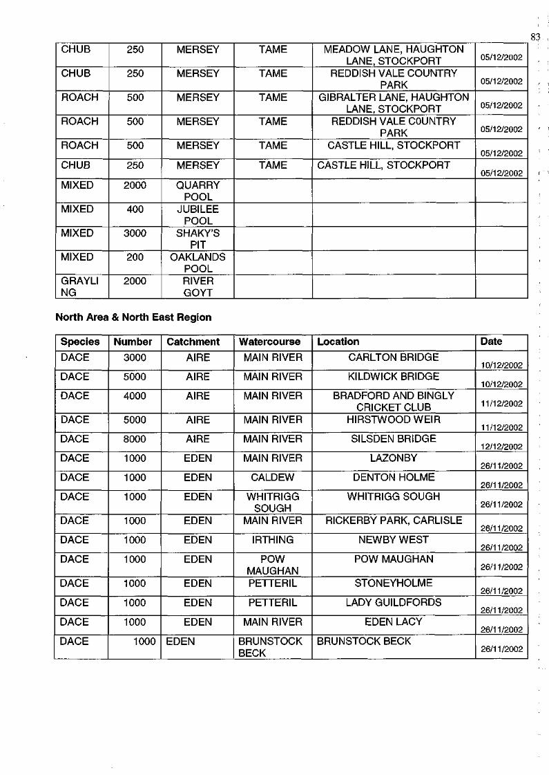
CHUB
CHUB
ROACH
ROACH
ROACH
CHUB
MIXED
MIXED
MIXED
MIXED
GRAYLI NG
250
250
500
500
500
250
2000
400
3000
200
2000
MERSEY
MERSEY
MERSEY
MERSEY
MERSEY
MERSEY
QUARRY POOL
JUBILEE POOL
SHAKY'S PIT
OAKLANDS POOL RIVER GOYT
TAME
TAME
TAME
TAME
TAME
TAME
MEADOW LANE, HAUGHTON LANE, STOCKPORT
REDDISH VALE COUNTRY PARK
GIBRALTER LANE, HAUGHTON LANE, STOCKPORT
REDDISH VALE COUNTRY PARK
CASTLE HILL, STOCKPORT
CASTLE HILL, STOCKPORT
05/12/2002
05/12/2002
05/12/2002
05/12/2002
05/12/2002
05/12/2002
North Area & North East Region
Species
DACE
DACE
DACE
DACE
DACE
DACE
DACE
DACE
DACE
DACE
DACE
DACE
DACE
DACE
DACE
Number
3000
5000
4000
5000
8000
1000
1000
1000
1000
1000
1000
1000
1000
1000
1000
Catchment
AIRE
AIRE
AIRE
AIRE
AIRE
EDEN
EDEN
EDEN
EDEN
EDEN
EDEN
EDEN
EDEN
EDEN
EDEN
Watercourse
MAIN RIVER
MAIN RIVER
MAIN RIVER
MAIN RIVER
MAIN RIVER
MAIN RIVER
CALDEW
WHITRIGG SOUGH
MAIN RIVER
IRTHING
POW MAUGHAN PETTERIL
PETTERIL
MAIN RIVER
BRUNSTOCK BECK
Location
CARLTON BRIDGE
KILDWICK BRIDGE
BRADFORD AND BINGLY CRICKET CLUB
HIRSTWOODWEIR
SILSDEN BRIDGE
LAZONBY
DENTON HOLME
WHITRIGG SOUGH
RICKERBY PARK, CARLISLE
NEWBY WEST
POW MAUGHAN
STONEYHOLME
LADY GUILDFORDS
EDEN LACY
BRUNSTOCK BECK
Date
10/12/2002
10/12/2002
11/12/2002
11/12/2002
12/12/2002
26/11/2002
26/11/2002
26/11/2002
26/11/2002
26/11/2002
26/11/2002
26/11/2002
26/11/2002
26/11/2002
26/11/2002
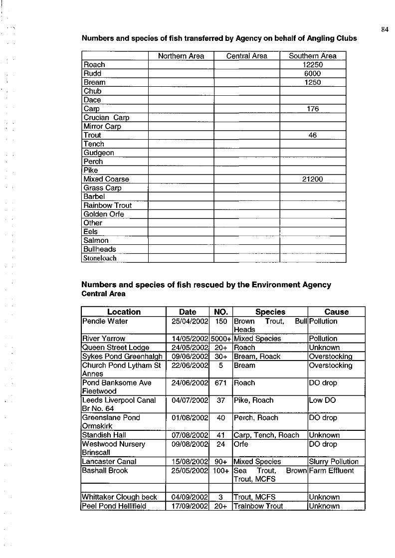
84 Numbers and species of fish transferred by Agency on behalf of Angling Clubs
Roach Rudd Bream Chub Dace Carp Crucian Carp Mirror Carp Trout Tench Gudgeon Perch Pike Mixed Coarse Grass Carp Barbel Rainbow Trout Golden Orfe Other Eels Salmon Bullheads Stoneloach
Northern Area Central Area Southern Area 12250 6000 1250
176
46
21200
Numbers and species of fish rescued by the Environment Agency Central Area
Location Pendle Water
River Yarrow Queen Street Lodge Sykes Pond Greenhaigh Church Pond Lytham St Annes Pond Banksome Ave Fleetwood Leeds Liverpool Canal Br No. 64 Greenslane Pond Ormskirk Standish Hall Westwood Nursery Brinscall Lancaster Canal Bashall Brook
Whittaker Clough beck Peel Pond Hellifield
Date 25/04/2002
14/05/2002 24/05/2002 09/06/2002 22/06/2002
24/06/2002
04/07/2002
01/08/2002
07/08/2002 09/08/2002
15/08/2002 25/05/2002
04/09/2002 17/09/2002
NO. 150
5000+ 20+ 30+ 5
671
37
40
41 24
90+ 100+
3 20+
Species Brown Trout, Bull Heads Mixed Species Roach Bream, Roack Bream
Roach
Pike, Roach
Perch, Roach
Carp, Tench, Roach Orfe
Mixed Species Sea Trout, Brown Trout, MCFS
Trout, MCFS Trainbow Trout
Cause Pollution
Pollution Unknown Overstocking Overstocking
DO drop
Low DO
DO drop
Unknown DO drop
Slurry Pollution Farm Effluent
Unknown Unknown
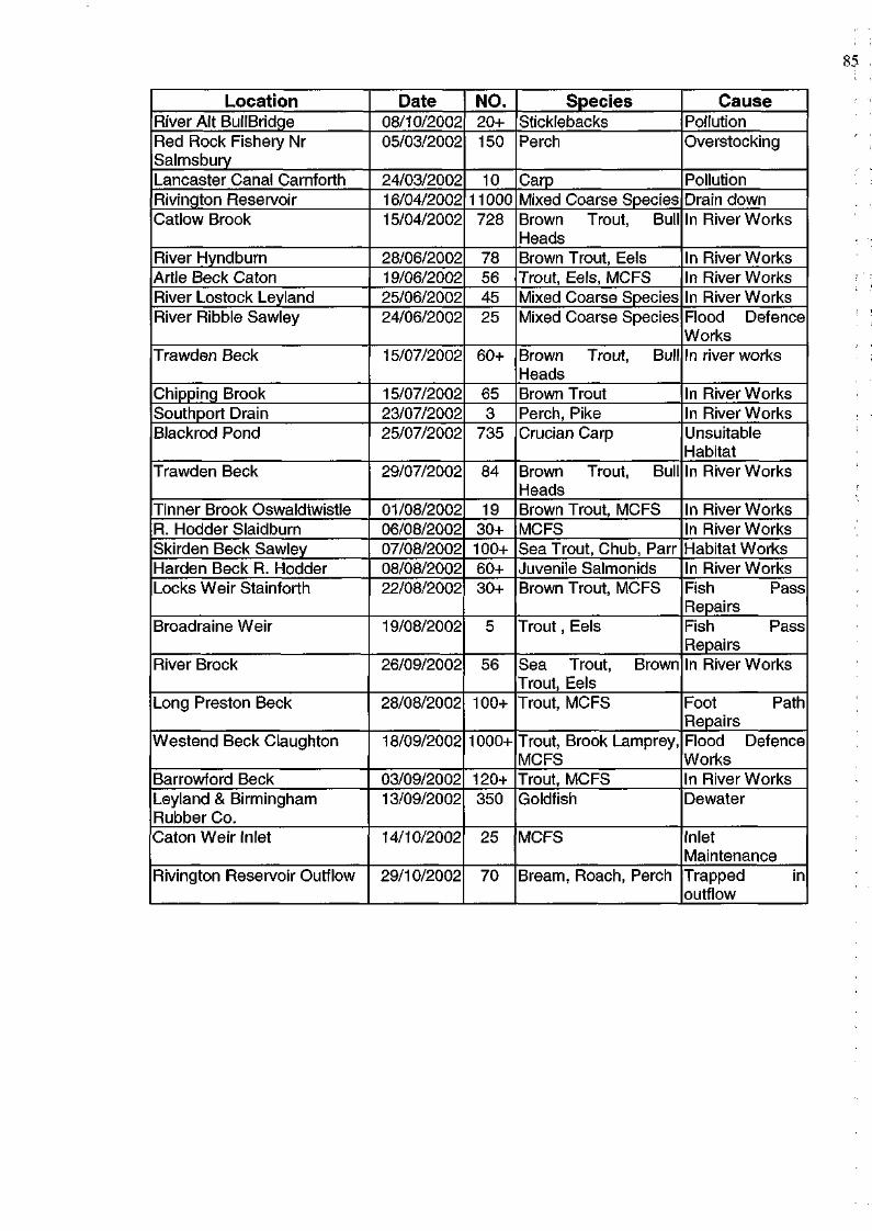
Location River Alt BullBridge Red Rock Fishery Nr Salmsbury Lancaster Canal Carnforth Rivington Reservoir Catlow Brook
River Hyndburn Artie Beck Caton River Lostock Leyland River Ribble Sawley
Trawden Beck
Chipping Brook Southport Drain Blackrod Pond
Trawden Beck
Tinner Brook Oswaldtwistle R. Hodder Slaidburn Skirden Beck Sawley Harden Beck R. Hodder Locks Weir Stainforth
Broadraine Weir
River Brock
Long Preston Beck
Westend Beck Claughton
Barrowford Beck Leyland & Birmingham Rubber Co. Caton Weir Inlet
Rivington Reservoir Outflow
Date 08/10/2002 05/03/2002
24/03/2002 16/04/2002 15/04/2002
28/06/2002 19/06/2002 25/06/2002 24/06/2002
15/07/2002
15/07/2002 23/07/2002 25/07/2002
29/07/2002
01/08/2002 06/08/2002 07/08/2002 08/08/2002 22/08/2002
19/08/2002
26/09/2002
28/08/2002
18/09/2002
03/09/2002 13/09/2002
14/10/2002
29/10/2002
NO. 20+ 150
10 11000 728
78 56 45 25
60+
65 3
735
84
19 30+ 100+ 60+ 30+
5
56
100+
1000+
120+ 350
25
70
Species Sticklebacks Perch
Carp Mixed Coarse Species Brown Trout, Bull Heads Brown Trout, Eels Trout, Eels, MCFS Mixed Coarse Species Mixed Coarse Species
Brown Trout, Bull Heads Brown Trout Perch, Pike Crucian Carp
Brown Trout, Bull Heads Brown Trout, MCFS MCFS Sea Trout, Chub, Parr Juvenile Salmonids Brown Trout, MCFS
Trout, Eels
Sea Trout, Brown Trout, Eels Trout, MCFS
Trout, Brook Lamprey, MCFS Trout, MCFS Goldfish
MCFS
Bream, Roach, Perch
Cause Pollution Overstocking
Pollution Drain down In River Works
In River Works In River Works In River Works Flood Defence Works In river works
In River Works In River Works Unsuitable Habitat In River Works
In River Works In River Works Habitat Works In River Works Fish Pass Repairs Fish Pass Repairs In River Works
Foot Path Repairs Flood Defence Works In River Works Dewater
Inlet Maintenance Trapped in outflow
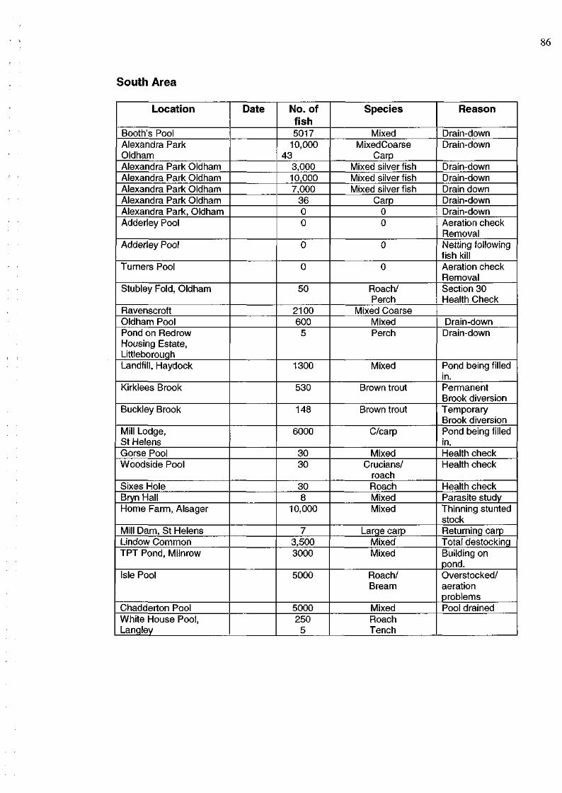
86
South Area
Location
Booth's Pool Alexandra Park Oldham Alexandra Park Oldham Alexandra Park Oldham Alexandra Park Oldham Alexandra Park Oldham Alexandra Park, Oldham Adderley Pool
Adderley Pool
Turners Pool
Stubley Fold, Oldham
Ravenscroft Oldham Pool Pond on Redraw Housing Estate, Littleborough Landfill, Haydock
Kirklees Brook
Buckley Brook
Mill Lodge, St Helens Gorse Pool Woodside Pool
Sixes Hole Bryn Hall Home Farm, Alsager
Mill Dam, St Helens Lindow Common TPT Pond, Milnrow
Isle Pool
Chadderton Pool White House Pool, Langley
Date No. of fish 5017
10,000 43
3,000 10,000 7,000
36 0 0
0
0
50
2100 600
5
1300
530
148
6000
30 30
30 8
10,000
7 3,500 3000
5000
5000 250
5
Species
Mixed MixedCoarse
Carp Mixed silver fish Mixed silver fish Mixed silver fish
Carp 0 0
0
0
Roach/ Perch
Mixed Coarse Mixed Perch
Mixed
Brown trout
Brown trout
C/carp
Mixed Crucians/
roach Roach Mixed Mixed
Large carp Mixed Mixed
Roach/ Bream
Mixed Roach Tench
Reason
Drain-down Drain-down
Drain-down Drain-down Drain down Drain-down Drain-down Aeration check Removal Netting following fish kill Aeration check Removal Section 30 Health Check
Drain-down Drain-down
Pond being filled in. Permanent Brook diversion Temporary Brook diversion Pond being filled in. Health check Health check
Health check Parasite study Thinning stunted stock Returning carp Total destocking Building on pond. Overstocked/ aeration problems Pool drained

4 MONITORING (SURVEYS, FISH COUNTERS AND REDD COUNTS)
SURVEYS CARRIED OUT FOR ANGLING CLUBS
Area
South
South South South South South South South South South South
South South South
South South South South
South South South South South South South South South South South South South South
North
Waterbody Name & Location
Woodsmeadow Northwich
Birkenhead Park Willow Lane, Willaston Combermere Mere View, Bacup Sayces Pit, Widnes Meadow View, Lymm Bryn Hall, Wigan Shepherds Pool, Nr Lymm Oaklands/Oakhanger Rode Pool, Rode Heath
Mellors Pool, Marple Linnet Clourh, Mellor Bickershaw Labour Club Water at Leigh Mathew's Pit, Northwich King Georges Pool Atherton Old Hall Border fishery, Balterley
Shepherd's pool Two Isle pool Whatcroft Pool, Northwich Mere Home Pool, Mere Faddiley Pool Golden Lake, Lakemore Eagley Mill, Bolton Reaseheath Pool Summit Brick Works, Todmorden Hassal Pool Sykes No.1, Stockport Dean Pool, Handforth Eagley Mill, Bolton Bowker Vale
Urswick Tarn, Great Urswick
Recipient Angling Club Or Owner Davenham AC
AWAC Thornton Hough Private syndicate Whitworth AS Netting Angler caught Netting Netting Private Mow Cop
East Team Longsight AC Bickershaw AC
Winnington Park
Mr P Winder Mr M Glover
Altrincham AC Tarporley Mr Vernon Altrincham Crewe A C Mr Ashmoor
Reaseheath College Todmorden AS Todmorden AC Edgeley AS Wilmslow AC Eagley AS
Broughton AS
Urswick Tarn Angling Association
Reason for survey
No fish caught in six hour match Reported fish losses New fishery Reported fish losses Fishery advice Diseased fish Diseased fish Samples for Brampton Cat 2 parasites Will Pool support (Coarse Fish) new water Poor catches Fishery advice Fishery advice
Assess Carp Nos. Habitat Improvement Stock Assessment Health check following fish kill Poor fishing New fishery New Fishery Health Check Poor Catches Fish Population Management Advice Advice and removal Health check Population study Poor sport Stocking levels Writing survey report
Water Sample report
Stock assessment
OTHER VISITS/WORKS
Area
North
Waterbody Name & Location River Bela
Recipient Angling Club Or Owner Milnthorpe Anglers
Reason for survey
Brown trout stocking & habitat assessment
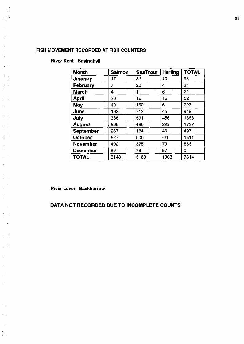
88
FISH MOVEMENT RECORDED AT FISH COUNTERS
River Kent - Basinghyll
Month January
February
March Apri l
May
June July
August September
October November
December TOTAL
Salmon 17
7
4
20
49 192
336
938 267
827 402
89 3148
SeaTrout 31 20
11
16 152
712
591 490
184
505 375
76 3163
Herling 10
4
6 16
6
45
456 299
46 -21
79 57
1003
TOTAL 58
31 21
52
207
949 1383
1727 497
1311
856
0 7314
River Leven Backbarrow
DATA NOT RECORDED DUE TO INCOMPLETE COUNTS
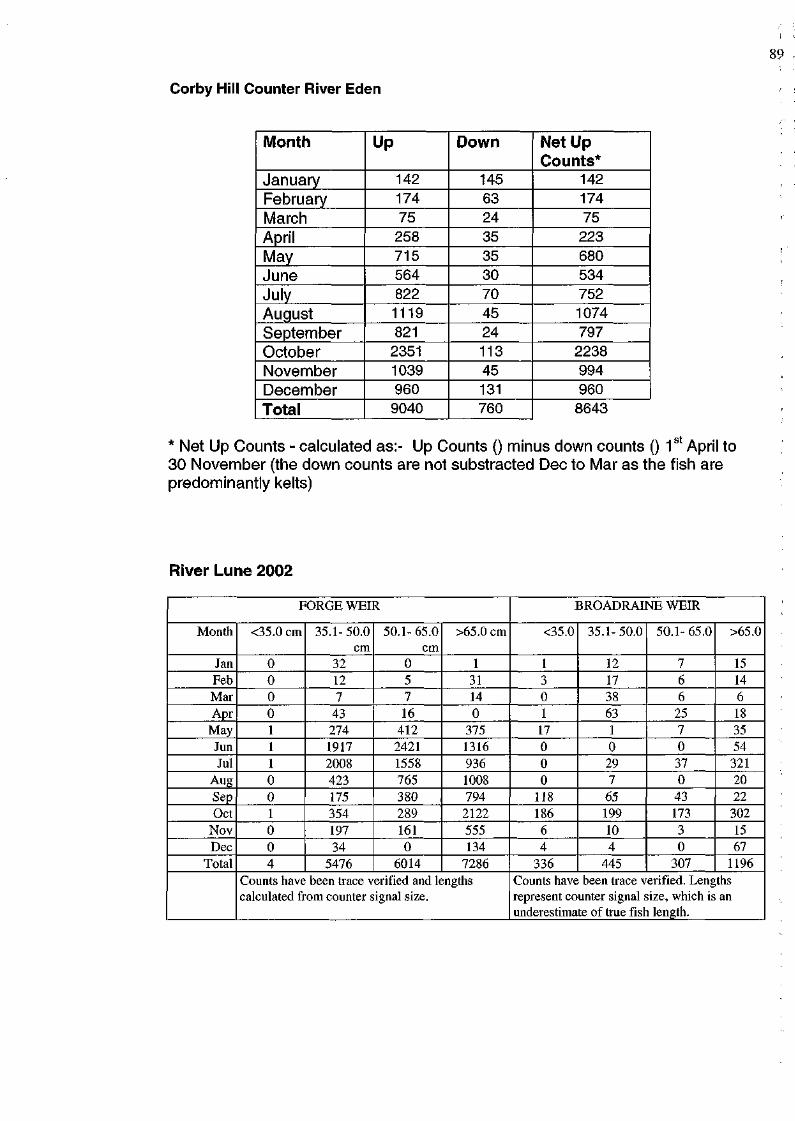
Corby Hill Counter River Eden
Month
January February March April May June July August September October November December
Total
Up
142 174
75 258 715 564 822 1119 821
2351 1039 960
9040
Down
145 63 24
35 35 30 70 45 24 113 45 131 760
Net Up Counts*
142
174 75
223 680 534 752 1074 797
2238 994 960 8643
* Net Up Counts - calculated as:- Up Counts () minus down counts () 1 April to 30 November (the down counts are not substracted Dec to Mar as the fish are predominantly kelts)
River Lune 2002
FORGE WEIR
Month
Jan Feb Mar Apr
May Jun Jul
Aug Sep Oct
Nov Dec
Total
<35.0 cm
0 0 0 0 1 1 1 0 0 1 0 0 4
35.1-50.0 cm
32 12 7
43 274 1917 2008 423 175 354 197 34
5476
50.1-65.0 cm
0 5 7 16
412 2421 1558 765 380 289 161 0
6014
>65.0 cm
1 31 14 0
375 1316 936 1008 794 2122 555 134
7286 Counts have been trace verified and lengths calculated from counter signal size.
BROADRAINE WEIR
<35.0
1 3 0 1 17 0 0 0
118 186 6 4
336
35.1-50.0
12 17 38 63 1 0 29 7 65 199 10 4
445
50.1-65.0
7 6 6
25 7 0 37 0
43 173 3 0
307
>65.0
15 14 6 18 35 54 321 20 22
302 15 67
1196 Counts have been trace verified. Lengths represent counter signal size, which is an underestimate of true fish length.
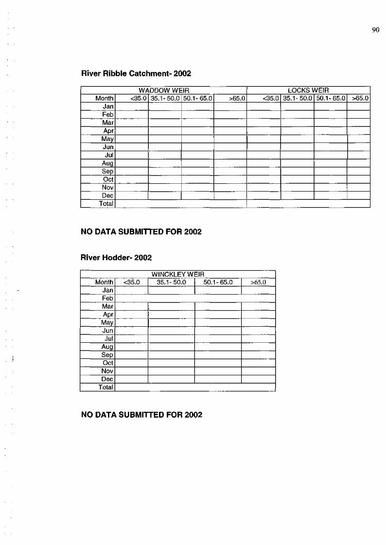
River Ribble Catchment- 2002
WADDOW WEIR Month
Jan Feb Mar Apr May Jun Jul
Aug Sep Oct Nov Dec
Total
<35.0 35.1-50.0 50.1-65.0 >65.0 LOCKS WEIR
<35.0 35.1-50.0 50.1-65.0 >65.0
NO DATA SUBMITTED FOR 2002
River Hodder- 2002
WINCKLEYW Month
Jan Feb Mar Apr May Jun Jul
Aug Sep Oct Nov Dec
Total
<35.0 35.1-50.0 EIR
50.1-65.0 >65.0
NO DATA SUBMITTED FOR 2002
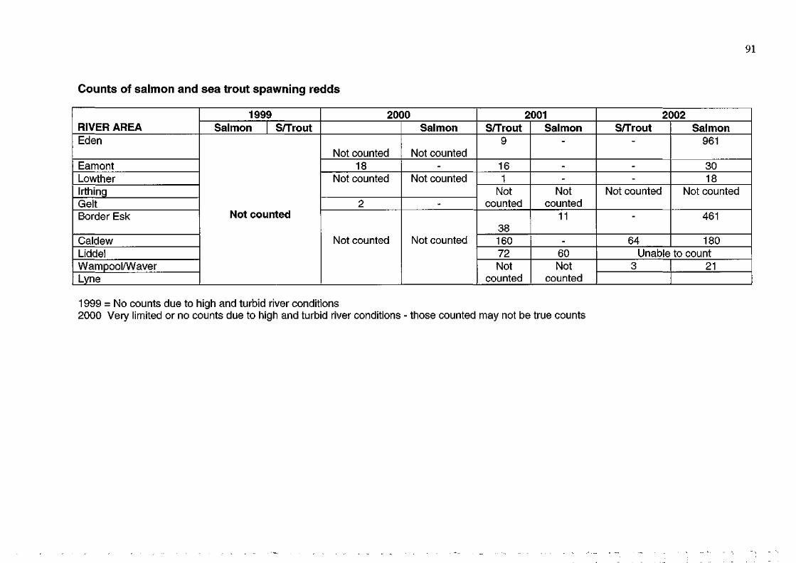
91
Counts of salmon and sea trout spawning redds
RIVER AREA Eden
Eamont Lowther Irthing Gelt Border Esk
Caldew Liddel Wampool/Waver Lyne
1999 Salmon S/Trout
Not counted
2000
Not counted 18
Not counted
2
Not counted
Salmon
Not counted -
Not counted
-
Not counted
2001 S/Trout
9
16 1
Not counted
38 160 72 Not
counted
Salmon -
--
Not counted
11
-60 Not
counted
2002 S/Trout
-
--
Not counted
-
64
Salmon 961
30 18
Not counted
461
180 Unable to count
3 21
1999 = No counts due to high and turbid river conditions 2000 Very limited or no counts due to high and turbid river conditions - those counted may not be true counts
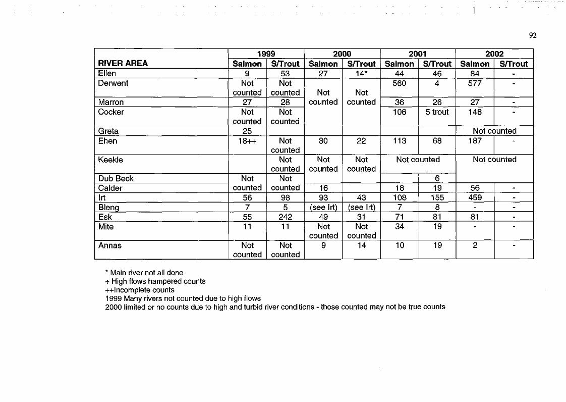
92
RIVER AREA Ellen Derwent
Marron Cocker
Greta Ehen
Keekle
Dub Beck Calder Irt Bleng Esk Mite
Annas
1999 Salmon
9 Not
counted 27 Not
counted 25
18++
Not counted
56 7
55 11
Not counted
S/Trout 53 Not
counted 28 Not
counted
Not counted
Not counted
Not counted
98 5
242 11
Not counted
2000 Salmon
27
Not counted
30
Not counted
16 93
(see Irt) 49 Not
counted 9
S/Trout 14*
Not counted
22
Not counted
43 (see Irt)
31 Not
counted 14
2001 Salmon
44 560
36 106
113
S/Trout 46 4
26 5 trout
68
Not counted
18 108 7
71 34
10
6 19
155 8
81 19
19
2002 Salmon
84 577
27 148
S/Trout --
-
-
Not counted 187 -
Not counted
56 459
-
81 -
2
-----
-
* Main river not all done + High flows hampered counts ++Incomplete counts 1999 Many rivers not counted due to high flows 2000 limited or no counts due to high and turbid river conditions - those counted may not be true counts
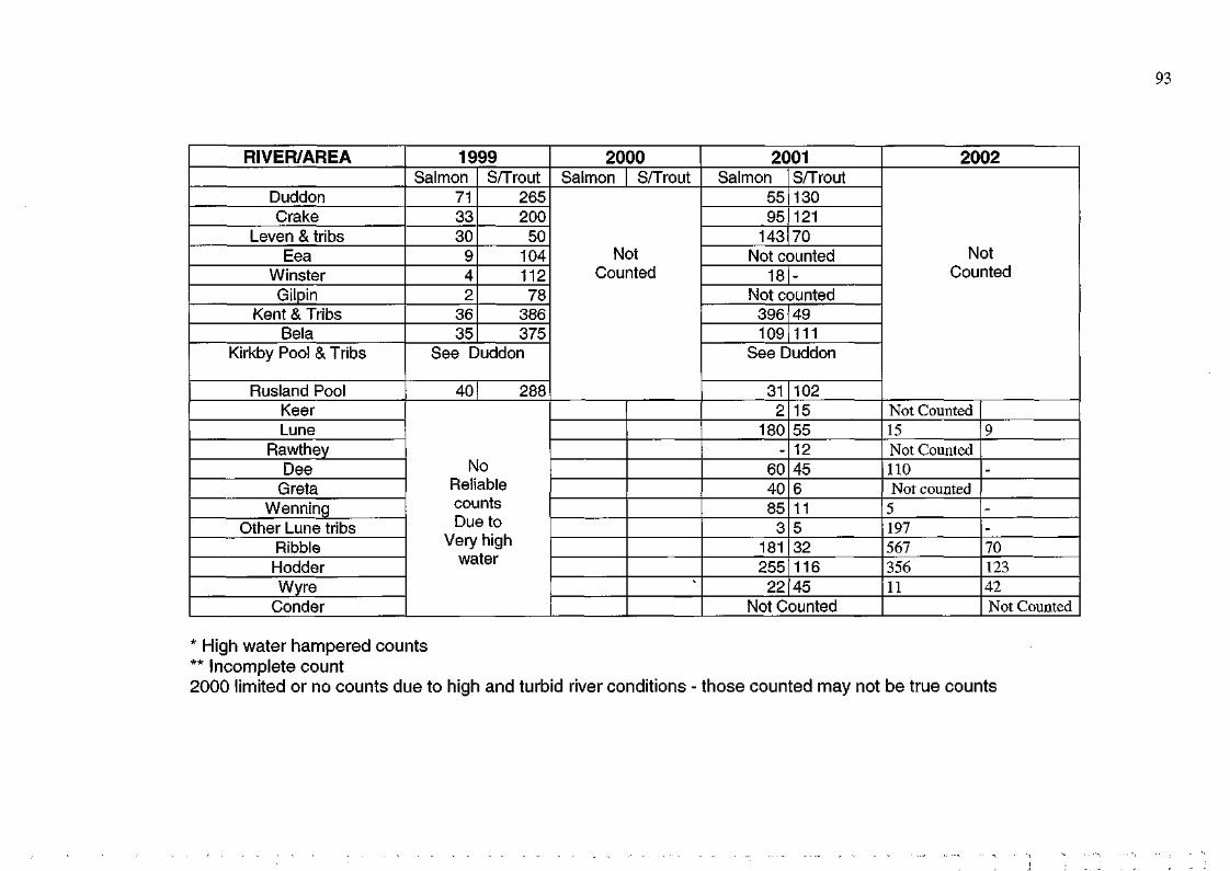
RIVER/AREA
Duddon Crake
Leven & tribs Eea
Winster Gilpin
Kent & Tribs Bela
Kirkby Pool & Tribs
Rusland Pool Keer Lune
Rawthey Dee
Greta Wenning
Other Lune tribs Ribble Hodder Wyre
Conder
1999 Salmon
71 33 30
9 4 2
36 35
S/Trout 265 200 50
104 112 78
386 375
See Duddon
40 288
No Reliable counts Due to
Very high water
2000 Salmon S/Trout
Not Counted
"*
2001 Salmon
55 95
143
S/Trout 130 121 70
Not counted 18 -
Not counted 396 109
49 111
See Duddon
31 2
180 -
60 40 85 3
181 255 22
102 15 55 12 45 6 11 5 32 116 45
Not Counted
2002
Not Counted
Not Counted 15 Not Counted 110 Not counted
5 197 567 356 11
9
-
--70 123 42 Not Counted
* High water hampered counts ** Incomplete count 2000 limited or no counts due to high and turbid river conditions - those counted may not be true counts
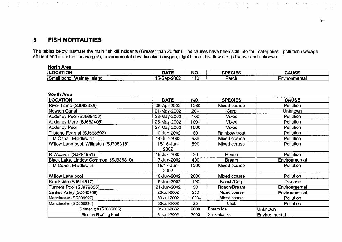
94
5 FISH MORTALITIES
The tables below illustrate the main fish kill incidents (Greater than 20 fish). The causes have been split into four categories : pollution (sewage effluent and industrial discharges), environmental (low dissolved oxygen, algal bloom, low flow etc.,) disease and unknown
North Area LOCATION Small pond, Walney Island
DATE 15-Sep-2002
NO. 110
SPECIES Perch
CAUSE Environmental
South Area LOCATION River Tame (SJ963935) Newton Canal Adderley Pool (SJ665403) Adderley Mere (SJ662405) Adderley Pool Tilstone Fearnal (SJ568592) T M Canal, Middlewich Willow Lane pool, Willaston (SJ795318)
R Weaver (SJ664651) Black Lake, Lindow Common (SJ836810) T M Canal, Middlewich
Willow Lane pool Brookside(SJ614817) Turners Pool (SJ978635) Sankey Valley (SD545959) Manchester (SD809927) Manchester (SD650991)
Grimsditch (SJ605805) Bidston Boating Pool
DATE 05-Apr-2002 01-May-2002 23-May-2002 25-May-2002 27-May-2002 10-Jun-2002 14-Jun-2002 15/16-Jun-
2002 15-Jun-2002 17-Jun-2002 16/17-Jun-
2002 18-Jun-2002 19-Jun-2002 21-Jun-2002 20-Jul-2002 30-Jul-2002 30-Jul-2002 31-Jul-2002 31-Jul-2002
NO. 1260 20+ 100
100+ 1000
80 939 500
20 400 1200
2000 100 30 250
1000+ 25
2000 2000
SPECIES Mixed coarse
Carp Mixed Mixed Mixed
Rainbow trout Mixed coarse Mixed coarse
Roach Bream
Mixed coarse
Mixed coarse Roach/Carp
Roach/Bream Mixed coarse Mixed coarse
Chub Bream Ide Sticklebacks
CAUSE Pollution Unknown Pollution Pollution Pollution Pollution Pollution Pollution
Pollution Environmental
Pollution
Pollution Disease
Environmental Environmental
Pollution Pollution
Unknown Environmental
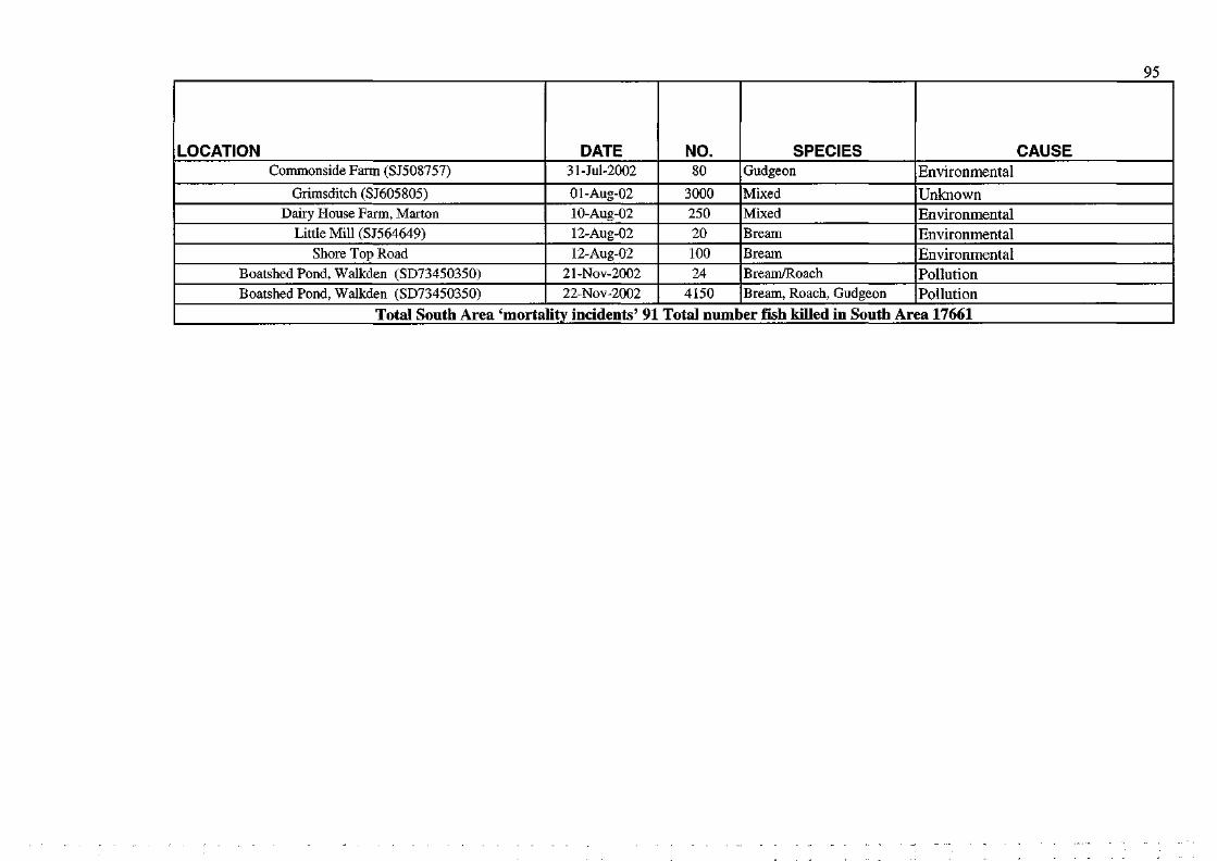
95
LOCATION Commonside Farm (SJ508757)
Grimsditch (SJ605805) Dairy House Farm, Marton
Little Mill (SJ564649) Shore Top Road
Boatshed Pond, Walkden (SD73450350) Boatshed Pond, Walkden (SD73450350)
DATE 31-M-2002
Ol-Aug-02 10-Aug-02 12-Aug-02 12-Aug-02
21-Nov-2002 22-Nov-2002
NO. 80
3000 250 20 100 24
4150
SPECIES Gudgeon
Mixed Mixed Bream
Bream Bream/Roach Bream, Roach, Gudgeon
CAUSE Environmental
Unknown Environmental Environmental Environmental Pollution Pollution
Total South Area 'mortality incidents' 91 Total number fish killed in South Area 17661
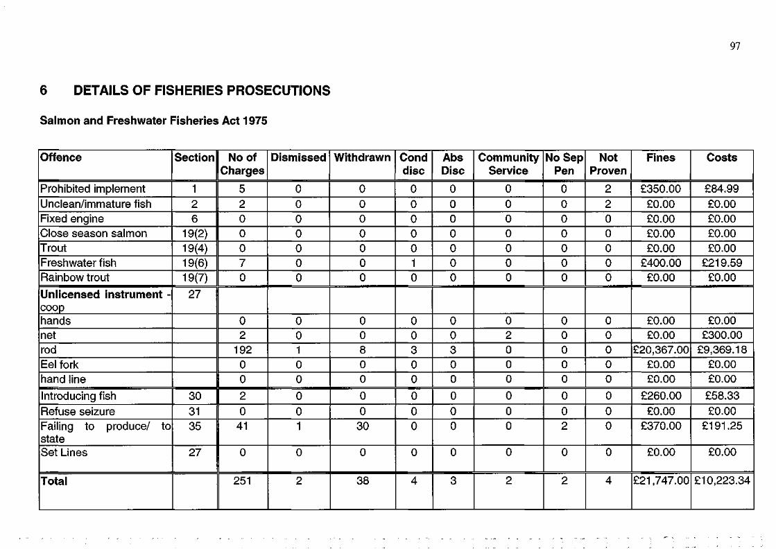
6 DETAILS OF FISHERIES PROSECUTIONS
Salmon and Freshwater Fisheries Act 1975
Offence
Prohibited implement Unclean/immature fish Fixed engine Close season salmon Trout Freshwater fish Rainbow trout
Unlicensed instrument -coop hands net rod Eel fork hand line
Introducing fish Refuse seizure Failing to produce/ to state Set Lines
Total
Section
1 2 6
19(2) 19(4) 19(6) 19(7)
27
30 31 35
27
No of Charges
5 2 0 0 0 7 0
0 2
192 0 0
2 0
41
0
251
Dismissed
0 0 0 0 0 0 0
0 0 1 0 0
0 0 1
0
2
Withdrawn
0 0 0 0 0 0 0
0 0 8 0 0
0 0
30
0
38
Cond disc
0 0 0 0 0 1 0
0 0 3 0 0
0 0 0
0
4
Abs Disc
0 0 0 0 0 0 0
0 0 3 0 0
0 0 0
0
3
Community Service
0 0 0 0 0 0 0
0 2 0 0 0
0 0 0
0
2
No Sep Pen
0 0 0 0 0 0 0
0 0 0 0 0
0 0 2
0
2
Not Proven
2 2 0 0 0 0 0
0 0 0 0 0
0 0 0
0
4
Fines
£350.00 £0.00 £0.00 £0.00 £0.00
£400.00 £0.00
£0.00 £0.00
£20,367.00 £0.00 £0.00
£260.00 £0.00
£370.00
£0.00
£21,747.00
Costs
£84.99 £0.00 £0.00 £0.00 £0.00
£219.59 £0.00
£0.00 £300.00
£9,369.18 £0.00 £0.00
£58.33 £0.00
£191.25
£0.00
£10,223.34
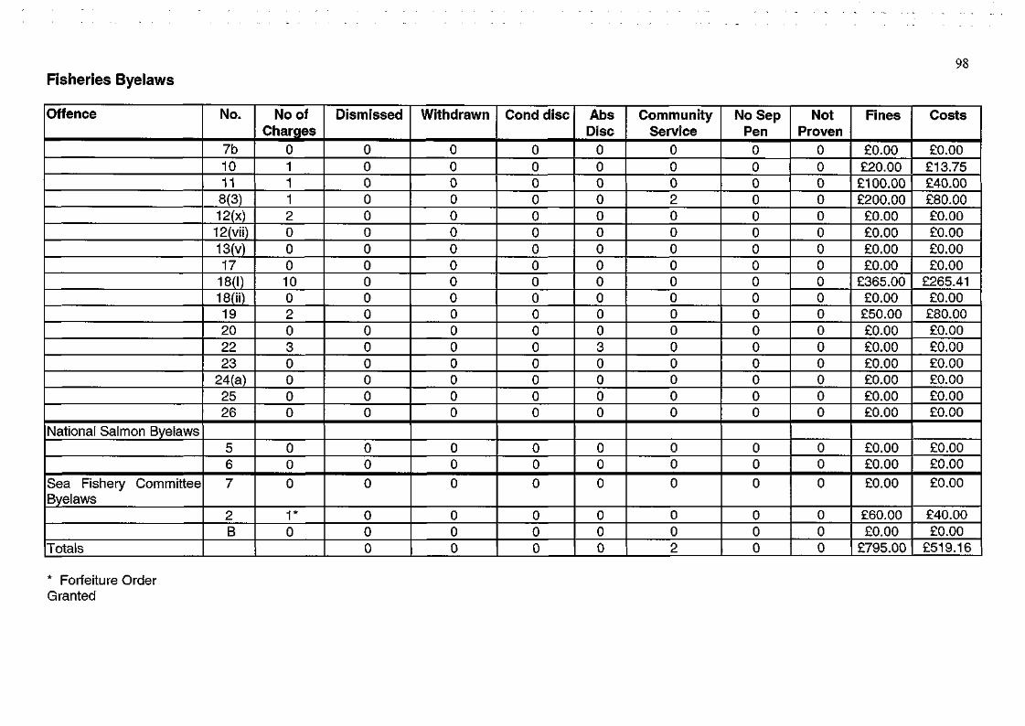
98 Fisheries Byelaws
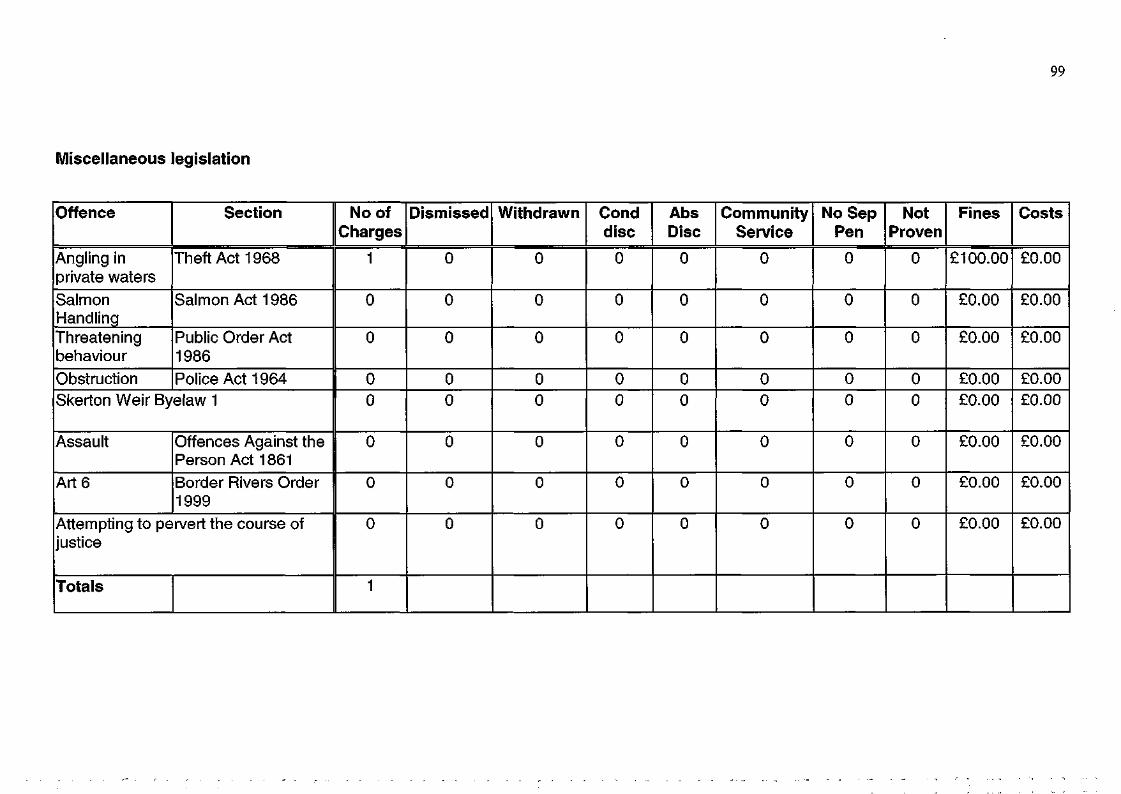
Miscellaneous legislation
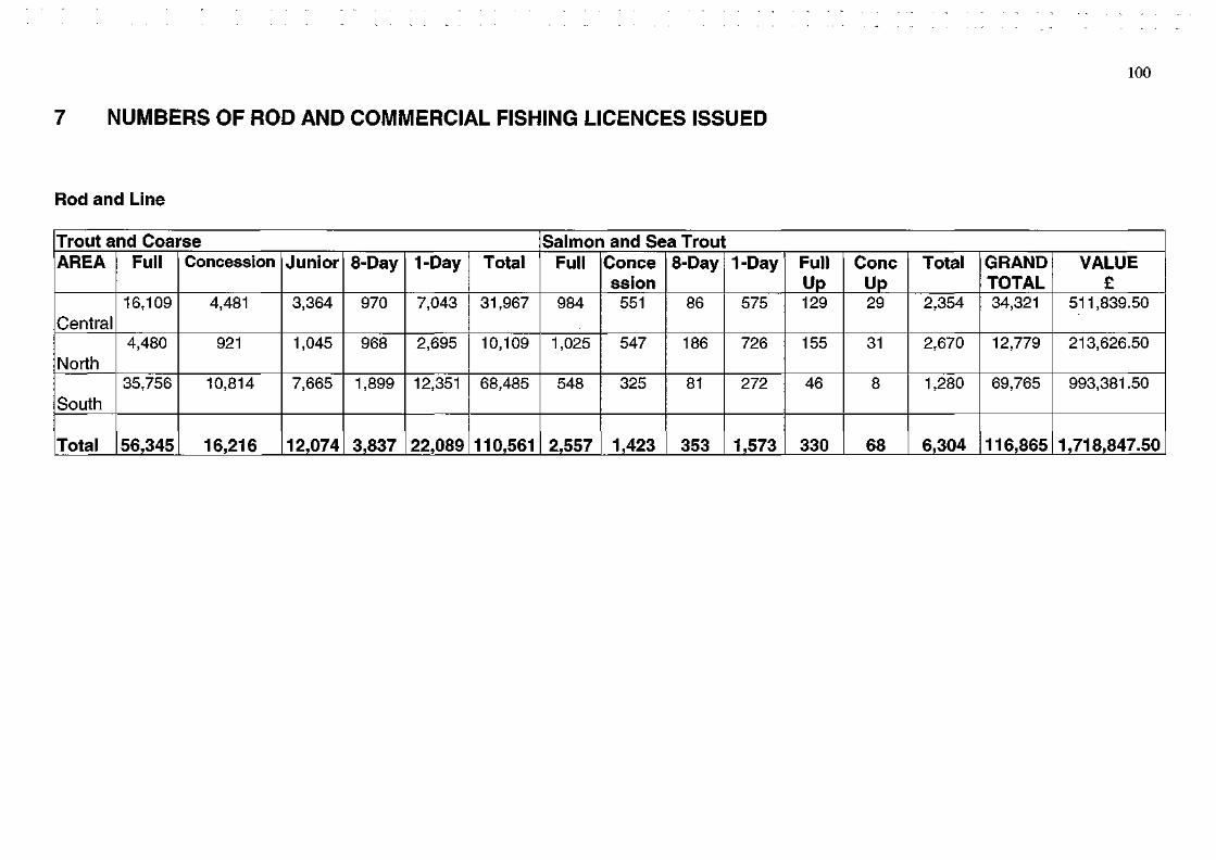
7 NUMBERS OF ROD AND COMMERCIAL FISHING LICENCES ISSUED
100
Rod and Line
Trout and Coarse AREA
Central
North
South
Total
Full
16,109
4,480
35,756
56,345
Concession
4,481
921
10,814
16,216
Junior
3,364
1,045
7,665
12,074
8-Day
970
968
1,899
3,837
1-Day
7,043
2,695
12,351
22,089
Total
31,967
10,109
68,485
110,561
Salmon and Sea Trout Full
984
1,025
548
2,557
Conce ssion
551
547
325
1,423
8-Day
86
186
81
353
1-Day
575
726
272
1,573
Full Up 129
155
46
330
Cone Up 29
31
8
68
Total
2,354
2,670
1,280
6,304
GRAND TOTAL 34,321
12,779
69,765
116,865
VALUE £
511,839.50
213,626.50
993,381.50
1,718,847.50
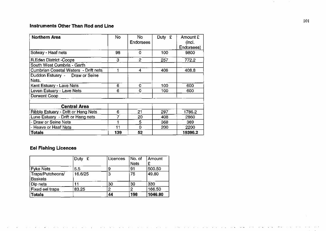
101 Instruments Other Than Rod and Line
Northern Area
Solway - Haaf nets
R.Eden District -Coops South West Cumbria - Garth Cumbrian Coastal Waters - Drift nets Duddon Estuary - Draw or Seine Nets. Kent Estuary - Lave Nets Leven Estuary - Lave Nets Derwent Coop
No
98
3
1
6 6
No Endorsees
0
2
4
0 0
Duty £
100
257
408
100 100
Amount £ (incl.
Endorsees) 9800
772.2
408.8
600 600
Central Area Ribble Estuary - Drift or Hang Nets Lune Estuary - Drift or Hang nets - Draw or Seine Nets - Heave or Haaf Nets Totals
6 7 1
11 139
21 20 5 0
52
297 408 368 200
1786.2 2860 369
2200 19396.2
Eel Fishing Licences
Fyke Nets Traps/Putcheons/ Baskets Dip nets Fixed eel traps Totals
Duty £
5.5 16.6/25
11 83.25
Licences
9 3
30 2 44
No. of Nets 91 75
30 2 198
Amount £ 500.50 49.80
330 166.50 1046.80
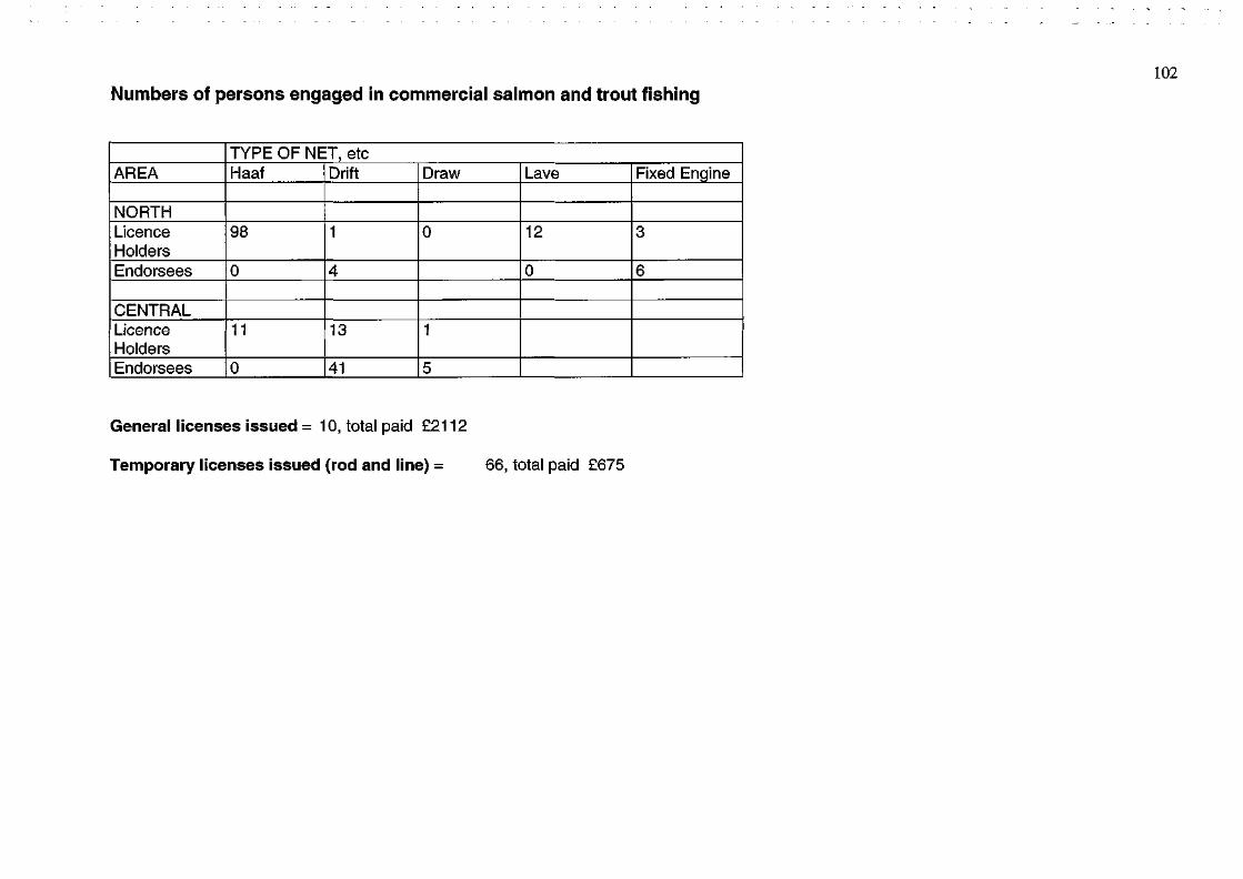
Numbers of persons engaged in commercial salmon and trout fishing
AREA
NORTH Licence Holders Endorsees
CENTRAL Licence Holders Endorsees
TYPE OF NET, etc Haaf
98
0
11
0
Drift
1
4
13
41
Draw
0
1
5
Lave
12
0
Fixed Engine
3
6
General licenses issued = 10, total paid £2112
Temporary licenses issued (rod and line) = 66, total paid £675
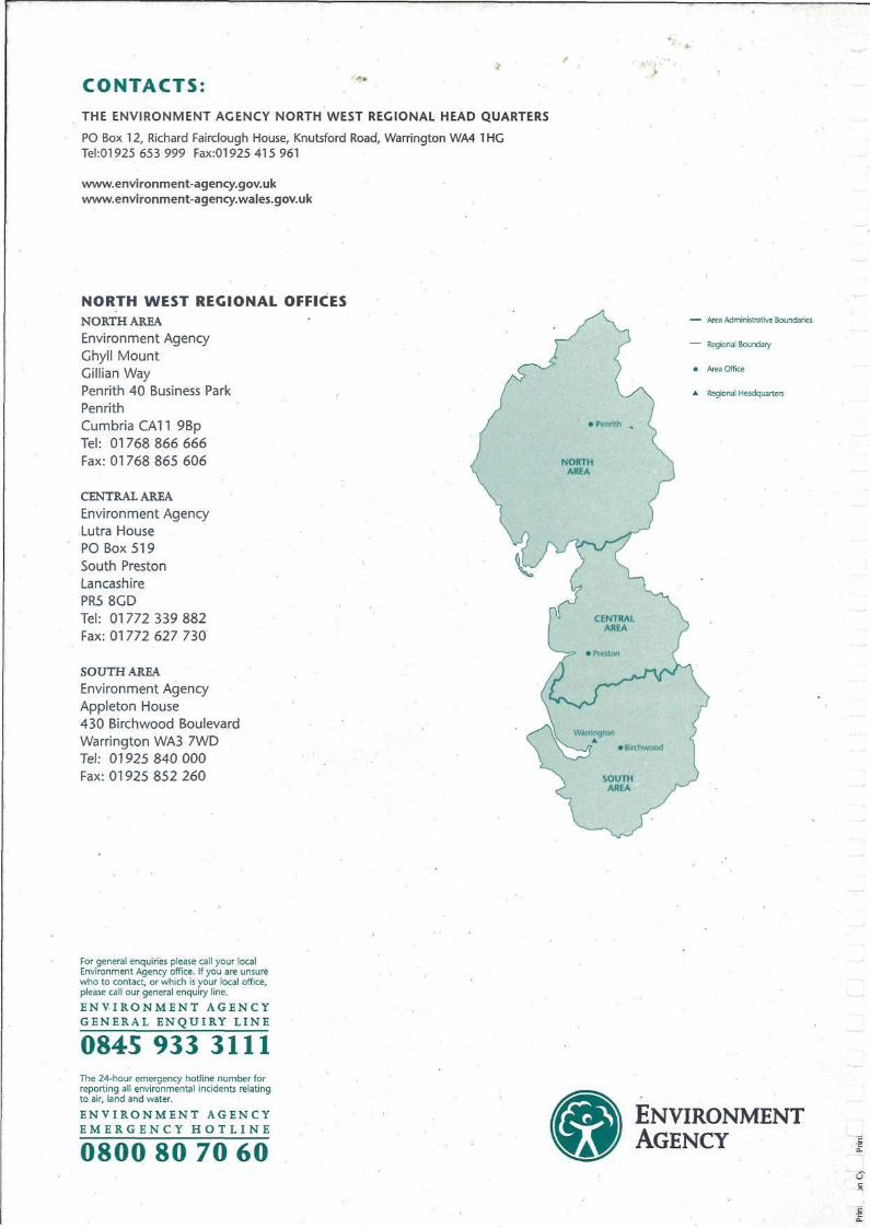
CONTACTS:
THE ENVIRONMENT AGENCY NORTH WEST REGIONAL HEAD QUARTERS
PO Box 12, Richard Fairclough House, Knutsford Road, Warrington WA4 1HG Tel:01925 653 999 Fax:01925 415 961
www.environment-agency.gov.uk www.environment-agency.wales.gov.uk
NORTH WEST REGIONAL OFFICES NORTH AREA
Environment Agency Ghyll Mount Gillian Way Penrith 40 Business Park Penrith Cumbria CA11 9Bp Tel: 01768 866 666 Fax: 01768 865 606
CENTRAL AREA
Environment Agency Lutra House PO Box 519 South Preston Lancashire PR5 8GD Tel: 01772 339 882 Fax: 01772 627 730
SOUTH AREA Environment Agency Appleton House 430 Birchwood Boulevard Warrington WA3 7WD Tel: 01925 840 000 Fax: 01925 852 260
For general enquiries please call your local Environment Agency office. If you are unsure who to contact, or which is your local office, please call our general enquiry line.
E N V I R O N M E N T A G E N C Y G E N E R A L E N Q U I R Y L I N E
0845 933 3111 The 24-hour emergency hotline number for reporting all environmental incidents relating to air, land and water.
E N V I R O N M E N T A G E N C Y E M E R G E N C Y H O T L I N E
0800 80 70 60 ENVIRONMENT AGENCY