nili fossae walkthrough
TRANSCRIPT
CRISM Data Users' WorkshopNili Fossae Data Processing Walkthrough
March 22, 2009
Frank Seelos and the CRISM Team
03/22/2009 CRISM Workshop - Data Processing Walkthrough FPS - 2
Walkthrough / Take Home Exercise
Blue Text: CAT/ENVI interface instructionsGreen Text: Filename of source data for accompanying figure
The intermediate data processing products, derived data products, and ancillary files presented here are available online:
PDS Geosciences Node: http://pds-geosciences.wustl.edu/workshops/CRISM SOC: http://crism.jhuapl.edu/CRISM_workshop_2009/
Participants in the CRISM Data Users' Workshop are encouraged to replicate the data processing and analysis presented here as a hands-on exercise
03/22/2009 CRISM Workshop - Data Processing Walkthrough FPS - 3
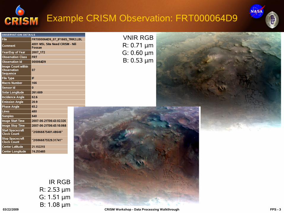
Example CRISM Observation: FRT000064D9
IR RGBR: 2.53 μmG: 1.51 μmB: 1.08 μm
VNIR RGBR: 0.71 μmG: 0.60 μmB: 0.53 μm
03/22/2009 CRISM Workshop - Data Processing Walkthrough FPS - 4
CRISM Data Processing Work Flow
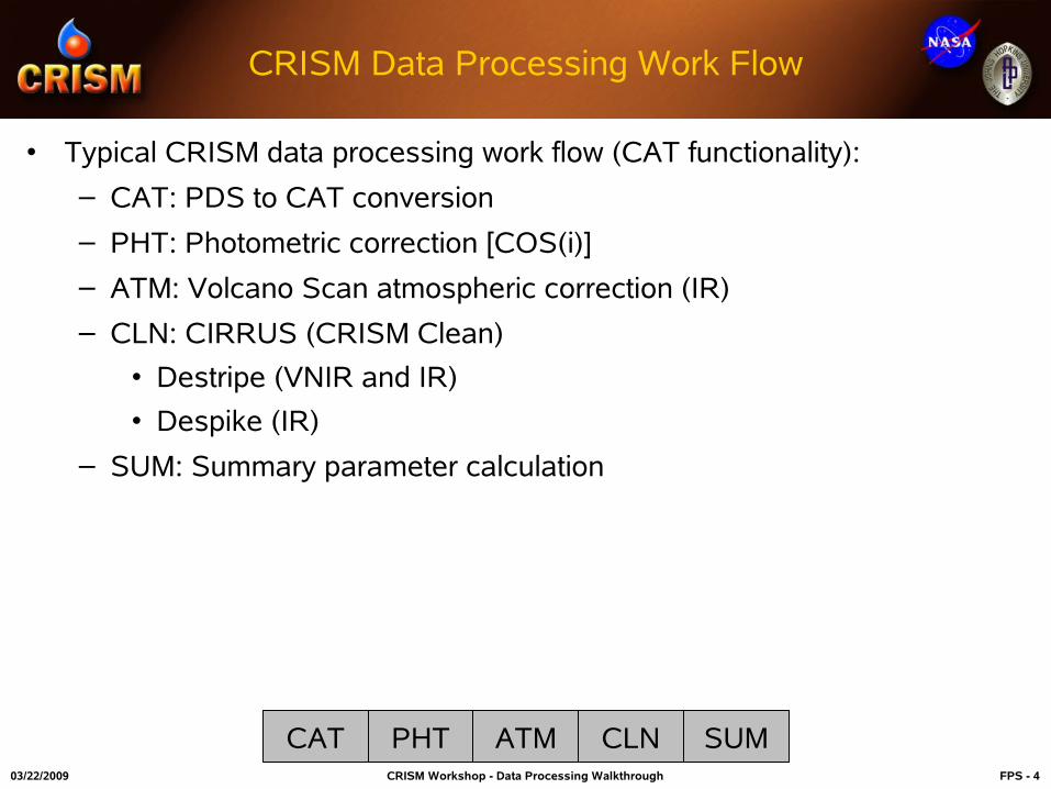
• Typical CRISM data processing work flow (CAT functionality):
– CAT: PDS to CAT conversion
– PHT: Photometric correction [COS(i)]
– ATM: Volcano Scan atmospheric correction (IR)
– CLN: CIRRUS (CRISM Clean)
• Destripe (VNIR and IR)
• Despike (IR)
– SUM: Summary parameter calculation
CAT PHT ATM CLN SUM

03/22/2009 CRISM Workshop - Data Processing Walkthrough FPS - 5
IR Progression: PDS to CAT
FRT000064D9_07_IF166L_TRR2_CAT.IMG FRT000064D9_07_IF166L_TRR2.IMG
ENVI → CAT → Convert Format: PDS to CAT
CAT PHT ATM CLN SUM
Reverses Spectral DimensionApplies Default Bad Bands
03/22/2009 CRISM Workshop - Data Processing Walkthrough FPS - 6
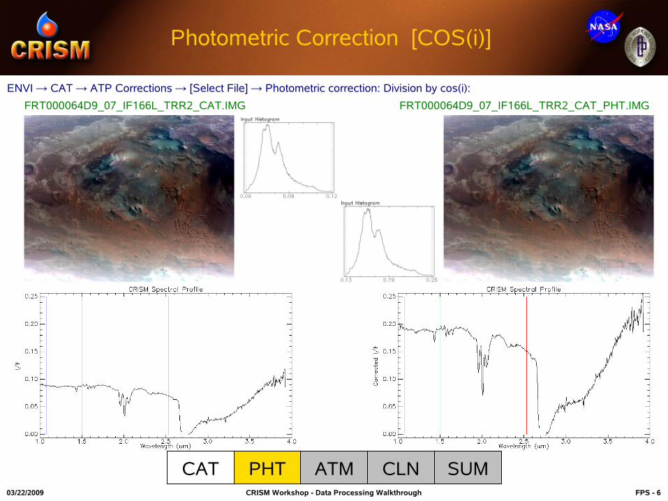
Photometric Correction [COS(i)]
FRT000064D9_07_IF166L_TRR2_CAT_PHT.IMG FRT000064D9_07_IF166L_TRR2_CAT.IMG
ENVI → CAT → ATP Corrections → [Select File] → Photometric correction: Division by cos(i):
CAT PHT ATM CLN SUM
03/22/2009 CRISM Workshop - Data Processing Walkthrough FPS - 7
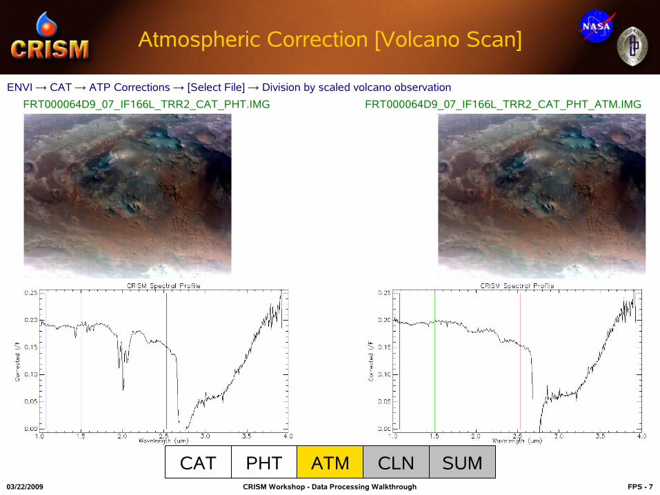
Atmospheric Correction [Volcano Scan]
FRT000064D9_07_IF166L_TRR2_CAT_PHT.IMG FRT000064D9_07_IF166L_TRR2_CAT_PHT_ATM.IMG
CAT PHT ATM CLN SUM
ENVI → CAT → ATP Corrections → [Select File] → Division by scaled volcano observation

03/22/2009 CRISM Workshop - Data Processing Walkthrough FPS - 8
CIRRUS [CRISM Clean]
FRT000064D9_07_IF166L_TRR2..._CAT_PHT_ATM.IMG
CAT PHT ATM CLN SUM
ENVI → CAT → Data Filtering → CIRRUS → Clean Spectral CubeSelect both destripe and despike for IR data
FRT000064D9_07_IF166L_TRR2..._CAT_PHT_ATM_DST_DSP.IMG

03/22/2009 CRISM Workshop - Data Processing Walkthrough FPS - 9
IR Spectral Summary Parameters
CAT PHT ATM CLN SUM
IRA (Infrared Albedo Proxy) D2300 (2300 nm Drop-Off)
LCPINDEX (Low-Calcium Pyroxene Index)
ISLOPE1 (1800 nm to 2500 nm Inverse Spectral Slope)
FRT000064D9_07_IF166L_TRR2..._CAT_PHT_ATM_DST_DSP_SUM.IMG
ENVI → CAT → Spectral Analysis Utilities → Spectral Summary Products → IR Data
03/22/2009 CRISM Workshop - Data Processing Walkthrough FPS - 10
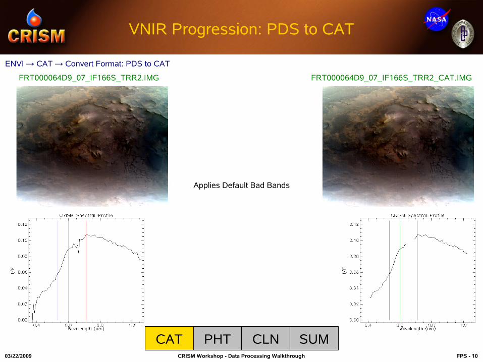
VNIR Progression: PDS to CAT
CAT PHT CLN SUM
ENVI → CAT → Convert Format: PDS to CAT
FRT000064D9_07_IF166S_TRR2.IMG FRT000064D9_07_IF166S_TRR2_CAT.IMG
Applies Default Bad Bands

03/22/2009 CRISM Workshop - Data Processing Walkthrough FPS - 11
Photometric Correction [COS(i)]
CAT PHT CLN SUM
ENVI → CAT → ATP Corrections → [Select File] → Photometric correction: Division by cos(i):
FRT000064D9_07_IF166S_TRR2_CAT_PHT.IMGFRT000064D9_07_IF166S_TRR2_CAT.IMG

03/22/2009 CRISM Workshop - Data Processing Walkthrough FPS - 12
CIRRUS [CRISM Clean]
CAT PHT CLN SUM
ENVI → CAT → Data Filtering → CIRRUS → Clean Spectral CubeSelect destripe for VNIR data
FRT000064D9_07_IF166S_TRR2_CAT_PHT_DST.IMGFRT000064D9_07_IF166S_TRR2_CAT_PHT.IMG
03/22/2009 CRISM Workshop - Data Processing Walkthrough FPS - 13
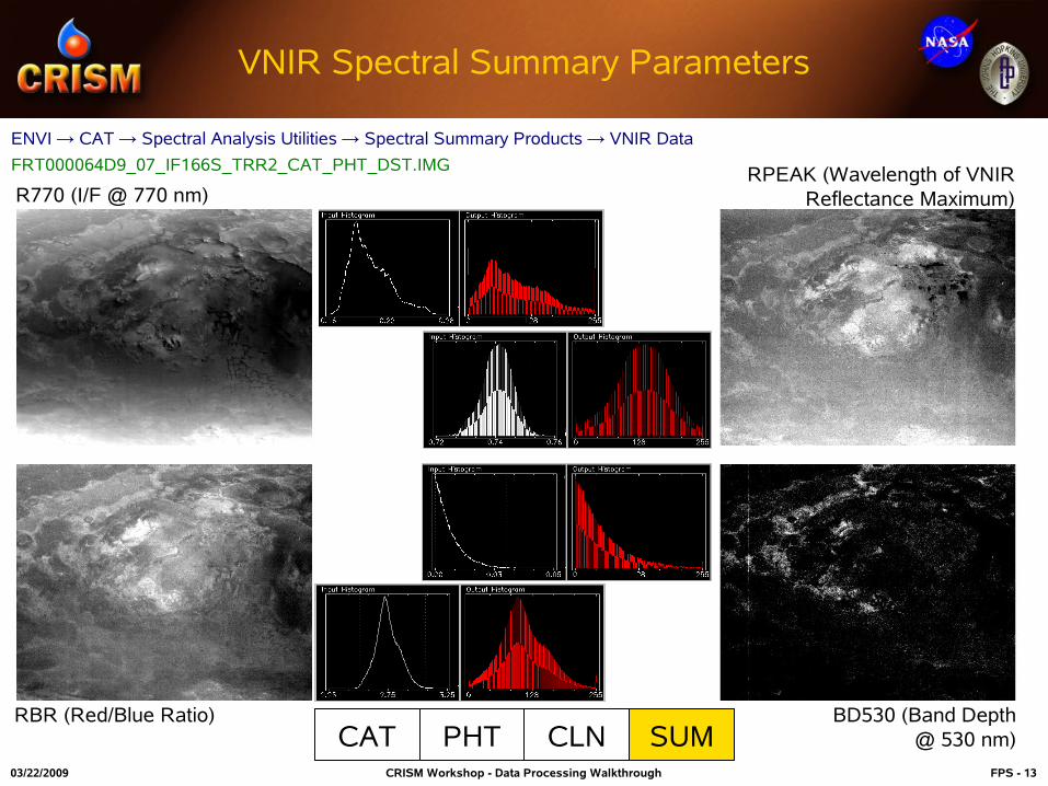
VNIR Spectral Summary Parameters
R770 (I/F @ 770 nm)
RBR (Red/Blue Ratio)
RPEAK (Wavelength of VNIR Reflectance Maximum)
BD530 (Band Depth @ 530 nm)CAT PHT CLN SUM
ENVI → CAT → Spectral Analysis Utilities → Spectral Summary Products → VNIR Data
FRT000064D9_07_IF166S_TRR2_CAT_PHT_DST.IMG
03/22/2009 CRISM Workshop - Data Processing Walkthrough FPS - 14
CRISM Data Analysis Work Flow
• Typical CRISM data analysis work flow (ENVI functionality):
– Spectral unit identification
• Guided spectral investigation
• Link spectral data and selected spectral summary parameter(s)
– Spectral extraction
• Create ROIs based on linked information sources
– Spectral ratios
– Spectral library comparison
03/22/2009 CRISM Workshop - Data Processing Walkthrough FPS - 15
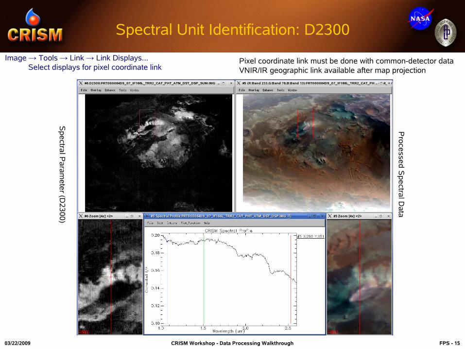
Spectral Unit Identification: D2300
Image → Tools → Link → Link Displays... Select displays for pixel coordinate link
Sp
ectra
l Pa
ram
ete
r (D2
30
0)
Pro
cesse
d S
pe
ctral D
ata
Pixel coordinate link must be done with common-detector dataVNIR/IR geographic link available after map projection
03/22/2009 CRISM Workshop - Data Processing Walkthrough FPS - 16
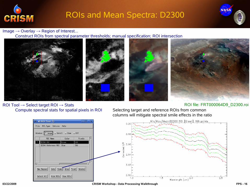
ROIs and Mean Spectra: D2300
ROI file: FRT000064D9_D2300.roi
Image → Overlay → Region of Interest... Construct ROIs from spectral parameter thresholds; manual specification; ROI intersection
ROI Tool → Select target ROI → StatsCompute spectral stats for spatial pixels in ROI Selecting target and reference ROIs from common
columns will mitigate spectral smile effects in the ratio
03/22/2009 CRISM Workshop - Data Processing Walkthrough FPS - 17
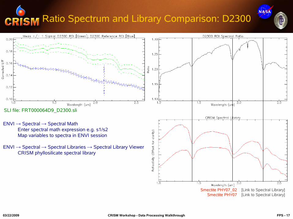
Ratio Spectrum and Library Comparison: D2300
ENVI → Spectral → Spectral MathEnter spectral math expression e.g. s1/s2Map variables to spectra in ENVI session
ENVI → Spectral → Spectral Libraries → Spectral Library ViewerCRISM phyllosilicate spectral library
SLI file: FRT000064D9_D2300.sli
Smectite PHY07_02 [Link to Spectral Library]Smectite PHY07 [Link to Spectral Library]

03/22/2009 CRISM Workshop - Data Processing Walkthrough FPS - 18
Spectral Unit Identification: LCPINDEX
Sp
ectra
l Pa
ram
ete
r (LC
PIN
DE
X)
Pro
cesse
d S
pe
ctral D
ata
Image → Tools → Link → Link Displays... Select displays for pixel coordinate link

03/22/2009 CRISM Workshop - Data Processing Walkthrough FPS - 19
ROIs and Mean Spectra: LCPINDEX
ROI file: FRT000064D9_LCPINDEX.roiROI Tool → Select target ROI → StatsCompute spectral stats for spatial pixels in ROI
Image → Overlay → Region of Interest... Construct ROIs from spectral parameter thresholds; manual specification; ROI intersection
03/22/2009 CRISM Workshop - Data Processing Walkthrough FPS - 20
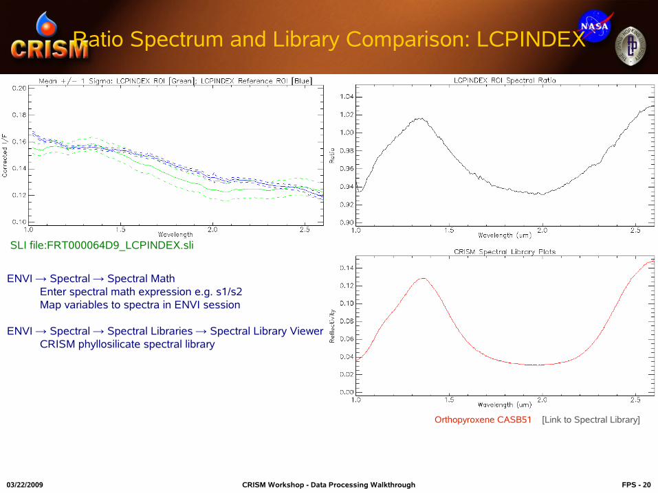
Ratio Spectrum and Library Comparison: LCPINDEX
SLI file:FRT000064D9_LCPINDEX.sli
ENVI → Spectral → Spectral MathEnter spectral math expression e.g. s1/s2Map variables to spectra in ENVI session
ENVI → Spectral → Spectral Libraries → Spectral Library ViewerCRISM phyllosilicate spectral library
Orthopyroxene CASB51 [Link to Spectral Library]

03/22/2009 CRISM Workshop - Data Processing Walkthrough FPS - 21
CRISM Data Registration
• Typical CRISM georeferencing procedure (CAT/ENVI functionality):
– Project single cube (CAT)
• MRO standard projection at native observation nadir resolution
– Project multiple cubes to a common reference (ENVI GLT)
• CAT or user supplied projection information
• VNIR/IR data from common observation for layer stacking
• Data from different observations for mosaicking
– Layer stacking and/or mosaicking (ENVI)
03/22/2009 CRISM Workshop - Data Processing Walkthrough FPS - 22
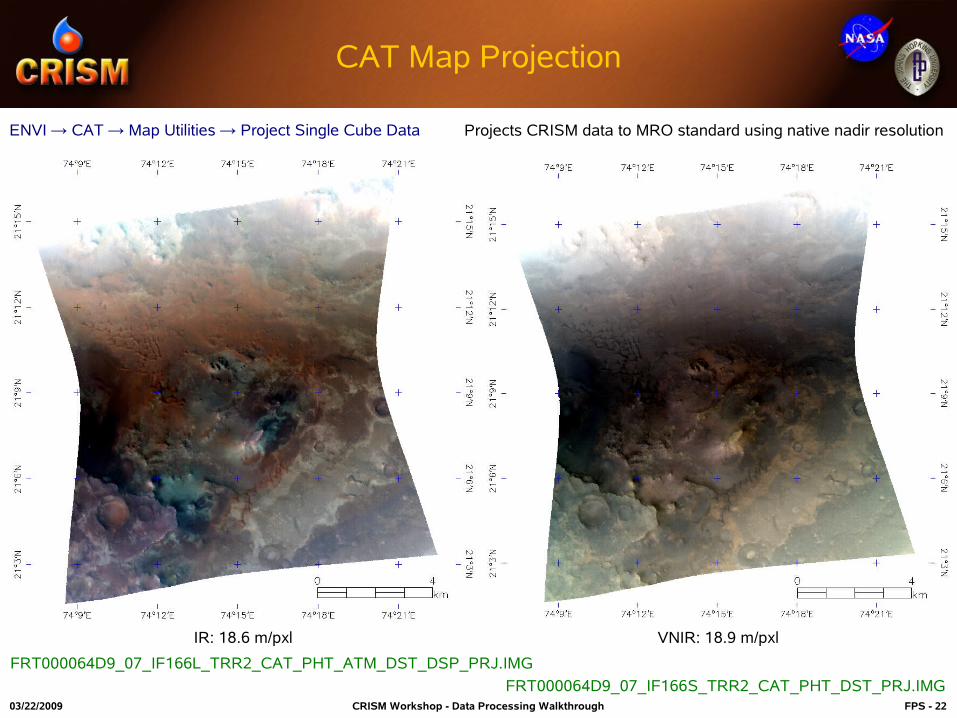
CAT Map Projection
IR: 18.6 m/pxl VNIR: 18.9 m/pxl
ENVI → CAT → Map Utilities → Project Single Cube Data Projects CRISM data to MRO standard using native nadir resolution
FRT000064D9_07_IF166S_TRR2_CAT_PHT_DST_PRJ.IMG
FRT000064D9_07_IF166L_TRR2_CAT_PHT_ATM_DST_DSP_PRJ.IMG
03/22/2009 CRISM Workshop - Data Processing Walkthrough FPS - 23
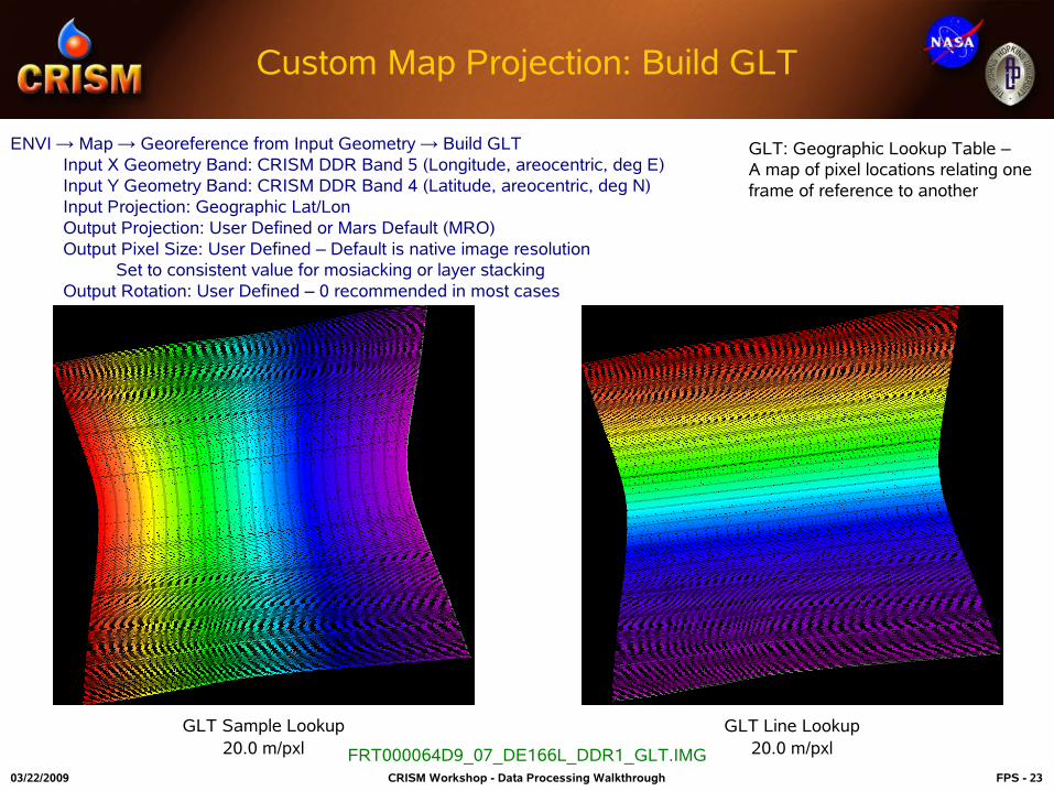
Custom Map Projection: Build GLT
ENVI → Map → Georeference from Input Geometry → Build GLTInput X Geometry Band: CRISM DDR Band 5 (Longitude, areocentric, deg E)Input Y Geometry Band: CRISM DDR Band 4 (Latitude, areocentric, deg N)Input Projection: Geographic Lat/LonOutput Projection: User Defined or Mars Default (MRO)Output Pixel Size: User Defined – Default is native image resolution
Set to consistent value for mosiacking or layer stackingOutput Rotation: User Defined – 0 recommended in most cases
GLT: Geographic Lookup Table – A map of pixel locations relating one frame of reference to another
FRT000064D9_07_DE166L_DDR1_GLT.IMG
GLT Sample Lookup20.0 m/pxl
GLT Line Lookup20.0 m/pxl
03/22/2009 CRISM Workshop - Data Processing Walkthrough FPS - 24
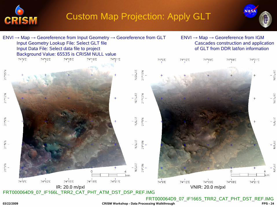
Custom Map Projection: Apply GLT
ENVI → Map → Georeference from Input Geometry → Georeference from GLTInput Geometry Lookup File: Select GLT fileInput Data File: Select data file to projectBackground Value: 65535 is CRISM NULL value
ENVI → Map → Georeference from IGM Cascades construction and application of GLT from DDR lat/lon information
IR: 20.0 m/pxl VNIR: 20.0 m/pxl
FRT000064D9_07_IF166S_TRR2_CAT_PHT_DST_REF.IMG
FRT000064D9_07_IF166L_TRR2_CAT_PHT_ATM_DST_DSP_REF.IMG
03/22/2009 CRISM Workshop - Data Processing Walkthrough FPS - 25
`
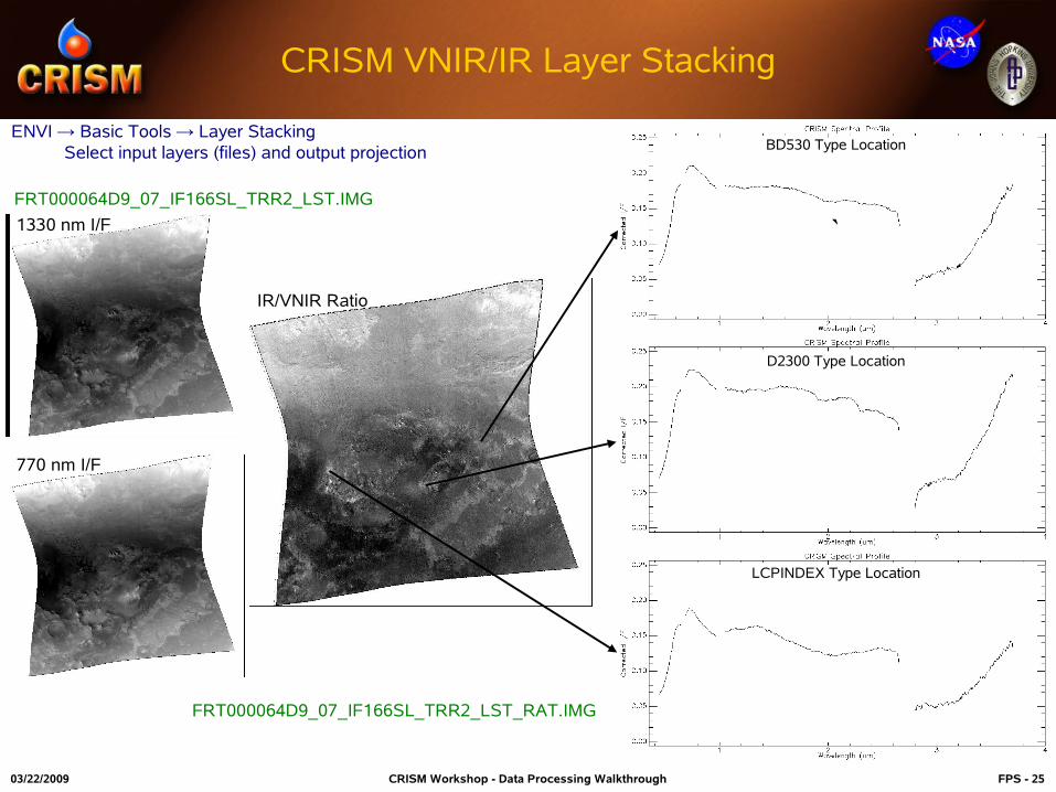
CRISM VNIR/IR Layer Stacking
ENVI → Basic Tools → Layer Stacking Select input layers (files) and output projection
FRT000064D9_07_IF166SL_TRR2_LST.IMG
FRT000064D9_07_IF166SL_TRR2_LST_RAT.IMG
1330 nm I/F
770 nm I/F
IR/VNIR Ratio
D2300 Type Location
LCPINDEX Type Location
BD530 Type Location

03/22/2009 CRISM Workshop - Data Processing Walkthrough FPS - 26
Additional Slides
03/22/2009 CRISM Workshop - Data Processing Walkthrough FPS - 27
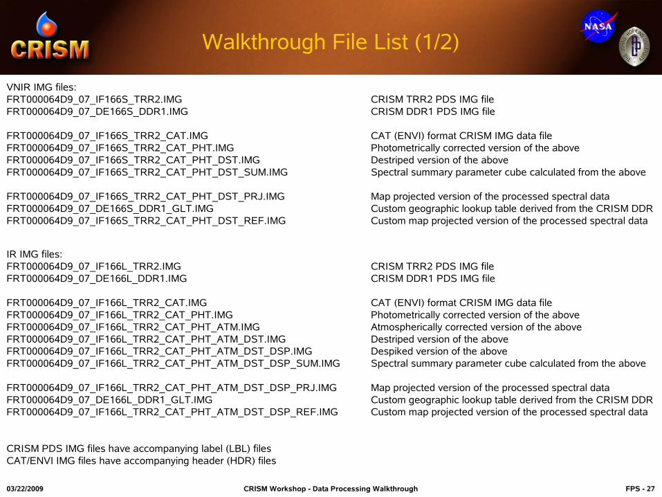
Walkthrough File List (1/2)
VNIR IMG files:FRT000064D9_07_IF166S_TRR2.IMG CRISM TRR2 PDS IMG fileFRT000064D9_07_DE166S_DDR1.IMG CRISM DDR1 PDS IMG file
FRT000064D9_07_IF166S_TRR2_CAT.IMG CAT (ENVI) format CRISM IMG data fileFRT000064D9_07_IF166S_TRR2_CAT_PHT.IMG Photometrically corrected version of the aboveFRT000064D9_07_IF166S_TRR2_CAT_PHT_DST.IMG Destriped version of the aboveFRT000064D9_07_IF166S_TRR2_CAT_PHT_DST_SUM.IMG Spectral summary parameter cube calculated from the above
FRT000064D9_07_IF166S_TRR2_CAT_PHT_DST_PRJ.IMG Map projected version of the processed spectral dataFRT000064D9_07_DE166S_DDR1_GLT.IMG Custom geographic lookup table derived from the CRISM DDRFRT000064D9_07_IF166S_TRR2_CAT_PHT_DST_REF.IMG Custom map projected version of the processed spectral data
IR IMG files:FRT000064D9_07_IF166L_TRR2.IMG CRISM TRR2 PDS IMG fileFRT000064D9_07_DE166L_DDR1.IMG CRISM DDR1 PDS IMG file
FRT000064D9_07_IF166L_TRR2_CAT.IMG CAT (ENVI) format CRISM IMG data fileFRT000064D9_07_IF166L_TRR2_CAT_PHT.IMG Photometrically corrected version of the aboveFRT000064D9_07_IF166L_TRR2_CAT_PHT_ATM.IMG Atmospherically corrected version of the aboveFRT000064D9_07_IF166L_TRR2_CAT_PHT_ATM_DST.IMG Destriped version of the aboveFRT000064D9_07_IF166L_TRR2_CAT_PHT_ATM_DST_DSP.IMG Despiked version of the aboveFRT000064D9_07_IF166L_TRR2_CAT_PHT_ATM_DST_DSP_SUM.IMG Spectral summary parameter cube calculated from the above
FRT000064D9_07_IF166L_TRR2_CAT_PHT_ATM_DST_DSP_PRJ.IMG Map projected version of the processed spectral dataFRT000064D9_07_DE166L_DDR1_GLT.IMG Custom geographic lookup table derived from the CRISM DDRFRT000064D9_07_IF166L_TRR2_CAT_PHT_ATM_DST_DSP_REF.IMG Custom map projected version of the processed spectral data
CRISM PDS IMG files have accompanying label (LBL) filesCAT/ENVI IMG files have accompanying header (HDR) files
03/22/2009 CRISM Workshop - Data Processing Walkthrough FPS - 28
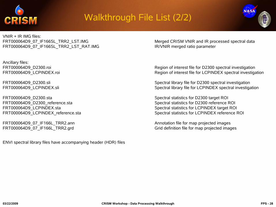
Walkthrough File List (2/2)
VNIR + IR IMG files:FRT000064D9_07_IF166SL_TRR2_LST.IMG Merged CRISM VNIR and IR processed spectral data FRT000064D9_07_IF166SL_TRR2_LST_RAT.IMG IR/VNIR merged ratio parameter
Ancillary files:FRT000064D9_D2300.roi Region of interest file for D2300 spectral investigationFRT000064D9_LCPINDEX.roi Region of interest file for LCPINDEX spectral investigation
FRT000064D9_D2300.sli Spectral library file for D2300 spectral investigationFRT000064D9_LCPINDEX.sli Spectral library file for LCPINDEX spectral investigation
FRT000064D9_D2300.sta Spectral statistics for D2300 target ROIFRT000064D9_D2300_reference.sta Spectral statistics for D2300 reference ROIFRT000064D9_LCPINDEX.sta Spectral statistics for LCPINDEX target ROIFRT000064D9_LCPINDEX_reference.sta Spectral statistics for LCPINDEX reference ROI
FRT000064D9_07_IF166L_TRR2.ann Annotation file for map projected imagesFRT000064D9_07_IF166L_TRR2.grd Grid definition file for map projected images
ENVI spectral library files have accompanying header (HDR) files

03/22/2009 CRISM Workshop - Data Processing Walkthrough FPS - 29
CRISM TRR3 Data Filtering Preview
FRT000064D9_07_IF166L_TRR2.IMG FRT000064D9_07_IF166L_TRR2_IKF.IMG