nell creek fish passage conceptual project design - … stores/data libraries/files/swcd... · nell...
TRANSCRIPT

1
Nell Creek Fish Passage Conceptual Project Design September 2, 2014 Prepared By: Curry Soil and Water Conservation District & Swanson Ecological Services, LLC Project Location: Nell Creek–Chetco River confluence upstream to the FSR1205 070 crossing T40S, R13W, Section 24 Latitude 42.097497, Longitude -124.192359 Project Ownership: Wilson and Kaye Holbrook (parcel is for sale) Ian and Carol Lee Leonard Ron Fallert
Note: The other landowners that use the private access road need to be contacted, and a formal agreement will be required to clarify aspects of the project such as temporary access, cost-share responsibilities, etc.
Project Objectives: (1) Restore fish passage where the existing concrete sill structure impedes
the upstream migration of juvenile and adult salmonids (2) Avoid damaging residential infrastructure as a result of the project’s implementation (3) Restore fish passage where the existing private access road currently impedes the upstream migration of juvenile and adult salmonids (4) Avoid triggering a headcut that degrades upstream habitat (5) Place logs instream to improve habitat where it is appropriate and cost-effective (6) Interplant the riparian area as needed to increase diversity and future instream wood recruitment
Project Permits: A DSL/USACE Removal-Fill Permit is required
Note: Replacement of the concrete sill structure with an engineered “roughened channel” may fit within NOAA’s SLOPES V Restoration, which would eliminate the need for an individual consultation, but hydraulic modeling to simulate passage will likely be required. Prevention of a headcut will also be a condition of meeting the SLOPES criteria, and a Stormwater Management Plan will likely be required because the replacement of the road crossing will be reviewed through SLOPES V Transportation.
Implementation: Not scheduled Funding: No implementation funds are pending or secured

2
OVERVIEW Nell Creek is a small fish bearing tributary of the Chetco River that enters from river left (looking downstream) near RM 7.5. The watershed is 245 acres in size, of which 34% is private ownership that extends from the Chetco River upstream 2,980 feet to the Rogue-Siskiyou National Forest boundary. Usable fish habitat extends upstream from the river approximately 0.76 miles to a Forest Service road crossing on FSR1205 070, which correlates with a steep increase in stream gradient that is the natural end of fish habitat. Juvenile fish are blocked, and adults seriously impeded, from accessing the usable habitat by the combined effects of a concrete sill structure at the mouth of Nell Creek, which was purportedly installed as part of a hatch-box operation, and a road-stream crossing culvert on a private access road located 240 feet upstream of the river (see photos). Upstream of the road crossing Nell Creek is moderately steep (~4%), with an active channel width of 12-15 feet. INVESTIGATIONS (1) Fish Usage: On January 17, 2014 ODFW’s Gold Beach Assistant District Fish Biologist and the
Curry Soil and Water Conservation District’s (SWCD) Project Manager used an electro-fisher to conduct a presence-absence fish survey upstream of the private road crossing. Sparse numbers of coastal cutthroat trout were observed, but no salmon or steelhead were present. The timing of the survey was meant to detect whether pre-smolts, particularly steelhead, were using the stream as overwintering habitat; in ODFW’s opinion this should be a key function of Nell Creek. Although the winter of 2013-14 was unseasonably dry up to the date of the survey, pre-smolts would likely have been present if the impediments did not exist, and cutthroat trout would have been observed in higher densities.
(2) Instream Habitat: The SWCD’s Project Manager walked segments of the upstream channel in late summer 2013 to make a general evaluation of the channel type and instream conditions. Based on those observations he concluded that instream wood placements and riparian interplanting should be further investigated if a restoration proposal is submitted for funding. ODFW will also conduct an Aquatic Inventory Protocol (AIP) instream habitat survey in April 2015 to capture pre-project data on wood, channel morphology, fish presence, etc. This survey should be consulted if instream wood placements and/or riparian interplantings are further investigated, and could provide additional data on the morphology of the upstream channel.
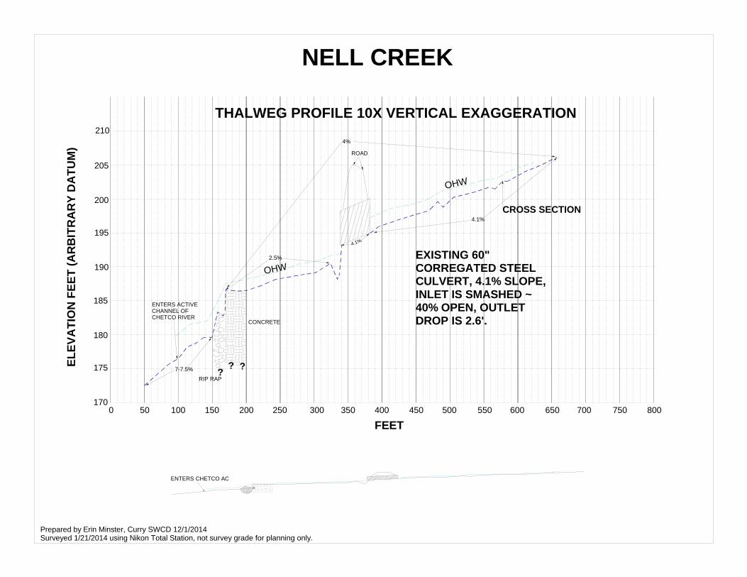
(3) Total Station Coordinate Survey: On January 21, 2014 the SWCD’s Project Manager and Data Management Specialist conducted an abbreviated coordinate survey using a Total Station survey instrument. An arbitrary datum was used to survey longitudinal and cross-sectional profiles of the stream channel, and spatial data was collected to develop a planview of the project area. The Data Management Specialist plotted the coordinate data using drafting software, and generated a longitudinal thalweg profile, channel cross-sections, and a planview map (see attached drawings).
(4) Engineering Site Visit: On September 2, 2014 a registered engineer specializing in stream restoration and fish passage visited the site with the SWCD’s Project Manager, to “brainstorm” design alternatives; no documents were produced.
CONCEPTUAL FISH PASSAGE DESIGN Based on the Total Station coordinate data, feedback received from the engineer, observations made during a bankfull event on February 14, 2014, regulatory constraints, and past experience designing and implementing fish passage projects, the following conceptual design solutions are recommended. Concrete Sill Structure: This structure should be removed and replaced with an engineered roughened channel that is constructed using large angular rock for grade control, and a mix of fine

3
and coarse substrate that fill the voids and prevent dewatering. The size, gradation, and volume of rock; and the slope, length, and position of the engineered channel; will have to be determined by a licensed engineer capable of modeling the hydraulics, and simulating fish passage over a range of discharge. An engineered roughened channel has the following advantages:
• A roughened channel can pass juvenile and adult salmonids over a wide range of discharge • A roughened channel can serve as grade control on the upstream channel, which is a
prudent measure to avoid triggering a headcut that would degrade upstream habitat and potentially threaten residential infrastructure
• A roughened channel likely can be permitted through the SLOPES V Restoration criteria Private Access Road Crossing: The existing culvert should be removed and replaced with a pre-fabricated steel bridge structure that is placed on poured concrete footings. Multiple companies provide these types of structures, which are engineered by the supplier to the specific design requirements of the site. A pre-fabricated steel bridge structure has the following advantages:
• Given the width of the active channel, a single span embedded arch culvert would not meet the SLOPES V Restoration fish passage criteria because the maximum width of this type of culvert is 14.25 feet and NOAA’s criteria requires the culvert to be 1.5 times the active channel width. To meet the SLOPES V criteria an approximately 20 ft wide embedded multi-plate or bottomless arch culvert would be required, and these structures are nearing the cost of a bridge without the intrinsic fish passage benefits of a bridge; they are also, in some ways, more difficult to install
• Installing a culvert that does not meet the SLOPES V Restoration fish passage criteria would require NOAA to conduct an individual ESA consultation for the project, which would require additional engineering and significantly lengthen the permitting process. It is also unclear whether NOAA would even entertain such a proposal given that there are no constraints at the project site to prevent a design that is consistent with the SLOPES criteria, and even if they would accept an alternative design, it would likely have to meet their stream simulation criteria, which would still prevent the use of a single span embedded arch culvert
• A bridge would meet the SLOPES V Restoration criteria as long as it provides an approximate 30 foot wide cross-sectional floodway at the crossing
• A bridge can accommodate greater vertical adjustment in the bed elevation than an embedded or bottomless arch culvert, which is an important consideration at this site because the channel bed fluctuates dramatically in response to the height of the Chetco River (terrace deposits indicate recent fluctuations of 4 feet or more)
• A pre-fabricated steel bridge structure will be engineered specifically for the site, so it will satisfy the legal requirements inherent to a residential road (i.e. load bearing certification, structural guardrails, adequate width and pitch for emergency vehicles, etc.) and, by default, provide the project sponsor protection against liability. Used materials, such as surplus steel beams, concrete slabs, and railcars, are troublesome to load test and certify, and it can be difficult to “fit” a structure made from used materials to a site, and finish it to a sufficient standard (decking, guard rails, etc.)
• A pre-fabricated steel bridge is modular in nature, and therefore is relatively easy and quick to install (the poured concrete footings are the limiting factor in the timeline)
• A pre-fabricated steel bridge is aesthetically pleasing

4
Grade Control Wood Structures: There is approximately 4.5 feet of vertical drop in the channel thalweg as it transitions through the fill prism of the private access road. When the existing culvert is replaced, whether with a bridge, open pipe arch, or multi-plate embedded arch culvert, the Nell Creek channel will naturally regrade this vertical instability by headcutting upstream. Allowing this to happen would (a) most likely not be permitted through SLOPES V Transportation, and (b) would degrade instream habitat for 500 feet or more upstream as the channel will incised and abandoned its floodplain and active terraces; releasing that much bedload in a short time span could also affect the channel downstream of the road and the residential infrastructure on river left (looking downstream). For these reasons a transitional segment of channel should be constructed in conjunction with the culvert replacement, using wood structures to control the stream gradient and produce high quality instream habitat. Other Considerations: • The existing road surface is asphalt, and it’s showing signs of deterioration from the
intersection of FSR1205 070 down to the Nell Creek crossing. Mobilization of heavy equipment and project materials will likely further degrade the condition of the asphalt, and approximately 100 feet will have to be removed to reconstruct the stream crossing. Repaving the road, even if confined to the road-stream crossing, will be a significant cost that needs to be accounted for in the project budget and in negotiations with the landowners
• Project implementation will require one or more large staging areas for heavy equipment and project materials. The Holbrook and Fallert parcels are the most suitable sites given their close proximity to the project area. Negotiations should occur well in advance of developing a project budget because the proximity and size of the staging area(s) will significantly influence the cost of the project
• Project implementation will generate 100s to 1000s of cubic yards of spoils material, most of which will be road fill and streambed aggregate. Some of this material can be reincorporated into the project, specifically as fine and coarse bed material used to fill the voids in the engineered roughened channel, but one or more off-site locations will be necessary to dispose of the excess material. The proximity of and access to these sites will significantly influence the cost of the project, so negotiations should occur in advance of developing a project budget
• The private road provides access to multiple residencies that are located beyond the road-stream crossing. An agreement will need to be reached with these landowners that, at a minimum, defines their fiscal contribution to the project and assigns responsibility for post-implementation maintenance of the project components
• Buried utilities may exist in the fill prism of the private access road. These need to be located, and accounted for in the project design
• Temporary access will be required during the replacement of the road-stream crossing culvert. It may be possible to develop a detour that routes traffic around the project area via FSR1205 070, but further investigation is needed to determine where the detour would connect with the private access road, and if it would be navigable for emergency service vehicles (i.e. fire tanker, ambulance, etc.). If a detour is feasible, the landowners and Forest Service will have to agree to the arrangement, otherwise a temporary crossing will have to be constructed through the project area.
• Residential infrastructure located downstream of the road-stream crossing must be protected during project implementation, and from adjustments in the stream channel that result from the project activities. Specifically, there are two well casings located on river right near the confluence with the Chetco River, and there are two residential structures (1 residency, 1 outbuilding) on river left (see planview drawing)

5
• Nell Creek is a perennial stream, so the incoming flow will have to be pumped or piped around the project area during implementation of the engineered roughened channel, replacement of the road-stream crossing, and installation of the grade-control wood structures
• The cost of project implementation will exceed $50,000, which is currently the threshold at which the State’s Prevailing Wage Rate laws apply if the project sponsor is a public agency, i.e. the Curry Soil and Water Conservation District, or if project funding dictates that these laws apply; the threshold at which the Federal Davis-Bacon wage rates apply is potentially lower. If these wage rate laws apply, the cost of project implementation will likely be 30%-40% higher than if the project were implemented by a private or non-profit entity, using funds that do not require these rates. This should be considered when negotiating with the private landowners because they may decide to contract and pay for the project construction, as a way to avoid these inflated costs
PROJECT ENGINEERING The Curry SWCD’s conceptual project design is for planning purposes only, and is not sufficient for implementation; it should only be used for non-construction tasks such as facilitating further discussion with the affected landowners, with jurisdictional regulatory personnel, and with potential funders. Given the complexity of the project site, the adjacent residential infrastructure, and the permit requirements, a registered professional engineer with experience in fish passage design and stream mechanics should be enlisted to advance this conceptual design to a “construction-ready”, 100% complete design; complete with the engineer’s stamp. At a minimum, the following tasks should be included in an engineering Scope of Work:
• Topographic Survey: The Curry SWCD’s Total Station coordinate survey was conducted for the purpose of developing a conceptual design, and is not sufficient for project engineering. A professional land surveyor, or preferably an engineering firm with survey capabilities, should conduct a topographic coordinate survey of the project area that extends from the Chetco River upstream through the segment of grade-control log structures, and includes sufficient detail to design the project components and protect the residential infrastructure. An arbitrary datum should be sufficient to establish the coordinate survey, unless there is a need to precisely locate property lines for the purpose of securing landowner permission, negotiating agreements, etc. LIDAR and/or aerial photography can be used to display features outside the project area, such as staging locations, access, disposal sites, etc. The coordinate data should be post-processed by the party conducting the survey. If a professional land surveyor conducts the survey, it is critical that there is direct communication between the surveyor and the project engineer in advance of the survey to ensure that the coordinate data is sufficient for the project design
• Engineered Roughened Channel: Replacement of the concrete sill with a roughened channel will require engineering to determine the location, morphology, and structural components of the channel; and to demonstrate that the channel will pass juvenile and adult fish in a manner comparable to “natural” conditions
• Pre-Fabricated Steel Bridge: Engineering will be required to determine the bridge length and alignment, the location of the bridge abutments, and the type and location of slope protection, if needed. The bridge structure and decking will be engineered by the supplier, and depending on their capacity, they may be able to engineer the bridge abutments as well; otherwise, the project engineer will design the abutments. Regardless of who designs the abutments, some degree of subsurface investigation will likely be necessary to determine the load bearing capacity of the soils at the abutment locations

6
• Transitional Stream Channel: Engineering will be required to determine the location, morphology, and the length of the stream channel that is constructed to transition Nell Creek through the vertical drop associated with the road-stream crossing. As part of the design the project engineer should determine the size, configuration, and location of the wood structures that are used to control the gradient of the constructed channel
• Preparation of Bid Documents; Construction Staking; Construction Inspection: The project engineer may need to be involved in the solicitation of construction bids and/or the implementation of the project. This will depend, in part, on the competency of the project sponsor, and on the capacity of the construction contractor. At a minimum, the project engineer should inspect project implementation at least once during construction of the roughened channel and at least once during construction of the transitional channel

W
W
W
ACCESS ROADP
RIV
ATE
RO
ADRESIDENCE
PATIO
CARPORT
GRADEDTURNOUT
CH
ETC
O R
IVER
GR
AVEL
BAR
LOW TERRACE
TERRACE
TERRACE/YARD
50-55
80+
70-75
15-20
30
60-65
60-65
60-65
45-50
10-15
20-25
35-40
40-45
55-60
2-4
0-2
NELL CREEK CULVERTPLANVIEW
CROSS SECTIO
N45-50D
ITC
HPERCENT SLOPE
BREAK IN SLOPE
OHW-ORDINARY HIGH WATER
THALWEG
SLOPE OF GRAVEL BAR
TOP OF GRAVEL BAR
RIP RAP
CONCRETE-REMNANT HATCHERY BOX
PP
EXISTING 60" CORREGATED STEEL CULVERT, 4.1% SLOPE, INLET IS SMASHED ~ 40% OPEN, OUTLET DROP IS 2.6'.
50 FEETN
GABIEON
PAVE
DEXPLANATION
RLRROHW
200205
10 20 30 40 50
210
0
215
70 80 90 100 11060 120 130
CROSS SECTION
Prepared by Erin Minster, Curry SWCD 12/1/2014Surveyed 1/21/2014 using Nikon Total Station, not survey grade for planning only.
10
ENTERS CHETCO AC
ENTERS ACTIVE CHANNEL OF CHETCO RIVER
170
175
180
185
0 50 100 150 200 250 300 350 400 450 500 550 600 650 700 750 800
190
195
200
205
210
7-7.5%
2.5%
4.1%
4%
4.1%
THALWEG PROFILE 10X VERTICAL EXAGGERATION
FEET
ELE
VATI
ON
FEE
T (A
RB
ITR
AR
Y D
ATU
M)
EXISTING 60" CORREGATED STEEL CULVERT, 4.1% SLOPE, INLET IS SMASHED ~ 40% OPEN, OUTLET DROP IS 2.6'.
ROAD
CONCRETE
RIP RAP
???
CROSS SECTION
Prepared by Erin Minster, Curry SWCD 12/1/2014Surveyed 1/21/2014 using Nikon Total Station, not survey grade for planning only.
NELL CREEK
OHW
OHW

Nell Creek Fish Passage: The concrete sill structure located near the confluence with the Chetco River impedes juvenile
and adult fish passage during winter baseflow condi ons. The structure was purportedly installed as part of hatch‐box
opera on.

Nell Creek Fish Passage: Top photo shows the channel between the concrete sill structure and the private road cross‐
ing, which aggrades when the Chetco River backwaters Nell Creek. Bo om photo shows the 60 inch diameter culvert
at the road crossing, which is an impediment to upstream fish migra on and a hydraulic constric on on the channel.

Nell Creek Fish Passage: Top photo shows the inlet of the 60 inch diameter culvert at the road crossing, which is a sig‐
nificant constric on on the channel. Bo om photo shows the Nell Creek channel upstream of the influence of the
road crossing, where the ac ve channel averages 12‐15 feet in width and the stream gradient is ~4%.

Nell Creek Fish Passage: Top photo shows the culvert outlet during a “bankfull event” that took place on February 14,
2014. The combina on of the culvert’s jump height and velocity act as a barrier to upstream fish migra on. Bo om
photo shows the concrete sill structure during the same event.