near future climate projections over the red river delta ...danida.vnu.edu.vn/cpis/personal/tan/near...
TRANSCRIPT
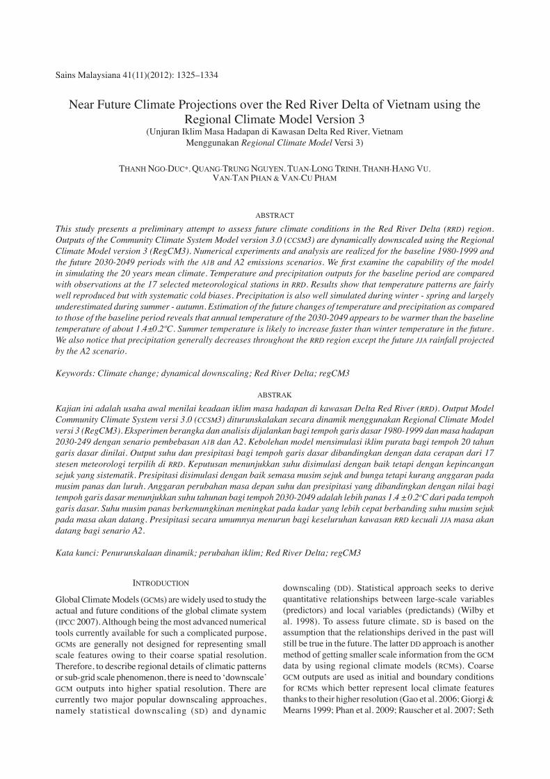
Sains Malaysiana 41(11)(2012): 1325–1334
Near Future Climate Projections over the Red River Delta of Vietnam using the Regional Climate Model Version 3
(Unjuran Iklim Masa Hadapan di Kawasan Delta Red River, Vietnam Menggunakan Regional Climate Model Versi 3)
THANH NGO-DUC*, QUANG-TRUNG NGUYEN, TUAN-LONG TRINH, THANH-HANG VU, VAN-TAN PHAN & VAN-CU PHAM
ABSTRACT
This study presents a preliminary attempt to assess future climate conditions in the Red River Delta (RRD) region. Outputs of the Community Climate System Model version 3.0 (CCSM3) are dynamically downscaled using the Regional Climate Model version 3 (RegCM3). Numerical experiments and analysis are realized for the baseline 1980-1999 and the future 2030-2049 periods with the A1B and A2 emissions scenarios. We first examine the capability of the model in simulating the 20 years mean climate. Temperature and precipitation outputs for the baseline period are compared with observations at the 17 selected meteorological stations in RRD. Results show that temperature patterns are fairly well reproduced but with systematic cold biases. Precipitation is also well simulated during winter - spring and largely underestimated during summer - autumn. Estimation of the future changes of temperature and precipitation as compared to those of the baseline period reveals that annual temperature of the 2030-2049 appears to be warmer than the baseline temperature of about 1.4±0.2ºC. Summer temperature is likely to increase faster than winter temperature in the future. We also notice that precipitation generally decreases throughout the RRD region except the future JJA rainfall projected by the A2 scenario.
Keywords: Climate change; dynamical downscaling; Red River Delta; regCM3
ABSTRAK
Kajian ini adalah usaha awal menilai keadaan iklim masa hadapan di kawasan Delta Red River (RRD). Output Model Community Climate System versi 3.0 (CCSM3) diturunskalakan secara dinamik menggunakan Regional Climate Model versi 3 (RegCM3). Eksperimen berangka dan analisis dijalankan bagi tempoh garis dasar 1980-1999 dan masa hadapan 2030-249 dengan senario pembebasan A1B dan A2. Kebolehan model mensimulasi iklim purata bagi tempoh 20 tahun garis dasar dinilai. Output suhu dan presipitasi bagi tempoh garis dasar dibandingkan dengan data cerapan dari 17 stesen meteorologi terpilih di RRD. Keputusan menunjukkan suhu disimulasi dengan baik tetapi dengan kepincangan sejuk yang sistematik. Presipitasi disimulasi dengan baik semasa musim sejuk and bunga tetapi kurang anggaran pada musim panas dan luruh. Anggaran perubahan masa depan suhu dan presipitasi yang dibandingkan dengan nilai bagi tempoh garis dasar menunjukkan suhu tahunan bagi tempoh 2030-2049 adalah lebih panas 1.4 ± 0.2oC dari pada tempoh garis dasar. Suhu musim panas berkemungkinan meningkat pada kadar yang lebih cepat berbanding suhu musim sejuk pada masa akan datang. Presipitasi secara umumnya menurun bagi keseluruhan kawasan RRD kecuali JJA masa akan datang bagi senario A2.
Kata kunci: Penurunskalaan dinamik; perubahan iklim; Red River Delta; regCM3
INTRODUCTION
Global Climate Models (GCMs) are widely used to study the actual and future conditions of the global climate system (IPCC 2007). Although being the most advanced numerical tools currently available for such a complicated purpose, GCMs are generally not designed for representing small scale features owing to their coarse spatial resolution. Therefore, to describe regional details of climatic patterns or sub-grid scale phenomenon, there is need to ‘downscale’ GCM outputs into higher spatial resolution. There are currently two major popular downscaling approaches, namely statistical downscaling (SD) and dynamic
downscaling (DD). Statistical approach seeks to derive quantitative relationships between large-scale variables (predictors) and local variables (predictands) (Wilby et al. 1998). To assess future climate, SD is based on the assumption that the relationships derived in the past will still be true in the future. The latter DD approach is another method of getting smaller scale information from the GCM data by using regional climate models (RCMs). Coarse GCM outputs are used as initial and boundary conditions for RCMs which better represent local climate features thanks to their higher resolution (Gao et al. 2006; Giorgi & Mearns 1999; Phan et al. 2009; Rauscher et al. 2007; Seth
1326
et al. 2007). An important advantage of DD is this approach can consistently represent the processes that drive climate dynamics and can also produce results for the regions where no observations are available. However, the level of detail information in DD requires relatively powerful computational resources, in terms of both computer speed and storage system. This constraint explains why RCMs have been seldom applied over Southeast Asia, particularly over the Indochina Peninsula. In Vietnam and surrounding regions, there have been several studies on the changes/trends of different climatic elements under the context of climate changes. Trends of precipitation extremes have been investigated using daily precipitation data of the second half of the 20th century (Endo et al. 2009; Manton et al. 2001). Endo et al. (2009) showed that hearvy precipitation increases in the south while it decreases in northern Vietnam. Takahashi (2011) analyzed rainfall in the transition wet-dry seasons and found that the monsoon onset is earlier over the western Indochina Peninsula and the rainfall in nothern Vietnam increases during October in the last 40 years. Kajikawa et al. (2012) confirmed the advanced monsoon onsets over the Bay of Bengal and the western Pacific in recent decades which consequently influence the rainfall activity in Vietnam. Ho et al. (2011) used a RCM to study future climate for 7 climatic sub-regions in Vietnam. They found that hot summer days will increase and cold winter nights will decrease as a consequence of global warming. They also found a strong opposite projected changes in precipitations extremes over the southern half of Vietnam. As a national effort, in August 2009, the Ministry of Natural Resources and Environment (MONRE) of Vietnam has officially announced the scenarios of climate change and sea level rise for Vietnam (MONRE of Vietnam 2009). The SD approach had been used to build the scenarios. According to MONRE, for the medium emission scenario, in the late 21st century, average temperatures in the country will increase by about 2.3ºC; total annual and rainy season rainfall will increase while it will decrease in dry seasons; sea level will rise by about 75 cm compared with the baseline period of 1980-1999. This study focused on a rather small region of Vietnam, the Red River Delta (RRD) region. We aim to make a first attempt using the DD approach to project future climate conditions over this region. RRD is the flat plain formed by the Red river and its distributaries joining in the ThaiBinh river in northern Vietnam (Figure 1). RRD is characterized by its landscape diversity with upstream hilly zone, flat topography in central part and strongly artificialized mangroves in its coastal zone. RRD is strongly affected by monsoon and has four distinct seasons. This region is frequently hit by tropical cyclones, floods and other climate related disasters, causing human casualties and heavy damages on properties and infrastructure. Therefore, necessary measures should be taken in RRD to prepare communities for climate-related disasters, which will consequently enhance the adaptive capacity to climate
change (Nguyen 2007). Among these measures, projecting and understanding future climate features over RRD are of great importance.
NUMERICAL EXPERIMENTS AND DATA
NUMERICAL EXPERIMENTS
The Regional Climate Model version 3.0 (RegCM3) is used in this study for dynamically downscaling global outputs. This model, developed at the Abdus Salam International Centre for Theoretical Physics (ICTP) (Pal et al. 2007), is a hydrostatic, limited-area model with a sigma vertical level. The previous versions of RegCM were described in Dickinson et al. (1989) (RegCM1), Giorgi and Bates (1989), Giorgi et al. (1993a, 1993b) (RegCM2), and Giorgi and Mearns (1999) (RegCM2.5). The global data used as initial and boundary conditions for RegCM3 in this study are the Community Climate System Model version 3.0 (CCSM3) outputs (Collins et al. 2005). CCSM3 is a coupled GCM with combination of the four components: atmosphere, land-surface, ocean and sea ice. CCSM3 has 1.4° of horizontal resolution and 26 vertical levels. The CCSM3 runs for the future in this study are based on the A1B-medium and the A2-high scenarios of greenhouse gas emissions from the Intergovernmental Panel on Climate Change (IPCC) Special Report on Emission Scenarios (SRES) (Nakicenovic & Swart 2000). RegCM3 is integrated with CCSM3 boundary for the baseline period from 1980 to 1999 and for the future period from 2030 to 2049. Lateral boundary conditions from CCSM3 are updated every 6 h. The model domain centered at 11.5oN and 108.0oE with 142 and 103 grid-points in west-east and south-north directions, respectively. The horizontal resolution is 36 km and the normal Mercator conformal projection is used. The model runs with 18 vertical σ-levels, in which 6 levels are under 850 mb in the planetary boundary layer. The top layer is at 50 mb. Other physical parameterization options are the same as those in Phan et al. (2009).
OBSERVED STATION DATA
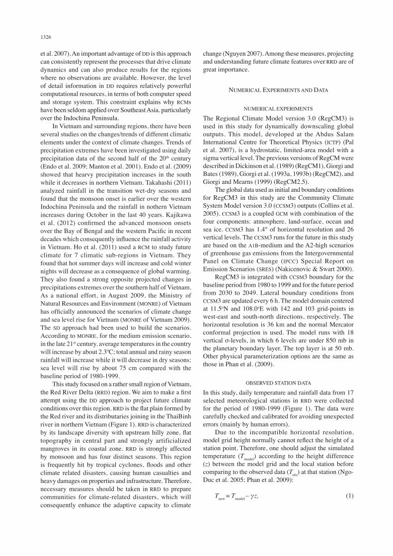
In this study, daily temperature and rainfall data from 17 selected meteorological stations in RRD were collected for the period of 1980-1999 (Figure 1). The data were carefully checked and calibrated for avoiding unexpected errors (mainly by human errors). Due to the incompatible horizontal resolution, model grid height normally cannot reflect the height of a station point. Therefore, one should adjust the simulated temperature (Tmodel) according to the height difference (z) between the model grid and the local station before comparing to the observed data (Tobs) at that station (Ngo-Duc et al. 2005; Phan et al. 2009):
Tnew = Tmodel – γz, (1)
1327
where is the environmental lapse rate. In this study, we use γ =0.65ºC/100 m which is the average value in the troposphere (Lutgens et al. 2006). Table 1 provides detail information about the model and station heights which will be used for lapse rate correction at the 17 meteorological stations in RRD.
THE ERA-INTERIM REANALYSIS DATA
The ERA-Interim reanalysis data (Dee et al. 2011) which is publicly available on the European Centre for Medium-Range Weather Forecasts (ECMWF) Data Server, at a 1.5° resolution, is used to validate the quality of the downscaling outputs. ERA-Interim represents a major undertaking
TABLE 1. The 17 meteorological stations and their heights (in m) as observed and as shown by the RegCM grid
Nb Stations Observed height
Model height
Nb Stations Observed height
Model height
123456789
TuyenQuangYenBaiPhuHoThaiNguyenTamDaoVietTriVinhYenBaViSonTay
42.056.036.036.0
897.017.010.020.07.0
232.1485.4225.1151.8151.8136.281.5
185.5136.2
1011121314151617
LangHaiDuongHungYenHaNamNhoQuanNamDinhThaiBinhVanLy
3.02.04.03.0
12.03.03.03.0
75.635.729.529.595.127.34.40.0
FIGURE 1. Orography of the Red River Delta (in m) and locations of the 17 meteorological stations
1328
by ECMWF to produce a reanalysis with an improved atmospheric model and assimilation system which replaces those used in ERA-40 (Uppala et al. 2005), particularly for the data-rich period from the 1990s.
RESULTS
PERFORMANCE OF REGCM3 DURING THE BASELINE PERIOD
Performance of RegCM3 in simulating surface climate elements over Vietnam was discussed in Phan et al.
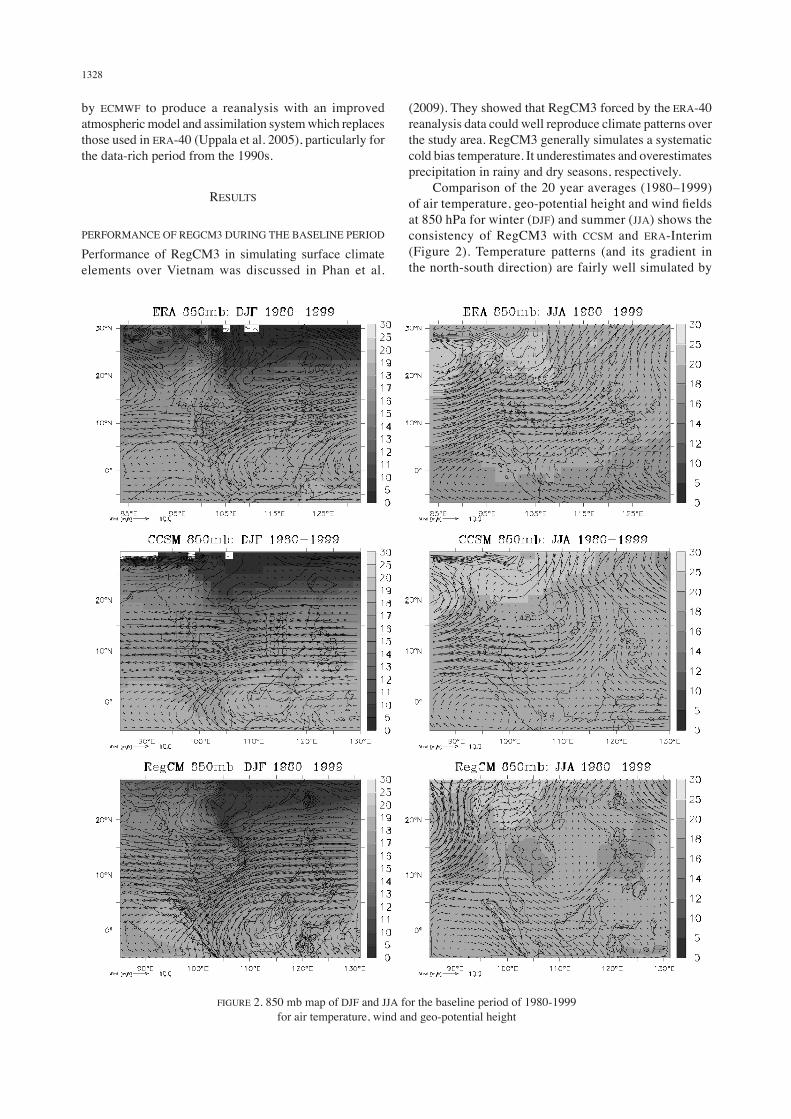
(2009). They showed that RegCM3 forced by the ERA-40 reanalysis data could well reproduce climate patterns over the study area. RegCM3 generally simulates a systematic cold bias temperature. It underestimates and overestimates precipitation in rainy and dry seasons, respectively. Comparison of the 20 year averages (1980–1999) of air temperature, geo-potential height and wind fields at 850 hPa for winter (DJF) and summer (JJA) shows the consistency of RegCM3 with CCSM and ERA-Interim (Figure 2). Temperature patterns (and its gradient in the north-south direction) are fairly well simulated by
FIGURE 2. 850 mb map of DJF and JJA for the baseline period of 1980-1999 for air temperature, wind and geo-potential height
1329
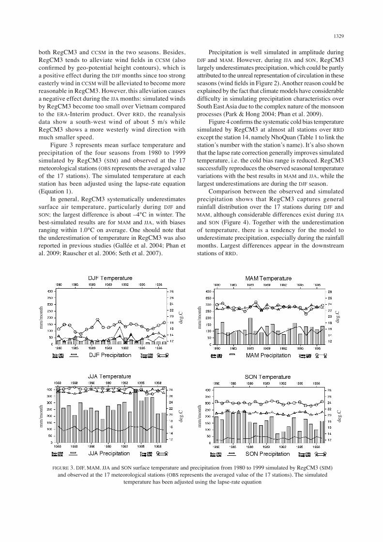
both RegCM3 and CCSM in the two seasons. Besides, RegCM3 tends to alleviate wind fields in CCSM (also confirmed by geo-potential height contours), which is a positive effect during the DJF months since too strong easterly wind in CCSM will be alleviated to become more reasonable in RegCM3. However, this alleviation causes a negative effect during the JJA months: simulated winds by RegCM3 become too small over Vietnam compared to the ERA-Interim product. Over RRD, the reanalysis data show a south-west wind of about 5 m/s while RegCM3 shows a more westerly wind direction with much smaller speed. Figure 3 represents mean surface temperature and precipitation of the four seasons from 1980 to 1999 simulated by RegCM3 (SIM) and observed at the 17 meteorological stations (OBS represents the averaged value of the 17 stations). The simulated temperature at each station has been adjusted using the lapse-rate equation (Equation 1). In general, RegCM3 systematically underestimates surface air temperature, particularly during DJF and SON; the largest difference is about –4°C in winter. The best-simulated results are for MAM and JJA, with biases ranging within 1.0°C on average. One should note that the underestimation of temperature in RegCM3 was also reported in previous studies (Gallée et al. 2004; Phan et al. 2009; Rauscher et al. 2006; Seth et al. 2007).
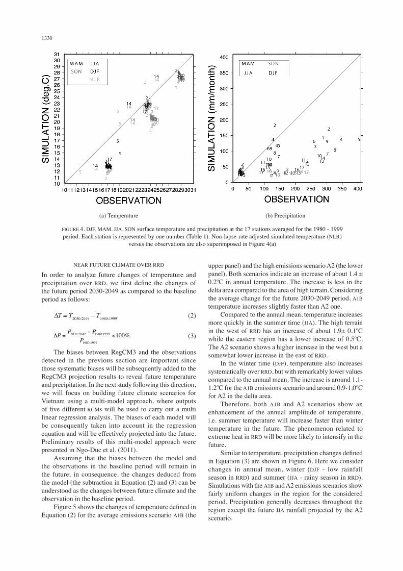
Precipitation is well simulated in amplitude during DJF and MAM. However, during JJA and SON, RegCM3 largely underestimates precipitation, which could be partly attributed to the unreal representation of circulation in these seasons (wind fields in Figure 2). Another reason could be explained by the fact that climate models have considerable difficulty in simulating precipitation characteristics over South East Asia due to the complex nature of the monsoon processes (Park & Hong 2004; Phan et al. 2009). Figure 4 confirms the systematic cold bias temperature simulated by RegCM3 at almost all stations over RRD except the station 14, namely NhoQuan (Table 1 to link the station’s number with the station’s name). It’s also shown that the lapse rate correction generally improves simulated temperature, i.e. the cold bias range is reduced. RegCM3 successfully reproduces the observed seasonal temperature variations with the best results in MAM and JJA, while the largest underestimations are during the DJF season. Comparison between the observed and simulated precipitation shows that RegCM3 captures general rainfall distribution over the 17 stations during DJF and MAM, although considerable differences exist during JJA and SON (Figure 4). Together with the underestimation of temperature, there is a tendency for the model to underestimate precipitation, especially during the rainfall months. Largest differences appear in the downstream stations of RRD.
deg.
Cde
g.C
deg.
Cde
g.C
mm
/mon
thm
m/m
onth
mm
/mon
thm
m/m
onth
FIGURE 3. DJF, MAM, JJA and SON surface temperature and precipitation from 1980 to 1999 simulated by RegCM3 (SIM) and observed at the 17 meteorological stations (OBS represents the averaged value of the 17 stations). The simulated
temperature has been adjusted using the lapse-rate equation
1330
NEAR FUTURE CLIMATE OVER RRD
In order to analyze future changes of temperature and precipitation over RRD, we first define the changes of the future period 2030-2049 as compared to the baseline period as follows:
∆T = T2030:2049 – T1980:1999. (2)
(3)
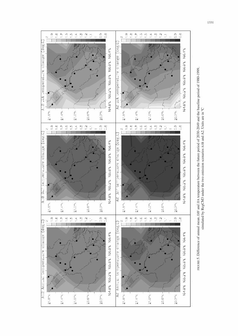
The biases between RegCM3 and the observations detected in the previous section are important since those systematic biases will be subsequently added to the RegCM3 projection results to reveal future temperature and precipitation. In the next study following this direction, we will focus on building future climate scenarios for Vietnam using a multi-model approach, where outputs of five different RCMs will be used to carry out a multi linear regression analysis. The biases of each model will be consequently taken into account in the regression equation and will be effectively projected into the future. Preliminary results of this multi-model approach were presented in Ngo-Duc et al. (2011). Assuming that the biases between the model and the observations in the baseline period will remain in the future; in consequence, the changes deduced from the model (the subtraction in Equation (2) and (3) can be understood as the changes between future climate and the observation in the baseline period. Figure 5 shows the changes of temperature defined in Equation (2) for the average emissions scenario A1B (the
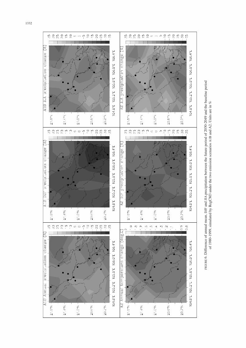
upper panel) and the high emissions scenario A2 (the lower panel). Both scenarios indicate an increase of about 1.4 ± 0.2ºC in annual temperature. The increase is less in the delta area compared to the area of high terrain. Considering the average change for the future 2030-2049 period, A1B temperature increases slightly faster than A2 one. Compared to the annual mean, temperature increases more quickly in the summer time (JJA). The high terrain in the west of RRD has an increase of about 1.9± 0.1ºC while the eastern region has a lower increase of 0.5ºC. The A2 scenario shows a higher increase in the west but a somewhat lower increase in the east of RRD. In the winter time (DJF), temperature also increases systematically over RRD, but with remarkably lower values compared to the annual mean. The increase is around 1.1-1.2ºC for the A1B emissions scenario and around 0.9-1.0ºC for A2 in the delta area. Therefore, both A1B and A2 scenarios show an enhancement of the annual amplitude of temperature, i.e. summer temperature will increase faster than winter temperature in the future. The phenomenon related to extreme heat in RRD will be more likely to intensify in the future. Similar to temperature, precipitation changes defined in Equation (3) are shown in Figure 6. Here we consider changes in annual mean, winter (DJF - low rainfall season in RRD) and summer (JJA - rainy season in RRD). Simulations with the A1B and A2 emissions scenarios show fairly uniform changes in the region for the considered period. Precipitation generally decreases throughout the region except the future JJA rainfall projected by the A2 scenario.
(a) Temperature (b) Precipitation
FIGURE 4. DJF, MAM, JJA, SON surface temperature and precipitation at the 17 stations averaged for the 1980 - 1999 period. Each station is represented by one number (Table 1). Non-lapse-rate adjusted simulated temperature (NLR)
versus the observations are also superimposed in Figure 4(a)
1331
FIG
URE
5. D
iffer
ence
of a
nnua
l mea
n, D
JF a
nd JJ
A te
mpe
ratu
re b
etw
een
the
futu
re p
erio
d of
203
0-20
49 a
nd th
e ba
selin
e pe
riod
of 1
980-
1999
, sim
ulat
ed b
y Re
gCM
3 un
der t
he tw
o em
issio
n sc
enar
ios A
1B a
nd A
2. U
nits
are
in ºC
1332
FIG
URE
6. D
iffer
ence
of a
nnua
l mea
n, D
JF a
nd JJ
A pr
ecip
itatio
n be
twee
n th
e fu
ture
per
iod
of 2
030-
2049
and
the
base
line
perio
d of
198
0-19
99, s
imul
ated
by
RegC
M3
unde
r the
two
emiss
ion
scen
ario
s A1B
and
A2.
Uni
ts ar
e in
%
1333
For the annual average over the period of 2030-2049, precipitation over RRD commonly decreases about 0-10% except for the southwest region where precipitation may increase 0-5% compared to the baseline period. In some specific locations of RRD, precipitation can decrease down to 15%. The decreasing trend of precipitation under the context of climate change is in agreement with the statement of Endo et al. (2009) in which the authors pointed out that precipitation in northern Vietnam was decreasing during the period of 1950-2000. This decreasing trend may threaten the municipal water supply, irrigation for agriculture, cause water shortage for downstream socio-economical and ecological systems in the future. Due to the small amount of rainfall over RRD in winter, a small change of DJF rainfall in the future may lead to a large increase/decrease (in %) compared to the baseline period. Both A1B and A2 scenarios show significant DJF rainfall deficit, of which the estuary of the Red river shows a decreasing rate of 30% under the A1B scenario. The common decreasing rate in the winter time is about 15-30% for A1B and about 10-20% for the A2 scenario. In future summer time, JJA precipitation under the A1B scenario also commonly decreases but with a lower decreasing rate compared to the winter. Under the A2 scenario, summer precipitation increases about 0-10% over a large part of RRD. Over some specific locations, the increasing rate can reach up to 15%. The changes in summer rainfall under the A2 scenario could lead to the possibility of more severe water-related disasters such as floods and landslides in the future.
CONCLUSION
In this study, it was shown that RegCM3 can consistently downscale the CCSM outputs. Together with a systematic cold bias of simulated temperature over the baseline period, there is a tendency for the model to underestimate precipitation, especially during the rainfall seasons. Largest rainfall differences appear in the downstream stations of RRD. Future annual temperature over RRD is likely to increase about 1.4±0.2ºC. Both A1B and A2 emissions scenarios show an enhancement of the annual amplitude of temperature, i.e. summer temperature will increase faster than winter temperature in the future. Thus, the phenomenon related to extreme heat in RRD will be more likely to intensify in the future. Results also show that precipitation will generally decrease under the context of climate change except the JJA rainfall projected by the A2 scenario. The increasing air temperature and decreasing precipitation suggest more negative impacts and damages caused by droughts, while the increasing summer rainfall under the A2 scenario could lead to the possibility of more severe water-related disasters in the future. It is expected that further studies in this direction will support decision-makers in implementing climate change solutions for the RRD region.
ACKNOWLEDGEMENT
The author thanks two anonymous reviewers for their helpful suggestions and comments. This research was supported by the Vietnam Ministry of Science and Technology Foundation (DT.NCCB-DHUD.2011-G/10) and the Danida project: ‘Impacts of Climate Change on Land Use Change in the Red River Delta and its Community Livelihood Change’.
REFERENCE
Collins, W.D., Bitz, C.M., Blackmon, M.L., Bonan, G.B., Bretherton, C.S., Carton, J.A., Chang, P., Doney, S.C., Hack, J.J., Hendrson, T.B., Kiehl, J.T., Large, W.G., Mckenna, D.S., Santer, B.D. & Smith, R.D. 2005. The community climate system model version 3. J. Climate 19: 2122-2143.
Dee, D.P., Uppala, S.M., Simmons, A.J., Berrisford, P., Poli, P., Kobayashi, S., Andrae, U., Balmaseda, M.A., Balsamo, G., Bauer, P., Bechtold, P., Beljaars, A.C.M., Van de Berg, L., Bidlot, J., Bormann, N., Delsol, C., Dragani, R., Fuentes, M., Geer, A.J., Haimberger, L., Healy, S.B., Hersbach, H., Hólm, E.V., Isaksen, L., Kållberg, P., Köhler, M., Matricardi, M., McNally, A.P., Monge-Sanz, B.M., Morcrette, J.J., Park, B.K., Peubey, C., de Rosnay, P., Tavolato, C., Thépaut, J.N. &Vitart, F. 2011. The ERA-Interim reanalysis: Configuration and performance of the data assimilation system. Quart. J. R. Meteorol. Soc. 137: 553-597.
Dickinson, R.E., Errico, R.M., Giorgi, F. & Bates, G. 1989. A regional climate model for the western United States. Clim. Change 15: 383-422.
Endo, N., Matsumoto, J. & Lwin, T. 2009. Trends in precipitation extremes over Southeast Asia. SOLA 5: 168-171.
Gallée, H., Moufouma-Okia, W., Bechtold, P., Brasseur, O. 2004. A high-resolution simulation of a West African rainy season using a regional climate model. J. Geophys. Res. 109: D05108.
Gao, X.J., Pal, J.S. & Giorgi, F. 2006. Projected changes in mean and extreme precipitation over the Mediterranean region from a high-resolution double nested RCM simulation. Geophys. Res. Lett. 33: L03706.
Giorgi, F. & Bates, G.T. 1989. The climatological skill of a regional model over complex terrain. Monthly Weather Review 117: 2325-2347.
Giorgi, F. & Mearns, L.O. 1999. Introduction to special section: Regional climate modeling revisited. Journal of Geophysical Research 104 (D6): 6335-6352.
Giorgi, F., Marinucci, M.R. & Bates, G.T. 1993a. Development of a second-generation regional climate model (RegCM2). I. Boundary-layer and radiative transfer processes, Mon. Weather Rev. 121: 2749-2813.
Giorgi, F., Marinucci, M.R., Bates, G.T. & De Canio, G. 1993b. Development of a second generation regional climate model (RegCM2). II. Convective processes and assimilation of lateral boundary conditions. Mon. Weather Rev. 121: 2814 -2832.
Ho, T.M.H., Phan, V.T., Le, N.Q. & Nguyen, Q.T. 2011. Extreme climatic events over Vietnam from observational data and RegCM3 projections. Clim. Res. 49: 87-100.
IPCC. 2007. Climate Change 2007: The Scientific Basis. Contribution of Working Group I to the Fourth Assessment Report of the Intergovernmental Panel on Climate Change Cambridge University Press, Cambridge, United Kingdom and New York, NY, USA.
1334
Kajikawa, Y., Yasunari, T., Yoshida, S. & Fujinami, H. 2012. Advanced Asian summer monsoon onset in recent decades. Geophys. Res. Lett. 39: L03803.
Lutgens, F.K., Tarbuck, E.J. & Tasa, D. 2006. The Atmosphere: An Introduction to Meteorology. 10th ed. Upper Saddle River, NJ: Pearson Prentice Hall. p. 520.
Manton, M.J., Della-Marta, P.M., Haylock, M.R., Hennessy, K.J., Nicholls, N., Chambers, L.E., Collins, D.A., Daw, G., Finet, A., Gunawan, D., Inape, K., Isobe, H., Kestin, T.S., Lefale, P., Leyu, C.H., Lwin, T., Maitrepierre, L., Ouprasitwong, N., Page, C.M., Pahalad, J., Plummer, N., Salinger, M.J., Suppiah, R., Tran, V.L., Trewin, B., Tibig, I. & Yee, D. 2001. Trends in extreme daily rainfall and temperature in Southeast Asia and the South Pacific: 1961-1998. International Journal of Climatology 21(3): 269-284.
MONRE of Vietnam. 2009. Climate Change, Sea level rise scenarios for Vietnam. Rep. p.34 Hanoi.
Nakicenovic, N. & Swart, R. Eds. 2000. Special report on emissions scenarios: A special report of working group III of the intergovernmental panel on climate change. Rep. p. 599.
Ngo-Duc, T., Polcher, J. & Laval, K. 2005. A 53-year forcing data set for land surface models. Journal of Geophysical Research 110: D06116.
Ngo-Duc, T., Phan, V.T., Hosaka, M., Nguyen, Q.T., Luong, M.T. & Kieu, Q.C. 2011. Evaluating performance of different regional simulations in present day climate and combining near future multi-model projections over Central Vietnam. Proceedings of The Second International Hy ARC workshop on Asian Monsoon and Water Cycle, August 22-24 Nha Trang, Vietnam. pp. 363-373.
Nguyen, H.N. 2007. Flooding in Mekong River Delta, Viet Nam. Human Development Report 2007, 2008. Rep. p. 23. UNDP.
Pal, J.S., Giorgi, F., Bi, X. & Elguindi, N. 2007. Regional climate modeling for the developing world: The ICTP RegCM3 and RegCNET. Bull. Am. Meteorol. Soc. 88: 1395-1409.
Park, S. & Hong, S. 2004. The role of surface boundary forcing over South Asia in the Indian summer monsoon circulation: A regional climate model sensitivity study. Geophys. Res. Lett. 31: L12112.
Phan, V.T., Ngo-Duc, T. & Ho, T.M.H. 2009. Seasonal and interannual variations of surface climate elements over Vietnam. Climate Research 40: 49-60.
Rauscher, S.A., Seth, A., Qian, J.H. & Camargo, S.J. 2006. Regional climate model domain choice in the tropics based on process considerations. Theor. Appl. Climatol 86: 229-246.
Rauscher, S.A., Seth, A., Liebmann, B., Qian, J.H. & Carmargo, S.J. 2007. Regional climate model–simulated timing and character of seasonal rains in South America. Mon. Wea. Rev. 135: 2642-2657.
Seth, A., Rauscher, S.A., Carmago, S.J., Qian, J.H. & Pal, J.S. 2007. RegCM3 regional climatologies using reanalysis and ECHAM global model driving fields. Clim. Dyn. 28: 461-480.
Takahashi, H.G. 2011. Long-term changes in rainfall and tropical cyclone activity over South and Southeast Asia. Adv. Geosci. 30: 17-22.
Uppala, S.M., Kallberg, P.W., Simmons, A.J. & Andrae, U. 2005. The ERA-40 reanalysis. QJR Meteorol Soc 131: 2961-3012.
Wilby, R.L., Wigley, T.M.L., Conway, D., Jones, P.D., Hewitson, B.C., Main, J. & Wilks, D.S. 1998. Statistical downscaling of general circulation model output: A comparison of methods. Water Res. 34: 2995-3008.
Thanh Ngo-Duc*, Quang-Trung Nguyen, Tuan-Long Trinh, Thanh-Hang Vu & Van-Tan Phan Department of MeteorologyHanoi University of Science Vietnam National University334 Nguyen Trai, Thanh Xuan, HanoiVietnam
Van-Cu Pham International Centre for Advanced research on Global change Vietnam National University144, Xuan Thuy st Cau Giay, Ha Noi Vietnam
*Corresponding author; email: [email protected]
Received: 24 October 2011Accepted: 7 June 2012