national seafloor geomorphology (nsgm) mapping …...national seafloor geomorphology (nsgm) mapping...
TRANSCRIPT

National Seafloor GeoMorphology (NSGM)
mapping workshop 29th October 2018
Summary & Actions
Rachel Nanson and Scott Nichol Distributed 19th November 2018

Introduction Geoscience Australia is leading the development of a scheme to map and classify seabed
morphology and geomorphology at multiple spatial scales, for use by a range of
disciplines and end-users. Central to the effort is the development of a consistent
vocabulary and mapping standard, which is now in draft form as the National Seafloor
GeoMorphology (NSGM) mapping scheme.
On 29th October 2018 a National Seafloor Geomorphology workshop was held at
Geoscience Australia. The workshop was attended by representatives from
Commonwealth and State agencies, industry and universities (Appendix 1), and had the
following objectives:
1. Engage with marine geoscience practitioners: we are seeking feedback and input
on the science of the draft NSGM
2. Engage with state agencies: determine how to connect the draft NSGM scheme
to the coast (intertidal and shallow subtidal)
3. Reach agreement towards the creation of a standard scheme for seafloor
geomorphology mapping in Australia.
Coastal and marine researchers and practitioners in sedimentology, geomorphology and
ecology, and state and Parks Australia representatives presented their own approaches to
mapping the seafloor (presentations are available on Google Drive). Participants also
commented on the translation of their own schemes to the draft NSGM scheme, and on
the structure and breadth of the NSGM scheme. This feedback and other discussion
points are represented later in this summary.
The National Seafloor GeoMorphology (NSGM) mapping scheme
The first generation map of seafloor geomorphology of the Australian margin utilised a
250 m resolution bathymetry grid (Heap and Harris, 2008). During the past decade, the
acquisition of high resolution multibeam sonar bathymetry has accelerated, providing the
opportunity to develop more detailed maps of seafloor geomorphology at local scales. It
is the intention of the NSGM scheme to utilise these finer-resolution topographic and
bathymetric datasets to map Australia’s coastal and marine estate in a consistent manner.
The NSGM mapping approach is based on the two-part scheme developed by the MIM1
working group in Europe, and distinguishes between seafloor morphology and
1 MAREANO – Norway; INFOMAR – Ireland; MAREMAP – UK (MIM)

geomorphology (Dove et al., 2016). The surface Morphology of the seafloor is mapped
using bathymetric data and derivatives (e.g. slope) and Geomorphology (genesis and
composition) is subsequently mapped where additional datasets (e.g. seabed samples) and
expertise are available. Figure 1 illustrates the distinction between these two parts, and
emphasises the implications for the application of contrasting geomorphic
interpretations. In this example, a Ridge Feature (Morphology) is mapped using bathymetry
data (Step 1). With the use of additional information, such as sub-bottom profiles and
sediment samples, the Ridge can be distinguished as a bedform that may either be active
or relict (Geomorphology: Step 2), with distinct implications for the end-user applications.
Figure 1. The Morphology of the seafloor can be mapped using bathymetry data alone (Step 1), however, additional data are required to extend the interpretation of these morphologies to determine their genesis and composition to produce a map of seafloor Geomorphology (Step 2). Potential applications for end-users are also illustrated.
A range of geomorphology-related schemes have been developed for Australia’s coastal
and marine realm, however, these are either restricted to intertidal to shelf settings, or do
not include a comprehensive geomorphic component (Figure 2). The geomorphic
components of these and other relevant international schemes have been integrated into
the draft NSGM scheme. Of these other schemes, Dove et al (2016) is one of the few
that attempts to apply the morphological and geomorphological mapping of coastal and

marine features to the full suite of offshore settings. They also structure this method by
utilising a two-part approach that distinguishes morphological mapping from
geomorphic interpretation, which is consistent with the fundamental principles of
geomorphology. Geoscience Australia is collaborating with the MIM working group to
progress their draft seafloor scheme and link it to the NSGM.
Figure 2. Scope of existing marine and coastal seafloor classification schemes. Australia’s seafloor mapping approaches are generally applied to the continental shelf, though several also extend landwards to characterise the coastal plain. A range of international marine mapping approaches span the shelf to the abyss.
We propose a semi-hierarchical approach to the Morphology part of the scheme,
whereby the seafloor is mapped into Provinces, Surfaces and Features (Figure 3). Provinces
define the broad bathymetric zone, ranging from the shelf to hadal zone. Surfaces
comprise three slope categories (escarpments, slopes and planes) that are mapped as
discrete (i.e. non-overlapping) polygons that do not overlap one another. Features
describe the shape of the seafloor, are broadly divided into highs, lows and planes (Dove
et al., 2016) and overlap Surface polygons.

Figure 3. This schematic illustrates a draft (and incomplete) version of the proposed structure of the National Seafloor GeoMorphology (NSGM) mapping scheme. The full list of Morphology and Geomorphology terms are provided in Dove et al. (2016); the glossary for these terms is under construction. The diagrammatic example illustrates the NSGM scheme applied to the example in Figure 1.

A draft Glossary that defines each of these Morphology terms is still under construction.
While these definitions are primarily based on IHO and CMECS (FGDC, 2012)
definitions, and so are consistent with many other schemes (e.g. Figure 2), our glossary
tightens some of their definitions. The NSGM glossary also proposes some additional
terms, and presents idealised sketches, automation approaches and example bathymetric
images for each.
A preliminary version of Part 2 of this approach (Geomorphology) is provided in Dove et al.
(2016), however, the settings and their hierarchy’s will be refined by specialists in each
setting (e.g. Reefs, Coasts, Glacial) in subsequent drafts of the scheme. Geoscience
Australia is collaborating with the MIM working group to refine Part 2 of the scheme,
and seek to include Australian practitioners in this process.
Workshop feedback
The draft NSGM scheme was presented at the workshop and a broad range of
suggestions for edits and additions were proposed on the day, and in follow-up
correspondence; these are summarised in Table 2. Solutions to these issues are proposed
in Table 2, however, further discussion of these and the draft NSGM are welcomed.
Table 2. Issues and discussion topics identified at the NSGM workshop, with initial responses
General issues How to address
How to apply consistently to different raster resolution
Develop a look-up table for recommended automation approach for varying grid resolution
Should units be able to be mapped at different scales (e.g. ridges)?
Mapping at different scales: MORPHOLOGY - features can be mapped at various scales (e.g. small ridge on a larger ridge - these shapes are scale independent), but GEOMORPHOLOGY will have strict scale rules
Breadth of end-users, needs to be multi-purpose
Continue to tailor to and engage environmental managers, executive managers (non-specialists), offshore industries, ecologists
Involve AHO Send draft and invite feedback on National NSGM Standard Operating Procedure (SOP)
How to update the national map of seabed geomorphic features (i.e. Heap and Harris, 2008)
Keep Heap and Harris (2008) unmodified but link to new NSGM maps (shapefiles) by listing their shapes as "parent" geomorphic features in attribute tablesfield.
Create new postage stamps of higher resolution NSG mapping and regularly (annually?) update a "National Coverage" shapefile that identifies higher resolution mapped datasets.
Integrate / edit Coastal Compartments to match
Edit Coastal Compartments based on NSGM interpretations of new bathymetry data as needed; ensure consistency between datasets

List potential habitats associated with each feature
Explicitly state what each feature type can be used as a potential ecological surrogate for
Topology rules are needed for what features can overlay one another
100% coverage of Provinces and Surfaces, but Features can overlap. Can we attempt rules for what defines overlaps and edges?
Part 1: MORPHOLOGY issues Consistency in application
Develop a tight glossary automate morphology mapping and scale for mapping raster resolutions; record analyst in metadata
Lumping and splitting terms
Apply Dove et al (2016) hierarchy of highs, lows and planes - then split as user needs
Size constraints on hills and seamounts are interpretations of genesis or potential habitat
We could group all hill-like features into one category, and allow depth and genesis of those features to be captured in the GEOMORPHOLOGY section
Could also add a field for the potential habitat / ecosystem the Morphology might support
Part 2: GEOMORPHOLOGY issues Prioritise the development of Part (ii) Geomorphology
Underway
Consistency in application
Develop a tight glossary expert application for interpreting geomorphology - record analyst in metadata
Expand the list of Features
Complete the glossary
Record sediment transport characteristics
Add azimuth and volume estimate fields; "bedform activity status" interpretation and age where known (e.g. relict, 6000 years BP C14; active);
Add process for formation (e.g. turbidity current; storm wave base; East Australia Current)
Include information on substrate
Include field(s) in Geomorphology
Future plans and Actions • In May 2019, Geoscience Australia will provide feedback from the NSGM workshop
to the next face-to-face meeting of the MIM working group (Dove et al).
• GA will develop a draft National Standard Operating Procedure for mapping seafloor
geomorphology to be circulated for comment in 2019. As a part of this process we
will continue to communicate our progress on the NSGM scheme to workshop
participants and those who have registered their interest, and invite your ongoing
feedback and input.
• Geoscience Australia to scope options for a second workshop of the NSGM working
group in mid- 2019.

Acknowledgements
The draft National Seafloor Geomorphology Mapping scheme is based on the two-part
approach and list of terms presented by Dove et al (2016). The advancement of this
scheme is an ongoing collaboration between Geoscience Australia (Rachel Nanson, Kim
Picard, Scott Nichol, Alix Post, Zhi Huang, Jodie Smith) and the Mareano-Infomar-
Maremap (MIM) group.
References Butler, C and Lucieer, V and Walsh, P and Flukes, E and Johnson, C, 2017. Seamap
Australia [Version 1.0] the development of a national benthic marine
classification scheme for the Australian continental shelf, Institute for Marine and
Antarctic Studies, Hobart, Tasmania.
CbiCS 2018. http://dev-coastkit.cbics.org/cbics_view
Chiocci, F.L. and Ridente, D., 2011. Regional-scale seafloor mapping and geohazard
assessment. The experience from the Italian project MaGIC (Marine Geohazards
along the Italian Coasts). Marine Geophysical Research, 32(1-2), pp.13-23.
Federal Geographic Data Committee, 2012. FGDC-STD-018-2012: Coastal and marine
ecological classification standard. FGDC, Reston, VA.
Dove, D., Bradwell, T., Carter, G., Cotterill, C., Gafeira, J., Goncalves, J., Green, S.,
Krabbendam, M., Mellett, C., Stevenson, A., Stewart, H. and Westhead, K., 2016.
Seabed geomorphology: a two-part classification system.
Greene, H.G., Yoklavich, M.M., Starr, R.M., O'Connell, V.M., Wakefield, W.W., Sullivan,
D.E., McRea Jr, J.E. and Cailliet, G.M., 1999. A classification scheme for deep
seafloor habitats. Oceanologica acta, 22(6), pp.663-678.
Griffin, C., Skene, D., Hazelwood, M., Nicholas, W. and Xu. J. 2010. A Nationally
Consistent Geomorphic Map and Classification of the Australian Coastal Zone.
Professional Opinion 2010/06.
Harris, P.T., Macmillan-Lawler, M., Rupp, J. and Baker, E.K., 2014. Geomorphology of
the oceans. Marine Geology, 352, pp.4-24.
Heap D and Harris, P. 2008. Geomorphology of the Australian margin and adjacent
seafloor, Australian Journal of Earth Sciences, 55:4, 555-585.
International Hydrographic Office 2017. https://www.iho.int/iho_pubs/bathy/B-
6_e4.1.0_2013_EF_rev2017.pdf
McPherson, A., Hazelwood, M., Moore, D., Owen, K., Nichol, S. & Howard, F. 2015.
The Australian Coastal Sediment Compartments Project: methodology and
product development. Record 2015/25. Geoscience Australia, Canberra.
http://dx.doi.org/10.11636/Record.2015.025
Nichol, S., Huang, Huang, Z., Howard, F., Porter-Smith, R., Lucieer, V., Barrett, N.
(2016). Geomorphological classification of reefs - Draft Framework for an
Australian Standard. Report to the National Environmental Science Program,
Marine Biodiversity Hub. Geoscience Australia. 28 pp.
Queensland Intertidal and Subtidal Ecosystem Classification Scheme. 2017.
https://wetlandinfo.des.qld.gov.au/wetlands/what-are-wetlands/definitions-
classification/classification-systems-background/intertidal-subtidal/
Sharples, C., R. Mount and T. Pederson. 2009. The Australian Coastal Smartline
Geomorphic and Stability Map Version 1: Manual and Data Dictionary, School
of Geography & Environmental Studies, University of Tasmania, 8th October
2009: 179 pp
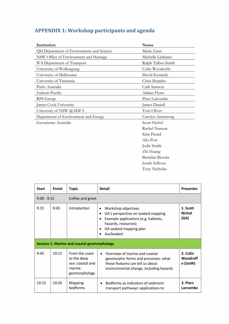
APPENDIX 1: Workshop participants and agenda
Institution Name Qld Department of Environment and Science Maria Zann NSW Office of Environment and Heritage Michelle Linklater WA Department of Transport Ralph Talbot-Smith University of Wollongong Colin Woodroffe University of Melbourne David Kennedy University of Tasmania Chris Sharples Parks Australia Cath Samson Fathom Pacific Adrian Flynn RPS Group Piers Larcombe James Cook University James Daniell University of NSW @ADFA Tom Oliver Department of Environment and Energy Carolyn Armstrong Geoscience Australia Scott Nichol Rachel Nanson Kim Picard Alix Post Jodie Smith Zhi Huang Brendan Brooke Jonah Sullivan Tony Nicholas
Start Finish Topic Detail Presenter
9:00 - 9:15 Coffee and greet
9:15 9:45 Introduction • Workshop objectives • GA’s perspective on seabed mapping • Example applications (e.g. habitats,
hazards, resources) • GA seabed mapping plan • AusSeabed
1. Scott Nichol (GA)
Session 1: Marine and coastal geomorphology
9:45 10:15 From the coast to the deep sea: coastal and marine geomorphology
• Overview of marine and coastal geomorphic forms and processes: what these features can tell us about environmental change, including hazards
2. Colin Woodroffe (UoW)
10:15 10:35 Mapping bedforms
• Bedforms as indicators of sediment transport pathways: applications to
3. Piers Larcombe

offshore engineering (RPS Group)
10:35-11:00 Morning tea
11:00 11:30 Geomorphology mapping approaches
• Existing geom. mapping schemes • New National Seafloor GeoMorphology
(NSGM) mapping approach • Translation of NSGM to state and other
schemes • Presentation of scheme strawman
4. Rachel Nanson (GA)
11:30 11:45
Discussion • Of NSGM DRAFT Scott Nichol and Rachel Nanson
Session 2: Geomorphology within existing mapping schemes
11:45 12:15 Coastal Compartments + Smartline
Geomorphic mapping within a compartment context and Smartline
5. Chris Sharples (UTas)
12:15 12:35 Ecological Classifications – CBiCS
Linking the scheme into abiotic components of biotope and habitat schemes
6. Adrian Flynn (Fathom Pacific)
12:35 – 1:30 Lunch
1:30 1:50 Qld Intertidal and Ecosystem Classification scheme 7. Maria Zann (Department of Environment and Science)
Session 3: Regional mapping programs and needs
1:50 2:10 A national perspective + Tasmania 8. Cath Samson (Parks Australia)
2:10 2:25 NSW 9. Michelle Linklater (OEH – NSW)
2:25 2:40 WA 10. Ralph Talbot-

Smith (DoT - WA)
2:40 3:00 VIC 11. David Kennedy (Melb Uni)
3:00 3:15 SA (absent) Alison Wright (DEW - SA)
3:15 – 3:30 Afternoon tea + discussion of compatibility of the strawman scheme
Session 4 DISCUSSION: Mapping scheme priorities
3:30 4:00 Part A – In small groups, determine priority geomorphic / compatible aspects from each existing scheme to the draft NSGM scheme
4:00 4:45 Part B – Add priority features and edits to NSGM scheme poster