national register of historic places – sample nomination ... · national register of historic...
TRANSCRIPT
Indiana Division of Historic Preservation and Archaeology 402 West Washington Street, Room W274 Indianapolis, IN 46204 317-232-1646
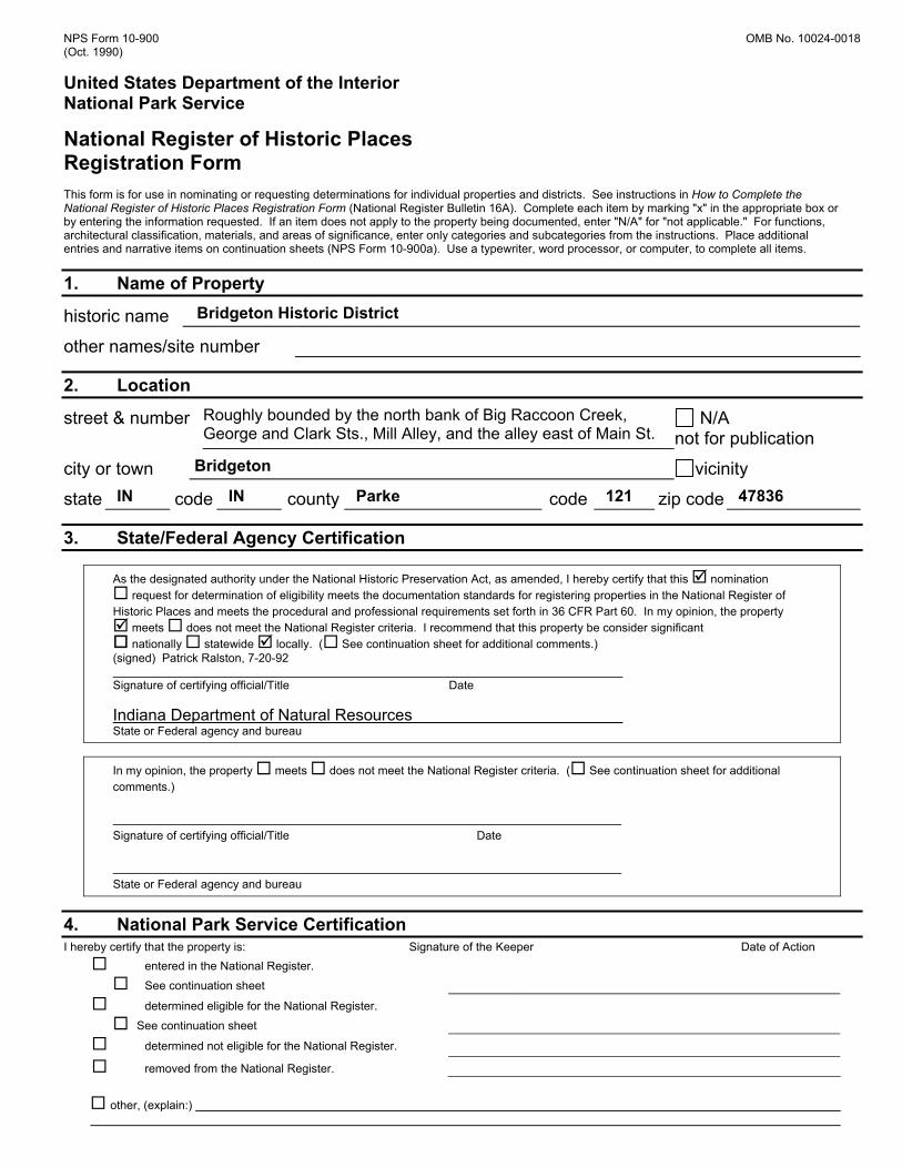
National Register of Historic Places – Sample Nomination Form Bridgeton Historic District, Parke County, Indiana Historic districts require a coordinated inventory and historical summary of a community, neighborhood, downtown, or other collection of historic buildings, sites or structures. Be sure to contact the DHPA to insure that your boundaries are acceptable before proceeding with a district nomination. Many communities chose to hire a qualified professional to prepare district applications due their complex nature. Owners of private property can object to a National Register designation – be sure you contact the Division and properly inform all owners and residents BEFORE you begin your district application. The Bridgeton Historic District is significant as an example of a rural mill town. The nomination documents the variety of resource types – the mill, a covered bridge, houses, small commercial blocks, carriage houses, and even several small barns. Depending on the scale of the district which you are nominating, you may wish to exclude smaller secondary buildings from your count and map. The applicant describes several representative non-contributing buildings as well as a good cross-section of historic buildings. The statement of significance gives the reader a sense of the importance of mill towns in local and state history. The map includes boundary, streets, contributing and non-contributing buildings, and locations of photographs.
Bridgeton Historic District includes a variety of building types. The mill at left provided the industrial base to the town’s economy in the 19th and early 20th centuries.
You may need to provide a list of all property owners from your local County Recorder’s Office to the Division with your application. Call us to make sure!
NPS Form 10-900 OMB No. 10024-0018 (Oct. 1990) United States Department of the Interior National Park Service
National Register of Historic Places Registration Form This form is for use in nominating or requesting determinations for individual properties and districts. See instructions in How to Complete the National Register of Historic Places Registration Form (National Register Bulletin 16A). Complete each item by marking "x" in the appropriate box or by entering the information requested. If an item does not apply to the property being documented, enter "N/A" for "not applicable." For functions, architectural classification, materials, and areas of significance, enter only categories and subcategories from the instructions. Place additional entries and narrative items on continuation sheets (NPS Form 10-900a). Use a typewriter, word processor, or computer, to complete all items.
1. Name of Property
historic name Bridgeton Historic District
other names/site number
2. Location
street & number Roughly bounded by the north bank of Big Raccoon Creek, George and Clark Sts., Mill Alley, and the alley east of Main St.
N/A not for publication
city or town Bridgeton vicinity
state IN code IN county Parke code 121 zip code 47836
3. State/Federal Agency Certification
As the designated authority under the National Historic Preservation Act, as amended, I hereby certify that this nomination request for determination of eligibility meets the documentation standards for registering properties in the National Register of
Historic Places and meets the procedural and professional requirements set forth in 36 CFR Part 60. In my opinion, the property meets does not meet the National Register criteria. I recommend that this property be consider significant nationally statewide locally. ( See continuation sheet for additional comments.)
(signed) Patrick Ralston, 7-20-92 Signature of certifying official/Title Date Indiana Department of Natural Resources State or Federal agency and bureau
In my opinion, the property meets does not meet the National Register criteria. ( See continuation sheet for additional comments.) Signature of certifying official/Title Date State or Federal agency and bureau
4. National Park Service Certification
I hereby certify that the property is: Signature of the Keeper Date of Action entered in the National Register.
See continuation sheet
determined eligible for the National Register.
See continuation sheet
determined not eligible for the National Register.
removed from the National Register.
other, (explain:)
Bridgeton Historic District Parke Co., IN Name of Property County and State
5. Classification Ownership of Property
Category of Property
(Check as many boxes as apply)
(Check only one box)
private building(s) public-local ⌧ district public-state site public-
Federal structure
object Name of related multiple property listing (Enter "N/A" if property is not part of a multiple property listing.) N/A
Number of Resources within Property (Do not include previously listed resources in the count.) Contributing Noncontributing
32 4 buildings 0 0 sites
1 0 structures 0 0 objects
33 4 Total Number of contributing resources previously listed in the National Register 1
6. Function or Use Historic Functions (Enter categories from instructions) INDUSTRY: manufacturing facility COMMERCE: specialty store, business SOCIAL: meeting hall TRANSPORTATION: road-related DOMESTIC: single dwelling
Current Functions (Enter categories from instructions) COMMERCE: specialty store RECREATION AND CULTURE: museum SOCIAL: meeting hall
7. Description Architectural Classification (Enter categories from instructions) LATE VICTORIAN OTHER: I-house Italianate
Materials (Enter categories from instructions) foundation STONE: sandstone walls WOOD: weatherboard METAL: aluminum roof ASPHALT other CONCRETE BRICK
Narrative Description (Describe the historic and current condition of the property on one or more sheets.)
Bridgeton Historic District Parke Co., IN Name of Property County and State
8. Statement of Significance Applicable National Register Criteria (Mark "x" in one or more boxes for the criteria qualifying the property for the National Register listing.)
A Property is associated with events that have made a significant contribution to the broad patterns of our history.
B Property is associated with the lives of persons
significant in our past. C Property embodies the distinctive characteristics of
a type, period, method of construction or represents the work of a master, or possesses high artistic values, or represents a significant and distinguishable entity whose components lack individual distinction.
D Property has yielded, or is likely to yield,
information important in prehistory or history. Criteria Considerations (Mark "x" in all the boxes that apply.) Property is:
A owned by a religious institution or used for religious purposes.
B removed from its original location.
C a birthplace or grave.
D a cemetery.
E a reconstructed building, object, or structure.
F a commemorative property.
G less than 50 years of age or achieved
significance within the past 50 years.
Areas of significance (Enter categories from instructions) INDUSTRY COMMERCE Period of Significance c.1850 - 1942 Significant Dates 1868, 1871 Significant Person (Complete if Criterion B is marked above) N/A Cultural Affiliation N/A Architect/Builder Daniels, Joseph Miller, Marion Works Progress Administration
Narrative Statement of Significance (Explain the significance of the property on one or more continuation sheets.)
9. Major Bibliographical References Bibliography (Cite the books articles, and other sources used in preparing this form on one or more continuation sheets.)
Previous documentation on file (NPS): preliminary determination if individual listing (36
CFR 67) has been requested previously listed in the National Register previously determined eligible by the National
Register designated a National Historic Landmark recorded by Historic American Buildings Survey #
recorded by Historic American Engineering Record
# Primary location of additional data:
State Historic Preservation Office Other State agency Federal agency Local government University Other
Name of repository: Indiana Historic Sites and Structures Inventory
Bridgeton Historic District Parke Co., IN Name of Property County and State
10. Geographical Data Acreage of Property 8.6 UTM References (Place additional UTM references on a continuation sheet.)
1 Zone Easting Northing
2 See continuation sheet
Verbal Boundary Description (Describe the boundaries of the property on a continuation sheet.) Boundary Justification
(Explain why the boundaries were selected on a continuation sheet.)
11. Form Prepared By
name/title Barbara Hardesty and Emma Thompson
organization Bridgeton Heritage Foundation date 12-6-91
street & number P.O. Box 1000 telephone
city or town Bridgeton state IN zip code 47836
Additional Documentation
Submit the following items with the completed form:
Continuation Sheets
Maps - A USGS map (7.5 0r 15 minute series) indicating the property's location.
A Sketch map for historic districts and properties having large acreage or numerous resources.
Photographs - Representative black and white photographs of the property.
Additional items - (Check with the SHPO or FPO for any additional items)
Property Owner (Complete this item at the request of SHPO or FPO.)
name List available at DHPA street & number telephone city or town state zip code Paperwork Reduction Act Statement: This information is being collected for applications to the National Register of Historic Places to nominate properties for listing or determine eligibility for listing, to list properties, and to amend listings. Response to this request is required to obtain a benefit in accordance to the National Historic Preservation Act, as amended (16 U.S.C. 470 et seq.) Estimated Burden Statement: Public reporting burden for this is estimated to average 18.1 hours per response including time for reviewing instructions, gathering and maintaining data, and completing and reviewing the form. Direct comments regarding the burden estimate or any aspect of this form to the Chief, Administrative Services Division, National Park Service, P.O. Box 37127, Washington, DC 20013-7127; and the Office of Management and Budget, Paperwork Reductions Projects (1024-0018), Washington, DC 20503.
3 Zone Easting Northing
4
NPS Form 10-900-a OMB Approval No. 1024-0018 (8-86) United States Department of the Interior National Park Service National Register of Historic Places Continuation Sheet
Section number __7___ Page __1___ Bridgeton Historic District, Parke County, IN __________________________________________________________________ Section 7 – Description The community of Bridgeton is located in Raccoon Township of Parke County, Indiana. Bridgeton is situated in Pleasant Valley and is nestled into a small meander of Big Raccoon Creek. Picturesque hills enframe and isolate the village, paralleling the broad creek and valley on both sides from the southwest to northeast. The valley is under cultivation, and corn and soybean fields surround the town as they have since the early 1800s. Originally, roads were dirt, but now are paved. Streets are narrow and lack curbs. The district lies on level terrain, with Big Raccoon Creek forming a distinct northern boundary. Included in the boundaries are two blocks which comprise the historic community of Bridgeton from its founding in 1823 until the mid 1900s. The 23 primary buildings of the district front onto a single street, Main Street, which runs southwest to northeast. Not quite half of primary buildings were originally residential, while the others were commercial. Two buildings had lodges, one was a town hall, and one was an industrial use (mill). Also included is a historic dam and covered bridge. Commercial buildings were located closer to the mill and were set close to the street. Houses generally have larger lots and deeper setbacks. Indicative of a rural small town are Bridgeton's many historic outbuildings, including barns, garages, wash houses, privies and smoke houses. Wood frame construction predominates in the district. Eighteen of the 23 primary buildings are wood framed. Only 3 main structures are brick, and 2 are molded concrete block. Most outbuildings are wood frame with board and batten siding, but several are masonry. Bridgeton's historic buildings are predominantly vernacular. No particular housing type dominates. Three seem to be I-house variants (numbers 15, 18, and 30; photos 26, 28, and 44 respectively). Two are late 1800s cottages representing the cross-plan type (number 21, photo 33) and pyramid-roof type (number 26, photo 41). One is a bungalow (number 20, photo 32) and one is a gabled-ell (number 6, photo 11). Among commercial buildings, there are three types. The former Bridgeton State Bank (number 29, photo 43), c. 1920, exemplifies the gable front type. Building 8, the Knights of Pythias Lodge (1903), and building 31, the Bridgeton General Store (1869) are vernacular, wood-framed interpretations of Italianate commercial blocks, each having two stories, hip roofs and rectangular massing. The basic commercial style featuring a squarefront main facade and large display windows, is represented by several buildings. Hopper Brothers Store, building 10, photo 18, is an example. Contributing buildings are those which were present during the period of significance and retain basic physical integrity. Only three buildings cannot meet this test. Two buildings, numbers 3 and 35, were lowered a full story sometime in the last half of the 1900s and do not retain, enough integrity to convey their significance. Building 4 is a 1978 post office building which replaced two historic commercial buildings. Building 37 is a recent building as well. Descriptions of representative buildings follow. Since Bridgeton has no address numbers, building numbers have been assigned. Refer to sketch map. Bridgeton Mill and Dam, Photos 1,2,3, and 4, Building 1. The most historically important building in the district is the Bridgeton Mill, erected in 1871. This site has been home to a grain mill since 1823. The first mill burned in c.1845 and was rebuilt in 1848. The second
NPS Form 10-900-a OMB Approval No. 1024-0018 (8-86) United States Department of the Interior National Park Service National Register of Historic Places Continuation Sheet
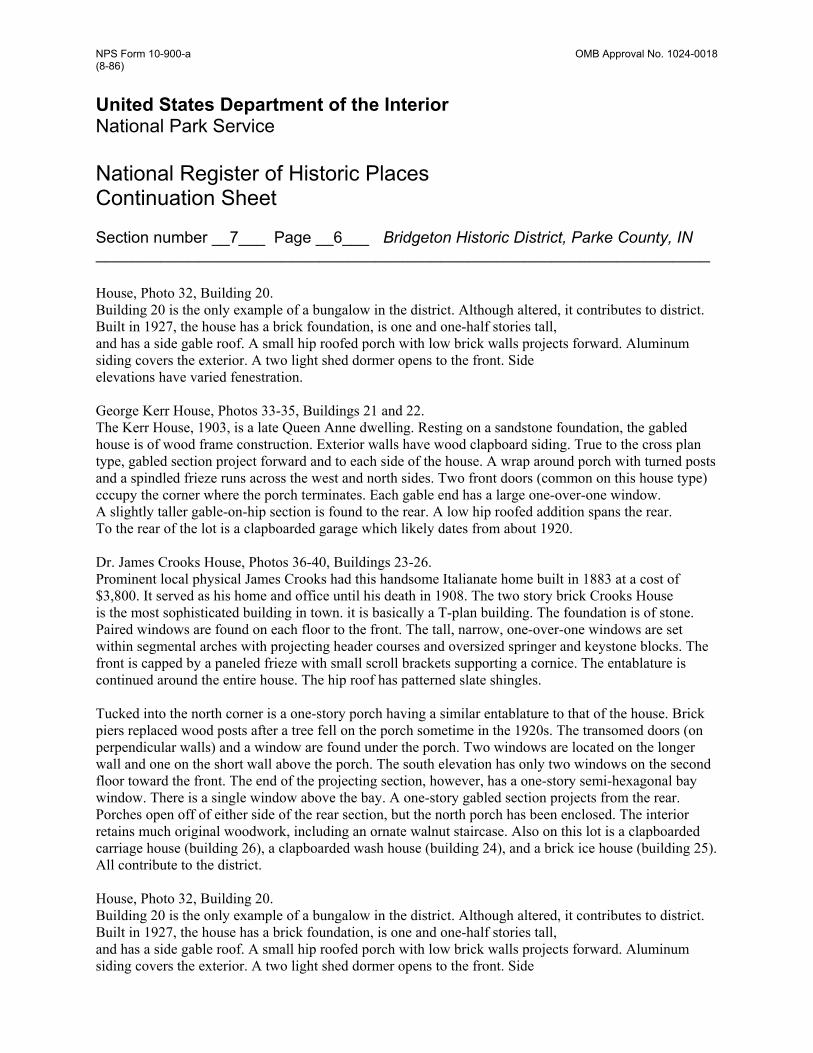
Section number __7___ Page __2___ Bridgeton Historic District, Parke County, IN __________________________________________________________________ mill was sold to Ralph Sprague in 1862 but was destroyed by fire in 1868. Sprague erected the present mill in 1871. The mill was equipped with both rollers (for flour) and burr stones (for feed). The mill is a heavy timber frame building with a sandstone foundation. It stands three stories tall and is capped by a gable roof. Large arches in the foundation at the northwest corner of the mill allowed water to enter the basement to power turbines (see historic drawing). The north elevation of the mill has four bays evenly spaced across the building. Each bay has original wooden six-over-six double-hung sash windows. The original weatherboard siding is obscured by an insulbrick-like material. The west elevation has three bays as does the east side. In each gable end are three windows lighting the attic, one toward the apex, and one each toward the corners. The south elevation is partly obscured by a shed roofed porch which was likely added in 1938. Also in 1938, a concrete block bay was extended from the south elevation and tied into the main roof at the ridge line (photo 4). This allowed grain trucks to be loaded. It was at this time that the mill was converted to supplying feed. The burr stones and rollers were removed. In 1940, the Weise family converted the mill to electric power, and began a feed grain operation from the Bridgeton Mill. Shortly after, a glazed block office addition was built east of the mill. In 1972, the Weises purchased burr stones from an old mill in New Palestine and installed them in the Bridgeton Mill. The interior of the mill still has some original operable equipment, although it is not water-powered. Corn meal is still ground at the mill, but mainly it is sold to tourists. The dam shown in photos 1, 2, and 3 is one of several built to harness the power of Big Raccoon Creek at this site. Built of heavy timbers in 1868, the dam was infilled and covered with concrete in 1913-1916. The dam contributes to the historic setting of Bridgeton and was an integral part of the mill operation. Dr. James Crooks Store House/Bridgeton Masonic Lodge No. 169, photos 5, and 6, building 2. Built in 1868, this two story, rectangular structure is best described in terms of style rather than type. Clearly Italianate in style, the building originally had three stories. The upper story replicated- the second story, and was capped by a flat roof with parapet masked by a cornice with scroll brackets (see historic drawing). In about 1920, for unknown reasons, the third floor was removed and the present hip roof with deep eaves was added. The building is set far back from Main Street. Its main facade has three round arched openings; a broad central entry with lunette transom, flanked by windows. The windows have been replaced by fixed sash. The use of glazed terra cotta for the round arches is quite unusual at this early date (photo 6). The central arch has rosette springers and triglyph-like voussoirs with a central oak-leaf keystone. The other flanking arches have identical springers and keystones, but the voussoirs are large vermiculated blocks. Opening sills are of sandstone. The second story has a central window with six-over-six double-hung sash. The sides of the building have three segmental arched openings along the second story. The site was regraded at some point to eliminate the need for a short flight of steps to the main door (compare photo 5 to drawing). Prominent local physical James Crooks built this structure as a drug store, store house for medical supplies, and he rented the upper floor to the local Masonic Lodge. The local chapter still meets here.
NPS Form 10-900-a OMB Approval No. 1024-0018 (8-86) United States Department of the Interior National Park Service National Register of Historic Places Continuation Sheet
Section number __7___ Page __3___ Bridgeton Historic District, Parke County, IN __________________________________________________________________ Ye Olde Covered Bridge Shoppe, Photo 8, Building 3 This non-contributing building was originally quite similar to buildings 8 and 31, having a two-story, hip roofed appearance. At some point in the last thirty years, it was reduced to one story and the store front was changed (see historic photo). Apparently, the cornice and scroll brackets were salvaged from the demolished second story, cut and fitted to the present structure. Thus, the gable end has irregularly spaced brackets which are not raked. U.S. Post Office, Photo 9, Building 4 The post office was built on the site of two wood-framed stores in 1978. It is non-contributing. Commercial Building, Photo 10, Building 5 Built c.1870, this modest frame building has a front facing gable roof and wood clapboard siding. The brick foundation is a recent replacement. The central entry has the original transom, but the doors are new. Originally, large six-over-six windows extended perhaps one foot lower than the current one-over-one sash. The simple corner board and frieze board are original. This frame structure has housed a doctor's office, a school for brief time, an undertaker's work room during the 1920s, and a barber shop during the 1930s and 40s. A local fabric artist now uses the building to make, display, and sell her works. Sprague-Webster-Kerr House, Photos 11-14, Buildings 6 and 7. Built for owner of the Bridgeton Mill in 1878, the Sprague-Webster-Kerr House is a classic example of the gabled-ell type. The ornamentation is Italianate in style. The Sprague House rests on a sandstone foundation and is two stories tall. The wood-frame house is sheathed in wood clapboard siding. Two gable roofed sections intersect, producing the gabled-ell type plan. The forward gable has two, two-over-two windows with entablature headers on each story. The cornice with scroll brackets runs across the entire house and follows the low pitch of the gable roof. Gable ends have bracketed returns. Both the front and side gable ends feature the distinctive "1878" oculus vents. The ell or side gable has two bays on each story. The primary entry is located under a one story shed roofed porch. The south wall has two windows on each story. Tucked into a rear corner is an enclosed porch. A one story rear section projects from the rear ell. A gable roofed, board and batten sided building, believed to be a wash house, is found behind the house (photo 14). The home was a single family residence until 1980, when its use changed to that of a gift shop. It is locally known as the "1878 House." Knights of Pythias Building, Photo 15, Building 8 Built in 1903 by the local K. of P. Lodge, this two story, wood framed, hip roofed building is sheathed in flush horizontal drop siding. The shed roofed porch supported on cast iron Tuscan columns is original to the building. the storefront is virtually intact, consisting of large framed windows by transoms and kick panels which angle toward the double door entry in the center. Above the storefront are two symmetrically placed four-over-four windows. The Knights of Pythias Lodge sign still hangs between the windows. Four windows are evenly placed along the second story side elevations. Several smaller windows were added along the north first story, but the diamond window is original. The
NPS Form 10-900-a OMB Approval No. 1024-0018 (8-86) United States Department of the Interior National Park Service National Register of Historic Places Continuation Sheet
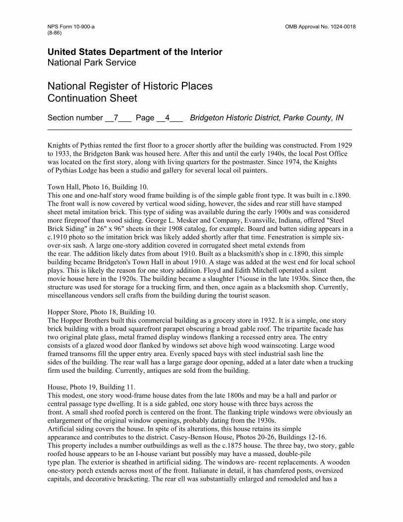
Section number __7___ Page __4___ Bridgeton Historic District, Parke County, IN __________________________________________________________________ Knights of Pythias rented the first floor to a grocer shortly after the building was constructed. From 1929 to 1933, the Bridgeton Bank was housed here. After this and until the early 1940s, the local Post Office was located on the first story, along with living quarters for the postmaster. Since 1974, the Knights of Pythias Lodge has been a studio and gallery for several local oil painters. Town Hall, Photo 16, Building 10. This one and one-half story wood frame building is of the simple gable front type. It was built in c.1890. The front wall is now covered by vertical wood siding, however, the sides and rear still have stamped sheet metal imitation brick. This type of siding was available during the early 1900s and was considered more fireproof than wood siding. George L. Mesker and Company, Evansville, Indiana, offered "Steel Brick Siding" in 26" x 96" sheets in their 1908 catalog, for example. Board and batten siding appears in a c.1910 photo so the imitation brick was likely added shortly after that time. Fenestration is simple six-over-six sash. A large one-story addition covered in corrugated sheet metal extends from the rear. The addition likely dates from about 1910. Built as a blacksmith's shop in c.1890, this simple building became Bridgeton's Town Hall in about 1910. A stage was added at the west end for local school plays. This is likely the reason for one story addition. Floyd and Edith Mitchell operated a silent movie house here in the 1920s. The building became a slaughter 1%ouse in the late 1930s. Since then, the structure was used for storage for a trucking firm, and then, once again as a blacksmith shop. Currently, miscellaneous vendors sell crafts from the building during the tourist season. Hopper Store, Photo 18, Building 10. The Hopper Brothers built this commercial building as a grocery store in 1932. It is a simple, one story brick building with a broad squarefront parapet obscuring a broad gable roof. The tripartite facade has two original plate glass, metal framed display windows flanking a recessed entry area. The entry consists of a glazed wood door flanked by windows set above high wood wainscoting. Large wood framed transoms fill the upper entry area. Evenly spaced bays with steel industrial sash line the sides of the building. The rear wall has a large garage door opening, added at a later date when a trucking firm used the building. Currently, antiques are sold from the building. House, Photo 19, Building 11. This modest, one story wood-frame house dates from the late 1800s and may be a hall and parlor or central passage type dwelling. It is a side gabled, one story house with three bays across the front. A small shed roofed porch is centered on the front. The flanking triple windows were obviously an enlargement of the original window openings, probably dating from the 1930s. Artificial siding covers the house. In spite of its alterations, this house retains its simple appearance and contributes to the district. Casey-Benson House, Photos 20-26, Buildings 12-16. This property includes a number outbuildings as well as the c.1875 house. The three bay, two story, gable roofed house appears to be an I-house variant but possibly may have a massed, double-pile type plan. The exterior is sheathed in artificial siding. The windows are- recent replacements. A wooden one-story porch extends across most of the front. Italianate in detail, it has chamfered posts, oversized capitals, and decorative bracketing. The rear ell was substantially enlarged and remodeled and has a
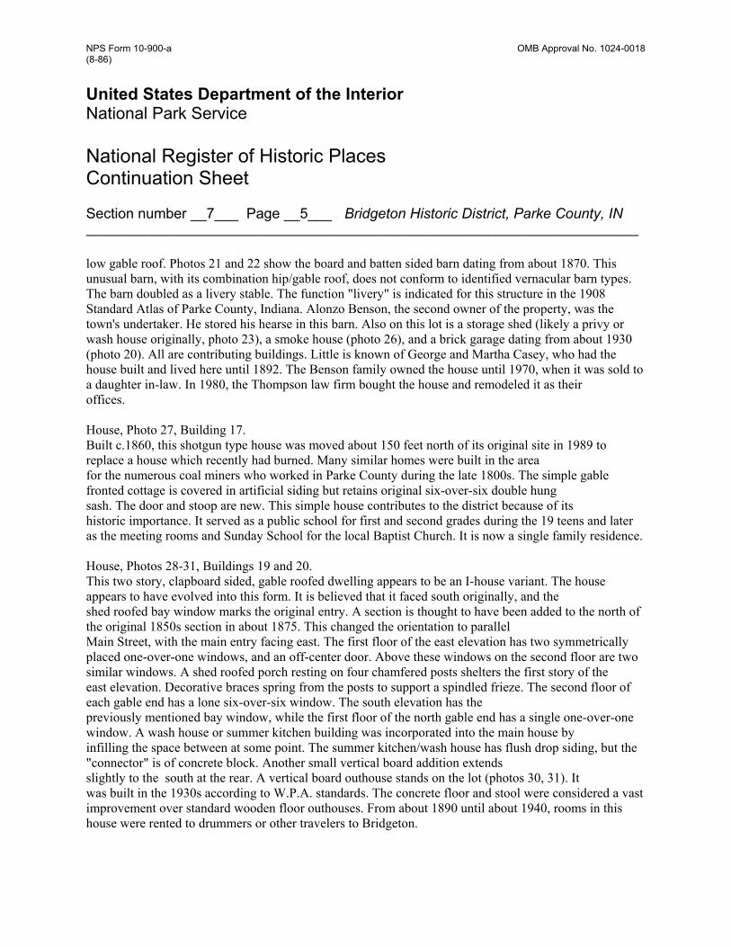
NPS Form 10-900-a OMB Approval No. 1024-0018 (8-86) United States Department of the Interior National Park Service National Register of Historic Places Continuation Sheet
Section number __7___ Page __5___ Bridgeton Historic District, Parke County, IN __________________________________________________________________ low gable roof. Photos 21 and 22 show the board and batten sided barn dating from about 1870. This unusual barn, with its combination hip/gable roof, does not conform to identified vernacular barn types. The barn doubled as a livery stable. The function "livery" is indicated for this structure in the 1908 Standard Atlas of Parke County, Indiana. Alonzo Benson, the second owner of the property, was the town's undertaker. He stored his hearse in this barn. Also on this lot is a storage shed (likely a privy or wash house originally, photo 23), a smoke house (photo 26), and a brick garage dating from about 1930 (photo 20). All are contributing buildings. Little is known of George and Martha Casey, who had the house built and lived here until 1892. The Benson family owned the house until 1970, when it was sold to a daughter in-law. In 1980, the Thompson law firm bought the house and remodeled it as their offices. House, Photo 27, Building 17. Built c.1860, this shotgun type house was moved about 150 feet north of its original site in 1989 to replace a house which recently had burned. Many similar homes were built in the area for the numerous coal miners who worked in Parke County during the late 1800s. The simple gable fronted cottage is covered in artificial siding but retains original six-over-six double hung sash. The door and stoop are new. This simple house contributes to the district because of its historic importance. It served as a public school for first and second grades during the 19 teens and later as the meeting rooms and Sunday School for the local Baptist Church. It is now a single family residence. House, Photos 28-31, Buildings 19 and 20. This two story, clapboard sided, gable roofed dwelling appears to be an I-house variant. The house appears to have evolved into this form. It is believed that it faced south originally, and the shed roofed bay window marks the original entry. A section is thought to have been added to the north of the original 1850s section in about 1875. This changed the orientation to parallel Main Street, with the main entry facing east. The first floor of the east elevation has two symmetrically placed one-over-one windows, and an off-center door. Above these windows on the second floor are two similar windows. A shed roofed porch resting on four chamfered posts shelters the first story of the east elevation. Decorative braces spring from the posts to support a spindled frieze. The second floor of each gable end has a lone six-over-six window. The south elevation has the previously mentioned bay window, while the first floor of the north gable end has a single one-over-one window. A wash house or summer kitchen building was incorporated into the main house by infilling the space between at some point. The summer kitchen/wash house has flush drop siding, but the "connector" is of concrete block. Another small vertical board addition extends slightly to the south at the rear. A vertical board outhouse stands on the lot (photos 30, 31). It was built in the 1930s according to W.P.A. standards. The concrete floor and stool were considered a vast improvement over standard wooden floor outhouses. From about 1890 until about 1940, rooms in this house were rented to drummers or other travelers to Bridgeton.
NPS Form 10-900-a OMB Approval No. 1024-0018 (8-86) United States Department of the Interior National Park Service National Register of Historic Places Continuation Sheet
Section number __7___ Page __6___ Bridgeton Historic District, Parke County, IN __________________________________________________________________ House, Photo 32, Building 20. Building 20 is the only example of a bungalow in the district. Although altered, it contributes to district. Built in 1927, the house has a brick foundation, is one and one-half stories tall, and has a side gable roof. A small hip roofed porch with low brick walls projects forward. Aluminum siding covers the exterior. A two light shed dormer opens to the front. Side elevations have varied fenestration. George Kerr House, Photos 33-35, Buildings 21 and 22. The Kerr House, 1903, is a late Queen Anne dwelling. Resting on a sandstone foundation, the gabled house is of wood frame construction. Exterior walls have wood clapboard siding. True to the cross plan type, gabled section project forward and to each side of the house. A wrap around porch with turned posts and a spindled frieze runs across the west and north sides. Two front doors (common on this house type) cccupy the corner where the porch terminates. Each gable end has a large one-over-one window. A slightly taller gable-on-hip section is found to the rear. A low hip roofed addition spans the rear. To the rear of the lot is a clapboarded garage which likely dates from about 1920. Dr. James Crooks House, Photos 36-40, Buildings 23-26. Prominent local physical James Crooks had this handsome Italianate home built in 1883 at a cost of $3,800. It served as his home and office until his death in 1908. The two story brick Crooks House is the most sophisticated building in town. it is basically a T-plan building. The foundation is of stone. Paired windows are found on each floor to the front. The tall, narrow, one-over-one windows are set within segmental arches with projecting header courses and oversized springer and keystone blocks. The front is capped by a paneled frieze with small scroll brackets supporting a cornice. The entablature is continued around the entire house. The hip roof has patterned slate shingles. Tucked into the north corner is a one-story porch having a similar entablature to that of the house. Brick piers replaced wood posts after a tree fell on the porch sometime in the 1920s. The transomed doors (on perpendicular walls) and a window are found under the porch. Two windows are located on the longer wall and one on the short wall above the porch. The south elevation has only two windows on the second floor toward the front. The end of the projecting section, however, has a one-story semi-hexagonal bay window. There is a single window above the bay. A one-story gabled section projects from the rear. Porches open off of either side of the rear section, but the north porch has been enclosed. The interior retains much original woodwork, including an ornate walnut staircase. Also on this lot is a clapboarded carriage house (building 26), a clapboarded wash house (building 24), and a brick ice house (building 25). All contribute to the district. House, Photo 32, Building 20. Building 20 is the only example of a bungalow in the district. Although altered, it contributes to district. Built in 1927, the house has a brick foundation, is one and one-half stories tall, and has a side gable roof. A small hip roofed porch with low brick walls projects forward. Aluminum siding covers the exterior. A two light shed dormer opens to the front. Side
NPS Form 10-900-a OMB Approval No. 1024-0018 (8-86) United States Department of the Interior National Park Service National Register of Historic Places Continuation Sheet
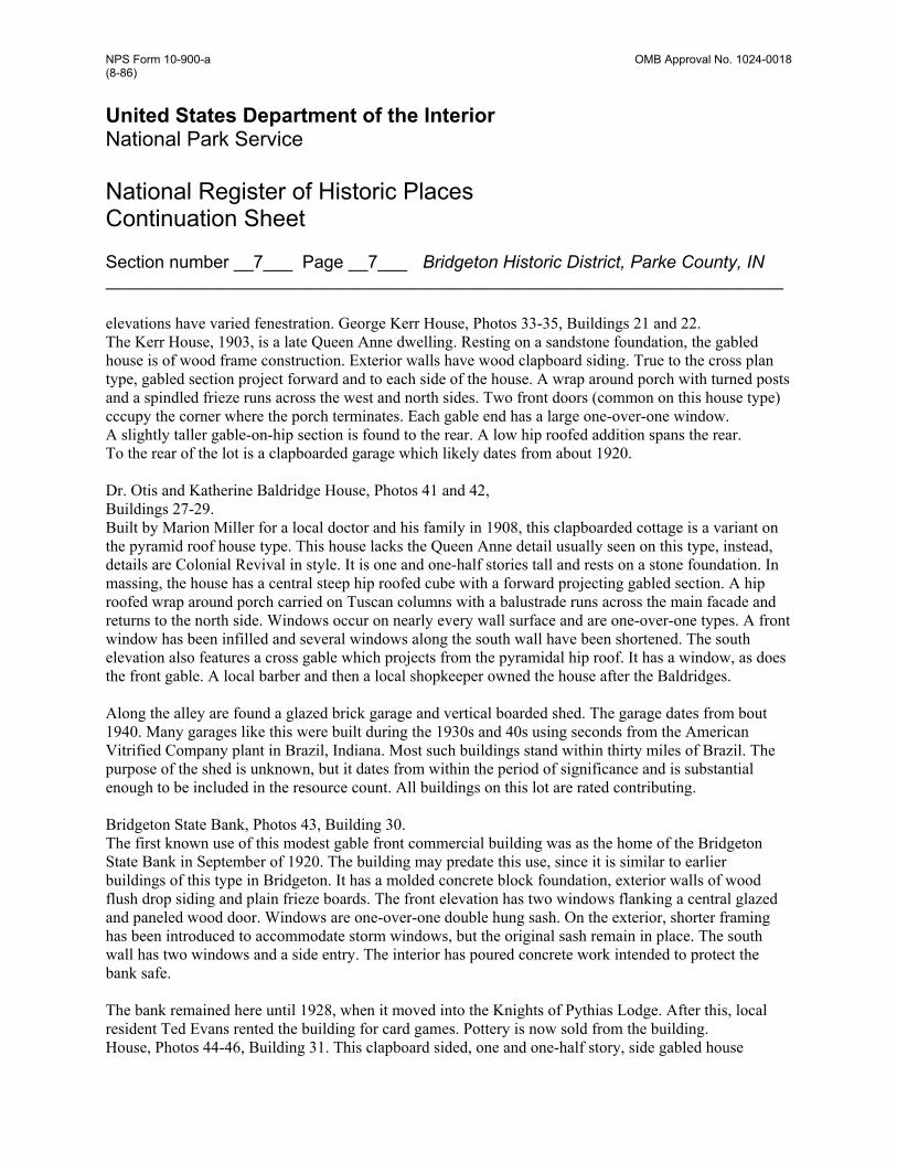
Section number __7___ Page __7___ Bridgeton Historic District, Parke County, IN __________________________________________________________________ elevations have varied fenestration. George Kerr House, Photos 33-35, Buildings 21 and 22. The Kerr House, 1903, is a late Queen Anne dwelling. Resting on a sandstone foundation, the gabled house is of wood frame construction. Exterior walls have wood clapboard siding. True to the cross plan type, gabled section project forward and to each side of the house. A wrap around porch with turned posts and a spindled frieze runs across the west and north sides. Two front doors (common on this house type) cccupy the corner where the porch terminates. Each gable end has a large one-over-one window. A slightly taller gable-on-hip section is found to the rear. A low hip roofed addition spans the rear. To the rear of the lot is a clapboarded garage which likely dates from about 1920. Dr. Otis and Katherine Baldridge House, Photos 41 and 42, Buildings 27-29. Built by Marion Miller for a local doctor and his family in 1908, this clapboarded cottage is a variant on the pyramid roof house type. This house lacks the Queen Anne detail usually seen on this type, instead, details are Colonial Revival in style. It is one and one-half stories tall and rests on a stone foundation. In massing, the house has a central steep hip roofed cube with a forward projecting gabled section. A hip roofed wrap around porch carried on Tuscan columns with a balustrade runs across the main facade and returns to the north side. Windows occur on nearly every wall surface and are one-over-one types. A front window has been infilled and several windows along the south wall have been shortened. The south elevation also features a cross gable which projects from the pyramidal hip roof. It has a window, as does the front gable. A local barber and then a local shopkeeper owned the house after the Baldridges. Along the alley are found a glazed brick garage and vertical boarded shed. The garage dates from bout 1940. Many garages like this were built during the 1930s and 40s using seconds from the American Vitrified Company plant in Brazil, Indiana. Most such buildings stand within thirty miles of Brazil. The purpose of the shed is unknown, but it dates from within the period of significance and is substantial enough to be included in the resource count. All buildings on this lot are rated contributing. Bridgeton State Bank, Photos 43, Building 30. The first known use of this modest gable front commercial building was as the home of the Bridgeton State Bank in September of 1920. The building may predate this use, since it is similar to earlier buildings of this type in Bridgeton. It has a molded concrete block foundation, exterior walls of wood flush drop siding and plain frieze boards. The front elevation has two windows flanking a central glazed and paneled wood door. Windows are one-over-one double hung sash. On the exterior, shorter framing has been introduced to accommodate storm windows, but the original sash remain in place. The south wall has two windows and a side entry. The interior has poured concrete work intended to protect the bank safe. The bank remained here until 1928, when it moved into the Knights of Pythias Lodge. After this, local resident Ted Evans rented the building for card games. Pottery is now sold from the building. House, Photos 44-46, Building 31. This clapboard sided, one and one-half story, side gabled house
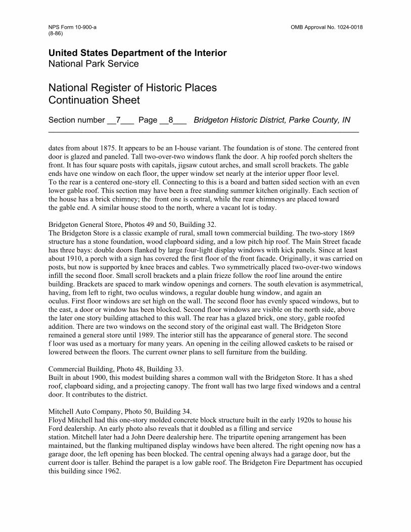
NPS Form 10-900-a OMB Approval No. 1024-0018 (8-86) United States Department of the Interior National Park Service National Register of Historic Places Continuation Sheet
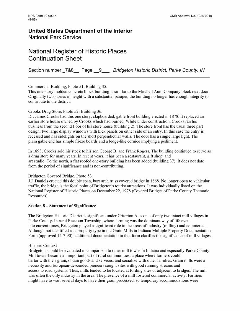
Section number __7___ Page __8___ Bridgeton Historic District, Parke County, IN __________________________________________________________________ dates from about 1875. It appears to be an I-house variant. The foundation is of stone. The centered front door is glazed and paneled. Tall two-over-two windows flank the door. A hip roofed porch shelters the front. It has four square posts with capitals, jigsaw cutout arches, and small scroll brackets. The gable ends have one window on each floor, the upper window set nearly at the interior upper floor level. To the rear is a centered one-story ell. Connecting to this is a board and batten sided section with an even lower gable roof. This section may have been a free standing summer kitchen originally. Each section of the house has a brick chimney; the front one is central, while the rear chimneys are placed toward the gable end. A similar house stood to the north, where a vacant lot is today. Bridgeton General Store, Photos 49 and 50, Building 32. The Bridgeton Store is a classic example of rural, small town commercial building. The two-story 1869 structure has a stone foundation, wood clapboard siding, and a low pitch hip roof. The Main Street facade has three bays: double doors flanked by large four-light display windows with kick panels. Since at least about 1910, a porch with a sign has covered the first floor of the front facade. Originally, it was carried on posts, but now is supported by knee braces and cables. Two symmetrically placed two-over-two windows infill the second floor. Small scroll brackets and a plain frieze follow the roof line around the entire building. Brackets are spaced to mark window openings and corners. The south elevation is asymmetrical, having, from left to right, two oculus windows, a regular double hung window, and again an oculus. First floor windows are set high on the wall. The second floor has evenly spaced windows, but to the east, a door or window has been blocked. Second floor windows are visible on the north side, above the later one story building attached to this wall. The rear has a glazed brick, one story, gable roofed addition. There are two windows on the second story of the original east wall. The Bridgeton Store remained a general store until 1989. The interior still has the appearance of general store. The second f loor was used as a mortuary for many years. An opening in the ceiling allowed caskets to be raised or lowered between the floors. The current owner plans to sell furniture from the building. Commercial Building, Photo 48, Building 33. Built in about 1900, this modest building shares a common wall with the Bridgeton Store. It has a shed roof, clapboard siding, and a projecting canopy. The front wall has two large fixed windows and a central door. It contributes to the district. Mitchell Auto Company, Photo 50, Building 34. Floyd Mitchell had this one-story molded concrete block structure built in the early 1920s to house his Ford dealership. An early photo also reveals that it doubled as a filling and service station. Mitchell later had a John Deere dealership here. The tripartite opening arrangement has been maintained, but the flanking multipaned display windows have been altered. The right opening now has a garage door, the left opening has been blocked. The central opening always had a garage door, but the current door is taller. Behind the parapet is a low gable roof. The Bridgeton Fire Department has occupied this building since 1962.
NPS Form 10-900-a OMB Approval No. 1024-0018 (8-86) United States Department of the Interior National Park Service National Register of Historic Places Continuation Sheet
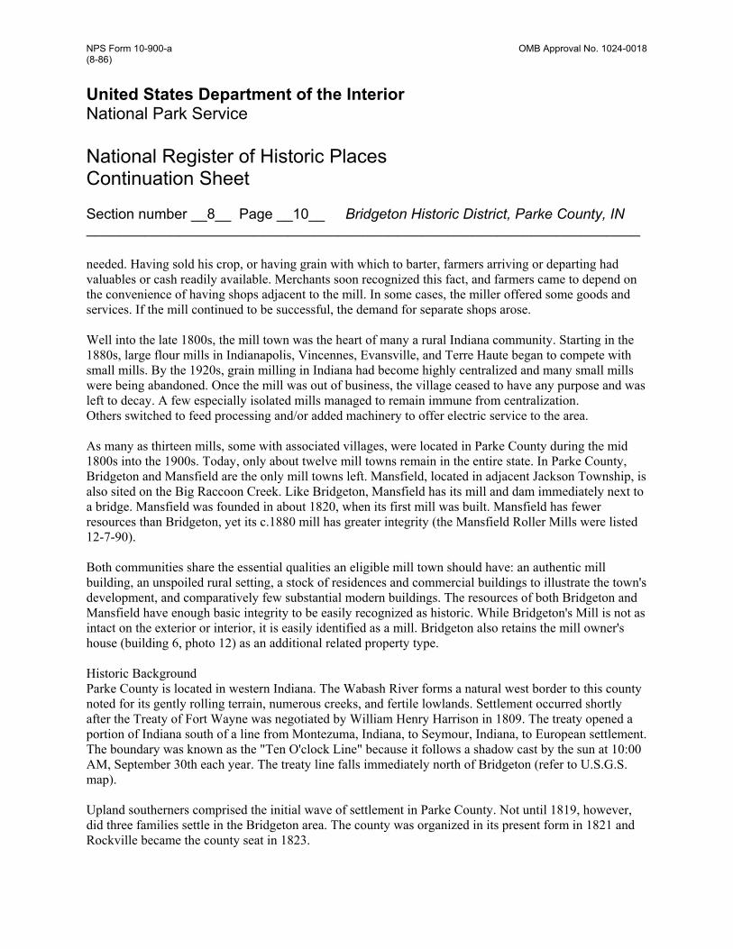
Section number _7&8__ Page __9___ Bridgeton Historic District, Parke County, IN __________________________________________________________________ Commercial Building, Photo 51, Building 35. This one-story molded concrete block building is similar to the Mitchell Auto Company block next door. Originally two stories in height with a substantial parapet, the building no longer has enough integrity to contribute to the district. Crooks Drug Store, Photo 52, Building 36. Dr. James Crooks had this one story, clapboarded, gable front building erected in 1878. It replaced an earlier store house owned by Crooks which had burned. While under construction, Crooks ran his business from the second floor of his store house (building 2). The store front has the usual three part design: two large display windows with kick panels on either side of an entry. In this case the entry is recessed and has sidelights on the short perpendicular walls. The door has a single large light. The plain gable end has simple frieze boards and a ledge-like cornice implying a pediment. In 1893, Crooks sold his stock to his son George B. and Frank Rogers. The building continued to serve as a drug store for many years. In recent years, it has been a restaurant, gift shop, and art studio. To the north, a flat roofed one-story building has been added (building 37). It does not date from the period of significance and is non-contributing. Bridgeton Covered Bridge, Photo 53. J.J. Daniels erected this double span, burr arch truss covered bridge in 1868. No longer open to vehicular traffic, the bridge is the focal point of Bridgeton's tourist attractions. It was individually listed on the National Register of Historic Places on December 22, 1978 (Covered Bridges of Parke County Thematic Resources). Section 8 – Statement of Significance The Bridgeton Historic District is significant under Criterion A as one of only two intact mill villages in Parke County. In rural Raccoon Township, where farming was the dominant way of life even into current times, Bridgeton played a significant role in the areas of industry (milling) and commerce. Although not identified as a property type in the Grain Mills in Indiana Multiple Property Documentation Form (approved 12-7-90), additional documentation in that form clarifies the significance of mill villages. Historic Context Bridgeton should be evaluated in comparison to other mill towns in Indiana and especially Parke County. Mill towns became an important part of rural communities, a place where farmers could barter with their grain, obtain goods and services, and socialize with other families. Grain mills were a necessity and European-descended pioneers sought sites with good running streams and access to road systems. Thus, mills tended to be located at fording sites or adjacent to bridges. The mill was often the only industry in the area. The presence of a mill fostered commercial activity. Farmers might have to wait several days to have their grain processed, so temporary accommodations were
NPS Form 10-900-a OMB Approval No. 1024-0018 (8-86) United States Department of the Interior National Park Service National Register of Historic Places Continuation Sheet
Section number __8__ Page __10__ Bridgeton Historic District, Parke County, IN __________________________________________________________________ needed. Having sold his crop, or having grain with which to barter, farmers arriving or departing had valuables or cash readily available. Merchants soon recognized this fact, and farmers came to depend on the convenience of having shops adjacent to the mill. In some cases, the miller offered some goods and services. If the mill continued to be successful, the demand for separate shops arose. Well into the late 1800s, the mill town was the heart of many a rural Indiana community. Starting in the 1880s, large flour mills in Indianapolis, Vincennes, Evansville, and Terre Haute began to compete with small mills. By the 1920s, grain milling in Indiana had become highly centralized and many small mills were being abandoned. Once the mill was out of business, the village ceased to have any purpose and was left to decay. A few especially isolated mills managed to remain immune from centralization. Others switched to feed processing and/or added machinery to offer electric service to the area. As many as thirteen mills, some with associated villages, were located in Parke County during the mid 1800s into the 1900s. Today, only about twelve mill towns remain in the entire state. In Parke County, Bridgeton and Mansfield are the only mill towns left. Mansfield, located in adjacent Jackson Township, is also sited on the Big Raccoon Creek. Like Bridgeton, Mansfield has its mill and dam immediately next to a bridge. Mansfield was founded in about 1820, when its first mill was built. Mansfield has fewer resources than Bridgeton, yet its c.1880 mill has greater integrity (the Mansfield Roller Mills were listed 12-7-90). Both communities share the essential qualities an eligible mill town should have: an authentic mill building, an unspoiled rural setting, a stock of residences and commercial buildings to illustrate the town's development, and comparatively few substantial modern buildings. The resources of both Bridgeton and Mansfield have enough basic integrity to be easily recognized as historic. While Bridgeton's Mill is not as intact on the exterior or interior, it is easily identified as a mill. Bridgeton also retains the mill owner's house (building 6, photo 12) as an additional related property type. Historic Background Parke County is located in western Indiana. The Wabash River forms a natural west border to this county noted for its gently rolling terrain, numerous creeks, and fertile lowlands. Settlement occurred shortly after the Treaty of Fort Wayne was negotiated by William Henry Harrison in 1809. The treaty opened a portion of Indiana south of a line from Montezuma, Indiana, to Seymour, Indiana, to European settlement. The boundary was known as the "Ten O'clock Line" because it follows a shadow cast by the sun at 10:00 AM, September 30th each year. The treaty line falls immediately north of Bridgeton (refer to U.S.G.S. map). Upland southerners comprised the initial wave of settlement in Parke County. Not until 1819, however, did three families settle in the Bridgeton area. The county was organized in its present form in 1821 and Rockville became the county seat in 1823.

NPS Form 10-900-a OMB Approval No. 1024-0018 (8-86) United States Department of the Interior National Park Service National Register of Historic Places Continuation Sheet
Section number __8__ Page __11__ Bridgeton Historic District, Parke County, IN __________________________________________________________________ Also in 1823, the first mill, a corn cracker, was built at what would become Bridgeton. Lockwood Mill was the name given to the settlement. Misters Lockwood and Sillman built the mill for Misters Oniel and Wasson. Daniel Kalley and a Mr. Searing were subsequent owners. A distillery was built within several years. In about 1845 the mill and distillery burned. Such was the need for a local mill that in 1848, a hewn log mill was erected on the site. The Onsley brothers and William Bean rebuilt the mill. It was a grist and saw mill. Also in 1848, a hewn log bridge spanned Big Raccoon Creek, giving farmers north of the town easy access to the mill. In 1849, the village applied for a post office and the name Bridgeton was given to the settlement. The village was named for its sturdy log bridge. Also in this year, the original plat of Bridgeton, including most of the town as it exists today, was recorded. Ralph Sprague was a significant figure in Bridgeton's history. He bought the mill in 1862, however, the building was destroyed by a fire in 1868. Sprague decided to rebuild, and the present mill was erected for him in 1871. The three story mill had two turbines, roller mills, a large set of Burr stones for feed, a small set of stones for corn, and cost $14,000. Also in 1868, the log bridge was replaced by the current Burr arch covered bridge. The dam was built at this time as well. Sprague later built his gabled ell house (building 6, photo 11) in town, residing there from 1878 until he sold the mill in 1882. Daniel Webster, the next owner of the mill, lived in the house with his family from 1882 until 1899. Webster employed John Hites at the mill. During this period, the mill operated on the exchange system. Farmers received thirty-five pounds of flour per bushel of wheat and forty pounds of meal per bushel of corn. The roller mill could produce seventy-five barrels of flour per day. The grain was delivered to towns by horse and wagon and later via a one ton truck. The brand name White Satin or White Oak was used for Bridgeton flour. By 1880, Bridgeton had a population of 120. In addition to the mill, the town had a drug store, two blacksmiths, a wagonmaker, grocery, two public schools and a fairgrounds just east of town. Significant during this period in Bridgeton's history was Dr. James Crooks. He had three buildings built in town, all of which still stand. This includes his store house/Masonic Temple of 1868 (building 2, photo 5), his drug store of 1878 (building 36, photo 52), and his residence of 1883 (building 23, photo 36). In about 1880, an Attica-Brazil railroad line built by the Chicago and Indiana Coal Company reached Bridgeton. An 1874 atlas indicates a "proposed" line on the site of the railroad. The coal company was interested in coal deposits in nearby Rosedale. Coal mining began in the Rosedale area in 1853 and continued into the 1920s. Mining undoubtedly contributed to the county's economy and likely helped Bridgeton prosper. The railroad also aided Bridgeton's development, yet, it exposed the local economy to outside influence. The turn of the century brought change and prosperity to Bridgeton. By 1893, the Fort Wayne, Terre Haute and Southwest Railroad and Indiana Midland Railroad shared the line to Bridgeton. A depot was present as of 1908 (no longer standing). The mill expanded to include a saw mill and boosted capacity to eighty barrels a day. In 1899, P.T. Winney bought the mill. He installed two 220 volt generators and offered electrical service to the town. In the 1890s, Bridgeton boasted a creamery, two general stores, a
NPS Form 10-900-a OMB Approval No. 1024-0018 (8-86) United States Department of the Interior National Park Service National Register of Historic Places Continuation Sheet
Section number _8&9_ Page __12__ Bridgeton Historic District, Parke County, IN __________________________________________________________________ millinery, a jeweler, a shoe manufacturer, a livery, two blacksmiths, a shingle factory, its own newspaper, a hotel, three doctors, and four lodge chapters. The town was at the height of its economic prosperity. The mill was sold in 1914 to George Brake and Fred A. Mitchell. The mill dam was reinforced with poured concrete. In 1915, Charles Mitchell bought Fred A. Mitchell's interest. Charles in turn sold his interest to Earl Miller in 1922. In 1938 the Bridgeton Mill followed the history of many other mills in Indiana when it was converted to a feed mill by new owner C. C. Hansel. Hansel removed the rollers, burrs, and added a concrete block extension to the south. Ernest and son Robert Weise purchased the mill in 1940 and converted it to an electric powered feed mill. The railroad line to Bridgeton was removed in 1929. Economic stagnation affected Bridgeton during the late 1920s and 30s. It is likely that the presence of the feed mill was the only factor which saved the town from complete abandonment. Farmers of the township had no other local source of supplies; this also helped Bridgeton survive. Recreation and tourism in Parke County started with the establishment of Turkey Run State Park in 1916. Visitors came to the park for its scenic beauty and because of its historic properties, such as the Narrows Covered Bridge. Parke County residents had always realized the importance of its thirty-three covered bridges, but in 1957, this was openly acknowledged by the starting of an annual Covered Bridge Festival. The festival gradually has brought Bridgeton back to economic vitality. In 1972, Robert Weise purchased old burr stones and began to grind meal using electric power in small lots for visitors to Bridgeton. Today, Bridgeton still owes its economic livelyhood to the mill and covered bridge. Tourists rather than farmers now visit the town to see the bridge and witness a replication of the grain milling process. Section 9 - Bibliography Andreas, A. T. Atlas Map of Parke County, Indiana. Chicago: Lakeside Press, 1874. Beckwith, H.W. History of Parke and Vigo Counties, Indiana. Chicago: H. H. Hill and N. Iddings, 1880. Branson, George. Archaeological and Historical Survey of Parke County. Indianapolis: Indiana Historical Bureau, 1927. Crooks, James M. D. Autobiography of James Crooks A.M., M.D. Moore and Langen Printing Company, 1900. History and Families, Parke County, Indiana. Indianapolis: Turner Publishing Company, 1989. Historical Sketch of Parke County, Parke County Memorial. Rockville, IN: Rockville Chautauqua Association, 1916.
NPS Form 10-900-a OMB Approval No. 1024-0018 (8-86) United States Department of the Interior National Park Service National Register of Historic Places Continuation Sheet
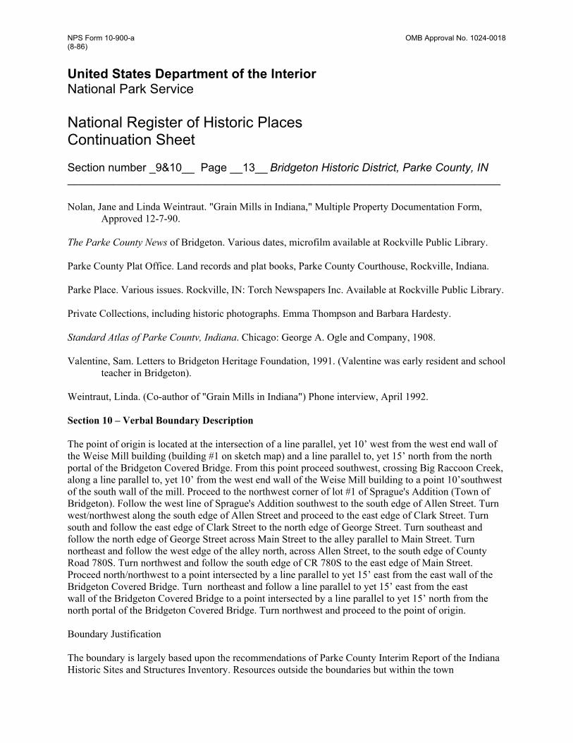
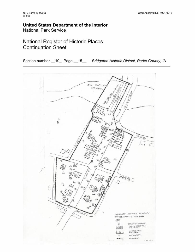
Section number _9&10__ Page __13__ Bridgeton Historic District, Parke County, IN __________________________________________________________________ Nolan, Jane and Linda Weintraut. "Grain Mills in Indiana," Multiple Property Documentation Form, Approved 12-7-90. The Parke County News of Bridgeton. Various dates, microfilm available at Rockville Public Library. Parke County Plat Office. Land records and plat books, Parke County Courthouse, Rockville, Indiana. Parke Place. Various issues. Rockville, IN: Torch Newspapers Inc. Available at Rockville Public Library. Private Collections, including historic photographs. Emma Thompson and Barbara Hardesty. Standard Atlas of Parke Countv, Indiana. Chicago: George A. Ogle and Company, 1908. Valentine, Sam. Letters to Bridgeton Heritage Foundation, 1991. (Valentine was early resident and school teacher in Bridgeton). Weintraut, Linda. (Co-author of "Grain Mills in Indiana") Phone interview, April 1992. Section 10 – Verbal Boundary Description The point of origin is located at the intersection of a line parallel, yet 10’ west from the west end wall of the Weise Mill building (building #1 on sketch map) and a line parallel to, yet 15’ north from the north portal of the Bridgeton Covered Bridge. From this point proceed southwest, crossing Big Raccoon Creek, along a line parallel to, yet 10’ from the west end wall of the Weise Mill building to a point 10’southwest of the south wall of the mill. Proceed to the northwest corner of lot #1 of Sprague's Addition (Town of Bridgeton). Follow the west line of Sprague's Addition southwest to the south edge of Allen Street. Turn west/northwest along the south edge of Allen Street and proceed to the east edge of Clark Street. Turn south and follow the east edge of Clark Street to the north edge of George Street. Turn southeast and follow the north edge of George Street across Main Street to the alley parallel to Main Street. Turn northeast and follow the west edge of the alley north, across Allen Street, to the south edge of County Road 780S. Turn northwest and follow the south edge of CR 780S to the east edge of Main Street. Proceed north/northwest to a point intersected by a line parallel to yet 15’ east from the east wall of the Bridgeton Covered Bridge. Turn northeast and follow a line parallel to yet 15’ east from the east wall of the Bridgeton Covered Bridge to a point intersected by a line parallel to yet 15’ north from the north portal of the Bridgeton Covered Bridge. Turn northwest and proceed to the point of origin. Boundary Justification The boundary is largely based upon the recommendations of Parke County Interim Report of the Indiana Historic Sites and Structures Inventory. Resources outside the boundaries but within the town
NPS Form 10-900-a OMB Approval No. 1024-0018 (8-86) United States Department of the Interior National Park Service National Register of Historic Places Continuation Sheet
Section number __10_ Page __14__ Bridgeton Historic District, Parke County, IN __________________________________________________________________ of Bridgeton generally are of post 1940 vintage. In some cases, older resources are interspersed with recent buildings, necessitating exclusion from the boundaries. The concentration of historic resources decreases suddenly on Main Street south of George Street. The boundary jogs to include the 1868 covered bridge. Although already listed, the bridge/mill relationship is significant to mill towns, as explained in section 8. The bridge and dam are vital to the history and setting of this mill town. The boundaries were verified by a DHPA staff site visit in March of 1992.
NPS Form 10-900-a OMB Approval No. 1024-0018 (8-86) United States Department of the Interior National Park Service National Register of Historic Places Continuation Sheet
Section number __10_ Page __15__ Bridgeton Historic District, Parke County, IN __________________________________________________________________