national atv / utv jamboree rides - … · national atv / utv jamboree rides note: rides range from...
TRANSCRIPT
1
Updated: September 26, 2016
NATIONAL ATV / UTV JAMBOREE RIDES
Note: Rides range from Beginner to Advanced and will last from 2 to 3 hours or an entire day of riding.
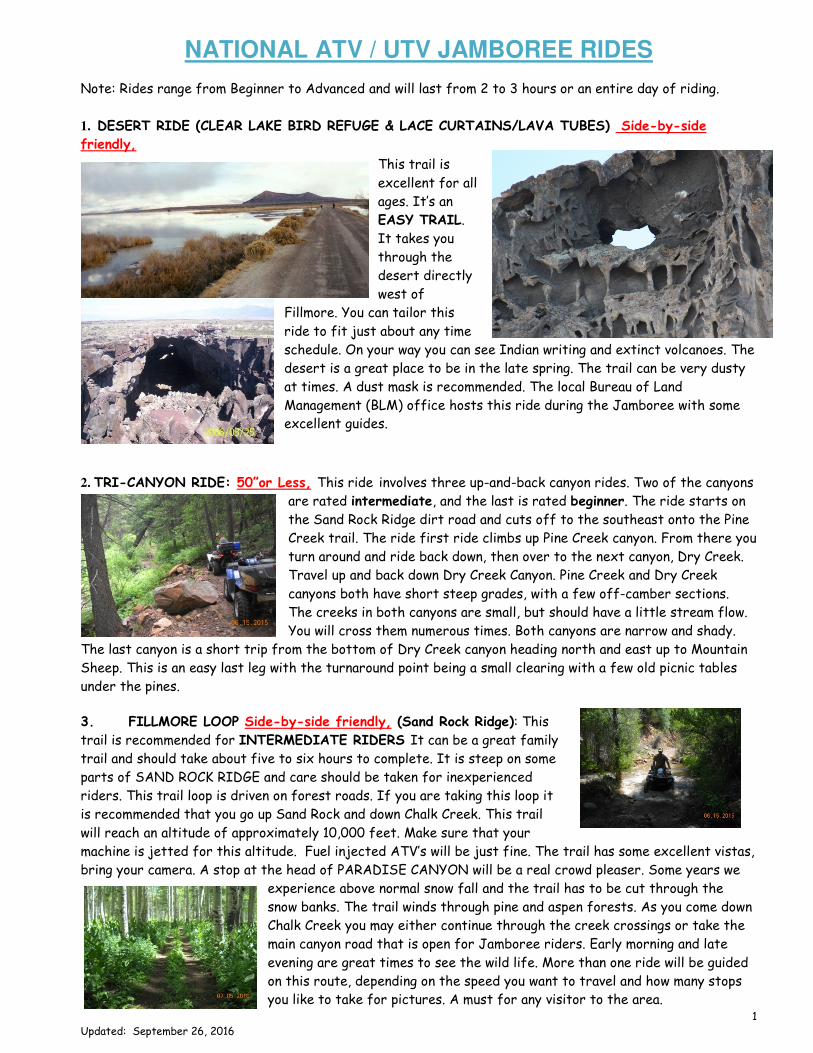
1. DESERT RIDE (CLEAR LAKE BIRD REFUGE & LACE CURTAINS/LAVA TUBES) Side-by-side
friendly,
This trail is
excellent for all
ages. It’s an
EASY TRAIL.
It takes you
through the
desert directly
west of
Fillmore. You can tailor this
ride to fit just about any time
schedule. On your way you can see Indian writing and extinct volcanoes. The
desert is a great place to be in the late spring. The trail can be very dusty
at times. A dust mask is recommended. The local Bureau of Land
Management (BLM) office hosts this ride during the Jamboree with some
excellent guides.
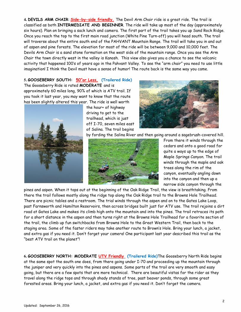
2. TRI-CANYON RIDE: 50”or Less, This ride involves three up-and-back canyon rides. Two of the canyons
are rated intermediate, and the last is rated beginner. The ride starts on
the Sand Rock Ridge dirt road and cuts off to the southeast onto the Pine
Creek trail. The ride first ride climbs up Pine Creek canyon. From there you
turn around and ride back down, then over to the next canyon, Dry Creek.
Travel up and back down Dry Creek Canyon. Pine Creek and Dry Creek
canyons both have short steep grades, with a few off-camber sections.
The creeks in both canyons are small, but should have a little stream flow.
You will cross them numerous times. Both canyons are narrow and shady.
The last canyon is a short trip from the bottom of Dry Creek canyon heading north and east up to Mountain
Sheep. This is an easy last leg with the turnaround point being a small clearing with a few old picnic tables
under the pines.
3. FILLMORE LOOP Side-by-side friendly, (Sand Rock Ridge): This
trail is recommended for INTERMEDIATE RIDERS It can be a great family
trail and should take about five to six hours to complete. It is steep on some
parts of SAND ROCK RIDGE and care should be taken for inexperienced
riders. This trail loop is driven on forest roads. If you are taking this loop it
is recommended that you go up Sand Rock and down Chalk Creek. This trail
will reach an altitude of approximately 10,000 feet. Make sure that your
machine is jetted for this altitude. Fuel injected ATV’s will be just fine. The trail has some excellent vistas,
bring your camera. A stop at the head of PARADISE CANYON will be a real crowd pleaser. Some years we
experience above normal snow fall and the trail has to be cut through the
snow banks. The trail winds through pine and aspen forests. As you come down
Chalk Creek you may either continue through the creek crossings or take the
main canyon road that is open for Jamboree riders. Early morning and late
evening are great times to see the wild life. More than one ride will be guided
on this route, depending on the speed you want to travel and how many stops
you like to take for pictures. A must for any visitor to the area.
2
Updated: September 26, 2016
4. DEVILS ARM CHAIR: Side-by-side friendly, The Devil Arm Chair ride is a great ride. The trail is
classified as both INTERMEDIATE AND BEGINNER. The ride will take up most of the day (approximately
six hours). Plan on bringing a sack lunch and camera. The first part of the trail takes you up Sand Rock Ridge.
Once you reach the top to the first main road junction (White Pine Turn-off) you will head south. The trail
will traverse about the entire south end of the PAHVANT Mountain Range. The trail will take you in and out
of aspen and pine forests. The elevation for most of the ride will be between 9,000 and 10,000 feet. The
Devils Arm Chair is a sand stone formation on the west side of the mountain range. Once you see the Arm
Chair the town directly west in the valley is Kanosh. This view also gives you a chance to see the volcanic
activity that happened 100’s of years ago in the Pahvant Valley. To see the “arm chair” you need to use little
imagination! I think the Devil must have a sense of humor! The route back is the same way you came.
5. GOOSEBERRY SOUTH: 50”or Less, (Trailered Ride)
The Gooseberry Ride is rated MODERATE and is
approximately 60 miles long, 90% of which is ATV trail. If
you took it last year, you may want to know that the route
has been slightly altered this year. The ride is well worth
the hour+ of highway
driving to get to the
trailhead, which is just
off I-70, seven miles east
of Salina. The trail begins
by fording the Salina River and then going around a sagebrush-covered hill.
From there it winds through the
cedars and onto a good road for
quite a ways up to the edge of
Maple Springs Canyon. The trail
winds through the maple and oak
trees along the rim of the
canyon, eventually angling down
into the canyon and then up a
narrow side canyon through the
pines and aspen. When it tops out at the beginning of the Oak Ridge Trail, the view is breathtaking. From
there the trail follows mostly along the ridge top along the Oak Ridge trail to the Browns Hole Trailhead.
There are picnic tables and a restroom. The trial winds through the aspen and on to the Gates Lake Loop,
past Farnsworth and Hamilton Reservoirs, then across bridges built just for ATV use. The trail rejoins a dirt
road at Gates Lake and makes its climb high onto the mountain and into the pines. The trail retraces its path
for a short distance in the aspen and then turns right at the Browns Hole Trailhead for a favorite section of
the trail, the climb up fun switchbacks from Browns Hole to the Great Western Trail, then back to the
staging area. Some of the faster riders may take another route to Brown’s Hole. Bring your lunch, a jacket,
and extra gas if you need it. Don’t forget your camera! One participant last year described this trail as the
“best ATV trail on the planet”!
6. GOOSEBERRY NORTH: MODERATE UTV Friendly (Trailered Ride)The Gooseberry North Ride begins
at the same spot the south one does, from there going under I-70 and proceeding up the mountain through
the juniper and very quickly into the pines and aspens. Some parts of the trail are very smooth and easy
going, but there are a few spots that are more technical. There are beautiful vistas for the rider as they
travel along the ridge tops and through shady stands of tree, past beaver ponds, through some great
forested areas. Bring your lunch, a jacket, and extra gas if you need it. Don’t forget the camera.
3
Updated: September 26, 2016
7. KANOSH RIDE Side-by-side friendly 60” or less. This is another trail that will suit ANY LEVEL of
rider. You will ride on improved gravel roads for the first 15 miles, winding your way past hay and corn fields
until you come to the town of Kanosh. It would be a good idea to top off your machine with fuel in Kanosh
unless you pack your own. From Kanosh the trail is well marked
as you travel south to the mouth of Dry Wash. You will enjoy
the cool oak trees and splashing through several small streams
(doesn’t sound too dry to me). The trail continues for several
miles through Dry Wash
until you reach BIG OAKS.
After you pass Big Oaks,
you will join up with the
main Kanosh Canyon road.
At this point your guide can
offer you a great easy ride
which is side-by-side friendly or offer the regular ATV’s a challenging
ride up what is called Al Gay Hollow trail, 4X4 is recommended. After you
make the loop on top of the mountain, the trail heads down Corn Creek
(Kanosh Canyon). There is a developed campground with water and rest
room facilities. After a short break you travel 4 miles back to Kanosh. Once you reach the town of Kanosh
your back track to Fillmore on the same route. The ride normally takes about five to six hours depending how
long you stop for pictures.
8. OLD MINE TOUR (Kimberly): INTERMEDIATE: 50”or Less, (Trailered Ride) The majority of this ride
is not difficult, but it has been rated intermediate for its length.
The group will trailer to the
staging area at Fremont
Indian State Park. The ride is
mostly through forested areas
with great views of the
11,000+ foot peaks of the
Tushar Range. These 11,000+
peaks are inaccessible at this
time of year because of the snow. As you start your trip, you will
travel through the Cottonwood trees crossing a small creek several times. You will gain elevation quickly and
travel through some very dense pine and aspen forests from time to time. The trail meets up with the main
forest road where you will travel to the town of Marysvale, then up
the canyon to Miners Park. It then retraces the route to Marysvale
and through the valley to Hoovers Café, a great place to take five
minutes and rest. You will then enter Deer Creek Canyon for the ride
back up the mountain and on to Kimberly. There will be stops at
mining areas such as the Silver King Mine, the Kimberly mining town,
Bullion City, and others. At some stops there are old cabins or short
walking tours to enjoy. The trail will take you through some of the
greatest mountain views in the state. The old mining town of
KIMBERLY still has some building standing. You will pass numerous old
mines that once held the promise of a good life, but didn’t quite pan out. As you make your way through the
pine and aspen forests you will be impressed by the beauty of this mountain. Make sure you bring your
camera. Every turn is a KODAK moment. The trail winds to a point between 10,000 and 11,000 feet in
elevation. You may want to check your jetting unless your machine is fuel injected. The tallest point you will
see is 12,173 feet (Delano Peak). On the trail you can see a variety of wildlife to include mountain sheep,
deer and elk. Certain times of the year the higher elevations of the trail are impassable because of snow.
Bring a jacket.

4
Updated: September 26, 2016
9. SEVIER COUNTY SPONSIRED LUNCH RUN: Side-by-side friendly, Join other ATV/UTV food
connoisseurs for the great 70 mile ride over the top of the Pahvant Mountain Range and down into Richfield
for lunch to a designated spot. The menu hasn’t been decided yet, but…. Will be worth the ride. Bring a
jacket as it gets cool at the high elevations. The top of the mountain in this area is a great spot for enjoying
the mountain flowers that are in abundance at this time of year. Lunch will be provided at no cost to the
first 25 riders by Sevier County Tourism.
10. ROBINS VALLEY/COFFEE PEAK: Side-by-side friendly. This trail is a great family ride and should
take about six to seven hours to complete. It will accommodate BEGINNER RIDERS Most of this trail is
driven on forest roads. You have one of two ways to begin this ride. You
may either head up Chalk Creek or take the main canyon road. Once you
reach the picnic areas in the canyon, continue up the road for several
miles until you come to a major road junction. (Bear Hollow Turn-off).
A right hand turn will put you riding towards Sand Rock Ridge. A left-
hand turn will put you heading north towards Robins Valley and Coffee
Peak. A large part of this trail is on the top of the PAHVANT Mountain
Range. Your ride will take you through large aspen forests. On your way
up you will pass an old cow corral. If you would like to take an excellent
side trip, turn left here and proceed down into Bear Hollow. This is an excellent trail on which to see deer
during morning and evening hours. You will have to back track to get back to the main trail, but it’s worth it.
ROBINS VALLEY is a great little valley in the top of the mountain. Definitely a great spot for a few family
pictures. The ride back is on the same trail.
11. POKER RUN: (Friday only) Side-by-side friendly. This ride is a Jamboree favorite. The first poker
punch will be at the East Millard Fair Grounds Friday morning after breakfast. Poker punches will be on the
trail when you stop for pictures or just to take a break. Your guide will be the dealer for the entire ride.
The poker prizes will be given out during the steak dinner and entertainment Friday night by Mr. Coke “Fred
Christensen” as your MC. This event is sponsored by the Coke Cola Company.
12. AMASA BASIN: MODERATE: Side-by-side
friendly or 50” (Trailered Ride). There are two
routes to the top. The 50” or less route is more
technical. The other one is side-by-side friendly. The
guide will determine which route to take. You will need
to trailer 80 miles west of Fillmore to the staging area.
The trail begins at sagebrush flat at the mouth of
Miller’s Canyon. The first part of the trail is built just
for ATV’s or UTV’s. Either route will put a smile on
your face and offer a unique desert riding experience.
Your guide will make a stop at a large sink hole to show
you what an underground prehistoric river can do. Visitors are surprised to see a lush green valley with
stands of aspen and unusually shaped rock formations. The climb on the west side of the valley takes riders
to a breathing-taking cliff with an aerial view of the valley nearly a mile below and mountains of Utah and
Nevada in the distance. The adjacent cliffs are home to a stand of Bristlecone pines, some of which are
several hundred years old. Remember your camera for the breathtaking views. The local Bureau of Land
Management (BLM) office hosts this ride during the Jamboree with some excellent guides.

5
Updated: September 26, 2016
13. TEEPLES CANYON/ SWEETWATER: DIFFICULT: 50”or Less,
Teeples Canyon is actually a short side trip off from the Pioneer
Canyon Trail. It is not for the beginning rider! Riding through the
boulders of the creek bottoms, the route crawls through maple,
aspen, and pines. There is an old steam engine in the canyon that was
once powered an old saw mill. Nearly every canyon in the area had a
saw mill at one time or another and the entire operation was usually
moved to another canyon when they were finished. In Teeples
Canyon there are still some reminders of days gone by. A great ride
for an experienced rider.
14. WHITE SAGE: 50”or Less, This trail is recommended for ADVANCED RIDERS. From start to finish
it will take you about three hours to traverse. It’s a great ride if you’re
looking to fill out an afternoon or just take a quick spin. At the mouth of
Chalk Creek Canyon there is an area to load and unload ATV’s and horse
trailers. From there you need to take the road to the left and then cross
the bridge. Turn left at the sign that says White Sage. The trail will
continue for about a quarter of a mile. Take the trail that is labeled as
ONE WAY. This helps prevent congestion on the narrow and steep parts of
the trail. There are several switchbacks and rocks on the trail, watch your
tire rims. When you reach the top of WHITE SAGE you’ll find it an excellent place for lunch. As you tackle
the trail a watchful eye should see wild turkeys, deer and depending on the time of year you could see elk.
When you leave WHITE SAGE and head down the trail you should be prepared to get wet. The trail runs
into Chalk Creek. You will cross the creek several times. At one point the creek is the trail. An excellent
trail to cool off on. One trail the advanced rider will repeat time and time again. Guaranteed.
NOTE: Rides which will be trailered are: Kimberly, Gooseberry “North and
South”, Kimberly, Amasa Valley and the Old Mine Tour.
ANOTHER SPECIAL NOTE: All of the above listed rides may or may
not be guided during the National ATV / UTV Jamboree. During past years
heavy winter snow has made it impossible to traverse some of the higher
elevations. This year is looking pretty good though. There are literally 100’s
of rides you could put together. If you know the area well enough and would
like to strike out on your own, let us help you put a ride together.