multimodal system integration - caltrans · multimodal system integration ... • promote public...
TRANSCRIPT

Multimodal System Integration High Speed Rail-Transit Connectivity Program
Transportation Planning Workshop Visalia, CA—District 6
April 9, 2014
Chris Ratekin
Chief, Transit Planning Branch
Office of Community Planning
Division of Transportation Planning
(916) 653-4615

What is it?
All modes? Connectivity? Integration? Everything all at once?

Overview
Sustainable mobility and community planning
Smart Mobility and Complete Streets Connectivity program overview and
background New directions

What is Community Planning?
Community planning is the integration of transportation and land use planning with
community values to create more livable and resource efficient communities.
(Computer-generated graphic)

Effective community planning results in vibrant communities with mixed land uses that encourage people to walk, cycle, and use transit.

Why are Transportation Choices Important?
MISSION: “Caltrans Improves Mobility Across California”
MOBILITY GOAL:
“Maximize transportation system performance and accessibility.”
STRATEGIES:
- Context Sensitive Solutions
- Multi-modal planning
- Complete Streets - Smart Mobility

What are Community Planning STRATEGIES?
Interconnected Travel Networks Traffic Calming/Complete Streets Bicycle- and Pedestrian-friendly Design Lively Streetscapes/Complete Streets Compact development (urban & rural areas) Jobs/Housing Proximity Mixed Land Uses Infill development Transit-Oriented Development (TOD) Smart Mobility Framework
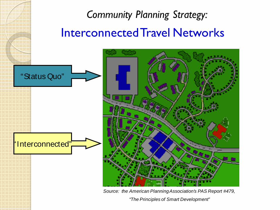
Interconnected Travel Networks
“Status Quo”
“Interconnected”
Source: the American Planning Association’s PAS Report #479,
“The Principles of Smart Development”
Community Planning Strategy:

Community Planning Strategy:
Traffic Calming/Complete Streets
“Before”
Results of a community “visioning” process for International Boulevard in Oakland – traffic calming, complete streets, multi-modal.
“After”

• “Bicycle-friendly”design
Downtown Hayward
(next to City Hall)
Downtown Los Angeles
(near the Union Transit Station)
• “Pedestrian-friendly”design
Community Planning Strategy:
Bicycle- and Pedestrian- friendly Design

“Neo-traditional” neighborhood design (Front porches, street trees, bike lanes)
(Santa Clara, CA)
Wide sidewalk and outdoor eating (Silicon Valley - S.F. Bay Area)
Community Planning Strategy:
Lively Streetscapes/Complete Streets

• “Sprawl”
• Compact Development
Photo courtesy of the Local Government Commission
Compact Development (urban and rural)
Community Planning Strategy:

Transportation-Efficient Rural Towns
Source: US EPA White Paper: “The Placemaking Premium” by Victor Dover, 2007.
(Illustrations by Dover Kohl and Partners)

Downtown Angels Camp
SR 49 – District 10
Preserve Main Streets Maintain Rural Character/Context Sensitive Design
For Main Streets Guidance, visit: http://www.dot.ca.gov/hq/oppd/guidance.htm
Downtown Calistoga
SR 29 – District 4
Community Planning Strategy:

• Mixed Land Uses
Shops below apartments and condominiums in “Little Italy” (near downtown San Diego)
• Infill Development
Community Planning Strategies:
Mixed Land Uses and Infill Development

Oakland City Center (12th St. BART station) - Plaza, offices, shops, restaurants
Historic Multi-Modal Transit Station, downtown San Diego
Transit-Oriented Development (TOD) - aka “Transit Villages”
For other examples – see Caltrans’ TOD website at: http://TransitOrientedDevelopment.dot.ca.gov
Community Planning Strategy:

Community Planning Strategy:
Smart Mobility Framework
Smart Mobility: Definition
Smart Mobility moves people and freight while enhancing California’s economic, environmental and human resources by emphasizing: Conventional and safe multi-modal travel, Speed suitability, Accessibility, Management of the circulation network, and Efficient use of land

What Laws and Policies Support Community Planning?
2002 State “Environmental Goals & Policies Report” law* established planning priorities to:
• “promote Equity, • strengthen the Economy, • protect the Environment, and • promote public health and safety”
Referred to as the “Three Es” * AB 857, Govt. Code Chapter 1016

Caltrans Director’s Policy #22 “Context Sensitive Solutions” (2001) What does “Context Sensitive Solutions” mean?
An approach to meeting transportation goals in harmony with community goals and natural environments.
“Context sensitive solutions
are reached through a collaborative, interdisciplinary approach involving all stakeholders.”

Deputy Directive 64-R1 “Complete Streets” (revised October 2008)
“The Department provides for the needs of travelers of all ages and abilities in all planning, programming, design, construction, operations, and maintenance activities and products on the State highway system.”
“The Department develops integrated, multimodal projects in balance with community goals, plans, and values…Bicycle, pedestrian, and transit travel is facilitated by creating “complete streets”…

SB 375 re: Climate Change
SB 375 became law 9/30/08; effective January 1, 2009: 1. Required the California Air Resources Board (ARB) to develop and
adopt regional greenhouse gas (GHG) emission reduction targets (for cars and light trucks) for each of the state’s 18 Metropolitan Planning Organizations (MPOs).
2. Required each MPO to adopt a Regional Transportation Plan (RTP) that meets ARB’s regional GHG reduction target -- with extensive input from the public and other government agencies. These plans must include a “sustainable communities strategy” (SCS).
…& other provisions re: environmental streamlining, housing elements, planning, etc.

What are the main activities of the HQ Office of Community Planning?
Public Participation/Engagement Community and Environmental Justice
Planning Grants & Technical Assistance Special Studies & Analysis Tools Native American Liaison Local Development & Intergovernmental
Review Complete Streets & Smart Mobility
Hoopa Valley Planning “Charrette”

HQ Community Planning Activities:
Community-Based Transportation Planning (CBTP) and Environmental Justice (EJ) Grants
Provide ‘seed funding’ for local planning that integrate land use, transportation, community involvement and environmental justice.
MPO’s/RTPA’s, Cities and Counties, Transit Agencies, and Native American Tribal Governments may apply.
For more information: http://www.dot.ca.gov/hq/tpp/grants.html
Site plan for the Pleasant
Hill TOD in the SF Bay Area

Smart Mobility Framework
Definition Principles Objectives Place Types Performance Measures Strategies
Pilot Studies Underway • I-680 CSMP • Sub-Regional Plan (SBCCOG)

Why Complete Streets?
Benefits of Complete Streets Increase physical activity, improve public
health and safety
Provide options and access for non-drivers
Decrease vehicle trips, air pollutant and greenhouse gas emissions
Improve livability, revitalize communities, and decrease transportation costs
25

Complete Streets--
Roadway type oMain Street oUrban oRural highway
Land uses (existing & planned)
Bike & Pedestrian Plans Safety & usage data Transit service (existing & planned)

Why is Transit Connectivity so important?
Administration support for HSR Changing travel trends Increasing focus on social equity and access Climate change, AB 32, SCSs CA @ 50 million Shifting focus to operations and maintenance Shrinking transportation funds New reports—SSTI, Program Review, CTIP

“The Division of Transportation Planning’s High-Speed Rail Transit Connectivity Program (HSR-TCP) was created on July 1, 2012 to assist Caltrans California Intercity Rail (CIR), California High-Speed Rail Authority (CHSRA), regional and local agencies, and transit operators in establishing healthy, sound multimodal transportation connections critical for the success of the HSR blended system.”
The department website states:

Further:
“The HSR-TCP is focused on the following activities: Assisting in the development of station area plans; Developing transportation and land use connections
critical to multimodal connectivity; Developing long-term strategies, policies, and strategic
plans to improve and ensure connectivity of the State's transportation system, while protecting the environment and affected communities;
Building partnerships with tribal governments, regional and local governments, transit operators, partner agencies, and stakeholders;”

What has been done?
Staff assigned—HQs and Districts Resources redirected Website created Initial activities identified Engagement and outreach started Internal roles and responsibilities clarified Coordination meetings


Bus Rapid Transit
Transit Signal Priority ◦ Extends green time for buses
Dedicated Bus Lane (Median or Curb)
• Rail-like Stations – Ticket Vending
Machines – Level Boarding
• “Next Bus” Real-Time Information

What’s next?
Define traditional vs. enhanced transit tasks Identify activities and staff leads Affirm and articulate direction Conduct meetings, teleconferences,
webinars, and workshops

You can help!
Brainstorm and provide feedback on traditional vs. enhanced transit tasks
Identify specific initiatives Consider how you can change what you
do to improve connectivity

Active Transportation Program
TAP
SR2S
BTA
ATP
TE
SRTS
RTP

Achieving Multimodal Success
Participate, persevere, patience, partner
Identify community needs, stakeholders, & options
Consider creative funding
Regional Planning—MPOs, RTPAs
System Planning— TCRs
Projects Initiation Documents & PDTs
District staff are there to help!
36

Resources
Complete Streets Program website: www.dot.ca.gov/hq/tpp/offices/ocp/complete_streets.html
Strategic Highway Safety Plan: http://www.dot.ca.gov/SHSP/ Smart Mobility: http://www.dot.ca.gov/hq/tpp/offices/ocp/smf.html AB 819: http://www.dot.ca.gov/hq/oppd/ab819/ Main Street, California:
http://www.dot.ca.gov/hq/LandArch/mainstreet/ Active Transportation Program:
http://www.dot.ca.gov/hq/LocalPrograms/atp/ High-Speed Rail Transit Connectivity Program: http://www.dot.ca.gov/hq/tpp/offices/ocp/hsr.html
37

Resources
SACOG Complete Streets Toolkit: http://www.sacog.org/complete-streets/toolkit/START.html
Context Sensitive Solutions: http://contextsensitivesolutions.org/ American Planning Association Complete Streets resources:
http://www.planning.org/research/streets/resources.htm FHWA Bike/Ped resources:
http://www.fhwa.dot.gov/environment/bikeped/ www.pedbikeinfo.org www.completestreets.org
38

Contact Information
Chris Ratekin, Branch Chief Transit Planning Office of Community Planning Caltrans, Sacramento [email protected] 916-653-4615