morehead city ocean dredged material disposal site - site ... · sediment characterization ... is...
TRANSCRIPT
o
MOREHEAD CITY FEBRUARY 2010
f Engineers
OCEAN DREDGED MATERIAL DISPOSAL SITE
SITE MANAGEMENT AND MONITORING PLAN U.S. Army Corps
Morehead City ODMDS, SMMP
The following Site Management and Monitoring Plan for the Morehead City ODMDS has been developed and agreed to pursuant to the Water Resources Development Act Amendments of 1992 (WRDA 92) to the Marine Protection, Research, and Sanctuaries Act of 1972 for the management and monitoring of ocean disposal activities, as resources allow, by the U.S. Environmental Protection Agency and the U.S. Army Corps of Engineers.
Jefferson M. Ryscavage Date A. Stanley Meiburg Date
Colonel, U.S. Army Acting Regional Administrator District Engineer U.S. E.P.A., Region 4 Wilmington District Atlanta, Georgia U.S. Army Corps of Engineers Wilmington, North Carolina This plan is effective from date of signature for a period not to exceed 10 years. The plan shall be reviewed and revised more frequently if site use and conditions at site indicate a need for revision.
Morehead City ODMDS, SMMP
i
Table of Contents
INTRODUCTION ......................................................................................................................................................... 1
SCOPE OF THE SMMP ............................................................................................................................................ 1
OBJECTIVES OF SITE MANAGEMENT ............................................................................................................... 2
MOREHEAD CITY OCEAN DREDGED MATERIAL DISPOSAL SITE (ODMDS) .......................................... 2
DISPOSAL HISTORY ................................................................................................................................................ 3
Historical Use of the Morehead City ODMDS ..................................................................................... 3 Morehead City Harbor Dredged Material Management ..................................................................... 5 Morehead City Harbor Federal Navigation Channel .......................................................................... 5 USCG Station Fort Macon ................................................................................................................... 6 North Carolina Stat Ports Authority (NCSPA) Maintenance and Projects ......................................... 7
CHARACTERISTICS OF DREDGED MATERIALS ............................................................................................. 7
Grain Size ............................................................................................................................................ 8 Inner Harbor ......................................................................................................................................... 8 Mid Harbor ........................................................................................................................................... 8 Outer Harbor ........................................................................................................................................ 8 Chemical and Biological Testing of Sediments .................................................................................. 8
DISPOSAL METHODS .............................................................................................................................................. 9
MANAGEMENT CONCERNS OR ISSUES ............................................................................................................ 9
Morehead City Harbor Dredged Material Management Plan (DMMP) .............................................. 9 Nearshore Placement .......................................................................................................................... 9 Direct Beach Placement .................................................................................................................... 10 Fine-Grained Inner Harbor Material .................................................................................................. 11 Mounding ............................................................................................................................................ 12 Site Use Management, Implementation, and Documentation .......................................................... 12 Navigation Channel Alignment .......................................................................................................... 13
OCEAN DREDGED MATERIAL SITE MANAGEMENT .................................................................................... 13
Types of Dredged Materials ............................................................................................................... 13 Evaluated Material .............................................................................................................................. 13 Dredged Material Suitable for Beneficial Uses ................................................................................... 13 Dredged Material With Debris ............................................................................................................ 14 Methods of Disposal ........................................................................................................................... 14 Disposal Quantities ............................................................................................................................. 15 Timing of Disposal .............................................................................................................................. 15 Channel Area ...................................................................................................................................... 15
SPECIFIC REQUIREMENTS .................................................................................................................................. 15
Ocean Disposal Verification ............................................................................................................... 15 Disposal Monitoring ............................................................................................................................ 15 Reporting and Data Formatting .......................................................................................................... 16 Designated Route To and From the Morehead City ODMDS ............................................................ 17 Disposal ‘Zones’ Within the ODMDS .................................................................................................. 17
BASELINE ASSESSMENT OF CONDITIONS AT THE MOREHEAD CITY ODMDS .................................. 18
Morehead City ODMDS, SMMP
ii
Site Designation EIS Baseline ............................................................................................................ 18 Information Obtained Since Site Designation .................................................................................... 18 Bathymetry ......................................................................................................................................... 18 Sediment Characterization ................................................................................................................. 18 Benthic Communities ......................................................................................................................... 18
SITE MONITORING ................................................................................................................................................. 19
Goals of Site Monitoring ..................................................................................................................... 19 Monitoring Methods and Rationale ..................................................................................................... 20 Site Bathymetry .................................................................................................................................. 20 Disposal Site Use Records ................................................................................................................. 20 Data Reporting ................................................................................................................................... 20
ANTICIPATED SITE USE ....................................................................................................................................... 20
MODIFICATION OF THE MOREHEAD CITY ODMDS SMMP ......................................................................... 21
IMPLEMENTATION OF THE MOREHEAD CITY ODMDS SMMP .................................................................. 21
REFERENCES .......................................................................................................................................................... 24
LIST OF TABLES
Table 1. Summary of ocean dredged material placed in the Morehead City ODMDS area ........................ 4 Table 2. Morehead City ODMDS monitoring strategies and thresholds for action .................................... 23
LIST OF FIGURES Figure 1. Morehead City Harbor, NC Vicinity Map Figure 2. Morehead City ODMDS and Vicinity Figure 3. Morehead City ODMDS Bathymetry Figure 4. Morehead City Harbor Channel Nomenclature Figure 5. Morehead City ODMDS Disposal Zones Figure 6. Morehead City ODMDS - Channel Extension No Disposal Zone
APPENDICES Appendix A – Numerical Model (STFATE) Input Parameters Appendix B – Generic Special Conditions for MPRSA Section 103 Permits Morehead City ODMDS Appendix C – Sediment Characteristics In Morehead City Federal Navigation Channel Appendix D – Sediment Characteristics In Morehead City ODMDS Vicinity Appendix E – Public Involvement, Morehead City ODMDS, SMMP

Morehead City ODMDS, SMMP
i
SITE MONITORING AND MANAGEMENT PLAN FOR THE
MOREHEAD CITY OCEAN DREDGED MATERIAL DISPOSAL SITE (ODMDS) FEBRUARY 2010
INTRODUCTION Under the MPRSA (Marine Protection, Research, and Sanctuaries Act) of 1972, it is the responsibility of the EPA (U.S. Environmental Protection Agency) and the USACE (U.S. Army Corps of Engineers) to monitor and manage Ocean Dredged Material Disposal Sites (ODMDS). The goal of this management is to ensure that ocean dredged material disposal activities will not unreasonably degrade the marine environment or endanger human health or economic potential. MPRSA, WRDA (the Water Resources Development Act) of 1992, and a Memorandum of Agreement between EPA and USACE requires the development of a SMMP (site management and monitoring plan) to specifically address the disposal of dredged material at the Morehead City ODMDS. Following an opportunity for public review and comment, the SMMP provisions will be requirements for all disposal activities at the site. All section 103 (MPRSA) ocean disposal permits or evaluations shall be conditioned as necessary to assure consistency with the SMMP.
This SMMP has been prepared in accordance with the Guidance Document for Development of Site Management Plans for Ocean Dredged Material Disposal Sites (EPA and USACE, 1996). This document provides a framework for the development of site monitoring and management plans required by MPRSA and WRDA. The SMMP may be modified if it is determined that such changes are warranted as a result of information obtained during the monitoring process. The SMMP will be reviewed and revised as needed or every ten years, whichever time period is shorter.
A Morehead City ODMDS SMMP was prepared in October 1997. This SMMP updates the 1997 SMMP focusing on areas where site use and conditions and evolving ocean policy indicate a need for revision.
SCOPE OF THE SMMP ODMDS management involves a broad range of activities including regulating the schedule of use, the quantity, and the physical/chemical characteristics of dredged materials dumped at the site. It also involves establishing disposal controls, conditions and requirements to avoid and minimize potential impacts to the marine environment. Finally, ODMDS management involves monitoring the site environs to verify that unanticipated or significant adverse effects are not occurring from past or continued use of the site and that permit conditions are met.
The SMMP shall include but not be limited to:
• A baseline assessment of conditions at the site; • A program for monitoring the site; • Special management conditions or practices to be implemented at each site that are necessary
for the protection of the environment; • Consideration of the quantity and physical/chemical characteristics of dredged materials to be
Morehead City ODMDS, SMMP
2
disposed of at the site; • Consideration of the anticipated use of the site over the long term; • A schedule for review and revision of the plan.
OBJECTIVES OF SITE MANAGEMENT There are three primary objectives in the management of the Morehead City ODMDS:
• Protection of the marine environment, living resources, and human health and welfare; • Documentation of disposal activities at the ODMDS and provision of information which is useful in
managing the dredged material disposal activities; • Provide for beneficial use of dredged material whenever practical.
The purpose of the SMMP is to provide guidelines in making management decisions necessary to fulfill mandated responsibilities to protect the marine environment as discussed previously. Risk-free decision-making is an impossible goal. However, an appropriate SMMP can narrow the uncertainty.
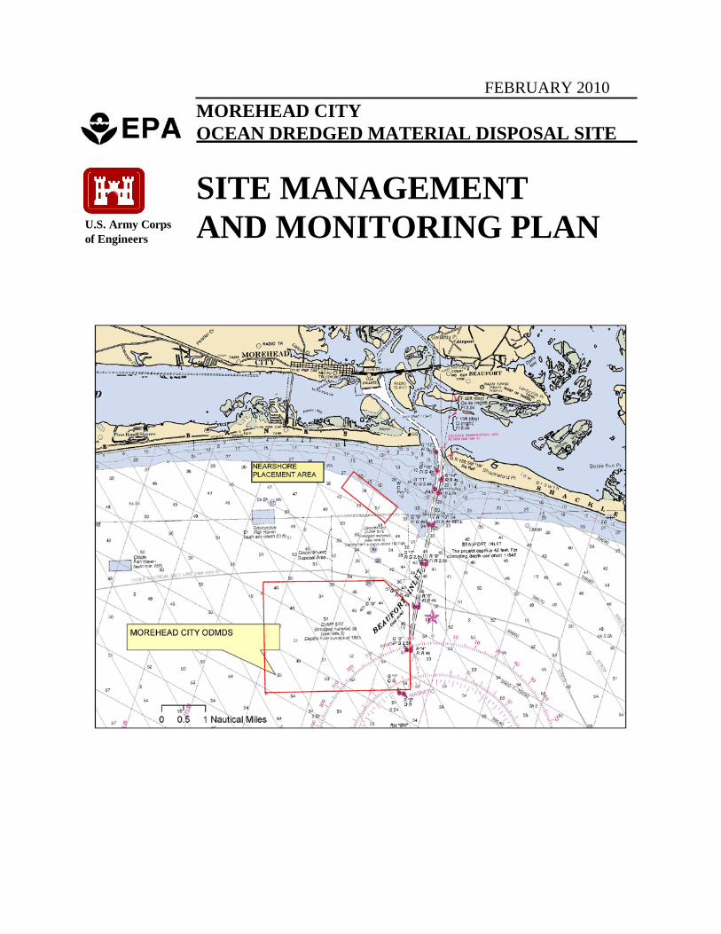
MOREHEAD CITY OCEAN DREDGED MATERIAL DISPOSAL SITE (ODMDS) The Morehead City ODMDS (Figures 1 and 2) was designated by EPA pursuant to Section 102(c) of the Marine Protection, Research, and Sanctuaries Act of 1972, as amended, as suitable for the ocean disposal of dredged material. The final rule was promulgated by EPA on 14 August 1987 (F.R. Vol 52 No. 157), effective 14 September 1987. The boundary coordinates for the Morehead City ODMDS are: (Assumed to be NAD 27 Geographic) (NAD 83 State Plane - Feet)
340 38'30" N 760 45'00" W N 332180 E 2676711 340 38'30" N 760 41'42" W N 332560 E 2693251 340 38'09" N 760 41'00" W N 330519 E 2696808 340 36'00" N 760 41'00" W N 317482 E 2697112 340 36'00" N 760 45'00" W N 317091 E 2677142
The site is located just beyond 3 nautical miles offshore and (beyond 3 nautical miles from the baseline of the territorial sea) of Morehead City, North Carolina. The Morehead City ODMDS has an area of about 8.0-square nautical miles. Depths within the ODMDS range from about -30 to -55 feet local mean low water (m.l.w.) based on a composite of bathymetric surveys which include data from 1995 to 2007. Figure 3 shows the latest available survey for a particular area. Depths are shallowest in the northern (inshore) portion and gradually deepen to the south (offshore). Approximately 60% of the area is greater than -50 feet m.l.w. The bathymetry is essentially flat except for slight mounds of dredged material in the northeast third and middle of the ODMDS due to previous dredged material discharges and the influence of the Beaufort Inlet ebb tide delta.
Material has been excavated from the Morehead City ODMDS by Carteret County as a borrow source for nourishment of the Bogue Banks beaches in 2004 and 2007 (Post-Isabel and -Ophelia Sand Replenishment Projects). Approximately 1.2 million cubic yards of sand were removed from the northeast corner of the Morehead City ODMDS during those two events by hopper dredges and pumped out onto the Bogue Banks beaches. A bathymetric survey of this “borrow area” portion of the Morehead City ODMDS is not known to be available.
Morehead City ODMDS, SMMP
3
DISPOSAL HISTORY Historical Use of the Morehead City ODMDS. Disposal of dredged materials in the ocean has been associated with the Morehead City Harbor Federal navigation project for many years. Federal dredging projects in Morehead City Harbor were begun in 1910. Continued use of the Morehead City Federal navigation channel depends upon annual maintenance dredging. Only one non-federal maintenance dredging and ocean dredged material disposal permit (permitted pursuant to Section 103) has taken place in the Morehead City Harbor area, that being associated with the State maintained portions of the North Carolina State Ports.
The harbor improvements can be divided into dredging within inner harbor and Beaufort Inlet ocean bar channels. Dredging in the inner harbor areas has been performed with a hydraulic cutterhead dredge or very recently with a bucket and barge with dredged material disposal being upland, on the beach, or in the Morehead City ODMDS. The ocean bar channel dredging has been accomplished using a hopper dredge with disposal in the ocean or on the beaches of Bogue Banks. The ocean bar channels specifically include Range A, the Cutoff, and Range B (Figure 4). In 1910, the Morehead City Harbor ocean bar channel was deepened to 20 feet at a width of 300 feet. Improvements to the channel were made in 1936 and 1978 when the ocean bar channel was deepened to 30 feet by 400 feet and 42 feet by 450 feet, respectively. In 1994, the bar channel was dredged to its present dimensions of 47 feet deep and 450 to 600 feet wide.
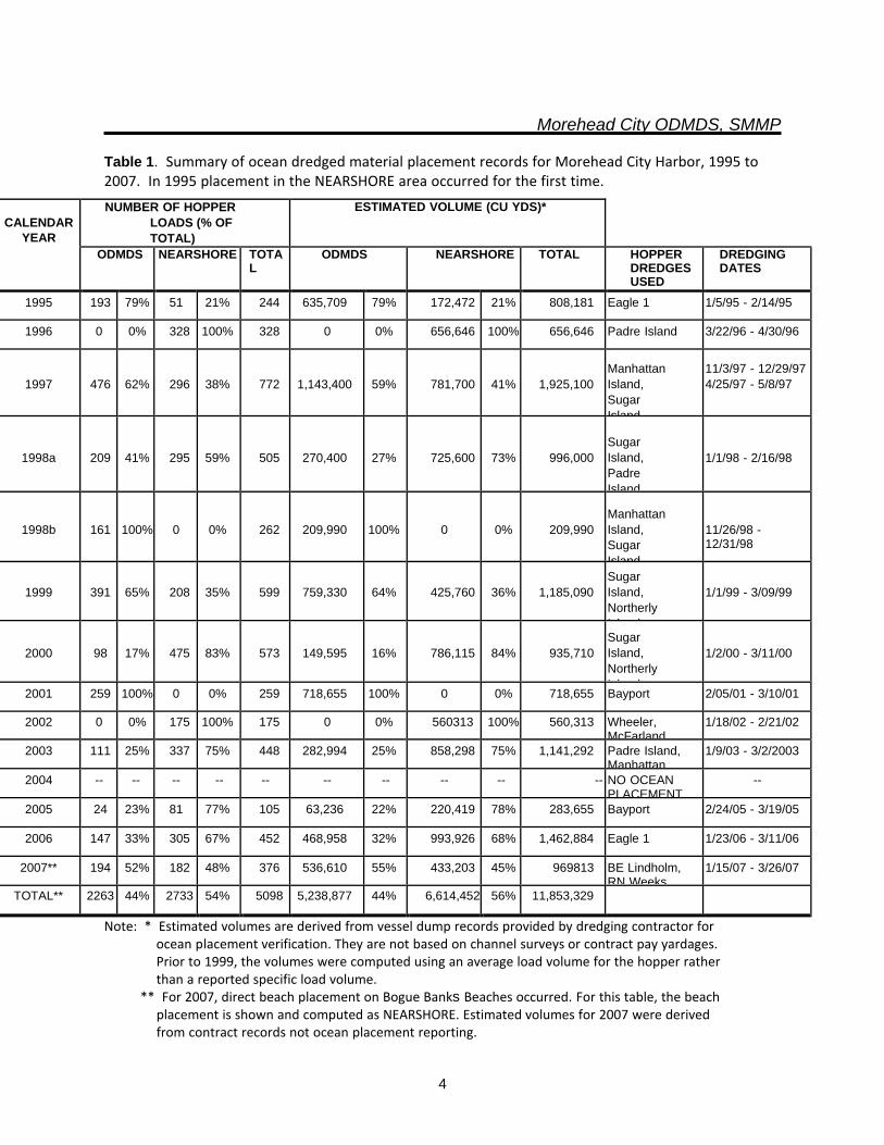
The placement of dredged materials in the ocean off Beaufort Inlet since 1995 is documented in Table 1. Since 1987 (the date of site designation) ocean disposal of dredged materials from the Morehead City Harbor Federal project channels has been placed within the Morehead City ODMDS. Beginning in 1995 sediments dredged during the maintenance of the Morehead City navigation channels were also placed in the Morehead City nearshore placement area off Bogue Banks or more infrequently directly on Bogue Banks beaches (the Nearshore Placement Area is discussed further in sections to follow). Accordingly, the quantity of dredged material being transported to the ODMDS for disposal has declined as compared to the pre-1995 levels.
Recently, the Morehead City ODMDS has been used as a borrow area for Bogue Banks beach replenishment. Sand from the ODMDS has been dredged and subsequently discharged as beachfill. Additional use of dredged material from the ODMDS for beach replenishment is possible.
Morehead City ODMDS, SMMP
4
Table 1. Summary of ocean dredged material placement records for Morehead City Harbor, 1995 to 2007. In 1995 placement in the NEARSHORE area occurred for the first time.
Note: * Estimated volumes are derived from vessel dump records provided by dredging contractor for ocean placement verification. They are not based on channel surveys or contract pay yardages. Prior to 1999, the volumes were computed using an average load volume for the hopper rather than a reported specific load volume. ** For 2007, direct beach placement on Bogue Banks Beaches occurred. For this table, the beach placement is shown and computed as NEARSHORE. Estimated volumes for 2007 were derived from contract records not ocean placement reporting.
CALENDAR
YEAR
NUMBER OF HOPPER LOADS (% OF TOTAL)
ESTIMATED VOLUME (CU YDS)*
ODMDS NEARSHORE TOTAL
ODMDS NEARSHORE TOTAL HOPPER DREDGES USED
DREDGING DATES
1995 193 79% 51 21% 244 635,709 79% 172,472 21% 808,181 Eagle 1 1/5/95 - 2/14/95
1996 0 0% 328 100% 328 0 0% 656,646 100% 656,646 Padre Island 3/22/96 - 4/30/96
1997
476
62%
296
38%
772
1,143,400
59%
781,700
41%
1,925,100
Manhattan Island, Sugar Island
11/3/97 - 12/29/97 4/25/97 - 5/8/97
1998a
209
41%
295
59%
505
270,400
27%
725,600
73%
996,000
Sugar Island, Padre Island
1/1/98 - 2/16/98
1998b
161
100%
0
0%
262
209,990
100%
0
0%
209,990
Manhattan Island, Sugar Island
11/26/98 - 12/31/98
1999
391
65%
208
35%
599
759,330
64%
425,760
36%
1,185,090 Sugar Island, Northerly I l d
1/1/99 - 3/09/99
2000
98
17%
475
83%
573
149,595
16%
786,115
84%
935,710 Sugar Island, Northerly I l d
1/2/00 - 3/11/00
2001 259 100% 0 0% 259 718,655 100% 0 0% 718,655 Bayport 2/05/01 - 3/10/01
2002 0 0% 175 100% 175 0 0% 560313 100% 560,313 Wheeler, McFarland
1/18/02 - 2/21/02
2003 111 25% 337 75% 448 282,994 25% 858,298 75% 1,141,292 Padre Island, Manhattan
1/9/03 - 3/2/2003
2004 -- -- -- -- -- -- -- -- -- -- NO OCEAN PLACEMENT
--
2005 24 23% 81 77% 105 63,236 22% 220,419 78% 283,655 Bayport 2/24/05 - 3/19/05
2006 147 33% 305 67% 452 468,958 32% 993,926 68% 1,462,884 Eagle 1 1/23/06 - 3/11/06
2007** 194 52% 182 48% 376 536,610 55% 433,203 45% 969813 BE Lindholm, RN Weeks
1/15/07 - 3/26/07
TOTAL** 2263 44% 2733 54% 5098 5,238,877 44% 6,614,452 56% 11,853,329
Morehead City ODMDS, SMMP
5
Morehead City Harbor Dredged Material Management. Access from the Atlantic Ocean to the existing Port of Morehead City and Radio Island is through Beaufort Inlet, which is between Bogue Banks and Shackleford Banks. Ships travel through the Beaufort Inlet Channel and up the Federal Morehead City Navigation Channel to reach the Port of Morehead City and the west side of Radio Island. The Port terminal is located only four miles from the open sea and the channel is easily navigable. Three governmental agencies perform dredging to maintain Morehead City Inner harbor navigation. The USACE, Wilmington District maintains the Morehead City Harbor Federal Navigation Channel. The North Carolina State Ports Authority (NCSPA) maintains harbor facilities adjacent to the federally maintained navigation channel. These areas include berthing areas along the face of the Morehead City State Port wharfs and facilities along Radio Island. The United States Coast Guard (USCG) maintains Station Fort Macon within Bogue Sound, near Beaufort Inlet at the entrance to Morehead City Harbor. The continued viability of the Port of Morehead City depends upon maintenance dredging. Dredging is required to maintain the navigable efficiency and safety of Morehead City Harbor and provide economic benefits to the Port of Morehead City and the region. Environmentally acceptable disposal of dredged material from Morehead City Harbor is required in order to maintain navigable conditions.
Morehead City Harbor Federal Navigation Channel. The channel across the Beaufort Inlet ocean bar is authorized to a 47-foot depth. The Beaufort Inlet Channel varies in width from 450 feet to 800 feet. Cutoff Channel is 600 feet wide and Morehead City Channel is 400 feet wide. The east leg (adjacent to berths 1, 2, and 3) and the east turning basin are maintained to a 45-foot depth. The west leg, the northwest leg (adjacent to berths 4 through 9), and the west turning basin are maintained to a 35-foot depth.
Currently, maintenance of Morehead City Harbor involves dredging the inner harbor channels approximately every two years by hydraulic pipeline. The inner harbor dredged material is placed either in the Brandt Island Upland Diked Disposal Area (hereafter referred to as Brandt Island) or directly on the beaches on Bogue Banks. The outer harbor navigation channels are usually maintained annually by hopper dredge and the resultant material is placed either in the United States Environmental Protection Agency (EPA) designated Morehead City Ocean Dredged Material Disposal Site (ODMDS), the Morehead City nearshore placement area, or directly placed on area beaches. The Morehead City nearshore placement area lies along or near the -25 foot m.l.w. contour (Figure 4). Use of the nearshore area is regulated under the Clean Water Act of 1977. The goal of the nearshore placement area is to retain sand dredged from the channel within the Beaufort Inlet ebb tide delta.
Brandt Island is a 96-acre island located just south of the North Carolina State Ports at Morehead City. The island is owned by North Carolina State Ports Authority (NCSPA) and has been used as a dredged material disposal area since about 1955. Brandt Island has been a sand-recycling disposal facility. Morehead City inner harbor dredged material has been placed in Brandt Island about every other year.
Morehead City ODMDS, SMMP
6
Every 8 to 10 years maintenance material is pumped out of Brandt Island and placed on the ocean beaches of Bogue Banks. In FY 1986, FY 1994, and FY 2005 approximately 3.9 million, 2.5 million, and 2.9 million cubic yards of dredged material, respectively, were pumped out of Brandt Island and placed on Bogue Banks from Fort Macon State Park to Atlantic Beach.
During the FY 2005 pump out of Brandt Island, it was evident that a quantity of fine-grained sediment had accumulated near the disposal area spillway. This material is not compatible for placement on the beach and therefore a majority of the unsuitable material was avoided during the pump out activity and left in-place. Due to fine-grained sediment, Brandt Island will not be pumped out in the future. FY05, the Morehead City inner harbor area was also dredged with the dredged material placed directly on the ocean beaches of Bogue Banks. However, the dredging was limited as portions of the inner harbor material were found to contain unacceptable levels of fine-grained material for beach placement.
The NCSPA and the Wilmington District, USACE previously constructed an interior dike dividing Brandt Island into two cells. One cell (approximately 8 acres in size) provided a limited-capacity disposal cell for fine-grained, non-beach quality dredged material (greater than 10 percent silt and clay) encountered in the Morehead City Harbor and the other was retained for sand recycling. Due to the need for disposal of fine-grained material and the lack of alternative upland sites for fine-grained sediments, there will only be one cell in Brandt Island in the future. The rehabilitation and potential expansion of the Brandt Island confined disposal area dikes would reduce the potential for ocean placement of inner harbor dredged materials. As capacity in Brandt Island is finite, material in Brandt Island could potentially be periodically removed and ocean dumped provided necessary regulatory approvals are obtained.
Because of the recurring quantities of fine-grained materials to be dredged from the inner harbor and the limited capacity of Brandt Island, a requirement for direct ocean disposal of the inner harbor dredged material in the designated Morehead City ODMDS is foreseeable provided necessary regulatory approvals are obtained.
USCG Station Fort Macon. The United States Coast Guard (USCG) Station Fort Macon is located adjacent to the Morehead City Harbor Federal Navigation Project. The station is located within Bogue Sound, near Beaufort Inlet at the entrance to Morehead City Harbor. The USCG Station entrance channels and basins must be periodically dredged to maintain adequate depth.
The USCG boat basin is used as a permanent docking facility for five cutters (Aquidneck, Block Island, Elm, Smilax, and Staten Island), and is the home of the USCG’s Fort Macon Marine Safety Team. USCG Station Fort Macon has many missions, including the safeguarding of navigational interests (government, commercial, and private), protecting North Carolina’s coastline from pollution and marine accidents and enforcement of federal laws and responsibilities under the Homeland Security Act. While maintenance of USCG Station Fort Macon is not included in the federal Morehead City Harbor Federal Navigation Project, the maintenance and function of the USCG Station is important to the port.
Morehead City ODMDS, SMMP
7
The USCG Station basin is dredged to various depths, mostly –22 feet m.l.w. (local Beaufort datum). The portion of the basin presently proposed for dredging and ocean disposal was last dredged in 2006. Approximately 67,000 cubic yards were dredged from the USCG Station Fort Macon basin and placed in the portion of the Brandt Island disposal site set aside for non-beach quality sediments. The amount of material to be maintenance dredged solely from the station basin as a result of any single event is anticipated to be less than 75,000 cubic yards at any one time. Sediments of the USCG Station Fort Macon vicinity generally consist of sands, silts, and clays occurring in various mixtures. The sediments are generally unconsolidated and relatively soft.
North Carolina State Ports Authority (NCSPA) Maintenance and Projects. The NCSPA maintains harbor facilities that are adjacent to the federally maintained navigation channel. These areas include berthing areas along the face of the Morehead City State Port wharfs and facilities along Radio Island. Maintenance of these facilities is required to realize the benefits of having a channel leading to the port. Maintenance of these areas is usually performed at the same time that the maintenance of the Federal portion is accomplished. In addition, the NCSPA is pursuing port industrial development on Radio Island. The adjacent deep-water Federal navigation channel, the short distance to the open Atlantic Ocean, and existing rail and road access contribute to the benefits of this site for port development.
The North Carolina State Ports Authority (NCSPA) property also includes approximately 185 acres of Radio Island, including the former Aviation Fuel Terminal Inc. The public uses the eastern portion of Radio Island, known as East Beach, for recreational purposes. The northern end of the island contains a mix of residences, privately owned land, and marine-related businesses. The southern tip of the island is owned by the US Navy and is used for military deployment activities. A new general cargo facility is proposed for Radio Island. The new facility would include 2,000 feet of wharf, 300,000 square feet of warehouse space, support buildings, dredging from the Morehead City Channel to the face of the new wharf on Radio Island, and improvements to the road and rail access on Radio Island.
The proposed Radio Island project consists of two 1,000-foot berths constructed using a sheet-pile bulkhead. The face of the wharf would be located 700 feet from the near channel line of Morehead City Channel. Dredging will be required between the existing channel and the proposed wharf to allow for the maneuvering and docking of ships at the wharf. Dredging of approximately 37 acres of estuarine bottom to a depth of 45 feet would be required to connect the proposed berths to Morehead City Channel. The construction of the proposed project will require the dredging of approximately 1.7 million cubic yards of dredge material.
CHARACTERISTICS OF DREDGED MATERIALS
Morehead City ODMDS, SMMP
8
Grain Size. The sediments dredged from the Morehead City Harbor navigation channels consist of a variety of materials depending on location within the harbor and proximity to Beaufort Inlet. Shoals occur where specific physical factors promote deposition or movement of sediments. These factors may vary spatially and temporally. Generally, sediments from the Beaufort Inlet area are sands which meet the criteria established in EPA’s Ocean Dumping Regulations and Criteria 40 CFR Part 227.13(b)(1) for environmental acceptability without further testing. The sediment characteristics are affected by the small sediment load of the Newport River which terminates in the area and by the dynamic nature of the Beaufort Inlet tidal currents and waves to further winnow small fractions in the sediments.
The sediments dredged from navigation channels in the Morehead City Harbor vicinity include flood- tide delta, barrier island, and nearshore marine sediments (fine to medium sand, littoral materials) as well as back-barrier, lagoonal, and tidal flat sediments (very fine, silty sands), and mixtures of both. Higher energy shoal areas in the inlet are comprised of fine to medium sands. Silt and very fine sand content increases moving in towards the inner harbor area. Shoals occur where specific physical factors promote deposition or movement of sediments. These factors may vary spatially and temporally. Sediment color gets increasingly darker inland away from the inlet, possibly due to an increase in organic material in the sediment.
The grain size characteristics of Morehead City Harbor navigation channel sediments are described in Appendix C. Based on recent sediment evaluations of Morehead City Harbor channel sediments, it is useful for project and dredged material disposal planning to define the harbor into three sections. The type of material present determines the disposal method feasibility.
Inner Harbor. Inner Range C, East Leg, West Leg, and Northwest Leg. Material is greater than 20% fines. This area has usually been dredged with a pipeline dredge.
Outer Harbor. Outer Range C, Range B, Cutoff, Range A to Station 110+00. Material has less than 10% fines. This portion of the harbor has been usually dredged with a pipeline dredge (Range C, and B) or a hopper dredge (Range B, Cutoff, and Range A).
Outer Entrance Channel. Range A from Station 110+00 to offshore limit of required dredging. Material is greater than 20% fines. This area has been historically dredged with a hopper dredge.
The Morehead City Harbor channel sediments which are beach-compatible sands meet the Part 227.13(b) criteria for compliance with the Ocean Dumping Regulations and Criteria without further testing. The Morehead City inner harbor sediments which have significant silt and clay components do not meet Part 227.13(b) criteria for exclusion from further evaluation. For those materials, additional information is necessary to determine compliance with the Ocean Dumping Regulations and Criteria.
Chemical and Biological Testing of Sediments. Representative samples of fine-grained sediments
Morehead City ODMDS, SMMP
9
from the Morehead City Inner harbor area have been chemically and biologically tested and found acceptable for ocean disposal in accordance with EPA’s Ocean Dumping Regulations and Criteria. This evaluation data is available in:
U.S. Army Corps of Engineers, Wilmington District, 2006. Evaluation of Dredged Material Proposed for Ocean Disposal, Morehead City Inner Harbor and USCG Station Fort Macon, North Carolina, September 2006, Report prepared by ANAMAR Environmental Consulting.
EPA Region 4 has concurred with these findings.
DISPOSAL METHODS Disposal of dredged material at the Morehead City ODMDS will occur using two methods; by hopper dredge, and by tug and barge or scow. For the outer ocean bar reaches, shoal material will likely be removed and transported to the ODMDS by a hopper dredge. Hopper dredges are designed to hydraulically dredge sediments, load and retain solids in the hoppers, and then haul them to the disposal site where disposal is accomplished by dumping through doors in the bottom of the hoppers or through the hull. For the inner harbor areas, shoal material will be removed by hopper dredge or by a hydraulic or mechanical dredge and placed into scows or barges moored next to the dredge. When full, the scow is pulled by a tug to the ODMDS and the load discharged through the bottom of the scow.
MANAGEMENT AND MONITORING CONCERNS OR ISSUES Morehead City Harbor Dredged Material Management Plan (DMMP). The Wilmington District, US Army Corps of Engineers (USACE) is currently in the process of preparing a Dredged Material Management Plan (DMMP) for the Morehead City Harbor Project. The purpose of the DMMP is to provide for economically and environmentally sound management of dredged material generated by maintenance of the Morehead City Harbor project for a 20-year period. The DMMP will be prepared in accordance with USACE Engineer Regulation ER 1105-2-100 Section 3-2, b.(8). The DMMP will include the preparation of a new National Environmental Policy Act (NEPA) document and other necessary determinations. The DMMP is scheduled for completion in mid-2011. The Morehead City SMMP may have to be revised when the DMMP is implemented.
Nearshore Placement. Since 1995, beach-quality sediments dredged during the maintenance of the Morehead City navigation channels have been routinely placed in a nearshore placement disposal area off Bogue Banks (Figure 5). The intention is to keep material within the active littoral system without dramatically increasing the amount of annual maintenance dredging in the channel or the cost of the maintenance dredging. Placement of the dredged material in shallower water increases littoral system activity. However, it also increases concerns regarding hopper dredge operating conditions. A hopper dredge with a draft of nearly 20 feet or more is vulnerable to grounding in a nearshore placement operation as compared to the ODMDS, particularly if any ocean swell is present. It is unlikely that routine hopper operations can place material further inshore than the 25-foot contour. The placement of sand in the Morehead City ODMDS removes the dredged material from the active littoral system, a loss
Morehead City ODMDS, SMMP
10
which may become permanent if the sand is not used for future placement on beaches or nearshore areas. However, nearshore placed sand would be more difficult to obtain (dredge) for future direct beach placement than sand placed in the Morehead City ODMDS. Dredged material placed in the ODMDS may be more easily obtained source of beach material than material placed in the nearshore area. The Morehead City ODMDS may become a regular source for beach material.
In summary, nearshore placement may be an alternative to the future ODMDS placement of beach- quality Morehead City Harbor dredged materials. However the nearshore placement area does not preclude the need for the Morehead City ODMDS. One factor contributing to the need of the ODMDS is the fine-grained material in the inner harbor area. Placement of the fine-grained dredged material in the nearshore placement area and in close proximity to the Bogue Banks recreational beaches would likely raise public concerns. The ODMDS is also needed if the site conditions such as depths in the site, draft of the hopper dredge, or ocean swell too severely restrict the hopper operations and thus hamper maintenance of navigable conditions for the Port of Morehead City.
Direct Beach Placement. There are no active Federal hurricane and storm damage reduction projects on the Bogue Banks beaches in the Morehead City area. However, the beach communities of Atlantic Beach, Pine Knoll Shores, Indian Beach, Salter Path, and Emerald Isle have experienced severe storm damage and erosion problems, particularly as a result of Hurricane Fran in September 1996 and Hurricane Floyd in September 1999. During the period from 1996 through 1999, Hurricanes Bertha, Bonnie, Dennis, and Irene have also affected the area. The storm damage and associated erosion from six named storms has resulted in considerable damage to homes and loss of the natural protective berm and dune system since 1996. The erosion of the existing berm and dune system has increased the storm damage susceptibility of existing structures and infrastructure.
The Bogue Banks Hurricane and Storm Damage Reduction Study is being pursued under the Corps of Engineers’ General Investigation (GI) Program. The Bogue Banks Study is being conducted in response to the following resolution adopted July 23, 1998:
Resolved by the Committee on Transportation and Infrastructure of the United States House of Representatives, that the Secretary of the Army is requested to review the report of the Chief of Engineers dated November 27, 1984, on Bogue Banks and Bogue Inlet, North Carolina, and other pertinent reports, to determine whether any modifications of the recommendations contained therein are advisable at the present time in the interest of shore protection and related purposes for Bogue Banks, North Carolina.
The sponsors’ interest is in developing a plan of protection against storm damages. From the shoreline, the study area extends landward approximately 500 feet. Seaward, the study area extends from the shoreline approximately 1 mile. However, the study area also includes offshore borrow areas lying 1 to 8 miles from the shoreline and borrow areas in Beaufort Inlet and Bogue Inlet. The Bogue Banks feasibility study is investigating measures and plans for hurricane and storm damage reduction. The study is also documenting incidental recreation benefits. Solutions considered for this study area
Morehead City ODMDS, SMMP
11
are berm and dune beachfills using material dredged from offshore borrow sites, and in some cases building relocations.
Central to the consideration of any beach placement alternative is the availability of environmentally acceptable borrow sites with material of sufficient quality and quantity to construct and maintain the project for its authorized life. Investigations for borrow material may be made at Bogue and Beaufort Inlets, Brandt Island, offshore of Cape Lookout to Shackleford Banks, within the estuary, the area offshore of the proposed beach areas including, the Morehead City navigation channels (i.e., Range A, the Cutoff, etc.), the United States Environmental Protection Agency (USEPA) designated Morehead City Ocean Dredged Material Disposal Site (ODMDS), and the nearshore placement area.
The direct placement of beach quality sand from maintenance dredging of Morehead City Harbor on these beaches would have hurricane and storm damage reduction benefits. The Corps of Engineers undertakes operations and maintenance activities where appropriate and environmentally acceptable. All practicable and reasonable alternatives are fully considered on an equal basis. This includes the discharge of dredged or fill material into waters of the U.S. or ocean waters in the least costly manner, at the least costly and most practicable location, and consistent with engineering and environmental requirements (33 C.F.R. § 335.4). Section 145 of the Water Resources Development Act of 1976, P.L. 94-587, as amended by Section 933 of the Water Resources Development Act of 1986, P.L. 99-662, and other laws, 33 U.S.C. § 426j provides authority for placement of dredged material on a beach where it is more costly than the least costly acceptable alternative. Under these Section 933 projects, the USACE may participate in the additional placement costs when: (1) requested by the State; (2) the Secretary of the Army considers it in the public interest; and (3) the added cost of disposal is justified by hurricane and storm damage reduction benefits.
A Section 933 direct placement of sand on Bogue Banks Beaches from the Morehead City navigation channel was conducted in 2007. This Section 933 project was a federal/non-federal cost-sharing program under which dredged shoal material from the outer harbor of Morehead City Federal Navigation Project was placed on the shoreline of Pine Knoll Shores. Carteret County was the non-federal sponsor and the community of Pine Knoll Shores took on all the local cooperation terms, including the non-federal cost share and rights of entry.
Using local and other funding sources, the Bogue Banks beach communities have replenished sand on those beaches with sand from the Morehead City ODMDS and other borrow areas. The need for sand and the public demand for future replenishment of sand on the Bogue Banks beaches will likely continue and increase. It is expected that less dredged material (sand) will be placed in the Morehead City ODMDS and sand may be removed from that area to renourish Bogue Banks beaches.
Fine-Grained, Inner Harbor Material. Because of the recurring quantities of fine-grained materials to
Morehead City ODMDS, SMMP
12
be dredged from the inner harbor area and the limited capacity for such materials in the Brandt Island dredged material disposal area, a requirement for periodic removal of the Brandt Island material and ocean disposal in the designated Morehead City ocean dredged material disposal site is anticipated. Currently, maintenance of Morehead City Harbor involves dredging the Morehead City Harbor inner harbor navigation channels about every two years by hydraulic pipeline. The inner harbor dredged material is placed either in the Brandt Island Diked Disposal Area (hereafter referred to as Brandt Island) or directly on the beaches on Bogue Banks. Brandt Island is a 96-acre island located just south of the North Carolina State Ports at Morehead City. The island is owned by North Carolina State Ports Authority (NCSPA) and has been used as a dredged material disposal area since about 1955. Morehead City inner harbor dredged material has been placed in Brandt Island about every other year. Every 8 to 10 years maintenance material has been pumped out of Brandt Island and placed on the ocean beaches of Bogue Banks. In FY 1986, FY 1994, and FY 2005 approximately 3.9 million, 2.5 million, and 2.9 million cubic yards of dredged material, respectively, were pumped out of Brandt Island and placed on Bogue Banks from Fort Macon State Park to Atlantic Beach. During the FY 2005 pump out of Brandt Island, it was evident that a quantity of fine-grained sediment had accumulated near the disposal area spillway. This material is not compatible for placement on the beach and therefore a majority of the unsuitable material was avoided during the pump out activity and left in-place. Future Brandt Island pump out events will have to take into consideration management of this fine-grained sediment. Also in FY05, the Morehead City inner harbor area was dredged with the dredged material placed directly on the ocean beaches of Bogue Banks. However, the dredging was limited as portions of the inner harbor material were found to contain unacceptable levels of fine-grained material for beach placement. Because of the recurring quantities of fine-grained materials to be dredged from the inner harbor area and the limited capacity for such materials in Brandt Island, there is a need for either periodic removal of the Brandt Island material using ocean disposal or direct ocean disposal of inner harbor dredged materials in the designated Morehead City ODMDS.
Moundinq. Bathymetric surveys have indicated that the sandy and coarse dredged materials historically placed within the Morehead City ODMDS have the potential to mound appreciably when specific areas are repeatedly used for disposal. Such mounds may limit future use of specific areas of the ODMDS and may pose impairment to navigation including use by hopper dredges. These limitations should be minimized to the extent possible.
Site Use Management, Implementation, and Documentation. The best efforts of environmental management are for naught if the actual site use is not carried out in a manner that fulfills those management goals and objectives. The site use information must be readily available and used to facilitate monitoring and management. Correct implementation of the ocean disposal specifications is a management concern. Dredging equipment, particularly navigation and documentation has improved significantly in recent years and use of these improved technologies is a management goal.
Morehead City ODMDS, SMMP
13
Navigation Channel Alignment. If the Morehead City Harbor navigation channel alignment is extended in a straight line and beyond the normal dredging limits, it overlaps a portion (southeast corner) of the Morehead City ODMDS. Disposal of dredged material in the channel alignment extension area is not acceptable as it may pose impairment to navigation.
OCEAN DREDGED MATERIAL SITE MANAGEMENT
All ocean disposal at the Morehead City ODMDS must be conducted in accordance with the Ocean
Dumping Regulations and Criteria (40 CFR Parts 220-229), whether conducted as a permit activity or as
a Federal activity. The following are Morehead City ODMDS management requirements and all permits
or evaluation concurrence shall be conditioned to include these requirements.
Types of Dredged Materials Material Evaluation. Only dredged materials which have been evaluated in accordance with EPA's
Ocean Dumping Regulations and Criteria and found in compliance with those criteria will be transported
for disposal in the Morehead City ODMDS.
Guidance for evaluation of dredged materials under the MPRSA Section 103 program is provided in the
Evaluation of Dredged Material Proposed for Ocean Disposal - Testing Manual, February 1991 and the
Southeast Regional Implementation Manual (SERIM) for Requirements and Procedures
for Evaluation of the Ocean Disposal of Dredged Material in Southeastern U.S. Atlantic and
Gulf Coast Waters, May 2008. The determination of dredged material suitability for ocean disposal must
be documented in a MPRSA Section 103 evaluation and approved by EPA Region 4 prior to disposal.
Dredged materials will be reevaluated for suitability for ocean disposal in accordance with current
USACE/EPA guidance at an interval not to exceed three years. Reevaluation and testing procedures will
be coordinated with the Wilmington District USACE and EPA Region 4 before any sampling or testing.
Dredged Material Suitable for Beneficial Uses. “Beneficial uses” refers to the concept that dredged
material can be disposed in a way that is economically and environmentally acceptable and accrues
natural resource benefits to society.
Beach-compatible dredged materials (sands) dredged from the navigation channel should be placed on
nearby beaches or within the active littoral system when it is economically feasible and environmentally
acceptable to do so. Site capacity and mounding factors are favorably affected by not placing beach
compatible sands in the ODMDS. Other beneficial uses of dredged materials are also encouraged
pending appropriate environmental review.
As discussed previously, dredged material was excavated from the Morehead City ODMDS by Carteret
County for sand replenishment of the Bogue Banks beaches in 2004 and 2007 (Post-Isabel and -
Morehead City ODMDS, SMMP
14
Ophelia Sand Replenishment Projects). Approximately 1.2 million cubic yards of historically placed
Morehead City Harbor dredged material were removed from the northeast corner of the Morehead City
ODMDS during those two events by hopper dredges and then pumped out onto the Bogue Banks
beaches. This repository for dredged material provided good quality sand material and facilitated access
for the beach replenishment. If beach-compatible sands are dredged during future maintenance of
Morehead City Harbor navigation and disposed of in the Morehead City ODMDS, placement of those
materials will be directed to a portion of the ODMDS or disposal zone where access and potential
opportunities for recycling and beach nourishment are facilitated (see disposal zones). Accordingly, the
northern half of the Morehead City ODMDS will be restricted for dredged material that is beach-
compatible sand. Conversely, fine-grained materials may not be discharged there.
The sediment testing described in Appendix C confirmed the harbor channel areas where fine-grained
materials occur and must be managed for disposal. Continued ocean disposal of these dredged
materials is likely as other disposal options including beneficial uses of dredged material are either not
available or not feasible. As discussed previously, only materials evaluated and found in compliance with
the EPA’s Ocean Dumping Regulations and Criteria can be transported to the ocean for disposal. In
order to minimize interference with potential use of beach-quality sand for beach replenishment, the fine-
grained sediments dredged from Morehead City Harbor navigation channels will be placed in the far
southwest corner of the Morehead City ODMDS as shown on Figure 5. As discussed in Appendix C, the
fine-grained sediments will come from the Morehead City inner harbor and very outer portion of the ocean
bar channel.
Dredged Material With Debris. If significant quantities of debris (either wood or man-made) are present
in the dredged materials, then debris management should be conducted. Significant quantities of debris
are considered to be those which would materially interfere with fishing in areas near the Morehead City
ODMDS or interfere with re-use of dredged material from within the ODMDS (i.e., beach nourishment
borrow material). Debris management may involve the following:
• Removal of the debris from the dredged material before transportation to the ODMDS; • Placement of dredged material in the ODMDS in a location (e.g., farthest distance possible from
the fishing areas or borrow areas ) such that debris interference is unlikely; • Immobilizing the debris within the ODMDS by covering it (capping) with dredged material.
Methods of Disposal. Disposal may be by hopper dredge or dump scow. For each disposal project, a
specific area within the ODMDS will be designated for use and a specific placement pattern will be
prescribed. Dredged materials will be discharged within the ODMDS boundaries. Dredged material
placement will not be allowed closer than 600 feet from the site boundary. The placement of dredged
materials outside the ODMDS boundaries is not acceptable under MPRSA authorities. An approved
ocean disposal verification plan must be carried out. Placement methods that minimize mounding of
Morehead City ODMDS, SMMP
15
dredged material within the designated placement area will be required. Specific procedures which
accomplish these goals are discussed under the Specific Requirements section which follows.
Disposal Quantities. Quantities of dredged materials placed within the ODMDS will be limited to those
amounts that do not produce unacceptable adverse effects to human health and welfare and the marine
environment or human uses of that environment (as defined in EPA's Ocean Dumping Regulations and
Criteria). The disposal quantity management objective for the Morehead City ODMDS is to regulate
disposal quantities such that depths in the disposal area following disposal do not interfere with
navigation. The disposal depth limitation will be -30 feet m.l.w. Current average depths in the ODMDS
are approximately -45 to -50 feet m.l.w.
Timing of Disposal. There are no seasonal restrictions to the placement of dredged material within the
Morehead City ODMDS. However, seasonal restrictions and seasonal special requirements apply to
particular dredging activities at particular locations.
Channel Area. If the alignment of the Morehead City Harbor Range A channel is extended seaward, it
crosses the eastern border of the ODMDS. In order to provide safe navigation, dredged material
placement will not be allowed within approximately 1000 feet of the current limits of channel dredging.
This area is shown on Figure 6. Placement of dredged material in this area will be allowed only after a
review by Wilmington District USACE in consultation with EPA Region 4 and only if a determination is
made that the proposed placement will specifically not interfere with navigation.
SPECIFIC REQUIREMENTS Ocean Disposal Verification.
Disposal Monitoring. For all disposal activities, an electronic tracking system (ETS) must be utilized.
The ETS will provide surveillance of the transportation and disposal of dredged material. The ETS will be
maintained and operated to continuously track in real-time the horizontal location and draft condition
(nearest 0.1 foot) of the disposal vessel (ie. hopper dredge or disposal scow) from the point of dredging to
the disposal site, and return to the point of dredging. Data shall be collected at least every 500 feet during
travel to and from the ODMDS and every minute or every 200 feet of travel, whichever is smaller, while
approaching within 1,000 feet and within the ODMDS. The following information shall be electronically
recorded for each disposal cycle:
• Sequential Load Number • Disposal Vessel Name (or Number) and Type (e.g. scow) • Tow Vessel Name (if applicable) • Captain of Disposal or Tow Vessel • Estimated Volume of Load • Description of Material Disposed
Morehead City ODMDS, SMMP
16
• Source of Dredged Material (i.e., channel or reach name) • Time, vessel position, and draft - in one minute intervals for the disposal cycle specified
previously, draft in feet; • Begin and end dump event times and positions; • Date, Time and Position at Start at Initiation and Completion of Disposal Event
The monitoring/verification plan will include an automated system that will record the horizontal location
and draft condition of the disposal vessel from the time it enters Range A outbound until it leaves Range
A inbound. Vessel positioning as a minimum shall be global positioning system. No vessel shall leave
for the disposal site without the ability to collect and record the ocean disposal verification data specified.
The disposal positions reported shall be those of the disposal vessel itself (i.e., the scow not the tug).
Use of the USACE Silent Inspector (SI) system is required for ETS monitoring/verification at the
Morehead City ODMDS. Information about the SI System can be found at http://si.usace.army.mil. The SI
system must be operational throughout the dredging and disposal project and that project data must be
submitted to the SI National Support Center in accordance with the specifications provided at the
aforementioned website. The data collected by the SI system shall, upon request, be made available to
the Regulatory Division/Branch of the U.S. Army Corps of Engineers, Wilmington District and to EPA
Region 4. Uploading of raw project data to the SI Support Center is required. (USACE REGULATORY
GUIDANCE LETTER No. 08-01 Date: 05 February 2008, SUBJECT: Guidance for Implementing the
Silent Inspector (SI) system for dredging projects requiring Department of the Army (DA) permits). The
use of SI is also required for USACE federal navigation projects.
Disposal monitoring and ETS data will be reported to EPA Region 4 and Wilmington USACE (via the SI
system) on a weekly basis utilizing the eXtensible Markup Language (XML) specification and protocol
(see the section to follow). EPA Region 4 and Wilmington USACE shall be notified within 24 hours if
disposal occurs outside of the ODMDS or specified disposal zone or if excessive leakage occurs.
Excessive leakage is any change in draft exceeding 1.5 feet from the point of departure from the dredging
site to the disposal site.
Reporting and Data Formatting. Disposal monitoring data shall be provided to EPA Region 4
electronically on a weekly basis. Data shall be provided per the EPA Region 4 XML format and delivered
as an attachment to an email to [email protected]. The XML format is available from EPA
Region 4.
A summary report of operations shall be provided by the Wilmington District, USACE to the EPA, Region
4, Ocean Dumping Coordinator at the completion of the dredging/ocean disposal project or activity within
90 days after project completion. For work under a Section 103 permit, the permit holder will be
responsible for providing the requested information to the Wilmington District, USACE. Minimum required
data to be included in the summary report is as follows:
Morehead City ODMDS, SMMP
17
• General Information 1) Project name; 2) Location; 3) Public notice or permit date; 4) Section 103 evaluation date;
• Disposal Site Used; • Project Type - Either Federal or Section 103 permit; • Type of Work - New or maintenance work; • Method of dredging and disposal; • Disposal dates - start to finish; • Quantity of dredged material disposed - in cubic yards; • Number of loads completed; • Contractor conducting the work; • Identification of any misplaced materials; • Dates of bathymetric surveys of ODMDS; • Point of contact for project.
The disposal summary reports should be accompanied by the bathymetry survey results (paper plot and
X,Y,Z ASCII data file), track plots for each disposal trip, a scatter plot of all dump locations, and a
summary table of the information required above. If all data is provided in the required XML format, track
plots, scatter plots and summary tables will not be necessary.
Designated Route To and From the Morehead City ODMDS. A transportation route to and from the
Morehead City ODMDS will be specified as the most direct and safest possible between the dredging
area and the ODMDS. Transit to the ODMDS may not leave the channel until after passing buoys “9” and
“10” and transit from the ODMDS must return to the channel at those buoys. Any traffic within the
exclusion zone around the Queen Anne’s Revenge is not permitted. The ocean disposal verification plan
discussed previously provides verification that the approved route was taken.
Disposal ‘Zones’ Within the ODMDS. To manage site use, maximize site capacity, reduce multiple user
conflicts, simplify monitoring and management, and reduce potential adverse impacts to the marine
environment, the Wilmington District, USACE in consultation with EPA Region 4, will designate zones
within the ODMDS for dredged materials from each specific ocean dumping activity. Two disposal zones
will be designated, a zone for beach-compatible sand and a zone for fine-grained non beach compatible
sediment. Site monitoring data will be used to adjust these zones relative to current site conditions. The
location of these zones may be adjusted using monitoring information.
If beach-compatible sands are dredged during future maintenance of Morehead City Harbor navigation
and disposed of in the Morehead City ODMDS, placement of those materials will be directed to a portion
of the ODMDS or disposal zone where access and potential opportunities for recycling and beach
nourishment are facilitated (see disposal zones). Accordingly, the northern half of the Morehead City
ODMDS will be restricted for dredged material that is beach-compatible sand. Fine-grained materials
may not be discharged in the beach-compatible zone.
Morehead City ODMDS, SMMP
18
In order to minimize interference with potential use of beach-quality sand for beach replenishment, fine-
grained sediments dredged from Morehead City Harbor navigation channels will be placed in the far
southwest corner of the Morehead City ODMDS as shown on Figure 5. As discussed in Appendix C, the
fine-grained sediments come from the Morehead City inner harbor and very outer portion of the ocean bar
channel. The coordinates of the fine-grained sediment disposal cell limits are:
(Assumed to be NAD 27 Geographic) (NAD 83 State Plane - Feet) 340 37'02" N 760 45'00" W N 323296 E 2676898 340 37'02" N 760 43'10" W N 323381 E 2686088 340 36'00" N 760 43'10" W N 317239 E 2686232 340 36'00" N 760 45'00" W N 317091 E 2677142
BASELINE ASSESSMENT OF CONDITIONS AT THE MOREHEAD CITY ODMDS Site Designation EIS Baseline. Baseline conditions at the Morehead City ODMDS are principally
reported in the site designation Environmental Impact Statement (EPA and USACE, 1985). The baseline
data contained in the EIS was obtained solely from the available scientific literature.
Information Obtained Since Site Designation. Site evaluations and monitoring since the site
designation has produced supplemental information in the following areas:
Bathymetry. Bathymetric surveys have generally been conducted on portions of the ODMDS before
and after each use since the site designation. These surveys have focused on the portions of the ODMDS
actually used for dredged material disposal. A composite of the most recent bathymetric surveys of the
Morehead City ODMDS is provided as Figure 3. The more recent surveys include areas that have been
used for dredged material disposal more recently. The bathymetric surveys indicate that appreciable
relict dredged material disposal mounds are present within the ODMDS in the northeast corner and
middle of the ODMDS. The bathymetry shown in the northeast corner is not current and does not show
the activity in that area where sand has been removed for beach nourishment.
Sediment Characterizations. The grain size characteristics of sediments in the vicinity of the Morehead
City ODMDS were surveyed in 1979, 1984, and 1986 (USACE/EPA, 1986). As a part of the Wilmington
District USACE’s Bogue Banks Feasibility Study, vibracore borings were made in the ocean off Bogue
Banks. Sediment grain size data in the vicinity of the Morehead City ODMDS is summarized in Appendix
C. These surveys indicated that the ODMDS vicinity sediments were predominantly sands with smaller
and varying amounts of silts, and clays. The quantity of shell present in the sediments varies from a trace
to 25%. Hard bottom or reef-rock materials have not been reported in the sediment characterizations.
Benthic Communities. Benthic communities approximately 2 miles inshore of the Morehead City
ODMDS were sampled by Peterson et al. (1999) as a part of the nearshore placement monitoring. The
stations were arranged in a grid of three transects with three stations on each transect at the 19-, 26-, and
Morehead City ODMDS, SMMP
19
36-foot isobaths. Taxa in order of abundance included polychaetes, annelids, bivalve molluscs, amphipod
crustaceans, ecinoderms, and nematodes. The total density of infaunal invertebrates ranged from 5-14
per 76 cm2 and total densities of larger epifaunal invertebrates ranged from 3 to 43 individuals per 10 m2.
This community of invertebrates sampled is thought to be representative of those occupying this
environment over a broad geographic area. Data on hard bottom locations in North Carolina waters (i.e.,
within 3 nautical miles of shore) has been collected from the scientific community, SCUBA divers and dive
shops, and recreational and commercial fishermen by Moser and Taylor (1995). No hard bottoms were
reported in the vicinity of the Morehead City ODMDS.
SITE MONITORING Goals of Site Monitoring. Site monitoring is conducted to ensure the environmental integrity of an
ocean dredged material disposal site and to verify compliance with site designation criteria, any special
site management conditions, and with permit conditions or federal authorization requirements. Monitoring
should provide useful and pertinent information to support site management decisions. The main
purpose of disposal site monitoring is to determine whether site management practices, including
disposal operations need to be changed to avoid unacceptable impacts or to provide benefits to resource
conditions. Site monitoring is not a stand alone activity. It is based on the site designation process, the
characteristics of the dredged materials, and compliance with authorized activities.
To use site monitoring as an effective tool, site managers need to define in quantitative terms thresholds
for unacceptable impacts and desired beneficial effects of dredged material disposal. Exceeding or not
exceeding the thresholds triggers specific management actions. A tiered strategy for a monitoring
program is desirable. With a tiered approach, an unacceptable result may trigger further and often more
complex monitoring. Continuous monitoring of all physical, chemical, and biological parameters and
resources in and around the ocean dredged material disposal site is not necessary. A monitoring
program should be structured to address specific questions (hypotheses) and measure key indicators and
endpoints, particularly those defined during site designation or specific project issues that arise. For the
Morehead City ODMDS, the site designation environmental impact statement identified navigation, fishing
(shrimping), and beach compatible sands as resources of concern.
The objectives of the site monitoring plan for the Morehead City ODMDS are to provide information to:
• Determine if the disposal activities are in compliance with site use restrictions and permit conditions;
• Determine the short and long-term fate of dredged materials placed at the site; • Determine the effect of the dredged material disposal on uses of the marine environment within and
outside the ODMDS.
Morehead City ODMDS, SMMP
20
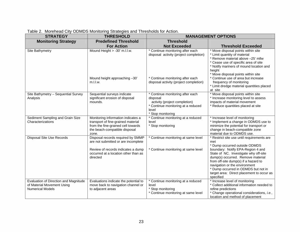
Monitoring Methods and Rationale. Proposed monitoring strategies for the Morehead City ODMDS
and thresholds for management actions are presented in Table 2 and discussed in the following
paragraphs. These methods will provide information to address specific and current management issues
at the site including; mounding (and site capacity); dumps occurring outside the disposal area; and
movement or fate of material. As indicated in Table 2, information obtained during monitoring may
indicate the need for additional monitoring at a higher, more complex, level. If more intensive monitoring
is required, this monitoring plan must be revised and additional thresholds for action established.
Site Bathymetry. Before and after single transducer surveys of the areas of active placement plus 1000
feet beyond in all directions will be conducted for each disposal activity. Positioning using GPS will be
required. Survey line spacing will be at most 100 feet. The vertical datum shall be m.l.w. (mean lower
low water, Beaufort Datum) and the UTM, NAD 1983.
The survey data will be made available as a coordinate data file in an electronic format specified by the
Wilmington District USACE and EPA Region 4. Pre-disposal and post-disposal surveys will be evaluated
using surface modeling techniques. Consecutive surveys will be compared to establish apparent net
direction of sediment movement. Estimates will be made of the quantities and types of materials retained
in the ODMDS. The ocean disposal verification data base will be used to associate dredging project
information with bathymetric features observed.
Sediment Sampling and Grain Size Characterizations. Sediment grab sampling within the ODMDS
and monitoring grain-size distributions within those samples will be periodically conducted as needed to
monitor for distribution, fate, and transport of fine-grained sediment disposed of in the ODMDS
particularly with respect to transport towards ODMDS areas that may be used as a source for sand
replenishment of the nearby beaches. This sampling may be augmented using LDFATE and MDFATE
models (USACE dredged material disposal numerical models).
Disposal Site Use Records. All dredged material disposal activities at the Morehead City ODMDS will
be conducted under an approved verification plan. The Wilmington District USACE will maintain a
database of site use. The documented site use information along with other information collected during
monitoring will be used to direct future ocean disposal and monitoring activities. The data requirements
were discussed previously.
Annual Reporting. An annual summary report of monitoring activities and results shall be prepared by
the Ocean Dumping Coordinators of the Wilmington District USACE and EPA Region 4.
ANTICIPATED SITE USE
Morehead City ODMDS, SMMP
21
It is anticipated that there will be a continued need for the Morehead City ODMDS. It is expected that the
ODMDS will be used for non beach-quality materials dredged during maintenance of the Morehead City
Harbor inner harbor and the outer ocean bar. The ODMDS will also be used when adverse weather
conditions make use of the shallow water nearshore placement area hazardous to hopper dredges. The
anticipated ODMDS use will be less than historic use as requirements and regulations increasingly
demand that beach-quality materials are returned to nearby active littoral systems. The site can be
expected to receive between about 150,000 and 400,000 cubic yards of dredged material per year. This
projection is based on dredging records, currently available dredged material disposal options, and recent
Wilmington District USACE sediment evaluations.
MODIFICATION OF THE MOREHEAD CITY ODMDS SMMP
Should the results of the monitoring surveys or valid reports from other sources indicate that continued
use of the ODMDS would lead to unacceptable effects, then the ODMDS management will be modified to
mitigate the adverse effects. The SMMP will be reviewed and updated at least every 10 years. The
SMMP will be reviewed and updated as necessary if site use changes significantly. For example, the
SMMP will be reviewed if the quantity or type of dredged material placed at site changes significantly or if
conditions at the site indicate a need for revision. The plan should be updated in conjunction with
activities authorizing use of the site.
IMPLEMENTATION OF THE MOREHEAD CITY ODMDS SMMP This plan shall be effective from date of signature for a period not to exceed 10 years. The EPA Region
4 and the Wilmington District USACE shall share responsibility for implementation of the SMMP. Site
users may be required to undertake monitoring activities as a condition of their permit. The Wilmington
District USACE will be responsible for implementation of the SMMP for Federal maintenance and new
work navigation projects.
23
Table 2. Morehead City ODMDS Monitoring Strategies and Thresholds for Action. STRATEGY THRESHOLD MANAGEMENT OPTIONS
Monitoring Strategy Predefined Threshold For Action
Threshold Not Exceeded
Threshold Exceeded
Site Bathymetry Mound Height > -30’ m.l.l.w. Mound height approaching –30’ m.l.l.w.
* Continue monitoring after each disposal activity (project completion) * Continue monitoring after each disposal activity (project completion)
* Move disposal points within site * Limit quantity of material * Remove material above –25’ mllw * Cease use of specific area of site * Notify mariners of mound location and height * Move disposal points within site * Continue use of area but increase frequency of monitoring * Limit dredge material quantities placed at site
Site Bathymetry – Sequential Survey Analysis
Sequential surveys indicate significant erosion of disposal mounds.
* Continue monitoring after each disposal activity (project completion) * Continue monitoring at a reduced level * Stop monitoring
* Move disposal points within site * Increase monitoring level to assess impacts of material movement * Reduce quantities placed at site
Sediment Sampling and Grain Size Characterizations
Monitoring information indicates a transport of fine-grained material from the fine-grained cell towards the beach-compatible disposal zone.
* Continue monitoring at a reduced level * Stop monitoring
* Increase level of monitoring * Implement a change in ODMDS use to minimize the potential for transport or change in beach-compatible zone material due to ODMDS use.
Disposal Site Use Records Disposal records required by SMMP are not submitted or are incomplete Review of records indicates a dump occurred at a location other than as directed
* Continue monitoring at same level * Continue monitoring at same level
* Restrict site use until requirements are met * Dump occurred outside ODMDS boundary: Notify EPA-Region 4 and State of NC. Investigate why off-site dump(s) occurred. Remove material from off-site dump(s) if a hazard to navigation or the environment * Dump occurred in ODMDS but not in target area: Direct placement to occur as specified
Evaluation of Direction and Magnitude of Material Movement Using Numerical Models
Evaluations indicate the potential to move back to navigation channel or to adjacent areas
* Continue monitoring at a reduced level * Stop monitoring * Continue monitoring at same level
* Increase level of monitoring * Collect additional information needed to refine predictions * Change operational considerations, i.e., location and method of placement
Morehead City ODMDS, SMMP
24
REFERENCES Moser, M. L. and T. B. Taylor. 1995. Hard Bottom Habitat in North Carolina State Waters: A Survey of Available Data. Report to the North Carolina Division of Coastal Management, Ocean Resources Task Force. Peterson, C. H., H.C. Summerson, H.S. Lenihan, J. Grabowski, S.P. Powers, and Jr. G.W. Sarfit. 1999. Beaufort Inlet benthic resources survey . UNC-CH, Morehead City, NC, Final Report to the US Army Corps of Engineers. U.S. Army Corps of Engineers (COE). 1999. Unpublished data. U.S. Army Corps of Engineers and U.S. Environmental Protection Agency (USACE and EPA). 1985. Final Environmental Impact Statement (FEIS) Morehead City Harbor, Ocean Dredged Material Disposal Site (ODMDS) Site Designation, January 1985. U.S. Army Corps of Engineers and U.S. Environmental Protection Agency (COE and EPA). 1986. Wilmington Harbor – Morehead City Harbor, Ocean Dredged Material Disposal Sites (ODMDS), 1986 Monitoring Survey Report. August. U.S. Environmental Protection Agency (USEPA) and U.S. Army Corps of Engineers (USACE). 1991. Evaluation of Dredged Material Proposed for Ocean Disposal-Testing Manual (Green Book). EPA-503/8-91-001. February 1991. http://www.epa.gov/owow/oceans/gbook/gbook.pdf U.S. Environmental Protection Agency (USEPA) and U.S. Army Corps of Engineers (USACE). 2008. Regional Implementation Manual - Requirements and Procedures for Evaluation of the Ocean Disposal of Dredged Material in Southeastern U.S. Atlantic and Gulf Coast Waters (SERIM). U.S. Environmental Protection Agency Region 4 and U.S. Army Corps of Engineers, South Atlantic Division, Atlanta, GA. http://www.epa.gov/region4/water/oceans/documents/Regional_Implementation_Manual.pdf
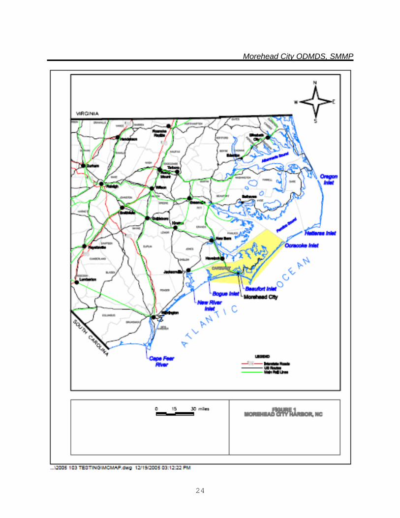
Morehead City ODMDS, SMMP
24
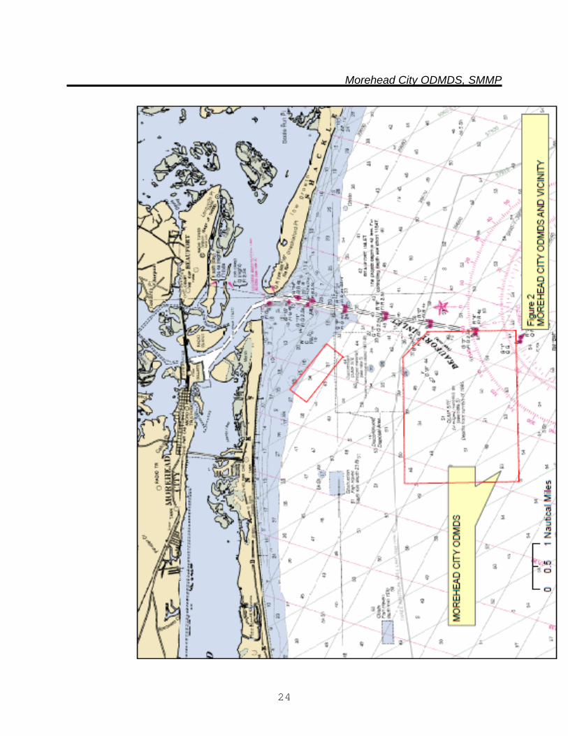
Morehead City ODMDS, SMMP
24
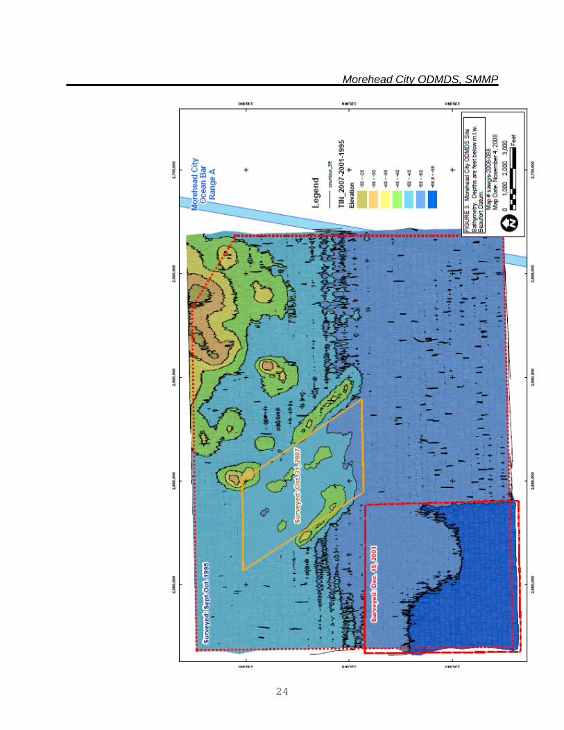
Morehead City ODMDS, SMMP
24
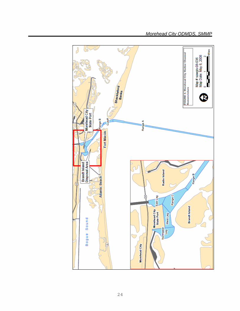
Morehead City ODMDS, SMMP
24
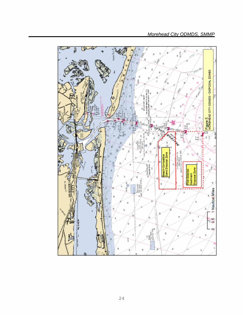
Morehead City ODMDS, SMMP
24
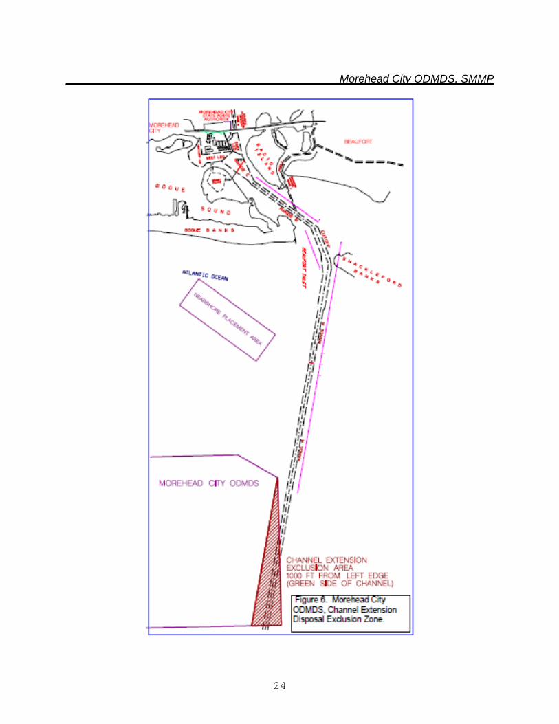
Morehead City ODMDS, SMMP
24
Morehead City ODMDS, SMMP
24
APPENDIX A
NUMERICAL MODEL (STFATE) INPUT PARAMETERS
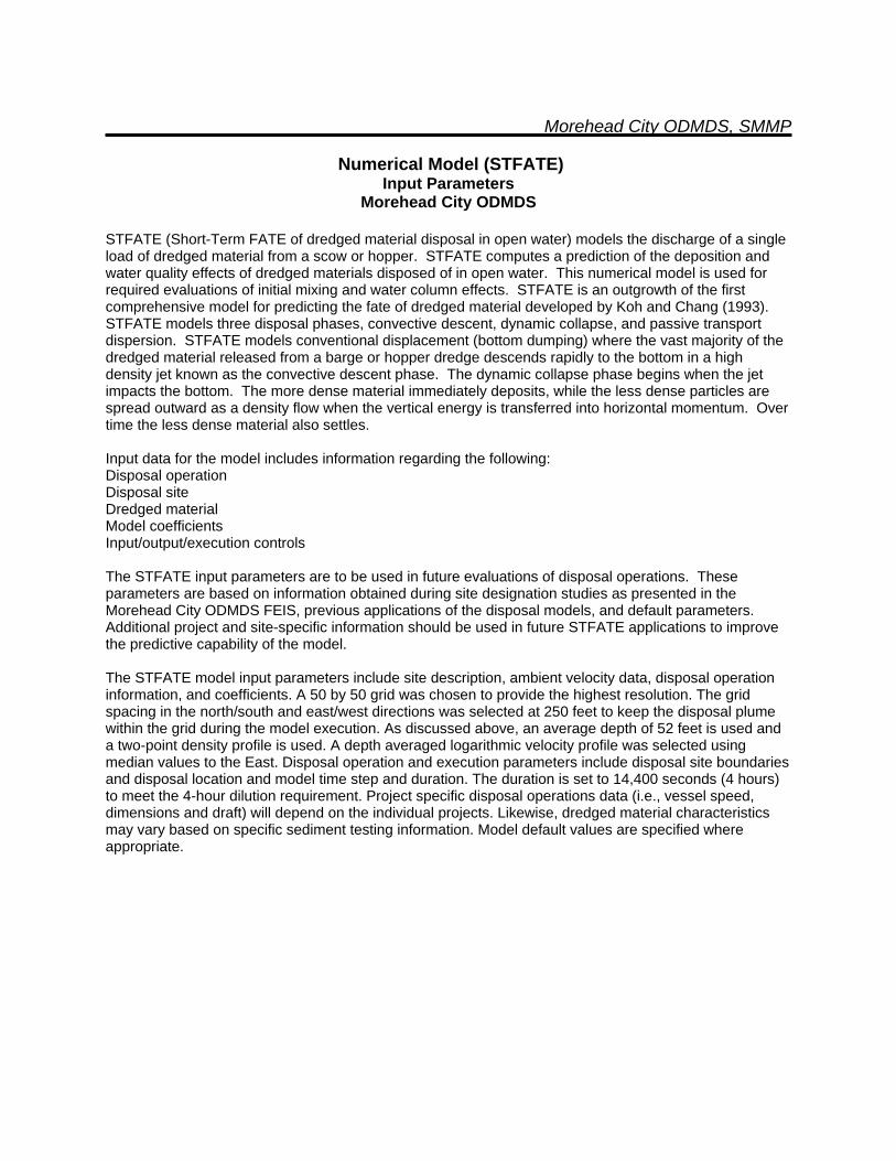
Morehead City ODMDS, SMMP
Numerical Model (STFATE) Input Parameters
Morehead City ODMDS
STFATE (Short-Term FATE of dredged material disposal in open water) models the discharge of a single load of dredged material from a scow or hopper. STFATE computes a prediction of the deposition and water quality effects of dredged materials disposed of in open water. This numerical model is used for required evaluations of initial mixing and water column effects. STFATE is an outgrowth of the first comprehensive model for predicting the fate of dredged material developed by Koh and Chang (1993). STFATE models three disposal phases, convective descent, dynamic collapse, and passive transport dispersion. STFATE models conventional displacement (bottom dumping) where the vast majority of the dredged material released from a barge or hopper dredge descends rapidly to the bottom in a high density jet known as the convective descent phase. The dynamic collapse phase begins when the jet impacts the bottom. The more dense material immediately deposits, while the less dense particles are spread outward as a density flow when the vertical energy is transferred into horizontal momentum. Over time the less dense material also settles. Input data for the model includes information regarding the following: Disposal operation Disposal site Dredged material Model coefficients Input/output/execution controls The STFATE input parameters are to be used in future evaluations of disposal operations. These parameters are based on information obtained during site designation studies as presented in the Morehead City ODMDS FEIS, previous applications of the disposal models, and default parameters. Additional project and site-specific information should be used in future STFATE applications to improve the predictive capability of the model. The STFATE model input parameters include site description, ambient velocity data, disposal operation information, and coefficients. A 50 by 50 grid was chosen to provide the highest resolution. The grid spacing in the north/south and east/west directions was selected at 250 feet to keep the disposal plume within the grid during the model execution. As discussed above, an average depth of 52 feet is used and a two-point density profile is used. A depth averaged logarithmic velocity profile was selected using median values to the East. Disposal operation and execution parameters include disposal site boundaries and disposal location and model time step and duration. The duration is set to 14,400 seconds (4 hours) to meet the 4-hour dilution requirement. Project specific disposal operations data (i.e., vessel speed, dimensions and draft) will depend on the individual projects. Likewise, dredged material characteristics may vary based on specific sediment testing information. Model default values are specified where appropriate.
Morehead City ODMDS, SMMP
ADDAMS Model Section 103 Regulatory Analysis for Ocean Water, Tier III, Short-Term Fate of Dredged Material from Split Hull Barge or Hopper/Toxicity Run Average sediment characteristics of recent sediment 103 evaluations were used to calculate the Volumetric Fractions. Parameters described in the disposal site were obtained from the Morehead City ODMDS Site Designation EIS (EPA, 1985), COE Bathymetric data, Nautical Charts, and The North Carolina Coastal Ocean Observing System www.NCCOOS.org., Buoy 41035. Map 1 shows the location and configuration of the reference station. STFATE model input parameters utilized in the module were as follows: Site Description
Parameter Value
Units
Number of Grid Points (left to right) 50 n/a
Number of Grid Points (top to bottom) 50 n/a
Spacing Between Grid Points (left to right) 250 ft
Spacing Between Grid Points (top to bottom) 250 ft
Constant Water Depth 52 ft Roughness Height at Bottom of Disposal Site
0.0051 ft
Slope of Bottom in X-Direction 0 Deg
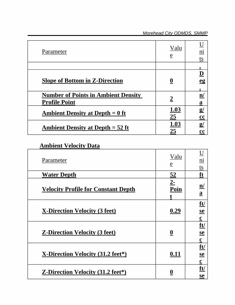
Morehead City ODMDS, SMMP
Parameter Value
Units .
Slope of Bottom in Z-Direction 0 Deg.
Number of Points in Ambient Density Profile Point 2 n/
a
Ambient Density at Depth = 0 ft 1.0325
g/cc
Ambient Density at Depth = 52 ft 1.0325
g/cc
Ambient Velocity Data
Parameter Value
Units
Water Depth 52 ft
Velocity Profile for Constant Depth 2-Point
n/a
X-Direction Velocity (3 feet) 0.29 ft/sec
Z-Direction Velocity (3 feet) 0 ft/sec
X-Direction Velocity (31.2 feet*) 0.11 ft/sec
Z-Direction Velocity (31.2 feet*) 0 ft/se
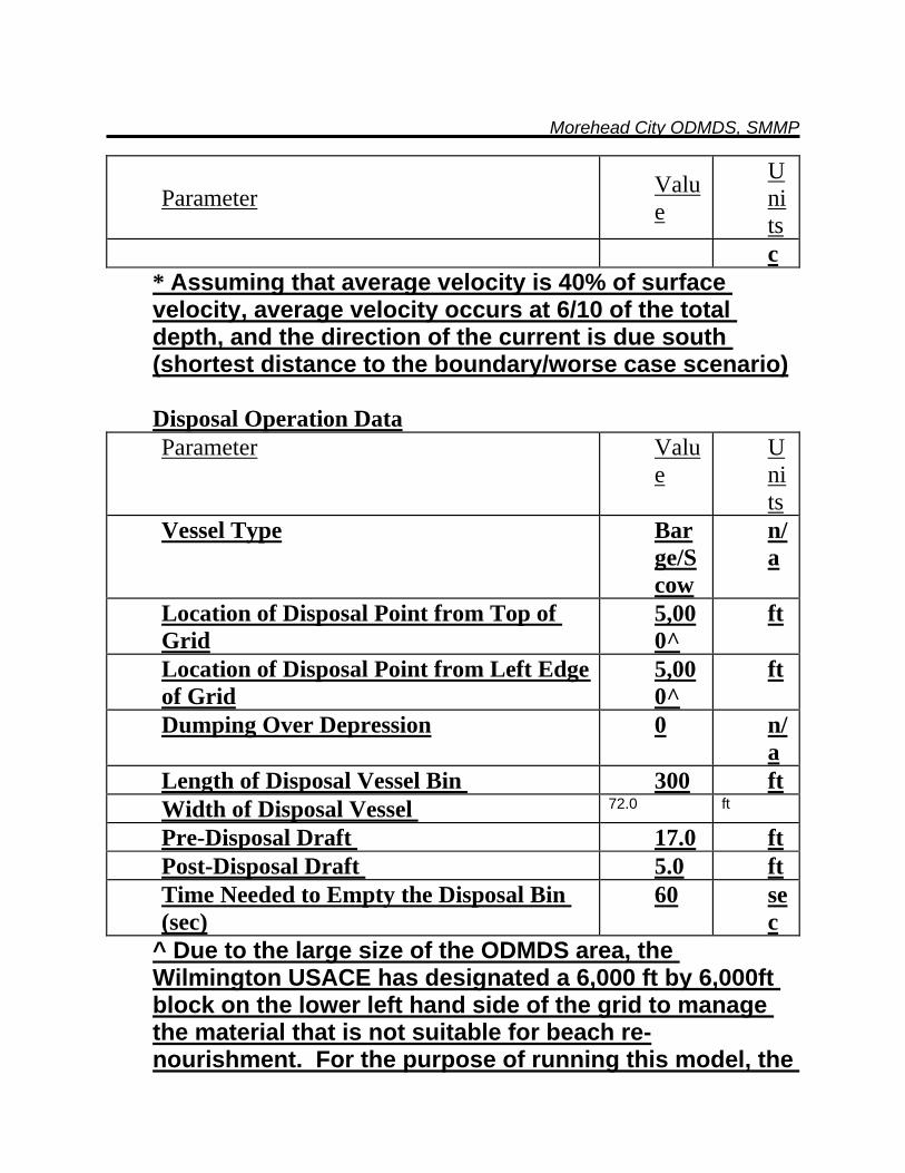
Morehead City ODMDS, SMMP
Parameter Value
Units c
* Assuming that average velocity is 40% of surface velocity, average velocity occurs at 6/10 of the total depth, and the direction of the current is due south (shortest distance to the boundary/worse case scenario) Disposal Operation Data Parameter Valu
e Units
Vessel Type Barge/Scow
n/a
Location of Disposal Point from Top of Grid
5,000^
ft
Location of Disposal Point from Left Edge of Grid
5,000^
ft
Dumping Over Depression 0 n/a
Length of Disposal Vessel Bin 300 ft Width of Disposal Vessel 72.0 ft
Pre-Disposal Draft 17.0 ft Post-Disposal Draft 5.0 ft Time Needed to Empty the Disposal Bin (sec)
60 sec
^ Due to the large size of the ODMDS area, the Wilmington USACE has designated a 6,000 ft by 6,000ft block on the lower left hand side of the grid to manage the material that is not suitable for beach re-nourishment. For the purpose of running this model, the
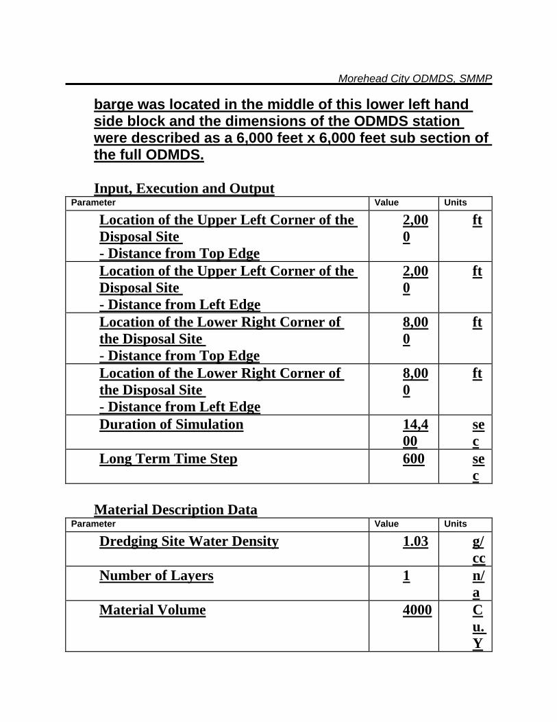
Morehead City ODMDS, SMMP
barge was located in the middle of this lower left hand side block and the dimensions of the ODMDS station were described as a 6,000 feet x 6,000 feet sub section of the full ODMDS. Input, Execution and Output
Parameter Value Units
Location of the Upper Left Corner of the Disposal Site - Distance from Top Edge
2,000
ft
Location of the Upper Left Corner of the Disposal Site - Distance from Left Edge
2,000
ft
Location of the Lower Right Corner of the Disposal Site - Distance from Top Edge
8,000
ft
Location of the Lower Right Corner of the Disposal Site - Distance from Left Edge
8,000
ft
Duration of Simulation 14,400
sec
Long Term Time Step 600 sec
Material Description Data
Parameter Value Units
Dredging Site Water Density 1.03 g/cc
Number of Layers 1 n/a
Material Volume 4000 Cu. Y
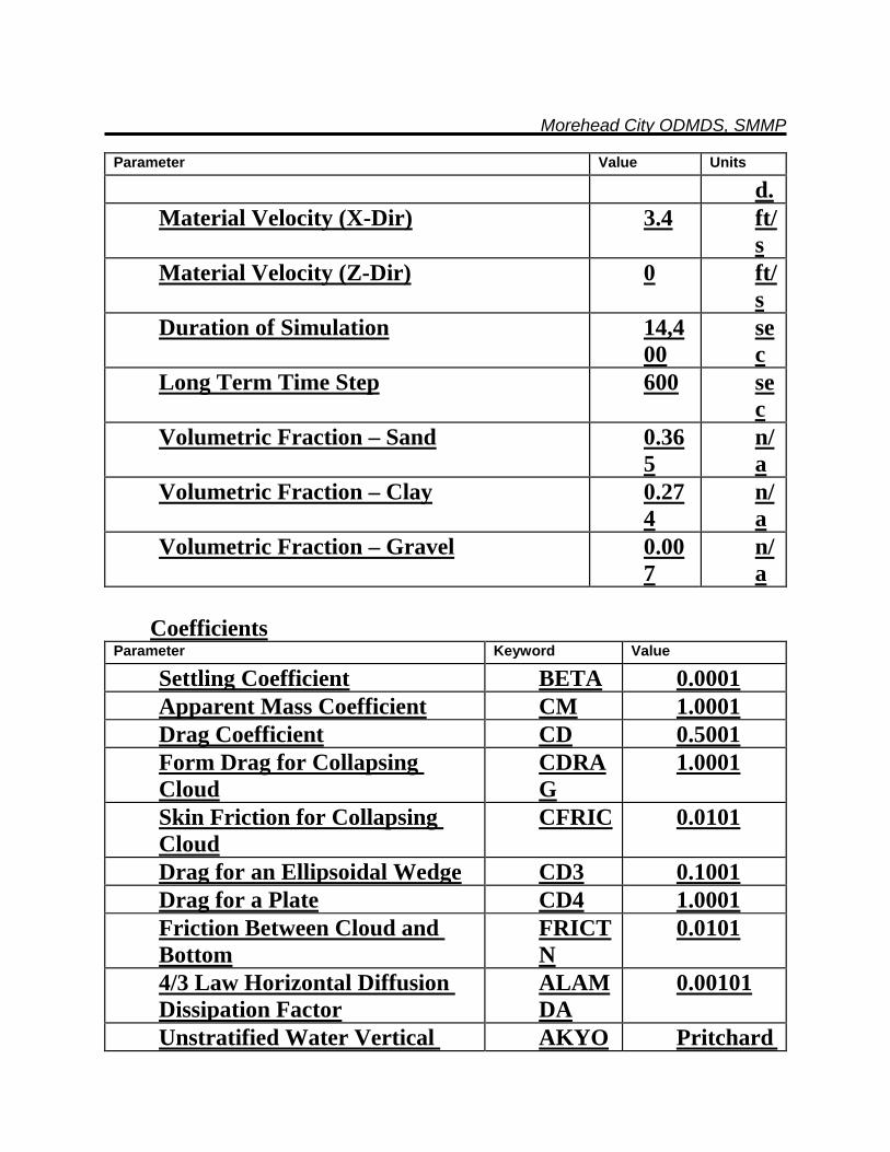
Morehead City ODMDS, SMMP
Parameter Value Units
d. Material Velocity (X-Dir) 3.4 ft/
s Material Velocity (Z-Dir) 0 ft/
s Duration of Simulation 14,4
00 sec
Long Term Time Step 600 sec
Volumetric Fraction – Sand 0.365
n/a
Volumetric Fraction – Clay 0.274
n/a
Volumetric Fraction – Gravel 0.007
n/a
Coefficients
Parameter Keyword Value
Settling Coefficient BETA 0.0001 Apparent Mass Coefficient CM 1.0001 Drag Coefficient CD 0.5001 Form Drag for Collapsing Cloud
CDRAG
1.0001
Skin Friction for Collapsing Cloud
CFRIC 0.0101
Drag for an Ellipsoidal Wedge CD3 0.1001 Drag for a Plate CD4 1.0001 Friction Between Cloud and Bottom
FRICTN
0.0101
4/3 Law Horizontal Diffusion Dissipation Factor
ALAMDA
0.00101
Unstratified Water Vertical AKYO Pritchard
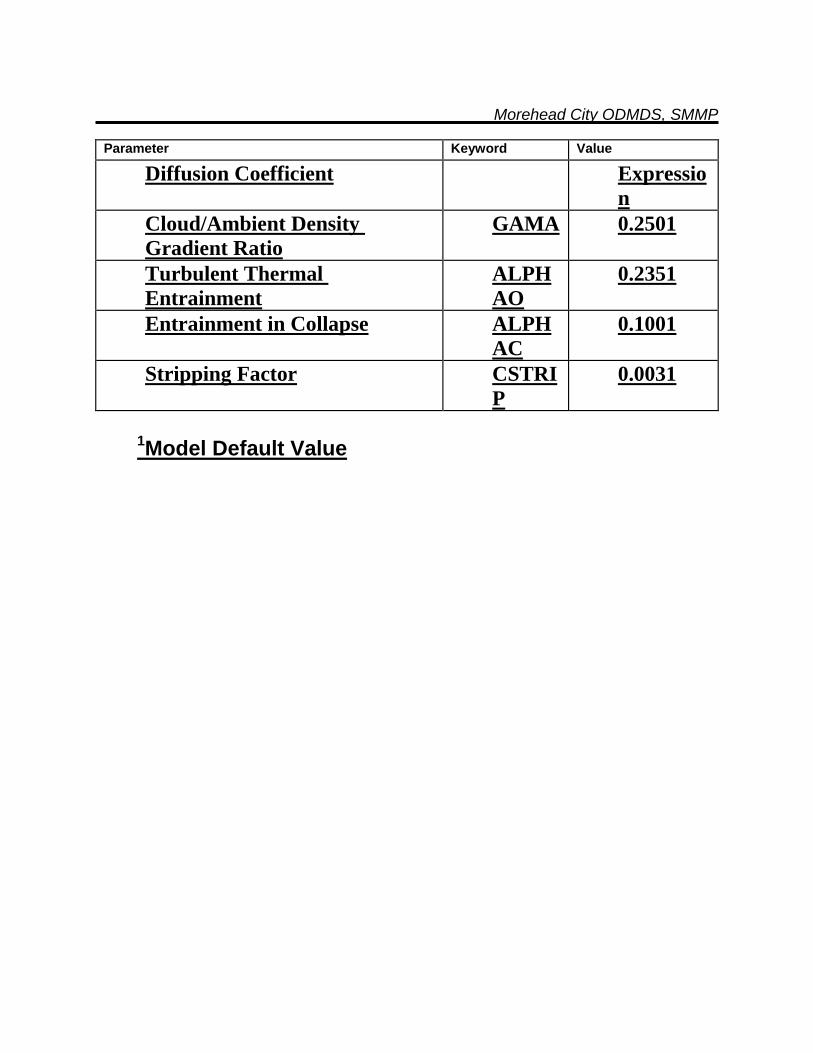
Morehead City ODMDS, SMMP
Parameter Keyword Value
Diffusion Coefficient Expression
Cloud/Ambient Density Gradient Ratio
GAMA 0.2501
Turbulent Thermal Entrainment
ALPHAO
0.2351
Entrainment in Collapse ALPHAC
0.1001
Stripping Factor CSTRIP
0.0031
1Model Default Value
APPENDIX B
GENERIC SPECIAL CONDITIONS FOR MPRSA SECTION 103 PERMITS
MOREHEAD CITY ODMDS
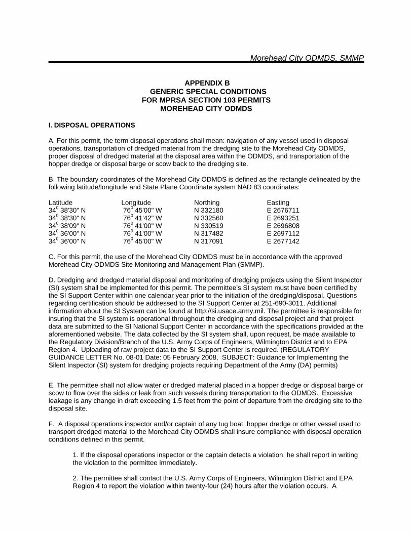
Morehead City ODMDS, SMMP
APPENDIX B GENERIC SPECIAL CONDITIONS
FOR MPRSA SECTION 103 PERMITS MOREHEAD CITY ODMDS
I. DISPOSAL OPERATIONS A. For this permit, the term disposal operations shall mean: navigation of any vessel used in disposal operations, transportation of dredged material from the dredging site to the Morehead City ODMDS, proper disposal of dredged material at the disposal area within the ODMDS, and transportation of the hopper dredge or disposal barge or scow back to the dredging site. B. The boundary coordinates of the Morehead City ODMDS is defined as the rectangle delineated by the following latitude/longitude and State Plane Coordinate system NAD 83 coordinates: Latitude Longitude Northing Easting 340 38'30" N 760 45'00" W N 332180 E 2676711 340 38'30" N 760 41'42" W N 332560 E 2693251 340 38'09" N 760 41'00" W N 330519 E 2696808 340 36'00" N 760 41'00" W N 317482 E 2697112 340 36'00" N 760 45'00" W N 317091 E 2677142 C. For this permit, the use of the Morehead City ODMDS must be in accordance with the approved Morehead City ODMDS Site Monitoring and Management Plan (SMMP). D. Dredging and dredged material disposal and monitoring of dredging projects using the Silent Inspector (SI) system shall be implemented for this permit. The permittee’s SI system must have been certified by the SI Support Center within one calendar year prior to the initiation of the dredging/disposal. Questions regarding certification should be addressed to the SI Support Center at 251-690-3011. Additional information about the SI System can be found at http://si.usace.army.mil. The permittee is responsible for insuring that the SI system is operational throughout the dredging and disposal project and that project data are submitted to the SI National Support Center in accordance with the specifications provided at the aforementioned website. The data collected by the SI system shall, upon request, be made available to the Regulatory Division/Branch of the U.S. Army Corps of Engineers, Wilmington District and to EPA Region 4. Uploading of raw project data to the SI Support Center is required. (REGULATORY GUIDANCE LETTER No. 08-01 Date: 05 February 2008, SUBJECT: Guidance for Implementing the Silent Inspector (SI) system for dredging projects requiring Department of the Army (DA) permits)
E. The permittee shall not allow water or dredged material placed in a hopper dredge or disposal barge or scow to flow over the sides or leak from such vessels during transportation to the ODMDS. Excessive leakage is any change in draft exceeding 1.5 feet from the point of departure from the dredging site to the disposal site. F. A disposal operations inspector and/or captain of any tug boat, hopper dredge or other vessel used to transport dredged material to the Morehead City ODMDS shall insure compliance with disposal operation conditions defined in this permit.
1. If the disposal operations inspector or the captain detects a violation, he shall report in writing the violation to the permittee immediately. 2. The permittee shall contact the U.S. Army Corps of Engineers, Wilmington District and EPA Region 4 to report the violation within twenty-four (24) hours after the violation occurs. A
Morehead City ODMDS, SMMP
complete written explanation of any permit violation shall be included in the post-dredging report.
G. For disposal operations which total greater than 10,000 cubic yards, the permittee shall conduct a bathymetric survey of the Morehead City ODMDS within two months prior to project disposal and within 60 days following project completion.
1. The number and length of the survey transects shall be sufficient to encompass the disposal zone within the ODMDS and a 1500-foot wide area around that zone. The survey transects shall be spaced at 500-foot intervals or less.
2. Vertical accuracy of the survey shall be ±0.5 feet. Horizontal location of the survey lines and depth sounding points will be determined by an automated positioning system utilizing either microwave line of site system or differential global positioning system. The vertical datum shall be mean lower low water (mllw) and the horizontal datum shall use North Carolina State Plane or latitude and longitude coordinates (North American Datum 1983). State Plane coordinates shall be reported to the nearest 0.10- foot and latitude and longitude coordinates shall be reported as degrees and decimal minutes to the nearest 0.01 minutes.
II. REPORTING REQUIREMENTS A. The permittee shall send the U.S. Army Corps of Engineers, Wilmington District’s Environmental Branch and EPA Region 4's Wetlands, Oceans, and Coastal Branch (61 Forsyth Street, Atlanta, GA 30303) a notification of commencement of work at least thirty (30) days before initiation of any dredging operations authorized by this permit and referenced by the permit number. In addition, the permittee agrees to contact the U.S. Coast Guard (Marine Safety Office) prior to disposing of any material in the ocean disposal site. B. The permittee shall submit to the U.S. Army Corps of Engineers weekly disposal monitoring reports. These reports shall contain the information described in Special Condition I.D. C. The permittee shall send one (1) copy of the disposal summary report to the Wilmington District and one (1) copy of the disposal summary report to EPA Region 4 documenting compliance with all general and special conditions defined in this permit. The disposal summary report shall be sent within 30 days after completion of the disposal operations authorized by this permit. The disposal summary report shall include the following information:
1. The report shall indicate whether all general and special permit conditions were met. Any violations of the permit shall be explained in detail.
2. The disposal summary report shall include the following information: Corps permit number, actual start date and completion date of dredging and disposal operations, total cubic yards disposed at the Morehead City ODMDS, locations of disposal events, and pre and post disposal bathymetric survey results (in hard and electronic formats).
III. PERMIT LIABILITY A. The permittee shall be responsible for ensuring compliance with all conditions of this permit. B. The permittee and all contractors or other third parties who perform an activity authorized by this permit on behalf of the permittee shall be separately liable for a civil penalty of up to $50,000 for each violation of any term of this permit they commit alone or in concert with the permittee or other parties. This liability shall be individual, rather than joint and several, and shall not be reduced in any fashion to reflect the liability assigned to and civil penalty assessed against the permittee or any other third party as defined in
Morehead City ODMDS, SMMP
33 U.S.C. Section 1415(a). C. If the permittee or any contractor or other third party knowingly violates any term of this permit (either alone or in concert), the permittee, contractor or other party shall be individually liable for the criminal penalties set forth in 33 U.S.C. Section 1415(b).
Morehead City ODMDS, SMMP
APPENDIX C
SEDIMENT CHARACTERISTICS IN MOREHEAD CITY FEDERAL NAVIGATION CHANNEL
Morehead City ODMDS, SMMP
APPENDIX C SEDIMENT CHARACTERISTICS IN
MOREHEAD CITY FEDERAL NAVIGATION CHANNEL Numerous borings have been performed in the Morehead City Harbor over the years. Many of those borings were for purposes other than to determine the suitability of disposal and therefore do not have the grain size testing that would be required to make a disposal decision. This analysis only uses the borings which have enough grain size data to make a determination of proper disposal. The analyses are summarized in Figures C1 and C2 and the following paragraphs. For this analysis, four sets of borings with lab testing were used. Also, borings performed this year were used, but the lab testing is not complete. Borings designated MIH-05-V-# are vibracore borings performed in 2005. These borings are located in Range C. Borings designated MOB-05-V-# are vibracore borings performed in 2005. These borings are located in Range A. Borings designated MHC-06- # are vibracore borings performed in 2006. These borings are located in Range C. Borings designated MHCOB-07-V-# are vibracore borings performed in 2007. These borings are located in Range A. All samples obtained from these borings within the channel were lab tested. Borings designated MHC-08-V-# are vibracore borings performed in 2008. These borings are located throughout the Morehead City Harbor from range C to Range A. They represent the most comprehensive set of borings performed to date for the identification of material to be dredged. The samples from these borings have been visually classified and are to be tested in the near future. Borings were performed from the Snell using a 3 7/8 inch diameter, 20 foot long, Alpine vibracore drill machine. The sampler consists of a metal barrel in which a plastic cylinder is inserted. After the plastic tube was inserted, a metal shoe was screwed onto the plastic tube and then the metal barrel. The shoe provided a cutting edge for the sampler and retained the plastic tube. An air-powered vibrator was mounted at the upper-most end of the vibracore barrel, and the vibrator and the vibracore barrel were mounted to a stand. This stand was lowered to the ocean floor by the Snell’s crane; the vibrator was activated and vibrated the vibracore barrel into the ocean sediment. The sediment sample is retained in the plastic cylinder. All borings were drilled to a depth of 20 feet below the ocean floor, unless vibracore refusal was encountered. Vibracore refusal was defined as a penetration rate of less than 0.1 feet in 10 seconds. All samples within the channel limits were tested in accordance with ASTM D 422. The sieves typically used in the testing were the 3/4”, 3/8”, #4, #7, #10, #14, #18, #25, #35, #45, #60, #80, #120, #170, #200, and #230 sieves. The borings were broken into three categories, green, red (maroon) and orange (Figure C-2). The “green” borings contain 10% or less fine grained material. The “orange” borings contain less than 20% fine grained material but more than 10%. Finally the “red” borings contain greater than 20% fine grained material. The percentage of fine grained material was determined from the grain size testing and the percent passing the #200 sieve.
Morehead City ODMDS, SMMP
The harbor areas are grouped based on the amount of fine content contained in the material to be dredged and the appropriate location for the material disposal. There are a few isolated areas which may contain material which is not consistent with the predominate material, but it is believed that these areas are anomalies and do not change the overall material types. See the attached map with the boring locations, boring color designations, and the lines delineating the major disposal areas Based on the information available at the present time, there are three distinct areas within the Morehead City Harbor (Figure C-1). The northern portion of Range C, the West Leg, the Northwest Leg, and the East Leg is the first area. This portion of the harbor consists predominantly of silt, silty sand, sandy silt and some clean sand. The material in this area contains too much fine grained material to meet the beach disposal requirements and should be placed in a disposal area that can accommodate fine grained material. The second area is the southern portion of Range C, all of Range B, all of the Cutoff, and Range A out to station 110+00. This portion of the harbor consists of slightly silty sand, and clean sand. The material in this area meets the requirement for beach disposal and should be disposed of in an appropriate location to utilize the sand material. The third area is the southern portion of Range A, from station 110+00 out to the end of Range A. This portion of the harbor consists predominantly of silt, silty sand, sandy silt and some clean sand. The material in this area contains too much fine grained material to meet the beach disposal requirements and should be placed in a disposal area that can accommodate fine grained material.


APPENDIX D SEDIMENT CHARACTERISTICS IN
MOREHEAD CITY ODMDS VICINITY
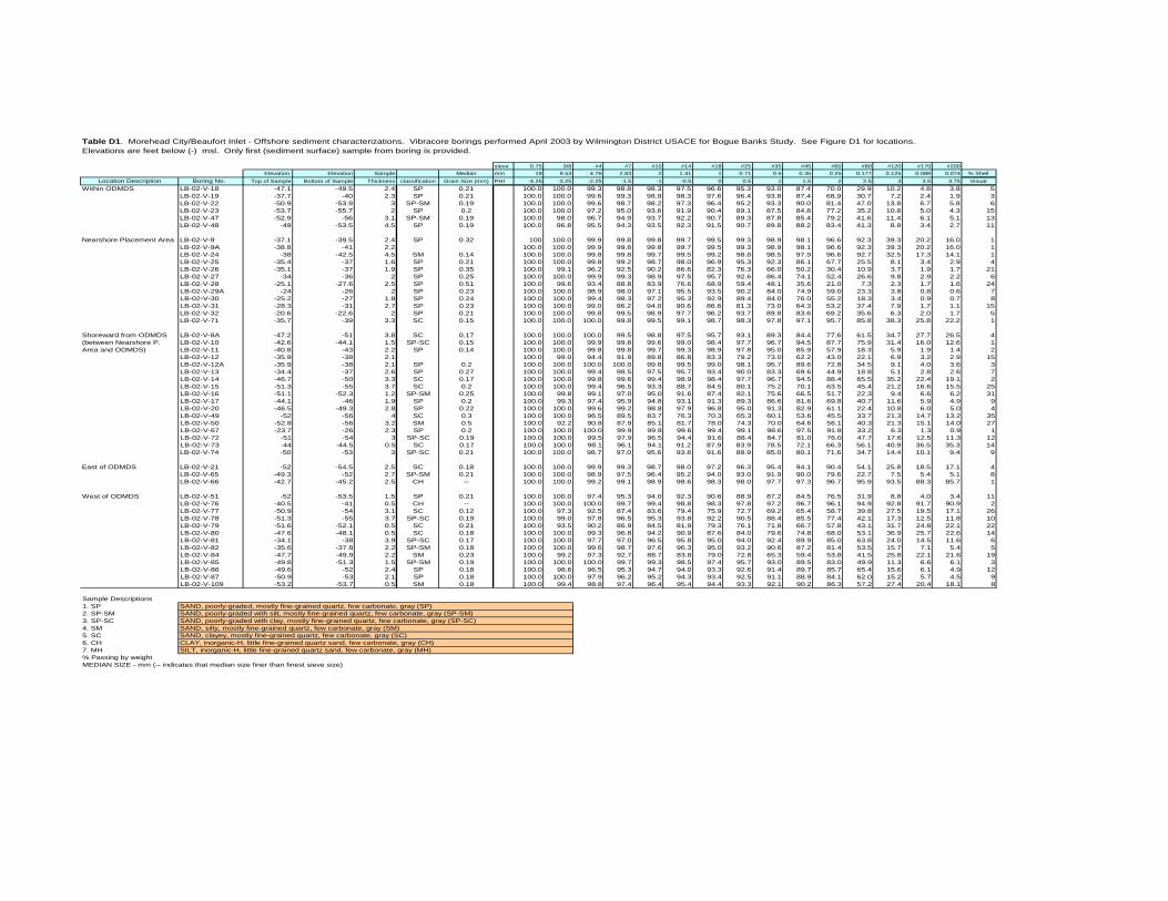
Table D1. Morehead City/Beaufort Inlet - Offshore sediment characterizations. Vibracore borings performed April 2003 by Wilmington District USACE for Bogue Banks Study. See Figure D1 for locations. Elevations are feet below (-) msl. Only first (sediment surface) sample from boring is provided.
sieve 0.75 3/8 #4 #7 #10 #14 #18 #25 #35 #45 #60 #80 #120 #170 #200Elevation Elevation Sample Median mm 19 9.53 4.76 2.83 2 1.41 1 0.71 0.5 0.35 0.25 0.177 0.125 0.088 0.074 % Shell
Location Description Boring No. Top of Sample Bottom of Sample Thickness classification Grain Size (mm) PHI -4.25 -3.25 -2.25 -1.5 -1 -0.5 0 0.5 1 1.5 2 2.5 3 3.5 3.75 Visual Within ODMDS LB-02-V-18 -47.1 -49.5 2.4 SP 0.21 100.0 100.0 99.3 98.8 98.3 97.5 96.6 95.3 93.0 87.4 70.0 29.9 10.2 4.8 3.8 5
LB-02-V-19 -37.7 -40 2.3 SP 0.21 100.0 100.0 99.6 99.3 98.9 98.3 97.6 96.4 93.8 87.4 68.9 30.7 7.2 2.4 1.9 3LB-02-V-22 -50.9 -53.9 3 SP-SM 0.19 100.0 100.0 99.6 98.7 98.2 97.3 96.4 95.2 93.3 90.0 81.4 47.0 13.8 6.7 5.8 6LB-02-V-23 -53.7 -55.7 2 SP 0.2 100.0 100.0 97.2 95.0 93.6 91.9 90.4 89.1 87.5 84.8 77.2 35.2 10.8 5.0 4.3 15LB-02-V-47 -52.9 -56 3.1 SP-SM 0.19 100.0 98.0 96.7 94.9 93.7 92.2 90.7 89.3 87.8 85.4 79.2 41.6 11.4 6.1 5.1 13LB-02-V-48 -49 -53.5 4.5 SP 0.19 100.0 96.8 95.5 94.3 93.5 92.3 91.5 90.7 89.8 88.2 83.4 41.3 8.8 3.4 2.7 11
Nearshore Placement Area LB-02-V-9 -37.1 -39.5 2.4 SP 0.32 100 100.0 99.9 99.8 99.8 99.7 99.5 99.3 98.9 98.1 96.6 92.3 39.3 20.2 16.0 1LB-02-V-9A -38.8 -41 2.2 100.0 100.0 99.9 99.8 99.8 99.7 99.5 99.3 98.9 98.1 96.6 92.3 39.3 20.2 16.0 1LB-02-V-24 -38 -42.5 4.5 SM 0.14 100.0 100.0 99.8 99.8 99.7 99.5 99.2 98.8 98.5 97.9 96.6 92.7 32.5 17.3 14.1 1LB-02-V-25 -35.4 -37 1.6 SP 0.21 100.0 100.0 99.8 99.2 98.7 98.0 96.9 95.3 92.3 86.1 67.7 25.5 8.1 3.4 2.9 4LB-02-V-26 -35.1 -37 1.9 SP 0.35 100.0 99.1 96.2 92.5 90.2 86.6 82.3 76.3 66.0 50.2 30.4 10.9 3.7 1.9 1.7 21LB-02-V-27 -34 -36 2 SP 0.25 100.0 100.0 99.9 99.3 98.9 97.5 95.7 92.6 86.4 74.1 52.4 26.6 9.8 2.9 2.2 6LB-02-V-28 -25.1 -27.6 2.5 SP 0.51 100.0 99.6 93.4 88.8 83.9 76.6 68.9 59.4 48.1 35.6 21.0 7.3 2.3 1.7 1.6 24LB-02-V-29A -24 -26 2 SP 0.23 100.0 100.0 98.9 98.0 97.1 95.5 93.5 90.2 84.0 74.9 59.0 23.3 3.8 0.8 0.6 7LB-02-V-30 -25.2 -27 1.8 SP 0.24 100.0 100.0 99.4 98.3 97.2 95.3 92.9 89.4 84.0 76.0 55.2 18.3 3.4 0.9 0.7 8LB-02-V-31 -28.3 -31 2.7 SP 0.23 100.0 100.0 99.0 96.2 94.0 90.6 86.6 81.3 73.0 64.3 53.2 37.4 7.9 1.7 1.1 15LB-02-V-32 -20.6 -22.6 2 SP 0.21 100.0 100.0 99.8 99.5 98.9 97.7 96.2 93.7 89.8 83.6 69.2 35.6 6.3 2.0 1.7 5LB-02-V-71 -35.7 -39 3.3 SC 0.15 100.0 100.0 100.0 99.8 99.5 99.1 98.7 98.3 97.8 97.1 95.7 85.8 38.3 25.8 22.2 1
Shoreward from ODMDS LB-02-V-8A -47.2 -51 3.8 SC 0.17 100.0 100.0 100.0 99.5 98.8 97.5 95.7 93.1 89.3 84.4 77.6 61.5 34.7 27.7 26.5 4(between Nearshore P. LB-02-V-10 -42.6 -44.1 1.5 SP-SC 0.15 100.0 100.0 99.9 99.8 99.6 99.0 98.4 97.7 96.7 94.5 87.7 75.9 31.4 16.0 12.6 1Area and ODMDS) LB-02-V-11 -40.8 -43 2.2 SP 0.14 100.0 100.0 99.8 99.8 99.7 99.3 98.9 97.8 95.0 85.9 57.9 18.3 5.9 1.9 1.4 2
LB-02-V-12 -35.9 -38 2.1 100.0 99.0 94.4 91.9 89.8 86.8 83.3 79.2 73.0 62.2 43.0 22.1 6.9 3.2 2.9 15LB-02-V-12A -35.9 -38 2.1 SP 0.2 100.0 100.0 100.0 100.0 99.8 99.5 99.0 98.1 95.7 89.6 72.8 34.5 9.1 4.0 3.6 3LB-02-V-13 -34.4 -37 2.6 SP 0.27 100.0 100.0 99.4 98.5 97.5 95.7 93.4 90.0 83.3 69.6 44.9 18.8 5.1 2.8 2.6 7LB-02-V-14 -46.7 -50 3.3 SC 0.17 100.0 100.0 99.8 99.6 99.4 98.9 98.4 97.7 96.7 94.5 88.4 65.5 35.2 22.4 19.1 2LB-02-V-15 -51.3 -55 3.7 SC 0.2 100.0 100.0 99.4 96.5 93.3 88.7 84.5 80.1 75.2 70.1 63.5 45.4 21.2 16.6 15.5 25LB-02-V-16 -51.1 -52.3 1.2 SP-SM 0.25 100.0 99.8 99.1 97.0 95.0 91.6 87.4 82.1 75.6 66.5 51.7 22.3 9.4 6.6 6.2 31LB-02-V-17 -44.1 -46 1.9 SP 0.2 100.0 99.3 97.4 95.9 94.8 93.1 91.3 89.3 86.6 81.6 69.8 40.7 11.6 5.9 4.9 9LB-02-V-20 -46.5 -49.3 2.8 SP 0.22 100.0 100.0 99.6 99.2 98.8 97.9 96.8 95.0 91.3 82.9 61.1 22.4 10.8 6.0 5.0 4LB-02-V-49 -52 -56 4 SC 0.3 100.0 100.0 96.5 89.5 83.7 76.3 70.3 65.3 60.1 53.6 45.5 33.7 21.3 14.7 13.2 35LB-02-V-50 -52.8 -56 3.2 SM 0.5 100.0 92.2 90.8 87.9 85.1 81.7 78.0 74.3 70.0 64.6 56.1 40.3 21.3 15.1 14.0 27LB-02-V-67 -23.7 -26 2.3 SP 0.2 100.0 100.0 100.0 99.9 99.8 99.6 99.4 99.1 98.6 97.5 91.8 33.2 6.3 1.3 0.9 1LB-02-V-72 -51 -54 3 SP-SC 0.19 100.0 100.0 99.5 97.9 96.5 94.4 91.6 88.4 84.7 81.0 76.0 47.7 17.6 12.5 11.3 12LB-02-V-73 -44 -44.5 0.5 SC 0.17 100.0 100.0 98.1 96.1 94.1 91.2 87.9 83.9 78.5 72.1 66.3 56.1 40.9 36.5 35.3 14LB-02-V-74 -50 -53 3 SP-SC 0.21 100.0 100.0 98.7 97.0 95.6 93.8 91.6 88.9 85.0 80.1 71.6 34.7 14.4 10.1 9.4 9
East of ODMDS LB-02-V-21 -52 -54.5 2.5 SC 0.18 100.0 100.0 99.9 99.3 98.7 98.0 97.2 96.3 95.4 94.1 90.4 54.1 25.8 18.5 17.1 4LB-02-V-65 -49.3 -52 2.7 SP-SM 0.21 100.0 100.0 98.9 97.5 96.4 95.2 94.0 93.0 91.9 90.0 79.6 22.7 7.5 5.4 5.1 8LB-02-V-66 -42.7 -45.2 2.5 CH -- 100.0 100.0 99.2 99.1 98.9 98.6 98.3 98.0 97.7 97.3 96.7 95.9 93.5 88.3 85.7 1
West of ODMDS LB-02-V-51 -52 -53.5 1.5 SP 0.21 100.0 100.0 97.4 95.3 94.0 92.3 90.6 88.9 87.2 84.5 76.5 31.9 8.8 4.0 3.4 11LB-02-V-76 -40.5 -41 0.5 CH -- 100.0 100.0 100.0 99.7 99.4 98.8 98.3 97.8 97.2 96.7 96.1 94.9 92.8 91.7 90.9 2LB-02-V-77 -50.9 -54 3.1 SC 0.12 100.0 97.3 92.5 87.4 83.6 79.4 75.9 72.7 69.2 65.4 58.7 39.8 27.5 19.5 17.1 26LB-02-V-78 -51.3 -55 3.7 SP-SC 0.19 100.0 99.0 97.8 96.5 95.3 93.8 92.2 90.5 88.4 85.5 77.4 42.1 17.3 12.5 11.8 10LB-02-V-79 -51.6 -52.1 0.5 SC 0.21 100.0 93.5 90.2 86.9 84.5 81.9 79.3 76.1 71.8 66.7 57.8 43.1 31.7 24.8 22.1 22LB-02-V-80 -47.6 -48.1 0.5 SC 0.18 100.0 100.0 99.3 96.8 94.2 90.9 87.6 84.0 79.6 74.8 68.0 53.1 36.9 25.7 22.6 14LB-02-V-81 -34.1 -38 3.9 SP-SC 0.17 100.0 100.0 97.7 97.0 96.5 95.8 95.0 94.0 92.4 89.9 85.0 63.8 24.0 14.5 11.6 6LB-02-V-82 -35.6 -37.8 2.2 SP-SM 0.18 100.0 100.0 99.6 98.7 97.6 96.3 95.0 93.2 90.6 87.2 81.4 53.5 15.7 7.1 5.4 5LB-02-V-84 -47.7 -49.9 2.2 SM 0.23 100.0 99.2 97.3 92.7 88.7 83.8 79.0 72.8 65.3 59.4 53.8 41.5 25.8 22.1 21.6 19LB-02-V-85 -49.8 -51.3 1.5 SP-SM 0.19 100.0 100.0 100.0 99.7 99.3 98.5 97.4 95.7 93.0 89.5 83.0 49.9 11.3 6.6 6.1 3LB-02-V-86 -49.6 -52 2.4 SP 0.18 100.0 98.6 96.5 95.3 94.7 94.0 93.3 92.6 91.4 89.7 85.7 65.4 15.6 6.1 4.9 12LB-02-V-87 -50.9 -53 2.1 SP 0.18 100.0 100.0 97.9 96.2 95.2 94.3 93.4 92.5 91.1 88.9 84.1 62.0 15.2 5.7 4.5 9LB-02-V-109 -53.2 -53.7 0.5 SM 0.18 100.0 99.4 98.8 97.4 96.4 95.4 94.4 93.3 92.1 90.2 86.3 57.2 27.4 20.4 18.1 8
Sample Descriptions1. SP2. SP-SM3. SP-SC4. SM5. SC6. CH7. MH% Passing by weightMEDIAN SIZE - mm (-- indicates that median size finer than finest sieve size)
SAND, clayey, mostly fine-grained quartz, few carbonate, gray (SC)CLAY, inorganic-H, little fine-grained quartz sand, few carbonate, gray (CH)SILT, inorganic-H, little fine-grained quartz sand, few carbonate, gray (MH)
SAND, poorly-graded, mostly fine-grained quartz, few carbonate, gray (SP)SAND, poorly-graded with silt, mostly fine-grained quartz, few carbonate, gray (SP-SM)SAND, poorly-graded with clay, mostly fine-grained quartz, few carbonate, gray (SP-SC)SAND, silty, mostly fine-grained quartz, few carbonate, gray (SM)
