mooloolaba futures plan - cabinet...1 mooloolaba spit futures plan context mooloolaba spit is a...
TRANSCRIPT
FINAL2 JULY 2009

Mooloolaba Spit Futures Plan
Introduction 1
Mooloolaba Spit Futures Plan 5
Land Use & Urban Design Strategy 7
Wharf/UnderWater World Precinct 9Residential Precinct 11Boating and Commercial Fishing Precinct 13Government and Peninsula Precinct 15
Mobility, Parking & Traffic Management Strategy 21
Water Usage Strategy 25
Safety, Anti-Social Behaviour & Crime Prevention Strategy 27
Implementation Plan 29
CONTENTS
Mooloolaba Spit Futures Plan1
ContextMooloolaba Spit is a unique place within South East Queensland, located on a narrow curving peninsula between the mouth of the Mooloolah River and the Pacific Ocean, and adjacent to the major commercial tourist centre of Mooloolaba.
It boasts a number of regional attractors, including the long sweeping surf beach, foreshore parkland with picnic facilities, restaurants, cafes and iconic entertainment facilities.
The adjoining Mooloolaba State Boat Harbour on the Mooloolah River is home to a large commercial fishing fleet, and the eastern end of the Spit accommodates a range of local and state Government uses.
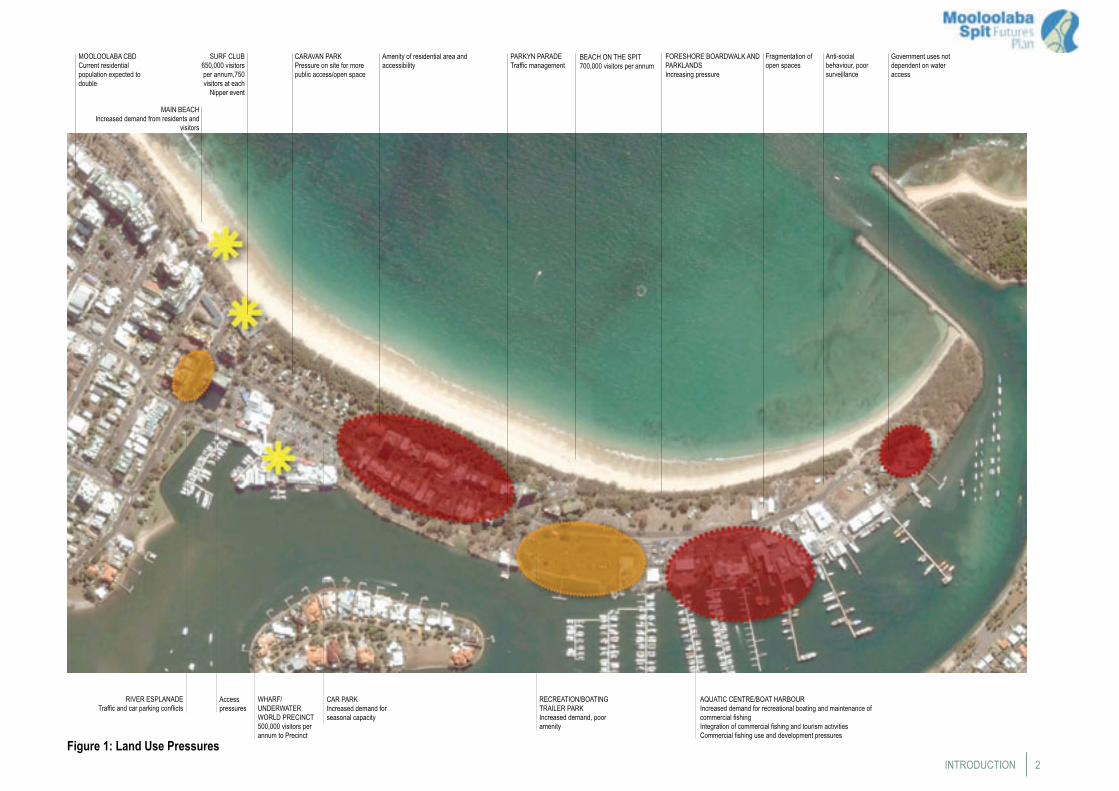
LAND USE PRESSURESFigure 1 depicts the range of factors contributing to use and development pressures on the Mooloolaba Spit. These include the following:
• An almost doubling of the Shire population over the next 20 years;
• The attractiveness of Mooloolaba beach which currently receives around 650,000 visitors annually and has a large junior life-saving program that currently attracts some 750 ‘nippers’ at each event;
• The Spit beach, regarded as one of the safest in South East Queensland, which also attracts some 700,000 visitors annually;
• Increasing pressure for more public open space, particularly at the western or town centre end of the Spit;
• Increasing regional demand on the foreshore boardwalks and parklands;
• Increasing demand for recreational boating, marina berths and associated land based activities, including trailer parking;
• Increasing pressure for complementary uses to augment the commercial fishing industry;
• The popularity of the Wharf/UnderWater World complex that currently attracts more than 500,000 visitors annually;
• Increasing conflicts between all the above uses and the amenity with the residential area of the Spit; Increasing demand for vehicle access and car parking leading to • congestion and traffic management issues; andGiven its location, the Spit will be highly vulnerable to the • long term impacts of climate change likely to be felt in coastal areas in the future, including sea level rise, changes in rainfall distribution, and an increase in the likelihood and intensity of extreme weather events, particularly flooding.
In summary, without a more effective management approach to the Spit area, the existing pressures on this area are not sustainable.
The Mooloolaba Spit Futures PlanIn recognition of these pressures, the then Department of Natural Resources and Water now Department of Environment and Resource Management (DERM) and the
Introduction
then Maroochy Shire Council, now Sunshine Coast Regional Council (SCRC) jointly commissioned the Mooloolaba Spit Futures Plan. The purpose of the Plan was to ensure a sustainable future and balanced use of the Spit while acknowledging the different aspirations of its stakeholders.
PLAN AIM AND OBJECTIVESThe aim of the Plan was to capture and realise the opportunities presented by the Spit area. This would form the basis of a whole-of-precinct approach in guiding future development of the Mooloolaba Spit. The Plan considered the opportunities and constraints on the Spit, together with options for future use and development. From this process, appropriate actions and strategies for implementing the preferred land use outcomes were recommended.
The Plan objectives to achieve these aims were as follows:
• Develop a medium to long term vision for the Spit precinct based on best practice urban design, town planning and sustainability principles that reflect the local and regional context, and address complex issues associated with this strategically located site;
• Provide an assessment of the appropriate style, scale, form, etc., of development within the precinct, considering State and local Government planning mechanisms;
• Enhance and maximise the level of public benefit from possible uses of the State-owned land within the precinct (with attention to social, economic and environmental benefit);
• Develop strategies and options for the use of the State-owned land to inter-relate, enhance and integrate with each other, the surrounding development and public spaces; and
• Provide options for land uses, built form, frontages, connectivity and accessibility, public space quality and amenity that will best benefit the local community and visitors/tourists to the area.
PLAN PROCESSThe Mooloolaba Spit Futures Plan was carried out in several phases. Consultation was an integral part of each phase.
The key plan phases were as follows:
• Issues Identification – involving a number of technical investigations and consultation to identify and document the issues, site context, constraints and opportunities. This phase was in effect a ‘situation analysis’;
• Options Development – this phase involved working with the community to prepare some guiding principles for the future use of the Spit and from this design options to address the issues;
• Evaluation of Options – the design responses were formed into strategy options for the Spit and evaluated through a Triple Bottom Line (TBL) assessment. This assessment then informed the preparation of preferred strategy options and development of a draft Plan for consultation;
• Development of a Plan – the final phase involved the refinement and further development of the preferred strategy options and the preparation of the Mooloolaba Spit Futures Plan having regard for the outcomes of consultation.
2
WHARF/UNDERWATER WORLD PRECINCT500,000 visitors per annum to Precinct
Access pressures
CAR PARKIncreased demand for seasonal capacity
RECREATION/BOATING TRAILER PARKIncreased demand, poor amenity
AQUATIC CENTRE/BOAT HARBOURIncreased demand for recreational boating and maintenance of commercial fishingIntegration of commercial fishing and tourism activitiesCommercial fishing use and development pressures
Anti-social behaviour, poor surveillance
Fragmentation of open spaces
Government uses not dependent on water access
PARKYN PARADETraffic management
Amenity of residential area and accessibility
FORESHORE BOARDWALK AND PARKLANDSIncreasing pressure
CARAVAN PARKPressure on site for more public access/open space
SURF CLUB650,000 visitors per annum,750 visitors at each
Nipper event
MAIN BEACHIncreased demand from residents and
visitors
RIVER ESPLANADETraffic and car parking conflicts
MOOLOOLABA CBDCurrent residential population expected to double
BEACH ON THE SPIT700,000 visitors per annum
Figure 1: Land Use PressuresINTRODUCTION
Mooloolaba Spit Futures Plan3
Vision and Guiding Principles
VISIONA vision to guide development on the Spit was prepared having regard for the opportunities in the area and the diverse range of community inputs into the Mooloolaba Spit Futures Plan. The vision was as follows:
“To preserve the unique and fragile environmental characteristics of the Mooloolaba Spit for present and future generations, to achieve a balance between diverse competing uses and to maintain:
• Safe boating access for maritime industry, recreational uses and operators; and
• A safe beach and parkland environment for residents and visitors.
GUIDING PRINCIPLESA number of guiding principles for future use and development on the Spit were prepared. A number of these principles are general to the overall Spit, while others are specific to certain areas or sites. The guiding principles are listed below.
General Principles in Relation to Public Benefit• Provide public car parking consistent with the whole of
Mooloolaba traffic and parking strategy to be undertaken by Council;
• Provide additional open space and enhance the existing open space;
• Improve accessibility through the provision of additional public thoroughfares, footpaths and cyclepaths;
• Improve aesthetics and scenic values on the Spit by providing view corridors between buildings;
• Upgrade public facilities such as BBQs, playground equipment, picnic areas, shade trees, toilets and public art; and
• Reconfigure the road network to improve traffic movement in and around the Spit.
General Principles in Relation to Development• Development should be designed in a manner to enhance the
urban design outcomes on the Spit;• No development on existing open space or parkland;• Any significant development or redevelopment should be
focused at the western end of the Spit only;• Any development on the Spit should maintain the integrity and
functioning of the State Boat Harbour;• No development on the northern side of Parkyn Parade (apart
from public amenities and small scale kiosks and excluding residential properties);
• Any development of the Spit and within the Boat Harbour will not lead to a deterioration of the existing traffic and parking situation and will need to be carried out in the context of an integrated traffic management and mobility strategy for the Spit and wider Mooloolaba area;
• Development on the Spit will be consistent with the SCRC’s planning scheme for the area; andFuture planning for development will need to address climate • change mitigation and adaptation measure to be put in place, including the ability of development to withstand the long term impacts of climate change such as sea level rise and extreme weather events.
General Principles in Relation to Landscape and Amenity• Maintain and enhance the sense of place for the Spit;• Protect the area’s natural vegetation;• Enhance the visual amenity of the car parks, boat trailer and
storage areas; and• Enhance the existing open space and provide additional public
facilities and open space areas. Facilities should include additional public telephones.
General Principles in Relation to Access and Mobility• Improve disability access;• Maintain and enhance access for commercial vehicles
related to the commercial fishing industry;Improve connectivity between the beach and river;•
• Improve accessibility to open space areas within the Spit;• Improve the accessibility and connectivity of the walking/cycle
trails;• Ensure that any development options implement the
requirements of Council’s whole of Mooloolaba traffic and parking strategy;
• Improve traffic accessibility to the Spit and traffic movement within the Spit; and
• Consider alternate methods of moving people around the Spit.
Vision
4STRATEGY
General Principles in Relation to Public Safety• Enhance the level of safety for all users of the Spit;• Adopt urban design strategies to reduce opportunities for anti-
social behaviour;• Maintain safe access to beach areas;• Create active frontages wherever possible to reduce areas with
poor surveillance; and• Develop strategies with Police and youth groups to address
problems of anti-social behaviour.
General Principles in Relation to Marine Areas• Maintain and enhance the functionality of the Boat Harbour; • Enhance public access to the river frontage where safe to do so;• Preserve and upgrade the rock wall fronting the river;• Consider the potential opportunities for a river based public
transport system; and• Address the land-side and water-side implications of any
development within the Boat Harbour.
Principles in Relation to the Wharf/UnderWater World Precinct
• Ensure that any development options are consistent with the planning scheme in force for the Spit and implement the requirements of Council’s whole of Mooloolaba traffic and parking strategy
• Recognise the regional significance of the Wharf and UnderWater World facilities to Queensland’s tourism industry; and
• Improve public accessibility between the Esplanade and the Wharf.
Principles in Relation to the Residential Precinct• Maintain the current amenity, nature and intensity of residential
development.
Principles in Relation to the Boating and Commercial Fishing Precinct
• Recognise the regional significance of the Boat Harbour to the recreational and boating commercial fishing industry;
• Enhance the amenity of the trailer parking area; and• Support the commercial fishing industry as an essential iconic
component of the Spit by allowing lessees to diversify their activities to include tourism-related activities in order to maintain viability.
Principles in Relation to the Government and Peninsula Precinct
• Rationalise and consolidate government marine oriented facilities on the Spit; and
• Improve public access to the eastern end of the Spit where appropriate.
Mooloolaba Spit Futures Plan5
Key elements of the Plan are shown in Figure 2.
Plan ComponentsThe Mooloolaba Spit Futures Plan comprises a number of integrated strategies that should be implemented over time in accordance with an Implementation Plan.
The strategies are:
• Land Use and Urban Design Strategy – outlines the proposed land uses in different parts of the Spit, intended development requirements and urban design outcomes;
• Landscape Strategy – provides a cohesive vision for the Spit, integrating the built realm, open space and circulation networks, and providing for a diverse range of recreational uses, spaces and character throughout the Spit;
• Water Use Strategy – assists in managing existing and future uses within the Mooloolaba State Boat Harbour and adjacent parts of the Mooloolah River in a manner consistent with the other strategies of the Mooloolaba Spit Plan;
• Mobility, Parking and Traffic Management Strategy – provides a range of initiatives to improve traffic management, parking, pedestrian and cyclist accessibility on the Spit, but will need to be linked to a whole of Mooloolaba traffic and parking study to be conducted by Council;
• Safety, Anti-Social Behaviour and Crime Prevention Strategy – aims to provide a range of measures to address those aspects of safety, prevention of anti-social behaviour and crime prevention that are outside the scope of the physical design measures proposed for the Spit; and
• Implementation Plan - aims to facilitate the intended outcomes and public benefits for the Spit.
Mooloolaba Spit Futures Plan
The Plan describes a broad range of initiatives and interventions consistent with the guiding principles to respond to the pressures on Mooloolaba Spit. The Plan provides a framework for the ongoing enhancement of the Spit for the benefit of residents and visitors.
Plan ObjectivesThe objectives of the Mooloolaba Spit Futures Plan are to:
• Recognise the Spit’s contribution to Mooloolaba and as a pre-eminent tourist destination on the Sunshine Coast region;
• Recognise the role that different parts of the Spit play in creating a range of opportunities for residents and visitors;
• Enhance the Spit as a place for the public, visitors and tourists, residents, recreational boating and commercial fishing and government;
• Create a place where all stakeholders can feel connected in their landscape with improved accessibility, safety, amenity, public space quality and environmental sensitivity; and
• Create a place where the integration of design outcomes within the wider urban context will reinforce a sense of connection, legibility and distinction. In particular, the linkages between movement and accessibility, building form and streetscape and between park and open space, will play a major role in reinforcing a desired sense of place.

6
RIVER EDGEImproved river edge and
river to beach pedestrian/cycle path and boardwalk
CARAVAN PARK15% of the caravan park to be replaced by parkland in Town Park to improve the connectivity between the beach and the river
WHARF/UNDERWATER WORLD PRECINCT
Any redevelopment of Wharf, car parks and Underwater World as per Council’s
planning scheme
TRAILER PARK AREALandscape upgrade of trailer park
AQUATIC CENTRE AREAProgressive upgrading of Sunshine Coast Aquatic Centre and associated facilities to provide active frontages to the river and Parkyn Parade
GOVERNMENT AND PENINSULA PRECINCTConsolidation of government facilities to better utilise site. Introduction of active frontages to improve safety and open space
DEEDI FACILITYCurrent QBFP use of site relocated and
integrated into surrounding parkland
BEACH ACCESSBeach access, to service residential
precinct, reduced to 5 formal access points. Final location to be resolved
PARKING45° parking in new aisle parallel to Parkyn Parade, with street trees in-between blocks of bays
PARKYN PARADEPedestrian crossings improved, solar lighting and traffic speed control. Avenue street planting.Footpath upgraded with street furniture added
Figure 2: Key Plan Elements
MOOLOOLABA SPIT FUTURES PLAN
COMMERCIAL FISHING AREAAllow for greater diversity of associated tourism activities
NOTE: Building envelopes shown are indicative only
Mooloolaba Spit Futures Plan7
Land Use & Urban Design Strategy
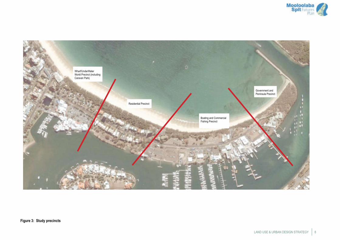
Division of Mooloolaba Spit into PrecinctsFor the purposes of the Land Use and Urban Design Strategy, the Spit has been divided into four general land use precincts. The subsequent elements of the Land Use and Urban Design Strategy provide detail on each precinct. The precincts as shown in Figure 3 are:
• The Wharf/UnderWater World Precinct, which also includes the caravan park site;
• The Residential Precinct comprising the existing area of residential units;
• The Boating and Commercial Fishing Precinct, which includes the boat trailer park, the Sunshine Coast Aquatic Centre area and the commercial fishing area; and
• The Government and Peninsula Precinct which includes the remainder of the Spit east of the commercial fishing area.
The Land Use and Urban Design Strategy deals with each of these precincts separately. However, the strategy elements recognise the relationships and similarities between precincts and will combine to provide a truly integrated land-use and urban design outcome for the Spit. All other strategies for the Plan deal with the Spit as a whole.
8
Figure 3: Study precincts
LAND USE & URBAN DESIGN STRATEGY
Wharf/UnderWater World Precinct (including Caravan Park)
Residential Precinct
Boating and Commercial Fishing Precinct
Government and Peninsula Precinct
Mooloolaba Spit Futures Plan9
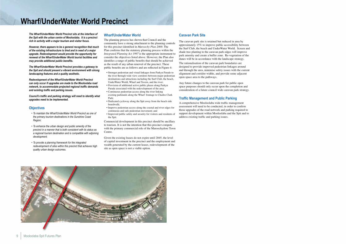
The Wharf/UnderWater World Precinct sits at the interface of the Spit with the urban centre of Mooloolaba. It is a precinct rich in activity with a major tourism and visitor focus.
However, there appears to be a general recognition that much of the existing infrastructure is tired and in need of a major upgrade. Redevelopment would provide the opportunity for renewal of the Wharf/UnderWater World tourist facilities and may provide additional public benefits.
The Wharf/UnderWater World Precinct provides a gateway to the Spit and should present a vibrant environment with strong landscaping features and a quality aesthetic.
Redevelopment of the Wharf/UnderWater World Precinct can only occur if upgrades are made to the Mooloolaba road network, to accommodate projected regional traffic demands and existing traffic and parking issues.
Council’s traffic and parking strategy will need to identify what upgrades need to be implemented.
Objectives• To maintain the Wharf/UnderWater World Precinct as one of
the primary tourism destinations in the Sunshine Coast Region;
• To enhance the urban design and public amenity of the precinct in a manner that is both consistent with its status as a regional tourism destination and is compatible with adjoining development;
• To provide a planning framework for the integrated redevelopment of sites within this precinct that achieves high quality urban design outcomes.
Wharf/UnderWater WorldThe planning process has shown that Council and the community have a strong attachment to the planning controls for this precinct identified in Maroochy Plan 2000. The Plan confirms that the statutory planning process within the Integrated Planning Act 1997 is the appropriate instrument to consider the objectives listed above. However, the Plan also identifies a range of public benefits that should be achieved as the result of any urban renewal of the precinct. These public benefits are as follows and are reflected in Figure 4:
• Stronger pedestrian and visual linkages from Parkyn Parade to the river through wide view corridors between major pedestrian destinations and attractions including the Surf Club, the beach, UnderWater World, Wharf and Tavern, and the river;
• Provision of additional active public plazas along Parkyn Parade associated with the redevelopment of the area;
• Continuous pedestrian access along the river linking existing parklands along the Wharf frontage to Charles Clark Park;
• Dedicated cycleway along the Spit away from the beach side boardwalk;
• Improve pedestrian access along the coastal and river edges for continuous and safe pedestrian movement; and
• Improved public safety and security for visitors and residents of the Spit.
Commercial development in this precinct should be ancillary to tourism. It is not the intention that this precinct compete with the primary commercial role of the Maroochydore Town Centre.
Given the existing leases do not expire until 2045, the level of capital investment in the precinct and the employment and wealth generated by the current leases, redevelopment of the site as open space is not a viable option.
Caravan Park Site
The caravan park site is retained but reduced in area by approximately 15% to improve public accessibility between the Surf Club, the beach and UnderWater World. Screen and shade tree planting to the caravan park edges will improve park amenity and create a buffer zone. Re-vegetation of the dunes will be in accordance with the landscape strategy.
The rationalisation of the caravan park boundaries are designed to provide improved pedestrian linkages around and through the area, minimise safety issues with the current alignment and corridor widths, and provide some adjacent open space area to the pathways.
Any future changes to the caravan park for public open space purposes should only occur upon the completion and consideration of a future council wide caravan park strategy.
Traffic Management and Public ParkingA comprehensive Mooloolaba wide traffic management assessment will need to be conducted, in order to confirm those upgrades of the road network and parking required to support development within Mooloolaba and the Spit and to address existing traffic and parking issues.
Wharf/UnderWater World Precinct

10
Figure 4: Potential Public Benefits from Future Redevelopment of Wharf/UnderWater World Precinct
Enlarged park with car parking rationalised
Stronger pedestrian linkage along rivers edge boardwalk etc. Dedicated bikeways away from beach board walk
More direct pedestrian link from Surf Club and Beach to Wharf/UnderWater World Precinct
Strong cross link from beach to river
Variety of accommodation options retained by keeping substantial part of the Caravan Park
Enhanced board walk shelters and beach front
More direct beach to river park link through new public plaza space at redeveloped Wharf
Broad view corridors from Parkyn Parade to river
Green link
View corridor
Pedestrian board walk
River to beach link
Parks
LAND USE & URBAN DESIGN STRATEGY
Mooloolaba Spit Futures Plan11
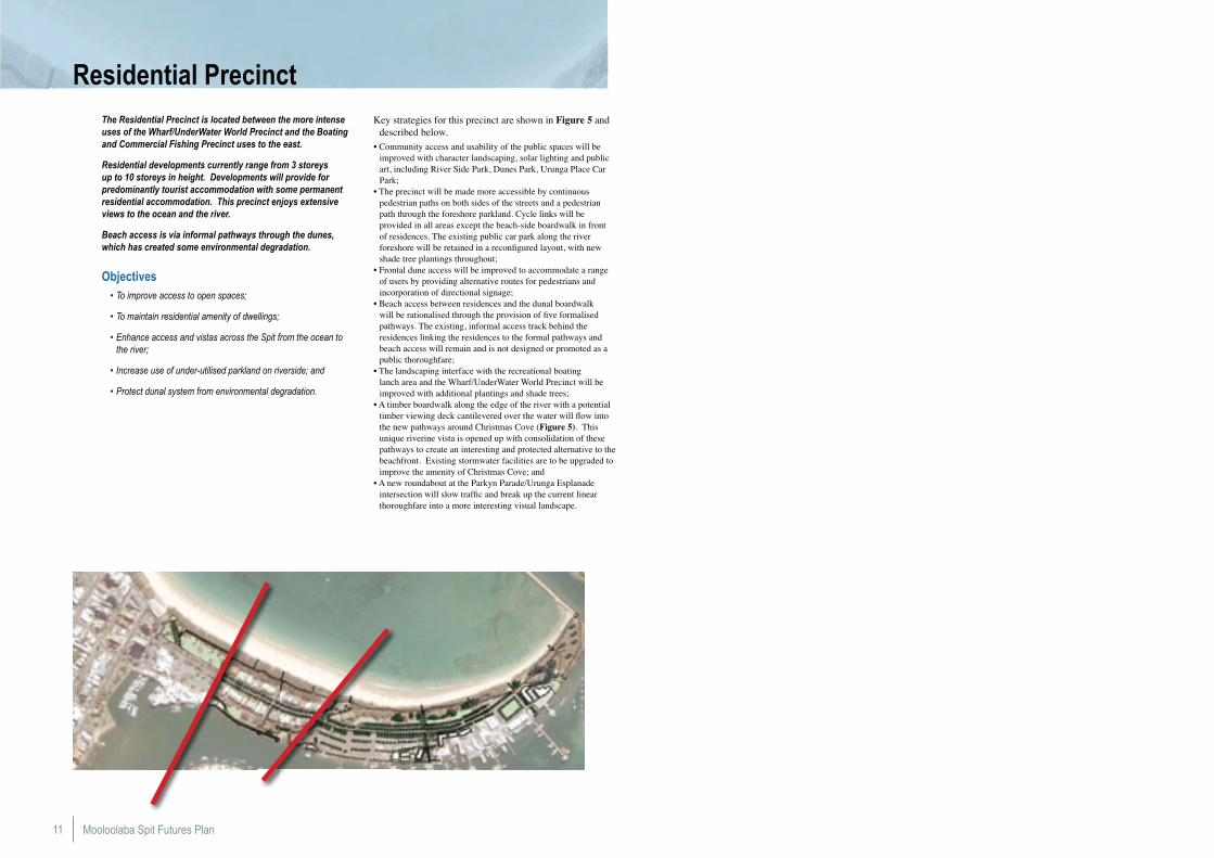
Residential PrecinctThe Residential Precinct is located between the more intense uses of the Wharf/UnderWater World Precinct and the Boating and Commercial Fishing Precinct uses to the east.
Residential developments currently range from 3 storeys up to 10 storeys in height. Developments will provide for predominantly tourist accommodation with some permanent residential accommodation. This precinct enjoys extensive views to the ocean and the river.
Beach access is via informal pathways through the dunes, which has created some environmental degradation.
Objectives• To improve access to open spaces;
• To maintain residential amenity of dwellings;
• Enhance access and vistas across the Spit from the ocean to the river;
• Increase use of under-utilised parkland on riverside; and
• Protect dunal system from environmental degradation.
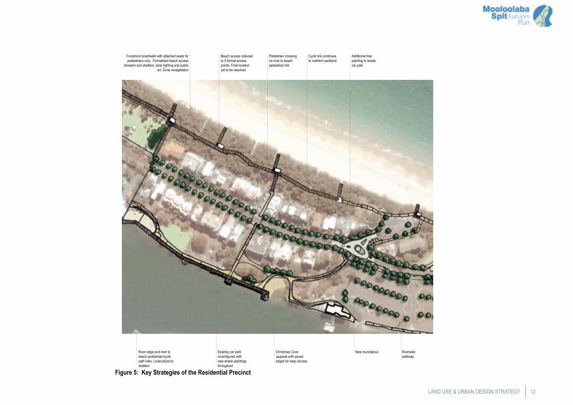
Key strategies for this precinct are shown in Figure 5 and described below.
• Community access and usability of the public spaces will be improved with character landscaping, solar lighting and public art, including River Side Park, Dunes Park, Urunga Place Car Park;
• The precinct will be made more accessible by continuous pedestrian paths on both sides of the streets and a pedestrian path through the foreshore parkland. Cycle links will be provided in all areas except the beach-side boardwalk in front of residences. The existing public car park along the river foreshore will be retained in a reconfigured layout, with new shade tree plantings throughout;
• Frontal dune access will be improved to accommodate a range of users by providing alternative routes for pedestrians and incorporation of directional signage;
• Beach access between residences and the dunal boardwalk will be rationalised through the provision of five formalised pathways. The existing, informal access track behind the residences linking the residences to the formal pathways and beach access will remain and is not designed or promoted as a public thoroughfare;
• The landscaping interface with the recreational boating lanch area and the Wharf/UnderWater World Precinct will be improved with additional plantings and shade trees;
• A timber boardwalk along the edge of the river with a potential timber viewing deck cantilevered over the water will flow into the new pathways around Christmas Cove (Figure 5). This unique riverine vista is opened up with consolidation of these pathways to create an interesting and protected alternative to the beachfront. Existing stormwater facilities are to be upgraded to improve the amenity of Christmas Cove; and
• A new roundabout at the Parkyn Parade/Urunga Esplanade intersection will slow traffic and break up the current linear thoroughfare into a more interesting visual landscape.
12
River edge and river to beach pedestrian/cycle path links. Lookout/picnic shelters
Christmas Cove upgrade with paved edges for easy access
New roundabout
Pedestrian crossing on river to beach pedestrian link
Beach access reduced to 5 formal access points. Final location yet to be resolved
Foreshore boardwalk with attached seats for pedestrians only. Formalised beach access
showers and shelters, solar lighting and public art. Dune revegetation
Additional tree planting to shade car park
Existing car park reconfigured with new shade plantings throughout
Riverside walkway
Cycle link continues to northern parkland
Figure 5: Key Strategies of the Residential Precinct
LAND USE & URBAN DESIGN STRATEGY

Mooloolaba Spit Futures Plan13
Boating & Commercial Fishing PrecinctThe Boating and Commercial Fishing Precinct is located between the Residential Precinct and the Government and Peninsula Precinct to the east.
Objectives• Improve the urban amenity of Parkyn Parade and establish
active frontages in the commercial fishing area;
• Create a better urban relationship between the Sunshine Coast Aquatic Centre with Parkyn Parade and the river foreshore;
• Enlarge and improve parkland north of Parkyn Parade;
• Improve the amenity of the boat trailer park in a manner that does not impact or impinge on the safe use of the trailer park;
• Enhance the commercial fishing industry on the Spit and support compatible redevelopment. Current commercial fishing uses to expand towards the street with active uses that enhance the tourism on the Spit; and
• Consolidate and link fragmented open spaces.
Key Strategies of this precinct are shown in Figures 7 and 8 and described below.
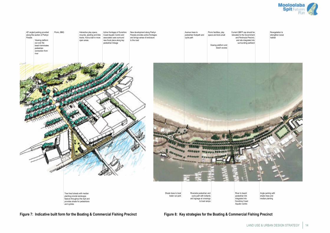
Sunshine Coast Aquatic Centre AreaProviding tree-lined streets with median planting will link the landscape features of the site with the rest of the Spit and provide shade for pedestrians and cyclists. A viewing platform over the beach will complete the pedestrian connection from the river to the beach.
The development of active frontages along Parkyn Parade will bring a sense of enclosure to the road and surround this new key pedestrian linkage, see Figure 6.
Parking will be consolidated in the precinct and redesigned as 45 degree bays with intermediate shade tree plantings, to create more car parks and open up more parkland.
In the future, the Plan envisages the progressive upgrading and efficient utilisation of the site for sailing related uses. Consistent with planning scheme provisions, future buildings should face Parkyn Parade, be a maximum of 3 storeys and incorporate an active frontage to Parkyn Parade. Associated car parking is to be provided on site. Only uses associated with the Sunshine Coast Aquatic Centre, Marina and/or sailing training are intended on site.
Development of the Commercial Fishing Industry will be encouraged, with compatible commercial and tourism uses such as facilities to service the recreational boating industry, restaurants, etc. Tree lined streets with median planting will link the landscape features of the site with the rest of the Spit
and provide shade for pedestrians and cyclists.
Redevelopment of buildings will include active street frontages, improve landscape and movement relationships with other sites in the precinct and bring forward the inherent aesthetic nature of all things nautical.
Parking will be consolidated in the precinct, Parkyn Parade will be redesigned as a slip lane with 45 degree bays to provide more useable parkland.
Queensland Boating and Fisheries Patrol SiteThe current Department of Employment, Economic Development and Innovation (DEEDI) Boating and Fisheries Patrol use should be relocated to the government use area of the Government and Peninsula Precinct. All buildings should ultimately be removed and the area integrated into the surrounding open space. New facilities such as play areas, solar lighting and shade tree plantings should be provided.
Boat Trailer ParkA wider road reserve is designed to accommodate a
footpath, parallel parking, cycle path, recreational fishing facilities (fish cleaning areas), avenue of shade trees, solar lighting and street furniture. The planting of additional large shade trees and upgrading of the pavement with permeable pavers will improve amenity and reduce runoff into the Mooloolah River.
Any expansion of the existing premises associated with Surf Life-Saving and the Coast Guard should only occur within their existing lease boundary. If expansion outside the boundary is required, an off-site location will need to be found.
Figure 6: Pedestrian linkages connect the river and beach, the foreshore parkland & shared paths
14
New development along Parkyn Parade provides active frontages and brings sense of enclosure to the road
Active frontages of Sunshine Coast Aquatic Centre and associated uses surround new focal place along key pedestrian linkage
Viewing platform out over the beach terminates pedestrian connection from river
Tree lined streets with median planting provide landscape feature throughout the Spit and provides shade for pedestrians and cyclists
450 angled parking provided along this section of Parkyn Parade
Figure 7: Indicative built form for the Boating & Commercial Fishing Precinct
Viewing platform and beach access
Picnic facilities, play space and kick-a-ball
Avenue trees to pedestrian footpath and cycle path
Revegetation to strengthen dunal habitat
Shade trees to boat trailer car park
Riverside pedestrian and cycle path with bollards
and signage at crossings to boat ramps
River to beach pedestrian link integrated into Sunshine Coast Aquatic Centre
Angle parking with shade trees and median planting
Picnic, BBQ Interactive play space, mounds, planting and bike tracks. Kick-a-ball in more open areas
Current QBFP use should be relocated to the Government
and Peninsula Precinct, and site integrated into
surrounding parkland
LAND USE & URBAN DESIGN STRATEGY
Figure 8: Key strategies for the Boating & Commercial Fishing Precinct

Mooloolaba Spit Futures Plan15
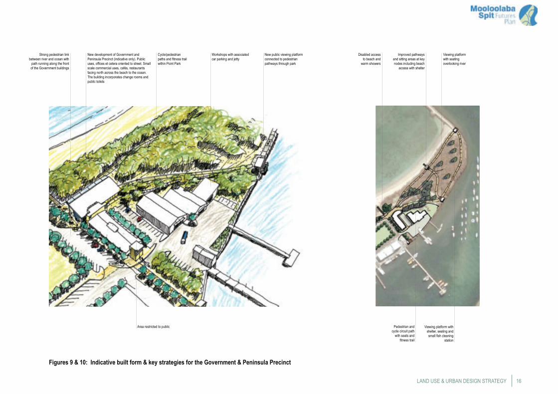
Government & Peninsula PrecinctThe Government and Peninsula Precinct is located to the east of the Boating and Commercial Fishing Precinct and contains an area of native bushland on its southern most tip.
Objectives• Rationalise and consolidate government uses to water
dependant services;
• Re-establish plant communities on the peninsula; and
• Encourage passive recreational activity on the peninsula.
Key Strategies for this precinct are shown in Figures 9 and 10 and described below.
The government uses in the precinct should be consolidated and designed to include uses such as, DTMR (Maritime Safety), Police (Water), DEEDI (Boating and Fisheries) and the Port of Brisbane marine pilot operations. Government services in the precinct must be limited to uses dependant on water access and include related activity such as shark contractors.
The development of active frontages on the ocean side of the precinct will enhance the existing open spaces and serve the visitors of the area by incorporating public toilets, cafes and restaurants. This will create a new gateway to the peninsula parklands making them more inviting and accessible.
Future planning for the facility will need to address climate change mitigation and adaptation to be put in place, including the ability of the development to withstand the long term impacts of climate change such as sea level rise and extreme weather events.
Revegetation of the parkland and dunes will improve habitat and enhance the scenic potential of this unique area. In addition, there should be no storage and/or treatment of dredge spoil on the Spit.
The urban containment and character of the ‘square about’ will be improved to reflect a termination of the vehicular pathway.
There should be no additional development outside the existing building leased area.
Public access will be designed so that it does not impact on the security needs of government users in this precinct.
Any proposals for additional berthing and marina facilities will require investigation.
16
New development of Government and Peninsula Precinct (indicative only). Public uses, offices et cetera oriented to street. Small scale commercial uses, cafés, restaurants facing north across the beach to the ocean. The building incorporates change rooms and public toilets
Strong pedestrian link between river and ocean with
path running along the front of the Government buildings
Workshops with associated car parking and jetty
New public viewing platform connected to pedestrian pathways through park
Cycle/pedestrian paths and fitness trail within Point Park
Viewing platform with shelter, seating and small fish cleaning
station
Improved pathways and sitting areas at key nodes including beach
access with shelter
Disabled access to beach and
warm showers
Pedestrian and cycle circuit path
with seats and fitness trail
Viewing platform with seating overlooking river
Figures 9 & 10: Indicative built form & key strategies for the Government & Peninsula Precinct
LAND USE & URBAN DESIGN STRATEGY
Area restricted to public
Mooloolaba Spit Futures Plan17
The Spit is a unique landscape with a remarkable north facing beach, public spaces, parks on the ocean and river and coastal boardwalks. The Spit will be treated as one landscape, to bring a cohesive visual and tangible sense of place.
Vehicle and pedestrian movement throughout the Spit has been mainly east - west along Parkyn Parade, or along the beach or the river.
Objectives• Provide a variety of open space experiences with a range of
recreation activities for the public;
• Improve existing parks and create additional parks in locations of high pedestrian usage;
• Improve public access and pedestrian amenity to and around the Spit;
• Improve visual and physical linkages across the Spit between the ocean and river; and
• Improve the quality and extent of dunal vegetation and shade tree plantings.
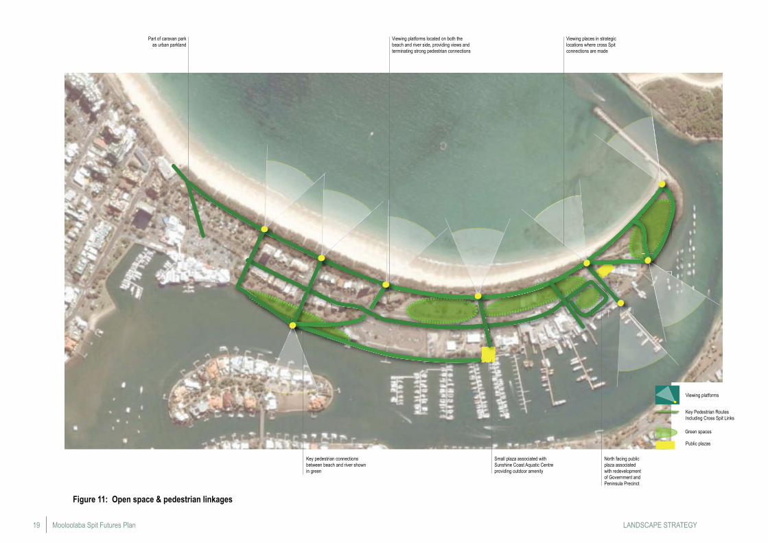
Linkages Open space and pedestrian linkages are depicted in Figure 11. The following is a strategic response to those opportunities.
PEDESTRIAN / CYCLE PATHSPedestrian movement is highlighted by the Plan and provides a continuous pathway circuit along the foreshore and riverside, incorporating existing walkways, linking pedestrian destinations, and inviting people into previously under-utilised areas due to the inconsistent path network. The pedestrian systems are located to enhance casual surveillance and maximise crime prevention through environmental design Crime Prevention Through Environmental Design (CPTED) responses.
Additional recreation opportunities will be provided, with designated cycle lanes and shared pedestrian/cycle paths along the river, linking up the foreshore to Urunga Esplanade and out to the Point. Cycle paths will not be located on the existing foreshore timber boardwalk.
The riverside boardwalk will provide better access to the river, increasing the range of recreation opportunities along its length. The foreshore boardwalk will be the major pedestrian access to the Point and will provide regular shaded access points to the beach. Pathways to the beach will be reduced in number and access controlled through fencing to increase areas of dunal vegetation and prevent potential degradation.
Pedestrian pathways will have feature pavement treatments, a coordinated palette of street furniture, directional signage and public art, where appropriate. A sense of place will be reinforced throughout the Spit through a unified landscape.
VEHICULAR STREETS
Parkyn ParadeThe key access road to the Spit and its range of activities is recognised through a number of plan recommendations. A boulevard with a high level of pedestrian amenity will be achieved through the provision of large avenue trees, wide footpaths, street furniture and attractive street lighting. Underground power lines will allow for avenue planting to shade the street and improve scenic amenity.
In the Boating and Commercial Fishing Precinct, Parkyn Parade will have 45° parking, with street trees in medians between blocks of parking bays, to replace existing car parks in park areas and facilitate easy access to parkland.
Through the Residential Precinct, Parkyn Parade will have parallel parking, with street trees in median between blocks of parking bays.
Landscape Strategy
Landscape ElementsKey elements of the Landscape Strategy are shown in Figure 12 and described below.
REVEGETATION WORKSThe dunal habitat zone will be improved by revegetation works and weeding in areas of degradation throughout the parklands. Additional tree planting with a variety of species indigenous to the area through the grove of casuarinas will increase biodiversity and scenic value at the end of the Spit.
LANDSCAPE PLANTINGThe Spit will become a lush and attractive environment with diverse and practical plantings that reinforce the coastal landscape character of the local area.
Large canopy trees will be planted throughout the Spit to provide shady places, particularly around high use areas in parks and in built areas such as streets and car parks.
Tree plantings will improve visual amenity and be used to highlight the Spit’s attributes by framing important views and vistas to water and other natural features.
Local indigenous species will predominate to reinforce the character of the Spit as a recreation zone and natural area. More ornamental plantings will be introduced in gardens around buildings and in parks, to create visual interest and define more intimate spaces and/or entry points.
FURNITURE AND FINISHESA well defined palette of landscape materials and elements will be utilised to provide visual cohesion and a strong style throughout the Spit. A variety of paving finishes will be utilised to define a hierarchy of spaces and pathways from high use structured areas to more informal natural areas.
Parks and street furniture will be practical, robust and attractive and include seats, tables, litter bins, drinking fountains, signage and lighting. Picnic shelters, public toilets, lookouts, etc. will be designed to provide a neat package of coordinated buildings and structures.
A signage and lighting strategy should be developed for the Spit to facilitate easy movement between locations and ensure adequate night lighting will create a safe and non-threatening place.
Parks and Open SpacesPark facilities are upgraded to provide more amenities such as kiosks, BBQs, solar lighting, public art, shade structures, picnic and kickabout spaces, pedestrian and cycle paths, seating walls, planting, and street furniture.
Stronger links between parks and open spaces allows for a more inviting and exciting use of the Spit by both residents and visitors.
CARAVAN PARK OPEN SPACE The caravan park site is retained but reduced in area by approximately 15% to improve public accessibility between the Surf Club and beach to UnderWater World. Screen and shade tree planting to the caravan park edges will improve park amenity and create a buffer zone.
The park will include a 6m wide pedestrian boulevard with an avenue of trees linking the beach and Surf Club to the Wharf/UnderWater World Precinct and will better cater for large crowds. A wide boardwalk through dunal habitat along the foreshore with attached bench seats, viewing platforms and beach access at key locations will create a formal coastal passage the entire length of the Spit.
Any future changes to the caravan park for public open space purposes should only occur upon the completion and consideration of a future council wide caravan park strategy.
DUNES PARKIs a vital habitat area for low key, passive recreation and pedestrian movement. A wide boardwalk through dunal habitat along the foreshore with attached bench seats and viewing platforms at key locations will formalise beach access and reduce informal pathways. Good quality solar lighting will be provided along the Boardwalk to improve safety and surveillance, and be balanced with environmental objectives.
High quality dunal habitat will be fenced off to prevent informal pathways degrading vegetation. The overall quality of this habitat will be improved by removal of inappropriate species planted in front of the beachside residences to better reflect the rest of the dunal landscape. Increasing biodiversity through a progressive revegetation program using species indigenous to the area and regular weeding and clearing will rejuvenate this important ecological zone.
18STRATEGY
FORESHORE PARKAn open shady parkland will be provided for active and passive recreation such as informal sports, picnicking and play. Improving facilities to include a kiosk, picnic shelters, BBQs, showers, toilets and park furniture will increase the useability of the park. An interactive play space with mounds, cycle tracks, plantings and open grassed areas for informal sports will provide active play opportunities for all ages.
A shared pedestrian and cycle path with shade trees will link the park from the Sunshine Coast Aquatic Centre to the lookout platform with showers and beach access. A wide combined boardwalk continues along the foreshore through the dunal habitat.
Landscape improvements include revegetation to create a wider dunal habitat along the foreshore, extra shade trees and gardens to enhance landscape character.
45° parking along Parkyn Parade will replace existing horse-shoe car parks, minimising the intrusion of cars parking within parkland areas. Shade trees will be planted between the car parking bays.
ROTARY PARKThe Rotary Park is an open shady parkland for passive recreation and community gatherings. With the relocation of the QBPF activities and the buildings removed, the adjacent parkland is expanded and additional park facilities may include picnic shelters, BBQs and park furniture. The intrusion of cars parking within the open space area to be minimised by 45° parking along Parkyn Parade which will replace the existing horse-shoe car park. Shade trees will be planted between the car parking bays.
THE POINT PARKThis place provides a nature zone for low key recreation activities such as walking, jogging, cycling and picnicking as an eco-alternative to the other more structured public spaces, making for a variety of recreation experiences on the Spit. Extensive tree planting will create greater biodiversity and improve the habitat and scenic value of the point.
New facilities will encourage greater use of the park and includes three viewing platforms with shade and seating overlooking the river, the ocean and the beach. The viewing area at the end of the groyne will include BBQ areas.
Improving visibility, lighting and signage to the entry point from the Square and Foreshore Park will create a safe and inviting threshold to this natural zone. A pathway circuit for pedestrians and cyclists with park furniture and good lighting will be installed, to provide better and more interesting access throughout the park.
RIVERSIDE PARKThe currently under-utilised river edge will become an active and thriving park, offering an alternative setting for recreation to the other parks on the ocean side. Low key activities such as walking, fishing, canoeing, swimming and picnicking will be encouraged in this area with new attractive elements by the river’s edge.
A wide boardwalk with attached seats along the river for pedestrian and cycle movement with integrated lookout platforms, shelters and seats at termination points of cross Spit linkages will encourage new users to enjoy the riverine vista.
A new footpath around Christmas Cove will improve accessibility, safety and reduce maintenance. Carefully designed and sited shared pathways will link into Parkyn Parade, the River Walk and the boat trailer car park as part of the new movement network.
The existing car park will be reconfigured, providing more open area for park activities and improving the riverside setting.
TRAILER PARK AREAThe boat trailer park is to remain with its current layout with some landscape improvements to soften the impact of the trailer park.
Additional shade trees will be planted and permeable pavers utilised to improve the visual amenity and soften the large expanse of paving within the trailer park. Provision for clean run off to the Mooloolah River will be via filters and pollutant traps to maintain water quality.
An avenue of shade trees along Parkyn Parade will provide for more comfortable pedestrian movement and strengthen landscape continuity through the park area.
The river walk will continue along the river edge, providing easier pedestrian and cycle links between Riverside Park and the Sunshine Coast Aquatic Centre. Bollards and signage will ensure pedestrian safety at crossing points to the boat launch ramps.
AQUATIC CENTRE AREAPublic domain areas will be upgraded in association with any redevelopment of the Sunshine Coast Aquatic Centre and its associated land uses. Pedestrian and cycle paths along the river edge will extend through to Parkyn Parade and will better activate this zone.
THE “SQUARE”The provision of this park for high use recreation such as play and picnicking will complement and contribute to the commercial/cafe activities around the edges of the park.
A themed play space area will provide an exciting attraction to the space for adults and children.
Picnic shelters and sculptural seating will also encourage patronage. Pedestrian crossings will improve safety and access to the park. Extensive shade tree planting and expanded/improved gardens will reinforce the landscape character of this space.
Pavement and kerb treatments to discourage hooning and facilitate pedestrians crossing from the beach will be provided.
Mooloolaba Spit Futures Plan19
Part of caravan park as urban parkland
Viewing platforms located on both the beach and river side, providing views and terminating strong pedestrian connections
Key pedestrian connections between beach and river shown in green
Viewing places in strategic locations where cross Spit connections are made
Small plaza associated with Sunshine Coast Aquatic Centre providing outdoor amenity
North facing public plaza associated with redevelopment of Government and Peninsula Precinct
Figure 11: Open space & pedestrian linkages
Viewing platforms
Key Pedestrian Routes Including Cross Spit Links
Green spaces
Public plazas
LANDSCAPE STRATEGY
20
FORESHORE PARKPicnic areas with kiosk, shelters, lookout platforms, BBQs, shade structures, seating walls, solar lights and public art. Play space and kickabout area. Beach access along key vistas. Revegetation with dunal species
POINT PARKPedestrian and cycle access and circuit path leading to lookout.Increased biodiversity through progressive revegetation program.Seats, picnic areas, viewing platforms, and beach access
THE “SQUARE”Themed play space, shade structure, picnic tables, toilets, showers and change rooms, shade trees and gardens
DUNES PARKBoardwalk with attached bench seats at key locations. Rehabilitation of dunal vegetation. Five formalised beach access points with solar lighting and public art
TRAILER PARK AREAWidened road reserve to accommodate footpath, parallel parking, cycle path, avenue of shade trees, solar lighting and street furniture.Plant additional large shade trees, using pavements with permeable pavers to improve amenity within trailer parking area.Improve runoff with filters and pollutant traps
SUNSHINE COAST AQUATIC CENTREPedestrian/cycle path to river edge and through the site to Parkyn Parade, with safe crossings near boat launch.Public domain areas associated with redevelopment of the Sunshine Coast Aquatic Centre and associated land uses
ROTARY PARKShelter facilities, shade, seating walls, planting, solar lighting, public art and park furniture. Crossing points, path condition and access upgraded. Ramp access for disabled use and warm beach shower. Revegetation with dunal species
CARAVAN PARK OPEN SPACEScreen and shade tree planting to the caravan park edges will improve park amenity and create a buffer zone
RIVERSIDE PARKBoardwalk with integrated seats, lookout platforms and shelters adjacent to new cycle pathways. Upgrade Christmas Cove and Trotters Beach. Reconfigure existing car park
Figure 12: Key landscape elements
LANDSCAPE STRATEGY
Mooloolaba Spit Futures Plan21
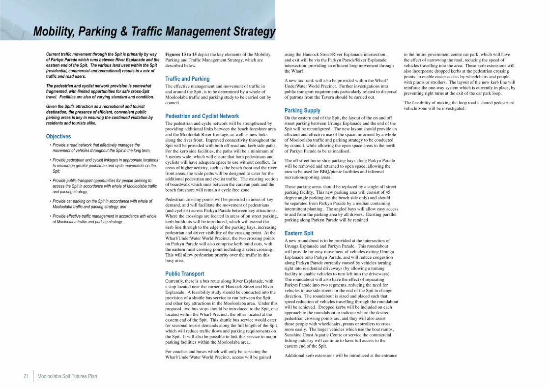
Mobility, Parking & Traffic Management Strategy
Current traffic movement through the Spit is primarily by way of Parkyn Parade which runs between River Esplanade and the eastern end of the Spit. The various land uses within the Spit (residential, commercial and recreational) results in a mix of traffic and road users.
The pedestrian and cyclist network provision is somewhat fragmented, with limited opportunities for safe cross-Spit travel. Facilities are also of varying standard and condition.
Given the Spit’s attraction as a recreational and tourist destination, the presence of efficient, convenient public parking areas is key in ensuring the continued visitation by residents and tourists alike.
Objectives• Provide a road network that effectively manages the
movement of vehicles throughout the Spit in the long term;
• Provide pedestrian and cyclist linkages in appropriate locations to encourage greater pedestrian and cycle movements on the Spit;
• Provide public transport opportunities for people seeking to access the Spit in accordance with whole of Mooloolaba traffic and parking strategy;
• Provide car parking on the Spit in accordance with whole of Mooloolaba traffic and parking strategy; and
• Provide effective traffic management in accordance wth whole of Mooloolaba traffic and parking strategy.
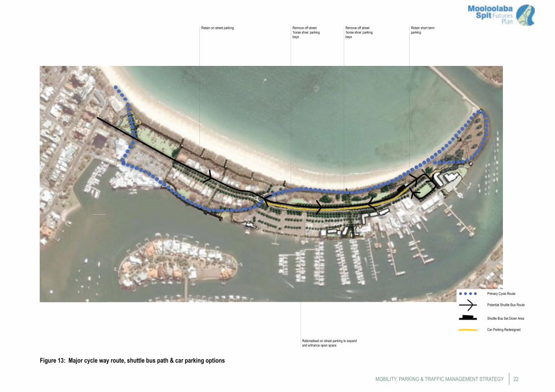
Figures 13 to 15 depict the key elements of the Mobility, Parking and Traffic Management Strategy, which are described below.
Traffic and ParkingThe effective management and movement of traffic in and around the Spit, is to be determined by a whole of Mooloolaba traffic and parking study to be carried out by council.
Pedestrian and Cyclist NetworkThe pedestrian and cycle network will be strengthened by providing additional links between the beach foreshore area and the Mooloolah River frontage, as well as new links along the river front. Improved connectivity throughout the Spit will be provided with both off road and kerb side paths. For the kerb side facilities, the paths will be a minimum of 3 metres wide, which will ensure that both pedestrians and cyclists will have adequate space to use without conflict. In areas of higher activity, such as the beach front and the river front areas, the wide paths will be designed to cater for the additional pedestrian and cyclist traffic. The existing section of boardwalk which runs between the caravan park and the beach foreshore will remain a cycle free zone.
Pedestrian crossing points will be provided in areas of key demand, and will facilitate the movement of pedestrians (and cyclists) across Parkyn Parade between key attractions. Where the crossings are located in areas of on street parking, kerb buildouts will be introduced, which will extend the kerb line through to the edge of the parking bays, increasing pedestrian and driver visibility of the crossing point. At the Wharf/UnderWater World Precinct, the two crossing points on Parkyn Parade will also comprise kerb build outs, with the eastern most crossing point including a zebra crossing. This will allow pedestrian priority over the traffic in this busy area.
Public TransportCurrently, there is a bus route along River Esplanade, with a stop located near the corner of Hancock Street and River Esplanade. A feasibility study should be conducted into the provision of a shuttle bus service to run between the Spit and other key attractions in the Mooloolaba area. Under this proposal, two bus stops should be introduced to the Spit, one located within the Wharf Precinct, the other located at the eastern end of the Spit. This shuttle bus service would cater for seasonal tourist demands along the full length of the Spit, which will reduce traffic flows and parking requirements on the Spit. It will also be possible to link this service to major parking facilities within the Mooloolaba area.
For coaches and buses which will only be servicing the Wharf/UnderWater World Precinct, access will be gained
using the Hancock Street/River Esplanade intersection, and exit will be via the Parkyn Parade/River Esplanade intersection, providing an efficient loop movement through the Wharf.
A new taxi rank will also be provided within the Wharf/UnderWater World Precinct. Further investigations into public transport requirements particularly related to dispersal of patrons from the Tavern should be carried out.
Parking SupplyOn the eastern end of the Spit, the layout of the on and off street parking between Urunga Esplanade and the end of the Spit will be reconfigured. The new layout should provide an efficient and effective use of the space, informed by a whole of Mooloolaba traffic and parking strategy to be conducted by council, while allowing the open space areas to the north of Parkyn Parade to be rationalised.
The off street horse-shoe parking bays along Parkyn Parade will be removed and returned to open space, allowing the area to be used for BBQ/picnic facilities and informal recreation/sporting areas.
These parking areas should be replaced by a single off street parking facility. This new parking area will consist of 45
degree angle parking (on the beach side only) and should be separated from Parkyn Parade by a median containing intermittent planting. The angled bays will allow easy access to and from the parking area by all drivers. Existing parallel parking along Parkyn Parade will be retained.
Eastern SpitA new roundabout is to be provided at the intersection of Urunga Esplanade and Parkyn Parade. This roundabout will provide for easy movement of vehicles exiting Urunga Esplanade onto Parkyn Parade, and will reduce congestion along Parkyn Parade currently caused by vehicles turning right into residential driveways (by allowing a turning facility to enable vehicles to turn left into the driveways). The roundabout will also have the effect of separating Parkyn Parade into two segments, reducing the need for vehicles to use side streets or the end of the Spit to change direction. The roundabout is sized and placed such that speed reduction of vehicles travelling through the roundabout will be achieved. Dropped kerbs will be included on each approach to the roundabout to indicate where the desired pedestrian crossing points are, and they will also assist those people with wheelchairs, prams or strollers to cross more easily. The larger vehicles which use the boat ramps, Sunshine Coast Aquatic Centre or service the commercial fishing industry will continue to have full access to the eastern end of the Spit.
Additional kerb extensions will be introduced at the entrance
to the future government centre car park, which will have the effect of narrowing the road, reducing the speed of vehicles travelling into the area. These kerb extensions will also incorporate dropped kerbs at the pedestrian crossing points, to enable easier access by wheelchairs and people with prams or strollers. The layout of the new kerb line will reinforce the one-way system which is currently in place, by preventing right turns at the exit of the car park loop.
The feasibility of making the loop road a shared pedestrian/vehicle zone will be investigated.
22
Retain on street parking
Figure 13: Major cycle way route, shuttle bus path & car parking options
Retain short term parking
Rationalised on street parking to expand and enhance open space
Remove off street ‘horse shoe’ parking bays
Remove off street ‘horse shoe’ parking bays
Potential Shuttle Bus Route
Primary Cycle Route
Car Parking Redesigned
Shuttle Bus Set Down Area
MOBILITY, PARKING & TRAFFIC MANAGEMENT STRATEGY
Mooloolaba Spit Futures Plan23
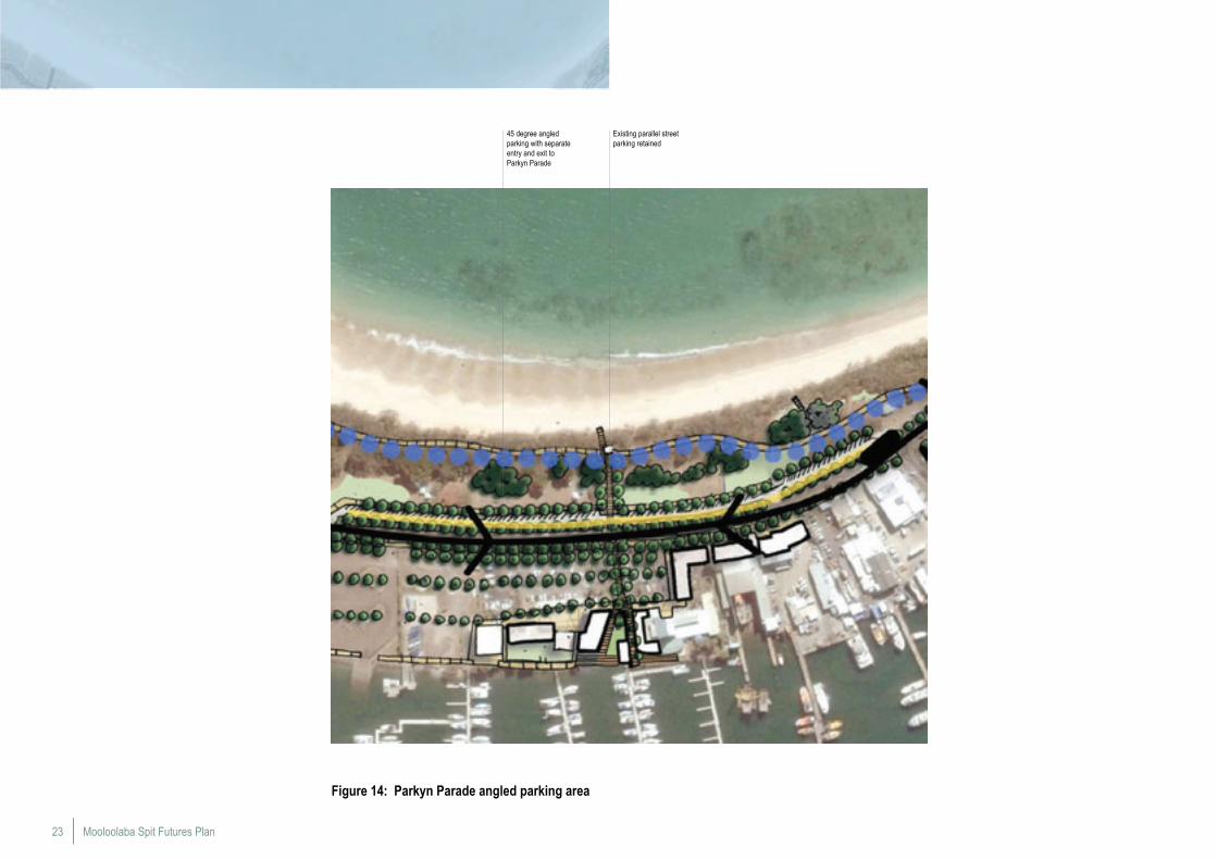
Figure 14: Parkyn Parade angled parking area
45 degree angled parking with separate entry and exit to Parkyn Parade
Existing parallel street parking retained
24
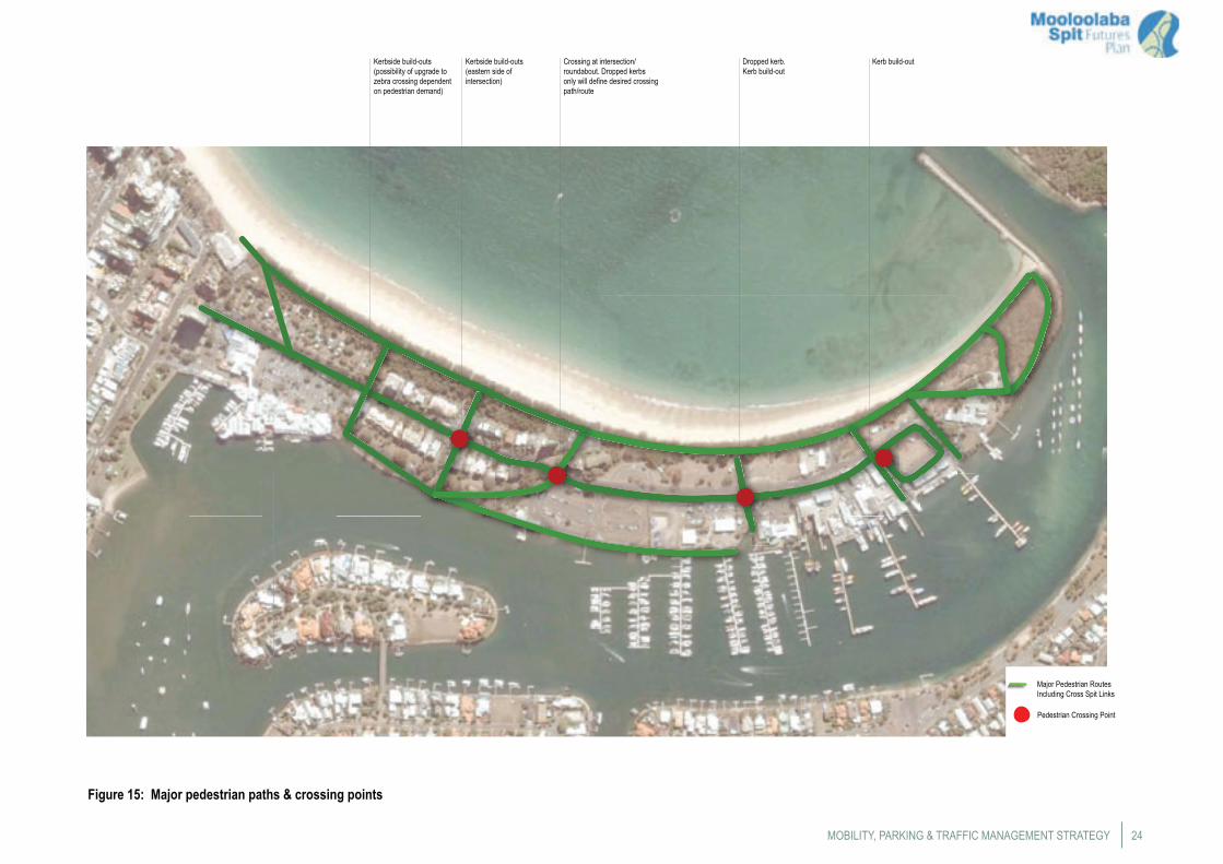
Kerbside build-outs (possibility of upgrade to zebra crossing dependent on pedestrian demand)
Figure 15: Major pedestrian paths & crossing points
Kerbside build-outs (eastern side of intersection)
Crossing at intersection/roundabout. Dropped kerbs only will define desired crossing path/route
Dropped kerb. Kerb build-out
Kerb build-out
Pedestrian Crossing Point
Major Pedestrian Routes Including Cross Spit Links
MOBILITY, PARKING & TRAFFIC MANAGEMENT STRATEGY
Mooloolaba Spit Futures Plan25
Water Usage Strategy
The Water Usage Strategy is intended to address issues relating to the use and management of the Mooloolaba State Boat Harbour (as shown in Figure 16) and adjoining waterways, particularly those affecting the use and enjoyment of the Mooloolaba Spit. A number of activities within the Boat Harbour will rely on supporting land facilities and may have wider implications, such as traffic generation and environmental amenity.
The Strategy has been prepared following consultation with DTMR and discussions with representatives from the Sunshine Coast Aquatic Centre and the commercial fishing industry.
Objectives• Ensure future uses within the Boat Harbour have regard to the
hydraulic capacity of the Mooloolah River;
• Improve the management of water quality within the Boat Harbour and adjacent waterways;
• Enable the Boat Harbour to be fully utilised without compromising its operational requirements and development potential; and
• Manage the uses and future development within the Boat Harbour to avoid adverse impacts on the amenity of the Spit.
Capacity of Boat HarbourNo definitive investigations have been carried out in relation to the capacity of the Boat Harbour, particularly in regard to the ability of the Mooloolah River to convey major flood flows, and the capacity of infrastructure to support water based activities. Any future proposals for berthing and marina facilities in the Boat Harbour will be required to carry out appropriate investigations in order to demonstrate that:
• The proposed development will not adversely impact on the capacity of the Mooloolah River to convey flood flows;
• Traffic flows associated with the proposal are managed to limit impact on the Spit;
• Associated car parking can be accommodated on site; • The proposal will not adversely impact on either the operational
functionality and development potential of the Boat Harbour; and
• Future development within the Boat Harbour will need to consider the width and depth requirements of the navigation channel, as well as current port procedures.
Water Quality/CirculationWater quality within the Boat Harbour can be affected by stormwater runoff into the river from the catchment and also point source contaminants associated with the operation and maintenance of vessels. Measures to manage water quality will include:
• All stormwater discharges to the river will be fitted with gross pollutant traps or similar devices to prevent litter entering the harbour. These will need to be cleaned regularly;
• Future redevelopment of the Wharf complex will incorporate engineering and design measures to improve the circulation of water within the existing marina;
• Regular monitoring of water quality will be required as a condition on any new or expanded activity; and
• The SCRC, DERM and lessees should undertake a joint review of water quality monitoring procedures within the Boat Harbour and consider the need for a more rigorous monitoring program.
Maintenance DredgingMaintenance of the entrance channel and main channel depth within the Boat Harbour is the responsibility of DTMR, whilst maintenance of water depth within the leased areas of the Boat Harbour is the responsibility of the individual lessees. DTMR has prepared a long-term Dredging and Disposal Strategy which addresses issues associated with maintenance dredging. When dredging consists of clean uncontaminated sand, the preference will be to use this material in locations that ensure its continued role in coastal processes and/or for beach nourishment. There will be no storage and/or treatment of dredge spoil on the Spit.
Managing Potential Use ConflictsActivities within the Boat Harbour which have the potential to conflict with its principal role of providing safe anchorage, launching and retrieving for vessels and recreational boats, need to be properly managed. Management measures are to include:
• Ongoing monitoring of all activities on the Boat Harbour should be carried out by DTMR Regional Harbour Master and the Boat Harbour Controller, to determine the potential for use conflicts;
• Implement measures to reduce potential conflicts with other users of the Boat Harbour; and
• The future proposals for facilities within the Boat Harbour are to be assessed in terms of potential use conflicts by DTMR.
Diversification of Use within the Commercial Fishing PrecinctThe Mooloolaba Spit Futures Plan provides for the continued development of the commercial fishing industry on the Spit. It also recognises the need and desirability of allowing operations to diversify their activities to include tourist related activities in order to maintain viability. Measures to facilitate the diversification of uses in this precinct include:
• Council and DTMR representatives from the commercial fishing industry will commence dialogue to determine possible implications of changes in the fishing industry on the nature of uses within the precinct; and
• Council and DTMR, in association with the commercial fishing operators, to review the current sub-lease conditions within the Boating and Commercial Fishing Precinct, to provide flexibility to cater for a wider range of compatible uses and the berthing of recreational vessels.
Provision of Repairs and Maintenance FacilitiesThe commercial fishing area provides facilities for the repair and maintenance of boats. While these activities are ‘industrial’ in nature, they are seen as an integral function of a Boat Harbour and any potential impacts can be effectively managed.
The need for facilities to repair and maintain vessels within the Boat Harbour is acknowledged in the Plan and provisions will be included in the planning scheme for the appropriate siting of, and/or to discourage, uses that would compromise the operation of such facilities.
Charter OperationsCharter fishing and dive boat activities operate from both the Wharf and Sunshine Coast Aquatic Centre marinas. Increased demand for charters is likely to continue, particularly with the recent sinking of the HMAS Brisbane as a dive site off the Sunshine Coast.
Future leasing arrangements should recognise the expansion requirements of charter operations based on the Spit to minimise any exclusivity issues.
Water TransportThe opportunity to establish a water taxi service between the Spit and locations on the other side and upstream of the river should be jointly investigated by the council and other relevant State agencies.
Trailer ParkingBoat trailer parking on the Spit (and elsewhere) is at a premium during peak periods and the public boat ramps and associated parking in this location are under increasing pressure as the Boat Harbour provides one of the safest launching points for sea access.
DTMR and council are encouraged to undertake a joint study to identify possible additional sites for boat ramps and associated parking to cater for this predicted demand. In the interim, signage will be provided to prohibit trailer parking outside the designated trailer park and to restrict cars without trailers from parking in the trailer park.
Live AboardsPermanent live aboards are not supported within the Boat Harbour as outlined in the Transport Infrastructure (Sunshine Coast Waterways) Management Plan 2000 which is implemented by DTMR.
26
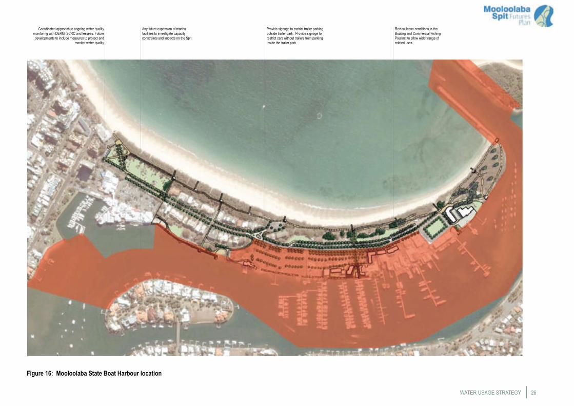
Figure 16: Mooloolaba State Boat Harbour location
WATER USAGE STRATEGY
Any future expansion of marina facilities to investigate capacity constraints and impacts on the Spit
Provide signage to restrict trailer parking outside trailer park. Provide signage to restrict cars without trailers from parking inside the trailer park
Review lease conditions in the Boating and Commercial Fishing Precinct to allow wider range of related uses
Coordinated approach to ongoing water quality monitoring with DERM, SCRC and lessees. Future developments to include measures to protect and
monitor water quality
Mooloolaba Spit Futures Plan27
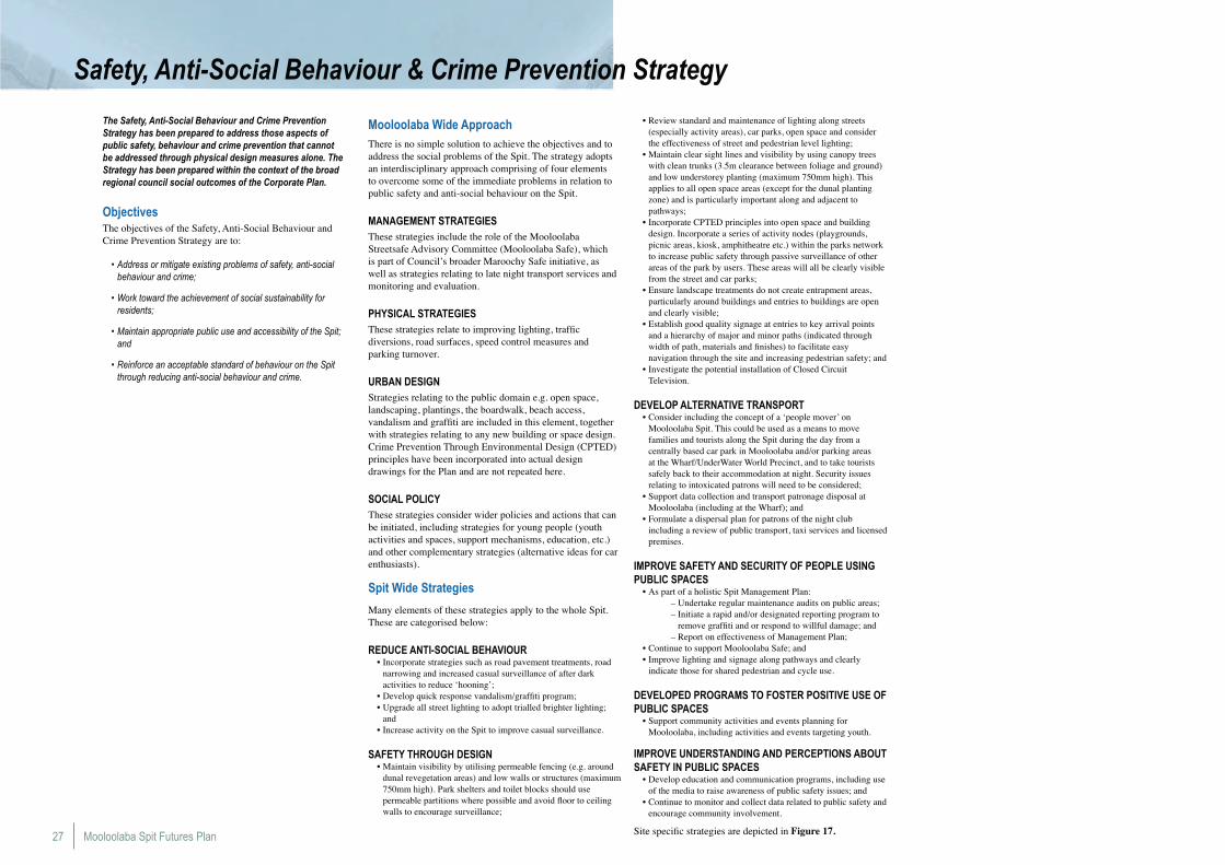
Safety, Anti-Social Behaviour & Crime Prevention Strategy
The Safety, Anti-Social Behaviour and Crime Prevention Strategy has been prepared to address those aspects of public safety, behaviour and crime prevention that cannot be addressed through physical design measures alone. The Strategy has been prepared within the context of the broad regional council social outcomes of the Corporate Plan.
ObjectivesThe objectives of the Safety, Anti-Social Behaviour and Crime Prevention Strategy are to:
• Address or mitigate existing problems of safety, anti-social behaviour and crime;
• Work toward the achievement of social sustainability for residents;
• Maintain appropriate public use and accessibility of the Spit; and
• Reinforce an acceptable standard of behaviour on the Spit through reducing anti-social behaviour and crime.
Mooloolaba Wide ApproachThere is no simple solution to achieve the objectives and to address the social problems of the Spit. The strategy adopts an interdisciplinary approach comprising of four elements to overcome some of the immediate problems in relation to public safety and anti-social behaviour on the Spit.
MANAGEMENT STRATEGIESThese strategies include the role of the Mooloolaba Streetsafe Advisory Committee (Mooloolaba Safe), which is part of Council’s broader Maroochy Safe initiative, as well as strategies relating to late night transport services and monitoring and evaluation.
PHYSICAL STRATEGIESThese strategies relate to improving lighting, traffic diversions, road surfaces, speed control measures and parking turnover.
URBAN DESIGNStrategies relating to the public domain e.g. open space, landscaping, plantings, the boardwalk, beach access, vandalism and graffiti are included in this element, together with strategies relating to any new building or space design. Crime Prevention Through Environmental Design (CPTED) principles have been incorporated into actual design drawings for the Plan and are not repeated here.
SOCIAL POLICYThese strategies consider wider policies and actions that can be initiated, including strategies for young people (youth activities and spaces, support mechanisms, education, etc.) and other complementary strategies (alternative ideas for car enthusiasts).
Spit Wide Strategies
Many elements of these strategies apply to the whole Spit. These are categorised below:
REDUCE ANTI-SOCIAL BEHAVIOUR• Incorporate strategies such as road pavement treatments, road
narrowing and increased casual surveillance of after dark activities to reduce ‘hooning’;
• Develop quick response vandalism/graffiti program;• Upgrade all street lighting to adopt trialled brighter lighting;
and• Increase activity on the Spit to improve casual surveillance.
SAFETY THROUGH DESIGN• Maintain visibility by utilising permeable fencing (e.g. around
dunal revegetation areas) and low walls or structures (maximum 750mm high). Park shelters and toilet blocks should use permeable partitions where possible and avoid floor to ceiling walls to encourage surveillance;
• Review standard and maintenance of lighting along streets (especially activity areas), car parks, open space and consider the effectiveness of street and pedestrian level lighting;
• Maintain clear sight lines and visibility by using canopy trees with clean trunks (3.5m clearance between foliage and ground) and low understorey planting (maximum 750mm high). This applies to all open space areas (except for the dunal planting zone) and is particularly important along and adjacent to pathways;
• Incorporate CPTED principles into open space and building design. Incorporate a series of activity nodes (playgrounds, picnic areas, kiosk, amphitheatre etc.) within the parks network to increase public safety through passive surveillance of other areas of the park by users. These areas will all be clearly visible from the street and car parks;
• Ensure landscape treatments do not create entrapment areas, particularly around buildings and entries to buildings are open and clearly visible;
• Establish good quality signage at entries to key arrival points and a hierarchy of major and minor paths (indicated through width of path, materials and finishes) to facilitate easy navigation through the site and increasing pedestrian safety; and
• Investigate the potential installation of Closed Circuit Television.
DEVELOP ALTERNATIVE TRANSPORT• Consider including the concept of a ‘people mover’ on
Mooloolaba Spit. This could be used as a means to move families and tourists along the Spit during the day from a centrally based car park in Mooloolaba and/or parking areas at the Wharf/UnderWater World Precinct, and to take tourists safely back to their accommodation at night. Security issues relating to intoxicated patrons will need to be considered;
• Support data collection and transport patronage disposal at Mooloolaba (including at the Wharf); and
• Formulate a dispersal plan for patrons of the night club including a review of public transport, taxi services and licensed premises.
IMPROVE SAFETY AND SECURITY OF PEOPLE USING PUBLIC SPACES
• As part of a holistic Spit Management Plan: – Undertake regular maintenance audits on public areas; – Initiate a rapid and/or designated reporting program to
remove graffiti and or respond to willful damage; and – Report on effectiveness of Management Plan;• Continue to support Mooloolaba Safe; and• Improve lighting and signage along pathways and clearly
indicate those for shared pedestrian and cycle use.
DEVELOPED PROGRAMS TO FOSTER POSITIVE USE OF PUBLIC SPACES
• Support community activities and events planning for Mooloolaba, including activities and events targeting youth.
IMPROVE UNDERSTANDING AND PERCEPTIONS ABOUT SAFETY IN PUBLIC SPACES
• Develop education and communication programs, including use of the media to raise awareness of public safety issues; and
• Continue to monitor and collect data related to public safety and encourage community involvement.
Site specific strategies are depicted in Figure 17.
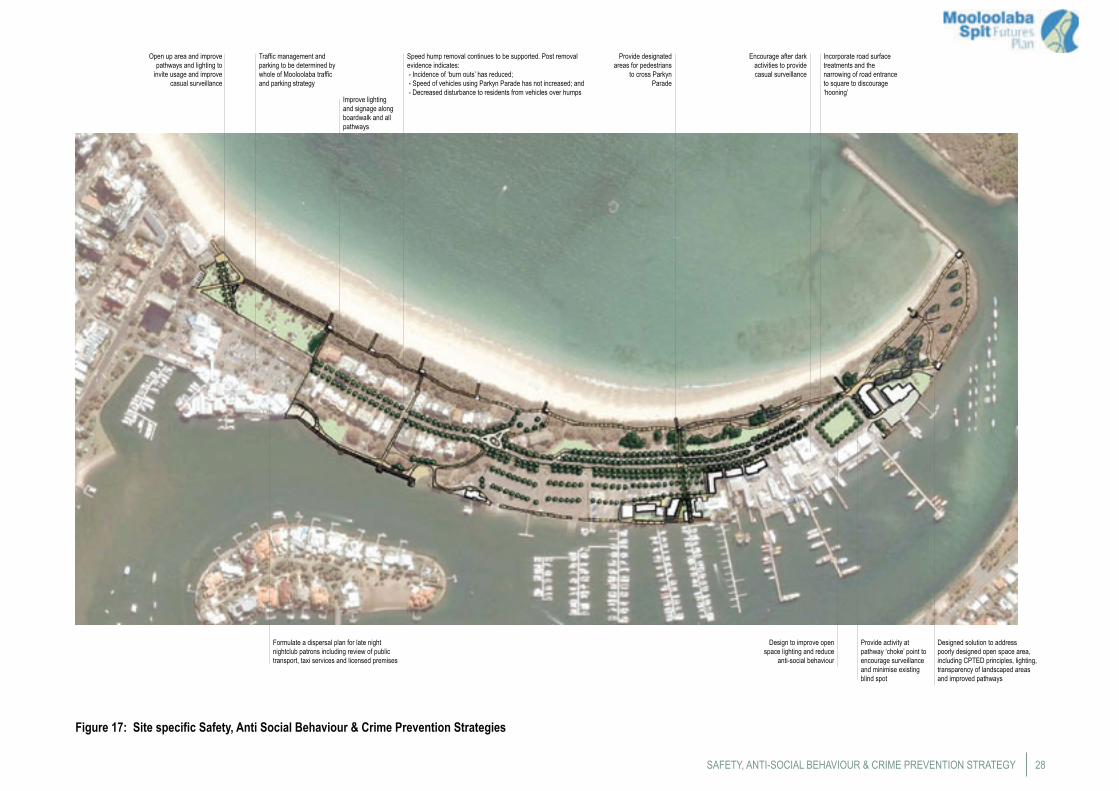
28
Figure 17: Site specific Safety, Anti Social Behaviour & Crime Prevention Strategies
SAFETY, ANTI-SOCIAL BEHAVIOUR & CRIME PREVENTION STRATEGY
Open up area and improve pathways and lighting to
invite usage and improve casual surveillance
Traffic management and parking to be determined by whole of Mooloolaba traffic and parking strategy
Improve lighting and signage along boardwalk and all pathways
Speed hump removal continues to be supported. Post removal evidence indicates: - Incidence of ‘burn outs’ has reduced; - Speed of vehicles using Parkyn Parade has not increased; and - Decreased disturbance to residents from vehicles over humps
Formulate a dispersal plan for late night nightclub patrons including review of public transport, taxi services and licensed premises
Provide activity at pathway ‘choke’ point to encourage surveillance and minimise existing blind spot
Incorporate road surface treatments and the narrowing of road entrance to square to discourage ‘hooning’
Encourage after dark activities to provide casual surveillance
Design to improve open space lighting and reduce
anti-social behaviour
Designed solution to address poorly designed open space area, including CPTED principles, lighting, transparency of landscaped areas and improved pathways
Provide designated areas for pedestrians
to cross Parkyn Parade
Mooloolaba Spit Futures Plan29
Implementation Plan
Project Implementation CommitteeImplementation of the Mooloolaba Spit Futures Plan will require commitment from both State and local government, together with the involvement of the private sector.
An initial requirement will be the need to establish a joint Project Implementation Committee (or similar). The purpose of this working group is to provide a coordinating and facilitating role to oversee and advance the implementation of key elements of the Plan. In particular, the group would coordinate issues around land use planning, tenure, management and operational activities to achieve a coordinated and consistent approach across the Spit and within precincts. This committee would comprise senior representatives from council and State Government agencies as required for specific projects. The Project Implementation Committee may also involve other stakeholders for specific projects such as the need to include Port of Brisbane and Brisbane Marine Pilots in deliberations on the development of the government centre.
Works and Other ImprovementsWorks and improvements to the Spit through the implementation of the strategies of the Plan include the following catalyst projects;
• Realign caravan park boundary and improve public accessibility to and around the Spit;
• Rationalisation of government uses within the Government and Peninsula Precinct and the relocation of QBFP;
• Encourage compatible redevelopment in the Boating and Commercial Fishing Precinct; and
• Undertake landscaping improvements and provide additional public facilities.
Elements of the Plan will also require more detailed planning and design to be undertaken including detailed costing information to enable funding options to be explored.
Legislative Framework for Development and RedevelopmentThe Plan will guide future use and development on the Spit for the next 20 years by providing the framework with which the broad long-term strategies contained within the plan can be translated into detailed Implementation Plans. The Plan does not authorise any development to occur, rather, it provides the overall framework in which development may occur.
The Plan will be used by State Government as the basis for evaluating the most appropriate use and tenure of State land at the Mooloolaba Spit in accordance with the Land Act 1994
and the objectives of the Government Land Policy.
Further, this Plan does not represent the final consideration of future development of any land and/or water on the Spit. For the final plan to be given effect there will be a necessity for:
Any development to require development approval • under the Integrated Planning Act 1997 and to comply with the relevant provisions of the planning scheme in place at the time and the requirements of the State under the laws and policies it administers; and
Most importantly, the requirements of the State’s • planning and development laws require that any future development is fully considered and appropriately conditioned to ensure that impacts on the environment are sustainable and issues such as traffic and parking are fully managed. This will require the development of further and more detailed studies to inform the decision-making process.
Recommended Actions
Establish Project Implementation Committee• Establish a Project Implementation Committee to identify tasks,
prepare a works program and oversee the implementation of the Plan.
Preparation of Detailed design and costing• Review outcomes of council’s Action Plan and determine
implications for any of the Plan Strategies:• Prepare detailed plans for modification of the caravan park,
costings and program;• Prepare detailed landscape plans for the various open space
areas and linkages in accordance with the Landscape Strategy including a schedule of embellishments and all associated costs suitable for eventual inclusion in an Infrastructure Charges Schedule;
• Prepare detailed designs for pedestrian crossings of Parkyn Parade;
• In conjunction with DTMR, prepare detailed plans and costings for proposed landscaping and pedestrian enhancements of the trailer parking area; and
• Develop a strategy and program for the rationalisation of land uses in the Government and Peninsula Precinct, including the preparation of a business case with detailed costings.
Funding options• Review funding options for infrastructure and landscaping
works and prepare frameworks for the determination of
infrastructure charges based on the detailed costings;• Review funding alternatives for State Government works
involving the rationalisation of government uses on the Spit; and
• Review policy options for directing value capture from the Spit into government works on the Spit.
Programming works• Review council capital works program including works to be
funded by general rates.
Further consultations• Consult with residents and DERM in relation to revegetation
and management of foreshore vegetation and rationalisation of beach access;
• Consult with Queensland Police in relation to implementation of the Safety, Anti-Social Behaviour and Crime Prevention Strategy;
• Consult with key stakeholder groups to provide opportunity for involvement during detailed bikeway and pedestrian design phase and implementation;
• Consult with Sunshine Coast Aquatic Centre regarding monitoring of activities;
• Consult with charter boat operators regarding facility needs; • Consult with commercial fishing operators to develop flexible
lease conditions to cater for changes in fishing industry; and• Consult with government agencies proposed to relocate to the
government precinct.
Further investigations• Undertake a council wide caravan park strategy;• Undertake detailed traffic and parking study for whole of
Mooloolaba;• Undertake a join boat ramp and trailer parking study;• Undertake a joint review of water quality monitoring
procedures within the Boat Harbour; and• Undertake an investigation to determine the capacity of the
Boat Harbour.